North Carolina Wildlife Resources Commission Charles R. Fullwood, Executive Director Mailing Address: Division of Inland Fisheries • 1721 Mail Service Center • Raleigh, NC 27699-1721 Telephone: (919) 733-3633 • Fax: (919) 715-7643 GUIDANCE MEMORANDUM TO ADDRESS AND MITIGATE SECONDARY AND CUMULATIVE IMPACTS TO AQUATIC AND TERRESTRIAL WILDLIFE RESOURCES AND WATER QUALITY (August 2002)

Welcome message from author
This document is posted to help you gain knowledge. Please leave a comment to let me know what you think about it! Share it to your friends and learn new things together.
Transcript
North Carolina Wildlife Resources Commission Charles R. Fullwood, Executive Director
Mailing Address: Division of Inland Fisheries • 1721 Mail Service Center • Raleigh, NC 27699-1721 Telephone: (919) 733-3633 • Fax: (919) 715-7643
GUIDANCE MEMORANDUM TO ADDRESS AND MITIGATE SECONDARY AND CUMULATIVE IMPACTS TO AQUATIC AND TERRESTRIAL WILDLIFE RESOURCES
AND WATER QUALITY (August 2002)
Page 2 August 2002 CSI Mitigation Measures
Executive Summary
Thousands of acres of land are developed each year in North Carolina, and this development consists of many individual and often unrelated projects. Without proper safeguards, the cumulative effects of land development can transform the landscape and negatively impact the environmental character and natural functions of the ecosystems. North Carolina projects a population increase of more than 3 million new individuals by the year 2020 (N. C. Progress Board 2001); therefore, it is imperative that coordinated measures be implemented to protect wildlife resources and their habitats.
When development is conducted in an unplanned and amorphous or ambiguous pattern it can have more serious impacts on ecosystem function. Rapidly developing landscapes can result in stream degradation due to increases in stormwater runoff, sedimentation and other pollutants, and riparian habitat losses. Some of the greatest impacts of development, both land-based and near-water development, occur on water quality in our streams and rivers. Many of our native species of aquatic organisms have become highly imperiled as a result. The decline in freshwater species is a direct reflection of declining quality of our streams and rivers, and rare and sensitive species are particularly affected by secondary and cumulative impacts associated with urban development due to their sensitivity to slight habitat alterations.
A more comprehensive approach to project review is necessary if we are to effectively
protect the environmental resources of the State. This approach should scrutinize the cumulative and secondary impacts (CSI) associated with all projects subject to State Environmental Policy Act (SEPA) requirements as closely as direct impacts. Cumulative effects are defined as effects resulting from the incremental impact of the proposed activity when added to other past, present, and probable future activities in the area. Cumulative effects can occur from individually minor but collectively significant activities taking place over a period of time. Secondary effects are defined as probable effects caused by and resulting from the proposed activity although they are later in time or further removed in distance.
Presently, cumulative and secondary impacts are often not fully addressed in an
environmental review. The Department of Environment and Natural Resources (DENR), has identified as part of the 2000 strategic plan the need to develop a policy for evaluating and mitigating the cumulative and secondary impacts. Identification of measures to mitigate for secondary and cumulative impacts was determined to be an important component of addressing impacts.
This document was primarily authored by biologists with the N. C. Wildlife Resources
Commission and the N. C. Division of Parks and Recreation. Significant contributions were provided by the CSI Working Group, which includes representatives from numerous state agencies concerned with the conservation of natural resources. The U. S. Fish and Wildlife Service, which supports these recommendations, also provided constructive review of the document.
This document is intended to serve as a guidance memorandum for local governments to
assist with addressing secondary and cumulative impacts associated with public projects. Implementation of these recommendations will assist in the mitigation of impacts to water quality, to fish and wildlife and their habitat generally, and in situations where federally threatened and endangered species exist. Alternatives to these measures will be examined on a case-by-case basis, provided that the same level of protection is afforded. The recommendations provided herein are intended to be applied to new developments or to existing developments for
Page 3 August 2002 CSI Mitigation Measures
which significant modifications or expansions are proposed. Incorporation of the measures that are outlined throughout the document by local governments will alleviate the concerns of the natural resource agencies and will provide for a smoother and more timely review of environmental documents and permits.
The recommendations presented in this document to avoid or mitigate these impacts are based on the best available science and were obtained by a synthesis of scientific information in journals, publications, reference books, and personal communication with professionals familiar with North Carolina aquatic species and other natural resources. However, the recommendations may be revised as more information becomes available about species’ habitat requirements and measures necessary to protect aquatic and terrestrial habitat and water quality. It is envisioned that through the active participation and initiative of local governments in partnership with State resource and regulatory agencies, the concerns regarding impacts of significance will be alleviated and the review of environmental documents and permits will be more efficient and effective.
Recommendations include measures regarding: • Forested buffers • Stream and wetland resources • Infrastructure locations • Floodplains • Impervious surfaces and stormwater treatment • Erosion and sediment control
Page 4 August 2002 CSI Mitigation Measures
Preface
This document is intended to serve as a guidance memorandum for local governments to assist with addressing secondary and cumulative impacts associated with public projects. Implementation of these recommendations will assist in the mitigation of impacts to water quality, to fish and wildlife and their habitat generally, and in situations where federally threatened and endangered species exist. Alternatives to these measures will be examined on a case-by-case basis, provided that the same level of protection is afforded. The recommendations provided herein are intended to be applied to new developments or to existing developments for which significant modifications or expansions are proposed. Incorporation of the measures that are outlined throughout the document by local governments will alleviate the concerns of the natural resource agencies and will provide for a smoother and more timely review of environmental documents and permits.
Agencies, municipalities, landowners, and the public share a responsibility to protect and
conserve fish and wildlife, which are public resources. Efforts to minimize secondary and cumulative impacts may not show immediate rewards, however such efforts are important to prevent future damage to riparian and stream systems and to rebuild degraded areas. These efforts will also help meet the anti-degradation standard established in Rule 15A NCAC 02B .0201, which provides for the maintenance, protection, and enhancement of existing uses.
During the fall of 2001 and through 2002 the N. C. Department of Environment and
Natural Resources (DENR) established and guided a Cumulative and Secondary Impact (CSI) Working Group. This group was made up of a variety of staff from Divisions within DENR. The CSI Working Group undertook the task of identifying, drafting, and developing a system and protocol for ensuring that cumulative and secondary impacts are adequately addressed during the review of documents required under the N. C. Environmental Policy Act. Identification of mitigation measures effective in reducing potential negative impacts associated with projects was a major component of this endeavor; therefore, a “mitigative measures” subgroup was formed. This document was developed as a result of that effort.
This document was primarily authored by biologists with the N. C. Wildlife Resources
Commission (NCWRC) and the N. C. Division of Parks and Recreation, and significant contributions were provided by the mitigative measures subgroup. The document includes comments, ideas, and suggestions from the entire CSI Working Group, which includes representatives from the N. C. Division of Coastal Management, N. C. Division of Environmental Health, N. C. Division of Land Resources, N. C. Division of Marine Fisheries, N. C. Division of Parks and Recreation, N. C. Division of Water Quality, N. C. Division of Water Resources, N. C. Office of Legislative and Intergovernmental Affairs, and the NCWRC. Constructive comments from many of these agencies improved the document. The U. S. Fish and Wildlife Service (USFWS), which supports these recommendations, also provided constructive review of the document.
The NCWRC and the Division of Parks and Recreation recognize that ongoing development and change to the natural landscape will continue and that continued economic development is critical to the citizens of the state. Furthermore, a healthy state is dependent upon a healthy economy and a healthy natural environment, both of which are integrated components. How and where change to the landscape occurs makes all the difference in the future of a sustainable economy and healthy natural environment. The assembled information consists of recommendations, that when implemented by a local government, will
Page 5 August 2002 CSI Mitigation Measures
simultaneously work to maintain or improve water quality, protect aquatic habitat, permit economic expansion, and preserve the character of the land. Introduction
Thousands of acres of land are developed each year in North Carolina, and this development consists of many individual and often unrelated projects. Without proper safeguards, the cumulative effects of land development can transform the landscape and negatively impact the environmental character and natural functions of the ecosystems. North Carolina projects a population increase of more than 3 million new individuals by the year 2020 (N. C. Progress Board 2001); therefore, it is imperative that coordinated measures be implemented to protect wildlife resources and their habitats. Most citizens want a clean environment and a healthy economy, therefore measures must be implemented statewide to allow economic growth without significant and irretrievable impacts to North Carolina’s environment.
Some of the greatest impacts of development, both land-based and near-water
development, occur on water quality in our streams and rivers. Many of our native species of aquatic organisms have become highly imperiled as a result. Approximately one-third of North American freshwater fish species (Williams et al. 1989) and 72% of freshwater mussel species (Williams et al. 1993) qualify for classification as “endangered”, “threatened”, or “special concern” at the federal level, and habitat loss is a primary culprit, particularly for mussels. In North Carolina, 21% of freshwater fishes and 53% of freshwater mussel species are designated endangered, threatened, or of special concern at the state level (LeGrand et al. 2001). The decline in freshwater species is a direct reflection of declining quality of our streams and rivers. Federally endangered and threatened species are particularly affected by secondary and cumulative impacts associated with urban development due to their sensitivity to slight habitat alterations. A high proportion of listed species occurs within areas of the state that are developing the most rapidly; some have lost major reaches of their habitats within the past few decades, others are in danger of being extirpated from entire river basins, and one species has been extirpated from the state, and thus is extinct (Carolina Elktoe, Alasmidonta robusta).
When development is conducted in an unplanned and amorphous or ambiguous pattern it
can have more serious impacts on ecosystem function. Rapidly developing landscapes can result in stream degradation due to increases in stormwater runoff, sedimentation and other pollutants, and riparian habitat losses. Measures that may mitigate these impacts include preservation of forested stream buffers of appropriate size, reduction of impervious surfaces, and effective stormwater treatment.
The recommendations presented in this document to avoid or mitigate these impacts are
based on the best available science and were obtained by a synthesis of scientific information in journals, publications, reference books, and personal communication with professionals familiar with North Carolina aquatic species and other natural resources. However, the recommendations may be revised as more information becomes available about species’ habitat requirements and measures necessary to protect aquatic and terrestrial habitat and water quality.
General Mitigation Measures for All Watersheds (more extensive measures apply to watersheds that support federal endangered and threatened species)
Although riparian zones constitute a small percentage of the landscape, they frequently
perform important ecological functions and contain a disproportionately high number of wildlife
Page 6 August 2002 CSI Mitigation Measures
species in comparison to most upland habitats (Fischer et al. 2000; Knutson and Naef 1997). As a matter of policy, the American Fisheries Society strongly urges that riparian areas be considered unique and distinctly valuable habitats, and that such areas be declared of critical environmental concern (AFS 1985). Riparian areas perform many functions that are essential to maintaining water quality, aquatic species survival, and biological productivity.
With regards to the measures required to protect streams from pollutants, the further the
intervention occurs from the source, the greater the costs to society (Reeves et al. 1991); resulting in a gradient from prevention to interdiction to restoration (Waters 1995). Watershed protection has been the most successful method of habitat rehabilitation (Reeves et al. 1991); however, given the difficulty of totally preventing or eliminating pollutants (e.g. sediment) at the source, interdiction such as the use of riparian buffers is an important tool in reducing damage to streams (Waters 1995). The functions of riparian zones are well documented and convey sometimes subtle but critical benefits to society. These functions are listed below.
Forested riparian area functions • Reduce pollutants and filter runoff • Improve air quality and lower ozone levels • Maintain stable water flows • Help sustain natural channel morphology • Help maintain water and air temperature by providing shade • Stabilize stream banks • Provide most of the organic carbon and nutrients to support the aquatic food web • Provide sources of large woody debris for the stream channel • Help reduce the severity of floods • Facilitate the exchange of groundwater and surface water • Provide critical wildlife habitat
Numerous studies have evaluated buffer widths needed for stream protection. Often
these have focused on a single parameter, which has resulted in a large variation in recommended buffer widths (Appendix A). For a buffer to effectively perform for all riparian processes, wider contiguous buffers (100–300 feet) are recommended (Knutson and Naef 1997; May and Horner 2000; Martin et al. 2000; Palik et al. 2000; Richards and Hollingsworth 2000; Stewart et al. 2000). Effective buffer sizes depend upon specific site conditions, such as slope and soil type. Although variable widths may be more applicable in some circumstances, they are often more difficult to understand, implement, and enforce. Therefore, we offer generalized recommendations of minimum buffer widths for predictable application across the North Carolina landscape. Because specific conditions differ, some deviations from the general recommendation may be acceptable, however deviations should be kept to a minimum. Discussions regarding buffers or riparian corridors refer to forested buffers where the dominant vegetation consists of native trees and shrubs.
Streams with wide, forested riparian corridors in developed areas are essential for the
protection of water quality and aquatic habitats. Natural riparian corridors are diverse, dynamic, and complex biophysical habitats (Naiman et al. 1993), and riparian ecosystems have the greatest vulnerability to alteration (Knutson and Naef 1997; and references therein). The maintenance of riparian habitat may yield the greatest gains for aquatic and terrestrial wildlife across the landscape while involving the least amount of area.
Numerous significant and negative consequences can result when headwater streams are
lost (Meyer and Wallace 2001), and the effects of degradation accumulate; therefore, the condition of the stream in the lower reaches is closely dependent on the condition in the
Page 7 August 2002 CSI Mitigation Measures
headwaters (Vannote et al. 1980). In addition, headwater streams can significantly reduce nutrient export to rivers (Alexander et al. 2000; Peterson et al. 2001).
1. We recommend the maintenance or establishment of a minimum 100-foot native forested
buffer along each side of perennial streams and 50-foot native forested buffer along each side of intermittent streams and wetlands throughout the present and future service areas or the entire municipal jurisdiction (EPA 2000; Stewart et al. 2000). We additionally encourage the implementation of buffers on ephemeral streams due to the important functions that they provide as headwater streams (Alexander et al. 2000; Peterson et al. 2001). Buffers should be measured horizontally from the edge of the stream bank (Knutson and Naef 1997), which may result in wider buffers on higher gradients, and must be provided over the entire length of stream, including headwater streams. Further, we recommend leaving 30% of the development area as greenspace, which would include buffers and wetlands and ensure that the greenspace is connected to natural resources.
Wide, contiguous riparian buffers have greater and more flexible potential than other options to maintain biological integrity (Horner et al. 1999) and could ameliorate many ecological issues related to land use and environmental quality (Naiman et al. 1993). As expansion of developed areas continues into the watershed, wildlife habitat can change, become fragmented, and even disappear. Riparian buffers provide travel corridors and habitat areas for wildlife displaced by development. In addition, riparian buffers serve to protect water quality by stabilizing stream banks, filtering capacity of stormwater runoff, and provide habitat for aquatic and fisheries resources.
2. We recommend that delineation of streams be conducted for the municipal service area according to U. S. Army Corps of Engineers (USACOE) or N. C. Division of Water Quality (NCDWQ) methodology. This information can be found at http://h2o.enr.state.nc.us/ncwetlans/strmfrm.html (accessed May 2002). U. S. Geological Survey (USGS) maps underestimate the extent of streams. Recent research has shown that USGS maps can underestimate total stream length in the Piedmont of North Carolina by 25 % (Gregory et al. in press).
3. We recommend that sewer lines, water lines, and other utility infrastructure be kept out of riparian buffer areas (Knutson and Naef 1997; and references therein). All utility crossings should be kept to a minimum, which includes careful routing design and the combination of utility crossings into the same right-of-way (provided there is not a safety issue). Discontiguous buffer segments can impair riparian functions disproportionate to the relative occurrence of the breaks in the buffer (May and Horner 2000; Van Sickle 2000), and multiple crossings can result in cumulative impacts. The directional bore (installation of utilities beneath the riverbed, avoiding impacts to the stream and buffer) stream crossing method should be used for utility crossings wherever practicable, and the open cut stream crossing method should only be used when water level is low and stream flow is minimal. Manholes or similar access structures should not be allowed within buffer areas. Stream crossings should be near perpendicular (75o to 105o) to stream flow and should be monitored at least every three months for maintenance needs during the first 24 months of the project and then annually thereafter. Sewer lines associated with crossing areas should be maintained and operated at all times to prevent the discharge to land or surface waters. We recommend a minimum 50–100 feet setback on all streams, lakes, and wetlands for these structures, which falls in line with the recommended buffer widths. In circumstances where minimum setbacks cannot be attained, sewer lines shall be constructed of ductile iron or other substance of equal durability. Further, pesticides
Page 8 August 2002 CSI Mitigation Measures
(including insecticides and herbicides) should not be used for maintenance of rights-of-way within 100 feet of perennial streams and 50 feet of intermittent streams, or within floodplains and wetlands associated with these streams.
4. Avoid the removal of large trees at the edges of construction corridors. Re-seed disturbed areas with seed mixtures that are beneficial to wildlife. Avoid fescue based mixtures because fescue is invasive and provides little benefit to wildlife. Native, annual small grains appropriate for the season are preferred and recommended (See http://www.esb.enr.state.nc.us/wetplant/wetland_plants.htm, and http://www.co.mecklenburg.nc.us/coeng/Storm/services/vegetation/vegetation.htm). Where feasible, use woody debris and logs from corridor clearing to establish brush piles and downed logs adjacent to the cleared right-of-way to improve habitat for wildlife. Allowing the corridor area to revegetate into a brush/scrub habitat would maximize benefits to wildlife. For areas adjacent to residential areas, a native shrub/grass option may also be beneficial. Minimize corridor maintenance and prohibit mowing between April 1 and October 1 to minimize impacts to nesting wildlife. We suggest a maintenance schedule that incorporates only a portion of the area —one third of the area, for example—each year instead of the entire project every 3 or 4 years. Herbicides and pesticides should never be used in wetland areas or near streams, as described above in item 3.
5. We recommend that the local governments prohibit commercial or residential development within the 100-year floodplain. Undeveloped floodplains strongly influence aquatic systems, support a combination of riparian and upland vegetation used by aquatic and terrestrial wildlife, supply a rich source of food to aquatic communities (Junk et al. 1989), and provide an important sediment trapping function (Palik et al. 2000). The filling of floodplains increases the potential for flooding of adjacent properties and interferes with the natural hydrologic process of the waterways. It also disrupts the continuity of migration corridors for wildlife. Instead, we recommend that developers set aside a portion of the land to be developed as green space and concentrate these areas along the streams and rivers (see Item 1 above). In addition we encourage “infill” (new development in unused or underutilized land in existing urban areas) development in urbanized portions of the jurisdiction and recommend the site practices for infill and brownfield development issued by the U. S. Environmental Protection Agency (EPA) (http://www.epa.gov; accessed May 2002) and the Center for Watershed Protection (http://www.cwp.org/; accessed May 2002). Floodplain maps may need to be updated to reflect development of the watershed. Floodplain remapping studies in Charlotte showed that buildout conditions would result in a floodplain width change from an average of 429 feet to 611 feet (http://www.co.mecklenburg.nc.us/coeng/storm/floodinfo/floodmaps.htm; accessed May 2002)
6. We recommend that the local government limit impervious surfaces to less than 10% of the watershed (Schueler 1994; Arnold and Gibbons 1996; Doll et al. 2000; Mallin et al. 2000; May and Horner 2000; Stewart et al. 2000; Paul and Meyer 2001). The construction of roadways and other impervious surfaces in new neighborhoods can produce short-term direct impacts as well as long-term cumulative effects. Multiple studies have shown that stream degradation occurs at approximately 10% coverage by impervious surfaces (Schueler 1994; Arnold and Gibbons 1996; Doll et al. 2000; Mallin et al. 2000; May and Horner 2000; Stewart et al. 2000; Paul and Meyer 2001). Likewise, the Wake County Watershed Management Plan Task Force performed a correlation

Page 9 August 2002 CSI Mitigation Measures
analysis of impervious surfaces to watershed classification based on water quality data, and they found that watersheds of unimpaired streams averaged 8% imperviousness, impacted streams averaged 11%, and degraded streams averaged 24% (http://projects.ch2m.com/WakeCounty/; accessed May 2002).
We also recommend that the local government provide for sufficient open space to effectively reduce impervious surface so that predevelopment hydrographic conditions are maintained, limit curb and gutter in new developments, and prevent direct discharges of stormwater into streams. To achieve no net change in the hydrology of the watershed, we recommend installation of grassed swales in place of curb and gutter and on-site stormwater management (i.e. bioretention areas or other attenuation measures). These designs often cost less to install (Kwon 2000) and significantly reduce environmental impacts from residential development. Information regarding financing stormwater management can be found at http://stormwaterfinance.urbancenter.iupui.edu/ (accessed May 2002).
Many of these recommendations have been applied in Maryland to protect the Chesapeake Bay from water quality degradation (MDE 2000). Suggested examples to accomplish the <10% impervious goal are using conventional designs at a level of <10% imperviousness or using conservation clusters with higher densities, with dedicated open space and other stormwater control measures to mimic the hydrograph consistent with an impervious coverage of less than 10%. Reduction of road widths is one method to reduce overall impervious surface coverage. The N. C. Department of Transportation (NCDOT) has issued road guidelines that allow for the reduction in street widths when compared to standard secondary road guidelines. This material can be found at http://www.doh.dot.state.nc.us/operations/tnd.pdf (accessed May 2002). In addition, there are site planning practices that, when incorporated with the above mentioned road building guideline, can further reduce the amount of impervious surface within a site (see recommendations in the document Better Site Design (Center for Watershed Protection; http://www.cwp.org/; accessed May 2002).
7. Use bridges for all permanent roadway crossings of streams and associated wetlands to eliminate the need to fill and culvert, where practicable. If culverts must be used, the culvert should be designed to allow passage of aquatic organisms. Generally, this means that the culvert or pipe invert is buried at least one foot below the natural streambed. If multiple cells are required, the second and/or third cells should be placed so that their bottoms are at stream bankfull stage. This will allow sufficient water depth in the culvert or pipe during normal flows to accommodate movements of aquatic organisms. If culverts are long and sufficient slope exists, baffle systems are recommended to trap gravel and provide resting areas for fish and other aquatic organisms. If multiple pipes or cells are used, at least one pipe or box should be designed to remain dry during normal flows to allow for wildlife passage. In addition, culverts or pipes should be situated so that no channel realignment or widening is required. Widening of the stream channel at the inlet or outlet of structures usually causes a decrease in water velocity causing sediment deposition that will require future maintenance. Finally, riprap should not be placed on the streambed.
8. We recommend that municipalities incorporate the elements listed below into their erosion and sediment control plans (see Brown and Caraco 2000 for additional information). Sediment is considered the most important cause of water pollution in the
Page 10 August 2002 CSI Mitigation Measures
United States (Waters 1995), and construction is considered the most damaging phase of the development cycle to aquatic resources (Brown and Caraco 2000).
a) Minimize clearing and grading and only perform these operations in the context of an overall stream protection strategy.
b) Protect waterways by preventing clearing adjacent to waterways, and stabilize drainage ways.
c) Phase construction for larger construction sites (>25 acres) to reduce the time and area that disturbed soils are exposed.
d) Stabilize soils as rapidly as possible (<2 weeks) by establishing a grass or mulch cover.
e) Protect steep slopes, and avoid clearing or grading existing steep slopes as much as possible.
f) Establish appropriate perimeter controls at the edge of construction sites to retain or filter concentrated runoff from relatively short distances before it leaves the site.
g) Employ advanced settling devices that contain design features which include greater wet or dry storage volume, perforated risers, better internal geometry, use of baffles, skimmers and other outlet devices, gentler side-slopes, and multiple cell construction.
h) Implement a certified contractors program so that trained and experienced contractors are on-site.
i) Sedimentation impacts should be minimized by regular inspection of erosion control measures, and sediment control devices should be maintained in good and effective condition at all times. Erosion and sediment controls should be reassessed after storms. The incorrect installation of erosion control structures and those not properly maintained can result in sedimentation impacts to nearby streams and wetlands.
Specific Mitigation Measures for Waters Containing Federally Listed Species Federally endangered and threatened species are particularly affected by secondary and
cumulative impacts associated with urban development due to their sensitivity to habitat degradation and resulting high probability of extirpation. A high proportion of listed species occurs within portions of the state that are developing the most rapidly; some have lost major reaches of their habitats within the past few decades, others are in danger of being extirpated from entire river basins, and one species has been extirpated from the state, and thus is extinct (Carolina Elktoe, Alasmidonta robusta). It is not just single species that are in danger of being lost in some systems, but entire faunas and communities.
For those watersheds that support federally endangered and threatened species, the
following additional conditions shall be followed. These measures provide a higher degree of protection and also serve to protect the state-listed species and the general biotic integrity of these systems. The natural resource agencies’ concerns regarding indirect effects to threatened and endangered species will be alleviated by adoption of these measures. The attached map (Appendix B) shows the location of NCDWQ designated 14 digit hydrologic unit code (HUC) drainage basins that support federally endangered and threatened species, and provide an indication of where the more extensive measures will apply. This map may be updated, as more information becomes available. Stormwater
Page 11 August 2002 CSI Mitigation Measures
1. Permits for new developments exceeding 6% imperviousness shall be required to include stormwater controls designed to replicate and maintain the hydrographic condition at the site prior to the change in landscape and at a minimum include provisions that satisfy WS II-HQW minimum standards (WSII-HQW waters as precedent; Schueler 1994; Arnold and Gibbons 1996; Doll et al. 2000; Mallin et al. 2000; May and Horner 2000; Stewart et al. 2000). This can be achieved through a variety of measures (see Item 6 above).
2. Insufficient information exists in the literature for the minimum buffer widths necessary to ensure the continued survival of federally endangered and threatened aquatic species. Therefore, the following minimum buffer recommendations are based on the best scientific information available and the opinion of biologists most familiar with the species in the state. The minimum recommended buffer widths may actually need to be more or less stringent; and therefore, recommended widths may be modified as more information becomes available. A 200-foot native, forested buffer on perennial streams and a 100-foot forested buffer on intermittent streams, or the full extent of the 100-year floodplain, shall be required for new developments. Detailed studies have resulted in recommendations of 200-foot buffers and wider for protection of priority habitats in the U. S. (Knutson and Naef 1997, and references therein; Martin et al. 2000; Richards and Hollingsworth 2000). If wooded buffers do not exist, then these areas shall be revegetated or allowed to naturally revegetate (so long as the area is pervious) to increase the functionality of a forested buffer. (Knutson and Naef 1997, and references therein; 200-foot buffers on Randleman Lake; 200-foot buffers associated with protection of aquatic endangered species habitats required for Buckhorn Reservoir Expansion Project in 1995 – City of Wilson).
3. Grassed swales shall be used in place of curb and gutter for new developments, except in areas with >5% slope. Check dams, level spreaders, and other associated best management practices shall be used to minimize the effect of stormwater runoff entering the riparian buffer areas. In areas where slopes exceed 5%, stormwater collected in piped conveyance systems shall be directed away from surface waters and best management practices shall be employed at both the intake and the outlet areas. Curbs and gutters may be used in combination with sidewalks in areas where clustering of uses increases the net local density to a level greater than 4 dwelling units per acre. This will separate the pedestrian portion of a street-scape from the automobile portion and will encourage greater pedestrian mobility within the cluster development (see recommendations in Pedestrian Facilities Users Guide at http://www.walkinginfo.org/insight/features_articles/userguide.htm; accessed May 2002). Clustering development away from riparian areas will also allow for greater stream protection.
4. We recommend that that direct discharges of stormwater to streams not be allowed. Effective energy dissipation at the pipe outlet shall be accomplished to prevent scour of the stream channel and buffer. Stream habitats are maintained most effectively when stormwater runoff is dispersed through a vegetated or grassed buffer zone prior to entering the riparian buffer. The ditching or piping of stormwater except when used in combination with grassed swales, level spreaders and check dams shall not be allowed in the riparian buffer. At no time should any mandated vegetated buffer zone be used for these engineered devices. In addition, the use of trees—particularly evergreen species—can be an effective component of an integrated stormwater management plan and can reduce the amount of surface water runoff by as much as 7% on a site due to interception, transpiration, and other processes (see http://www.sustainable-
Page 12 August 2002 CSI Mitigation Measures
communities.agsci.ubc.ca/bulletins/TB_issueforest.pdf, and http://wcufre.ucdavis.edu/urban.htm; accessed May 2002).
5. Emergency management procedures shall provide for the containment of runoff from fighting residential, commercial, or industrial fires and for the removal and clean up of any hazardous spills that may endanger nearby streams, instead of flushing contaminants into waterways.
Wastewater Infrastructure 1. Force mains shall be used to the greatest extent practicable. Gravity sewer lines shall be
installed to follow along the outside of the100-year floodplain contour unless topographic features, existing development, or other conditions restrict this technique.
2. Public and private sewer lines adjacent to streams shall parallel streams and be sited as far as practicable from stream and tributary corridors (Knutson and Naef 1997; and references therein). A minimum 200-foot buffer shall be provided for perennial streams and a 100-foot buffer for intermittent streams to maintain the integrity of the buffer or the full extent of the 100-year floodplain. Sewer lines close to streams shall be constructed of ductile iron or other substance of equal durability, similar to the guidance under the general mitigation measures item number 3.
3. No new sewer lines or structures shall be installed or constructed in the 100-year floodplain or within 50 feet of wetlands associated with a 100-year floodplain (Knutson and Naef 1997; and references therein).
4. Septic tanks, lift stations, wastewater treatment plants, sand filters, and other pretreatment systems shall not be located in areas subject to frequent flooding (areas inundated at a 10-year or less frequency) unless designed and installed to be watertight and to remain operable during a 10-year storm. Mechanical or electrical components of treatment systems shall be above the 100-year flood level or otherwise protected against a 100-year flood (As per rule 15A NCAC 18A .1950 – Location of Sanitary Sewage Systems).
5. Only aerial crossings elevated sufficiently to reduce the risk of flood damage or directional boring stream crossings shall be allowed. The placement of these crossings will be limited to major stream or creek confluences. Manholes or similar access structures shall not be allowed within buffer areas. Stream crossing areas shall be monitored once a quarter for maintenance needs.
Water and Utility Infrastructure (Electricity, Telecommunications, and Gas) 1. All water lines and utilities shall follow roads or meet the requirements associated with
sewer line placements (Killebrew 1993; Knutson and Naef 1997; and references therein). Stream crossing guidance is presented under the general mitigation measures item number 3.
Page 13 August 2002 CSI Mitigation Measures
Maintenance of Rights-of-Ways
1. Insecticides and herbicides shall not be used within 200 feet of streams, floodplains, and associated wetlands (Knutson and Naef 1997; and references therein) except when needed to protect native flora and fauna from exotics and when using appropriately labeled products, such as biopesticides (http://www.epa.gov/pesticides/biopesticides/; accessed May 2002).
2. Native, forested plant communities shall be maintained within 200-foot buffer area of streams, floodplains, and associated wetlands. A closed canopy will be maintained over streams. Emphasis will be placed upon trimming trees, instead of tree removal, within 200 feet of streams, floodplains, and associated wetlands (Knutson and Naef 1997; and references therein).
Sediment and Erosion Control
1. In addition to the items listed under the general mitigation measures, locally enforced stringent erosion and sedimentation control requirements shall be developed and implemented for all construction. The development of these requirements shall be fully coordinated with the state and federal agencies involved in aquatic endangered species protection. These measures shall be state-of-the-science and significantly exceed state minimum requirements for sediment and erosion control. Local ordinances shall be developed to prevent “forestry exemptions” from turning into development opportunity without meeting the conditions identified in this memorandum.
2. Fill or buildings shall not be allowed in the 100-year floodplain (as described in previous sections).
Additional Recommendations for Federally Listed Species
1. The local government shall solicit assistance and concurrence from resource agencies such as NCDWQ, N. C. Division of Land Resources, NCWRC, N. C. Natural Heritage Program, and USFWS during the initial development and assessment of best management practices for stormwater management, sediment and erosion control, utility placement, etc.
2. Maps shall be developed of the anticipated construction lines of utilities associated with expanded service areas. This information shall become part of a Geographic Information System (GIS) database housed and maintained by the local government. Surveys or reviews will use maps and field determinations, when necessary, in conjunction with USACOE and NCDWQ delineation criteria for wetlands and waters. As infrastructure or development is planned or developed, field surveys should be conducted to assess impacts and means to avoid impacts. Field surveys (delineation) or intensive map reviews (including soil surveys, National Wetland Inventories (NWI) maps, USGS maps, watershed protection maps of all wetlands and waters) shall be completed and mapped with GIS technology. All GIS databases and associated files shall be provided to state and federal agencies upon request.

Page 14 August 2002 CSI Mitigation Measures
3. Local governments shall encourage and offer incentives for new developments, as part of the subdivision review process, to use low impact development technique for stormwater control (Low Impact Development; EPA Document # 841– B-00-002 and 841-B-00-003), and reduce impediments to implementing the plan. Proposed projects that are subject to NCEPA review shall identify as a part of the subdivision review process anticipated impervious surface amounts prior to plat approval.
4. Developers and builders, including land-clearing operators, shall be required to participate in a local government stormwater and sediment erosion control education program. Certification and bonding is recommended.
5. Infiltration practices (e.g., reduced road widths, rain gardens, parking lot bioretention areas, increased sheet flow instead of ditching, and disconnect impervious areas) to maintain predevelopment hydrographic conditions shall be emphasized over detention ponds. Condition information should include the base flow for low flow conditions.
6. Conservation Reserve Program lands and restoration of prior converted wetlands shall be encouraged to help manage overall stormwater impacts as part of a regional integrated stormwater management plan.
7. Site gas stations, car washes, and other “spill” land uses at least 200 feet from streams and wetlands.
8. The local government shall provide an environmental check-off list that a developer must complete before the issuance of development approvals to ensure protection of aquatic habitats for threatened and endangered species and that proper state and federal permits have been obtained. This shall preclude the issuance of any subdivision plan, building, and utility permits without inclusion of pertinent protective measures. This process shall ensure that land clearing does not occur without a site plan, including erosion control.
9. A watershed impact evaluation board shall be established to review projects within the service area with aquatic, endangered species. The board would ensure compliance, preview infrastructure and development plans, and be eligible to seek funding for conservation initiatives designed to protect and preserve aquatic, endangered species.
10. We encourage local governments to consider retrofit options, including abandonment of chronic problem areas especially where projects exist in floodplains and are on failing septic systems. These areas should not be candidates for sewer service. Local governments should explore all buyout opportunities of these areas prior to exploration of providing sewer services to these areas. In addition, this should apply to schools and other public institutions. These public facilities should be relocated to more suitable areas. Local governments are encouraged to strengthen local land development codes to ensure that privates lands donated to the public for usage of schools and other public facilities (i.e. fire, police, or medical facilities) are located outside of the 100-year floodplain so as to avoid future problems.
11. We recommend the use of conservation easements, public ownership, or deed restrictions to ensure the perpetual conservation of natural buffer areas.
Page 15 August 2002 CSI Mitigation Measures
Literature cited AFS (American Fisheries Society). 1985. AFS policy statement #14: Strategies for stream
riparian area management. AFS, Bethesda, Maryland. Available: http://www.fisheries.org/Public_Affairs/Policy_Statements/Index_policy_statements.shtml. (May 2002).
Alexander, R. B., R. A. Smith, and G. E. Schwarz. 2000. Effect of stream channel size on the
delivery of nitrogen to the Gulf of Mexico. Nature 403:758–761. Arnold, C. L., and C. J. Gibbons. 1996. Impervious surface coverage—the emergence of a key
environmental indicator. Journal of the American Planning Association 62:243–258. Brown, W., and D. Caraco. 2000. Muddy water in – muddy water out? Watershed Protection
Techniques 2(3):393–403. City of Wilson. 1995. EIS for the Buckhorn Reservoir Expansion. Doll, B. A., D. E. Wise-Frederick, C. M. Buckner, S. D. Wilkerson, W. A. Harman, and R. E.
Smith. 2000. Hydraulic geometry relationships for urban streams throughout the piedmont of North Carolina. Pages 299–304 in P.J. Wigington, Jr. and R.L. Beschta, eds. Proceedings of the American Water Resources Association International Conference on riparian ecology and management in multi-land use watersheds, Portland, Oregon.
EPA (U. S. Environmental Protection Agency). 2000. Model ordinances to protect local
resources. EPA, Office of Water, Washington, D. C. Available: http://www.epa.gov/owowwtr1/NPS/ordinance/index.htm. (May 2002).
Fischer, R. A., C. O. Martin, and J. C. Fischenich. 2000. Improving riparian buffer strips and
corridors for water quality and wildlife. Pages 457–462 in P. J. Wigington, Jr. and R. L. Beschta, eds. Proceedings of the American Water Resources Association International Conference on riparian ecology and management in multi-land use watersheds, Portland, Oregon.
Gregory, J. D., E. Fleck, S. D. Smith, D. Penrose, J. Lawson, and R. Darling. In press.
Defining, identifying, and mapping headwater streams in North Carolina. Water Resources Research Institute, University of North Carolina, Raleigh.
Horner, R. R., C. W. May, E. H. Livingston, and J. Maxted. 1999. Impervious cover, aquatic
community health, and stormwater BMPs: is there a relationship? Proceedings of the Sixth Biennial Stormwater Research Conference, Tampa, Florida.
Junk, W. J., P. B. Bayley, and R. E. Sparks. 1989. The flood pulse concept in river-floodplain
systems. Pages 110–127 in D. P. Dodge, ed. Proceedings of the International Large River Symposium. Canadian Special Publication of Fisheries and Aquatic Sciences 106, Ottawa.
Killebrew, C. J. 1993. Oil and gas activities. Pages 209–220 in C. F. Bryan and D. A.
Rutherford, eds. Impacts on warmwater streams: guidelines for evaluation. Southern Division, American Fisheries Society, Little Rock, Arkansas.
Page 16 August 2002 CSI Mitigation Measures
Knutson, K. L., and V. L. Naef. 1997. Management recommendations for Washington’s priority habitats: riparian. Washington Department of Fish and Wildlife, Olympia.
Kwon, H. 2000. An introduction to better site design. Watershed Protection Techniques
3(2)623–632. LeGrand, J. E., Jr., S. P. Hall, and J. T. Finnegan. 2001. Natural Heritage Program list of the
rare animal species of North Carolina. North Carolina Natural Heritage Program, Division of Parks and Recreation, Department of Environment and Natural Resources, Raleigh.
Mallin, M. A., K. E. Williams, E. C. Esham, and R. P. Lowe. 2000. Effect of human
development on bacteriological water quality in coastal watersheds. Ecological Applications 10:1047–1056.
Martin, C. O., R. A. Fischer, and H. H. Allen. 2000. Riparian issues on Corps of Engineers and
DOD Military Lands. Pages 317–322 in P. J. Wigington, Jr. and R. L. Beschta, eds. Proceedings of the American Water Resources Association International Conference on riparian ecology and management in multi-land use watersheds, Portland, Oregon.
May, C. W., and R. R. Horner. 2000. The cumulative impacts of watershed urbanization on
stream-riparian ecosystems. Pages 281–286 in P. J. Wigington, Jr. and R. L. Beschta, eds. Proceedings of the American Water Resources Association International Conference on riparian ecology and management in multi-land use watersheds, Portland, Oregon.
MDE (Maryland Department of the Environment). 2000. 2000 Maryland stormwater design
manual, volumes I and II. Center for Watershed Protection and MDE, Water Management Administration, Baltimore, Maryland. Available: http://www.mde.state.md.us/environment/wma/stormwatermanual/. (May 2002).
Meyer, J. L., and J. B. Wallace. 2001. Lost linkages and lotic ecology: rediscovering small
streams. Pages 295–317 in M. C. Press, N. J. Huntly, and S. Levin, eds. Ecology: achievement and challenge. Blackwell Science, Oxford, U. K.
Naiman, R. J., H. Decamps, and M. Pollock. 1993. The role of riparian corridors in maintaining
regional biodiversity. Ecological Applications. 3:209–212. North Carolina Progress Board. 2001. North Carolina 20/20 Report. Available:
http://www.ncpb.state.nc.us/scoreboard.htm. (May 2002). Palik, B. J., J. C. Zasada, and C. W. Hedman. 2000. Ecological principles for riparian
silviculture. Pages 233–254 in E. S. Verry, J. W. Hornbeck, and C. A. Dolloff, eds. Riparian management in forests of the continental eastern United States. Lewis Publishers, Boca Raton, Florida.
Paul, M. J., and J. L. Meyer. 2001. Streams in the urban landscape. Annual Review of Ecology
and Systematics 32:333–365. Peterson, B. J., W. M. Wollheim, P. J. Mulholland, J. R. Webster, J. L. Meyer, J. L. Tank, E.
Marti, W. B. Bowden, H. M. Valett, A. E. Hershey, W. H. McDowell, W. K. Dodds, S. K. Hamilton, S. Gregory, and D. D. Morrall. 2001. Control of nitrogen export from watersheds by headwater streams. Science 292:86-90.
Page 17 August 2002 CSI Mitigation Measures
Reeves, G. H., J. D. Hall, T. D. Roelofs, T. L. Hickman, and C. O. Baker. 1991. Rehabilitating
and modifying stream habitats. Pages 519–557 in W. R. Meehan, ed. Influences of forest and rangeland management on salmonid fishes and their habitats. American Fisheries Society Special Publication 19, Bethesda, Maryland.
Richards, C., and B. Hollingsworth. 2000. Managing riparian areas for fish. Pages 157–168 in
E. S. Verry, J. W. Hornbeck, and C. A. Dolloff, eds. Riparian management in forests of the continental eastern United States, Lewis Publishers, Boca Raton, Florida.
Schueler, T. 1994. The importance of imperviousness. Watershed Protection Techniques.
1(3):100–111. Stewart, J. S., D. M. Downes, L.Wang, J. A. Wierl, and R. Bannerman. 2000. Influences of
riparian corridors on aquatic biota in agricultural watersheds. Pages 209–214 in P. J. Wigington, Jr. and R. L. Beschta, eds. Proceedings of the American Water Resources Association International Conference on riparian ecology and management in multi-land use watersheds, Portland, Oregon.
Vannote, R. L., G. W. Minshell, K. W. Cummins, J. R. Sedell, and C. E. Cushing. 1980. The
river continuum concept. Canadian Journal of Fisheries and Aquatic Sciences 37:130–137.
Van Sickle, J. 2000. Modeling variable-width riparian buffers, with an application to woody
debris recruitment. Pages 107–112 in P. J. Wigington, Jr. and R. L. Beschta, eds. Proceedings of the American Water Resources Association International Conference on riparian ecology and management in multi-land use watersheds, Portland, Oregon.
Waters, T. F. 1995. Sediment in streams: sources, biological effects, and control. American
Fisheries Society Monograph 7, Bethesda, Maryland. Williams, J. D., M. L. Warren, Jr., K. S. Cummings, J. L. Harris, and R. J. Neves. 1993.
Conservation status of freshwater mussels of the United States and Canada. Fisheries 18(9):6–22.
Williams, J. E., J. E. Johnson, D. A. Hendrickson, S. Contreras-Balderas, J. D. Williams, M.
Navaro-Mendoza, D. E. McAllister, and J. E. Deacon. 1989. Fishes of North America endangered, threatened, or of special concern: 1989. Fisheries 14(6):2–20.

Page 18 August 2002 CSI Mitigation Measures
Appendices Appendix A. Minimum riparian habitat buffer widths needed to retain various riparian habitat functions as reported in the literature. Riparian habitat function Perpendicular distance
from stream in meters (feet in parentheses)
Source
Filter Nutrients (General)
36(118) Young et al. 1980 (MN)
18(59) retention of only 20–50% of surface ammonium and 50% of nitrite and nitrate
Daniels and Gilliam 1996 (NC)
9(29) grass Dillaha et al. 1989 in Osborne and Kovacic 1993
30(98) Doyle, et al. 1977 in Osborne and Kovacic 1993
31(102) 94% reduction in ground water nitrate
Hanson et al. 1994
30(100) 78% reduction in groundwater nitrate
Hubbard 1997 (GA)
16(52) Jacobs and Gilliam 1985 (NC) 10(32) James, et al. (in press) in Osborne and
Kovacic 1993 55(180) Jordan et al. 1993 (MD) 25(82) Lowrance, et al. 1984 10–40(33–131) Lowrance 1992 (GA) 16(52) or 39(127) grass Osborne and Kovacic 1993 (IL) 19(62) ~70–80% reduction Peterjohn and Correll 1984 (MD) 50(164) 80–90% reduction Peterjohn and Correll 1984 (MD) 30(98) Pinay and Decamps 1988 in Osborne and
Kovacic 1993 27(88) grass Schnabel 1986 in Osborne and Kovacic
1993 30(98) Spruill 2000 (NC) 17–20(56–66) or 31(100) to produce lowest simulated outputs
Williams et al. 2000 (GA)
21(70) reduced surface N by 67% and ammonium by 71% [recommended 40m (118)]
Young et al. 1980 (MN)
Filter Nitrogen
27(88) grass Young, et al. 1980 in Osborne and Kovacic 1993
Page 19 August 2002 CSI Mitigation Measures
Riparian habitat function Perpendicular distance
from stream in meters (feet in parentheses)
Source
10(32)–20(65) Aubertin and Patric 1974 in Osborne and Kovacic 1993 (WV)
Nearly 50% of 137Cs labeled sediment moved over 100m(328) in riparian area
Cooper et al 1987 (NC)
16(52) Cooper and Gilliam 1987 in Osborne and Kovacic 1993
6–18(20–59) Daniels and Gilliam 1996 (NC) 9(30) (grass filter) Dillaha et al. 1989 (VA); Dillaha et al. 1988
(VA); Magette et al. 1989 (MD) 9(29) Haupt and Kidd 1965 in Osborne and
Kovacic 1993 (ID) 55(180) Jordan et al. 1993 (MD) Most sediment deposited within 1st 30(98) of buffer but extends 80(262) in riparian buffers
Lowrance et al. 1988 (GA)
30(98) removed 75-80% from storm water in logged areas
Lynch et al. 1985
28(92) for 81% efficiency Mander et al. 1997 (Estonia) 16(52) or 39(127)grass Osborne and Kovacic 1993 (IL) 19(62) trapped 90% of sediment
Peterjohn and Correll 1984 (MD)
50(164) trapped 94% of sediment
Peterjohn and Correll 1984 (MD)
50(164) for 84% total and 73% soluble P removal efficiency
Peterjohn and Correll 1984 (MD)
15(49)–45(147) Trimble and Sartz 1957 in Osborne and Kovacic 1993 (NH)
30(100) recommended for trapping sediment
Wenger 1999
17–20(56–66) or 28(92) to produce lowest simulated outputs
Williams et al. 2000 (GA)
21(69) for 67% total and 69% soluble P removal efficiency
Young et al. 1980 (MN)
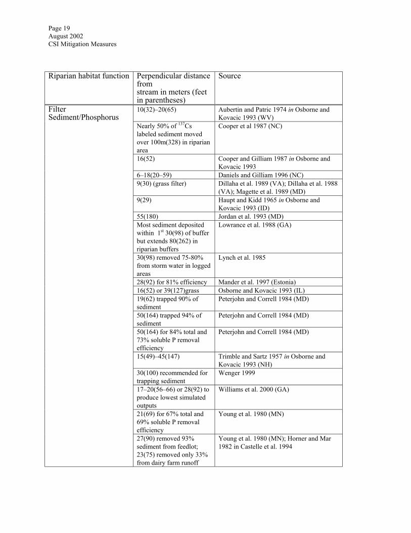
Filter Sediment/Phosphorus
27(90) removed 93% sediment from feedlot; 23(75) removed only 33% from dairy farm runoff
Young et al. 1980 (MN); Horner and Mar 1982 in Castelle et al. 1994
Page 20 August 2002 CSI Mitigation Measures
Riparian habitat function Perpendicular distance
from stream in meters (feet in parentheses)
Source
9(30) (fecal coliform/grass filter)
Coyne et al. 1998 (KY) Filter Contaminants
15–80 (49–262) adequate for nonpoint source pollution
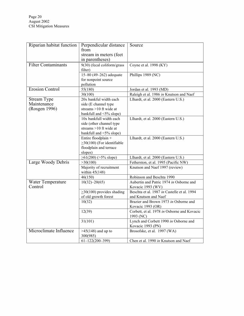
Phillips 1989 (NC)
55(180) Jordan et al. 1993 (MD) Erosion Control 30(100) Raleigh et al. 1986 in Knutson and Naef 20x bankful width each side (E channel type streams >10 ft wide at bankfull and <5% slope)
Llhardt, et al. 2000 (Eastern U.S.)
10x bankfull width each side (other channel type streams >10 ft wide at bankfull and <5% slope)
Llhardt, et al. 2000 (Eastern U.S.)
Entire floodplain + >30(100) (For identifiable floodplain and terrace slopes)
Llhardt, et al. 2000 (Eastern U.S.)
Stream Type Maintenance (Rosgen 1996)
>61(200) (>5% slope) Llhardt, et al. 2000 (Eastern U.S.) >30(100) Fetherston, et al. 1995 (Pacific NW) Majority of recruitment within 45(148)
Knutson and Naef 1997 (review) Large Woody Debris
46(150) Robinson and Beschta 1990 10(32)–20(65) Aubertin and Patric 1974 in Osborne and
Kovacic 1993 (WV) >30(100) provides shading of old growth forest
Beschta et al. 1987 in Castelle et al. 1994 and Knutson and Naef
10(32) Brazier and Brown 1973 in Osborne and Kovacic 1993 (OR)
12(39) Corbett, et al. 1978 in Osborne and Kovacic 1993 (NC)
Water Temperature Control
31(101) Lynch and Corbett 1990 in Osborne and Kovacic 1993 (PN)
>45(148) and up to 300(985)
Brosofske, et al. 1997 (WA) Microclimate Influence
61–122(200–399) Chen et al. 1990 in Knutson and Naef
Page 21 August 2002 CSI Mitigation Measures
Riparian habitat function Perpendicular distance
from stream in meters (feet in parentheses)
Source
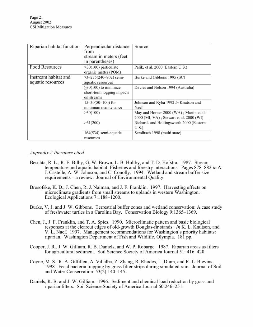
Food Resources >30(100) particulate organic matter (POM)
Palik, et al. 2000 (Eastern U.S.)
73–275(240–902) semi-aquatic resources
Burke and Gibbons 1995 (SC)
>30(100) to minimize short-term logging impacts on streams
Davies and Nelson 1994 (Australia)
15–30(50–100) for minimum maintenance
Johnson and Ryba 1992 in Knutson and Naef
>30(100) May and Horner 2000 (WA) ; Martin et al. 2000 (MI, VA) ; Stewart et al. 2000 (WI)
>61(200) Richards and Hollingsworth 2000 (Eastern U.S.)
Instream habitat and aquatic resources
164(534) semi-aquatic resources
Semlitsch 1998 (multi state)
Appendix A literature cited Beschta, R. L., R. E. Bilby, G. W. Brown, L. B. Holtby, and T. D. Hofstra. 1987. Stream
temperature and aquatic habitat: Fisheries and forestry interactions. Pages 878–882 in A. J. Castelle, A. W. Johnson, and C. Conolly. 1994. Wetland and stream buffer size requirements – a review. Journal of Environmental Quality.
Brosofske, K. D., J. Chen, R. J. Naiman, and J. F. Franklin. 1997. Harvesting effects on
microclimate gradients from small streams to uplands in western Washington. Ecological Applications 7:1188–1200.
Burke, V. J. and J. W. Gibbons. Terrestrial buffer zones and wetland conservation: A case study
of freshwater turtles in a Carolina Bay. Conservation Biology 9:1365–1369. Chen, J., J. F. Franklin, and T. A. Spies. 1990. Microclimatic pattern and basic biological
responses at the clearcut edges of old-growth Douglas-fir stands. In K. L. Knutson, and V. L. Naef. 1997. Management recommendations for Washington’s priority habitats: riparian. Washington Department of Fish and Wildlife, Olympia. 181 pp.
Cooper, J. R., J. W. Gilliam, R. B. Daniels, and W. P. Robarge. 1987. Riparian areas as filters
for agricultural sediment. Soil Science Society of America Journal 51: 416–420. Coyne, M. S., R. A. Gilfillen, A. Villalba, Z. Zhang, R. Rhodes, L. Dunn, and R. L. Blevins.
1998. Fecal bacteria trapping by grass filter strips during simulated rain. Journal of Soil and Water Conservation. 53(2):140–145.
Daniels, R. B. and J. W. Gilliam. 1996. Sediment and chemical load reduction by grass and
riparian filters. Soil Science Society of America Journal 60:246–251.
Page 22 August 2002 CSI Mitigation Measures
Davies, P. E. and M. Nelson. 1994. Relationships between riparian buffer widths and the effects of logging on stream habitat, invertebrate community composition and fish abundance. Australian Journal of Marine and Freshwater Resources 45:1289–1305.
Dillaha, T. A., R. B. Reneau, S. Mostaghimi, and D. Lee. 1989. Vegetative filter strips for
agricultural nonpoint source pollution control. Transactions of the ASAE 32(2):513–519. Dillaha, T. A., J. H. Sherrard, D. Lee, S. Mostaghimi, and V. O. Shanholtz. 1988. Evaluation of
vegetative filter strips as a best management practice for feed lots. Journal of the Water Pollution Control Federation 60(7):1231–1238.
Fetherston, K. L., R. J. Naiman, R. E. Bilby. Large woody debris, physical process, and riparian
forest development in montane river networks of the Pacific Northwest. Geomorphology 13:133–144.
Hanson, G. C., P. M. Groffman, and A. J. Gold. 1994. Denitrification in riparian wetlands
receiving high and low groundwater nitrate inputs. Journal of Environmental Quality 23:917–922.
Horner, R. R. and B. W. Mar. 1982. Guide for water quality impact assessment of
highway operations and maintenance. Pages 878–882 in A. J. Castelle, A. W. Johnson, and C. Conolly. 1994. Wetland and stream buffer size requirements – a review. Journal of Environmental Quality.
Hubbard, R. K. 1997. Riparian buffer systems for managing animal waste. In S. Wenger.
1999. A review of the scientific literature on riparian buffer width, extent and vegetation. Institute of Ecology, University of Georgia, Athens, GA. 59 pp.
Jacobs, T. C. and J. W. Gilliam. 1985. Riparian losses of nitrate from agricultural drainage
waters. Journal of Environmental Quality 14(4):472–478. Johnson, A. W. and D. M. Ryba. 1992. A literature review of recommended buffer widths to
maintain various functions of stream riparian areas. In K.L. Knutson and V. L. Naef. 1997. Management recommendations for Washington’s priority habitats: riparian. Washington Department of Fish and Wildlife, Olympia. 181 pp.
Jordan, T. E., D. L. Correll, and D. E. Weller. 1993. Nutrient interception by a riparian forest
receiving inputs from adjacent cropland. Journal of Environmental Quality 22:467–473. Knutson, K. L. and V. L. Naef. 1997. Management recommendations for Washington’s priority
habitats: riparian. Washington Department of Fish and Wildlife, Olympia. 181 pp. Llhardt, B. L., E. S. Verry, and B. J. Palik. 2000. Defining riparian areas. Pages 23–42 in E. S.
Verry, J. W. Hornbeck, and C. A. Dolloff, eds. Riparian management in forests of the continental eastern United States, Lewis Publishers, Boca Raton, Florida.
Lowrance, R. 1992. Groundwater nitrate and denitrification in a Coastal Plain riparian forest.
Journal of Environmental Quality 21:401–405. Lowrance, R. R., S. McIntyre, and C. Lance. 1988. Erosion and deposition in a
field/forest system estimated using cesium-137 activity. Journal of Soil and Water Conservation 41(4):266–271.
Page 23 August 2002 CSI Mitigation Measures
Lynch, J. A., E. S. Corbett, and K. Mussallem. 1985. Best management practices for controlling
nonpoint source pollution on forested watersheds. Journal of Soil and Water Conservation 40:164–167.
Magette, W. L., R. B. Brinsfield, R. E. Palmer and J. D. Wood. 1989. Nutrient and sediment
removal by vegetated filter strips. Transactions of the ASAE 32(2):663–667. Mander, U., V. Kuusemets, K. Lohmus, and T. Mauring. 1997. Efficiency and dimensioning of
riparian buffer zones in agricultural catchments. Ecological Engineering 8:99–324. Martin, C. O., R. A. Fischer, and H. H. Allen. 2000. Riparian issues on Corps of Engineers and
DOD Military Lands. Pages 317–322 in P. J. Wigington, Jr. and R. L. Beschta, eds. Proceedings of the American Water Resources Association International Conference on riparian ecology and management in multi-land use watersheds, Portland, Oregon.
May, C. W. and R. R. Horner. 2000. The cumulative impacts of watershed urbanization on
stream-riparian ecosystems. Pages 281–286 in P. J. Wigington, Jr. and R. L. Beschta, eds. Proceedings of the American Water Resources Association International Conference on riparian ecology and management in multi-land use watersheds, Portland, Oregon.
Osborne, J. L. and D. A. Kovacic. 1993. Riparian vegetated buffer strips in water-quality
restoration and stream management. Freshwater Biology 29:243–258. Palik, B. J., J. C. Zasada, and C. W. Hedman. 2000. Ecological principles for riparian
silviculture. Pages 233–254 in E. S. Verry, J. W. Hornbeck, and C. A. Dolloff, eds. Riparian management in forests of the continental eastern United States, Lewis Publishers, Boca Raton, Florida.
Peterjohn, W. T., and D. L. Correll. 1984. Nutrient dynamics in an agricultural watershed.
Observations on the role of a riparian forest. Ecology 65:1466–1475. Phillips, J. D. 1989. Nonpoint source pollution control effectiveness of riparian forests along a
Coastal Plain river. Journal of Hydrology 110:221–237. Raleigh, R. F., T. Hickman, R. C. Soloman, and P. C. Nelson. 1984. Habitat suitability
information: rainbow trout. In K. L. Knutson, and V. L. Naef. 1997. Management recommendations for Washington’s priority habitats: riparian. Washington Department of Fish and Wildlife, Olympia. 181 pp.
Richards, C., and B. Hollingsworth. 2000. Managing riparian areas for fish. Pages 157–168 in
E. S. Verry, J. W. Hornbeck, and C. A. Dolloff, eds. Riparian management in forests of the continental eastern United States, Lewis Publishers, Boca Raton, Florida.
Robison, E. G., and R. L. Beschta. 1990. Identifying tress in riparian areas that can provide
coarse woody debris to streams. Forestry Science 36:790–801. Semilitsch, R. D. 1998. Biological delineation of terrestrial buffer zones for pond-breeding
salamanders. Conservation Biology 12:1113–1119. Spruill, T. B. 2000. Statistical evaluation of effects of riparian buffers on nitrate and ground
water quality. Journal of Environmental Quality 29:1523–1538.
Page 24 August 2002 CSI Mitigation Measures
Stewart, J. S., D. M. Downes, L.Wang, J. A. Wierl, and R. Bannerman. 2000. Influences of
riparian corridors on aquatic biota in agricultural watersheds. Pages 209–214 in P. J. Wigington, Jr. and R. L. Beschta, eds. Proceedings of the American Water Resources Association International Conference on riparian ecology and management in multi-land use watersheds, Portland, Oregon.
Wenger, S. 1999. A review of the scientific literature on riparian buffer width, extent and
vegetation. Institute of Ecology, University of Georgia, Athens, GA. 59 pp. Williams, R. G., R. Lowrance, and S. P. Inamdar. 2000. Simulation of nonpoint source
pollution control using the riparian ecosystem management model (REMM). Pages 433–438 in P. J. Wigington, Jr. and R. L. Beschta, eds. Proceedings of the American Water Resources Association International Conference on riparian ecology and management in multi-land use watersheds, Portland, Oregon.
Young , R. A., T. Huntrods, and W. Anderson. 1980. Effectiveness of vegetated buffer strips in
controlling pollution from feedlot runoff. Journal of Environmental Quality 9(3):483–487.

Related Documents