Niobrara, Lower Platte, and Kansas River Basin Calendar Year 2015 Summary of Actual Operations and Calendar Year 2016 Annual Operating Plans U.S. Department of Interior Bureau of Reclamation Great Plains Region

Welcome message from author
This document is posted to help you gain knowledge. Please leave a comment to let me know what you think about it! Share it to your friends and learn new things together.
Transcript
Niobrara, Lower Platte, andKansas River Basin
Calendar Year 2015 Summary of Actual Operations
and
Calendar Year 2016 Annual Operating Plans
U.S. Department of InteriorBureau of ReclamationGreat Plains Region
CONTENTS
Page SYNOPSIS ............................................................................................................................ 1
General ................................................................................................................................ 1 2015 Summary .................................................................................................................... 1 2016 Outlook ....................................................................................................................... 5
HEADLINES 2015 ............................................................................................................... 6
CHAPTER I - INTRODUCTION ...................................................................................... 7 Purpose of This Report ........................................................................................................ 7 Operational Responsibilities ................................................................................................ 7 Tables and Exhibits ............................................................................................................. 8 Water Supply ....................................................................................................................... 8 Reservoir Operations ........................................................................................................... 8 Major Features ..................................................................................................................... 8 Irrigation and Reclamation Districts .................................................................................... 9 Municipal Water .................................................................................................................. 9 Fish and Wildlife ................................................................................................................. 9 State of Colorado Division of Wildlife ................................................................................ 9 State of Kansas Department of Wildlife, Parks and Tourism ............................................ 10 Power Interference Considerations .................................................................................... 10 Environmental Considerations ........................................................................................... 10 Republican River Compact - Kansas v. Nebraska ............................................................. 10 Republican River Basin Study ........................................................................................... 11 Niobrara River Basin Study ............................................................................................... 12 Emergency Management ................................................................................................... 12 Public Safety Reviews ....................................................................................................... 13
CHAPTER II - NIOBRARA AND LOWER PLATTE RIVER BASINS ..................... 13 Mirage Flats Project in Nebraska ....................................................................................... 13 Ainsworth Unit, Sandhills Division in Nebraska ............................................................... 15 North Loup Division in Nebraska ...................................................................................... 17
CHAPTER III - REPUBLICAN RIVER BASIN ........................................................... 19 Armel Unit, Upper Republican Division in Colorado ....................................................... 19 Frenchman Unit, Frenchman-Cambridge Division in Nebraska ........................................ 20
Meeker-Driftwood, Red Willow, and Cambridge Units, Frenchman-Cambridge Division in Nebraska ............................................................... 21
Almena Unit, Kanaska Division in Kansas ........................................................................ 23 Franklin, Superior-Courtland, and Courtland Units,
Bostwick Division in Nebraska and Kansas .................................................................. 24
CHAPTER IV - SMOKY HILL RIVER BASIN .......................................................... 27 Kirwin Unit, Solomon Division in Kansas ........................................................................ 27 Webster Unit, Solomon Division in Kansas ...................................................................... 28 Glen Elder Unit, Solomon Division in Kansas .................................................................. 29 Cedar Bluff Unit, Smoky Hill Division in Kansas ............................................................. 31
LIST OF TABLES (all following page 32) 1 - Reservoir Data - Niobrara, Lower Platte and Kansas River Basins
(Capacity Allocations) 2 - Summary of 2015 Operations
Mirage Flats Project, Sandhills Division, and North Loup Division, Sheet 1 of 5 Upper Republican Division, Sheet 2 of 5 Frenchman-Cambridge Division, Sheet 3 of 5 Kanaska and Bostwick Divisions, Sheet 4 of 5 Solomon and Smoky Hill Divisions, Sheet 5 of 5
3 - Acres Irrigated in 2015 and Estimates for 2016 4 - Operation Estimates - 2016
Box Butte Reservoir, Sheet 1 of 16 Merritt Reservoir, Sheet 2 of 16 Calamus Reservoir, Sheet 3 of 16 Davis Creek Reservoir, Sheet 4 of 16 Bonny Reservoir, Sheet 5 of 16 Enders Reservoir, Sheet 6 of 16 Swanson Lake, Sheet 7 of 16 Hugh Butler Lake, Sheet 8 of 16 Harry Strunk Lake, Sheet 9 of 16 Keith Sebelius Lake, Sheet 10 of 16 Harlan County Lake, Sheet 11 of 16 Lovewell Reservoir, Sheet 12 of 16 Kirwin Reservoir, Sheet 13 of 16 Webster Reservoir, Sheet 14 of 16 Waconda Lake, Sheet 15 of 16 Cedar Bluff Reservoir, Sheet 16 of 16
5 - Flood Damages Prevented by Nebraska-Kansas Projects Reservoirs 6 - Water Diverted in 2015 and Estimated Diversion for 2016 7 - Summary of Precipitation, Reservoir Storage and Inflows

LIST OF EXHIBITS (all following Table 7)
Historical 2016 Name of Reservoir Operation Oper
ation
Box Butte Reservoir 1A 1B Merritt Reservoir 2A 2B Calamus Reservoir 3A 3B Davis Creek Reservoir 4A 4B Bonny Reservoir 5A 5B Enders Reservoir 6A 6B Swanson Lake 7A 7B Hugh Butler Lake 8A 8B Harry Strunk Lake 9A 9B Keith Sebelius Lake 10A 10B Harlan County Lake 11A 11B Lovewell Reservoir 12A 12B Kirwin Reservoir 13A 13B Webster Reservoir 14A 14B Waconda Lake 15A 15B Cedar Bluff Reservoir 16A 16B
Canal Diversions and Acres Irrigated
17 - Mirage Flats Irrigation District 18 - Ainsworth Irrigation District 19 - Twin Loups Irrigation District 20 - Frenchman Valley Irrigation District 21 - H&RW Irrigation District 22 - Frenchman-Cambridge Irrigation District 23 - Almena Irrigation District 24 - Bostwick Irrigation District in Nebraska 25 - Kansas-Bostwick Irrigation District 26 - Kirwin Irrigation District 27 - Webster Irrigation District 28 - Glen Elder Irrigation District

1
SYNOPSIS General This year is the sixty-third consecutive year that an Annual Operating Plan (AOP) has been prepared for the Federally-owned dams and reservoirs in the Niobrara, Lower Platte, and Kansas River basins. The plan has been developed by the Water Operations Group in McCook, Nebraska for the 16 dams and reservoirs that are located in Colorado, Nebraska, and Kansas. These reservoirs, together with nine diversion dams, nine pumping plants, and 20 canal systems, serve approximately 269,745 acres of project lands in Nebraska and Kansas. In addition to irrigation and municipal water, these features serve flood control, recreation, and fish and wildlife purposes. A map at the end of this report shows the location of these features. The reservoirs in the Niobrara and Lower Platte River Basins are operated by either irrigation or reclamation districts. The reservoirs in the Kansas River Basin are operated by either the Bureau of Reclamation or the Corps of Engineers. Kirwin Irrigation District provides operational and maintenance assistance for Kirwin Dam. The diversion dams, pumping plants, and canal systems are operated by either irrigation or reclamation districts. A Supervisory Control and Data Acquisition System located in McCook, Nebraska is used to assist in operational management of all 11 dams under Reclamation's jurisdiction that are located in the Kansas River Basin. A Hydromet system collects and stores near real time data at selected stations in the Nebraska-Kansas Projects. The data includes water levels in streams, canals, and reservoirs and also gate openings. This data is transmitted to a satellite and downloaded to a Reclamation receiver in Boise, Idaho. The data can then be accessed by anyone interested in monitoring water levels or water usage in an irrigation system. The Nebraska-Kansas projects currently have 60 Hydromet stations that can be accessed. The Nebraska-Kansas Area Office (NKAO) has installed and maintains 41 of these Hydromet stations. These stations can be found on the Internet by accessing Reclamation’s home page at http://www.usbr.gov/gp. From the home page, select “Hydromet–Hydrological Data Center” under the Water Operations heading. On page 6 “The Headlines 2015”, which follows this synopsis is indicative of the awareness that the local residents have of the natural resource development and conservation in the Niobrara, Lower Platte, and Kansas River Basins. 2015 Summary Climatic Conditions Precipitation at the project dams during 2015 ranged from 92 percent of normal at Webster Dam to 148 percent of normal near Box Butte Dam. Annual precipitation was above normal for 13 of the 16 project dams. Temperatures in January and March 2015 were generally above normal, while temperatures in February 2015 were typically below normal throughout the project area. Precipitation in January 2015 was well below the normal average for most of the projects. February 2015 precipitation ranged drastically from zero percent to 340 percent. March 2015 precipitation was well below normal with all of the project dams below 26 percent of the average. Temperatures in April 2015 were generally above normal while in May 2015 they were
2
generally below normal. Precipitation during April 2015 was generally above average with only four project dams below average. May 2015 precipitation was well above normal at most of the project dams. Eleven of the project dams received four or more inches of precipitation and five of the project dams received over seven inches of precipitation. Temperatures in July and August 2015 were generally below normal, while temperatures in June 2015 were typically above normal throughout the project area. Total precipitation for June 2015 ranged from 24 percent to 188 percent. July and August 2015 precipitation was above normal for ten of the project dams. Precipitation recorded in September 2014 ranged from six percent to 306 percent. October 2014 precipitation ranged from 37 percent to 264 percent. November 2014 precipitation was one of the best on record with ranges from 130 percent to 440 percent of normal. In December 2014, precipitation was widely ranged but was very favorable for project dams in the Kansas River and Niobrara Basins. Temperatures in the fall and winter were generally above the normal average. Storage Reservoirs Conservation Operations: The 2015 inflow was below the dry year forecast for Hugh Butler Lake. Inflows at Swanson Lake, Harry Strunk Lake and Lovewell Reservoir were between the normal year and wet year forecasts. The inflows for Box Butte Reservoir and Merritt Reservoir were above the wet year forecast. The remaining reservoirs had inflows between the dry year and normal year forecasts. Fourteen of the sixteen reservoirs had below average carryover storage from the 2014 water year. Reservoir releases were made from Merritt, Virginia Smith, Medicine Creek, and Lovewell Dams to maintain or reduce reservoir levels prior to the 2015 irrigation season. Box Butte, Enders, and Webster Reservoirs, along with Swanson, Hugh Butler, Keith Sebelius, and Harlan County Lakes did not have sufficient storage to provide water users with a full water supply. Lovewell Reservoir, Harry Strunk Lake, and Waconda Lake utilized some flood pool storage during 2015. Irrigation demands greatly reduced the storage in several project reservoirs throughout the summer. Reservoir storage was below average at twelve of the sixteen reservoirs at the end of 2015. On September 20, 2011, the State of Colorado ordered that Bonny Reservoir be drained for Republican River Compact compliance. All of the water in Bonny Reservoir was evacuated by the end of May 2012 and no storage has been recorded since. The State of Colorado order remains in effect and inflows continue to be bypassed. On January 1, 2015 the State of Nebraska, Department of Natural Resources (NDNR) determined a “Compact Call Year” (Compact Call) to be in effect on the Republican River Basin for the third consecutive year. The Compact Call resulted in the NDNR issuing closing notices on all natural flow and storage permits in the basin until such time that the NDNR determines that early administration is no longer needed to ensure Republican River Compact compliance. All surface water appropriations in the Republican River Basin above Guide Rock Diversion Dam were closed on January 1, 2015. On February 26, 2015 the NDNR notified Reclamation that storage in the reservoirs could resume and that all water being stored under the Compact
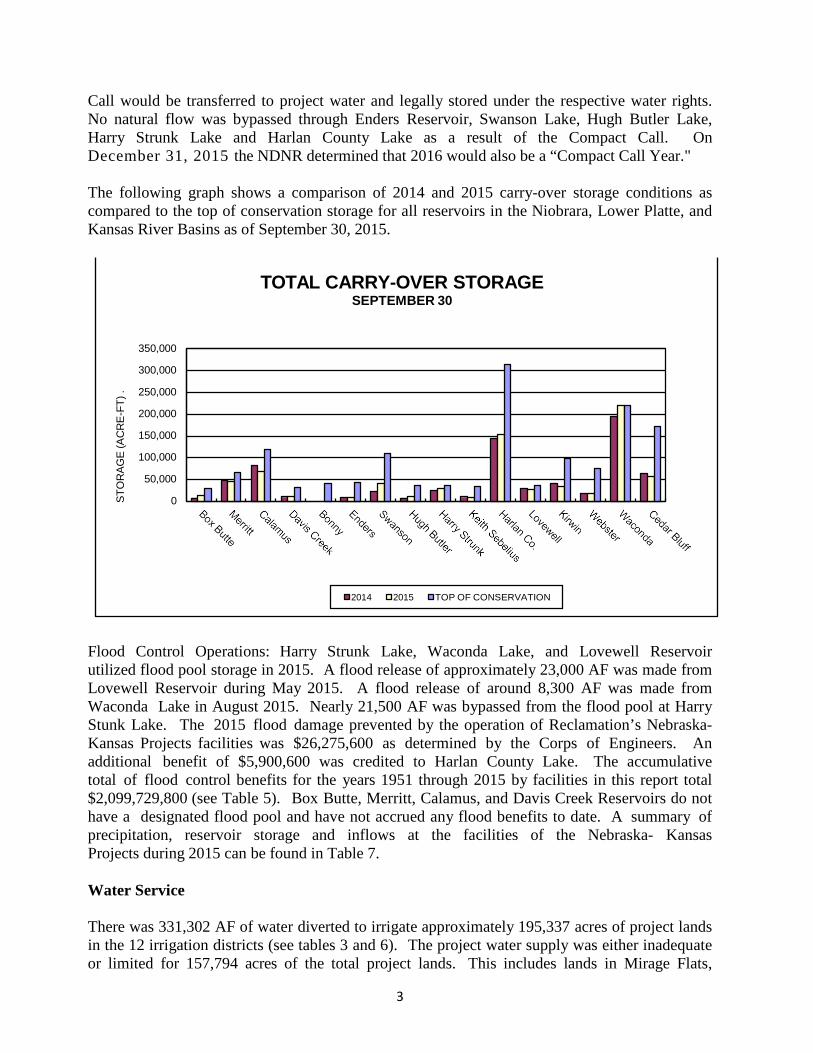
3
Call would be transferred to project water and legally stored under the respective water rights. No natural flow was bypassed through Enders Reservoir, Swanson Lake, Hugh Butler Lake, Harry Strunk Lake and Harlan County Lake as a result of the Compact Call. On December 31, 2015 the NDNR determined that 2016 would also be a “Compact Call Year." The following graph shows a comparison of 2014 and 2015 carry-over storage conditions as compared to the top of conservation storage for all reservoirs in the Niobrara, Lower Platte, and Kansas River Basins as of September 30, 2015. Flood Control Operations: Harry Strunk Lake, Waconda Lake, and Lovewell Reservoir utilized flood pool storage in 2015. A flood release of approximately 23,000 AF was made from Lovewell Reservoir during May 2015. A flood release of around 8,300 AF was made from Waconda Lake in August 2015. Nearly 21,500 AF was bypassed from the flood pool at Harry Stunk Lake. The 2015 flood damage prevented by the operation of Reclamation’s Nebraska-Kansas Projects facilities was $26,275,600 as determined by the Corps of Engineers. An additional benefit of $5,900,600 was credited to Harlan County Lake. The accumulative total of flood control benefits for the years 1951 through 2015 by facilities in this report total $2,099,729,800 (see Table 5). Box Butte, Merritt, Calamus, and Davis Creek Reservoirs do not have a designated flood pool and have not accrued any flood benefits to date. A summary of precipitation, reservoir storage and inflows at the facilities of the Nebraska- Kansas Projects during 2015 can be found in Table 7. Water Service There was 331,302 AF of water diverted to irrigate approximately 195,337 acres of project lands in the 12 irrigation districts (see tables 3 and 6). The project water supply was either inadequate or limited for 157,794 acres of the total project lands. This includes lands in Mirage Flats,
STO
RAG
E (A
CR
E-F
T) .
2014 2015 TOP OF CONSERVATION
TOTAL CARRY-OVER STORAGE SEPTEMBER 30
350,000
300,000
250,000
200,000
150,000
100,000
50,000
0

4
Frenchman Valley, H&RW, Frenchman-Cambridge, Almena, Bostwick in Nebraska, Kansas Bostwick, and Webster Irrigation Districts. The project water supplies for the other units mentioned in this report were adequate in 2015. The water requirements of three municipalities, one rural water district, and two fish hatchery facilities were met in 2015. Both storage releases and natural flows are utilized in meeting these demands. Fish and Wildlife and Recreation Benefits The National Recreational Fisheries Policy declares that the Government’s vested stewardship responsibilities must work in concert with the state managing agency’s recreational fisheries constituency and the general public to conserve, restore, and enhance recreational fisheries and their habitats. The NKAO is available for meetings if requested with Nebraska, Colorado, and Kansas state management agencies to discuss the AOP. Information is solicited from the agencies to enhance fisheries resources within the flexibility allowed while still meeting contractual obligations with the various irrigation districts. Reservoir operations were favorable for recreation and fish and wildlife uses in 2015 at those project reservoirs with full or nearly full conservation pools prior to the irrigation season. The higher water levels experienced early in the year submerged existing shoreline vegetation. Normal irrigation demands and the lack of precipitation during the summer greatly reduced the pool levels at several reservoirs allowing for late summer shoreline revegetation. The draining of Bonny Reservoir and the State administration of storage rights in southwest Nebraska reservoirs in previous years diminished recreation benefits at these facilities. 2016 Outlook Three forecast conditions have been developed for each of the reservoirs in the Niobrara, Lower Platte, and Kansas River Basins conforming to established operating criteria under various reservoir inflow conditions. These operation studies are included in Table 4, sheets 1 through 16. The municipal and rural water district water supply requirements will be met under all three inflow forecast conditions for all units. Under reasonable minimum inflow forecast conditions, irrigation districts receiving storage water from the following lakes and reservoirs are expected to receive less than a full supply: Box Butte, Enders, Swanson, Hugh Butler, Harry Strunk, Keith Sebelius, Harlan County, Lovewell, Kirwin, and Webster. The irrigation districts affected are Mirage Flats; Frenchman Valley and H&RW; Frenchman-Cambridge; Almena; Bostwick in Nebraska; Kansas Bostwick; Kirwin; and Webster; respectively. If 2016 is a dry year, 169,259 of the total 269,745 acres with service available to be irrigated (63 percent) will have an inadequate water supply. Under most probable inflow conditions, it is expected that Mirage Flats, Frenchman Valley, H&RW, Frenchman-Cambridge, Almena, and Webster Irrigation Districts would experience some shortages to irrigation demands from Box Butte Reservoir, Enders Reservoir, Swanson Lake, Hugh Butler Lake, Harry Strunk Lake, Keith Sebelius Lake, and Webster Reservoir. Most irrigators in these districts plan to use water from private wells to supplement the project water
5
supply. Even under reasonable maximum inflow conditions, Frenchman Valley and H&RW Irrigation Districts are expected to experience irrigation demand shortages from Enders Reservoir. Under reasonable minimum inflow conditions, the conservation pools at Merritt, Calamus, Davis Creek, and Lovewell Reservoirs, and Harry Strunk Lake are expected to fill during 2016. Even with low reservoir levels and inadequate water supplies for some project lands, the recommendations of various state agencies will be considered. As in the past, irrigation and reclamation districts will advise state agencies regarding aquatic weed control and canal operations. Reclamation will continue to operate the reservoirs and other facilities under its jurisdiction in the best interests of all project functions and for the optimum public benefit. Water is not expected to be stored in Bonny Reservoir during 2016 as the State of Colorado’s order to bypass all inflows remains in effect. Bonny Reservoir was drained in 2012 by order of the State of Colorado to assist in meeting Republican River Compact compliance.

6
Nebraska, Kansas and Coloradocontinue cooperation with wat
Nebraska joins 12 other states in suing over new U.S. federal water rules
New water management plan adopted by URNRD
URNRD approves $2.5 million to study flood water diver sion from South Platte
URNRD required to make up 14,600 AF in 2015
Pumping shut down on Rock Creek Project
U.S. Supreme Court ruling favors Nebraska on imported water
2015 HEADLINES
er

7
CHAPTER I – INTRODUCTION Purpose of This Report This AOP advises water users, cooperating agencies, and other interested groups or persons of the actual operations during 2015 and serves as a guideline for the 2016 operations. This report also describes the responsibilities of Reclamation, Corps of Engineers, and the irrigation and reclamation districts in the Niobrara, Lower Platte, and Kansas River Basins. Operational Responsibilities Reclamation is responsible for irrigation operations at all federal reservoirs in the Nebraska-Kansas Projects. Reclamation is also responsible for the operation and maintenance (O&M), safety of the structure, and reservoir operations not specifically associated with regulation of the flood control storage at the reservoirs constructed by Reclamation. Regulation of the flood control storage is the responsibility of the Corps of Engineers. In addition to irrigation and flood control, these reservoirs provide recreation, fish and wildlife, and municipal water supply benefits. By contractual arrangements with Reclamation, the irrigation or reclamation districts in the Niobrara, Lower Platte, and Kansas River Basins are responsible for the O&M of the canals and irrigation distribution facilities constructed or rehabilitated by Reclamation. In addition, the appropriate irrigation or reclamation districts are responsible for operating and maintaining Box Butte, Merritt, Virginia Smith and Davis Creek Dams. The Corps of Engineers operates and maintains Harlan County Dam and Lake. The State of Colorado provides operational guidelines for Bonny Reservoir. Operational guidelines for Cedar Bluff Reservoir are provided by the State of Kansas. Reclamation operates and maintains eleven dams and reservoirs in the Republican, Solomon, and Smoky Hill River Basins. Under a contract with Reclamation, Kirwin Irrigation District performs certain operational and maintenance functions at Kirwin Dam. An updated Field Working Agreement was executed on July 17, 2001 between the Corps of Engineers and Reclamation regarding operation of Harlan County Dam and Lake. The agreement provides for a sharing of the decreasing water supply into Harlan County Lake. Storage capacity allocations were redefined based on the 2000 sediment survey and a procedure was established for sharing the reduced inflow and summer evaporation among the various lake uses. The States of Nebraska, Colorado, and Kansas are responsible for the administration and enforcement of their state laws pertaining to the water rights and priorities of all parties concerned with the use of water. As provided by the lease agreement between Reclamation and the states, the states are responsible for administering the water surface activities and the federal lands around the reservoirs. The U.S. Fish and Wildlife Service administer the water surface activities and most of the federal lands at Kirwin Reservoir. Reclamation cooperates with all state agencies and compact commissions to ensure that all operations are in compliance with state laws and compact requirements.
8
Tables and Exhibits Records for the facilities reported in the AOP are included as tables and exhibits and are located following page 32. Water Supply For forecasting purposes, values of annual inflows that will be statistically equaled or exceeded 10, 50 and 90 percent of the time were selected from the probability data to be reasonable maximum (wet year), most probable (normal year), and reasonable minimum (dry year) inflow conditions, respectively. Inflow records from 1996 through 2015 were used for the analysis of reservoirs in the Niobrara, Lower Platte and Kansas River Basins. Reservoir Operations All operations are scheduled for optimum benefits of the authorized project functions. Monthly or as often as runoff and weather conditions dictate. Reclamation evaluates the carry-over storage and estimated inflow at each reservoir to determine whether excess water is anticipated. If excess inflow is apparent, controlled releases will be made to maximize the downstream benefits. Major Features The Mirage Flats Project was constructed under the Water Conservation and Utilization Act and includes an irrigation storage reservoir, diversion dam and canal system. The other features discussed in this report are all a part of the Pick-Sloan Missouri Basin Program and include single and multipurpose reservoirs, diversion dams, pump stations and canal systems. The sixteen storage facilities now in operation are listed below.
Constructed by Reclamation
1. Operated by irrigation or reclamation districts-Box Butte and Merritt Dams in the Niobrara River Basin and Virginia Smith and Davis Creek Dams in the Lower Platte River Basin.
2. Operated by Reclamation--Bonny, Trenton, Enders, Red Willow, Medicine Creek, Norton, Lovewell, Kirwin, Webster, Glen Elder, and Cedar Bluff Dams in the Kansas River Basin. A contract provides for Kirwin Irrigation District to perform certain operational and maintenance functions at Kirwin Dam.
Constructed and Operated by the Corps of Engineers
1. Harlan County Dam in the Kansas River Basin.

9
Irrigation and Reclamation Districts Twelve irrigation districts and one reclamation district in the Niobrara, Lower Platte, and Kansas River Basins have contracted with Reclamation for water supply and irrigation facilities. The Twin Loups Irrigation District has contracted their O&M responsibilities to the Twin Loups Reclamation District. Bostwick Irrigation District in Nebraska has contracted their O&M responsibilities for Superior-Courtland Diversion Dam and the Courtland Canal between the head gates and the Nebraska-Kansas state line to Kansas Bostwick Irrigation District. The contracted irrigation season for Mirage Flats Irrigation District is April through September. The contracted irrigation season for Frenchman-Cambridge Irrigation District is April 15 through October 15 or such additional period from April 1 to April 15 of each year as may be agreed upon between the District and Reclamation. The contracted irrigation season for Frenchman Valley and H&RW Irrigation Districts is from May 1 through October 15 or such additional period from April 1.through May 1 of each year as determined between the District and Reclamation. The contracted irrigation season for Twin Loups Reclamation District and Almena, Bostwick in Nebraska and Kansas Bostwick Irrigation Districts is May 1 through September 30 or such additional period from April 1 through November 15 of each year as determined between the District and Reclamation. For Ainsworth, Kirwin and Webster Irrigation Districts, the contracted irrigation season is from May 1 through September 30. Municipal Water Three municipalities in Kansas (Norton, Russell, and Beloit) and one rural water district in Kansas (Mitchell County Rural Water District No. 2) have executed water service contracts or repayment contracts for full or supplemental water supplies. Fish and Wildlife The Calamus Fish Hatchery is located below Virginia Smith Dam and Calamus Reservoir. The hatchery is operated and maintained by the Nebraska Game and Parks Commission (Commission) and produces approximately 53 million fish per year. The water supply is provided by natural flows passed through Virginia Smith Dam and from Calamus Reservoir storage through an agreement dated July 28, 1988, between the Commission and the Twin Loups Reclamation District. The State of Kansas is presently using the fish hatchery facility below Cedar Bluff Reservoir for waterfowl habitat. State of Colorado Division of Wildlife The State of Colorado provides operational guidelines for Bonny Reservoir. The entire conservation pool storage was purchased by the State of Colorado on June 24, 1982.
10
State of Kansas Department of Wildlife, Parks and Tourism (KDWPT) The State of Kansas acquired the use and control of portions of the conservation capacity at Cedar Bluff Reservoir following the reformulation of the Cedar Bluff Unit in October of 1992. The City of Russell's existing water storage right and contract with the United States remained unchanged. Power Interference Considerations A Power Interference Agreement exists between Reclamation, the Twin Loups Reclamation District, and the Loup River Public Power District. Subordination Agreements also exist between Reclamation, the Ainsworth Irrigation District, and the Nebraska Public Power District and between Reclamation, the Mirage Flats Irrigation District and the Nebraska Public Power District. Provisions of these agreements will be incorporated into the 2016 operations. Environmental Considerations A "Statement of Operational Objectives" for Harlan County Lake sets forth the general operational objectives and the specific reservoir uses that are desirable. The operational objectives indicate that fish and wildlife interests are best served by high reservoir levels with minimum fluctuations, and regulation of the outflow in excess of the minimum desired flows. Although the statement recognizes flood control and irrigation as primary purposes, it indicates that comprehensive operational plans should be developed for maximum integration of the secondary uses. These operational objectives are also considered in the operation of all Reclamation reservoirs in the Kansas River Basin, Niobrara River Basin, and the Lower Platte River Basin. The regulated outflow can also benefit farmers, ranchers, cities, and other interests below the reservoirs. Republican River Compact – Kansas v. Nebraska On May 26, 1998, Kansas filed a petition with the U. S. Supreme Court stating that Nebraska had violated the Republican River Compact by using more than its share of the Republican River water supply. The three original parties to the Republican River Compact; Kansas, Nebraska and Colorado, became parties to the case. Because the major water development structures in the Republican River Basin were constructed by the Bureau of Reclamation and the Corps of Engineers, the United States was allowed to participate as amicus curiae. After seventeen months of negotiations, the Final Settlement Stipulation (Stipulation) was signed by each respective governor and attorney general and was filed with the Special Master on December 16, 2002. The United States Supreme Court approved the settlement and dismissed the case on May 19, 2003. The settlement provides for a moratorium on new groundwater wells, special rules for administration of water during water short years, protection of storage releases, minimized flood flow effects on the accounting, recognition by Nebraska of a 1948 priority date for the Kansas Bostwick Irrigation District, inclusion of the impacts of groundwater pumping from table and wells in the accounting, and accounting for all reservoirs 15 AF and larger within the river basin.
11
The Stipulation also required that Colorado, Kansas and Nebraska, in cooperation with the United States, form a Conservation Committee to develop a proposed study plan to determine the quantitative effects of non-federal reservoirs and land terracing practices on water supplies in the Republican River Basin above Hardy, Nebraska. The study plan supported by Colorado, Kansas and Nebraska, the Natural Resources Conservation Service, and Reclamation was completed and signed on April 28, 2004. Cooperative agreements for completing the five year study were developed between Reclamation, the University of Nebraska-Lincoln (UNL), and Kansas State University. Installation of data loggers on 35 reservoirs throughout the basin was completed in 2004. Advanced monitoring equipment for terraces and additional reservoirs was installed by UNL in 2006. Data collection and model development continued through 2009. The Conservation Committee presented a Summary Report of Preliminary Findings for the study at the 2011 Republican River Compact annual meeting held in Burlington, Colorado on August 31, 2011. The Republican River Compact Administration (RRCA) reviewed the report and determined a formal study report was needed. The final report was released in June of 2014. Water Short Year Administration will be in effect in those years in which the projected or actual irrigation supply is less than 119,000 AF of storage available for use from Harlan County Lake as determined by Reclamation. It was determined that Water Short Year Administration would be in effect in 2015. Republican River Basin Study In early 2016, the Republican River Basin Study (Basin Study) was completed. The Basin Study represented an extensive collaborative effort among the states of Colorado, Kansas, and Nebraska to identify adaptation strategies that address current and future water management challenges in the basin. The Basin Study found that climate change may have a pronounced impact on future supplies and demands across the basin. The modeling tools developed under the study were used to evaluate alternatives to improve the supply reliability at the Frenchman-Cambridge Irrigation District in Nebraska, as well as the Bostwick Irrigation Districts in Nebraska and Kansas. Nebraska focused on augmenting the supply of Swanson Lake and creating new surface water storage on Thompson Creek, a tributary of the Republican River. Kansas evaluated alternatives that increase the storage volume at Lovewell Reservoir. The newly developed ground and surface water modeling tools will help inform future water management decisions that help build resiliency against future climate change, while also maintaining compliance with the Republican River Compact. The Basin Study is a part of Reclamation’s WaterSMART Program. The report is available online at www.usbr.gov/watersmart/bsp.

12
Niobrara River Basin Study The Niobrara River Basin Study was completed and submitted in November 2015 to the Office of Policy to begin the internal review process. The Niobrara River Basin Study is a collaborative effort by NDNR and Reclamation to evaluate current and future water supply and demand and to collaborate with stakeholders in the region to identify potential adaptation strategies to reduce any identified gaps. The overarching study objectives were to identify the effects of climate change on future water supplies and identify potential management actions in the basin. The Niobrara River Basin Study relies on an integrated surface-groundwater model to assess hydrological effects of proposed alternatives aimed at improving basin resiliency. Potential management actions were evaluated in an effort to address the gap between water supply and demand. Alternative 1 proposes a structural change with construction of the Mirage Flats Pumping Station which would reduce canal seepage during surface water delivery leaving more surface water in the system. Alternative 2 proposes an operational change by using the Mirage Flats main canal and lateral system to recharge local groundwater. Both Alternatives result in Box Butte Reservoir levels that are higher than the Future No Action alternative due to increased canal delivery efficiencies in one scenario and lower irrigation diversions in the other scenario. Furthermore, both strategies generally exceed those of a No Action scenario; showing potential for future consideration as additional analysis in the basin is conducted. The study confirms that the Niobrara River faces a range of potential future imbalances between water supply and demand. Addressing such imbalances may require additional analysis and may not be resolved through any single approach or alternative. Integrated water models and related analysis developed in this study are a useful resource that can assist stakeholders in the basin as they continue coordinated efforts to improve system reliability and develop strategies that address the basin’s needs. Emergency Management The NKAO continues to coordinate with local jurisdictions that could potentially be impacted by flooding from large operational releases and/or dam failure. Tabletop Exercises of the Emergency Action Plans (EAP) for Box Butte, Kirwin, Lovewell, and Merritt Dams were held in 2015. Tabletop exercises will be held for Glen Elder and Webster Dams, and a Functional Exercise will be held for the Norton Dam EAP in 2016. Communications Directories for all of the EAPs are reviewed annually. Emergency radios have been installed at all dams. These radios will be used as a backup means of communication when notifying the local emergency management officials in the event of an emergency at the dam. The NKAO has two satellite phones that can be used in an emergency. Management and dam operators have been trained on the use of these phones.

13
Public Safety Reviews The Annual Safety Training for field personnel was held in McCook, Nebraska in the spring of 2015. This training provided personnel the opportunity to update their training in Fall Protection, Hazardous Energy Control Program, Confined Space, Defensive Driving, First Aid, CPR, AED, Chainsaw Use, Welding and Cutting, Herbicide/Pesticide Safety, Security, and Respirator Training and Fit Testing. The ongoing safety reviews of project facilities continue to identify potential safety hazards to the public and operating personnel. NKAO combines elements of the Annual Safety Inspections of the major facilities with the Dam Safety Facility Reviews when possible, and conducts follow up inspections when deficiencies are not on-the-spot correctible. This format provides for enhanced communication and coordination between both the Area Safety Specialist and Staff, and teams of Dam Safety Specialists. NKAO continues to involve Great Plains Region Safety and Occupational Health in Billings, Montana when maintenance and operational items, such as replacing AED batteries and pads, and reprogramming CPR protocol, is required. Attention continues with regard to issues concerning contractor safety, defensive driving, National Fire Protection Association 70E Electrical Safety/Arc Flash, construction equipment safety, lock out/tag out, personal protective equipment, welding, cutting, coating safety procedures, confined space, pesticide and herbicide use, fall protection/slips, trips, and falls, working alone, near-miss accident reporting, and completing job hazard analyses, with emphasis from managers, supervisors, employees, and the NKAO Safety Committee. Guidance contained in the Reclamation Safety and Occupational Health Plan is incorporated. Employees were provided safety and health training and given information related to these and several other issues throughout the year.
CHAPTER II - NIOBRARA AND LOWER PLATTE RIVER BASINS Mirage Flats Project in Nebraska General Flows in the Niobrara River along with Box Butte Reservoir storage provide a water supply for the 11,662 acre Mirage Flats Project. From 2006 to 2015, the project water supply averaged 9,338 AF, which is about 0.80 AF per irrigable acre. Many irrigators supplement their water supply with private wells. The Mirage Flats Irrigation District cooperates with the Commission by operating the Box Butte Dam outlet works gate and the Dunlap Diversion Dam gates in a manner to avoid sudden large changes in the flows of the Niobrara River. A 30-year agreement was made in 1990 between the district and the Commission whereby the district would not draw the reservoir water level below elevation 3978.00 feet (2,026 AF). In return the district received an up-front payment which was used to improve the efficiency of the project's delivery system. On March 17, 2000, the district agreed to increase the minimum reservoir level by one additional foot to an elevation of 3979.00 feet (2,392 AF). In return the district received an

14
additional payment from the Commission for the 20 years left on the original agreement. A data collection platform was installed in May of 1992 to monitor the reservoir elevation and outflow at Box Butte Dam. A telephone ( primary communication system), and a radio ( backup communication system) have been installed at the outlet works for contacting the Region 23 Emergency Management Agency. 2015 Summary The flows of the Niobrara River plus the carry-over storage in Box Butte Reservoir were not adequate to provide a full water supply for the project lands. Precipitation in the Mirage Flats Irrigation District totaled 25.10 inches, which is 148 percent of normal. The 2015 total inflow of 20,980 AF was above the wet-year forecast. May 2015 inflow was the second greatest recorded and June 2015 inflow was the greatest recorded for the respective months in nearly 50 years. The reservoir level began 2015 at an elevation of 3992.51 feet (14.5 feet below the top of conservation). The pool level gradually increased during the late winter and early spring peaking at a n elevation of 4003.22 feet on July 10, 2015. May 2015 precipitation was the second greatest ever recorded at the site (7.19 inches), and June 2015 precipitation was the third greatest ever recorded at the site (6.35 inches) for the respective months. Irrigation releases began on July 11, 2015 and ended on September 15, 2015. Diversions of 11,154 AF to the Mirage Flats Canal provided irrigation water for approximately 6,765 acres, 58 percent of the service available acreage. The farm deliveries from the project water supply totaled 5,186 AF (0.77 acre-foot per irrigated acre), which is a delivery efficiency of 46 percent. Total reservoir storage was 12,950 AF at the end of the irrigation season. Privately owned irrigation wells supplemented the project water supply. The reservoir level at the end of 2015 was 3998.58 feet (8.4 feet below the top of conservation). Higher reservoir levels experienced in 2011 resulted in increased toe drain seepage and observed wet areas below the dam. Engineers with Reclamation’s Technical Service Center (TSC) out of Denver, Colorado followed up with a special inspection that summer. Irrigation releases decreased the reservoir level throughout the summer, seepage returned to near normal levels, and observed wet areas dried up. Three SOD recommendations were completed in 2012 as a result of this event including performing an Issue Evaluation on changed seepage conditions at higher reservoir levels, stockpiling of filter sand and drain gravel at the dam, and daily monitoring of instrumentation when the reservoir level exceeds 4004.00 feet. A Corrective Action/Value Planning Study was initiated and Appraisal Level Design Alternatives and Costs were completed in 2013. An Internal Alert remains in effect at the dam. The district continued to implement water conservation measures as outlined in their Water Management Plan and their Long Range Plan. Assistance to project irrigators provided by the district include delivery system improvements that provide on-farm efficiency improvements, such as relocation of turnouts, burying pipe for better access, and on-farm efficiency incentives. In 2013, the district received funding assistance through the Water Conservation Field Services Program (WCFSP) to install new gates and automation equipment on seven of the check structures on Sturgeon Lateral. The district began installation of this automation equipment in the spring of 2014.

15
2016 Outlook The project water supply is expected to be inadequate in 2016 as it has been since the early 1960's. In the spring, the district will inform their water users of the amount of water that will be available from storage in Box Butte Reservoir. It is anticipated that district irrigators will continue to use their privately-owned irrigation wells as a supplemental supply. The district’s future water conservation plans include the automation of Dunlap Diversion Dam and the outlet works gate at Box Butte Dam. The district is also researching opportunities to provide groundwater recharge benefits in the project area. District delivery system improvements were reviewed as a potential alternative in the Niobrara River Basin Study. A Constructability Review was completed in 2015, and a Final Design is scheduled for completion in 2017 to address reservoir seepage conditions. The Standing Operating Procedures (SOP) for Box Butte Dam is scheduled for revision in 2016. Ainsworth Unit, Sandhills Division in Nebraska General Within the Ainsworth Irrigation District, there are approximately 35,000 acres with available service. The project water supply is provided by Snake River flows and Merritt Reservoir storage. The reservoir is filled to an elevation of 2944.0 feet each fall after the irrigation season. This level is approximately two feet below the top of conservation capacity and within the repaired area of soil cement on the upstream face of the dam. The reservoir is regulated to maintain this level until the ice clears each spring. Maintaining the reservoir at this elevation during the winter will help avoid ice damage to the older existing soil cement at lower elevations. Upon ice-out the outlet pipe is drained, inspected, and repaired as necessary. The reservoir is then rapidly filled to an elevation of 2946.0 feet to reduce shoreline erosion around the reservoir and minimize sand accumulations on the face of the dam. This filling process generally takes place in April. The reservoir level is maintained until irrigation releases begin to draw on the pool around mid-May. Seepage, pickup and toe drain flow normally result in flows of up to 15 cubic feet per second (cfs) below Merritt Dam. Reclamation has executed a Memorandum of Agreement (MOA) between Reclamation, the Commission and the Ainsworth Irrigation District for Snake River releases below Merritt Dam. The purpose of this MOA is to establish the protocol that will be used to make future releases of water from Merritt Dam to the lower Snake River. The development of the MOA was an environmental commitment outlined in the Ainsworth Irrigation District Final Environmental Assessment for the conversion of a Long-Term Water Service Contract to a Repayment Contract (December 2006). Release criteria will be based on the best available scientific data to determine when local conditions warrant releases to the Snake River. When it becomes necessary to release water from Merritt Reservoir, Reclamation will direct the Ainsworth Irrigation District to make the necessary releases to the river. Changes to the river will be staged to allow fish and other aquatic organisms time to acclimate to the changing environment.
16
2015 Summary Precipitation, as recorded near Merritt Dam, totaled 28.99 inches, which was 142 percent of normal. May 2015 recorded precipitation of 7.35 inches which was the second greatest ever recorded for the month. The total yearly inflow of 202,465 AF was above the wet year forecast and the second greatest annual total since dam construction. The reservoir level at the beginning of the year was at a n elevation of 2944.00 feet. The water supply was more than adequate to meet the project's irrigation requirement. There was 71,552 AF diverted from Merritt Reservoir into Ainsworth Canal, with 40,553 AF delivered to the farm head gates (delivery efficiency of 57 percent). There were 34,626 acres of land irrigated in 2015. Merritt Dam recorded 5.05 inches of precipitation during September 2015, the second greatest ever for the month. The reservoir elevation at the end of 2015 was 2944.00 feet. The district provided a total of 386 AF of irrigation water from holding ponds located within the district’s service area. During the 2011 annual site inspection at Merritt Dam, a large seep located near the outlet works stilling basin wing wall was observed to be transporting sand material. After discussions with personnel in the Regional Office and TSC, it was determined that the seep was an ongoing issue. An Issue Evaluation to address the transportation of sand observed was initiated in 2012 and was completed in 2015. A Risk Analysis was also recently conducted. 2016 Outlook During the winter months, the reservoir will be regulated to maintain an elevation of 2944.0 feet (2.0 feet below the top of conservation capacity). In order to alleviate erosive action to the lands around the reservoir and to maximize all benefits associated with the reservoir, releases from Merritt Reservoir will be regulated to fill the conservation capacity during the early spring. This filling generally takes place during April. If weather conditions or irrigation demands dictate, it may be necessary to begin filling the reservoir prior to this time. The reservoir level will be maintained from the end of April until irrigation releases begin. Following the irrigation season the reservoir will begin to refill. A release of 50 cfs will be made to the Snake River beginning around the second week of October and will continue until the reservoir reaches the desired winter elevation. The water supply is expected to be adequate in 2016 for the irrigation of 35,000 acres. The SOP for Merritt Dam is scheduled for revision in 2016. Issue Evaluation will be completed in 2017 to address spillway foundation issues. In accordance with the Ainsworth Irrigation District’s water conservation plan, improved water measurement opportunities were identified as one of the main objectives of the district. The district is working with Reclamation to investigate the possibility of installing some new ramp flumes to improve delivery system operations. The district continues to evaluate measurement and automation opportunities on a number of laterals and turnouts.
17
North Loup Division in Nebraska General The North Loup Division is located in the Loup River drainage basin. Water is diverted from both the Calamus and North Loup Rivers for the irrigation of approximately 55,100 acres of project lands. Operation of the division also provides a sustained groundwater supply for an additional 17,000 acres. Principal features of the division include Virginia Smith Dam and Calamus Reservoir, Calamus Fish Hatchery, Kent Diversion Dam, Davis Creek Dam and Reservoir, five principal canals, one major and one small pumping plant and numerous open ditch and buried pipe laterals. Calamus Reservoir is normally regulated at three to four feet below the top of conservation capacity during the winter months. Maintaining the reservoir at this elevation during the winter helps avoid ice damage to the soil cement on the upstream face of the dam. After the ice clears in the spring, the reservoir is filled to conservation capacity. The North Loup Division project operation is restricted to no water diversions from the Calamus and North Loup Rivers during the months of July and August, and also during the month of September whenever sufficient water is available in the storage reservoirs to deliver full water demands. During this time, inflows to Calamus Reservoir are required to be bypassed under the Power Interference Agreement between Reclamation, the Twin Loups Reclamation District, and the Loup River Public Power District and as required in the authorizing legislation. Davis Creek Reservoir level is maintained at an average elevation of 2048.0 feet from the end of the irrigation season through the winter months. Off season seepage and evaporation has historically resulted in a reservoir drawdown of 2.5 to 3.0 feet requiring an end of September reservoir level of 2050.0 feet or less. This carry-over elevation provides a minimal recreational pool while reducing increases in groundwater storage due to reservoir seepage. The reservoir is filled via Mirdan Canal starting in April and will generally reach full content by the end of June. A 160-acre recreation area adjoining the reservoir continues to be managed by the Lower Loup Natural Resources District. The area includes a boat ramp, a handicapped accessible fishing pier, a day-use area, a primitive camping area, shelter and a hiking path. Public lands adjoining Kent Diversion Dam are managed by the Commission and are also open to day-use fishing with handicapped accessibility provided. 2015 Summary Precipitation at Virginia Smith Dam was 22.61 inches which is 94 percent of normal for the year. The inflow totaled 250,588 AF which was between the dry year and normal year forecasts. The reservoir level at the beginning of 2015 was a t a n elevation o f 2239.41 feet (4.6 feet below the top of conservation). The conservation pool filled on April 9, 2015. The water supply was more than adequate for the district’s needs. There were 114,875 AF of water released into Mirdan Canal and 4,118 AF diverted through Kent Canal from the North Loup River. A total of 51,091 AF was diverted for district use above Davis Creek Reservoir. The farm head gate delivery was 30,366 AF which is a delivery efficiency of 59 percent. Land irrigated in 2015 totaled 34,110 acres above Davis Creek Reservoir. The Calamus Fish Hatchery used bypassed natural flows and storage from the reservoir totaling 4,110 AF.

18
Calamus Reservoir inflows were bypassed during July, August, and September 2015 as required. The elevation at the end of 2015 was 2240.44 feet. The precipitation total of 26.48 inches near Davis Creek Dam was 107 percent of normal. Inflow to Davis Creek Reservoir totaled 52,348 AF during 2015. The reservoir elevation at the beginning of 2015 was 2049.43 feet. Beginning in mid-April 2015, Davis Creek Reservoir was filled from an elevation of 2047.83 feet to a peak elevation of 2076.16 feet on July 1, 2015 using diversions from Calamus Reservoir and the North Loup River. A release of 43,552 AF was made from Davis Creek Dam into Fullerton Canal, with 19,104 AF delivered to the farm head gates which is a 44 percent delivery efficiency. There were 21,016 acres irrigated below Davis Creek Reservoir. The monthly precipitation total for November 2 0 1 5 w a s (4.13 inches) which was the highest ever recorded at the site for that month. The reservoir elevation at the end of 2015 was 2049.62 feet, 26.4 feet below the top of conservation. The SOP for Virginia Smith Dam was reviewed in 2015. 2016 Outlook Filling of Calamus Reservoir will continue through late winter and early spring. The reservoir will be allowed to fill to an elevation of 2244.0 feet (top of conservation capacity) in late March or April 2016. This reservoir level will be maintained in order to minimize shoreline erosion until demands begin to draw on the reservoir. Bypassing of inflows will be made during July, August and September 2016 under all inflow forecast conditions. In the fall the reservoir will be filled to an elevation of approximately 2240.0 feet, if possible. Water will be available for all irrigable acres with service from the Mirdan, Geranium and Scotia Canals and Lateral Systems. It is estimated that approximately 34,000 acres will be irrigated from these canals. Water supplies will be sufficient to meet the full dry year requirements. The SOP for Davis Creek is scheduled for review in 2016. Filling of Davis Creek Reservoir will take place this spring with flows diverted from the North Loup River at Kent Division Dam and transported through Kent and Mirdan Canals. Storage water can also be transferred from Calamus Reservoir into Davis Creek Reservoir during the summer months via Mirdan Canal. Water will be sufficient to irrigate an estimated 21,000 acres from Elba and Fullerton Canals under all inflow forecast conditions. The reservoir level will be regulated to normal winter levels at the end of the season. The fish hatchery demand for 2016 is expected to be similar to that of the last few years with approximately 5,000 AF required for the hatchery. The district plans to expand their remote monitoring capabilities by installing equipment at additional wasteways and key canal measurement sites throughout their delivery system. In addition to further remote monitoring capabilities, the district will continue to expand the radio control network. Additionally, the district intends to further integrate an alarm and monitoring system into their existing infrastructure to reduce the risk of operational failure.
19
CHAPTER III - REPUBLICAN RIVER BASIN Armel Unit, Upper Republican Division in Colorado General Normal reservoir operations for Bonny Reservoir have historically been for recreation and fish and wildlife support, although water has been available for water right administration and irrigation purposes. Bonny Reservoir inflows from the South Fork of the Republican River and Landsman Creek are released into Hale Ditch as requested by the Colorado State Engineer. The state can utilize Bonny Reservoir storage water for Hale Ditch and other natural flow appropriators under short- term water service contracts. Most of the 700 acres served by Hale Ditch are now owned and operated by the Division of Wildlife, Colorado Department of Natural Resources. The historic operation pattern of Bonny Reservoir enhanced the spring fish spawn and provided excellent fishing opportunities during the summer and hunting conditions each fall. In September of 2011, the State of Colorado ordered all storage water evacuated from Bonny Reservoir for Republican River Compact compliance. As a result, the reservoir fishery was decimated and future operations are unlikely to provide fishing opportunities. 2015 Summary The annual precipitation total of 20.78 inches at Bonny Dam was 121 percent of average. Bonny Dam recorded 9.10 inches of precipitation during the month of May 2015, the greatest ever recorded for the month. The annual computed inflow of 5,571 AF to Bonny Reservoir was between the dry year and normal year forecasts. Bonny Reservoir remains drained, and inflows continue to be bypassed for the purpose of compact compliance. Currently, the State of Colorado plans to operate Bonny Reservoir as a dry reservoir. As directed by the Colorado State Water Commissioner, water was bypassed through Bonny Dam into Hale Ditch beginning April 1, 2015 and continuing through October 20, 2015. A total of 1,028 AF of water was diverted into Hale Ditch. During the remainder of 2015 water was bypassed through the reservoir into the South Fork Republican River as ordered by the Colorado State Engineer for compact compliance. A Comprehensive Review was held at Bonny Dam in 2015. 2016 Outlook The State of Colorado’s order to release all of the storage in Bonny Reservoir for Republican River Compact compliance remains in effect. If the order continues throughout 2016, water will not be available in the reservoir for irrigation or fishery purposes. Any water allowed to be stored in Bonny Reservoir during 2016 would be available to Hale Ditch and other private irrigators under short-term water service contracts executed with the state. The Colorado State Water Commissioner is expected to direct that water be bypassed into Hale Ditch again in 2016.

20
Frenchman Unit, Frenchman-Cambridge Division in Nebraska General The Culbertson Canal and the Culbertson Extension Canal systems serve 9,292 acres in the Frenchman Valley Irrigation District and 11,915 acres in the H&RW Irrigation District. The water supply for these lands is furnished by flows from Frenchman and Stinking Water Creeks and off-season storage in Enders Reservoir located on Frenchman Creek, a tributary of the Republican River in southwest Nebraska. Irrigation releases are conveyed via Frenchman Creek from Enders Reservoir to Culbertson Diversion Dam. Reclamation maintains and clears this section of Frenchman Creek prior to irrigation releases each spring. The normal operation of Enders Reservoir, with the gradual rise in water surface during the spring months, provides desirable fish spawning conditions. Irrigation releases normally deplete the conservation storage by late summer, thereby limiting the fishing and recreational usage. Due to extremely low storage levels, irrigation releases have not been made from Enders Reservoir since 2003. Annual reservoir inflows have steadily declined from around 61,000 AF when Enders Dam was constructed to only 6,000 AF in recent years. Extensive groundwater pumping from upstream well development along with various conservation practices have resulted in the depletion of inflows. The conservation pool has not filled since 1968. 2015 Summary The annual precipitation total of 20.23 inches at Enders Dam was slightly above normal ( 106 percent). The 2015 inflow into Enders Reservoir of 5,554 AF was between the dry year and normal year forecasts. The reservoir level began 2015 at an elevation o f 3082.72 feet (29.6 feet below top of conservation). This was the lowest level ever recorded on the first of January since initial filling. Enders Dam recorded 8.25 inches of precipitation during the month of May 2015, the greatest ever recorded for the month. The reservoir level increased gradually during the spring to a peak elevation of 3085.50 feet on June 7, 2015. Evaporation decreased the reservoir level from June through mid-October 2015 reaching a n elevation o f 3083.67 feet on October 22, 2015. Due to the extremely low water supply available, no water was released from Enders Reservoir for irrigation. At the end of 2015 the reservoir level was 28.0 feet (3084.28 feet) below the top of conservation. This was the second lowest end of year level recorded since initial filling. The Corps of Engineers determined that Enders Reservoir prevented $31,200 in flood damages. The Frenchman Valley Irrigation District diverted 9,121 AF of natural flow from Frenchman Creek in 2015. The district reports that approximately 871 acres received 438 AF of water. Farm delivery averaged about .50 foot per irrigated acre in the irrigation district. Several farmers supplemented their water supply with private irrigation wells. The H&RW Irrigation District did not divert water into Culbertson Extension Canal in 2015. This was the thirteenth consecutive year that the district did not deliver water.
21
2016 Outlook The fall and early winter inflows into Enders Reservoir were near the dry year forecast. If dry year conditions prevail, the project water supply is expected to experience a shortage of about 77,200 AF. Normal year conditions are expected to be inadequate by 59,000 AF and wet year conditions by 25,400 AF, to irrigate the 9,292 acres in the Frenchman Valley Irrigation District and 11,915 acres in the H&RW Irrigation District. The Frenchman Valley Irrigation District has expressed an interest in replacement of additional open ditch laterals with buried pipe. Future piping projects are somewhat limited due to the water supply shortage. The district is also investigating remote monitoring opportunities to improve the delivery system operations. The district has identified two additional operational wasteway sites that would improve delivery systems with remote monitoring. The Frenchman Valley Irrigation District and the H&RW Irrigation District are investigating possible alternatives for the most efficient use of the declining water supply in the basin. The districts have also participated in discussions with NDNR on the water supply issues as they relate to the Republican River Compact and the settlement. Meeker-Driftwood, Red Willow, and Cambridge Units, Frenchman-Cambridge Division in Nebraska General Service is provided for Frenchman-Cambridge Irrigation District by Meeker-Driftwood Canal to 16,855 acres; Red Willow Canal to 4,797 acres; Bartley Canal to 6,353 acres; and Cambridge Canal to 17,664 acres. The water supply for these lands is provided by storage in Swanson, Hugh Butler, and Harry Strunk Lakes, and inflows of the Republican River and Red Willow and Medicine Creeks. The Frenchman-Cambridge Irrigation District has replaced all of the open ditch laterals that were economically feasible with buried pipe which has significantly increased both system and on-farm efficiencies. 2015 Summary The annual precipitation total of 20.21 inches at Trenton Dam was 101 percent of normal. The inflow of 42,316 AF to Swanson Lake was between the normal year and wet year forecasts. The lake level began 2015 at an elevation of 2728.96 feet and gradually increased throughout the early winter and spring. The peak elevation on June 24, 2015 was 2739.74 feet (12.3 feet below the top of conservation). The reservoir level decreased throughout the irrigation season and reached an elevation of 2733.77 feet on November 10, 2015. The district diverted 15,350 AF from June 24, 2015 through September 3, 2015 and delivered 5,248 AF to the farms, which is a delivery efficiency of 34 percent. At the end 2015, the reservoir level was 17.2 feet below the top of conservation at 2734.84 feet. The Corps of Engineers determined that Swanson Lake prevented $8,741,900 in flood damages in 2015. In late February 2013, the Upper Republican Natural Resources District (URNRD) began operating the Rock Creek Augmentation Project. The augmentation water is pumped from the ground and diverted into Rock Creek. The water flows from Rock Creek into the North
22
Fork of the Republican River at Parks, Nebraska. From there the water travels approximately 35 miles to Swanson Lake. The URNRD pumped water into Rock Creek during January of 2015 for compact compliance. The project was turned off after January 2015 and was not utilized during the remainder of 2015. The Republican River Water Conservation District (RRWCD) built and completed the Colorado Compliance Pipeline in April 2014. The augmentation water is pumped from the ground and flows approximately 8 to 15 miles south to the North Fork of the Republican River just above the Colorado-Nebraska state line. The water then travels approximately 55 miles to Swanson Lake. The RRWCD pumped water from January through mid-April 2015 and again from November through December 2015 for compact compliance. The annual precipitation total at Red Willow Dam was 21.80 inches (111 percent of normal). The annual inflow of 9,064 AF into Hugh Butler Lake was near the dry year forecast. The reservoir level at the beginning of 2015 was 2556.88 feet, 24.9 feet below the top of conservation. Late winter and spring inflows gradually increased the lake level to an elevation of 2562.60 feet by the end of June 2015. Summer evaporation slowed reservoir gains and the lake level peaked at 2562.74 feet on August 10, 2015. No irrigation releases were made from Hugh Butler Lake in 2015. Fall and early winter inflows increased the lake level to an end of year elevation of 2562.97 feet, 18.8 feet below the top of conservation. The Corps of Engineers determined that Hugh Butler Lake prevented $21,200 in flood damages in 2015. The annual precipitation total of 23.74 inches at Medicine Creek Dam was 115 percent of normal. The inflow of 58,086 AF was just above the normal year forecast. The reservoir level at the beginning of 2015 was 1.8 feet above the top of conservation at 2367.85 feet. The reservoir level was maintained near this level through the end of June 2015 as all inflows were passed through the uncontrolled spillway notch. Additional releases were started from the river outlet works on June 29, 2015 to meet increasing irrigation demands. Irrigation releases continued through September 8, 2015 reducing the reservoir level to 2361.76 feet. The district diverted 29,156 AF into Cambridge Canal and delivered 8,719 AF to 15,363 acres of district lands. Late fall and early winter inflows increased the level of Harry Strunk Lake to an elevation of 2365.60 feet on November 16, 2015 (0.5 foot below the top of conservation). Releases were started at this time to maintain this reservoir level throughout the winter months. Medicine Creek Dam recorded 3.61 inches of precipitation during the month of November 2015, the greatest ever recorded for the month. The reservoir level at the end of 2015 was 2365.61 feet. The Nebraska Cooperative Republican Platte Enhancement Project (N-CORPE) is an interlocal agency formed by the Upper Republican Natural Resource District (NRD), the Middle Republican NRD, the Lower Republican NRD, and the Twin Platte NRD. N-CORPE has constructed an augmentation project that pumps groundwater from Lincoln County into Medicine Creek. The delivery system consists of a 42-inch diameter pipe approximately six miles long. The pumped water enters at the source of Medicine Creek and travels approximately 57 stream miles to Harry Strunk Lake. The capacity of the project is approximately 87 cfs (63,000 AF annually). The augmentation project was in operation from January through late March of 2015, and again from late October until the end of 2015.
23
Since initial filling of Harry Strunk Lake, seepage has been observed along the right slope of the outlet works excavation of Medicine Creek Dam. This seepage is collected in two toe drains installed during initial construction and an additional drain added in 2000. Sediment was observed within the drain pipes during a video inspection in 2003. A recommendation was created in 2006 to replace the outlet works toe drain with a new, engineered drain including a manhole and method to measure flow and sediment and to place an engineered weighted filter with a drain over the right slope of the outlet works excavation. An Issue Evaluation was performed in 2013, and a portion of the drain was exposed for further investigation of the soils and drain condition. The inspection discovered cementation of the gravel placed around the drain pipe during construction which could impede water from entering the toe drains and is the likely cause of the seepage in this vicinity. Final design of the repair and construction began in the fall of 2014. Construction and final documentation was completed in 2015. The district was selected for a 2012 NKAO WCFSP grant for a project which would allow the district to automate the new Bartley Canal pumping plant on Cambridge Diversion Dam and to automate six check structures located downstream of the pumping plant outlet pipe. This project included $95,902 of federal funding assistance with the District contributing $96,388 through funding and in-kind services. The project was completed in 2015. 2016 Outlook Forecasts show that carry-over storage, streamflow gains, plus reasonable minimum inflows for the three lakes supplying the Frenchman-Cambridge Irrigation District will be inadequate to meet the full dry year irrigation requirement by 39,800 AF. The water supply will be inadequate by 3,100 AF under normal year conditions. The water supply will be adequate under wet year conditions. Almena Unit, Kanaska Division in Kansas General Service is available to 5,764 acres in the Almena Irrigation District. The project water supply is provided by Prairie Dog Creek flows and Keith Sebelius Lake storage. The water service contract for the City of Norton, Kansas, provides for a maximum annual use of 1,600 AF from Keith Sebelius Lake. In July of 2007, the Kansas Department of Wildlife and Parks and the Almena Irrigation District entered into a MOA to maintain a minimum pool elevation in the reservoir for ten years. The MOA was approved by the irrigators within the district and provided that no water would be released for irrigation below elevation 2288.5 feet. 2015 Summary The annual precipitation at Norton Dam totaled 27.25 inches, which is 111 percent of normal. The total inflow of 4,252 AF was at the dry year forecast. The reservoir was 16.3 feet (2288.02 feet) below the top of conservation pool at the beginning of 2015. The reservoir level slowly increased to a peak elevation of 2288.81 feet on June 19, 2015. No irrigation releases

24
were made during 2015. The reservoir level gradually decreased during the summer and fall reaching a n elevation of 2287.24 feet on November 10, 2015. Norton Dam recorded 4.09 inches of precipitation during the month of November 2015, the greatest ever recorded for the month. Keith Sebelius Lake ended 2015 at an elevation of 2287.74 feet (16.6 feet below the top of conservation). The city of Norton used 356 AF of municipal water during 2015. 2016 Outlook If 2016 is a dry year without significant runoff producing storms above Keith Sebelius Lake, it is anticipated that the water supply may be inadequate by as much as 17,200 AF. If normal inflow into the lake and normal rainfall over the irrigated area occur in 2016, a shortage of 11,000 AF may be experienced. The water supply will be adequate under wet year conditions. Requirements for the city of Norton will be met in full in 2016. The district continues to plan projects to replace open ditch laterals with buried pipe that will reduce seepage losses, lessen maintenance requirements, and provide improvements in on-farm efficiencies. However, due to uncertainty of the district’s water supply in the past and the temporary agreements with the State to forgo irrigation releases, the district may delay some identified delivery system improvement projects. Franklin, Superior-Courtland, and Courtland Units, Bostwick Division in Nebraska and Kansas General Harlan County Lake storage and Republican River flows provide a project water supply for 22,454 acres in the Bostwick Irrigation District in Nebraska, and 13,378 acres in the Kansas Bostwick Irrigation District No. 2 (KBID) above Lovewell Reservoir. This storage and natural flows, together with White Rock Creek flows and Lovewell Reservoir storage, furnish a water supply for 29,122 acres below Lovewell Reservoir in the KBID. The lands in the Franklin and Superior-Courtland Units are in the Bostwick Irrigation District in Nebraska. The lands in the Courtland Unit downstream of the Kansas state line are in the KBID. In accordance with the off-season flow alternative outlined in Reclamation's final environmental assessment dated December 16, 1983, and amended on November 21, 2002, Harlan County Lake releases will be 10 cfs during the months of December, January, and February, except when the reservoir is at low levels. During water short years releases for these three months will be either zero or 5 cfs depending on reservoir levels. Natural gain in streamflow, plus irrigation return flows, and operational bypass at Superior-Courtland Diversion Dam will provide some flow downstream. The KDWPT has requested that the KBID and Reclamation maintain, when possible, a flow of 20 cfs into Lovewell Reservoir when the Courtland Canal is in operation and the conservation pool is below capacity. This recommended inflow provides excellent fishing around the canal inlet to the reservoir.
25
The seepage below Lovewell Dam into White Rock Creek maintains a small live stream throughout the year. Harlan County Dam is currently operating under an Interim Operating Plan (IOP) initiated in 2003. The IOP resulted from a “Dam Safety Assurance Study” that evaluated the adequacy of the dam as required by Corps of Engineers dam safety regulations. There were three primary findings from this study: 1) Tainter gate bearings may experience significant bearing friction when operated under increasing water load; 2) concerns of spillway stability due to water pressure in the foundation of the dam; 3) spillway was found to be hydrologically deficient when modern hydrologic criteria were applied to the dam. The IOP has resulted in a decrease of flood protection capability. The “Lovewell Reservoir Regulation Manual” was revised in 2010 to allow for a two foot rise in the conservation pool for water storage during drought years. Storing additional water during drought periods increases the project’s irrigation beneficial purpose without adversely affecting the ability to protect for the project design storm. A calculation of available water supply will be made at the end of March to determine if additional water can be stored in Lovewell Reservoir. Bostwick Division - Harlan County Lake Operations 2015 Summary The annual precipitation at Harlan County Dam totaled 28.85 inches of rainfall, which is 127 percent of normal. The 2015 inflow of 106,728 AF was between the dry year and normal year forecasts. Harlan County Lake began 2015 approximately 14.9 feet below the top of conservation pool, at 1930.81 feet. The lake level gradually filled to a peak elevation of 1936.45 feet on June 22, 2015. Irrigation releases began on June 21, 2015 and continued through September 11, 2015. The lake level on September 11, 2015 was 1931.56 feet. KBID entered into an Excess Capacity Contract (Warren Act Authority) with Reclamation for the use of compact compliance water stored in Harlan County Lake during 2014. An amendment to this contract between the KBID and Reclamation in December of 2014 provided for 14,100 AF of water to be carried over into 2015. No water was released under this contract during the 2015 irrigation season. Losses due to evaporation resulted in 10,900 AF remaining in this pool at the end of 2015. Irrigation releases from Harlan County Lake totaled 54,502 AF in 2015. Harlan County Dam recorded 1.80 inches of precipitation during December 2015, the greatest ever recorded for the month. The level of Harlan County Lake on December 31, 2015 was at an elevation of 1932.86 feet (12.9 feet below the top of conservation). Harlan County Lake prevented $5,900,600 of downstream flood damages during 2015 according to the Corps of Engineers. There was 30,533AF delivered to Lovewell Reservoir via Courtland Canal during 2015. This was approximately 42 percent of the total Lovewell Reservoir inflow.
26
Bostwick Division - Nebraska 2015 Summary Irrigation diversions were made into Franklin, Naponee, Franklin Pump, Superior, and Courtland Canals in Nebraska in 2015. The district diverted 24,133 AF of water and delivered 8,963 AF to the farm head gates (37 percent delivery efficiency). In 2015, the Bostwick Irrigation District in Nebraska was awarded a WaterSMART WEEG for a project which will replace approximately 2.7 miles of open ditch on Franklin Lateral 38.9 with buried pipe. The project is expected to provide an estimated water savings of 620 AF per year. This project is to be completed with a federal contribution of $169,692 and a non-federal contribution of $211,319. These pipe projects provide delivery system improvements by eliminating seepage losses and operational wasteways, improving water measurement and accounting by utilizing water meters, and providing on-farm benefits by allowing land owners the opportunity to convert to sprinkler irrigation. Bostwick Division – Kansas 2015 Summary The 2015 precipitation at Lovewell Dam totaled 34.91 inches, which was 127 percent of normal. The total annual inflow recorded at Lovewell Reservoir was 71,888 AF. Approximately 41,833 AF of the inflow was from White Rock Creek which was between the normal year and wet year forecasts. The reservoir elevation at the beginning of 2015 was 1580.46 feet (2.1 feet below the top of conservation). Republican River diversions were made via the Courtland Canal into Lovewell Reservoir from January through late April 2015. The pool level gradually increased to an elevation of 1583.88 feet (1.3 feet above top of conservation) on May 6, 2015. Lovewell Dam recorded 7.78 inches of rainfall overnight on May 6, 2015. Runoff from the storm event increased the level of Lovewell Reservoir to 7.2 feet into the flood pool with 50 percent of the flood pool storage occupied. Flood releases were staged up to 1,250 cfs by May 9, 2015 and maintained through May 18, 2015 when Lovewell Reservoir reached the desired target level. Approximately 23,000 AF was released from the reservoir. Lovewell Dam recorded 11.41 inches of precipitation during May 2015, the greatest ever recorded for the month. Canal releases from Lovewell Reservoir began on May 19, 2015 and continued through September 12, 2015. The reservoir elevation at the end of the irrigation season was at 1578.80 feet. Republican River flow was diverted via Courtland Canal into Lovewell Reservoir through mid-December 2015. Lovewell Dam recorded 4.76 inches of precipitation during November and December 2015, the second greatest ever recorded for the period. The pool level at the end of 2015 was 1582.13 feet (0.5 foot below top of conservation). Lovewell Reservoir prevented $27,900 of downstream flood damages during 2015 according to the Corps of Engineers. KBID diverted a total of 51,980 AF to serve 11,173 acres above Lovewell Dam and 27,797 acres below Lovewell Dam. District farm delivery totaled 25,665 AF for an efficiency of 49 percent.
27
The district was selected for a 2015 NKAO WCFSP grant for a project that allowed the district to convert an open ditch lateral to buried pipe. Bostwick Division 2016 Outlook The storage in Harlan County Lake and Lovewell Reservoir and flows of the Republican River and White Rock Creek are expected to be inadequate in meeting the full dry year irrigation requirement for the Bostwick lands. On August 27, 2015 the RRCA adopted a Resolution Approving Accounting Adjustments and Agreements Related to the Operation of Harlan County Lake for Compact Call Year 2016 (Resolution). The Resolution (with several provisions) essentially provided that KBID would be assured of at least 40,000 AF of irrigation water supply held in Harlan County Lake on June 1, 2016. This supply includes KBID’s share of project water, with the remaining balance being provided through the N-CORPE augmentation project. KBID has also entered into an Excess Capacity Contract (Warren Act authority) with Reclamation for compact water stored in Harlan County Lake. As of December 31, 2015 a total of 10,900 AF remained in this pool. Additional project water will be allocated in accordance to the MOA between the Bostwick, Nebraska Irrigation District and KBID. Both districts have applied for 2016 NKAO WCFSP grants which will, if chosen, allow the districts to continue replacing open ditch canals and laterals with buried pipe. Both districts will continue to investigate remote monitoring site installation that will provide system operations improvements. Bostwick Irrigation District in Nebraska has installed canal automation equipment on a number of check structures along Franklin Canal through a Water Conservation Field Services grant. The district continues to explore opportunities to increase this radio automated network.
CHAPTER IV - SMOKY HILL RIVER BASIN Kirwin Unit, Solomon Division in Kansas General The water supply for the 11,465 acres of land in the Kirwin Irrigation District is furnished by Kirwin Reservoir storage and inflows from the North Fork Solomon River and Bow Creek. The operation of Kirwin Dam and Reservoir affords many opportunities for recreation, fishing, hunting, fish spawning, and preservation of waterfowl species. The U.S. Fish and Wildlife Service (Service) has completed the Kirwin National Wildlife Refuge Comprehensive Conservation Plan (CCP). The 1997 National Refuge System Improvement Act required the Service to develop a CCP for each of its refuges. The Kirwin Refuge CCP will guide the refuge management activities through 2025.
28
2015 Summary The annual precipitation total of 23.36 inches at Kirwin Dam was 99 percent of normal. The inflow of 17,802 AF was between the dry year and normal year forecasts. The reservoir level was 14.1 feet below the top of conservation pool at the beginning of 2015 (elevation 1715.11 feet). The reservoir level slowly increased to an elevation of 1716.21 feet on June 15, 2015. Irrigation releases began on June 29, 2015 and continued through August 28, 2015 decreasing the reservoir level to 1713.47 feet. The reservoir level gradually decreased throughout the fall and early winter to a minimum elevation of 1712.66 feet on November 16, 2015. Kirwin Dam recorded 2.54 inches of precipitation during the month of December 2015, the second greatest ever recorded for the month. The reservoir level increased to an elevation of 1713.10 feet on December 31, 2015 (16.1 feet below the top of conservation). The Corps of Engineers determined that Kirwin Reservoir prevented $8,100 in flood damages. A total of 11,997 AF was released into Kirwin Canal to irrigate 8,717 acres of project lands during 2015. Farm delivery efficiency was 65 percent with 5,692 AF delivered to farms. 2016 Outlook Carry-over storage and the forecasted inflows in the North Fork of the Solomon River are expected to be inadequate by 6,100 AF to irrigate district lands under dry year conditions. Normal year and wet year forecasted inflows would be adequate to irrigate all district lands. The district continues to explore opportunities for replacing sections of open ditch lateral with buried pipe. The district is also assisting landowners with on-farm improvements such as the installation of sprinklers, assisting with burying lines to pivots and through the relocation of turnouts. Future conservation projects include the possibility of installing remote monitoring equipment at the wasteways and at the Kirwin North and South Canal split. Future conservation projects may be delayed due to the declining water supply and availability of cost-share funding. During the Comprehensive Facility Review in 2002, a recommendation was made to patch the spalled and delaminated area of the spillway chute floor. The deterioration of the spillway chute concrete floor was examined further in 2012 during the scoping and design data collection phase of the project. Coring’s were performed at spillway locations to assist in determining the depths of the delaminations. A Value Engineering Study was conducted in 2013 and a contract was awarded in September 2013. Work included removing and replacing deteriorated concrete on the spillway floor, upstream apron, stilling basin and spillway chute blocks; and repairing the earthen dike located downstream of the stilling basin. Construction was completed in 2015. Webster Unit, Solomon Division in Kansas General The Webster Irrigation District has service available to 8,537 acres. The project water supply is provided by Webster Reservoir storage and flows of the South Fork Solomon River.

29
2015 Summary In 2015, the precipitation at Webster Dam was 92 percent of normal (21.84 inches). The inflow of 5,057 AF was slightly above the dry year forecast. The reservoir level was 21.6 feet below the top of conservation pool at the beginning of 2015 (elevation 1870.85 feet). The reservoir level slowly increased to a n elevation o f 1871.44 on July 28, 2015. No irrigation releases were made in 2015 due to the short water supply. The pool level slowly decreased in the fall and winter, and the elevation was 1870.03 feet on December 31, 2015 (22.4 feet below the top of conservation). Webster Dam recorded 2.61 inches of precipitation during the month of December 2015, the second greatest ever recorded for the month. The Corps of Engineers determined that Webster Reservoir prevented $5,100 in flood damages. 2016 Outlook The carry-over storage and the flows in the South Fork Solomon River are expected to be inadequate to irrigate district lands in 2016 under dry year conditions by 28,100 AF and under normal conditions by 8,500 AF. The water supply will be adequate under wet year inflow conditions. The district continued to explore opportunities to cost share with Reclamation and district irrigators for the replacement of open ditch laterals with buried pipe. The district will continue to seek outside funding for water conservation improvement projects. Future conservation projects include the possibility of installing remote monitoring equipment at the wasteways and at the beginning of the second and third sections of Osborne Canal. These projects may be delayed due to current low water supplies and the availability of cost-share funding. Glen Elder Unit, Solomon Division in Kansas General Releases from Waconda Lake are regulated as outlined in two memorandums of understanding between the State of Kansas and Reclamation. Releases are made for the city of Beloit, the Mitchell County Rural Water District, the long-term water service contract with Glen Elder Irrigation District, and for water right administration. Renewal of the long term water service contract with the City of Beloit, Kansas was completed in 2008. The new repayment contract became effective on January 1, 2009. The repayment contract with Beloit, Kansas, provides for the annual use of up to 2,000 AF from Waconda Lake storage. Water is measured at the Glen Elder Dam river outlet works. The water service contract with the Mitchell County Rural Water District No. 2 provides for 1,009 AF of storage water as available from Waconda Lake. The water service contract with the Glen Elder Irrigation District provides for the use of up to 18,000 AF of storage water each year. Based on the current State of Kansas Certificate of Appropriation, water usage is not to exceed 15,170 AF per calendar year. Water is released and measured through the river outlet works.
30
When compatible with flood control operations, the operating criteria for Waconda Lake provide for a stable or rising pool level during the fish spawning period each spring. When possible, Waconda Lake is allowed to fill during the late summer and early fall to flood exposed shoreline vegetation. This flooded aquatic vegetation is very beneficial to waterfowl management. Waconda Lake is normally regulated at one to two feet below the top of conservation capacity during the winter months. Maintaining the lake at this level reduces shoreline erosion, provides a buffer for spring runoff and lessens ice damage to the upstream face of Glen Elder Dam. Releases from Waconda Lake are regulated each year to maintain a constant water surface level while the lake is ice covered. 2015 Summary The annual precipitation total of 25.66 inches at Glen Elder Dam was 101 percent of normal. The inflow of 103,844 AF was between the dry year and normal year forecasts. The lake level at the beginning of 2015 was 2.4 feet below the top of conservation at 1453.25 feet. Evaporation combined with minimal irrigation releases to offset inflows during the first four months of 2015 and the lake level was 1453.31 feet on May 6, 2015. Irrigation releases began on April 1, 2015. Glen Elder Dam recorded 9.78 inches of precipitation from May 7, 2015 through June 19, 2015, gradually increasing the lake level to elevation 1455.26 feet on June 20, 2015. A storm system passing through North Central Kansas overnight on August 4, 2015 resulted in unofficial reports of five inches of rain in the North Fork Solomon River Basin above Waconda Lake. Waconda Lake storage increased 31,000 AF from the storm runoff with a peak average daily inflow of approximately 5,300 cfs. Storage peaked with 22,000 AF of the flood pool occupied (1.7 feet into the flood pool). A flood release began on August 7, 2015, and the lake level was reduced to a target level by August 24, 2015. Irrigation releases continued through September 16, 2015. Waconda Lake ended the year 0.5 foot (elevation 1455.12 feet) below the top of conservation. Waconda Lake prevented $14,589,400 of downstream flood damages during 2015 according to the Corps of Engineers. A total of 35,610 AF of water was released from Glen Elder Dam in 2015. Storage releases of 3,626 AF combined with natural flow releases of 5,253 AF for the irrigation of 5,544 acres in the Glen Elder Irrigation District. The district delivered 3,530 AF to the farms resulting in a delivery efficiency of 40 percent. Storage releases totaling 932 AF were made for the City of Beloit, with an additional 3,787 AF bypassed for water quality as directed by the State Water Commissioner. Releases to the Mitchell County Rural Water District No. 2 totaled 719 AF. 2016 Outlook The municipal requirement of Beloit and the requirements of the Mitchell County Rural Water District No. 2 will be met in full with releases as required from Waconda Lake. It is expected that the Kansas Water Commissioner will request that inflows be passed through the lake for water right administration. The storage in Waconda Lake and flows in the North and South Forks of the Solomon River will furnish a full water supply to the Glen Elder Irrigation District. The reservoir will be regulated to maintain a constant level during the winter months when the

31
reservoir is ice-covered to minimize ice damage. Under normal year conditions, the lake is expected to be maintained between one and two feet below the top of the conservation pool during the winter. The Glen Elder Irrigation District continues to encourage their producers to advance water ordering times to improve on water releases, making more efficient use of the district’s water supply. Some district pumping sites present problems due to river conditions at the sites. In order to minimize required reservoir releases, the district is investigating potential improvements to those water pumping sites. Cedar Bluff Unit, Smoky Hill Division in Kansas General Cedar Bluff Reservoir storage furnishes a maximum of 2,000 AF each year for the City of Russell, Kansas when required. Prior to 1993, Cedar Bluff Reservoir storage and Smoky Hill River flows had provided a water supply for 6,800 acres in the Cedar Bluff Irrigation District. Reformulation of the Cedar Bluff Unit in October of 1992 resulted in the dissolution of the Cedar Bluff Irrigation District with the Kansas Water Office and Kansas Department of Wildlife and Parks acquiring the use and control of portions of the reservoir conservation capacity. A "designated operating pool" was established for Cedar Bluff Reservoir and includes the following sub allocation pools: The City of Russell's existing water storage right which remained unchanged (2,700 AF); an artificial recharge pool under control of the Kansas Water Office (5,110 AF); and a fish, wildlife and recreation pool under control of the KDWPT (21,061 AF). A “joint-use pool” has been established between the operating pool and the flood control pool for water supply, flood control, environmental and fish, wildlife and recreation purposes. Water rights for the “joint-use pool” are held jointly between the KDWPT and the Kansas Water Office. A Contract Administration Memorandum between the United States of America, represented by Reclamation, the State of Kansas and the City of Russell was signed in November and December of 2003, establishing an accounting procedure for water storage in Cedar Bluff Reservoir. In January 2006 a Memorandum of Understanding was signed by the State of Kansas agencies, Kansas Water Office, and Kansas Department of Wildlife and Parks. The KDWPT will be responsible for the joint pool releases and for the water rights. 2015 Summary The annual precipitation total at Cedar Bluff Dam was 25.47 inches which is 121 percent of normal. The 2015 inflow of 7,763 AF was between the dry year and normal year forecasts. The reservoir level at the beginning of 2015 was 2121.08 feet (22.9 feet below top of conservation). The level of Cedar Bluff Reservoir slowly increased to a n elevation o f 2121.20 on June 6, 2015. Water was not released from the reservoir for the City of Russell or the Kansas Water Office in 2015. Evaporation and seepage losses exceeded inflows throughout the remainder of 2015 and the reservoir level gradually decreased to an elevation of 2119.29 feet on December 31, 2015 (24.7 feet below the top of conservation). October through December 2015 precipitation at Cedar Bluff Dam totaled 7.95 inches and was the greatest ever recorded for the period. The Corps of Engineers determined that the reservoir prevented $2,850,800 in flood damages.
32
The State of Kansas operates and maintains the fish hatchery facility located below Cedar Bluff Dam. There were no releases to the facility in 2015. 2016 Outlook Storage in Cedar Bluff Reservoir on December 31, 2015 was within the joint use pool. The KDWPT is expected to use very little if any water in the operations of the fish hatchery facility. If conditions are dry, the City of Russell and the Kansas Water Office may request a release to the river for recharge in 2016.

TABLE 1
RESERVOIR DATA - NIOBRARA, LOWER PLATTE AND KANSAS RIVER BASINS
CAPACITY ALLOCATIONS*
LIVE CONSERVATION FLOOD
RESERVOIR DEAD Inactive Active CONTROL Box Butte - Elevation Ft. 3969.0 3979.0 4007.0 ---
Total Acre-feet 188 2,392 29,161 --- Net Acre-feet 188 2,204 26,769 --- Merritt - Elevation Ft. 2875.0 2896.0 2946.0 ---
Total Acre-feet 774 4,662 66,726 --- Net Acre-feet 774 3,888 62,064 --- Calamus - Elevation Ft. 2185.0 2213.3 2244.0 ---
Total Acre-feet 35 20,150 119,469 --- Net Acre-feet 35 20,115 99,319 --- Davis Creek - Elevation Ft. 1998.5 2003.0 2076.0 ---
Total Acre-feet 76 172 31,158 --- Net Acre-feet 76 96 30,986 --- Bonny - Elevation Ft. 3635.5 3638.0 3672.0 3710.0
Total Acre-feet 0 0 36,508 165,328 Net Acre-feet 0 0 36,508 128,820 Enders - Elevation Ft. 3080.0 3082.4 3112.3 3127.0
Total Acre-feet 7,516 8,948 42,910 72,958 Net Acre-feet 7,516 1,432 33,962 30,048 Swanson - Elevation Ft. 2710.0 2720.0 2752.0 2773.0
Lake Total Acre-feet 1,027 10,329 110,175 244,362 Net Acre-feet 1,027 9,302 99,846 134,187 Hugh Butler - Elevation Ft. 2552.0 2558.0 2581.8 2604.9
Lake Total Acre-feet 5,185 8,921 36,224 85,070 Net Acre-feet 5,185 3,736 27,303 48,846 Harry Strunk - Elevation Ft. 2335.0 2343.0 2366.1 2386.2
Lake Total Acre-feet 3,408 7,897 34,647 87,361 Net Acre-feet 3,408 4,489 26,750 52,714 Keith Sebelius - Elevation Ft. 2275.0 2280.4 2304.3 2331.4
Lake Total Acre-feet 1,636 3,993 34,510 133,740 Net Acre-feet 1,636 2,357 30,517 99,230 Harlan County - Elevation Ft. 1885.0 1927.0 1945.73 1973.5
Lake*** Total Acre-feet 0 118,099 314,111 814,111 Net Acre-feet 0 118,099 196,012 500,000 Lovewell - Elevation Ft. 1562.07 1571.7 1582.6 1595.3
Total Acre-feet 1,659 11,644 35,666 86,131 Net Acre-feet 1,659 9,985 24,022 50,465 Kirwin - Elevation Ft. 1693.0 1697.0 1729.25 1757.3
Total Acre-feet 4,969 8,515 98,154 313,290 Net Acre-feet 4,969 3,546 89,639 215,136 Webster - Elevation Ft. 1855.5 1860.0 1892.45 1923.7
Total Acre-feet 1,256 4,231 76,157 259,510 Net Acre-feet 1,256 2,975 71,926 183,353 Waconda - Elevation Ft. 1407.8 1428.0 1455.6 1488.3
Lake Total Acre-feet 248 26,237 219,420 942,408 Net Acre-feet 248 25,989 193,183 722,988 Cedar Bluff - Elevation Ft. 2090.0 2107.8 2144.0 2166.0
Total Acre-feet 4,402 28,574 172,452 364,342 Net Acre-feet 4,402 24,172 143,878 191,890 Total Storage (A.F.) Total Net Acre-feet
32,379 32,379
264,764 1,457,448 232,385 1,192,684
3,815,125 2,357,677
**
* Includes space for sediment storage. ** Includes total active storage for Box Butte, Merritt, Calamus, and Davis Creek Reservoirs. *** Bottom of irrigation pool for Harlan County Lake is 1932.5 feet, 164,111 AF.
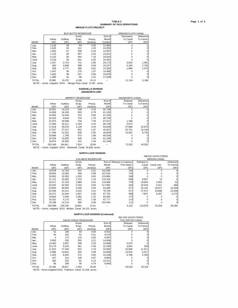
TABLE 2
SUMMARY OF 2015 OPERATIONS MIRAGE FLATS PROJECT
Page 1 of 5
BOX BUTTE RESERVOIR MIRAGE FLATS CANAL
Month
TOTAL 20,980 10,379 4,108 25.10 -- 11,154 5,186 NOTE -- Acres irrigated 2015: Mirage Flats Canal 6,765 acres.
SANDHILLS DIVISION
AINSWORTH UNIT
MERRITT RESERVOIR AINSWORTH CANAL
Month
TOTAL 202,465 194,841 7,624 28.99 -- 71,552 40,553 NOTE -- Acres irrigated 2015: Ainsworth Canal 34,626 acres.
NORTH LOUP DIVISION
CALAMUS RESERVOIR
ABOVE DAVIS CREEK MIRDAN CANAL
Month
TOTAL 250,588 229,236 16,802 22.61 -- 4,110 114,875 51,091 30,366 NOTE -- Acres irrigated 2015: Mirdan Canal 34,110 acres.
NORTH LOUP DIVISION (Continued)
DAVIS CREEK RESERVOIR
BELOW DAVIS CREEK FULLERTON CANAL
Month
TOTAL 52,348 49,657 2,593 26.48 -- 43,552 19,104 NOTE - Acres irrigated 2015: Fullerton Canal 21,016 acres.
Inflow
(AF)
Outflow
(AF)
Gross Evap.
(AF)
Precip.
(Inches)
End of Month
Content
Diversions To Canal
(AF)
Delivered To Farms
(AF) Jan. 1,126 28 84 0.05 11,860 0 0 Feb. 1,525 24 111 1.02 13,250 0 0 Mar. 1,552 27 208 0.18 14,567 0 0 Apr. 1,732 30 357 2.52 15,912 0 0 May 4,132 36 464 7.19 19,544 0 0 June 4,219 30 641 6.35 23,092 0 0 July 1,537 3,715 741 2.86 20,173 4,003 1,381 Aug. 260 4,608 588 0.94 15,237 5,183 2,735 Sep. 259 1,777 386 0.81 13,333 1,968 1,070 Oct. 1,447 36 275 1.57 14,469 0 0 Nov. 1,602 36 157 0.60 15,878 0 0 Dec. 1,589 32 96 1.01 17,339 0 0
Inflow
(AF)
Outflow
(AF)
Gross Evap.
(AF)
Precip.
(Inches)
End of Month
(AF)
Release To Canal
(AF)
Delivered To Farms
(AF) Jan. 16,001 14,123 239 0.16 62,739 0 0 Feb. 14,909 16,245 303 0.79 61,100 0 0 Mar. 14,855 14,440 415 0.05 61,100 0 0 Apr. 16,163 9,818 719 1.75 66,726 0 0 May 21,973 20,948 734 7.35 67,017 1,158 0 June 17,084 16,211 1,164 4.43 66,726 3,673 3 July 17,618 29,576 1,139 3.44 53,629 27,568 15,675 Aug. 17,537 27,017 842 1.67 43,307 25,751 16,140 Sep. 17,449 14,291 639 5.05 45,826 13,402 8,735 Oct. 16,666 1,785 673 1.66 60,034 0 0 Nov. 15,336 13,825 445 1.20 61,100 0 0 Dec. 16,874 16,562 312 1.44 61,100 0 0
Inflow
(AF)
Outflow
(AF)
Gross Evap.
(AF)
Precip.
(Inches)
End of Release to Calamus Month Fish Hatch.
(AF) (AF)
Release to Canal
(AF)
Canal Use
(AF)
Delivered To Farms
(AF) Jan. 19,878 14,763 431 0.01 102,590 195 0 0 0 Feb. 18,904 13,305 556 0.58 107,633 176 0 0 0 Mar. 19,652 10,392 1,033 0.00 115,860 248 0 0 0 Apr. 21,131 16,082 1,744 2.16 119,165 659 8,557 14 0 May 23,411 21,319 1,889 3.32 119,368 278 19,843 2,942 32 June 23,422 22,592 2,243 3.63 117,955 433 18,424 3,311 466 July 23,820 46,904 3,186 2.94 91,685 577 33,142 18,871 13,159 Aug 22,046 41,011 2,015 3.31 70,705 577 27,072 19,686 12,539 Sep. 20,271 21,644 1,607 2.60 67,725 569 7,837 6,267 4,170 Oct. 19,664 2,934 1,062 1.32 83,393 173 0 0 0 Nov. 19,201 4,175 642 2.28 97,777 114 0 0 0 Dec. 19,188 14,115 394 0.46 102,456 111 0 0 0
Inflow
(AF)
Outflow
(AF)
Gross Evap.
(AF)
Precip.
(Inches)
End of Month
(AF)
Release To Canal
(AF)
Delivered To Farms
(AF) Jan. 41 190 50 0.60 9,552 0 0 Feb. 44 165 61 0.51 9,370 0 0 Mar. 0 173 110 0.05 9,087 0 0 Apr. 5,950 226 203 3.21 14,608 0 0 May 13,463 3,957 306 2.03 23,808 3,074 0 June 13,173 5,225 461 4.36 31,295 3,834 283 July 11,522 17,340 522 2.19 24,955 15,900 11,511 Aug. 6,066 14,841 332 2.99 15,848 13,976 5,017 Sep. 1,502 6,920 272 4.65 10,158 6,768 2,293 Oct. 167 212 149 0.97 9,964 0 0 Nov. 330 202 81 4.13 10,011 0 0 Dec. 90 206 46 0.79 9,849 0 0

TABLE 2 SUMMARY OF 2015 OPERATIONS
Page 2 of 5
UPPER REPUBLICAN DIVISION
ARMEL UNIT
BONNY RESERVOIR
Month
TOTAL 5,571 5,571 0 20.78 -- 1,028
Inflow
(AF)
Outflow
(AF)
Gross Evap.
(AF)
Precip.
(Inches)
End of Month
(AF)
Outflow To Hale Ditch (AF)
Jan. 307 307 0 0.54 0 0 Feb. 333 333 0 0.05 0 0 Mar. 425 425 0 0.00 0 0 Apr. 456 456 0 1.62 0 286 May 817 817 0 9.10 0 346 June 2,184 2,184 0 2.40 0 298 July 442 442 0 3.49 0 98 Aug. 123 123 0 0.32 0 0 Sep. 119 119 0 1.25 0 0 Oct. 123 123 0 1.11 0 0 Nov. 119 119 0 0.89 0 0
Dec. 123 123 0 0.01 0 0

TABLE 2
SUMMARY OF 2015 OPERATIONS Page 3 of 5
FRENCHMAN-CAMBRIDGE DIVISION
FRENCHMAN UNIT
ENDERS RESERVOIR CULBERTSON CANAL CULBERTSON EXT.CANAL
Month
TOTAL 5,554 2,178 2,348 20.23 -- 9,121 438 0 0 NOTE: Acres irrigated 2015: Culbertson Canal - 871 acres; Culbertson Extension Canal - 0 acres.
FRENCHMAN-CAMBRIDGE DIVISION (Continued)
MEEKER-DRIFTWOOD UNIT
SWANSON LAKE
MEEKER-DRIFTWOOD
Month
TOTAL 42,316 16,048 10,365 20.21 -- 15,350 5,248 NOTE: Acres irrigated 2015: Meeker-Driftwood Canal - 9,326 acres.
FRENCHMAN-CAMBRIDGE DIVISION (Continued) RED WILLOW UNIT
HUGH BUTLER LAKE
RED WILLOW CANAL
BARTLEY CANAL
Month
TOTAL 9,064 1,448 2,878 21.80 -- 0 0 8,590 461 NOTE -- Acres irrigated 2015: Red Willow Canal - 0 acres; Bartley Canal 1,117 acres.
FRENCHMAN-CAMBRIDGE DIVISION (Continued) CAMBRIDGE UNIT
HARRY STRUNK LAKE CAMBRIDGE CANAL
Month
TOTAL 58,086 56,808 5,489 23.74 -- 29,156 8,719 NOTE -- Acres irrigated 2015: Cambridge Canal 15,363 acres.
Inflow
(AF)
Outflow
(AF)
Gross Evap.
(AF)
Precip.
(Inches)
End of Month
(AF)
Diversions To Canal
(AF)
Delivered To Farms
(AF)
Diversions To Canal
(AF)
Delivered To Farms
(AF) Jan. 535 185 47 0.00 9,453 0 0 0 0 Feb. 465 167 57 0.30 9,694 0 0 0 0 Mar. 465 185 95 0.00 9,879 0 0 0 0 Apr. 610 179 196 2.04 10,114 809 0 0 0 May 1,227 185 260 8.25 10,896 2,254 0 0 0 June 547 179 347 2.07 10,917 2,264 54 0 0 July 107 185 404 0.52 10,435 1,261 134 0 0 Aug. 324 185 351 2.52 10,223 1,275 145 0 0 Sep. 92 179 270 1.11 9,866 873 103 0 0 Oct. 296 185 151 2.06 9,826 385 2 0 0 Nov. 441 179 109 1.05 9,979 0 0 0 0 Dec. 445 185 61 0.31 10,178 0 0 0 0
Inflow
(AF)
Outflow
(AF)
Gross Evap.
(AF)
Precip.
(Inches)
End of Month
(AF)
Release To Canal
(AF)
Delivered To Farms
(AF) Jan. 4,684 61 181 0.05 32,130 0 0 Feb. 4,151 56 252 0.34 35,973 0 0 Mar. 3,990 61 402 0.10 39,500 0 0 Apr. 4,819 60 913 3.89 43,346 0 0 May 10,085 61 1,057 4.71 52,313 0 0 June 8,991 732 1,524 2.90 59,048 833 12 July 1,281 7,974 1,815 2.33 50,540 7,948 2,612 Aug. 419 6,006 1,309 2.66 43,644 5,951 2,324 Sep. 0 855 1,270 0.76 41,519 618 300 Oct. 0 61 889 0.93 40,569 0 0 Nov. 1,236 60 485 1.33 41,260 0 0 Dec. 2,660 61 268 0.21 43,591 0 0
Inflow
(AF)
Outflow
(AF)
Gross Evap.
(AF)
Precip.
(Inches)
End of Month
(AF)
Diversions To Canal
(AF)
Delivered To Farms
(AF)
Diversions To Canal
(AF)
Delivered To Farms
(AF) Jan. 665 123 45 0.00 8,638 0 0 0 0 Feb. 610 111 58 0.00 9,079 0 0 0 0 Mar. 582 123 101 0.00 9,437 0 0 0 0 Apr. 1,142 119 345 2.73 10,115 0 0 1,517 0 May 1,256 123 302 4.53 10,946 0 0 2,331 57 June 2,111 119 436 4.36 12,502 0 0 2,153 36 July 618 123 496 2.58 12,501 0 0 1,403 180 Aug. 373 123 370 2.28 12,381 0 0 1,084 133 Sep. 51 119 323 1.01 11,990 0 0 102 55 Oct. 427 123 190 1.70 12,104 0 0 0 0 Nov. 694 119 138 2.35 12,541 0 0 0 0 Dec. 535 123 74 0.26 12,879 0 0 0 0
Inflow
(AF)
Outflow
(AF)
Gross Evap.
(AF)
Precip.
(Inches)
End of Month
(AF)
Diversions To Canal
(AF)
Delivered To Farms
(AF) Jan. 6,691 5,764 131 0.00 38,780 0 0 Feb. 6,417 6,327 150 0.00 38,720 0 0 Mar. 7,197 6,972 265 0.00 38,680 0 0
Apr. 3,894 4,467 653 2.27 37,454 3,300 16 May 3,928 3,376 650 4.21 37,356 4,538 36 June 4,281 3,882 807 2.28 36,948 4,756 253 July 3,207 7,289 841 6.03 32,025 7,278 3,732 Aug. 4,223 6,500 617 2.65 29,131 7,387 3,604 Sep. 2,296 2,146 499 1.52 28,782 1,897 1,078 Oct. 2,530 62 458 1.05 30,792 0 0 Nov. 6,514 2,767 272 3.61 34,267 0 0 Dec. 6,908 7,256 146 0.12 33,773 0 0

TABLE 2 SUMMARY OF 2015 OPERATIONS
Page 4 of 5
KANASKA DIVISION
ALMENA UNITKEITH SEBELIUS LAKE ALMENA CANAL
Month
TOTAL 4,252 719 3,787 27.25 -- 356 0 0 NOTE: Acres irrigated 2015: Almena Canal -0 acres.
BOSTWICK DIVISION
FRANKLIN UNIT HARLAN COUNTY LAKE Data from Corps of Engineers FRANKLIN CANAL
NAPONEE CANAL
Month
TOTAL 106,728 54,502 33,652 28.85 -- 15,240 5,976 812 253 NOTE: Acres irrigated 2015: Franklin Canal - 9,954 acres; Naponee Canal - 305 acres.
FRANKLIN PUMP CANAL
BOSTWICK DIVISION (Continued) SUPERIOR-COURTLAND UNIT
SUPERIOR CANAL COURTLAND CANAL - ABOVE LOVEWELL
BOSTWICK DIVISION (Continued) COURTLAND UNIT
LOVEWELL RESERVOIR
COURTLAND (Below)
TOTAL 41,833 30,533 71,888 58,073 9,156 34.91 -- 31,544 17,599 NOTE: Acres irrigated 2015: Courtland Canal below Lovewell 27,797 acres.
Inflow
(AF)
Outflow
(AF)
Gross Evap.
(AF)
Precip.
(Inches)
End of Month
(AF)
Release To City of Norton
(AF)
Diversions To Canal
(AF)
Delivered To Farms
(AF) Jan. 233 50 62 0.17 9,797 19 0 0 Feb. 226 45 79 0.30 9,899 17 0 0 Mar. 222 52 133 0.21 9,936 21 0 0 Apr. 693 54 430 3.77 10,145 24 0 0 May 658 58 417 4.67 10,328 27 0 0 June 476 63 520 2.42 10,221 33 0 0 July 300 85 639 3.23 9,797 54 0 0 Aug. 483 72 522 4.41 9,686 42 0 0 Sep. 88 75 465 1.18 9,234 46 0 0 Oct. 169 66 297 1.88 9,040 35 0 0 Nov. 469 49 145 4.09 9,315 19 0 0 Dec. 235 50 78 0.92 9,422 19 0 0
Inflow
(AF)
Outflow
(AF)
Gross Evap.
(AF)
Precip.
(Inches)
End of Month
(AF)
Release To Canal
(AF)
Delivered To Farms
(AF)
Release To Canal
(AF)
Delivered To Farms
(AF) Jan. 7,597 0 496 0.00 155,943 0 0 0 0 Feb. 10,840 0 666 0.06 166,117 0 0 0 0 Mar. 12,228 0 987 0.23 177,358 0 0 0 0 Apr. 12,040 0 2,635 3.29 186,763 0 0 0 0 May 9,511 0 3,097 3.62 193,177 0 0 0 0 June 14,985 2,729 4,283 5.30 201,150 0 0 22 0 July 8,757 28,340 5,074 5.07 176,493 9,268 2,966 436 126 Aug. 8,618 19,363 5,014 6.09 160,734 5,972 3,010 354 127 Sep. 2,093 4,070 5,322 0.52 153,435 0 0 0 0 Oct. 1,775 0 3,118 1.18 152,092 0 0 0 0 Nov. 6,115 0 2,085 1.69 156,122 0 0 0 0 Dec. 12,169 0 875 1.80 167,416 0 0 0 0
NEBRASKA USE KANSAS USE Month
Diverted To Canal
(AF)
Delivered To Farms
(AF)
Diverted To Canal
(AF)
Delivered To Farms
(AF)
Total Diversion
(AF)
Total
(AF)
Delivered To Farms
(AF)
Diversion To Canal
(AF)
Delivered To Farms
(AF) Jan. 0 0 0 0 3,501 0 0 0 0 Feb. 0 0 0 0 3,138 0 0 0 0 Mar. 0 0 0 0 3,888 0 0 0 0 Apr. 0 0 157 0 2,887 0 0 0 0 May 0 0 639 0 0 0 0 0 0 June 74 14 0 0 3,960 0 0 2,580 139 July 634 251 3,251 878 13,504 305 274 8,388 3,373 Aug. 319 171 2,524 986 12,400 178 160 7,081 3,260 Sep. 0 0 0 0 6,577 0 0 2,387 1,294 Oct. 0 0 0 0 2,887 0 0 0 0 Nov. 0 0 0 0 3,432 0 0 0 0 Dec. 0 0 0 0 1,275 0 0 0 0
Est. Flow from
Inflow from
Total
Gross End of Month Release
To Canal (AF)
Delivered To Farms
(AF) White Rock Courtland Inflow Outflow Evap. Precip. Content Month Creek (AF) 34.8 (AF) (AF) (AF) (AF) (Inches) (AF) Jan. 0 2,282 2,263 12 156 0.05 31,715 0 0 Feb. 59 2,719 2,778 11 203 0.92 34,279 0 0 Mar. 0 3,243 3,134 12 376 0.48 37,025 0 0 Apr. 896 2,741 3,637 12 1,037 2.47 39,613 0 0 May 26,677 120 26,797 23,409 828 11.41 42,173 385 0 June 6,314 687 7,001 6,842 1,531 4.11 40,801 3,709 504 July 2,041 3,966 6,007 11,251 1,482 4.72 34,075 11,268 6,763 Aug. 2,993 4,360 7,353 11,513 1,193 4.71 28,722 11,378 7,121 Sep. 1,003 3,718 4,721 4,975 1,009 0.75 27,459 4,804 3,211 Oct. 0 2,290 1,940 12 717 0.53 28,670 0 0 Nov. 112 3,076 3,188 12 408 2.37 31,438 0 0 Dec. 1,738 1,331 3,069 12 216 2.39 34,279 0 0
TOTAL 1,027 436 6,571 1,864 57,449 483 434 20,436 8,066 NOTE: Acres irrigated 2015: Franklin Pump Canal - 1,087 acres; Superior Canal - 6,154 acres.
Courtland Canal-Nebraska use - 1,412 acres. Courtland Canal-Kansas use - 11,173 acres.
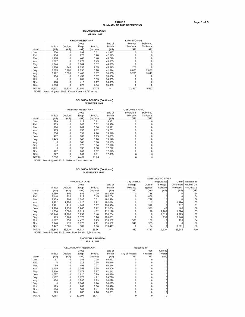
TABLE 2 Page 5 of 5
SUMMARY OF 2015 OPERATIONS
SOLOMON DIVISION KIRWIN UNIT
KIRWIN RESERVOIR KIRWIN CANAL
Gross End of Release Delivered Inflow Outflow Evap. Precip. Month To Canal To Farms
Month (AF) (AF) (AF) (Inches) (AF) (AF) (AF)
Jan. 850 0 199 0.01 41,917 0 0 Feb. 936 0 278 0.78 42,575 0 0
Mar. 1,108 0 443 0.40 43,240 0 0
Apr. 1,687 0 1,272 1.43 43,655 0 0 May 1,844 0 1,104 3.57 44,395 0 0
June 1,790 149 2,093 2.03 43,943 267 0
July 5,583 5,786 2,196 6.10 41,544 6,025 2,051 Aug. 2,122 5,893 1,468 3.37 36,305 5,705 3,641
Sep. 154 0 1,453 0.37 35,006 0 0
Oct. 0 0 701 0.59 34,305 0 0 Nov. 498 0 418 2.17 34,385 0 0
Dec. 1,230 0 226 2.54 35,389 0 0
TOTAL 17,802 11,828 11,851 23.36 -- 11,997 5,692 NOTE: Acres irrigated 2015: Kirwin Canal - 8,717 acres.
SOLOMON DIVISION (Continued) WEBSTER UNIT
WEBSTER RESERVOIR OSBORNE CANAL
Gross End of Diversions Delivered Inflow Outflow Evap. Precip. Month To Canal To Farms
Month (AF) (AF) (AF) (Inches) (AF) (AF) (AF)
Jan. 289 0 118 0.12 18,851 0 0 Feb. 233 0 148 0.62 18,936 0 0
Mar. 284 0 249 0.06 18,971 0 0
Apr. 965 0 655 2.62 19,281 0 0 May 856 0 597 2.90 19,540 0 0
June 482 0 983 1.99 19,039 0 0
July 1,449 0 948 6.10 19,540 0 0 Aug. 0 0 945 0.96 18,595 0 0
Sep. 0 0 975 0.64 17,620 0 0
Oct. 0 0 398 1.90 17,222 0 0
Nov 122 0 269 1.32 17,075 0 0 Dec. 377 0 147 2.61 17,305 0 0
TOTAL 5,057 0 6,432 21.84 -- 0 0 NOTE: Acres irrigated 2015: Osborne Canal - 0 acres.
SOLOMON DIVISION (Continued)
GLEN ELDER UNIT OUTFLOW TO RIVER
WACONDA LAKE City of Beloit Irrig.District Other Release To
Gross End of Storage Quality Storage Controlled Mitchell Co. Inflow Outflow Evap. Precip. Month Release Bypass Release Releases RWD No. 2
Month (AF) (AF) (AF) (Inches) (AF) (AF) (AF) (AF) (AF) (AF)
Jan. 2,286 802 682 0.05 191,899 0 738 0 0 64 Feb. 2,444 720 919 0.45 192,704 0 666 0 0 54
Mar. 2,159 804 1,585 0.01 192,474 0 738 0 0 66
Apr. 4,922 1,256 4,126 1.92 192,014 0 1 0 1,190 65 May 18,981 916 4,143 6.37 205,936 0 548 0 317 51
June 14,216 1,138 6,960 3.72 212,054 0 571 42 466 59
July 11,534 3,596 7,814 4.62 212,178 0 29 2,106 1,396 65 Aug. 35,144 11,105 5,933 3.40 230,284 0 0 1,319 9,729 57
Sep. 109 3,969 6,373 0.16 220,051 0 0 159 3,748 62
Oct. 1,862 953 4,428 1.79 216,532 583 107 0 199 64 Nov. 2,740 770 1,970 2.11 216,532 349 365 0 0 56 Dec. 7,447 9,581 981 1.06 213,417 0 24 0 9,501 56
TOTAL 103,844 35,610 45,914 25.66 -- 932 3,787 3,626 26,546 719 NOTE: Acres irrigated 2015: Glen Elder District 5,544 acres.
SMOKY HILL DIVISION ELLIS UNIT
CEDAR BLUFF RESERVOIR Releases To:
Gross End of Fish Kansas Inflow Outflow Evap. Precip. Month City of Russell Hatchery Water
Month (AF) (AF) (AF) (Inches) (AF) (AF) (AF) (AF) Jan. 87 0 243 0.08 60,961 0 0 0 Feb. 0 0 313 0.38 60,648 0 0 0 Mar. 89 0 493 0.07 60,244 0 0 0 Apr. 1,415 0 1,353 3.38 60,306 0 0 0 May 2,110 0 1,174 5.77 61,242 0 0 0 June 1,077 0 1,920 0.79 60,399 0 0 0 July 1,457 0 2,076 4.72 59,780 0 0 0
Aug. 104 0 1,786 1.23 58,098 0 0 0 Sep. 0 0 2,063 1.10 56,035 0 0 0
Oct. 429 0 988 3.38 55,476 0 0 0 Nov. 416 0 504 2.41 55,388 0 0 0 Dec. 579 0 286 2.16 55,681 0 0 0
TOTAL 7,763 0 13,199 25.47 -- 0 0 0

TABLE 3
ACRES IRRIGATED IN 2015 AND ESTIMATES FOR 2016
Estimated Acres With Acres Acres to be Service Irrigated Irrigated
Irrigation District and Canal Available in 2015 in 2016 Mirage Flats Irrigation District
Mirage Flats Canal 11,662 6,765 11,000 Ainsworth Irrigation District
Ainsworth Canal 35,000 34,626 34,500 Twin Loups Irrigation District
Above Davis Creek 34,053 34,110 34,000 Below Davis Creek 21,063 21,016 21,000
Total Twin Loups Irrigation District 55,116 55,126 55,000
Frenchman Valley Irrigation District Culbertson Canal 9,292 871 1,000
H & RW Irrigation District Culbertson Extension Canal 11,915 0 0
Frenchman-Cambridge Irrigation District Meeker-Driftwood Canal 16,855 9,326 10,000 Red Willow Canal 4,797 0 0 Bartley Canal 6,353 1,117 3,000 Cambridge Canal 17,664 15,363 16,000
Total Frenchman-Cambridge Irrigation District 45,669 25,806 29,000
Almena Irrigation District Almena Canal 5,764 0 0
Bostwick Irrigation District in Nebraska Franklin Canal 11,031 9,954 10,000 Naponee Canal 1,607 305 500 Franklin Pump Canal 2,026 1,087 1,000 Superior Canal 6,056 6,154 6,000 Courtland Canal (Nebraska) 1,735 1,412 1,500
Total Bostwick Irrigation Dist. in Nebraska 22,455 18,912 19,000
Kansas-Bostwick Irrigation District Courtland Canal above Lovewell 13,378 11,173 11,500 Courtland Canal below Lovewell 29,122 27,797 28,000
Total Kansas-Bostwick Irrigation District 42,500 38,970 39,500
Kirwin Irrigation District Kirwin Canal 11,465 8,717 8,500
Webster Irrigation District Osborne Canal 8,537 0 0
Glen Elder Irrigation District 10,370 5,544 6,000 TOTAL PROJECT USES 269,745 195,337 203,500
Non-Project Uses Hale Ditch 700 200 200
TOTAL PROJECT AND NON-PROJECT
270,445
195,537
203,700
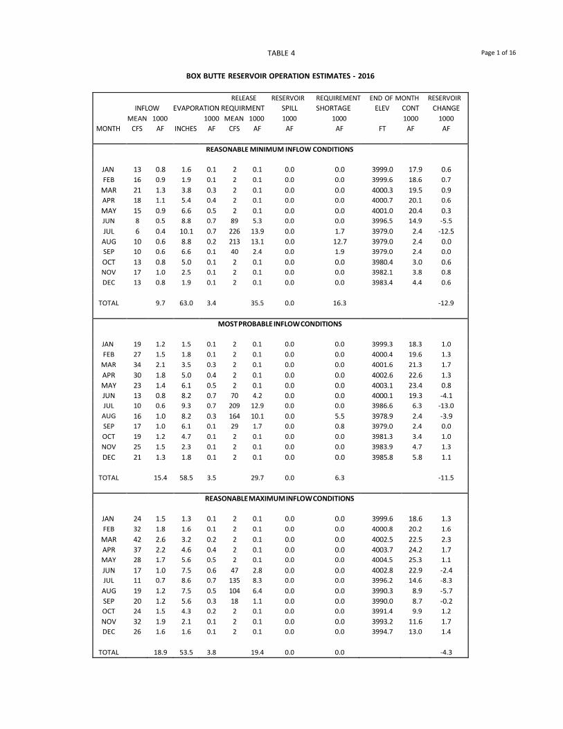
TABLE 4 Page 1 of 16
BOX BUTTE RESERVOIR OPERATION ESTIMATES - 2016
RELEASE RESERVOIR REQUIREMENT END OF MONTH RESERVOIR INFLOW EVAPORATION REQUIRMENT SPILL SHORTAGE ELEV CONT CHANGE
MEAN 1000 1000 MEAN 1000 1000 1000 1000 1000 MONTH CFS AF INCHES AF CFS AF AF AF FT AF AF
REASONABLE MINIMUM INFLOW CONDITIONS
JAN 13 0.8 1.6 0.1 2 0.1 0.0 0.0 3999.0 17.9 0.6 FEB 16 0.9 1.9 0.1 2 0.1 0.0 0.0 3999.6 18.6 0.7
MAR 21 1.3 3.8 0.3 2 0.1 0.0 0.0 4000.3 19.5 0.9 APR 18 1.1 5.4 0.4 2 0.1 0.0 0.0 4000.7 20.1 0.6 MAY 15 0.9 6.6 0.5 2 0.1 0.0 0.0 4001.0 20.4 0.3 JUN 8 0.5 8.8 0.7 89 5.3 0.0 0.0 3996.5 14.9 -5.5 JUL 6 0.4 10.1 0.7 226 13.9 0.0 1.7 3979.0 2.4 -12.5 AUG 10 0.6 8.8 0.2 213 13.1 0.0 12.7 3979.0 2.4 0.0 SEP 10 0.6 6.6 0.1 40 2.4 0.0 1.9 3979.0 2.4 0.0 OCT 13 0.8 5.0 0.1 2 0.1 0.0 0.0 3980.4 3.0 0.6 NOV 17 1.0 2.5 0.1 2 0.1 0.0 0.0 3982.1 3.8 0.8 DEC 13 0.8 1.9 0.1 2 0.1 0.0 0.0 3983.4 4.4 0.6
TOTAL 9.7 63.0 3.4 35.5 0.0 16.3 -12.9
MOST PROBABLE INFLOW CONDITIONS
JAN 19 1.2 1.5 0.1 2 0.1 0.0 0.0 3999.3 18.3 1.0 FEB 27 1.5 1.8 0.1 2 0.1 0.0 0.0 4000.4 19.6 1.3
MAR 34 2.1 3.5 0.3 2 0.1 0.0 0.0 4001.6 21.3 1.7 APR 30 1.8 5.0 0.4 2 0.1 0.0 0.0 4002.6 22.6 1.3 MAY 23 1.4 6.1 0.5 2 0.1 0.0 0.0 4003.1 23.4 0.8 JUN 13 0.8 8.2 0.7 70 4.2 0.0 0.0 4000.1 19.3 -4.1 JUL 10 0.6 9.3 0.7 209 12.9 0.0 0.0 3986.6 6.3 -13.0
AUG 16 1.0 8.2 0.3 164 10.1 0.0 5.5 3978.9 2.4 -3.9 SEP 17 1.0 6.1 0.1 29 1.7 0.0 0.8 3979.0 2.4 0.0 OCT 19 1.2 4.7 0.1 2 0.1 0.0 0.0 3981.3 3.4 1.0 NOV 25 1.5 2.3 0.1 2 0.1 0.0 0.0 3983.9 4.7 1.3 DEC 21 1.3 1.8 0.1 2 0.1 0.0 0.0 3985.8 5.8 1.1
TOTAL 15.4 58.5 3.5 29.7 0.0 6.3 -11.5
REASONABLE MAXIMUM INFLOW CONDITIONS
JAN 24 1.5 1.3 0.1 2 0.1 0.0 0.0 3999.6 18.6 1.3 FEB 32 1.8 1.6 0.1 2 0.1 0.0 0.0 4000.8 20.2 1.6
MAR 42 2.6 3.2 0.2 2 0.1 0.0 0.0 4002.5 22.5 2.3 APR 37 2.2 4.6 0.4 2 0.1 0.0 0.0 4003.7 24.2 1.7 MAY 28 1.7 5.6 0.5 2 0.1 0.0 0.0 4004.5 25.3 1.1 JUN 17 1.0 7.5 0.6 47 2.8 0.0 0.0 4002.8 22.9 -2.4 JUL 11 0.7 8.6 0.7 135 8.3 0.0 0.0 3996.2 14.6 -8.3 AUG 19 1.2 7.5 0.5 104 6.4 0.0 0.0 3990.3 8.9 -5.7 SEP 20 1.2 5.6 0.3 18 1.1 0.0 0.0 3990.0 8.7 -0.2 OCT 24 1.5 4.3 0.2 2 0.1 0.0 0.0 3991.4 9.9 1.2 NOV 32 1.9 2.1 0.1 2 0.1 0.0 0.0 3993.2 11.6 1.7 DEC 26 1.6 1.6 0.1 2 0.1 0.0 0.0 3994.7 13.0 1.4
TOTAL 18.9 53.5 3.8 19.4 0.0 0.0 -4.3
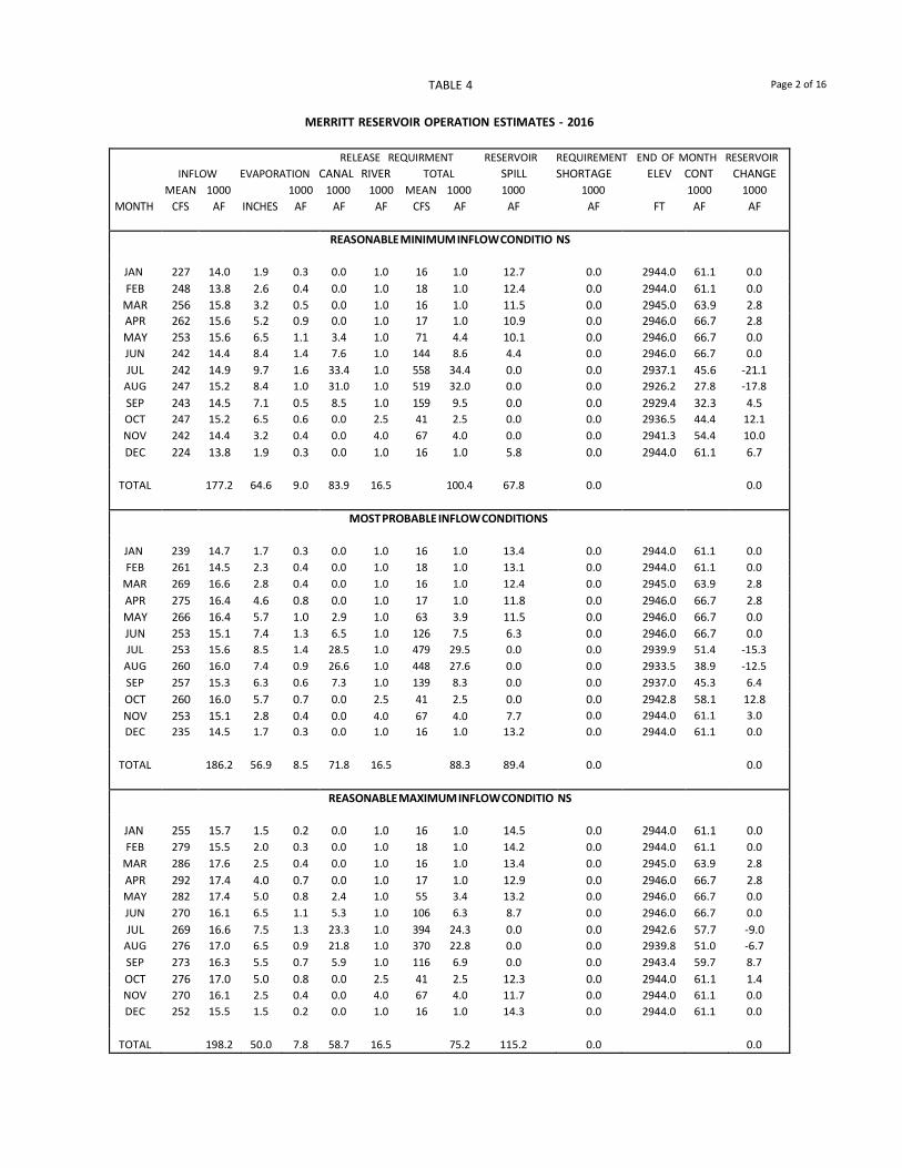
TABLE 4 Page 2 of 16
MERRITT RESERVOIR OPERATION ESTIMATES - 2016
RELEASE REQUIRMENT RESERVOIR REQUIREMENT END OF MONTH RESERVOIR INFLOW EVAPORATION CANAL RIVER TOTAL SPILL SHORTAGE ELEV CONT CHANGE
MEAN 1000 1000 1000 1000 MEAN 1000 1000 1000 1000 1000 MONTH CFS AF INCHES AF AF AF CFS AF AF AF FT AF AF
REASONABLE MINIMUM INFLOW CONDITIO NS
JAN 227 14.0 1.9 0.3 0.0 1.0 16 1.0 12.7 0.0 2944.0 61.1 0.0 FEB 248 13.8 2.6 0.4 0.0 1.0 18 1.0 12.4 0.0 2944.0 61.1 0.0
MAR 256 15.8 3.2 0.5 0.0 1.0 16 1.0 11.5 0.0 2945.0 63.9 2.8 APR 262 15.6 5.2 0.9 0.0 1.0 17 1.0 10.9 0.0 2946.0 66.7 2.8 MAY 253 15.6 6.5 1.1 3.4 1.0 71 4.4 10.1 0.0 2946.0 66.7 0.0 JUN 242 14.4 8.4 1.4 7.6 1.0 144 8.6 4.4 0.0 2946.0 66.7 0.0 JUL 242 14.9 9.7 1.6 33.4 1.0 558 34.4 0.0 0.0 2937.1 45.6 -21.1
AUG 247 15.2 8.4 1.0 31.0 1.0 519 32.0 0.0 0.0 2926.2 27.8 -17.8 SEP 243 14.5 7.1 0.5 8.5 1.0 159 9.5 0.0 0.0 2929.4 32.3 4.5 OCT 247 15.2 6.5 0.6 0.0 2.5 41 2.5 0.0 0.0 2936.5 44.4 12.1 NOV 242 14.4 3.2 0.4 0.0 4.0 67 4.0 0.0 0.0 2941.3 54.4 10.0 DEC 224 13.8 1.9 0.3 0.0 1.0 16 1.0 5.8 0.0 2944.0 61.1 6.7
TOTAL 177.2 64.6 9.0 83.9 16.5 100.4 67.8 0.0 0.0
MOST PROBABLE INFLOW CONDITIONS
JAN 239 14.7 1.7 0.3 0.0 1.0 16 1.0 13.4 0.0 2944.0 61.1 0.0 FEB 261 14.5 2.3 0.4 0.0 1.0 18 1.0 13.1 0.0 2944.0 61.1 0.0
MAR 269 16.6 2.8 0.4 0.0 1.0 16 1.0 12.4 0.0 2945.0 63.9 2.8 APR 275 16.4 4.6 0.8 0.0 1.0 17 1.0 11.8 0.0 2946.0 66.7 2.8 MAY 266 16.4 5.7 1.0 2.9 1.0 63 3.9 11.5 0.0 2946.0 66.7 0.0 JUN 253 15.1 7.4 1.3 6.5 1.0 126 7.5 6.3 0.0 2946.0 66.7 0.0 JUL 253 15.6 8.5 1.4 28.5 1.0 479 29.5 0.0 0.0 2939.9 51.4 -15.3
AUG 260 16.0 7.4 0.9 26.6 1.0 448 27.6 0.0 0.0 2933.5 38.9 -12.5 SEP 257 15.3 6.3 0.6 7.3 1.0 139 8.3 0.0 0.0 2937.0 45.3 6.4 OCT 260 16.0 5.7 0.7 0.0 2.5 41 2.5 0.0 0.0 2942.8 58.1 12.8 NOV 253 15.1 2.8 0.4 0.0 4.0 67 4.0 7.7 0.0 2944.0 61.1 3.0 DEC 235 14.5 1.7 0.3 0.0 1.0 16 1.0 13.2 0.0 2944.0 61.1 0.0
TOTAL 186.2 56.9 8.5 71.8 16.5 88.3 89.4 0.0 0.0
REASONABLE MAXIMUM INFLOW CONDITIO NS
JAN 255 15.7 1.5 0.2 0.0 1.0 16 1.0 14.5 0.0 2944.0 61.1 0.0 FEB 279 15.5 2.0 0.3 0.0 1.0 18 1.0 14.2 0.0 2944.0 61.1 0.0
MAR 286 17.6 2.5 0.4 0.0 1.0 16 1.0 13.4 0.0 2945.0 63.9 2.8 APR 292 17.4 4.0 0.7 0.0 1.0 17 1.0 12.9 0.0 2946.0 66.7 2.8 MAY 282 17.4 5.0 0.8 2.4 1.0 55 3.4 13.2 0.0 2946.0 66.7 0.0 JUN 270 16.1 6.5 1.1 5.3 1.0 106 6.3 8.7 0.0 2946.0 66.7 0.0 JUL 269 16.6 7.5 1.3 23.3 1.0 394 24.3 0.0 0.0 2942.6 57.7 -9.0
AUG 276 17.0 6.5 0.9 21.8 1.0 370 22.8 0.0 0.0 2939.8 51.0 -6.7 SEP 273 16.3 5.5 0.7 5.9 1.0 116 6.9 0.0 0.0 2943.4 59.7 8.7 OCT 276 17.0 5.0 0.8 0.0 2.5 41 2.5 12.3 0.0 2944.0 61.1 1.4 NOV 270 16.1 2.5 0.4 0.0 4.0 67 4.0 11.7 0.0 2944.0 61.1 0.0 DEC 252 15.5 1.5 0.2 0.0 1.0 16 1.0 14.3 0.0 2944.0 61.1 0.0
TOTAL 198.2 50.0 7.8 58.7 16.5 75.2 115.2 0.0 0.0

TABLE 4 Page 3 of 16
CALAMUS RESERVOIR OPERATION ESTIMATES - 2016
RELEASE REQUIRMENT RESERVOIR REQUIREMENT END OF MONTH RESERVOIR INFLOW EVAPORATION CANAL RIVER TOTAL SPILL SHORTAGE ELEV CONT CHANGE
MEAN 1000 1000 1000 1000 MEAN 1000 1000 1000 1000 1000 MONTH CFS AF INCHES AF AF AF CFS AF AF AF FT AF AF
REASONABLE MINIMUM INFLOW CONDITION S
JAN 299 18.4 1.9 0.5 0.5 3.1 58 3.6 14.3 0.0 2240.4 102.5 0.0 FEB 318 17.7 2.3 0.6 0.5 2.8 59 3.3 13.8 0.0 2240.4 102.5 0.0
MAR 356 21.9 4.2 1.1 0.5 3.1 58 3.6 10.0 0.0 2242.0 109.7 7.2 APR 367 21.9 6.6 1.8 0.5 3.0 59 3.5 6.8 0.0 2244.0 119.5 9.8 MAY 406 25.0 6.9 2.0 2.7 3.1 94 5.8 17.2 0.0 2244.0 119.5 0.0 JUN 371 22.1 8.4 2.5 5.6 3.0 144 8.6 11.0 0.0 2244.0 119.5 0.0 JUL 347 21.4 9.5 2.8 33.8 21.4 896 55.2 0.0 0.0 2235.8 82.9 -36.6
AUG 326 20.1 9.5 2.2 30.4 20.1 820 50.5 0.0 0.0 2226.3 50.3 -32.6 SEP 309 18.4 7.4 1.3 8.2 18.4 446 26.6 0.0 0.0 2222.8 40.8 -9.5 OCT 307 18.9 5.6 0.8 0.5 3.1 58 3.6 0.0 0.0 2227.9 55.3 14.5 NOV 334 19.9 3.0 0.5 0.5 3.0 59 3.5 0.0 0.0 2232.7 71.2 15.9 DEC 323 19.9 1.7 0.4 0.5 3.1 58 3.6 0.0 0.0 2236.8 87.1 15.9
TOTAL 245.6 67.0 16.5 84.2 87.2 171.4 73.1 0.0 -15.4
MOST PROBABLE INFLOW CONDITIONS
JAN 330 20.3 1.7 0.4 0.5 3.1 58 3.6 16.3 0.0 2240.4 102.5 0.0 FEB 350 19.5 2.0 0.5 0.5 2.8 54 3.3 15.7 0.0 2240.4 102.5 0.0
MAR 391 24.1 3.7 1.0 0.5 3.1 58 3.6 12.3 0.0 2242.0 109.7 7.2 APR 404 24.1 5.9 1.6 0.5 3.0 57 3.5 9.2 0.0 2244.0 119.5 9.8 MAY 450 27.7 6.1 1.8 2.3 3.1 88 5.4 20.5 0.0 2244.0 119.5 0.0 JUN 409 24.4 7.4 2.2 4.7 3.0 125 7.7 14.5 0.0 2244.0 119.5 0.0 JUL 383 23.6 8.4 2.5 25.8 23.6 802 49.4 0.0 0.0 2237.8 91.2 -28.3
AUG 360 22.2 8.4 2.0 23.0 22.2 734 45.2 0.0 0.0 2231.3 66.2 -25.0 SEP 341 20.3 6.5 1.3 5.2 20.3 414 25.5 0.0 0.0 2229.4 59.7 -6.5 OCT 339 20.9 5.0 0.9 0.5 3.1 58 3.6 0.0 0.0 2234.0 76.1 16.4 NOV 369 22.0 2.7 0.6 0.5 3.0 57 3.5 0.0 0.0 2238.5 94.0 17.9 DEC 357 22.0 1.5 0.4 0.5 3.1 58 3.6 11.5 0.0 2240.0 100.5 6.5
TOTAL 271.1 59.3 15.2 64.5 93.4 157.9 100.0 0.0 -2.0
REASONABLE MAXIMUM INFLOW CONDITIO NS
JAN 378 23.3 1.5 0.4 0.5 3.1 58 3.6 19.3 0.0 2240.4 102.5 0.0 FEB 403 22.4 1.8 0.5 0.5 2.8 59 3.3 18.6 0.0 2240.4 102.5 0.0
MAR 450 27.7 3.3 0.9 0.5 3.1 58 3.6 16.0 0.0 2242.0 109.7 7.2 APR 465 27.7 5.2 1.4 0.5 3.0 59 3.5 13.0 0.0 2244.0 119.5 9.8 MAY 515 31.7 5.4 1.6 1.9 3.1 81 5.0 25.1 0.0 2244.0 119.5 0.0 JUN 470 28.0 6.6 2.0 3.8 3.0 114 6.8 19.2 0.0 2244.0 119.5 0.0 JUL 438 27.0 7.5 2.2 17.9 27.0 729 44.9 0.0 0.0 2239.8 99.4 -20.1
AUG 414 25.5 7.5 1.9 15.7 25.5 669 41.2 0.0 0.0 2235.5 81.8 -17.6 SEP 391 23.3 5.8 1.3 4.1 23.3 460 27.4 0.0 0.0 2234.1 76.4 -5.4 OCT 388 23.9 4.4 1.0 0.5 3.1 58 3.6 0.0 0.0 2238.8 95.7 19.3 NOV 423 25.2 2.4 0.6 0.5 3.0 59 3.5 16.3 0.0 2240.0 100.5 4.8 DEC 409 25.2 1.4 0.4 0.5 3.1 58 3.6 21.2 0.0 2240.0 100.5 0.0
TOTAL 310.9 52.8 14.2 46.9 103.1 150.0 148.7 0.0 -2.0
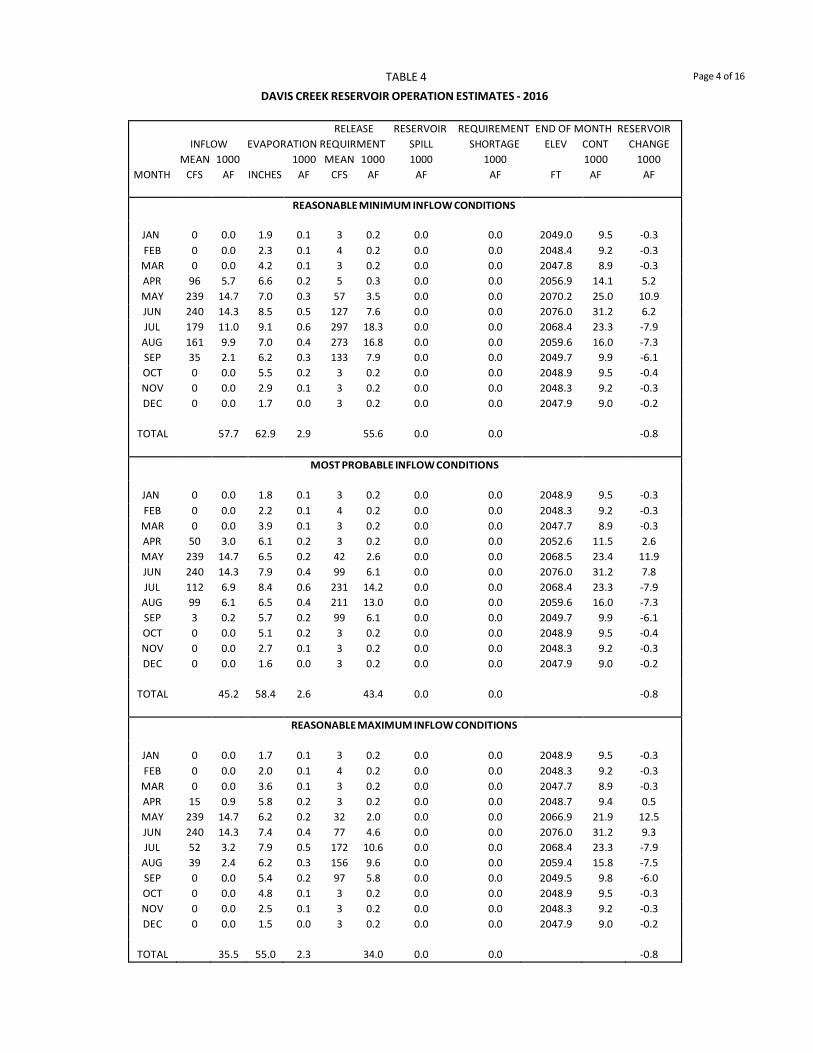
TABLE 4 Page 4 of 16
DAVIS CREEK RESERVOIR OPERATION ESTIMATES - 2016
RELEASE RESERVOIR REQUIREMENT END OF MONTH RESERVOIR INFLOW EVAPORATION REQUIRMENT SPILL SHORTAGE ELEV CONT CHANGE
MEAN 1000 1000 MEAN 1000 1000 1000 1000 1000 MONTH CFS AF INCHES AF CFS AF AF AF FT AF AF
REASONABLE MINIMUM INFLOW CONDITIONS
JAN 0 0.0 1.9 0.1 3 0.2 0.0 0.0 2049.0 9.5 -0.3 FEB 0 0.0 2.3 0.1 4 0.2 0.0 0.0 2048.4 9.2 -0.3 MAR 0 0.0 4.2 0.1 3 0.2 0.0 0.0 2047.8 8.9 -0.3 APR 96 5.7 6.6 0.2 5 0.3 0.0 0.0 2056.9 14.1 5.2 MAY 239 14.7 7.0 0.3 57 3.5 0.0 0.0 2070.2 25.0 10.9 JUN 240 14.3 8.5 0.5 127 7.6 0.0 0.0 2076.0 31.2 6.2 JUL 179 11.0 9.1 0.6 297 18.3 0.0 0.0 2068.4 23.3 -7.9
AUG 161 9.9 7.0 0.4 273 16.8 0.0 0.0 2059.6 16.0 -7.3 SEP 35 2.1 6.2 0.3 133 7.9 0.0 0.0 2049.7 9.9 -6.1 OCT 0 0.0 5.5 0.2 3 0.2 0.0 0.0 2048.9 9.5 -0.4 NOV 0 0.0 2.9 0.1 3 0.2 0.0 0.0 2048.3 9.2 -0.3 DEC 0 0.0 1.7 0.0 3 0.2 0.0 0.0 2047.9 9.0 -0.2
TOTAL 57.7 62.9 2.9 55.6 0.0 0.0 -0.8
MOST PROBABLE INFLOW CONDITIONS
JAN 0 0.0 1.8 0.1 3 0.2 0.0 0.0 2048.9 9.5 -0.3 FEB 0 0.0 2.2 0.1 4 0.2 0.0 0.0 2048.3 9.2 -0.3 MAR 0 0.0 3.9 0.1 3 0.2 0.0 0.0 2047.7 8.9 -0.3 APR 50 3.0 6.1 0.2 3 0.2 0.0 0.0 2052.6 11.5 2.6 MAY 239 14.7 6.5 0.2 42 2.6 0.0 0.0 2068.5 23.4 11.9 JUN 240 14.3 7.9 0.4 99 6.1 0.0 0.0 2076.0 31.2 7.8 JUL 112 6.9 8.4 0.6 231 14.2 0.0 0.0 2068.4 23.3 -7.9
AUG 99 6.1 6.5 0.4 211 13.0 0.0 0.0 2059.6 16.0 -7.3 SEP 3 0.2 5.7 0.2 99 6.1 0.0 0.0 2049.7 9.9 -6.1 OCT 0 0.0 5.1 0.2 3 0.2 0.0 0.0 2048.9 9.5 -0.4 NOV 0 0.0 2.7 0.1 3 0.2 0.0 0.0 2048.3 9.2 -0.3 DEC 0 0.0 1.6 0.0 3 0.2 0.0 0.0 2047.9 9.0 -0.2
TOTAL 45.2 58.4 2.6 43.4 0.0 0.0 -0.8
REASONABLE MAXIMUM INFLOW CONDITIONS
JAN 0 0.0 1.7 0.1 3 0.2 0.0 0.0 2048.9 9.5 -0.3 FEB 0 0.0 2.0 0.1 4 0.2 0.0 0.0 2048.3 9.2 -0.3 MAR 0 0.0 3.6 0.1 3 0.2 0.0 0.0 2047.7 8.9 -0.3 APR 15 0.9 5.8 0.2 3 0.2 0.0 0.0 2048.7 9.4 0.5 MAY 239 14.7 6.2 0.2 32 2.0 0.0 0.0 2066.9 21.9 12.5 JUN 240 14.3 7.4 0.4 77 4.6 0.0 0.0 2076.0 31.2 9.3 JUL 52 3.2 7.9 0.5 172 10.6 0.0 0.0 2068.4 23.3 -7.9
AUG 39 2.4 6.2 0.3 156 9.6 0.0 0.0 2059.4 15.8 -7.5 SEP 0 0.0 5.4 0.2 97 5.8 0.0 0.0 2049.5 9.8 -6.0 OCT 0 0.0 4.8 0.1 3 0.2 0.0 0.0 2048.9 9.5 -0.3 NOV 0 0.0 2.5 0.1 3 0.2 0.0 0.0 2048.3 9.2 -0.3 DEC 0 0.0 1.5 0.0 3 0.2 0.0 0.0 2047.9 9.0 -0.2
TOTAL 35.5 55.0 2.3 34.0 0.0 0.0 -0.8

TABLE 4 Page 5 of 16
BONNY RESERVOIR OPERATION ESTIMATES - 2016
RELEASE REQUIRMENT RESERVOIR REQUIREMENT END OF MONTH RESERVOIR INFLOW EVAPORATION CANAL RIVER TOTAL SPILL SHORTAGE ELEV CONT CHANGE
MEAN 1000 1000 1000 1000 MEAN 1000 1000 1000 1000 1000 MONTH CFS AF INCHES AF AF AF CFS AF AF AF FT AF AF
REASONABLE MINIMUM INFLOW CONDITIONS
JAN 5 0.3 2.3 0.0 0.0 0.1 2 0.1 0.2 0.0 3638.0 0.0 0.0 FEB 5 0.3 3.1 0.0 0.0 0.1 2 0.1 0.2 0.0 3638.0 0.0 0.0
MAR 6 0.4 3.9 0.0 0.0 0.1 2 0.1 0.3 0.0 3638.0 0.0 0.0 APR 7 0.4 6.2 0.0 0.1 0.1 3 0.2 0.2 0.0 3638.0 0.0 0.0 MAY 8 0.5 7.8 0.0 0.4 0.1 8 0.5 0.0 0.0 3638.0 0.0 0.0 JUN 7 0.4 10.1 0.0 0.5 0.1 10 0.6 0.0 0.2 3638.0 0.0 0.0 JUL 3 0.2 11.6 0.0 0.8 0.1 15 0.9 0.0 0.7 3638.0 0.0 0.0
AUG 2 0.1 10.1 0.0 0.6 0.1 11 0.7 0.0 0.6 3638.0 0.0 0.0 SEP 2 0.1 8.5 0.0 0.5 0.1 10 0.6 0.0 0.5 3638.0 0.0 0.0 OCT 3 0.2 7.8 0.0 0.5 0.1 10 0.6 0.0 0.4 3638.0 0.0 0.0 NOV 5 0.3 3.9 0.0 0.0 0.1 2 0.1 0.2 0.0 3638.0 0.0 0.0 DEC 5 0.3 2.3 0.0 0.0 0.1 2 0.1 0.2 0.0 3638.0 0.0 0.0
TOTAL 3.5 77.6 0.0 3.4 1.2 4.6 1.3 2.4 0.0
MOST PROBABLE INFLOW CONDITIONS
JAN 13 0.8 2.1 0.0 0.0 0.1 2 0.1 0.7 0.0 3638.0 0.0 0.0 FEB 14 0.8 2.8 0.0 0.0 0.1 2 0.1 0.7 0.0 3638.0 0.0 0.0
MAR 15 0.9 3.5 0.0 0.0 0.1 2 0.1 0.8 0.0 3638.0 0.0 0.0 APR 17 1.0 5.5 0.0 0.1 0.1 3 0.2 0.8 0.0 3638.0 0.0 0.0 MAY 19 1.2 6.9 0.0 0.3 0.1 6 0.4 0.8 0.0 3638.0 0.0 0.0 JUN 17 1.0 9.0 0.0 0.3 0.1 7 0.4 0.6 0.0 3638.0 0.0 0.0 JUL 8 0.5 10.4 0.0 0.5 0.1 10 0.6 0.0 0.1 3638.0 0.0 0.0
AUG 6 0.4 9.0 0.0 0.4 0.1 8 0.5 0.0 0.1 3638.0 0.0 0.0 SEP 3 0.2 7.6 0.0 0.3 0.1 7 0.4 0.0 0.2 3638.0 0.0 0.0 OCT 6 0.4 6.9 0.0 0.3 0.1 6 0.4 0.0 0.0 3638.0 0.0 0.0 NOV 12 0.7 3.5 0.0 0.0 0.1 2 0.1 0.6 0.0 3638.0 0.0 0.0 DEC 11 0.7 2.1 0.0 0.0 0.1 2 0.1 0.6 0.0 3638.0 0.0 0.0
TOTAL 8.6 69.3 0.0 2.2 1.2 3.4 5.6 0.4 0.0
REASONABLE MAXIMUM INFLOW CONDITIONS
JAN 23 1.4 1.8 0.0 0.0 0.1 2 0.1 1.3 0.0 3638.0 0.0 0.0 FEB 24 1.4 2.5 0.0 0.0 0.1 2 0.1 1.3 0.0 3638.0 0.0 0.0
MAR 26 1.6 3.1 0.0 0.0 0.1 2 0.1 1.5 0.0 3638.0 0.0 0.0 APR 30 1.8 4.9 0.0 0.0 0.1 2 0.1 1.7 0.0 3638.0 0.0 0.0 MAY 34 2.1 6.1 0.0 0.1 0.1 3 0.2 1.9 0.0 3638.0 0.0 0.0 JUN 30 1.8 8.0 0.0 0.1 0.1 3 0.2 1.6 0.0 3638.0 0.0 0.0 JUL 16 1.0 9.2 0.0 0.1 0.1 3 0.2 0.8 0.0 3638.0 0.0 0.0
AUG 10 0.6 8.0 0.0 0.1 0.1 3 0.2 0.4 0.0 3638.0 0.0 0.0 SEP 7 0.4 6.7 0.0 0.1 0.1 3 0.2 0.2 0.0 3638.0 0.0 0.0 OCT 11 0.7 6.1 0.0 0.0 0.1 2 0.1 0.6 0.0 3638.0 0.0 0.0 NOV 20 1.2 3.1 0.0 0.0 0.1 2 0.1 1.1 0.0 3638.0 0.0 0.0 DEC 21 1.3 1.8 0.0 0.0 0.1 2 0.1 1.2 0.0 3638.0 0.0 0.0
TOTAL 15.3 61.3 0.0 0.5 1.2 1.7 13.6 0.0 0.0

TABLE 4 Page 6 of 16
ENDERS RESERVOIR OPERATION ESTIMATES - 2016
RELEASE RESERVOIR REQUIREMENT END OF MONTH RESERVOIR INFLOW EVAPORATION REQUIRMENT SPILL SHORTAGE ELEV CONT CHANGE
MEAN 1000 1000 MEAN 1000 1000 1000 1000 1000 MONTH CFS AF INCHES AF CFS AF AF AF FT AF AF
REASONABLE MINIMUM INFLOW CONDITIONS
JAN 6 0.4 1.4 0.1 3 0.2 0.0 0.0 3084.5 10.3 0.1 FEB 5 0.3 1.6 0.1 4 0.2 0.0 0.0 3084.5 10.3 0.0
MAR 5 0.3 2.7 0.1 3 0.2 0.0 0.0 3084.5 10.3 0.0 APR 5 0.3 5.8 0.2 3 0.2 0.0 0.0 3084.3 10.2 -0.1 MAY 6 0.4 7.4 0.3 3 0.2 0.0 0.0 3084.2 10.1 -0.1 JUN 5 0.3 9.4 0.4 176 10.5 0.0 9.4 3082.4 8.9 -1.2 JUL 6 0.4 10.3 0.4 532 32.8 0.0 32.6 3082.0 8.7 -0.2
AUG 6 0.4 8.7 0.3 505 31.1 0.0 30.9 3081.8 8.6 -0.1 SEP 5 0.3 6.5 0.2 75 4.5 0.0 4.3 3081.7 8.5 -0.1 OCT 5 0.3 4.1 0.1 3 0.2 0.0 0.0 3081.7 8.5 0.0 NOV 5 0.3 3.0 0.1 3 0.2 0.0 0.0 3081.7 8.5 0.0 DEC 5 0.3 1.7 0.1 3 0.2 0.0 0.0 3081.7 8.5 0.0
TOTAL 4.0 62.6 2.4 80.5 0.0 77.2 -1.7
MOST PROBABLE INFLOW CONDITIONS
JAN 11 0.7 1.3 0.1 3 0.2 0.0 0.0 3084.8 10.6 0.4 FEB 11 0.6 1.4 0.1 3 0.2 0.0 0.0 3085.3 10.9 0.3
MAR 10 0.6 2.5 0.1 3 0.2 0.0 0.0 3085.7 11.2 0.3 APR 10 0.6 5.4 0.2 3 0.2 0.0 0.0 3086.0 11.4 0.2 MAY 11 0.7 6.8 0.3 3 0.2 0.0 0.0 3086.2 11.6 0.2 JUN 10 0.6 8.7 0.4 114 7.0 0.0 4.1 3082.4 8.9 -2.7 JUL 11 0.7 9.5 0.3 487 30.0 0.0 29.6 3082.4 8.9 0.0
AUG 11 0.7 8.0 0.3 388 23.9 0.0 23.5 3082.4 8.9 0.0 SEP 10 0.6 5.9 0.2 36 2.2 0.0 1.8 3082.4 8.9 0.0 OCT 10 0.6 3.8 0.1 3 0.2 0.0 0.0 3082.7 9.2 0.3 NOV 10 0.6 2.8 0.1 3 0.2 0.0 0.0 3083.2 9.5 0.3 DEC 10 0.6 1.6 0.1 3 0.2 0.0 0.0 3083.7 9.8 0.3
TOTAL 7.6 57.7 2.3 64.7 0.0 59.0 -0.4
REASONABLE MAXIMUM INFLOW CONDITIONS
JAN 23 1.4 1.2 0.0 3 0.2 0.0 0.0 3086.0 11.4 1.2 FEB 22 1.2 1.3 0.1 4 0.2 0.0 0.0 3087.2 12.3 0.9
MAR 21 1.3 2.3 0.1 3 0.2 0.0 0.0 3088.5 13.3 1.0 APR 22 1.3 4.9 0.2 3 0.2 0.0 0.0 3089.6 14.2 0.9 MAY 23 1.4 6.2 0.3 3 0.2 0.0 0.0 3090.6 15.1 0.9 JUN 22 1.3 7.9 0.4 40 2.4 0.0 0.0 3088.8 13.6 -1.5 JUL 26 1.6 8.6 0.4 297 18.3 0.0 12.4 3082.4 8.9 -4.7
AUG 23 1.4 7.3 0.3 229 14.1 0.0 13.0 3082.4 8.9 0.0 SEP 20 1.2 5.4 0.2 3 0.2 0.0 0.0 3083.6 9.7 0.8 OCT 21 1.3 3.5 0.1 3 0.2 0.0 0.0 3085.0 10.7 1.0 NOV 22 1.3 2.5 0.1 3 0.2 0.0 0.0 3086.4 11.7 1.0 DEC 21 1.3 1.4 0.1 3 0.2 0.0 0.0 3087.7 12.7 1.0
TOTAL 16.0 52.5 2.3 36.6 0.0 25.4 2.5
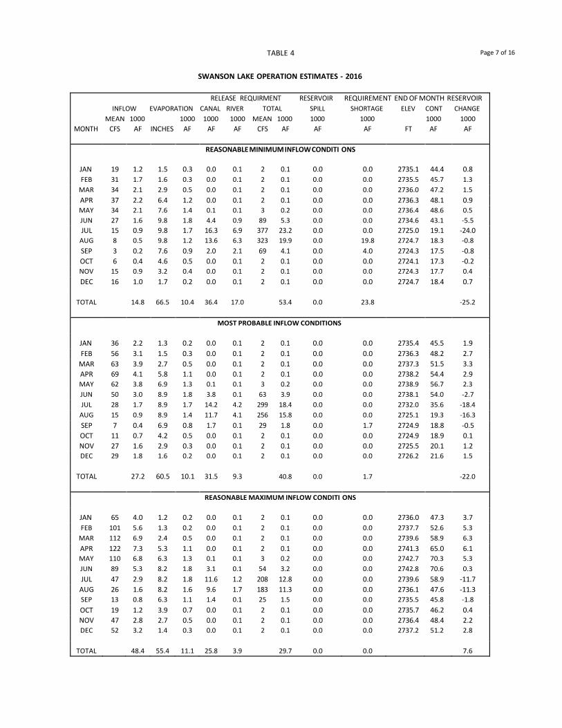
TABLE 4 Page 7 of 16
SWANSON LAKE OPERATION ESTIMATES - 2016
RELEASE REQUIRMENT RESERVOIR REQUIREMENT END OF MONTH RESERVOIR INFLOW EVAPORATION CANAL RIVER TOTAL SPILL SHORTAGE ELEV CONT CHANGE
MEAN 1000 1000 1000 1000 MEAN 1000 1000 1000 1000 1000 MONTH CFS AF INCHES AF AF AF CFS AF AF AF FT AF AF
REASONABLE MINIMUM INFLOW CONDITI ONS
JAN 19 1.2 1.5 0.3 0.0 0.1 2 0.1 0.0 0.0 2735.1 44.4 0.8 FEB 31 1.7 1.6 0.3 0.0 0.1 2 0.1 0.0 0.0 2735.5 45.7 1.3
MAR 34 2.1 2.9 0.5 0.0 0.1 2 0.1 0.0 0.0 2736.0 47.2 1.5 APR 37 2.2 6.4 1.2 0.0 0.1 2 0.1 0.0 0.0 2736.3 48.1 0.9 MAY 34 2.1 7.6 1.4 0.1 0.1 3 0.2 0.0 0.0 2736.4 48.6 0.5 JUN 27 1.6 9.8 1.8 4.4 0.9 89 5.3 0.0 0.0 2734.6 43.1 -5.5 JUL 15 0.9 9.8 1.7 16.3 6.9 377 23.2 0.0 0.0 2725.0 19.1 -24.0
AUG 8 0.5 9.8 1.2 13.6 6.3 323 19.9 0.0 19.8 2724.7 18.3 -0.8 SEP 3 0.2 7.6 0.9 2.0 2.1 69 4.1 0.0 4.0 2724.3 17.5 -0.8 OCT 6 0.4 4.6 0.5 0.0 0.1 2 0.1 0.0 0.0 2724.1 17.3 -0.2 NOV 15 0.9 3.2 0.4 0.0 0.1 2 0.1 0.0 0.0 2724.3 17.7 0.4 DEC 16 1.0 1.7 0.2 0.0 0.1 2 0.1 0.0 0.0 2724.7 18.4 0.7
TOTAL 14.8 66.5 10.4 36.4 17.0 53.4 0.0 23.8 -25.2
MOST PROBABLE INFLOW CONDITIONS
JAN 36 2.2 1.3 0.2 0.0 0.1 2 0.1 0.0 0.0 2735.4 45.5 1.9 FEB 56 3.1 1.5 0.3 0.0 0.1 2 0.1 0.0 0.0 2736.3 48.2 2.7
MAR 63 3.9 2.7 0.5 0.0 0.1 2 0.1 0.0 0.0 2737.3 51.5 3.3 APR 69 4.1 5.8 1.1 0.0 0.1 2 0.1 0.0 0.0 2738.2 54.4 2.9 MAY 62 3.8 6.9 1.3 0.1 0.1 3 0.2 0.0 0.0 2738.9 56.7 2.3 JUN 50 3.0 8.9 1.8 3.8 0.1 63 3.9 0.0 0.0 2738.1 54.0 -2.7 JUL 28 1.7 8.9 1.7 14.2 4.2 299 18.4 0.0 0.0 2732.0 35.6 -18.4
AUG 15 0.9 8.9 1.4 11.7 4.1 256 15.8 0.0 0.0 2725.1 19.3 -16.3 SEP 7 0.4 6.9 0.8 1.7 0.1 29 1.8 0.0 1.7 2724.9 18.8 -0.5 OCT 11 0.7 4.2 0.5 0.0 0.1 2 0.1 0.0 0.0 2724.9 18.9 0.1 NOV 27 1.6 2.9 0.3 0.0 0.1 2 0.1 0.0 0.0 2725.5 20.1 1.2 DEC 29 1.8 1.6 0.2 0.0 0.1 2 0.1 0.0 0.0 2726.2 21.6 1.5
TOTAL 27.2 60.5 10.1 31.5 9.3 40.8 0.0 1.7 -22.0
REASONABLE MAXIMUM INFLOW CONDITI ONS
JAN 65 4.0 1.2 0.2 0.0 0.1 2 0.1 0.0 0.0 2736.0 47.3 3.7 FEB 101 5.6 1.3 0.2 0.0 0.1 2 0.1 0.0 0.0 2737.7 52.6 5.3
MAR 112 6.9 2.4 0.5 0.0 0.1 2 0.1 0.0 0.0 2739.6 58.9 6.3 APR 122 7.3 5.3 1.1 0.0 0.1 2 0.1 0.0 0.0 2741.3 65.0 6.1 MAY 110 6.8 6.3 1.3 0.1 0.1 3 0.2 0.0 0.0 2742.7 70.3 5.3 JUN 89 5.3 8.2 1.8 3.1 0.1 54 3.2 0.0 0.0 2742.8 70.6 0.3 JUL 47 2.9 8.2 1.8 11.6 1.2 208 12.8 0.0 0.0 2739.6 58.9 -11.7
AUG 26 1.6 8.2 1.6 9.6 1.7 183 11.3 0.0 0.0 2736.1 47.6 -11.3 SEP 13 0.8 6.3 1.1 1.4 0.1 25 1.5 0.0 0.0 2735.5 45.8 -1.8 OCT 19 1.2 3.9 0.7 0.0 0.1 2 0.1 0.0 0.0 2735.7 46.2 0.4 NOV 47 2.8 2.7 0.5 0.0 0.1 2 0.1 0.0 0.0 2736.4 48.4 2.2 DEC 52 3.2 1.4 0.3 0.0 0.1 2 0.1 0.0 0.0 2737.2 51.2 2.8
TOTAL 48.4 55.4 11.1 25.8 3.9 29.7 0.0 0.0 7.6

TABLE 4 Page 8 of 16
HUGH BUTLER LAKE OPERATION ESTIMATES - 2016
RELEASE RESERVOIR REQUIREMENT END OF MONTH RESERVOIR INFLOW EVAPORATION REQUIRMENT SPILL SHORTAGE ELEV CONT CHANGE
MEAN 1000 1000 MEAN 1000 1000 1000 1000 1000 MONTH CFS AF INCHES AF CFS AF AF AF FT AF AF
REASONABLE MINIMUM INFLOW CONDITIONS
JAN 10 0.6 1.3 0.1 3 0.2 0.0 0.0 2563.3 13.2 0.3 FEB 13 0.7 1.4 0.1 4 0.2 0.0 0.0 2563.8 13.6 0.4
MAR 15 0.9 2.6 0.1 3 0.2 0.0 0.0 2564.4 14.2 0.6 APR 15 0.9 7.2 0.4 3 0.2 0.0 0.0 2564.7 14.5 0.3 MAY 16 1.0 8.5 0.5 3 0.2 0.0 0.0 2565.1 14.8 0.3 JUN 15 0.9 10.4 0.6 29 1.7 0.0 0.0 2563.5 13.4 -1.4 JUL 13 0.8 11.5 0.6 73 4.5 0.0 2.1 2560.9 11.2 -2.2
AUG 13 0.8 10.2 0.5 62 3.8 0.0 3.5 2560.9 11.2 0.0 SEP 8 0.5 7.9 0.4 15 0.9 0.0 0.7 2560.8 11.1 -0.1 OCT 8 0.5 5.0 0.2 3 0.2 0.0 0.0 2560.9 11.2 0.1 NOV 10 0.6 3.0 0.1 3 0.2 0.0 0.0 2561.3 11.5 0.3 DEC 10 0.6 1.6 0.1 3 0.2 0.0 0.0 2561.7 11.8 0.3
TOTAL 8.8 70.6 3.7 12.5 0.0 6.3 -1.1
MOST PROBABLE INFLOW CONDITIONS
JAN 15 0.9 1.1 0.1 3 0.2 0.0 0.0 2563.6 13.5 0.6 FEB 18 1.0 1.3 0.1 4 0.2 0.0 0.0 2564.4 14.2 0.7
MAR 21 1.3 2.3 0.1 3 0.2 0.0 0.0 2565.4 15.2 1.0 APR 22 1.3 6.4 0.4 3 0.2 0.0 0.0 2566.2 15.9 0.7 MAY 23 1.4 7.5 0.4 3 0.2 0.0 0.0 2567.0 16.7 0.8 JUN 22 1.3 9.2 0.5 23 1.4 0.0 0.0 2566.4 16.1 -0.6 JUL 18 1.1 10.2 0.6 62 3.8 0.0 0.0 2562.8 12.8 -3.3
AUG 18 1.1 9.1 0.5 52 3.2 0.0 1.0 2560.9 11.2 -1.6 SEP 12 0.7 7.0 0.3 13 0.8 0.0 0.4 2560.9 11.2 0.0 OCT 13 0.8 4.5 0.2 3 0.2 0.0 0.0 2561.4 11.6 0.4 NOV 15 0.9 2.7 0.1 3 0.2 0.0 0.0 2562.1 12.2 0.6 DEC 15 0.9 1.4 0.1 3 0.2 0.0 0.0 2562.8 12.8 0.6
TOTAL 12.7 62.7 3.4 10.8 0.0 1.4 -0.1
REASONABLE MAXIMUM INFLOW CONDITIONS
JAN 21 1.3 1.0 0.1 3 0.2 0.0 0.0 2564.1 13.9 1.0 FEB 27 1.5 1.1 0.1 4 0.2 0.0 0.0 2565.3 15.1 1.2
MAR 32 2.0 2.1 0.1 3 0.2 0.0 0.0 2567.1 16.8 1.7 APR 32 1.9 5.9 0.4 3 0.2 0.0 0.0 2568.3 18.1 1.3 MAY 32 2.0 6.9 0.4 3 0.2 0.0 0.0 2569.6 19.5 1.4 JUN 34 2.0 8.4 0.5 18 1.1 0.0 0.0 2569.9 19.9 0.4 JUL 26 1.6 9.4 0.6 45 2.8 0.0 0.0 2568.3 18.1 -1.8
AUG 26 1.6 8.3 0.5 39 2.4 0.0 0.0 2567.1 16.8 -1.3 SEP 17 1.0 6.4 0.4 8 0.5 0.0 0.0 2567.2 16.9 0.1 OCT 19 1.2 4.1 0.2 3 0.2 0.0 0.0 2567.9 17.7 0.8 NOV 22 1.3 2.5 0.2 3 0.2 0.0 0.0 2568.8 18.6 0.9 DEC 21 1.3 1.3 0.1 3 0.2 0.0 0.0 2569.7 19.6 1.0
TOTAL 18.7 57.4 3.6 8.4 0.0 0.0 6.7

TABLE 4 Page 9 of 16
HARRY STRUNK LAKE OPERATION ESTIMATES - 2016
RELEASE RESERVOIR REQUIREMENT END OF MONTH RESERVOIR INFLOW EVAPORATION REQUIRMENT SPILL SHORTAGE ELEV CONT CHANGE
MEAN 1000 1000 MEAN 1000 1000 1000 1000 1000 MONTH CFS AF INCHES AF CFS AF AF AF FT AF AF
REASONABLE MINIMUM INFLOW CONDITIONS
JAN 34 2.1 1.3 0.1 2 0.1 1.1 0.0 2366.1 34.6 0.8 FEB 43 2.4 1.4 0.2 2 0.1 2.1 0.0 2366.1 34.6 0.0
MAR 45 2.8 2.6 0.3 2 0.1 2.4 0.0 2366.1 34.6 0.0 APR 45 2.7 7.1 0.8 2 0.1 1.8 0.0 2366.1 34.6 0.0 MAY 49 3.0 8.2 0.9 2 0.1 2.0 0.0 2366.1 34.6 0.0 JUN 50 3.0 10.2 1.1 89 5.3 0.0 0.0 2364.1 31.2 -3.4 JUL 47 2.9 11.2 1.1 318 19.6 0.0 0.0 2349.8 13.4 -17.8
AUG 37 2.3 9.9 0.5 268 16.5 0.0 9.2 2343.0 7.9 -5.5 SEP 23 1.4 7.8 0.3 27 1.6 0.0 0.5 2343.0 7.9 0.0 OCT 29 1.8 5.1 0.2 2 0.1 0.0 0.0 2345.1 9.4 1.5 NOV 34 2.0 3.0 0.1 2 0.1 0.0 0.0 2347.3 11.2 1.8 DEC 32 2.0 1.6 0.1 2 0.1 0.0 0.0 2349.3 13.0 1.8
TOTAL 28.4 69.4 5.7 43.8 9.4 9.7 -20.8
MOST PROBABLE INFLOW CONDITIONS
JAN 47 2.9 1.2 0.1 2 0.1 1.9 0.0 2366.1 34.6 0.8 FEB 59 3.3 1.3 0.1 2 0.1 3.1 0.0 2366.1 34.6 0.0
MAR 63 3.9 2.3 0.2 2 0.1 3.6 0.0 2366.1 34.6 0.0 APR 62 3.7 6.4 0.7 2 0.1 2.9 0.0 2366.1 34.6 0.0 MAY 67 4.1 7.4 0.8 2 0.1 3.2 0.0 2366.1 34.6 0.0 JUN 69 4.1 9.2 1.0 74 4.4 0.0 0.0 2365.3 33.3 -1.3 JUL 63 3.9 10.2 1.1 265 16.3 0.0 0.0 2355.8 19.8 -13.5 AUG 50 3.1 9.0 0.6 222 13.7 0.0 0.0 2344.0 8.6 -11.2 SEP 34 2.0 7.0 0.3 20 1.2 0.0 0.0 2344.7 9.1 0.5 OCT 41 2.5 4.6 0.2 2 0.1 0.0 0.0 2347.4 11.3 2.2 NOV 45 2.7 2.8 0.1 2 0.1 0.0 0.0 2350.2 13.8 2.5 DEC 44 2.7 1.4 0.1 2 0.1 0.0 0.0 2352.7 16.3 2.5
TOTAL 38.9 62.8 5.3 36.4 14.7 0.0 -17.5
REASONABLE MAXIMUM INFLOW CONDITIONS
JAN 71 4.4 1.1 0.1 2 0.1 3.4 0.0 2366.1 34.6 0.8 FEB 92 5.1 1.1 0.1 2 0.1 4.9 0.0 2366.1 34.6 0.0
MAR 96 5.9 2.1 0.2 2 0.1 5.6 0.0 2366.1 34.6 0.0 APR 96 5.7 5.7 0.6 2 0.1 5.0 0.0 2366.1 34.6 0.0 MAY 102 6.3 6.6 0.7 2 0.1 5.5 0.0 2366.1 34.6 0.0 JUN 106 6.3 8.2 0.9 47 2.8 2.6 0.0 2366.1 34.6 0.0 JUL 97 6.0 9.1 1.0 182 11.2 0.0 0.0 2362.3 28.4 -6.2 AUG 78 4.8 8.0 0.7 154 9.5 0.0 0.0 2358.4 23.0 -5.4 SEP 52 3.1 6.3 0.5 2 0.1 0.0 0.0 2360.3 25.5 2.5 OCT 63 3.9 4.1 0.3 2 0.1 0.0 0.0 2362.7 29.0 3.5 NOV 70 4.2 2.5 0.2 2 0.1 0.0 0.0 2365.1 32.9 3.9 DEC 67 4.1 1.3 0.1 2 0.1 2.2 0.0 2366.1 34.6 1.7
TOTAL 59.8 56.1 5.4 24.4 29.2 0.0 0.8

TABLE 4 Page 10 of 16
KEITH SEBELIUS LAKE OPERATION ESTIMATES - 2016
RELEASE RESERVOIR REQUIREMENT END OF MONTH RESERVOIR INFLOW EVAPORATION REQUIRMENT SPILL SHORTAGE ELEV CONT CHANGE
MEAN 1000 1000 MEAN 1000 1000 1000 1000 1000 MONTH CFS AF INCHES AF CFS AF AF AF FT AF AF
REASONABLE MINIMUM INFLOW CONDITIONS
JAN 2 0.1 1.5 0.1 2 0.1 0.0 0.0 2287.6 9.3 -0.1 FEB 4 0.2 1.9 0.1 2 0.1 0.0 0.0 2287.6 9.3 0.0
MAR 6 0.4 3.0 0.2 2 0.1 0.0 0.0 2287.7 9.4 0.1 APR 7 0.4 7.9 0.4 2 0.1 0.0 0.0 2287.6 9.3 -0.1 MAY 10 0.6 8.8 0.5 6 0.4 0.0 0.0 2287.2 9.0 -0.3 JUN 12 0.7 11.1 0.6 57 3.4 0.0 0.0 2283.0 5.7 -3.3 JUL 8 0.5 12.4 0.5 146 9.0 0.0 7.3 2280.4 4.0 -1.7
AUG 8 0.5 11.1 0.4 138 8.5 0.0 8.4 2280.4 4.0 0.0 SEP 3 0.2 8.8 0.3 27 1.6 0.0 1.5 2280.0 3.8 -0.2 OCT 2 0.1 6.0 0.2 2 0.1 0.0 0.0 2279.6 3.6 -0.2 NOV 2 0.1 3.3 0.1 2 0.1 0.0 0.0 2279.5 3.5 -0.1 DEC 2 0.1 1.7 0.1 2 0.1 0.0 0.0 2279.3 3.4 -0.1
TOTAL 3.9 77.5 3.5 23.6 0.0 17.2 -6.0
MOST PROBABLE INFLOW CONDITIONS
JAN 5 0.3 1.4 0.1 2 0.1 0.0 0.0 2287.8 9.5 0.1 FEB 5 0.3 1.6 0.1 2 0.1 0.0 0.0 2287.9 9.6 0.1
MAR 10 0.6 2.7 0.1 2 0.1 0.0 0.0 2288.3 10.0 0.4 APR 12 0.7 6.9 0.4 2 0.1 0.0 0.0 2288.5 10.2 0.2 MAY 16 1.0 7.7 0.4 3 0.2 0.0 0.0 2288.9 10.6 0.4 JUN 22 1.3 9.7 0.6 45 2.8 0.0 0.0 2286.6 8.5 -2.1 JUL 16 1.0 10.9 0.5 138 8.5 0.0 3.5 2280.4 4.0 -4.5
AUG 15 0.9 9.7 0.3 112 6.9 0.0 6.3 2280.4 4.0 0.0 SEP 7 0.4 7.7 0.3 21 1.3 0.0 1.2 2280.4 4.0 0.0 OCT 3 0.2 5.3 0.2 2 0.1 0.0 0.0 2280.2 3.9 -0.1 NOV 5 0.3 2.9 0.1 2 0.1 0.0 0.0 2280.4 4.0 0.1 DEC 3 0.2 1.5 0.1 2 0.1 0.0 0.0 2280.4 4.0 0.0
TOTAL 7.2 68.0 3.2 20.4 0.0 11.0 -5.4
REASONABLE MAXIMUM INFLOW CONDITIONS
JAN 10 0.6 1.2 0.1 2 0.1 0.0 0.0 2288.1 9.8 0.4 FEB 13 0.7 1.5 0.1 2 0.1 0.0 0.0 2288.6 10.3 0.5
MAR 23 1.4 2.4 0.1 2 0.1 0.0 0.0 2289.9 11.5 1.2 APR 23 1.4 6.2 0.4 2 0.1 0.0 0.0 2290.7 12.4 0.9 MAY 36 2.2 6.9 0.4 3 0.2 0.0 0.0 2292.0 14.0 1.6 JUN 47 2.8 8.7 0.6 27 1.6 0.0 0.0 2292.5 14.6 0.6 JUL 34 2.1 9.7 0.7 71 4.4 0.0 0.0 2289.9 11.6 -3.0
AUG 31 1.9 8.7 0.5 68 4.2 0.0 0.0 2287.0 8.8 -2.8 SEP 13 0.8 6.9 0.3 15 0.9 0.0 0.0 2286.5 8.4 -0.4 OCT 6 0.4 4.7 0.2 2 0.1 0.0 0.0 2286.6 8.5 0.1 NOV 10 0.6 2.6 0.1 2 0.1 0.0 0.0 2287.1 8.9 0.4 DEC 8 0.5 1.3 0.1 2 0.1 0.0 0.0 2287.4 9.2 0.3
TOTAL 15.4 60.8 3.6 12.0 0.0 0.0 -0.2

TABLE 4 Page 11 of 16
HARLAN COUNTY LAKE OPERATION ESTIMATES - 2016
INFLOW
MEAN 1000 MONTH CFS AF
RELEASE RESERVOIR REQUIREMENT END OF MONTH RESERVOIR EVAPORATION REQUIRMENT SPILL SHORTAGE ELEV CONT CHANGE
1000 MEAN 1000 1000 1000 1000 1000 INCHES AF CFS AF AF AF FT AF AF
REASONABLE MINIMUM INFLOW CONDITIONS
JAN 39 2.4 1.4 1.1 0 0.0 0.0 0.0 1932.9 168.7 1.3 FEB 61 3.4 1.6 1.3 0 0.0 0.0 0.0 1933.2 170.8 2.1
MAR 81 5.0 2.8 2.2 0 0.0 0.0 0.0 1933.5 173.6 2.8 APR 70 4.2 6.5 5.2 0 0.0 0.0 0.0 1933.4 172.6 -1.0 MAY 89 5.5 8.1 6.5 0 0.0 0.0 0.0 1933.3 171.6 -1.0 JUN 74 4.4 9.6 7.6 198 11.8 0.0 0.0 1931.6 156.6 -15.0 JUL 75 4.6 10.8 8.1 739 45.5 0.0 10.5 1927.0 118.1 -38.5
AUG 60 3.7 9.5 5.8 554 34.1 0.0 34.1 1926.7 116.0 -2.1 SEP 30 1.8 7.5 4.5 54 3.2 0.0 3.2 1926.3 113.3 -2.7 OCT 28 1.7 5.1 3.0 0 0.0 0.0 0.0 1926.1 112.0 -1.3 NOV 37 2.2 3.2 1.9 0 0.0 0.0 0.0 1926.1 112.3 0.3 DEC 37 2.3 2.0 1.2 0 0.0 0.0 0.0 1926.3 113.4 1.1
TOTAL 41.2 68.1 48.4 94.6 0.0 47.8 -54.0
MOST PROBABLE INFLOW CONDITIONS
JAN 106 6.5 1.3 1.0 0 0.0 0.0 0.0 1933.4 172.9 5.5 FEB 167 9.3 1.4 1.1 0 0.0 0.0 0.0 1934.2 181.1 8.2
MAR 224 13.8 2.4 2.0 0 0.0 0.0 0.0 1935.4 192.9 11.8 APR 193 11.5 5.7 4.9 0 0.0 0.0 0.0 1936.0 199.5 6.6 MAY 243 15.0 7.0 6.1 0 0.0 0.0 0.0 1936.9 208.4 8.9 JUN 203 12.1 8.4 7.5 64 3.8 0.0 0.0 1937.0 209.2 0.8 JUL 205 12.6 9.4 8.4 456 28.1 0.0 0.0 1934.7 185.3 -23.9
AUG 166 10.2 8.3 6.9 610 37.6 0.0 0.0 1931.0 151.0 -34.3 SEP 82 4.9 6.6 4.8 34 2.0 0.0 0.0 1930.8 149.1 -1.9 OCT 76 4.7 4.5 3.3 0 0.0 0.0 0.0 1931.0 150.5 1.4 NOV 102 6.1 2.8 2.0 0 0.0 0.0 0.0 1931.5 154.6 4.1 DEC 101 6.2 1.8 1.3 0 0.0 0.0 0.0 1932.0 159.5 4.9
TOTAL 112.9 59.6 49.3 71.5 0.0 0.0 -7.9
REASONABLE MAXIMUM INFLOW CONDITIONS
JAN 247 15.2 1.1 0.9 0 0.0 0.0 0.0 1934.3 181.7 14.3 FEB 386 21.5 1.3 1.1 0 0.0 0.0 0.0 1936.3 202.1 20.4
MAR 521 32.1 2.1 1.8 0 0.0 0.0 0.0 1939.1 232.4 30.3 APR 450 26.8 5.0 4.7 0 0.0 0.0 0.0 1941.0 254.5 22.1 MAY 567 34.9 6.2 6.2 0 0.0 0.0 0.0 1943.3 283.2 28.7 JUN 471 28.1 7.4 7.7 37 2.2 0.0 0.0 1944.7 301.4 18.2 JUL 477 29.4 8.3 8.8 143 8.8 0.0 0.0 1945.6 313.2 11.8
AUG 383 23.6 7.3 8.1 136 8.4 6.2 0.0 1945.7 314.1 0.9 SEP 190 11.3 5.8 6.4 20 1.2 3.7 0.0 1945.7 314.1 0.0 OCT 179 11.0 3.9 4.3 0 0.0 6.7 0.0 1945.7 314.1 0.0 NOV 238 14.2 2.5 2.8 0 0.0 11.4 0.0 1945.7 314.1 0.0 DEC 235 14.5 1.6 1.8 0 0.0 12.7 0.0 1945.7 314.1 0.0
TOTAL 262.6 52.5 54.6 20.6 40.7 0.0 146.7
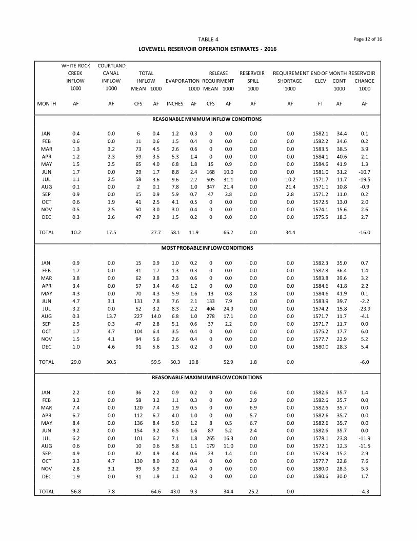
TABLE 4 Page 12 of 16
LOVEWELL RESERVOIR OPERATION ESTIMATES - 2016
MONTH
WHITE ROCK COURTLAND CREEK CANAL
INFLOW INFLOW 1000 1000
AF AF
TOTAL RELEASE RESERVOIR REQUIREMENT END OF MONTH RESERVOIR
INFLOW EVAPORATION REQUIRMENT SPILL SHORTAGE ELEV CONT CHANGE MEAN 1000 1000 MEAN 1000 1000 1000 1000 1000
CFS AF INCHES AF CFS AF AF AF FT AF AF
REASONABLE MINIMUM INFLOW CONDITIONS
JAN 0.4 0.0 6 0.4 1.2 0.3 0 0.0 0.0 0.0 1582.1 34.4 0.1 FEB 0.6 0.0 11 0.6 1.5 0.4 0 0.0 0.0 0.0 1582.2 34.6 0.2
MAR 1.3 3.2 73 4.5 2.6 0.6 0 0.0 0.0 0.0 1583.5 38.5 3.9 APR 1.2 2.3 59 3.5 5.3 1.4 0 0.0 0.0 0.0 1584.1 40.6 2.1 MAY 1.5 2.5 65 4.0 6.8 1.8 15 0.9 0.0 0.0 1584.6 41.9 1.3 JUN 1.7 0.0 29 1.7 8.8 2.4 168 10.0 0.0 0.0 1581.0 31.2 -10.7 JUL 1.1 2.5 58 3.6 9.6 2.2 505 31.1 0.0 10.2 1571.7 11.7 -19.5
AUG 0.1 0.0 2 0.1 7.8 1.0 347 21.4 0.0 21.4 1571.1 10.8 -0.9 SEP 0.9 0.0 15 0.9 5.9 0.7 47 2.8 0.0 2.8 1571.2 11.0 0.2 OCT 0.6 1.9 41 2.5 4.1 0.5 0 0.0 0.0 0.0 1572.5 13.0 2.0 NOV 0.5 2.5 50 3.0 3.0 0.4 0 0.0 0.0 0.0 1574.1 15.6 2.6 DEC 0.3 2.6 47 2.9 1.5 0.2 0 0.0 0.0 0.0 1575.5 18.3 2.7
TOTAL 10.2 17.5 27.7 58.1 11.9 66.2 0.0 34.4 -16.0
MOST PROBABLE INFLOW CONDITIONS
JAN 0.9 0.0 15 0.9 1.0 0.2 0 0.0 0.0 0.0 1582.3 35.0 0.7 FEB 1.7 0.0 31 1.7 1.3 0.3 0 0.0 0.0 0.0 1582.8 36.4 1.4
MAR 3.8 0.0 62 3.8 2.3 0.6 0 0.0 0.0 0.0 1583.8 39.6 3.2 APR 3.4 0.0 57 3.4 4.6 1.2 0 0.0 0.0 0.0 1584.6 41.8 2.2 MAY 4.3 0.0 70 4.3 5.9 1.6 13 0.8 1.8 0.0 1584.6 41.9 0.1 JUN 4.7 3.1 131 7.8 7.6 2.1 133 7.9 0.0 0.0 1583.9 39.7 -2.2 JUL 3.2 0.0 52 3.2 8.3 2.2 404 24.9 0.0 0.0 1574.2 15.8 -23.9
AUG 0.3 13.7 227 14.0 6.8 1.0 278 17.1 0.0 0.0 1571.7 11.7 -4.1 SEP 2.5 0.3 47 2.8 5.1 0.6 37 2.2 0.0 0.0 1571.7 11.7 0.0 OCT 1.7 4.7 104 6.4 3.5 0.4 0 0.0 0.0 0.0 1575.2 17.7 6.0 NOV 1.5 4.1 94 5.6 2.6 0.4 0 0.0 0.0 0.0 1577.7 22.9 5.2 DEC 1.0 4.6 91 5.6 1.3 0.2 0 0.0 0.0 0.0 1580.0 28.3 5.4
TOTAL 29.0 30.5 59.5 50.3 10.8 52.9 1.8 0.0 -6.0
REASONABLE MAXIMUM INFLOW CONDITIONS
JAN 2.2 0.0 36 2.2 0.9 0.2 0 0.0 0.6 0.0 1582.6 35.7 1.4 FEB 3.2 0.0 58 3.2 1.1 0.3 0 0.0 2.9 0.0 1582.6 35.7 0.0
MAR 7.4 0.0 120 7.4 1.9 0.5 0 0.0 6.9 0.0 1582.6 35.7 0.0 APR 6.7 0.0 112 6.7 4.0 1.0 0 0.0 5.7 0.0 1582.6 35.7 0.0 MAY 8.4 0.0 136 8.4 5.0 1.2 8 0.5 6.7 0.0 1582.6 35.7 0.0 JUN 9.2 0.0 154 9.2 6.5 1.6 87 5.2 2.4 0.0 1582.6 35.7 0.0 JUL 6.2 0.0 101 6.2 7.1 1.8 265 16.3 0.0 0.0 1578.1 23.8 -11.9
AUG 0.6 0.0 10 0.6 5.8 1.1 179 11.0 0.0 0.0 1572.1 12.3 -11.5 SEP 4.9 0.0 82 4.9 4.4 0.6 23 1.4 0.0 0.0 1573.9 15.2 2.9 OCT 3.3 4.7 130 8.0 3.0 0.4 0 0.0 0.0 0.0 1577.7 22.8 7.6 NOV 2.8 3.1 99 5.9 2.2 0.4 0 0.0 0.0 0.0 1580.0 28.3 5.5 DEC 1.9 0.0 31 1.9 1.1 0.2 0 0.0 0.0 0.0 1580.6 30.0 1.7
TOTAL 56.8 7.8 64.6 43.0 9.3 34.4 25.2 0.0 -4.3

TABLE 4 Page 13 of 16
KIRWIN RESERVOIR OPERATION ESTIMATES - 2016
RELEASE RESERVOIR REQUIREMENT END OF MONTH RESERVOIR INFLOW EVAPORATION REQUIRMENT SPILL SHORTAGE ELEV CONT CHANGE
MEAN 1000 1000 MEAN 1000 1000 1000 1000 1000 MONTH CFS AF INCHES AF CFS AF AF AF FT AF AF
REASONABLE MINIMUM INFLOW CONDITIONS
JAN 5 0.3 1.3 0.2 0 0.0 0.0 0.0 1713.1 35.5 0.1 FEB 7 0.4 1.6 0.3 0 0.0 0.0 0.0 1713.1 35.6 0.1
MAR 13 0.8 2.8 0.4 0 0.0 0.0 0.0 1713.3 36.0 0.4 APR 13 0.8 6.4 1.0 0 0.0 0.0 0.0 1713.2 35.8 -0.2 MAY 21 1.3 7.9 1.3 8 0.5 0.0 0.0 1713.0 35.3 -0.5 JUN 18 1.1 9.6 1.5 87 5.2 0.0 0.0 1710.9 29.7 -5.6 JUL 16 1.0 10.9 1.5 193 11.9 0.0 0.0 1704.1 17.3 -12.4
AUG 11 0.7 9.6 0.8 179 11.0 0.0 5.6 1700.0 11.8 -5.5 SEP 7 0.4 7.4 0.5 8 0.5 0.0 0.5 1699.9 11.7 -0.1 OCT 3 0.2 5.1 0.4 0 0.0 0.0 0.0 1699.7 11.5 -0.2 NOV 5 0.3 3.0 0.2 0 0.0 0.0 0.0 1699.8 11.6 0.1 DEC 5 0.3 1.6 0.1 0 0.0 0.0 0.0 1700.0 11.8 0.2
TOTAL 7.6 67.2 8.2 29.1 0.0 6.1 -23.6
MOST PROBABLE INFLOW CONDITIONS
JAN 15 0.9 1.1 0.2 0 0.0 0.0 0.0 1713.3 36.1 0.7 FEB 25 1.4 1.4 0.2 0 0.0 0.0 0.0 1713.7 37.3 1.2
MAR 41 2.5 2.5 0.4 0 0.0 0.0 0.0 1714.5 39.4 2.1 APR 45 2.7 5.7 1.0 0 0.0 0.0 0.0 1715.0 41.1 1.7 MAY 70 4.3 7.1 1.3 6 0.4 0.0 0.0 1715.8 43.7 2.6 JUN 59 3.5 8.6 1.6 71 4.4 0.0 0.0 1715.0 41.2 -2.5 JUL 55 3.4 9.8 1.8 193 11.9 0.0 0.0 1711.3 30.9 -10.3
AUG 39 2.4 8.6 1.2 149 9.2 0.0 0.0 1707.5 22.9 -8.0 SEP 20 1.2 6.6 0.7 8 0.5 0.0 0.0 1707.5 22.9 0.0 OCT 13 0.8 4.6 0.5 0 0.0 0.0 0.0 1707.7 23.2 0.3 NOV 17 1.0 2.7 0.3 0 0.0 0.0 0.0 1708.1 23.9 0.7 DEC 13 0.8 1.4 0.2 0 0.0 0.0 0.0 1708.4 24.5 0.6
TOTAL 24.9 60.1 9.4 26.4 0.0 0.0 -10.9
REASONABLE MAXIMUM INFLOW CONDITIONS
JAN 45 2.8 1.0 0.2 0 0.0 0.0 0.0 1714.0 38.0 2.6 FEB 75 4.2 1.3 0.2 0 0.0 0.0 0.0 1715.3 42.0 4.0
MAR 120 7.4 2.3 0.4 0 0.0 0.0 0.0 1717.4 49.0 7.0 APR 134 8.0 5.1 1.0 0 0.0 0.0 0.0 1719.4 56.0 7.0 MAY 211 13.0 6.3 1.3 5 0.3 0.0 0.0 1722.4 67.4 11.4 JUN 174 10.4 7.7 1.8 59 3.5 0.0 0.0 1723.7 72.5 5.1 JUL 164 10.1 8.8 2.2 167 10.3 0.0 0.0 1723.1 70.1 -2.4
AUG 115 7.1 7.7 1.8 119 7.3 0.0 0.0 1722.6 68.1 -2.0 SEP 60 3.6 6.0 1.4 7 0.4 0.0 0.0 1723.0 69.9 1.8 OCT 39 2.4 4.1 1.0 0 0.0 0.0 0.0 1723.4 71.3 1.4 NOV 52 3.1 2.4 0.6 0 0.0 0.0 0.0 1724.0 73.8 2.5 DEC 41 2.5 1.3 0.3 0 0.0 0.0 0.0 1724.5 76.0 2.2
TOTAL 74.6 54.0 12.2 21.8 0.0 0.0 40.6
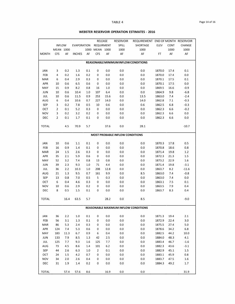
TABLE 4 Page 14 of 16
WEBSTER RESERVOIR OPERATION ESTIMATES - 2016
RELEASE RESERVOIR REQUIREMENT END OF MONTH RESERVOIR INFLOW EVAPORATION REQUIRMENT SPILL SHORTAGE ELEV CONT CHANGE
MEAN 1000 1000 MEAN 1000 1000 1000 1000 1000 MONTH CFS AF INCHES AF CFS AF AF AF FT AF AF
REASONABLE MINIMUM INFLOW CONDITIONS
JAN 3 0.2 1.3 0.1 0 0.0 0.0 0.0 1870.0 17.4 0.1 FEB 4 0.2 1.6 0.2 0 0.0 0.0 0.0 1870.0 17.4 0.0
MAR 6 0.4 2.9 0.3 0 0.0 0.0 0.0 1870.1 17.5 0.1 APR 10 0.6 6.5 0.6 0 0.0 0.0 0.0 1870.1 17.5 0.0 MAY 15 0.9 8.2 0.8 16 1.0 0.0 0.0 1869.5 16.6 -0.9 JUN 10 0.6 10.4 1.0 107 6.4 0.0 0.0 1864.9 9.8 -6.8 JUL 10 0.6 11.5 0.9 253 15.6 0.0 13.5 1863.0 7.4 -2.4
AUG 6 0.4 10.6 0.7 227 14.0 0.0 14.0 1862.8 7.1 -0.3 SEP 3 0.2 7.8 0.5 10 0.6 0.0 0.6 1862.5 6.8 -0.3 OCT 2 0.1 5.2 0.3 0 0.0 0.0 0.0 1862.3 6.6 -0.2 NOV 3 0.2 3.2 0.2 0 0.0 0.0 0.0 1862.3 6.6 0.0 DEC 2 0.1 1.7 0.1 0 0.0 0.0 0.0 1862.3 6.6 0.0
TOTAL 4.5 70.9 5.7 37.6 0.0 28.1 -10.7
MOST PROBABLE INFLOW CONDITIONS
JAN 10 0.6 1.1 0.1 0 0.0 0.0 0.0 1870.3 17.8 0.5 FEB 16 0.9 1.4 0.1 0 0.0 0.0 0.0 1870.8 18.6 0.8
MAR 24 1.5 2.6 0.3 0 0.0 0.0 0.0 1871.4 19.8 1.2 APR 35 2.1 5.9 0.6 0 0.0 0.0 0.0 1872.3 21.3 1.5 MAY 52 3.2 7.4 0.8 13 0.8 0.0 0.0 1873.2 22.9 1.6 JUN 39 2.3 9.3 1.0 71 4.4 0.0 0.0 1871.4 19.8 -3.1 JUL 36 2.2 10.3 1.0 208 12.8 0.0 0.0 1863.7 8.2 -11.6
AUG 21 1.3 9.5 0.7 161 9.9 0.0 8.5 1863.0 7.4 -0.8 SEP 13 0.8 7.0 0.5 5 0.3 0.0 0.0 1863.0 7.4 0.0 OCT 6 0.4 4.6 0.3 0 0.0 0.0 0.0 1863.1 7.5 0.1 NOV 10 0.6 2.9 0.2 0 0.0 0.0 0.0 1863.5 7.9 0.4 DEC 8 0.5 1.5 0.1 0 0.0 0.0 0.0 1863.7 8.3 0.4
TOTAL 16.4 63.5 5.7 28.2 0.0 8.5 -9.0
REASONABLE MAXIMUM INFLOW CONDITIONS
JAN 36 2.2 1.0 0.1 0 0.0 0.0 0.0 1871.3 19.4 2.1 FEB 56 3.1 1.3 0.1 0 0.0 0.0 0.0 1872.9 22.4 3.0
MAR 86 5.3 2.4 0.3 0 0.0 0.0 0.0 1875.5 27.4 5.0 APR 124 7.4 5.3 0.6 0 0.0 0.0 0.0 1878.6 34.2 6.8 MAY 183 11.3 6.7 0.9 6 0.4 0.0 0.0 1882.5 44.2 10.0 JUN 133 7.9 8.5 1.3 42 2.5 0.0 0.0 1884.0 48.3 4.1 JUL 125 7.7 9.3 1.6 125 7.7 0.0 0.0 1883.4 46.7 -1.6
AUG 73 4.5 8.6 1.4 101 6.2 0.0 0.0 1882.3 43.6 -3.1 SEP 44 2.6 6.3 1.0 2 0.1 0.0 0.0 1882.9 45.1 1.5 OCT 24 1.5 4.2 0.7 0 0.0 0.0 0.0 1883.1 45.9 0.8 NOV 34 2.0 2.6 0.4 0 0.0 0.0 0.0 1883.7 47.5 1.6 DEC 31 1.9 1.4 0.2 0 0.0 0.0 0.0 1884.3 49.2 1.7
TOTAL 57.4 57.6 8.6 16.9 0.0 0.0 31.9

TABLE 4 Page 15 of 16
WACONDA RESERVOIR OPERATION ESTIMATES - 2016
RELEASE RESERVOIR REQUIREMENT END OF MONTH RESERVOIR INFLOW EVAPORATION REQUIRMENT SPILL SHORTAGE ELEV CONT CHANGE
MEAN 1000 1000 MEAN 1000 1000 1000 1000 1000 MONTH CFS AF INCHES AF CFS AF AF AF FT AF AF
REASONABLE MINIMUM INFLOW CONDITIONS
JAN 29 1.8 1.2 0.9 19 1.2 6.0 0.0 1454.6 207.1 -6.3 FEB 43 2.4 1.4 1.0 20 1.1 0.3 0.0 1454.6 207.1 0.0
MAR 83 5.1 2.7 1.9 18 1.1 2.1 0.0 1454.6 207.1 0.0 APR 86 5.1 6.8 4.8 17 1.0 0.0 0.0 1454.5 206.4 -0.7 MAY 99 6.1 8.4 5.9 18 1.1 0.0 0.0 1454.5 205.5 -0.9 JUN 84 5.0 10.5 7.4 45 2.7 0.0 0.0 1454.0 200.4 -5.1 JUL 136 8.4 12.4 8.6 156 9.6 0.0 0.0 1453.2 190.6 -9.8
AUG 50 3.1 10.6 7.1 125 7.7 0.0 0.0 1452.1 178.9 -11.7 SEP 39 2.3 8.5 5.4 35 2.1 0.0 0.0 1451.6 173.7 -5.2 OCT 29 1.8 5.5 3.4 21 1.3 0.0 0.0 1451.3 170.8 -2.9 NOV 34 2.0 2.9 1.8 27 1.6 0.0 0.0 1451.2 169.4 -1.4 DEC 28 1.7 1.4 0.8 24 1.5 0.0 0.0 1451.2 168.8 -0.6
TOTAL 44.8 72.3 49.0 32.0 8.4 0.0 -44.6
MOST PROBABLE INFLOW CONDITIONS
JAN 81 5.0 1.0 0.7 10 0.6 10.0 0.0 1454.6 207.1 -6.3 FEB 120 6.7 1.3 0.9 10 0.6 5.2 0.0 1454.6 207.1 0.0
MAR 227 14.0 2.4 1.7 10 0.6 11.7 0.0 1454.6 207.1 0.0 APR 237 14.1 6.1 4.3 8 0.5 0.0 0.0 1455.4 216.4 9.3 MAY 274 16.9 7.5 5.5 10 0.6 7.8 0.0 1455.6 219.4 3.0 JUN 233 13.9 9.4 6.9 32 2.0 5.0 0.0 1455.6 219.4 0.0 JUL 378 23.3 11.1 8.2 112 6.9 8.2 0.0 1455.6 219.4 0.0
AUG 140 8.6 9.5 7.0 89 5.5 0.0 0.0 1455.2 215.5 -3.9 SEP 106 6.3 7.6 5.5 21 1.3 0.0 0.0 1455.2 215.0 -0.5 OCT 83 5.1 4.9 3.6 10 0.6 0.0 0.0 1455.3 215.9 0.9 NOV 94 5.6 2.6 1.9 15 0.9 23.6 0.0 1453.6 195.1 -20.8 DEC 75 4.6 1.3 0.9 13 0.8 2.9 0.0 1453.6 195.1 0.0
TOTAL 124.1 64.7 47.1 20.9 74.4 0.0 -18.3
REASONABLE MAXIMUM INFLOW CONDITIONS
JAN 242 14.9 0.9 0.7 3 0.2 20.3 0.0 1454.6 207.1 -6.3 FEB 363 20.2 1.2 0.9 4 0.2 19.1 0.0 1454.6 207.1 0.0
MAR 685 42.2 2.2 1.6 5 0.3 40.3 0.0 1454.6 207.1 0.0 APR 715 42.6 5.5 3.9 5 0.3 26.1 0.0 1455.6 219.4 12.3 MAY 825 50.8 6.8 5.0 5 0.3 45.5 0.0 1455.6 219.4 0.0 JUN 703 41.9 8.6 6.3 22 1.3 34.3 0.0 1455.6 219.4 0.0 JUL 1141 70.3 10.1 7.4 70 4.3 58.6 0.0 1455.6 219.4 0.0
AUG 419 25.8 8.7 6.4 57 3.5 15.9 0.0 1455.6 219.4 0.0 SEP 320 19.1 7.0 5.1 12 0.7 13.3 0.0 1455.6 219.4 0.0 OCT 248 15.3 4.5 3.3 6 0.4 11.6 0.0 1455.6 219.4 0.0 NOV 282 16.8 2.4 1.8 5 0.3 39.0 0.0 1453.6 195.1 -24.3 DEC 224 13.8 1.2 0.8 5 0.3 12.7 0.0 1453.6 195.1 0.0
TOTAL 373.7 59.1 43.2 12.1 336.7 0.0 -18.3
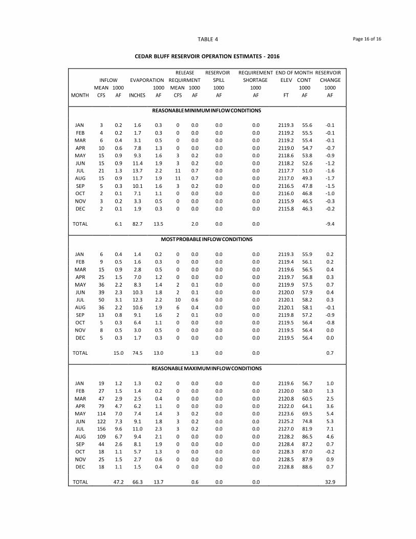
TABLE 4 Page 16 of 16
CEDAR BLUFF RESERVOIR OPERATION ESTIMATES - 2016
RELEASE RESERVOIR REQUIREMENT END OF MONTH RESERVOIR INFLOW EVAPORATION REQUIRMENT SPILL SHORTAGE ELEV CONT CHANGE
MEAN 1000 1000 MEAN 1000 1000 1000 1000 1000 MONTH CFS AF INCHES AF CFS AF AF AF FT AF AF
REASONABLE MINIMUM INFLOW CONDITIONS
JAN 3 0.2 1.6 0.3 0 0.0 0.0 0.0 2119.3 55.6 -0.1 FEB 4 0.2 1.7 0.3 0 0.0 0.0 0.0 2119.2 55.5 -0.1
MAR 6 0.4 3.1 0.5 0 0.0 0.0 0.0 2119.2 55.4 -0.1 APR 10 0.6 7.8 1.3 0 0.0 0.0 0.0 2119.0 54.7 -0.7 MAY 15 0.9 9.3 1.6 3 0.2 0.0 0.0 2118.6 53.8 -0.9 JUN 15 0.9 11.4 1.9 3 0.2 0.0 0.0 2118.2 52.6 -1.2 JUL 21 1.3 13.7 2.2 11 0.7 0.0 0.0 2117.7 51.0 -1.6
AUG 15 0.9 11.7 1.9 11 0.7 0.0 0.0 2117.0 49.3 -1.7 SEP 5 0.3 10.1 1.6 3 0.2 0.0 0.0 2116.5 47.8 -1.5 OCT 2 0.1 7.1 1.1 0 0.0 0.0 0.0 2116.0 46.8 -1.0 NOV 3 0.2 3.3 0.5 0 0.0 0.0 0.0 2115.9 46.5 -0.3 DEC 2 0.1 1.9 0.3 0 0.0 0.0 0.0 2115.8 46.3 -0.2
TOTAL 6.1 82.7 13.5 2.0 0.0 0.0 -9.4
MOST PROBABLE INFLOW CONDITIONS
JAN 6 0.4 1.4 0.2 0 0.0 0.0 0.0 2119.3 55.9 0.2 FEB 9 0.5 1.6 0.3 0 0.0 0.0 0.0 2119.4 56.1 0.2
MAR 15 0.9 2.8 0.5 0 0.0 0.0 0.0 2119.6 56.5 0.4 APR 25 1.5 7.0 1.2 0 0.0 0.0 0.0 2119.7 56.8 0.3 MAY 36 2.2 8.3 1.4 2 0.1 0.0 0.0 2119.9 57.5 0.7 JUN 39 2.3 10.3 1.8 2 0.1 0.0 0.0 2120.0 57.9 0.4 JUL 50 3.1 12.3 2.2 10 0.6 0.0 0.0 2120.1 58.2 0.3
AUG 36 2.2 10.6 1.9 6 0.4 0.0 0.0 2120.1 58.1 -0.1 SEP 13 0.8 9.1 1.6 2 0.1 0.0 0.0 2119.8 57.2 -0.9 OCT 5 0.3 6.4 1.1 0 0.0 0.0 0.0 2119.5 56.4 -0.8 NOV 8 0.5 3.0 0.5 0 0.0 0.0 0.0 2119.5 56.4 0.0 DEC 5 0.3 1.7 0.3 0 0.0 0.0 0.0 2119.5 56.4 0.0
TOTAL 15.0 74.5 13.0 1.3 0.0 0.0 0.7
REASONABLE MAXIMUM INFLOW CONDITIONS
JAN 19 1.2 1.3 0.2 0 0.0 0.0 0.0 2119.6 56.7 1.0 FEB 27 1.5 1.4 0.2 0 0.0 0.0 0.0 2120.0 58.0 1.3
MAR 47 2.9 2.5 0.4 0 0.0 0.0 0.0 2120.8 60.5 2.5 APR 79 4.7 6.2 1.1 0 0.0 0.0 0.0 2122.0 64.1 3.6 MAY 114 7.0 7.4 1.4 3 0.2 0.0 0.0 2123.6 69.5 5.4 JUN 122 7.3 9.1 1.8 3 0.2 0.0 0.0 2125.2 74.8 5.3 JUL 156 9.6 11.0 2.3 3 0.2 0.0 0.0 2127.0 81.9 7.1
AUG 109 6.7 9.4 2.1 0 0.0 0.0 0.0 2128.2 86.5 4.6 SEP 44 2.6 8.1 1.9 0 0.0 0.0 0.0 2128.4 87.2 0.7 OCT 18 1.1 5.7 1.3 0 0.0 0.0 0.0 2128.3 87.0 -0.2 NOV 25 1.5 2.7 0.6 0 0.0 0.0 0.0 2128.5 87.9 0.9 DEC 18 1.1 1.5 0.4 0 0.0 0.0 0.0 2128.8 88.6 0.7
TOTAL 47.2 66.3 13.7 0.6 0.0 0.0 32.9
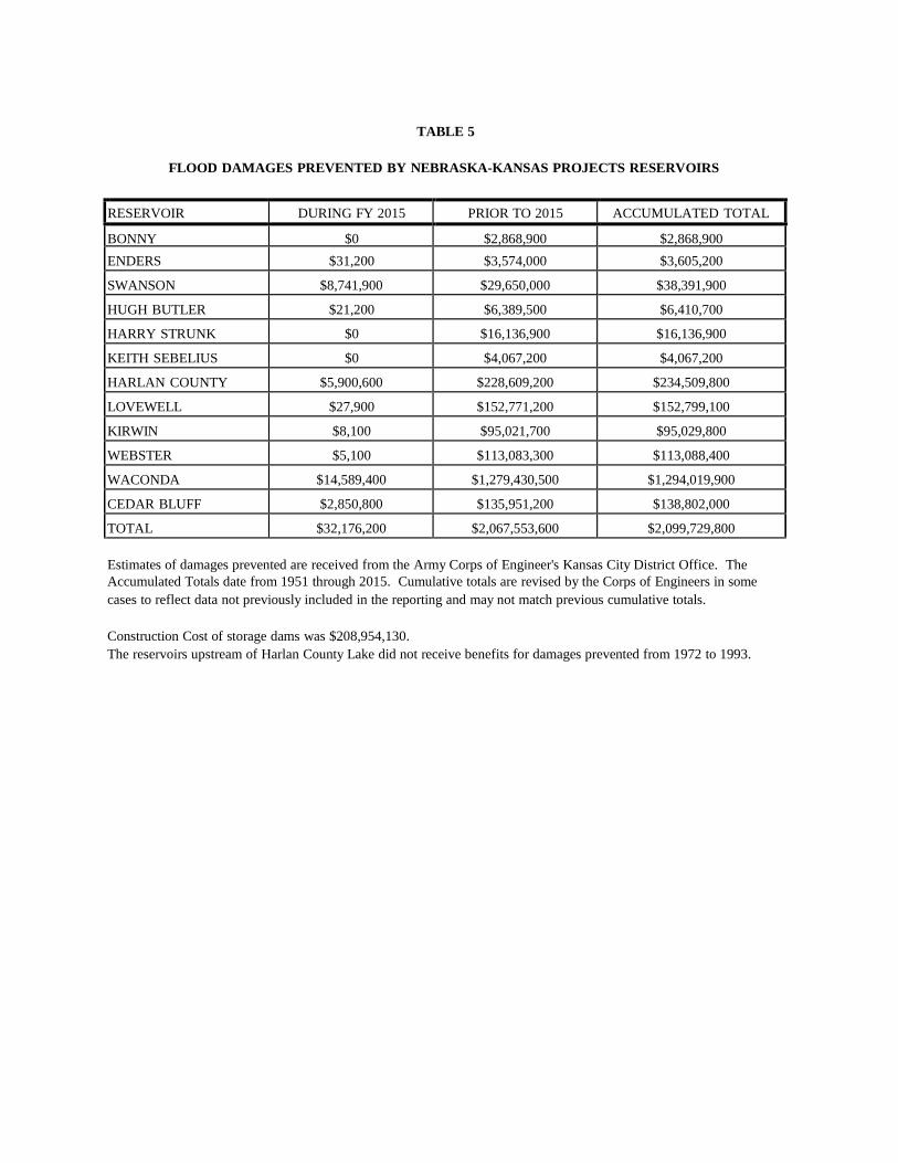
TABLE 5
FLOOD DAMAGES PREVENTED BY NEBRASKA-KANSAS PROJECTS RESERVOIRS
RESERVOIR DURING FY 2015 PRIOR TO 2015 ACCUMULATED TOTAL
BONNY $0 $2,868,900 $2,868,900 ENDERS $31,200 $3,574,000 $3,605,200
SWANSON $8,741,900 $29,650,000 $38,391,900
HUGH BUTLER $21,200 $6,389,500 $6,410,700
HARRY STRUNK $0 $16,136,900 $16,136,900
KEITH SEBELIUS $0 $4,067,200 $4,067,200
HARLAN COUNTY $5,900,600 $228,609,200 $234,509,800
LOVEWELL $27,900 $152,771,200 $152,799,100
KIRWIN $8,100 $95,021,700 $95,029,800
WEBSTER $5,100 $113,083,300 $113,088,400
WACONDA $14,589,400 $1,279,430,500 $1,294,019,900
CEDAR BLUFF $2,850,800 $135,951,200 $138,802,000
TOTAL $32,176,200 $2,067,553,600 $2,099,729,800 Estimates of damages prevented are received from the Army Corps of Engineer's Kansas City District Office. The Accumulated Totals date from 1951 through 2015. Cumulative totals are revised by the Corps of Engineers in some cases to reflect data not previously included in the reporting and may not match previous cumulative totals.
Construction Cost of storage dams was $208,954,130. The reservoirs upstream of Harlan County Lake did not receive benefits for damages prevented from 1972 to 1993.

TABLE 6 WATER DIVERTED IN 2015 AND THE
ESTIMATED DIVERSION FOR 2016 (Units - Acre-Feet)
2015 Irrigation
Operations
10-Year Average Estimated
Diversion 2015 Diversion Irrigation District and Canal From To (2005-2014) Diversion in 2016
Mirage Flats Irrigation District Mirage Flats Canal
7/11
9/16
9,285
11,154
13,000
Ainsworth Irrigation District Ainsworth Canal
5/18
9/21
71,400
71,552
73,000
Twin Loups Irrigation District Above Davis Creek 4/16 9/30 45,178 51,091 46,000 Below Davis Creek 5/4 9/14 41,646 43,552 44,000
Total Twin Loups Irrigation District 86,824 94,643 90,000
Frenchman Valley Irrigation District
Culbertson Canal H & RW Irrigation District
Culbertson Extension Canal
4/15
Did not
9/30 run.
4,115
0
9,121
0
9,000
0 Frenchman-Cambridge Irrigation District
Meeker-Driftwood Canal 6/24 9/03 11,448 15,350 25,000 Red Willow Canal Did not run. 926 0 0 Bartley Canal 4/8 9/5 4,299 8,590 10,000 Cambridge Canal 4/13 9/9 18,834 29,156 26,000
Total Frenchman-Cambridge Irrigation District 35,507 53,096 61,000
Almena Irrigation District Almena Canal
Bostwick Irrigation District in Nebraska
Did not run.
1,731 0 0
Franklin Canal 7/01 8/28 11,873 15,240 15,000 Naponee Canal 6/30 8/28 602 812 1,000 Franklin Pump Canal 6/29 8/27 582 1,027 1,000 Superior Canal 4/28 8/28 4,618 6,571 7,000 Courtland Canal (Nebraska) 6/11 9/30 310 483 1,000
Total Bostwick Irrigation District in Nebraska 17,985 24,133 25,000
Kansas-Bostwick Irrigation District
Courtland Canal above Lovewell 6/20 9/30 16,395 20,436 19,000 Courtland Canal below Lovewell 5/19 9/13 35,107 31,544 33,000
Total Kansas-Bostwick Irrigation District 51,502 51,980 52,000
Kirwin Irrigation District Kirwin Canal 6/29 8/28 11,892 11,997 12,000
Webster Irrigation District
Osborne Canal Did not run. 5,802 0 0 Glen Elder Irrigation District 4/1 9/16 4,756 3,626 5,000
TOTAL 300,799 331,302 340,000
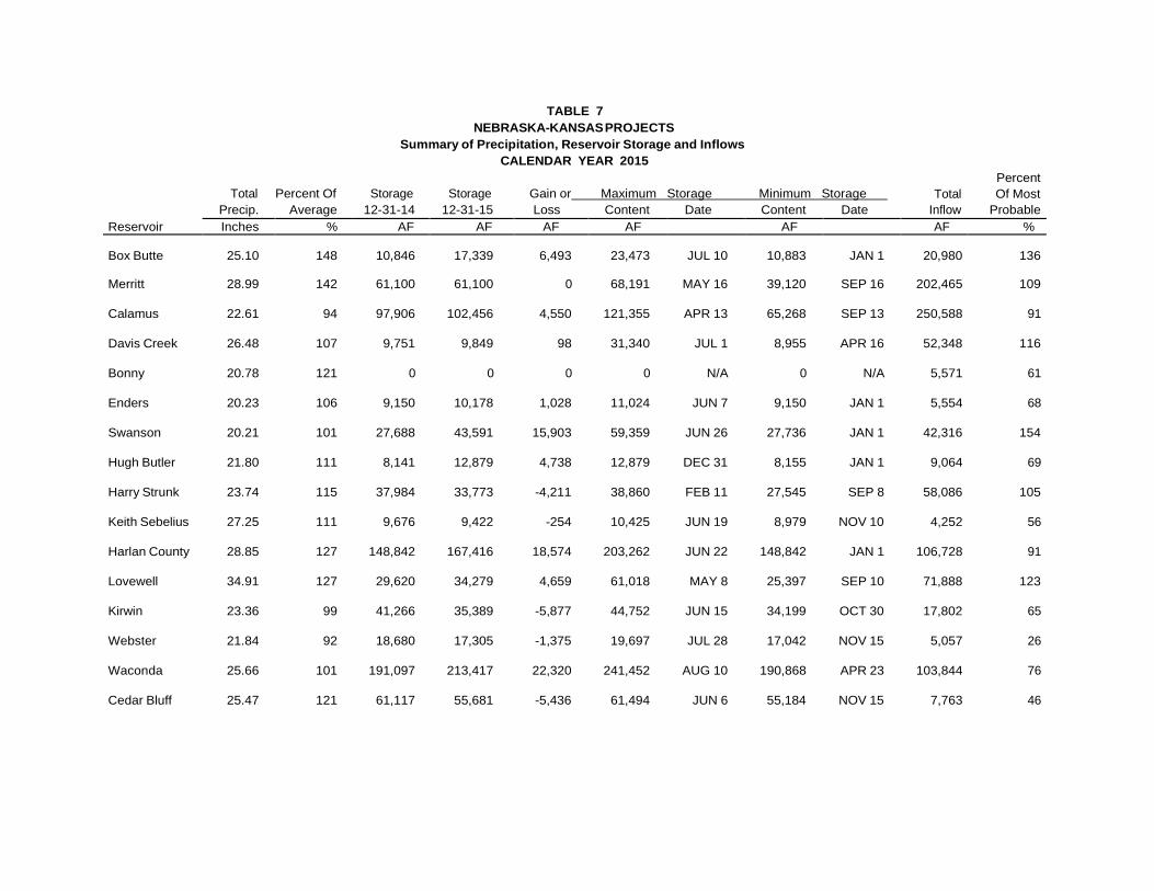
Percent
Total Percent Of Storage Storage Gain or Maximum Storage Minimum Storage Total Of Most Reservoir
Precip. Average 12-31-14 12-31-15 Loss Content Date Content Date Inflow Probable Inches % AF AF AF AF AF AF %
Box Butte 25.10 148 10,846 17,339 6,493 23,473 JUL 10 10,883 JAN 1 20,980 136
Merritt 28.99 142 61,100 61,100 0 68,191 MAY 16 39,120 SEP 16 202,465 109
Calamus 22.61 94 97,906 102,456 4,550 121,355 APR 13 65,268 SEP 13 250,588 91
Davis Creek 26.48 107 9,751 9,849 98 31,340 JUL 1 8,955 APR 16 52,348 116
Bonny 20.78 121 0 0 0 0 N/A 0 N/A 5,571 61
Enders 20.23 106 9,150 10,178 1,028 11,024 JUN 7 9,150 JAN 1 5,554 68
Swanson 20.21 101 27,688 43,591 15,903 59,359 JUN 26 27,736 JAN 1 42,316 154
Hugh Butler 21.80 111 8,141 12,879 4,738 12,879 DEC 31 8,155 JAN 1 9,064 69
Harry Strunk 23.74 115 37,984 33,773 -4,211 38,860 FEB 11 27,545 SEP 8 58,086 105
Keith Sebelius 27.25 111 9,676 9,422 -254 10,425 JUN 19 8,979 NOV 10 4,252 56
Harlan County 28.85 127 148,842 167,416 18,574 203,262 JUN 22 148,842 JAN 1 106,728 91
Lovewell 34.91 127 29,620 34,279 4,659 61,018 MAY 8 25,397 SEP 10 71,888 123
Kirwin 23.36 99 41,266 35,389 -5,877 44,752 JUN 15 34,199 OCT 30 17,802 65
Webster 21.84 92 18,680 17,305 -1,375 19,697 JUL 28 17,042 NOV 15 5,057 26
Waconda 25.66 101 191,097 213,417 22,320 241,452 AUG 10 190,868 APR 23 103,844 76
Cedar Bluff 25.47 121 61,117 55,681 -5,436 61,494 JUN 6 55,184 NOV 15 7,763 46
TABLE 7 NEBRASKA-KANSAS PROJECTS
Summary of Precipitation, Reservoir Storage and Inflows CALENDAR YEAR 2015

Outflow
6
5
4
3
2
1
0 JAN FEB MAR APR MAY JUN JUL AUG SEP OCT NOV DEC
2013 2014 2015
TOP OF CONSERVATION
Inflow
4
3
2
1
0 JAN FEB MAR APR MAY JUN JUL AUG SEP OCT NOV DEC
2013 2014 2015
Storage
END OF MONTH CONTENT 40
30
20
10
0 J F M A M J J A S O N D J F M A M J J A S O N D J F M A M J J A S O N D
2013 2014 2015
Thou
sand
Acr
e-Fe
et
Thou
sand
Acr
e-Fe
et
Thou
sand
Acr
e-Fe
et
EXHIBIT 1A
BOX BUTTE RESERVOIR ACTUAL OPERATION

Outflow
14
12
10
8
6
4
2
0 JAN FEB MAR APR MAY JUN JUL AUG SEP OCT NOV DEC
MIN YEAR NORMAL YEAR MAX YEAR
MIN YEAR NORMAL YEAR MAX YEAR
TOP OF CONSERVATION
Inflow
3
2
1
0 JAN FEB MAR APR MAY JUN JUL AUG SEP OCT NOV DEC
Storage END OF MONTH CONTENT
40
30
20
10
0 J F M A M J J A S O N D J F M A M J J A S O N D J F M A M J J A S O N D
DRY YEAR NORMAL YEAR WET YEAR
Thou
sand
Acr
e-Fe
et
Thou
sand
Acr
e-Fe
et
Thou
sand
Acr
e-Fe
et
EXHIBIT 1B
BOX BUTTE RESERVOIR 2016 OPERATION PLAN
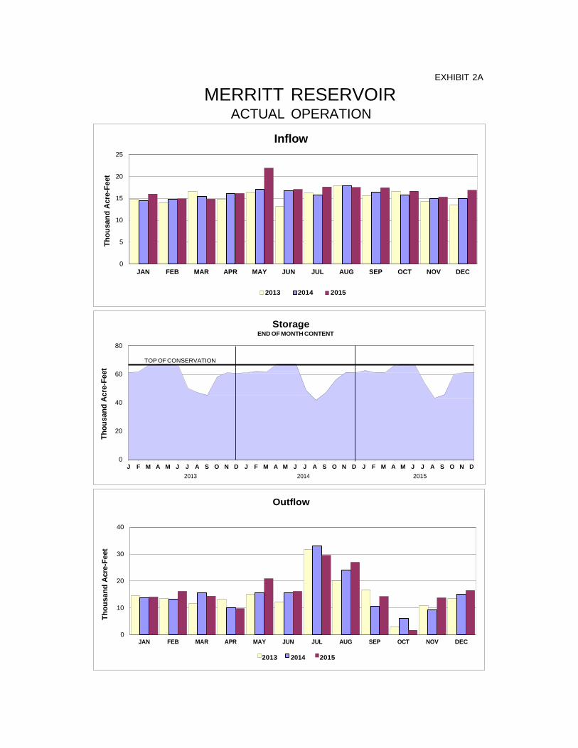
Inflow 25
20
15
10
5
0 JAN FEB MAR APR MAY JUN JUL AUG SEP OCT NOV DEC
2013 2014 2015
Outflow
40
30
20
10
0 JAN FEB MAR APR MAY JUN JUL AUG SEP OCT NOV DEC
2013 2014 2015
TOP OF CONSERVATION
Storage END OF MONTH CONTENT
80
60
40
20
0 J F M A M J J A S O N D J F M A M J J A S O N D J F M A M J J A S O N D
2013 2014 2015
Thou
sand
Acr
e-Fe
et
Thou
sand
Acr
e-Fe
et
Thou
sand
Acr
e-Fe
et
EXHIBIT 2A
MERRITT RESERVOIR ACTUAL OPERATION

Inflow
20
15
10
5
0 JAN FEB MAR APR MAY JUN JUL AUG SEP OCT NOV DEC
Storage
80
60
40
20
0 J F M A M J J A S O N D J F M A M J J A S O N D J F M A M J J A S O N D
DRY YEAR NORMAL YEAR WET YEAR
Outflow
40
30
20
10
0 JAN FEB MAR APR MAY JUN JUL AUG SEP OCT NOV DEC
MIN YEAR NORMAL YEAR MAX YEAR
END OF MONTH CONTENT
MIN YEAR NORMAL YEAR MAX YEAR
TOP OF CONSERVATION
Th
ousa
nd A
cre-
Feet
Th
ousa
nd A
cre-
Feet
Th
ousa
nd A
cre-
Feet
EXHIBIT 2B
MERRITT RESERVOIR 2016 OPERATION PLAN

EXHIBIT 3A
CALAMUS RESERVOIR ACTUAL OPERATION
TOP OF CONSERVATION
Inflow 30
Thou
sand
Acr
e-Fe
et
20
10
0 JAN FEB MAR APR MAY JUN JUL AUG SEP OCT NOV DEC
2013 2014 2015
Storage END OF MONTH CONTENT
150
120
90
60
30
0 J F M A M J J A S O N D J F M A M J J A S O N D J F M A M J J A S O N D
2013 2014 2015
Outflow
60
50
40
30
20
10
0 JAN FEB MAR APR MAY JUN JUL AUG SEP OCT NOV DEC
2013 2014 2015
Thou
sand
Acr
e-Fe
et
Thou
sand
Acr
e-Fe
et
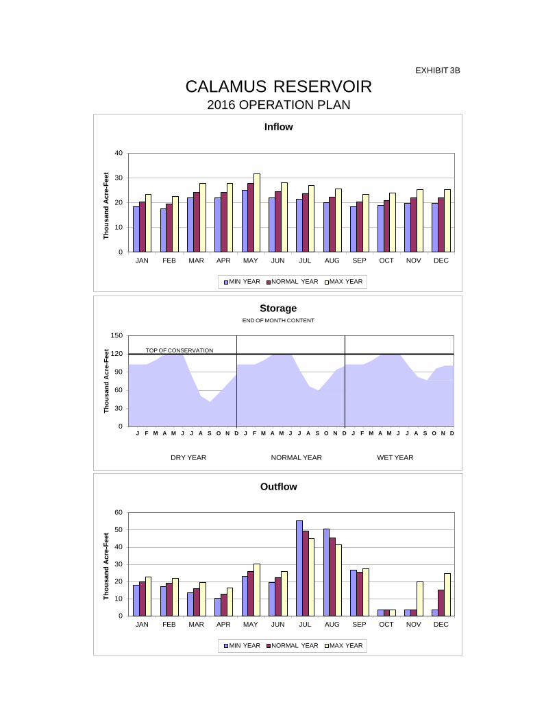
Inflow
40
30
20
10
0 JAN FEB MAR APR MAY JUN JUL AUG SEP OCT NOV DEC
MIN YEAR NORMAL YEAR MAX YEAR
MIN YEAR NORMAL YEAR MAX YEAR
TOP OF CONSERVATION
Storage END OF MONTH CONTENT
150
120
90
60
30
0
J F M A M J J A S O N D J F M A M J J A S O N D J F M A M J J A S O N D
DRY YEAR NORMAL YEAR WET YEAR
Outflow
60
50
40
30
20
10
0 JAN FEB MAR APR MAY JUN JUL AUG SEP OCT NOV DEC
Thou
sand
Acr
e-Fe
et
Thou
sand
Acr
e-Fe
et
Thou
sand
Acr
e-Fe
et
EXHIBIT 3B
CALAMUS RESERVOIR 2016 OPERATION PLAN
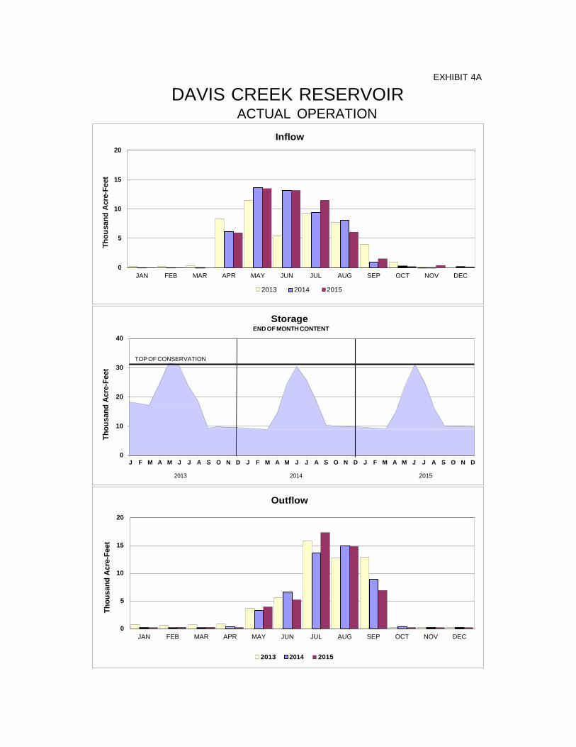
EXHIBIT 4A
DAVIS CREEK RESERVOIR ACTUAL OPERATION
TOP OF CONSERVATION
Inflow 20
15
10
5
0 JAN FEB MAR APR MAY JUN JUL AUG SEP OCT NOV DEC
2013 2014 2015
Storage END OF MONTH CONTENT
40
30
Thou
sand
Acr
e-Fe
et
20
10
0 J F M A M J J A S O N D J F M A M J J A S O N D J F M A M J J A S O N D
2013 2014 2015
Outflow
20
15
10
5
0 JAN FEB MAR APR MAY JUN JUL AUG SEP OCT NOV DEC
2013 2014 2015
Thou
sand
Acr
e-Fe
et
Thou
sand
Acr
e-Fe
et
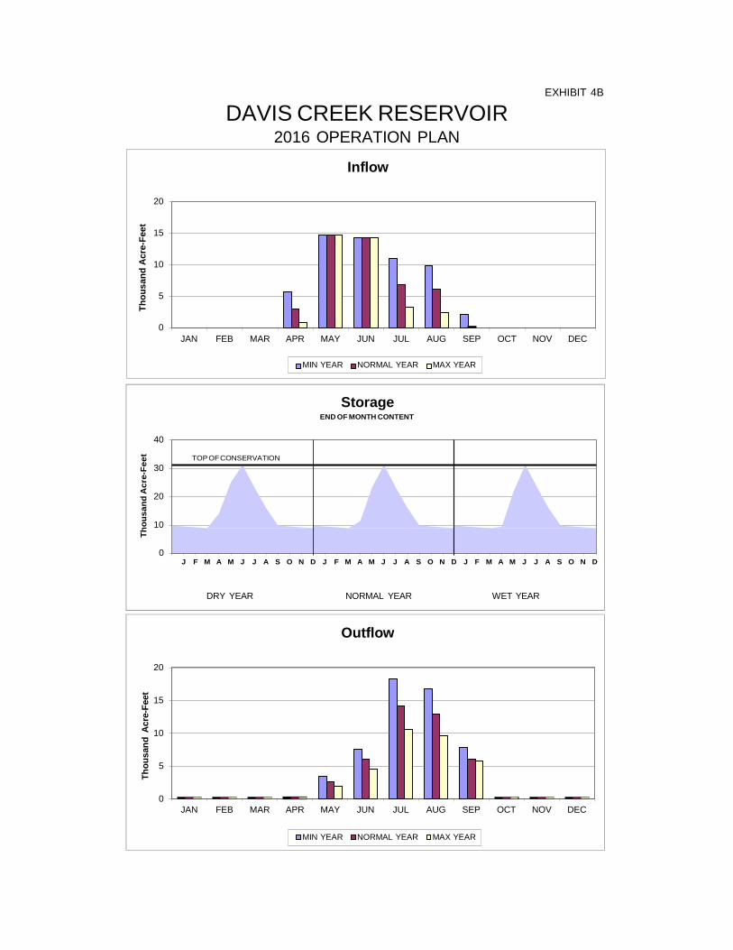
Inflow
20
15
10
5
0 JAN FEB MAR APR MAY JUN JUL AUG SEP OCT NOV DEC
Storage
40
30
20
10
0 J F M A M J J A S O N D J F M A M J J A S O N D J F M A M J J A S O N D
DRY YEAR NORMAL YEAR WET YEAR
Outflow
20
15
10
5
0 JAN FEB MAR APR MAY JUN JUL AUG SEP OCT NOV DEC
MIN YEAR NORMAL YEAR MAX YEAR
END OF MONTH CONTENT
MIN YEAR NORMAL YEAR MAX YEAR
TOP OF CONSERVATION
Thou
sand
Acr
e-Fe
et
Th
ousa
nd A
cre-
Feet
Th
ousa
nd A
cre-
Feet
EXHIBIT 4B
DAVIS CREEK RESERVOIR 2016 OPERATION PLAN
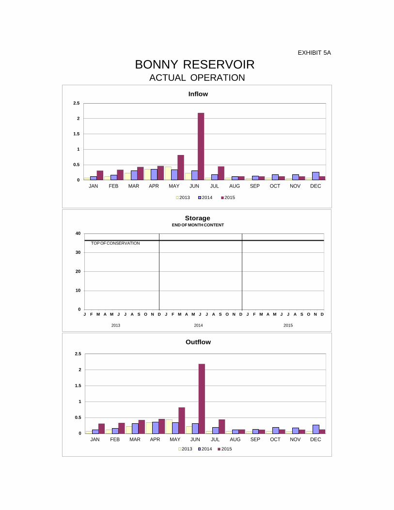
EXHIBIT 5A
BONNY RESERVOIR ACTUAL OPERATION
TOP OF CONSERVATION
Inflow 2.5
2
1.5
1
0.5
0 JAN FEB MAR APR MAY JUN JUL AUG SEP OCT NOV DEC
2013 2014 2015
Storage END OF MONTH CONTENT
40
30
20
10
0 J F M A M J J A S O N D J F M A M J J A S O N D J F M A M J J A S O N D
2013 2014 2015
Outflow
2.5
2
1.5
1
0.5
0 JAN FEB MAR APR MAY JUN JUL AUG SEP OCT NOV DEC
2013 2014 2015

Inflow
3
2
1
0 JAN FEB MAR APR MAY JUN JUL AUG SEP OCT NOV DEC
Outflow
3
2
1
0 JAN FEB MAR APR MAY JUN JUL AUG SEP OCT NOV DEC
MIN YEAR NORMAL YEAR MAX YEAR
MIN YEAR NORMAL YEAR MAX YEAR
Storage END OF MONTH CONTENT
40
TOP OF CONSERVATION
30 20 10 0
J F M A M J J A S O N D J F M A M J J A S O N D J F M A M J J A S O N D
DRY YEAR NORMAL YEAR WET YEAR
Thou
sand
Acr
e-Fe
et
Thou
sand
Acr
e-Fe
et
Thou
sand
Acr
e-Fe
et
EXHIBIT 5B
BONNY RESERVOIR 2016 OPERATION PLAN

2.0
Inflow
1.5
1.0
0.5
0.0 JAN FEB MAR APR MAY JUN JUL AUG SEP OCT NOV DEC
2013 2014 2015
Storage END OF MONTH CONTENT
50
40
30
20
10
0 J F M A M J J A S O N D J F M A M J J A S O N D J F M A M J J A S O N D
2013 2014 2015
Outflow
5.0
4.0
3.0
2.0
1.0
0.0 JAN FEB MAR APR MAY JUN JUL AUG SEP OCT NOV DEC
2013 2014 2015
TOP OF CONSERVATION
Thou
sand
Acr
e-Fe
et
Thou
sand
Acr
e-Fe
et
Th
ousa
nd A
cre-
Feet
EXHIBIT 6A
ENDERS RESERVOIR ACTUAL OPERATION
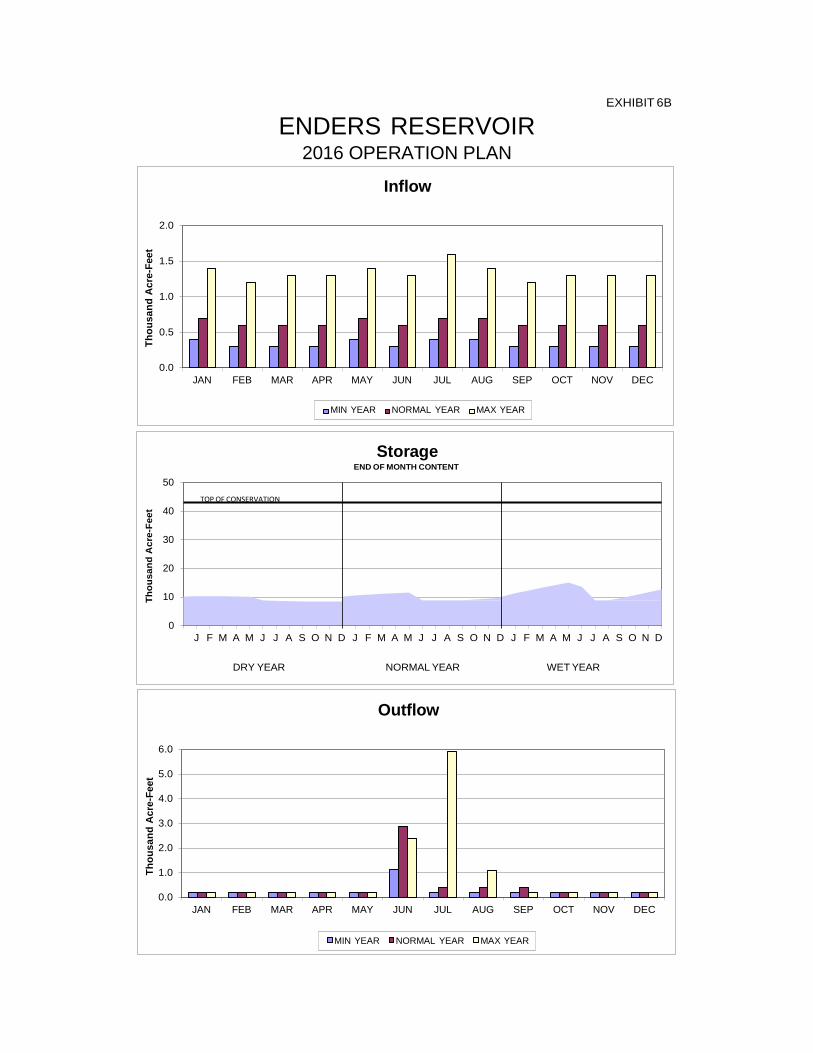
END OF MONTH CONTENT
TOP OF CONSERVAION
Inflow
2.0
1.5
1.0
0.5
0.0 JAN FEB MAR APR MAY JUN JUL AUG SEP OCT NOV DEC
Outflow
6.0
5.0
4.0
3.0
2.0
1.0
0.0 JAN FEB MAR APR MAY JUN JUL AUG SEP OCT NOV DEC
MIN YEAR NORMAL YEAR MAX YEAR
MIN YEAR NORMAL YEAR MAX YEAR
Storage END OF MONTH CONTENT
50 TOP OF CONSERVATION
40 30 20 10
0 J F M A M J J A S O N D J F M A M J J A S O N D J F M A M J J A S O N D
DRY YEAR NORMAL YEAR WET YEAR
Thou
sand
Acr
e-Fe
et
Thou
sand
Acr
e-Fe
et
Thou
sand
Acr
e-Fe
et
EXHIBIT 6B
ENDERS RESERVOIR 2016 OPERATION PLAN
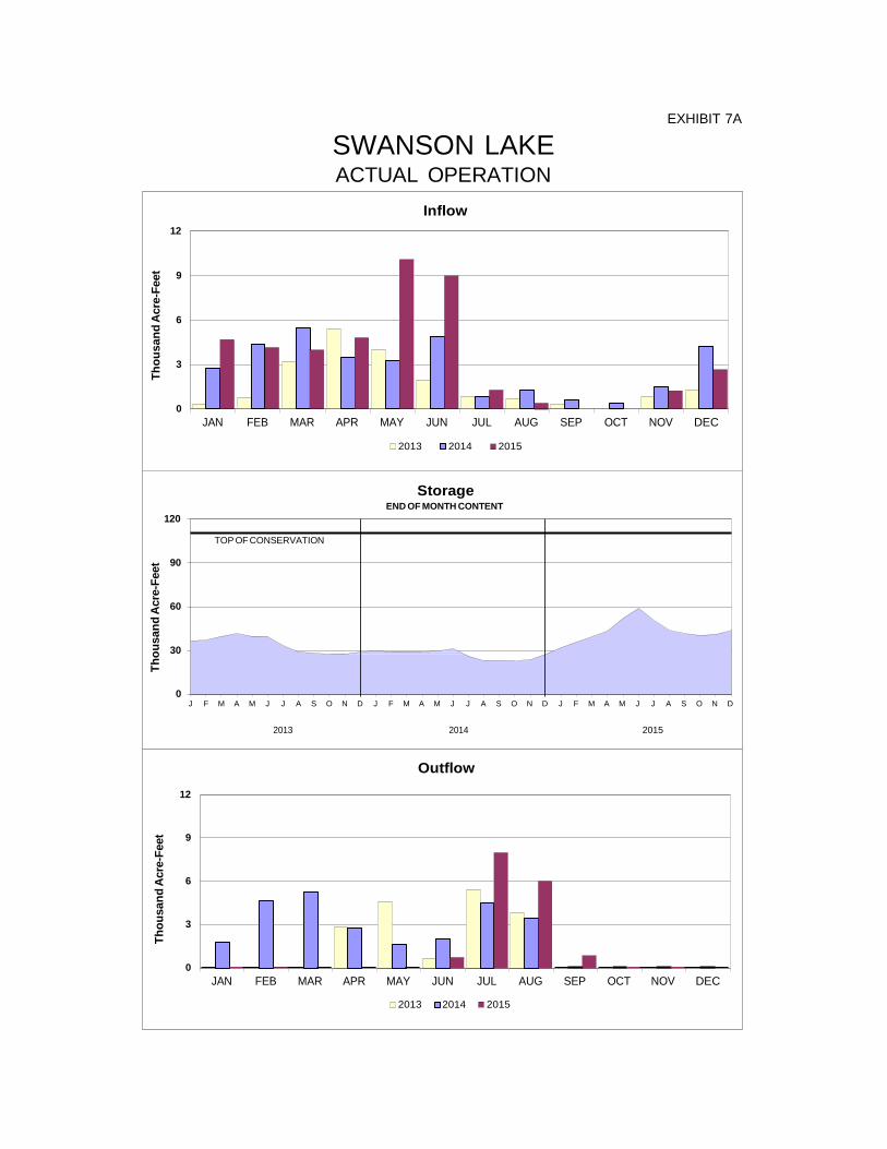
Inflow 12
9
6
3
0 JAN FEB MAR APR MAY JUN JUL AUG SEP OCT NOV DEC
2013 2014 2015
Storage
120
90
60
30
0 J F M A M J J A S O N D J F M A M J J A S O N D J F M A M J J A S O N D
2013 2014 2015
Outflow
12
9
6
3
0 JAN FEB MAR APR MAY JUN JUL AUG SEP OCT NOV DEC
2013 2014 2015
END OF MONTH CONTENT
TOP OF CONSERVATION
Thou
sand
Acr
e-Fe
et
Thou
sand
Acr
e-Fe
et
Thou
sand
Acr
e-Fe
et
EXHIBIT 7A
SWANSON LAKE ACTUAL OPERATION

Inflow
10
8
6
4
2
0 JAN FEB MAR APR MAY JUN JUL AUG SEP OCT NOV DEC
Outflow
25
20
15
10
5
0 JAN FEB MAR APR MAY JUN JUL AUG SEP OCT NOV DEC
MIN YEAR NORMAL YEAR MAX YEAR
MIN YEAR NORMAL YEAR MAX YEAR
Storage END OF MONTH CONTENT
120
TOP OF CONSERVATION
90 60 30
0 J F M A M J J A S O N D J F M A M J J A S O N D J F M A M J J A S O N D
DRY YEAR NORMAL YEAR WET YEAR
Thou
sand
Acr
e-Fe
et
Thou
sand
Acr
e-Fe
et
Thou
sand
Acr
e-Fe
et
EXHIBIT 7B
SWANSON LAKE 2016 OPERATION PLAN
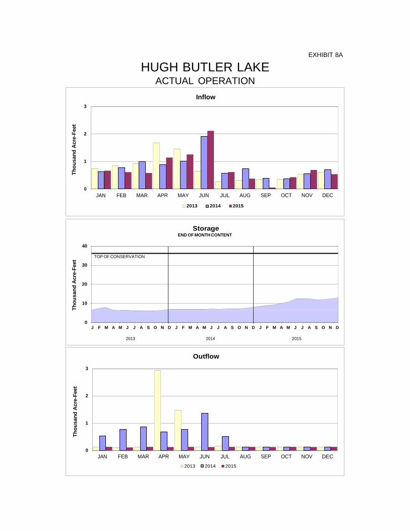
EXHIBIT 8A
HUGH BUTLER LAKE ACTUAL OPERATION
Inflow 3
2
1
0 JAN FEB MAR APR MAY JUN JUL
2013 2014
AUG 2015
SEP OCT NOV DEC
TOP OF CONSERVATION
Storage END OF MONTH CONTENT
40
30
20
10
0 J F M A M J J A S O N D J F M A M J J A S O N D J F M A M J J A S O N D
2013 2014 2015
Outflow
3
2
1
0 JAN FEB MAR APR MAY JUN JUL AUG SEP OCT NOV DEC
2013 2014 2015
Thou
sand
Acr
e-Fe
et
Thou
sand
Acr
e-Fe
et
Thou
sand
Acr
e-Fe
et
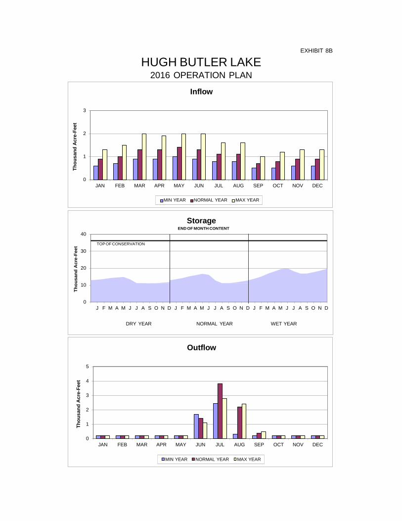
Inflow
3
2
1
0 JAN FEB MAR APR MAY JUN JUL AUG SEP OCT NOV DEC
Outflow
5
4
3
2
1
0 JAN FEB MAR APR MAY JUN JUL AUG SEP OCT NOV DEC
MIN YEAR NORMAL YEAR MAX YEAR
MIN YEAR NORMAL YEAR MAX YEAR
Storage END OF MONTH CONTENT
40
TOP OF CONSERVATION
30 20 10
0 J F M A M J J A S O N D J F M A M J J A S O N D J F M A M J J A S O N D
DRY YEAR NORMAL YEAR WET YEAR
Thou
sand
Acr
e-Fe
et
Thou
sand
Acr
e-Fe
et
Thou
sand
Acr
e-Fe
et
EXHIBIT 8B
HUGH BUTLER LAKE 2016 OPERATION PLAN
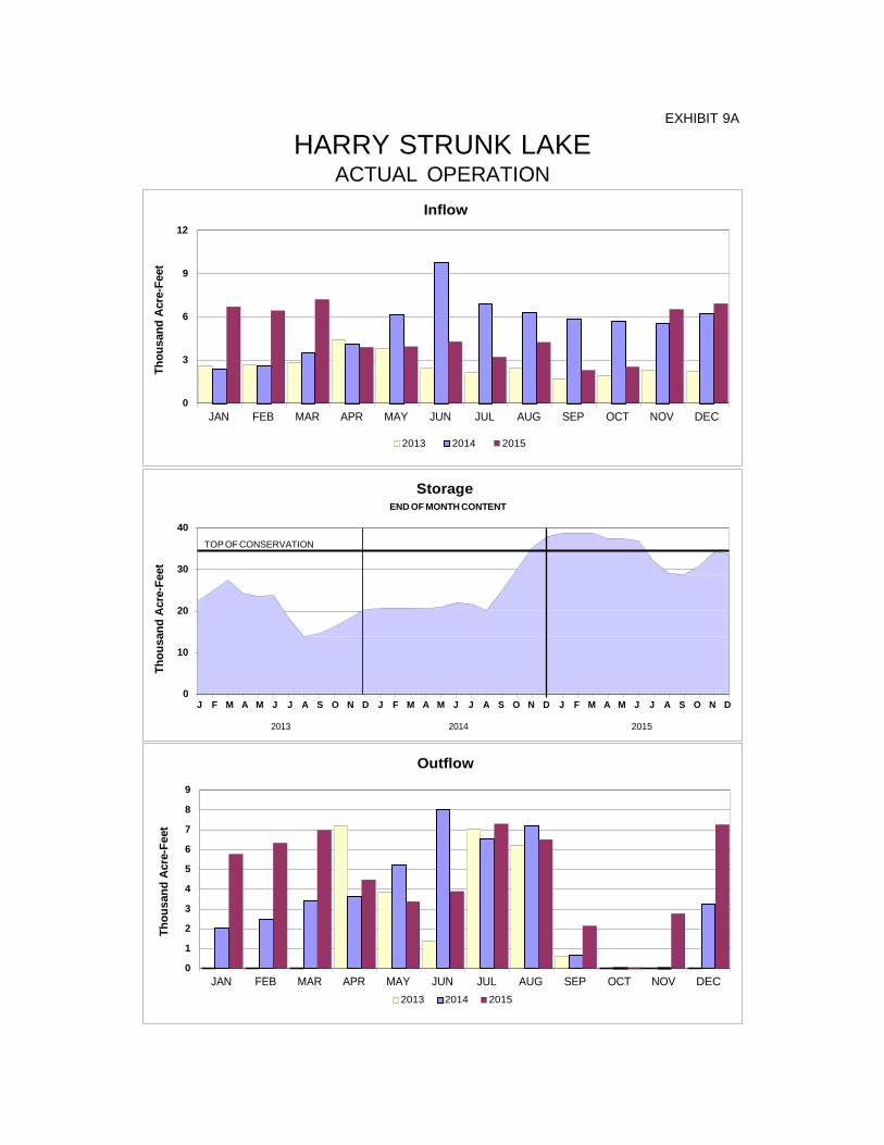
EXHIBIT 9A
HARRY STRUNK LAKE ACTUAL OPERATION
TOP OF CONSERVATION
Inflow 12
9
6
3
0 JAN FEB MAR APR MAY JUN JUL AUG SEP OCT NOV DEC
2013 2014 2015
Storage END OF MONTH CONTENT
40
30
20
10
0 J F M A M J J A S O N D J F M A M J J A S O N D J F M A M J J A S O N D
2013 2014 2015
Outflow
9
8
7
6
5
4
3
2
1
0 JAN FEB MAR APR MAY JUN JUL AUG SEP OCT NOV DEC
2013 2014 2015
Thou
sand
Acr
e-Fe
et
Thou
sand
Acr
e-Fe
et
Thou
sand
Acr
e-Fe
et
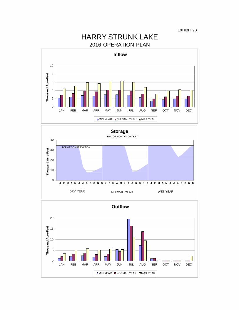
Inflow
10
8
6
4
2
0 JAN FEB MAR APR MAY JUN JUL AUG SEP OCT NOV DEC
Outflow
20
15
10
5
0 JAN FEB MAR APR MAY JUN JUL AUG SEP OCT NOV DEC
MIN YEAR NORMAL YEAR MAX YEAR
MIN YEAR NORMAL YEAR MAX YEAR
Storage END OF MONTH CONTENT
40
TOP OF CONSERVATION 30 20 10
0 J F M A M J J A S O N D J F M A M J J A S O N D J F M A M J J A S O N D
DRY YEAR NORMAL YEAR WET YEAR
Thou
sand
Acr
e-Fe
et
Thou
sand
Acr
e-Fe
et
Thou
sand
Acr
e-Fe
et
EXHIBIT 9B
HARRY STRUNK LAKE 2016 OPERATION PLAN

Outflow
3
2
1
0 JAN FEB MAR APR MAY JUN JUL AUG SEP OCT NOV DEC
2013 2014 2015
TOP OF CONSERVATION
Inflow 2
1.5
1
0.5
0 JAN FEB MAR APR MAY JUN JUL AUG SEP OCT NOV DEC
2013 2014 2015
Storage END OF MONTH CONTENT
40
30
20
10
0 J F M A M J J A S O N D J F M A M J J A S O N D J F M A M J J A S O N D
2013 2014 2015
Thou
sand
Acr
e-Fe
et
Thou
sand
Acr
e-Fe
et
Thou
sand
Acr
e-Fe
et
EXHIBIT 10A
KEITH SEBELIUS LAKE ACTUAL OPERATION

Inflow
6
5
4
3
2
1
0 JAN FEB MAR APR MAY JUN JUL AUG SEP OCT NOV DEC
MIN YEAR NORMAL YEAR MAX YEAR
MIN YEAR NORMAL YEAR MAX YEAR
TOP OF CONSERVATION
Storage END OF MONTH CONTENT
40
30
20
10
0 J F M A M J J A S O N D J F M A M J J A S O N D J F M A M J J A S O N D
DRY YEAR NORMAL YEAR WET YEAR
Outflow
6
5
4
3
2
1
0 JAN FEB MAR APR MAY JUN JUL AUG SEP OCT NOV DEC
Thou
sand
Acr
e-Fe
et
Thou
sand
Acr
e-Fe
et
Thou
sand
Acr
e-Fe
et
EXHIBIT 10B
KEITH SEBELIUS LAKE 2016 OPERATION PLAN

Inflow 30
25
20
15
10
5
0 JAN FEB MAR APR MAY JUN JUL AUG SEP OCT NOV DEC
2013 2014 2015
350
300
250
200
150
100
50
0 J F M A M J J A S O N D J F M A M J J A S O N D J F M A M J J A S O N D
2013 2014 2015
Outflow
30
25
20
15
10
5
0 JAN FEB MAR APR MAY JUN JUL AUG SEP OCT NOV DEC
2013 2014 2015
Storage END OF MONTH CONTENT
TOP OF CONSERVATION
Thou
sand
Acr
e-Fe
et
Thou
sand
Acr
e-Fe
et
Thou
sand
Acr
e-Fe
et
EXHIBIT 11A
HARLAN COUNTY LAKE ACTUAL OPERATION
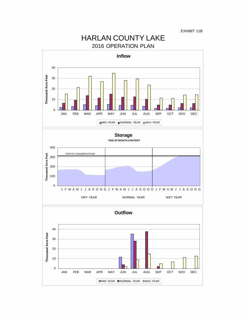
Inflow
40
30
20
10
0 JAN FEB MAR APR MAY JUN JUL AUG SEP OCT NOV DEC
Outflow
40
30
20
10
0 JAN FEB MAR APR MAY JUN JUL AUG SEP OCT NOV DEC
MIN YEAR NORMAL YEAR MAX YEAR
MIN YEAR NORMAL YEAR MAX YEAR
Storage END OF MONTH CONTENT
400
TOP OF CONSERVATION 300 200 100
0 J F M A M J J A S O N D J F M A M J J A S O N D J F M A M J J A S O N D
DRY YEAR NORMAL YEAR WET YEAR
Thou
sand
Acr
e-Fe
et
Thou
sand
Acr
e-Fe
et
Thou
sand
Acr
e-Fe
et
EXHIBIT 11B
HARLAN COUNTY LAKE 2016 OPERATION PLAN

EXHIBIT 12A
LOVEWELL RESERVOIR ACTUAL OPERATION
TOP OF CONSERVATION
Inflow 30
25
20
15
10
5
0 JAN FEB MAR APR MAY JUN JUL AUG SEP OCT NOV DEC
2013 2014 2015
Storage END OF MONTH CONTENT
50
40
30
20
10
0 J F M A M J J A S O N D J F M A M J J A S O N D J F M A M J J A S O N D
2013 2014 2015
Outflow
25
20
15
10
5
0 JAN FEB MAR APR MAY JUN JUL AUG SEP OCT NOV DEC
2013 2014 2015
Thou
sand
Acr
e-Fe
et
Thou
sand
Acr
e-Fe
et
Thou
sand
Acr
e-Fe
et

Inflow
15
12
9
6
3
0 JAN FEB MAR APR MAY JUN JUL AUG SEP OCT NOV DEC
Outflow
40
30
20
10
0 JAN FEB MAR APR MAY JUN JUL AUG SEP OCT NOV DEC
MIN YEAR NORMAL YEAR MAX YEAR
MIN YEAR NORMAL YEAR MAX YEAR
Storage END OF MONTH CONTENT
50
40 TOP OF CONSERVATION
30
20
10
0 J F M A M J J A S O N D J F M A M J J A S O N D J F M A M J J A S O N D
DRY YEAR NORMAL YEAR WET YEAR
Thou
sand
Acr
e-Fe
et
Thou
sand
Acr
e-Fe
et
Thou
sand
Acr
e-Fe
et
EXHIBIT 12B
LOVEWELL RESERVOIR 2016 OPERATION PLAN
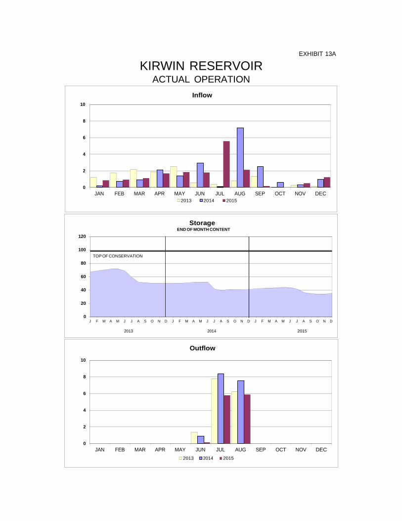
EXHIBIT 13A
KIRWIN RESERVOIR ACTUAL OPERATION
TOP OF CONSERVATION
Inflow 10
8
6
4
2
0 JAN FEB MAR APR MAY JUN JUL AUG SEP OCT NOV DEC
2013 2014 2015
Storage
END OF MONTH CONTENT 120
100
80
60
40
20
0 J F M A M J J A S O N D J F M A M J J A S O N D J F M A M J J A S O N D
2013 2014 2015
Outflow
10
8
6
4
2
0 JAN FEB MAR APR MAY JUN JUL AUG SEP OCT NOV DEC
2013 2014 2015
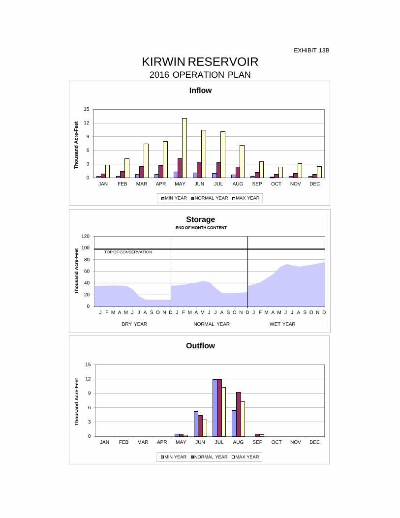
Inflow
15
12
9
6
3
0 JAN FEB MAR APR MAY JUN JUL AUG SEP OCT NOV DEC
Outflow
15
12
9
6
3
0 JAN FEB MAR APR MAY JUN JUL AUG SEP OCT NOV DEC
MIN YEAR NORMAL YEAR MAX YEAR
MIN YEAR NORMAL YEAR MAX YEAR
Storage END OF MONTH CONTENT
120 100
TOP OF CONSERVATION
80 60 40 20 0
J F M A M J J A S O N D J F M A M J J A S O N D J F M A M J J A S O N D
DRY YEAR NORMAL YEAR WET YEAR
Thou
sand
Acr
e-Fe
et
Thou
sand
Acr
e-Fe
et
Thou
sand
Acr
e-Fe
et
EXHIBIT 13B
KIRWIN RESERVOIR 2016 OPERATION PLAN
EXHIBIT 14A
WEBSTER RESERVOIR ACTUAL OPERATION
TOP OF CONSERVATION
Inflow 4
3
2
1
0 JAN FEB MAR APR MAY JUN JUL AUG SEP OCT NOV DEC
2013 2014 2015
Storage END OF MONTH CONTENT
80
60
40
20
0 J F M A M J J A S O N D J F M A M J J A S O N D J F M A M J J A S O N D
2013 2014 2015
Outflow
10
8
6
4
2
0 JAN FEB MAR APR MAY JUN JUL AUG SEP OCT NOV DEC
2013 2014 2015

Inflow
15
12
9
6
3
0 JAN FEB MAR APR MAY JUN JUL AUG SEP OCT NOV DEC
Outflow
15
12
9
6
3
0 JAN FEB MAR APR MAY JUN JUL AUG SEP OCT NOV DEC
MIN YEAR NORMAL YEAR MAX YEAR
MIN YEAR NORMAL YEAR MAX YEAR
Storage END OF MONTH CONTENT
80 TOP OF CONSERVATION
60 40 20 0
J F M A M J J A S O N D J F M A M J J A S O N D J F M A M J J A S O N D
DRY YEAR NORMAL YEAR WET YEAR
Thou
sand
Acr
e-Fe
et
Thou
sand
Acr
e-Fe
et
Thou
sand
Acr
e-Fe
et
EXHIBIT 14B
WEBSTER RESERVOIR 2016 OPERATION PLAN

EXHIBIT 15A
WACONDA LAKE ACTUAL OPERATION
TOP OF CONSERVATION
Inflow 40
30
20
10
0
JAN FEB MAR APR MAY JUN JUL AUG SEP OCT NOV DEC
2014 2015
Storage END OF MONTH CONTENT
250
200
150
100
50
0 J F M A M J J A S O N D J F M A M J J A S O N D J F M A M J J A S O N D
2013 2014 2015
Outflow 15
12
9
6
3
0 JAN FEB MAR APR MAY JUN JUL AUG SEP OCT NOV DEC
2013 2014 2015
Thou
sand
Acr
e-Fe
et
Thou
sand
Acr
e-Fe
et
Thou
sand
Acr
e-Fe
et

Inflow
80
70
60
50
40
30
20
10
0 JAN FEB MAR APR MAY JUN JUL AUG SEP OCT NOV DEC
Outflow
80
70
60
50
40
30
20
10
0 JAN FEB MAR APR MAY JUN JUL AUG SEP OCT NOV DEC
MIN YEAR NORMAL YEAR MAX YEAR
MIN YEAR NORMAL YEAR MAX YEAR
Storage END OF MONTH CONTENT
250 TOP OF CONSERVATION
200
150
100
50
0 J F M A M J J A S O N D J F M A M J J A S O N D J F M A M J J A S O N D
DRY YEAR NORMAL YEAR WET YEAR
Thou
sand
Acr
e-Fe
et
Thou
sand
Acr
e-Fe
et
Thou
sand
Acr
e-Fe
et
EXHIBIT 15B
WACONDA LAKE 2016 OPERATION PLAN
TOP OF CONSERVATION
Inflow 10.0
8.0
6.0
4.0
2.0
0.0 JAN FEB MAR APR MAY JUN JUL AUG SEP OCT NOV DEC
2013 2014 2015
Storage END OF MONTH CONTENT
200
150
100
50
0 J F M A M J J A S O N D J F M A M J J A S O N D J F M A M J J A S O N D
2013 2014 2015
Outflow
2.5
2.0
1.5
1.0
0.5
0.0 JAN FEB MAR APR MAY JUN JUL AUG SEP OCT NOV DEC
2013 2014 2015
EXHIBIT 16A
CEDAR BLUFF RESERVOIR ACTUAL OPERATION
Inflow
10
8
6
4
2
0 JAN FEB MAR APR MAY JUN JUL AUG SEP OCT NOV DEC
Outflow
1.0
0.8
0.5
0.3
0.0 JAN FEB MAR APR MAY JUN JUL AUG SEP OCT NOV DEC
MIN YEAR NORMAL YEAR MAX YEAR
MIN YEAR NORMAL YEAR MAX YEAR
Storage END OF MONTH CONTENT
200 TOP OF CONSERVATION
150 100 50
0 J F M A M J J A S O N D J F M A M J J A S O N D J F M A M J J A S O N D
DRY YEAR NORMAL YEAR WET YEAR
Thou
sand
Acr
e-Fe
et
Thou
sand
Acr
e-Fe
et
Thou
sand
Acr
e-Fe
et
EXHIBIT 16B
CEDAR BLUFF RESERVOIR 2016 OPERATION PLAN

ACRES IRRIGATED DELIVERED TO FARMS DIVERTED TO CANAL
15
12
9
6
3
0 2006 2007 2008 2009 2010 2011 2012 2013 2014 2015 2016
2006
2007
2008
2009
2010
2011
2012
2013
2014
2015
DIVERTED af/acre 0.94 0.63 0.78 1.44 1.37 1.20 1.05 0.66 0.93 1.65
DELIVERED af/acre 0.38 0.23 0.16 0.25 0.52 0.44 0.39 0.28 0.35 0.77
EFFICIENCY 41% 36% 21% 18% 38% 37% 37% 42% 38% 46%
FORECASTED SHORTAGES (2016) DRY YEAR 16,300 AF NORMAL YEAR 6,300 AF WET YEAR 0 AF
1000
AF
DIV
ERTE
D O
R D
ELIV
ERED
/ 10
00 A
CR
ES IR
RIG
ATED
EXHIBIT 17
MIRAGE FLATS IRRIGATION DISTRICT CANAL DIV., FARM DEL., AND ACRES IRRIG.

90
80
70
60
50
40
30
20
10
0 2006 2007 2008 2009 2010 2011 2012 2013 2014 2015 2016
ACRES IRRIGATED DELIVERED TO FARMS DIVERTED TO CANAL
2006
2007
2008
2009
2010
2011
2012
2013
2014
2015
DIVERTED af/acre 2.42 2.19 1.81 1.77 2.03 1.84 2.46 1.98 2.06 2.07
DELIVERED af/acre 1.61 1.39 1.02 0.99 1.18 0.98 1.60 1.12 1.14 1.17
EFFICIENCY 66% 64% 56% 56% 58% 53% 65% 56% 55% 57%
FORECASTED SHORTAGES (2016) DRY YEAR 0 AF NORMAL YEAR 0 AF WET YEAR 0 AF
EXHIBIT 18
AINSWORTH IRRIGATION DISTRICT CANAL DIV., FARM DEL., AND ACRES IRRIG.
120
110
100
90
80
70
60
50
40
30
20
10
0 2006 2007 2008 2009 2010 2011 2012 2013 2014 2015 2016
ACRES IRRIGATED DELIVERED TO FARMS DIVERTED TO CANAL
2006
2007
2008
2009
2010
2011
2012
2013
2014
2015
DIVERTED af/acre 1.74 1.48 1.41 1.41 1.50 1.58 2.08 1.67 1.44 1.72
DELIVERED af/acre 0.98 0.74 0.72 0.62 0.68 0.74 1.28 0.82 0.54 0.90
EFFICIENCY 56% 50% 51% 44% 45% 47% 61% 49% 38% 52%
FORECASTED SHORTAGES (2016) DRY YEAR 0 AF NORMAL YEAR 0 AF WET YEAR 0 AF
EXHIBIT 19
TWIN LOUPS IRRIGATION DISTRICT CANAL DIV., FARM DEL., AND ACRES IRRIG.
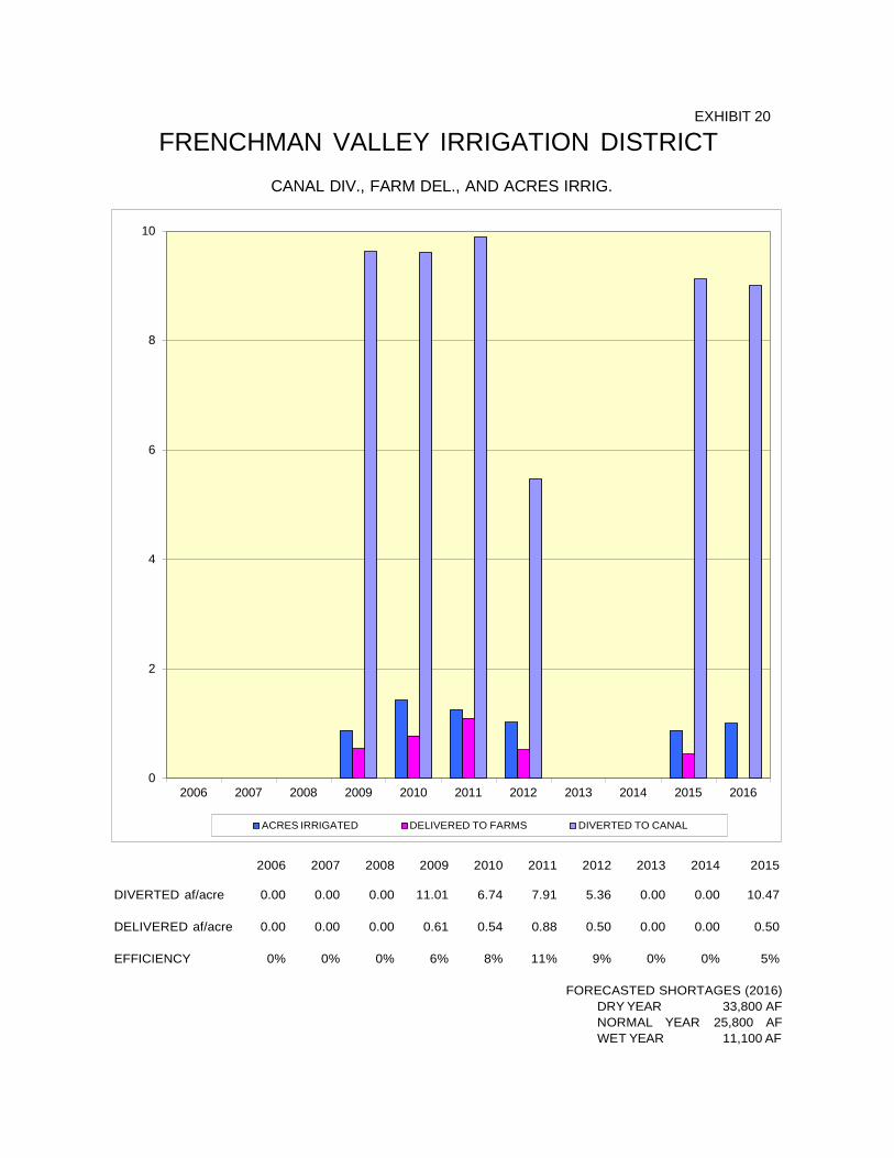
10
8
6
4
2
0 2006 2007 2008 2009 2010 2011 2012 2013 2014 2015 2016
ACRES IRRIGATED DELIVERED TO FARMS DIVERTED TO CANAL
2006
2007
2008
2009
2010
2011
2012
2013
2014
2015
DIVERTED af/acre 0.00 0.00 0.00 11.01 6.74 7.91 5.36 0.00 0.00 10.47
DELIVERED af/acre 0.00 0.00 0.00 0.61 0.54 0.88 0.50 0.00 0.00 0.50
EFFICIENCY 0% 0% 0% 6% 8% 11% 9% 0% 0% 5%
FORECASTED SHORTAGES (2016) DRY YEAR 33,800 AF NORMAL YEAR 25,800 AF WET YEAR 11,100 AF
EXHIBIT 20
FRENCHMAN VALLEY IRRIGATION DISTRICT CANAL DIV., FARM DEL., AND ACRES IRRIG.
ACRES IRRIGATED DELIVERED TO FARMS DIVERTED TO CANAL
10
8
6
4
2
0 2006 2007 2008 2009 2010 2011 2012 2013 2014 2015 2016
2006
2007
2008
2009
2010
2011
2012
2013
2014
2015
DIVERTED af/acre 0.00 0.00 0.00 0.00 0.00 0.00 0.00 0.00 0.00 0.00
DELIVERED af/acre 0.00 0.00 0.00 0.00 0.00 0.00 0.00 0.00 0.00 0.00
EFFICIENCY 0% 0% 0% 0% 0% 0% 0% 0% 0% 0%
FORECASTED SHORTAGES (2016) DRY YEAR 43,400 AF NORMAL YEAR 33,200 AF WET YEAR 14,300 AF
1000
AF
DIV
ERTE
D O
R D
ELIV
ERED
/ 10
00 A
CR
ES IR
RIG
ATED
EXHIBIT 21
H AND RW IRRIGATION DISTRICT CANAL DIV., FARM DEL., AND ACRES IRRIG.
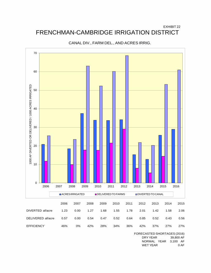
ACRES IRRIGATED DELIVERED TO FARMS DIVERTED TO CANAL
70
60
50
40
30
20
10
0 2006 2007 2008 2009 2010 2011 2012 2013 2014 2015 2016
2006
2007
2008
2009
2010
2011
2012
2013
2014
2015
DIVERTED af/acre 1.23 0.00 1.27 1.68 1.55 1.78 2.01 1.42 1.58 2.06
DELIVERED af/acre 0.57 0.00 0.54 0.47 0.52 0.64 0.85 0.52 0.43 0.56
EFFICIENCY 46% 0% 42% 28% 34% 36% 42% 37% 27% 27%
FORECASTED SHORTAGES (2016) DRY YEAR 39,800 AF NORMAL YEAR 3,100 AF WET YEAR 0 AF
1000
AF
DIV
ER
TED
OR
DE
LIVE
RE
D /
1000
AC
RES
IRR
IGAT
ED
EXHIBIT 22
FRENCHMAN-CAMBRIDGE IRRIGATION DISTRICT CANAL DIV., FARM DEL., AND ACRES IRRIG.
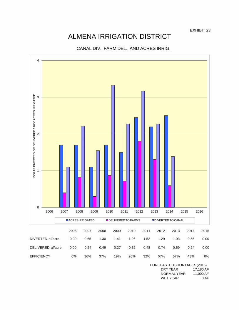
ACRES IRRIGATED DELIVERED TO FARMS DIVERTED TO CANAL
4
3
2
1
0 2006 2007 2008 2009 2010 2011 2012 2013 2014 2015 2016
2006
2007
2008
2009
2010
2011
2012
2013
2014
2015
DIVERTED af/acre 0.00 0.65 1.30 1.41 1.96 1.52 1.29 1.03 0.55 0.00
DELIVERED af/acre 0.00 0.24 0.49 0.27 0.52 0.48 0.74 0.59 0.24 0.00
EFFICIENCY 0% 36% 37% 19% 26% 32% 57% 57% 43% 0%
FORECASTED SHORTAGES (2016) DRY YEAR 17,180 AF NORMAL YEAR 11,000 AF WET YEAR 0 AF
1000
AF
DIV
ERTE
D O
R D
ELIV
ERED
/ 10
00 A
CR
ES IR
RIG
ATED
EXHIBIT 23
ALMENA IRRIGATION DISTRICT CANAL DIV., FARM DEL., AND ACRES IRRIG.
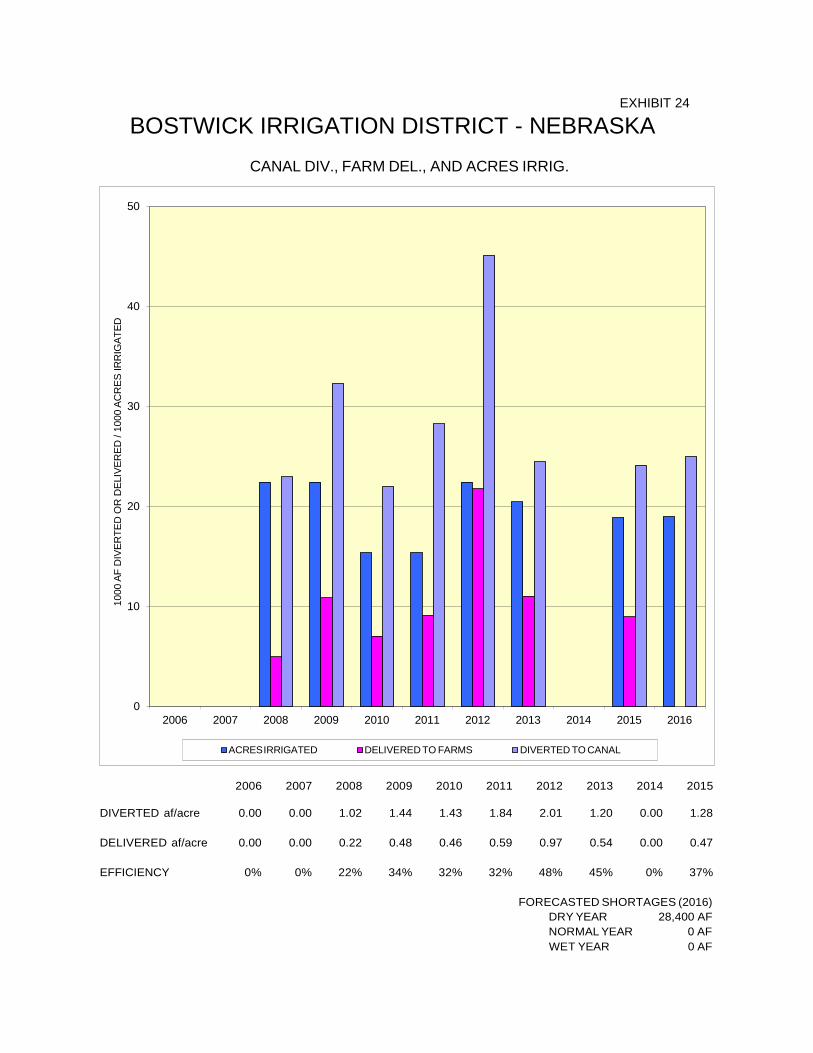
ACRES IRRIGATED DELIVERED TO FARMS DIVERTED TO CANAL
50
40
30
20
10
0 2006 2007 2008 2009 2010 2011 2012 2013 2014 2015 2016
2006
2007
2008
2009
2010
2011
2012
2013
2014
2015
DIVERTED af/acre 0.00 0.00 1.02 1.44 1.43 1.84 2.01 1.20 0.00 1.28
DELIVERED af/acre 0.00 0.00 0.22 0.48 0.46 0.59 0.97 0.54 0.00 0.47
EFFICIENCY 0% 0% 22% 34% 32% 32% 48% 45% 0% 37%
FORECASTED SHORTAGES (2016) DRY YEAR 28,400 AF NORMAL YEAR 0 AF WET YEAR 0 AF
1000
AF
DIV
ERTE
D O
R D
ELIV
ERED
/ 10
00 A
CR
ES IR
RIG
ATED
EXHIBIT 24
BOSTWICK IRRIGATION DISTRICT - NEBRASKA CANAL DIV., FARM DEL., AND ACRES IRRIG.
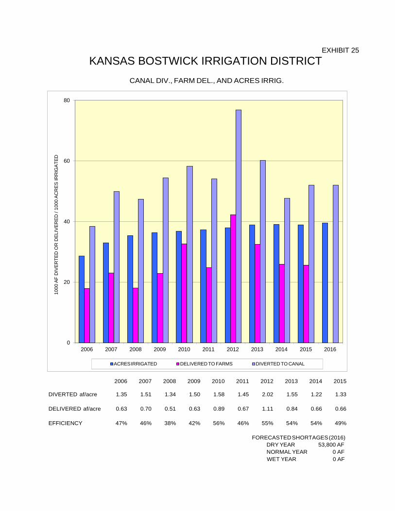
ACRES IRRIGATED DELIVERED TO FARMS DIVERTED TO CANAL
80
60
40
20
0 2006 2007 2008 2009 2010 2011 2012 2013 2014 2015 2016
2006
2007
2008
2009
2010
2011
2012
2013
2014
2015
DIVERTED af/acre 1.35 1.51 1.34 1.50 1.58 1.45 2.02 1.55 1.22 1.33
DELIVERED af/acre 0.63 0.70 0.51 0.63 0.89 0.67 1.11 0.84 0.66 0.66
EFFICIENCY 47% 46% 38% 42% 56% 46% 55% 54% 54% 49%
FORECASTED SHORTAGES (2016) DRY YEAR 53,800 AF NORMAL YEAR 0 AF WET YEAR 0 AF
1000
AF
DIV
ERTE
D O
R D
ELIV
ERED
/ 10
00 A
CR
ES IR
RIG
ATED
EXHIBIT 25
KANSAS BOSTWICK IRRIGATION DISTRICT
CANAL DIV., FARM DEL., AND ACRES IRRIG.
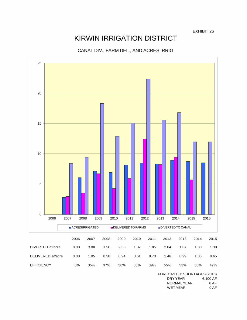
25
20
15
10
5
0 2006 2007 2008 2009 2010 2011 2012 2013 2014 2015 2016
ACRES IRRIGATED DELIVERED TO FARMS DIVERTED TO CANAL
2006
2007
2008
2009
2010
2011
2012
2013
2014
2015
DIVERTED af/acre 0.00 3.00 1.56 2.58 1.87 1.85 2.64 1.87 1.88 1.38
DELIVERED af/acre 0.00 1.05 0.58 0.94 0.61 0.73 1.46 0.99 1.05 0.65
EFFICIENCY 0% 35% 37% 36% 33% 39% 55% 53% 56% 47%
FORECASTED SHORTAGES (2016) DRY YEAR 6,100 AF NORMAL YEAR 0 AF WET YEAR 0 AF
EXHIBIT 26
KIRWIN IRRIGATION DISTRICT CANAL DIV., FARM DEL., AND ACRES IRRIG.

ACRES IRRIGATED DELIVERED TO FARMS DIVERTED TO CANAL
15
12
9
6
3
0 2006 2007 2008 2009 2010 2011 2012 2013 2014 2015 2016
2006
2007
2008
2009
2010
2011
2012
2013
2014
2015
DIVERTED af/acre 0.00 0.00 0.00 4.00 2.14 2.27 2.33 1.99 0.00 0.00
DELIVERED af/acre 0.00 0.00 0.00 1.18 0.79 0.88 1.27 1.04 0.00 0.00
EFFICIENCY 0% 0% 0% 30% 37% 39% 55% 52% 0% 0%
FORECASTED SHORTAGES (2016) DRY YEAR 28,120 AF NORMAL YEAR 8,500 AF WET YEAR 0 AF
1000
AF
DIV
ERTE
D O
R D
ELIV
ERED
/ 10
00 A
CR
ES IR
RIG
ATED
EXHIBIT 27
WEBSTER IRRIGATION DISTRICT CANAL DIV., FARM DEL., AND ACRES IRRIG.

20
18
16
14
12
10
8
6
4
2
0 2006 2007 2008 2009 2010 2011 2012 2013 2014 2015 2016
ACRES IRRIGATED DELIVERED TO FARMS DIVERTED TO CANAL
2006
2007
2008
2009
2010
2011
2012
2013
2014
2015
DIVERTED af/acre 2.39 2.19 1.05 1.83 1.35 1.40 3.17 1.53 1.81 1.60
DELIVERED af/acre 1.04 0.77 0.51 0.83 0.67 0.70 1.41 0.59 0.86 0.64
EFFICIENCY 44% 35% 48% 45% 50% 50% 44% 39% 47% 40%
FORECASTED SHORTAGES (2016) DRY YEAR 0 AF NORMAL YEAR 0 AF WET YEAR 0 AF
EXHIBIT 28
GLEN ELDER IRRIGATION DISTRICT CANAL DIV., FARM DEL., AND ACRES IRRIG.
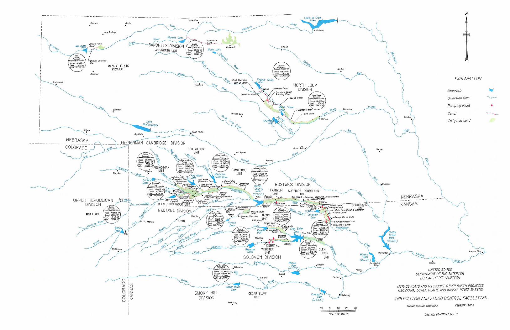
Hoy Springs .
MIRAGE FLATS PROJECT
Oshkosh
UPPER REPUBLICAN DIVISION
ARMEL UNIT
SMOKY HILL DIVISION
Ness City .
NORTH LOUP DIVISION
<//&~
BOSTWICK DIVISION SUPERIOR-COURTLAND
UNIT Red Cloud \" Superlor-Collriland D/~fS,on Dam .. • \I~upenor Conal
10 I
o 10 20 I I I
SCALE OF MILES
30 I
N
-lL
II
[XPLANATION
Reservoir
Diversion Dam
Pumping Plant
Canal
Irrigated Land
NEBRASKA -------- ----KANSAS
UNITW STATES DEPARTMENT OF THE INTERIOR
BUREAU OF RECLAMATION
MIRAGE FLATS AND MISSOURI RIVER BASIN PROJECTS NIOBRARA, LOWER PLATTE AND KANSAS RIVER BASINS
IRRIGATION AND FLOOD CONTROL FACILITI[S
GRAND ISWlD, NEBRASKA FEBRUARY 2005
OWG. NO. 60-705- I R". 10
•
Related Documents