Available online at www.gi.sanu.ac.rs J. Geogr. Inst. Cvijic 62(1) (11-29) Original scientific paper UDC:911.2:504.06(497.11) DOI: 10.2298/IJGI1201011M MOUNTAIN BORDER AREA OF EASTERN SERBIA IN THE FUNCTION OF THE SPRING ZONES OF SURFACE WATER Miroljub Milinčić* 1 ,Bojana Mihajlović*, Dejan Šabić*, Nina Ćurčić** *Faculty of Geography, University of Belgrade **Geographical Institute ″Jovan Cvijic″ SASA, Belgrade Received 25 January 2012; reviewed 13 March 2012; accepted 19 March 2012 Abstract: Border mountain area of eastern Serbia has a distinct potential and importance in the function of surface water sources, which are characterized by range of geographical and environmental characteristics and similarities determined by mountainous character of the territory. For the purposes of this paper, border area of Serbia towards Bulgaria is provisionally determined by iso-border of 25 km. On the defined area of eastern Serbia there are 11 individual territories allocated in the function of being surface water source. Key objects for the realization of the goals of rational and functional exploitation of surface water sources are accumulations. They are the link between the system of surface water sources and water supply system. Key words: water accumulations, surface waters, Serbia, Bulgaria, source of water Introduction Mountain areas, as rugged and fundamentally significant geo-spatial factors, determine directly or indirectly the numerous components of physical- geographical, socio-geographical and ecological-geographical complex of broader spatial wholes. They stimulate the frequent variability of the natural (orographical, geological, climate, hydrographical, pedological, bio- geographical) and socio-economic (settlement, demographic, cultural, infrastructural, etc.) diversity of space. The border area of Serbia and Bulgaria is characterised by a series of geographic-ecological characteristics and similarities determined by mountain character of the territory. The domination of the mountain relief stands out particularly, as well as the dissection of the topographic surface, dispersive and low population coverage and the structure and quality of some ecological resources. In the context of this paper, the resource of domicile waters is especially emphasized as the basis for the formation of the surface water source areas. 1 Correspondence to: mikan@gеf.bg.ac.rs

Welcome message from author
This document is posted to help you gain knowledge. Please leave a comment to let me know what you think about it! Share it to your friends and learn new things together.
Transcript
Available online at www.gi.sanu.ac.rs
J. Geogr. Inst. Cvijic 62(1) (11-29)
Original scientific paper UDC:911.2:504.06(497.11)
DOI: 10.2298/IJGI1201011M
MOUNTAIN BORDER AREA OF EASTERN SERBIA IN THE FUNCTION OF THE SPRING ZONES OF SURFACE WATER
Miroljub Milinčić*1,Bojana Mihajlović*, Dejan Šabić*, Nina Ćurčić** *Faculty of Geography, University of Belgrade **Geographical Institute ″Jovan Cvijic″ SASA, Belgrade Received 25 January 2012; reviewed 13 March 2012; accepted 19 March 2012 Abstract: Border mountain area of eastern Serbia has a distinct potential and importance in the function of surface water sources, which are characterized by range of geographical and environmental characteristics and similarities determined by mountainous character of the territory. For the purposes of this paper, border area of Serbia towards Bulgaria is provisionally determined by iso-border of 25 km. On the defined area of eastern Serbia there are 11 individual territories allocated in the function of being surface water source. Key objects for the realization of the goals of rational and functional exploitation of surface water sources are accumulations. They are the link between the system of surface water sources and water supply system. Key words: water accumulations, surface waters, Serbia, Bulgaria, source of water
Introduction
Mountain areas, as rugged and fundamentally significant geo-spatial factors, determine directly or indirectly the numerous components of physical-geographical, socio-geographical and ecological-geographical complex of broader spatial wholes. They stimulate the frequent variability of the natural (orographical, geological, climate, hydrographical, pedological, bio-geographical) and socio-economic (settlement, demographic, cultural, infrastructural, etc.) diversity of space. The border area of Serbia and Bulgaria is characterised by a series of geographic-ecological characteristics and similarities determined by mountain character of the territory. The domination of the mountain relief stands out particularly, as well as the dissection of the topographic surface, dispersive and low population coverage and the structure and quality of some ecological resources. In the context of this paper, the resource of domicile waters is especially emphasized as the basis for the formation of the surface water source areas. 1 Correspondence to: mikan@gеf.bg.ac.rs
J. Geogr. Inst. Cvijic 62(1) (11-29)
12
Serbia and Bulgaria belong to the group of the most deficient and most endangered states of Europe according to absolute and specific availability of domicile waters.2 A very expressive seasonal, annual (perennial) and spatial unevenness is being attached to relatively small quantities of own waters under the influence of morphologic-tectonic structure and climate conditions, and so the real situation has been considerably more unfavourable in a domain of their sufficiency (dominant resource on 2/3 of the territory of Serbia). They are mostly characterised by a long period of low waters, both unfavourable to watercourses as ecosystems (beneath biological minimum) and all categories of consumers (below water supply minimum). In contrast to that, ephemeral torrential floods are also ecological and economic disasters-sometimes of catastrophic scales especially for settlements, infrastructure, economic facilities, arable areas and other anthropogenic and natural values in the zones of destructive influence. The torrential character of pluviometric regime causes the larger part of the annual domicile water discharges to be realised in ephemeral torrential floodings.3 Owing to the Danube (the most significant international hydrographical transversal of Europe), the unfavourable condition and scope of this part of water resources is facilitated to a great extent in the parts of the national territories by the abundance of transit waters, participating with over 9/10 in the total balance of surface waters of Serbia and Bulgaria. This kind of natural regime along with the increasing deficiency of water resources causes the need for organising the natural water regime, i.e. alleviating their harmful effect. Moreover, expressed temporal and spatial discordance is being alleviated (inversion) between available and necessary quantities of waters (Milincic, 2001). With that aim, 60 accumulations were built in the territory of Serbia with high dams, as well as more than a hundred small and micro accumulations. In the territory of Bulgaria, there are more than 100 accumulations with high dams and several thousand of small and micro
2 They are representative example of the maxim accepted at the first OUN conference on waters (Mar del Plata, 1977). “Globally, there would probably be enough water to satisfy all needs, but it seems as if it tends to be in the wrong time, wrong place and of wrong quality.” Actually, there is not water where most needed, while the greatest deficiencies are in the periods of the largest demands in all spheres of consumption. 3 This has been the reason for dread of the potential mechanisms of global climate changes and their effect on the quality and temporal distribution of precipitation. Global trends of climate changes are marked by the increase in temperature and period of much drier years, and predicted to last up to 2250 (Tusinskii G. K., 1966, 54). The mechanisms of climate changes have shown that the precipitation decrease of 10% also decreases the discharge for 30%, while in certain conditions for 40-70% (UNESCO: World Water Resources, 1998).
Mountain border area of Eastern Serbia in the function of the spring zones of surface waters
13
accumulations. Accumulations, mainly multi-purposed, transform4 the downstream water regime (dominantly “destructive” into usable), influencing the real increase in the scope of this existential resource. Moreover, the accumulation basins and the regulation of discharge enable more and more significant temporal and spatial redistribution of waters. The influence of such actions is that the natural hydrographical network is turned into natural-technical water supply system which develops and functions in the conditions of the simultaneous effect of natural and anthropogenic factors.
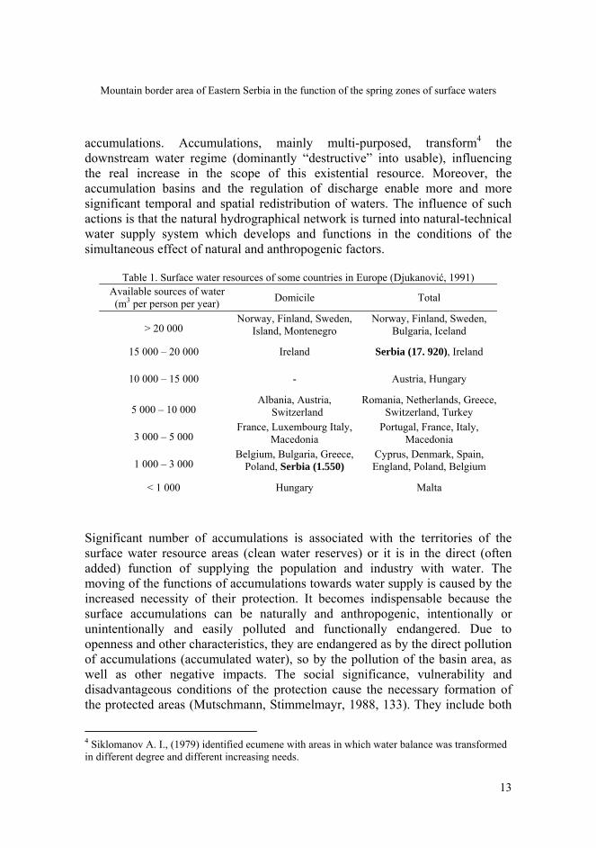
Table 1. Surface water resources of some countries in Europe (Djukanović, 1991) Available sources of water (m3 per person per year) Domicile Total
> 20 000 Norway, Finland, Sweden,
Island, Montenegro Norway, Finland, Sweden,
Bulgaria, Iceland
15 000 – 20 000 Ireland Serbia (17. 920), Ireland
10 000 – 15 000 - Austria, Hungary
5 000 – 10 000 Albania, Austria,
Switzerland Romania, Netherlands, Greece,
Switzerland, Turkey
3 000 – 5 000 France, Luxembourg Italy,
Macedonia Portugal, France, Italy,
Macedonia
1 000 – 3 000 Belgium, Bulgaria, Greece,
Poland, Serbia (1.550) Cyprus, Denmark, Spain, England, Poland, Belgium
< 1 000 Hungary Malta
Significant number of accumulations is associated with the territories of the surface water resource areas (clean water reserves) or it is in the direct (often added) function of supplying the population and industry with water. The moving of the functions of accumulations towards water supply is caused by the increased necessity of their protection. It becomes indispensable because the surface accumulations can be naturally and anthropogenic, intentionally or unintentionally and easily polluted and functionally endangered. Due to openness and other characteristics, they are endangered as by the direct pollution of accumulations (accumulated water), so by the pollution of the basin area, as well as other negative impacts. The social significance, vulnerability and disadvantageous conditions of the protection cause the necessary formation of the protected areas (Mutschmann, Stimmelmayr, 1988, 133). They include both
4 Siklomanov A. I., (1979) identified ecumene with areas in which water balance was transformed in different degree and different increasing needs.
J. Geogr. Inst. Cvijic 62(1) (11-29)
14
areas of accumulations and basin surfaces. The regime of protection and use has been established on them, but not with the aim of eliminating the risk and achieving the absolute safety, but in the function of minimizing the possible negative impacts.5 Even above a series of lacks, the practice of the formation of the surface water source areas, the accumulating of waters and their temporal and spatial redistribution in accordance with ecological and water supply needs do not have crucial alternative. On the contrary, the surface source areas, with a help of dams and accumulations, have more and more solved the water supplying problems. These systems succeeded to solve those demands which the ground water resource areas (wells and springs) could not which is gathering and keeping, as well as significant spatial and temporal (seasonal-perennial) transformation of the existing water regimes and the increase of the total usable water resources. Moreover, the encouraging determinant has been the intensive progression from communal into regional and interregional phase, with expressive compounding and increasing the capacities of the system. Serbia made significant progress in the development of the water supply systems which enable the integral managing of the surface waters. Except accumulations and protected surface source areas, about 5 000 km of major pipelines were built. Out of 18 planned regional water supplying systems as the basic units of the complex unique system of water supplying of Serbia, eleven of them will depend on the accumulation basins and surface water source areas.6
Mountain area as ecological resource in the function of the surface water source areas
As positive morphological-structural wholes, mountains are impressive, complex, dynamic, while from the aspect of geo-ecological processes they are on the level of broader spatial wholes of relevant geospatial category. By their morphologic structures, expressive height dissection and morphological 5 Large states, possessing considerable areas, are acquainted with one-restricted use of space. When defining the resource areas (primary, secondary,) in the territory of the former Soviet Union, Komar (1975) anticipated the possibility of reserving and one-restricted using of certain areas. This has been applied in the territory of the USA by the dislocation of human resources and economic activities, turning the basin areas into the autochthonous reserves without presence of anthropogenic factor (Djordjevic, 1995, 132). With Serbia and Bulgaria, as well as many other states, one-restricted use of territories is inadmissible and potentially problematic (socially irresponsible) due to the main characteristics and the restriction of area as the primary national resource. 6 Over 150 m3 of qualitative waters in Serbia are provided from these territories.
Mountain border area of Eastern Serbia in the function of the spring zones of surface waters
15
sculptures, they represent the factor and/or modifier of many natural (geodynamics, climate, hydrography, pedology, flora, fauna, etc.) and socio-economic (population, settlements, economy, etc.) characteristics of geo-space. They are the most preserved regional ecosystems according to the degree of anthropogenic impacts, the condition of the system of the environment and the functional relations. Such level of complexity and relative rarity makes them very significant for natural and social communities. Even though they essentially are not, they are most often given the attributes like “natural”, “autochthonous”, “wild” and “native”, etc. Emphasizing the characteristic of pyramidal diversity of mountain areas Ljesevic (200, 40-42) pointed out that every series of height belts was the individual geographical whole, while each height belt separate type of the region. Therefore, the end of the 20th century was marked by appeals (Agenda 21, “Mountain Agenda”, etc) that mountain areas, due to their significance and characteristics, deserve special consideration in the process of the protection and valorisation. Except in the function of the surface water source areas (clean water reserves), they are also significant as:
- Reserves of biosphere and genetic diversity, - Areas for production of organically healthy food and biological
production, - Factors of the effect of preservation on wider surroundings
(ecological conforming functions), - Index of ecological climax of wider area, - Areas of the specific cultural and historical heritage conservations, - Polygons for scientific, educational, tourist, recreation and other
purposes. Ecological condition of mountain areas is significantly determined by the effects of the natural, primarily orographic, barrier and peripheral position (Cvijic J., -“isolating” and “separating”).7 It was being strengthened by the processes of interior geographical dilution of socio-economic contents. Even though of different cause, time of appearing 8 and intensity, they show positive correlation 7 Some environmental determinists (Churchill Semple, 1911; Hartschorn, 1939; Taylor, 1951; Huntington, 1962; McHarg, 1971, et al.) regard relief and other physical-geographical factors of mountain areas as the prevailing determinants of the human activities, cultural level, civilisation, land use structure, etc. 8 Many west European countries have paid attention to this problem since 1957. The support of different levels of managing and planning has been provided for development and protection of these areas, as well as the coordination between many development policies and activities, differentiated and adapted to meso- and macro-conditions (physical, economic and ecological), characteristics and demands. The perspective of their development has permanently been supported by numerous papers and some of them are singled out as the most significant. The
J. Geogr. Inst. Cvijic 62(1) (11-29)
16
with developmental processes of opposite tendencies (territorial grouping and territorial diluting)-deagrarization, deruralization and depopulation of hilly-mountain territories on the one hand and closely concentrated processes of industrialisation and urbanisation of lowland and valley areas on the other hand. Actually, the processes of migrations of population from mountains to towns are the universal spatial phenomena of modern world. Such processes of polarisation in regard of horology and chronology represent the components of the overall development of the human society (Milincic, 2004). Therefore, due to low degree of control on these areas in regard of cultural-geographical and economic-geographical development, as well as socio-economic integration with the surrounding territories, there is a problem of their expressive isolation and peripheral position. Cumulatively, this leads to the increase of non valorised, complex, developmental potentials of the national territories, which in the perspective can become the limiting factor of the realisation of other strategic goals of the existence and development. The processes of geographical grouping on the one hand, and diluting on the other hand, influenced that significant spatial consequences are generated on the local and the resources of wider surroundings, while one of the acutest problems has been the problem of the territories which serve for providing the water resources as the most significant ecological functions. Moreover, the increasing ecological crisis is causing the necessity that those elements of the natural environment which are of the benefit for humans (society), and availability and offer are less than demand, get the status of the resource.9 In that context, the increase in the significance of water, the problem of its sufficiency, as well as the sufficiency of the territories which serve for its providing (gathering, accumulation and preservation), influence the mountain areas become specific ones and more significant developmental natural resources. Stefanovic (1971) and Brdarevska (2001) thought similarly on the relations between the urban systems and wider surroundings. The territories of these characteristics (open areas or rural ecosystems) are denoted by many other terms: “resource regions” (Runova, 1973), “resource areas” (Komar, 1975), “regions of natural potentials (Dinic, 1997), etc.
European Council proclaimed 1987 and 1988 the years of rural areas, in 1992 the EEC made General Strategy for sustainable development of rural areas and resource management through CAP (Common Agrarian Policy) programme from 1992, ASP (Agricultural Strategy Paper) from 1995, AGENDA 2000 from July 1997 and set of laws of the EU from 1999. The report of the ESDP (European Spatial Development Perspective) from 1999 marked the situation of hilly-mountain and peripheral areas within EEC borders as still difficult. 9 Lang (1979, 25) pointed out that the relation towards “natural resources” was caused by social needs and developmental problems.
Mountain border area of Eastern Serbia in the function of the spring zones of surface waters
17
One of the key factors in the realisation of the surface water source areas becomes the sufficiency of areas10 suitable for the formation of dams and accumulation basins. The loss (filling in) of the existing ones and insufficient availability of new areas of these characteristics represent particularly difficult geographical handicap in the “struggle” for providing the water resource. The fact that there are less of them than necessary and that in perspective their availability will be in reverse proportion with the increase in the demand, have influenced that they become a special kind of the spatial resource, not being sufficiently respected until now. In fact, their obtuseness has been the result of the consumption and non-renewal, as well as the necessity of positive-attractive combination of many physical and anthropogeographical elements. According to the significance the following physical-geographical factors stand out:
-Morphology (the necessity that the barrier is in gorge like part, while larger part of the accumulation basin is in the valley part (composite valley) with possible small fall of the longitudinal profile),11
- Hydrology (area of the basin, discharge, runoff), - Geological structure (stability, water-repellent), - Petrological structure (occurrence of unwanted formations in the
basin or the accumulation itself),12 - Erosion (accumulation basin is the lower erosion basis of water
stream zone), - Seismic and inductive activity, - Pedological and bio-geographical characteristics.
In the group of various anthropogeographic factors, the following ones are more significantly respected:
- Settlement-geographical, - Population, - Historical-geographical,
10 The fact is that it is about the valleys of the middle and upper parts of the watercourses which had transit, intermediary, transitional and central functions for centuries, i.e. they were attractive for different forms of valorisation and concentration. 11 According to Mutschmann, Stimmelmayr, (1988, 123, 125), the depths of over 50 m are desirable to have the quality of accumulated water preserved. With the aim of protecting these areas, particularly from deposits of materials, the construction of pre-dams and micro-accumulations is recommended. The main characteristics of geospace and the condition of the environment in Serbia are the representatives of these recommendations to be respected. Possibility that the accumulations keep the deposits and thus save large accumulation basins make them significant and desirable in the head parts of the basins. 12 These factors can cause significant processes of unintentional pollution. The group of unwanted formations includes serpentinites, peridotite-serpentinites (asbestos and talc particles), granodiorite grus containing decayed particles of micas and feldspars, karst, etc.
J. Geogr. Inst. Cvijic 62(1) (11-29)
18
- Economic (industry, agriculture, mining, forestry), - Infrastructural (road and railroad traffic arteries, PTT), etc.
Vujnovic (1995, 302) pointed out that in each river basin “there is only one and exclusively one natural aquatoria which gives optimal parameters of the accumulations of the necessary (or possible) quantities of water for certain purposes.13 However, it has already been emphasized that even though dominantly significant, the natural predispositions are not merely relevant and crucial for determining the locations of the dam and morphometric characteristics of the accumulation basins. The parameters of the anthropogeographic factors of the potentially defined area also become more significant. In the situation of respecting more complex physical and anthropogeographic factors, it comes to the rapid reduction in the number of locations suitable for the formation of the potential accumulations. Exactly this kind of the situations of the increasing needs on the one hand and the impossibility to provide enough number of locations of corresponding characteristics in the area of Serbia on the other hand, cause indispensable conflict in the valorisation of the space and the priorities for their purpose. The conflict is above all the consequence of existential significance of these infrastructural systems, insufficient number of suitable locations and still present divergence in the approach to this problem. The difference in the approach is so much wide that it is hard to be perceived at one place. And while in the locating and dimensioning of this kind of objects Djordjevic (1998, 64) emphasized just physical-geographical conditions as only significant, Vujnovic (1995, 302) considered that the presence of settlements, infrastructure, mountains, nature reserves and similar values was the factor which “degrades the natural predispositions of space” for the aquatoria creation. The level of perception of this kind of degradation causes that the groups interested in the construction have proclaimed some areas of planned hydro-technical projects as “problematic”, while some projects were abandoned and considered to be “definitely lost”. The areas which are economically-geographically and cultural-historically valorised most complexly or represent valuable settlement, economic, infrastructural and cultural-historical locations and (or) wholes are the so-called problematic and lost areas. Disregarding the fact that water resources can be considered as the renewable ones, the option of providing them makes them to be dependable on the 13 According to McHarg, (1971), the area is naturally predisposed for some purpose.
Mountain border area of Eastern Serbia in the function of the spring zones of surface waters
19
possibility of their accumulating. The qualitative and quantitative characteristics of accumulated water are widely dependent on the features, processes and relations between the place for the river damming (profile of the dam) and the basin area. By deteriorating the characteristics of accumulation basin, the value of the basin becomes so much degraded that it loses its basic reason of the existence. Therefore, one of the basic issues for this option of development of water power infrastructure has been the solution of the triangle the apexes of which have been the limited number of suitable locations, effects manifested in the accumulation basin and concentrated and absolutely increasing needs for water.
Mountain border area of eastern Serbia The border area of Eastern Serbia and Bulgaria, conditionally determined by the border belt of 25 km for the needs of this paper, is of dominant mountain character, with expressed hydrographical divergence, i.e. centrifugal type of the river net and dominantly domicile water resources. The positive characteristics also have other indexes of the condition of the water resource: length and density of water courses, water balance, pluviometric regime, prevailing quality class, erosion processes, etc. Moreover, the mutual fact is that the water pollution mostly occurs below the isohypse of 500 m above the sea level, while above this border, i.e. above the border of urban settlements and industrial centres, waters of the first and the II class can be gathered. The conveniences are also the following areas (upper parts of the basins):
-Dominant domicile waters which have mainly been the subject of accumulating for the water supplying needs,
-Available, relatively favourable locations for their accumulation and preservation,
-Height potential by which the economic distribution is enabled in wider territorial distances in relation to the zones of water consumers, etc.
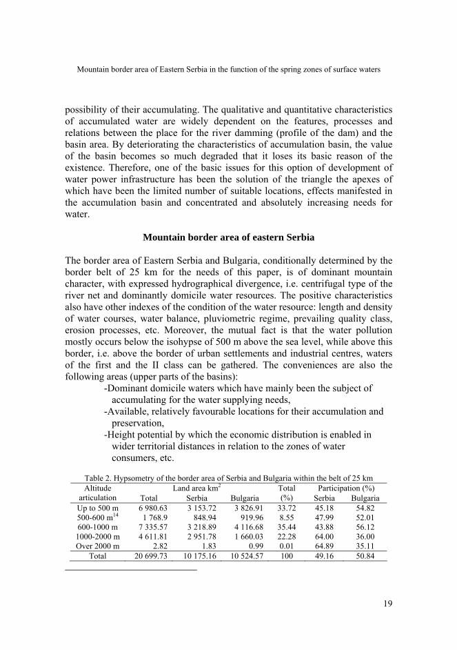
Table 2. Hypsometry of the border area of Serbia and Bulgaria within the belt of 25 km Land area km2 Participation (%) Altitude
articulation Total Serbia Bulgaria Total (%) Serbia Bulgaria
Up to 500 m 6 980.63 3 153.72 3 826.91 33.72 45.18 54.82 500-600 m14 1 768.9 848.94 919.96 8.55 47.99 52.01 600-1000 m 7 335.57 3 218.89 4 116.68 35.44 43.88 56.12 1000-2000 m 4 611.81 2 951.78 1 660.03 22.28 64.00 36.00 Over 2000 m 2.82 1.83 0.99 0.01 64.89 35.11
Total 20 699.73 10 175.16 10 524.57 100 49.16 50.84
J. Geogr. Inst. Cvijic 62(1) (11-29)
20
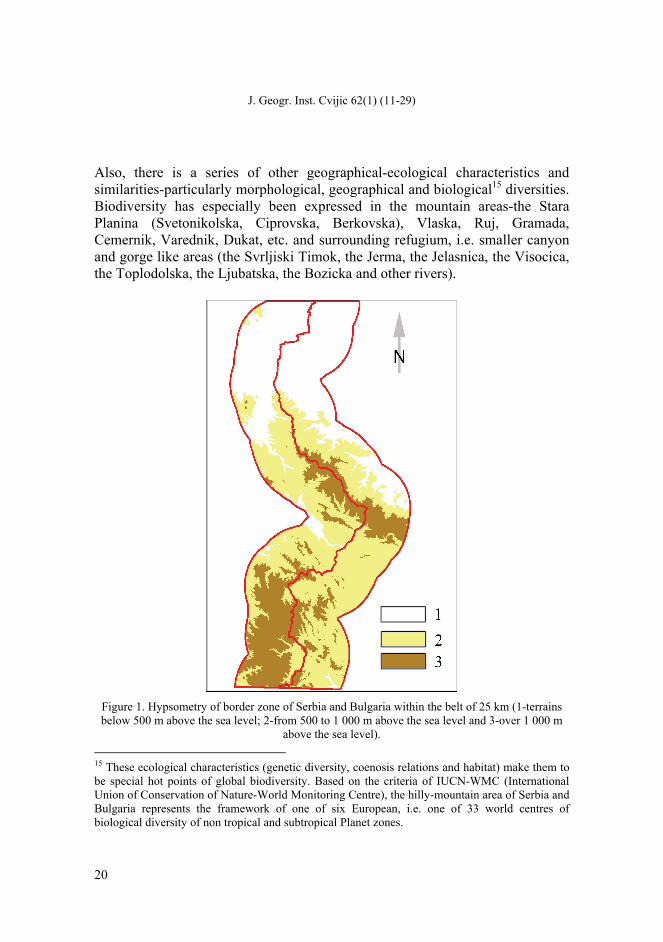
Also, there is a series of other geographical-ecological characteristics and similarities-particularly morphological, geographical and biological15 diversities. Biodiversity has especially been expressed in the mountain areas-the Stara Planina (Svetonikolska, Ciprovska, Berkovska), Vlaska, Ruj, Gramada, Cemernik, Varednik, Dukat, etc. and surrounding refugium, i.e. smaller canyon and gorge like areas (the Svrljiski Timok, the Jerma, the Jelasnica, the Visocica, the Toplodolska, the Ljubatska, the Bozicka and other rivers).
Figure 1. Hypsometry of border zone of Serbia and Bulgaria within the belt of 25 km (1-terrains below 500 m above the sea level; 2-from 500 to 1 000 m above the sea level and 3-over 1 000 m
above the sea level). 15 These ecological characteristics (genetic diversity, coenosis relations and habitat) make them to be special hot points of global biodiversity. Based on the criteria of IUCN-WMC (International Union of Conservation of Nature-World Monitoring Centre), the hilly-mountain area of Serbia and Bulgaria represents the framework of one of six European, i.e. one of 33 world centres of biological diversity of non tropical and subtropical Planet zones.
Mountain border area of Eastern Serbia in the function of the spring zones of surface waters
21
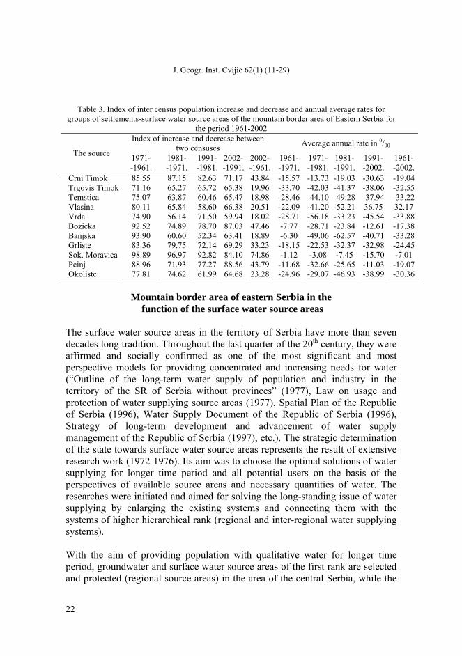
The comparative analysis of vertical dissection of the relief for the territory of Serbia (Mladenovic, 1984) with the same one in the conditionally determined border area of Eastern Serbia show the ratio of 61.54%:45.18% below the isohypse of 500 m above the sea level. Contrary, the ratio is 27.28%:39.98% at low mountain relief, while it is 10.95%:29.01% at the mid-mountain one. This indicates the expressive mountain character of analysed territory. By the interaction of physical-geographical characteristics of the hilly-mountain areas, as well as the enduring effect of barrier position of the international border, the mountain border area of Eastern Serbia is characterised by the process of dominant stagnation and disintegration of settlement, population and economic landscape. The most expressive absolute depopulation value in the period 1961-2002 is recorded at Vlasina -20.010, Trgoviski Timok -15.870, Temstica -11.680, Pcinja -9.332 and Sokobanjska Moravica -6.484 inhabitants. In contrast to absolute values of the change of the population number, in which mainly population and territorially larger source areas dominate, the relative indexes also reveal the level of the depopulation intensity at smaller source areas. The highest per cent of the inter-census decrease in the period 1961-2002 is at the following source areas: Vrla - 81.98%, Banjska River - 81.11%, Trgoviski Timok - 80.04%, Temstica - 81.02%, Vlasina - 79.49% and Okoliska River - 76.72%. Even though these processes were universal spatial phenomena in the case of determined surface water source areas, they had torrential demographic character according to the scope and intensity which violated their developmental perspective. Cumulatively, these determinants (natural barrier position, geographical peripheral position and depopulation) introduced the new component in the weakening of the location conditions (“Push” factor) of the settlement, infrastructural, industrial and contemporary agro-complex of the mountain border area. Therefore, the mountain area appears to be the restrictive determinant of some economic branches in the recent conditions, especially of the primary and secondary sector, but also as the stimulating factor of water supply management. Moreover, these conditions enabled the pro-gradation of the condition of the basic natural elements of the environment in the most significant part of the mountain areas by the processes of dynamic homeostasis. This especially reflected well the conditions of water resources, and so this part of the mountain area has been emphasized as the base of fresh water resources.
J. Geogr. Inst. Cvijic 62(1) (11-29)
22
Table 3. Index of inter census population increase and decrease and annual average rates for groups of settlements-surface water source areas of the mountain border area of Eastern Serbia for
the period 1961-2002 Index of increase and decrease between
two censuses Average annual rate in 0/00 The source 1971-
-1961. 1981- -1971.
1991- -1981.
2002--1991.
2002--1961.
1961- -1971.
1971--1981.
1981- -1991.
1991- -2002.
1961- -2002.
Crni Timok 85.55 87.15 82.63 71.17 43.84 -15.57 -13.73 -19.03 -30.63 -19.04 Trgovis Timok 71.16 65.27 65.72 65.38 19.96 -33.70 -42.03 -41.37 -38.06 -32.55 Temstica 75.07 63.87 60.46 65.47 18.98 -28.46 -44.10 -49.28 -37.94 -33.22 Vlasina 80.11 65.84 58.60 66.38 20.51 -22.09 -41.20 -52.21 36.75 32.17 Vrda 74.90 56.14 71.50 59.94 18.02 -28.71 -56.18 -33.23 -45.54 -33.88 Bozicka 92.52 74.89 78.70 87.03 47.46 -7.77 -28.71 -23.84 -12.61 -17.38 Banjska 93.90 60.60 52.34 63.41 18.89 -6.30 -49.06 -62.57 -40.71 -33.28 Grlistе 83.36 79.75 72.14 69.29 33.23 -18.15 -22.53 -32.37 -32.98 -24.45 Sok. Moravica 98.89 96.97 92.82 84.10 74.86 -1.12 -3.08 -7.45 -15.70 -7.01 Pcinj 88.96 71.93 77.27 88.56 43.79 -11.68 -32.66 -25.65 -11.03 -19.07 Okoliste 77.81 74.62 61.99 64.68 23.28 -24.96 -29.07 -46.93 -38.99 -30.36
Mountain border area of eastern Serbia in the
function of the surface water source areas The surface water source areas in the territory of Serbia have more than seven decades long tradition. Throughout the last quarter of the 20th century, they were affirmed and socially confirmed as one of the most significant and most perspective models for providing concentrated and increasing needs for water (“Outline of the long-term water supply of population and industry in the territory of the SR of Serbia without provinces” (1977), Law on usage and protection of water supplying source areas (1977), Spatial Plan of the Republic of Serbia (1996), Water Supply Document of the Republic of Serbia (1996), Strategy of long-term development and advancement of water supply management of the Republic of Serbia (1997), etc.). The strategic determination of the state towards surface water source areas represents the result of extensive research work (1972-1976). Its aim was to choose the optimal solutions of water supplying for longer time period and all potential users on the basis of the perspectives of available source areas and necessary quantities of water. The researches were initiated and aimed for solving the long-standing issue of water supplying by enlarging the existing systems and connecting them with the systems of higher hierarchical rank (regional and inter-regional water supplying systems). With the aim of providing population with qualitative water for longer time period, groundwater and surface water source areas of the first rank are selected and protected (regional source areas) in the area of the central Serbia, while the
Mountain border area of Eastern Serbia in the function of the spring zones of surface waters
23
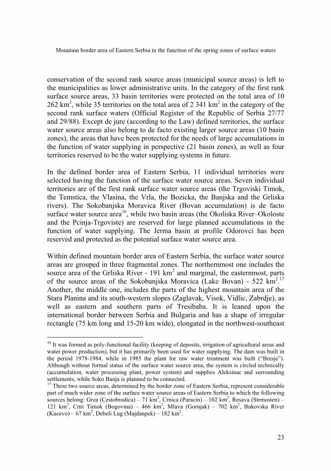
conservation of the second rank source areas (municipal source areas) is left to the municipalities as lower administrative units. In the category of the first rank surface source areas, 33 basin territories were protected on the total area of 10 262 km2, while 35 territories on the total area of 2 341 km2 in the category of the second rank surface waters (Official Register of the Republic of Serbia 27/77 and 29/88). Except de jure (according to the Law) defined territories, the surface water source areas also belong to de facto existing larger source areas (10 basin zones), the areas that have been protected for the needs of large accumulations in the function of water supplying in perspective (21 basin zones), as well as four territories reserved to be the water supplying systems in future. In the defined border area of Eastern Serbia, 11 individual territories were selected having the function of the surface water source areas. Seven individual territories are of the first rank surface water source areas (the Trgoviski Timok, the Temstica, the Vlasina, the Vrla, the Bozicka, the Banjska and the Grliska rivers). The Sokobanjska Moravica River (Bovan accumulation) is de facto surface water source area16, while two basin areas (the Okoliska River–Okoloste and the Pcinja-Trgoviste) are reserved for large planned accumulations in the function of water supplying. The Jerma basin at profile Odorovci has been reserved and protected as the potential surface water source area. Within defined mountain border area of Eastern Serbia, the surface water source areas are grouped in three fragmental zones. The northernmost one includes the source area of the Grliska River - 191 km2 and marginal, the easternmost, parts of the source areas of the Sokobanjska Moravica (Lake Bovan) - 522 km2.17 Another, the middle one, includes the parts of the highest mountain area of the Stara Planina and its south-western slopes (Zaglavak, Visok, Vidlic, Zabrdje), as well as eastern and southern parts of Tresibaba. It is leaned upon the international border between Serbia and Bulgaria and has a shape of irregular rectangle (75 km long and 15-20 km wide), elongated in the northwest-southeast
16 It was formed as poly-functional facility (keeping of deposits, irrigation of agricultural areas and water power production), but it has primarily been used for water supplying. The dam was built in the period 1978-1984, while in 1985 the plant for raw water treatment was built (“Bresje”). Although without formal status of the surface water source area, the system is circled technically (accumulation, water processing plant, power system) and supplies Aleksinac and surrounding settlements, while Soko Banja is planned to be connected. 17 These two source areas, determined by the border zone of Eastern Serbia, represent considerable part of much wider zone of the surface water source areas of Eastern Serbia to which the following sources belong: Grza (Cestobrodica) – 71 km2, Crnica (Paracin) – 102 km2, Resava (Strmosten) – 121 km2, Crni Timok (Bogovina) – 466 km2, Mlava (Gornjak) – 702 km2, Bukovska River (Kucevo) – 67 km2, Debeli Lug (Majdanpek) – 182 km2.
J. Geogr. Inst. Cvijic 62(1) (11-29)
24
direction. The following source areas belong to this zone: the Temstica (Temska) - 755 km2, the Trgoviski Timok (Baranica) - 496 km2 and the Okoliska River (Okoliste) - 44 km2. The third zone, approximately of meridian spreading direction, includes the Jerma basin (Odorovci) south of the Nisava, wider area of the Vlasina, the source area of the Bozicka River (Bosilegrad) - 189 km2, as well as the parts of the source areas of the Pcinja (Trgoviste) - 542 km2 on the western side of Dukat Mountain (1 831 m above the sea level) and the Banjska River (Prvonek) - 86 km2 on the western slopes of Patarica (1 672 m above the sea level).
Table 4. Surface water source areas of the border area of Eastern Serbia Surface basin (km2)
River location Municipality Total source of water
The exploitation
The Sources And Reservoirs Of Surface Water of the first rank 1. Trgoviski Timok Baranica Knjazevac 523 496 2. Temštica Temska Pirot 818 755 1989. 3. Vlasina Vlasotince Vlasotince 1 050 918 1949. 4. Vrla Rajkinci Surdulica 213 126 5. Bozicka Bosilegrad Bosilegrad 213 189 1978. 6. Banjska River Prvonek Vranje 115 86 2006. 7. Grliska Grliste Zajecar 191 178 1989. The Sources And Reservoirs Of Surface Water sources in the water supply function of population 8. Sokobanj. Moravica Bovan Aleksinac 522 1985.
Sources of surface waters planned for realization until 2021. 9. Pcinja Prohor. Pcinja. Trgoviste 542 496 10. Okoliska River Okoliste Svrljig 44
Reserved area as potential source of surface waters 11. Jerma Odorovci Dimitrovgrad 557 349 The accumulations are the key facilities for the realisation of the rational and functional exploitation of the surface water source areas. They are the link between the systems of surface sources and water supplying systems (regional and interregional). The following accumulations were realised in the previous period: Vlasina in 1949, Lisina in 1978, Bovan in 1985, Grliste in 1989, Visocica in 1989 and Prvonek in 2006. The total capacity of accumulated water reaches 446.9 x10⁶ m3 at these six accumulations. Vlasina (176x106m3) and Zavoj (170x106m3) have the largest volume. These two accumulations participate with 77.4% in the total accumulated water. The water accumulated in three smallest accumulations (Prvonek-20x106m3, Grliste-12.5x10⁶m3 and Lisina-10.4x10⁶m3) participates with 9.59% in the total quantity.
Mountain border area of Eastern Serbia in the function of the spring zones of surface waters
25
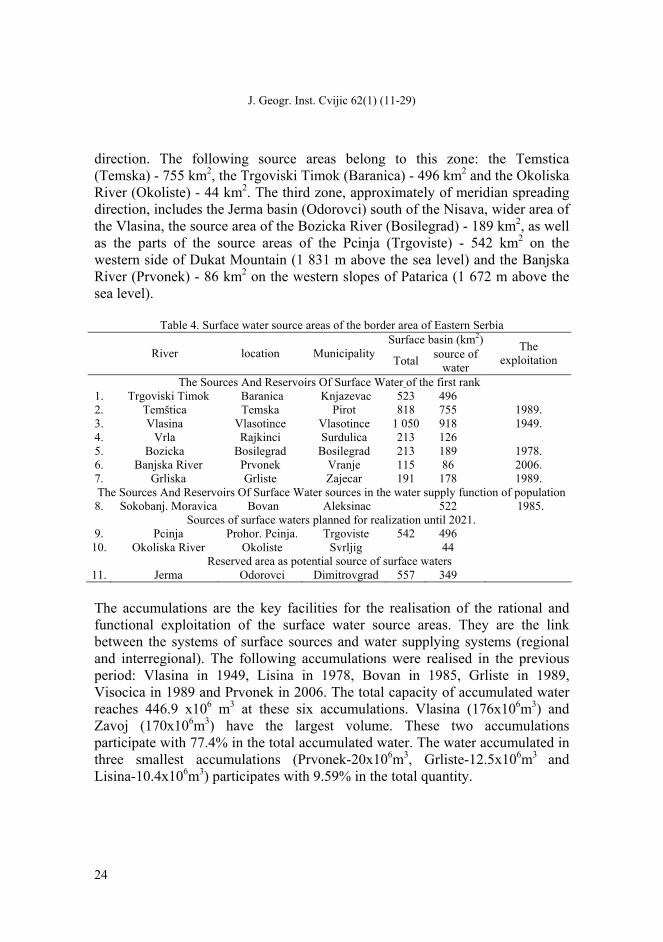
Figure 2. “Vlasina” system - example of the extension of borders of the surface water source areas
and inter-basin transfer of water resources (according to the PPPPN “Vlasina”, 2002)
The following accumulations are planned to be constructed: Svodje on the Vlasina (80x106m3), Prohor on the Pcinja (58x106m3), Zukovac on the Aldinacka River (17x106m3) and Okoliste on the Okoliska River (15x106m3). The formation of the accumulation on the Vlasina will solve the problems of the
J. Geogr. Inst. Cvijic 62(1) (11-29)
26
current supplying from the open Vlasina river course.18 Surdulica and Vladicin Han are supplied with water from the Vrla watercourse-the surface water source area of the first rank (F=126 km2). Table 5. Regional systems and sub-systems of water supplying which are leaned or will be leaned
on the surface source areas and accumulations of the mountain border area of Eastern Serbia. Reservoirs For Water Supplying
Regional system Subsystem Built Planned
until 2021.Reserved
space
Pčinjski Prvonek Prohor Pcinjski Upper-South Morava’sVlasinski Vlasina, Lisina Nisavski Zavoj Vlasinski Svodje Lower-South Morava’sMoravicki Bovan
Timočki Crni Timok Grliste Bogovina Zukovac, Okoliste In the previous period, significant hydro-technical works were realised on the transfer of waters at some surface source areas. Lake Vlasina is one of firstly formed accumulations in Serbia (1949) after the World War II. It was projected for power production, while the water supplying function was just added. It was proclaimed the surface source area on 918 km2 in 1977. It has the area of 16.5 km2 under the maximum water level (1 213.8 m above the sea level), while the primary basin is of 50 km2 which has been enlarged for several times. Due to imbalance of topographic basin area, as well as total volume of the accumulation (168x106m3), the first charging of the basin lasted five years, from 1949 to 1954. By the formation of Lake Lisina (the Lisinska River and the Bozicka River) in 1978, the first rank surface water source area of the Bozicka River was activated (F=189 km2). This surface water source area is territorially extended by carrying the part of the Ljubatska waters (the Crna and the Golema). Water accumulated in Lake Lisinsko-together with canals and pump-accumulation plants (PAP)-represents the framework of the most extensive hydro-technical interventions in the inter-basin19 transfer of waters in Serbia. The most significant canals are Lisina and Bozica (the total length of 25 km with two tunnels of 5.7 km each), by which 74.7x10⁶m3 of water is being annually transferred from Lisina accumulation over the same-called plant in Lake Vlasinsko (Cvetkovic, 1985). This system, together with water gathered by ducts of Cemernik, Struna and Jerma, represents about 80% of the total waters in the “Vlasina” system. 18 Water plant “Nerezine” supplies Vlasotince and surroundings (20 000 inhabitants). 19 The transfer of waters of the Bozicka, the Lisinska and the Ljubata rivers represents the transfer (example of artificial bifurcation) from the Aegean basin into the basin of the Black Sea.
Mountain border area of Eastern Serbia in the function of the spring zones of surface waters
27
The Temstica basin (F=818 km2) is the surface water source area of the first rank on the area of 755 km2, while in 1989 “Zavoj” (F=584 km) accumulation was formed within it on the Visocica for power production and water supply purposes. The plans on the increase of water in this accumulation have been realised by transforming the waters of the Toplodolska River into the Visocica. Also, the upstream profiles are protected for new accumulations (cascading water accumulation) within some surface water source areas. This has been in the case of the surface source areas of the Trgoviski Timok. For the needs of water supply management up to 2021, the basin of the right tributary of the Aldinacka River (profile Zukovac F=77 km2) has been protected for the construction (17x106m3) of large mono-functional accumulation.
Conclusions The mountain character, domination of natural (primary) characteristics, as well as complementary structure of ecological resources of this part of the border area of Eastern Serbia represent the significant determinant of locating and functional activating the surface water source areas. The increasing significance of water resources, particularly qualitative domicile ones, has influenced they become the basic differential characteristic of these areas and the most significant developmental potential on the regional and national level. Therefore, the surface water source areas, due to the value and rarity, have special social treatment of the valorisation and very often the priority in the protection and reservation of the area. The progressed settlement-population atrophy and erosion of the vital functions of these areas has just been another one in a series of stimulating factors of the existence and certain territorial extension of surface source areas. Such functional activation has been the specific factor of the decrease in the non-valorised ecological potentials and mountain border area of Eastern Serbia in the whole. Cumulatively, these areas have the increasing significance both for the realisation of other strategic goals of the existence and the development of Serbia.
Acknowledgements This paper presents results of the investigation within the projects 176008, 173038, and III47007 founded by Ministry of Education and Science of the Republic of Serbia.
J. Geogr. Inst. Cvijic 62(1) (11-29)
28
References
Brdarevska, M. (2001). Odnos urbanih funkcija i ekosistema Beograda. Beograd: Geografski fakultet, doktorska disertacija.
Dinić, J. (1997). Prirodni potencijal Srbije – Ekonomsko-geografska analiza i ocena. Beograd: Ekonomski fakultet.
Đorđević, B. (1990). Vodoprivredni sistemi. Beograd: Naučna knjiga, Građevinski fakultet.
Đorđević, S. (1995). Sanitarna zaštita akumulacije. U Akumulacije kao izvorišta za snabdevanje vodom. Leskovac.
Dukić, D. (1971). Vodosnabdevanje gradskih naselja i industrije u SR Srbiji. Zbornik radova 18(1). Beograd: PMF – Geografski zavod.
Lang, R. (1979). O ekonomskoj politici prema prirodnoj okolini čovjeka. U Privredni razvoj i čo-vjekova radna i životna okolina. Zagreb: Izdavačko-instruktivni biro.
Lješević, A. M. (2002). Planinski geoekosistemi. U S planinom u novi vek. Kopaonik.
McHarg, I. L (1971). Design with Nature. Natural History Press. New York: Garden City.
Mutschman, J. i Stimmelmayr, F. (1988). Snabdevanje vodom, priručnik, Beograd: IRO Građevin-ska knjiga.
Okun, A.D. (1973). Regionalno upravljanje u sistemu vodoopskrbe i odvoda otpadnih voda. U Regionalni aspekti zaštite voda. Sarajevo: Regionalni komitet za međunarodnu hidrološku deceniju UNESCO-a i Akademija nauka i umjetnosti Bosne i Hercegovine.
Stefanović, V. D. (1971). Specifičnosti procesa urbanizacije u Jugoslaviji u periodu 1948-1961. god. Beograd: Ekonomski fakultet, doktorska disertacija.
Vujnović, R. (1995). Vode Srbije, Planovi razvoja i neke realizacije u vodoprivredi. Beograd: Gra-đevinska knjiga.
Dukić, D., Gavrilović, Lj. (1989). Vodni resursi SR Srbije – njihovo iskorišćavanje i zaštita. Glasnik Srpskog geografskog društva, 69(1).
Đorđević, J. (1998). Tipologija fizičko-geografskih pojava i procesa za potrebe prostornog planiranja. Beograd: Geografski fakultet, doktorska disertacija.
Milinčić A. M. (2005). Deficit voda i geografija žeđi. Glasnik Srpskog geografskog društva, (55), 89-100.
Milinčić, A. M, Jovanović, B. (2008). Resurs sveže vode kao determinanta bezbednosti i kvaliteta životne sredine. U Bezbednost u posmodernom ambijentu. Beograd: CESNA B.
Milinčić, A. M. (2001). Srbija - geopolitika životne sredine, Beograd: Srpsko geografsko društvo.
Milinčić, A. M. (2004). Ekonomsko-geografska i ekološka polarizacija prostora kao faktor novih funkcionalnih odnosa među prostornim celinama. Glasnik Srpskog geografskog društva, 84(2), 157-164.
Mountain border area of Eastern Serbia in the function of the spring zones of surface waters
29
Milinčić, A. M. (2005). Veštačke vodne akumulacije kao faktor prostorne transformacije i disperzije razvojnih potencijala. U Srbija i savremeni procesi u Evropi i Svetu. Beograd: Geografski fakultet.
Milinčić, A. M. (2009). Ekološka ograničenja i revitalizacija naselja teritorija izvorišta površinskih voda Srbije. Beograd: Geografski fakultet.
Milinčić, A. M., Lješević, A. M. i Pecelj, M. J. (2007). Problem svježe vode kao faktor društvenog delovanja i organizacije prostora. U Radovi Filozofskog fakulteta 9(2). Istočno Sarajevo: Filozofski fakultet. Pale.
Milinčić, A. M., Ratkaj, I., Pecelj, M. (2007). Osnovna obeležja geoprostora i stanje životne sredine – okvir održivog razvoja Srbije. U Prvi kongres srpskih geografa, (knj. 1) 345-352. Beograd: Srpsko geografsko društvo.
Mladenović, T. (1984). Visinska struktura reljefa zemljišta u SFR Jugoslaviji. Beograd: Vojnogeografski institut.
Тушинский, Г. К. (1966). Космос и ритмы природы Земли. Серия Новое в науке. Москва: Просвещение.
Cvetković, B. (1985). Vlasinske hidroelektrane – Godine uspona. Vranje: Nova Jugoslavija.
Шикломанов, А. И. (1979). Антропогенные изменения водности рек. Ленинград: Гидромете-оиздат.
*** (1996). Vodoprivredna osnova Republike Srbije. Beograd: Istitut za vodoprivredu ”Jaroslav Černi”, Nacrt.
*** (1996). Prostorni plan Republike Srbije. Republika Srbija. Beograd: Službeni glasnik.
*** (1998). World Water Resources. UNESCO.
*** (2002). PPPPN Vlasina. Beograd: Ministarstvo urbanizma i građevina i IAUS, radna verzija.
*** (2002). Prostorni plan područja posebne namene Vlasina 2001-2021. godine. Beograd: Energoprojekt – urbanizam i arhitektura a. d. Nacrt plana – radna verzija.
Related Documents