Swan Canning Riverpark Mooring Management Program June 2015

Welcome message from author
This document is posted to help you gain knowledge. Please leave a comment to let me know what you think about it! Share it to your friends and learn new things together.
Transcript
Swan Canning RiverparkMooring Management Program
June 2015
Contents
DEFINITIONS ________________________________________________ 3 PART 1 PURPOSE ____________________________________________ 4
Objectives _______________________________________________ 4 Background ______________________________________________ 5
PART 2 LEGISLATIVE FRAMEWORK _____________________________ 6 Swan River Trust __________________________________________ 6 Department of Transport ____________________________________ 6 Other applicable documents _________________________________ 7
PART 3 AGENCY ROLES AND RESPONSIBILITIES _________________ 8 Swan River Trust __________________________________________ 8 Department of Transport ____________________________________ 8
PART 4 MOORING ADMINISTRATION ____________________________ 9 Licensed Moorings _________________________________________ 9 Mooring Licence Areas and Moorings in Leased Areas _____________ 9 Emergency Moorings ______________________________________ 10 Courtesy Moorings ________________________________________ 10
PART 5 AGREED PARAMETERS FOR MOORING MANAGEMENT ____ 11 Mooring Apparatus ________________________________________ 11 Mooring Zones ___________________________________________ 11 Mooring Numbers _________________________________________ 12 General Management _____________________________________ 13
PART 6 REPORTING REQUIREMENTS __________________________ 14 PART 7 REVIEW AND AMENDMENT ____________________________ 14 APPENDICES _______________________________________________ 14
2
Definitions
Courtesy Mooring A mooring administered by the Swan River Trust under the Mooring Regulations 1998 and regulation 27 of the Swan and Canning Rivers Management Regulations 2007.
Emergency Mooring A mooring administered by the Department of Transport for use in emergency situations under the Mooring Regulations 1998.
Licensee Person or entity that holds the licence for the licensed mooring or mooring area or jetty.
Licensed Mooring An individual mooring within a Mooring Control Area that is licensed under regulation 12 of the Mooring Regulations 1998.
Mooring Control Area An area declared under section 10 of the Shipping and Pilotage Act 1967. The entire Swan and Canning Rivers is a declared Mooring Control Area.
Mooring Licence Area An area that has a mooring licence under section 65 of the Western Australian Marine Act 1982 that allows multiple moorings within the licence area.
Mooring Zone Agreed areas under this Mooring Management Program where moorings are permitted within the Riverpark. Refer Appendix 1.
Swing Mooring A mooring with one point (buoy) of connection to the vessel. Jetty Licence A licence issued to a jetty, pier, wharf, grid, slip, landing,
place, stage platform (other than a platform that is a vessel for the purposes of the Western Australian Marine Act 1982) or similar structure whether fixed or floating erected wholly or in part on or over any waters.
Jetty & Mooring Licence A combined licence issued under Section 65 of the Western Australian Marine Act 1982 and Section 7 of the Jetties Act 1926. The licence provides approval for the construction of the jetty and mooring of vessels.
Environmentally Friendly Mooring apparatus designed to ensure minimal contact Mooring and impact on riverbed.
3
Part 1 Purpose
The Swan River Trust (the Trust) and the Department of Transport (DoT) share responsibility for the management of swing moorings within the Swan Canning Riverpark (Riverpark). This Mooring Management Program (MMP) has been prepared in partnership between the DoT and the Trust pursuant to section 53 of the Swan and Canning Rivers Management Act 2006 (SCRM Act).
The MMP formalises the approvals process and management of swing moorings between the Trust and DoT. The MMP is consistent with the Draft River Protection Strategy (Swan River Trust, 2011).
The MMP provides parameters with regard to the management of swing moorings within the Riverpark. To the extent that the MMP is satisfied, both in day-to-day management and regarding any material changes involving swing moorings as described herein, development approvals under Part 5 of the SCRM Act will not be required by the DoT. A permit issued under the Swan and Canning Rivers Management Regulations 2007 (SCRM Regulations) will be required for activities such as relocating and installing swing moorings.
The MMP provides a regime for managing swing moorings in the Riverpark that supports the sustainable management of the Riverpark to meet both the DoT’s and the Trust’s mandate. The MMP will formalise and streamline current arrangements and provide certainty for mooring licensees, as well as the Trust and DoT, regarding approvals required for swing moorings in the Riverpark.
The MMP will come into effect from a date to be specified in the gazettal notice, for a term of five years, following the approval of the Minister for Environment.
Objectives
1. To promote and facilitate coordinated management of swing moorings within the Riverpark;
2. To ensure that management of swing moorings is aligned with the protection of ecological and community benefit and amenity values of the Riverpark; and
3. To set parameters on the management of swing moorings within the Riverpark.
4
Background
Swing moorings have been an accepted historical practice for storing boats on the Swan and Canning Rivers. With increasing demand for access to swing moorings on the rivers, the DoT, in consultation with the Trust, introduced a licensing regime in 1998 to manage access to and demand for swing moorings.
The entire Riverpark is a declared Mooring Control Area (MCA) as per section 10 of the Shipping and Pilotage Act 1967. There were 18 mooring zones informally established in the Riverpark where swing moorings had historically been installed in large numbers. An informal agreement between the DoT and the Trust has restricted the issuing of licensed moorings to individuals within these mooring zones.
In addition to these informal mooring zones, a number of mooring licence areas were issued, predominately to yacht clubs (see Appendix 1). These mooring licence areas allow clubs to provide a limited number of swing moorings within the licence area.
5
Part 2 Legislative Framework
Various Acts and Regulations establish the roles and responsibilities of the Trust and the DoT. These directly affect the management of the Riverpark and moorings within it.
Policies and various management strategies have also been developed by the agencies that have an influence on the management of moorings.
Swan River Trust
The Trust is charged with the protection of the Swan and Canning Rivers and associated land, pursuant to the SCRM Act. The SCRM Act vests the River reserve in the Trust as well as establishing the Riverpark that the Trust manages. The Riverpark and the Development Control Area (DCA) are land and waters as defined in sections 9 and 10 of the SCRM Act.
Among the Trust’s various functions and powers (section 23) is the control of activities and development within the DCA. Accordingly, Part 5 of the SCRM Act outlines the role of the Trust in approving all development within the DCA. This is in conjunction with the SCRM Regulations that defines whether various activities constitute development and require a Part 5 approval from the Minister for Environment, or can be approved under the SCRM Regulations through a permit from the Trust.
Moorings are a form of development and therefore would normally be the subject of Part 5 development control pursuant to section 70. However, the SCRM Regulations provide that works or activities carried out by Schedule 5 authorities in accordance with an approved management program do not require assessment under Part 5 of the SCRM Act. The Trust is empowered to provide a permit to the DoT based on the approved MMP.
Department of Transport
The DoT is charged with ensuring the safe and sustainable use of Western Australian navigable waters pursuant to the Western Australian Marine Act 1982 (WAMA), its subsidiary regulations, and other applicable legislation.
DoT is the appointed “controlling authority” to administer the Mooring Control Area in the Swan and Canning Rivers declared under section 10(2) of the Shipping and Pilotage Act 1967. DoT may issue a licence pursuant to section 65 of the Western Australian Marine Act 1982, which allows DoT to administer these mooring licences in accordance with the Mooring Regulations 1998.
6
Other applicable documents
These documents include strategies, policies, and guidelines that influence or deal with peripheral issues associated with swing moorings within the Riverpark, including boat maintenance and dinghy storage on the foreshore. The agencies refer to and abide by these and other relevant documents.
Draft River Protection Strategy (SRT, 2011) Sharing the Rivers: Swan Canning Riverpark Aquatic Use Review and Management
Framework Draft (DoT and SRT, 2011); Boating Management Strategy for the Swan Canning Riverpark (SRT, 2009) Policy SRT/DE15 Yacht Clubs with Slipways, Boat Pens, Water Lease and Jetty
Licence (SRT, 2001); and Policy SRT/D26 Dinghy Management along the Swan Canning Riverpark Shoreline
(SRT 2010).
These documents are available on the website of the Swan River Trust (www.swanrivertrust.wa.gov.au).
7
Part 3 Agency Roles andResponsibilities
There are various administrative roles and responsibilities of the Trust and the DoT regarding swing moorings within the Riverpark.
The MMP will be administered by the Trust in partnership with the DoT.
Swan River Trust
The Trust assesses the MMP and ensures that the program aligns to the objectives of the SCRM Act. The Trust can recommend approval of the program by the Minister for Environment. The Trust must review the MMP five years from the commencement of the MMP.
The Trust will manage any moorings for which it is a licensee in accordance with this MMP.
Department of Transport
The DoT has responsibility for the day-to-day management of licensed moorings and mooring licence areas pursuant to the Mooring Regulations 1998 and Western Australian Marine Act 1982 respectively. The MMP outlines the parameters of management.
8
Part 4 Mooring Administration
All swing moorings in the Riverpark are required to be administered as per this MMP and in line with the relevant legislation, policies, and guidelines of each organisation.
Licensed Moorings
The majority of individual licensed moorings are within mooring zones (see Table 1). They are administered by the DoT (Marine Safety Business Unit) in accordance with Mooring Regulations 1998. A licence is granted to an individual or entity for a specific location with various conditions and responsibilities attached to the licensee including maintenance of the mooring infrastructure. A mooring licence does not confer ‘ownership’ of a mooring, only allowing the licence holder the right to use and access the site.
Under this arrangement, any licensed moorings now existing outside of the formalised mooring zones (Appendix 1) under the MMP will be offered sites within the agreed zones as and when they become available.
Mooring Licence Areas and Moorings in Leased Areas
A mooring licence area is a defined area within which the licence holder can have swing moorings. These are administered by the DoT (Coastal Infrastructure Business Unit) in accordance with Section 65 of the Western Australian Marine Act 1982.
Some organisations such as yacht clubs that hold waterbed leases have established moorings within their leases. The leases are also administered by the DoT’s Coastal Infrastructure Business Unit on behalf of the Trust. All organisations with jetties where boats are moored have a jetty and mooring licence rather than a mooring licence area.
Consistent with practice around the State, the placement and number of individual moorings in mooring licence areas and leased areas has not been previously controlled by DoT.
In the future, DoT will require a variation to jetty and mooring licences and mooring area licences in the Riverpark when they are renewed. The variation will acknowledge the MMP and its requirements and will specify the current number of moorings within the lease and mooring licence areas.
The licensee or its agent would however continue to require approval from the Trust for the installation or the relocation of moorings in those areas as is currently the case.
Table 2 records the current estimated number of moorings within mooring licence areas and waterbed leases in the Swan and Canning rivers. It is assumed that when they were installed the moorings received any required approvals and complied with the applicable standards.
9

Unless approval is granted by the Trust, the number of moorings in mooring licence areas and lease areas will be limited to those shown in Table 2.
Emergency Moorings
The DoT has placed a number of emergency moorings within the Riverpark. Some of these are within mooring zones and some are outside. These are administered and maintained by the DoT (Marine Safety Business Unit). The emergency moorings are used to secure vessels that may have come off private moorings or been left on a licensed mooring illegally. There are 10 emergency moorings in the Riverpark. The DoT is also the licensee of the emergency moorings under the Mooring Regulations 1998. There is high demand for access to these moorings and this MMP allows for additional emergency moorings up to a total of 20.
The DoT will consult with the Trust and reach agreement as to the placement of additional emergency moorings.
Courtesy Moorings
A number of courtesy moorings have been installed by the Trust in the Riverpark. These are maintained by the Trust, which is the licensee of these moorings under the Mooring Regulations 1998. These moorings allow both commercial and recreational boat owners to moor, without having to drop anchor, for a maximum of four hours during the day, and overnight between sunset and sunrise. Their use is outlined by regulation 24 of the SCRM Regulations. There are currently 33 courtesy moorings installed at locations throughout the Riverpark. There is a high demand for access to these moorings in peak periods and this MMP allows additional courtesy moorings to be established up to a total of 50.
The Trust will consult with the DoT and reach agreement as to the establishment of additional courtesy moorings.
The DoT maintains courtesy moorings in other Mooring Control Areas across Western Australia. The transfer of the management of the Riverpark courtesy moorings from the Trust to the DoT may occur at some point in the future under mutual agreement. This change in management is allowable under the terms of this MMP.
10
Part 5 Agreed Parameters forMooring Management
There are agreed principles and parameters for the management of individual moorings as well as mooring zones and mooring licence areas within the Riverpark.
Any intention to depart from these agreed parameters will require negotiation between the Trust and the DoT. Such changes may or may not require the development of a new MMP or other form of development approval.
Mooring Apparatus
Only single point swing moorings are permitted under this MMP. A request to install any other design of mooring will require an amendment to the MMP and possibly separate assessment under the SCRM Act.
All new reallocated or replaced moorings are to be environmental friendly moorings with no apparatus other than the anchoring system on the Riverbed.
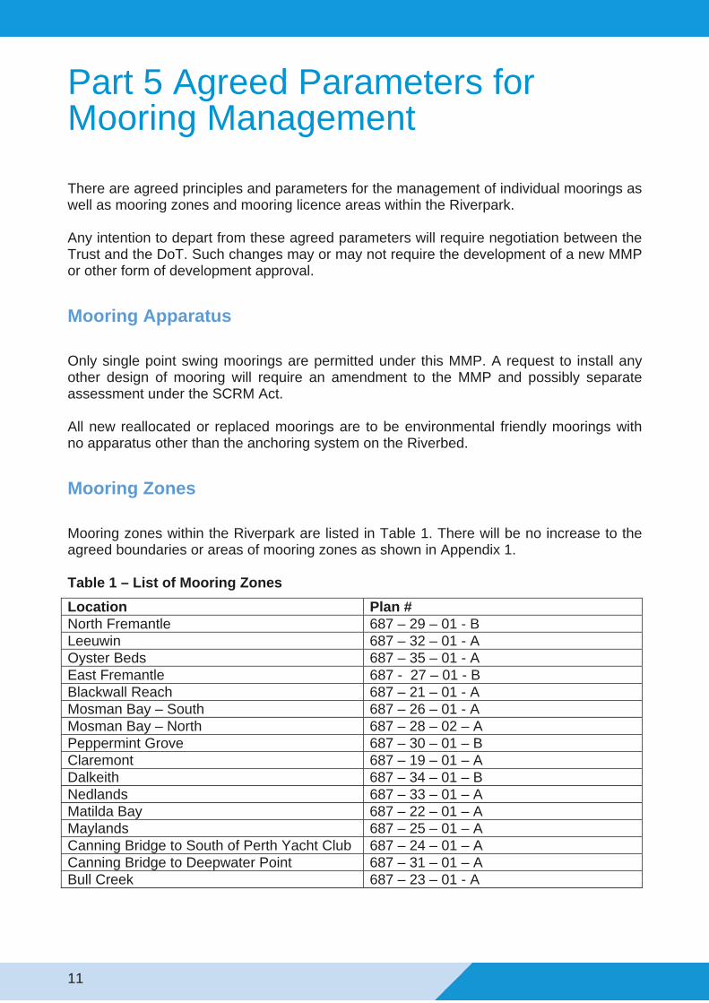
Mooring Zones
Mooring zones within the Riverpark are listed in Table 1. There will be no increase to the agreed boundaries or areas of mooring zones as shown in Appendix 1.
Table 1 – List of Mooring Zones
Location Plan # North Fremantle 687 – 29 – 01 - B Leeuwin 687 – 32 – 01 - A Oyster Beds 687 – 35 – 01 - A East Fremantle 687 - 27 – 01 - B Blackwall Reach 687 – 21 – 01 - A Mosman Bay – South 687 – 26 – 01 - A Mosman Bay – North 687 – 28 – 02 – A Peppermint Grove 687 – 30 – 01 – B Claremont 687 – 19 – 01 – A Dalkeith 687 – 34 – 01 – B Nedlands 687 – 33 – 01 – A Matilda Bay 687 – 22 – 01 – A Maylands 687 – 25 – 01 – A Canning Bridge to South of Perth Yacht Club 687 – 24 – 01 – A Canning Bridge to Deepwater Point 687 – 31 – 01 – A Bull Creek 687 – 23 – 01 - A
11
No new mooring zones will be allowed within the Riverpark under this MMP. Any request for additional mooring zones will require an amendment to the MMP and possibly a separate assessment under the SCRM Act.
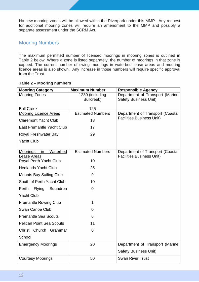
Mooring Numbers
The maximum permitted number of licensed moorings in mooring zones is outlined in Table 2 below. Where a zone is listed separately, the number of moorings in that zone is capped. The current number of swing moorings in waterbed lease areas and mooring licence areas is also shown. Any increase in those numbers will require specific approval from the Trust.
Table 2 – Mooring numbers
Mooring Category Maximum Number Responsible Agency Mooring Zones
Bull Creek
1230 (including Bullcreek)
125
Department of Transport (Marine Safety Business Unit)
Mooring Licence Areas
Claremont Yacht Club
East Fremantle Yacht Club
Royal Freshwater Bay
Yacht Club
Estimated Numbers
18
17
29
Department of Transport (Coastal Facilities Business Unit)
Moorings in Waterbed Lease Areas Royal Perth Yacht Club
Nedlands Yacht Club
Mounts Bay Sailing Club
South of Perth Yacht Club
Perth Flying Squadron
Yacht Club
Fremantle Rowing Club
Swan Canoe Club
Fremantle Sea Scouts
Pelican Point Sea Scouts
Christ Church Grammar
School
Estimated Numbers
10
25
9
10
0
1
0
6
11
0
Department of Transport (Coastal Facilities Business Unit)
Emergency Moorings 20 Department of Transport (Marine
Safety Business Unit)
Courtesy Moorings 50 Swan River Trust
12
General Management
No new licensed moorings will be allocated for sites outside the agreed mooring zones.
No new mooring licence areas will be allocated or issued.
It is recognised that a number of licensed moorings have been installed outside of the agreed zones identified in Appendix 1 prior to this MMP taking effect. DoT will offer the licensees of these moorings sites within the agreed zones as and when they become available. If an application is received to transfer a mooring, DoT will condition the transfer (where possible) on moving the mooring into a mooring zone.
13
Part 6 Reporting Requirements
DoT will provide annual reports based on the financial year to the Trust in an agreed format no later than 31 August each year. Special meetings can also occur between the two parties to deal with specific MMP matters. This report will include updates on current numbers of moorings installed per mooring category and the number of licensed moorings outside mooring zones. The report will also outline any changes made to standard mooring licence terms and conditions. The Trust may request further information on any issues related to moorings management be included in the reports.
Part 7 Review and Amendment
The MMP will be subject to review after the fifth anniversary of the date of its operation and following the expiry of each five yearly interval thereafter. Amendments can be made, if required, prior or during a review in line with the process outlined in the SCRM Act. If it is determined no amendments are necessary during the review, it may be agreed that the MMP is to continue in force without amendment.
Appendices
1. Map of Agreed Mooring Zones and licence Areas
14
Swan
River
POINT WALTER
ROAD
BLACKWALL
REAC
H
PARADE
STREET
DRIVE
BEACH STREET
DOWNEY
BATEMAN CHIDLEY WAY STREET
STREET KENT
L:\
HC
S\T
EN
UR
E\S
wa
n R
ive
r M
oo
rin
g A
rea
s\6
87
21
01
A.m
xd
D
NODE LATITUDE (SOUTH) LONGITUDE (EAST) A 32° 1.677' 115° 46.677' B 32° 1.620' 115° 46.592' C 32° 1.460' 115° 46.701' D 32° 1.294' 115° 46.829' E 32° 1.020' 115° 47.074' F 32° 0.909' 115° 47.112' G 32° 0.932' 115° 47.153'
RRRO
AA
ISH
BRAUNTON STREET A
EAST FREMANTLE
Legend
N Mooring Zone Lease Boundary
SUBJECT TO SURVEY Cadastre Coastline (Landgate 2012)
PREPARED BY CARTOGRAPHIC SERVICES Examined by Manager Cartography:Drawn by: S Salgado
0 100 200 300 4001 ESSEX STREET FREMANTLE D. DawsD Daws: ............................................Date: 28 April 2015METRESLANDGATE AERIAL IMAGERY FEBRUARY 2014 28 April 2015Date: .................................................
PLAN 687 - 21 - 01 - A
WELLINGTON
SWAN RIVERBLACKWALL REACH
MOORING ZONESITE PLAN
ALL THAT PORTION OF SWAN RIVER WATERS ENCLOSED BY A CONTIGUOUS LINE FORMED BY SEGMENTS
POSITION OF SEGMENT NODES USING A HORIZONTAL DATUM BASED ON GDA94
THE WATERS ARE SHOWN HATCHED ON PLAN, TRANSPORT WA 687-21-01A. AREA, 22.62 HECTARES
F G
E
MOSMAN PARK
D
C
B
BICTON
!
ETT D
HACKETT ENTRY No. 1
HACKETT ENTRY No. 2
AUSTRALIA II DRIVE
SWAN RIVERMATI
MOORLDA BAYING ZONE
SITE PLAN ALL THAT PORTION OF SWAN RIVER WATERS ENCLOSED BY A CONTIGUOUS LINE FORMED BY SEGMENTS
THE POSITION OF SEGMENT NODES USING A HORIZONTAL DATUM BASED ON GDA94
NODE LATITUDE (SOUTH) LONGITUDE (EAST) NODE LATITUDE (SOUTH) LONGITUDE (EAST) A 31° 58.739' 115° 49.271' E 31° 59.013' 115° 49.327' B 31° 58.739' 115° 49.437' F 31° 58.937' 115° 49.361' C 31° 58.933' 115° 49.430' G 31° 58.898' 115° 49.304' D 31° 59.056' 115° 49.372' H 31° 58.901' 115° 49.273'
THE WATERS ARE SHOWN HATCHED ON PLAN, TRANSPORT WA 687-22-01A. AREA, 10.81 HECTARES
A B
HACK
IVE
! !
!
!
!
!!
!
RSwan River
Matilda H G Bay
CClosed Waters F
(Motorised Vessels) ROYAL PERTHYACHT CLUB
CRAWLEY E
D
L:\
HC
S\T
EN
UR
E\S
wa
n R
ive
r M
oo
rin
g A
rea
s\6
87
-22
-01
-A.m
xd
Legend
N Mooring Zone
Cadastre
SUBJECT TO SURVEY Mooring Licence Area
PREPARED BY
Closed Waters (Motorised Vessels)
Lease Boundary
Coastline (Landgate 2012)
CARTOGRAPHIC SERVICES 1 ESSEX STREET FREMANTLE 0 50 100 150 200
LANDGATE AERIAL IMAGERY FEBRUARY 2014 METRES
Drawn by: S Salgado
Date: 7 April 2015
Examined by Manager Cartography:
D. DawsD Daws: ............................................
7 April 2015Date: .................................................
PLAN 687 - 22 - 01 - A
J O H N
N
P W a
t e r
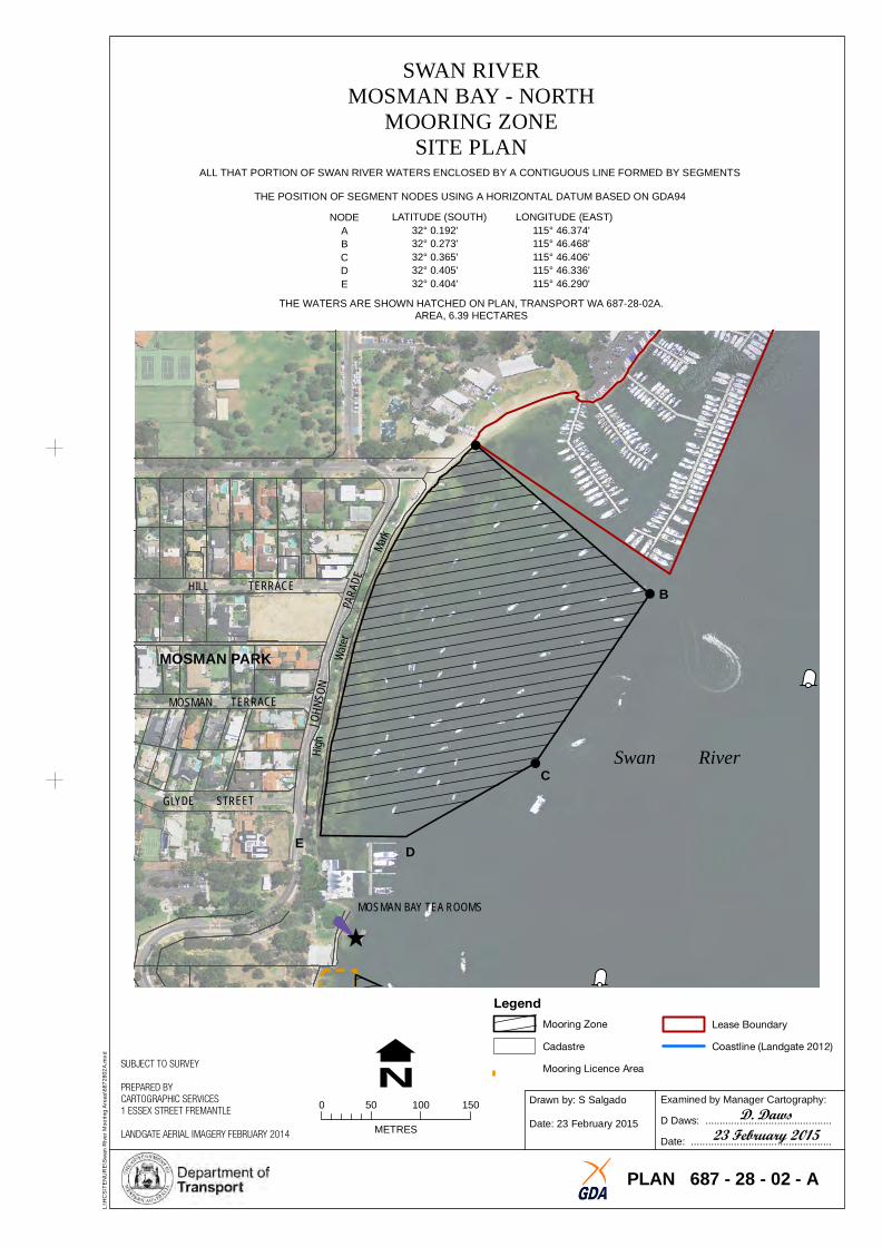
SWAN RIVERMOSMAN BAY - NORTH
MOORING ZONE SITE PLAN
ALL THAT PORTION OF SWAN RIVER WATERS ENCLOSED BY A CONTIGUOUS LINE FORMED BY SEGMENTS
THE POSITION OF SEGMENT NODES USING A HORIZONTAL DATUM BASED ON GDA94
NODE LATITUDE (SOUTH) LONGITUDE (EAST) A 32° 0.192' 115° 46.374' B 32° 0.273' 115° 46.468' C 32° 0.365' 115° 46.406' D 32° 0.405' 115° 46.336' E 32° 0.404' 115° 46.290'
THE WATERS ARE SHOWN HATCHED ON PLAN, TRANSPORT WA 687-28-02A. AREA, 6.39 HECTARES
A
J O H N S O N S T R E E T F R E S HR O Y A L
W A T E RB A Y Y A C H T C L U B
A R
MaA
E
S O
H ig h
!
!
! !
!
rk
D HILL TERR AC E B
MOSMAN PARK
MOSM AN TER RACE
Swan RiverC
GL YD E STR EET
E D
MOS MAN BAY TEA ROOM S
Legend
N Lease Boundary
Coastline (Landgate 2012)
L:\
HC
S\T
EN
UR
E\S
wa
n R
ive
r M
oo
rin
g A
rea
s\6
87
28
02
A.m
xd
SUBJECT TO SURVEY
PREPARED BY CARTOGRAPHIC SERVICES
0 50 100 150 1 ESSEX STREET FREMANTLE
METRES LANDGATE AERIAL IMAGERY FEBRUARY 2014
Mooring Zone
Cadastre
Mooring Licence Area
Drawn by: S Salgado
Date: 23 February 2015
Examined by Manager Cartography:
D. DawsD Daws: ............................................
23 February 2015 Date: .................................................
PLAN 687 - 28 - 02 - A
VICTORIAAVENUE
VICTORIA
BAY
ROAD
CHES
TER
ROAD
AVENUE A
CLAREMONT YACHT CLUB B
Freshwater
Bay
Swan River
C
D E
L:\
HC
S\T
EN
UR
E\S
wa
n R
ive
r M
oo
rin
g A
rea
s\6
87
19
01
A.m
xd
SUBJECT TO SURVEY
PREPARED BY CARTOGRAPHIC SERVICES
N 0 100 200 3001 ESSEX STREET FREMANTLE
LANDGATE AERIAL IMAGERY FEBRUARY 2014 METRES
PLAN 687 - 19 - 01 - A
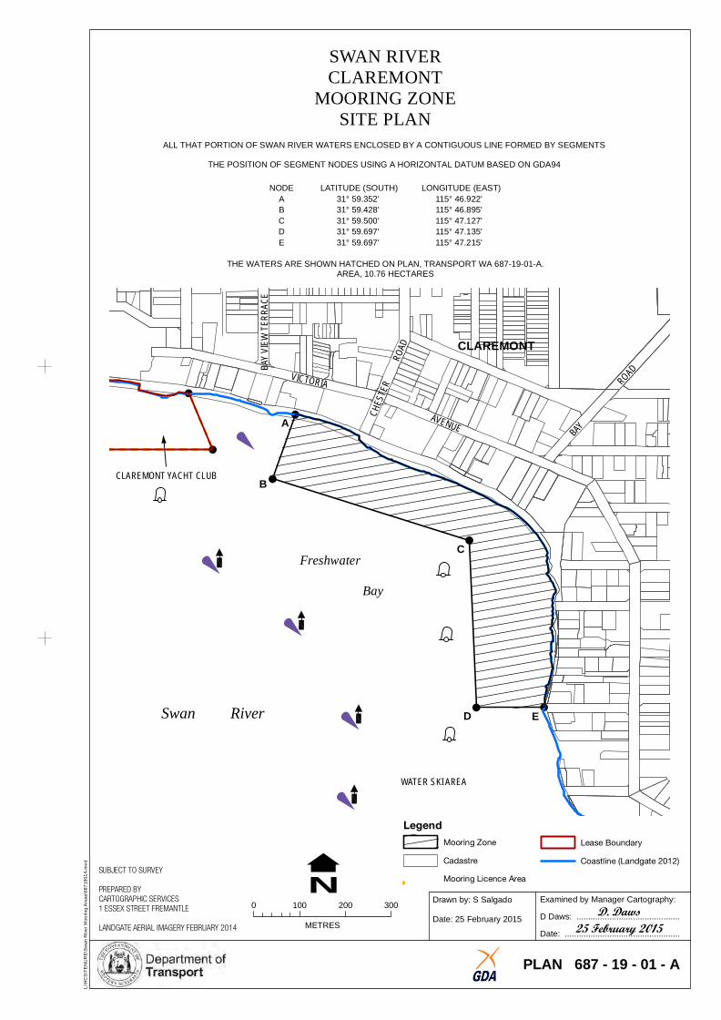
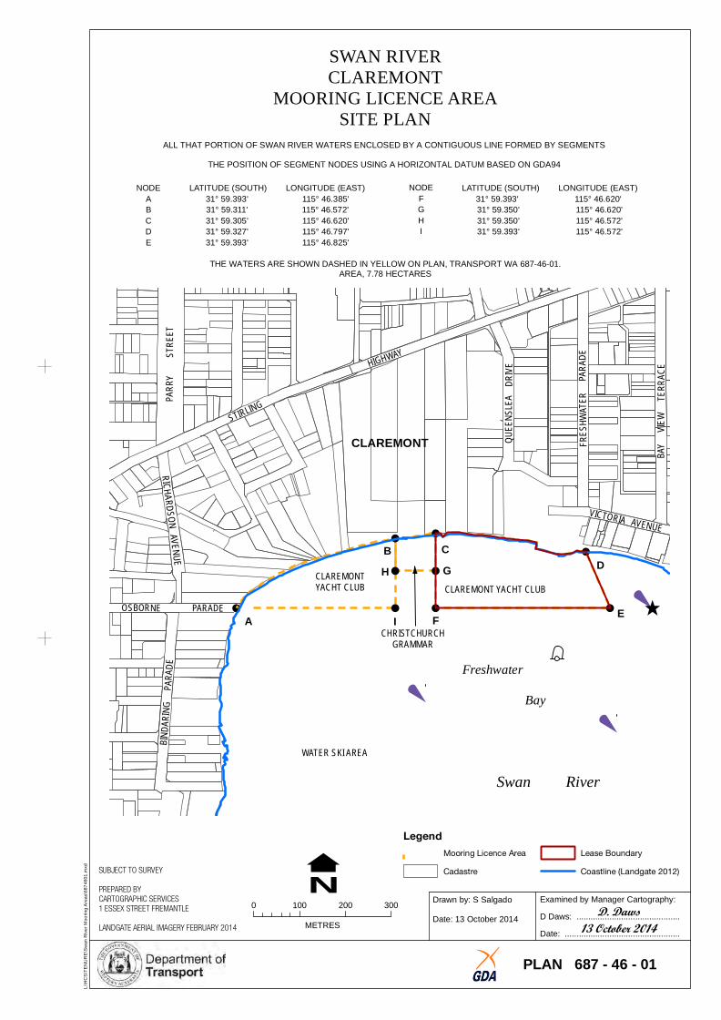
SWAN RIVERCLAREMONT
MOORING ZONESITE PLAN
ALL THAT PORTION OF SWAN RIVER WATERS ENCLOSED BY A CONTIGUOUS LINE FORMED BY SEGMENTS
THE POSITION OF SEGMENT NODES USING A HORIZONTAL DATUM BASED ON GDA94
NODE LATITUDE (SOUTH) LONGITUDE (EAST) A 31° 59.352' 115° 46.922' B 31° 59.428' 115° 46.895' C 31° 59.500' 115° 47.127' D 31° 59.697' 115° 47.135' E 31° 59.697' 115° 47.215'
THE WATERS ARE SHOWN HATCHED ON PLAN, TRANSPORT WA 687-19-01-A.B
YVIW
TRR
AAC
EE
EAREA, 10.76 HECTARES
!
!
!
! !
!
!
CLAREMONT
WATER SKI AREA
Legend
Mooring Zone
Cadastre
Mooring Licence Area
Lease Boundary
Coastline (Landgate 2012)
Examined by Manager Cartography:Drawn by: S Salgado
D. DawsD Daws: ............................................Date: 25 February 2015 25 February 2015Date: .................................................
!
DRIVE CKETT
AUSTRALIA II DRIVE
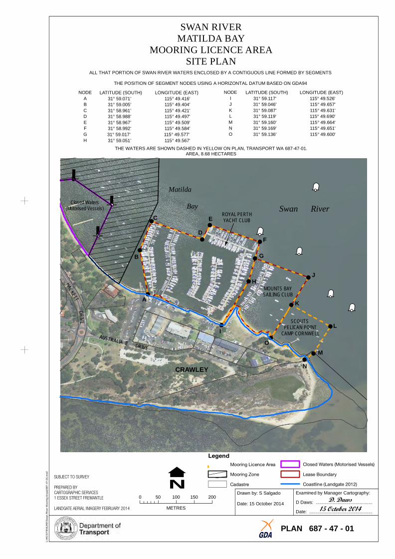
SWAN RIVERMATILDA BAY
MOORING LICENCE AREASITE PLAN
ALL THAT PORTION OF SWAN RIVER WATERS ENCLOSED BY A CONTIGUOUS LINE FORMED BY SEGMENTS
THE POSITION OF SEGMENT NODES USING A HORIZONTAL DATUM BASED ON GDA94
HA
!
!
!
!
!
!
!
!
!
!
!
!
!
! !
!
NODE LATITUDE (SOUTH) LONGITUDE (EAST) NODE LATITUDE (SOUTH) LONGITUDE (EAST) A 31° 59.071' 115° 49.416' I 31° 59.117' 115° 49.526' B 31° 59.005' 115° 49.404' J 31° 59.046' 115° 49.657' C 31° 58.961' 115° 49.421' K 31° 59.087' 115° 49.631' D 31° 58.988' 115° 49.497' L 31° 59.119' 115° 49.690' E 31° 58.967' 115° 49.509' M 31° 59.160' 115° 49.664' F 31° 58.992' 115° 49.584' N 31° 59.169' 115° 49.651' G 31° 59.017' 115° 49.577' O 31° 59.136' 115° 49.600' H 31° 59.051' 115° 49.567'
THE WATERS ARE SHOWN DASHED IN YELLOW ON PLAN, TRANSPORT WA 687-47-01. AREA, 8.68 HECTARES
Matilda Closed Waters
(Motorised Vessels) Bay Swan RiverROYAL PERTHC E YACHT CLUB D
F
B G
JH
MOUNTS BAYSAILING CLUBA K
PELSCOUTSICAN POINT LI CAMP CORNWELL
O M
NCRAWLEY
Legend
Closed Waters (Motorised Vessels)Mooring Licence Area
L:\
HC
S\T
EN
UR
E\S
wa
n R
ive
r M
oo
rin
g A
rea
s\6
87
-47
-01
.mxd
N Mooring Zone
SUBJECT TO SURVEY
CadastrePREPARED BY
Lease Boundary
Coastline (Landgate 2012)
CARTOGRAPHIC SERVICES 1 ESSEX STREET FREMANTLE 0 50 100 150 200
LANDGATE AERIAL IMAGERY FEBRUARY 2014 METRES
Drawn by: S Salgado
Date: 15 October 2014
Examined by Manager Cartography:
D. DawsD Daws: ............................................
15 October 2014Date: .................................................
PLAN 687 - 47 - 01
!
CA INN NG
BEACH
ROAD
KILLILAN ROAD
DUNVEGAN ROAD
DUNCRAIG ROAD
CARRON ROAD
STROME ROAD
CANNING RIVER MOOR
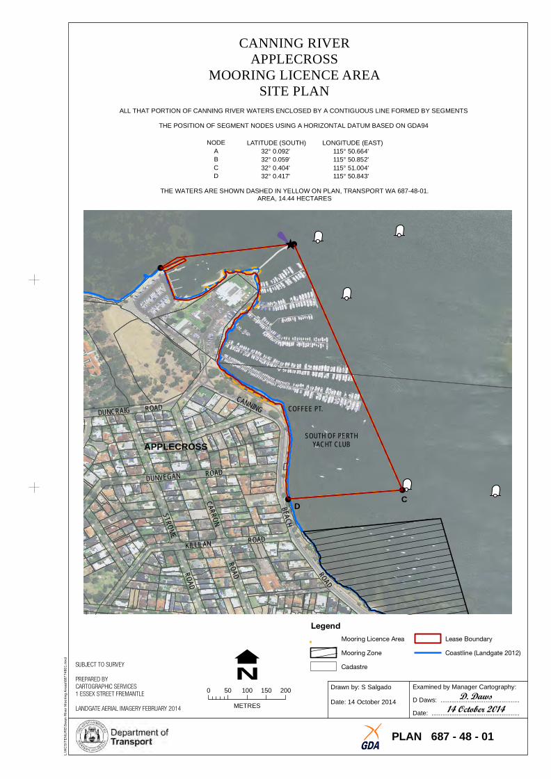
APPLECROSSING LICENCE AREA
SITE PLAN ALL THAT PORTION OF CANNING RIVER WATERS ENCLOSED BY A CONTIGUOUS LINE FORMED BY SEGMENTS
THE POSITION OF SEGMENT NODES USING A HORIZONTAL DATUM BASED ON GDA94
NODE LATITUDE (SOUTH) LONGITUDE (EAST) A 32° 0.092' 115° 50.664' B 32° 0.059' 115° 50.852' C 32° 0.404' 115° 51.004' D 32° 0.417' 115° 50.843'
THE WATERS ARE SHOWN DASHED IN YELLOW ON PLAN, TRANSPORT WA 687-48-01. AREA, 14.44 HECTARES
B
A
Canning River
!
!
!
!
APPLECROSS
COFFEE PT.
SOUTH OF PERTHYACHT CLUB
D C
Legend
L:\
HC
S\T
EN
UR
E\S
wa
n R
ive
r M
oo
rin
g A
rea
s\6
87
74
80
1.m
xd
SUBJECT TO SURVEY
PREPARED BY CARTOGRAPHIC SERVICES
N 0 50 100 150 200
1 ESSEX STREET FREMANTLE
METRESLANDGATE AERIAL IMAGERY FEBRUARY 2014
Mooring Licence Area Lease Boundary
Mooring Zone Coastline (Landgate 2012)
Cadastre
Drawn by: S Salgado
Date: 14 October 2014
Examined by Manager Cartography:
D. DawsD Daws: ............................................
14 October 2014Date: .................................................
PLAN 687 - 48 - 01
!
STIRLING
HIGHWAY
RICHARDSON AVENUE
B INDA
RI NG
P ARA
DE
VICTORIA AVENUE
NODE LATITUDE (SOUTH) LONGITUDE (EAST) NODE LATITUDE (SOUTH) LONGITUDE (EAST) A 31° 59.393' 115° 46.385' F 31° 59.393' 115° 46.620' B 31° 59.311' 115° 46.572' G 31° 59.350' 115° 46.620' C 31° 59.305' 115° 46.620' H 31° 59.350' 115° 46.572' D 31° 59.327' 115° 46.797' I 31° 59.393' 115° 46.572' E 31° 59.393' 115° 46.825'
THE WATERS ARE SHOWN DASHED IN YELLOW ON PLAN, TRANSPORT WA 687-46-01. AREA, 7.78 HECTARES
!
! !
!
!!
!!
!OSBORNE PARADE EFA ICHRISTCHURCH
GRAMMAR
L:\
HC
S\T
EN
UR
E\S
wa
n R
ive
r M
oo
rin
g A
rea
s\6
87
46
01
.mxd
N Mooring Licence Area Lease Boundary
SUBJECT TO SURVEY Cadastre Coastline (Landgate 2012)
PREPARED BY CARTOGRAPHIC SERVICES Examined by Manager Cartography:Drawn by: S Salgado
0 100 200 3001 ESSEX STREET FREMANTLE D. DawsD Daws: ............................................Date: 13 October 2014METRESLANDGATE AERIAL IMAGERY FEBRUARY 2014 13 October 2014Date: .................................................
PLAN 687 - 46 - 01
SWAN RIVER MOOR
CLAREMONTING LICENCE AREA
SITE PLAN ALL THAT PORTION OF SWAN RIVER WATERS ENCLOSED BY A CONTIGUOUS LINE FORMED BY SEGMENTS
THE POSITION OF SEGMENT NODES USING A HORIZONTAL DATUM BASED ON GDA94PA
YS
RRRE
ET
T
QUNS
LA
DRIV
EEE
E
PR
RR
AA
ADE
EE
TSH
WF
Freshwater
Bay
WATER SKI AREA
Swan River
Legend
CLAREMONT
B C GCLAREMONT H
YACHT CLUB CLAREMONT YACHT CLUB
BY
VIW
TRR
AAC
EE
E
D
RIVERSIDE ROAD
!
!
!
!
SWAN RIVEREAST FREMANTLE
MOORING LICENCE AREA SITE PLAN
ALL THAT PORTION OF SWAN RIVER WATERS ENCLOSED BY A CONTIGUOUS LINE FORMED BY SEGMENTS
THE POSITION OF SEGMENT NODES USING A HORIZONTAL DATUM BASED ON GDA94
NODE LATITUDE (SOUTH) LONGITUDE (EAST) A 32° 1.595' 115° 45.817' B 32° 1.515' 115° 45.793' C 32° 1.509' 115° 45.830' D 32° 1.586' 115° 45.853'
THE WATERS ARE SHOWN DASHED IN YELLOW ON PLAN, TRANSPORT WA 687-45-01. AREA, 0.90 HECTARES
Swan River
B A
FREMANTLEROWING CLUB INC
C NORM McKENZI
D RESERVE E
TAOIST TAI CHISOCIETY OF
AUSTRALIA INC
SWAN YACHT CLUB
EAST FREMANTLE
Legend
L:\
HC
S\T
EN
UR
E\S
wa
n R
ive
r M
oo
rin
g A
rea
s\6
87
45
01
.mxd
SUBJECT TO SURVEY
PREPARED BY CARTOGRAPHIC SERVICES
N 0 20 40 60 80 1 ESSEX STREET FREMANTLE
LANDGATE AERIAL IMAGERY FEBRUARY 2014 METRES
Mooring Licence Area
Cadastre
Lease Boundary
Coastline (Landgate 2012)
Drawn by: S Salgado
Date: 13 October 2014
Examined by Manager Cartography:
D. DawsD Daws: ............................................
13 October 2014 Date: .................................................
PLAN 687 - 45 - 01
BRUC
EST
REET
ESPLANADE
BIRDW
OOD
PARA
DE
THE
AVENUE
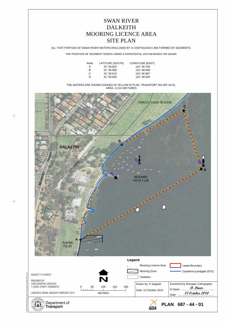
SWAN RIDALKEI
VERTH
MOORING LICENCE AREASITE PLAN
ALL THAT PORTION OF SWAN RIVER WATERS ENCLOSED BY A CONTIGUOUS LINE FORMED BY SEGMENTS
THE POSITION OF SEGMENT NODES USING A HORIZONTAL DATUM BASED ON GDA94
Node LATITUDE (SOUTH) LONGITUDE (EAST) A 31° 59.823' 115° 48.740' B 31° 59.596' 115° 48.838' C 31° 59.515' 115° 48.987' D 31° 59.655' 115° 49.029'
THE WATERS ARE SHOWN DASHED IN YELLOW IN PLAN, TRANSPORT WA 687-44-01. AREA, 11.54 HECTARES
!
!
!
!
CHARLES COURT RESERVE C
BDALKEITH
D NEDLANDS
YACHT CLUB
APLAYINGFIELDS
Legend
L:\
HC
S\T
EN
UR
E\S
wa
n R
ive
r M
oo
rin
g A
rea
s\6
87
44
01
.mxd
SUBJECT TO SURVEY
PREPARED BY CARTOGRAPHIC SERVICES 1 ESSEX STREET FREMANTLE 0 50 100 150 200
N LANDGATE AERIAL IMAGERY FEBRUARY 2014 METRES
Mooring Licence Area Lease Boundary
Mooring Zone Coastline (Landgate 2012)
Cadastre
Drawn by: S Salgado
Date: 13 October 2014
Examined by Manager Cartography:
D. DawsD Daws: ............................................
13 October 2014Date: .................................................
PLAN 687 - 44 - 01
HACKETT DRI E
E
O D Y
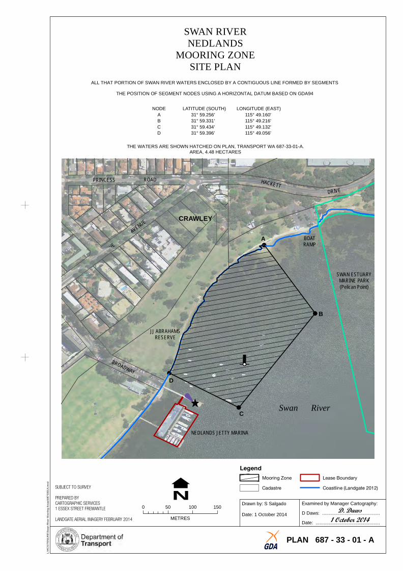
SWAN RIVERNEDLANDS
MOORING ZONESITE PLAN
ALL THAT PORTION OF SWAN RIVER WATERS ENCLOSED BY A CONTIGUOUS LINE FORMED BY SEGMENTS
THE POSITION OF SEGMENT NODES USING A HORIZONTAL DATUM BASED ON GDA94
NODE LATITUDE (SOUTH) LONGITUDE (EAST) A 31° 59.256' 115° 49.160' B 31° 59.331' 115° 49.216' C 31° 59.434' 115° 49.132' D 31° 59.396' 115° 49.056'
THE WATERS ARE SHOWN HATCHED ON PLAN, TRANSPORT WA 687-33-01-A. AREA, 4.48 HECTARES
V
E U
THE AV N
BR A WA
!
!
!
!
PRINCESS ROAD
CRAWLEY
JJ ABRAHAMSRESERVE
A BOATRAMP
B
SWAN ESTUARYMARINE PARK(Pelican Point)
D
Legend
NEDLANDS JETTY MARINA
C Swan River
L:\
HC
S\T
EN
UR
E\S
wa
n R
ive
r M
oo
rin
g A
rea
s\6
87
33
01
A.m
xd
SUBJECT TO SURVEY
PREPARED BY CARTOGRAPHIC SERVICES 1 ESSEX STREET FREMANTLE 0 50 100 150
LANDGATE AERIAL IMAGERY FEBRUARY 2014 METRES
N Mooring Zone
Cadastre
Lease Boundary
Coastline (Landgate 2012)
Drawn by: S Salgado
Date: 1 October 2014
Examined by Manager Cartography:
D. DawsD Daws: ............................................
1 October 2014Date: .................................................
PLAN 687 - 33 - 01 - A
CLOSED WATERS
(MOTORISED VESSELS)
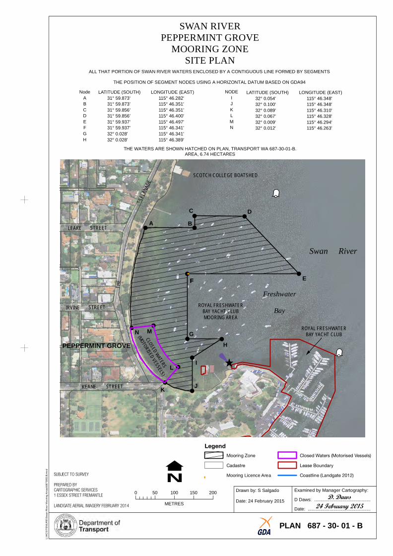
SWAN RIVERPEPPERMI
MOOR NT GROVE
ING ZONESITE PLAN
ALL THAT PORTION OF SWAN RIVER WATERS ENCLOSED BY A CONTIGUOUS LINE FORMED BY SEGMENTS
THE POSITION OF SEGMENT NODES USING A HORIZONTAL DATUM BASED ON GDA94
Node LATITUDE (SOUTH) LONGITUDE (EAST) NODE LATITUDE (SOUTH) LONGITUDE (EAST) A 31° 59.873' 115° 46.282' I 32° 0.054' 115° 46.348' B 31° 59.873' 115° 46.351' J 32° 0.100' 115° 46.348' C 31° 59.856' 115° 46.351' K 32° 0.089' 115° 46.310' D 31° 59.856' 115° 46.400' L 32° 0.067' 115° 46.328' E 31° 59.937' 115° 46.497' M 32° 0.009' 115° 46.294' F 31° 59.937' 115° 46.341' N 32° 0.012' 115° 46.263' G 32° 0.028' 115° 46.341' H 32° 0.028' 115° 46.389'
THE WATERS ARE SHOWN HATCHED ON PLAN, TRANSPORT WA 687-30-01-B. AREA, 6.74 HECTARES
PLANA
DE
ES
HET
!
!!
!
!
!
!
!!
!
! !
!
!
SCOTCH COLLEGE BOATSHED
C D
LEAKE A BSTREET
Swan River
IRVINE STREET
FF E
Freshwater ROYAL FRESHWATER
BAY YACHT CLUBMOORING AREA
Bay
PEPPERMINT GROVE N M G
ROYAL FRESHWATERBAY YACHT CLUB
H
L I
KEANE STREET JK
L:\
HC
S\T
EN
UR
E\S
wa
n R
ive
r M
oo
rin
g A
rea
s\6
87
30
01
B.m
xd
Legend
N Mooring Zone
Cadastre
SUBJECT TO SURVEY Mooring Licence Area
Closed Waters (Motorised Vessels)
Lease Boundary
Coastline (Landgate 2012)
PREPARED BY CARTOGRAPHIC SERVICES
0 50 100 150 2001 ESSEX STREET FREMANTLE
METRESLANDGATE AERIAL IMAGERY FEBRUARY 2014
Drawn by: S Salgado
Date: 24 February 2015
Examined by Manager Cartography:
D. DawsD Daws: ............................................
24 February 2015Date: .................................................
PLAN 687 - 30- 01 - B
formerly BUTT ROAD HARDEY
ROAD
DRAIN RESERVE
SWAN RIVERMAYLANDS
MOORING ZONESITE PLAN
ALL THAT PORTION OF SWAN RIVER WATERS ENCLOSED BY A CONTIGUOUS LINE FORMED BY SEGMENTS
THE POSITION OF SEGMENT NODES USING A HORIZONTAL DATUM BASED ON GDA94
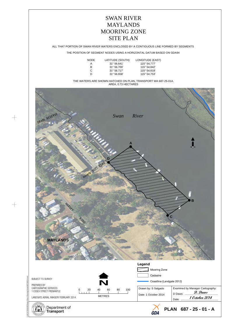
NODE LATITUDE (SOUTH) LONGITUDE (EAST) A 31° 56.641' 115° 54.777' B 31° 56.700' 115° 54.842' C 31° 56.717' 115° 54.818' D 31° 56.658' 115° 54.753'
THE WATERS ARE SHOWN HATCHED ON PLAN, TRANSPORT WA 687-25-01A. AREA, 0.73 HECTARES
Swan River
!
!
!
!
A
D
B
C
MAYLANDS
Legend
L:\
HC
S\T
EN
UR
E\S
wa
n R
ive
r M
oo
rin
g A
rea
s\6
87
25
01
A.m
xd
SUBJECT TO SURVEY
PREPARED BY CARTOGRAPHIC SERVICES
N 0 20 40 60 80 100
1 ESSEX STREET FREMANTLE
METRESLANDGATE AERIAL IMAGERY FEBRUARY 2014
Mooring Zone
Cadastre
Coastline (Landgate 2012)
Drawn by: S Salgado
Date: 1 October 2014
Examined by Manager Cartography:
D. DawsD Daws: ............................................
1 October 2014Date: .................................................
PLAN 687 - 25 - 01 - A
RIVER
SIDE
DRIVE
PRES
TON
POINT
SWAN RIVEROYSTER BEDS
MOORING ZONE SITE PLAN
RD
OA
!
!
!
!
ALL THAT PORTION OF SWAN RIVER WATERS ENCLOSED BY A CONTIGUOUS LINE FORMED BY SEGMENTS
THE POSITION OF SEGMENT NODES USING A HORIZONTAL DATUM BASED ON GDA94
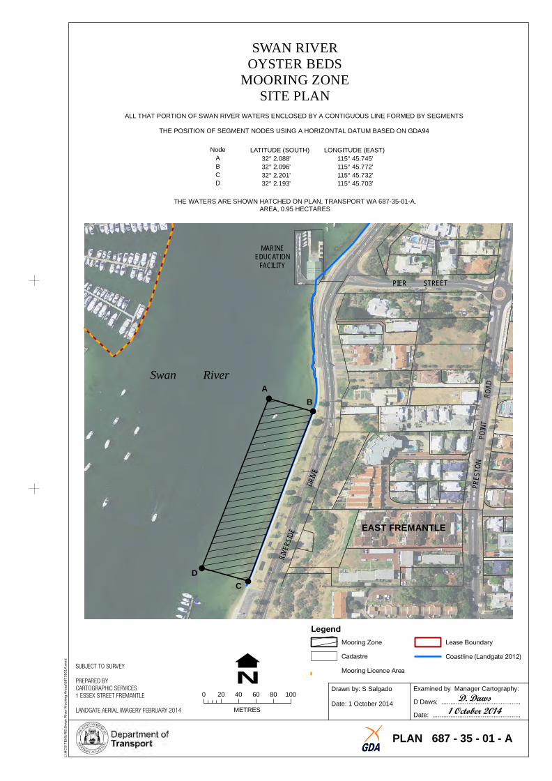
Node LATITUDE (SOUTH) LONGITUDE (EAST) A 32° 2.088' 115° 45.745' B 32° 2.096' 115° 45.772' C 32° 2.201' 115° 45.732' D 32° 2.193' 115° 45.703'
THE WATERS ARE SHOWN HATCHED ON PLAN, TRANSPORT WA 687-35-01-A. AREA, 0.95 HECTARES
MARIEDUCAT
NEION
FACILITY
PIER STREET
Swan River A
B
EAST FREMANTLE
D C
Legend
L:\
HC
S\T
EN
UR
E\S
wa
n R
ive
r M
oo
rin
g A
rea
s\6
87
35
01
A.m
xd
SUBJECT TO SURVEY
PREPARED BY CARTOGRAPHIC SERVICES 1 ESSEX STREET FREMANTLE 0 20 40 60 80 100
LANDGATE AERIAL IMAGERY FEBRUARY 2014 METRES
N Mooring Zone Lease Boundary
Cadastre Coastline (Landgate 2012)
Mooring Licence Area
Drawn by: S Salgado
Date: 1 October 2014
Examined by Manager Cartography:
D. DawsD Daws: ............................................
1 October 2014 Date: .................................................
PLAN 687 - 35 - 01 - A
STIRLING
HIGHWAY
JOHN
TURTONSTREET
JOHANNAHSTREET
RIVER
SIDE
ROAD
STREET
SWAN RIVERNORTH FREMANTLE
MOORING ZONESITE PLAN
ALL THAT PORTION OF SWAN RIVER WATERS ENCLOSED BY A CONTIGUOUS LINE FORMED BY SEGMENTS
THE POSITION OF SEGMENT NODES USING A HORIZONTAL DATUM BASED ON GDA94
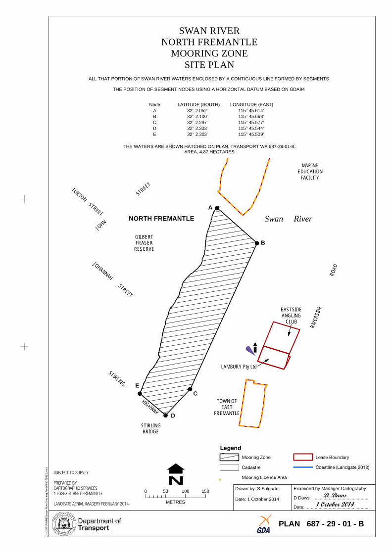
Node LATITUDE (SOUTH) LONGITUDE (EAST) A 32° 2.052' 115° 45.614' B 32° 2.100' 115° 45.668' C 32° 2.297' 115° 45.577' D 32° 2.333' 115° 45.544' E 32° 2.303' 115° 45.509'
THE WATERS ARE SHOWN HATCHED ON PLAN, TRANSPORT WA 687-29-01-B. AREA, 4.87 HECTARES
MARIEDUCAT
NEION
FACILITY
A NORTH FREMANTLE Swan River
GILBERTFRASER B
RESERVE
LAMBURY Pty Ltd
E
!
!
!
!
!
EASTSIANGLI
DE CLUB
NG
C TOWN OF
EASTFREMANTLED
STIRLIBR
NGIDGE
Legend
L:\
HC
S\T
EN
UR
E\S
wa
n R
ive
r M
oo
rin
g A
rea
s\6
87
29
01
B.m
xd
SUBJECT TO SURVEY
PREPARED BY CARTOGRAPHIC SERVICES 1 ESSEX STREET FREMANTLE 0 50 100 150
LANDGATE AERIAL IMAGERY FEBRUARY 2014 METRES
N Mooring Zone
Cadastre
Mooring Licence Area
Lease Boundary
Coastline (Landgate 2012)
Drawn by: S Salgado
Date: 1 October 2014
Examined by Manager Cartography:
D. DawsD Daws: ............................................
1 October 2014Date: .................................................
PLAN 687 - 29 - 01 - B
KWINA
NA
E
ESPLANADE
CRANFOR AVENUE
LEACH HIGHWAY
WEST
THE
VD I
RI RTVE
REW
FAY
AD
RIVE
OLPU VERT N
RI
!
! N E
OR
D
D
OR
O
L:\
HC
S\T
EN
UR
E\S
wa
n R
ive
r M
oo
rin
g A
rea
s\6
87
23
01
A.m
xd
N Cadastre
SUBJECT TO SURVEY
Coastline (Landgate 2012)PREPARED BY CARTOGRAPHIC SERVICES Examined by Manager Cartography:Drawn by: S Salgado
0 100 200 3001 ESSEX STREET FREMANTLE D. DawsD Daws: ............................................ LANDGATE AERIAL IMAGERY FEBRUARY 2014 METRES
Date: 1 October 2014 1 October 2014Date: .................................................
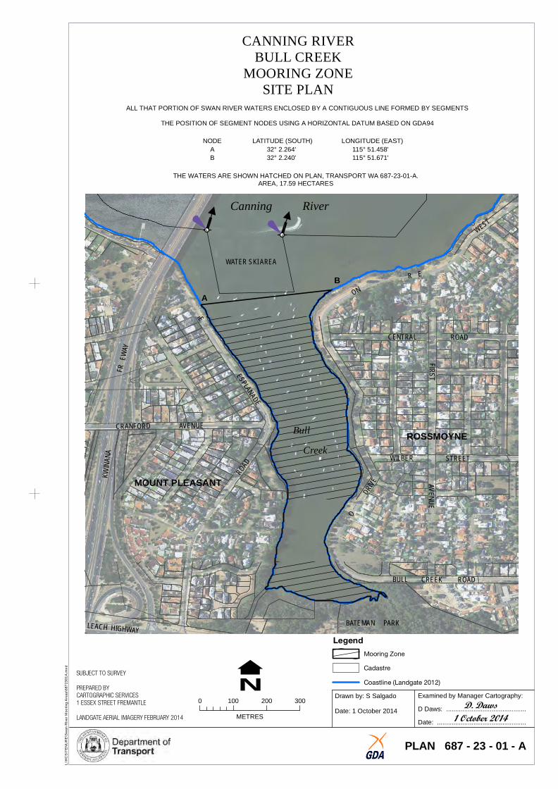
PLAN 687 - 23 - 01 - A
CANNING RIVERBULL CREEK
MOORING ZONESITE PLAN
ALL THAT PORTION OF SWAN RIVER WATERS ENCLOSED BY A CONTIGUOUS LINE FORMED BY SEGMENTS
THE POSITION OF SEGMENT NODES USING A HORIZONTAL DATUM BASED ON GDA94F
NODE LATITUDE (SOUTH) LONGITUDE (EAST) A 32° 2.264' 115° 51.458' B 32° 2.240' 115° 51.671'
IRSTAV
NUE
E
THE WATERS ARE SHOWN HATCHED ON PLAN, TRANSPORT WA 687-23-01-A. AREA, 17.59 HECTARES
B
Canning River
WATER SKI AREA
A
MOUNT PLEASANT
CENTRAL ROAD
Bull ROSSMOYNECreek
WILBER STREET
BULL CREEK ROAD
BATEMAN PARK Legend
Mooring Zone
HA
EET
THE
ESPL
ANAD
E
ROOKWOOD STREET
VIEW
ROAD
HELM STREET
KISHO
RN
ROAD
KWINA
NA
FREE
W AY
WATER SKI AREA BOUNDARY
WATER SKI AEA BOUNDARY
A B
IST
WK NR
S
! !
!
!
!
!
MOUNT PLEASANT
L:\
HC
S\T
EN
UR
E\S
wa
n R
ive
r M
oo
rin
g A
rea
s\6
87
31
01
A.m
xd
N Cadastre
SUBJECT TO SURVEY Coastline (Landgate 2012)
PREPARED BY CARTOGRAPHIC SERVICES Examined by Manager Cartography:Drawn by: S Salgado
0 50 100 150 2001 ESSEX STREET FREMANTLE D. DawsD Daws: ............................................Date: 1 October 2014METRESLANDGATE AERIAL IMAGERY FEBRUARY 2014 1 October 2014Date: .................................................
PLAN 687 - 31 - 01 - A
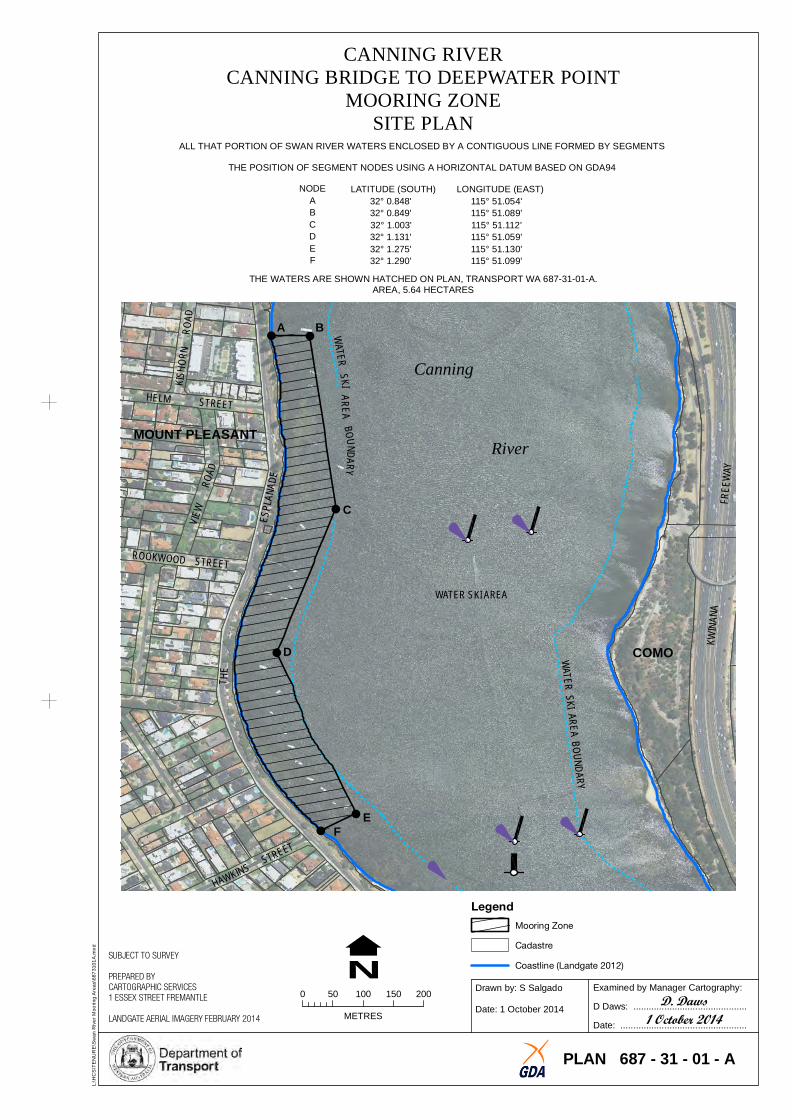
CANNING RIVERCANNING BRIDGE TO DEEPWATER POINT
MOORING ZONESITE PLAN
ALL THAT PORTION OF SWAN RIVER WATERS ENCLOSED BY A CONTIGUOUS LINE FORMED BY SEGMENTS
THE POSITION OF SEGMENT NODES USING A HORIZONTAL DATUM BASED ON GDA94
R
NODE LATITUDE (SOUTH) LONGITUDE (EAST) A 32° 0.848' 115° 51.054' B 32° 0.849' 115° 51.089' C 32° 1.003' 115° 51.112' D 32° 1.131' 115° 51.059' E 32° 1.275' 115° 51.130' F 32° 1.290' 115° 51.099'
THE WATERS ARE SHOWN HATCHED ON PLAN, TRANSPORT WA 687-31-01-A. AREA, 5.64 HECTARES
Canning
River
C
WATER SKI AREA
D COMO
EF
Legend
Mooring Zone
JERRAT DRIVE
POINT
PETRA S
REET
!
!
!
!
!!
!
!
!
!
!
!
TL
:\H
CS
\TE
NU
RE
\Sw
an
Riv
er
Mo
ori
ng
Are
as\
68
72
70
1B
.mx
d
N Cadastre Coastline (Landgate 2012)
SUBJECT TO SURVEY Mooring Licence Area
PREPARED BY CARTOGRAPHIC SERVICES Examined by Manager Cartography:Drawn by: S Salgado
0 50 100 150 2001 ESSEX STREET FREMANTLE D. DawsD Daws: ............................................Date: 9 October 2014METRESLANDGATE AERIAL IMAGERY FEBRUARY 2014 9 October 2014Date: .................................................
PLAN 687 - 27 - 01 - B
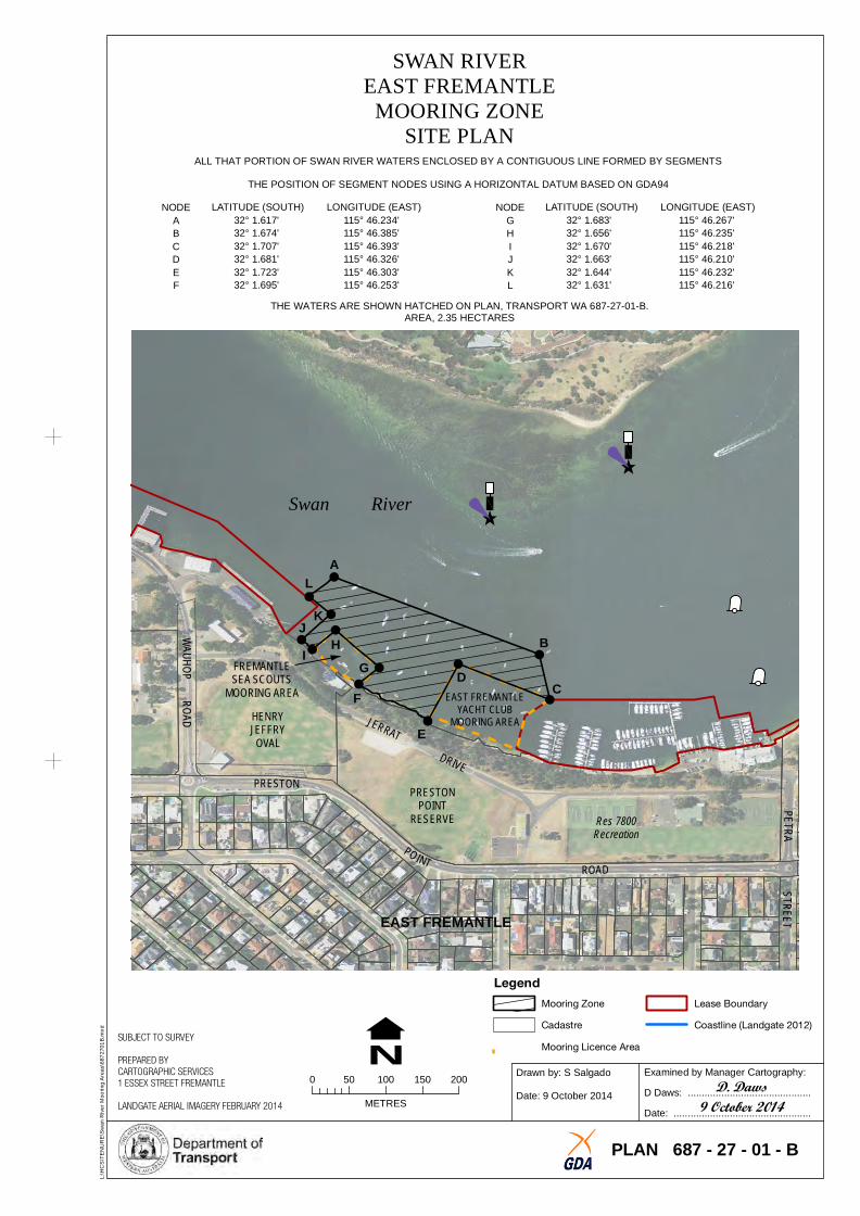
SWAN RIVEREAST FREMANTLE
MOORING ZONESITE PLAN
ALL THAT PORTION OF SWAN RIVER WATERS ENCLOSED BY A CONTIGUOUS LINE FORMED BY SEGMENTS
THE POSITION OF SEGMENT NODES USING A HORIZONTAL DATUM BASED ON GDA94
NODE LATITUDE (SOUTH) LONGITUDE (EAST) NODE LATITUDE (SOUTH) LONGITUDE (EAST) A 32° 1.617' 115° 46.234' G 32° 1.683' 115° 46.267' B 32° 1.674' 115° 46.385' H 32° 1.656' 115° 46.235' C 32° 1.707' 115° 46.393' I 32° 1.670' 115° 46.218' D 32° 1.681' 115° 46.326' J 32° 1.663' 115° 46.210' E 32° 1.723' 115° 46.303' K 32° 1.644' 115° 46.232' F 32° 1.695' 115° 46.253' L 32° 1.631' 115° 46.216'
THE WATERS ARE SHOWN HATCHED ON PLAN, TRANSPORT WA 687-27-01-B. AREA, 2.35 HECTARES
Swan River
A
L
J K H B
IFREMANTLE GUH
PR
OO
AAD
WD
MOORING AREA F EAST FREMANTLE C
YACHT CLUB
SEA SCOUTS
HENRYJEFFRY
OVAL
PRESTON
E MOORING AREA
PRESTONPOINT
RESERVE Res 7800Recreation
ROAD
EAST FREMANTLE
Legend
Mooring Zone Lease Boundary
RIVER
SIDE
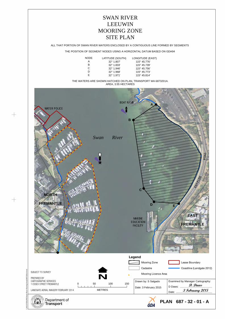
SWAN RILEEUW
VERIN
MOORING ZONE SITE PLAN
ALL THAT PORTION OF SWAN RIVER WATERS ENCLOSED BY A CONTIGUOUS LINE FORMED BY SEGMENTS
THE POSITION OF SEGMENT NODES USING A HORIZONTAL DATUM BASED ON GDA94
DRO
A
!
!
!
!
!!
NODE LATITUDE (SOUTH) LONGITUDE (EAST) A 32° 1.807' 115° 45.776' B 32° 1.833' 115° 45.739' C 32° 1.946' 115° 45.756' D 32° 1.968' 115° 45.773' E 32° 1.971' 115° 45.814'
THE WATERS ARE SHOWN HATCHED ON PLAN, TRANSPORT WA 6873201A. AREA, 3.55 HECTARES
BOAT RAMP AWATER POLICE
B
Swan River
C
NORTH
FREMANTLE D
MARIEDUCAT
NEION
FACILITY
Legend
E
EAST FREMANTLE
Lease Boundary
Coastline (Landgate 2012)
L:\
HC
S\T
EN
UR
E\S
wa
n R
ive
r M
oo
rin
g A
rea
s\6
87
32
01
A.m
xd
SUBJECT TO SURVEY
PREPARED BY CARTOGRAPHIC SERVICES 1 ESSEX STREET FREMANTLE 0 50 100 150
N LANDGATE AERIAL IMAGERY FEBRUARY 2014 METRES
Mooring Zone
Cadastre
Mooring Licence Area
Drawn by: S Salgado
Date: 3 February 2015
Examined by Manager Cartography:
D. DawsD Daws: ............................................
3 February 2015 Date: .................................................
PLAN 687 - 32 - 01 - A
ERT EET
R
STREET
MOSMAN PARK
WELLINGTON
L:\
HC
S\T
EN
UR
E\S
wa
n R
ive
r M
oo
rin
g A
rea
s\6
87
26
01
A.m
xd
N Cadastre Coastline (Landgate 2012)
SUBJECT TO SURVEY Mooring Licence Area
PREPARED BY CARTOGRAPHIC SERVICES Examined by Manager Cartography: 1 ESSEX STREET FREMANTLE 0 100 200 300 400
Drawn by: S Salgado
D. DawsD Daws: ............................................ LANDGATE AERIAL IMAGERY FEBRUARY 2014 METRES
Date: 2 February 2015
2 February 2015Date: .................................................
PLAN 687 - 26 - 01 - A
MOSMANS RESTAURANT
ASWAN
SS
REET
TT
OON
WCANOECLUB Mosman
H I
SWAN RIVERMOSMAN BAY - SOUTH
MOORING ZONESITE PLAN
ALL THAT PORTION OF SWAN RIVER WATERS ENCLOSED BY A CONTIGUOUS LINE FORMED BY SEGMENTS
THE POSITION OF SEGMENT NODES USING A HORIZONTAL DATUM BASED ON GDA94
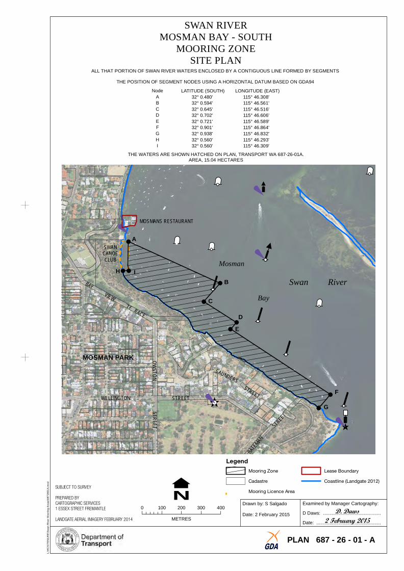
Node LATITUDE (SOUTH) LONGITUDE (EAST) A 32° 0.480' 115° 46.308' B 32° 0.594' 115° 46.561' C 32° 0.645' 115° 46.516' D 32° 0.702' 115° 46.606' E 32° 0.721' 115° 46.589' F 32° 0.901' 115° 46.864' G 32° 0.938' 115° 46.832' H 32° 0.560' 115° 46.293' I 32° 0.560' 115° 46.309'
THE WATERS ARE SHOWN HATCHED ON PLAN, TRANSPORT WA 687-26-01A. AREA, 15.04 HECTARES
BAI W
T
Y V E
ACE R E
S R
ND SUAS
NTEM
ABA
!
!
!
!
!!
!
!
!
B Swan River C Bay
D
E
STREET F
G
Legend
Mooring Zone Lease Boundary
ESPLANADE
BIRDW
OOD
PARADE
ARROLL STREET
SADLIER STREET
SWAN RIDALKEI
VERTH
MOORING ZONESITE PLAN
ALL THAT PORTION OF SWAN RIVER WATERS ENCLOSED BY A CONTIGUOUS LINE FORMED BY SEGMENTS
THE POSITION OF SEGMENT NODES USING A HORIZONTAL DATUM BASED ON GDA94
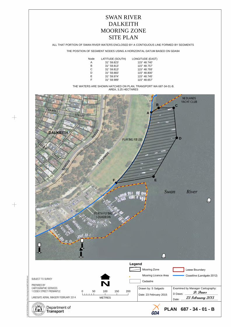
Node LATITUDE (SOUTH) LONGITUDE (EAST) A 31° 59.823' 115° 48.740' B 31° 59.813' 115° 48.757' C 31° 59.813' 115° 48.793' D 31° 59.883' 115° 48.800' E 31° 59.974' 115° 48.745' F 31° 59.989' 115° 48.657'
THE WATERS ARE SHOWN HATCHED ON PLAN, TRANSPORT WA 687-34-01-B. AREA, 3.25 HECTARES
NEDLANDSYACHT CLUB
C!
! !
!
!
!
B C A
DALKEITH PLAYING FIELDS D
F E
Swan River
PERTH FLYISQUADRON
NG
Legend
L:\
HC
S\T
EN
UR
E\S
wa
n R
ive
r M
oo
rin
g A
rea
s\6
87
34
01
B.m
xd
SUBJECT TO SURVEY
PREPARED BY CARTOGRAPHIC SERVICES 1 ESSEX STREET FREMANTLE 0 50 100 150 200
N LANDGATE AERIAL IMAGERY FEBRUARY 2014 METRES
Mooring Zone Lease Boundary
Mooring Licence Area Coastline (Landgate 2012)
Cadastre
Drawn by: S Salgado
Date: 23 February 2015
Examined by Manager Cartography:
D. DawsD Daws: ............................................
23 February 2015Date: .................................................
PLAN 687 - 34 - 01 - B
CA INN NG
BEACH
OAD
KILLI
CARRON
LAN ROAD
KINTAIL ROAD HIGHWAY
FREEWAY
NANA
CANNING RIVERCANNING BRIDGE TO SOUTH OF PERTH YACHT CLUB
MOORING ZONESITE PLAN
ALL THAT PORTION OF CANNING RIVER WATERS ENCLOSED BY A CONTIGUOUS LINE FORMED BY SEGMENTS
THE POSITION OF SEGMENT NODES USING A HORIZONTAL DATUM BASED ON GDA94
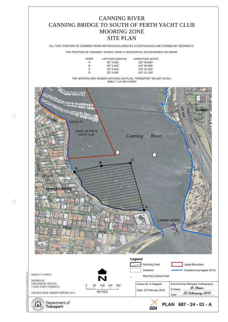
NODE LATITUDE (SOUTH) LONGITUDE (EAST) A 32° 0.462' 115° 50.864' B 32° 0.442' 115° 50.955' C 32° 0.432' 115° 51.053' D 32° 0.592' 115° 51.100'
THE WATERS ARE SHOWN HATCHED ON PLAN, TRANSPORT WA 687-24-01A. AREA, 7.14 HECTARES
KWI
RAD
O!
!
! !
R
COMO
COFFEE PT.
SOUTH OF PERTHYACHT CLUB Canning River
CB A
APPLECROSS
D
CANNING BRIDGE
CANNING
Legend
L:\
HC
S\T
EN
UR
E\S
wa
n R
ive
r M
oo
rin
g A
rea
s\6
87
24
01
A.m
xd
SUBJECT TO SURVEY
PREPARED BY CARTOGRAPHIC SERVICES
N 0 50 100 150 200
1 ESSEX STREET FREMANTLE
METRESLANDGATE AERIAL IMAGERY FEBRUARY 2014
Mooring Zone Lease Boundary
Cadastre Coastline (Landgate 2012)
Mooring Licence Area
Drawn by: S Salgado
Date: 23 February 2015
Examined by Manager Cartography:
D. DawsD Daws: ............................................
23 February 2015Date: .................................................
PLAN 687 - 24 - 01 - A
Related Documents