Oahu Day-Use Moorings Assessment of the presence or absence of sanctioned day-use mooring buoys (submerged permanent commercial-use buoy) and unsanctioned day-use mooring buoys along with the collection of data pertinent to the buoys current condition and of the localized surrounding. This includes buoy, line, shackle and anchoring equipment. It also includes any and all ecological and biological findings during the assessment.

Welcome message from author
This document is posted to help you gain knowledge. Please leave a comment to let me know what you think about it! Share it to your friends and learn new things together.
Transcript
Oahu Day-Use Moorings
1
Assessment of the presence or absence of sanctioned day-use mooring buoys (submerged permanent commercial-use buoy) and unsanctioned day-use mooring buoys along with the collection of data pertinent to the buoys current condition and of the localized surrounding. This includes buoy, line, shackle and anchoring equipment. It also includes any and all ecological and biological findings during the assessment.
Oahu Day-Use Moorings
2
Funding
This publication is a result of funding from the National Oceanic and Atmospheric Administration, Center for Sponsored Coastal Ocean Research, under awards #NA11NOS4260182 and #NA12NOS4260150 to the University of Hawaii for the Hawaii Coral Reef Initiative.
Field Team Scuba surveys were conducted by four members of the Reef Restoration Team under the Social Science Research Institute (SSRI) for Research Corporation University of Hawaii (RCUH) contracted by Hawaii Division of Aquatic Resources (DAR). The four members of the Reef Restoration team consisted of Catherine Gewecke (Senior Reef Restoration Field Technician), Kendall Tejchma (Reef Restoration Field Technician), Travis Thyberg (Reef Restoration Monitoring Coordinator) and Dan Lager (Reef Restoration Field Technician). Catherine Gewecke (Senior Reef Restoration Field Technician) served on the team for 6.5 years, and conducted over 175 scientific dives for DAR involving fish, benthic and aquatic invasive surveys with photographic documentation and GIS analysis. Kendall Tejchma (Reef Restoration Field Technician) served on the team for 1 year and conducted 20 scientific dives for DAR involving fish, benthic and aquatic invasive surveys with photographic documentation, and over 2000 scientific dives for Sea Life Park Hawaii and 550 recreational dives. Dan Lager was a new hire to the Reef Restoration Team and had conducted 70 scientific dives for Hawaii Institute of Marine Biology (HIMB) involving coral/benthic and aquatic invasive quadrat surveys with photographic documentation and coral point analysis, and 130 recreational dives. Travis Thyberg (Reef Restoration Monitoring Coordinator) served on the team for one year and conducted hundreds of scientific dives for the University of Miami involving coral/benthic quadrat surveys with photographic documentation, coral nursery monitoring including out-planting and transplanting coral fragments and sea-grass research.
Report
Cathy Gewecke
Kendall Tjechma
Travis Thyberg
Photos
Kendall Tjechma
Travis Thyberg
Dan Lager
Oahu Day-Use Moorings
3
Table of Contents Background Information: ........................................................................................................................................ 4
Report Findings: Unsanctioned DMB Locations and Anchor Attachment Methods ............................................. 9
Report Findings: DMBs within Special Zoning Areas ........................................................................................... 15
Report Findings: Coral Growth on Day Use Mooring Buoys ................................................................................ 17
Report Findings: Ecological Observations ............................................................................................................ 22
Report Findings: DMB Component Replacement ................................................................................................ 25
Appendix: .............................................................................................................................................................. 28
South - Waikiki - Day Use Mooring Buoys ............................................................................................................ 28
Kewalos Pipe(New) (Status Unknown) Survey 6/16/2014 ............................................................................... 29
Kewalos Pipe (Old) (Unsanctioned) Survey 6/16/2014 .................................................................................... 33
Magic Island 2 (Sanctioned) Survey 5/21/2014 ................................................................................................ 38
Kilikani 1 (Unsanctioned) Survey 6/26/2014 .................................................................................................... 43
Kilikani 2 (Unsanctioned) Survey 6/26/2014 .................................................................................................... 48
Spirits (Unsanctioned) Survey 6/26/2014 ........................................................................................................ 53
Aukai (Unsanctioned) Survey 6/26/2014 ......................................................................................................... 58
Makani 2 (Unsanctioned) Survey 6/26/2014 .................................................................................................... 63
Makani 1 (Unsanctioned) Survey 6/26/2014 .................................................................................................... 68
Illegal Canyons (Mai Tai’s) (Unsanctioned) Survey 5/21/2014 ......................................................................... 74
Southeast - Maunalua Bay - Day Use Mooring Buoys .......................................................................................... 78
Anglers Reef (New) Surveyed 6/3/2014 ........................................................................................................... 80
Anglers Reef (Old) Surveyed ............................................................................................................................. 85
Hawaii Loa Surveyed 7/1/2014 ......................................................................................................................... 89
Koko Craters 5 Surveyed 7/1/2014 ................................................................................................................... 94
Koko Craters 3 (Sanctioned) Surveyed 6/02/2014 ........................................................................................... 98
Koko Craters 4 (Sanctioned) Surveyed ........................................................................................................... 105
Maunalua Bay: Turtle Canyon ........................................................................................................................ 110
Pawaa Surveyed 6/3/2014 .............................................................................................................................. 114
Turtle Canyon 1 Surveyed 5/27/2014 ............................................................................................................. 119
Turtle Canyon 2 Surveyed ............................................................................................................................... 124
Turtle Canyons 4 Surveyed 6/2/2014 ............................................................................................................. 129
West Coast - Leeward - Day Use Mooring Buoys ............................................................................................... 135
Keaau Corners/Stars (Unsanctioned) Survey 5/22/2014 ............................................................................... 136
Ammo Reef 1 (Unsanctioned) Survey 5/29/2014 ........................................................................................... 140
Ammo Reef 3 Survey 7/2/2014 ...................................................................................................................... 144
Land of Oz (Sanctioned) Survey 6/17/2014 .................................................................................................... 149
Big Mouth Cave Survey 5/29/2014 ................................................................................................................. 154
Makaha Caverns 3 Survey 6/17/2014 ............................................................................................................. 158
Makaha Caverns 1 Survey 6/17/2014 ............................................................................................................. 163
Makaha Caverns Unknown (Unsanctioned) Survey 5/22/2014 ..................................................................... 168
Oahu Day-Use Moorings
4
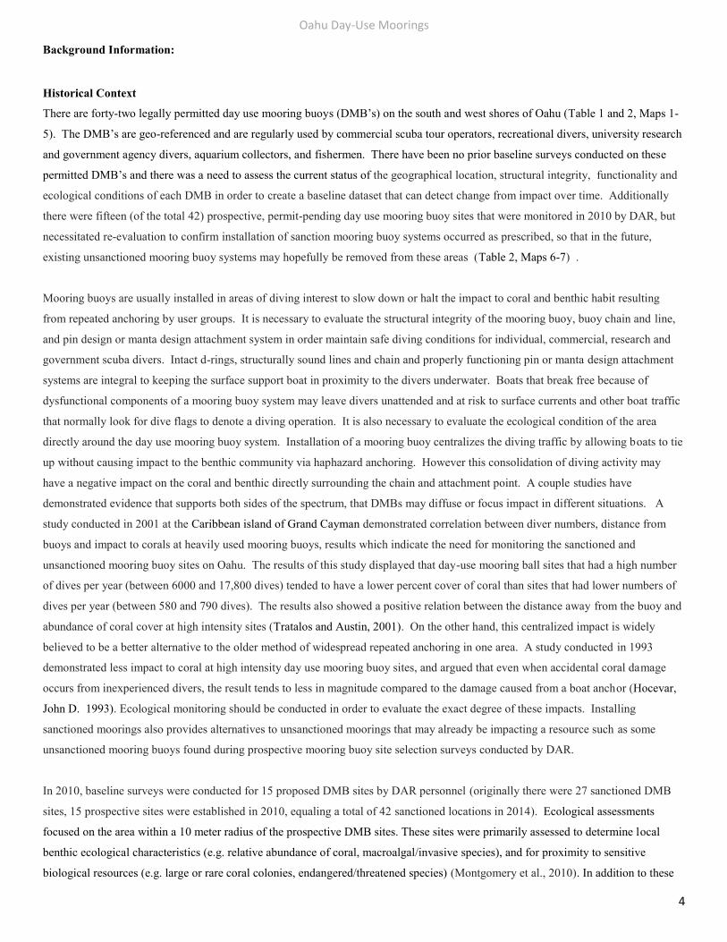
Background Information:
Historical Context
There are forty-two legally permitted day use mooring buoys (DMB’s) on the south and west shores of Oahu (Table 1 and 2, Maps 1-
5). The DMB’s are geo-referenced and are regularly used by commercial scuba tour operators, recreational divers, university research
and government agency divers, aquarium collectors, and fishermen. There have been no prior baseline surveys conducted on these
permitted DMB’s and there was a need to assess the current status of the geographical location, structural integrity, functionality and
ecological conditions of each DMB in order to create a baseline dataset that can detect change from impact over time. Additionally
there were fifteen (of the total 42) prospective, permit-pending day use mooring buoy sites that were monitored in 2010 by DAR, but
necessitated re-evaluation to confirm installation of sanction mooring buoy systems occurred as prescribed, so that in the future,
existing unsanctioned mooring buoy systems may hopefully be removed from these areas (Table 2, Maps 6-7) .
Mooring buoys are usually installed in areas of diving interest to slow down or halt the impact to coral and benthic habit resulting
from repeated anchoring by user groups. It is necessary to evaluate the structural integrity of the mooring buoy, buoy chain and line,
and pin design or manta design attachment system in order maintain safe diving conditions for individual, commercial, research and
government scuba divers. Intact d-rings, structurally sound lines and chain and properly functioning pin or manta design attachment
systems are integral to keeping the surface support boat in proximity to the divers underwater. Boats that break free because of
dysfunctional components of a mooring buoy system may leave divers unattended and at risk to surface currents and other boat traffic
that normally look for dive flags to denote a diving operation. It is also necessary to evaluate the ecological condition of the area
directly around the day use mooring buoy system. Installation of a mooring buoy centralizes the diving traffic by allowing boats to tie
up without causing impact to the benthic community via haphazard anchoring. However this consolidation of diving activity may
have a negative impact on the coral and benthic directly surrounding the chain and attachment point. A couple studies have
demonstrated evidence that supports both sides of the spectrum, that DMBs may diffuse or focus impact in different situations. A
study conducted in 2001 at the Caribbean island of Grand Cayman demonstrated correlation between diver numbers, distance from
buoys and impact to corals at heavily used mooring buoys, results which indicate the need for monitoring the sanctioned and
unsanctioned mooring buoy sites on Oahu. The results of this study displayed that day-use mooring ball sites that had a high number
of dives per year (between 6000 and 17,800 dives) tended to have a lower percent cover of coral than sites that had lower numbers of
dives per year (between 580 and 790 dives). The results also showed a positive relation between the distance away from the buoy and
abundance of coral cover at high intensity sites (Tratalos and Austin, 2001). On the other hand, this centralized impact is widely
believed to be a better alternative to the older method of widespread repeated anchoring in one area. A study conducted in 1993
demonstrated less impact to coral at high intensity day use mooring buoy sites, and argued that even when accidental coral damage
occurs from inexperienced divers, the result tends to less in magnitude compared to the damage caused from a boat anchor (Hocevar,
John D. 1993). Ecological monitoring should be conducted in order to evaluate the exact degree of these impacts. Installing
sanctioned moorings also provides alternatives to unsanctioned moorings that may already be impacting a resource such as some
unsanctioned mooring buoys found during prospective mooring buoy site selection surveys conducted by DAR.
In 2010, baseline surveys were conducted for 15 proposed DMB sites by DAR personnel (originally there were 27 sanctioned DMB
sites, 15 prospective sites were established in 2010, equaling a total of 42 sanctioned locations in 2014). Ecological assessments
focused on the area within a 10 meter radius of the prospective DMB sites. These sites were primarily assessed to determine local
benthic ecological characteristics (e.g. relative abundance of coral, macroalgal/invasive species), and for proximity to sensitive
biological resources (e.g. large or rare coral colonies, endangered/threatened species) (Montgomery et al., 2010). In addition to these
Oahu Day-Use Moorings
5
characteristics, DAR biologists also noted if any large, transient animals (e.g. marine mammals) were present, the proximity of the site
to surf breaks, and amount of boat traffic in the area (Montgomery et al., 2010). The results of the compendium of the surveys proved
a need for an assessment of additional illegal mooring buoys. Many sites with illegal mooring buoy systems in 2010 were in the
process of damaging coral due to the placement of the buoy line or chain or the method attachment to the substrate.
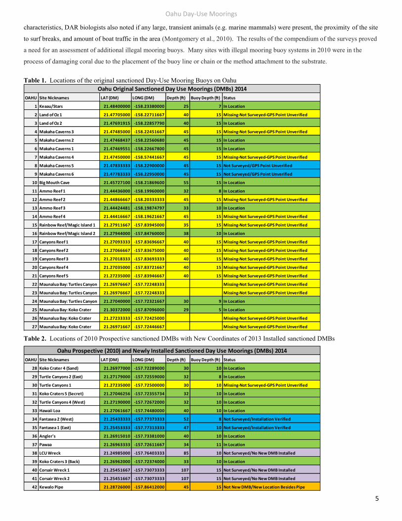
Table 1. Locations of the original sanctioned Day-Use Mooring Buoys on Oahu
Table 2. Locations of 2010 Prospective sanctioned DMBs with New Coordinates of 2013 Installed sanctioned DMBs
OAHU Site Nicknames LAT (DM) LONG (DM) Depth (ft) Buoy Depth (ft) Status
1 Keaau/Stars 21.48400000 -158.23380000 25 7 In Location
2 Land of Oz 1 21.47705000 -158.22711667 40 15 Missing-Not Surveyed-GPS Point Unverified
3 Land of Oz 2 21.47691915 -158.22857790 40 15 In Location
4 Makaha Caverns 3 21.47485000 -158.22451667 45 15 Missing-Not Surveyed-GPS Point Unverified
5 Makaha Caverns 2 21.47468437 -158.22560680 45 15 In Location
6 Makaha Caverns 1 21.47469551 -158.22667800 45 15 In Location
7 Makaha Caverns 4 21.47450000 -158.57441667 45 15 Missing-Not Surveyed-GPS Point Unverified
8 Makaha Caverns 5 21.47833333 -158.22900000 45 15 Not Surveyed/GPS Point Unverified
9 Makaha Caverns 6 21.47783333 -158.22950000 45 15 Not Surveyed/GPS Point Unverified
10 Big Mouth Cave 21.45727100 -158.21869600 55 15 In Location
11 Ammo Reef 1 21.44436000 -158.19960000 32 8 In Location
12 Ammo Reef 2 21.44866667 -158.20333333 45 15 Missing-Not Surveyed-GPS Point Unverified
13 Ammo Reef 3 21.44424481 -158.19874797 33 10 In Location
14 Ammo Reef 4 21.44416667 -158.19621667 45 15 Missing-Not Surveyed-GPS Point Unverified
15 Rainbow Reef/Magic Island 1 21.27911667 -157.83945000 35 15 Missing-Not Surveyed-GPS Point Unverified
16 Rainbow Reef/Magic Island 2 21.27944000 -157.84760000 38 10 In Location
17 Canyons Reef 1 21.27093333 -157.83696667 40 15 Missing-Not Surveyed-GPS Point Unverified
18 Canyons Reef 2 21.27066667 -157.83675000 40 15 Missing-Not Surveyed-GPS Point Unverified
19 Canyons Reef 3 21.27018333 -157.83693333 40 15 Missing-Not Surveyed-GPS Point Unverified
20 Canyons Reef 4 21.27035000 -157.83721667 40 15 Missing-Not Surveyed-GPS Point Unverified
21 Canyons Reef 5 21.27235000 -157.83946667 40 15 Missing-Not Surveyed-GPS Point Unverified
22 Maunalua Bay: Turtles Canyon 21.26976667 -157.72248333 Missing-Not Surveyed-GPS Point Unverified
23 Maunalua Bay: Turtles Canyon 21.26976667 -157.72248333 Missing-Not Surveyed-GPS Point Unverified
24 Maunalua Bay: Turtles Canyon 21.27040000 -157.72321667 30 9 In Location
25 Maunalua Bay: Koko Crater 21.30372000 -157.87096000 29 5 In Location
26 Maunalua Bay: Koko Crater 21.27233333 -157.72425000 Missing-Not Surveyed-GPS Point Unverified
27 Maunalua Bay: Koko Crater 21.26971667 -157.72446667 Missing-Not Surveyed-GPS Point Unverified
Oahu Original Sanctioned Day Use Moorings (DMBs) 2014
OAHU Site Nicknames LAT (DM) LONG (DM) Depth (ft) Buoy Depth (ft) Status
28 Koko Crater 4 (Sand) 21.26977000 -157.72289000 30 10 In Location
29 Turtle Canyons 2 (East) 21.27179000 -157.72559000 32 8 In Location
30 Turtle Canyons 1 21.27235000 -157.72500000 30 10 Missing-Not Surveyed-GPS Point Unverified
31 Koko Craters 5 (Secret) 21.27046256 -157.72355734 32 10 In Location
32 Turtle Canyons 4 (West) 21.27190000 -157.72672000 32 10 In Location
33 Hawaii Loa 21.27061667 -157.74480000 40 10 In Location
34 Fantasea 2 (West) 21.25433333 -157.77373333 52 8 Not Surveyed/Installation Verified
35 Fantasea 1 (East) 21.25453333 -157.77313333 47 10 Not Surveyed/Installation Verified
36 Angler's 21.26915010 -157.73381000 40 10 In Location
37 Pawaa 21.26963333 -157.72611667 34 11 In Location
38 LCU Wreck 21.24985000 -157.76403333 85 10 Not Surveyed/No New DMB Installed
39 Koko Craters 3 (Back) 21.26962000 -157.72374000 33 10 In Location
40 Corsair Wreck 1 21.25451667 -157.73073333 107 15 Not Surveyed/No New DMB Installed
41 Corsair Wreck 2 21.25451667 -157.73073333 107 15 Not Surveyed/No New DMB Installed
42 Kewalo Pipe 21.28726000 -157.86412000 45 15 Not New DMB/New Location Besides Pipe
Oahu Prospective (2010) and Newly Installed Sanctioned Day Use Moorings (DMBs) 2014
Oahu Day-Use Moorings
6
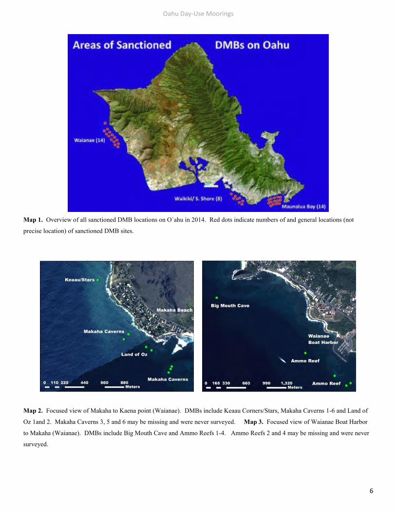
Map 1. Overview of all sanctioned DMB locations on O`ahu in 2014. Red dots indicate numbers of and general locations (not
precise location) of sanctioned DMB sites.
Map 2. Focused view of Makaha to Kaena point (Waianae). DMBs include Keaau Corners/Stars, Makaha Caverns 1-6 and Land of
Oz 1and 2. Makaha Caverns 3, 5 and 6 may be missing and were never surveyed. Map 3. Focused view of Waianae Boat Harbor
to Makaha (Waianae). DMBs include Big Mouth Cave and Ammo Reefs 1-4. Ammo Reefs 2 and 4 may be missing and were never
surveyed.
Oahu Day-Use Moorings
7
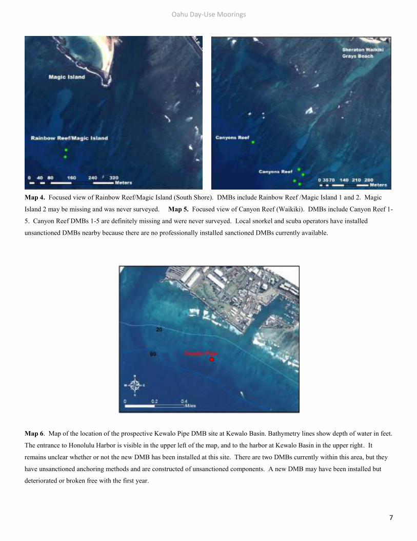
Map 4. Focused view of Rainbow Reef/Magic Island (South Shore). DMBs include Rainbow Reef /Magic Island 1 and 2. Magic
Island 2 may be missing and was never surveyed. Map 5. Focused view of Canyon Reef (Waikiki). DMBs include Canyon Reef 1-
5. Canyon Reef DMBs 1-5 are definitely missing and were never surveyed. Local snorkel and scuba operators have installed
unsanctioned DMBs nearby because there are no professionally installed sanctioned DMBs currently available.
Map 6. Map of the location of the prospective Kewalo Pipe DMB site at Kewalo Basin. Bathymetry lines show depth of water in feet.
The entrance to Honolulu Harbor is visible in the upper left of the map, and to the harbor at Kewalo Basin in the upper right. It
remains unclear whether or not the new DMB has been installed at this site. There are two DMBs currently within this area, but they
have unsanctioned anchoring methods and are constructed of unsanctioned components. A new DMB may have been installed but
deteriorated or broken free with the first year.
Oahu Day-Use Moorings
8
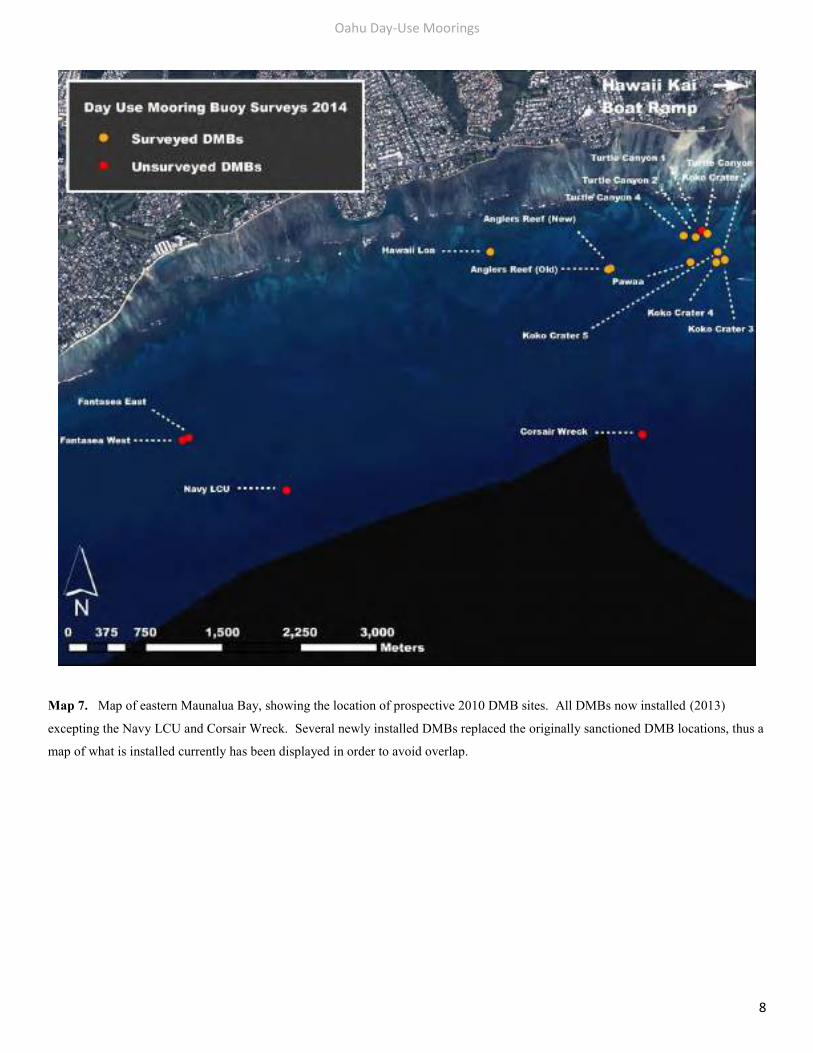
Map 7. Map of eastern Maunalua Bay, showing the location of prospective 2010 DMB sites. All DMBs now installed (2013)
excepting the Navy LCU and Corsair Wreck. Several newly installed DMBs replaced the originally sanctioned DMB locations, thus a
map of what is installed currently has been displayed in order to avoid overlap.
Oahu Day-Use Moorings
9
Report Findings: Unsanctioned DMB Locations and Anchor Attachment Methods
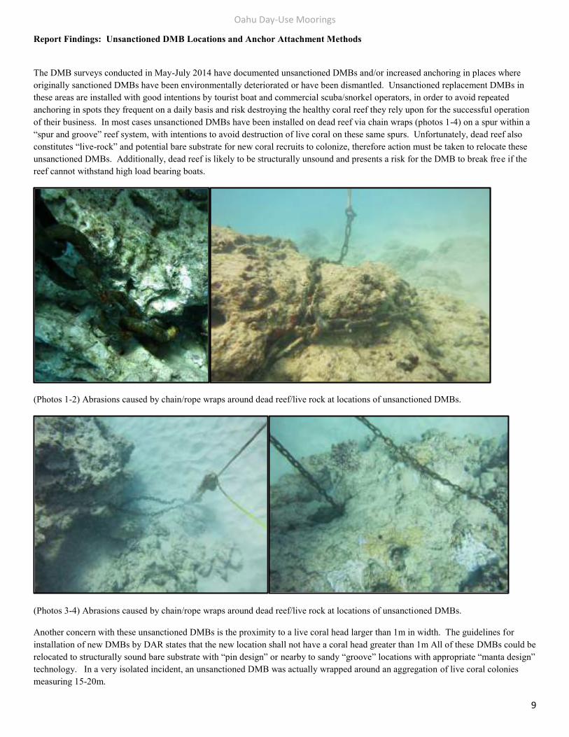
The DMB surveys conducted in May-July 2014 have documented unsanctioned DMBs and/or increased anchoring in places where originally sanctioned DMBs have been environmentally deteriorated or have been dismantled. Unsanctioned replacement DMBs in these areas are installed with good intentions by tourist boat and commercial scuba/snorkel operators, in order to avoid repeated anchoring in spots they frequent on a daily basis and risk destroying the healthy coral reef they rely upon for the successful operation of their business. In most cases unsanctioned DMBs have been installed on dead reef via chain wraps (photos 1-4) on a spur within a “spur and groove” reef system, with intentions to avoid destruction of live coral on these same spurs. Unfortunately, dead reef also constitutes “live-rock” and potential bare substrate for new coral recruits to colonize, therefore action must be taken to relocate these unsanctioned DMBs. Additionally, dead reef is likely to be structurally unsound and presents a risk for the DMB to break free if the reef cannot withstand high load bearing boats.
(Photos 1-2) Abrasions caused by chain/rope wraps around dead reef/live rock at locations of unsanctioned DMBs.
(Photos 3-4) Abrasions caused by chain/rope wraps around dead reef/live rock at locations of unsanctioned DMBs.
Another concern with these unsanctioned DMBs is the proximity to a live coral head larger than 1m in width. The guidelines for installation of new DMBs by DAR states that the new location shall not have a coral head greater than 1m All of these DMBs could be relocated to structurally sound bare substrate with “pin design” or nearby to sandy “groove” locations with appropriate “manta design” technology. In a very isolated incident, an unsanctioned DMB was actually wrapped around an aggregation of live coral colonies measuring 15-20m.
Oahu Day-Use Moorings
10
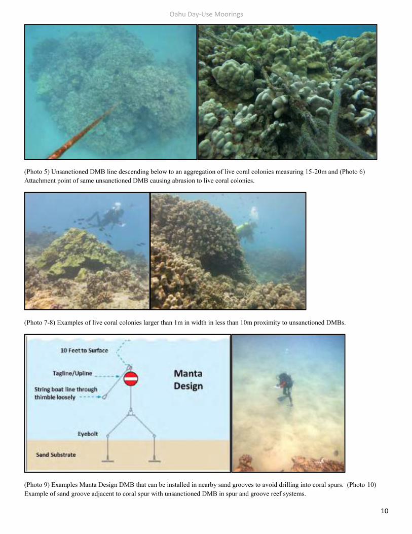
(Photo 5) Unsanctioned DMB line descending below to an aggregation of live coral colonies measuring 15-20m and (Photo 6) Attachment point of same unsanctioned DMB causing abrasion to live coral colonies.
(Photo 7-8) Examples of live coral colonies larger than 1m in width in less than 10m proximity to unsanctioned DMBs.
(Photo 9) Examples Manta Design DMB that can be installed in nearby sand grooves to avoid drilling into coral spurs. (Photo 10) Example of sand groove adjacent to coral spur with unsanctioned DMB in spur and groove reef systems.
Oahu Day-Use Moorings
11
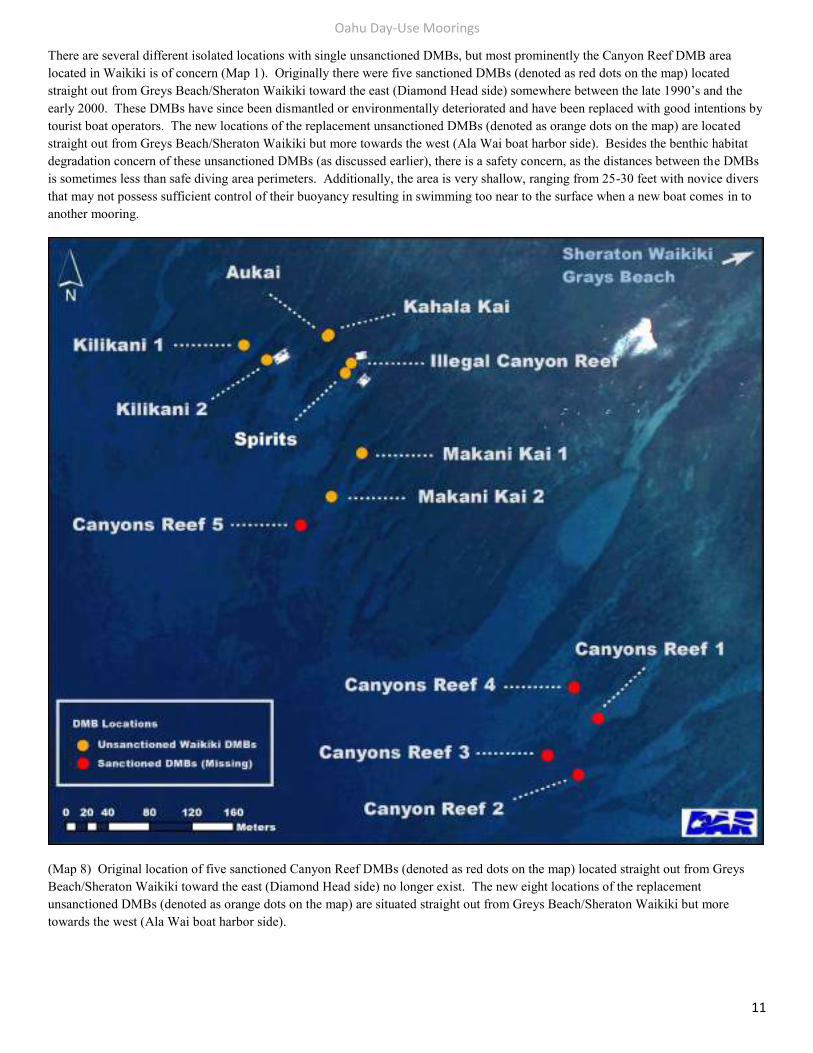
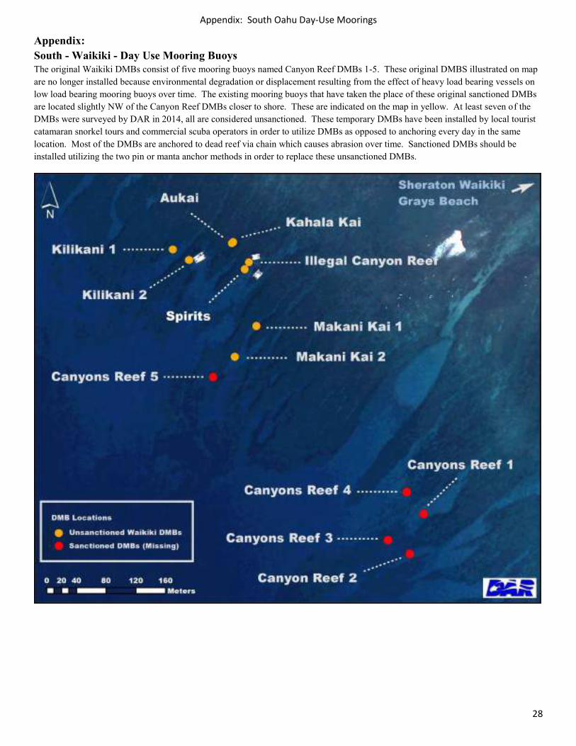
There are several different isolated locations with single unsanctioned DMBs, but most prominently the Canyon Reef DMB area located in Waikiki is of concern (Map 1). Originally there were five sanctioned DMBs (denoted as red dots on the map) located straight out from Greys Beach/Sheraton Waikiki toward the east (Diamond Head side) somewhere between the late 1990’s and the early 2000. These DMBs have since been dismantled or environmentally deteriorated and have been replaced with good intentions by tourist boat operators. The new locations of the replacement unsanctioned DMBs (denoted as orange dots on the map) are located straight out from Greys Beach/Sheraton Waikiki but more towards the west (Ala Wai boat harbor side). Besides the benthic habitat degradation concern of these unsanctioned DMBs (as discussed earlier), there is a safety concern, as the distances between the DMBs is sometimes less than safe diving area perimeters. Additionally, the area is very shallow, ranging from 25-30 feet with novice divers that may not possess sufficient control of their buoyancy resulting in swimming too near to the surface when a new boat comes in to another mooring.
(Map 8) Original location of five sanctioned Canyon Reef DMBs (denoted as red dots on the map) located straight out from Greys Beach/Sheraton Waikiki toward the east (Diamond Head side) no longer exist. The new eight locations of the replacement unsanctioned DMBs (denoted as orange dots on the map) are situated straight out from Greys Beach/Sheraton Waikiki but more towards the west (Ala Wai boat harbor side).
Oahu Day-Use Moorings
12
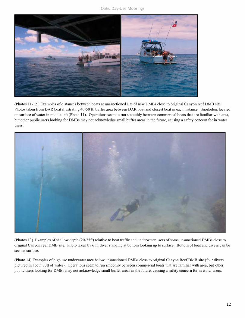
(Photos 11-12) Examples of distances between boats at unsanctioned site of new DMBs close to original Canyon reef DMB site. Photos taken from DAR boat illustrating 40-50 ft. buffer area between DAR boat and closest boat in each instance. Snorkelers located on surface of water in middle left (Photo 11). Operations seem to run smoothly between commercial boats that are familiar with area, but other public users looking for DMBs may not acknowledge small buffer areas in the future, causing a safety concern for in water users.
(Photos 13) Examples of shallow depth (20-25ft) relative to boat traffic and underwater users of some unsanctioned DMBs close to original Canyon reef DMB site. Photo taken by 6 ft. diver standing at bottom looking up to surface. Bottom of boat and divers can be seen at surface.
(Photo 14) Examples of high use underwater area below unsanctioned DMBs close to original Canyon Reef DMB site (four divers pictured in about 30ft of water). Operations seem to run smoothly between commercial boats that are familiar with area, but other public users looking for DMBs may not acknowledge small buffer areas in the future, causing a safety concern for in water users.
Oahu Day-Use Moorings
13
Management Suggestions:
Best practice would be to organize a stakeholder meeting between the commercial boats that utilize this are on a regular basis and ask what concerns and ideas they may have. Ideally, sanctioned DMBs should be installed before unsanctioned DMBs are removed. This will show cooperation with the stakeholders and also deter any anchoring in the absence of unsanctioned DMBs. DMBs utilized by commercial scuba operations should be installed at slightly greater depths (30-40 ft.) with larger buffer areas in between boats. DMBs utilized by commercial tourist and snorkel operations would likely want to maintain current location of shallower DMBs to allow for snorkel tours, but sanctioned DMBs should be installed with greater buffer areas between boats. All unsanctioned DMBs should be replaced with sanctioned DMB consisting of a mooring buoy, intact descending line, intact tagline with stainless steel thimble for attachment to vessel and a pin design or manta design anchor system.
Other isolated areas needing new anchor attachment locations:
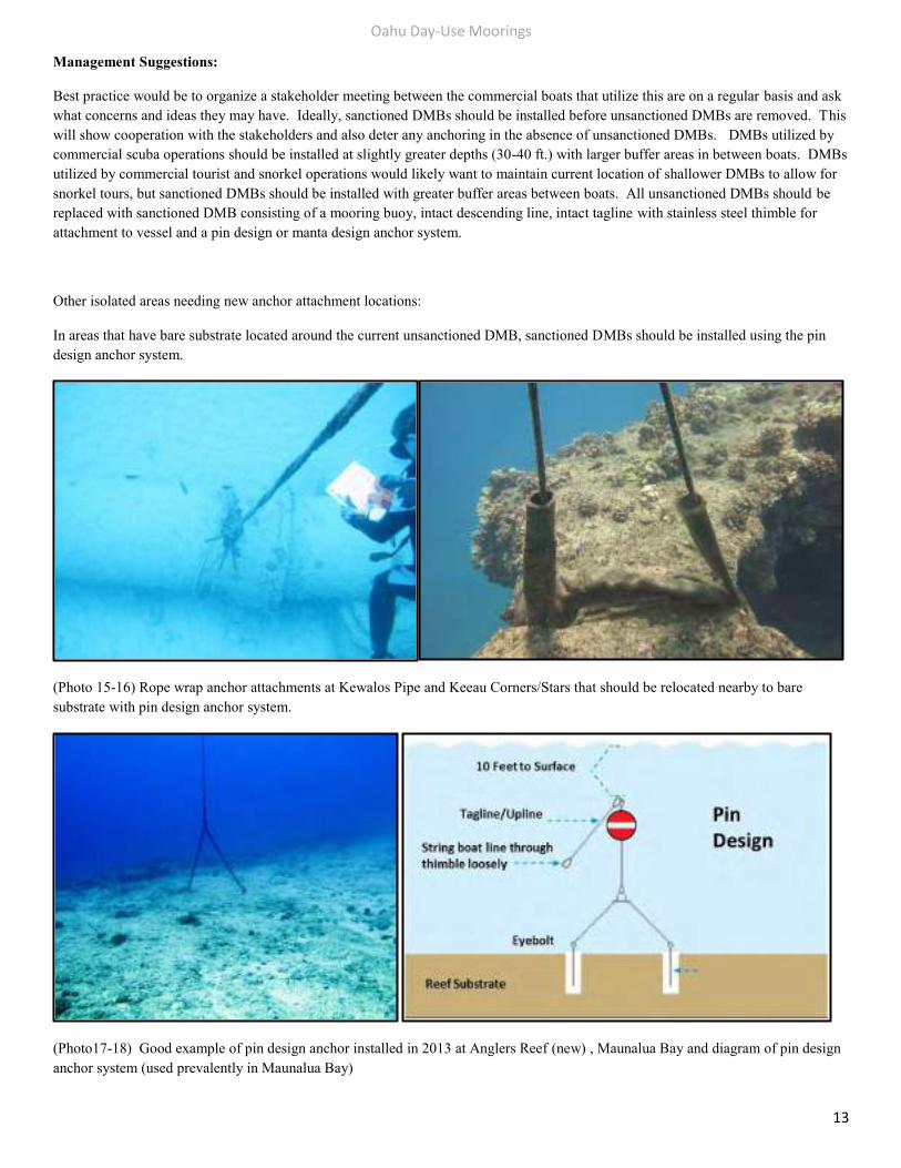
In areas that have bare substrate located around the current unsanctioned DMB, sanctioned DMBs should be installed using the pin design anchor system.
(Photo 15-16) Rope wrap anchor attachments at Kewalos Pipe and Keeau Corners/Stars that should be relocated nearby to bare substrate with pin design anchor system.
(Photo17-18) Good example of pin design anchor installed in 2013 at Anglers Reef (new) , Maunalua Bay and diagram of pin design anchor system (used prevalently in Maunalua Bay)
Oahu Day-Use Moorings
14
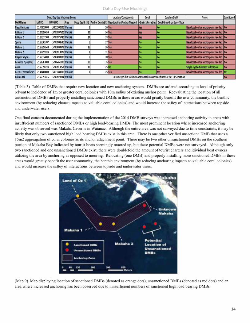
(Table 3) Table of DMBs that require new location and new anchoring system. DMBs are ordered according to level of priority relvant to incidence of 1m or greater coral colonies with 10m radius of existing anchor point. Reevaluating the location of all unsanctioned DMBs and properly installing sanctioned DMBs in these areas would greatly benefit the user community, the benthic environment (by reducing chance impacts to valuable coral colonies) and would increase the saftey of interactions between topside and underwater users.
One final concern documented during the implementation of the 2014 DMB surveys was increased anchoring activity in areas with insuffucient numbers of sanctioned DMBs or high load-bearing DMBs. The most prominent location where increased anchoring activity was observed was Makaha Caverns in Waianae. Although the entire area was not surveyed due to time constraints, it may be likely that only two sanctioned high load bearing DMBs exist in this area. There is one other verified unsactione DMB that uses a 15m2 aggreagation of coral colonies as its anchor attachment point. There may be two other unsanctioned DMBs on the southern portion of Makaha Bay indicated by tourist boats seemingly moored up, but these potential DMBs were not surveyed. Although only two sanctioned and one unsanctioned DMBs exist, there were doublefold the amount of tourist charters and idividual boat owners utilizing the area by anchoring as opposed to mooring. Relocating (one DMB) and properly installing more sanctioned DMBs in these areas would greatly benefit the user community, the benthic environment (by reducing anchoring impacts to valuable coral colonies) and would increase the saftey of interactions between topside and underwater users.
(Map 9) Map displaying location of sanctioned DMBs (denoted as orange dots), unsanctioned DMBs (denoted as red dots) and an area where increased anchoring has been observed due to innsufficient numbers of sanctioned high load bearing DMBs.
Location/Components Coral Coral on DMB Notes Sanctioned
DMB Name LAT DD LONG DD Area Buoy Depth (ft) Anchor Depth (ft) New Location/Anchor Needed >1m in 10m radius Coral Growth on Buoy/Rope
Illegal Makaha 21.47619000 -158.22302000 Wainae 5 26 Yes Yes No New location for anchor point needed No
Kilikani 1 21.27390459 -157.83997620 Waikiki 11 34 Yes Yes No New location for anchor point needed No
Kilikani 2 21.27377308 -157.83976740 Waikiki 27 33 Yes Yes No New location for anchor point needed No
Spirits 21.27365707 -157.83904530 Waikiki 5 27 Yes No No New location for anchor point needed No
Makani 1 21.27296548 -157.83889979 Waikiki 15 26 Yes No No New location for anchor point needed No
Makani 2 21.27259324 -157.83918075 Waikiki 8 31 Yes No No New location for anchor point needed No
Illegal Canyons 21.27374000 -157.83899000 Waikiki 5 20 Yes No No New location for anchor point needed No
Kewalos Pipe (Old) 21.28783000 -157.86461000 Waikiki 20 35 Yes No No New location for anchor point needed No
Aukai 21.27398724 -157.83919257 Waikiki 10 25 No No No Single eyebolt already in location No
Keeau Corners/Stars 21.48400000 -158.23380000 Waianae 7 25 Yes No Yes New location for anchor point needed Yes
Kahala Kai 21.27397416 -157.83920984 Waikiki No
Oahu Day Use Moorings Buoys
Unsurveyed due to Time Constraints/Unsanctioned DMB at this GPS Location

Oahu Day-Use Moorings
15
Report Findings: DMBs within Special Zoning Areas The three areas on Oahu with DMB locations (West-Waianae, South-Waikiki, and Southeast-Maunalua Bay) are either within or in close proximity certain areas of specialized zoning. There appears to be minimal conflict between utilization of DMBs and these areas of specialized zoning. The one area that poses potential conflict is Southeast-Maunalua Bay. Maunalua Bay consists of three overlapping specialized zoning areas. The entire bay is zoned as a Laynet Fishing Prohibited Area and the NOAA Humpback Whale Sanctuary. Overlapping a smaller portion of these two zones is a Commercial Operations zone within an Ocean Recreation Management Area. This area is located directly outside Hawaii Kai harbor and contains eleven sanctioned DMBs. This area is heavily used by commercial scuba and snorkle operators, tourist catamaran cruise operators and parasailing operators. From observations conducted during the 2014 DMB surveys, there is a concern that parasailing operations may function in too close proximity to scuba and snorkling operations. This overlapping of topside and in-water activites creates an evironment for unsafe operations between boats underway and unmarked divers or snorklers that have been separated form their vessal. The below map (Map 10) displays the sanctioned DMBs and three specialized zones that occur within Maunalua Bay. The following map (Map 11) displays a focused view of the sanctioned DMBs within the commercial zone that coincide with the current area of parasailing operations.
(Map 10) Overview of Maunalua Bay displaying the locations of sanctioned DMBs and the three overlaping management areas: a Commercial Operations Zone (ORMA), a Laynet Prohibited Fishing Area, and the NOAA Humpback Whale Sanctuary.
Oahu Day-Use Moorings
16
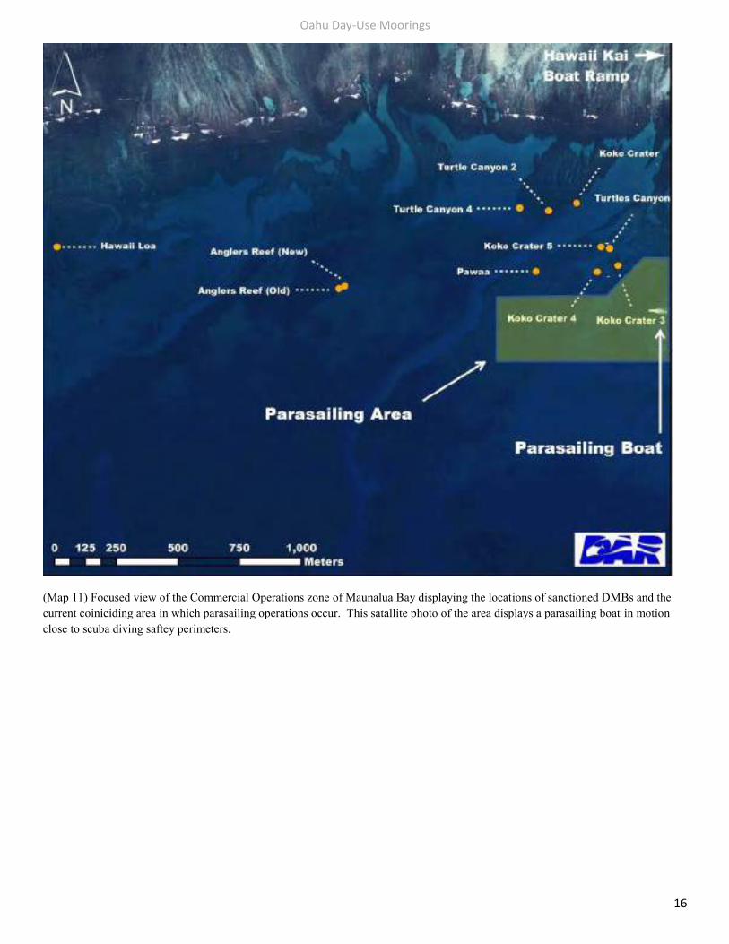
(Map 11) Focused view of the Commercial Operations zone of Maunalua Bay displaying the locations of sanctioned DMBs and the current coiniciding area in which parasailing operations occur. This satallite photo of the area displays a parasailing boat in motion close to scuba diving saftey perimeters.
Oahu Day-Use Moorings
17
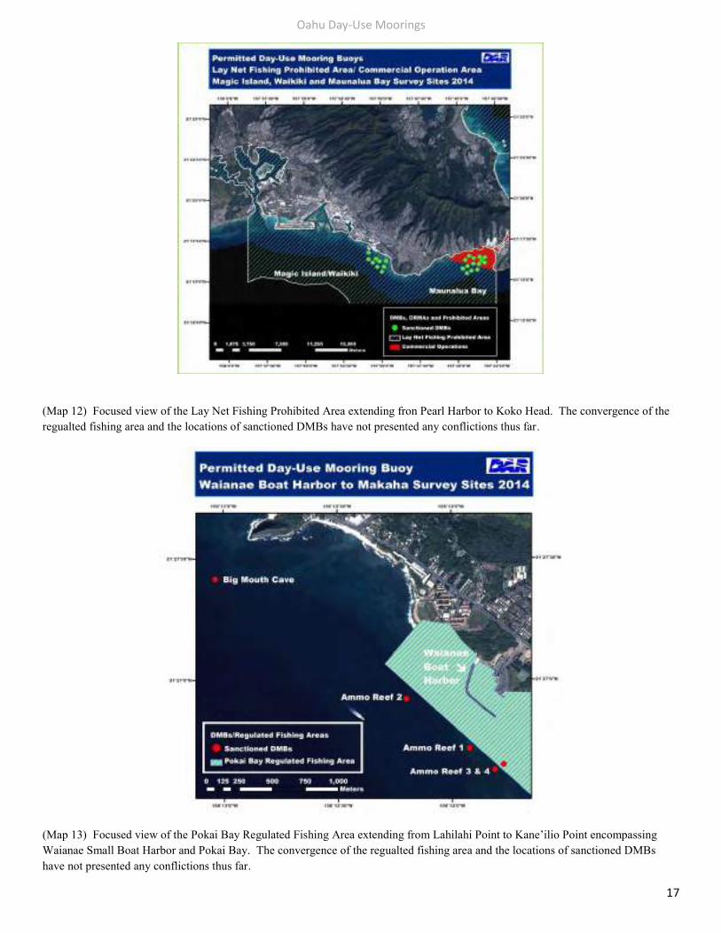
(Map 12) Focused view of the Lay Net Fishing Prohibited Area extending fron Pearl Harbor to Koko Head. The convergence of the regualted fishing area and the locations of sanctioned DMBs have not presented any conflictions thus far.
(Map 13) Focused view of the Pokai Bay Regulated Fishing Area extending from Lahilahi Point to Kane’ilio Point encompassing Waianae Small Boat Harbor and Pokai Bay. The convergence of the regualted fishing area and the locations of sanctioned DMBs have not presented any conflictions thus far.
Oahu Day-Use Moorings
18
Report Findings: Coral Growth on Day Use Mooring Buoys
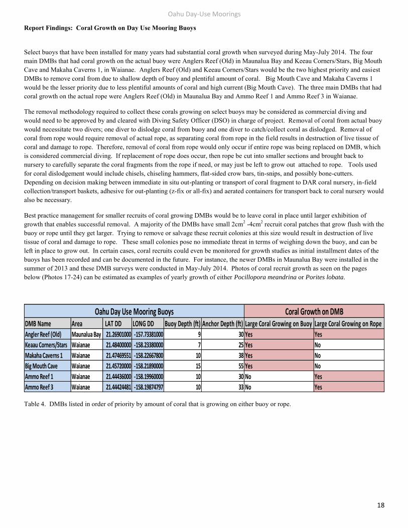
Select buoys that have been installed for many years had substantial coral growth when surveyed during May-July 2014. The four main DMBs that had coral growth on the actual buoy were Anglers Reef (Old) in Maunalua Bay and Keeau Corners/Stars, Big Mouth Cave and Makaha Caverns 1, in Waianae. Anglers Reef (Old) and Keeau Corners/Stars would be the two highest priority and easiest DMBs to remove coral from due to shallow depth of buoy and plentiful amount of coral. Big Mouth Cave and Makaha Caverns 1 would be the lesser priority due to less plentiful amounts of coral and high current (Big Mouth Cave). The three main DMBs that had coral growth on the actual rope were Anglers Reef (Old) in Maunalua Bay and Ammo Reef 1 and Ammo Reef 3 in Waianae.
The removal methodology required to collect these corals growing on select buoys may be considered as commercial diving and would need to be approved by and cleared with Diving Safety Officer (DSO) in charge of project. Removal of coral from actual buoy would necessitate two divers; one diver to dislodge coral from buoy and one diver to catch/collect coral as dislodged. Removal of coral from rope would require removal of actual rope, as separating coral from rope in the field results in destruction of live tissue of coral and damage to rope. Therefore, removal of coral from rope would only occur if entire rope was being replaced on DMB, which is considered commercial diving. If replacement of rope does occur, then rope be cut into smaller sections and brought back to nursery to carefully separate the coral fragments from the rope if need, or may just be left to grow out attached to rope. Tools used for coral dislodgement would include chisels, chiseling hammers, flat-sided crow bars, tin-snips, and possibly bone-cutters. Depending on decision making between immediate in situ out-planting or transport of coral fragment to DAR coral nursery, in-field collection/transport baskets, adhesive for out-planting (z-fix or all-fix) and aerated containers for transport back to coral nursery would also be necessary.
Best practice management for smaller recruits of coral growing DMBs would be to leave coral in place until larger exhibition of growth that enables successful removal. A majority of the DMBs have small 2cm2 -4cm2 recruit coral patches that grow flush with the buoy or rope until they get larger. Trying to remove or salvage these recruit colonies at this size would result in destruction of live tissue of coral and damage to rope. These small colonies pose no immediate threat in terms of weighing down the buoy, and can be left in place to grow out. In certain cases, coral recruits could even be monitored for growth studies as initial installment dates of the buoys has been recorded and can be documented in the future. For instance, the newer DMBs in Maunalua Bay were installed in the summer of 2013 and these DMB surveys were conducted in May-July 2014. Photos of coral recruit growth as seen on the pages below (Photos 17-24) can be estimated as examples of yearly growth of either Pocillopora meandrina or Porites lobata.
Table 4. DMBs listed in order of priority by amount of coral that is growing on either buoy or rope.
DMB Name Area LAT DD LONG DD Buoy Depth (ft) Anchor Depth (ft) Large Coral Growing on Buoy Large Coral Growing on RopeAngler Reef (Old) Maunalua Bay 21.26901000 -157.73381000 9 30 Yes Yes
Keaau Corners/Stars Waianae 21.48400000 -158.23380000 7 25 Yes No
Makaha Caverns 1 Waianae 21.47469551 -158.22667800 10 38 Yes No
Big Mouth Cave Waianae 21.45720000 -158.21890000 15 55 Yes No
Ammo Reef 1 Waianae 21.44436000 -158.19960000 10 30 No Yes
Ammo Reef 3 Waianae 21.44424481 -158.19874797 10 33 No Yes
Coral Growth on DMBOahu Day Use Mooring Buoys
Oahu Day-Use Moorings
19
Large Coral growing on Buoys
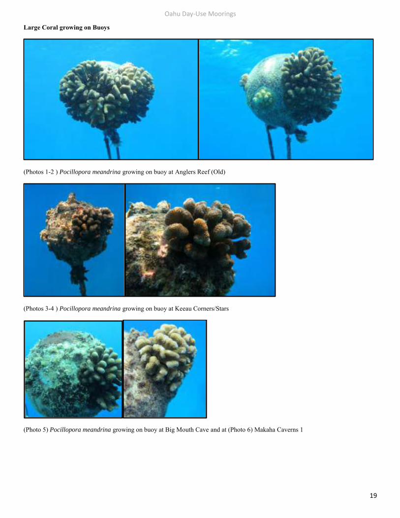
(Photos 1-2 ) Pocillopora meandrina growing on buoy at Anglers Reef (Old)
(Photos 3-4 ) Pocillopora meandrina growing on buoy at Keeau Corners/Stars
(Photo 5) Pocillopora meandrina growing on buoy at Big Mouth Cave and at (Photo 6) Makaha Caverns 1
Oahu Day-Use Moorings
20
Large Coral growing on Attachment Ropes
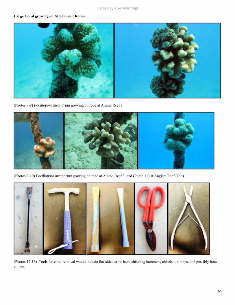
(Photos 7-8) Pocillopora meandrina growing on rope at Ammo Reef 1
(Photos 9-10) Pocillopora meandrina growing on rope at Ammo Reef 3, and (Photo 11) at Anglers Reef (Old)
(Photos 12-16) Tools for coral removal would include flat-sided crow bars, chiseling hammers, chisels, tin-snips, and possibly bone-cutters.
Oahu Day-Use Moorings
21
Small Coral Recruits growing on Buoys and Attachment Ropes
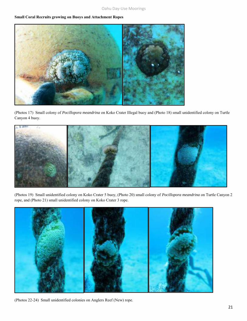
(Photos 17) Small colony of Pocillopora meandrina on Koko Crater Illegal buoy and (Photo 18) small unidentified colony on Turtle Canyon 4 buoy.
(Photos 19) Small unidentified colony on Koko Crater 5 buoy, (Photo 20) small colony of Pocillopora meandrina on Turtle Canyon 2 rope, and (Photo 21) small unidentified colony on Koko Crater 3 rope.
(Photos 22-24) Small unidentified colonies on Anglers Reef (New) rope.
Oahu Day-Use Moorings
22
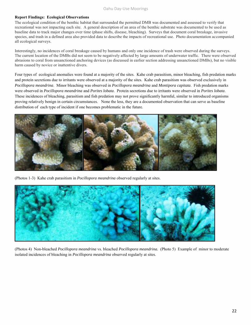
Report Findings: Ecological Observations The ecological condition of the benthic habitat that surrounded the permitted DMB was documented and assessed to verify that recreational was not impacting each site. A general description of an area of the benthic substrate was documented to be used as baseline data to track major changes over time (phase shifts, disease, bleaching). Surveys that document coral breakage, invasive species, and trash in a defined area also provided data to describe the impacts of recreational use. Photo documentation accompanied all ecological surveys. Interestingly, no incidences of coral breakage caused by humans and only one incidence of trash were observed during the surveys. The current location of the DMBs did not seem to be negatively affected by large amounts of underwater traffic. There were observed abrasions to coral from unsanctioned anchoring devices (as discussed in earlier section addressing unsanctioned DMBs), but no visible harm caused by novice or inattentive divers. Four types of ecological anomalies were found at a majority of the sites. Kahe crab parasitism, minor bleaching, fish predation marks and protein secretions due to irritants were observed at a majority of the sites. Kahe crab parasitism was observed exclusively in Pocillopora meandrina. Minor bleaching was observed in Pocillopora meandrina and Montipora capitata. Fish predation marks were observed in Pocillopora meandrina and Porites lobata. Protein secretions due to irritants were observed in Porites lobata. These incidences of bleaching, parasitism and fish predation may not prove significantly harmful, similar to introduced organisms proving relatively benign in certain circumstances. None the less, they are a documented observation that can serve as baseline distribution of each type of incident if one becomes problematic in the future.
(Photos 1-3) Kahe crab parasitism in Pocillopora meandrina observed regularly at sites.
(Photos 4) Non-bleached Pocillopora meandrina vs. bleached Pocillopora meandrina. (Photo 5) Example of minor to moderate isolated incidences of bleaching in Pocillopora meandrina observed regularly at sites.
Oahu Day-Use Moorings
23
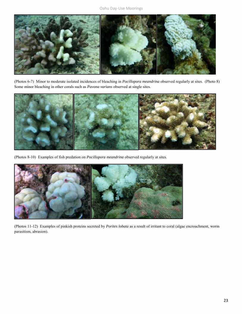
(Photos 6-7) Minor to moderate isolated incidences of bleaching in Pocillopora meandrina observed regularly at sites. (Photo 8) Some minor bleaching in other corals such as Pavona varians observed at single sites.
(Photos 8-10) Examples of fish predation on Pocillopora meandrina observed regularly at sites.
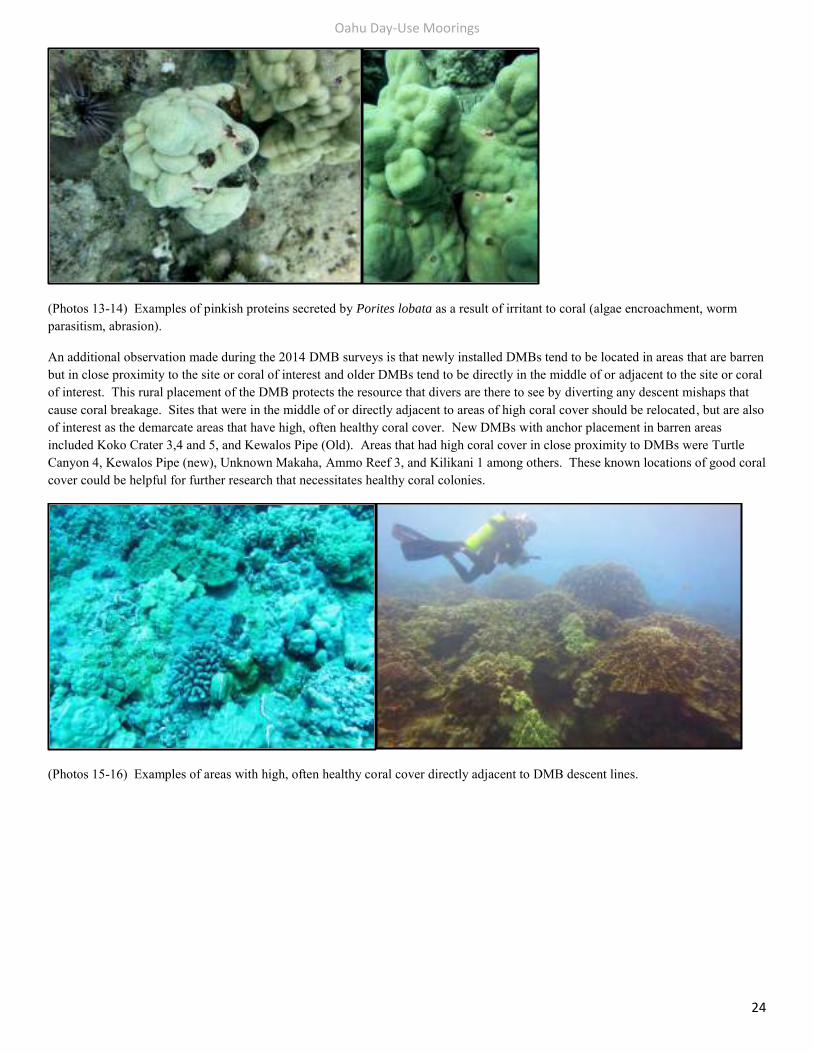
(Photos 11-12) Examples of pinkish proteins secreted by Porites lobata as a result of irritant to coral (algae encroachment, worm parasitism, abrasion).
Oahu Day-Use Moorings
24
(Photos 13-14) Examples of pinkish proteins secreted by Porites lobata as a result of irritant to coral (algae encroachment, worm parasitism, abrasion).
An additional observation made during the 2014 DMB surveys is that newly installed DMBs tend to be located in areas that are barren but in close proximity to the site or coral of interest and older DMBs tend to be directly in the middle of or adjacent to the site or coral of interest. This rural placement of the DMB protects the resource that divers are there to see by diverting any descent mishaps that cause coral breakage. Sites that were in the middle of or directly adjacent to areas of high coral cover should be relocated, but are also of interest as the demarcate areas that have high, often healthy coral cover. New DMBs with anchor placement in barren areas included Koko Crater 3,4 and 5, and Kewalos Pipe (Old). Areas that had high coral cover in close proximity to DMBs were Turtle Canyon 4, Kewalos Pipe (new), Unknown Makaha, Ammo Reef 3, and Kilikani 1 among others. These known locations of good coral cover could be helpful for further research that necessitates healthy coral colonies.
(Photos 15-16) Examples of areas with high, often healthy coral cover directly adjacent to DMB descent lines.
Oahu Day-Use Moorings
25
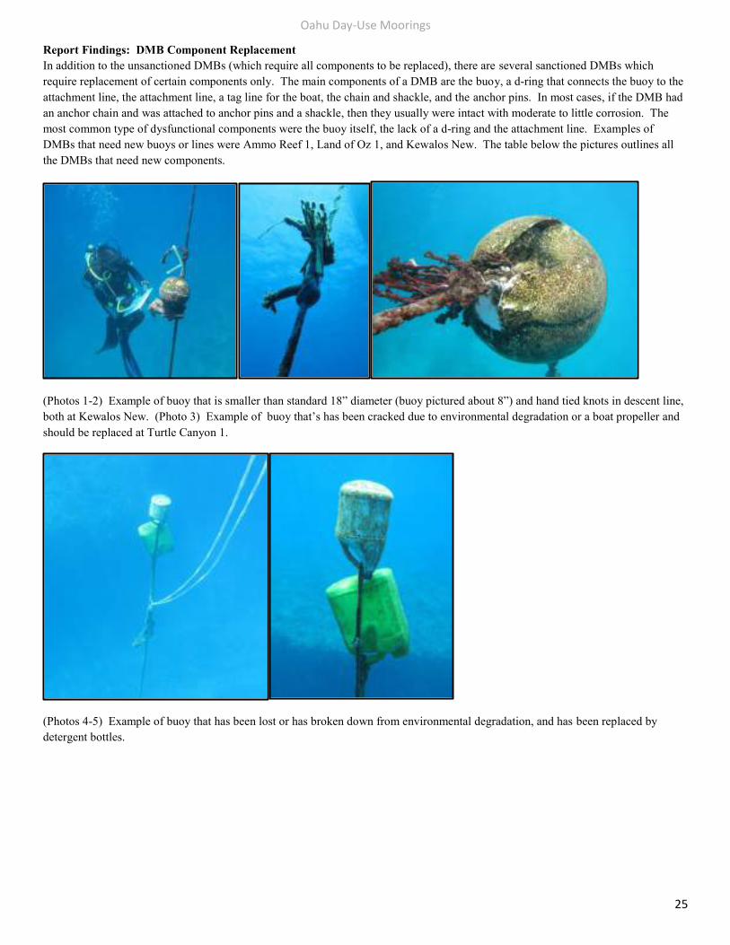
Report Findings: DMB Component Replacement In addition to the unsanctioned DMBs (which require all components to be replaced), there are several sanctioned DMBs which require replacement of certain components only. The main components of a DMB are the buoy, a d-ring that connects the buoy to the attachment line, the attachment line, a tag line for the boat, the chain and shackle, and the anchor pins. In most cases, if the DMB had an anchor chain and was attached to anchor pins and a shackle, then they usually were intact with moderate to little corrosion. The most common type of dysfunctional components were the buoy itself, the lack of a d-ring and the attachment line. Examples of DMBs that need new buoys or lines were Ammo Reef 1, Land of Oz 1, and Kewalos New. The table below the pictures outlines all the DMBs that need new components.
(Photos 1-2) Example of buoy that is smaller than standard 18” diameter (buoy pictured about 8”) and hand tied knots in descent line, both at Kewalos New. (Photo 3) Example of buoy that’s has been cracked due to environmental degradation or a boat propeller and should be replaced at Turtle Canyon 1.
(Photos 4-5) Example of buoy that has been lost or has broken down from environmental degradation, and has been replaced by detergent bottles.
Oahu Day-Use Moorings
26
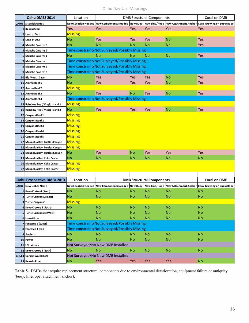
Table 5. DMBs that require replacement structural components due to environmental deterioration, equipment failure or antiquity (buoy, line/rope, attachment anchor).
Location Coral on DMB
OAHU SiteNicknames New Location Needed New Components Needed New Buoy New Line/Rope New Attachment Anchor Coral Growing on Buoy/Rope
1 Keaau/Stars Yes Yes Yes Yes Yes Yes
2 Land of Oz 1 Missing
3 Land of Oz 2 No Yes Yes Yes No Yes
4 Makaha Caverns 3 No No No No No Yes
5 Makaha Caverns 2 Time constraint/Not Surveyed/Possibly Missing
6 Makaha Caverns 1 No No No No No Yes
7 Makaha Caverns Time constraint/Not Surveyed/Possibly Missing
8 Makaha Caverns 5 Time constraint/Not Surveyed/Possibly Missing
9 Makaha Caverns 6 Time constraint/Not Surveyed/Possibly Missing
10 Big Mouth Cave No Yes Yes Yes No Yes
11 Ammo Reef 1 No Yes Yes Yes No Yes
12 Ammo Reef 2 Missing
13 Ammo Reef 3 No Yes No Yes No Yes
14 Ammo Reef 4 Time constraint/Not Surveyed/Possibly Missing
15 Rainbow Reef/Magic Island 1 Missing
16 Rainbow Reef/Magic Island 2 No Yes Yes Yes No Yes
17 Canyons Reef 1 Missing
18 Canyons Reef 2 Missing
19 Canyons Reef 3 Missing
20 Canyons Reef 4 Missing
21 Canyons Reef 5 Missing
22 Maunalua Bay: Turtles Canyon Missing
23 Maunalua Bay: Turtles Canyon Missing
24 Maunalua Bay: Turtles Canyon No Yes No Yes Yes Yes
25 Maunalua Bay: Koko Crater No No No No No No
26 Maunalua Bay: Koko Crater Missing
27 Maunalua Bay: Koko Crater Missing
Location Coral on DMB
OAHU New Dobor Name New Location Needed New Components Needed New Buoy New Line/Rope New Attachment Anchor Coral Growing on Buoy/Rope
1 Koko Crater 4 (Sand) No No No No No No
2 Turtle Canyons 2 (East) No No No No No No
3 Turtle Canyons 1 Missing
4 Koko Craters 5 (Secret) No No No No No No
5 Turtle Canyons 4 (West) No No No No No No
6 Hawaii Loa No No No No No No
7 Fantasea 2 (West) Time constraint/Not Surveyed/Possibly Missing
8 Fantasea 1 (East) Time constraint/Not Surveyed/Possibly Missing
9 Angler's No No No No No No
10 Pawaa No No No No No No
11 LCU Wreck Not Surveyed/No New DMB Installed
12 Koko Craters 3 (Back) No No No No No No
13&14 Corsair Wreck (x2) Not Surveyed/No New DMB Installed
15 Kewalo Pipe No Yes Yes Yes Yes No
Oahu DMBS 2014 DMB Structural Components
Oahu Prospective DMBs 2010 DMB Structural Components
Oahu Day-Use Moorings
27
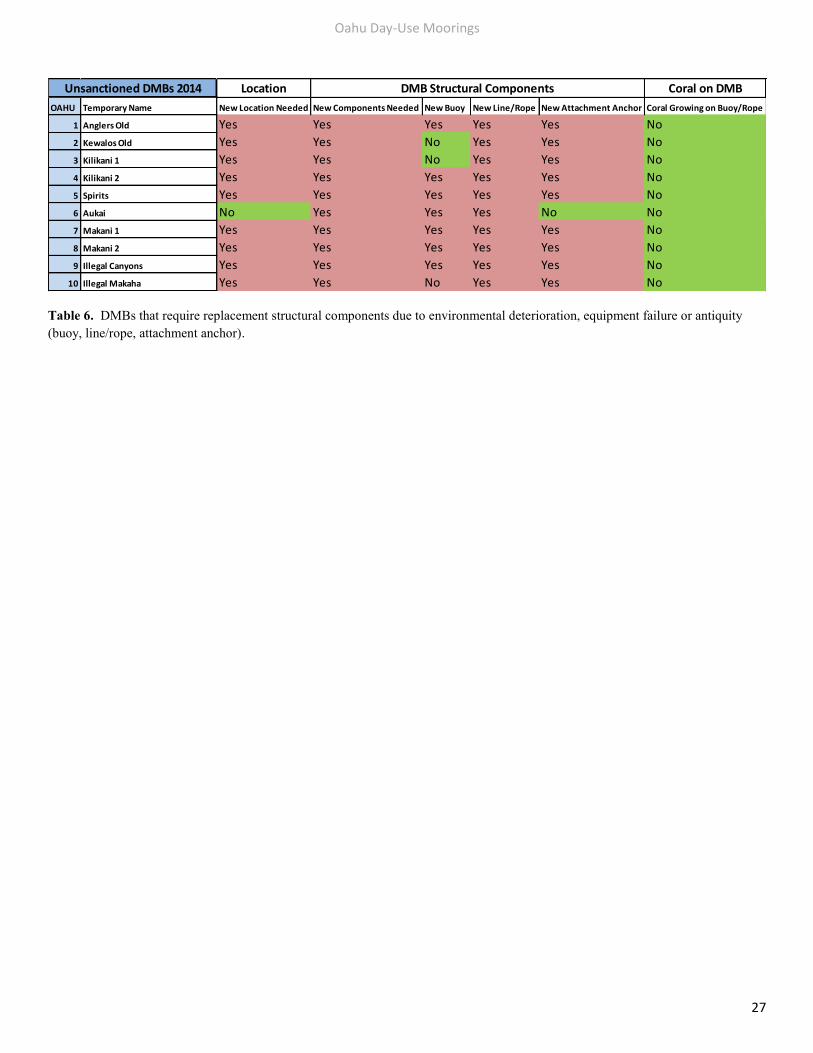
Table 6. DMBs that require replacement structural components due to environmental deterioration, equipment failure or antiquity (buoy, line/rope, attachment anchor).
Location Coral on DMB
OAHU Temporary Name New Location Needed New Components Needed New Buoy New Line/Rope New Attachment Anchor Coral Growing on Buoy/Rope
1 Anglers Old Yes Yes Yes Yes Yes No
2 Kewalos Old Yes Yes No Yes Yes No
3 Kilikani 1 Yes Yes No Yes Yes No
4 Kilikani 2 Yes Yes Yes Yes Yes No
5 Spirits Yes Yes Yes Yes Yes No
6 Aukai No Yes Yes Yes No No
7 Makani 1 Yes Yes Yes Yes Yes No
8 Makani 2 Yes Yes Yes Yes Yes No
9 Illegal Canyons Yes Yes Yes Yes Yes No
10 Illegal Makaha Yes Yes No Yes Yes No
Unsanctioned DMBs 2014 DMB Structural Components
Appendix: South Oahu Day-Use Moorings
28
Appendix: South - Waikiki - Day Use Mooring Buoys The original Waikiki DMBs consist of five mooring buoys named Canyon Reef DMBs 1-5. These original DMBS illustrated on map are no longer installed because environmental degradation or displacement resulting from the effect of heavy load bearing vessels on low load bearing mooring buoys over time. The existing mooring buoys that have taken the place of these original sanctioned DMBs are located slightly NW of the Canyon Reef DMBs closer to shore. These are indicated on the map in yellow. At least seven of the DMBs were surveyed by DAR in 2014, all are considered unsanctioned. These temporary DMBs have been installed by local tourist catamaran snorkel tours and commercial scuba operators in order to utilize DMBs as opposed to anchoring every day in the same location. Most of the DMBs are anchored to dead reef via chain which causes abrasion over time. Sanctioned DMBs should be installed utilizing the two pin or manta anchor methods in order to replace these unsanctioned DMBs.
Appendix: Waikiki Kewalos (New)(Status Unknown)
29
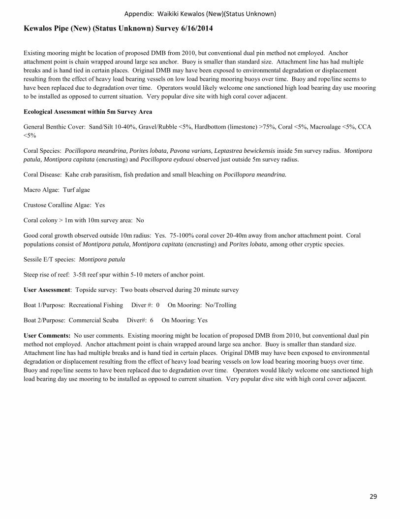
Kewalos Pipe (New) (Status Unknown) Survey 6/16/2014
Existing mooring might be location of proposed DMB from 2010, but conventional dual pin method not employed. Anchor attachment point is chain wrapped around large sea anchor. Buoy is smaller than standard size. Attachment line has had multiple breaks and is hand tied in certain places. Original DMB may have been exposed to environmental degradation or displacement resulting from the effect of heavy load bearing vessels on low load bearing mooring buoys over time. Buoy and rope/line seems to have been replaced due to degradation over time. Operators would likely welcome one sanctioned high load bearing day use mooring to be installed as opposed to current situation. Very popular dive site with high coral cover adjacent.
Ecological Assessment within 5m Survey Area
General Benthic Cover: Sand/Silt 10-40%, Gravel/Rubble <5%, Hardbottom (limestone) >75%, Coral <5%, Macroalage <5%, CCA <5%
Coral Species: Pocillopora meandrina, Porites lobata, Pavona varians, Leptastrea bewickensis inside 5m survey radius. Montipora patula, Montipora capitata (encrusting) and Pocillopora eydouxi observed just outside 5m survey radius.
Coral Disease: Kahe crab parasitism, fish predation and small bleaching on Pocillopora meandrina.
Macro Algae: Turf algae
Crustose Coralline Algae: Yes
Coral colony > 1m with 10m survey area: No
Good coral growth observed outside 10m radius: Yes. 75-100% coral cover 20-40m away from anchor attachment point. Coral populations consist of Montipora patula, Montipora capitata (encrusting) and Porites lobata, among other cryptic species.
Sessile E/T species: Montipora patula
Steep rise of reef: 3-5ft reef spur within 5-10 meters of anchor point.
User Assessment: Topside survey: Two boats observed during 20 minute survey
Boat 1/Purpose: Recreational Fishing Diver #: 0 On Mooring: No/Trolling
Boat 2/Purpose: Commercial Scuba Diver#: 6 On Mooring: Yes
User Comments: No user comments. Existing mooring might be location of proposed DMB from 2010, but conventional dual pin method not employed. Anchor attachment point is chain wrapped around large sea anchor. Buoy is smaller than standard size. Attachment line has had multiple breaks and is hand tied in certain places. Original DMB may have been exposed to environmental degradation or displacement resulting from the effect of heavy load bearing vessels on low load bearing mooring buoys over time. Buoy and rope/line seems to have been replaced due to degradation over time. Operators would likely welcome one sanctioned high load bearing day use mooring to be installed as opposed to current situation. Very popular dive site with high coral cover adjacent.
Appendix: Waikiki Kewalos (New)(Status Unknown)
30
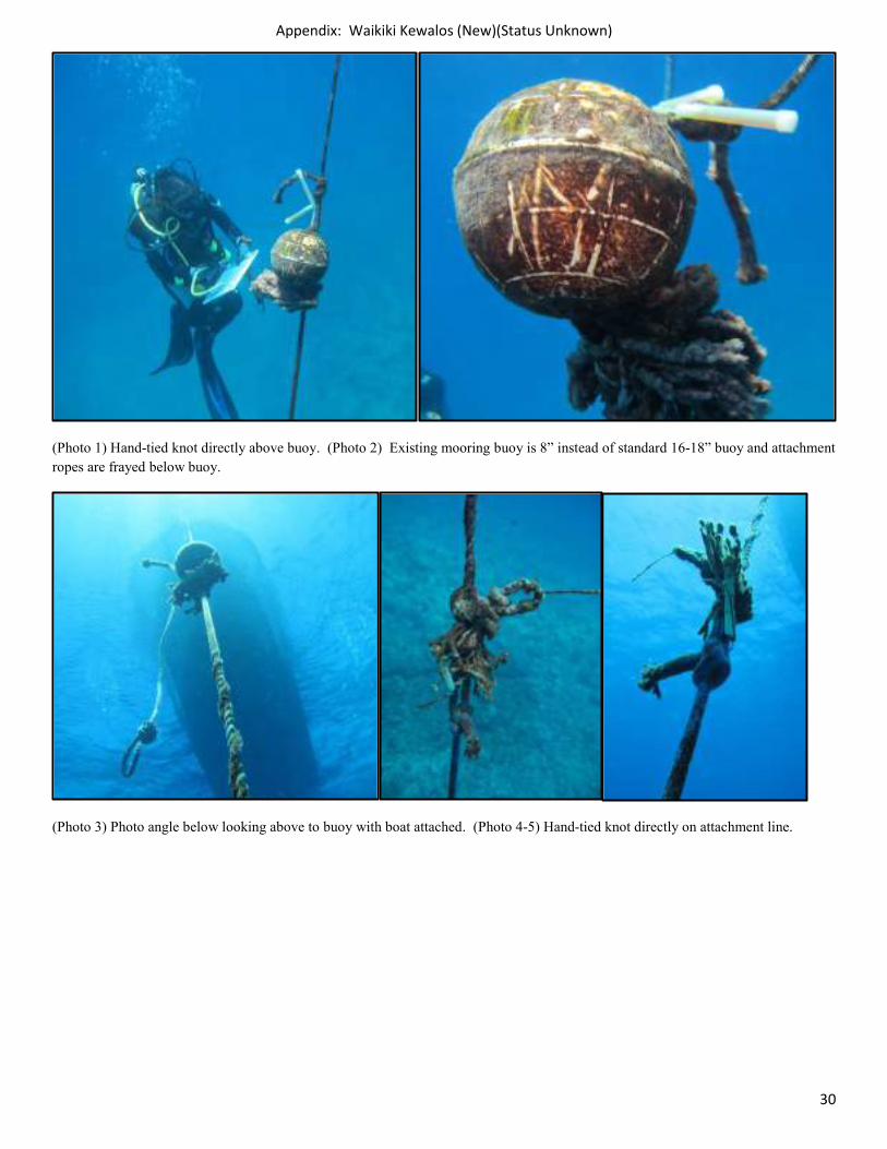
(Photo 1) Hand-tied knot directly above buoy. (Photo 2) Existing mooring buoy is 8” instead of standard 16-18” buoy and attachment ropes are frayed below buoy.
(Photo 3) Photo angle below looking above to buoy with boat attached. (Photo 4-5) Hand-tied knot directly on attachment line.
Appendix: Waikiki Kewalos (New)(Status Unknown)
31
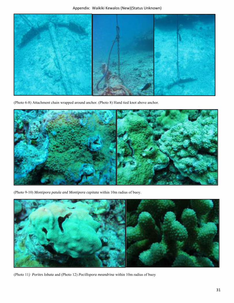
(Photo 6-8) Attachment chain wrapped around anchor. (Photo 8) Hand tied knot above anchor.
(Photo 9-10) Montipora patula and Montipora capitata within 10m radius of buoy.
(Photo 11) Porites lobata and (Photo 12) Pocillopora meandrina within 10m radius of buoy
Appendix: Waikiki Kewalos (New)(Status Unknown)
32
(Photo 13) Pocillopora eydouxi within 20m of buoy and (Photo 14) nearly 100% coral cover with 25m of buoy
Buoy Name: Kewalos New Buoy Depth: 8ft Attachment Point Depth: 37ft
New GPS Coordinates: N 21.28726 W -157.86412 Condition: Poor
Unsanctioned/New Location Needed: No Replacement Components Needed: Yes
Buoy Intact: No. Buoy only 8 inches, smaller than 18 inch diameter standard size.
Lines Intact: No. Lines have had multiple breaks, hand-tied in some areas.
Attachment to Ground Intact: No. Anchor attachment point is chain wrapped around large sea anchor.
Coral Growing on Buoy: No
Coral Growing on Attachment Rope: No
1m Coral Head in 10m Radius around Buoy: No Coral Growth Surrounding Buoy: High
Appendix: Waikiki Kewalos (Old) (Unsanctioned)
33
Kewalos Pipe (Old) (Unsanctioned) Survey 6/16/2014
This popular shore dive is located approximately 1/8 mile southwest of the Kewalo Basin Boat Harbor channel. Kewalo Pipe is named after the 48” retired drain pipe that leads from shore seaward 400 yards. Depths range from 20-70 feet. The pipe itself provides shelter to a myriad of species including crabs, lobster, frog fish, and a selection of moray eels. In addition, the nearby reefs on either side of the pipe offer fish viewing areas.
Ecological Assessment within 5m Survey Area
General Benthic Cover: Sand/Silt >75%, Gravel/Rubble 10-40%, Hardbottom (limestone) 10-40%, Coral <5%, Macroalage <5%, CCA <5%
Coral Species: Pocillopora meandrina, Porites lobata, Montipora capitata (encrusting) and Leptastrea bewickensis.
Coral Disease: Kahe crab parasitism, fish predation and small bleaching on Pocillopora meandrina.
Macro Algae: Lyngbya majuscula, Native filamentous green and red algae
Crustose Coralline Algae: No
Coral colony > 1m with 10m survey area: No
Good coral growth observed outside 10m radius: No. Area is predominantly covered by sand, bare limestone substrate and rubble. Most coral present is growing on actual pipe.
Sessile E/T species: No
Steep rise of reef: No
User Assessment: Topside survey: One boat observed during 20 minute survey. Same scuba boat as observed in Kewalos New survey.
Boat 1/Purpose: Commercial Scuba Diver#: 6 On Mooring: Yes
User Comments: No user comments. Existing mooring is in same location and condition as originally surveyed in 2010 by DAR. Mooring buoy line is wrapped around Kewalos Pipe attachment point, no anchor chain present. Coral growing on pipe is subject to abrasion by rope at attachment point. No d-ring under buoy, no metal components on any part of DMB. Attachment line is fraying underneath buoy and at attachment point and is split in certain places. Operators would likely welcome one sanctioned high load bearing day use mooring to be installed nearby into substrate employing two pin anchor method, as opposed to current situation. Very popular dive site for shallow beginner dives.
Appendix: Waikiki Kewalos (Old) (Unsanctioned)
34
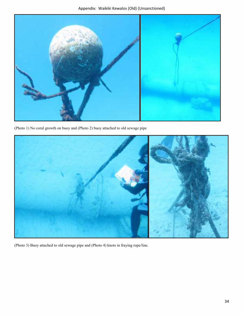
(Photo 1) No coral growth on buoy and (Photo 2) buoy attached to old sewage pipe
(Photo 3) Buoy attached to old sewage pipe and (Photo 4) knots in fraying rope/line.
Appendix: Waikiki Kewalos (Old) (Unsanctioned)
35
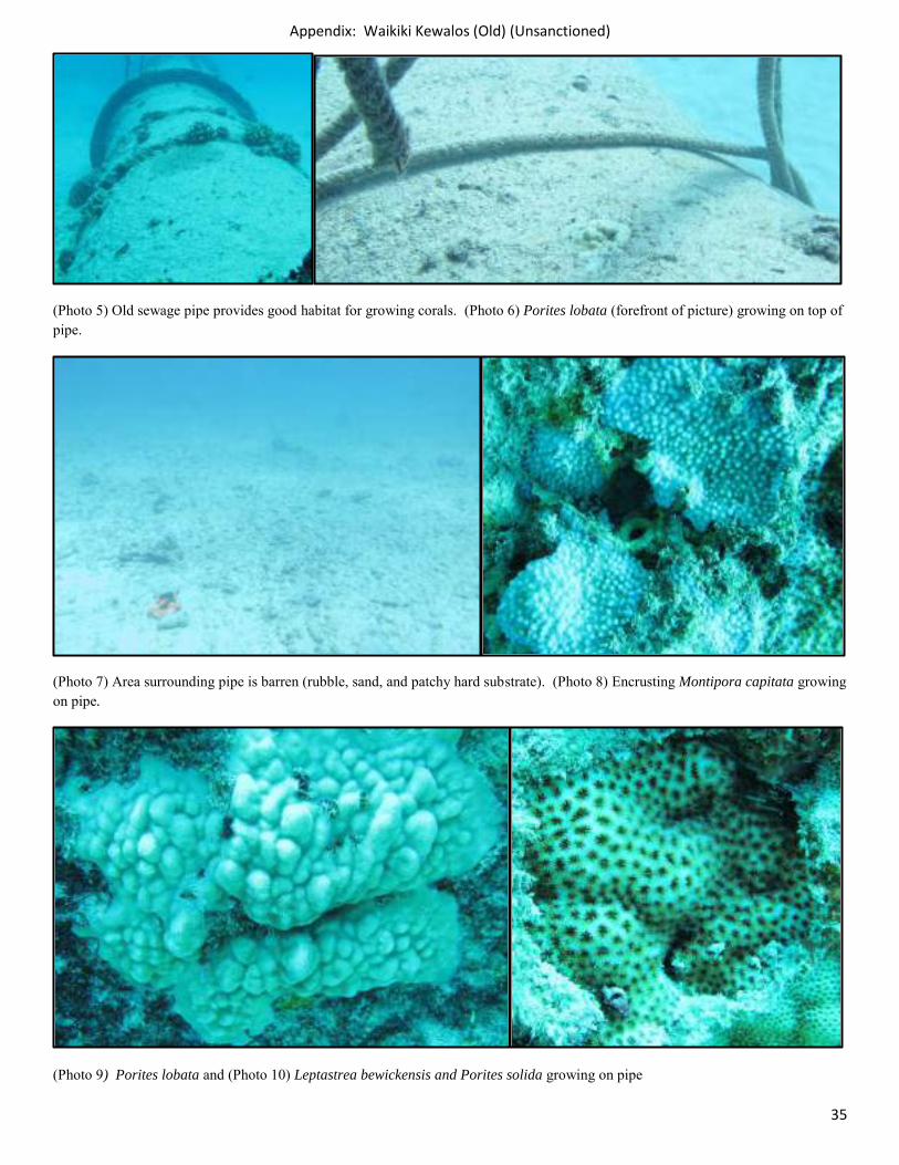
(Photo 5) Old sewage pipe provides good habitat for growing corals. (Photo 6) Porites lobata (forefront of picture) growing on top of pipe.
(Photo 7) Area surrounding pipe is barren (rubble, sand, and patchy hard substrate). (Photo 8) Encrusting Montipora capitata growing on pipe.
(Photo 9) Porites lobata and (Photo 10) Leptastrea bewickensis and Porites solida growing on pipe
Appendix: Waikiki Kewalos (Old) (Unsanctioned)
36
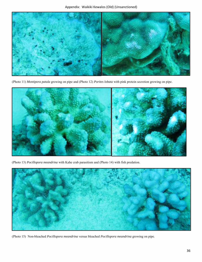
(Photo 11) Montipora patula growing on pipe and (Photo 12) Porites lobata with pink protein secretion growing on pipe.
(Photo 13) Pocillopora meandrina with Kahe crab parasitism and (Photo 14) with fish predation.
(Photo 15) Non-bleached Pocillopora meandrina versus bleached Pocillopora meandrina growing on pipe.
Appendix: Waikiki Kewalos (Old) (Unsanctioned)
37
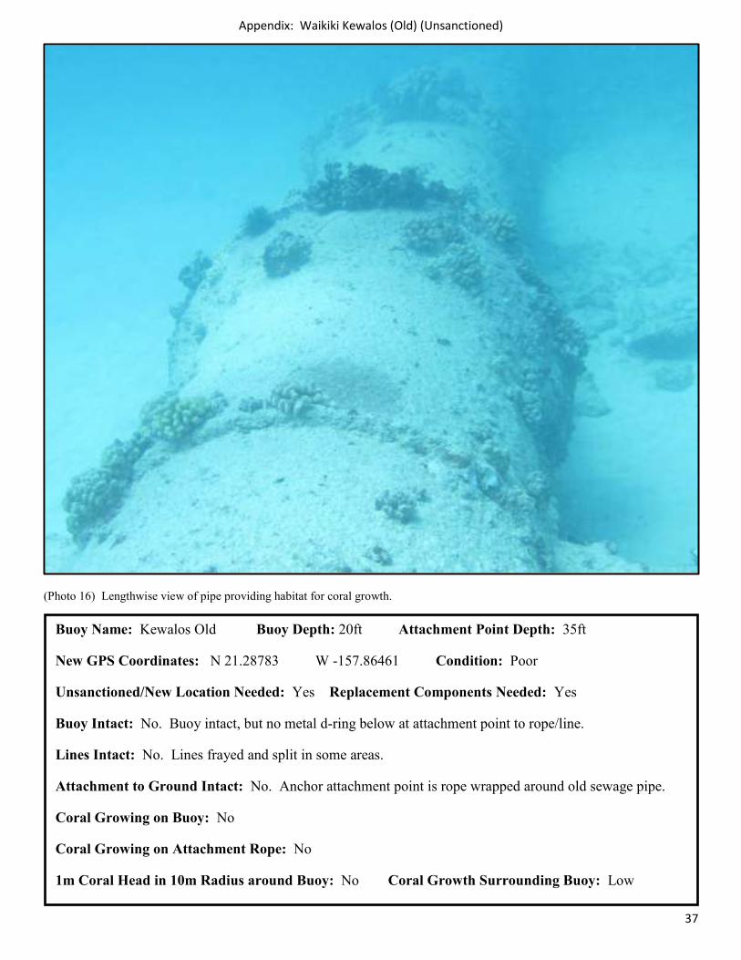
(Photo 16) Lengthwise view of pipe providing habitat for coral growth.
Buoy Name: Kewalos Old Buoy Depth: 20ft Attachment Point Depth: 35ft
New GPS Coordinates: N 21.28783 W -157.86461 Condition: Poor
Unsanctioned/New Location Needed: Yes Replacement Components Needed: Yes
Buoy Intact: No. Buoy intact, but no metal d-ring below at attachment point to rope/line.
Lines Intact: No. Lines frayed and split in some areas.
Attachment to Ground Intact: No. Anchor attachment point is rope wrapped around old sewage pipe.
Coral Growing on Buoy: No
Coral Growing on Attachment Rope: No
1m Coral Head in 10m Radius around Buoy: No Coral Growth Surrounding Buoy: Low
Appendix: Waikiki Magic Island 2 (Sanctioned)
38
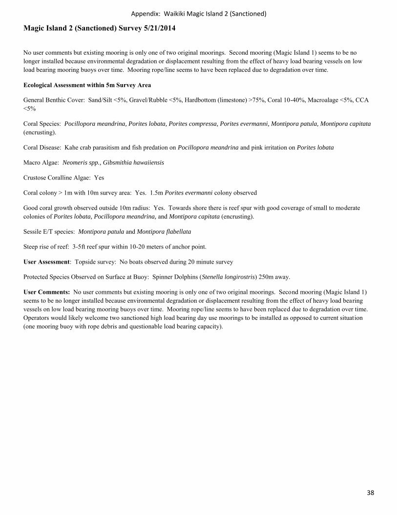
Magic Island 2 (Sanctioned) Survey 5/21/2014
No user comments but existing mooring is only one of two original moorings. Second mooring (Magic Island 1) seems to be no longer installed because environmental degradation or displacement resulting from the effect of heavy load bearing vessels on low load bearing mooring buoys over time. Mooring rope/line seems to have been replaced due to degradation over time.
Ecological Assessment within 5m Survey Area
General Benthic Cover: Sand/Silt <5%, Gravel/Rubble <5%, Hardbottom (limestone) >75%, Coral 10-40%, Macroalage <5%, CCA <5%
Coral Species: Pocillopora meandrina, Porites lobata, Porites compressa, Porites evermanni, Montipora patula, Montipora capitata (encrusting).
Coral Disease: Kahe crab parasitism and fish predation on Pocillopora meandrina and pink irritation on Porites lobata
Macro Algae: Neomeris spp., Gibsmithia hawaiiensis
Crustose Coralline Algae: Yes
Coral colony > 1m with 10m survey area: Yes. 1.5m Porites evermanni colony observed
Good coral growth observed outside 10m radius: Yes. Towards shore there is reef spur with good coverage of small to moderate colonies of Porites lobata, Pocillopora meandrina, and Montipora capitata (encrusting).
Sessile E/T species: Montipora patula and Montipora flabellata
Steep rise of reef: 3-5ft reef spur within 10-20 meters of anchor point.
User Assessment: Topside survey: No boats observed during 20 minute survey
Protected Species Observed on Surface at Buoy: Spinner Dolphins (Stenella longirostris) 250m away.
User Comments: No user comments but existing mooring is only one of two original moorings. Second mooring (Magic Island 1) seems to be no longer installed because environmental degradation or displacement resulting from the effect of heavy load bearing vessels on low load bearing mooring buoys over time. Mooring rope/line seems to have been replaced due to degradation over time. Operators would likely welcome two sanctioned high load bearing day use moorings to be installed as opposed to current situation (one mooring buoy with rope debris and questionable load bearing capacity).
Appendix: Waikiki Magic Island 2 (Sanctioned)
39
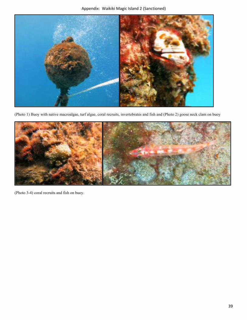
(Photo 1) Buoy with native macroalgae, turf algae, coral recruits, invertebrates and fish and (Photo 2) goose neck clam on buoy
(Photo 3-4) coral recruits and fish on buoy.
Appendix: Waikiki Magic Island 2 (Sanctioned)
40
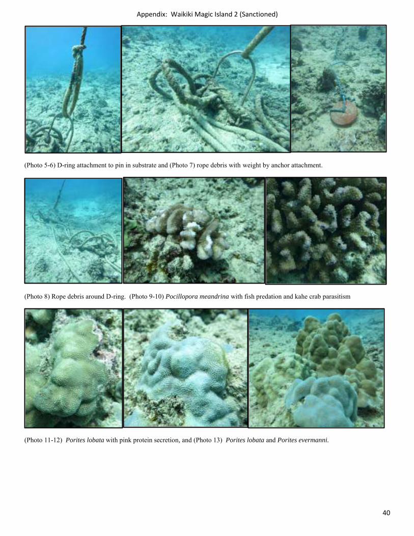
(Photo 5-6) D-ring attachment to pin in substrate and (Photo 7) rope debris with weight by anchor attachment.
(Photo 8) Rope debris around D-ring. (Photo 9-10) Pocillopora meandrina with fish predation and kahe crab parasitism
(Photo 11-12) Porites lobata with pink protein secretion, and (Photo 13) Porites lobata and Porites evermanni.
Appendix: Waikiki Magic Island 2 (Sanctioned)
41
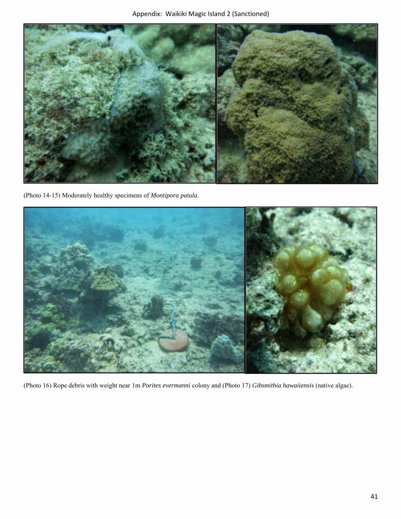
(Photo 14-15) Moderately healthy specimens of Montipora patula.
(Photo 16) Rope debris with weight near 1m Porites evermanni colony and (Photo 17) Gibsmithia hawaiiensis (native algae).
Appendix: Waikiki Magic Island 2 (Sanctioned)
42
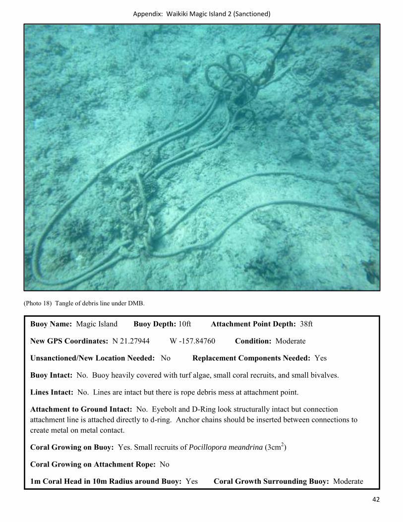
(Photo 18) Tangle of debris line under DMB.
Buoy Name: Magic Island Buoy Depth: 10ft Attachment Point Depth: 38ft
New GPS Coordinates: N 21.27944 W -157.84760 Condition: Moderate
Unsanctioned/New Location Needed: No Replacement Components Needed: Yes
Buoy Intact: No. Buoy heavily covered with turf algae, small coral recruits, and small bivalves.
Lines Intact: No. Lines are intact but there is rope debris mess at attachment point.
Attachment to Ground Intact: No. Eyebolt and D-Ring look structurally intact but connection attachment line is attached directly to d-ring. Anchor chains should be inserted between connections to create metal on metal contact.
Coral Growing on Buoy: Yes. Small recruits of Pocillopora meandrina (3cm2)
Coral Growing on Attachment Rope: No
1m Coral Head in 10m Radius around Buoy: Yes Coral Growth Surrounding Buoy: Moderate
Appendix: Waikiki Kilikani 1 (Sanctioned)
43
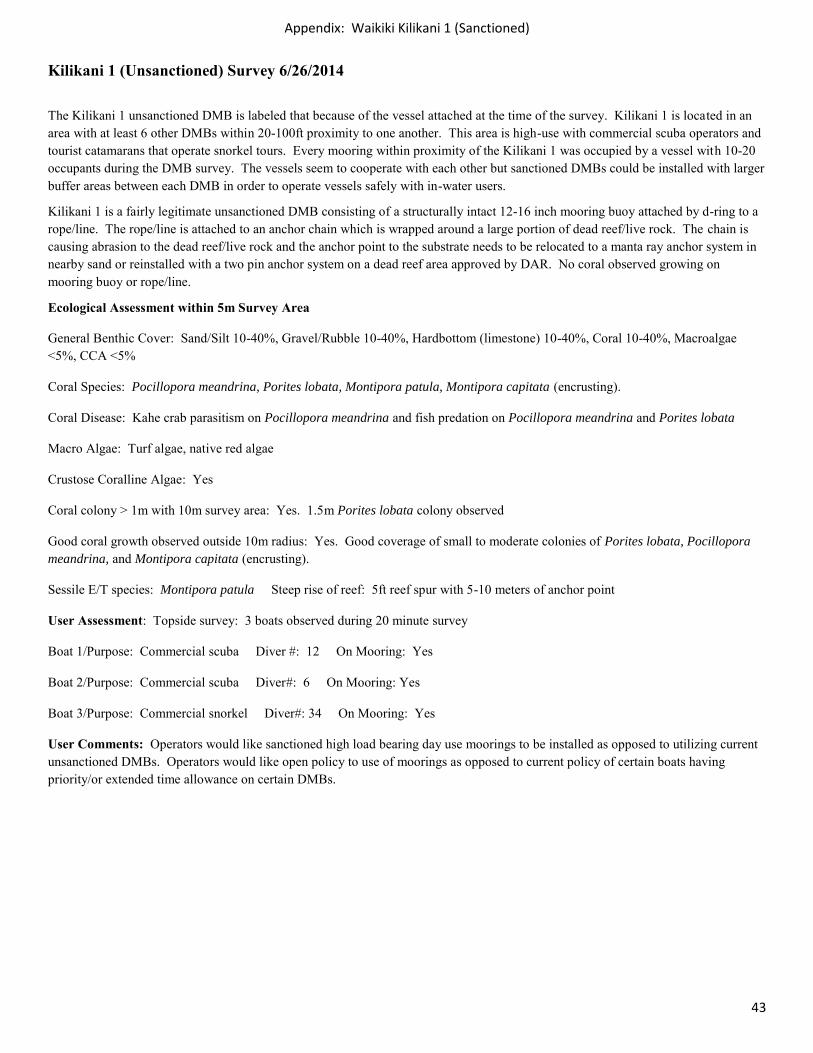
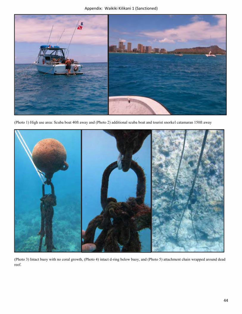
Kilikani 1 (Unsanctioned) Survey 6/26/2014
The Kilikani 1 unsanctioned DMB is labeled that because of the vessel attached at the time of the survey. Kilikani 1 is located in an area with at least 6 other DMBs within 20-100ft proximity to one another. This area is high-use with commercial scuba operators and tourist catamarans that operate snorkel tours. Every mooring within proximity of the Kilikani 1 was occupied by a vessel with 10-20 occupants during the DMB survey. The vessels seem to cooperate with each other but sanctioned DMBs could be installed with larger buffer areas between each DMB in order to operate vessels safely with in-water users.
Kilikani 1 is a fairly legitimate unsanctioned DMB consisting of a structurally intact 12-16 inch mooring buoy attached by d-ring to a rope/line. The rope/line is attached to an anchor chain which is wrapped around a large portion of dead reef/live rock. The chain is causing abrasion to the dead reef/live rock and the anchor point to the substrate needs to be relocated to a manta ray anchor system in nearby sand or reinstalled with a two pin anchor system on a dead reef area approved by DAR. No coral observed growing on mooring buoy or rope/line.
Ecological Assessment within 5m Survey Area
General Benthic Cover: Sand/Silt 10-40%, Gravel/Rubble 10-40%, Hardbottom (limestone) 10-40%, Coral 10-40%, Macroalgae <5%, CCA <5%
Coral Species: Pocillopora meandrina, Porites lobata, Montipora patula, Montipora capitata (encrusting).
Coral Disease: Kahe crab parasitism on Pocillopora meandrina and fish predation on Pocillopora meandrina and Porites lobata
Macro Algae: Turf algae, native red algae
Crustose Coralline Algae: Yes
Coral colony > 1m with 10m survey area: Yes. 1.5m Porites lobata colony observed
Good coral growth observed outside 10m radius: Yes. Good coverage of small to moderate colonies of Porites lobata, Pocillopora meandrina, and Montipora capitata (encrusting).
Sessile E/T species: Montipora patula Steep rise of reef: 5ft reef spur with 5-10 meters of anchor point
User Assessment: Topside survey: 3 boats observed during 20 minute survey
Boat 1/Purpose: Commercial scuba Diver #: 12 On Mooring: Yes
Boat 2/Purpose: Commercial scuba Diver#: 6 On Mooring: Yes
Boat 3/Purpose: Commercial snorkel Diver#: 34 On Mooring: Yes
User Comments: Operators would like sanctioned high load bearing day use moorings to be installed as opposed to utilizing current unsanctioned DMBs. Operators would like open policy to use of moorings as opposed to current policy of certain boats having priority/or extended time allowance on certain DMBs.
Appendix: Waikiki Kilikani 1 (Sanctioned)
44
(Photo 1) High use area: Scuba boat 40ft away and (Photo 2) additional scuba boat and tourist snorkel catamaran 150ft away
(Photo 3) Intact buoy with no coral growth, (Photo 4) intact d-ring below buoy, and (Photo 5) attachment chain wrapped around dead reef.
Appendix: Waikiki Kilikani 1 (Sanctioned)
45
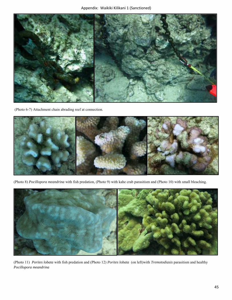
(Photo 6-7) Attachment chain abrading reef at connection.
(Photo 8) Pocillopora meandrina with fish predation, (Photo 9) with kahe crab parasitism and (Photo 10) with small bleaching.
(Photo 11) Porites lobata with fish predation and (Photo 12) Porites lobata (on left)with Tremotodiasis parasitism and healthy Pocillopora meandrina
Appendix: Waikiki Kilikani 1 (Sanctioned)
46
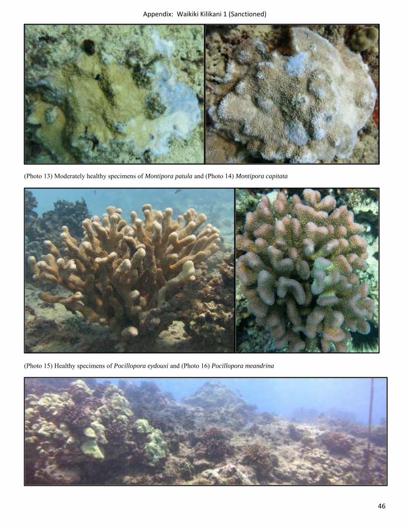
(Photo 13) Moderately healthy specimens of Montipora patula and (Photo 14) Montipora capitata
(Photo 15) Healthy specimens of Pocillopora eydouxi and (Photo 16) Pocillopora meandrina
Appendix: Waikiki Kilikani 1 (Sanctioned)
47
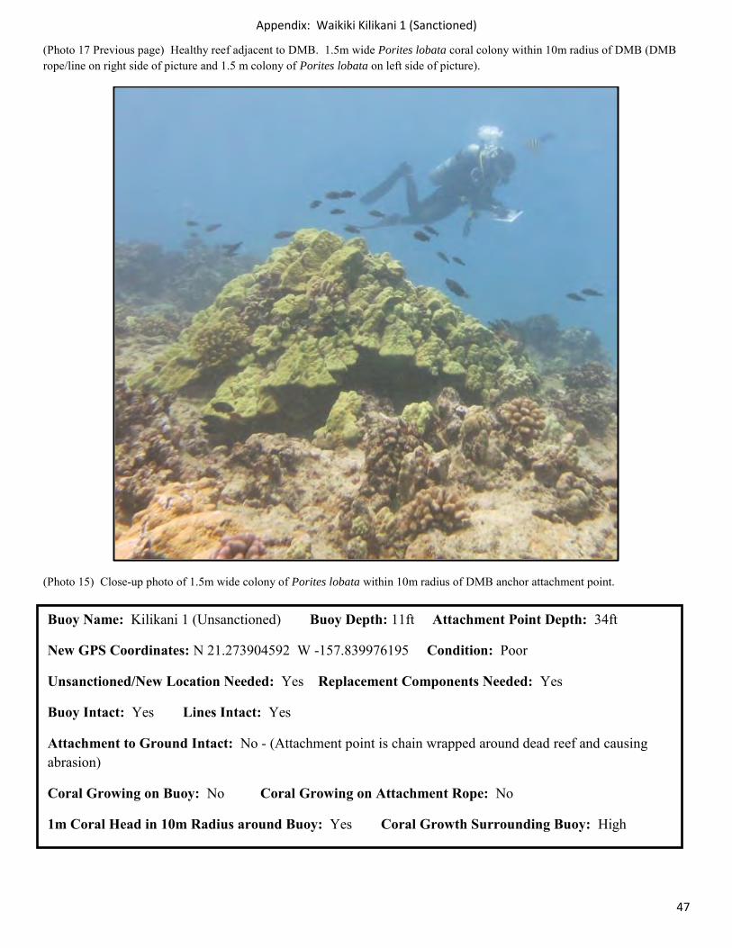
(Photo 17 Previous page) Healthy reef adjacent to DMB. 1.5m wide Porites lobata coral colony within 10m radius of DMB (DMB rope/line on right side of picture and 1.5 m colony of Porites lobata on left side of picture).
(Photo 15) Close-up photo of 1.5m wide colony of Porites lobata within 10m radius of DMB anchor attachment point.
Buoy Name: Kilikani 1 (Unsanctioned) Buoy Depth: 11ft Attachment Point Depth: 34ft
New GPS Coordinates: N 21.273904592 W -157.839976195 Condition: Poor
Unsanctioned/New Location Needed: Yes Replacement Components Needed: Yes
Buoy Intact: Yes Lines Intact: Yes
Attachment to Ground Intact: No - (Attachment point is chain wrapped around dead reef and causing abrasion)
Coral Growing on Buoy: No Coral Growing on Attachment Rope: No
1m Coral Head in 10m Radius around Buoy: Yes Coral Growth Surrounding Buoy: High
Appendix: Waikiki Kilikani 2 (Unsanctioned)
48
Kilikani 2 (Unsanctioned) Survey 6/26/2014
The Kilikani 2 unsanctioned DMB is labeled that because of proximal location to Kilikani 1. Kilikani 2 is located in an area with at least 6 other DMBs within 20-100ft proximity to one another. This area is high-use with commercial scuba operators and tourist catamarans that operate snorkel tours. Every mooring within proximity of the Kilikani 2 was occupied by a vessel with 10-20 occupants during the DMB survey. The vessels seem to cooperate with each other but sanctioned DMBs could be installed with larger buffer areas between each DMB in order to operate vessels safely with in-water users.
Kilikani 2 is an illegitimate unsanctioned DMB consisting of only a rope/line with a fender buoy wrapped around a large portion of dead reef/live rock. The rope is causing abrasion to the dead reef/live rock and the anchor point to the substrate needs to be relocated to a manta ray anchor system in nearby sand or reinstalled with a two pin anchor system on a dead reef area approved by DAR. No coral observed growing on rope/line.
Site: Kilikani 2 Date: 6/26/2014
Ecological Assessment within 5m Survey Area
General Benthic Cover: Sand/Silt 40-75%, Gravel/Rubble <5%, Hardbottom (limestone) 10-40%, Coral 10-40%, Macroalage <5%, CCA <5%
Coral Species: Pocillopora meandrina, Porites lobata, Montipora patula, Montipora capitata (encrusting).
Coral Disease: Kahe crab parasitism on and fish predation on Pocillopora meandrina, pink irritation observed on Porites lobata.
Macro Algae: Native red algae Crustose Coralline Algae: Yes
Coral colony > 1m with 10m survey area: Yes. 1.0m Porites lobata colony observed
Good coral growth observed outside 10m radius: Yes. Good coverage of small to moderate colonies of Porites lobata, Pocillopora meandrina, Montipora patula and Montipora capitata (encrusting) located on attachment point reef spur.
Sessile E/T species: Montipora patula Steep rise of reef: 3-5ft reef spur with 5-10 meters of anchor point
User Assessment: Topside survey: 3 boats observed during 20 minute survey (Same boats as Kilikani 1 survey). Surveys were conducted in tandem within 40 minute period.
Boat 1/Purpose: Commercial scuba Diver #: 12 On Mooring: Yes
Boat 2/Purpose: Commercial scuba Diver#: 6 On Mooring: Yes
Boat 3/Purpose: Commercial snorkel Diver#: 34 On Mooring: Yes
User Comments: Operators would like sanctioned high load bearing day use moorings to be installed as opposed to utilizing current unsanctioned DMBs. Operators would like open policy to use of moorings as opposed to current policy of certain boats having priority/or extended time allowance on certain DMBs.
Appendix: Waikiki Kilikani 2 (Unsanctioned)
49
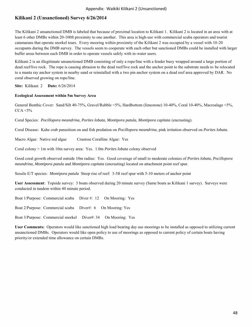
(Photo 1) High use area: Scuba boat 40ft away (same image as in Kilikani 1) and (Photo 2) group of scuba divers observed while conducting the survey.
(Photo 3) Attachment rope with fender buoy wrapped around dead reef. (Photo 4) No coral growing on fender buoy.
(Photo 5) Attachment rope wrapped around dead reef and (Photo 6) attachment rope abrading reef at connection with live coral colony nearby.
Appendix: Waikiki Kilikani 2 (Unsanctioned)
50
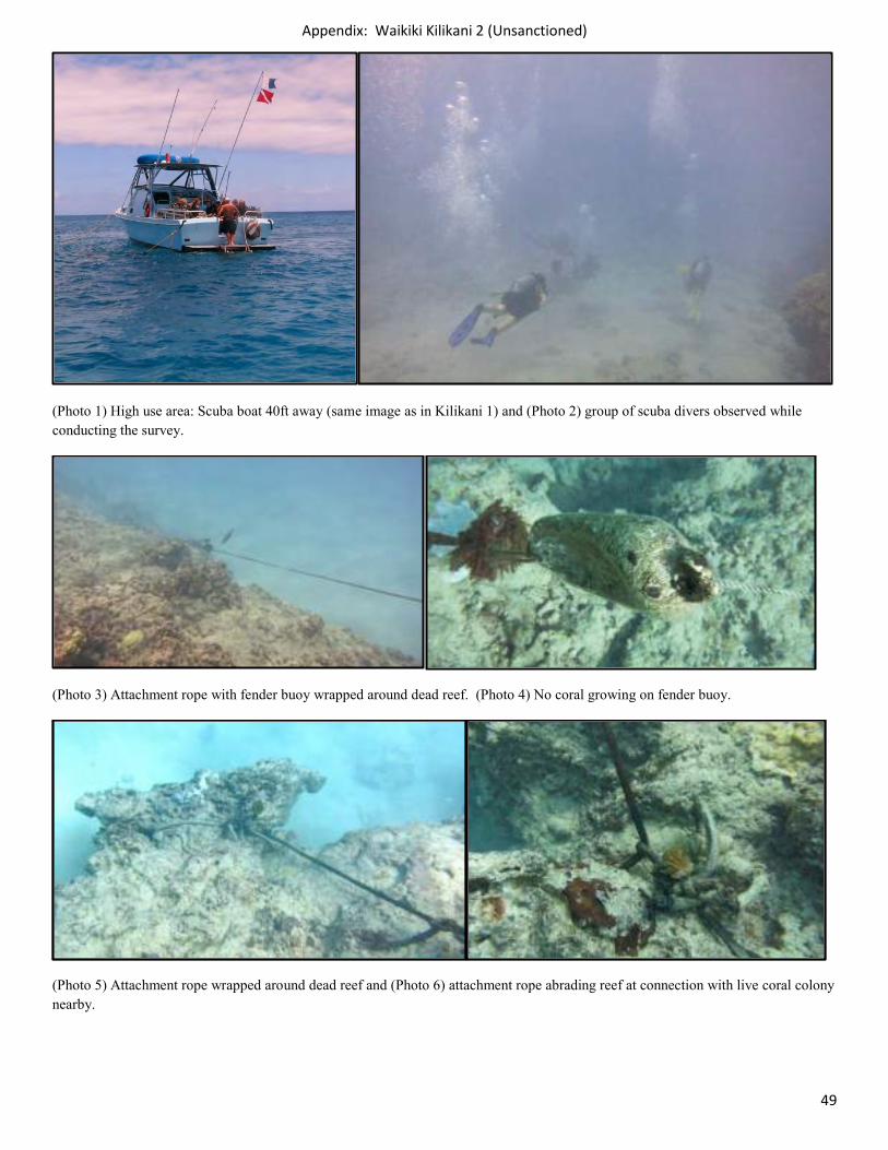
(Photo 7 & 8) 1m wide Porites lobata coral colony within 10m radius of DMB.
(Photo 9) Unsanctioned DMB located on spur reef adjacent to sand groove: Pocillopora meandrina and Porites lobata (bottom center of picture). (Photo 10) New two pin or manta anchor system could be installed in adjacent sand groove with minimal impact to spur reef (diver in sand groove).
Appendix: Waikiki Kilikani 2 (Unsanctioned)
51
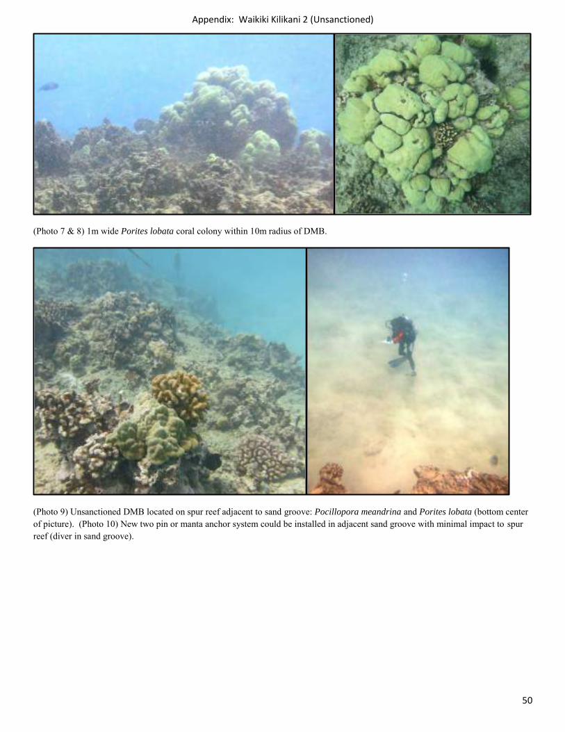
(Photo 11) Pocillopora meandrina with kahe crab parasitism and (Photo 12) Pocillopora meandrina with bleaching.
(Photo 13) Healthy specimens of Montipora patula and (Photo 14) Leptastrea transversa
Appendix: Waikiki Kilikani 2 (Unsanctioned)
52
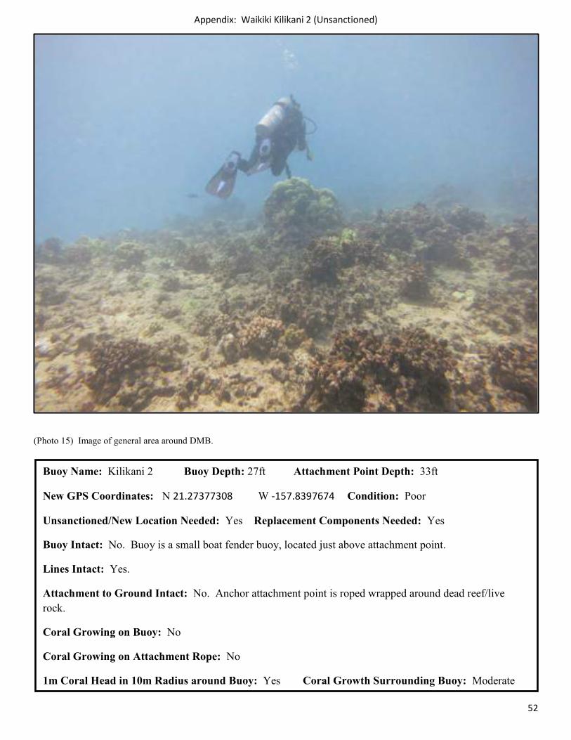
(Photo 15) Image of general area around DMB.
Buoy Name: Kilikani 2 Buoy Depth: 27ft Attachment Point Depth: 33ft
New GPS Coordinates: N 21.27377308 W -157.8397674 Condition: Poor
Unsanctioned/New Location Needed: Yes Replacement Components Needed: Yes
Buoy Intact: No. Buoy is a small boat fender buoy, located just above attachment point.
Lines Intact: Yes.
Attachment to Ground Intact: No. Anchor attachment point is roped wrapped around dead reef/live rock.
Coral Growing on Buoy: No
Coral Growing on Attachment Rope: No
1m Coral Head in 10m Radius around Buoy: Yes Coral Growth Surrounding Buoy: Moderate
Appendix: Waikiki Spirits (Unsanctioned)
53
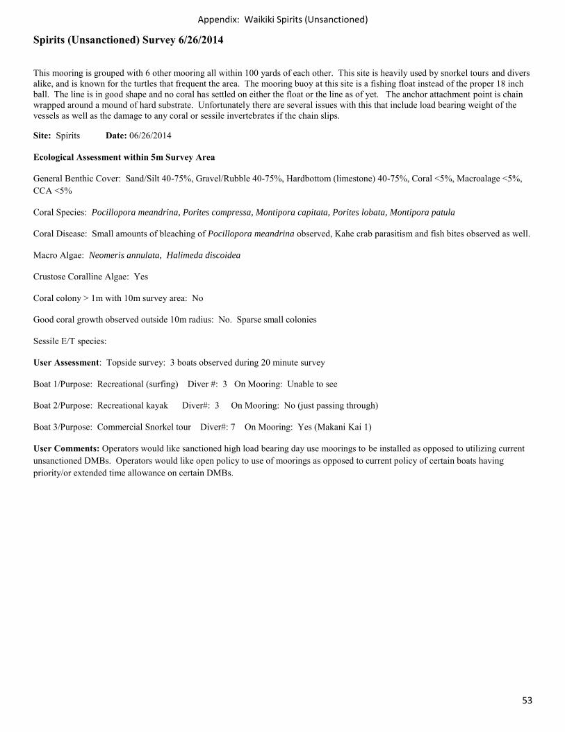
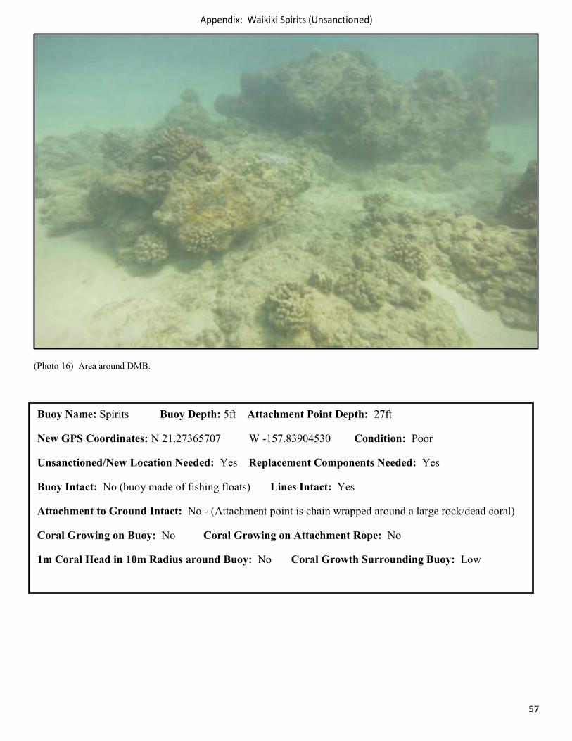
Spirits (Unsanctioned) Survey 6/26/2014
This mooring is grouped with 6 other mooring all within 100 yards of each other. This site is heavily used by snorkel tours and divers alike, and is known for the turtles that frequent the area. The mooring buoy at this site is a fishing float instead of the proper 18 inch ball. The line is in good shape and no coral has settled on either the float or the line as of yet. The anchor attachment point is chain wrapped around a mound of hard substrate. Unfortunately there are several issues with this that include load bearing weight of the vessels as well as the damage to any coral or sessile invertebrates if the chain slips.
Site: Spirits Date: 06/26/2014
Ecological Assessment within 5m Survey Area
General Benthic Cover: Sand/Silt 40-75%, Gravel/Rubble 40-75%, Hardbottom (limestone) 40-75%, Coral <5%, Macroalage <5%, CCA <5%
Coral Species: Pocillopora meandrina, Porites compressa, Montipora capitata, Porites lobata, Montipora patula
Coral Disease: Small amounts of bleaching of Pocillopora meandrina observed, Kahe crab parasitism and fish bites observed as well.
Macro Algae: Neomeris annulata, Halimeda discoidea
Crustose Coralline Algae: Yes
Coral colony > 1m with 10m survey area: No
Good coral growth observed outside 10m radius: No. Sparse small colonies
Sessile E/T species:
User Assessment: Topside survey: 3 boats observed during 20 minute survey
Boat 1/Purpose: Recreational (surfing) Diver #: 3 On Mooring: Unable to see
Boat 2/Purpose: Recreational kayak Diver#: 3 On Mooring: No (just passing through)
Boat 3/Purpose: Commercial Snorkel tour Diver#: 7 On Mooring: Yes (Makani Kai 1)
User Comments: Operators would like sanctioned high load bearing day use moorings to be installed as opposed to utilizing current unsanctioned DMBs. Operators would like open policy to use of moorings as opposed to current policy of certain boats having priority/or extended time allowance on certain DMBs.
Appendix: Waikiki Spirits (Unsanctioned)
54
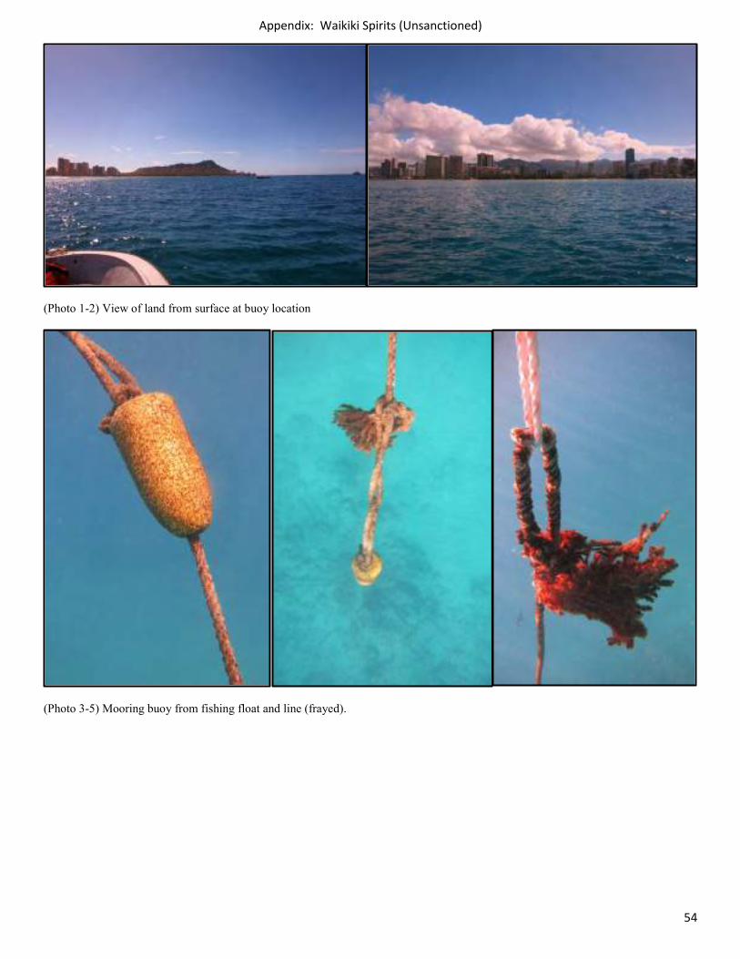
(Photo 1-2) View of land from surface at buoy location
(Photo 3-5) Mooring buoy from fishing float and line (frayed).
Appendix: Waikiki Spirits (Unsanctioned)
55
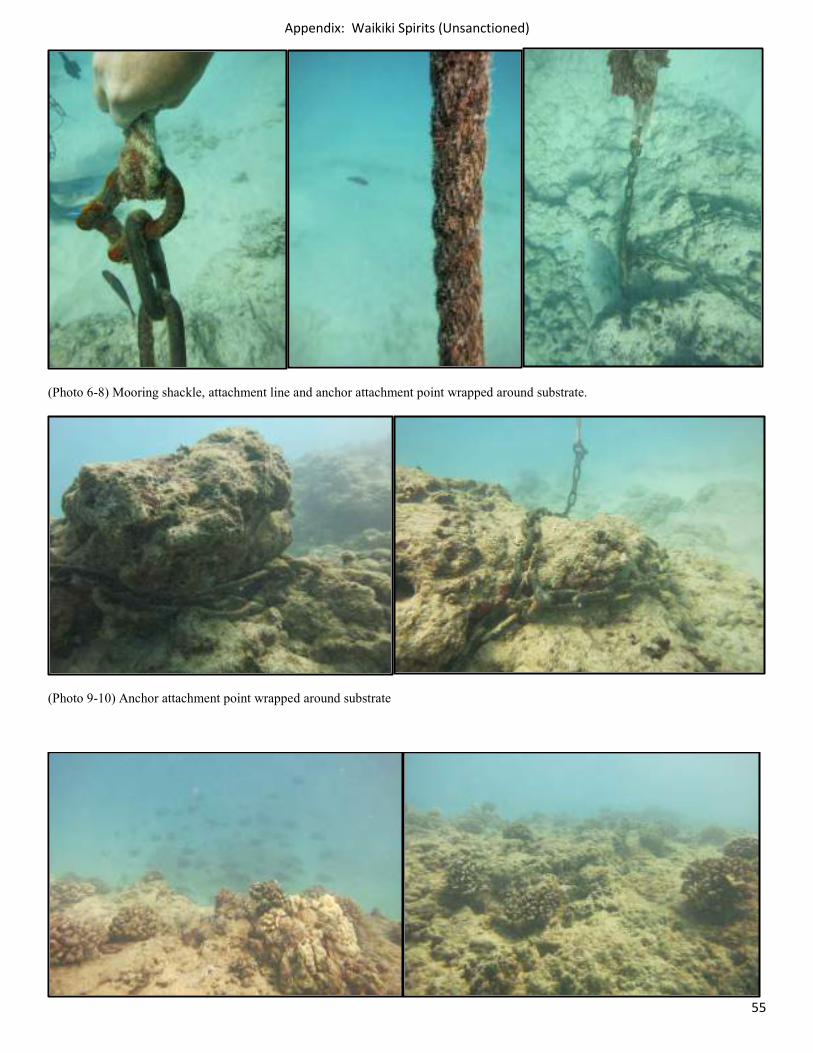
(Photo 6-8) Mooring shackle, attachment line and anchor attachment point wrapped around substrate.
(Photo 9-10) Anchor attachment point wrapped around substrate
Appendix: Waikiki Spirits (Unsanctioned)
56
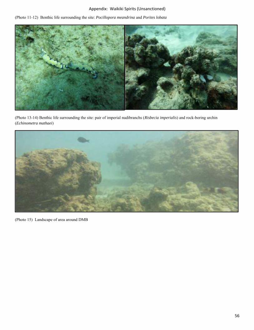
(Photo 11-12) Benthic life surrounding the site: Pocillopora meandrina and Porites lobata
(Photo 13-14) Benthic life surrounding the site: pair of imperial nudibranchs (Risbecia imperialis) and rock-boring urchin (Echinometra mathaei)
(Photo 15) Landscape of area around DMB
Appendix: Waikiki Spirits (Unsanctioned)
57
(Photo 16) Area around DMB.
Buoy Name: Spirits Buoy Depth: 5ft Attachment Point Depth: 27ft
New GPS Coordinates: N 21.27365707 W -157.83904530 Condition: Poor
Unsanctioned/New Location Needed: Yes Replacement Components Needed: Yes
Buoy Intact: No (buoy made of fishing floats) Lines Intact: Yes
Attachment to Ground Intact: No - (Attachment point is chain wrapped around a large rock/dead coral)
Coral Growing on Buoy: No Coral Growing on Attachment Rope: No
1m Coral Head in 10m Radius around Buoy: No Coral Growth Surrounding Buoy: Low
Appendix: Waikiki Aukai (Unsanctioned)
58
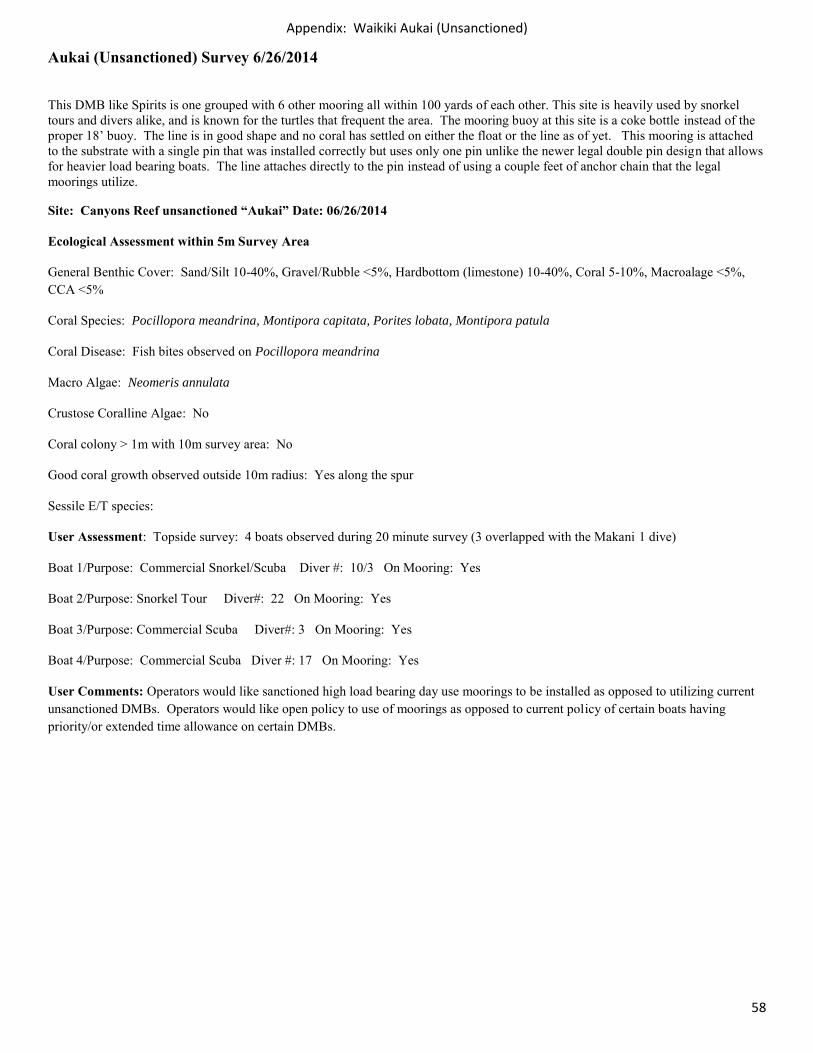
Aukai (Unsanctioned) Survey 6/26/2014
This DMB like Spirits is one grouped with 6 other mooring all within 100 yards of each other. This site is heavily used by snorkel tours and divers alike, and is known for the turtles that frequent the area. The mooring buoy at this site is a coke bottle instead of the proper 18’ buoy. The line is in good shape and no coral has settled on either the float or the line as of yet. This mooring is attached to the substrate with a single pin that was installed correctly but uses only one pin unlike the newer legal double pin design that allows for heavier load bearing boats. The line attaches directly to the pin instead of using a couple feet of anchor chain that the legal moorings utilize.
Site: Canyons Reef unsanctioned “Aukai” Date: 06/26/2014
Ecological Assessment within 5m Survey Area
General Benthic Cover: Sand/Silt 10-40%, Gravel/Rubble <5%, Hardbottom (limestone) 10-40%, Coral 5-10%, Macroalage <5%, CCA <5%
Coral Species: Pocillopora meandrina, Montipora capitata, Porites lobata, Montipora patula
Coral Disease: Fish bites observed on Pocillopora meandrina
Macro Algae: Neomeris annulata
Crustose Coralline Algae: No
Coral colony > 1m with 10m survey area: No
Good coral growth observed outside 10m radius: Yes along the spur
Sessile E/T species:
User Assessment: Topside survey: 4 boats observed during 20 minute survey (3 overlapped with the Makani 1 dive)
Boat 1/Purpose: Commercial Snorkel/Scuba Diver #: 10/3 On Mooring: Yes
Boat 2/Purpose: Snorkel Tour Diver#: 22 On Mooring: Yes
Boat 3/Purpose: Commercial Scuba Diver#: 3 On Mooring: Yes
Boat 4/Purpose: Commercial Scuba Diver #: 17 On Mooring: Yes
User Comments: Operators would like sanctioned high load bearing day use moorings to be installed as opposed to utilizing current unsanctioned DMBs. Operators would like open policy to use of moorings as opposed to current policy of certain boats having priority/or extended time allowance on certain DMBs.
Appendix: Waikiki Aukai (Unsanctioned)
59
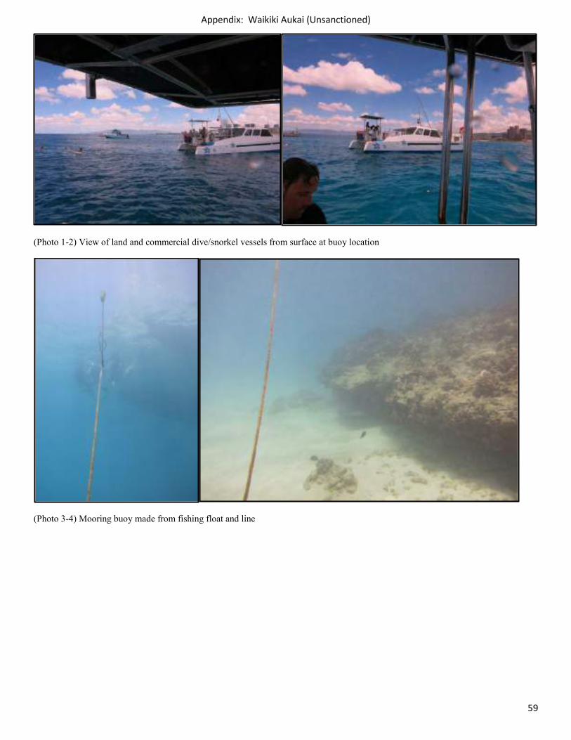
(Photo 1-2) View of land and commercial dive/snorkel vessels from surface at buoy location
(Photo 3-4) Mooring buoy made from fishing float and line
Appendix: Waikiki Aukai (Unsanctioned)
60
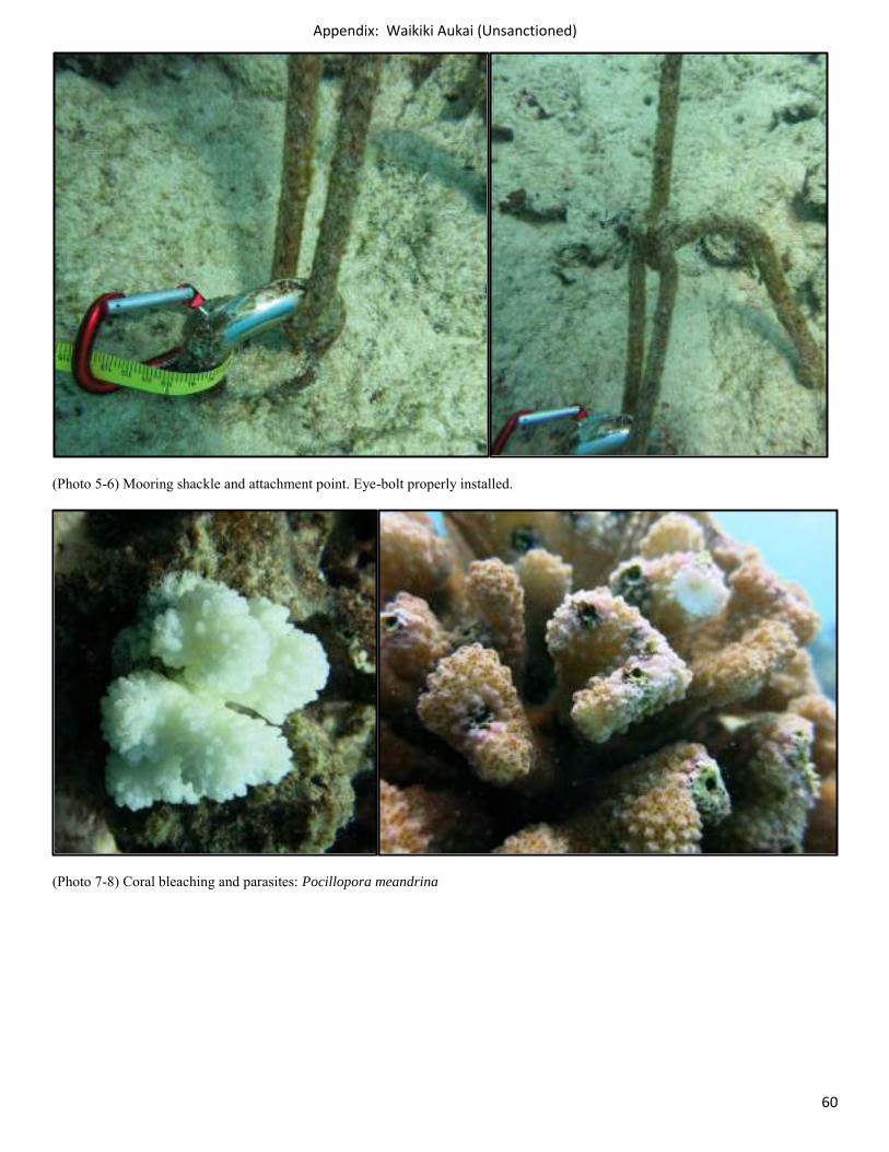
(Photo 5-6) Mooring shackle and attachment point. Eye-bolt properly installed.
(Photo 7-8) Coral bleaching and parasites: Pocillopora meandrina
Appendix: Waikiki Aukai (Unsanctioned)
61
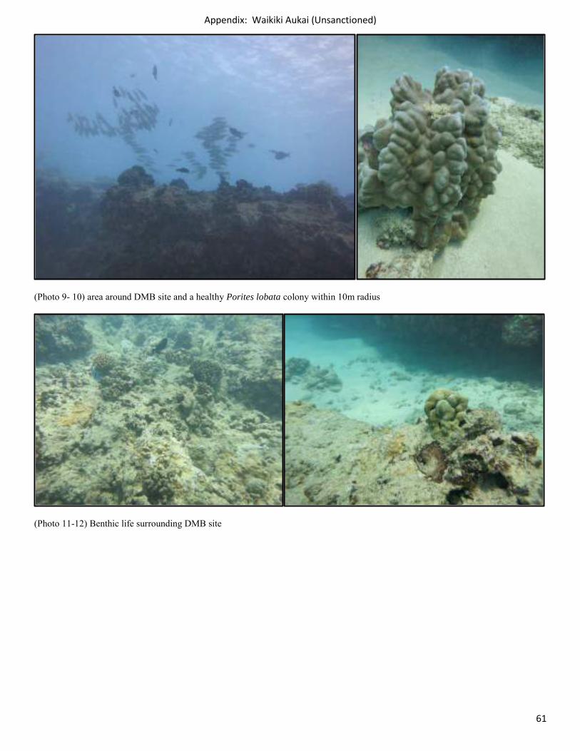
(Photo 9- 10) area around DMB site and a healthy Porites lobata colony within 10m radius
(Photo 11-12) Benthic life surrounding DMB site
Appendix: Waikiki Aukai (Unsanctioned)
62
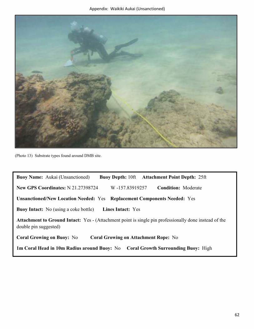
(Photo 13) Substrate types found around DMB site.
Buoy Name: Aukai (Unsanctioned) Buoy Depth: 10ft Attachment Point Depth: 25ft
New GPS Coordinates: N 21.27398724 W -157.83919257 Condition: Moderate
Unsanctioned/New Location Needed: Yes Replacement Components Needed: Yes
Buoy Intact: No (using a coke bottle) Lines Intact: Yes
Attachment to Ground Intact: Yes - (Attachment point is single pin professionally done instead of the double pin suggested)
Coral Growing on Buoy: No Coral Growing on Attachment Rope: No
1m Coral Head in 10m Radius around Buoy: No Coral Growth Surrounding Buoy: High
Appendix: Waikiki Makani 2 (Unsanctioned)
63
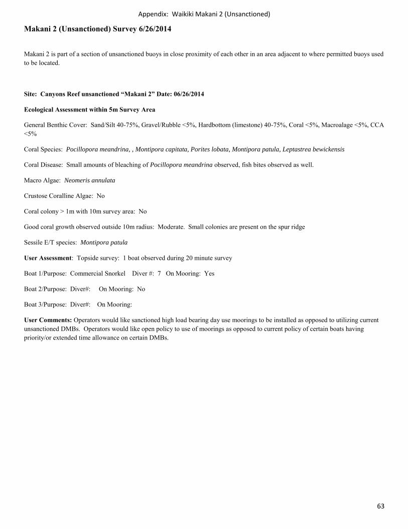
Makani 2 (Unsanctioned) Survey 6/26/2014
Makani 2 is part of a section of unsanctioned buoys in close proximity of each other in an area adjacent to where permitted buoys used to be located.
Site: Canyons Reef unsanctioned “Makani 2” Date: 06/26/2014
Ecological Assessment within 5m Survey Area
General Benthic Cover: Sand/Silt 40-75%, Gravel/Rubble <5%, Hardbottom (limestone) 40-75%, Coral <5%, Macroalage <5%, CCA <5%
Coral Species: Pocillopora meandrina, , Montipora capitata, Porites lobata, Montipora patula, Leptastrea bewickensis
Coral Disease: Small amounts of bleaching of Pocillopora meandrina observed, fish bites observed as well.
Macro Algae: Neomeris annulata
Crustose Coralline Algae: No
Coral colony > 1m with 10m survey area: No
Good coral growth observed outside 10m radius: Moderate. Small colonies are present on the spur ridge
Sessile E/T species: Montipora patula
User Assessment: Topside survey: 1 boat observed during 20 minute survey
Boat 1/Purpose: Commercial Snorkel Diver #: 7 On Mooring: Yes
Boat 2/Purpose: Diver#: On Mooring: No
Boat 3/Purpose: Diver#: On Mooring:
User Comments: Operators would like sanctioned high load bearing day use moorings to be installed as opposed to utilizing current unsanctioned DMBs. Operators would like open policy to use of moorings as opposed to current policy of certain boats having priority/or extended time allowance on certain DMBs.
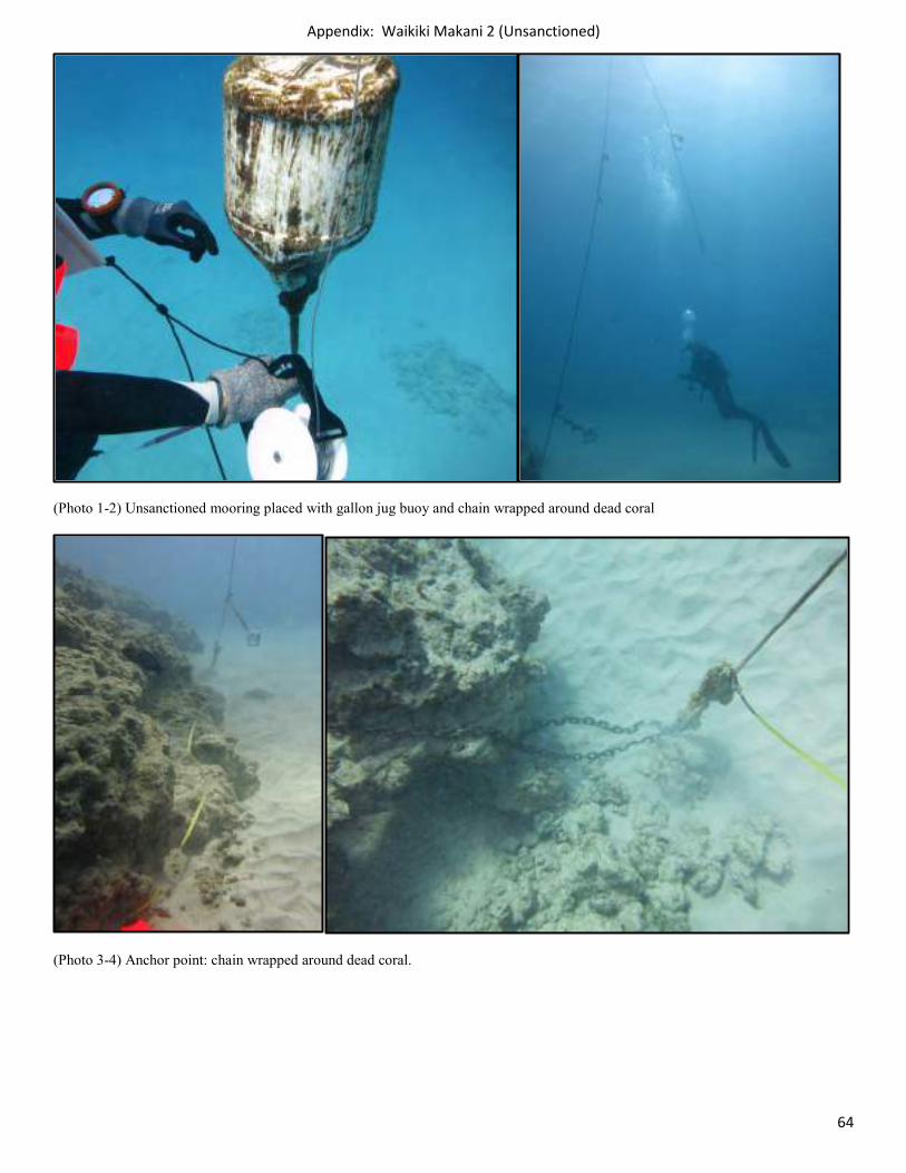
Appendix: Waikiki Makani 2 (Unsanctioned)
64
(Photo 1-2) Unsanctioned mooring placed with gallon jug buoy and chain wrapped around dead coral
(Photo 3-4) Anchor point: chain wrapped around dead coral.
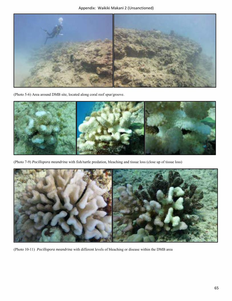
Appendix: Waikiki Makani 2 (Unsanctioned)
65
(Photo 5-6) Area around DMB site, located along coral reef spur/groove.
(Photo 7-9) Pocillopora meandrina with fish/turtle predation, bleaching and tissue loss (close up of tissue loss)
(Photo 10-11) Pocillopora meandrina with different levels of bleaching or disease within the DMB area
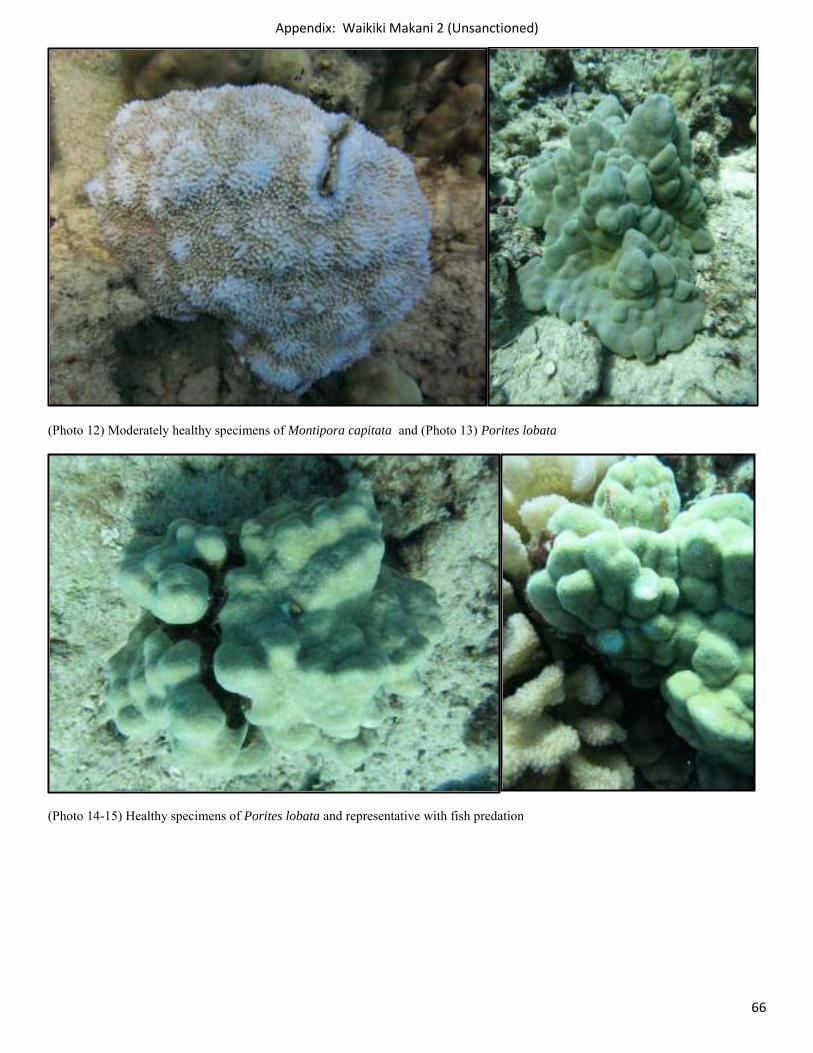
Appendix: Waikiki Makani 2 (Unsanctioned)
66
(Photo 12) Moderately healthy specimens of Montipora capitata and (Photo 13) Porites lobata
(Photo 14-15) Healthy specimens of Porites lobata and representative with fish predation
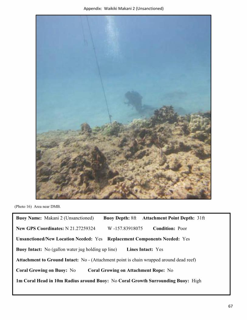
Appendix: Waikiki Makani 2 (Unsanctioned)
67
(Photo 16) Area near DMB.
Buoy Name: Makani 2 (Unsanctioned) Buoy Depth: 8ft Attachment Point Depth: 31ft
New GPS Coordinates: N 21.27259324 W -157.83918075 Condition: Poor
Unsanctioned/New Location Needed: Yes Replacement Components Needed: Yes
Buoy Intact: No (gallon water jug holding up line) Lines Intact: Yes
Attachment to Ground Intact: No - (Attachment point is chain wrapped around dead reef)
Coral Growing on Buoy: No Coral Growing on Attachment Rope: No
1m Coral Head in 10m Radius around Buoy: No Coral Growth Surrounding Buoy: High
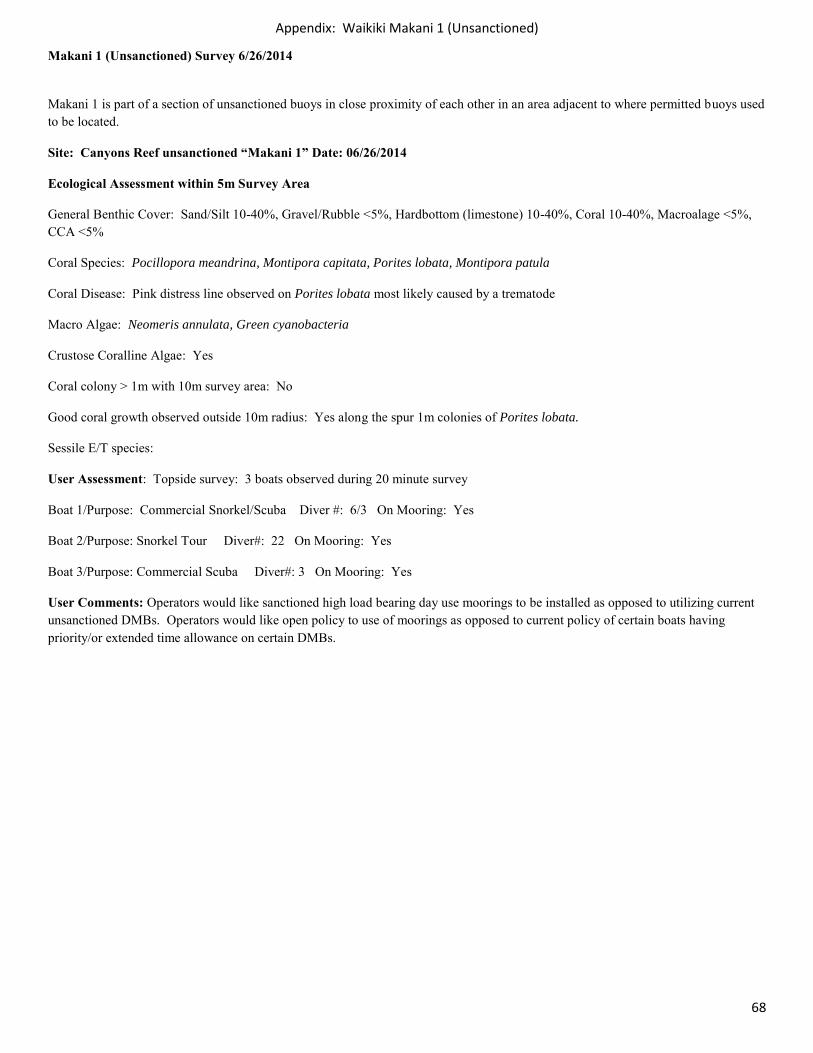
Appendix: Waikiki Makani 1 (Unsanctioned)
68
Makani 1 (Unsanctioned) Survey 6/26/2014
Makani 1 is part of a section of unsanctioned buoys in close proximity of each other in an area adjacent to where permitted buoys used to be located.
Site: Canyons Reef unsanctioned “Makani 1” Date: 06/26/2014
Ecological Assessment within 5m Survey Area
General Benthic Cover: Sand/Silt 10-40%, Gravel/Rubble <5%, Hardbottom (limestone) 10-40%, Coral 10-40%, Macroalage <5%, CCA <5%
Coral Species: Pocillopora meandrina, Montipora capitata, Porites lobata, Montipora patula
Coral Disease: Pink distress line observed on Porites lobata most likely caused by a trematode
Macro Algae: Neomeris annulata, Green cyanobacteria
Crustose Coralline Algae: Yes
Coral colony > 1m with 10m survey area: No
Good coral growth observed outside 10m radius: Yes along the spur 1m colonies of Porites lobata.
Sessile E/T species:
User Assessment: Topside survey: 3 boats observed during 20 minute survey
Boat 1/Purpose: Commercial Snorkel/Scuba Diver #: 6/3 On Mooring: Yes
Boat 2/Purpose: Snorkel Tour Diver#: 22 On Mooring: Yes
Boat 3/Purpose: Commercial Scuba Diver#: 3 On Mooring: Yes
User Comments: Operators would like sanctioned high load bearing day use moorings to be installed as opposed to utilizing current unsanctioned DMBs. Operators would like open policy to use of moorings as opposed to current policy of certain boats having priority/or extended time allowance on certain DMBs.
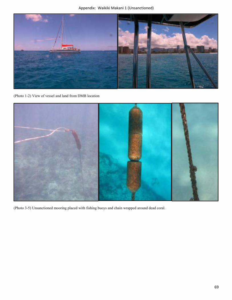
Appendix: Waikiki Makani 1 (Unsanctioned)
69
(Photo 1-2) View of vessel and land from DMB location
(Photo 3-5) Unsanctioned mooring placed with fishing buoys and chain wrapped around dead coral.
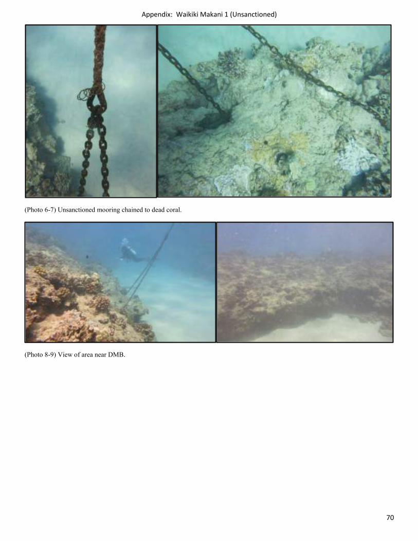
Appendix: Waikiki Makani 1 (Unsanctioned)
70
(Photo 6-7) Unsanctioned mooring chained to dead coral.
(Photo 8-9) View of area near DMB.
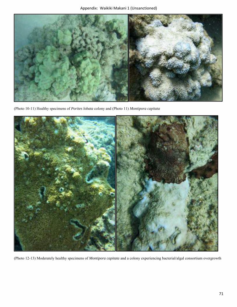
Appendix: Waikiki Makani 1 (Unsanctioned)
71
(Photo 10-11) Healthy specimens of Porites lobata colony and (Photo 11) Montipora capitata
(Photo 12-13) Moderately healthy specimens of Montipora capitata and a colony experiencing bacterial/algal consortium overgrowth
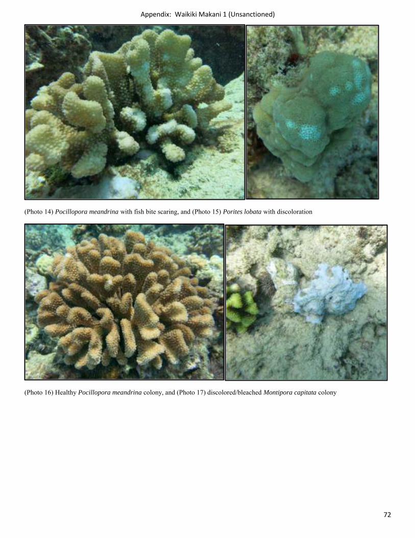
Appendix: Waikiki Makani 1 (Unsanctioned)
72
(Photo 14) Pocillopora meandrina with fish bite scaring, and (Photo 15) Porites lobata with discoloration
(Photo 16) Healthy Pocillopora meandrina colony, and (Photo 17) discolored/bleached Montipora capitata colony
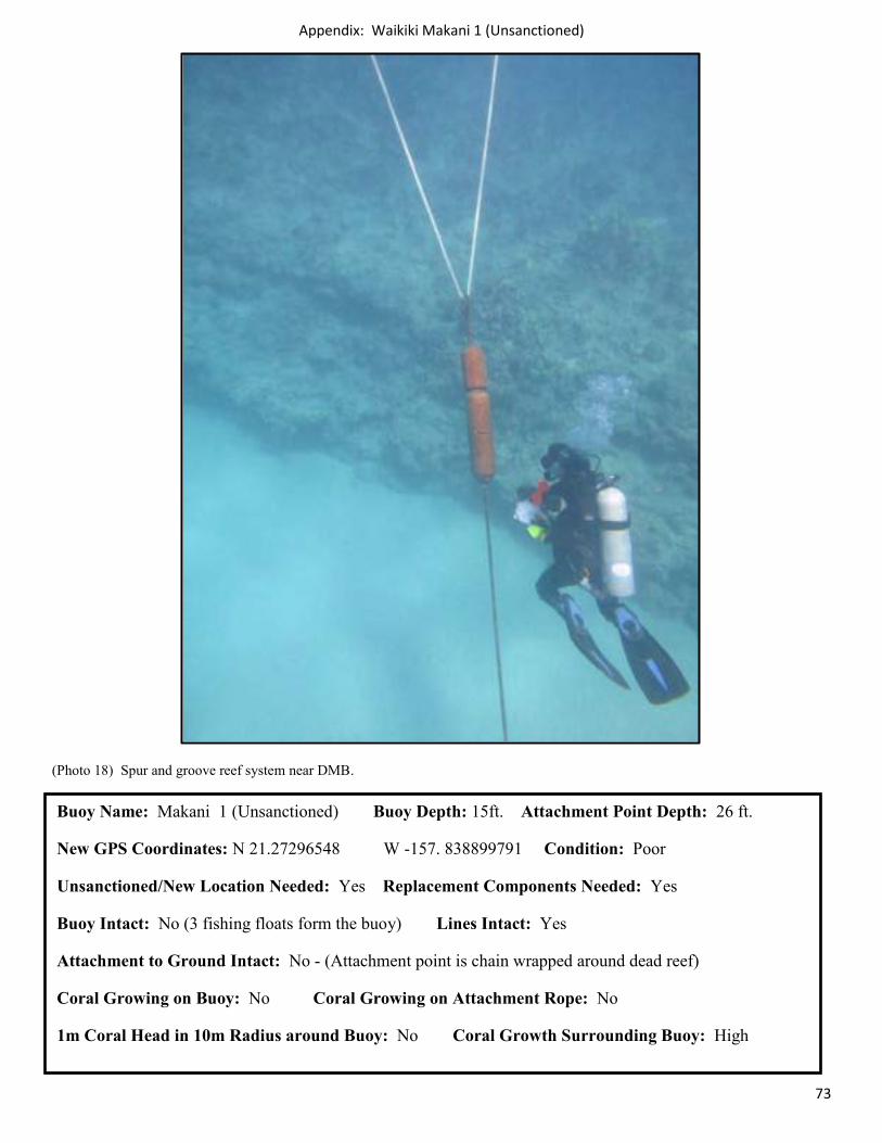
Appendix: Waikiki Makani 1 (Unsanctioned)
73
(Photo 18) Spur and groove reef system near DMB.
Buoy Name: Makani 1 (Unsanctioned) Buoy Depth: 15ft. Attachment Point Depth: 26 ft.
New GPS Coordinates: N 21.27296548 W -157. 838899791 Condition: Poor
Unsanctioned/New Location Needed: Yes Replacement Components Needed: Yes
Buoy Intact: No (3 fishing floats form the buoy) Lines Intact: Yes
Attachment to Ground Intact: No - (Attachment point is chain wrapped around dead reef)
Coral Growing on Buoy: No Coral Growing on Attachment Rope: No
1m Coral Head in 10m Radius around Buoy: No Coral Growth Surrounding Buoy: High
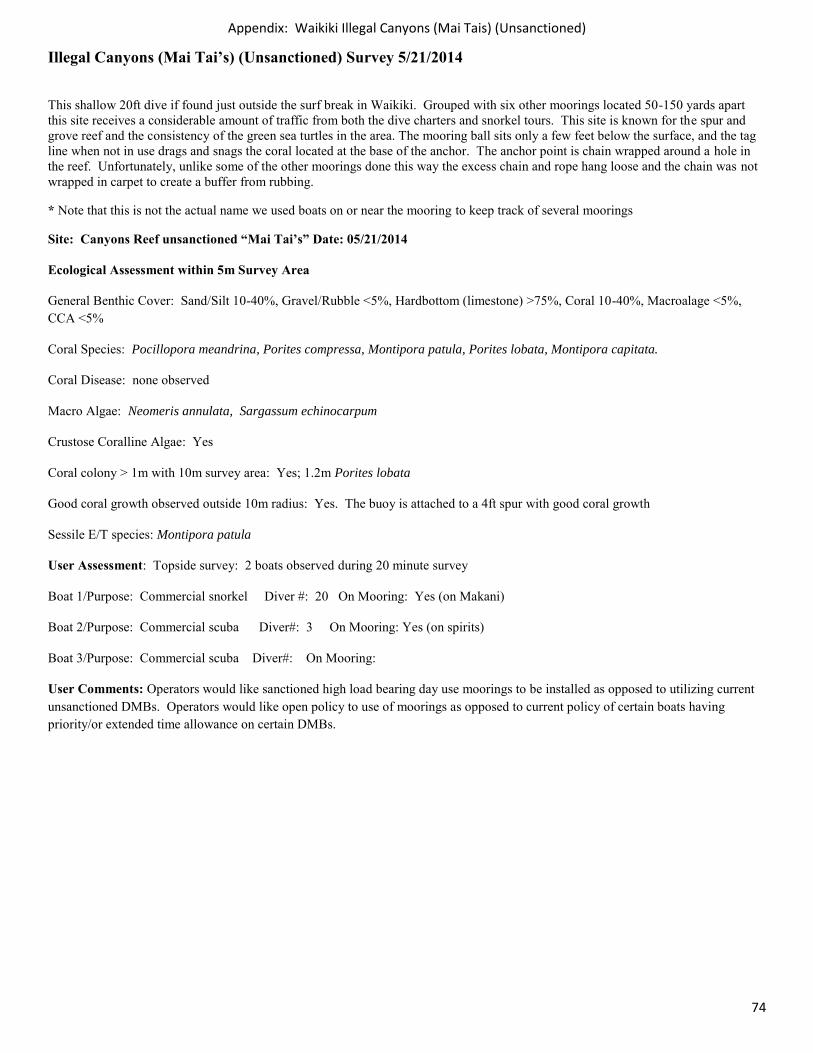
Appendix: Waikiki Illegal Canyons (Mai Tais) (Unsanctioned)
74
Illegal Canyons (Mai Tai’s) (Unsanctioned) Survey 5/21/2014
This shallow 20ft dive if found just outside the surf break in Waikiki. Grouped with six other moorings located 50-150 yards apart this site receives a considerable amount of traffic from both the dive charters and snorkel tours. This site is known for the spur and grove reef and the consistency of the green sea turtles in the area. The mooring ball sits only a few feet below the surface, and the tag line when not in use drags and snags the coral located at the base of the anchor. The anchor point is chain wrapped around a hole in the reef. Unfortunately, unlike some of the other moorings done this way the excess chain and rope hang loose and the chain was not wrapped in carpet to create a buffer from rubbing.
* Note that this is not the actual name we used boats on or near the mooring to keep track of several moorings
Site: Canyons Reef unsanctioned “Mai Tai’s” Date: 05/21/2014
Ecological Assessment within 5m Survey Area
General Benthic Cover: Sand/Silt 10-40%, Gravel/Rubble <5%, Hardbottom (limestone) >75%, Coral 10-40%, Macroalage <5%, CCA <5%
Coral Species: Pocillopora meandrina, Porites compressa, Montipora patula, Porites lobata, Montipora capitata.
Coral Disease: none observed
Macro Algae: Neomeris annulata, Sargassum echinocarpum
Crustose Coralline Algae: Yes
Coral colony > 1m with 10m survey area: Yes; 1.2m Porites lobata
Good coral growth observed outside 10m radius: Yes. The buoy is attached to a 4ft spur with good coral growth
Sessile E/T species: Montipora patula
User Assessment: Topside survey: 2 boats observed during 20 minute survey
Boat 1/Purpose: Commercial snorkel Diver #: 20 On Mooring: Yes (on Makani)
Boat 2/Purpose: Commercial scuba Diver#: 3 On Mooring: Yes (on spirits)
Boat 3/Purpose: Commercial scuba Diver#: On Mooring:
User Comments: Operators would like sanctioned high load bearing day use moorings to be installed as opposed to utilizing current unsanctioned DMBs. Operators would like open policy to use of moorings as opposed to current policy of certain boats having priority/or extended time allowance on certain DMBs.
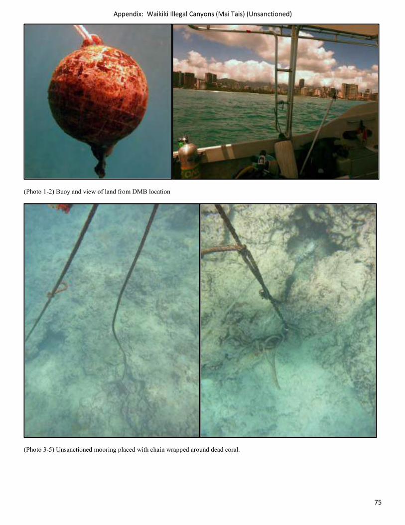
Appendix: Waikiki Illegal Canyons (Mai Tais) (Unsanctioned)
75
(Photo 1-2) Buoy and view of land from DMB location
(Photo 3-5) Unsanctioned mooring placed with chain wrapped around dead coral.
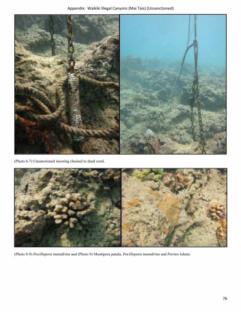
Appendix: Waikiki Illegal Canyons (Mai Tais) (Unsanctioned)
76
(Photo 6-7) Unsanctioned mooring chained to dead coral.
(Photo 8-9) Pocillopora meandrina and (Photo 9) Montipora patula, Pocillopora meandrina and Porites lobata
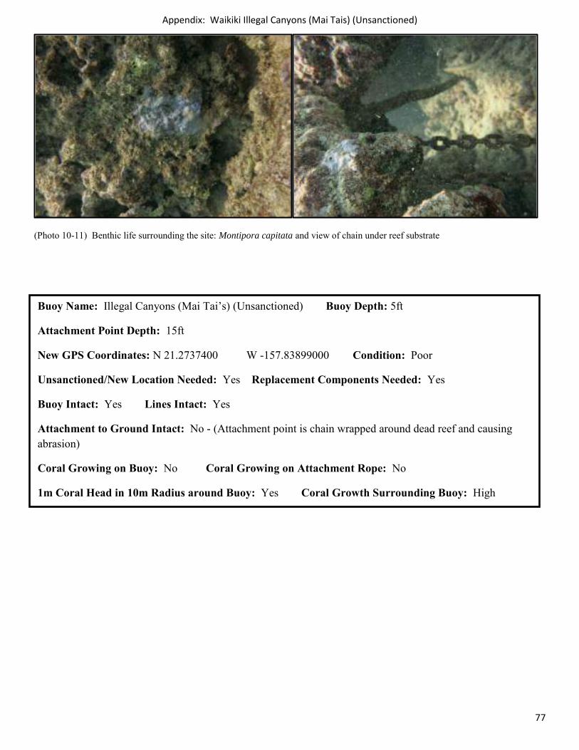
Appendix: Waikiki Illegal Canyons (Mai Tais) (Unsanctioned)
77
(Photo 10-11) Benthic life surrounding the site: Montipora capitata and view of chain under reef substrate
Buoy Name: Illegal Canyons (Mai Tai’s) (Unsanctioned) Buoy Depth: 5ft
Attachment Point Depth: 15ft
New GPS Coordinates: N 21.2737400 W -157.83899000 Condition: Poor
Unsanctioned/New Location Needed: Yes Replacement Components Needed: Yes
Buoy Intact: Yes Lines Intact: Yes
Attachment to Ground Intact: No - (Attachment point is chain wrapped around dead reef and causing abrasion)
Coral Growing on Buoy: No Coral Growing on Attachment Rope: No
1m Coral Head in 10m Radius around Buoy: Yes Coral Growth Surrounding Buoy: High
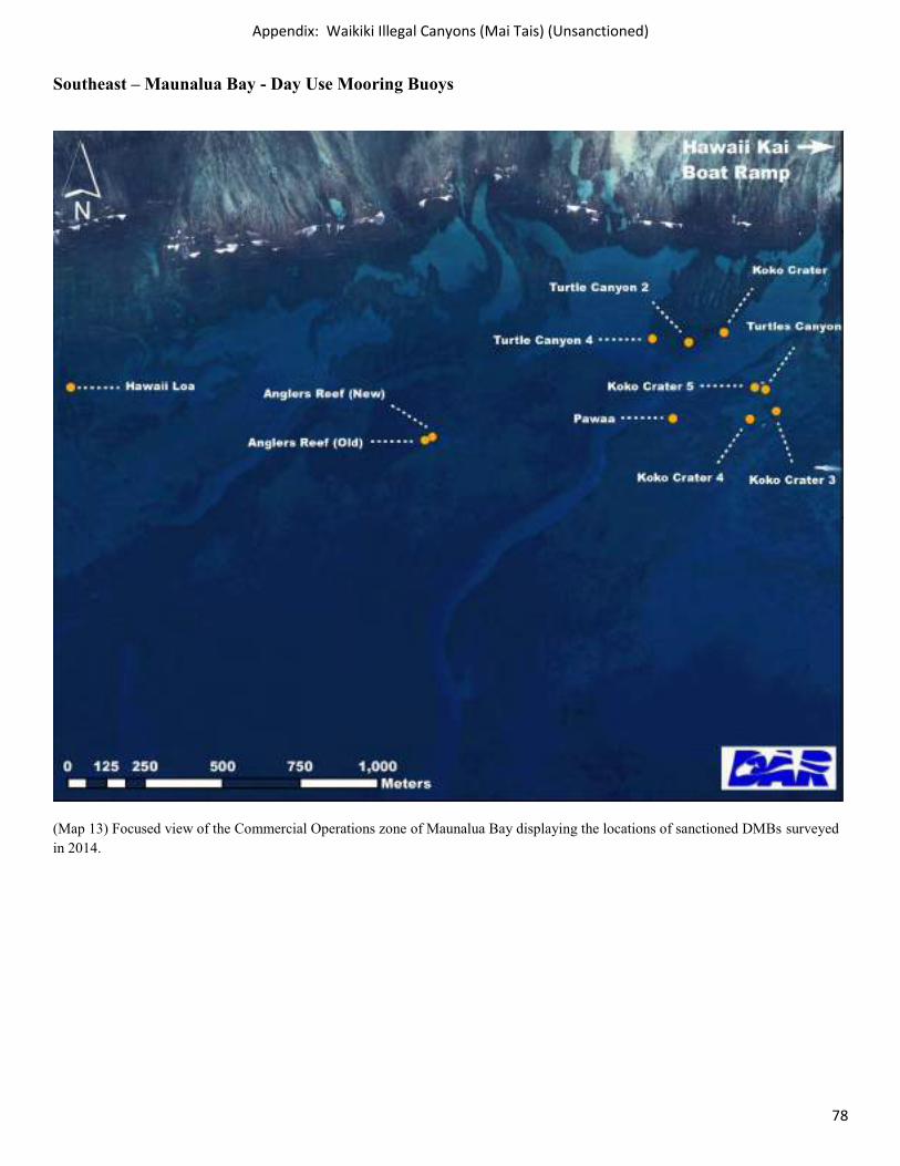
Appendix: Waikiki Illegal Canyons (Mai Tais) (Unsanctioned)
78
Southeast – Maunalua Bay - Day Use Mooring Buoys
(Map 13) Focused view of the Commercial Operations zone of Maunalua Bay displaying the locations of sanctioned DMBs surveyed in 2014.
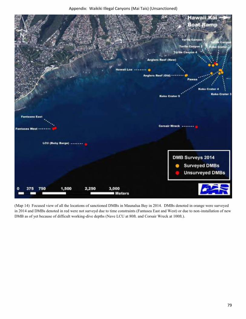
Appendix: Waikiki Illegal Canyons (Mai Tais) (Unsanctioned)
79
(Map 14) Focused view of all the locations of sanctioned DMBs in Maunalua Bay in 2014. DMBs denoted in orange were surveyed in 2014 and DMBs denoted in red were not surveyd due to time constraints (Fantasea East and West) or due to non-installation of new DMB as of yet because of difficult working-dive depths (Nave LCU at 80ft. and Corsair Wreck at 100ft.).
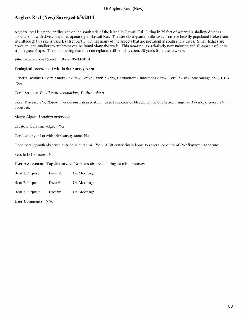
SE Anglers Reef (New)
80
Anglers Reef (New) Surveyed 6/3/2014
Anglers’ reef is a popular dive site on the south side of the island in Hawaii Kai. Sitting in 35 feet of water this shallow dive is a popular spot with dive companies operating in Hawaii Kai. The site sits a quarter mile away from the heavily populated Koko crater site although this site is used less frequently, but has many of the aspects that are prevalent in south shore dives. Small ledges are prevalent and smaller invertebrates can be found along the walls. This mooring is a relatively new mooring and all aspects of it are still in great shape. The old mooring that this one replaces still remains about 50 yards from the new one.
Site: Anglers Reef (new) Date: 06/03/2014
Ecological Assessment within 5m Survey Area
General Benthic Cover: Sand/Silt >75%, Gravel/Rubble <5%, Hardbottom (limestone) >75%, Coral 5-10%, Macroalage <5%, CCA <5%
Coral Species: Pocillopora meandrina, Porites lobata.
Coral Disease: Pocillopora meandrina fish predation. Small amounts of bleaching and one broken finger of Pocillopora meandrina observed.
Macro Algae: Lyngbya majuscula
Crustose Coralline Algae: Yes
Coral colony > 1m with 10m survey area: No
Good coral growth observed outside 10m radius: Yes. A 3ft crater rim is home to several colonies of Pocillopora meandrina.
Sessile E/T species: No
User Assessment: Topside survey: No boats observed during 20 minute survey
Boat 1/Purpose: Diver #: On Mooring:
Boat 2/Purpose: Diver#: On Mooring:
Boat 3/Purpose: Diver#: On Mooring:
User Comments: N/A
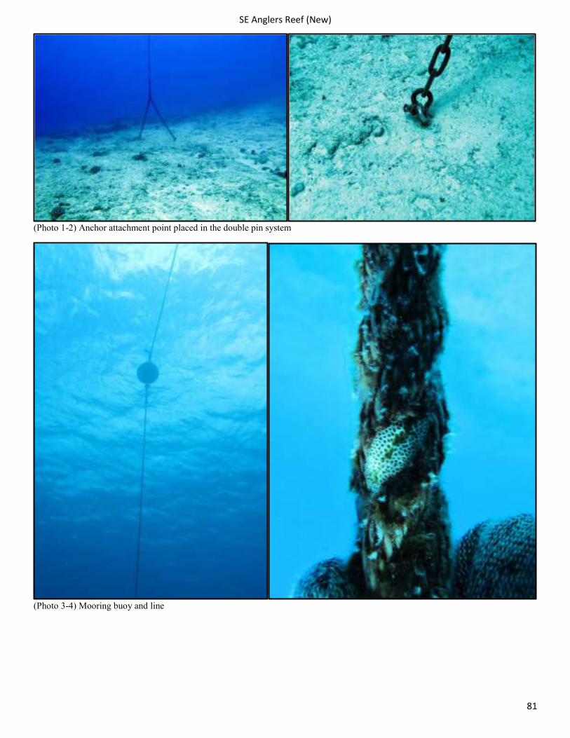
SE Anglers Reef (New)
81
(Photo 1-2) Anchor attachment point placed in the double pin system
(Photo 3-4) Mooring buoy and line
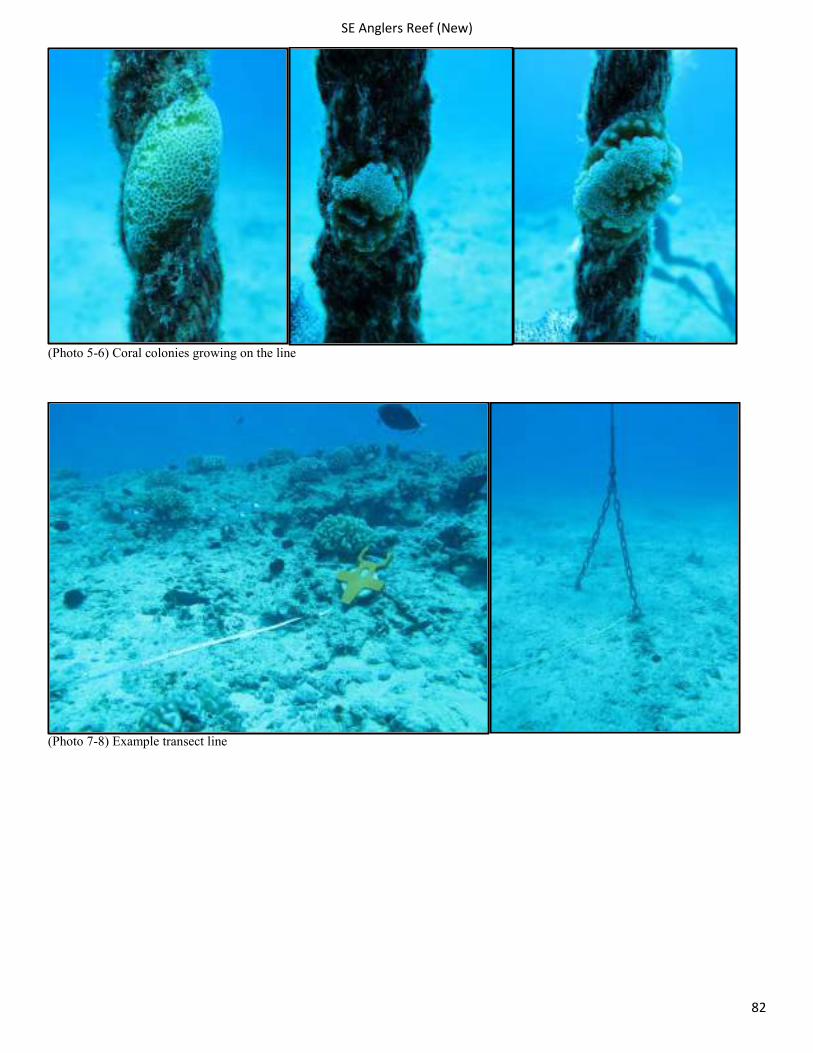
SE Anglers Reef (New)
82
(Photo 5-6) Coral colonies growing on the line
(Photo 7-8) Example transect line
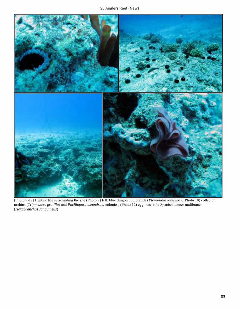
SE Anglers Reef (New)
83
(Photo 9-12) Benthic life surrounding the site (Photo 9) left: blue dragon nudibranch (Ptereolidia ianthina), (Photo 10) collector urchins (Tripneustes gratilla) and Pocillopora meandrina colonies, (Photo 12) egg mass of a Spanish dancer nudibranch (Hexabranchus sanguineus)
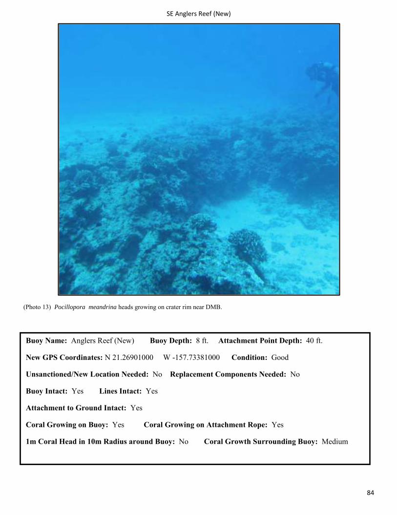
SE Anglers Reef (New)
84
(Photo 13) Pocillopora meandrina heads growing on crater rim near DMB.
Buoy Name: Anglers Reef (New) Buoy Depth: 8 ft. Attachment Point Depth: 40 ft.
New GPS Coordinates: N 21.26901000 W -157.73381000 Condition: Good
Unsanctioned/New Location Needed: No Replacement Components Needed: No
Buoy Intact: Yes Lines Intact: Yes
Attachment to Ground Intact: Yes
Coral Growing on Buoy: Yes Coral Growing on Attachment Rope: Yes
1m Coral Head in 10m Radius around Buoy: No Coral Growth Surrounding Buoy: Medium
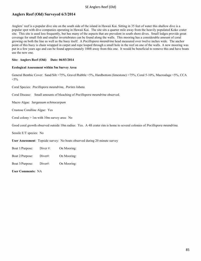
SE Anglers Reef (Old)
85
Anglers Reef (Old) Surveyed 6/3/2014
Anglers’ reef is a popular dive site on the south side of the island in Hawaii Kai. Sitting in 35 feet of water this shallow dive is a popular spot with dive companies operating in Hawaii Kai. The site sits a quarter mile away from the heavily populated Koko crater site. This site is used less frequently, but has many of the aspects that are prevalent in south shore dives. Small ledges provide great coverage for small fish and smaller invertebrates can be found along the walls. This mooring has a considerable amount of coral growing on both the line as well as the buoy itself. A Pocillopora meandrina head measured over twelve inches wide. The anchor point of this buoy is chain wrapped in carpet and rope looped through a small hole in the reef on one of the walls. A new mooring was put in a few years ago and can be found approximately 100ft away from this one. It would be beneficial to remove this and have boats use the new one.
Site: Anglers Reef (Old) Date: 06/03/2014
Ecological Assessment within 5m Survey Area
General Benthic Cover: Sand/Silt >75%, Gravel/Rubble <5%, Hardbottom (limestone) >75%, Coral 5-10%, Macroalage <5%, CCA <5%
Coral Species: Pocillopora meandrina, Porites lobata.
Coral Disease: Small amounts of bleaching of Pocillopora meandrina observed.
Macro Algae: Sargassum echinocarpum
Crustose Coralline Algae: Yes
Coral colony > 1m with 10m survey area: No
Good coral growth observed outside 10m radius: Yes. A 4ft crater rim is home to several colonies of Pocillopora meandrina.
Sessile E/T species: No
User Assessment: Topside survey: No boats observed during 20 minute survey
Boat 1/Purpose: Diver #: On Mooring:
Boat 2/Purpose: Diver#: On Mooring:
Boat 3/Purpose: Diver#: On Mooring:
User Comments: NA
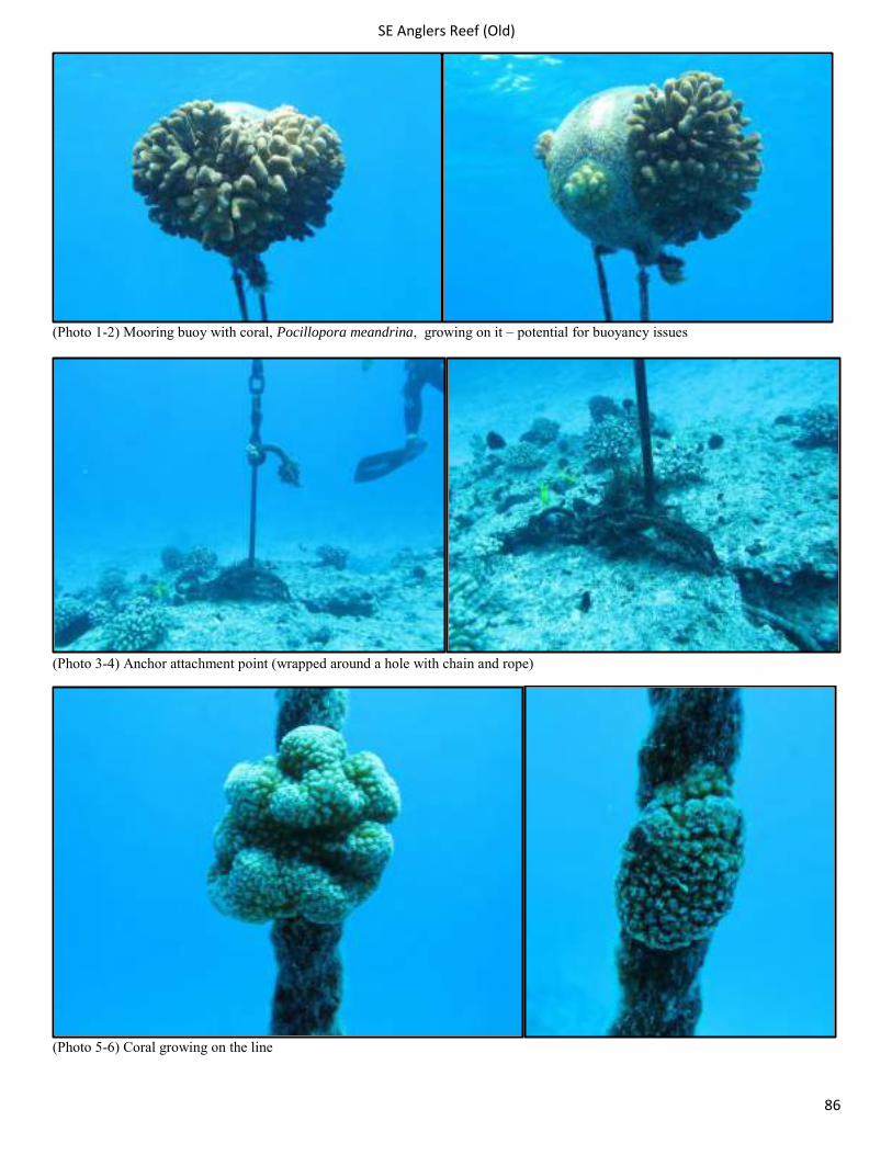
SE Anglers Reef (Old)
86
(Photo 1-2) Mooring buoy with coral, Pocillopora meandrina, growing on it – potential for buoyancy issues
(Photo 3-4) Anchor attachment point (wrapped around a hole with chain and rope)
(Photo 5-6) Coral growing on the line
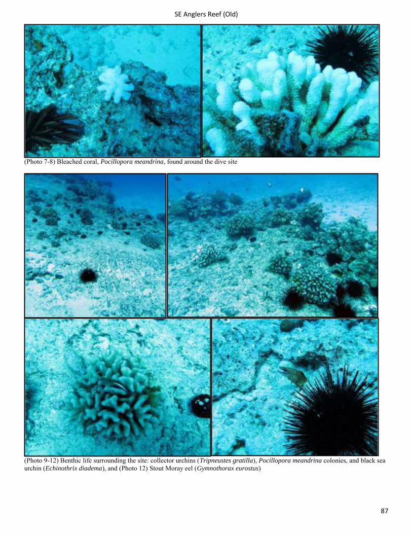
SE Anglers Reef (Old)
87
(Photo 7-8) Bleached coral, Pocillopora meandrina, found around the dive site
(Photo 9-12) Benthic life surrounding the site: collector urchins (Tripneustes gratilla), Pocillopora meandrina colonies, and black sea urchin (Echinothrix diadema), and (Photo 12) Stout Moray eel (Gymnothorax eurostus)
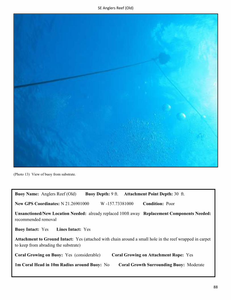
SE Anglers Reef (Old)
88
(Photo 13) View of buoy from substrate.
Buoy Name: Anglers Reef (Old) Buoy Depth: 9 ft. Attachment Point Depth: 30 ft.
New GPS Coordinates: N 21.26901000 W -157.73381000 Condition: Poor
Unsanctioned/New Location Needed: already replaced 100ft away Replacement Components Needed: recommended removal
Buoy Intact: Yes Lines Intact: Yes
Attachment to Ground Intact: Yes (attached with chain around a small hole in the reef wrapped in carpet to keep from abrading the substrate)
Coral Growing on Buoy: Yes (considerable) Coral Growing on Attachment Rope: Yes
1m Coral Head in 10m Radius around Buoy: No Coral Growth Surrounding Buoy: Moderate
SE Hawaii Loa
89
Hawaii Loa Surveyed 7/1/2014
Located two miles from the Hawaii Kai Harbor in 30ft of water this site receives traffic frequently but not as steadily as Koko Craters. Small encrusting coral has begun growing on the buoy but still remains relatively small. There is very little coral growing on the rope compared to other sites surveyed. The two anchor pins and chain remain intact. The area surrounding the site has several small mounds of coral that periodically occur. Within the 5m area there is a Porites lobata head that if considered one colony measures 1m.
Site: Hawaii Loa Date: 07/01/2014
Ecological Assessment within 5m Survey Area
General Benthic Cover: Sand/Silt 10-40%, Gravel/Rubble 10-40%, Hardbottom (limestone) 40-75%, Coral 10-40%, CCA 10-40%,%, Macroalage <5%
Coral Species: Pocillopora meandrina, Porites compressa, Montipora patula, Montipora capitata, Leptastrea bewickensis
Coral Disease: Kahe crab parasitism on Pocillopora meandrina and small amounts of bleaching in Pocillopora meandrina
Macro Algae: Lyngbya majuscula
Crustose Coralline Algae: Yes
Coral colony > 1m with 10m survey area: Possibly (3 large coral formations that may be made up of several colonies)
Good coral growth observed outside 10m radius: Yes. Gradual 2-3ft rises and drops.
Sessile E/T species: Montipora patula
User Assessment: Topside survey: No boats moored during the 20 minute survey. A 1 man kayak went by but did not stop.
Boat 1/Purpose: Diver #: On Mooring:
Boat 2/Purpose: Diver#: On Mooring:
Boat 3/Purpose: Diver#: On Mooring:
User Comments:
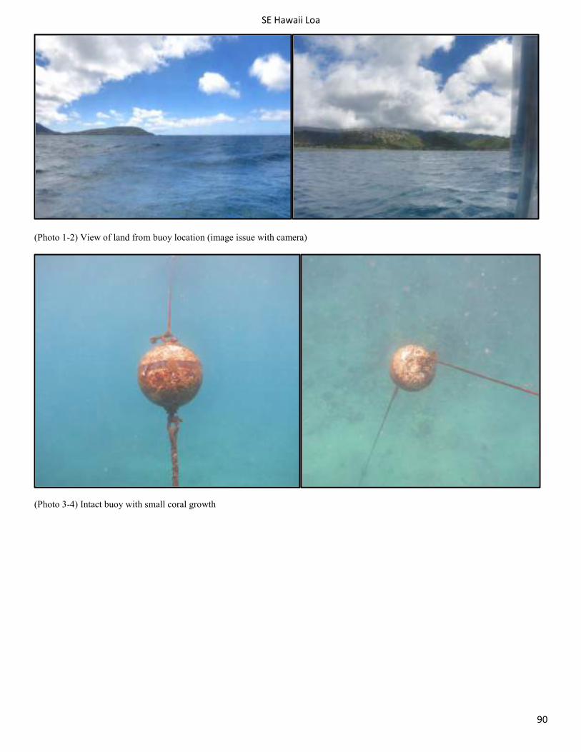
SE Hawaii Loa
90
(Photo 1-2) View of land from buoy location (image issue with camera)
(Photo 3-4) Intact buoy with small coral growth
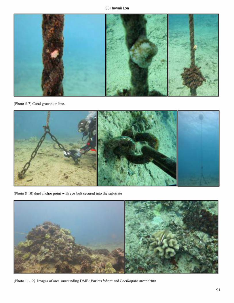
SE Hawaii Loa
91
(Photo 5-7) Coral growth on line.
(Photo 8-10) duel anchor point with eye-bolt secured into the substrate
(Photo 11-12) Images of area surrounding DMB: Porites lobata and Pocillopora meandrina
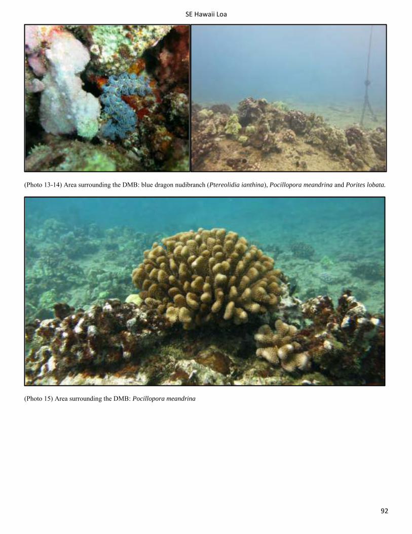
SE Hawaii Loa
92
(Photo 13-14) Area surrounding the DMB: blue dragon nudibranch (Ptereolidia ianthina), Pocillopora meandrina and Porites lobata.
(Photo 15) Area surrounding the DMB: Pocillopora meandrina
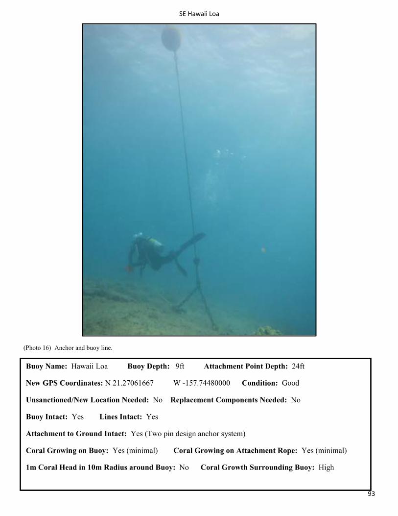
SE Hawaii Loa
93
(Photo 16) Anchor and buoy line.
Buoy Name: Hawaii Loa Buoy Depth: 9ft Attachment Point Depth: 24ft
New GPS Coordinates: N 21.27061667 W -157.74480000 Condition: Good
Unsanctioned/New Location Needed: No Replacement Components Needed: No
Buoy Intact: Yes Lines Intact: Yes
Attachment to Ground Intact: Yes (Two pin design anchor system)
Coral Growing on Buoy: Yes (minimal) Coral Growing on Attachment Rope: Yes (minimal)
1m Coral Head in 10m Radius around Buoy: No Coral Growth Surrounding Buoy: High
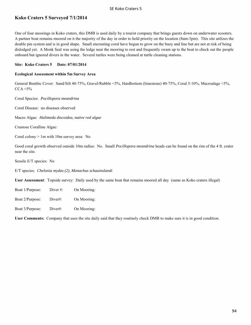
SE Koko Craters 5
94
Koko Craters 5 Surveyed 7/1/2014
One of four moorings in Koko craters, this DMB is used daily by a tourist company that brings guests down on underwater scooters. A partner boat remains moored on it the majority of the day in order to hold priority on the location (8am-3pm). This site utilizes the double pin system and is in good shape. Small encrusting coral have begun to grow on the buoy and line but are not at risk of being dislodged yet. A Monk Seal was using the ledge near the mooring to rest and frequently swam up to the boat to check out the people onboard but ignored divers in the water. Several turtles were being cleaned at turtle cleaning stations.
Site: Koko Craters 5 Date: 07/01/2014
Ecological Assessment within 5m Survey Area
General Benthic Cover: Sand/Silt 40-75%, Gravel/Rubble <5%, Hardbottom (limestone) 40-75%, Coral 5-10%, Macroalage <5%, CCA <5%
Coral Species: Pocillopora meandrina
Coral Disease: no diseases observed
Macro Algae: Halimeda discoidea, native red algae
Crustose Coralline Algae:
Coral colony > 1m with 10m survey area: No
Good coral growth observed outside 10m radius: No. Small Pocillopora meandrina heads can be found on the rim of the 4 ft. crater near the site.
Sessile E/T species: No
E/T species: Chelonia mydas (2), Monachus schauinslandi
User Assessment: Topside survey: Daily used by the same boat that remains moored all day (same as Koko craters illegal)
Boat 1/Purpose: Diver #: On Mooring:
Boat 2/Purpose: Diver#: On Mooring:
Boat 3/Purpose: Diver#: On Mooring:
User Comments: Company that uses the site daily said that they routinely check DMB to make sure it is in good condition.
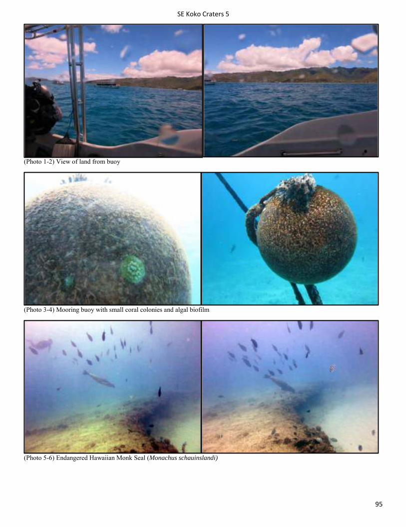
SE Koko Craters 5
95
(Photo 1-2) View of land from buoy
(Photo 3-4) Mooring buoy with small coral colonies and algal biofilm
(Photo 5-6) Endangered Hawaiian Monk Seal (Monachus schauinslandi)
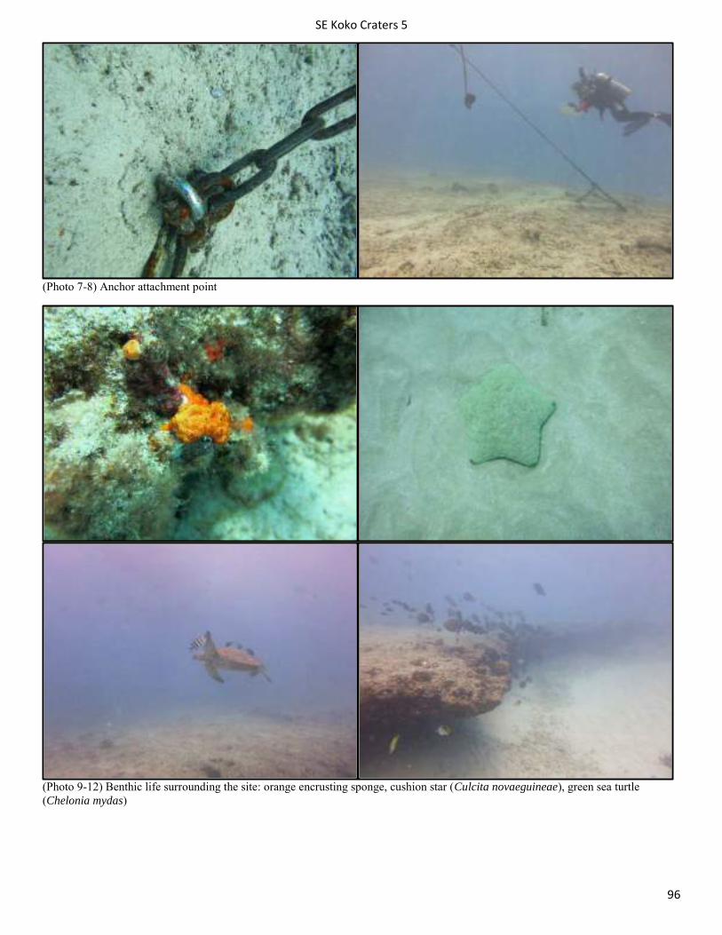
SE Koko Craters 5
96
(Photo 7-8) Anchor attachment point
(Photo 9-12) Benthic life surrounding the site: orange encrusting sponge, cushion star (Culcita novaeguineae), green sea turtle (Chelonia mydas)
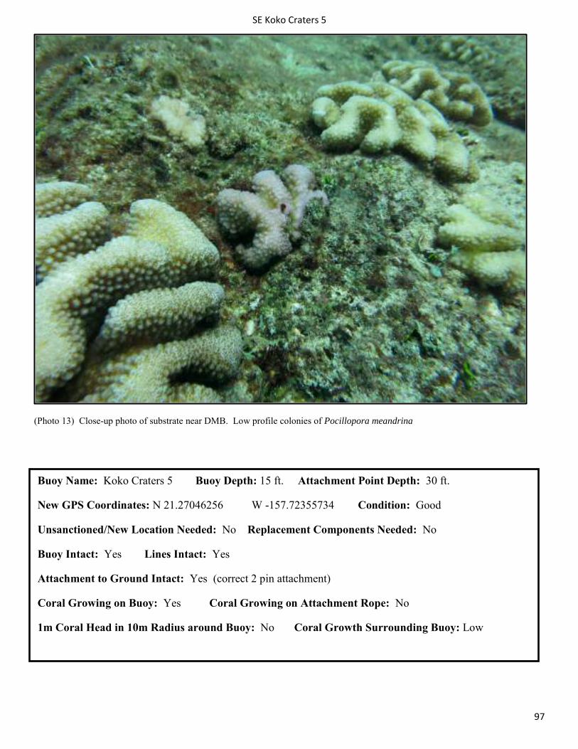
SE Koko Craters 5
97
(Photo 13) Close-up photo of substrate near DMB. Low profile colonies of Pocillopora meandrina
Buoy Name: Koko Craters 5 Buoy Depth: 15 ft. Attachment Point Depth: 30 ft.
New GPS Coordinates: N 21.27046256 W -157.72355734 Condition: Good
Unsanctioned/New Location Needed: No Replacement Components Needed: No
Buoy Intact: Yes Lines Intact: Yes
Attachment to Ground Intact: Yes (correct 2 pin attachment)
Coral Growing on Buoy: Yes Coral Growing on Attachment Rope: No
1m Coral Head in 10m Radius around Buoy: No Coral Growth Surrounding Buoy: Low
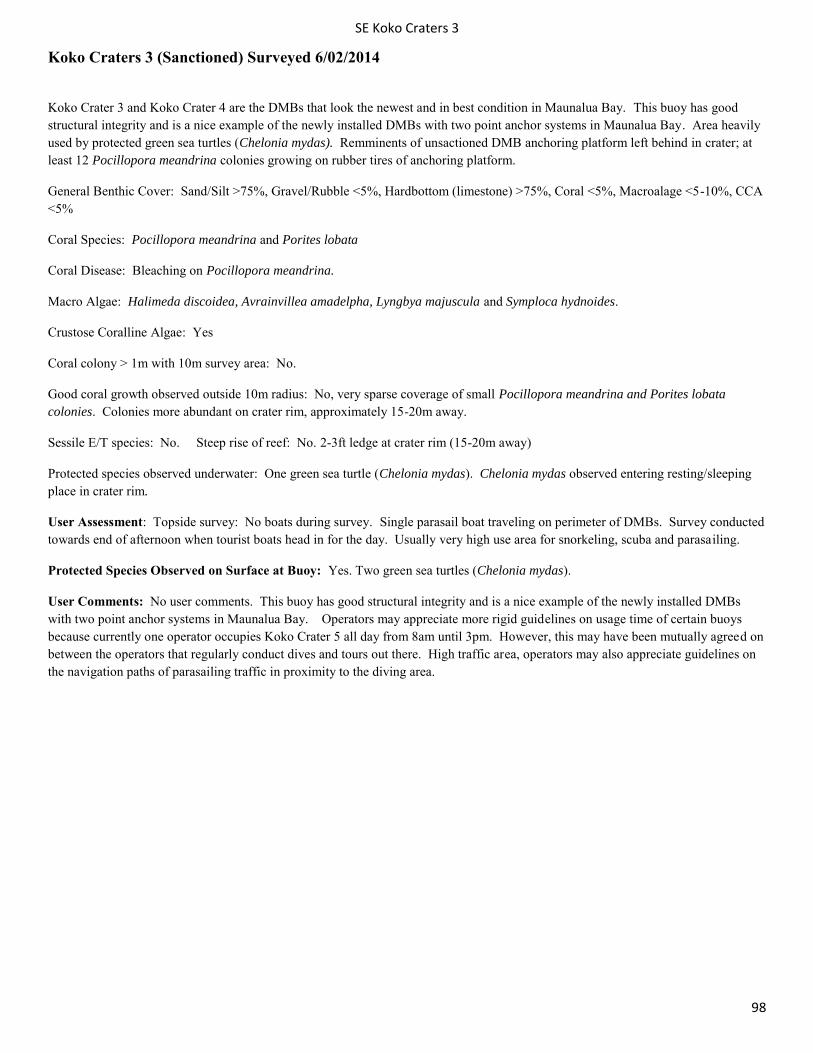
SE Koko Craters 3
98
Koko Craters 3 (Sanctioned) Surveyed 6/02/2014
Koko Crater 3 and Koko Crater 4 are the DMBs that look the newest and in best condition in Maunalua Bay. This buoy has good structural integrity and is a nice example of the newly installed DMBs with two point anchor systems in Maunalua Bay. Area heavily used by protected green sea turtles (Chelonia mydas). Remminents of unsactioned DMB anchoring platform left behind in crater; at least 12 Pocillopora meandrina colonies growing on rubber tires of anchoring platform.
General Benthic Cover: Sand/Silt >75%, Gravel/Rubble <5%, Hardbottom (limestone) >75%, Coral <5%, Macroalage <5-10%, CCA <5%
Coral Species: Pocillopora meandrina and Porites lobata
Coral Disease: Bleaching on Pocillopora meandrina.
Macro Algae: Halimeda discoidea, Avrainvillea amadelpha, Lyngbya majuscula and Symploca hydnoides.
Crustose Coralline Algae: Yes
Coral colony > 1m with 10m survey area: No.
Good coral growth observed outside 10m radius: No, very sparse coverage of small Pocillopora meandrina and Porites lobata colonies. Colonies more abundant on crater rim, approximately 15-20m away.
Sessile E/T species: No. Steep rise of reef: No. 2-3ft ledge at crater rim (15-20m away)
Protected species observed underwater: One green sea turtle (Chelonia mydas). Chelonia mydas observed entering resting/sleeping place in crater rim.
User Assessment: Topside survey: No boats during survey. Single parasail boat traveling on perimeter of DMBs. Survey conducted towards end of afternoon when tourist boats head in for the day. Usually very high use area for snorkeling, scuba and parasailing.
Protected Species Observed on Surface at Buoy: Yes. Two green sea turtles (Chelonia mydas).
User Comments: No user comments. This buoy has good structural integrity and is a nice example of the newly installed DMBs with two point anchor systems in Maunalua Bay. Operators may appreciate more rigid guidelines on usage time of certain buoys because currently one operator occupies Koko Crater 5 all day from 8am until 3pm. However, this may have been mutually agreed on between the operators that regularly conduct dives and tours out there. High traffic area, operators may also appreciate guidelines on the navigation paths of parasailing traffic in proximity to the diving area.
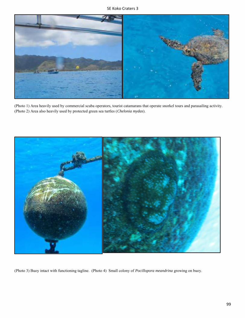
SE Koko Craters 3
99
(Photo 1) Area heavily used by commercial scuba operators, tourist catamarans that operate snorkel tours and parasailing activity. (Photo 2) Area also heavily used by protected green sea turtles (Chelonia mydas).
(Photo 3) Buoy intact with functioning tagline. (Photo 4) Small colony of Pocillopora meandrina growing on buoy.

SE Koko Craters 3
100
(Photo 5) Newly installed (two years) two pin anchor system seen from above. (Photo 6) Small coral colony growing on intact new rope/line.
(Photo 7 & 7) Newly installed (one year old) two pin anchor system seen from ground. Chain has little corrosion and anchor eyebolts appropriatly placed in area devoid of coral.
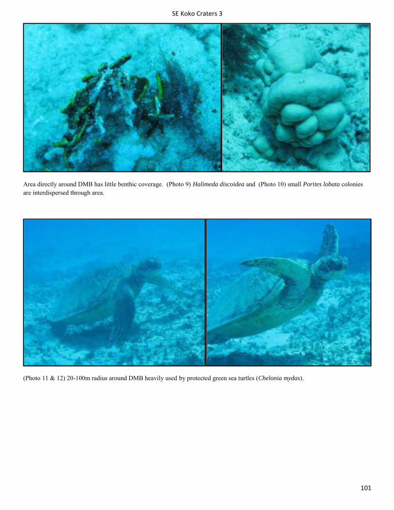
SE Koko Craters 3
101
Area directly around DMB has little benthic coverage. (Photo 9) Halimeda discoidea and (Photo 10) small Porites lobata colonies are interdispersed through area.
(Photo 11 & 12) 20-100m radius around DMB heavily used by protected green sea turtles (Chelonia mydas).
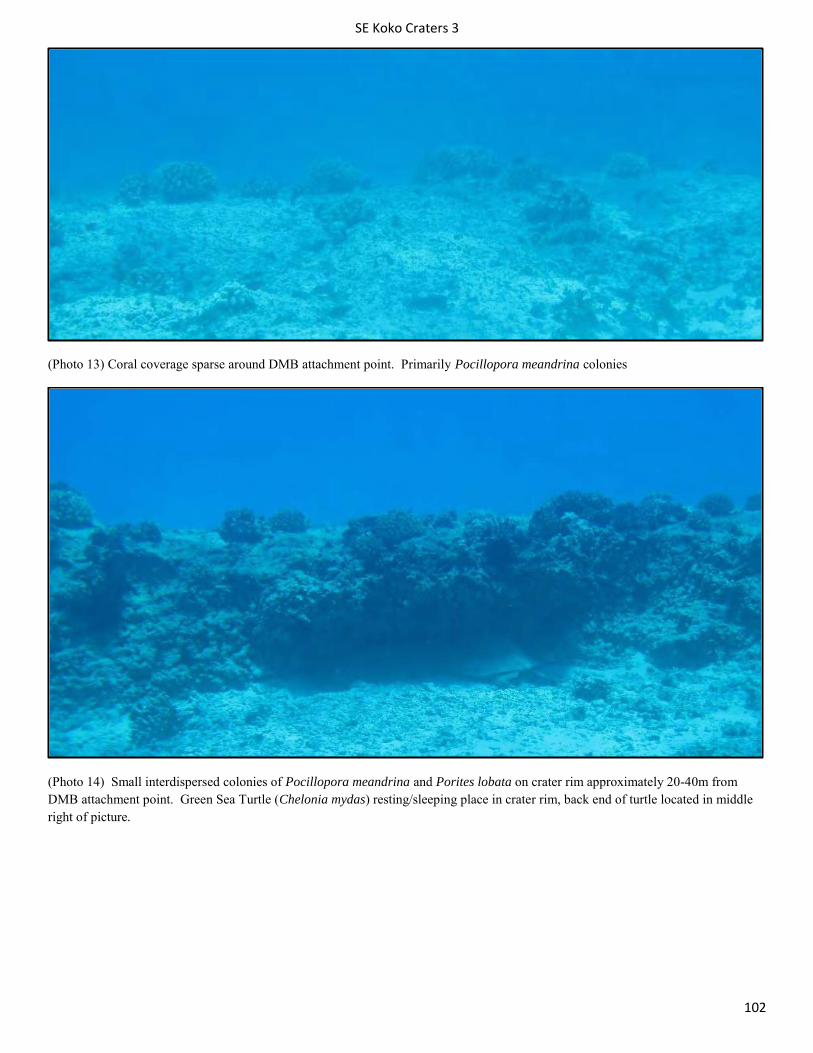
SE Koko Craters 3
102
(Photo 13) Coral coverage sparse around DMB attachment point. Primarily Pocillopora meandrina colonies
(Photo 14) Small interdispersed colonies of Pocillopora meandrina and Porites lobata on crater rim approximately 20-40m from DMB attachment point. Green Sea Turtle (Chelonia mydas) resting/sleeping place in crater rim, back end of turtle located in middle right of picture.
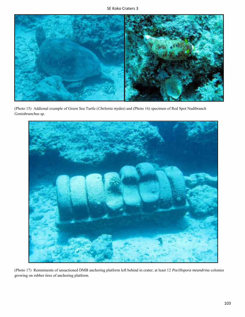
SE Koko Craters 3
103
(Photo 15) Addional example of Green Sea Turtle (Chelonia mydas) and (Photo 16) specimen of Red Spot Nudibranch Goniobranchus sp.
(Photo 17) Remminents of unsactioned DMB anchoring platform left behind in crater; at least 12 Pocillopora meandrina colonies growing on rubber tires of anchoring platform.
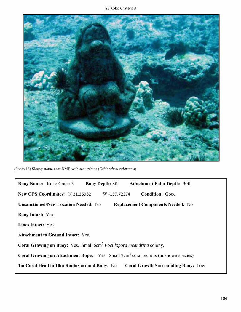
SE Koko Craters 3
104
(Photo 18) Sleepy statue near DMB with sea urchins (Echinothrix calamaris)
Buoy Name: Koko Crater 3 Buoy Depth: 8ft Attachment Point Depth: 30ft
New GPS Coordinates: N 21.26962 W -157.72374 Condition: Good
Unsanctioned/New Location Needed: No Replacement Components Needed: No
Buoy Intact: Yes.
Lines Intact: Yes.
Attachment to Ground Intact: Yes.
Coral Growing on Buoy: Yes. Small 6cm2 Pocillopora meandrina colony.
Coral Growing on Attachment Rope: Yes. Small 2cm2 coral recruits (unknown species).
1m Coral Head in 10m Radius around Buoy: No Coral Growth Surrounding Buoy: Low
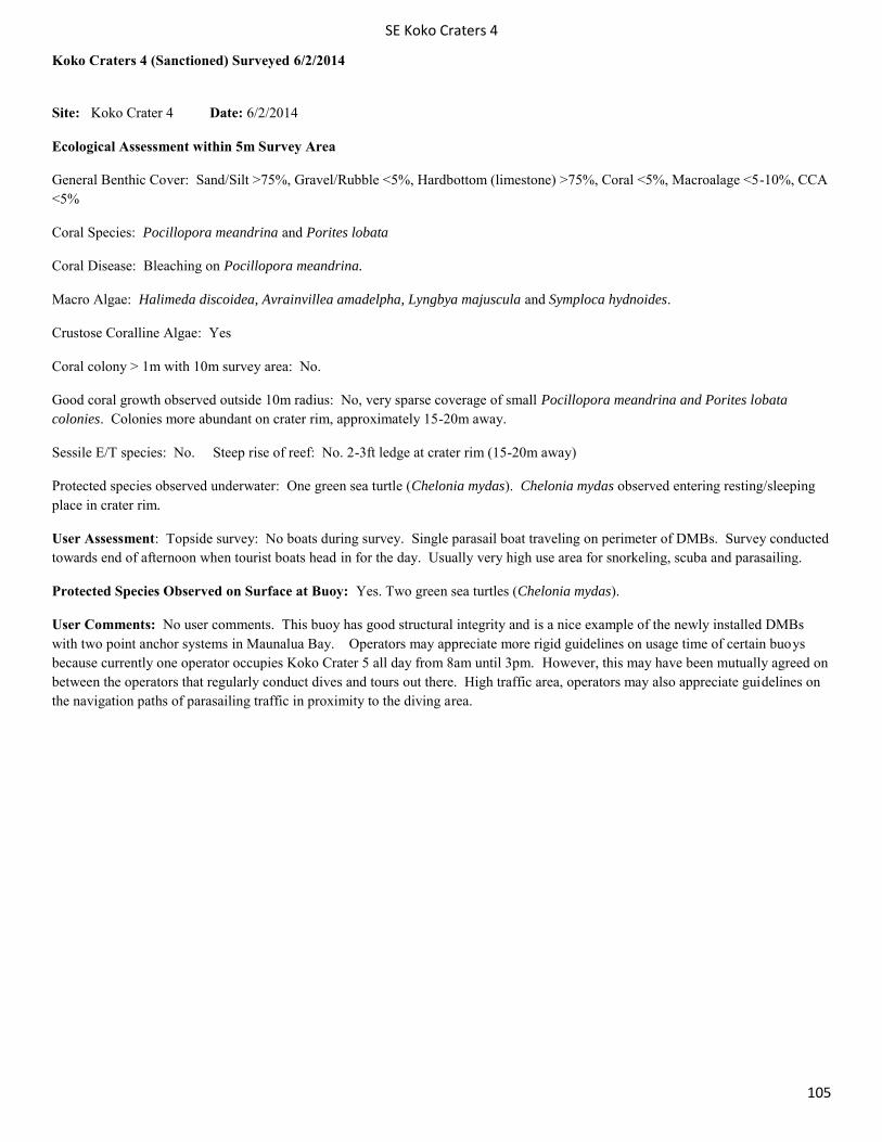
SE Koko Craters 4
105
Koko Craters 4 (Sanctioned) Surveyed 6/2/2014
Site: Koko Crater 4 Date: 6/2/2014
Ecological Assessment within 5m Survey Area
General Benthic Cover: Sand/Silt >75%, Gravel/Rubble <5%, Hardbottom (limestone) >75%, Coral <5%, Macroalage <5-10%, CCA <5%
Coral Species: Pocillopora meandrina and Porites lobata
Coral Disease: Bleaching on Pocillopora meandrina.
Macro Algae: Halimeda discoidea, Avrainvillea amadelpha, Lyngbya majuscula and Symploca hydnoides.
Crustose Coralline Algae: Yes
Coral colony > 1m with 10m survey area: No.
Good coral growth observed outside 10m radius: No, very sparse coverage of small Pocillopora meandrina and Porites lobata colonies. Colonies more abundant on crater rim, approximately 15-20m away.
Sessile E/T species: No. Steep rise of reef: No. 2-3ft ledge at crater rim (15-20m away)
Protected species observed underwater: One green sea turtle (Chelonia mydas). Chelonia mydas observed entering resting/sleeping place in crater rim.
User Assessment: Topside survey: No boats during survey. Single parasail boat traveling on perimeter of DMBs. Survey conducted towards end of afternoon when tourist boats head in for the day. Usually very high use area for snorkeling, scuba and parasailing.
Protected Species Observed on Surface at Buoy: Yes. Two green sea turtles (Chelonia mydas).
User Comments: No user comments. This buoy has good structural integrity and is a nice example of the newly installed DMBs with two point anchor systems in Maunalua Bay. Operators may appreciate more rigid guidelines on usage time of certain buoys because currently one operator occupies Koko Crater 5 all day from 8am until 3pm. However, this may have been mutually agreed on between the operators that regularly conduct dives and tours out there. High traffic area, operators may also appreciate guidelines on the navigation paths of parasailing traffic in proximity to the diving area.
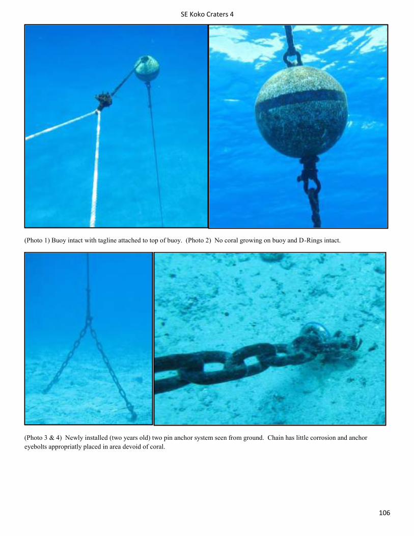
SE Koko Craters 4
106
(Photo 1) Buoy intact with tagline attached to top of buoy. (Photo 2) No coral growing on buoy and D-Rings intact.
(Photo 3 & 4) Newly installed (two years old) two pin anchor system seen from ground. Chain has little corrosion and anchor eyebolts appropriatly placed in area devoid of coral.
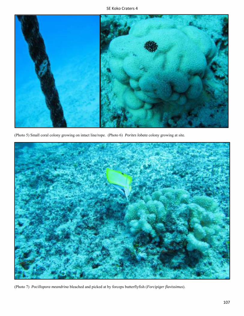
SE Koko Craters 4
107
(Photo 5) Small coral colony growing on intact line/rope. (Photo 6) Porites lobata colony growing at site.
(Photo 7) Pocillopora meandrina bleached and picked at by forceps butterflyfish (Forcipiger flavissimus).
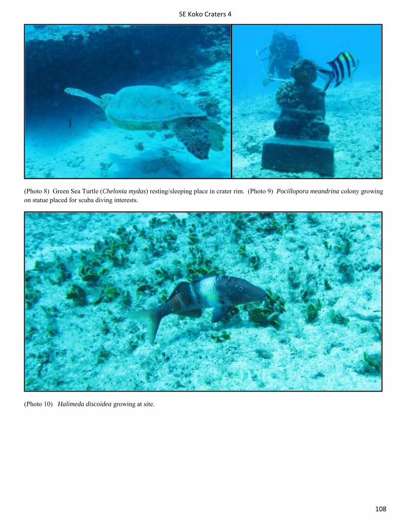
SE Koko Craters 4
108
(Photo 8) Green Sea Turtle (Chelonia mydas) resting/sleeping place in crater rim. (Photo 9) Pocillopora meandrina colony growing on statue placed for scuba diving interests.
(Photo 10) Halimeda discoidea growing at site.
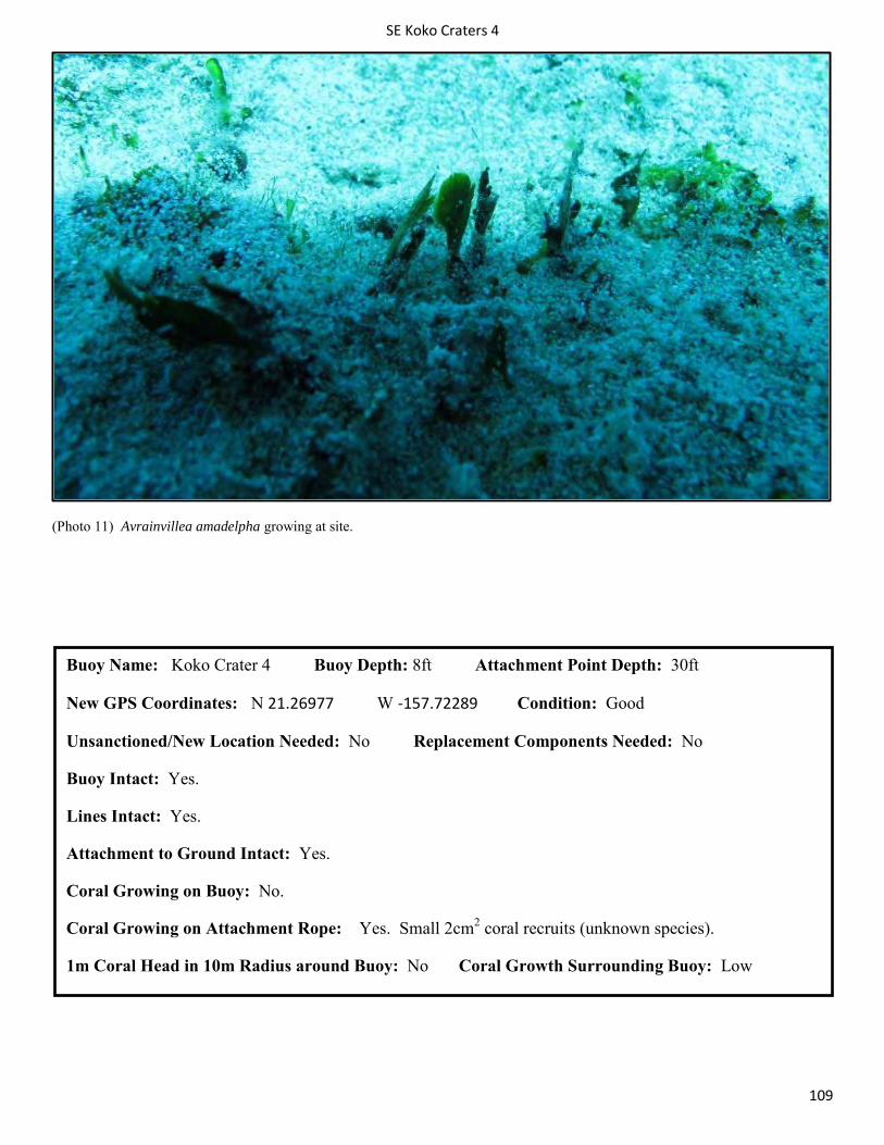
SE Koko Craters 4
109
(Photo 11) Avrainvillea amadelpha growing at site.
Buoy Name: Koko Crater 4 Buoy Depth: 8ft Attachment Point Depth: 30ft
New GPS Coordinates: N 21.26977 W -157.72289 Condition: Good
Unsanctioned/New Location Needed: No Replacement Components Needed: No
Buoy Intact: Yes.
Lines Intact: Yes.
Attachment to Ground Intact: Yes.
Coral Growing on Buoy: No.
Coral Growing on Attachment Rope: Yes. Small 2cm2 coral recruits (unknown species).
1m Coral Head in 10m Radius around Buoy: No Coral Growth Surrounding Buoy: Low
SE Maunalua Bay:Turtle Canyon
110
Maunalua Bay : Turtle Canyon
This mooring is grouped with 3 other moorings within 100 yards of each other. This site is heavily used by dive boats because of nearness to the harbor and the relative calmness of the water in this area. Small basins formed by lava in the past create a unique diving environment, with Sea Turtles and the occasional monk seal. The mooring here is illegal but made from a large sturdy sea anchor that is heavy enough for most boats to safely tie to. The mooring line is entirely made of chain and has more bounce than the traditional lines due to the weight though both the buoy and chain are in good shape. As long as the current buoy remains in good shape the chain should pose no threat but possibly switching part of the chain to rope is advised.
Site: Koko Craters Unsanctioned Date: 07/01/2014
Ecological Assessment within 5m Survey Area
General Benthic Cover: Sand/Silt 40-75%, Gravel/Rubble 10-40%, Hardbottom (limestone) 40-75%, Coral 5-10%, Macroalage <5%, CCA <5%
Coral Species: Pocillopora meandrina, Porites lobata.
Coral Disease: Kahe crab parasitism on Pocillopora meandrina and small amounts of bleaching in Pocillopora meandrina
Macro Algae: Halimeda discoidea, Symploca Hydnoides
Crustose Coralline Algae: Yes
Coral colony > 1m with 10m survey area: No
Good coral growth observed outside 10m radius: No the 10 m radius is composed of sand and hard bottom barren craters.
Sessile E/T species: no
User Assessment: Topside survey: 3 boats observed during 20 minute survey
Boat 1/Purpose: Commercial scuba Diver #: 0 On Mooring: Yes –Support barge that moves when boat with guests arrives
Boat 2/Purpose: Commercial scuba Diver#: 24 On Mooring: Yes- trades places with the barge and the barge attaches to this vessel
Boat 3/Purpose: Commercial scuba Diver#: 6 On Mooring: Yes
User Comments: NA
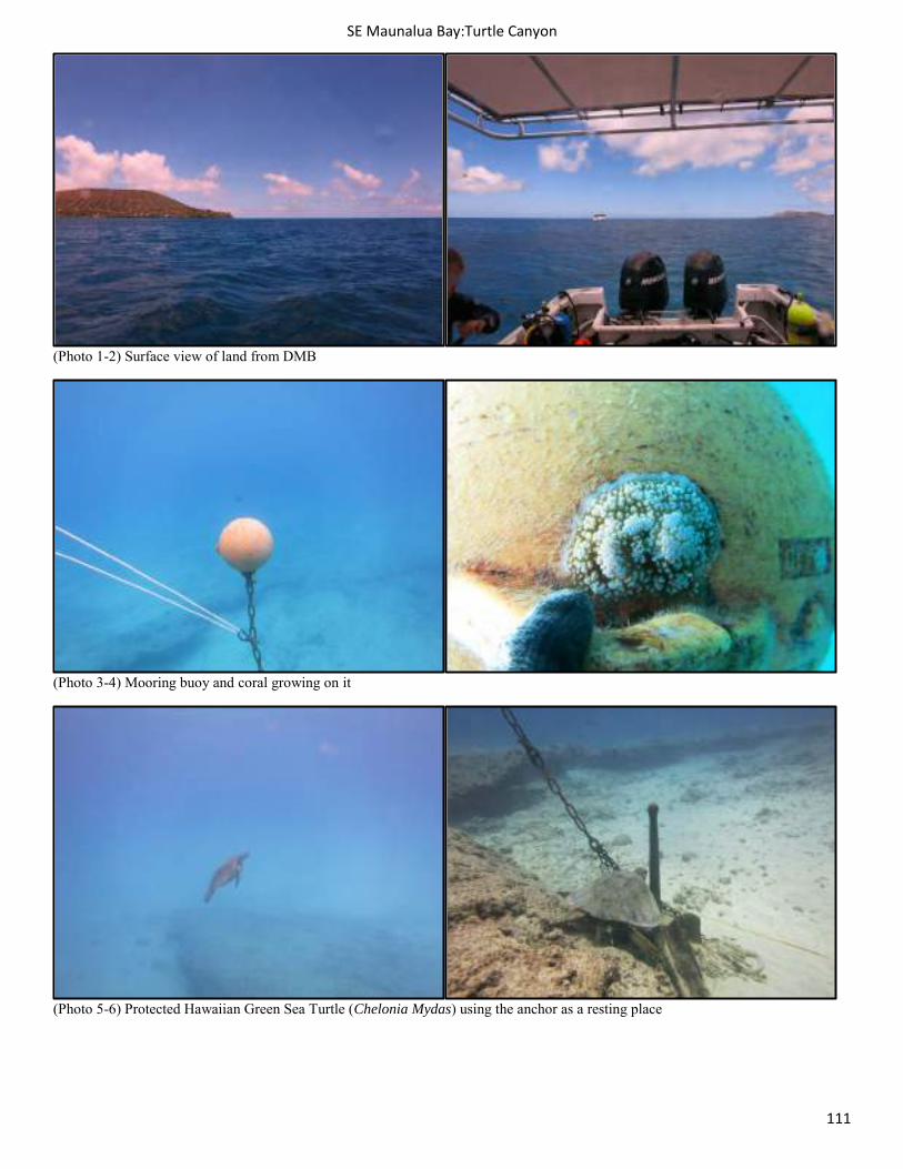
SE Maunalua Bay:Turtle Canyon
111
(Photo 1-2) Surface view of land from DMB
(Photo 3-4) Mooring buoy and coral growing on it
(Photo 5-6) Protected Hawaiian Green Sea Turtle (Chelonia Mydas) using the anchor as a resting place
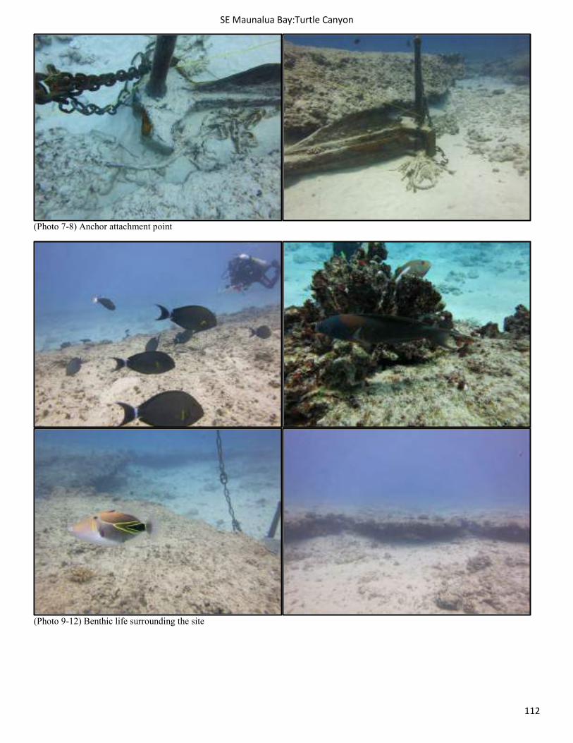
SE Maunalua Bay:Turtle Canyon
112
(Photo 7-8) Anchor attachment point
(Photo 9-12) Benthic life surrounding the site
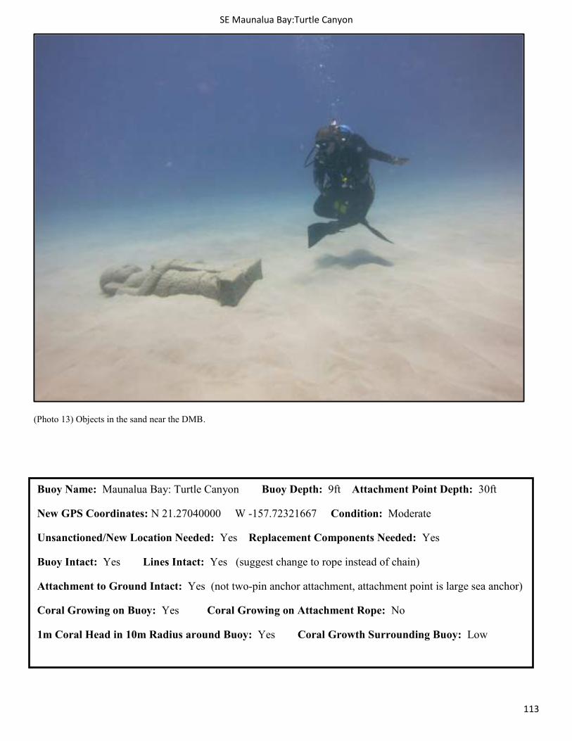
SE Maunalua Bay:Turtle Canyon
113
(Photo 13) Objects in the sand near the DMB.
Buoy Name: Maunalua Bay: Turtle Canyon Buoy Depth: 9ft Attachment Point Depth: 30ft
New GPS Coordinates: N 21.27040000 W -157.72321667 Condition: Moderate
Unsanctioned/New Location Needed: Yes Replacement Components Needed: Yes
Buoy Intact: Yes Lines Intact: Yes (suggest change to rope instead of chain)
Attachment to Ground Intact: Yes (not two-pin anchor attachment, attachment point is large sea anchor)
Coral Growing on Buoy: Yes Coral Growing on Attachment Rope: No
1m Coral Head in 10m Radius around Buoy: Yes Coral Growth Surrounding Buoy: Low
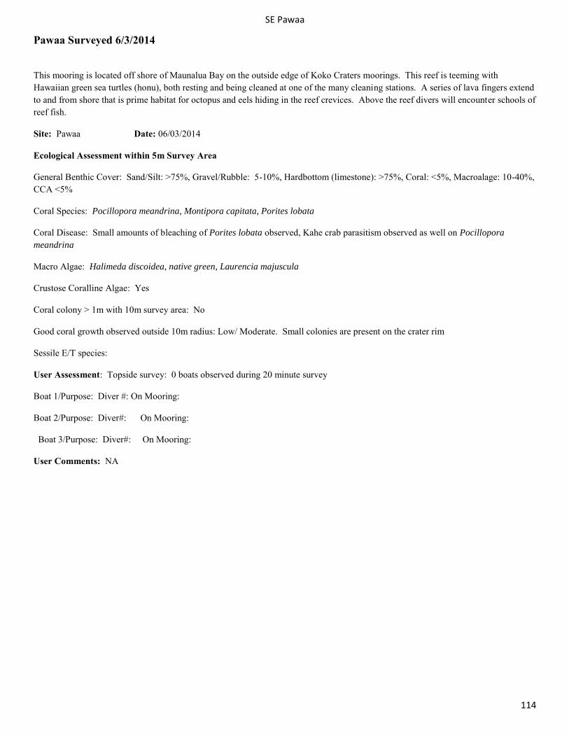
SE Pawaa
114
Pawaa Surveyed 6/3/2014
This mooring is located off shore of Maunalua Bay on the outside edge of Koko Craters moorings. This reef is teeming with Hawaiian green sea turtles (honu), both resting and being cleaned at one of the many cleaning stations. A series of lava fingers extend to and from shore that is prime habitat for octopus and eels hiding in the reef crevices. Above the reef divers will encounter schools of reef fish.
Site: Pawaa Date: 06/03/2014
Ecological Assessment within 5m Survey Area
General Benthic Cover: Sand/Silt: >75%, Gravel/Rubble: 5-10%, Hardbottom (limestone): >75%, Coral: <5%, Macroalage: 10-40%, CCA <5%
Coral Species: Pocillopora meandrina, Montipora capitata, Porites lobata
Coral Disease: Small amounts of bleaching of Porites lobata observed, Kahe crab parasitism observed as well on Pocillopora meandrina
Macro Algae: Halimeda discoidea, native green, Laurencia majuscula
Crustose Coralline Algae: Yes
Coral colony > 1m with 10m survey area: No
Good coral growth observed outside 10m radius: Low/ Moderate. Small colonies are present on the crater rim
Sessile E/T species:
User Assessment: Topside survey: 0 boats observed during 20 minute survey
Boat 1/Purpose: Diver #: On Mooring:
Boat 2/Purpose: Diver#: On Mooring:
Boat 3/Purpose: Diver#: On Mooring:
User Comments: NA
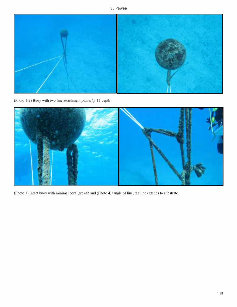
SE Pawaa
115
(Photo 1-2) Buoy with two line attachment points @ 11’depth
(Photo 3) Intact buoy with minimal coral growth and (Photo 4) tangle of line, tag line extends to substrate.
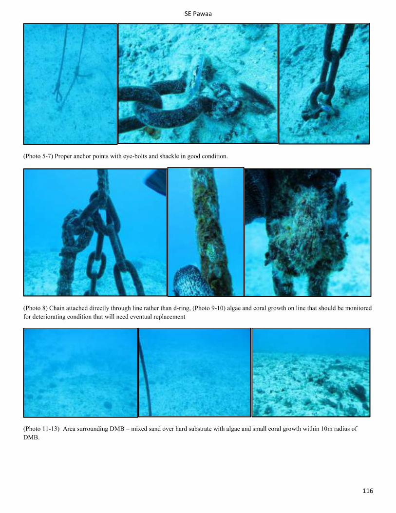
SE Pawaa
116
(Photo 5-7) Proper anchor points with eye-bolts and shackle in good condition.
(Photo 8) Chain attached directly through line rather than d-ring, (Photo 9-10) algae and coral growth on line that should be monitored for deteriorating condition that will need eventual replacement
(Photo 11-13) Area surrounding DMB – mixed sand over hard substrate with algae and small coral growth within 10m radius of DMB.
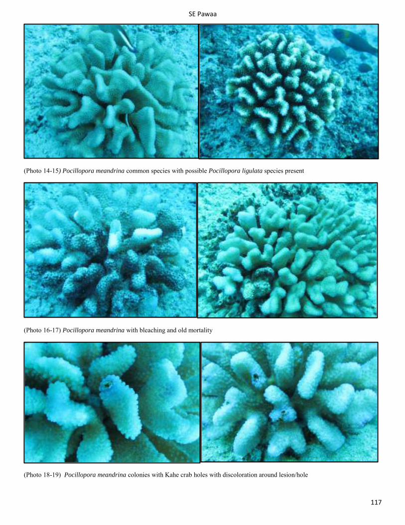
SE Pawaa
117
(Photo 14-15) Pocillopora meandrina common species with possible Pocillopora ligulata species present
(Photo 16-17) Pocillopora meandrina with bleaching and old mortality
(Photo 18-19) Pocillopora meandrina colonies with Kahe crab holes with discoloration around lesion/hole
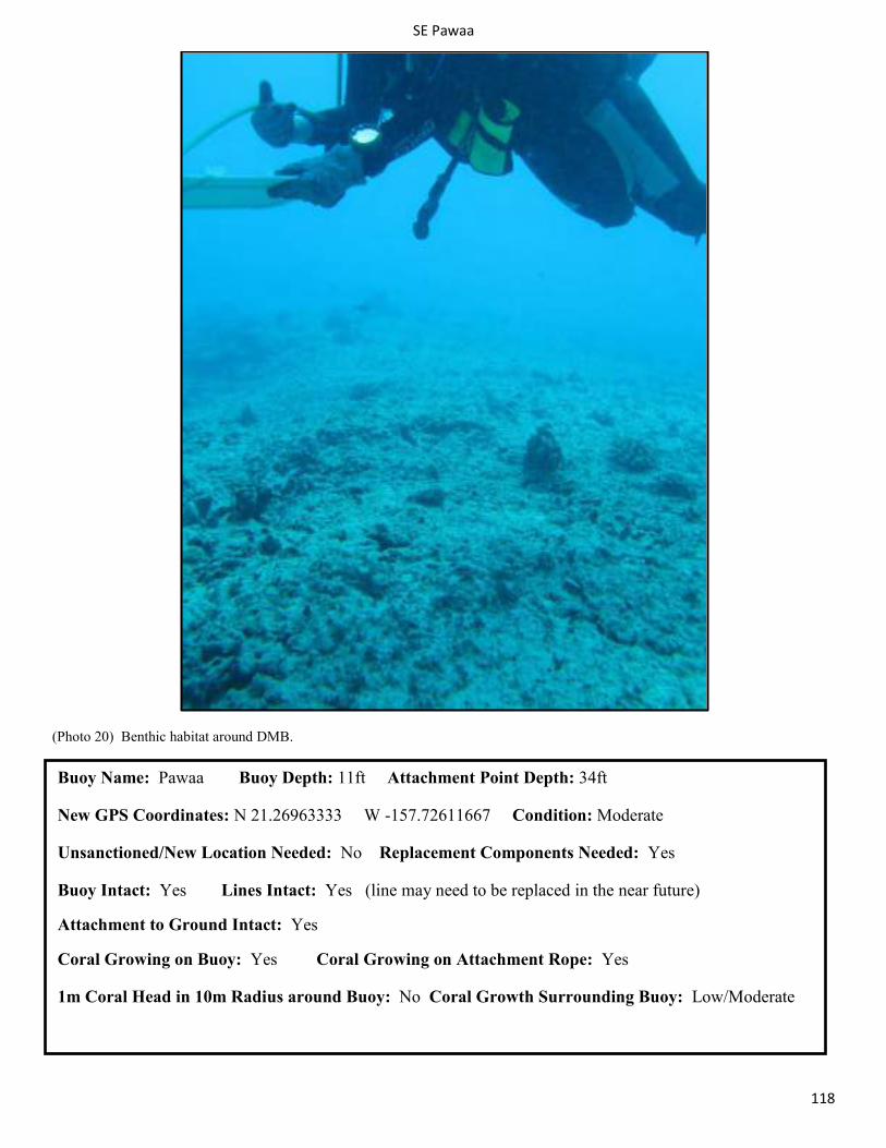
SE Pawaa
118
(Photo 20) Benthic habitat around DMB.
Buoy Name: Pawaa Buoy Depth: 11ft Attachment Point Depth: 34ft
New GPS Coordinates: N 21.26963333 W -157.72611667 Condition: Moderate
Unsanctioned/New Location Needed: No Replacement Components Needed: Yes
Buoy Intact: Yes Lines Intact: Yes (line may need to be replaced in the near future)
Attachment to Ground Intact: Yes
Coral Growing on Buoy: Yes Coral Growing on Attachment Rope: Yes
1m Coral Head in 10m Radius around Buoy: No Coral Growth Surrounding Buoy: Low/Moderate
SE Turtle Canyon 1
119
Maunalua Bay: Koko Crater Surveyed 5/27/2014
Turtle Canyon moorings are located ½ mile west of the number one channel marker of the Hawaii Kai boat channel (Maunalua Bay). They can be found 200 yards from east to west and 100 yards from the surf line (north to south). These moorings are placed on lava flow reef terminating in sand offshore (south). The maximum depth is 35feet in the sand at the end of the reef. As the name suggests, this area is home to a large population of Hawaiian green sea turtles (honu). Large schools of black durgeon triggerfish greet divers on each dive. Octopus and moray eels are also plentiful. This is one of the few locations that crocodile eels have been sighted. Look for these rare eels burrowing in the sand.
Site: Turtle Canyon 1 Date: 5/27/2014
Ecological Assessment within 5m Survey Area
General Benthic Cover: Sand/Silt >75%, Gravel/Rubble <5%, Hardbottom (limestone) 10-40%, Coral 5-10%, Macroalage 10-40%, CCA <5%
Coral Species: Pocillopora meandrina, Porites lobata, Porites solida, Montipora capitata (encrusting), and Cyphastrea occelina .
Coral Disease: Fish predation on Pocillopora meandrina and possible multi-focal tissue loss on Porites lobata.
Macro Algae: Neomeris spp., Halimeda discoidea, Asparagopsis taxiformis and filamentous native green (possibly Cladophora sericea ).
Crustose Coralline Algae: Yes Coral colony > 1m with 10m survey area: No.
Good coral growth observed outside 10m radius: Moderate coverage of small heads of Pocillopora meandrina and Porites lobata every 3-5 ft.
Sessile E/T species: No. Steep rise of reef: 2-3 ft. rise in reef spur within 10 meters of anchor point.
User Assessment: Topside survey: 2 boats observed during 20 minute survey. Multiple parasailing boats using outside perimeter of DMB areas. High use area for snorkeling, scuba and parasailing.
Boat 1/Purpose: Commercial snorkel Diver #: 12 On Mooring: Yes
Boat 2 & 3/Purpose: Commercial scuba Diver#: 6 On Mooring: Yes
Protected Species Observed on Surface at Buoy: Yes. One green sea turtle (Chelonia mydas).
User Comments: No user comments. This buoy may not be a newly installed DMB as it does not have the two pin anchor system. The buoy on this DMB needs to be replaced as it is cracked. The buoy should also be lowered in the water column, as the crack may be a result of being hit by a boat propeller, the buoyancy is only 5ft below the surface currently. Operators may appreciate more rigid guidelines on usage time of certain buoys because currently one operator occupies Koko Crater 1 all day from 8am until 3pm. However, this may have been mutually agreed on between the operators that regularly conduct dives and tours out there. High traffic area, operators may also appreciate guidelines on the navigation paths of parasailing traffic in proximity to the diving area.
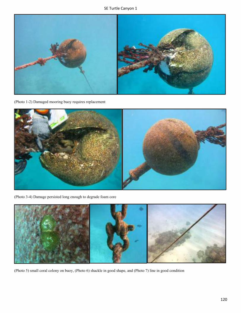
SE Turtle Canyon 1
120
(Photo 1-2) Damaged mooring buoy requires replacement
(Photo 3-4) Damage persisted long enough to degrade foam core
(Photo 5) small coral colony on buoy, (Photo 6) shackle in good shape, and (Photo 7) line in good condition
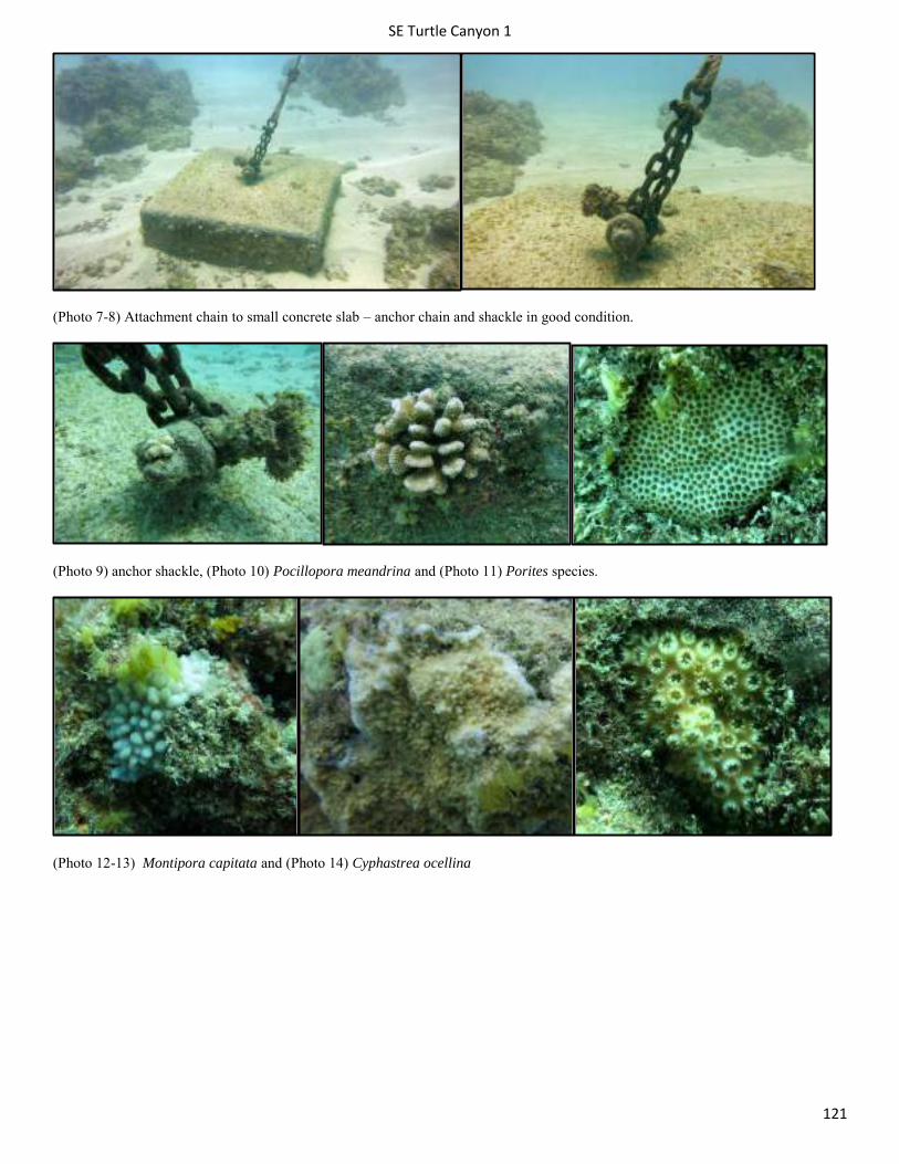
SE Turtle Canyon 1
121
(Photo 7-8) Attachment chain to small concrete slab – anchor chain and shackle in good condition.
(Photo 9) anchor shackle, (Photo 10) Pocillopora meandrina and (Photo 11) Porites species.
(Photo 12-13) Montipora capitata and (Photo 14) Cyphastrea ocellina
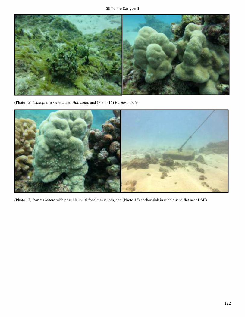
SE Turtle Canyon 1
122
(Photo 15) Cladophora sericea and Halimeda, and (Photo 16) Porites lobata
(Photo 17) Porites lobata with possible multi-focal tissue loss, and (Photo 18) anchor slab in rubble sand flat near DMB
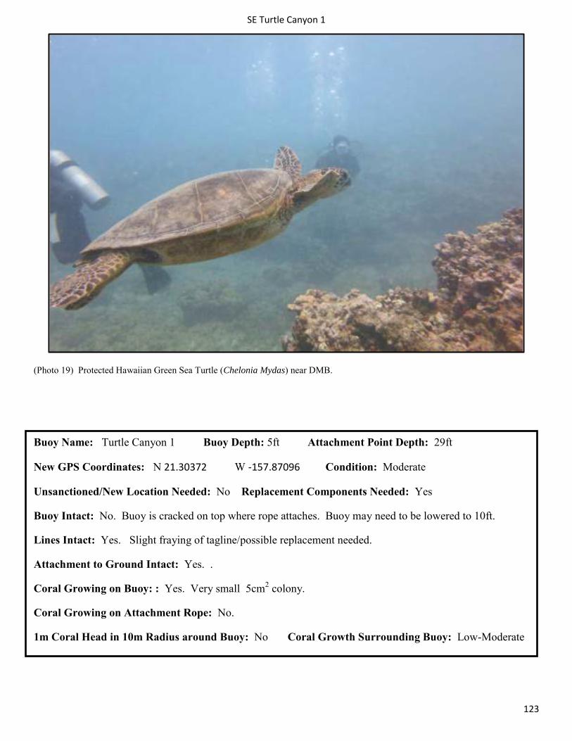
SE Turtle Canyon 1
123
(Photo 19) Protected Hawaiian Green Sea Turtle (Chelonia Mydas) near DMB.
Buoy Name: Turtle Canyon 1 Buoy Depth: 5ft Attachment Point Depth: 29ft
New GPS Coordinates: N 21.30372 W -157.87096 Condition: Moderate
Unsanctioned/New Location Needed: No Replacement Components Needed: Yes
Buoy Intact: No. Buoy is cracked on top where rope attaches. Buoy may need to be lowered to 10ft.
Lines Intact: Yes. Slight fraying of tagline/possible replacement needed.
Attachment to Ground Intact: Yes. .
Coral Growing on Buoy: : Yes. Very small 5cm2 colony.
Coral Growing on Attachment Rope: No.
1m Coral Head in 10m Radius around Buoy: No Coral Growth Surrounding Buoy: Low-Moderate
SE Turtle Canyon 2
124
Turtle Canyon 2 Surveyed
Turtle canyons moorings are located ½ mile west of the number one channel marker of the Hawaii Kai boat channel (Maunalua Bay). They can be found 200 yards from east to west and 100 yards from the surf line (north to south). These moorings are placed on lava flow reef terminating in sand offshore (south). The maximum depth is 35feet in the sand at the end of the reef. As the name suggests, this area is home to a large population of Hawaiian green sea turtles (honu). Large schools of black durgeon triggerfish greet divers on each dive. Octopus and moray eels are also plentiful. This is one of the few locations that crocodile eels have been sighted. Look for these rare eels burrowing in the sand.
Site: Turtle Canyon 2 Date: 5/27/2014
Ecological Assessment within 5m Survey Area
General Benthic Cover: Sand/Silt 10-40%, Gravel/Rubble <5%, Hardbottom (limestone) >75%, Coral 10-40%, Macroalage <5%, CCA <5%
Coral Species: Pocillopora meandrina, Porites lobata, Porites solida, Montipora capitata (encrusting), Montipora patula, Porites evermanni, Pavona varians and Fungia scutaria.
Coral Disease: Fish predation on Pocillopora meandrina.
Macro Algae: Halimeda discoidea, Asparagopsis taxiformis, Lyngbya majuscula and native brown algae.
Crustose Coralline Algae: Yes
Coral colony > 1m with 10m survey area: No.
Good coral growth observed outside 10m radius: Moderate coverage of small heads of Pocillopora meandrina, Porites lobata, and Montipora patula evenly dispersed throughout area.
Sessile E/T species: Montipora patula. Steep rise of reef: No.
User Assessment: Topside survey: No boats during survey. Survey conducted towards end of afternoon when tourist boats head in for the day. Usually very high use area for snorkeling, scuba and parasailing.
Protected Species Observed on Surface at Buoy: No. One pod of 5+ spinner dolphins (Stenella longirostris) swam by after 20 minute survey window was finished.
User Comments: No user comments. This buoy has good structural integrity and is a nice example of the newly installed DMBs with two point anchor systems in Maunalua Bay. The buoy should be lowered in the water column as the buoyancy is only 5ft below the surface currently. Operators may appreciate more rigid guidelines on usage time of certain buoys because currently one operator occupies Koko Crater 1 all day from 8am until 3pm. However, this may have been mutually agreed on between the operators that regularly conduct dives and tours out there. High traffic area, operators may also appreciate guidelines on the navigation paths of parasailing traffic in proximity to the diving area.
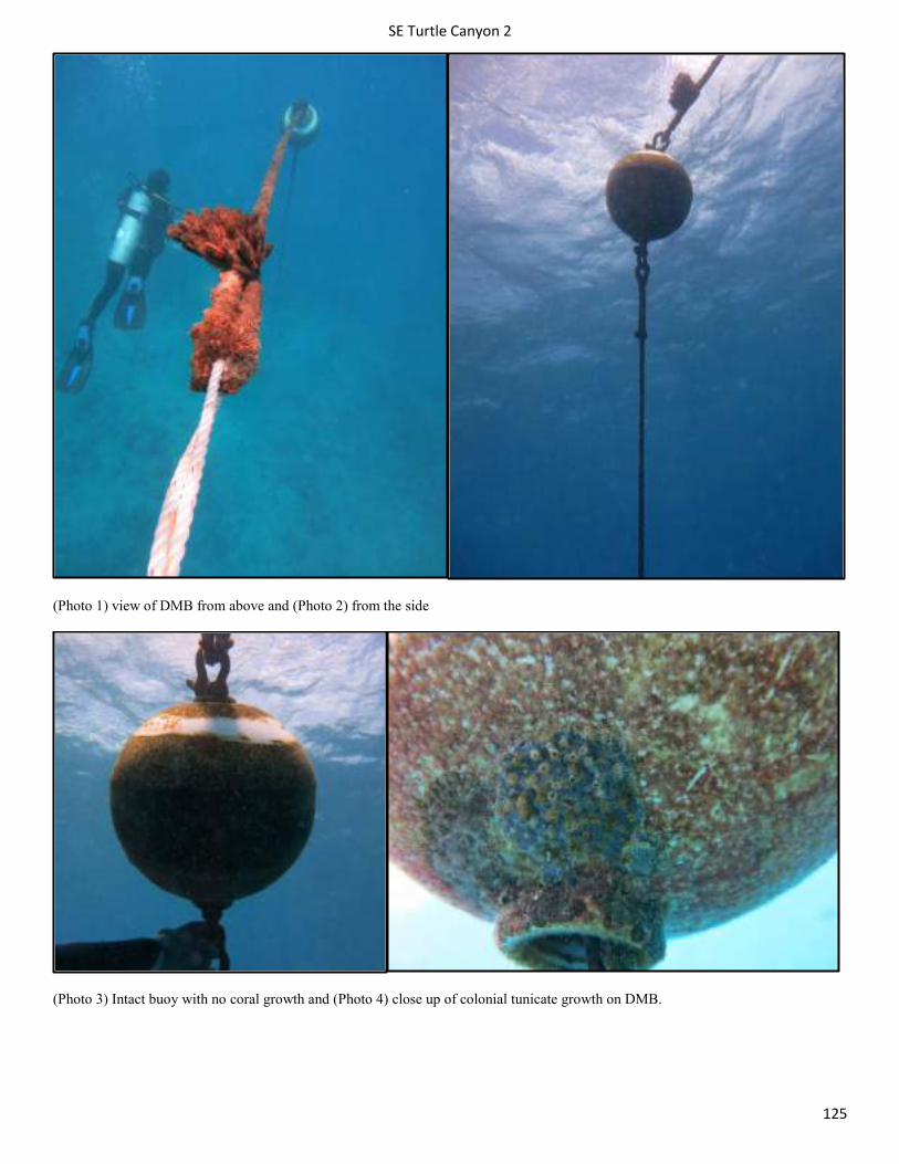
SE Turtle Canyon 2
125
(Photo 1) view of DMB from above and (Photo 2) from the side
(Photo 3) Intact buoy with no coral growth and (Photo 4) close up of colonial tunicate growth on DMB.
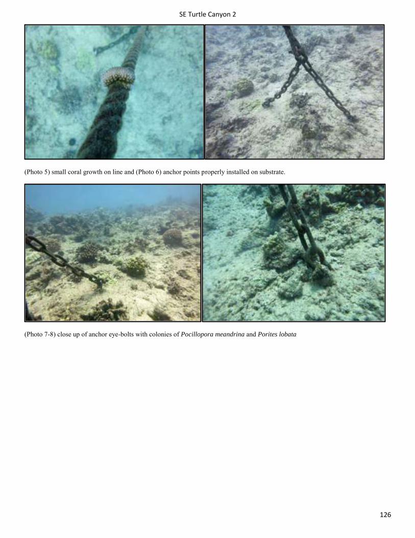
SE Turtle Canyon 2
126
(Photo 5) small coral growth on line and (Photo 6) anchor points properly installed on substrate.
(Photo 7-8) close up of anchor eye-bolts with colonies of Pocillopora meandrina and Porites lobata

SE Turtle Canyon 2
127
(Photo 9) image of general area near DMB: primarily colonies of Pocillopora meandrina and Porites lobata
(Photo 10) image of general area near DMB: primarily colonies of Pocillopora meandrina and Porites lobata
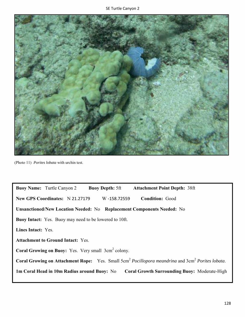
SE Turtle Canyon 2
128
(Photo 11) Porites lobata with urchin test.
Buoy Name: Turtle Canyon 2 Buoy Depth: 5ft Attachment Point Depth: 38ft
New GPS Coordinates: N 21.27179 W -158.72559 Condition: Good
Unsanctioned/New Location Needed: No Replacement Components Needed: No
Buoy Intact: Yes. Buoy may need to be lowered to 10ft.
Lines Intact: Yes.
Attachment to Ground Intact: Yes.
Coral Growing on Buoy: Yes. Very small 3cm2 colony.
Coral Growing on Attachment Rope: Yes. Small 5cm2 Pocillopora meandrina and 3cm2 Porites lobata.
1m Coral Head in 10m Radius around Buoy: No Coral Growth Surrounding Buoy: Moderate-High
SE Turtle Canyon 4
129
Turtle Canyons 4 Surveyed 6/2/2014
Turtle canyons moorings are located ½ mile west of the number one channel marker of the Hawaii Kai boat channel (Maunalua Bay). They can be found 200 yards from east to west and 100 yards from the surf line (north to south). These moorings are placed on lava flow reef terminating in sand offshore (south). The maximum depth is 35feet in the sand at the end of the reef. As the name suggests, this area is home to a large population of Hawaiian green sea turtles (honu). Large schools of black durgeon triggerfish greet divers on each dive. Octopus and moray eels are also plentiful. This is one of the few locations that crocodile eels have been sighted. Look for these rare eels burrowing in the sand.
Site: Turtle Canyons 4 Date: 06/02/2014
Ecological Assessment within 5m Survey Area
General Benthic Cover: Sand/Silt 5-10%, Gravel/Rubble <5%, Hardbottom (limestone) >75%, Coral 10-40%, Macroalage 5-10%, CCA <5%
Coral Species: Pocillopora meandrina, Porites lobata, Pavona duerdeni, Montipora capitata
Coral Disease: pink distress line observed on Porites lobata most likely caused by a trematode, fish bites marks on Pocillopora meandrina
Macro Algae: Halimeda discoidea, Asparagopsis taxiformis, Dictyota sandvicensis
Crustose Coralline Algae: Yes
Coral colony > 1m with 10m survey area: Yes
Good coral growth observed outside 10m radius: Yes good growth along the ridge
Sessile E/T species: Montipora patula (outside 10m radius)
User Assessment: Topside survey: No boats observed during 20 minute survey
Boat 1/Purpose: Diver #: On Mooring:
Boat 2/Purpose: Diver#: On Mooring:
Boat 3/Purpose: Diver#: On Mooring:
User Comments: NA
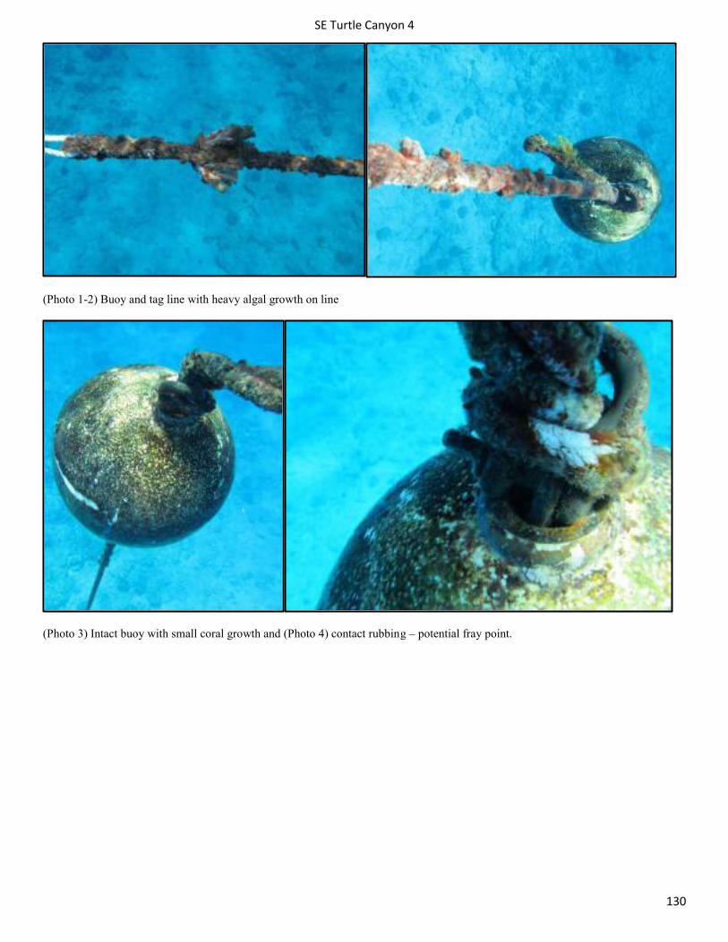
SE Turtle Canyon 4
130
(Photo 1-2) Buoy and tag line with heavy algal growth on line
(Photo 3) Intact buoy with small coral growth and (Photo 4) contact rubbing – potential fray point.
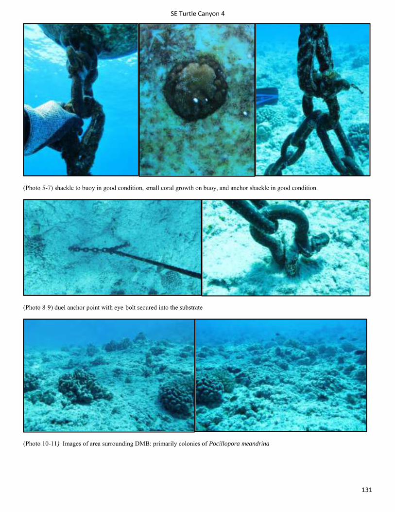
SE Turtle Canyon 4
131
(Photo 5-7) shackle to buoy in good condition, small coral growth on buoy, and anchor shackle in good condition.
(Photo 8-9) duel anchor point with eye-bolt secured into the substrate
(Photo 10-11) Images of area surrounding DMB: primarily colonies of Pocillopora meandrina
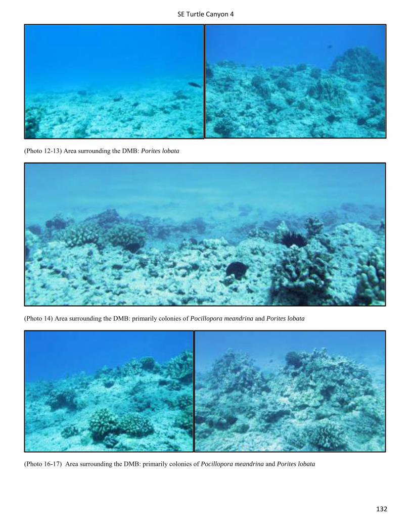
SE Turtle Canyon 4
132
(Photo 12-13) Area surrounding the DMB: Porites lobata
(Photo 14) Area surrounding the DMB: primarily colonies of Pocillopora meandrina and Porites lobata
(Photo 16-17) Area surrounding the DMB: primarily colonies of Pocillopora meandrina and Porites lobata
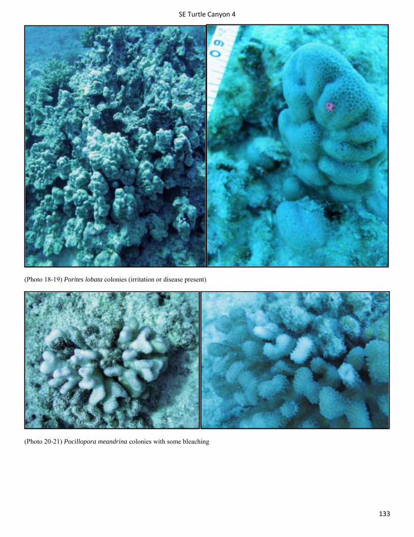
SE Turtle Canyon 4
133
(Photo 18-19) Porites lobata colonies (irritation or disease present)
(Photo 20-21) Pocillopora meandrina colonies with some bleaching
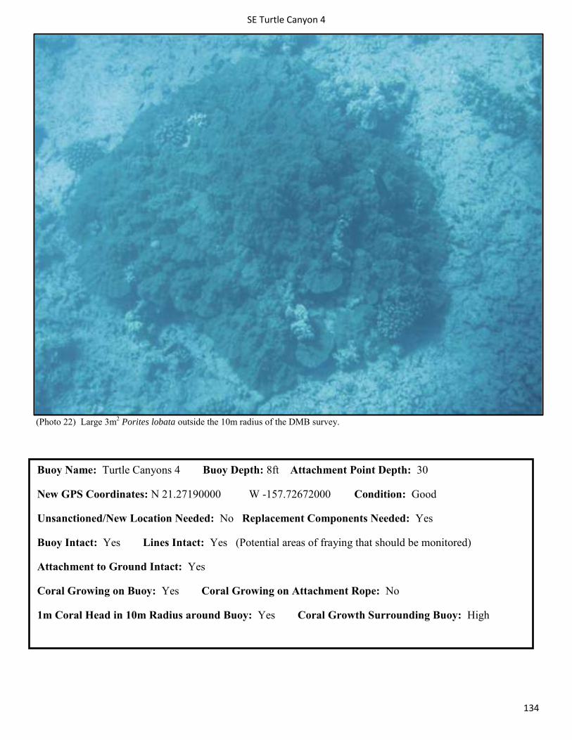
SE Turtle Canyon 4
134
(Photo 22) Large 3m2 Porites lobata outside the 10m radius of the DMB survey.
Buoy Name: Turtle Canyons 4 Buoy Depth: 8ft Attachment Point Depth: 30
New GPS Coordinates: N 21.27190000 W -157.72672000 Condition: Good
Unsanctioned/New Location Needed: No Replacement Components Needed: Yes
Buoy Intact: Yes Lines Intact: Yes (Potential areas of fraying that should be monitored)
Attachment to Ground Intact: Yes
Coral Growing on Buoy: Yes Coral Growing on Attachment Rope: No
1m Coral Head in 10m Radius around Buoy: Yes Coral Growth Surrounding Buoy: High
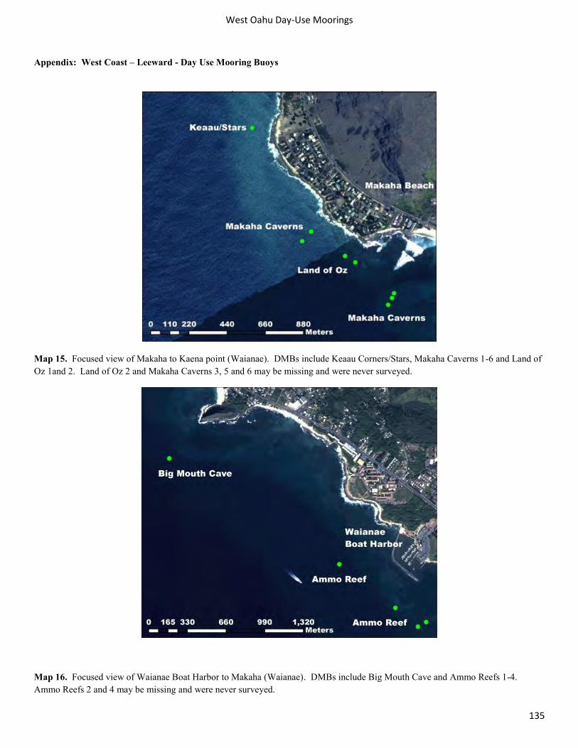
West Oahu Day-Use Moorings
135
Appendix: West Coast – Leeward - Day Use Mooring Buoys
Map 15. Focused view of Makaha to Kaena point (Waianae). DMBs include Keaau Corners/Stars, Makaha Caverns 1-6 and Land of Oz 1and 2. Land of Oz 2 and Makaha Caverns 3, 5 and 6 may be missing and were never surveyed.
Map 16. Focused view of Waianae Boat Harbor to Makaha (Waianae). DMBs include Big Mouth Cave and Ammo Reefs 1-4. Ammo Reefs 2 and 4 may be missing and were never surveyed.
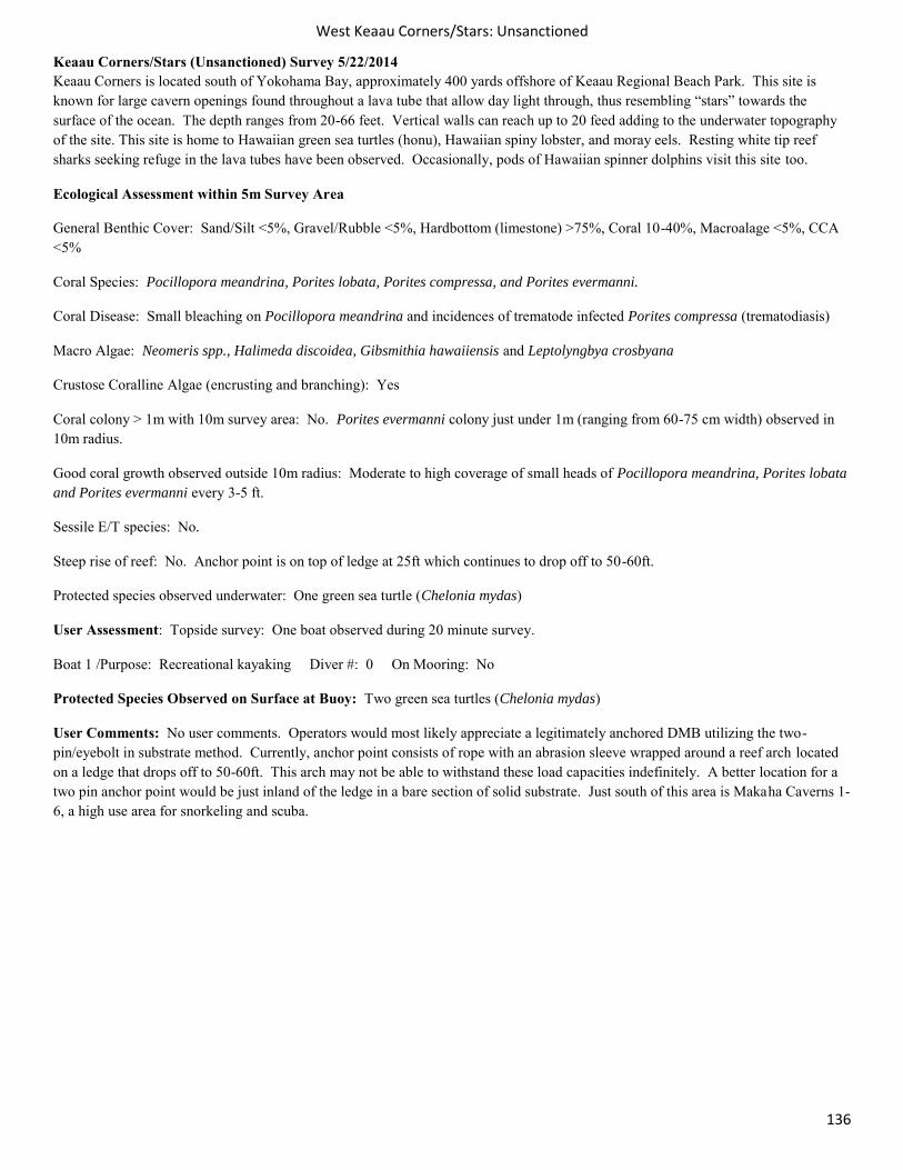
West Keaau Corners/Stars: Unsanctioned
136
Keaau Corners/Stars (Unsanctioned) Survey 5/22/2014 Keaau Corners is located south of Yokohama Bay, approximately 400 yards offshore of Keaau Regional Beach Park. This site is known for large cavern openings found throughout a lava tube that allow day light through, thus resembling “stars” towards the surface of the ocean. The depth ranges from 20-66 feet. Vertical walls can reach up to 20 feed adding to the underwater topography of the site. This site is home to Hawaiian green sea turtles (honu), Hawaiian spiny lobster, and moray eels. Resting white tip reef sharks seeking refuge in the lava tubes have been observed. Occasionally, pods of Hawaiian spinner dolphins visit this site too.
Ecological Assessment within 5m Survey Area
General Benthic Cover: Sand/Silt <5%, Gravel/Rubble <5%, Hardbottom (limestone) >75%, Coral 10-40%, Macroalage <5%, CCA <5%
Coral Species: Pocillopora meandrina, Porites lobata, Porites compressa, and Porites evermanni.
Coral Disease: Small bleaching on Pocillopora meandrina and incidences of trematode infected Porites compressa (trematodiasis)
Macro Algae: Neomeris spp., Halimeda discoidea, Gibsmithia hawaiiensis and Leptolyngbya crosbyana
Crustose Coralline Algae (encrusting and branching): Yes
Coral colony > 1m with 10m survey area: No. Porites evermanni colony just under 1m (ranging from 60-75 cm width) observed in 10m radius.
Good coral growth observed outside 10m radius: Moderate to high coverage of small heads of Pocillopora meandrina, Porites lobata and Porites evermanni every 3-5 ft.
Sessile E/T species: No.
Steep rise of reef: No. Anchor point is on top of ledge at 25ft which continues to drop off to 50-60ft.
Protected species observed underwater: One green sea turtle (Chelonia mydas)
User Assessment: Topside survey: One boat observed during 20 minute survey.
Boat 1 /Purpose: Recreational kayaking Diver #: 0 On Mooring: No
Protected Species Observed on Surface at Buoy: Two green sea turtles (Chelonia mydas)
User Comments: No user comments. Operators would most likely appreciate a legitimately anchored DMB utilizing the two-pin/eyebolt in substrate method. Currently, anchor point consists of rope with an abrasion sleeve wrapped around a reef arch located on a ledge that drops off to 50-60ft. This arch may not be able to withstand these load capacities indefinitely. A better location for a two pin anchor point would be just inland of the ledge in a bare section of solid substrate. Just south of this area is Makaha Caverns 1-6, a high use area for snorkeling and scuba.
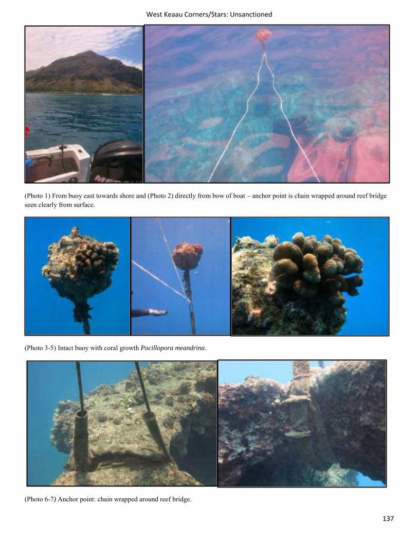
West Keaau Corners/Stars: Unsanctioned
137
(Photo 1) From buoy east towards shore and (Photo 2) directly from bow of boat – anchor point is chain wrapped around reef bridge seen clearly from surface.
(Photo 3-5) Intact buoy with coral growth Pocillopora meandrina.
(Photo 6-7) Anchor point: chain wrapped around reef bridge.
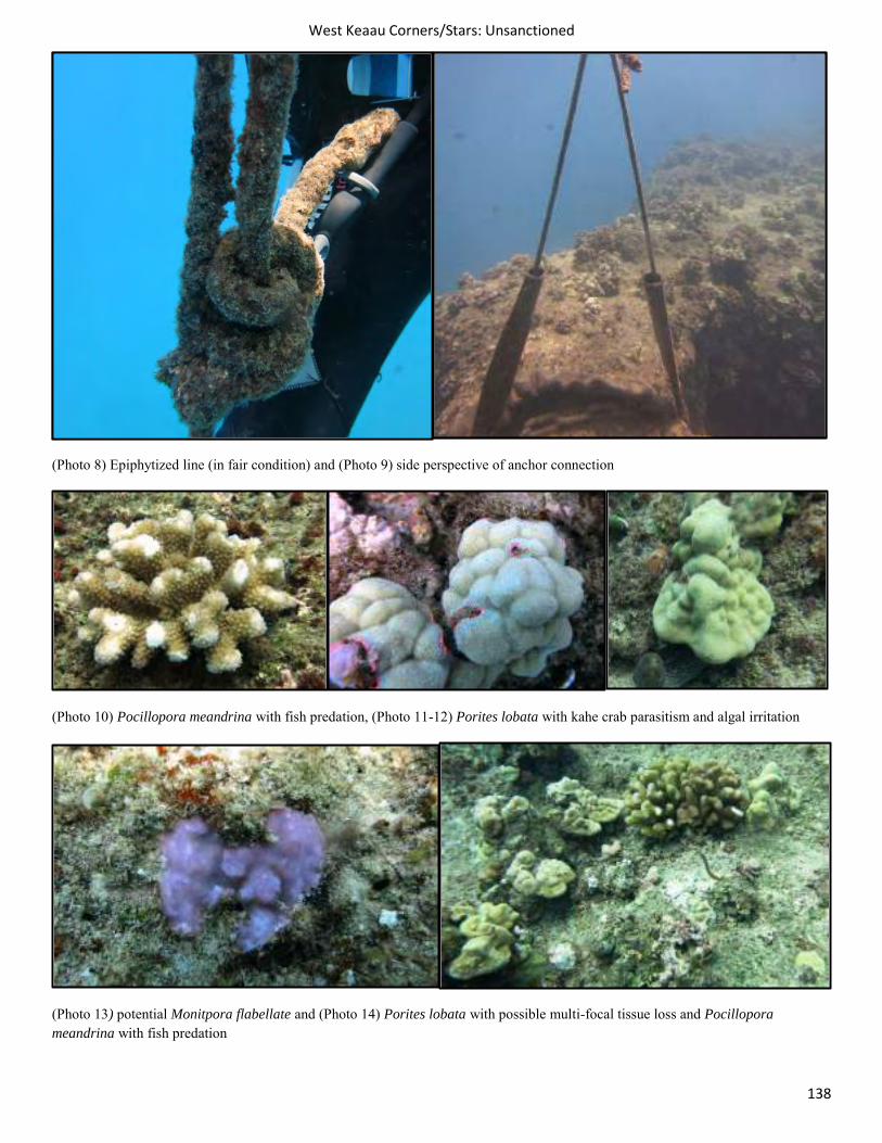
West Keaau Corners/Stars: Unsanctioned
138
(Photo 8) Epiphytized line (in fair condition) and (Photo 9) side perspective of anchor connection
(Photo 10) Pocillopora meandrina with fish predation, (Photo 11-12) Porites lobata with kahe crab parasitism and algal irritation
(Photo 13) potential Monitpora flabellate and (Photo 14) Porites lobata with possible multi-focal tissue loss and Pocillopora meandrina with fish predation
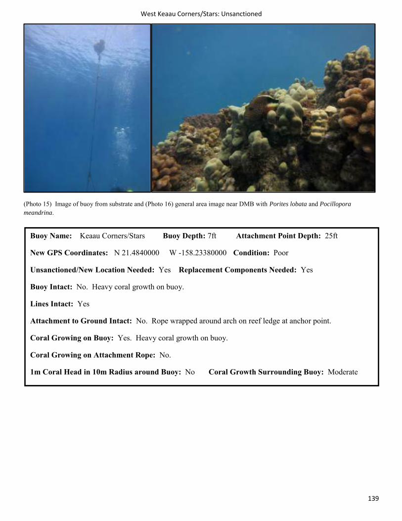
West Keaau Corners/Stars: Unsanctioned
139
(Photo 15) Image of buoy from substrate and (Photo 16) general area image near DMB with Porites lobata and Pocillopora meandrina.
Buoy Name: Keaau Corners/Stars Buoy Depth: 7ft Attachment Point Depth: 25ft
New GPS Coordinates: N 21.4840000 W -158.23380000 Condition: Poor
Unsanctioned/New Location Needed: Yes Replacement Components Needed: Yes
Buoy Intact: No. Heavy coral growth on buoy.
Lines Intact: Yes
Attachment to Ground Intact: No. Rope wrapped around arch on reef ledge at anchor point.
Coral Growing on Buoy: Yes. Heavy coral growth on buoy.
Coral Growing on Attachment Rope: No.
1m Coral Head in 10m Radius around Buoy: No Coral Growth Surrounding Buoy: Moderate
West Ammo Reef 1
140
Ammo Reef 1 (Unsanctioned) Survey 5/29/2014
Ammo Reef is located approximately 400 yards out from the Waianae harbor mouth and is placed in about 30 feet of water. This surrounding area is a popular spot for recreational tour companies that snorkel and watch for populations of spinner and bottlenose dolphins that frequent the area. The mooring pin is located on a piece of cement block (most likely a discarded pier section) and consists of a chain wrapped through the heavy cleat. The rope is in good condition but several colonies of coral have settled and grown on the line. The top D ring is also in place and in good condition. The mooring buoy itself is missing and the line is currently being held aloft by a water container inverted to act as a makeshift buoy.
Ecological Assessment within 5m Survey Area
General Benthic Cover: Sand/Silt 40-75%, Gravel/Rubble <5%, Hardbottom (limestone) 10-40%, Coral 10-40%, Macroalage <5%, CCA <5%
Coral Species: Pocillopora meandrina, Porites lobata, Montipora patula, Montipora capitata (encrusting).
Coral Disease: Kahe crab parasitism on and fish predation on Pocillopora meandrina, pink irritation observed on Porites lobata.
Macro Algae: Native red algae
Crustose Coralline Algae: Yes
Coral colony > 1m with 10m survey area: Yes. 1.0m Porites lobata colony observed
Good coral growth observed outside 10m radius: Yes. Good coverage of small to moderate colonies of Porites lobata, Pocillopora meandrina, Montipora patula and Montipora capitata (encrusting).
Sessile E/T species: Montipora patula Steep rise of reef: 5ft reef spur with 5-10 meters of anchor point
User Assessment: Topside survey: 1 boat observed during 20 min survey.
Boat 1/Purpose: Kayaker Diver #: 0 On Mooring: No, passing by
User Comments: Operators would like sanctioned high load bearing day use moorings to be installed as opposed to utilizing current unsanctioned DMBs. Operators would like open policy to use of moorings as opposed to current policy of certain boats having priority/or extended time allowance on certain DMBs.
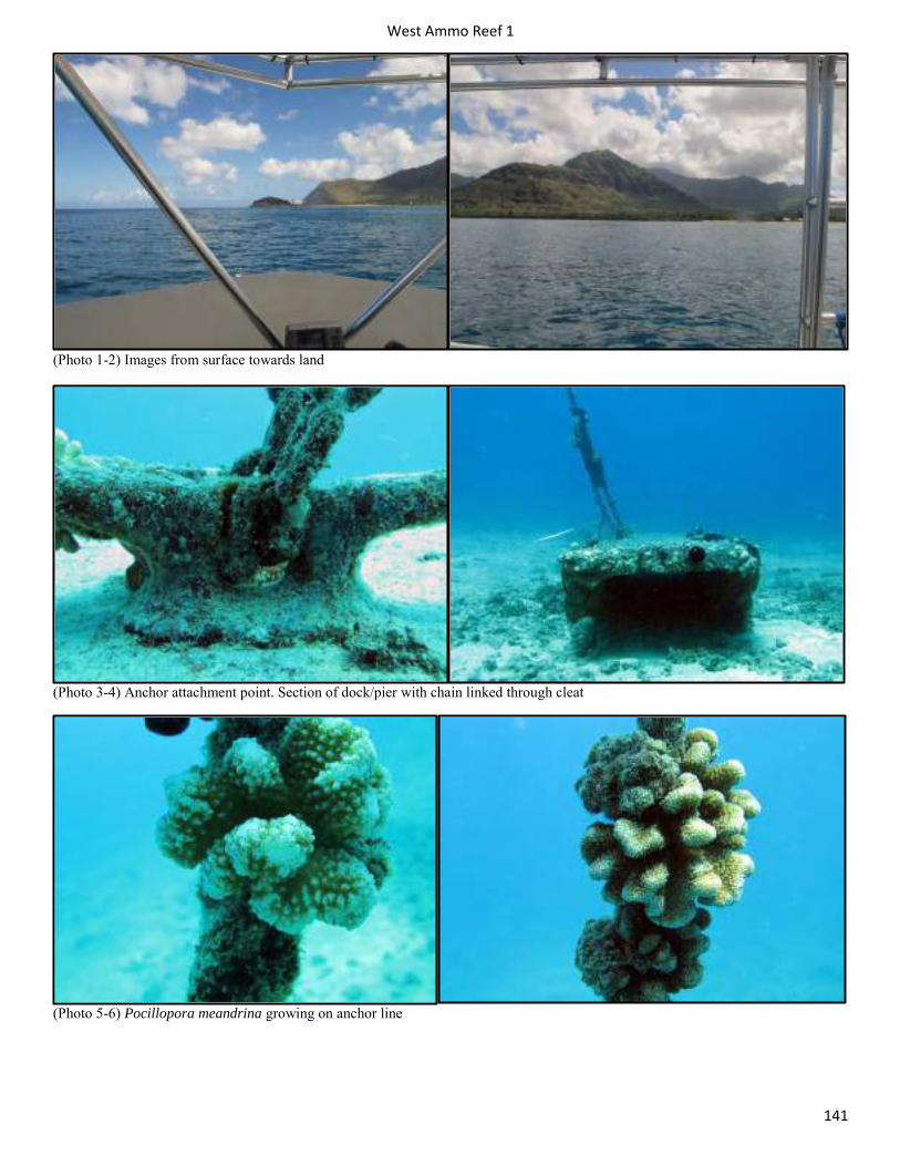
West Ammo Reef 1
141
(Photo 1-2) Images from surface towards land
(Photo 3-4) Anchor attachment point. Section of dock/pier with chain linked through cleat
(Photo 5-6) Pocillopora meandrina growing on anchor line
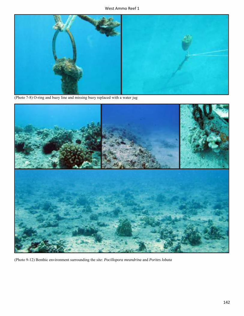
West Ammo Reef 1
142
(Photo 7-8) O-ring and buoy line and missing buoy replaced with a water jug
(Photo 9-12) Benthic environment surrounding the site: Pocillopora meandrina and Porites lobata
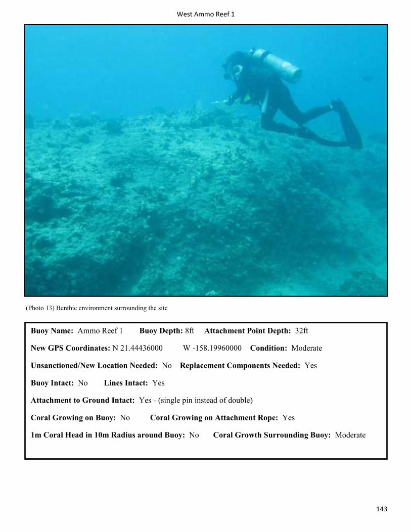
West Ammo Reef 1
143
(Photo 13) Benthic environment surrounding the site
Buoy Name: Ammo Reef 1 Buoy Depth: 8ft Attachment Point Depth: 32ft
New GPS Coordinates: N 21.44436000 W -158.19960000 Condition: Moderate
Unsanctioned/New Location Needed: No Replacement Components Needed: Yes
Buoy Intact: No Lines Intact: Yes
Attachment to Ground Intact: Yes - (single pin instead of double)
Coral Growing on Buoy: No Coral Growing on Attachment Rope: Yes
1m Coral Head in 10m Radius around Buoy: No Coral Growth Surrounding Buoy: Moderate
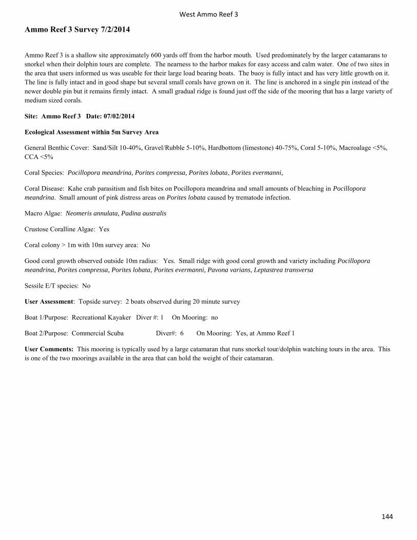
West Ammo Reef 3
144
Ammo Reef 3 Survey 7/2/2014
Ammo Reef 3 is a shallow site approximately 600 yards off from the harbor mouth. Used predominately by the larger catamarans to snorkel when their dolphin tours are complete. The nearness to the harbor makes for easy access and calm water. One of two sites in the area that users informed us was useable for their large load bearing boats. The buoy is fully intact and has very little growth on it. The line is fully intact and in good shape but several small corals have grown on it. The line is anchored in a single pin instead of the newer double pin but it remains firmly intact. A small gradual ridge is found just off the side of the mooring that has a large variety of medium sized corals.
Site: Ammo Reef 3 Date: 07/02/2014
Ecological Assessment within 5m Survey Area
General Benthic Cover: Sand/Silt 10-40%, Gravel/Rubble 5-10%, Hardbottom (limestone) 40-75%, Coral 5-10%, Macroalage <5%, CCA <5%
Coral Species: Pocillopora meandrina, Porites compressa, Porites lobata, Porites evermanni,
Coral Disease: Kahe crab parasitism and fish bites on Pocillopora meandrina and small amounts of bleaching in Pocillopora meandrina. Small amount of pink distress areas on Porites lobata caused by trematode infection.
Macro Algae: Neomeris annulata, Padina australis
Crustose Coralline Algae: Yes
Coral colony > 1m with 10m survey area: No
Good coral growth observed outside 10m radius: Yes. Small ridge with good coral growth and variety including Pocillopora meandrina, Porites compressa, Porites lobata, Porites evermanni, Pavona varians, Leptastrea transversa
Sessile E/T species: No
User Assessment: Topside survey: 2 boats observed during 20 minute survey
Boat 1/Purpose: Recreational Kayaker Diver #: 1 On Mooring: no
Boat 2/Purpose: Commercial Scuba Diver#: 6 On Mooring: Yes, at Ammo Reef 1
User Comments: This mooring is typically used by a large catamaran that runs snorkel tour/dolphin watching tours in the area. This is one of the two moorings available in the area that can hold the weight of their catamaran.
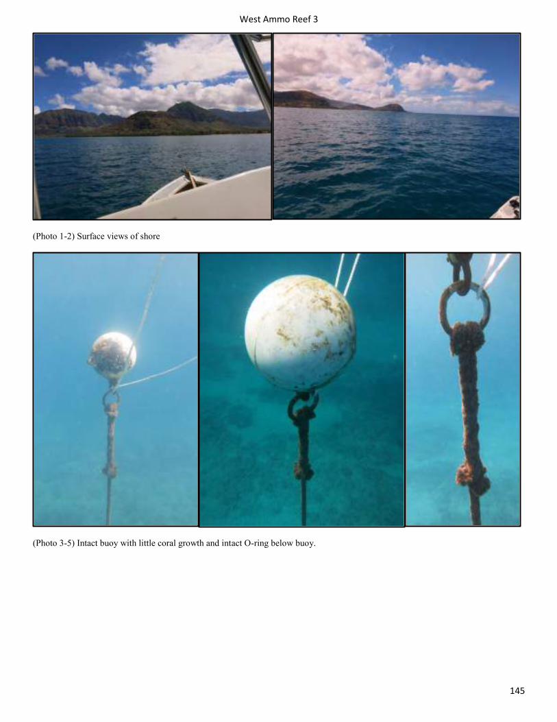
West Ammo Reef 3
145
(Photo 1-2) Surface views of shore
(Photo 3-5) Intact buoy with little coral growth and intact O-ring below buoy.
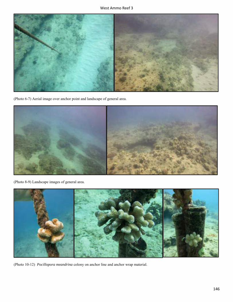
West Ammo Reef 3
146
(Photo 6-7) Aerial image over anchor point and landscape of general area.
(Photo 8-9) Landscape images of general area.
(Photo 10-12) Pocillopora meandrina colony on anchor line and anchor wrap material.
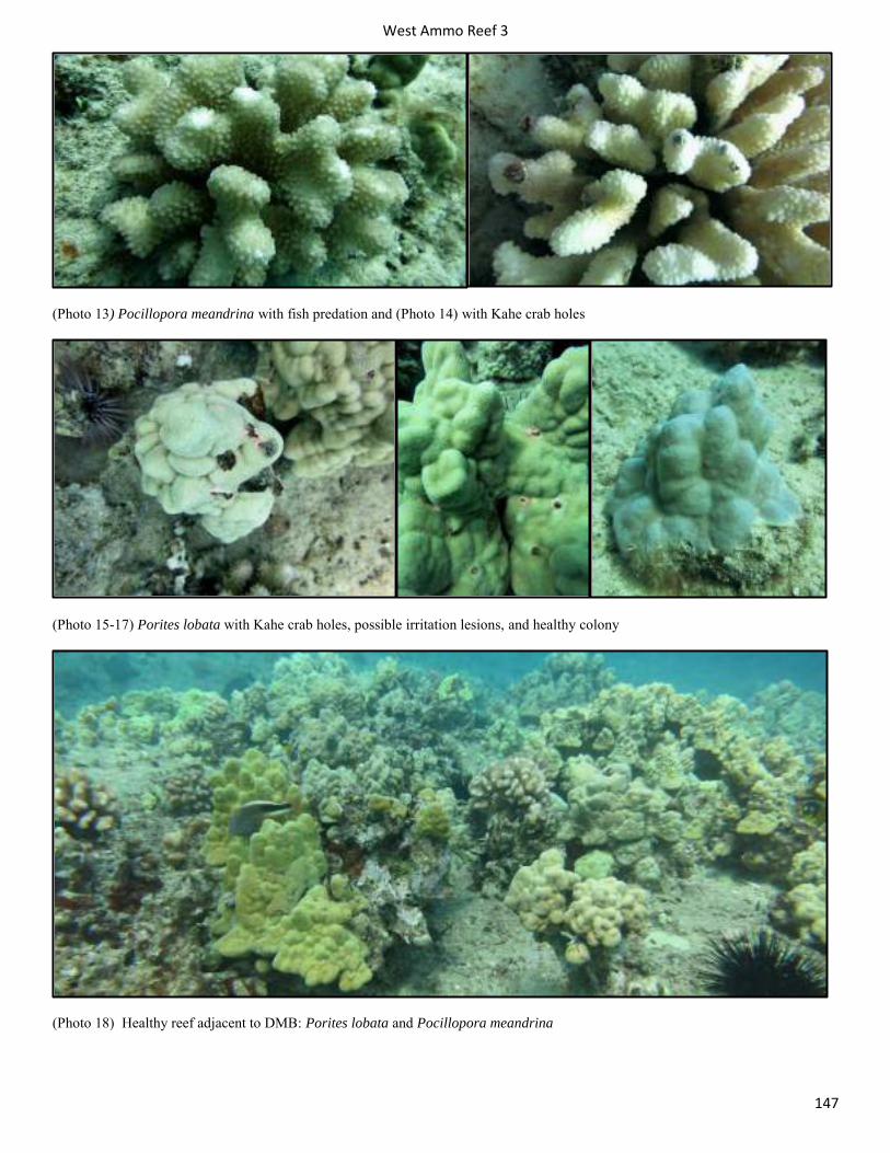
West Ammo Reef 3
147
(Photo 13) Pocillopora meandrina with fish predation and (Photo 14) with Kahe crab holes
(Photo 15-17) Porites lobata with Kahe crab holes, possible irritation lesions, and healthy colony
(Photo 18) Healthy reef adjacent to DMB: Porites lobata and Pocillopora meandrina
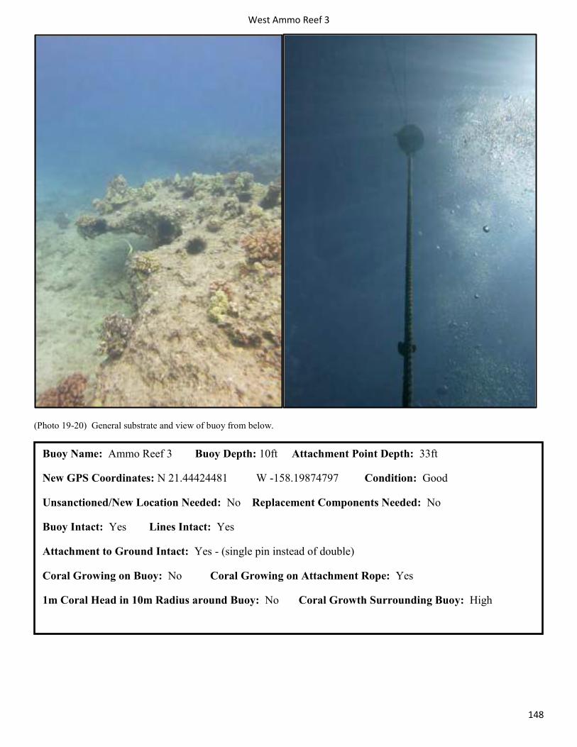
West Ammo Reef 3
148
(Photo 19-20) General substrate and view of buoy from below.
Buoy Name: Ammo Reef 3 Buoy Depth: 10ft Attachment Point Depth: 33ft
New GPS Coordinates: N 21.44424481 W -158.19874797 Condition: Good
Unsanctioned/New Location Needed: No Replacement Components Needed: No
Buoy Intact: Yes Lines Intact: Yes
Attachment to Ground Intact: Yes - (single pin instead of double)
Coral Growing on Buoy: No Coral Growing on Attachment Rope: Yes
1m Coral Head in 10m Radius around Buoy: No Coral Growth Surrounding Buoy: High
West Land of Oz: Sanctioned
149
Land of Oz (Sanctioned) Survey 6/17/2014
Land of Oz mooring is located off the north end of Makaha Beach Park and Makaha surfing beach. These moorings are located near the Makaha Caverns Moorings. This is a great dive site plentiful with nudibranchs, pipefish, octopi, and Hawaiian green sea turtles (honu). Occasionally spotted eagle rays swim by. There is a properly installed eye-bolt in the substrate, but the line and buoy has been replaced (buoy now multiple jugs suspending line).
Ecological Assessment within 5m Survey Area
General Benthic Cover: Sand/Silt 10-40%,, Gravel/Rubble 10-40%, Hardbottom (basalt) 10-40%, Coral 5-10%, Macroalage <5%, CCA <5%
Coral Species: Pocillopora meandrina, Porites lobata, Montipora capitata (encrusting) and Fungia scutaria. Leptastrea transversa observed outside 5m survey area.
Coral Disease: Small bleaching on Pocillopora meandrina.
Macro Algae: Padina spp., Halimeda discoidea, Neomeris spp., Asparagopsis taxiformis, unidentified native brown algae and possibly Liagora spp. (unidentified).
Crustose Coralline Algae: No
Coral colony > 1m with 10m survey area: No
Good coral growth observed outside 10m radius: No. Area is predominantly covered by turf algae/macroalgae covered basalt substrate and rubble. Sparse coverage of Pocillopora meandrina and Porites lobata heads.
Sessile E/T species: No
Steep rise of reef: 15ft canyon walls within 10-15 meters of anchor point.
User Assessment: Topside survey: No boats observed during 20 minute survey. Note: Three commercial scuba/snorkel tour boats already moored at Makaha 1-4 DMBs prior to start of survey. Unknown number of divers.
User Comments: No user comments. Mooring buoy and rope/line needs to be replaced. Existing buoy is inverted detergent bottle attached to line. Line is worn and colonized by small amounts of Pocillopora meandrina and algal epiphytes. Operators would likely welcome new components that suffice high load-bearing requirements on existing DMB.
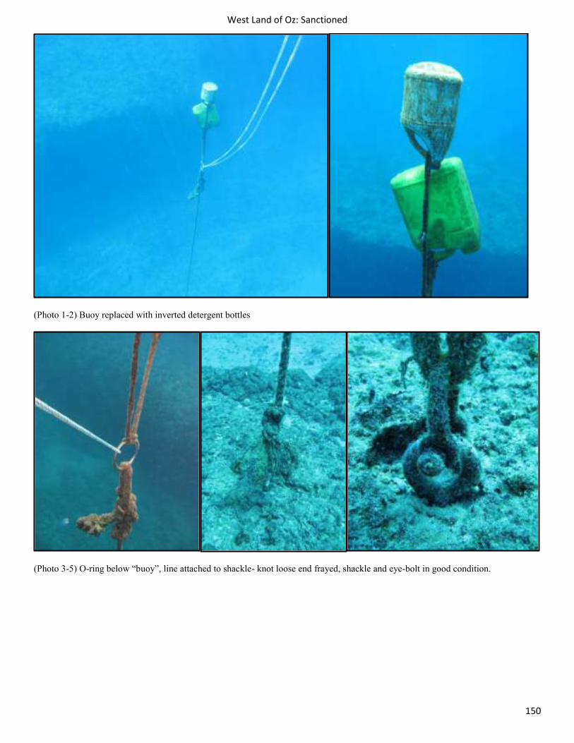
West Land of Oz: Sanctioned
150
(Photo 1-2) Buoy replaced with inverted detergent bottles
(Photo 3-5) O-ring below “buoy”, line attached to shackle- knot loose end frayed, shackle and eye-bolt in good condition.
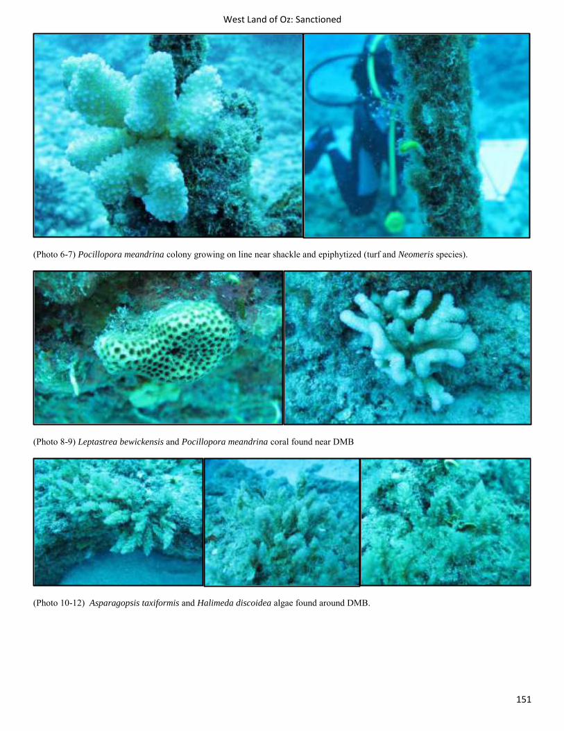
West Land of Oz: Sanctioned
151
(Photo 6-7) Pocillopora meandrina colony growing on line near shackle and epiphytized (turf and Neomeris species).
(Photo 8-9) Leptastrea bewickensis and Pocillopora meandrina coral found near DMB
(Photo 10-12) Asparagopsis taxiformis and Halimeda discoidea algae found around DMB.
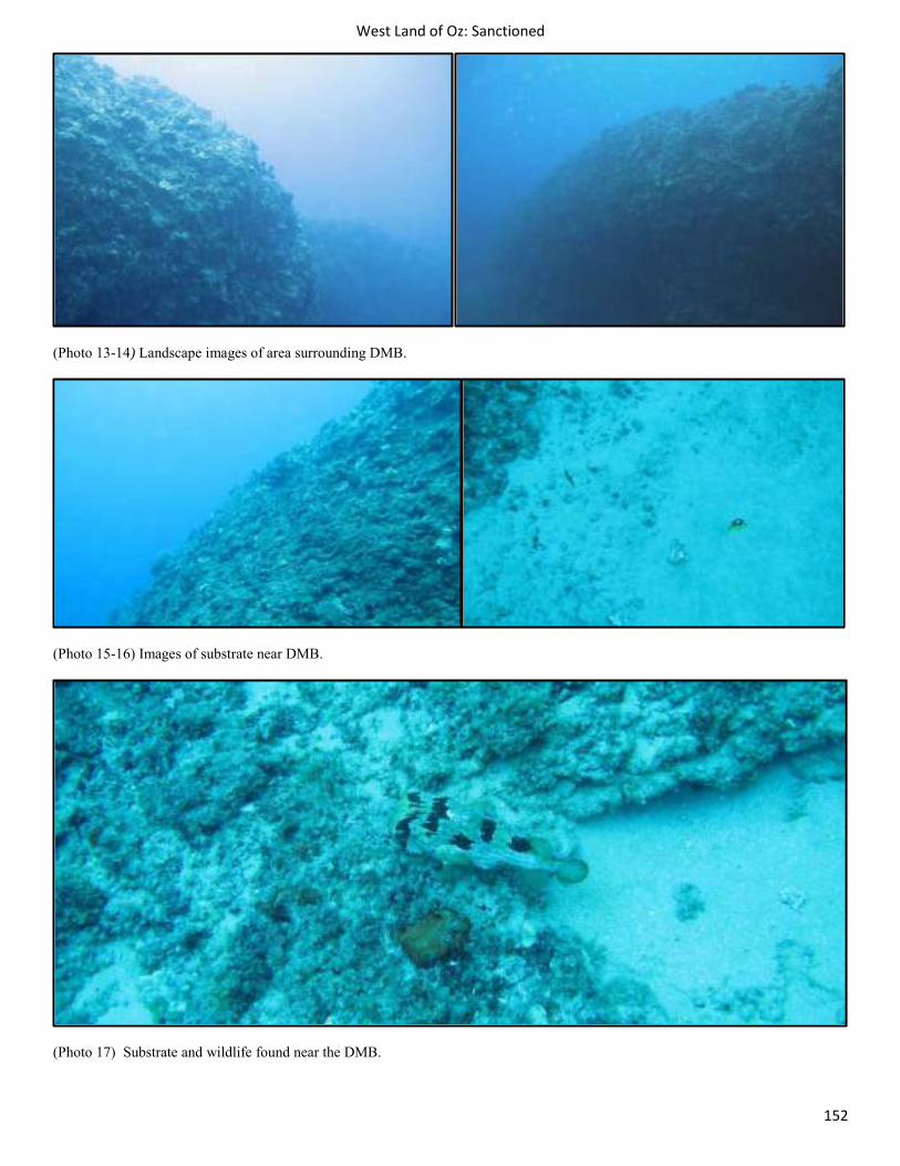
West Land of Oz: Sanctioned
152
(Photo 13-14) Landscape images of area surrounding DMB.
(Photo 15-16) Images of substrate near DMB.
(Photo 17) Substrate and wildlife found near the DMB.
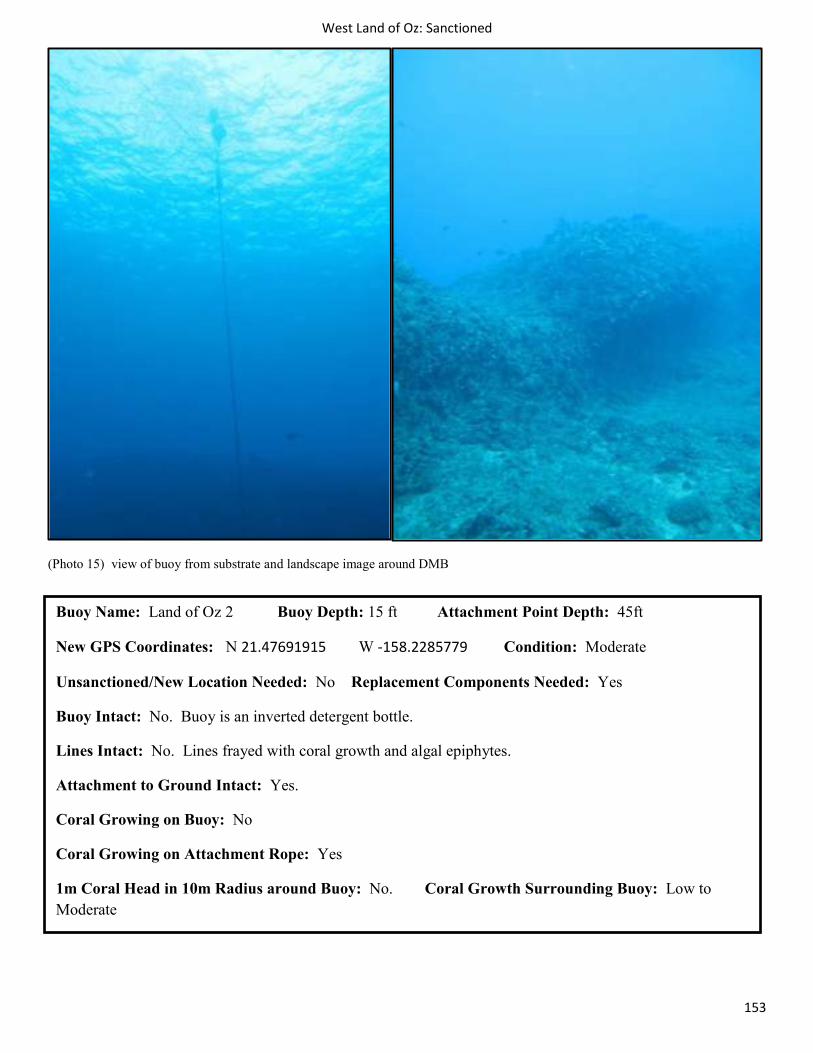
West Land of Oz: Sanctioned
153
(Photo 15) view of buoy from substrate and landscape image around DMB
Buoy Name: Land of Oz 2 Buoy Depth: 15 ft Attachment Point Depth: 45ft
New GPS Coordinates: N 21.47691915 W -158.2285779 Condition: Moderate
Unsanctioned/New Location Needed: No Replacement Components Needed: Yes
Buoy Intact: No. Buoy is an inverted detergent bottle.
Lines Intact: No. Lines frayed with coral growth and algal epiphytes.
Attachment to Ground Intact: Yes.
Coral Growing on Buoy: No
Coral Growing on Attachment Rope: Yes
1m Coral Head in 10m Radius around Buoy: No. Coral Growth Surrounding Buoy: Low to Moderate
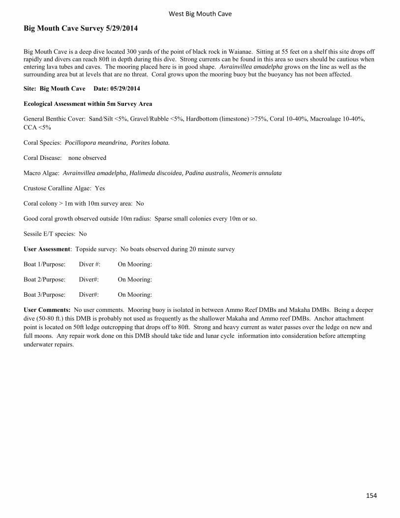
West Big Mouth Cave
154
Big Mouth Cave Survey 5/29/2014
Big Mouth Cave is a deep dive located 300 yards of the point of black rock in Waianae. Sitting at 55 feet on a shelf this site drops off rapidly and divers can reach 80ft in depth during this dive. Strong currents can be found in this area so users should be cautious when entering lava tubes and caves. The mooring placed here is in good shape. Avrainvillea amadelpha grows on the line as well as the surrounding area but at levels that are no threat. Coral grows upon the mooring buoy but the buoyancy has not been affected.
Site: Big Mouth Cave Date: 05/29/2014
Ecological Assessment within 5m Survey Area
General Benthic Cover: Sand/Silt <5%, Gravel/Rubble <5%, Hardbottom (limestone) >75%, Coral 10-40%, Macroalage 10-40%, CCA <5%
Coral Species: Pocillopora meandrina, Porites lobata.
Coral Disease: none observed
Macro Algae: Avrainvillea amadelpha, Halimeda discoidea, Padina australis, Neomeris annulata
Crustose Coralline Algae: Yes
Coral colony > 1m with 10m survey area: No
Good coral growth observed outside 10m radius: Sparse small colonies every 10m or so.
Sessile E/T species: No
User Assessment: Topside survey: No boats observed during 20 minute survey
Boat 1/Purpose: Diver #: On Mooring:
Boat 2/Purpose: Diver#: On Mooring:
Boat 3/Purpose: Diver#: On Mooring:
User Comments: No user comments. Mooring buoy is isolated in between Ammo Reef DMBs and Makaha DMBs. Being a deeper dive (50-80 ft.) this DMB is probably not used as frequently as the shallower Makaha and Ammo reef DMBs. Anchor attachment point is located on 50ft ledge outcropping that drops off to 80ft. Strong and heavy current as water passes over the ledge on new and full moons. Any repair work done on this DMB should take tide and lunar cycle information into consideration before attempting underwater repairs.
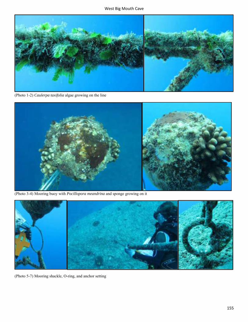
West Big Mouth Cave
155
(Photo 1-2) Caulerpa taxifolia algae growing on the line
(Photo 3-4) Mooring buoy with Pocillopora meandrina and sponge growing on it
(Photo 5-7) Mooring shackle, O-ring, and anchor setting
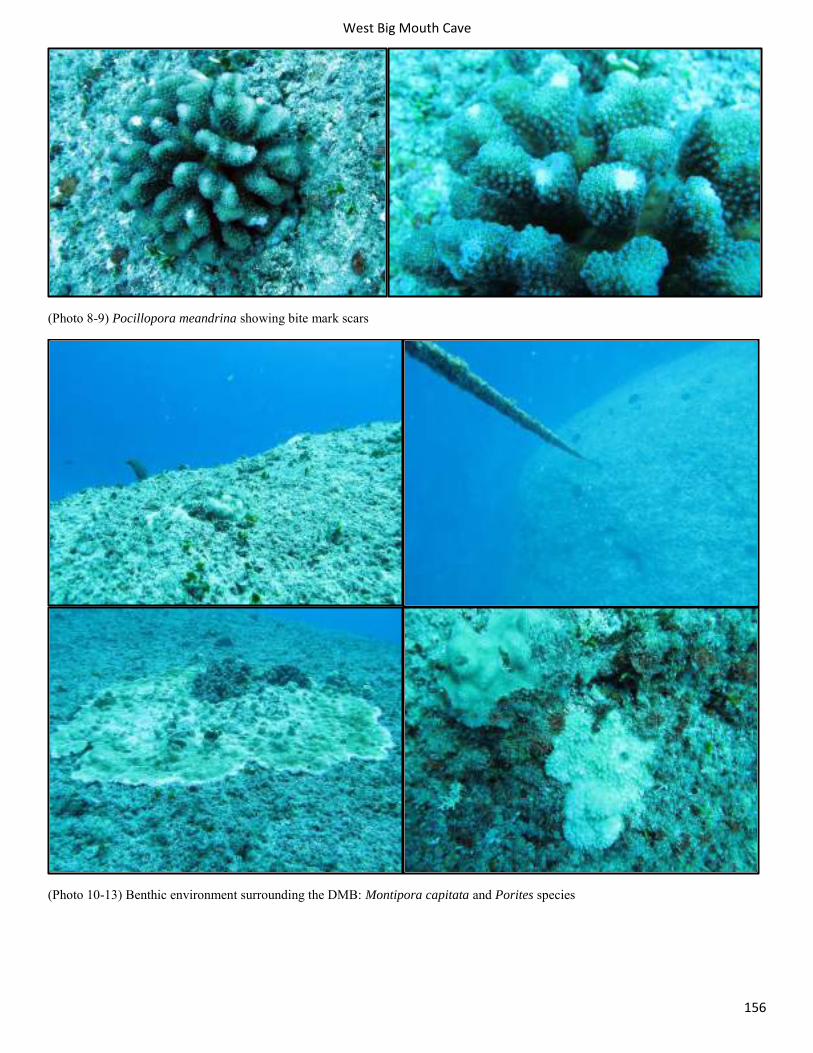
West Big Mouth Cave
156
(Photo 8-9) Pocillopora meandrina showing bite mark scars
(Photo 10-13) Benthic environment surrounding the DMB: Montipora capitata and Porites species
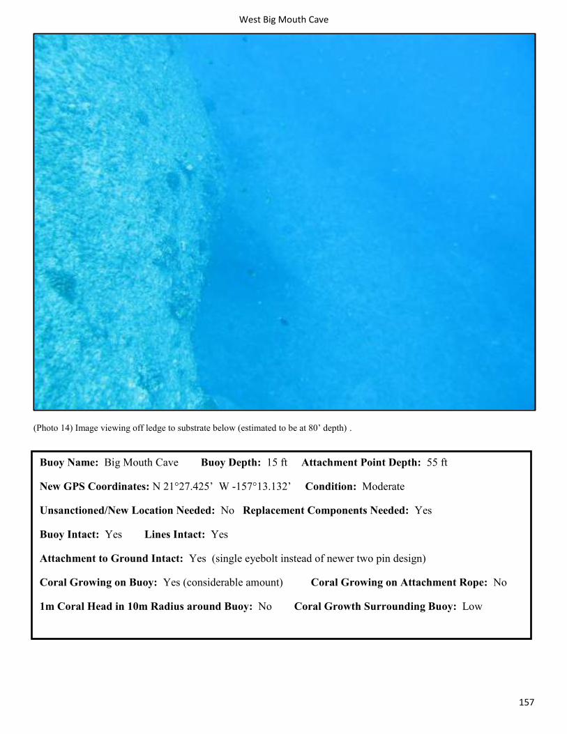
West Big Mouth Cave
157
(Photo 14) Image viewing off ledge to substrate below (estimated to be at 80’ depth) .
Buoy Name: Big Mouth Cave Buoy Depth: 15 ft Attachment Point Depth: 55 ft
New GPS Coordinates: N 21°27.425’ W -157°13.132’ Condition: Moderate
Unsanctioned/New Location Needed: No Replacement Components Needed: Yes
Buoy Intact: Yes Lines Intact: Yes
Attachment to Ground Intact: Yes (single eyebolt instead of newer two pin design)
Coral Growing on Buoy: Yes (considerable amount) Coral Growing on Attachment Rope: No
1m Coral Head in 10m Radius around Buoy: No Coral Growth Surrounding Buoy: Low
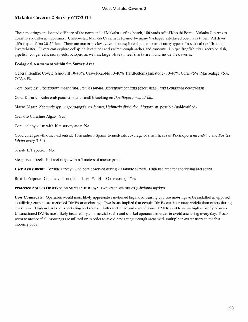
West Makaha Caverns 2
158
Makaha Caverns 2 Survey 6/17/2014
These moorings are located offshore of the north end of Makaha surfing beach, 100 yards off of Kepuhi Point. Makaha Caverns is home to six different moorings. Underwater, Makaha Caverns is formed by many V-shaped interlaced open lava tubes. All dives offer depths from 20-50 feet. There are numerous lava caverns to explore that are home to many types of nocturnal reef fish and invertebrates. Divers can explore collapsed lava tubes and swim through arches and canyons. Unique frogfish, titan scorpion fish, pipefish, conger eels, moray eels, octopus, as well as, large white tip reef sharks are found inside the caverns.
Ecological Assessment within 5m Survey Area
General Benthic Cover: Sand/Silt 10-40%, Gravel/Rubble 10-40%, Hardbottom (limestone) 10-40%, Coral <5%, Macroalage <5%, CCA <5%
Coral Species: Pocillopora meandrina, Porites lobata, Montipora capitata (encrusting), and Leptastrea bewickensis.
Coral Disease: Kahe crab parasitism and small bleaching on Pocillopora meandrina.
Macro Algae: Neomeris spp., Asparagopsis taxiformis, Halimeda discoidea, Liagora sp. possible (unidentified)
Crustose Coralline Algae: Yes
Coral colony > 1m with 10m survey area: No.
Good coral growth observed outside 10m radius: Sparse to moderate coverage of small heads of Pocillopora meandrina and Porites lobata every 3-5 ft.
Sessile E/T species: No.
Steep rise of reef: 10ft reef ridge within 5 meters of anchor point.
User Assessment: Topside survey: One boat observed during 20 minute survey. High use area for snorkeling and scuba.
Boat 1 /Purpose: Commercial snorkel Diver #: 14 On Mooring: Yes
Protected Species Observed on Surface at Buoy: Two green sea turtles (Chelonia mydas)
User Comments: Operators would most likely appreciate sanctioned high load bearing day use moorings to be installed as opposed to utilizing current unsanctioned DMBs or anchoring. Two boats implied that certain DMBs can bear more weight than others during our survey. High use area for snorkeling and scuba. Both sanctioned and unsanctioned DMBs exist to serve high capacity of users. Unsanctioned DMBs most likely installed by commercial scuba and snorkel operators in order to avoid anchoring every day. Boats seem to anchor if all moorings are utilized or in order to avoid navigating through areas with multiple in-water users to reach a mooring buoy.
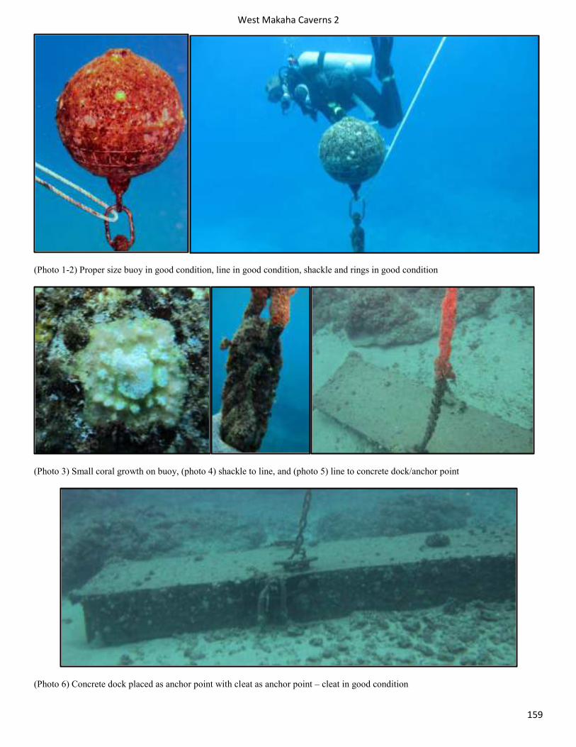
West Makaha Caverns 2
159
(Photo 1-2) Proper size buoy in good condition, line in good condition, shackle and rings in good condition
(Photo 3) Small coral growth on buoy, (photo 4) shackle to line, and (photo 5) line to concrete dock/anchor point
(Photo 6) Concrete dock placed as anchor point with cleat as anchor point – cleat in good condition
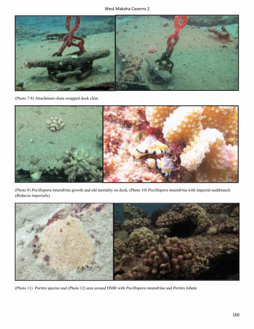
West Makaha Caverns 2
160
(Photo 7-8) Attachment chain wrapped dock cleat.
(Photo 9) Pocillopora meandrina growth and old mortality on dock, (Photo 10) Pocillopora meandrina with Imperial nudibranch (Risbecia imperialis)
(Photo 11) Porites species and (Photo 12) area around DMB with Pocillopora meandrina and Porites lobata
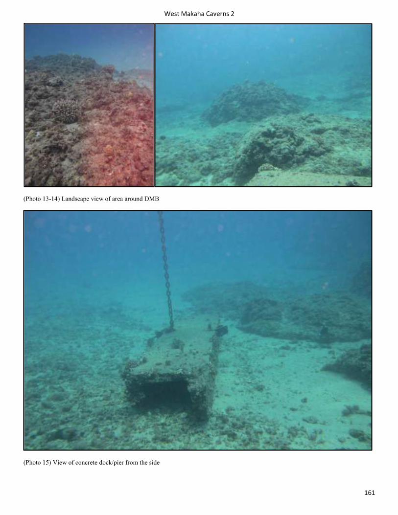
West Makaha Caverns 2
161
(Photo 13-14) Landscape view of area around DMB
(Photo 15) View of concrete dock/pier from the side
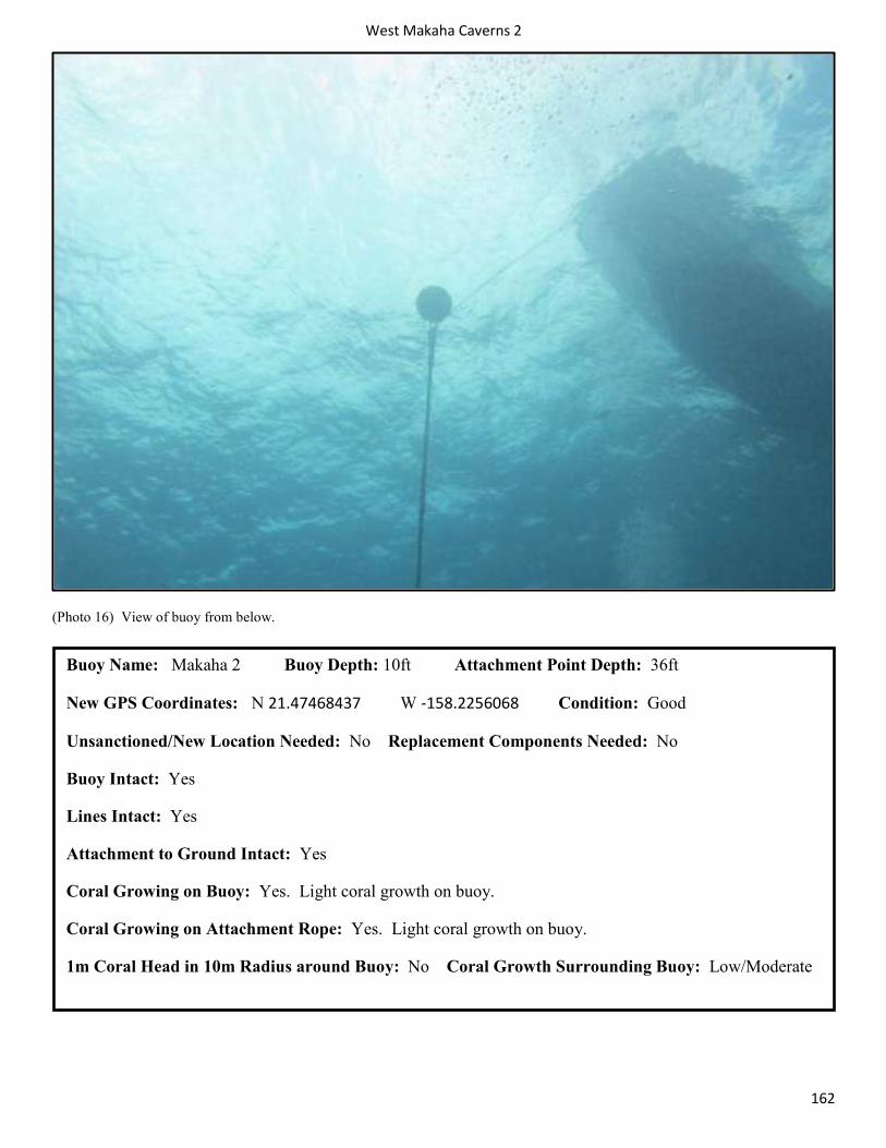
West Makaha Caverns 2
162
(Photo 16) View of buoy from below.
Buoy Name: Makaha 2 Buoy Depth: 10ft Attachment Point Depth: 36ft
New GPS Coordinates: N 21.47468437 W -158.2256068 Condition: Good
Unsanctioned/New Location Needed: No Replacement Components Needed: No
Buoy Intact: Yes
Lines Intact: Yes
Attachment to Ground Intact: Yes
Coral Growing on Buoy: Yes. Light coral growth on buoy.
Coral Growing on Attachment Rope: Yes. Light coral growth on buoy.
1m Coral Head in 10m Radius around Buoy: No Coral Growth Surrounding Buoy: Low/Moderate

West Makaha Caverns 1
163
Makaha Caverns 1 Survey 6/17/2014
These moorings are located offshore of the north end of Makaha surfing beach, 100 yards off of Kepuhi Point. Makaha Caverns is home to six different moorings. Underwater, Makaha Caverns is formed by many V-shaped interlaced open lava tubes. All dives offer depths from 20-50 feet. There are numerous lava caverns to explore that are home to many types of nocturnal reef fish and invertebrates. Divers can explore collapsed lava tubes and swim through arches and canyons. Unique frogfish, titan scorpion fish, pipefish, conger eels, moray eels, octopus, as well as, large white tip reef sharks are found inside the caverns.
Ecological Assessment within 5m Survey Area
General Benthic Cover: Sand/Silt 10-40%, Gravel/Rubble <5%, Hardbottom (limestone) >75%, Coral 10-40%, Macroalage >75%, CCA <5%
Coral Species: Pocillopora meandrina, Porites lobata, Pocillopora damicornis, and Leptastrea bewickensis.
Coral Disease: Fish predation and small bleaching on Pocillopora meandrina.
Macro Algae: Neomeris spp., Avrainvillea amadelpha, Halimeda discoidea, Native turf or grazed native brown macroalgae that covers 75-100% of the substrate.
Crustose Coralline Algae: Yes
Coral colony > 1m with 10m survey area: No.
Good coral growth observed outside 10m radius: Moderate coverage of small heads of Pocillopora meandrina every 3-5 ft.
Sessile E/T species: No.
Steep rise of reef: 10ft reef ridge within 5 meters of anchor point.
User Assessment: Topside survey: 6 boats observed during 20 minute survey. High use area for snorkeling and scuba.
Boat 1 & 2/Purpose: Commercial snorkel Diver #: 24 On Mooring: No/Anchored
Boat 3 & 4/Purpose: Recreational scuba/filming Diver#: 4 On Mooring: No/Anchored
Boat 5 & 6/Purpose: Commercial snorkel Diver#: 22 On Mooring: Yes
Protected Species Observed on Surface at Buoy: 3 Green sea turtles (Chelonia mydas)
User Comments: Operators would most likely appreciate sanctioned high load bearing day use moorings to be installed as opposed to utilizing current unsanctioned DMBs or anchoring. Two boats implied that certain DMBs can bear more weight than others during our survey. High use area for snorkeling and scuba. Both sanctioned and unsanctioned DMBs exist to serve high capacity of users. Unsanctioned DMBs most likely installed by commercial scuba and snorkel operators in order to avoid anchoring every day. Boats seem to anchor if all moorings are utilized or in order to avoid navigating through areas with multiple in-water users to reach a mooring buoy.
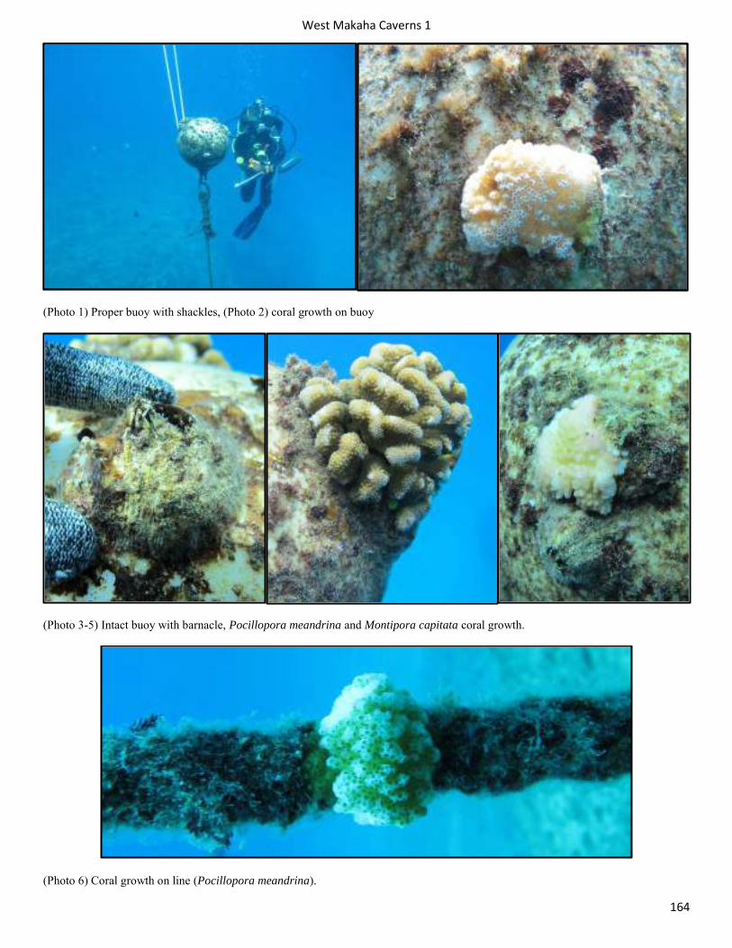
West Makaha Caverns 1
164
(Photo 1) Proper buoy with shackles, (Photo 2) coral growth on buoy
(Photo 3-5) Intact buoy with barnacle, Pocillopora meandrina and Montipora capitata coral growth.
(Photo 6) Coral growth on line (Pocillopora meandrina).
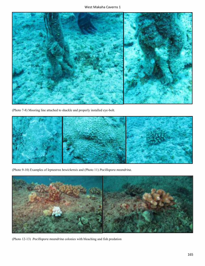
West Makaha Caverns 1
165
(Photo 7-8) Mooring line attached to shackle and properly installed eye-bolt.
(Photo 9-10) Examples of leptastrea bewickensis and (Photo 11) Pocillopora meandrina.
(Photo 12-13) Pocillopora meandrina colonies with bleaching and fish predation
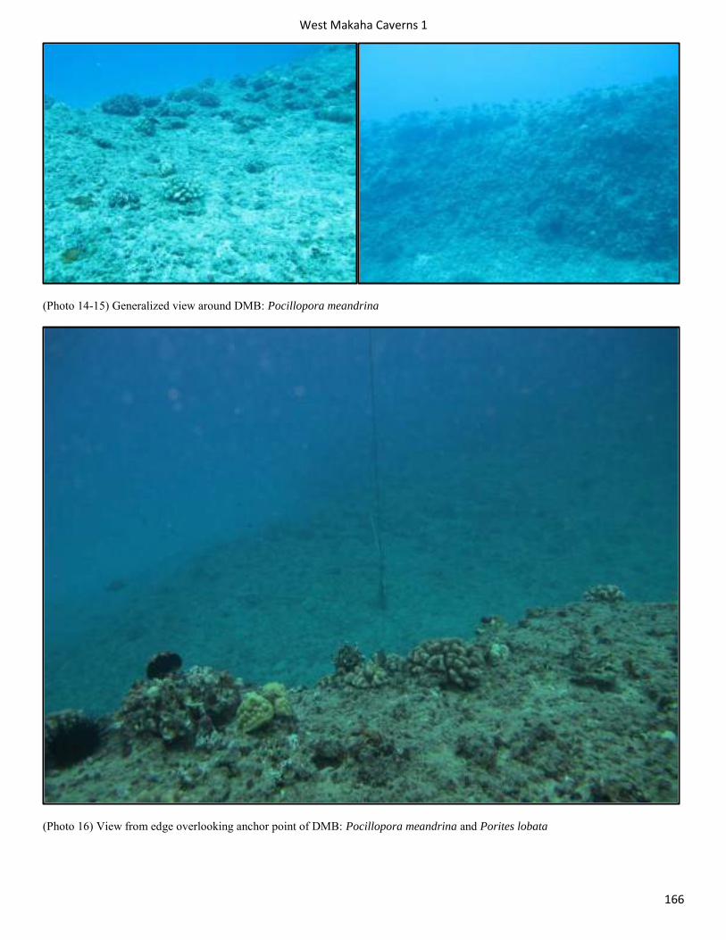
West Makaha Caverns 1
166
(Photo 14-15) Generalized view around DMB: Pocillopora meandrina
(Photo 16) View from edge overlooking anchor point of DMB: Pocillopora meandrina and Porites lobata
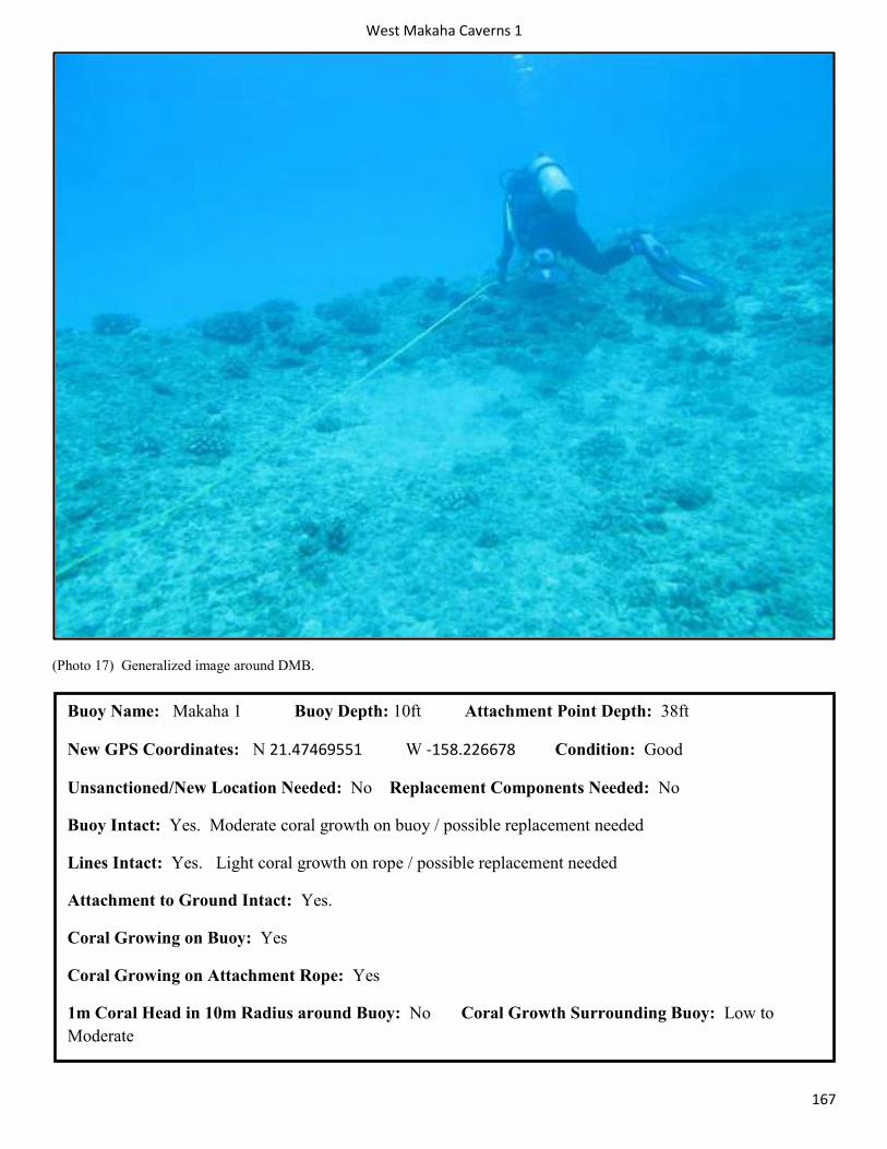
West Makaha Caverns 1
167
(Photo 17) Generalized image around DMB.
Buoy Name: Makaha 1 Buoy Depth: 10ft Attachment Point Depth: 38ft
New GPS Coordinates: N 21.47469551 W -158.226678 Condition: Good
Unsanctioned/New Location Needed: No Replacement Components Needed: No
Buoy Intact: Yes. Moderate coral growth on buoy / possible replacement needed
Lines Intact: Yes. Light coral growth on rope / possible replacement needed
Attachment to Ground Intact: Yes.
Coral Growing on Buoy: Yes
Coral Growing on Attachment Rope: Yes
1m Coral Head in 10m Radius around Buoy: No Coral Growth Surrounding Buoy: Low to Moderate
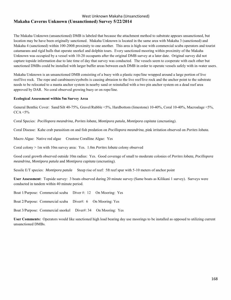
West Unknown Makaha (Unsanctioned)
168
Makaha Caverns Unknown (Unsanctioned) Survey 5/22/2014
The Makaha Unknown (unsanctioned) DMB is labeled that because the attachment method to substrate appears unsanctioned, but location may be have been originally sanctioned. Makaha Unknown is located in the same area with Makaha 3 (sanctioned) and Makaha 4 (sanctioned) within 100-200ft proximity to one another. This area is high-use with commercial scuba operators and tourist catamarans and rigid hulls that operate snorkel and dolphin tours. Every sanctioned mooring within proximity of the Makaha Unknown was occupied by a vessel with 10-20 occupants after the original DMB survey at a later date. Original survey did not capture topside information due to late time of day that survey was conducted. The vessels seem to cooperate with each other but sanctioned DMBs could be installed with larger buffer areas between each DMB in order to operate vessels safely with in-water users.
Makaha Unknown is an unsanctioned DMB consisting of a buoy with a plastic rope/line wrapped around a large portion of live reef/live rock. The rope and carabineers/eyebolts is causing abrasion to the live reef/live rock and the anchor point to the substrate needs to be relocated to a manta anchor system in nearby sand or reinstalled with a two pin anchor system on a dead reef area approved by DAR. No coral observed growing buoy or on rope/line.
Ecological Assessment within 5m Survey Area
General Benthic Cover: Sand/Silt 40-75%, Gravel/Rubble <5%, Hardbottom (limestone) 10-40%, Coral 10-40%, Macroalage <5%, CCA <5%
Coral Species: Pocillopora meandrina, Porites lobata, Montipora patula, Montipora capitata (encrusting).
Coral Disease: Kahe crab parasitism on and fish predation on Pocillopora meandrina, pink irritation observed on Porites lobata.
Macro Algae: Native red algae Crustose Coralline Algae: Yes
Coral colony > 1m with 10m survey area: Yes. 1.0m Porites lobata colony observed
Good coral growth observed outside 10m radius: Yes. Good coverage of small to moderate colonies of Porites lobata, Pocillopora meandrina, Montipora patula and Montipora capitata (encrusting).
Sessile E/T species: Montipora patula Steep rise of reef: 5ft reef spur with 5-10 meters of anchor point
User Assessment: Topside survey: 3 boats observed during 20 minute survey (Same boats as Kilikani 1 survey). Surveys were conducted in tandem within 40 minute period.
Boat 1/Purpose: Commercial scuba Diver #: 12 On Mooring: Yes
Boat 2/Purpose: Commercial scuba Diver#: 6 On Mooring: Yes
Boat 3/Purpose: Commercial snorkel Diver#: 34 On Mooring: Yes
User Comments: Operators would like sanctioned high load bearing day use moorings to be installed as opposed to utilizing current unsanctioned DMBs.
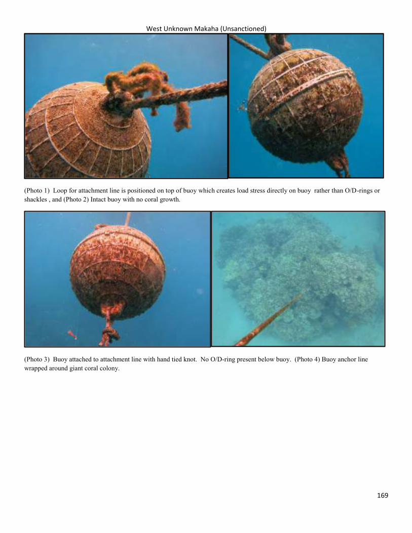
West Unknown Makaha (Unsanctioned)
169
(Photo 1) Loop for attachment line is positioned on top of buoy which creates load stress directly on buoy rather than O/D-rings or shackles , and (Photo 2) Intact buoy with no coral growth.
(Photo 3) Buoy attached to attachment line with hand tied knot. No O/D-ring present below buoy. (Photo 4) Buoy anchor line wrapped around giant coral colony.
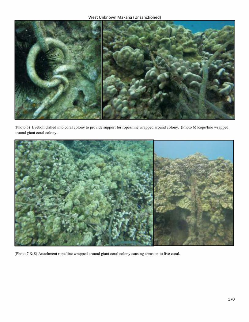
West Unknown Makaha (Unsanctioned)
170
(Photo 5) Eyebolt drilled into coral colony to provide support for ropes/line wrapped around colony. (Photo 6) Rope/line wrapped around giant coral colony.
(Photo 7 & 8) Attachment rope/line wrapped around giant coral colony causing abrasion to live coral.
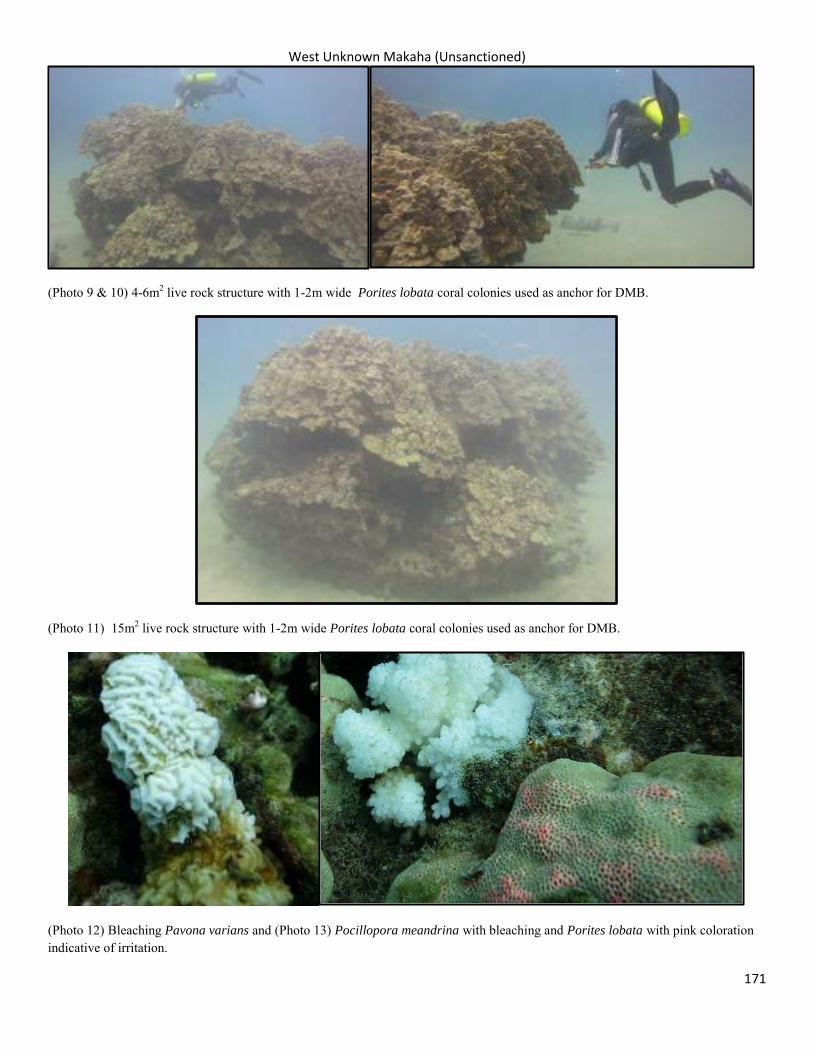
West Unknown Makaha (Unsanctioned)
171
(Photo 9 & 10) 4-6m2 live rock structure with 1-2m wide Porites lobata coral colonies used as anchor for DMB.
(Photo 11) 15m2 live rock structure with 1-2m wide Porites lobata coral colonies used as anchor for DMB.
(Photo 12) Bleaching Pavona varians and (Photo 13) Pocillopora meandrina with bleaching and Porites lobata with pink coloration indicative of irritation.
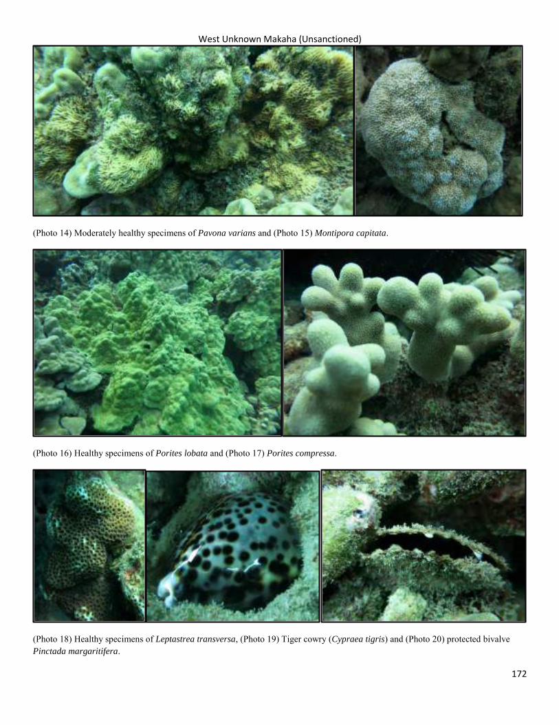
West Unknown Makaha (Unsanctioned)
172
(Photo 14) Moderately healthy specimens of Pavona varians and (Photo 15) Montipora capitata.
(Photo 16) Healthy specimens of Porites lobata and (Photo 17) Porites compressa.
(Photo 18) Healthy specimens of Leptastrea transversa, (Photo 19) Tiger cowry (Cypraea tigris) and (Photo 20) protected bivalve Pinctada margaritifera.
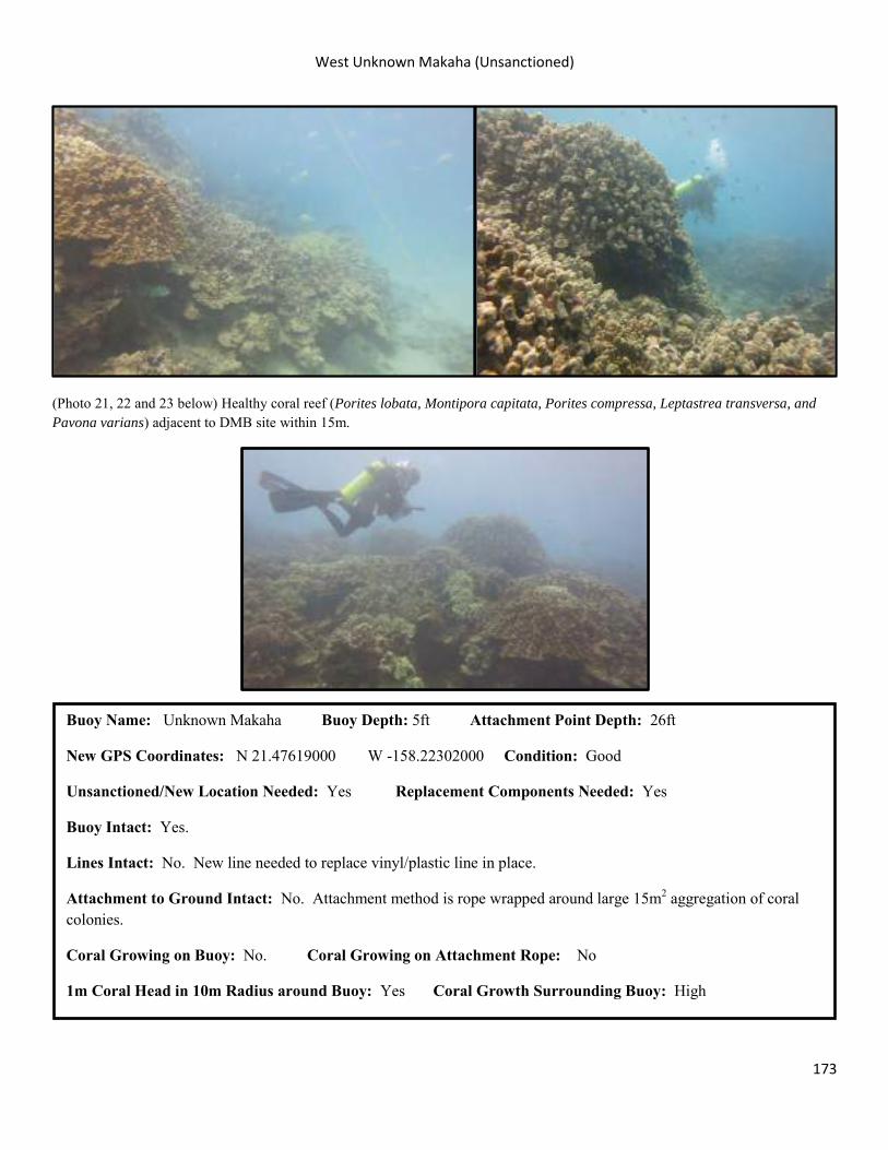
West Unknown Makaha (Unsanctioned)
173
(Photo 21, 22 and 23 below) Healthy coral reef (Porites lobata, Montipora capitata, Porites compressa, Leptastrea transversa, and Pavona varians) adjacent to DMB site within 15m.
Buoy Name: Unknown Makaha Buoy Depth: 5ft Attachment Point Depth: 26ft
New GPS Coordinates: N 21.47619000 W -158.22302000 Condition: Good
Unsanctioned/New Location Needed: Yes Replacement Components Needed: Yes
Buoy Intact: Yes.
Lines Intact: No. New line needed to replace vinyl/plastic line in place.
Attachment to Ground Intact: No. Attachment method is rope wrapped around large 15m2 aggregation of coral colonies.
Coral Growing on Buoy: No. Coral Growing on Attachment Rope: No
1m Coral Head in 10m Radius around Buoy: Yes Coral Growth Surrounding Buoy: High
Appendix: Survey Methodology
174
Project Objectives The focus of this project will be the three main areas of DMB located on the south and west shores of Oahu (Manualua Bay, Waikiki, and Waianae). For each of those areas, the project objectives will be to document the (A) current location of sanctioned and unsanctioned DMBs with GIS, (B) the structural integrity, (C) the functionality (number and type of users) and (D) the ecological conditions of each legal DMB. A. Geographical Location Each legal and permit pending DMB be will be located with reference coordinates and verified with a geographical positioning system (GPS) in order to create a DMB layer with a geographical information system (GIS). This DMB layer can then be overlaid or merged with other GIS layers that geo-reference the location of Ocean Recreation Management Areas (ORMAs), Fishing Management Areas (FMA’s), presence of marine mammals or benthic habitat. This merging of GIS layers will create a more detailed and higher resolution picture of how recreational day-use mooring activity may interact with marine zoning or benthic habitat. The location of illegal DMBs will be verified and geo-referenced if located during surveys. B. Structural Integrity For each legal DMB the integrity of the mooring buoy, chain, attachment method and attachment point will be evaluated and graded with photo documentation. It is the State of Hawaii’s responsibility to ensure the structural integrity of a permitted DMB and employ any safety measures possible to maintain this integrity for recreational users. For illegal DMBs the attachment point and attachment method will be evaluated and assessed to estimate damage impact to benthic environment and structural integrity in terms of safety for recreational users. C. Functionality The functionality of the permitted DMB will be assessed by documenting number and type of users during a certain time period for the duration of the underwater survey. This type of survey will gather census data on the demographics of user groups and utilization type of the DMB (fishing, spear fishing, recreational scuba, commercial scuba, researchers). D. Ecological Condition The ecological condition of the benthic habitat surround the permitted DMB will be documented and assessed to verify that recreational use is not impacting each site. A general description of an area of the benthic substrate can be used as baseline data to track major changes over time (phase shifts, disease, bleaching). Surveys that document coral breakage, invasive species, and trash in a defined area can also provide data to describe the impacts of recreational use. Photo documentation will accompany all ecological surveys. A more detailed survey can be designed in the future (perhaps a scuba snap assessment using GPS attached to dive floats)
Appendix: Survey Methodology
175
Proposed Methods Survey methodology will be based on past survey methodology used to describe sites that were proposed for DMB installation. Survey methodology Surveys will be conducted by teams of three divers. Two divers will conduct the underwater survey while one safety diver stays in the boat on the surface and conducts a surface survey, while conducting normal surface support/safety operations. Underwater Survey: All habitat descriptions and quantifications will be observed within a 10 m radius survey area of the mooring buoy and chain location. Divers will each have a separate survey sheet. First survey sheet (Survey Sheet 1) is aimed to take data on the mooring buoy/ chain/attachment point and quantify ecological impacts in area from use. Second survey sheet (Survey Sheet 2) is aimed to quantify general description of benthic habitat and protected species activity/incidence. Mooring Buoy Condition and Impacted Resources Survey Sheet 1 Mooring Buoy Condition and Impacted Resources 1. Survey Sheet Header On the surface before conducting dive, both divers will fill out section with Island, Dive Site, Date, Depth (use boat depth finder or dive computer after dive), New GPS Lat/Long, DAR Divers/Boat Driver (names), and Time. For multiple Dive Sites with same name (such as Makaha Caverns), numbering system will designated beforehand and diver will enter appropriate name with allocated # (ie; Makaha Caverns 1, Makaha Caverns 2). 2. Mooring Buoy Condition of Buoy: Diver will observe condition of buoy on descent. Diver will observe condition of buoy attachment to chain and condition of D-Rings where boat bridal lines attach. Diver will mark down anything that looks corroded or suspect and document with photograph. Diver will observe condition of buoy. Does buoy buoyancy and position in the water column seem satisfactory? Buoys are generally positioned 25ft or shallower. Diver will observe if buoy seems weighted down with possibility of impacting benthic habitat. Coral on Buoy: Diver will observe any growth of coral growing on buoy. If coral growing diver will mark down # of incidences, species and form (encrusting/pillar/plate) and document with photograph. AIS (aquatic invasive species) on Buoy: Diver will observe any growth of AIS growing on buoy. If AIS growing diver will mark down # of incidences, species and form (sprigs/clumps/mats) and document with photograph. 3. Buoy Chain Condition of Chain: Diver will observe condition of chain on descent. Diver will observe condition of chain attachment to substrate and structural condition of attachment device/object. Diver will mark down anything that looks corroded or suspect and document with photograph. Diver will observe position of chain in relation to benthic habitat: Is chain dragging or snagged on substrate/coral?
Appendix: Survey Methodology
176
Coral on Chain: Diver will observe any growth of coral growing on chain. If coral growing diver will mark down # of incidences, species and form (encrusting/pillar/plate) and document with photograph. AIS on Chain (Aquatic Invasive Species): Diver will observe any growth of AIS growing on buoy. If AIS growing diver will mark down # of incidences, species and form (sprigs/clumps/mats) and document with photographs. Once Divers have completed decent down the chain/line to the bottom, divers will swim out a 10 M transect tape and use tape to visualize 10 M radius circle around center of day use mooring attachment point. All quantitative and qualitative observations of benthic environment will be constrained to the 10 M radius circle. 4. Impacted Resources at Site Broken Coral: Diver will observe any incidences of broken coral heads within 10 m radius. Diver will document broken coral heads that are a result of scuba diving operations and not a result of wave action or surge. Diver will mark down # of incidences, species and form of coral (encrusting/pillar/plate) and document with photograph. Diseased Coral: Diver will observe any incidences of diseased coral heads within 10 m radius. Diver will mark down # of incidences of disease, species and form of coral (encrusting/pillar/plate) and document disease with photograph. Bleached Coral: Diver will observe any incidences of bleached coral heads within 10 m radius. Diver will mark down # of incidences of bleached coral, species and form of coral (encrusting/pillar/plate) and document bleaching with photograph. Trash/Marine Debris: Diver will observe any incidences of trash or marine debris within 10 m radius. Diver will mark down # of incidences of trash, whether or not trash/marine debris is impacting coral heads or may lead to marine animal entanglement, document trash/marine debris with photograph and remove trash or marine debris if possible. Prohibited Fishing Practices: Diver will observe any incidences of prohibited fishing practice around day use mooring. Diver will document any incidences of illegal fishing acts (laynets longer than 100 ft./ laynets unattended/bag limits exceeded). Diver will report observations to Hawaii Division of Conservation and Resource Enforcement (DOCARE) as soon as possible. (See Appendix) Survey Sheet 1 Example: On-site Assessment of Buoy/Chain/Environment for Permanent DMBs (10m radius) Benthic Assessment and Protected Species Survey Sheet 2 Benthic Assessment and Protected Species 1. Survey Sheet Header On the surface before conducting dive, both divers will fill out section with Island, Dive Site, Date, Depth (use boat depth finder or dive computer after dive), New GPS Lat/Long, DAR Divers/Boat Driver (names), and Time. For multiple Dive Sites with same name (such as Makaha Caverns), numbering system will designated beforehand and diver will enter appropriate name with allocated # (ie; Makaha Caverns 1, Makaha Caverns 2). 2. General Benthic Cover
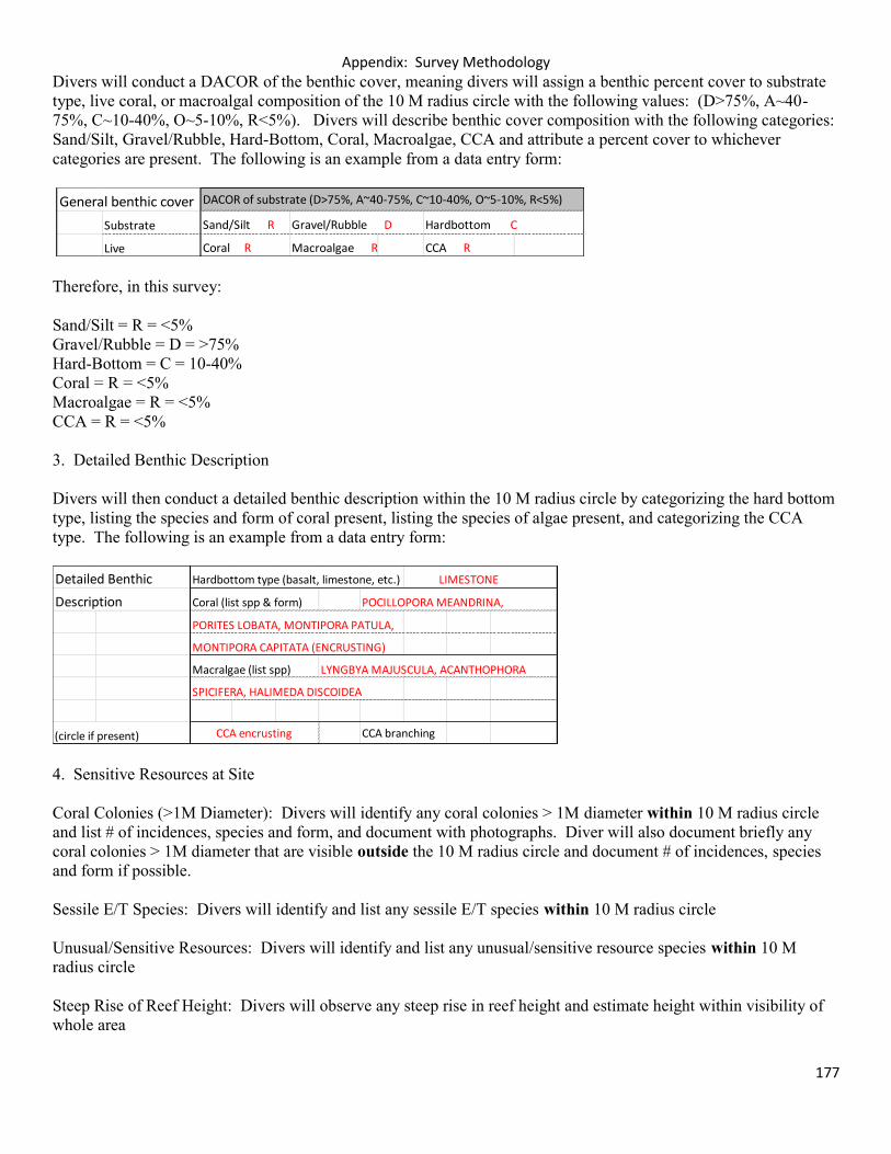
Appendix: Survey Methodology
177
Divers will conduct a DACOR of the benthic cover, meaning divers will assign a benthic percent cover to substrate type, live coral, or macroalgal composition of the 10 M radius circle with the following values: (D>75%, A~40-75%, C~10-40%, O~5-10%, R<5%). Divers will describe benthic cover composition with the following categories: Sand/Silt, Gravel/Rubble, Hard-Bottom, Coral, Macroalgae, CCA and attribute a percent cover to whichever categories are present. The following is an example from a data entry form:
Therefore, in this survey: Sand/Silt = R = <5% Gravel/Rubble = D = >75% Hard-Bottom = C = 10-40% Coral = R = <5% Macroalgae = R = <5% CCA = R = <5% 3. Detailed Benthic Description Divers will then conduct a detailed benthic description within the 10 M radius circle by categorizing the hard bottom type, listing the species and form of coral present, listing the species of algae present, and categorizing the CCA type. The following is an example from a data entry form:
4. Sensitive Resources at Site Coral Colonies (>1M Diameter): Divers will identify any coral colonies > 1M diameter within 10 M radius circle and list # of incidences, species and form, and document with photographs. Diver will also document briefly any coral colonies > 1M diameter that are visible outside the 10 M radius circle and document # of incidences, species and form if possible. Sessile E/T Species: Divers will identify and list any sessile E/T species within 10 M radius circle Unusual/Sensitive Resources: Divers will identify and list any unusual/sensitive resource species within 10 M radius circle Steep Rise of Reef Height: Divers will observe any steep rise in reef height and estimate height within visibility of whole area
General benthic cover DACOR of substrate (D>75%, A~40-75%, C~10-40%, O~5-10%, R<5%)
Substrate Sand/Silt R Gravel/Rubble D Hardbottom C
Live Coral R Macroalgae R CCA R
Detailed Benthic Hardbottom type (basalt, limestone, etc.) LIMESTONE
Description Coral (list spp & form) POCILLOPORA MEANDRINA,
PORITES LOBATA, MONTIPORA PATULA,
MONTIPORA CAPITATA (ENCRUSTING)
Macralgae (list spp) LYNGBYA MAJUSCULA, ACANTHOPHORA
SPICIFERA, HALIMEDA DISCOIDEA
(circle if present) CCA encrusting CCA branching
Appendix: Survey Methodology
178
5. Protected Species Protected Species: Divers will identify any protected species (Turtle, Humpback Whale, Monk Seal, Dolphin, Other Cetacean) within visibility around buoy. (See Appendix) Survey Sheet 2 Example: Benthic Assessment and Protected Species Surface Survey Survey Sheet 3 Surface Activity Assessment 1. Survey Sheet Header On the surface before dive is conducted, surface support/safety diver will fill out section with Island, Dive Site, Date, Depth (use boat depth finder or dive computer after dive), New GPS Lat/Long, DAR Divers/Boat Driver (names), and Time. For multiple Dive Sites with same name (such as Makaha Caverns), numbering system will designated beforehand and diver will enter appropriate name with allocated # (ie; Makaha Caverns 1, Makaha Caverns 2). 2. Boats User Group and Activities Surface support/safety diver will observe number of boats in area, purpose of boat (commercial scuba, individual scuba, research, fishing), fishing method (spear, pole, laynet) and the method of attachment (boat is anchored, on another mooring buoy or surface support is unable to tell). 3. Protected Species Protected Species: Surface support/safety diver will identify any protected species (Turtle, Humpback Whale, Monk Seal, Dolphin, Other Cetacean) within visibility around buoy. Surface support/safety diver will compare numbers with divers after dive to avoid replicate data. (See Appendix) Survey Sheet 3 Example: Assessment of Surface Activity for Day Use Mooring Buoys (20 Minute Survey) Unsanctioned Moorings: Any newly discovered unsanctioned moorings will be geo-referenced and will be evaluated according to the Interim DAR DMB Site-Selection Guidelines which are as follows:
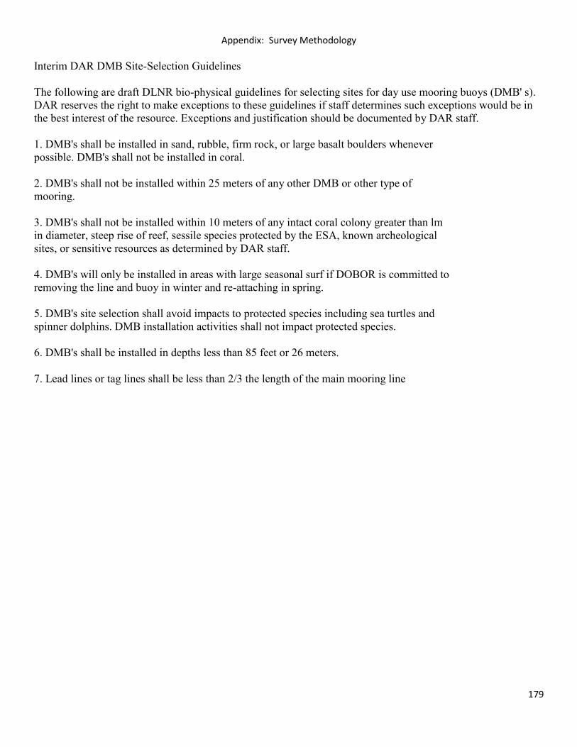
Appendix: Survey Methodology
179
Interim DAR DMB Site-Selection Guidelines The following are draft DLNR bio-physical guidelines for selecting sites for day use mooring buoys (DMB' s). DAR reserves the right to make exceptions to these guidelines if staff determines such exceptions would be in the best interest of the resource. Exceptions and justification should be documented by DAR staff. 1. DMB's shall be installed in sand, rubble, firm rock, or large basalt boulders whenever possible. DMB's shall not be installed in coral. 2. DMB's shall not be installed within 25 meters of any other DMB or other type of mooring. 3. DMB's shall not be installed within 10 meters of any intact coral colony greater than lm in diameter, steep rise of reef, sessile species protected by the ESA, known archeological sites, or sensitive resources as determined by DAR staff. 4. DMB's will only be installed in areas with large seasonal surf if DOBOR is committed to removing the line and buoy in winter and re-attaching in spring. 5. DMB's site selection shall avoid impacts to protected species including sea turtles and spinner dolphins. DMB installation activities shall not impact protected species. 6. DMB's shall be installed in depths less than 85 feet or 26 meters. 7. Lead lines or tag lines shall be less than 2/3 the length of the main mooring line
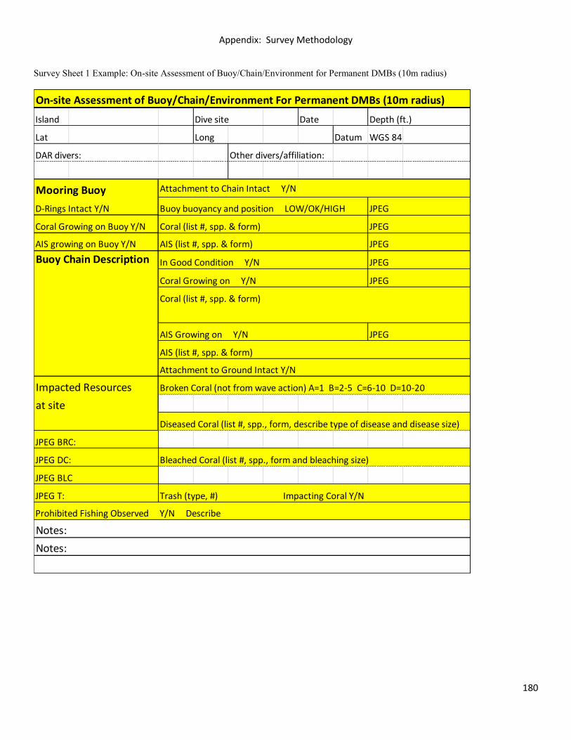
Appendix: Survey Methodology
180
Survey Sheet 1 Example: On-site Assessment of Buoy/Chain/Environment for Permanent DMBs (10m radius)
On-site Assessment of Buoy/Chain/Environment For Permanent DMBs (10m radius)
Island Dive site Date Depth (ft.)
Lat Long Datum WGS 84
DAR divers: Other divers/affiliation:
Mooring Buoy Attachment to Chain Intact Y/N
AIS growing on Buoy Y/N
Coral (list #, spp. & form)
AIS (list #, spp. & form)
Impacted Resources Broken Coral (not from wave action) A=1 B=2-5 C=6-10 D=10-20
at site
Diseased Coral (list #, spp., form, describe type of disease and disease size)
Bleached Coral (list #, spp., form and bleaching size)
Trash (type, #) Impacting Coral Y/N
Buoy Chain Description
JPEG
JPEG
JPEG
JPEG
JPEG
JPEG
AIS (list #, spp. & form)
In Good Condition Y/N
Coral Growing on Y/N
AIS Growing on Y/N
JPEG BRC:
JPEG DC:
JPEG BLC
JPEG T:
Notes:
Notes:
D-Rings Intact Y/N
Coral Growing on Buoy Y/N
Prohibited Fishing Observed Y/N Describe
Buoy buoyancy and position LOW/OK/HIGH
Coral (list #, spp. & form)
Attachment to Ground Intact Y/N
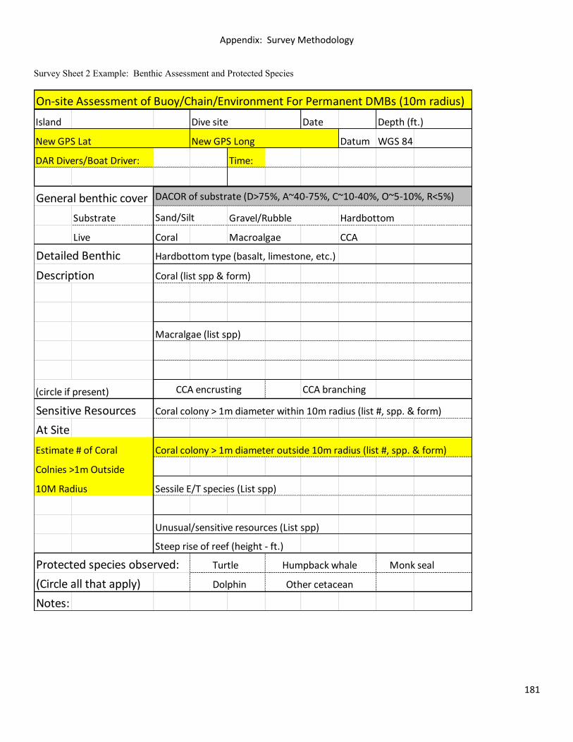
Appendix: Survey Methodology
181
Survey Sheet 2 Example: Benthic Assessment and Protected Species
On-site Assessment of Buoy/Chain/Environment For Permanent DMBs (10m radius)
Island Dive site Date Depth (ft.)
New GPS Lat New GPS Long Datum WGS 84
DAR Divers/Boat Driver: Time:
General benthic cover DACOR of substrate (D>75%, A~40-75%, C~10-40%, O~5-10%, R<5%)
Substrate Sand/Silt Gravel/Rubble Hardbottom
Live Coral Macroalgae CCA
Detailed Benthic Hardbottom type (basalt, limestone, etc.)
Description Coral (list spp & form)
Macralgae (list spp)
(circle if present) CCA encrusting CCA branching
Sensitive Resources Coral colony > 1m diameter within 10m radius (list #, spp. & form)
At Site
Estimate # of Coral Coral colony > 1m diameter outside 10m radius (list #, spp. & form)
Colnies >1m Outside
10M Radius Sessile E/T species (List spp)
Unusual/sensitive resources (List spp)
Steep rise of reef (height - ft.)
Protected species observed: Turtle Humpback whale Monk seal
(Circle all that apply) Dolphin Other cetacean
Notes:
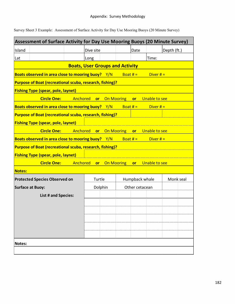
Appendix: Survey Methodology
182
Survey Sheet 3 Example: Assessment of Surface Activity for Day Use Mooring Buoys (20 Minute Survey)
Assessment of Surface Activity for Day Use Mooring Buoys (20 Minute Survey)
Island Dive site Date Depth (ft.)
Lat Long
Purpose of Boat (recreational scuba, research, fishing)?
Fishing Type (spear, pole, laynet)
Purpose of Boat (recreational scuba, research, fishing)?
Fishing Type (spear, pole, laynet)
Protected Species Observed on Turtle Humpback whale Monk seal
Surface at Buoy: Dolphin Other cetacean
Purpose of Boat (recreational scuba, research, fishing)?
Boats observed in area close to mooring buoy? Y/N Boat # = Diver # =
Boats observed in area close to mooring buoy? Y/N Boat # = Diver # =
Time:
Circle One: Anchored or On Mooring or Unable to see
List # and Species:
Notes:
Circle One: Anchored or On Mooring or Unable to see
Fishing Type (spear, pole, laynet)
Boats observed in area close to mooring buoy? Y/N Boat # = Diver # =
Circle One: Anchored or On Mooring or Unable to see
Notes:
Boats, User Groups and Activity
Appendix: Survey Methodology
183
References Clark, Athline M. 2005. A Statewide Partnership for Reef Protection: Hawai’i’s Day-Use Mooring Program. Mooring Buoy Planning Guide. International PADI, Inc. 19300 : 57-63. Hocevar, John D. 1993. A Survey of the Stoney Coral Community Composition of Pompano Ledge, Broward Co. , Florida with a Preliminary Evaluation of the Effectiveness of Mooring Buoys in Reducing Coral Damage. Mooring Buoy Planning Guide. International PADI, Inc. 19300 : 33-35. MacDonald, Craig D. and Mike Markrich. 1992. Hawaii’s Ocean Recreation Industry; Economic Growth (1981-1995) and Management Considerations. Maine Technology Society. In MTS ’92 Proceedings Vol. I. pp. 3371-377. Malama Kai. 2012. O’ahu Public Day-Use Mooring Guidebook. DOBOR Public Guidebooks. 1-15. Montgomery, Anthony, Murakawa, Paul, and Brett Schumacher. 2010. Compendium of Ecological Assessment Reports for Day-Use Mooring Buoy Sites on O`ahu. Hawaii Division of Aquatic Resources. 1-63. Project AWARE Foundation and PADI International Resort Association. Mooring Buoy Planning Guide. International PADI, Inc. 19300 : 1-92 Tratalos, J.A., and T.J. Austin. 2001. Impacts of recreational SCUBA diving on coral communities of the Caribbean island of Grand Cayman. Biological Conservation. 102 : 67–75
Related Documents