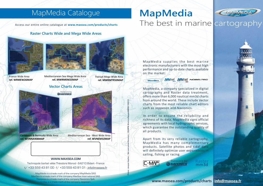
WWW.MAXSEA.COM Technopole Izarbel -allée Théodore Monod - 64210 Bidart - France t/ +33 559 43 81 00 - f/ +33 559 43 81 01 - [email protected] MapMedia is a trade mark of the company MapMedia SAS. MaxSea is a trade mark of the company MaxSea International SAS. Navionics is a trade mark of the company Navionics SpA. C-Map is a trade mark of the company Jeppesen. Photos : Jacques Vapillon / Not contractual Document / EN-MPM -BrochureDiptyqueMM3D-102012 MapMedia Catalogue Datacore by MapMedia The best in marine cartography MapMedia supplies the best marine electronic manufacturers with the most high performance and up-to-date charts available on the market: MapMedia, a company specialized in digital cartography and Raster data treatment, offers more than 6,000 nautical mm3d charts from around the world. These include Vector charts from the most reliable chart editors such as Jeppesen and Navionics. In order to ensure the reliability and richness of its data, MapMedia signs official agreements with local hydrographic services, which guarantee the outstanding quality of all products. Apart from its very reliable cartography, MapMedia has many complementary products. Satellite photos and tidal data will definitely optimize user experiences in sailing, fishing or racing. www.maxsea.com/products/charts [email protected] Access our entire online catalogue at www.maxsea.com/products/charts mm3d Raster Datacore by Vector Charts Areas Raster Charts Wide and Mega Wide Areas France Wide Area ref. WRMEW26MAP Mediterranean Sea Mega Wide Area ref. MWRMEM23MAP Transat Mega Wide Area ref. MWRMTR50MAP Caribbean & Bermuda Wide Area ref. WVNNA908MAP Mediterranean Sea - West Wide Area ref. WVNEM32MAP

Welcome message from author
This document is posted to help you gain knowledge. Please leave a comment to let me know what you think about it! Share it to your friends and learn new things together.
Transcript
www.maxsea.comTechnopole Izarbel -allée Théodore Monod - 64210 Bidart - France
t/ +33 559 43 81 00 - f/ +33 559 43 81 01 - [email protected]
MapMedia is a trade mark of the company MapMedia SAS.MaxSea is a trade mark of the company MaxSea International SAS.
Navionics is a trade mark of the company Navionics SpA.C-Map is a trade mark of the company Jeppesen.
Pho
tos
: Jac
ques
Vap
illon
/ N
ot c
ontr
actu
al D
ocum
ent
/ e
N-m
Pm
-Bro
chur
eDip
tyqu
emm
3D
-10
20
12
MapMedia Catalogue
Datacore by
MapMediaThe best in marine cartography
M a p M e d i a s u p p l i e s t h e b e st m a r i n e electronic manufacturers with the most high performance and up-to-date charts available on the market:
MapMedia, a company specialized in digital cartography and Raster data treatment, offers more than 6,000 nautical mm3d charts from around the world. These include Vector charts from the most reliable chart editors such as Jeppesen and Navionics.
In order to ensure the re l iabi l i ty and richness of its data, MapMedia signs official agreements with local hydrographic services, which guarantee the outstanding quality of all products.
Apart from its very reliable cartography, M a p M e d i a h a s m a ny co m p l e m e nta r y products. Satellite photos and tidal data will definitely optimize user experiences in sailing, fishing or racing.
www.maxsea.com/products/charts [email protected]
Access our entire online catalogue at www.maxsea.com/products/charts
mm3dRasterDatacore by
Vector Charts Areas
Raster Charts Wide and Mega Wide Areas
France Wide Arearef. WRMEW26MAP
Mediterranean Sea Mega Wide Arearef. MWRMEM23MAP
Transat Mega Wide Arearef. MWRMTR50MAP
Caribbean & Bermuda Wide Arearef. WVNNA908MAP
Mediterranean Sea - West Wide Arearef. WVNEM32MAP
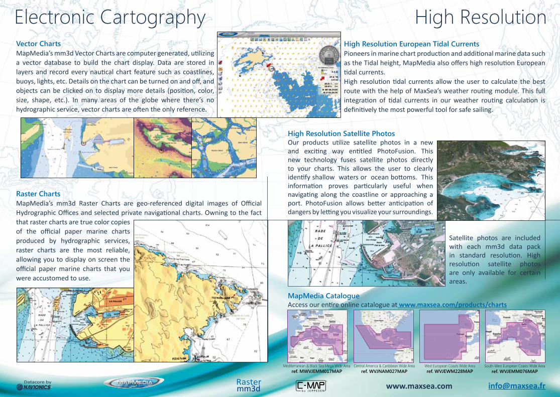
Electronic CartographyVector ChartsMapMedia’s mm3d Vector Charts are computer generated, utilizing a vector database to build the chart display. Data are stored in layers and record every nautical chart feature such as coastlines, buoys, lights, etc. Details on the chart can be turned on and off, and objects can be clicked on to display more details (position, color, size, shape, etc.). In many areas of the globe where there’s no hydrographic service, vector charts are often the only reference.
High Resolution Satellite PhotosOur products utilize satellite photos in a new and exciting way entitled PhotoFusion. This new technology fuses satellite photos directly to your charts. This allows the user to clearly identify shallow waters or ocean bottoms. This information proves particularly useful when navigating along the coastline or approaching a port. PhotoFusion allows better anticipation of dangers by letting you visualize your surroundings.
Satellite photos are included with each mm3d data pack in standard resolution. High resolution satellite photos are only available for certain areas.
Raster ChartsMapMedia’s mm3d Raster Charts are geo-referenced digital images of Official Hydrographic Offices and selected private navigational charts. Owning to the fact that raster charts are true color copies of the official paper marine charts produced by hydrographic services, raster charts are the most reliable, allowing you to display on screen the official paper marine charts that you were accustomed to use.
High Resolution European Tidal CurrentsPioneers in marine chart production and additional marine data such as the Tidal height, MapMedia also offers high resolution European tidal currents.High resolution tidal currents allow the user to calculate the best route with the help of MaxSea’s weather routing module. This full integration of tidal currents in our weather routing calculation is definitively the most powerful tool for safe sailing.
High Resolution
mm3dRasterDatacore by [email protected]
MapMedia CatalogueAccess our entire online catalogue at www.maxsea.com/products/charts
South-West European Coasts Wide Arearef. WVJEMM076MAP
www.maxsea.com
Mediterranean & Black Sea Mega Wide Arearef. MWVJEMM017MAP
Central America & Caribbean Wide Arearef. WVJNAM027MAP
West European Coasts Wide Arearef. WVJEWM228MAP
Related Documents