1 Late Miocene to Pliocene stratigraphic evolution of northeast Carmen Island, Gulf of California: implications for oblique-rifting tectonics Rebecca J. Dorsey, Department of Geological Sciences, 1272 University of Oregon, Eugene, OR, 97403-1272, [email protected] Paul J. Umhoefer, Department of Geology, Box 4099, Northern Arizona University, Flagstaff AZ 86011, [email protected] James C. Ingle, Jr., Dept. of Geological and Environmental Sciences, Stanford University, Palo Alto, CA 94305-2115, [email protected] Larry Mayer, Department of Geology, Miami University, Oxford, OH 45056, [email protected] Submitted to Sedimentary Geology, October 18, 1999 Revised: June 10, 2000 ( and Jan. 20, 20001) keywords: Pliocene, Gulf of California, stratigraphy, micropaleontology, tectonics Abstract This paper describes a thick section of late Miocene (?) to middle Pliocene marine sedimentary rocks exposed at Punta Perico, northeastern Carmen Island, in the southern Gulf of California. These strata overlie Miocene volcanic rocks along a low-angle unconformity and have a total thickness of ~1,100 m. The section contains the following units: (1) lower conglomerate (~750 m thick) representing submarine debris flows and grain flows; (2) conglomerate and sandstone (~90-160 m) deposited by gravelly and sandy turbidity currents; (3) marlstone and mudstone (~120 m) with benthic forams that record bathyal water depths (400-500 m) and an age of ~3.5-3.1 Ma; (4) dacite breccia and boulder beds (~20 m) emplaced by submarine avalanches and debris flows; and (5) stratified conglomerate and bioclastic limestone (≥80 m) deposited by traction currents in a shallow shelf environment. Conjugate syn-sedimentary faults, deformation bands, and growth structures are recognized within a 250-m-wide belt adjacent to a large N-striking, W-dipping normal fault that bounds the eastern margin of the Pliocene section, indicating that the eastern normal fault was active during deposition of at least the upper ~300 meters of the dipping section. Considering the thickness of the two units below the marlstone (~900 m) and assuming a range of possible sediment- accumulation rates (0.2-1.0 m/ka), we postulate that deposition of the lower conglomerate was initiated in late Miocene or early Pliocene time (~8 to 4 Ma), possibly coincident with initial opening of the Gulf of California. Deposition of the marlstone unit above a probable unconformity represents a major change in basinal tectonics at ~3.5-3.1 Ma, which is about the time when seafloor spreading and transform faulting were initiated in the Gulf of California. These tentative correlations suggest that the Baja California peninsula was structurally and mechanically linked to the deep Gulf during late Miocene to middle Pliocene time. 1. Introduction The Gulf of California is a highly oblique-divergent plate boundary that has evolved in the past ~6 million years into a young ocean basin that is opening along well developed transform faults connected by short spreading ridges (Fig. 1; e.g. Moore and Buffington, 1968; Larson et al., 1968; Curray and Moore, 1984; Lonsdale, 1989). The first stage of major offset in the gulf took place along a system of strike-slip faults and related pull-apart basins oriented parallel to the overall gulf trend between ~6 and 3.6 Ma (Lonsdale, 1989). Beginning ~3.5 Ma this fault zone evolved into the modern system of transform faults oriented ~20 more westerly than the gulf trend, and it is generally believed that most of the Pacific-North America plate motion since 3.5 Ma has occurred on transform faults and linked spreading centers in the deep gulf (e.g. Lonsdale, 1989; DeMets et al., 1990; DeMets, 1995). Recent work in the Loreto area has provided useful information about the timing and style of late Pliocene transtensional deformation and basin development in eastern Baja California Sur (Fig. 1B; Umhoefer et al., 1994; Zanchi, 1994; Umhoefer and Stone, 1996; Umhoefer and Dorsey, 1997), but structural relationships and connections between the onland faults and oceanic transforms in the gulf are complex and remain poorly understood.

Welcome message from author
This document is posted to help you gain knowledge. Please leave a comment to let me know what you think about it! Share it to your friends and learn new things together.
Transcript
1
Late Miocene to Pliocene stratigraphic evolution of northeast Carmen
Island, Gulf of California: implications for oblique-rifting tectonics
Rebecca J. Dorsey, Department of Geological Sciences, 1272 University of Oregon,Eugene, OR, 97403-1272, [email protected]
Paul J. Umhoefer, Department of Geology, Box 4099, Northern Arizona University,Flagstaff AZ 86011, [email protected]
James C. Ingle, Jr., Dept. of Geological and Environmental Sciences, StanfordUniversity, Palo Alto, CA 94305-2115, [email protected]
Larry Mayer, Department of Geology, Miami University, Oxford, OH 45056,[email protected]
Submitted to Sedimentary Geology, October 18, 1999
Revised: June 10, 2000 ( and Jan. 20, 20001)
keywords: Pliocene, Gulf of California, stratigraphy, micropaleontology, tectonics
AbstractThis paper describes a thick section of late Miocene
(?) to middle Pliocene marine sedimentary rocks exposedat Punta Perico, northeastern Carmen Island, in thesouthern Gulf of California. These strata overlieMiocene volcanic rocks along a low-angle unconformityand have a total thickness of ~1,100 m. The sectioncontains the following units: (1) lower conglomerate(~750 m thick) representing submarine debris flows andgrain flows; (2) conglomerate and sandstone (~90-160m) deposited by gravelly and sandy turbidity currents; (3)marlstone and mudstone (~120 m) with benthic foramsthat record bathyal water depths (400-500 m) and an ageof ~3.5-3.1 Ma; (4) dacite breccia and boulder beds (~20m) emplaced by submarine avalanches and debris flows;and (5) stratified conglomerate and bioclastic limestone(≥80 m) deposited by traction currents in a shallow shelfenvironment. Conjugate syn-sedimentary faults,deformation bands, and growth structures are recognizedwithin a 250-m-wide belt adjacent to a large N-striking,W-dipping normal fault that bounds the eastern marginof the Pliocene section, indicating that the easternnormal fault was active during deposition of at least theupper ~300 meters of the dipping section. Consideringthe thickness of the two units below the marlstone(~900 m) and assuming a range of possible sediment-accumulation rates (0.2-1.0 m/ka), we postulate thatdeposition of the lower conglomerate was initiated inlate Miocene or early Pliocene time (~8 to 4 Ma),possibly coincident with initial opening of the Gulf ofCalifornia. Deposition of the marlstone unit above aprobable unconformity represents a major change inbasinal tectonics at ~3.5-3.1 Ma, which is about the
time when seafloor spreading and transform faultingwere initiated in the Gulf of California. These tentativecorrelations suggest that the Baja California peninsulawas structurally and mechanically linked to the deepGulf during late Miocene to middle Pliocene time.
1. IntroductionThe Gulf of California is a highly oblique-divergent
plate boundary that has evolved in the past ~6 millionyears into a young ocean basin that is opening alongwell developed transform faults connected by shortspreading ridges (Fig. 1; e.g. Moore and Buffington,1968; Larson et al., 1968; Curray and Moore, 1984;Lonsdale, 1989). The first stage of major offset in thegulf took place along a system of strike-slip faults andrelated pull-apart basins oriented parallel to the overallgulf trend between ~6 and 3.6 Ma (Lonsdale, 1989).Beginning ~3.5 Ma this fault zone evolved into themodern system of transform faults oriented ~20° morewesterly than the gulf trend, and it is generally believedthat most of the Pacific-North America plate motionsince 3.5 Ma has occurred on transform faults and linkedspreading centers in the deep gulf (e.g. Lonsdale, 1989;DeMets et al., 1990; DeMets, 1995). Recent work inthe Loreto area has provided useful information aboutthe timing and style of late Pliocene transtensionaldeformation and basin development in eastern BajaCalifornia Sur (Fig. 1B; Umhoefer et al., 1994; Zanchi,1994; Umhoefer and Stone, 1996; Umhoefer andDorsey, 1997), but structural relationships andconnections between the onland faults and oceanictransforms in the gulf are complex and remain poorlyunderstood.
2
Pliocene geology and stratigraphy exposed onCarmen Island permit us to study the history ofdeformation and sedimentation within the narrow shelfregion that lies between the continental microplate ofBaja California and young oceanic transforms andspreading centers in the Gulf of California. Thecontinental shelf in the southwestern gulf displays steepirregular bathymetry controlled by large fractures zones,believed to be inactive (Lonsdale, 1989), and youngerstrike-slip and normal faults that bound linear crustalblocks and island uplifts (Fig. 1B). The presence ofraised marine terraces around the margins of the islandand a small platform of flat-lying Pleistocene carbonatesexposed up to ~20 m above sea level on the southernpeninsula (Fig. 2A), combined with its overall lineargeometry and steep flanking bathymetry, all suggest thatCarmen has been uplifted during late Pliocene(?) andPleistocene time by young ENE-striking normal faultson the east and west margins of the island. The bedrockgeology of Carmen Island consists primarily of dippingMiocene volcanic rocks (Comondú Formation ofHausback, 1984; Sawlan, 1991) overlain by less steeplydipping Pliocene sedimentary rocks and smaller patchesof raised Quaternary limestones (Fig. 2; Anderson,1950). The change from east-dipping Miocene rocks inthe northern 2/3 of the island to flat-lying and west-dipping rocks in the south is inferred by us (unpubl.field data) to be related to a segment boundary thatseparates west-dipping normal faults in the north fromeast-dipping faults in the south. Most of the Pliocenedeposits on Carmen Island consist of relatively thin (<several 100�s of m), gently dipping, impure bioclasticcarbonates and calcareous sandstones. By contrast, thePliocene section exposed at Punta Perico is substantiallythicker (~1100 m), more diverse, and more deformedthan other Pliocene sections, and thus preserves themost complete and probably oldest record of Pliocenesedimentation and faulting on the island.
The thick package of Pliocene strata exposedbetween Bahia Salinas and Punta Perico (Fig. 2B) wasoriginally studied by Anderson (1950), who identifiedthis as the type section for the Carmen Formation. Twoother localities on northern Carmen Island were alsoassigned to the Carmen Formation by Anderson (1950).However, our work has shown that one of thoselocalities was mis-identified and exposes only Miocenevolcanic rocks, and the other locality contains flat-lyingshallow-marine deposits that resemble only a restricted,small exposure of the youngest unit we studied at PuntaPerico (upper conglomerate and bioclastic limestone) andtherefore does not resemble most of the CarmenFormation exposed at its type locality in the study area(Fig. 2B). The problems encountered with Anderson�s(1950) correlation of the Carmen Formation to otherparts of the island cause us to regard them as suspect,and we therefore restrict use of the name CarmenFormation to the thick dipping section of Pliocene strataexposed between Bahia Salinas and Punta Perico (Fig.2B).
2. Geology of Bahia Salinas to Punta PericoThe geology of the study area consists of Miocene
volcanic rocks and Pliocene sedimentary rocks that arecut by several large N-striking and NW-striking normalfaults. The geologic map (Fig. 2B) reveals a large areaof Pliocene marine conglomerate that unconformablyoverlies Miocene volcanic rocks in the northwest, dipsconsistently to the southeast, and is bounded on thesouthwest and northeast by large-offset NW-strikingnormal faults. In the southeastern part of the area (Fig.2B), the conglomerate is overlain by a unit ofinterbedded conglomerate and sandstone, which in turn isoverlain by bathyal marlstone and mudstone exposed insmaller exposures along the coast. The SE-dippingsection of Pliocene sedimentary rocks is truncated on theeast by a large N-striking normal fault that juxtaposesPliocene strata in the hangingwall against Miocenevolcanic rocks in the footwall (Fig. 2B). The youngestpart of the dipping Pliocene section consists ofinterbedded conglomerate and impure bioclasticcarbonates. Younger map units include flat-lyingcalcarenite and calcarenitic sandstone inferred to be upperPliocene or Pleistocene in age, and Quaternary alluviumand playa lake deposits.
Excellent exposures in coastal sea cliffs and erodinghills permit direct observation of the thick dippingPliocene section and two of the major faults in the area(Fig. 3A). The panel in Figure 3A was produced bytracing over a photograph that was taken looking towardthe northeast, along the strike of dipping Pliocene beds.The scale in the line drawing was generated bycomparing distance measurements on the geologic map(Fig. 2) with the same features in the photograph.Thicknesses of the main stratigraphic units (Fig. 4) weremeasured directly from this panel; although thicknessesobtained in this way inevitably have some uncertainty(we estimate ± ~10%), they are consistent with thethickness obtained in the eastern measured section (Fig.8). A geologic cross section (Fig. 3B) was constructedfrom the photo-overlay panel, revealing the geometry ofthe large normal fault and related smaller antithetic faultsin the eastern part of the map area. The summarystratigraphic section (Fig. 4) also was constructed usinginformation in Figure 3A.
3. Pliocene Stratigraphy and Sedimentology3.1. Lower Conglomerate
The lower conglomerate unit covers much of themap area and makes up a remarkably thick anduninterrupted section, approximately 750 m thick (Fig.4). Its basal contact with underlying Miocene volcanicrocks is mappable east of the coastal lagoon (Fig. 2B),but contact relationships are difficult to observe due totalus cover and steep slopes. As viewed from a distance,the Miocene rocks (thick volcanic flows and breccias) areseen to dip approximately 45° to the SE, about 10°steeper than the contact with conglomerate and beddingin its lower part (~35°) (Fig. 3A). This indicates thepresence of a low-angle unconformity that formed by

3
tilting and erosion of the Miocene rocks, prior todeposition of the Pliocene conglomerate.
The upper ~450 meters of the lower conglomerateunit, which is 100% exposed in sea cliffs in the centralpart of Figure 3A, contains only conglomerate with noother interbedded lithologies. Below that, the lower~300 meters is less well exposed in the background hillsbut the weathering style and our mapping indicate that italso contains only conglomerate down to the base of thesection. The conglomerate is poorly to moderatelysorted, clast- to matrix supported, and contains pebbles,cobbles and boulders up to 1.5 m long (long axis) in apebbly sandstone matrix (Fig. 5 A,B). Clasts consist ofandesitic to mafic volcanic rocks eroded from theunderlying Miocene volcanics. Thin interbeds ofsandstone are very rare and discontinuous, and beddingplanes are typically defined by concentrations of cobble-to small boulder-size clasts among otherwisehomogenous pebble-cobble conglomerate. Moderateinternal organization is represented by these larger clastconcentrations, which often make up the lower part ofweakly developed fining-up depositional units 0.5 to 2.0m thick (Fig. 5B). Clast imbrications are present insome beds, indicating paleo-transport directions that varyfrom ~ east to southwest. The upper part of thisconglomerate unit displays a decrease in bed thicknessand increase in degree of organization and thin sandstoneinterbeds in a ~10-15-m transitional interval, indicatinga conformable contact with the overlying conglomerateand sandstone unit (Fig. 5A).
The depositional environment of the lowerconglomerate unit is difficult to interpret due to the lackof fossils and other lithologies. As noted by previousworkers (e.g. Winn and Dott, 1979; Hein and Walker,1982), it can be difficult to distinguish between marineand nonmarine conglomerate in the absence of associatedfine-grained facies and paleontological indicators, and itis usually only by association with interbedded shales,sandstones, or fossils that we can confidently determinethe depositional setting. In spite of this limitation, thelower conglomerate is interpreted to be a thicksuccession of marine gravels based on its conformablecontact with the overlying conglomerate and sandstoneunit, which contains abundant evidence for deposition byturbidity currents in a submarine setting. It is unlikelythat alluvial fan conglomerate would be conformablyoverlain by submarine-slope deposits without any of theintervening environments (fluvial, deltaic, marine shelf)preserved in the stratigraphy. Thus the ungraded, poorlysorted conglomerate beds in this unit are interpreted torecord deposition by subaqueous debris flows in a marineslope setting (e.g. Hampton, 1972; Hampton et al.,1996; Mulder and Cochonat, 1996). Better organizeddeposits that include a basal clast concentration overlainby normally graded gravel may record development oflimited turbulence and sorting during downslopetransformation of gravelly debris flows (Lowe, 1982;Nemec and Steel, 1984; Nemec, 1990).
3.2. Conglomerate and Sandstone
The thickness of this unit varies from ~90 mexposed in sea cliffs in the south to more than 160 m asmeasured at north beach, where the upper contact is notexposed (Fig. 2, 3, 4). It consists of interbedded pebble-cobble conglomerate and sandstone intervals that average~ 1 to 5 m thick and range up to ~10 m thick (Fig. 5A).These are well bedded, well organized and sorted depositsthat show abundant stratification and normal grading insandstone and pebbly sandstone, sharp erosive contactsbetween conglomerate and sandstone beds, broad shallowchannel geometries in conglomerate units, and somelow-angle cross bedding in channelized conglomerates.Sandstone beds are well sorted, thin-to medium-bedded,and commonly display normal grading from sharp-basedcoarse-grained pebbly sandstone to fine sand. Verticalburrows ~0.5 to 1.5 cm in diameter are present locally.Conglomerate beds are moderately to well sorted, withclasts that range from small pebble to small bouldersize, and commonly display clast imbrications withaverage paleotransport toward the SE. Abundant soft-sediment deformation and liquefaction features and relateddeformation bands associated with a set of SE-dippingnormal faults were observed at the north beach locality(NB, Fig 2B; Fig. 5C,D). Rare coarsening-up intervalsconsist of thin-bedded sandstone grading upward intobipartite deposits of well bedded sandstone with thinbasal pebble and cobble stringers, through thin ormedium bedded conglomerate and sandstone, intoconglomerate with minor thin sandstone interbeds. Theupper contact with the marlstone-mudstone unit is asharp depositional contact that was not described indetail during this study. The map pattern (Fig. 2) showsthat the contact truncates ESE-dipping strata in theconglomerate and sandstone unit just west of the large,eastern normal fault.
Conglomerate and sandstone in this unit areinterpreted to be deposits of gravelly and sandy sedimentgravity flows that accumulated in a submarine channelcomplex, probably at or near the base of a marine slope.We considered a nonmarine origin for this unit, but thefacies are notably better sorted than fluvial deposits, lackpaleosols, and contain abundant features such as normalgrading and distinct gravel-sand segregation that arecommon in marine sandy and gravelly turbiditesuccessions. Thus, sharp-based normally gradedsandstone beds are interpreted to be turbidites formedfrom low-density turbidity currents. Pebble and cobblestringers at the base of some sand beds represent pebblytraction lag deposits that were entrained along the base ofsandy turbidity currents. Well sorted and imbricatedconglomerate beds are interpreted as the deposits ofnoncohesive debris flows, or grain flows, that weredeposited in close association with the sandy turbidites.This is a classic association of sand and gravel depositionsimilar to cases described in other studies of marineclastic turbidite and conglomerate successions (Walker,1975, 1977; Winn and Dott, 1979; Hein and Walker,1982; Lowe, 1982; Nemec, 1990). Fault-related soft-sediment deformation and liquefaction features indicatethat normal faulting was active during or shortly after

4
deposition of this unit. The upper contact withmarlstone and mudstone is interpreted to be anunconformity based on the truncation of strata impliedby the map pattern near the large eastern normal fault(Fig. 2B).
3.3. Marlstone and MudstoneThis unit is ~120 m thick and consists of soft,
yellow, thin-bedded calcareous marlstone, mudstone, andclaystone (Fig. 6A) that contains abundant foraminiferantests and only minor detrital sand and silt. It commonlydisplays thin, fine-scale planar laminations defined bysubtle variations in grain size and color possibly relatedto organic content. Normal grading in some beds isdefined by the presence of very fine-grained, planarlaminated detrital sand at the base, with upward decreasein abundance of transported forams in a calcareous mudor clay matrix. Some intervals are massive andstructureless due to burrow mixing. Diagenetic featuresinclude rare beds that are heavily calcite-cemented andresistant to weathering (Fig. 6A) and fairly commonsecondary gypsum veins. The upper contact with thedacite unit was not observed directly, but it appears to beconformable based on the presence of foram-richmudstone interbedded and mixed with the upper daciteunit. The micropaleontology of this unit is describedbelow.
The marlstone-mudstone unit was deposited bypelagic sedimentation in a quiet marine environment thatwas mostly isolated from detrital input, in sharp contrastto conditions recorded in the underlying and overlyingclastic units. Normal grading in some beds and relatedsorting of transported foram tests records deposition byvery distal, dilute turbidity currents. Abundant fine-scalelamination and very minor bioturbation suggest that theenvironment was depleted in oxygen during most of itsdeposition. A bathyal water depth of ~400-500 m wasdetermined for this unit based on study of benthic forams(see below).
3.4. Dacite UnitThe dacite unit is ~20 m thick and occupies in an
important stratigraphic transition from bathyalmarlstone and mudstone to shallow-marine coarse clasticdeposits of the upper conglomerate and bioclasticlimestone unit (Fig. 4, 7, 8). It is divided into twofacies: (1) dacite breccia that was observed only in thefootwall of the southeastern growth fault; and (2) daciteboulder beds observed only in the hangingwall of thesame fault (Fig. 7). The breccia facies consists ofalternating beds and irregular masses of white breccia andyellow marlstone and mudstone. Breccia beds containangular fragments of porphyritic dacite (white fine-grained groundmass with phenocrysts of plagioclase,quartz, biotite, and hornblende), ~3 to 30 cm indiameter, dispersed in a matrix of yellow mudstone thatis intimately mixed with sand- to granule-size dacitefragments (Fig. 6B). The breccia forms chaoticallydeformed beds and irregular masses ~1-3 m thick that areinterlayered with and truncate thin-bedded marlstone and
mudstone, revealing abundant features of soft-sedimentdeformation, liquefaction, and chaotic mechanicalmixing.
Dacite boulder beds are massive and ungraded, ~ 0.5to 2 m thick, and contain subangular to subrounded,cobble- to boulder-size clasts encased in a matrix ofwhite laminated dacitic sand that contains small pockets(2-10 cm thick) of dacite-bearing volcaniclastic pebbleconglomerate (Fig. 6C). Some beds consist of single-clast horizons of dacite boulders up to 1-2 m indiameter, with laminated dacite sand draped around theedges of isolated clasts. The boulder beds are interbeddedwith foram-bearing mudstone and heterolithicvolcaniclastic conglomerate and sandstone, and mostcontacts with interbedded lithologies are sharp. Adetailed section was not measured through this unit inthe hangingwall of the growth fault (Fig. 7), but ourobservations indicate that lithologies interbedded in thelower part of the unit consist of bathyal marlstone andmudstone, and that stratified sandstone and conglomerateare interbedded in the upper part. The upper contact withconglomerate and bioclastic limestone is sharp andappears erosional. Laser-beam 40Ar-39Ar dating ofindividual biotite crystals in dacite collected from aboulder bed yielded consistent ages of ~12 Ma (P.Renne, personal comm., 1999).
The dacite unit is interpreted to be a complexaccumulation of submarine landslides, rock falls, anddebris flows that were shed from unstable exposures ofMiocene volcanic rocks on either submarine or subaerialsteep slopes (e.g. Nemec, 1990). Although textures inthe breccia facies resemble pepperites that form by syn-eruptive intrusion of magmas into shallow wetsediments, the Miocene age of a dacite boulder requiresthat the dacite is not Pliocene, and instead was derivedfrom older bedrock exposures by slope failures. Thuswe conclude that breccia facies record intense fracturingof large masses of dacite that slid catastrophically intothe basin and were mechanically mixed with marldeposits during rapid emplacement and deformation onthe sea floor. Boulder beds represent submarineavalanches and/or debris flows that were generated bymass wasting events on a steep submarine slope.Processes of avalanching are favored for the boulder bedsbecause they generally lack a syndepositional matrix.Matrix in these beds consists of well laminated daciticsand that drapes over and around individual clasts (Fig.6C) and probably was deposited by turbidity currentsthat trailed behind the bouldery avalanches depositingtheir suspended sand load after deposition of isolatedclasts. The slight rounding observed in boulder clastscould also be produced by this process. Stratifiedvolcaniclastic conglomerate and sandstone interbedded inthe upper part of the boulder beds unit have an uncertainorigin. They may be deposits of gravelly grain flowsand turbidity currents produced on a steep slope, or theycould be coarse-grained deposits of a high-energyshallow marine setting, as is inferred for the overlyingunit. The latter interpretation would imply a very rapidphase of uplift during this time interval. If the first
5
interpretation is correct, then the transition to shallow-marine conditions is represented by the sharp contactwith overlying conglomerate and bioclastic limestone,which also would appear to imply a short-lived rapiduplift event.
3.5. Upper Conglomerate and Bioclastic LimestoneThis unit is at least ~80 m thick (upper contact not
exposed) and is exposed only in the southeast part of thestudy area where it is faulted against Miocene volcanicrocks (Figs. 2, 3). It makes up alternating units of (1)well stratified sandy pebble-cobble conglomerate withthin interbeds of bioclastic limestone and variableamounts of broken shell debris in the matrix, and (2)well stratified sandy to pebbly bioclastic limestone(calcarenite and shell hash) commonly with thinsandstone and conglomerate interbeds (Fig. 6D, 7, 8).Stratification is pervasive and consists primarily ofplanar bedding with some low-angle cross bedding andrare shallow channel geometries. Carbonate debrisconsists of broken fragments of calcareous molluscanfaunas including pectens, oysters, corals, barnacles andrhodoliths (concentrically layered calcareous red algae).We observe a wide range of mixing of coarse siliciclasticdetritus and fragmental bioclastic carbonate, varyingfrom very pure concentrations to mixtures in which thetwo components are sub-equal. Most bedding contactsare sharp and erosional, with planar to broadly lenticulargeometries.
The conglomerate and bioclastic limestone unitformed in a high-energy marine-shelf setting in whichstrong traction currents modified and reworked asubstrate of coarse-grained, mixed carbonate andsiliciclastic detritus. The carbonate debris was derivedfrom nearby lower-energy settings where molluscan andcoral faunas lived, although the uncommon rhodolithsmay have grown and lived within this setting. Thepervasive abundance of planar to low-angle crossstratification, sharp bedding contacts, abundance ofcoarse bioclastic detritus, and rare channel forms, allsuggest that deposition took place above fair-weatherwave base within the shoreface. Alternatively, it ispossible that high-energy reworking of the deposits tookplace by strong tidal rip currents in somewhat deeperwater. Accumulation of more than ~80 meters ofsection in a shallow marine setting would require thatbasin subsidence during this interval was about equal tosediment accumulation rate. Although these depositsbear some similarities to mixed carbonate andsiliciclastic sediment gravity flow deposits recentlydocumented in the Loreto basin (Dorsey and Kidwell,1999), the lack of inverse to normal grading inconglomerate beds, lack of normal grading and otherturbiditic features in the carbonate beds, and lack oflarge-scale clinoform cross bedding, all indicate that thisunit was not deposited by debris flows and turbiditycurrents in foresets of Gilbert-type deltas. Thesedeposits do, however, closely resemble other examplesof mixed bioclastic carbonate and siliciclastic sedimentsin the Loreto basin (sequence 3), where they have been
interpreted as traction deposits of a high-energy,carbonate-producing shallow shelf setting (Dorsey et al.,1997; Dorsey and Umhoefer, 2000).
4. PaleobathymetryQuantitative analysis of benthic foraminifera in this
study provides a means of (1) estimating the water depth(paleobathymetry) in which the sediments weredeposited, (2) assessing the benthic environmentalsettings in which deposition took place, and (3)establishing the magnitude of downslope transport ofsediments by noting the sources and abundance ofredeposited species. It is important to note that samplesanalyzed for this report were collected exclusively fromthe marlstone-mudstone unit of the Carmen Formationexposed in sea cliffs NW of Punta Perico (Fig. 2B).Substantial thicknesses of conglomerate within thesection both stratigraphically above and below themarlstone unit were not sampled or, where sampled, didnot yield well preserved microfossils. Despite thelimited sample base, the foraminiferal assemblagesrecovered from the marlstone unit are generally wellpreserved, abundant, and provide clear evidence of thepaleoenvironmental, paleobathymetric, andpaleoceanographic history of this area.
4.1 Methods Twenty-one samples from the marlstone unit wereanalyzed for benthic foraminifera. Samples were treatedwith kerosene and water and washed over a 200 meshscreen; 17 samples yielded good to excellentassemblages. An average of 315 specimens wereidentified and counted in 14 samples with three samplesyielding less than 60 specimens each. Relativeabundances of species were tabulated in terms of percentof the total population counted in a given sample.Identification and paleoenvironmental andpaleobathymetric interpretation of the foraminifera wereaided by the fact that many of the species found in thesesediments are still living in the modern Gulf ofCalifornia. In addition, those benthic species which arethought to be extinct are close relatives of living taxaand display biofacies associations essentially identical totheir modern counterparts. Indeed, foraminifera from theCarmen Formation were first described by Natland(1950) who emphasized their similarity to Recent,Pleistocene, and Pliocene faunas described fromelsewhere along the Pacific coasts of Mexico and CentralAmerica.
Recurrent distributional patterns of Holocenelittoral, neritic, and bathyal benthic foraminifera in thesubtropical-tropical eastern Pacific Ocean form the basicmodel used to interpret fossil foraminifera in this study.Key reports describing these associations and patternsinclude Bandy and Arnal (1957), Smith (1963, 1964),Lankford and Phleger (1973), Streeter (1972), Golik andPhleger (1977), Ingle and Keller (1980), and Resig(1981). Special emphasis was placed on comparisonwith modern foraminiferal distributions in the Gulf ofCalifornia as described by Bandy (1961), Brenner (1962),

6
Phleger (1964), and Douglas, et al. (1998b). Inparticular, Douglas et al. (1998b) have demonstrated thedynamic nature of water mass-sediment-benthicforaminiferal relationships in modern shelf and slopeenvironments in the Gulf of California, includingbiofacies represented in marl deposits of the CarmenFormation.
Comparison of modern biofacies compositionsallowed common species to be assigned to a series ofbiofacies representing littoral to middle bathyal depthsettings of the shelf and slope (Table 1). Extinct specieswere assigned to a given biofacies following Ingle(1980) and their reported associations with still livingtaxa of known environmental and bathymetricpreferences. In constructing biofacies, reference was alsomade to other reports in which benthic foraminiferalwere used to interpret the paleobathymetric andpaleoenvironmental history of Neogene sequences in theGulf of California and adjacent areas (Ingle, 1974;Boehm, 1984; McCloy et al., 1988; McDougall 1985;Carreño, 1992; Douglas et al., 1998a; and McDougall etal., 1999). Not all species identified in samples wereassigned to a given biofacies resulting in biofaciescomposed largely of common to abundant species andthose with the least equivocal environmental signatures.
4.2. Paleobathymetric and Paleoenvironmental TrendsVariation in the relative abundances of benthic
foraminiferal biofacies and selected species through thelower ~30 m of the marlstone unit demonstrates thatthese sediments were deposited at a water depth ofapproximately 400 to 500 m (Fig. 9B). Thus, theestimated water depth is similar to that originallyproposed for the Carmen Formation by Natland (1950)in his pioneering study of foraminifera from thesedeposits. Relatively high abundances of upper bathyalspecies including Bolivina interjuncta, B. humilus,Buliminella tenuata and Uvigerina excellens are presentthroughout the section analyzed. Specifically, highabundances of Bolivina humilus and other bolivinidsmatch biofacies associated with the impingement of theoxygen minimum layer in the modern Gulf of Californiaand off Central America. The combined association of aCancris dominated shelf edge biofacies together with theBolivina-rich upper bathyal biofacies in the upper part ofthe section may indicate somewhat shallower depths ca.350-400 m based on observations by Douglas et al.(1998a) and Douglas et al. (1998b). However, there ismuch evidence of sediment redeposition in this sectionas noted below, which is probably responsible for theanomalously high abundance of outer neritic-shelf edgetaxa near the middle part of the analyzed interval (Fig.9B). In addition, significant abundances of upper middlebathyal species including Bolivina subadvena andCassidulina delicata support deposition in the lowerrange of upper bathyal water depths. Higher abundancesof upper middle bathyal taxa dominate assemblages inthe lower half of the short section analyzed and suggestthat the water depth approached or exceeded 500 mduring deposition of this material.
Biofacies patterns indicate that vigorous downslopemovement of sediments characterized this period in thebasin history, consistent with sedimentological evidenceof turbidites and sediment gravity flows in theunderlying conglomerate and sandstone unit. Sources ofdisplaced material include littoral, inner neritic and shelfedge environments as clearly marked by spikes in therelative abundances of species indicative of thesesettings (Fig. 9B). For example, high abundances of theshelf edge species Cancris inflatus occur in the middle ofthe section along with high abundances of both upperand middle bathyal taxa. However, the most dramaticevidence of this process is seen in the lower part of thestudied interval where assemblages composedexclusively of littoral and inner neritic species occurwithin thin sandy marlstone turbidite beds. Occurrencesof Amphistegina gibbosa, a tropical reef dwellingspecies no longer living in the eastern Pacific Ocean(Crouch and Poag, 1979), highlight redeposited littoralsediments throughout the section. Unfortunately,samples collected within the thick conglomeratesunderlying the marlstone unit did not yield identifiableforaminifera. However, a sample collected frommudstone interbedded with dacite boulder beds thatimmediately overly the marlstone unit (foram sample12-22-97-5 in Fig. 3A; Fig. 3B, 7) yielded aforaminiferal assemblage dominated by upper bathyaltaxa indicating this unit also was deposited in a waterdepth of ca. 400-500 m. Finally, a sample of sandycoquina lying directly on top of the conglomerate andsandstone unit at the basal contact of the marlstone(foram sample 12-22-97-6 in Fig. 3A) contains acomplete mixture of littoral through upper middlebathyal species representing the cumulative result ofredeposition of littoral and neritic species within anupper bathyal setting. Downslope redeposition ofbenthic foraminifera is common on the relatively steepbasin margins of the modern Gulf of California (Bandy,1961) and this process was clearly active duringdeposition of the marlstone unit.
5. Biostratigraphy and AgeExposures of the Carmen Formation on Carmen
Island were originally mapped by Anderson (1950) withfossil mollusks in these sediments described by Durham(1950) and foraminifera described by Natland (1950).Durham assigned a middle Pliocene age to the CarmenFormation based largely on correlations with molluscanfaunas described from the Pacific coasts of Central andSouth America. Natland concluded the foraminiferalassemblages were upper Pliocene in age based on hiscorrelations with microfaunas reported from the CharcoAzul Formation in Panama and the relatively wellstudied Neogene benthic foraminiferal biostratigraphyestablished in the Los Angeles and Ventura basins ofCalifornia. As it turns out, these early workers wereessentially correct in their assignment of middle andupper Pliocene ages to the Carmen Formation asconfirmed by application of modern planktonicbiostratigraphy during this study.

7
Planktonic foraminifera are common to abundant in13 samples collected from the lower portion of themarlstone unit northwest of Punta Perico (Fig. 9).Planktonic foraminifera commonly comprise 15 - 20 %of the total benthic and planktonic foraminiferalpopulations in these samples. Because thebiostratigraphically significant species of planktonicforaminifera range through much of the 30 m section ofthe marlstone unit illustrated in Figure 9, a summarylist of all species identified in this section is provided(Table 2). In addition, calcareous nannofossils wereanalyzed by Stanley Kling (1997, personalcommunication) in samples 6 and 7 of this samesection, with species identified also listed in Table 2.
The studied planktonic foraminiferal assemblages aredominated by species of Globigerina, Globigerinoides,Globorotalia, Neogloboquadrina and Pulleniatina typicalof a tropical surface water setting and similar to modernplanktonic faunas inhabiting the southern Gulf ofCalifornia today (Parker, 1973). Some samples containsignificant numbers of Globigerina bulloides,presumably reflecting episodic upwelling and highproductivity. Key planktonic foraminifera identified inthe marlstone unit include Globigerinoides extremus, G.obliquus, Globorotalia limbata, Neogloboquadrinadutertrei, N. humerosa, Pulleniatina alicusps, P.praecursor, P. primalis s.l., and Sphaeroidinellopsisseminulina (Table 2). The co-occurrence of late formsof Pulleniatina primalis s.l. and P. praecursor togetherwith specimens of the distinctive form P. alicuspisdescribed from upper Pliocene deposits in the Gulf ofCalifornia (Carreño, 1992) indicate an age no older than3.5 Ma, following ranges and correlations presented byKeigwin (1976), Kennett and Srinivasan (1983), andBerggren et al. (1995). In addition, the co-occurrence ofcommon specimens of Neogloboquadrina humerosa ,rare specimens of N. dutertrei, and Sphaeroidinellopsisseminulina allow the fauna to be correlated with zonePL3 of Berggren et al. (1995), which places an upperlimit on the age of these sediments of 3.1 Ma followingcorrelations of Berggren et al. (1995).
An upper Pliocene age for the Carmen Formationsediments is also indicated by the character of thecalcareous nannofossils identified in the marlstone unit(Table 2). According to Stanley Kling (1997, personalcommunication), the floras identified do not containcommon and widespread early Pliocene forms such asReticulofenestra pseudoumbilicata and Sphenolithusspp. suggesting that they are late rather than earlyPliocene in age. Hence, the floras are tentativelyassigned to calcareous nannofossil zone CN12 of Bukry(1973, 1975). The absence of the early Pliocene formsdoes not appear to be a preservational problem and theyhave been routinely reported to be present in lowerPliocene deposits elsewhere within the Gulf ofCalifornia region (Aubry, 1979; Carreño, 1992;McDougall et al., 1999).
Finally, extinct species of benthic foraminifera alsoindicate a late Pliocene age for these sediments, andinclude Cassidulinella pliocenica and Amphistegina
gibbosa. Cassidulinella pliocenica was originallydescribed from upper Pliocene sediments of southernCalifornia and is a distinctive species with an apparentlynarrow stratigraphic range (Natland, 1940).Amphistegina gibbosa is a tropical reef dwelling specieswhich is still living in the Atlantic-Caribbean provincebut apparently became extinct in the eastern PacificOcean in late Pliocene time ca. 2.5 Ma due to closure ofthe Isthmus of Panama and cooling water temperatures(Crouch and Poag, 1979). This littoral species ispresent in a number of the studied samples (Figure 9B)and has been reported from Pliocene and upper Mioceneage sediments elsewhere in the Gulf of California(McDougall et al., 1999). This species has mostrecently been reported in upper Pliocene sediments of theLoreto basin (Fig. 1B; Douglas et al., 1998a) whereradiometric dating indicates these deposits range from ca.2.6 to 1.97 Ma in age (Umhoefer et al., 1994).
6. Structural Analysis6.1 Data
We observe numerous features, all located near theeastern margin of the Pliocene section, that recordsynbasinal deformation during deposition. Severalgrowth structures involve thickening of strata into thehangingwall of normal faults, and include: meter-scalesoft-sediment faults in the north beach section (Fig.5C); an intra-formational fault at north beach that has~10 meters of throw and is overlain by unfaulted strata;and the keystone graben at the south end of the easternfault (Figs. 2B, 3B, 7). Other evidence for soft-sediment deformation includes conglomerate clasts thathave been dragged into plastic-style fault planes (Figs.5C, 5D) and clastic sand dikes mms to cms wide thatinject into fault planes and adjacent footwall deposits(Fig. 5D). We also have observed many mm- to cm-wide deformation bands in Pliocene sandstones at northbeach that are subparallel to soft-sediment faults and insome cases form web-like networks (e.g. above thehammer in Fig. 5C). Many soft-sediment deformationfeatures at north beach are associated with smallconjugate faults that commonly die out up section andare defined by thin clastic seams and deformation bands.Many of the observed small-scale deformationstructures (including liquefaction features and associateddeformation bands) are similar to features described inthe Loreto basin by Zanchi (1991) and inunconsolidated Quaternary sediments on the northernCalifornia coast (Cashman and Cashman, 2000). Finally, the map pattern in Figure 2B (eastern part)appears to require a buttress unconformity between theconglomerate-sandstone unit and overlying marlstone-mudstone unit, which suggests a phase of intrabasinalerosion related to deformation.
Several large normal and oblique-normal faults cutMiocene and Pliocene rocks in the Punta Perico area(Fig. 2B). These faults form two sets: one set thatstrikes N to NNE, and one that strikes NW (average~315°). The N-striking fault that bounds the easternmargin of the Pliocene section has a minimum dip-slip

8
separation of 1.5 km (Fig. 3B). A major NW-strikingnormal fault truncates the southwestern edge of theoutcrop belt and appears to control the orientation ofthe shoreline on the SW edge of the peninsula (Fig.2B). This fault has ~650 m of stratigraphic throw, asdetermined from offset of the base of the marlstone-mudstone unit. Pliocene strata in the study area form a2-km-wide, SE-dipping homocline (Figs. 2B, 3B). Thestrike of bedding is not parallel to that of the easternbasin-bounding fault, but instead strikes ~25° moreeasterly than the fault. The strike of bedding inMiocene volcanic rocks below and adjacent to thecontact with Pliocene strata is subparallel to that of thePliocene rocks, but the average dip of bedding in theMiocene rocks is about 10° steeper than in the Pliocenesection (Fig. 3, 10A).
Striations on the major faults and secondary faultswithin the major fault zones indicate that all of thefaults are either pure normal faults or have a smallcomponent of dextral slip, indicating movement oftheir hangingwall to the W and SW (Fig. 10C).Secondary faults with observed striae strike NW toNNE and dip to the W (Fig. 10B, D). Striae on thesefaults indicate motion to the SW to WNW, with anaverage trend of ~260°, similar to kinematics of themajor faults. Faults without striae are common in thePliocene section. Along the southern beach, the strikeof unstriated faults is similar to that of striated faults,with dip directions varying from SW to WNW.Unstriated faults at north beach (NB, Fig. 2B) form twoconjugate sets, one set that strikes N and dips steeplyW, and another that strikes NE and dips steeply tomoderately to the SE (Fig. 10B, dashed lines).
6.2 InterpretationPliocene strata in the Punta Perico area record
complex faulting that occurred during deposition of theupper part of the section. Most of the features thatshow soft-sediment deformation are located within ~250m of the large, N-striking eastern normal fault, andthere is abundant evidence that the upper part of thesection was deposited during displacement on this fault.It is possible that the large eastern normal fault wasactive during deposition of the entire Pliocene sectionand acted as a basin-bounding border fault.
Fault-kinematic data in the Punta Perico area yieldan average extension direction of west-southwest,intermediate between the late Miocene proto-gulfdirection (250°) and modern (280°) extension directiondetermined in the Loreto region (Umhoefer and Stone,1996; Umhoefer et al., 1997). The kinematics onmajor faults varies between southwest and westwardmovement of the hanging wall blocks (Fig. 10C), andthe kinematics on secondary faults varies more widelybut around the same directions (Fig. 10B,D). Ratherthan taking the average extension direction at facevalue, however, it appears that the N-striking and NW-striking faults make up two distinct fault populationsthat may record different stages of extensional strain.N-striking normal faults are approximately parallel to
late Pliocene - Quaternary normal faults in thesoutheast Loreto basin (Umhoefer and Stone, 1996),and similarly are interpreted to record ~ E-W extension.The NW-striking faults are more difficult to interpretand are discussed below.
NW-striking faults in the Punta Perico area couldbe reactivated proto-gulf (late Miocene) faults, sincethey strike within ~10° of typical proto-gulf normalfaults (Umhoefer et al., 1997). However, theirorientation is also very close to that of major transformfaults in the Gulf of California, and the map patternsuggests that they cross-cut and are younger than the N-striking eastern normal fault. Thus we believe that theNW-striking normal faults may reflect the modern stateof stress and strain accumulating in the region.Although NW-striking faults in the gulf are generallyexpected to be strike-slip faults, the faults observed inthis study consistently reveal down-dip lineations thatindicate normal displacement. We suggest that normaloffset on NW-striking faults could be the result oftransform-normal extension as proposed by Ben-Avraham (1992) and Ben-Avraham and Zoback (1992).According to this model, large faults oriented parallel tomajor transforms experience both strike-slip and dip-slip movement, with normal displacement resultingfrom deflection of the stress field in the vicinity ofweak faults where high shear stresses cannot bemaintained (Ben-Avraham and Zoback, 1992). Theweak-fault model is controversial (e.g. Scholz andSaucier, 1993), and it is beyond the scope of this paperto fully evaluate this problem.
Alternatively, the NW-striking faults may havebeen active concurrently with the large eastern normalfault, although we have no data or direct observationsto support this interpretation. If the two fault sets wereactive concurrently, it could reflect a mixed mode offault kinematics that existed during a transition instructural style from NE-SW extension to ~E-Wextension in the gulf. However, this would imply amiddle Pliocene timing of tectonic change, which issubstantially later than the time (late Miocene to earlyPliocene) when this transition is believed to haveoccurred in the region (Angelier et al., 1981; Stock andHodges, 1989; Umhoefer and Stone, 1996). For thisreason we favor the first interpretation, that the NW-striking normal faults represent modern strainaccumulating in the area and probably are younger thanthe large N-striking eastern normal fault. If CarmenIsland has rotated substantially clockwise since middlePliocene time, it would further suggest that the easternnormal fault may have originally formed as a NW-striking normal fault that later was rotated into itspresent position. This last idea is speculative and needsto be tested in future studies of paleomagnetism on theisland.
Pliocene strata in the study area contain manycharacteristics of a half graben that formed adjacent tothe eastern fault, but many aspects of the structure alsoindicate that it is not a simple half graben. Thepresence of two major sets of faults with different

9
orientations and variable kinematics is not a simplehalf graben geometry. The dip direction of the thickhomoclinal section is not perpendicular to either theeastern or the northern basin-bounding faults, and italso is not intermediate between the two sets of faults,which might be expected if both sets of faults wereactive during deposition. Instead, the beds dip to thesoutheast, oblique to the eastern fault and away fromthe NW-striking faults. The conjugate faults in thenorth beach section also do not have a simpleorientation relative to the eastern fault, but insteaddefine an oblique configuration in which theintersection of the two planes plunges moderately tothe south (Fig. 10B). The orientation of the smallconjugate faults is similar to that of faults which boundthe keystone graben at the southern end of the easternfault; this graben is defined by antithetic northeast-striking normal faults that dip southeast and truncatedownward against the main, west-dipping eastern fault(Fig. 3B). The northeast strike of these faults issubparallel to the strike of bedding in the thickPliocene section, and we infer that these faults mayrepresent an adjustment in slip direction along theeastern fault, from west-directed extension to morewest-northwest - east-southwest extension duringevolution of the eastern fault zone.
7. Discussion and ConclusionsPliocene strata of the Carmen Formation at Punta
Perico provide insights into the nature of marinesedimentation and deformation during the early stages ofdevelopment of the Gulf of California. Below weintegrate information about age, stratigraphic styles,thicknesses, and contact relationships to consider thepossible regional significance of events recorded here.First, we can use the age of the marlstone unit (~3.5-3.1Ma) and measured thickness of underlying conglomeraticunits (~900 m) to estimate a range of possible ages forthe onset of marine deposition at Punta Perico.Although the lower conglomerate is not dated, we inferthat the rate of sediment accumulation in a rift-controlledmarine slope setting of this nature can be bracketedbetween about 0.2 and 1.0 m/ka, which yields abracketing age estimate for the base of the section ofbetween about 8 and 4 Ma (late Miocene to earlyPliocene). Although this value is under-constrained, itallows the basal unconformity to be placed in a regionalcontext.
The major tectonic transition that took place in thesouthern gulf region during this time window was theonset of strike-slip faulting and initial opening of theGulf of California at ~6 Ma (Larson et al., 1968;Lonsdale, 1989). It is possible that this tectonic changecaused widespread subsidence that led to submergence ofthe Comondú volcanic rocks below sea level and onsetof marine deposition. Although we have not observedtransgressive shoreline or shallow marine strata in thelower part of the section, the basal ~20-30 m of thesection are covered and may contain a thin interval ofrocky shoreline and nearshore deposits. If present, the
inferred transgressive deposits are overlain by asuccession of coarse-grained slope conglomerates thatdisplays remarkable thickness (~750) and lack ofinterbedded fines. This appears to require that thesubsidence event that initiated deposition at Perico wasvery rapid, causing an area that was previously erodingabove sea level to be quickly transformed into asubmarine slope without preserving a substantialthickness of deposits belonging to the interveningenvironments. This implied rapid rate of basininitiation supports the inference that the onset ofsedimentation at Punta Perico may have been related tothe tectonic transition at ~6 Ma that caused initialopening of the Gulf of California. Alternatively,deposition of the thick lower conglomerate units mayhave begun during late Miocene proto-gulf extension(e.g. Stock and Hodges, 1989), with depositioncontinuing into early Pliocene time. We presently donot have sufficient data to distinguish between these twopossibilities.
The next significant change in the section occurs atthe unconformity between the conglomerate-sandstoneunit and overlying foram-rich marlstone-mudstone. Thiscontact records a period of submarine erosion followedby pelagic sedimentation in a bathyal marine setting thatwas nearly isolated from detrital input, in sharp contrastto conditions represented by the underlying andoverlying conglomeratic units. Our field data show thatthe large eastern normal fault was active duringdeposition of the upper 4 units in the study area, and itseems likely that the unconformity at the base of themarlstone unit is related to this phase of fault slip andsyn-basinal deformation. The switch to sediment-starvedconditions represented by the marlstone may haveresulted from basin reorganization and construction ofstructural barriers in a deforming slope, which couldhave blocked input of clastic material for a period oftime. A tectonically active and unstable setting isfurther suggested by: (1) catastrophic emplacement ofdacitic submarine avalanches and boulder beds at the endof the starved-basin phase; and (2) apparently rapid upliftand transition to shelfal carbonates and reworked gravelsrepresented by the upper unit. The biostratigraphy offorams and calcareous nanoplankton yields an age of~3.5-3.1 Ma for the marlstone unit. Although wecannot prove a direct link, we hypothesize thatintrabasinal deformation and rapid uplift of the sea floorwere controlled by changes in local faulting patternsrelated to a regional tectonic transition, from earlyPliocene oblique rifting to the modern system of largetransform faults and small oceanic spreading centers, atapproximately 3.5 Ma (Lonsdale, 1989). This may alsocoincide with intiation of the Loreto fault and Loretobasin at about 3.5-3.6 Ma (Dorsey and Umhoefer,2000).
Finally, we consider the strain patterns representedby fault-kinematic data presented above. The data givemixed results in which both NW- and N-striking majorfaults have dominantly down-dip striae, and thus appearto record both NE-SW and E-W extension (Fig. 10).

10
The E-W direction resembles that of Plio-Pleistoceneextension associated with the modern phase of dextralshear and oblique rifting in the gulf (Angelier et al.,1981; Stock and Hodges, 1989; Umhoefer and Stone,1996). NE-SW extension is commonly attributed tolate Miocene proto-gulf extension, but in the PuntaPerico area the map pattern suggests that the NW-striking normal faults may be younger than the large N-striking fault at the eastern boundary of the Pliocenesection. We know that the eastern normal fault wasactive during deposition of the upper part of the section,and it�s possible that the NW-striking faults also aresynbasinal, although we have no direct evidence for that.Both sets of faults cut the marlstone unit. With theseconstraints and uncertainties in mind, we suggest thatthe NW-striking normal faults may reflect the modern,active strain field, and that large normal displacementshave occurred on NW-striking faults which are expectedto be strike-slip faults. This can potentially beexplained as a product of transform-normal extensionthat results from slip on a relatively weak faultembedded in a relatively strong crust (Ben-Avraham andZoback, 1992), but this idea is speculative and remainsuntested.
AcknowledgmentsThis work was supported by a grant from the
National Science Foundation (NSF # EAR-9526506).We are grateful to Benito Bermuves, Director of theParque Marino Nacional Bahia de Loreto, for granting uspermission to study the geology of Carmen Island andhelping coordinate the logistics of our access to theisland. Paul Renne provided an 40Ar-39Ar date on thedacite unit. Tobias Schwennicke and Cathy Busby arethanked for their thoughtful and constructive reviews ofthis paper.
References CitedAnderson, C.A., 1950. Geology of islands and
neighboring land areas. 1940 E.W. Scripps cruise to theGulf Of California. Geol. Soc. Am. Mem. 43, Part 1:iii-53.
Angelier, J., Colletta, B., Chorowicz, J., Ortlieb, L.and Rangin, C., 1981. Fault tectonics of the BajaCalifornia Peninsula and the opening of the Sea ofCortez, Mexico. J. Struct. Geol., 3: 347-357.
Aubry, M.-P., 1979. Calcareous nannofossilbiostratigraphy, Leg 64. Init. Rep. Deep Sea DrillingProj., 64: 955-972.
Bandy, O.L., 1961. Distribution of foraminifera,radiolaria, and diatoms in the Gulf of California.Micropaleontol., 7: 1-26.
Bandy, O.L. and Arnal, R.E., 1957. Distribution ofRecent foraminifera off the west coast of CentralAmerica. Am. Assoc. Pet. Geol. Bull., 41: 2037-2053.
Ben-Avraham, Z., 1992. Development of asymmetricbasins along continental transform faults.Tectonophysics, 215: 209-220.
Ben-Avraham, Z., and Zoback, M.D., 1992.Transform-normal extension and asymmetric basins; analternative to pull-apart models. Geology, 20: 423-426.
Berggren, W.A., Hilgen, F.J., Langereis, C.G.,Kent, D.V., Obradovicxh, J.D., Raffi, I., Raymo, M.E.,and Shackleton, N.J., 1995. Late Neogene chronology:new perspectives in high resolution stratigraphy. Geol.Soc. Am. Bull., 107: 1272-1287.
Berggren, W.A., Kent, D.V., Swisher, C.C., III, andAubry, M.-P., 1995. A revised Cenozoic chronologyand chronostratigraphy. Soc. Econ. Paleontol. Mineral.Spec. Publ. 54: 129-212.
Boehm, M.C., 1984. An overview of thelithostratigraphy, biostratigraphy, andpaleoenvironments of the late Neogene San Felipemarine sequence, Baja California, Mexico. In: V.A.Frizzell, Jr. (Editor), Geology of Baja CaliforniaPeninsula. Field Trip Guidebook, Pac. Sect., Soc. Econ.Paleontol. Mineral., 39: 253-265.
Brenner, 1962. A zoogeographic analysis of someshallow water foraminifera in the Gulf of California.Bull. Am. Mus. Nat. Hist., 123: 249-298.
Bukry, D., 1973. Low-latitude coccolithbiostratigraphic zonation. Init. Rep. Deep Sea DrillingProj., 15: 127-149.
Bukry, D., 1975. Coccolith and silicoflagellatestratigraphy, northwestern Pacific Ocean, Deep SeaDrilling Project Leg 32. Init. Rep. Deep Sea DrillingProj., 32: 677-701.
Carreño, A.L., 1992. Calcareous Neogenemicrofossils of Baja California Sur, Mexico.Universidad National Autonoma de Mexico, Instituto deGeologia Paleontologia Mexicana, 59: 1-93.
Cashman, S.M., and Cashman, K.V., 2000.Cataclasis and deformation-band formation inunconsolidated marine terrace sand, Humboldt County,California. Geology, 28: 111-114.
Crouch, R.W. and Poag, C.W., 1979. Amphisteginagibbosa d�Orbigny from the California borderlands: theCaribbean connection. J. Foram. Res., 9: 85-105.
Curray, J. R., and Moore, D. G., 1984. Geologichistory of the mouth of the Gulf of California. In: J.K.Crouch, and S.B. Bachman (Editors), Tectonics andsedimentation along the California margin. Field TripGuidebook, Pac. Sect. Soc. Econ. Paleontol. Mineral.38: 17-35.
DeMets, C., 1995. A reappraisal of seafloorspreading lineations in the Gulf of California;implications for the transfer of Baja California to thePacific Plate and estimates of Pacific-North Americamotion. Geoph. Res. Let. 22: 3545-3548.
DeMets, C., Gordon, R.G., Argus, D.F., and Stein,S., 1990. Current plate motions. Geoph. J. Internat.,101: 425-478.
Dorsey, R.J., Stone, K.A., and Umhoefer, P.J.,1997. Stratigraphy, sedimentology, and tectonicdevelopment of the southeastern Loreto basin, BajaCalifornia Sur, Mexico. In: M.E. Johnson, and J.Ledesma-Vasquez (Editors), Pliocene Carbonates andRelated Facies Flanking the Gulf of California, Baja

11
California Sur, Mexico. Geol. Soc. Am. Spec. Paper,318: 83-109.
Dorsey, R.J. and Kidwell, S.M., 1999. Mixedcarbonate-siliciclastic sedimentation on a tectonicallyactive margin: Example from the Pliocene of BajaCalifornia Sur, Mexico. Geology, 27: 935-938.
Dorsey, R.J. and Umhoefer, P.J., 2000. Tectonic andeustatic controls on sequence stratigraphy of thePliocene Loreto basin, Baja California Sur, Mexico.Geol. Soc. Am. Bull., 112: 177-199.
Douglas, R.G., Arreola-Hernandez, J.F., Nava-Sanchez, E., and Gorsline, D., 1998a. Depositionalbiofacies in the late Pliocene Loreto basin, Gulf ofCalifornia. EOS, Trans., Am. Geoph. Union, 79:F514.
Douglas, R.G., DeDiego, T., Gorsline, D., andNava-Sanchez, E., 1998b. Modern �black shales� in theGulf of California. Geol. Soc. Am. Abstr. with Progr.,30: A-55.
Durham, J.W., 1950. Megascopic paleontology andmarine stratigraphy. E.W. Scripps cruise to the Gulf ofCalifornia. Geol. Soc. Am. Mem. 43, Part II: ii-216.
Golik, A. and Phleger, F., 1977. Benthonicforaminifera from the Gulf of Panama. J. Foram. Res.,7: 83-99.
Hampton, M.A., 1972. The role of subaqueousdebris flow in generating turbidity currents. J. Sediment.Petrol., 42: 775-793.
Hampton, M.A., Lee, H.J., and Locat, J., 1996.Submarine landslides. Reviews of Geophysics, 34: 33-59.
Hausback, B.P., 1984. Cenozoic volcanic andtectonic evolution of Baja California, Mexico, In: V.A.Frizzell, Jr. (Editor), Geology of Baja CaliforniaPeninsula. Field Trip Guidebook, Pac. Sect., Soc. Econ.Paleontol. Mineral., 39: 219-236.
Hein, F. J., and Walker, R. G., 1982. The Cambro-Ordovician Cap Enrage Formation, Quebec, Canada:conglomeratic deposits of a braided submarine channelwith terraces. Sedimentology, 29: 309-329.
Ingle, J.C., Jr., 1974. Paleobathymetric history ofNeogene marine sediments, northern Gulf of California.In: G. Gastil, and J. Lillegraven (Editors), Guidebook tothe Geology of Peninsular California. Pac. Sect. Soc.Econ. Paleontol. Mineral., p. 121-138.
Ingle, J.C., Jr., 1980. Cenozoic paleobathymetry anddepositional history of selected sequences within theSouthern California continental borderland. In: W.V.Sliter (Editor), Studies in marine micropaleontology andpaleoecology: a memorial volume to Orville L. Bandy.Cushman Foundation for Foraminiferal Research, Spec.Pub. 19: 163-195.
Ingle, J.C., Jr. and Keller, G., 1980. Benthicforaminiferal biofacies of the eastern Pacific marginbetween 40°S and 32°N. In: M. Field, A.H. Bouma,I.P. Colburn, R.G. Douglas, and J.C. Ingle (Editors),Quaternary depositional environments of the PacificCoast. Pac. Sect. Soc. Econ. Paleontol. Mineral.,Pacific Coast Paleogeography Symposium, 4: 341-355.
Keigwin, L.D., Jr., 1976. Late Cenozoic planktonicforaminiferal biostratigraphy of the Panama basin.Micropaleontology, 22: 419-442.
Kennett, J.P. and Srinivasan, M.S., 1983. Neogeneplanktonic foraminifera. Hutchison Ross Publ. Co.,Stroudsburg, 265 pp.
Lankford, R.R. and Phleger, F.B., 1973.Foraminifera from the nearshore turbulent zone, westernNorth America. J. Foram. Res., 3: 101-132.
Larson, R.L., Menard, H.W., and Smith, S.M.,1968. Gulf of California: A result of ocean-floorspreading and transform faulting: Science, 161: 781-784.
Lonsdale, P., 1989. Geology and tectonic history ofthe Gulf of California. In: E.L. Winterer, et al.(Editors), The eastern Pacific Ocean and Hawaii.Boulder, Colorado, Geol. Soc. Am., Geology of NorthAmerica, N: 499-521.
Lowe, D.R., 1982. Sediment gravity flows: II.Depositional models with special reference to thedeposits of high-density turbidity currents. J. Sediment.Petrol., 52: 279-297.
Lyle, M., and Ness, G.E., 1991. The opening of theGulf of California, In: J. P. Dauphin and B. R. T.Simoneit (Editors) The Gulf and Peninsula Province ofthe Californias. Am. Assoc. Petrol. Geol. Mem. 47:403-423.
McCloy, C., Ingle, J.C., and Barron, J.A., 1988.Neogene stratigraphy, foraminifera, diatoms, anddepositional history of Maria Madre Island, Mexico:evidence of early Neogene marine conditions in thesouthern Gulf of California. Mar. Micropaleontol., 13:193-212.
McDougall, K., Poore, R.Z., and Matti, J., 1999.Age and paleoenvironment of the Imperial Formationnear San Gorgonio Pass, southern California. J. Foram.Res., 29: 1-25.
McDougall, K., 1985. Miocene to Pleistocenebenthic foraminifers and paleoceanography of the MiddleAmerica slope, Deep Sea Drilling Project Leg 84. Init.Rep. Deep Sea Drilling Proj, LXXXIV: 363-418.
Moore, D.G. and and Buffington, E.C., 1968.Transform faulting and growth of the Gulf of Californiasince late Pliocene. Science, 161: 1238-1241.
Mulder, T., and Cochonat, P., 1996. Classificationof offshore mass movements. J. Sediment. Res., 66: 43-57.
Natland, M.L., 1950. Report on the Pleistocene andPliocene Foraminifera. 1940 E.W. Scripps cruise to theGulf Of California. Geol. Soc. Am. Mem. 43, Part 4:1-55.
Natland, M.N., 1940. New genus of foraminiferafrom the latter Tertiary of California. J. Paleontol., 14:570.
Nemec, W., 1990. Aspects of sediment movementon steep delta slopes. In: A. Colella, and D.B. Prior(Editors), Coarse-Grained Deltas. Int. Assoc.Sedimentol. Spec. Publ., 10: 29-73.
Nemec, W., and Steel, R. J., 1984. Alluvial andcoastal conglomerates; their significant features andsome comments on gravelly mass-flow deposits. In:

12
E.H. Koster, and R.J. Steel (Editors), Sedimentology ofGravels and Conglomerates. Can. Soc. Petr. Geol.,Mem., 10: 1-31.
Parker, F.L., 1973. Living planktonic foraminiferafrom the Gulf of California. J. Foram. Res., 3: 70-77.
Phleger, F.B., 1964. Patterns of living benthonicforaminifera, Gulf of California. In: Tj. H. van Andel,and G.G. Shor (Editors), Marine Geology of the Gulf ofCalifornia. Am. Assoc. Petrol. Geol. Mem., 3: 377-394.
Resig, J.M., 1981. Biogeography of benthicforaminifera of the northern Nazca plate and adjacentcontinental margin. In: L.D. Kulm, J. Dymond, J.Basch, and D.M. Hussong (Editors), Nasca Plate:Crustal Formation and Andean Convergence. Geol. Soc.Am. Mem., 154: 619-666.
Sawlan, M.G., 1991. Magmatic evolution of theGulf of California rift: In: J.P. Dauphin, and B.R.T.Simoneit (Editors) The Gulf and Peninsular Province ofthe Californias. Am. Asso. Petrol. Geol. Mem. 47:301-375.
Scholz, C. H., and Saucier, F. J., 1993. What do theCajon Pass stress measurements say about stress on theSan Andreas Fault? Comment on: In situ stressmeasurements to 3.5 km depth in the Cajon Passscientific research borehole; implications for themechanics of crustal faulting. J. Geophys. Res., 98:17,867-17,873.
Smith, P.B., 1963. Quantitative and qualitativeanalysis of the family Bolivinidae. U. S. Geol. Survey,Prof. Paper, 429-A: A1-A38.
Smith, J.T., 1991. Cenozoic marine mollusks andpaleogeography of the Gulf of California. In: J.P.Dauphin, and B.R.T. Simoneit (Editors) The Gulf andPeninsular Province of the Californias. Am. Asso.Petrol. Geol. Mem. 47: 637-666.
Smith, P.B., 1964. Ecology of benthonic species.U.S. Geol. Survey, Prof. Paper, 429-B: B1-B55.
Stock, J.M., and Hodges, K.V., 1989. Pre-Plioceneextension around the Gulf of California and the transferof Baja California to the Pacific plate: Tectonics, 8: 99-115.
Streeter, S.S., 1972. Living benthonic foraminiferaof the Gulf of California, a factor analysis of Phleger�s(1964) data. Micropaleontology, 18: 64-73.
Umhoefer, P.J., Dorsey, R.J., and Renne, P.R.,1994. Tectonics of the Pliocene Loreto basin, BajaCalifornia Sur, Mexico, and evolution of the Gulf ofCalifornia. Geology, 22: 649-652.
Umhoefer, P.J., and Stone, K.A., 1996. Descriptionand kinematics of the SE Loreto basin fault array, BajaCalifornia Sur, Mexico: a positive field test of oblique-rift models: J. Struct. Geol., 18: 595-614.
Umhoefer, P.J., and Dorsey, R.J., 1997. Translationof terranes: Lessons from central Baja California,Mexico. Geology, 25, 1007-1010.
Umhoefer, P.J., Mayer, L., and Dorsey, R.J., 1997.Rift segmentation on the margin of the Gulf ofCalifornia near Loreto, Baja California peninsula,Mexico: Geol. Soc. Am. Abstr. Progr., 29: A481.
Umhoefer, P.J., Mayer, L., and Dorsey, R.J., inpress. Evolution of the margin of the Gulf of Californianear Loreto, Baja California peninsula, Mexico.Tectonics.
Walker, R. G., 1975. Generalized facies models forresedimented conglomerates of turbidite association.Geol. Soc. Am. Bull., 86: 737-748.
Walker, R. G., 1977. Deposition of upper Mesozoicresedimented conglomerates and associated turbidites insouthwestern Oregon. Geol. Soc. Am. Bull., 88: 273-285.
Winn, R. D., Jr., and Dott, R. H., Jr., 1979. Deep-water fan-channel conglomerates of Late Cretaceous age,southern Chile. Sedimentology, 26: 203-228.
Zanchi, A., 1991. Tectonic and liquefactionstructures in the Loreto basin, Baja California (Mexico):synsedimentary deformation along a fossil fault plane.Geodyn. Acta, 5: 187-202.
Zanchi, A., 1994. The opening of the Gulf ofCalifornia near Loreto, Baja California, Mexico: frombasin and range extension to transtentional tectonics: J.Struct. Geol., v. 16, p. 1619-1639.
Figure Captions
Figure 1. A. Regional tectonics of the Pacific - NorthAmerica plate boundary in the Gulf of California. B.Bathymetry and major structures in the southern Gulf ofCalifornia, showing oceanic transforms, spreadingcenters, fracture zones, and fault-bounded blocks in theshelf region between Baja California and the deep gulf.EPR = East Pacific Rise; LF = Loreto fault; LB =Loreto basin.
Figure 2. A. simplified geologic map of Carmen island,modified from Anderson (1950) and unpubl. field data.Mv is Miocene volcanic rocks; Ps is Pliocenesedimentary rocks; Ql is Quaternary limestone; Qsa isQuaternary salt and alluvium in the north Carmen saltgraben. B. Geologic map of the area between SalinasBay and Punta Perico. Mapping for this study wascarried out by the authors on a combined topographicand Landsat image base. Heavy lines with bar and ballare normal faults. X-X� is the line of section in Fig. 3.NB = north beach (informal name). Strike and dips in Aand B represent bedding attitudes.
Figure 3. A. Line drawing of photograph taken lookingNE, showing continuous homocline of SE-dippingPliocene section and position of Figures 7, 8, and 9.Line of section shown in Figure 2. Thin lines representbedding surfaces, thick lines represent contacts betweenunits, plain thick lines are depositional contacts,decorated thick lines are normal faults. C isconglomerate; calc. is Quaternary (?) sandy calcarenite;cbl is conglomerate and bioclastic limestone; dac isdacite unit; m is marlstone & mudstone; cs isconglomerate and sandstone; Mv is Miocene volcanic

13
rocks (Comondú Formation). B. NW to SE Geologiccross section of Punta Perico, drafted on top of linedrawing in Figure 3A.
Figure 4. Summary stratigraphic section of the PuntaPerico area, showing interpretation of depositionalsettings and age of the marlstone-mudstone unit (basedon biostratigraphy of planktonic foraminifera).Thicknesses determined from cross section in Fig. 3Band measured section in Fig. 8.
Figure 5. A. View looking NE at sea-cliff exposures ofthe upper part of the lower conglomerate unit (left)overlain along a conformable contact by theconglomerate and sandstone unit. See Fig. 2B forlocation. B. Detail of lower conglomerate unit,showing weak bedding defined by concentrations ofboulder clasts. C. Close-up view a syn-depositionalnormal fault in conglomerate and sandstone unit at northbeach (NB, Fig. 2), view looking SW. Note up-sectiondecrease in fault displacement, clasts dragged into faultzone, sand dikes, and deformation bands above thehammer. D. Close-up view looking south at soft-sediment faulting at north beach. Note injection of sanddike along central fault plane, and plastic style of offsetin lower left. Contact indicated by arrow tips correlatesacross central fault.
Figure 6. A. Typical outcrop of yellow marlstone andmudstone. B. Close-up view of dacitic breccia. C.Example of a dacite boulder bed, showing laminateddacitic sand draped onto and around isolated boulderclasts. D. Well stratified, interbedded conglomerate andbioclastic limestone in the hangingwall of the growthfault shown in Figure 7.
Figure 7. Photograph (top) and line drawing (bottom) ofsoutheast-dipping antithetic growth fault in southeast
part of study area. Apparent dip to northwest is due tooblique view in the photograph; actual dip is steeply tothe southeast, obliquely toward observer. Correlation ofunits across fault was determined from field notes,measured section (Fig. 8), and detailed photo-analysis.Note pronounced thickening of unit A, and to lesserdegree units B and C, from the footwall to thehangingwall. See Figures 2B and 3A for location.
Figure 8. Measured section of the upper part of thePliocene section, footwall of the antithetic growth faultseen in Figure 7. See also Fig. 2B and 3 for location.
Figure 9. A. Line drawing of coastal exposure ofmarlstone unit, about 3 km northwest of Punta Perico.Numbers beneath dots indicate J. Ingle foram samples(numbered 3-26-88-1, -2, etc.). See Fig. 2B forlocation. B. Estimated age, planktonic foraminiferal andcalcareous nanoplankton zones, stratigraphic variation ofbenthic foraminiferal biofacies and selected benthicforaminifera, and paleobathymetry for the lower 30 m ofthe marlstone unit. Note upermost meter ofconglomerate and sandstone unit at base of the section.See Table 1 for composition and bathymetric ranges ofbenthic foraminiferal biofacies, and text forbiostratigraphic evidence for zonal assignments.Correlation of planktonic zones with radiometric timescale follows Berggren, Kent, et al. (1995).
Figure 10. Lower hemisphere, equal-area stereonetsshowing the structural characteristics of bedding andfaults in the Punta Perico area. A. Poles to bedding forMiocene volcanic rocks and Pliocene sedimentary rocks.Miocene rocks dip consistently more steeply than thePliocene strata, and dip direction is predominantlytoward the SE. B and C. Faults in Pliocene strata atnorth beach (NB) and elsewhere in the area. D. Faults inMiocene volcanic rocks.

200
1000
1000
1000
1000
200
0
2000
GULFOF
La
Paz
Carm
en
bas
in
200
3000
Car
men
Isla
nd
24°
110°
200
km
EP
R
San
An
dre
as
fau
ltsy
stem
La
Paz
A
Act
ive
and
inac
tive
spre
adin
g ri
dge
Act
ive
faul
ts(in
clud
ing
tran
sfor
ms)
Fra
ctu
re z
on
eo
r in
activ
e fa
ult
?
Alt
ba
sin
CA
LIFO
RN
IA
Alt
Tra
nsfo
rm
Alt
Frac
ture
Zon
e
LB
LF
B
100
km
200
0
200
200
Lore
toL
os
Mo
chis
112°
26° 108°
Baj
a C
alif
orn
ia
Su
r
MA
INLA
ND
ME
XIC
O
Fara
llon
basi
n
Lo
reto
200
Fig
ure
1

��������
yyyyyyyy
����������������������������������������
yyyyyyyyyyyyyyyyyyyyyyyyyyyyyyyyyyyyyyyy
��������������
yyyyyyyyyyyyyy��
����
yyyyyy
������������������������������
yyyyyyyyyyyyyyyyyyyyyyyyyyyyyy
��������
yyyyyyyy
���������������
yyyyyyyyyyyyyyy
����������������������������������������������������������������������������������������������������������������������������������������������������������������������������������������������������������������������������������������������������������������������������������������������������������������������������������������������������������������
yyyyyyyyyyyyyyyyyyyyyyyyyyyyyyyyyyyyyyyyyyyyyyyyyyyyyyyyyyyyyyyyyyyyyyyyyyyyyyyyyyyyyyyyyyyyyyyyyyyyyyyyyyyyyyyyyyyyyyyyyyyyyyyyyyyyyyyyyyyyyyyyyyyyyyyyyyyyyyyyyyyyyyyyyyyyyyyyyyyyyyyyyyyyyyyyyyyyyyyyyyyyyyyyyyyyyyyyyyyyyyyyyyyyyyyyyyyyyyyyyyyyyyyyyyyyyyyyyyyyyyyyyyyyyyyyyyyyyyyyyyyyyyyyyyyyyyyyyyyyyyyyyyyyyyyyyyyyyyyyyyyyyyyyyyyyyyyyyyyyyyyyyyyyyyyy
�y
����������������������������
yyyyyyyyyyyyyyyyyyyyyyyyyyyy
������������������������������
yyyyyyyyyyyyyyyyyyyyyyyyyyyyyy
��yycg&ss
N
playalake
lagoon
Qal
Qal
B
NB23 25
12
35
45
2122
16
44
33
41
35
A
40
40
4535
6
29
10
18
45
40
3
Mv
Ps
5 km
Ql
Qsa
Mv
Ps
20
X
X'
���������
yyyyyyyyy��
����
yyyyyy
���������
yyyyyyyyy
����yyyyMiocene volcanic rocks
Pliocene lower conglomerate
Qal
Pliocene conglomerate and sandstone
Pliocene marlstone and mudstone
Plioc. upper conglomerateand bioclastic limestone
Quaternary alluvium
������yyyyyyPlio-Pleistocene (?)
sandy calcarenite
EXPLANATION
Gulf of California
Figure 2
20
Fig. 9
Fig. 7,8
Fig. 5A
Bahia Salinas
PuntaPerico
20 1
scale in km
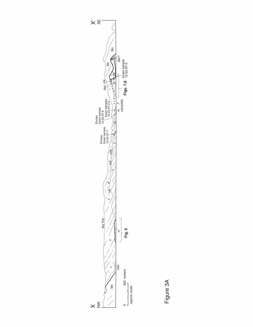
NW
SE
Mv
Mv
cc
m
c
csc
cm
Mv
mcbl
cbl
calc
.
sky
line
ofse
acl
iffs
top
cam
psite
Dor
sey
fora
m s
ampl
e 12
-22-
97-1
fora
m s
ampl
es
12-2
2-97
-2,3
Dor
sey
fora
m s
ampl
e 12
-22-
97-6
fora
m s
ampl
e 12
-22-
97-5
appr
ox. s
cale
030
0 m
eter
sF
igs.
7,8
dac
dac?
Fig
. 9
XX
'
Fig
ure
3A
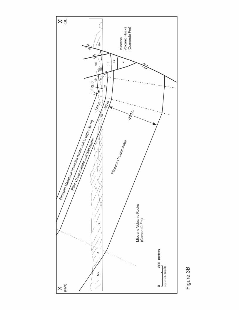
(NW
)(S
E)
appr
ox. s
cale
030
0 m
eter
s
Mv
Mv
cc
c
csc
cm
mcbl
m
cbl
Plio
cene
Con
glom
erat
e
Plio
c. C
ongl
omer
ate
and
San
dsto
ne
Plio
cene
Mar
lsto
ne (i
nclu
des
daci
te u
nit i
n up
per 2
0 m
)
Mio
cene
Vol
cani
c R
ocks
(Com
ondú
Fm
)
Mio
cene
V
olca
nic
Roc
ks(C
omon
dú F
m)
cs c
cbl
Fig
. 8
Fig
ure
3B
~750
m
~90
m
~140
m
XX
'
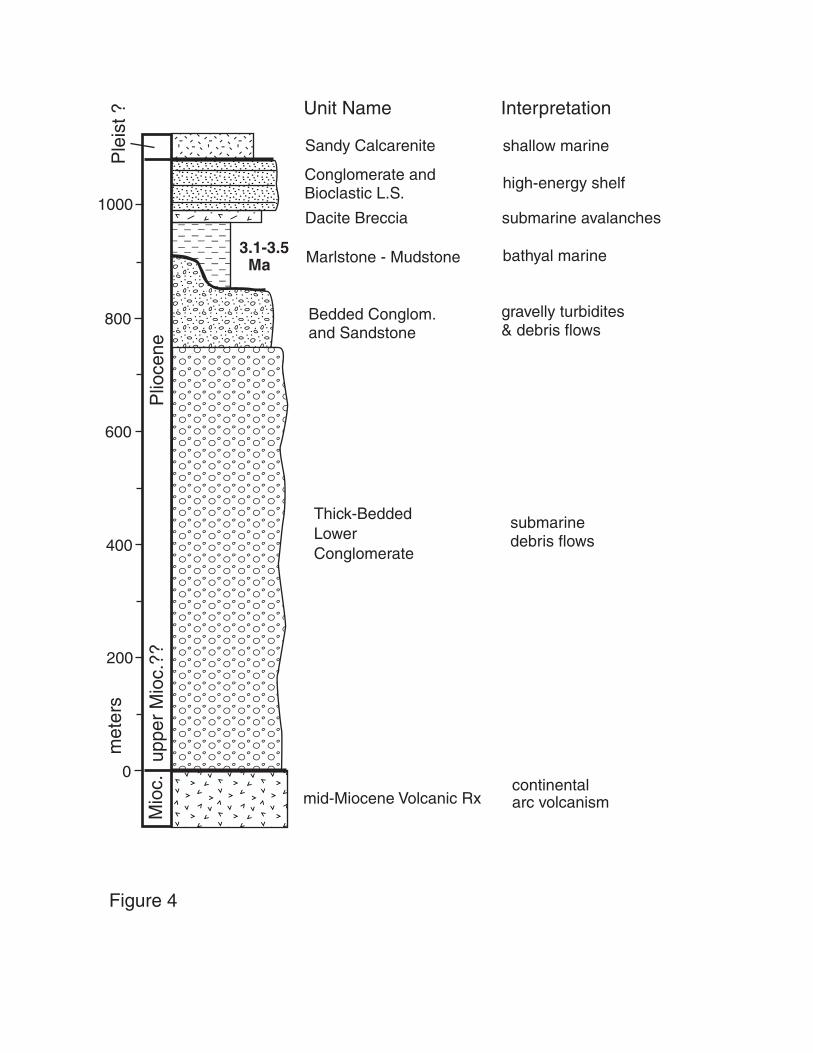
��������yyyyyyyy
������������������������������
yyyyyyyyyyyyyyyyyyyyyyyyyyyyyy
���������������������
�����������������������������������
yyyyyyyyyyyyyyyyyyyyyyyyyyyyyyyyyyy
������������
yyyyyyyyyyyy���������
������������������������������������������������������������������������������������������������������������������������������������������������������������������������������������������������������������������������������������������������������������������������������������������������������������������������������������
yyyyyyyyyyyyyyyyyyyyyyyyyyyyyyyyyyyyyyyyyyyyyyyyyyyyyyyyyyyyyyyyyyyyyyyyyyyyyyyyyyyyyyyyyyyyyyyyyyyyyyyyyyyyyyyyyyyyyyyyyyyyyyyyyyyyyyyyyyyyyyyyyyyyyyyyyyyyyyyyyyyyyyyyyyyyyyyyyyyyyyyyyyyyyyyyyyyyyyyyyyyyyyyyyyyyyyyyyyyyyyyyyyyyyyyyyyyyyyyyyyyyyyyyyyyyyyyyyyyyyyyyyyyyyyyyyyyyyyyyyyyyyyyyyyyyyyyyyyyyyyyyyyyyyyyyyyyyyyyyyyyyyyyyyyyyy
��������QQQQQQQQ¢¢¢¢¢¢¢¢
mid-Miocene Volcanic Rx
Thick-BeddedLowerConglomerate
Bedded Conglom. and Sandstone
Marlstone - Mudstone
Dacite Breccia
Conglomerate and Bioclastic L.S.
submarine debris flows
gravelly turbidites& debris flows
bathyal marine
submarine avalanches
high-energy shelf
continentalarc volcanism
Unit Name Interpretation
3.1-3.5 Ma
0
200
met
ers
400
600
800
1000
Plio
cene
Ple
ist ?
Mio
c.Sandy Calcarenite shallow marine
uppe
r M
ioc.
??
Figure 4
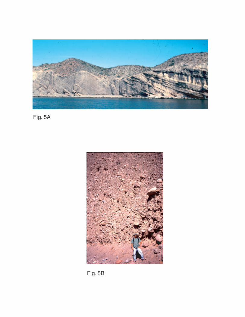
Fig. 5A
Fig. 5B
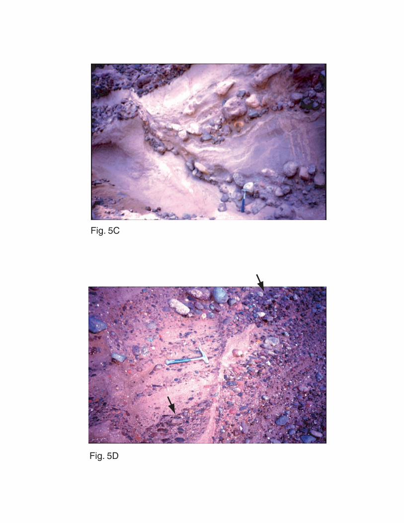
Fig. 5C
Fig. 5D
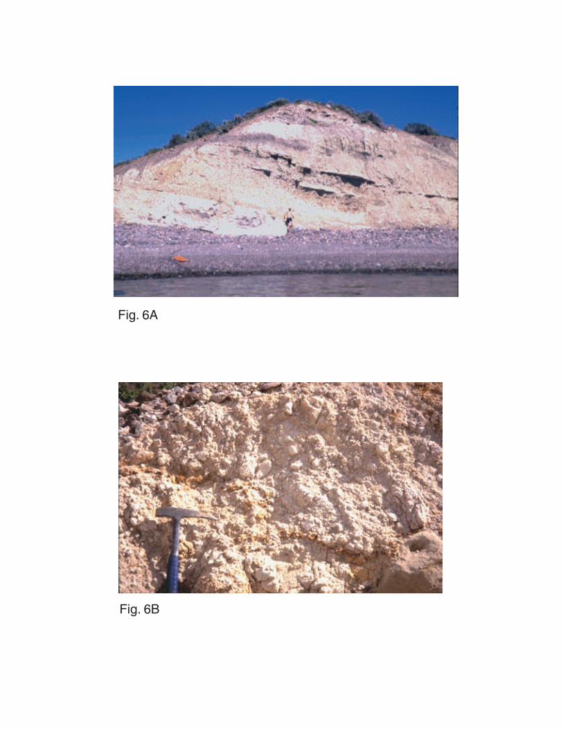
Fig. 6A
Fig. 6B
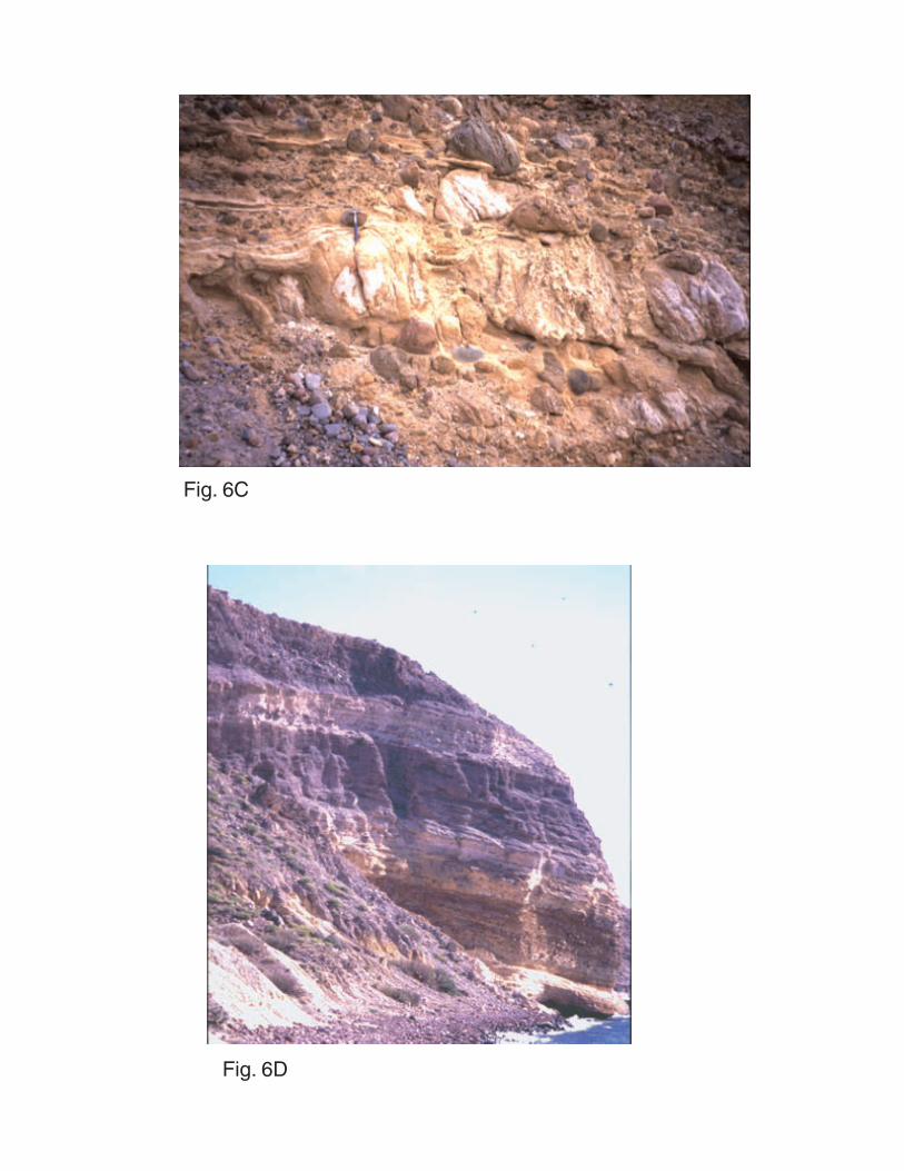
Fig. 6C
Fig. 6D
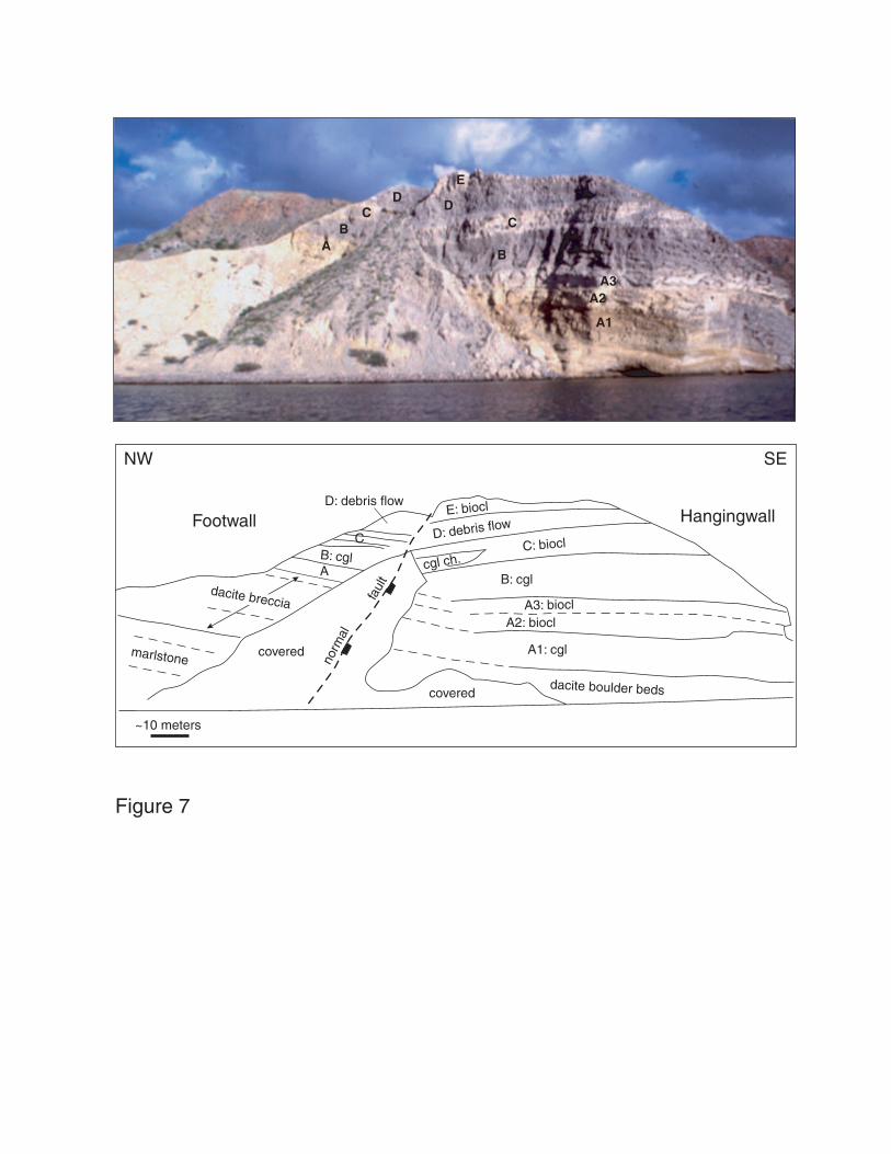
CC
B
DD
E
BA
A1
A2A3
~10 meters
D: debris flow
A1: cgl
A2: biocl
B: cgl
covered
covered
D: debris flow
B: cgl
CC: biocl
E: biocl
norm
al
faul
t
dacite boulder beds
marlstone
A
A3: biocl
cgl ch.
NW SE
HangingwallFootwall
dacite breccia
Figure 7

���������������
yyyyyyyyyyyyyyy
������������������������
yyyyyyyyyyyyyyyyyyyyyyyy
0
20
40
60
80
100
���������������������������������������������������������������������������������������������������������������������������
yyyyyyyyyyyyyyyyyyyyyyyyyyyyyyyyyyyyyyyyyyyyyyyyyyyyyyyyyyyyyyyyyyyyyyyyyyyyyyyyyyyyyyyyyyyyyyyyyyyyyyyyyyyyyyyyyyyyyyyyyyy
���������������
yyyyyyyyyyyyyyy
������������������
@@@@@@@@@@@@@@@@@@
������������������
ÀÀÀÀÀÀÀÀÀÀÀÀÀÀÀÀÀÀ���������
yyyyyyyyy������������������������
yyyyyyyyyyyyyyyyyyyyyyyy
���������������
yyyyyyyyyyyyyyy
������������yyyyyyyyyyyy
������yyyyyy������������yyyyyyyyyyyy
������yyyyyy������������yyyyyyyyyyyy������������yyyyyyyyyyyy������������yyyyyyyyyyyy������yyyyyy������yyyyyy
met
ers
dacitic breccia
yellow marlstone and mudstone
lenticular channel fill of reworked dacite debris,slumped and mixed with some mud and marl
shelly pebbly calcarenite and hash with peb-cob congl interbeds
strongly planar stratified peb-cob conglomerate, rare small boulders
planar stratified and interbedded: molluscan shell hash with abundant larger shell fragments and shelly pebble conglomerate
unsorted, structureless, matrix-supported cobble-boulder conglomerate (debris flow)
strongly planar stratified to low-angle cross-stratified,sparsely pebbly to cobbly molluscan shell hash
pebble-cobble congl, can't see internal structures due to weathering
Figure 8
high
-ene
rgy
shal
low
mar
ine
base of sxn is ~80 meters above base of the marlstone unit (tentative)
A
B
C
D
E
letters indicate stratigraphic units shown in Fig. 7

12
34
56
97
8be
ach
grav
elbe
ach
grav
elQ
allu
vium
Qua
t. al
luvi
umQ
uat.
allu
vium
Qua
t. al
luvi
umQ
uat.
allu
vium
benc
h of
Q a
lluvi
umis
abo
ut 3
m h
igh
beac
h gr
avel
boul
ders
c
mm
mm
m =
mar
lsto
nec
= c
ongl
omer
ate
WN
WE
SE
coas
t lin
e
m
~5
met
ers
App
rox.
Sca
le:
Fig
. 9A
appr
ox. p
ositi
onof
Dor
sey
sam
ples


1
2
T
PT
Faults in Miocene Rocks (N = 22)
Faults in Pliocene strata:7 with striae, 22 without striae
A) B)
C) D)
A
B
= Pliocene bedding (N = 28)= Miocene bedding (N = 7)
P
Faults in Pliocene Rocks:thick black lines = 2 major NW-striking faultsthick gray line = major fault at E end of North Beachdashed lines = 3 faults from within fault zone at Eend of North Beachthin lines = 2 secondary faults from south end ofeastern basin-bounding fault
Figure 10
Related Documents