*j& {'** ls ,1j l..i -$-,*, [' a *, ro l H 6 ir $: q ffi tg -j,l! J f, i t. '.'',, i j ? i! { w r:l .,,:i : Beeland Groupr LLG PART625MINERAL WELL PERMIT APPLICATION Non-Hazardous Injection Well Beeland Group, LLC Alba, Michigan FacilitY Antrim GountY T30N, RsW, Section 14,SE % Section MDEQ Permit # TBD January 5,2007 1@88 !!,bst cfEtfield av€.. sle 201 Liuteron, coloTado 301274139

Welcome message from author
This document is posted to help you gain knowledge. Please leave a comment to let me know what you think about it! Share it to your friends and learn new things together.
Transcript
*j&{'**ls,1jl..i-$-,*,
[ 'a* ,rolH6
ir$:qffitg-j,l!
J
f,it.
' . ' ' , ,
ij
?i !
{wr:l.,,:i
:
Beeland Groupr LLG
PART 625 MINERAL WELL PERMITAPPLICATION
Non-Hazardous Injection Well
Beeland Group, LLC
Alba, Michigan FacilitY
Antrim GountY
T30N, RsW, Section 14, SE % Section
MDEQ Permit # TBD
January 5,2007
1@88 !!,bst cfEtfield av€.. sle 201Liuteron, coloTado 30127 4139
nli*. .:::.
*,llllllll:M
ffi
: ' ,
Janrary 2007 BEELAND GROUP, LLC- MDEO PERMIT ATTACHMENTS
ffiFg
i,j, . 1
A. Well ldentification and Proiect Description
A.1. Describe in detait the purpose of the well and its anticipatedlife expectancy
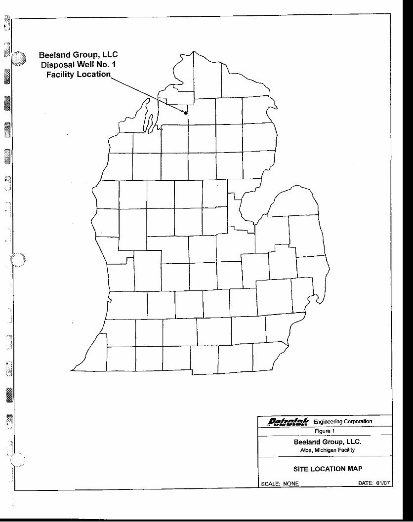
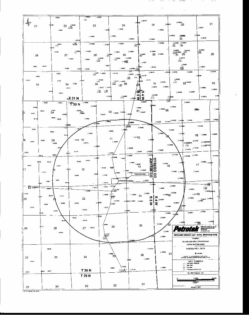
Through the submittal of this application, Beeland Group, LLC, requestsauthorization from the Michigan Department of Environmental Quality (MDEQ) toinstall and operate a non hazardous disposal well located at their Alba, Michiganfacility pursuant to the applicable MDEQ Mineral Well regulations as specified inthe Natural Resources and Environmental Protection Act No. 451 , Parl625 (asamended), The well is to be located in Antrim County, Michigan within the limitsof Star Township, approximately 495 feet from the south line and 1,320 feet fromthe east line of the southeast corner of Section 14, T30N, RsW. A mapidentifoing the facility location is included as Figure 1 at the end of this section.
All applicable information, figures and forms as identified by the MDEQ PermitApplication Instructions for Disposal, Storage, or Brine Production Wells areincluded in this document. Section A includes all information pertainlng to Wellldentification and Project Description, including items 1-13 (i'e' purpose of thewell through description of the planned coring program). Section B includes alladditional information required for an application for a permit to drill and operatea disposal well, including items 1-17 (i.e. Form EQP 7200-14 through inquiring ifthe well is to be a multisource commercial hazardous well). Note that theapplication is not being sought to'drill and operate a storage well or for theproduction of brine (or conversion of wells for this pumose), and this is alsoaddressed in Section B, Figures and forms referenced in each subsection(e.g.Section A-1) are included at the end of that subsection. Also note that theguidance showed two item B.2, both numbered "2", so this document presents 17elements under Section B, not 16 as numbered in the Guidance(http:/A,rrww. michiqan.qov/deq).
The Beeland Group of Jackson, Michigan iniends to operale a single Non-Hazardous Disposal Well in Alba, Michigan for underground injection of fluidsfrom a groundwater remediation project. Fresh water aquifers in the vicinity ofthis well are to be protected by multiple strings of casing and cement. Injectedfluids will be delivered lo the Dundee Formation injection interval under gravityfeed or positive pressure flow through tubing and a packer. The well is to haveone cemented long string protective casing extending into the injection inierval'The wellbore is to be an openhole completion within the injection interval. Theannulus area between the protective casing and injection tubing string is to befilled with inhibited fresh water. Annulus pressure will be continuously monitoredto detect any leaks in the tubing or casing and annulus pressure is to bemaintained at levels of more than 100 psi above ihe iubing pressure'
I
:
1.:l
-.1
#nE
wf!
,.i
ffiiri
l,iWlllli
liiilllli'
{*
ffi
wffi:q
trr!*
;.1
_t
il:i
$$
ffiffis
',, ...:,,,,i
' ' . ,!
January 2007 BEELAND GROUP. LLC. MDEO PERMIT ATTACHMENTS
Beeland Group LLC intends to operate this well for a period of up to 20 yearsuProjeci life may be aliered based on future information acquired during theoperation of the groundwater remediation project.
ffiffiffif9
*$
I:
:
I
:i!
{:str&
g*.'t
Beeland GrouP, LLC 5=fi.rDisposafWellNo. I / |
--N
Facility t"""r,o"
/ I( | | I I f.--tr I r rL4-l\ | | i l --J-1--.1 I \t--r-----r--_1l-Jl
[v,r I +r [f]--_I I r
Fg$@l& Ens ineerin g corporationFigure 1
Beeland Group, LLC.Alba, Michigan Facility
SITE LOGATION MAP
SCALE: NONE DATE: 01/07
i?,1
ri:lil,,rt..wsi#$
BEELAND GROUP, LLC. MDEQ PERMIT ATTACHMENTSJanuary 2oo7
ffiffi$sgffi
a,-.li..:\
* :
t'l
|;
.*4
ffiffi:;
A,2. Notification: At the same time as submitting the permit
application, mail via first-class United States mail' a copy of the
Riit page of the permit application and cover letter to the clerk
of the township and the iurface owner of record of the land on
which the well is to be located'
A letter has been prepared and submittedlo the Clerk of Star Township
"Lnu"ving " copy',of the first page of the permit application. The permit applicant
ir in" 6*i., otifie lana on ilhich the well is to be located, and therefore no
submittal to the landowner is required-
At the end of this Section (A.2), a copy of the Cover Letter is presented, notifuing
ine Cfetf< of Star Township thai an nppfication for Permit to Drill/Deepen/Convert,
unU Op.rrt a Well has been submifted for the following address:
10577 Alba HighwaY,Alba, Michigan 4961 1
ni
i;&*1,,.,,...
lltlr.i,t:ti
lit -
&
' i . '
ffiffiffiffi
;:!
: ,
;
j""l
s&
@
ffi#
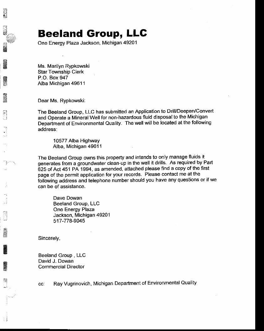
Beeland Group, LLCOne Energy Plaza Jackson, Michigan 49201
Ms. Marilyn RypkowskiStar Township ClerkP.O. Box 947Alba Michigan 49611
Dear Ms. Rypkowski:
The Beeland Group, LLC has submitted an Application to Drill/Deepen/Convertand Operate a Mineral Well for non-hazardous fluid disposal to the MichiganDepartment of Environmental Quality. The well will be located at the followingaddress:
1Q577 Alba HighwayAlba, Michigan 4961 1
The Beeland Group owns this property and intends to only manage fluids itgenerates from a groundwater clean-up in the well it drills. As required by PartOZS of nct 451 PA 1994, as amended, aftached please find a copy of the firstpage of the permit application for your records. Please contact me al thefollowing address and telephone number should you have any questions or if wecan be of assistance.
Dave DowanBeeland Group, LLCOne Energy PlazaJackson, Michigan 49201517-778-9045
Sincerely,
Beeland Group , LLCDavid J. DowanCommercial Director
Ray Vugrinovich, Michigan Department of Environmental Quality
January 2Oo7 BEELAND GROUP, LLC. MDEO PERMIT ATTACHMENTS
i5,,4{sffi
ffiffi
fry
tffi
$*Jl
,1')
"',t
: : . i
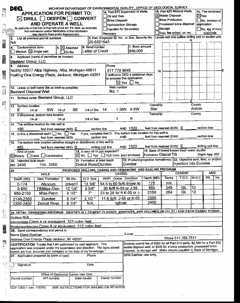
A.3- Form EQP 7200-1, Application for Permit to Drill, Deepen'Operate, with an original signature from the applicant or theapplicant's agent' See instructions on reverse of form.
The Application for Permit to Drill Deepen, or Operate the Beeland GroupDisposal Well No. 1 is presented on Form EQP 7200-01- A Completed andSigned Form is attached at the end of this Section (A'3)-
.
i".l
. . i
#{&nH
ffiT
fsc:,1i-..i
*
ffi
DCA MrcHrcAN DEPARTMENT oFAPPLICATION FOR PERMIT TO:
X DRILL E oeepen flcoruvenrAND OPERATE AWELL
By authority of Pad 615 of Part 625 of Acl 451 PA 1894, as amended.Non{ubmisslon aft,/or falsification of thls lntormalion
ffiwry
rcsult in fnes
bottom hole location
feet frcm nsarest
Icombination
Signature
drilling unit onN
straight orfeel from nearest
oftoolsIcaute
Pad 625 Mineral Wells
fee sched. on rev.
lc. Fee enclosedXve"[No, revision of
1a. Part 6'15 SupeNisor of Wells
noit and casnBrine Disposal!nydrocarbon Storage
Ilnjeclion for secondaty
Fed. Employer lD. No. or Soc. Security No
I Bhnket El single well
8. Applicant (name of permittee as bonded)
:10577 Alba Highway, Alba, Michigan 49611mailing:One Energy Plaza, Jackson, Michigan 49201
0. Lease or well nama (be asBeeland DisDosal Well11. Su.face owner Beeland Group, LLC
l t4otSec 14
13. It directional. bottom hole location1t4 ot 114 ot 1,/4 of Seq T R
14. The surfac€ location lor this wellseclion line AND 1320 feet flgrn n9gl9:!
15. ls this a diredional welP Ll No Ll Yes lf yes, complete linels. The bottom hole location for ihis well is
feet ftom nearest (N/S) - sec{ion line
Base of lowesl known tresh water aquiferGlacial Till Depth App. 850
18- ls sour oil orgasE ruo n Yes n H2S cont. plan enclosed
23 to 26 lb/ ft K-55 or J-
S€nd cor.espondence and Parmit toName Dave Dowhan E-matl
Phone 517 -768-7517
ie pemit fee of $3oo for all Part 615 wells; $2,500 fot a Part 625disposal u/ell; or $500 for a brine production, processed brine
or sloraqe wetl. Make checks payable to State of
CERTIFICATION 'l state that I am authorized by said applicant. This
application was prepared under my supeNision and direction. The facts statedherein are true, accurate and complete to the best of my knowledge-'
27- Application prepared by (print or type)
EOP 7200-1 (rev. 1/2005) SEE
use onry.
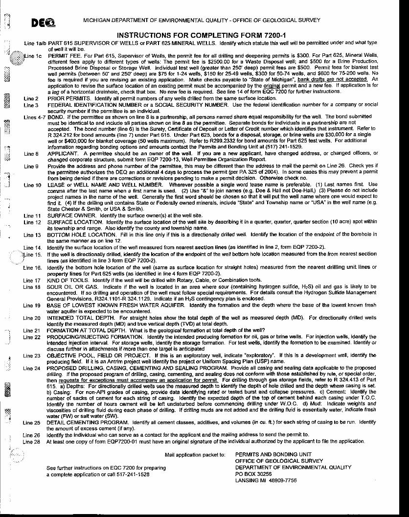
jj DE€ N/ICHIGAN DEPARTMENT OF ENVIRONMENTAL QUALITY . OFFICE OF GEOLOGICAL SURVEY
INSTRUCTIONS FOR COMPLETING FORM 72OO-{--
, Line 1alb PART 615 SUPERVISOR OF WELLS or PART 625 MINEML WELLS. Identiry $rhich statute this well will be permitted under and what type
..j ...,- of well it will be.--
- 'Ljne 1c PERMIT FEE. For Part 615, Supervisor of Wetls, lhe permit fee for all drilling and deepening permits is $300- For Part 625, MineralWells,
\ different fees apply to different types of wells: The permit fee is $2500.00 tor a Waste Disposal well; and $500 for a Brine Production,
: Processed Brine Disposal or Storage Well. Individual test well (greater than 250' deep) permit fEes ate $500. Permit lees for blanket test
i* welt permits (between 50' and 250' deep) ate $75lo. 1-24 welb, $150 for 25-49 welts, $300 for 5G74 wells, and $600 ior 75-200 wells. No*$ fee is required if you are revising an existing application- Make checks payable to:State of Michigan", bank drafts are not acceoted. An
application to revise the surface location of an existing permit must be accompanied by the orjoinal pefmit and a new fee. lf application is fofa leg of a horizontal drainhole, check that box, No new fee is required. See line 14 of torm EQC 7200 for fu her instructions.
Line 2 PRIOR PERMITS. ldentiry all permit numbers ot any lyells drilled from the same surface location.Line 3 FEDERAL IDENTIFICATION NUMBER or a SOCIAL SECURITY NUMBER. Use the federal identmcation number for a mmpany or social
security number if the permitiee is an individual.Lines 4-7 BOND. It the permittee as shown on line I is a partnership, all persons named share equat responsibility tor thewell. The bond submitted
: must be identical to aod includg all parties shown on line 8 as the permittee- Separate bonds for individuals in a partneFhip are not:i accepted. The bond number (line 6) is the Surety, Certificate of Deposit or Letter of Credit number ',vhich k entifies that instrument. Refer lo'-" R 324.2121ot bond amounts (line 7) under Part 615. Under Part 625, bonds for a disposal, storage, or brine wells are $30,000 for a single
well or $400,000 for blanket coverage (50 wells maximum). Refer to R299.2332 for bond amounts tor Part 625 test wells- For additional1.i information regarding bonding options and amounts contrci the Permits and Bonding Ljnlt at F1n 241-1529.t]:j Line I APPLICANT, A permittee should be an owner of the well. It you are a new applicant, have changed address, of changed officers, or'':A
changed corporate struciure, submit form EQP 7200-13, Well Pemittee organization Repo .Line 9 Provide the address and phone number of the permitteg, this may be different than the address to mail the permit on Line 26. Check yes if
the permihee authorizes the DEQ an additional 4 days to proc€ss the pemit (per PA 325 of 2004). In some qases lhis may prevent a permitfrom being denied if lhere are correclions or revisions pending to make a permit decision. Othetwise check no.
ffi
-1l
Line 't4.
, ' ?ine 15.
Line '16.
Line 17Line 18
Line 10 LEASE or WELL NAME AND WELL NUMBER. Wherevor possible a single word lease name is preferable. (1) Last names first. Usecomma afierthe last name when a first name is used- (2) Use "A'toioin names (e.9. Doe & Hall not Doe-Hall,) (3) Please do not includeproieot names in the name of the well- Generally lhe first word should be chosen so that it will put the well name where one would expect tofind it. (4) lf the dnlling unit contains State or Federally owned minerals, include 'State" and Township name or 'USA" in the well name (e.9.State Chester & Smith, or USA & Smith).
Line 11 SURFACE OWNFR. ldentify the surface owne(s) at tie well site-Line12 SURFACE LOCATION- ldentjfy the surface location otthe wellsite by describing it in a quarter, quarter, quarter section (10 acre) spotwithin
its to,vnship and range. Also identifu the county and township name.Line 13 BOTTOM HOLE LOCATION. Fitl in this line only if this is a directionally ddlled well. Identify the location ofthe endpoint of the borehole in
the same manner as on line '12.
fdentiry the surface focation of the well measured from nearest sectiqn lines (as identified in line 2,lorrn EAP 72OO-Z).tfthe well is directionatly drilled, identiry the location of ahe endpoint ofthe wellbottom hole location measured from the from nearest sectionlines (as identified in line 3 form EQP 720$2).ldentiry the bottom hole location of the well (same as surface bcation for straight holes) measured from the nearest drilling unit lines orproperty lines for Part 625 wells (as identitied in line 4 torm EQP 7200-2).KIND OF TOOLS. ldentify if lhe wetlwillbe drilled with Rotaty, Cable. or Combination tools.SOUR OIL OR GAS. Indic€te if the well is located in an area where sour (containing hydrogen sulfide, HzS) oil and gas is likely to beencountered. lf so d lling and operation of the well must follow special requirements- For details .onsuft the Hydrogen Sulfide Managementc€neral Provisions, R324.1101-R 324.1129. Indicate if an H?S contingency plan is enclosed.BASE OF LOWEST KNOWN FRESH WATER AQUIFER. ldenfry $e formation and the depth where the base of the lowest known freshwEter aquifer is expected to be encountered.INTENDED TOTAL DEPTH. For st.aight holes show lhe tolal depth of the well as measured depth (MD). For directionally drilled wellsidentify the measured depth (MD) and t ue vertical depth ffVD) at total depth-FORMATION AT TOTAL DEPTH. What is the geological fomation at total depth of th€ well?PRODUCING/INJECTING FORMATION. ldentiry the intended productng formation ior oil, gas or brine wells. For injection wells, identr'ry theintended injection interval. For storage wells, identiry the storage io.mation. For test wells, identify the formation to be examined. ldentiry ordiscuss further in attachments if more than one target is anticipatedOBJECTIVE POOL, FIELD OR PROJECT. lf this is an exploratory well, indicate 'explotatory'. It this is a development well, identify theprcducing field. lf il is an Ant m projecl wBll id€ntiry the proiect or Uniform Spacing Plan (USP) name.PROPOSED DRILLING, CASING, CEMENTING AND SEALING PROGRAM- P,ovide all casing and sealing data applicable to the proposeddflling. lf the proposed program of drilling, casing, cementing, and sealing does ngt conform with thosE established by rule, or special order,then requests for exceptions must accompanv an aopli@tion tor oermit. For drilling through gas slorage fields, refer to R 324.413 of Part615. a) Depths: For directionally drilled lr,ells use ihe measured deplh to identiry the depth of hole dilled and the depth where casing is set.b) Casing: For non-APl grades of casing, provide data ldentifying rated or tested bsrst and sollapse prcssures. c) Cement: Identify thenumber of sacks ol cemer{ for each string of casing. ldenlify the expected depth of the top ot cement behind each casing under T-O.C.ldediry the number of hours cement will be lefi undisturbed before commencing dtilling under W.O.C. d) Mud: Indicate weights andviscosities of drilling fluid during each phase of dilling. lf drilling mlds are not added and the dilling fluid is essentially wEter, indicate freshwater (Fl,tV) or salt water (SW).DETAIL CEMENTING PROGRAM. ldentiry all cement classes, additives, and volumes (in cu. ft.) for each string of casing to be run. ldentirythe amount ofexcess cement (if any).ldentiry the individual who can serve as a contact lor the applicant and the mailing address to send the pernit to.At least one copy of form EQP7200-01 must have an original signature ofthe individual authorized by the applicant to file the application.
I
:
.!. j
Line 19
Line 20
Line 21Line 22
Line 23
Line 24
ffig
wi' : Line25
, Line26Ltne zd
Mail application packet to: PERMITS AND BONDING UNITOFFICE OF GEOLOGICAL SURVEY
See further instructions on EQC 7200 for preparinga complete appllcation ot call 517-241-1528
DEPARTMENT OF ENVIRONMENTAL QUALITYPO BOX 30256LANSTNG Mt 48909-7756
$1 i i
in
ft,llfi|l\,:r::1:liii$
;swffiffi
fa&i*s:lt
tJ
q
"
:f i!
. ' ' :
;J#KK
January 2OO7 BEELAND GROUP, LLC. MDEO PERMIT ATTACHMENTS
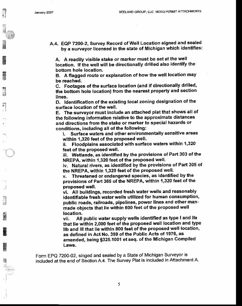
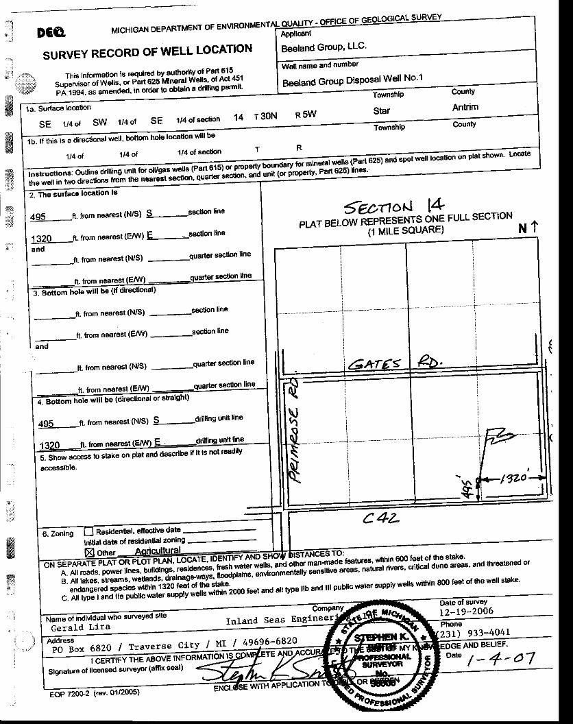
A,4. EQP 72OO-2, Survey Record of Well Location signed and sealedby a surveyor licensed in the state of Michigan which identifies:
A. A readily visible stake or marker must be set at the welllocation. lf the well will be directionally drilled also identify thebottom hole location,B, A flagged route or explanation of how the well location maybe reached.C. Footages of the surface location (and if directionally drilled'the bottom hole location) from the nearest property and sectionlines.D. ldentification of the existing local zoning designation of thesurface location of the well.E, The surveyor must include an athched plat that shows all ofthe following information relative to the approximate distancesand directions from the stake or marker to special hazards orconditions, including all of the following:
i. Surface waters and other environmentally sensitive areaswithin 1,320 feet of the proposed well'ii. Floodplains associated with surface waters within 1'320feet of the proPosed well.iii. Wetlands, as identified by the provisions of Part 303 of theNREPA, within 1,320 feet of the proposed well'iv. Natural rivers, as identified by the provisions of Paft 305 ofthe NREPA, within 1,320 feet of the proposed well'v, Threatened or endangered species, as identified by theprovisions of Part 365 of the NREPA, within {,320 feet of theproposed well'vi. All buildings, recorded fresh water wells and reasonablyidentifiable fresh water wells utilized for human consumption,public roads, railroads, pipelines, power lines and other man-made objects that lie within 600 feet of the proposed welllocation.vii. All public water supply wells identified as type I and llathat lie within 2,000 feet of the proposed well location and typeItb and lll that lie within 800 feet of the proposed well location,as defined in Act No.399 ofthe Public Acts of 1976' asamended, being $325'1001 etseq. of the Michigan GompiledLaws.
Form EPQ 72OO-02, singed and sealed by a State of Michigan Surveyor isincluded at the end of section A.4. The Survey Plat is included in Attachment A.ts
-',",.;' .,i,,,il.r:,,,,1
:
t;l , l
ii,,1,'',,,,".rlta::itr
*iil#w
1",lFd{w'
January 2007 BEELAND GROUP. LLC, MOEO PERMIT ATTACHMENTS
ffii3
l;f.il
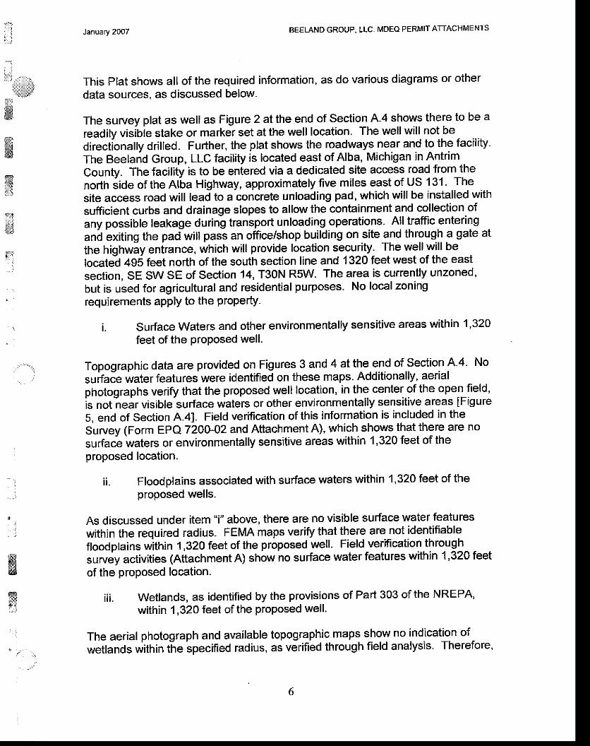
This Plat shows all of the required information, as do various diagrams or otherdata sources, as discussed below.
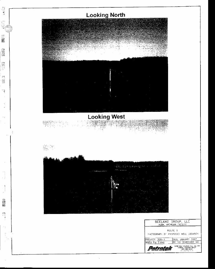
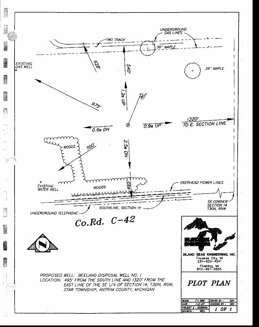
The survey plat as well as Figure 2 at the end of section A.4 shows there to be areadily visibie stake or marker set at the well location. The well will not bedirectionally drilled. Further, the plat shows the roadways near and to the facilityThe Beeland Group, LLC facility is located easi of Alba, Michigan in Antrim .county. The facility is to be entered via a dedicated site access road from thenorth iide of the Aha Highway, approximately five miles east of US 131' Thesite access road will lead to a concrete unloading pad, which will be installed withsufficient curbs and drainage slopes to allow the containment and collection ofany possible leakage during transport unloading operations. All traffic enteringand exiting the pad will pass an office/shop building on site and through a gate atthe highwiy entrance, which will provide location security. The well will belocate-d +9s feet north of the south section line and 1320 feet west of the eastsection, SE SW SE of Section 14, T30N RsW. The area is currently unzoned,but is used for agricultural and residential purposes. No local zoningrequirements apply to the property.
i. surface waters and other environmentally sensitive areas within 1,320feet of the Proposed well.
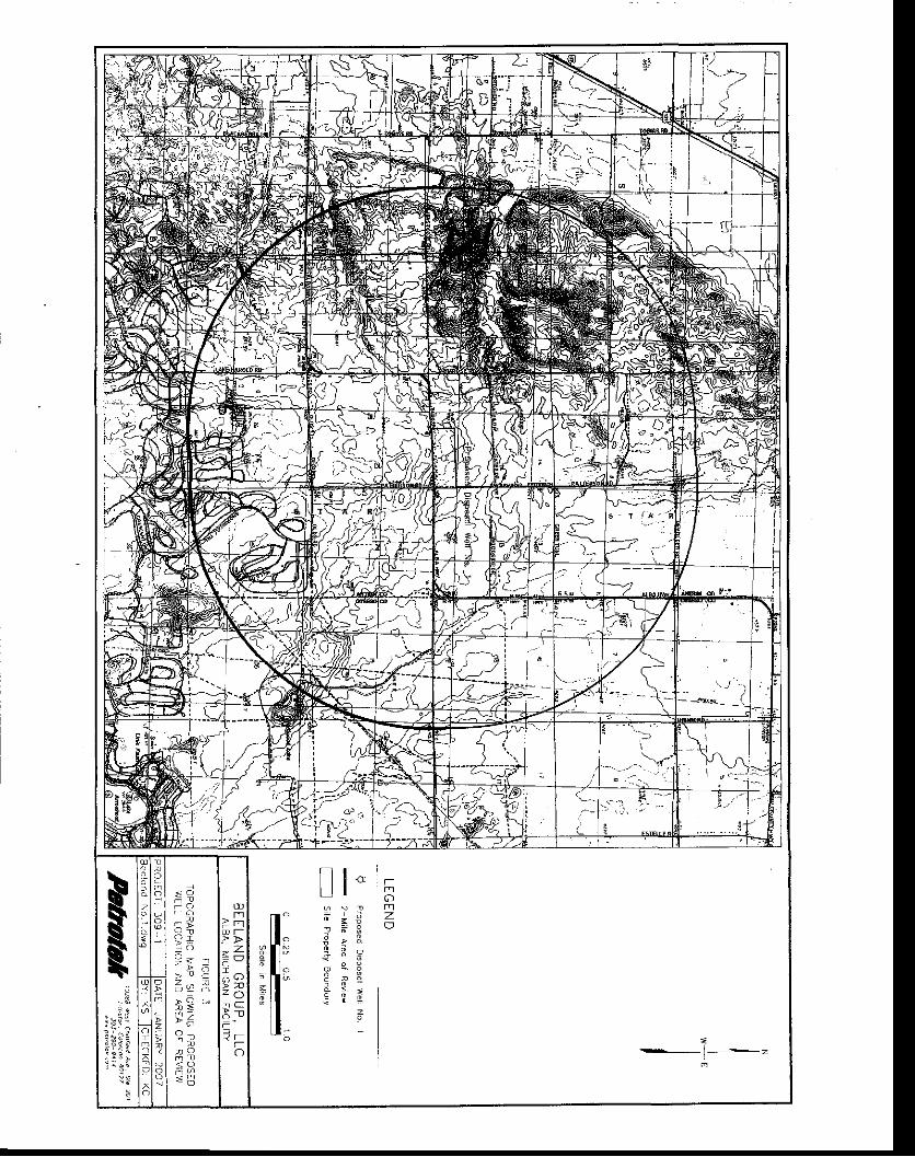
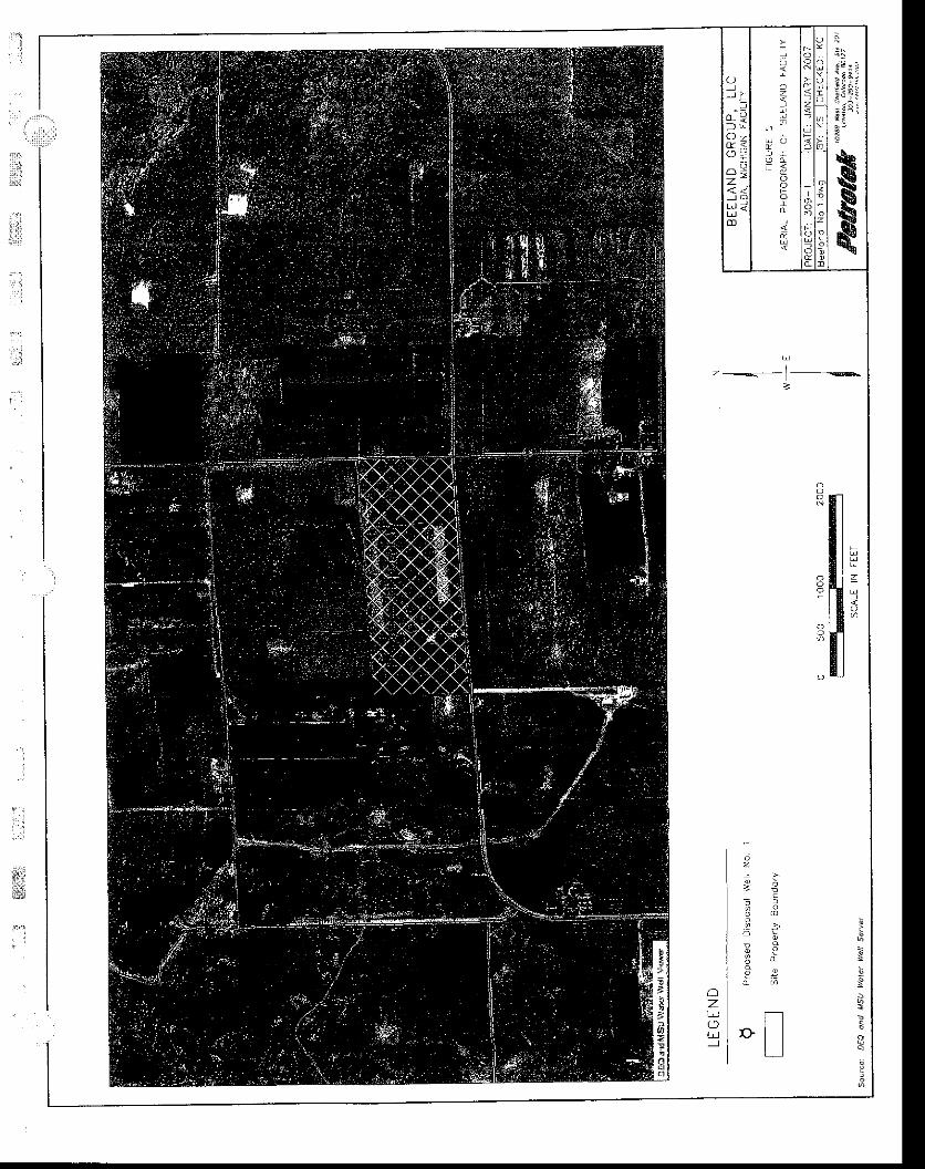
Topographic data are provided on Figures 3 and 4 at the end of section A.4- Norurfuie water features were identified on these maps. Additionally, aerialphotographs verify that the proposed well location, in the center of the open field,is not-near visible surface waters or other environmentally sensitive areas lFigure5, end of section A.41. Field verification of this information is included in thesurvey (Form EPQ 7200-02 and Attachment A), which shows that there are nosurface waters or environmentally sensitive areas within 1,320 feet of theproposed location.
ii. Floodplains associated with surface waters within 1'320 feet of theproposed wells.
As discussed under item "i" above, there are no visible surface water featureswithin the required radius. FEMA maps verify thal there are not identifiablefloodplains wittrin t,320 feet of the proposed well. Field verification throughsurvey activities (Attachment A) show no surface water features within 1,320 feetof the proposed location.
iii. Wetlands, as ideniified by the provisions of Part 303 of the NREPA,within 1,320 feet of the proposed well.
The aerial photograph and available topographic maps show no indication ofweflands ,,'iitnin tn. specified radius, as verified through field analysis. Therefore,
. l
#&
slr:
T.;.,.
i#&ffiffi&i l: l
January 2007 BEELAND GROUP, LLC. MDEO PERMIT ATTACHMENTS
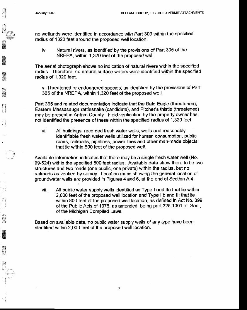
no wetlands were identified in accordance with Part 303 wjthin the specifiedradius of 1320 feet around the proposed well location.
iv. Natural rivers, as identified by the provisions of Part 305 of theNREPA, within 1,320 feet of the proposed well.
The aerial photograph shows no indication of natural rivers within the specifiedradius. Therefore. no natural surface waters were identified within the specifiedradius of 1,320 feet.
v. Threatened or endangered species, as identified by the provisions of Part365 of the NREPA, within 1,320 feet of the proposed well.
Part 365 and related documentation indicate that the Bald Eagle (threatened),Eastern Massasauga rattlesnake (candidate), and Pitche/s thistle (threatened)may be present in Antrim County. Field verification by the property owner hasnot identified the presence of these within the specified radius of 1,320 feet.
vi. All buildings, recorded fresh water wells, wells and reasonablyidentifiable fresh water wells utilized for human consumption, publicroads, railroads, pipelines, power lines and other man-made objectsthat lie within 600 feet of the proposed well.
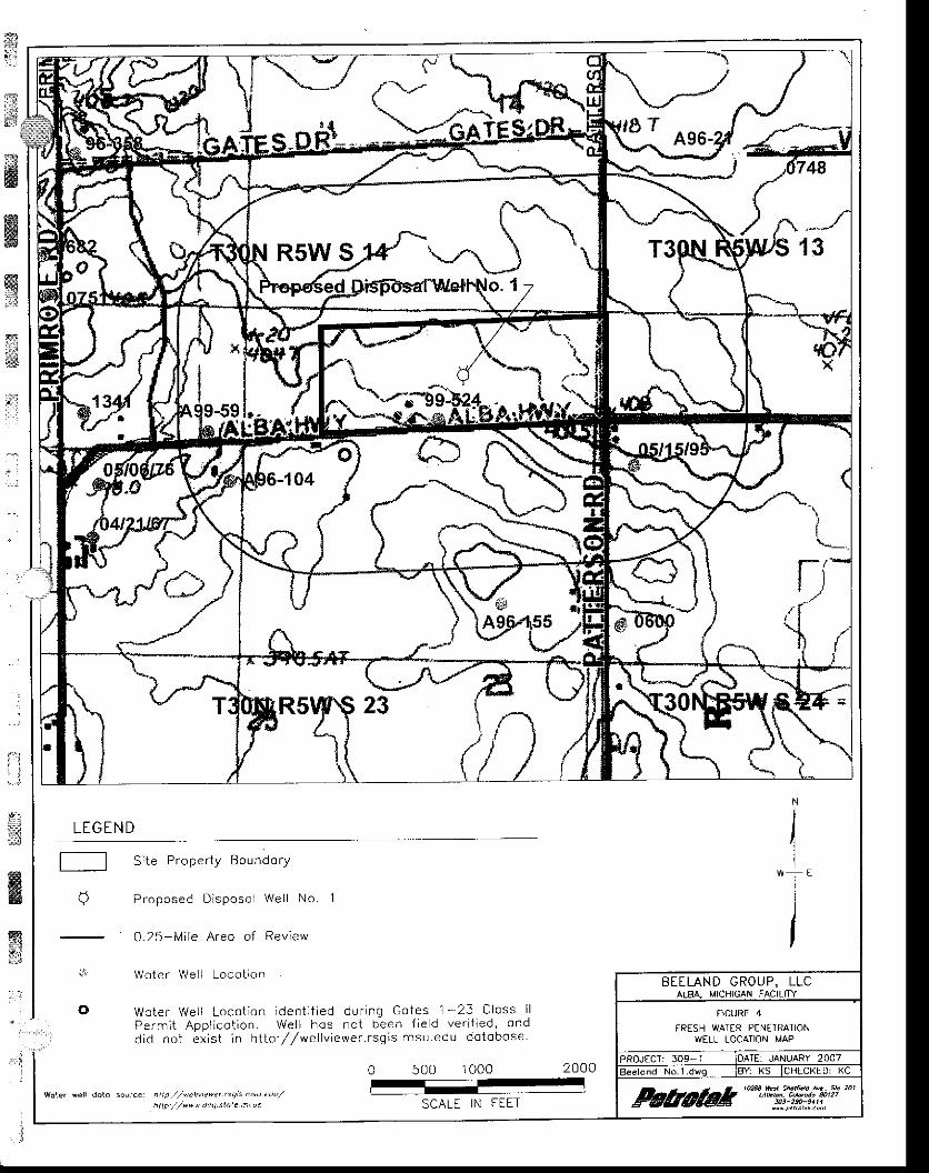
Available information indicates that there may be a single fresh water well (No.99-524) within the specified 600 feet radius. Available data show there to be twostructures and two roads (one public, one private) within the radius, but norailroads as verified by survey- Location maps showing the general location ofgroundwaier wells are provided in Figures 4 and 6, at the end of Section A.4.
vii. All public water supply wells identified as Type I and lla that lie within2,000 feet of the proposed well location and Type llb and lll that liewithin 800 feet of the proposed well location, as defined in Act No. 399of the Public Acts of 1976, as amended, being part 325.'1001 et. Seq.,of the Michigan Compiled Laws.
Based on available daia, no public water supply wells of any type have beenidentified within 2,000 feet of the proposed well location.
:t'f
,,, '...,
: ::
J :
r:.:
fl&xa
6{C
s.l
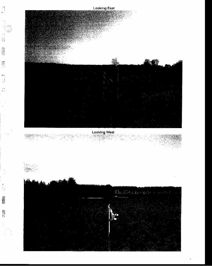
Lookinq North
tr
*
i . ,
.t,l
kinoo.i.'i-{.
L. West
BEELAND GROUP, LLC
FICURL 2
P n O O G R A P O F F o T - O \ l w r . L O L a - r o \
-c-)
z
ll-
,il; i ;E,fl' q;A; l l ! " e E
[ = .
E. i i
i ! ." :' t : " a
l=: f: -! < .
i ? -> 6
9 !
€u
o
rzootnOc--o-.)
fr$
ffiffiffi;l
ffi;l
".:
LEGEN D I1"l'I
a
woter sell dot. so!rce: htt p ./httirte-et "q;snsn
tdo/' r L / / ^ " " d " a . t . e ' q l
S i te P rope r t y Boundo ry
Proposed D i sposo l We l l No . I
0 .25 -M i l e A reo o f Rev iew
Wote r We i l Loco t ron
Wote r we , r Loco l o r de r t t ' ed cd -q Co ies ?J C loss l lD e . r r ; t A p p r . c o ' r o n . W e r ' l _ o 5 - o l o e e n l i e o v e r . f : e d . o n dd id no i ex i s t i n h i i p : / /we l l v i ewe r . r sq ; s r . nsu edu do tobose
0 500 1000 2000=
SCALE IN FEET
BEELAND GROUP, LLC
F1GURE 4FRESH WATER PENITRATION
WELL LOCATION MAP
:
o ze tm -:m)
;
{
i
e
r i : i* ;R ii t t A :; .5s :
E'
rr||
-*qis8
:ELIJ <
m
I
n96
rlz(-)J
.ll=: [ -
I< t
; €
9 t i
3 ^ Y* .
!
,.
g
I
1N,-1 2 1 23 24 1 9 . 2 0
2E
; ? ; lI
;':fe27 25
.4nt3
'i; 29 2A
33
i - r 3 l N
35
liil ,d:
31+sz
lr ,.," +
.,1
I
*l* d?"*,$l
:otu
{*{./
=-t4,=oo
1 3
-t
El 'to +.*o
1 7
1 t:'15
7
v
{20
-_-=-:d--
22
-4
-i',-'z,/*
29 fi" GnorP, urc AIBA fitcHralx gIrE
_ ".*""l '*.,34
T 3 0 N
,*iilY":,E&iE*rtrJr5&1'L.,
o105 04
T 2 9 N
\0 3 l o 2
.i:: i ^
DECI MICHIGAN DEPARTMENT OF ENVIRONMENT
SURVEY RECORD OFWELL LOCATION
Thi6 lnfo.mation is '€qulr€d by aur|otlv ot Pdr 615 - 's,#l i Jii'# fr",i'ii. -.i-J; a; !sy1g1g11;i'^T$il;;;"#.i'io"o-* to o'ot'tn
" ornrno psmrl
fGfrom trole wttl bs (if
ft. fiom nearest (t'US) 6ec{on line
ft from n€qrest (E/W) s€otlon line
and
ft. lrom nsarest (l'l/S) $Ert€r saction lln€
ft. from noarast s6c{on lfio
€ortorl 14PLATBEL;w;.rfi fr?t$S^"#iFULLsEcrtoN
ffiffi*$;ti.I1t
q* Nf
ffitr, ' i
I J
c42
" #l':H]$ffi#-:1fiff?.'r6'#il"t"j;[;; ;, "nd au rype rb a,ld m pubrc \tater supprv wdts wit n 80o r6et or d'e werr stake'
c. Arl W; I and lla publlc water 6uppy wer|s tf - ;r, fi iind
t2-t9-?oo6
23L) 933-4O4rAND BELIEF.
Apdlcant
Be€land Group, LLC'
Beeland Group Disposal Well No'1
1a. Sur{ace location
SE 1t4of SW 1/4 of t/4 ol se@n 14 T 30N
rb:flta'nth.ffi.ond*,d|.boftomhol€ locason vdll be
the wetl in two directions ftom the ne'rg
z-The curface locatlon ls
495 ft- ttom .Earest (N/s) S sBcdon lin6
1 320 ft. trom nearest (E/vv) E - s€cdon lin6
and
ft. from nearest (NS) quadar sectior lhe
l-lEottom hole wlll be
495 n. rum neat€st (N/s) S drilling unit llne
r l
*lqzo-1
;ffi$;-" - p'"t *d d*cribe if it i6 not teadilv
lnital datg o{ residan[al zoning
Gerald L i ra Inland Seas Engine
ioJ'"i.* ,po / traverse cltv / ur -i-1?iP6. 6-9.2-9
@FoRt'tarloNsrgnuh,,u or riJiJ surveyor (amx seat)
td6fiEOP 720G2 (rev. 0t/2005)frfi-,cPPl-tClTloi'l
^' l- +- 07
s
;,,11ililiil:t:
irar 'r'lu:;i-
#lffi 1,,,r,,*"w
l?Aswtu
ffil
nlII
cil\'.)\( !- 36" MAPLE
{2.r,
I\ l
NI Mst //
6 as;@->-'d6, DN
l'.)(n)l
bz
:
ffi
wffi
EXISfINGWA|ER WELL woo05
SOUTHLINE, SECTION 14
urorroror*o onrroilj
Co.Rd. C-42
{e srcnot't ttut
/- IzERHEAD PowER LtNEs
IJ- A ,-l=-\r- t
sEcnoN t4BON, R5W
PROPOSED WELL: BEEUND DISPOSAL WELL NO. tLOCATION: 495' FROM THE SOUTH LINE AND l32O' FROM THE
EAST LINE OF THE SE I/4 OF SECTION 14, TJON, R5W,STAR TOWNSHIP, ANTRIM COUNry, MICHIGAN
IIILAT{D 6EAA EM$Effi q INC.Trovors€ Clty, Ml23t -933-4041
Flushlno, MlE1o-467:o5s5
.::t
Looking West: i : i : ' . . , i . ' i t i 1 l . . : ' . : . : l ; . : l ' : . : . . . : . . . ] ! | . . . . , . . i i ' . , 1 ; $ l l : . . . i : 1 | 1 ; , . l . l . .
ffitr
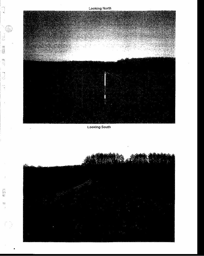
Looking North
Looking South
*'airil
#....t
* ' r ; ' '.."r{sm
January 2OO7 BEELAND GROUP, LLC. MDEQ PERMIT ATTACHMENTS
,4,5. Form EQP 7200-4, Wellhead Blowout Gontrol System.
The blowout control system for the proposed well is presented in form EQP-7200-4, presented at the end of this Section (A.5). lt is noted that no positivepressures are expected during the installation of this shallow (<2500') injectionwell.
ffiffigffi
ti:l. :
. ,
r'1: ;
g
.*
ffi
fficw&
,ll
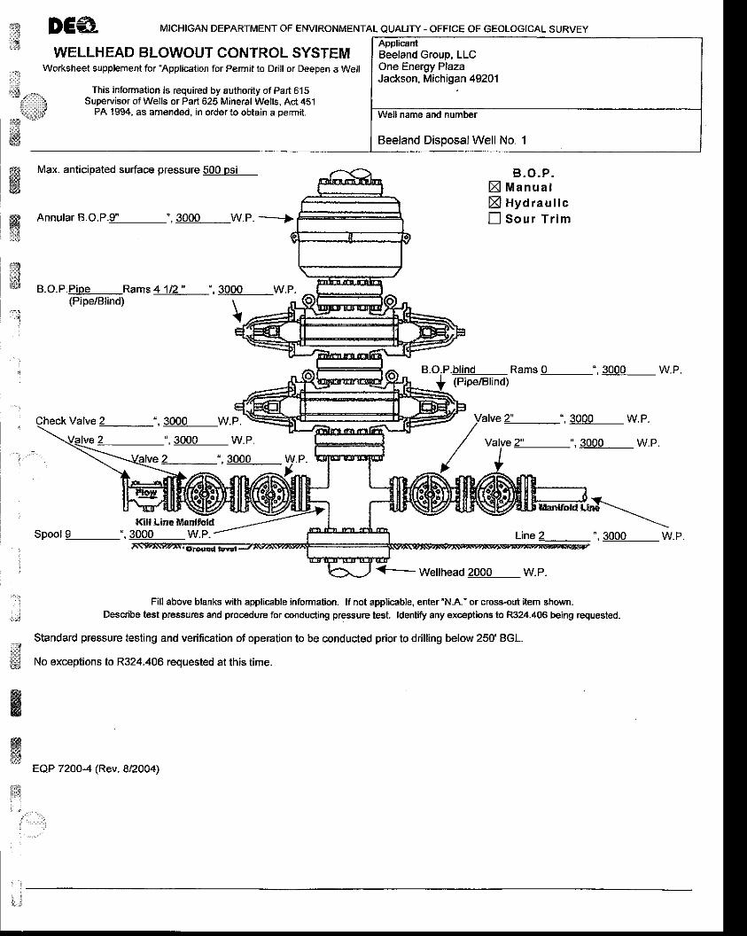
€ DEA MTcHTGAN DEeARTMENT oF ENVTRoNMENTAL euAury - oFFrcE oF GEoLoGTcAL suRVEy
1 ..,-, I ApplicantWELLHEAD BLOWOUT CONTROL SYSTEM
Worksheet supplement for ?pplication for Permit to Drill or Deepen a Well
s -.^ This information is required by authority of part 615
lsqiilp PA 1994, as amended, in order to obtain a pemit.
ffi
f? Max. anlicipaled surface pressure lQQagl
ffi
qE
anB.O.P.Pipe Rams 4 1i2 " ' , 3000 W,P.
B, O. P .X Manuatxl Hyd rau I icn Sour T r im
.h!!I!l Rams 0 ", 3000 W.P.(Pipe/Blind)
Valve 2" ", 3000 W.P.
Valve 2" ",3000 W.P.
(Pipe/Blind) \{
:,.,i
Valve 2 ",3000 W.P.
2 ' ,3000 w.P.
2 ",3000 w.P.-:=I /-..=!- -^ --,,*-t --
&ffi
16ll line lvlantfoldSpool I ", 3000 W.P. Line 2 ', 3000 W.P.
Wellhead 2000 W.P.
Fill above blanks with appliceble information. lf not applicable, enter 'N-A." or cross-out item shown.Descdbe tesl pressurcs and procedure for conduding pressure test. ldentry any exceptions to R324.406 being requested-
Standard pressure testing and verification of operation to be conducted pdor to ddlling below 250' BGL.
No exceptions to R324.406 requested at lhis time.
EQP 7200-4 (Rev. 8/2004)
1n
. . . . ' . . ' ' .
ApplicantBeeland Group, LLCOne Energy PlazaJackson, Miehigan 49201
Well name and number
Beeland Disposal Well No. 1
. :
1,.;1
ffiL]
llrrini**ds\
#if!id
ffi
ffi
ffim;:al3
lst;;$t
*'J: 1
' l
,-.i
:
,i
January 2007 BEELAND GROUP, LLC, MDEO PERMIT ATTACHIMENTS
4.6, Form EQP 7500-3, Environmental lmpact Assessment forMineral Wells Surface Facilities
The Environmental lmpact Assessment of Mineral Wells Surface Feature ispresented in/on Form EQP 7500-3, presented at the end of this Section (4.6).
iliu*a{$q
&
wnq
: - - :
i$ DCAMICHIGAN DEPARTMENT OF ENVIRONMENTAL OUALIry - OFFICE OF GEOLOGICAL SURVEY
ENVIRONMENTAL IMPACT ASSESSMENT FOR MINERAL WELLS AND SURFACE FACILITIESTo be submitted with an application for a well pernit pursuant to Pad625,1994 PA 451, as amended (The Act) or prior to
construction of associated surface facilities located more than 300 feet from the proposed well.Check all boxes and fill in all blanks that apply to the proposed well(s) or proposed surface facility.Submit a Soil Erosion and Sedimentation Control Plan (EOP 7200-18) for each drill site, surface facilitv and flowline
This EIA is for (check one)n Well only. Complete Parts A, B, D, E, and Ff] Surface facility only (to be constructed more than 300 feet from the well). Complete Parts Al, 42, C, D, E, and F
A. PROJECTDESCRIPTION
ffiffiffi*sqs
ed
r'1
l:
&aw.i
t. ApplicantBeeland GrouD, LLC One Enerqv Plaia, Jackson Michioan 492012. Well name and numberBeeland Disoosal Well No. 1
WEll typeArtificial brine production wellNatural brine production wellTest well greater than 250' deep or penetrating below deepest freshwater aquiferBlanket test well(s) Number of proposed wells _ Anticipated maximum depthProcessed brine disDosal wellSingle-source, non-commercial, waste disposal wellMulti-source commercial non-hazardous waste disposal wellMulti-source commercial hazardous waste disoosal wellStoraoe well
Lj Yes B] No ls this well a replacement for an existing well?lf Yes, list
Existing well name and numberCurrent ownerExisting well type and statusExisting well localionReason for reDlacementDisoosition of existino well
Ll Yes EI No ls this well a reentry of an existing welt?lf Yes, list
Existing well name and numberCurrent ownerExisting well type and status
Reason for reentry
5.
6. I Yes X No ls the well expected to encounter hydrogen sulfide {HrS)?lf Yes, list formations expected to contain HzS and anticipated depths to tops of formations
N/A
7, X Yes LJNo ls ihewell expected to encounler oil orgas?lf Yes, list formations expected to contain oil or gas and anticipated depths to tops of formations
Antrim and Traverse Limestone may possibly contain gas in the vicinity; target injection zone is below these intervals.Anticipated top of Antrim: 1200 ft BGL; Anticipated base Antrim: approx. 1350 ft BGL; Anticipated top Traverse Limestone:bprox. 1400 ft BGL; Anticipated base Traverse Limestone: approx. 2050 ft BGL.
Page 1 of 5
8. E Yes X No Witl the well be drilled from an existing dritl pad?lf Yes, list well name, number, permit number and status of all existing wells on the drill pad (if no wells, write "none")
N/A
Attachment A for Plot Plan
Show proposed well end all existing wells on accompanying scale map identified as applying to Part 41 of the ElA.
B. DRILLS]TE
Drill site access route dimensions2qfeet x aoo 600 feet.Provide a detailed description of topography, drainage, soil type(s), direction and percentage of slopes, land cover andpresent land use for the drill site access route. Sho/v route on eccompanying scale map labeled Part Bl. The drill siteoccurs in an area of relative flat topography, with no surface drainages. Soil types encountered will be the Kalskaska-Kar1in Comples with less than 6% slopes. Soils are described as having a high infiltration rate (low run-off potential).Current land cover is grassland, and the present land use is agricultural.
1 .
t Drill site dimensions z9qfeet x Zoqfeet.Provide a detailed description of topography, drainage, soil types(s), direction and percentage of slopes, land cover andpresent land use for the drill site. Show well site on accompanying scale map labeled Part 82 The Survey Plat(Attachment A) serves as the Part 82 map (Attachment A is included in the MDEQ Application). Also see Section D ofthis form EOP 7500-3.
NOTE: lf any "Yes" box in items 83, 84, 85, 86, E}7 or 88 is checked, the corresponding feature(s) must beidentified on an accompanying scale map identified a6 applying to Part B ofthe ElA.
n Yes E No Are drain tiles present on the drill site?lf Yes, how they Will be handled if they are encountered?
,NiA'ri
J ,
4. Are any of the following located within 600 feet of the proposed wellhead?E Yes I No BuitdingsE Yes f] No Domestic fresh water wellsE Yes ! No Public roadsI Yes ENo RaikoadsE Yes ! No Power linesI Yes 5 No Pipelines! Yes E No Other man-made features (list individual features)
See Attachment A of the MDEQ Application, Survey Record of Well Location form.
5, Are any of th€ following located within 800 feet of the proposed wellhead?! yes X No Type IIB public water wells Type ll is a non-community water supply with > 15 service connections or >
25 indlviduals for not less than 60 days per year.n yes E No Tvpe lll public water wells Type lll is a public water supplv which is neither TvDe I nor Voe ll.
, . . J
Are any of the following located within 1320 feet of the proposed wellhead?D Yes El No Surface waters and other environmentally sensitive areasE yes El No Floodplains associated with surface watersI Yes El No Wetlands, as identified by sections 30301 to 30323 of the Act.! Ves 6 No Natural rivers, as identified by sections 30501 to 30515 of the ActE Yes E No Threatened or endangered species as identified by sections 36501 to 36507 of the Act
6.
. l
&
'".
EQP 7500-3 (rev. 8i/2004) Page 2 ot 5
,ffi:'rlei&3e#ffiw
ffi
,;
it. l
' l
" :
l
iiii
ffitrE
ffiffi
ry".i
I
7. Are any of the following located within 2000 feet of the proposect wellhead?! Yes 5 No Type I pubtic water wells
Type I is a community water supply with year-round service, > '15 living units or > 25 residents.a I Yes fi trto type llA public water wells Type ll is a non-community water supply with > 15 service connections or# > 25 individuals lor not less than 60 days per year.'"8.
fJ Yes El No Are Great Lakes shorelines loiqtgd within 1500 feet ofthe proposqd welthead?9. El Yes ! No Will fresh water be used to dri this we ?
lf Yes, will the water be supplied from! A "permanent' water well, to be retained after final completion OR used for drinking water (to be drilled and installed
pursuant to Paft 127 ot 1979 PA 368. as amended) ORD A "temporary" waterwell, to be plugged upon final completion and not used for drinking water OREl Another source (identify) offsite oilfield contractor supplier, as required
lf No, identify the dri ing fluid to be used.10. Drilling fluid pit location and handling and disposal of dritt cuttings, muds and fluids
Anticipated depth to groundwater <200 ft Depth determined by local well loosPit typeI On site in-ground pit. Anticipated dimensions: L _ W _ D _
Show proposed pit location on accompanying scale map labeled part B1O.
fl Remote in-ground pit. Anticipated dimensions: L _ W _ D _Attach approval of landowner and show remote pit location on accompanying scale map labeled Part 81O.
Xl on-site steel tanks with no in{round pits (complete 10a and 10d below, do not comptlte too and 10c)a. fl Yes ENo Witt tnewell be dritled into or through bedded salt deposits?
lf Yes.n Yes X No Witl the dritt cuttings contain sotid satt?lf Yes, describe plans for handling and disposing of drill cuttings.
N/A
't
b. n Yes E No Will the drilling fluitl pit contents be solidified after drilting?If Yes, identify the pit solidification contractor and pit solidification method.
Not completed as per ltem 10, above.
c. E Yes fl tto Witl ttre drilting fluid pit contents be removed after drilling?lf Yes, identiry the site for disposal of the removed material.
Not completed as per ltem 10, above.
d. X Yes ! No vwtl any pit fluid be disposed by a ticensed liquid waste hauter?lf Yes, identiry the waste hauler.
Northern A-1 or other suitable eouivalent
lf No, describe disposal plans for pit fluids_N/A
EQP 7500-3 (rev. 8/2004) Page 3 of 5

,}::.1
dffiffissq
C. SURFACE FACILIry1. X Yes No Will the well have associated surface facilities?
lf No, Do not complete the remainder of Part C.lf Yes,
n Yes E No Does a surface facitity currently exist?lf Yes, show facllity location relative to the wellhead on a scate map labeled Part C1. Do not complete the remainder
of Part C.if No,
X Yes I No Has a location for the surface facitity been chosen?lf Yes, complete Parts C2 through Cl0lf No, at least 60 days prior to beginning construction, submit an EIA for the Surface Facility (this form), a facilitypfan, and a Soil Erosion and Sedimentation Control Plan (EQP 72OO-18) to the Oflice of Geological SurveyDistrict
fl Yes El No Are drain tiles present on the proposed surface facility site?lf Yes, discuss how they will be handled if they are encountered?
Are any of the following located within 600 teet of the proposed surface facility site?E Yes n No BuildingsE Yes n No Domestic fresh water wellsX Yes n No Public roadsn Yes X No Railroadsn Yes E t,lo Power linesn ves X t'lo Pipelinesn yes E lto Other man-made features (list individual features)
Are any of the following located within 800 f€et of the proposed surface facility site?[1 Yes 5No Type llB public water wells. Type ll isa non-community water supply with > 15 service connections or
> 25 individuals for not less than 60 days per year.wells. T
ffiffi
2, U Yes X No ls the proposed surface facility site more than 300 feet from the wellhead?lf Yes, complete Parts C3 through c10 and submit a map shov/ing the location of the surface facility site relative to thewellhead.lf No, do not complete the remainder of Part C.
3. Dlmenslons of surface facility acceas road: 20 fuetx <600 feet.Describe the topography, drainage, soil type(s), direction and percentage of slopes, land cover and present land use:
Topography is generally flat, with no visible drainage, Kalka"ks-6"r1;n "oil
complex 04% slope is present comprised ofwef f/excessively drained soils in upland plains. Surface layer consists of sand/loan with a 26-27 inch subsoil; rapid tomoderately rapid permeability. Present land use is woodlands and crop/agricullural areas.
4, Dimensions of surfaee facility site: <200 feet x <200 feet.Describe the topography, drainage, soil type(s), direction and percentage of slopes, Iand cover and present land use:
Topography is generally flat, with no visible drainage. lGlkaska-Karlin soil complex 0-6% slope is present comprlsed ofwell/excessively drained soils in upland plains. Surface layer consists of sand/loan wth a 26-27 inch subsoil, rapid to
NOTE: lf any "Yes" box in items C5, C6, C7, C8, C9, or c10 is checked, the corresponding feature(s) must besection of Part G of the ElA.
EOP 750G3 (rev. 8,/2004)
l
Page 4 ot 5
which is neither
l::li
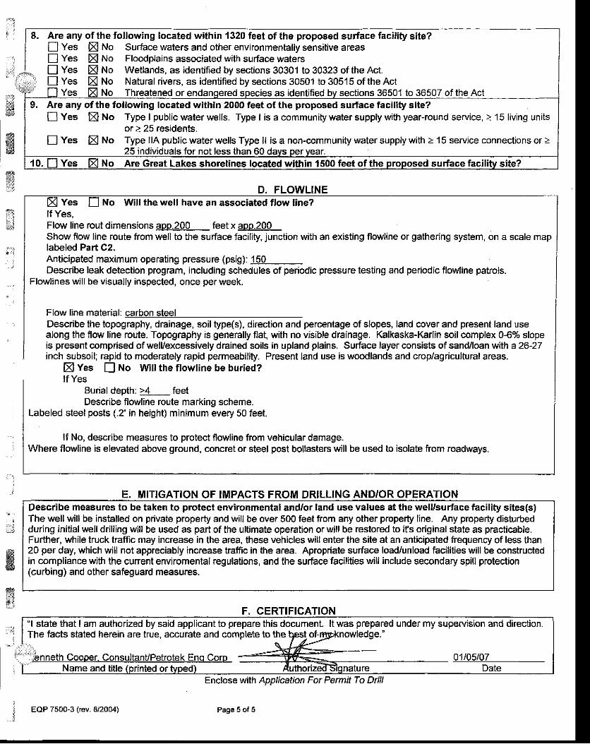
rt . ' Are any of the following located within 1320 feet of the proposed surface facility site?
! Yes ffi trto Surface waters and other environmentally sensitive areasn yes El tto Floodplains associated with surface watersE Yes X No Wetlands, as identified by sections 30301 to 30323 of the Act.n Yes XNo Natural rivers, as identified by sections 30501 to30515oftheAct
Yes No Threatened or as identified bv sections 36501 to 36507 of the Act
D, FLOWLINE
6ffi,..
9, Are any of the following located within 2000 feet of the proposed surface facility site?IYes fiNo Type I public water wells. Type lis a community water supply with year-round service, > 15 living units
or > 25 residents.! yes XNo Type llA public waier wells Type ll isa non-community water supply with >'15 service connections or >
25 individuals for not less than 60 davs oer vear.No Are Great Lakes shorelines located within 1500 feet of the prooosed surface facility site?
:
Yes No Will the well have an associated flow line?lf Yes,Flow line rout dimensions aop-200 feet x aoo.200Show flow line route from well to the surface facility, junction with an existing flo\ rline or gathering system, on a scale maplabeled Part C2.Anticipated maximum operating pressure (psig): 150Describe leak detection program, including schedules of periodic pressure testing and perlodic flowline patrols.
Flowlines will be visually inspected, once per week.
Flow line material: carbon steelDescribe the topography, drainage, soil type(s), direction and percentage of slopes, land cover and present land usealong the flow line route. Topography is generally flat, with no visible drainage. Kalkaska-Karlin soil complex 0{% slopeis present comprised of well/excessively drained soils in upland plains. Surface layer consists of sand/loan with a 26-27inch subsoil; rapid to moderately rapid permeability. Present land use is woodlands and crop/agricultural areas.
X Yes E No Vyill the flowline be buried?lf Yes
Burial depth: >4 feetDescribe flowline roule marking scheme.
Labeled steel posts (.2' in height) minimum every 50 feet.
lf No, describe measures to protect flowline from vehicular damage.Where flowline is elevated above ground, concret or steel post bollasters will be used to isolate from roadways.
E. MITIGATION OF IMPACTS FROM DRILLING AND/OR OPERATION
:
ffi
Describe measures to be taken to protect environmental and/or land use values at the well/surface facility sites(s)The well will be installed on private property and will be over 500 feet from any other properly line. Any property dishrrbedduring initialwell drilling will be used as part of the ultimate operation orwill be restored to ifs original state as practicable.Further, while truck traffic may increase in the area, these vehicles will enter the site at an anticipated frequency of less than20 per day, which will not appreciably increase traffic in the area. Apropriate surface load/unload facilities will be constructedin compliance with lhe cunent enviromental regulations, and the surface facilities will include secondary spill protection(curbing) and oiher safeguard measures.
ffift-}'
F, CERTIFIGATION"l state that I am authorized by said applicant to prepare this document. lt was prepared under my superuision and direction.The facts stated herein are true, accurate and compleie to the qEst- of-E knowledge.'
and title (Drinied or tuoed) AuthorizetfSionature DateEnclose with Apprbation For Permit To Dill
Page 5 of 5. EOP 7500-3 (rev. 8/2004). i
ffiH$n:
st" .
$,&s
ffit*'@*i]
wt;'r**
it:;J
-"r1
:
. - ' ,
' -,..i
,
i,.rli
$:,I
ffig
ffi
irl
'-.ti.-..
l
January 2007 BEELAND GROUP. LLC. MDEQ PERMIT ATTACHMENTS
A.7. Form EQP 7200-18, Soil Erosion and Sedimentation ControlPlan
The Soil erosion and Sediment Control Plan is presented in/on Form EQP 7200-18, presented at the end of this Section (A.7).
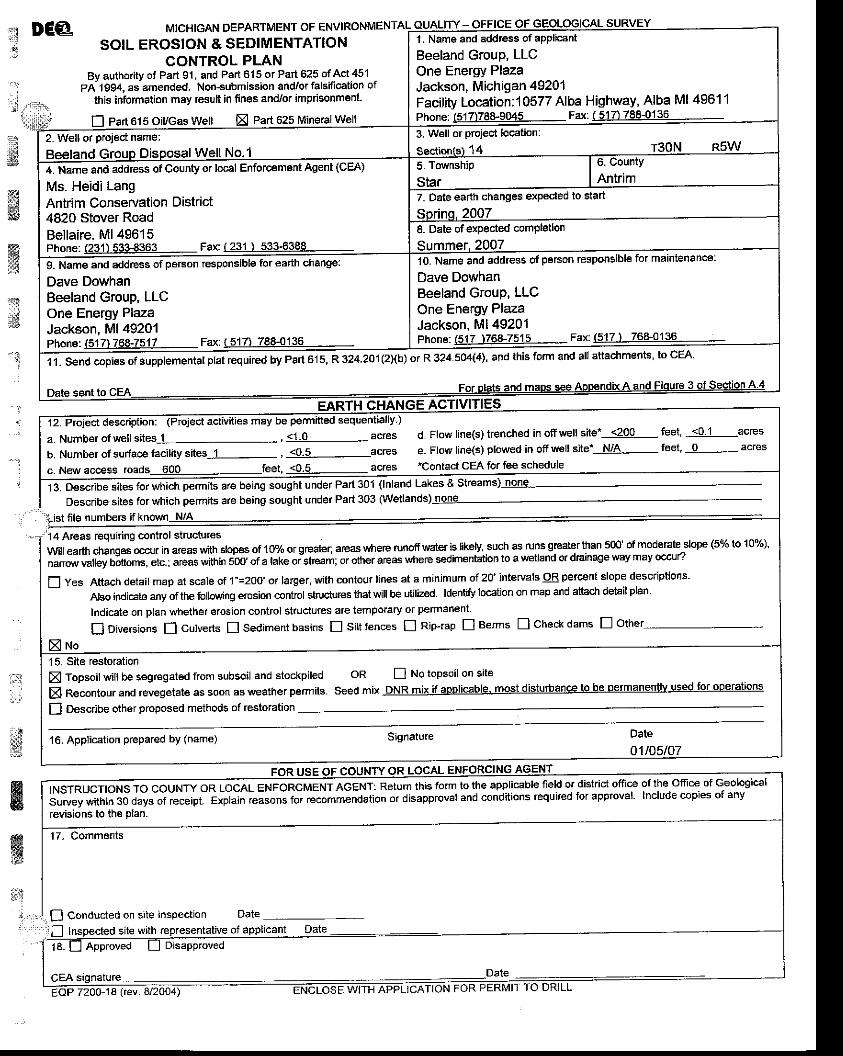
,.:1 DE@
::i
MICHIGAN DEPARTMENT OF ENVIRONMENT
SOIL EROSION & SEDIMENTATIONCONTROL PLA'N
By authority ot Part 91 , and Part 615 or Pa 625 of Act 451PA1994. asamended. Non-submission and/or falsification of
lhis information may result in fines and/or imprisonmenl.
fl Part 61 5 oiycas Welt Part 625 Mineral Well
11- : t-{4ii
gtwffi.it
s"i
::t' : . l
$
-t. Name and addtess of applicant
Beeland Group, LLCOne Energy PlazaJackson, Michigan 49201Facility Location:10577 Alba Highway, Alba Ml 4961 1
4 r30N 89!y3. Well or project location:2- Well or projec{ name:
ilI"rn"-u and add,uss of County or local Enforcement Agent (cEA)
Ms- Heidi LangAntrim Conservation District4820 Stover RoadBellaire. Ml 49615
7. Date earth changes e)Qeded to start
8. Date of expected completion
Phone: (517 t76&7515 Fax (517 ) 768-0136
10. Name and address of person responsible for maintenancel
Dave DowhanBeeland Group, LLCone Energy PlazaJackson, Ml 49201
9. Nam€ and address gf parson responsible 60r earth change:
Dave DowhanBeeland Group, LLCOne Energy PlazaJackson, Ml 49201Phone:(517)768-7517 Fax:(51ZLl€.€{j!9-
1.1. Send copies of supplementat pt"t required by eart o1s3 324.201(21{b) ot R 324.504(4), and this fotm and all attachments, to cEA'
b. Number of surface facility sites-L- , lql-acresc. New accesa roads 600 feet, l9iq- acres
d. Flow line(s) trenched in offveell site*--5?99- fuet, -llljl-acrese- Fiow line(s) plowed in off uell site'-N4{- feet, _lq.- acres
"Contact CEA for fee schedule
13. Describ" "lt"s
fo, whl"h permits are being sought under Part 301 (lnland Lakes & Streams) none
Describg sites forwhich permits are being sought under Part 303 (Wetlands) none
file numbers if known N/A ,,'14 Areas Equiting control structuresWll earth changes occ1lr in areas ltith stopEs of 10% of greaie[ areas where runofi water is likely' such as runs greater than 500'^of m:d^e:Srslope (5% to 10%)'
;ffi;J;ffifi",[].jii.i lil"" i,iiiiii l6b' .i a take oisheam or other ar€as where sedimentation to a v/etland or drainase wav mav ocru,
E yes Attach detail map at scale ot 1"=2oo' or larger, \riith contour lines at a minimum of 20' intervals 9B petcent slope descriptions-
Abo indicate any of the lollowing erosion control structures that will be utilzed. ldediry bcation on map and attach detail plan
Indicate on plan whelhar erosion conttol struclures are temporary or permanent
I Diversions f] culverts I sediment basins E sift fences I nip-rap E Berms ! check dams E other
fl Describe other proposed methods ot restoration
E Topsoilwill be segregated from subsoil and stockpiled
El Recontour and revegetate as soon as weather permits
oR n No topsoil on site
Seed mix DNR mix if applicable. most disturbance tO be lermanentlv used for ooerations
16. Application prepared by (name)
&w;ri
f f iLENFoRcMENTAGENT:Retumthisfo'mtotheapp|icab|ef ie|dordistr ictoff iceo'theoff iceofGeo|ogica|survey within 30 days of receipt. Exptajn reasons for recommendation or disappfoval and conditions required for app.oval. Include copies of any
fevisions to the DIan.
'17- Commeflts
O Conducted on site inspection Date ----i
r--^-r^.r .n- -ith .6^rd.Ah1'tn'a ^f.^nli..nf nrte
18. I l Appfoved [-l ulsapproved
CEA signature -Date_--.......='----=-_-ruK72OO-18 lev
January 2007 BEELAND GROUP, LLC. MDEQ PERMIT ATTACHMENTS
:]l , { \'*l&s
$$ffiffi*{
ffi13
,
:',.i
*.t
a'Lg
&
ffi
A.8. Provide a conformance bond' For information regardingbonding options see the link to mineral well bonds athttp://www.michigan'gov/deqogs and click on Miireral Wells orcontact David Davis at 517 -241 -1529 -
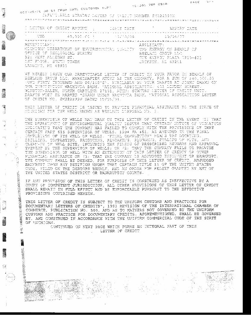
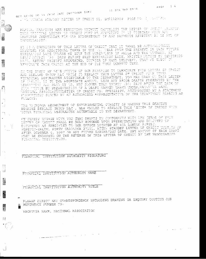
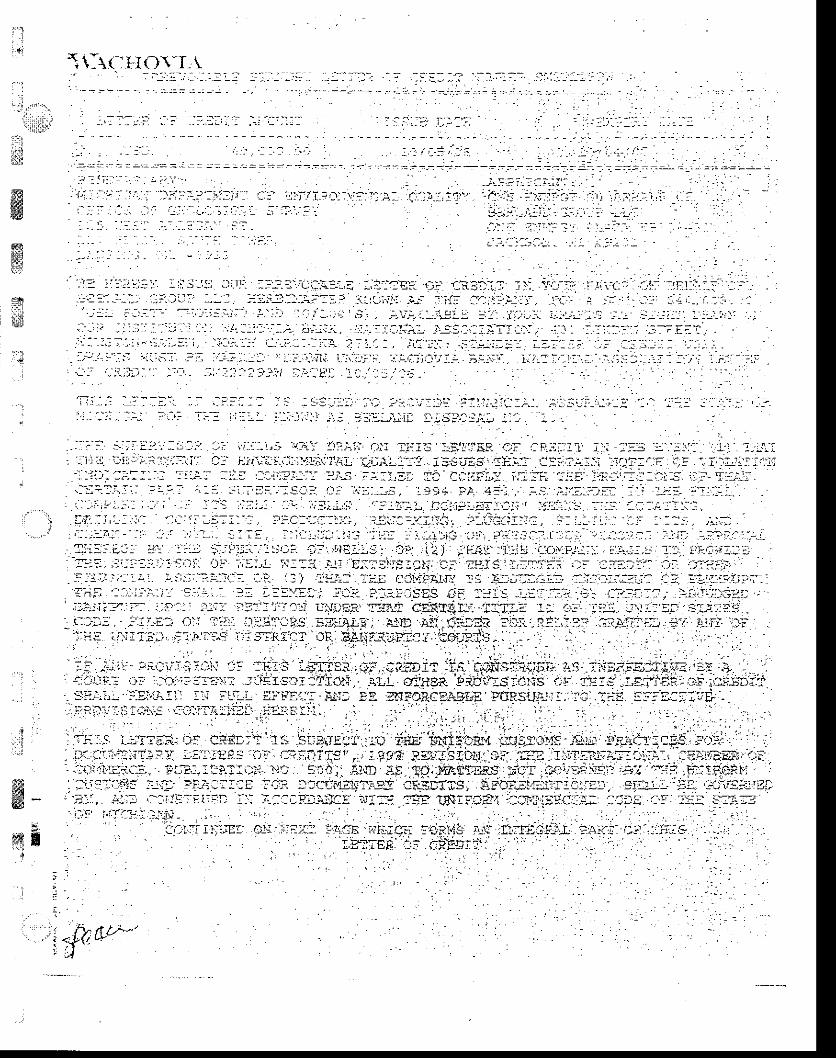
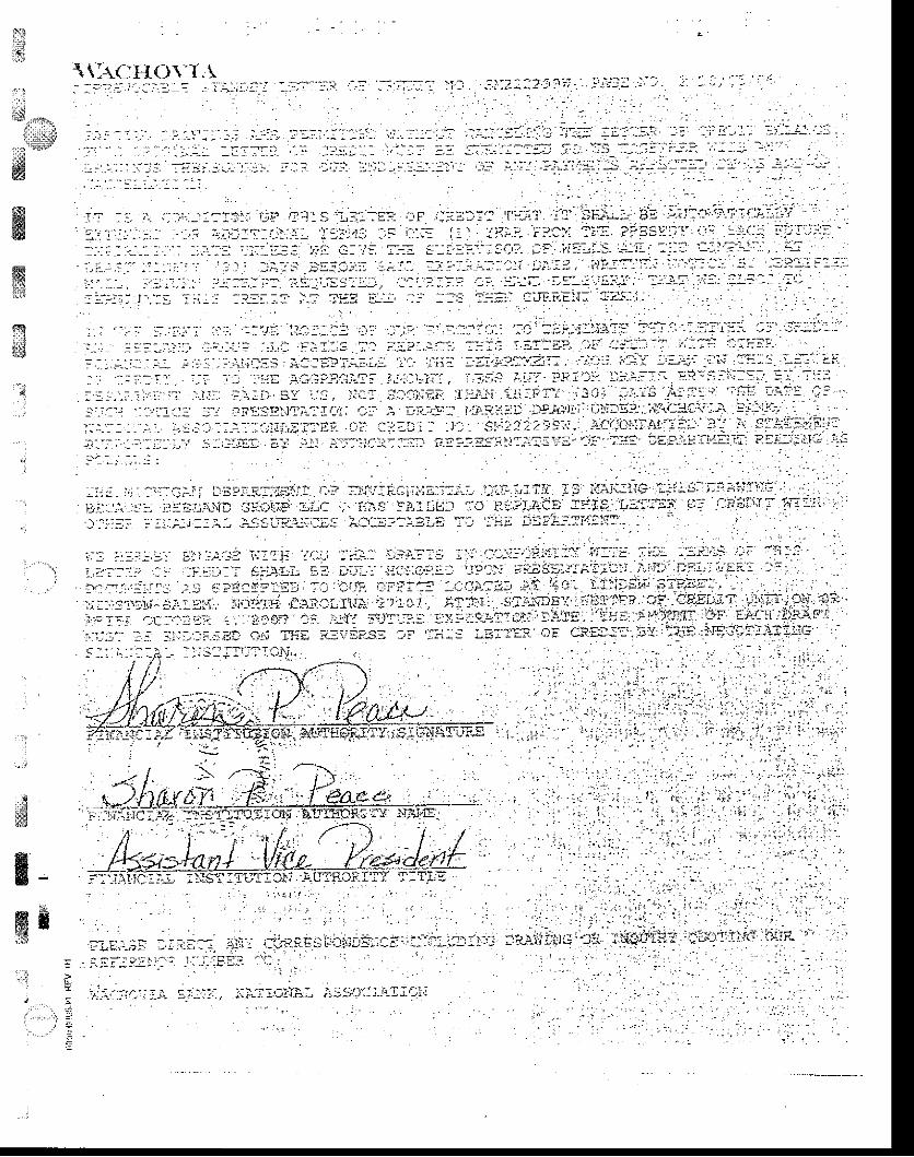
The Beeland Group, LLC has secured a Letter of Credit in the amount of$40,000.00 with the Michigan Department of Environmental Quality Office ofGeologic Survey designated as the beneficiary. A copy of this document isprovided at the end of Section A.8, along with a copy of the letter submitted toUSepn requesting that this financial assurance be accepted simultaneously forsatisfying federal requirements.
1t
:?r,ii
i:3
.;
;. .]i * - - "&ffi
3.4 .6
ffiffi$1
' ;
,
':
I:t
ffig8"{
;
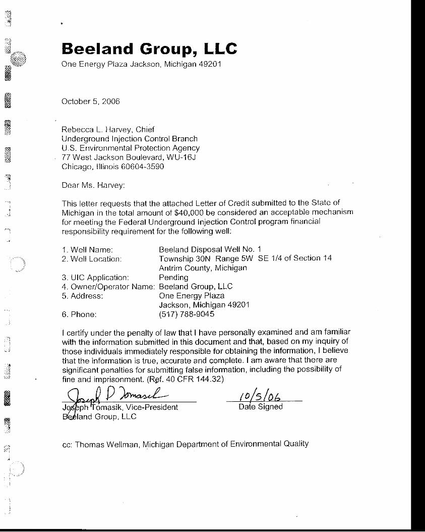
Beeland Group, LLGOne Energy Plaza Jackson, Michigan 49201
October 5, 2006
Rebecca L. Harvey, ChiefUnderground Inject ion Control BranchU.S. Environmental Protection Agency77 West Jackson Boulevard, WU-16JChicago, l l l i no is 60604-3590
Dear Ms. Harvey:
This letter requests that the attached Letter of Credit submitted to the State ofMichigan in the total amount of $40,000 be considered an acceptable mechanismfor meeting the Federal Underground Inject ion Control program f inancialresponsibi l i ty requirement for the fol lowing well :
1 . We l l Name:2. Wel l Locat ion:
6. Phone:Jackson, Michigan 49201(517) 788-9045
Beeland Disposal Well No. 1Township 30N Range 5W SE 1/4 of Section 14Antrim County, MichiganPendingUIC Application:
Owner/Operator Name: Beeland Group, LLCAddress: One Energy Plaza
I certify under the penalty of law that I have personally examined and am familiarwith the information submitted in this document and that, based on my inquiry ofthose individuals immediately responsible for obtaining the information' I believethat the information is true, accurate and complete. I am aware that there aresignificant penalties for submitting false information, including the possibility offine and imprisonment. (Rpf. 40 CFR144.32)
n n1 /1 | |\h,
"4 V ''aYu*.r.-- /0/5/0/^
Jt'pnh Tomasik, Vice-President Date SignedBQfland Group, LLC
cc: Thomas Wellman, Michigan Department of Environmental Quali ty
{i
- . ' - : n ' - 1 r : " = i ?
i r : _ i - . : E - r ' - J i l _ : i t F O l l : ! l - i t ! j = - i O ' l e F 9 r l i : :
#ffiffi$
;*tC ;1:1Si
'.]lii$t,iit:!r,
'$
:_ ' : . , ! t , , ' )
. ' : : . . a : , I
: : : - : . - , - : . i - :
t i , : ! , : | .1 - i i : , : : . : i S: .. s l : . . - " . : i . j : i - - 1 : i : : i t : - : ' .
i_ -- i r , I : , i -1.7 :? - r : _ . : . ' . . : ' . . ; j ' : J t : : : j : _ . - . : _ ; - _ :: :E:-; : : :1. i , : ; ' ;- ;- :- : - : j . : , j . l - - : - . . - ' ,
- . : ^ . , . i - _
, - : . : ! . : : ) i . : : _ t - 1 ) , . \
r : : - - : : . . : - - . ] - , : . : - : : t . - i : : ; . : . : ' : i i . : ' : ' . a . . - . : ; . : . : - t 1 ' ] . - . : : 1 : : . , ' , ; : ; . . i , : : - - 1 : ' . : : -
' . ' i ' , ' ,
, ' js- i _1:-: :- - ' : : _1'J j : t= -; i t lai , i1:; .1 ,3: , .1. '_' i : :_:-: j :-_ | ?,. , ' ! : :
_? l ,r ,_r_:- i 3 , ' ,1 : . r l ;- j : : i . - :- ,1:t : aL:i r ; i l - l - 3 : : 41 ' : _ - - : : : i . i i a , , - : : l . . r : i ! . r ' : : { , t ' _ i - - : l t : : _ - " r : - ss -_ : ' - : - : . : I : t , . . . _ . . _ - , _ : - j : : - : ' _? .a - j = .: l : l l i : l : : - : . , : - : - : : : . , : : ) ? : : i . l , : i : : l l i I i - : . - 2 l i i 1 , i . : : : : : i : - : ' i : : , : i
- - . - : : a? a . : : . . : - - , : 17 i : : .
D i ,_. ' :_::S ).-_SI : : j - j -?:, ; : : " aa_\-,/ : : - . : ' , ) :?. :r ; : .r j :r : : . ' : i_ : : ; j . : i : , :- :r i i t : . ' - .- i . : :at:4,: . - : i ' ) ._: ia'r ' iai
a:! , l r : r ! :1 a-.--. at: .22. ?, ) : j - t
, . j :r . i : Tt: j " : . t ̂" , . .
, : -) : .
i
;:
li:!
"!i
,:,;
i;*i-n
i*
.?9.:
!i
i!
.,.t
*:1
&
_ _ - . : : . . ! ' . _ : - , - = . : _ : A : _ _ . j , . r ' . _
: : , : i i : : - : , : . : i ' ? : : ' - : ; : i , r ] ; : . i , . l ' : : : : l : r . : , - i l - : - ' : ! : t ' : :S
. j : - - r - - : : : : . T i : ; ' : : : . T : : a . : : : : : j : : ' - : i a : i-: i - '.-i,.lIl::r T:'Lii-T i:-:t :Ci'1:j.:ii.': :ii-: :'-\l l-:-r \i ,-:::.?:,'! ;iI i::
'i;E ?.j-:1,'1:l:l:; ll l!':r1-T
: : l l . ' . : ' ; : : : - . : ' . : i 1 : S . - l ? : : : ' . - : - i l : . 3 i l : l i . ; - : . j i J r 1 ; - i - c * i . F - 1 ! : : : i - . ) :
: i i - l l . : : i ; 1 . ,- .r i , l?*l j :_i . : t : : . l l _iTs tr:r ' . : , 1? ir : t ,La. - i :- . . j - , , a:ci l r .)--: '_:: : : . : ' : !at : ' ! ' ' : ' .1 : , '1.:) : : i :1
. - . - : - - i . . i . ' - - . i : i ! : i : : : : . : , . = . - - = " . - : . : . - . . , - : . r - : . . l - l - l i : _ . , - : . , ; : : : , ; : ' . 1 , : . : : i ' . , - : - - - r . - : : : .
:Lf,-! . : :- I ia ' ,- : ' - . ' i i : : - t- 3: ' : : , : l ia:,- i t : : :- : I i : : t l : - ; : l l i -- : !F.:9Sai:: t ; : :- ' j ' l . i ' - l : ; . i ; l -r . :-- : . : l : ' - :- ,
: : - - : : . - - r : ' , ! - : ' . - . > i ? : i s i - : ; ' : : - . z - - i " - ' : : l ; - ' ' ] ; : ; - : . ' . - / i i r r - j l l ? ? - : . ' , : : ) i: : j : : : j r .a!: . ' . :ai , ' -) ; . ' j : i . ; :L- i ; : ' - : ; - l l : ; ; :T:-,-! ,- : : l : , : - i --S :t : larr- i :1 - i i ] . !- , ' : ' : j l ' l3F
F-: i . ;ni l : ,L. i 'S3---t- i l i i l : i? .--. , Tir--r-,T l- ' : : ' - , i l i - i t .r : i :- : , ' i ' r :1: l l l : :- :1., : : : i l l I t-J. : ,)- l i i :1l i?1..: : : : i l :" ; i i : ' . S.--r- l-- ! : tr f=:{-:1. i- . , i . i -Jr-: : i : i -= l i : :- - : IT?:. : l l - : . : :
- ' l .r-JJ;:=D
E-{: ' inl i -- ' i .- l F":)) l . \ l ; f ' FI: i ;T:Cl: l l t l tE-? Ti: :AT r:; lT-a,.f l i l : :- .1 .L l ' i9 T-: i : IT: l S:f- lES,:ti., ?-:.'-), tl'l f:."! 5t;lcp.3 Eii,it-i.. i,til .iiti ,,a?i:.:i a:!1 ! E:I-:: ,3i-ilillll; q-! .\!l-: alll?,1t : i , ;E: ST.n-T:5 DIST^..:CT ' iR E..-. ; l l -r .- i :Tal , :Di- '-- iTS.
It:.L.i: -:F.a'.:!S:f)i i AP:tiS L:::EL l? a:-::;-- ' : i ::a-rNg:it,-t: i ,S ]I:aai';a:?:YE !f . i .atr:;5 ;i:?-l l.1p??EliT.]:F.].SDIaTICI.', -; i: , l f;5? ?,---.afi3loi:S i-? ?irs i-ET:i! C: CREDITsii-l-l-.]- Rs'ir.l:.; r\: Fii]Jl EFiEC: Alin Ei Ej.5.,ric::.-:i:-; P-,11s1j,ii.il :: :-riE :Pi!c?:-iEilp_t1.r: S I ijr'J1.: l:,?:lTir.:ttEi :{Ep,i-rii.
TIIIS LEt-iga 3F CREDIT iS S-0BJEaT Ta filE Lrii I t0ar.i aus?oi{3.Ai:-D FF}-CT:CE5 fORDOa:J'iEtiT.\-;,-]. lE:tTEF,s c'!: C?-:D115,., 1:9i F.:l1rS:Cri CF TilE I iiTE lJ.i;T]. a,)iA.L Cii.u"lBE.F. D!'Cai'11'i:F-ae , tl"rBl, I aA-TIc!.' :'iC. :0t, .t- -cs Tr) :r';-?f !i:S tno: rlo:/E?].:E! tsT 1?5 'ilqi FOPJ'1cu3ToirS:! ,r-.i,i: P3?..:rcE F..:r.p- tccl;l'19N1-rfty ci.:)i:s, AFcRli'tBirirlliEt, s:tAtT, EE 3ov3FJ]tDgY, i:.]; i)t'l5AFiUEt Il; ACCOP$Flla€ :,;i:5 ':ga lrli: a13j"i :'f :'tt{EF-ClA1, CoL€ cF !ti: S?}.f!cF i.!i::i _ c.u,: _
:_tltlf )i,Et .-':; ;i?>:T ?.qG: tit:i:i-: FO?I:S 1r; :l:::3,c-r-i- n.l:T 3? T:iIs3i:ElIl
*K
: : 1
g
n : ; l a : ? ( r : r ' ' ' j : '
. , i - - l i l : i l : u : ' . : l l i F
O ( i i , i - ' r r '
ffiffi1t*
$
?)_1. - - ; . . - . . . . :_ r , ; , t . : : r j : ;a - : . : : " - - : r i : : l : ' i l - . - : : ; : ' a? - . : .1 : ' . : ' , .1 ,? . , .11 . . " : - - ' ' - l : ' - , : r - - r ' :
: - : : . : ' . " . : : . : - r : . - ' : 1 l : ' a ' : ; . ' : : ' : . 1 . - i l i l : t ' - ' : " ' - - ' - ; : ' l ' ' : - l : ' : = - : ' : ' - : r : - : l r - l l '
. ' :-:,r.:-:.::1.-- - ̂ -.ut:,:- '- ' t.t!:- -..; ' :, i :: : l ::.):.I Ir.:: l l : :a .),:.: ,., '-.: l l-1-::: - s ---;: i::: , :- --- ' -:: ' ' ' : !-
:1 . : i . : : - - ; - - : : : :
i - i . ^ : l i . - . ; : - f : i ; - - j " : - - ^ : :
^ i : - : - : : - - : - : : - - : - : : i - i : - - - - - -
. ' '
: : . j : : - a ; : - - ' : - - r j - l l : . a : . . ' , : - : - j i l {S j i
" ' - ' : - - . - ' : ' i ' : = " : j : : - : : ' : j ' : : : : l ' ' - - ! : : r ' - - : : - " - ' - i : '
l : : i : : , - - - - . . ' , : - - t : . . ^ . .
a : l : : , i . i . J i ' : a ; : " : l : : . i t ; ' ? : - i : - . ' t : r : r i : . - J i ; : ) - ! : : : : ' ' ' : " : j ' :
" :
t : - : . i . t ; t : : r . r - - j ) j - , j . j : j i a : l i : a ! . : . . 1 : - : - a : : i ' - : - . : : : ) ' . : \ ; . - -= . 1 , : : : r ' : : - : - : ' - - ; ' : a a ; l ' : : : l - - ' - : : l
;.:. -, :::-.';l ' ::a-::::-': -. :,l i:a;--e), :.:.. ':".::.? 'l l '-:-:-:: a='-'.. ';a:": ""':":' '": ":; =-'-:' ' ' :"
1 ; : : r : l . i : - ' . , I i " : : : - : ' : : . ' : : - : : : : : : - 1 ' - a l - 3 : - r : : : : r i - i : - : l : : : - : : l : '
r:
'::::, ':::, :::.:.:;)., i:,a';!.?.:':.j:l::-:: ira t)i'i::'- l)i:'i;:::)-L i':i"t':;:'; l-: :t''i:::l;: l-1"' -q lli-ir:: -:';
!- ' : t ,- ; : . : : . : j : - . :- ; : -- : ; . :) : ;v t 'La . 1' ;5 a.r ' . ;-- i) : : : l=; t ; t- : ' : ' ' : ' ' i : : : ' - t : :
?' t ^r ^;:- j ' l I
- ' : : ; i
' : . - r l t :- a:: : . : . . ; :
- . ' . - ' -s::--.- l : ' l : : . ' : 'a::?T.:. :-a :r l ?: ' :a : t ;^ i ' : : ln; l l : '
: ' - : - : , : ,a.-,a' ; . j : : : :r :- j I j r l :- : j i l i -L"-: ! j i l ; - l -- : : j : ' : l l l : l i i - l ' j : :1: ' I ' / ; - ; ' j -- . : l l : : ; : ' ' : rr l ' ' r ' i : r : '
: : . . : l -- ir : ' : i :r ;1: l rr .- :- : : . l : ; i l : i i i ' l l i ' lFEi 1l?-r ' ' : E:--9 sE:' ;- i ' ' l : ' t r : : ' ' ; ' : - ' ) : ' " " : :
i ' :1 '
a- -: ' . i ' i . : ' ; lai . i . ' i : ;Eal i : :r ,- : ' - ' -- ' ' . r?. D??iC= : ' i ' : l a7r1 ! ' : ' i i j1 l : i ; i : ' : i ; : ' l - : ! i '
; , r : i . is. ' .-- t j - j ,ai i l . : , l i : l i l i : l .- l i - :- :r i , : i ; t- 2' ;- l ' - . , l ' . i l - , : : : :-r-r: t t i L:1' : t : : ' r : i : ' : : - :
' j l ' - ; i ' :" j - ;
, : .- - . t i : . r : iC:;Ej-: , , , ai l i t i l l : ' : j : j i --- l :- ' ; l ; : ;- ! ; :- t : :Cl l t i 'T; ' Tt-: - i j ' : : ' ; : j : : ' 2f ' ' L 1:?'] l j
:).'.)?.'. .::1. i:.;iltr:; i:: :-,il ar,: i8.E?'S5 lf :i:':: \"i'-:: J'i j? i-ji':]];':l 1^r' :liq :i;:i -r'-!:l::
&ffitr
=- , - . : . " ; : . : : i : . - : - - ' - : - r j - - : . - ; " : - f+ :E l := . - . : r€ - - -
.:'l:-.Fii S i:,1;..D;lra; fi;:L.j:J:i'iG tp-i-t;:ini tt ::j;:-:t F':" :r -11::ll: .] 1';'
*
r:.lt.
t:_:i I rin-r-;, i-s:ca:i,.T: trl;
. :. '7:::.-: : a .::--'r-:,1.1
i , :
it5j
' . :
lrltitlb.
a'1
w-8r
;i
t :
: , - : . t , :
{i!l\( ttlo\-r,!
r ' 1 - - - - : _ , , _ . :
ffiffitr]t5
: : . ( l : : ' : : : : i : . r ' 1 r . .
, i ' l l : . i ._ - - _ ; r ' r : ) - i , i : . : . ' '
i _ _ -
. ' : . - . . ; 1 _ : - . 1 ; ; : - - r .
- . - , . : . _ - - - : : . - : '
:!#
j . : . : .- ' : : - . .- j : i ; . i ; l : - : i . : : : i :
- : . - : - : . i ' : : : - _ i . - : . ; i : . " :_c . : : f . .1 1 : . - , - - . i , :+ i ; . - i . 4= . . , . . : . i . . : . j2 . . -_ r . l . . ' r i - . : : ' .1 .
. i : , ' , l . , : , : ' . . ' - ' , ' . ] . i , . ' j ] , ' : ' , : s i : : ] , : . : j ' - . : : j ; i - i $ . ' , , : ! : . i : 2 ' . i ' c . i 4 ? ; ' ' n 7 : . . ' ' ) : : | . , : { j j : i l . : i . : : ' : . J , lI , l1 . l i , r - , . . r i i .a : l :1 : ; : i : i t - , : , : : c : . ; i i :1 ;c , ;5 i ; : : t : i , . f5 , : : i : , : ! r - : : , t : : : , . - t ' - ' , i ' - - .1_ . : .
l l i . 'i - ' . , : : . : . - - : i ' . . 1 . : - - : . : i n : t : i , r : ; - . : ; l , : . : l . ' i - . . i : i : . t r l . p : ; i . - , : - : . t . . , . ' . : _ : - . . , - . - : i i - - : . r ' - 1 1
' - l j i : ' -L r - : : : . : : : : i ' . . f ' t - r ' . ' r l j , - : . f , : . I , )EL i j - .A : . i .2 ) - i . ; t i :1 . ' : r j , ' . t l , . .p ; - ; - . - r . - . ! . , l ' : : . : I - - . i i r : - : .- ' ' . - . = , : i ' - - -_ : . :1 j . t i ' . , J i ' I , j_ : j . . j : : : - i . r . . j r .E t - ;a l j : i t l ; j : r . iF :J3 . : , - - r i ,? . . - . - JL f l : . : a , l . . J t .a7 :
. i_r::.::,.- : : j :: -=:::r-- l;- l; .ail l :!:a ri.SuFqlJ-: ' ..1: I;;-;.=:!:
-t:-.t.t LI:-11 :-: ----rJ-.i iyi;,- -
T ; : - _ , - . : : i _ . . . _ ' r - - ) : l = = . r = r , : ^ ; : . - ' r . r - : ! - . t q , - l i ; - - : t - . i . - . " : * . - - . . : - * - = t - - . : : . . . t = = = a . . .. . : . " f . - - . - .
' - . : - - . ' - . . . : - . 1 - . : ^ - - ' ' : : ' : i l - " " , - - : . : : - - - : - , . - " . ' - " . ' ' -
jlli1j.i iia: L -:'u::i ::,j.i:/- :r::':?;1: -r-1JtFl!. :- i i ! - i . , - ' " :
* . : : . . : , - . . * -=t . ' : : : i . . . r ; ; - i .
;:;."; , - ; : '-,,,., ..; ;-;,- .^ t ,;a*-=r : , . i l - : ; . - ; , : : t : . + , . i ; t . l : l
' ,--4.,,::;r- !;.'ril-t?.];:cN u! :Er.: :.+::=er,."; :t;o;" ,isle
: aia;iF-: ii: :1'l:+:: -:i:;.-Lt--:i .;irsr,rri:?ict; . q.r-r. ci;+ea fiiC
. ., . --.--.:; ";,.- . - :- '-j::1 - : i:j::"-.3-)J-I i +i. =.: +_
- . . , - . \ - - : . - - - r ; - - ^ ; : : ^ - ; * . J ; ;1 ; i . 1 . . : : . : - J : _ _ t : i r y - , j , _ r : * _ i - 5 { . / , . . - . .
3r:.i.:i i 'j.
r,ilTIEe. 1F .
'.Jj ' ,1!
xltl-rcI{(]\-L\
:r'!
ar,1,... .9
:li!w-:.+: . l:-:: : iJ, '. '*;,:-; i j ::n : ' :-:; :: ' : :;1^., ;r.,::. ' :.--: :,-.|-- ' \ ' : t--..:::.J': i-:= a!'?:.:n : ' :tr '-:;; r!-l l- '- .-1-; ':.:::
'a:-- .1 ' i - :::,:,;-- ::T-1.: ,":- l.-:. i l- ' ,; ' . : a.:
' :.1. ::.;- j:::-tt i :-r :s-: '-..: i r 'r j--i ;:.--:; : j ' lp ,
: . . . . ' . ' - : la . i r . : - - : . : : . . : : . . . : j i - - : i . : : . - . - - - : - : - : : : - f i : . - : - - : . : ' i i l l l - i ; r - : : - l l - - ' - - : - - ' - : - : : i ' - * '- . . " , - - - . . , - - - . : . , : _ _ - : - - _ _
j , . , _ , : : ' , _ . , - , _ . . . : : - _ : - . : . : - , - ; . - . , .
..:: i j . .I l l ' i . :-: ' i ' i f :r- '+-1.itr1.-i i . .* ':" l: i :r: i-ai i ' :rr: j:. '-: :-" '. i i ,: l i l t- ig :1',. i- i: l :e T:j:S i: i ' ; l l i ' '1. ' .
; j : . .:.. :rr :.,: j '{. j : i .\t l -;-. i-,r,;9 .j-f . i-:.*,-( ! i. l lU_' ' ;1r 11;.:;t,Ll:; : i i I9 .t: i ::*j:r. !:-: i . 'r i l iT:- on1t,|t.
1.;; -,:
i . : l : : : - : : . : . : : t i : i . r r : l ' : : :1 - - : . : - ; - ' f ! . - - - : i ' - i I j i ' . : ' : ; . : : : -? . : r . : . - . i ' r i : - . : J ' : : : :a - : : : '
' ' "1 - t " : : '1,.jr:-,-:'.:,? :::: -ll:,i:ir:
i *iir;t.L 5f . t:-11, t -€a-:::C,-aEi '-i!::1.' aIE 3:_ i.r'j;- i:U:;. ;j{'':; t.-i,::vfl-r :-,'1 - .
1 -.......:-:: i .:. j j ;: j t l j-.;: 1.t a':-:. a,l l-.= --.:::1i-1a) ;.T
';: i i ' . !.I l i iE:.;: SIF;E:. - . . ...
'': -':-:-'r-li- j:,.- 2-.t,, 1;;1t-;:1.a 'l::1'l:11r.) ;z t i,l t , i.ill: s:--:r-:ls'i i,i1'1Fi ii: -c-IE!:t, illl-."lrl-l -1:'
r : : i i . r a ,c : ! . t ' :7 . , . ' i . .F 1 r . ' j d? I -JT ' - : . r t : : : - . ' -? - :?1a4 i ' ,1 , ' !E . ' i r . : . ' j i ' ' l i l ] : - iF i t i : i . : i JP- ) f ' ' l
: :':: '--- i:': -'i..:;i :!ii al:; ri:i:l:- ;i ::l-= :-='::r:r. cF a.ag::-:j :'{ ?ji :irs r:l-}l';:ic :-
wffi
' ' ; ' - : ' r " ' : - - -
lT ' : . r - . r . . ' . : , . - ' : : : i ' : tJ f ? ! i . i 'L : ' : :E: t : 'F : j : f : : ' l l ; i ' j ' t : ' : : l i j - - : .A; : i i : : r . . " ' '1 t e t1. ' ' , ' r . . . -' :--t j:l:-::.,: ..-! !.;-11r'-*. r,ll::r.' I I:i l..raj i;5 llr...: i:1 .1:l:-.L ;tl: ': T:= ?i53ql;'f i-:i :i: '- '-:i: l":i I '.;;:l 'a -
::.:a ::'.,.---: . ' : , '..-:i '-j.-: 'a:: "!l
i: ' j!. T-- s -a--:,..-- e -' '. -' .i;: '-::-S. :!:t ' '! '--::a ': ':;,r' '= ':, t ': , ; . . . i_ : - : - ' - l . ; . ' , ' - . : - : i - : r r i ! - i . .1 : : .1 : ; - - . l - r : : . , , . . - : ' . : ' . i t ; ' := , : l : , j l " ' ? : i ' . : - : ' . ' 1 - i - . : : r : : - : r,:-: ' .t,. :. j .:t- ' :.tr :r j: t-:rj. ir: ' .-.-5;,;s.:-:, ,:a,:;:.=: at ;r:C 't::-. ' i 'L!1:.: :- 1--'.:?.ri;::.?:=ll i :t,: .:: i-:1,: J-.:t T,i-: :P-:!-.;:- ): fF-E a:i, ;:- ::rr :;::i aijF.-r-;i{; azt:i - .. : ' , ' '
. . : , , : . . : . . : - . , . l . : . j ' . - ; "
i , i . : ;1 : - . : : i : . . ; ' : . . ' , : : ' ' | : " ' ]F , ] ' . l . . ) : ; , i : ' i i . l . ) - j i : . ] - l ] . i . ] : ] i . j 1 : : l . . : ; i ; . : - , : . : ; : : i - i ]3 :11 i ' . i i ' - - . i i ; . : : :: . ; j : l : . - - : :1 , . : r . ' - - - : , j . J E ' : . ' - : ; : i :? ' . . : -1 : : : ; : : : i l 4 -p - : r ' ' ' j - ' * j - ' j : ' ' ' - l : : - : ' - r '
i.-:..:-:,..1.' .i-j.. -. i'-::i',:-+.il:,'.::i . r:"a=?f-i:,;:, li.'l: :.,-ii:l ::Zl'!:J:':'?i': ::Lr'i i?: ;;-'-1r -ii'i,-:5l i-;. tfi il',
. . . : . . laa : : . . : . i ! : : , y ; i2 - : . .a , :p_q.11 . ;5 -
_ ; , . - r , l , t_ - .
:L i ,S i i . r : .PF i ' l - - ! - ; : . ' - t : l i ? l : : : : - - - i ; : : . r , = - . : . . T - . :
. :::., '-::. i ;..:, lrr:t ' ,, i ir.: ! j-!r l., 3'!
'1.:a , i;. i :: .::Jci,:f lnt l l i i t i . ' . i i iF l ' ; l -r:Ji ---, i; i : -T-:.1 ?;:;: '- i i ir: +:
_-r-.: '_.j ..:I ' .t: l-, ' .rFE: E:.t"j i--: ' Jlt i .r:\ : i : i .:::E: r. l i-3i '.:: .;)!--i ' . 'J-: i j) ' !: i-?. i,::{rjr i i : -:.r lr !r-: i:!.:. . ,
l; -'.,'--- ;:. ).,i,::', : ., -:.1-::r:;l,A?:-ep- {r: .:::-Dl: .l:; - S:;r?- ?2 a'tii.':. -r-.fic:'::;ll'1i f' ?; ': !i-1i=?liij:,
."!'.-: :.:,-l--:': l:::! : -.,:i€a: , a; ,|ji .:i-j:';14:i: f.i:j ?.? ?2.tE!,1!:;':='iat a:t: 1:iz' ;Et'.1:q:r'Ej:"-, E5!-:i;Llc ,:':f
l ' . _ - , : - , . j - , . ' . , , . ' . , , ' , . , , - ' . : ' . . ._ , , - . . . . ' . . . . . : . , . , : .
f's
d
.j
''l
dK_ff i*:3
t.
ffii*
w
ffiry.ry1!:i
#.*$13
l' 'l
' ,
ini
mliA
t n z.i ...- 7.1'rtrttt: ' l a
gf f i -g

ffifr January 2OO7 BEELAND GROUP, LLC. MDEO PERMIT ATTACHMENTS
A.9. The permit application fee as specified by statute:
' Disposal well for disposal of waste products
. Disposal well for processed brine
. Storage well
' Natural or artificial brine production well
$2,500.00
500.00
500.00
500.00
A check in the amount of $2500 for the permit application fee is attached to thecover letter transmitting this application.
i
. :
fjl!,{
lqlm&
,tcI J
i.. i
'il''1"'"'"
'I .)
j
J. -,1
January 2007 BEETAND GROUP, LLC. MDEO PERMIT ATTACHMENTS
f. ifll -,1ri'i1
:lrr::ll]:]13
6*
ffiw,*
ffi;:i
, l
...:
.l
t . ltrl
ffi
ffiffi'!1
-l
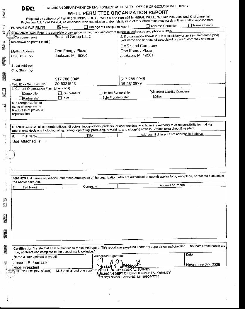
A.10,An organization report, form EQP 7200-13' if a currentorganization report is not on file with the supervisor'
The organization Report presenting the current corporate organizational statusof Beellnd Group, LLC is.presented on form EQP 7200-13, at the end of this
Section (A.10).
13
x' . :
PURPoSE FoFl FtLING:i IGGA"'ZA'.N E.r* ,
, !
D Address correclron
',&
ffiffi,ffi
2, lf orqanization shown in 1 is a subsidiary or an assumed name (dba)'
oive nime and address of associated or parent company or person
CMS Land ComDanvOne Enerov PlazaJackson, Ml 49201
517 -788-9045
name Beeland Group L.L.C.(as shown on pelmit to drall)
L4ailing Address One Energy Plaza
city, state, zip Jackson, Ml 49201
Street AddressCity, State, ZiP
Phone 517-788-9045Fed. lD or Soc. Sec. No. 20-53215433- Current Organization Plan
Ecorpo.ation
{check one)
fhoint Venture
4. ll reorganization ofname change, name& address of Previousorggnization
ff idirectors,incorporato6,parlners,orshareholder5whohavelheauthoritytoorresponsibi| ityformakingop"i"ti.n.f O".itio* including siting, drilling, operatins, produc g' rewo*ing, and plug
ffianemp|oyeesoftheolganizalion'whoareauthorizedtosUbmitapp|ication5,workp|ans'orrecordspur5uantto
.-.'j
.*
&6
Certlflcation "l state lhat I am authorized to make this repon-true, accurale and complete to the best of my knowledge "
This report was prepared under my supervision and direction The tacts stated herein are
Joseph P. Tomasik
DEPT OF ENVIRONMENTAL OUALITYBOX 30256 LANSING Ml 48909-7/56
etIr!
..t{l::r:rrilr
w&
ffiffi
ffiss:. J;d
fi:i' i
- .
t -
[i6t*l
a
M
l
Officers - Beeland Grbup LLC
David W. Joos, Cbief Executive Officer
Thomas W. Elward, President and Chief Operating Officer
James E- Brunner, Senior Vice President and General Counsel
John M. Butler, Senior Vice President
Carol A- Isles, Vice President and Controller
Sharon A. Mcllnay, Vice President
Laura L- Mountcastle, Vice President and Treasurer
Catherine M. Reynolds, Vice President and Secretary
Joseph P. Tomasrk. Vice Presrdent
Theodore J. Vogel, Vice President and Chief Tax Counsel
Jane M- Kramer, Assistant S€cretal
Joyce H. Norkey, Assistant Secretary
Beverly S. Burger. Assistant Treasurer
James L. Loewen, Assistant Treasuer
:wt
It- i
iJ .tl1Wi:.:ffi
January 2007 BEELAND GROUP, LLC. MDEO PERIVIIT ATTACHMENTS
ffiffi#
3qE
'l
."']
-.i
,,!iw
**
ffiffi, i J
A.ll.Description of the drilling program' including the drilling fluidand mud program, how the fluids will be handled and ultimatedisposition oi the drilling fluids. Inctude a discussion ofwhether overpressured zones are anticipated and how the mudprogram will be modified to accommodate such a condition'
The proposed Beeland well No. 'l is to be a newly installed class I well. wellt'to. i wilt be located in the Southeast 'll4 of Section 14, Township 30 Norih,Range 5 West, Antrim Gounty, Michigan. Ground level is estimated to beappriximatety 1,335 feet above sea level (ASL) with Kelly Bushing (KB)that willbb'dependeni on type of rig avaitable. The well will be drilled to a Total Depth
OD) df no greateriiran 2,450 feet BGL, into the top of the Detroit River Group,and'will.belompleted openhole in the Dundee Formation and the top of theDetroit River GrouP.
Drilling, Gasing and Testing Program
The conductor casing, 13-3/8-inch, 54.5 lb/ft to 61 lb/ft, J-55 or K-55 grade,sT&c, or suitable equivalent will be drilled and cemented or driven to refusal inthe Glacial Drift to a maximum depth of approximately 175 feet BGL'
After a roiary rig is brought to the location, a 12zc-inch hole will be drilled out ofthe surface casing to a depth of approximately 950 feet. The intermediatecasing shoe will bL hrgeted at a minimum of 100 feet below the base of theGlaciil Drift. After the shallow openhole logging program is complete (seeattached table), the hole will be conditioned and minimum I S/8-inch, 36 lb/ft, J-55 or K-55, LT&C, or suitable equivalent surface casing will be installed to a.depth of approximately 950 feet. The cementing program will be determinedbased on iield conditions, but will likely consist of a mixture of 249 sacks (based
on a gauge hole) of Michigan equivalent class A standard cemeni with 3 percent
Ca6lian-d addilives. Appiopriate excess cement will be pumped based on fieldconditions. lt is anticipated that a float shoe will be used plus a float collar o_nejoint up from the bottom and that centralizers are to be placed a minimum of oneevery fifth joint.
After the intermediate casing string has been cemented, a cement bond log willbe conducted to document &meni circulation to surface. The cement will bedrilled out of the intermediate string and an 8 1/2-inch hole will then drilled toapproximately 2,150 feet BGL. The top of the D.u1de9 injection formation will beplnetrated in tnis stage of the drilling process. After the deep openhole loggingprogr"m is complete isee attached table), the hole will be conditioned andmiriimum 7-inch, 23 lb/ft to 26 lb/ft, K-55 or J-55 grade, LT&C' or suitableequivatent long-string casing will be installed to a depth of approximately 2,150
feet. The cementing program forthe long string will be determined based on field
conditions, but will likely consist of a mixture of 264 sacks (based on a gauge
14
; January 2OO7 BEELAND GROUP, LLC, MDEO PERMIT AfiACHMENTS
ffiffiffi.%
&
-t
"1
.l
' :
d#6m,s.:;
:,.]
hole) of Michigan equivalent class A standard cement with 3 percent caclz.andadditives. Appropriate excess cement will be pumped based on field conditions,It is anticipated that a float shoe will be used plus a float collar one joint up fromthe bottom and that centralizers are to be placed a minimum of one every fifthjoint.
The final stage of drilting will be conducted using a 6-1/4-inch drill bit to drill outcement and iomplete the well as an openhole to a depth of approximately 2,450feet. After drilling is complete, additional openhole logging will be conducted toobtain data regarding the Dundee injection interval- A cement bond log and abaseline casing inspection log will be conducted in the long-slring casing, and adirectional survey will be conducted to ascerlain the bottomhole localion andtrajectory of the wellbore. A packer will be set at a depth of approximately 2,100feet insioe the 7-inch long string casing. Four and one-half inch injection tubing isproposed forthe completion. Fluid will then be swabbed from the well to obtain asample of injection interval fluids. A radioaclive tracer survey and a temperaturelog will then-be conducted to establish baseline conditions and initial externalm-echanical integrity. A pressure transient test will atso be conducted to deriveestimates of formation pressure and properties. A proposed schematic for theBeeland Well is presenied in Figure 7, presented at the end of Section A'11'
No over-pressured zones are anticipaled during drilling of the Beeland well. lfunder-pressured zones are encountered (as is likely), lost-circulation materialswill be utilized to control fluid loss as necessary based on well conditions. Freshwater will be trucked to the site using local oilfield suppliers or a pre-existingwater well already located on the property will be used to supply water duringdrilling and testing of this well. Fresh water will be used as the drilling fluid, andwill b; held in on-site tanks with no in-ground pits. lt is not anticipated that thewell will encounter dry bedded salts during dritling. upon completion of drillingoperations, remaining fluids and solids will be disposed of off-site by a licensedwaste hauler. such as Northern A-1 or a suitable equivalent contractor'
. :
l 5
Iif,i
ffiffiffi*t
ffin
a
-.l
l
JSII
&i
nH
i*
1 . '
L'
$,
LB-/(c )
LD'
tilEttEE
ffiasdeepas7s,WIntermediate casingi I 5/8", 36 lb/ft., K-55 or J-55, set @ approx' 950'
q--N | | N
;.:.ffi;;ffi;,"".:K5s'set@approx2'150' ES | | Npac.-et.7,'x41t2"La,seBore,ser@approximatery2,roo'
#+l
I N
NIINNIIN
"--M N--fl-l_[N@*\_-l
=AgEg!- gE Els,"""""sj:l:=t-Figure 7
Beeland Group, LLG'Alba. Michigan FacilitY
WELL SCHEMATICDISPOSAL WELL NO- 1
SCALE: NONE DAIE:01,/07
i!l l
:11ii'?:l1l:li
";;rlli,ri1't
";;i,jj
ffiK
€fq11
$l;1i$t
ffir-,1
-,..
January 2007 BEELAND GROUP, LLC, MDEQ PERMIT ATTACHMENTS
A.12 Description of the cementing program including the type'properties and compressive strength of cement to be used on each
. casing string. Indicate if DV tools will be used'
Figure 7 (end of Section A.11) presents the well completion diagram and alsoincludes information pertaining to the cementing program. As shown on thisdiagram, approximately 249 sacks (294 cubic feet) of Michigan equivalent ClassA type cement with 3 percent caclz additives will be used to set the intermediatecaaing from 950 ft BGS to ground surface. Also, approximately 264 sacks (312cubic-feet) of Michigan equivalent Class A type cement with 3 percent CaCl2additives will be used to set the long string casing from about 2150 ft BGS toground surface. At 60" F and 0 psi (standard surface conditions), a minimumultimate compressive strength of 1500 psi will be targeted. No DV tools will beused.
fisffis@
:
16
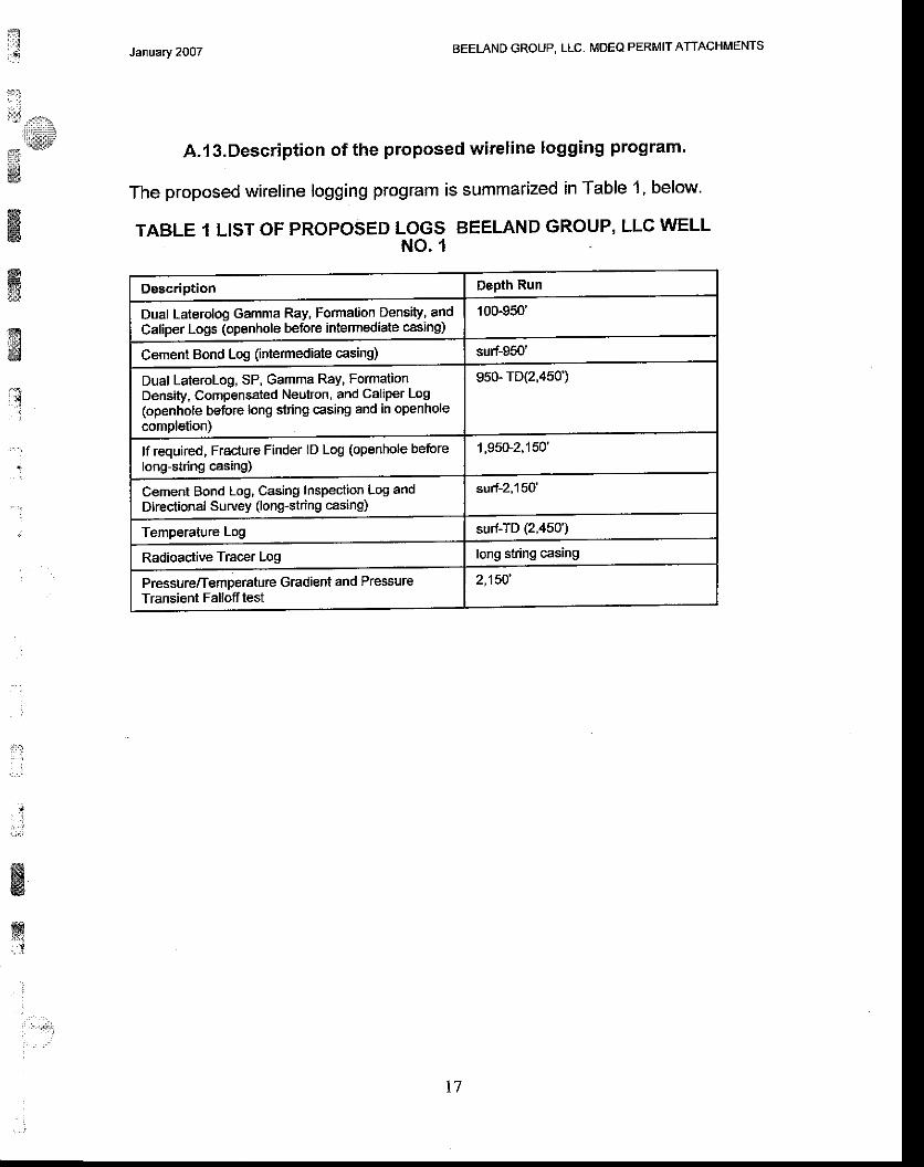
t: 1
1rl
iif ,.o*
* e l1"1
ffi
ffiffi:]I
fr3ffi
rq
January 2OO7 BEELAND GROUP, LLC. MDEQ PERMIT ATTACHMENTS
,A.l3.Description of the proposed wireline logging program'
The proposed wireline logging program is summarized in Table 1, below'
TABLE 1 LIST OF PROPOSED LOGS BEELAND GROUP, LLC WELLNO.1
Description Dspth Run
Dual Laterolog Gamma Ray, Formation Density, andCaliper Logs (openhole before intemediate casing)
100-950'
Cemeni Bond Log (intemediate casing) sun-gcu
Dual Laterolog, SP, Gamma Ray, FormationDensity, Compensated Neutron, and Caliper Log(openhole before long string casing and in openholecompletion)
95G.rD(2,450)
lf required, Fracture Finder lD Log (openhole beforelong-string casing)
1,95u2,150',
Cement Bond Log, Casing Inspection Log andDirectional Survey (long-string casing)
surf-2,150'
Temperature Log surf-TD (2,450')
Radioactive Tracer Log long string casing
Pressure/Temperature Gradient and PressureTransient Falloff test
2,150',
t7
ffiffisili::
ffirell /rnu
l,..'..lF
#
:
Jan!ary 2007 BEELAND GROUP, LLC, MDEQ PERMIT ATTACHMENTS
A.l4.Description of the testing program, including pressure tests oncasing strings, and any planned drill stem tests'
The Beeland Disposal Wetl No. 1 is to be installed and tested in 2OO7 accordingto applicable regulations and permit requirements. Static pressure of the Dundeeand estimates of various injection interval characteristics are to be determinedvia pressure transient testing, while native brine chemistry and characteristiqs areto be determined based on acquisition of a fluid sample. Characteristics of theinjection interval are also to be evaluated based on conducting geophysical welllogging. No core sampling is currently planned. Additional details regarding thewell logging are presented in Response 13 of this application, geophysicallogging details.
After the open hole has been drilled, but prior to conducting any injection testing,injection interval fluid will be produced from the well using either a submersiblepump or swabbing equipment. Based on fluid loss experienced during drillingand field conditions, target production volumes for obtaining representativesamples will be adjusted in the field. In any case, a minimum of '100 bbls of fluidwill be produced before sampling is conducted. Field parameiers including pHand conductivity will also be monitored at surface as fluid is recovered todetermine when representative sampling is practical. Fluid will be subjected toanalysis for the following parameters: Alkalinity, Arsenic, Barium, Bicarbonate,Cadmium, Calcium, Carbonate, Chloride, Chromium, Conductivity, Copper,Hardness, lron, Lead, Magnesium, Manganese, Molybdenum, Nickel, Nitrate' as(N), pH, Potassium, Radium 226, Radium 228, Selenium, Silica as SiO2'Sodium, Specific Gravity, Strontium, Sulfur, TDS, TSS, and Zinc. SeeAttachment B, the WAP, for sampling information.
Priorto drilling out of ihe intermediate and the long string casings, casingpressure tests will be conducted to generally ascertain the condition of the string.At a minimum, pressure tests of a 30-minute duration, with a minimum pressuregradient of 0.6 psilft will be conducted prior to continued drilling.
lnitial mechanical integrity testing for the Beeland well will include reservoirmonitoring as specified in 40 CFR 146.13 (d) in addition to static annuluspressure testing. Beeland will provide MDEQ a minimum of 30 days notice ofannual testing. Notice is to include proposed procedures for testing. Althoughtest procedures or methods may be changed based on approval by future MDEQstaff, the following procedure will be utilized forthe first such testing to beoerformed:
1. Conduct Wellsite Safety MeetingA. Prior to commencement of field activities, conduct safety meeting
with contractors and personnel to be involved with field services
l.l;
atffirslt
w
ffi#
ffi' :.,,:. ',,
j
18
t&t,..*rr$
13,43
January 2OO7 AEELAND GROUP, LLC, MDEQ PERMIT AfiACHMENTS
-1w
ffi&g:6*
&gi d€d
i!,:::
:. :
,i
B.c.
D.
and MIT testing. Ensure that all safety procedures are understoodand review days work activities.
Conduct Fall-Off TestA. Record data regarding test well injection at typical operating
conditions (constant rate). Rate, temperature and specific gravityversus time will be sampled and recorded during the injectionperiod. Cumulative volume injected should also be recorded.Continue injection for a minimum of approximately five hours. Notethat significant rate variations may yield poor quality data or requiremore complicated analysis techniques.Rig-up pressure gauge.Obtain final stabilized injection pressure for a minimum of one hour.Ensure that the gauge temperature readings have also stabilized.After gauge recordings are stable, cease injection and monitorpressure fall-off. Instantaneous shut-in yields best results-Continue monitoring pressure for a minimum of five hours or until avalid observation of fall-off curve is observed.
E. Stop test data acquisition, rigdown and release equipment.Annulus Pressure TestA. Stabilize well pressure and temperature.B. Anangements will be made for a representative from the USEPA to
be present to witness this testing.C. Install ball valve or similar type "bleed" valve on annulus gate valve.
Pressurize annulus to a minimum of 100 psig with liquid and shut-inpump side gate valve. lf typical operating annulus pressures areabove 100 psi, higher pressures acceptable to the agency andcompatible with the well completion configuration will be utilized inthis testing. Pressure to be used will be delailed in proposedprocedures supplied with notification of testing. Install certifiedgauge on "bleed" type valve. The annulus may need to beoressurized and bled off several times to ensure an absence of air.Monitor and record pressure for one hour. Pressure may notfluctuate more than 3 percent during the one-hour test. At theconclusion of the test, lower the annulus pressure to normaloperating pressure-
J .
" l
t:gWw63
m
E
ffi::3
t
t9
BEELAND GROUP, LLC. MDEO PERMIT ATTACHIMENTSJanvary 2007
:!;: ! .d{cai,
r:*!!
ffiffiffi
T:l
" - .
:
A.l S.Description of any planned coring program'
No coring program ls currently planned for implementation during the drilling of
Beeland GrouP DisPosal Well No. 1'
:
r:,.
:i;lt
ai*;
&wffiss
{i:
:
nai
:,lj,s.-.i:l:tt:tt:u!
;.:ll"',#&
ffiffi{}
@
il
' .
: ' - ' :
January 2007 BEELAND GROUP, LLC. MDEQ PERMIT ATTACHMENTS
B. Additional information required for an application for a permit to drilland operate a disposal well or to convert a previously drilled well to such awell:
8.1. Form EQP7200-14,Injection Well Data.
lnjection Well Data is presented on form EQP 7200-14, which is attached at theend of this Section (8.1).
t:.:
* lFJ!44E:J
g&
ffi:ii:!
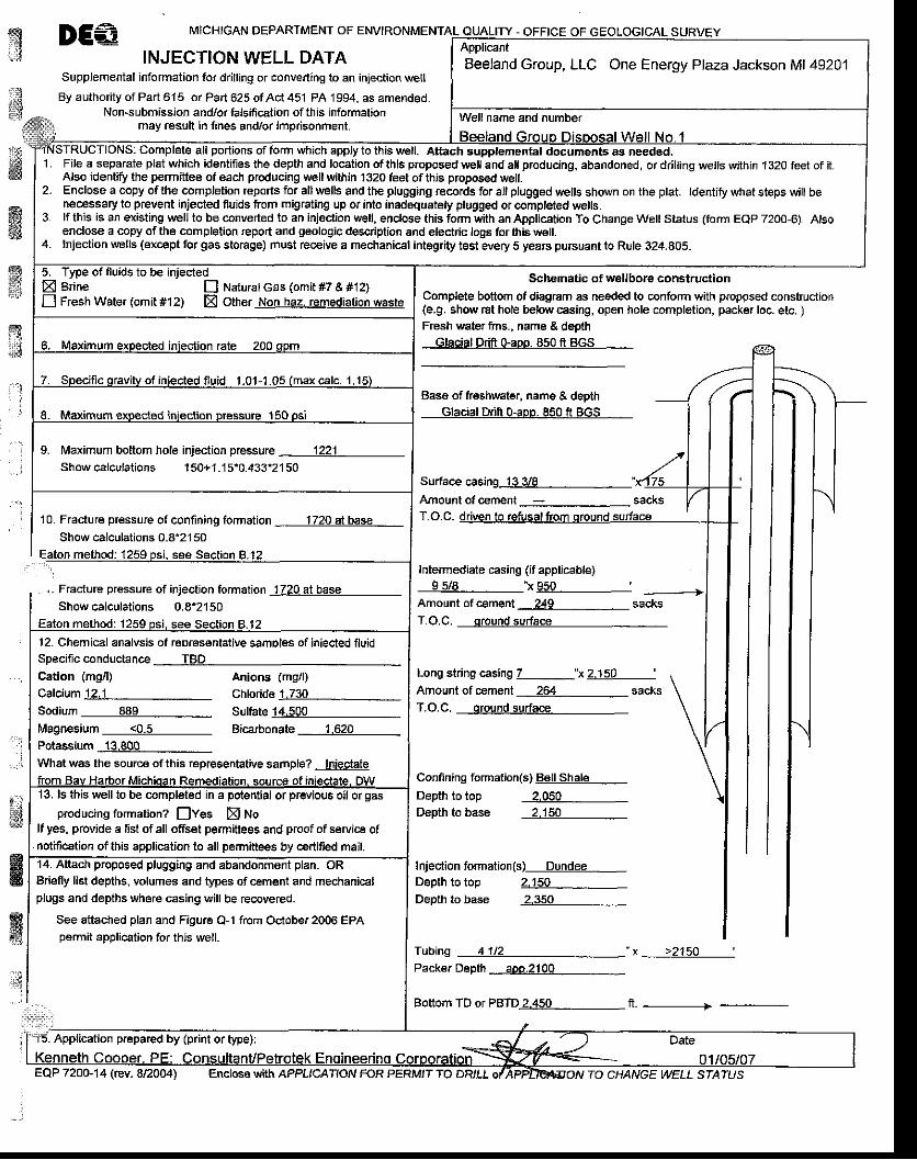
ry',J
DE€ MICHIGAN DEPARTMENT OF ENVIRONMENTAL OUALITY - OFFICE OF
INJECTION WELL DATASupplemental information for drilling or converting to an injectioo well
By authodty of Part 6.15 or Part 625 of Aci 451 PA 1994, as amended.Non-submission andlor tabmcation of this information
may rcsult in tines and/or imprisonment.
ffi
$
ffi
ffiffii*
10. Frac{ure pressure ol confining formation 1720 albaseShow calculations 0-8"2150
, - Fracture pressure of injection formation Jl?g3llEgC_Showcalculations 0.8'2150
Schematic of wellbore construction
Complete bottom ofdiagram as needed to coniorm with propgsed construction(e.9. show rat hole below casing, open hole completion, packer loc. etc. )Fresh water frns. . name & deoth
Glacial Drift Gaoo, 850 ft BGS
Base of freshwater. name & deDthGlacial Drifr o-aoo. 850 ft BGS
Surface casing_lggg__Amount of cement _-:_ sacks
Intermediate casing (if applicable)9 5/8 "x 950 '
Amount ofcement 249 sacksT.O.C. qround surface
14. Attach proposed plugging and abandonment plan. ORBdefly list depths, volumes and types of cement and mechanicalplugs and depths wh6re casing will be recovered-
See attached plan and Figure O-l f.om Oclober 2006 EPApermit application for thjs well.
Long string casing Z__"x2.150Amount of cement 264 sacksT.O.C. oround surface
Confining formation(s) Bell ShaleDepth to top 2,050Depth to base 2.150
Injection formation(s)-Q!!deq_Dapth to top
HKw.4
2.150Depth to base 2.350
Tubing ____llll?Packer Depth aoo.2100
" x >2150 ',
Bottom TD of PBTDj44ig__ fr. ---------------->
ApplicantBeeland Group, LLC One Energy Plaza Jackson Ml 49201
portions of form which apply to this well. Attach supplemental documenb as needed,1 .
2 .
3.
4.
File a separate plat which identifies the depth and location of this proposed well and all producing, abandoned, or dr,lling wells wlhin 1320 feet of it.Also identiry the permittee of each producing $€ll within 1320 feet ofthis proposed well.Enclose a copy ofthe completion reports for allwells and the plugging records ior altplugged wells shown on the plat. ldentify what steps willbenecessary to prevent injected fluids from migrating up or into inadequatety plugged or completed wells.lf this is an existing lvell to be converted to an injection well, enclose this form with an Application To Change Well Status (form EQP 7200-6). Alsoenclose a copy of the completion report and geologic desqiption and electric logs for this well-lnjection wells (except for gas stocge) must receive a mechanical integrily test every 5 years puBuant lo Rule 324.805.
E Brine E Naturalcas (omit #7 & #12)E Fresh Wate, (omit #12) E Other Non haz. remediation waste
lvfaximum bottom hole injection pressure 1221Showcalculat jons 150+1.15.0.43f2150
12. Chemical analvsis of reDresentative samDles of iniecled fluid
Magnesium_____llll Bicarbonate 1.620Potassium 13.800What was the source of this representative sample? Iniectate
r4,ell to be completed in a potential or previous oil or gasproducing formation? lves E tto
lf yes, provide a list ofall ofiset permittees and proof of service ofnotification of thE application to all permittees by ce.tifed mail.
Application prepared by (print or type):
EQP 720G14 (rev. 8/20M) Enclose with APPL,CATION FOR PERM,T 70 DRILL TO CHANGE WELL STATUS
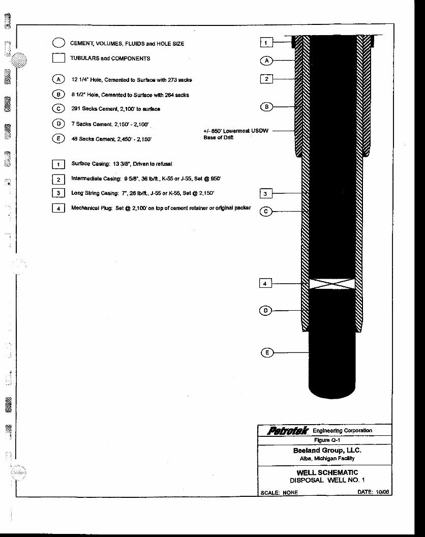
{sid
i-li d
ffiffi
tr
, . ;
..:
fl
Mechnnical Plug: S€t @ 2,1 m' on bp of cement relainer or ortginal packer
N
ffiJ
I-
(4'
@/;\\Y-l
@/,:\
E]EtrlE
MI Elglne€rbg corpoEnonFbure O-l
Beeland Group, lIC.Alba, Mlcfilgan Fsdllty
WELLSGI{EMATICDISPOSAL !/'/ELL NO. 1
scALF: NONE DATE:1qm
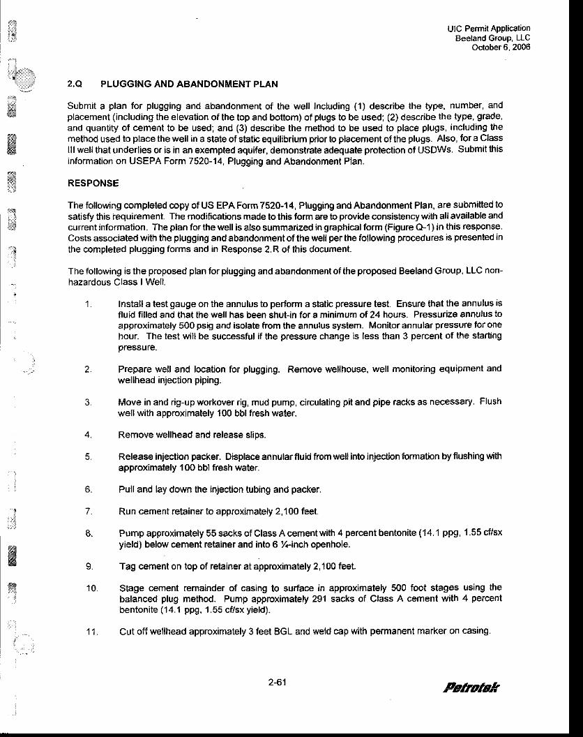
i{ UIC Permit ApplicationBeeland GTouP LLC
October 6. 2006
2,Q PLUGGING AND ABANDONMENT PLAN
Submit a plan for plugging and abandonment of the well Including (1) describe the type, number, andplacement (including the elevation of the top and bottom) of plugs to be used; (2) describe the type, grade,and quantity of cement to be used; and (3) describe the method to be used to place plugs, including themethod used to place the well in a state of static equilibrium prior to placement of the plugs. Also, for a Classlll well that underlies or is in an exempted aquifer, demonstrate adequate protection of USDWS. Submit thisinformation on USEPA Form 7520-14, Plugging and Abandonment Plan.
RESPONSE
The following completed copy of US EPA Form 7520-14, Plugging and Abandonment Plan, are submitted tosatisry this requirement. The modifications made to this form are to provide consistency wif| all available andcurrent information. The plan for the well is also summarized in graphical form (Figure G1) in this response.Costs associated with the plugging and abandonment ofthe well per the following procedures is presented inthe completed plugging forms and in Response 2.R of this document.
The following is the proposed plan for plugging and abandonment of the proposed Beeland Group, LLC non-hazardous Class I Well.
1. Install a test gauge on the annulus to perform a slatic pressure test. Ensure that ihe annulus is{luid filted and ihai the well has been shut-in for a minimum of 24 hours. Pressurize annulus toapproximately 500 ps(l and isolate from the annulus system. Monitor annular pressure for onehour. The test will be successful if the pressure change is less than 3 percent ot the startingpressure.
2. Prcpare well and location for plugging. Remove wellhouse, well monitoring equipment andwellhead injection piping.
Move in and rig-up workover rig, mud pump, circulating pit and pipe racks as necessary. Flushwell with approximately 100 bbl fresh water.
Remove wellhead and release slips.
Release iniection pacRer. Displace annularfluid from well into injection formation by flushing withapproximately 100 bbl fresh waGr.
Pull and lay down the injection tubing and packer,
Run cement retainer to approximately 2,100 feet.
Pump approximately 55 sacks of Class A cement with 4 percent bentonite (14.1 ppg, 1.55 cflsxyield) below cement retiainer and into 6 7.-inch openhole.
Tag cement on top of retrainer at approximately 2,100 teet.
Stage cement remainder of casing to suriace in approximetely 500 foot stages using thebalanced plug method. Pump approximately 291 sacks of Class A cement with 4 percentbentonite ('14.1 ppg, 1.55 cflsx yield).
11. Cut off wellhead approximately 3 feet BGL and weld cap with permanent marker on casing
1\
*;
:$
l l:,,lrfr\
"r!ji'!;:11
ffi
ffiffi
ffi:a"j
' I
:.,,]
4.
c .
6.
7.
8.
'10.
ffiffi
i
. - . .
2€'1 Pclratok
13t i
l.;**1i"''''"qlt$t
*$
MffiM
ffif;4
frw'l
:
f;st
ffi
&w
UIC Permit ApplicationBeeland Group, LLC
October 6. 2006
t ' ' j
t5
12. Rig down and move out pulling unit and equipment.
13. Submit required plugging records to USEPA and MDEO.
Post-Closure Care Requirem€ntg
Beeland will provide noti{ication of closure to USEPA, Region 5, the MDEQ and lhe local zoning authorities.Included with the notification will be information regarding the nature ot the injected waste streem,identification of the depths of the injection and confining zones, well schematics and plugging records.Beeland will retain, for a period of three years following the well closure, records reflecting the nature,composition and volume of all injected f,uids. At the discretion of the director of USEPA, Region 5, Beelandwillthen deliver the records to the director atthe conclusion ofthe retention period, ordispose ofsuch recordsupon written approval of the director.
2-62 tulrola*
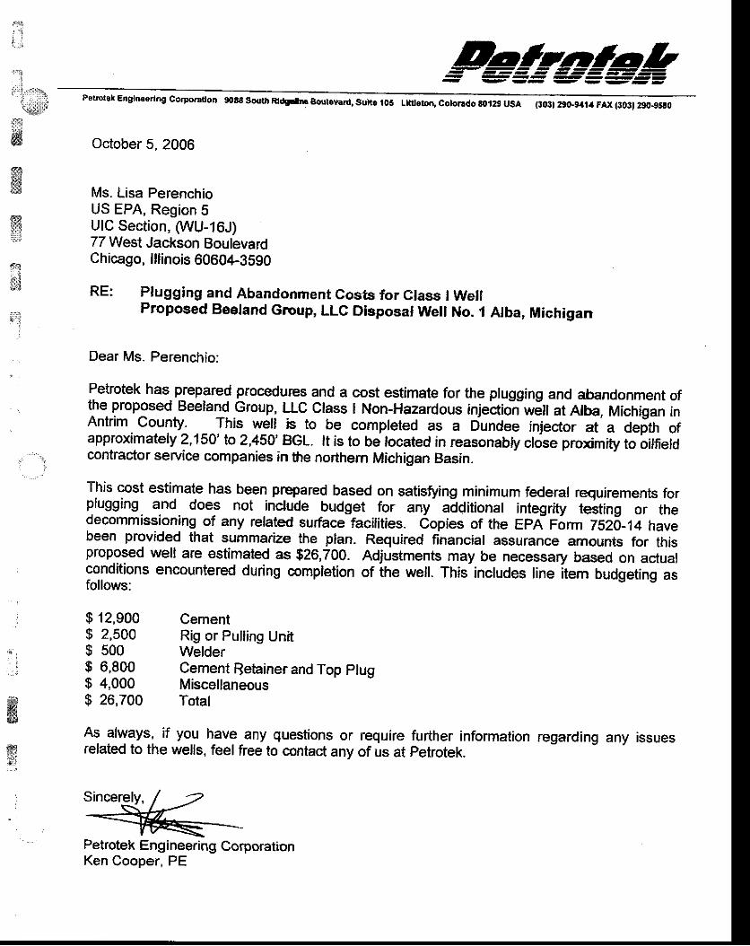
i..,i
j
i:r:l: ...r|j{' i , : t , , ; , , ir#ly!
{!il
4tgw
&*
ffi
$(:1
**
'{::lt
Pstotok Englneerlng co.poradotl 9088 south Rlrtgit|o Boql.y.rd, sult. lo5 Lttiloton, cotor.do 80t29 usa (:03) 29oL9:fia FAx {3031 290-95S0
October 5, 2006
Ms. Lisa PerenchioUS EPA, Region 5UIC Section, WU-16J)77 West Jackson BoulevardChicago, lllinois 60604-3590
RE: Plugging and Abandonment Costs for Class I WellProposed Beeland Group, LLG Disposal Well No. 1 Alba, Michigan
Dear Ms. Perenchio:
Petrotek has. prepared procedues and a cost estimale for the plugging and abandonment ofthe proposed Beeland Group, LLC class I Non-Hazardous in;ectioir-wEn at Alba, Michigan inAntrim county. This w_e.ll 5_to be compreted as a Dundee injector at a oefth ofapproximately 2,150' to 2,450'BGL. lt is to be located in reasonably close proximity to oitfieldcontractor service companies in fie northem Michigan Basin.
This cost estimate has been prepared based on satisfoing minimum federal requirements forplugging and does not .include budget for any- additional integrity testing or thedecommissioning of any related surface facilities. copies of the Epn- porm Tszo-1q havebeen provided that summarize the plan. Required financial assurance amounts for thisproposed well are estimaled as $26,700. Adjustments may be necessary based on actualconditions encountered during completion of the well. This includes line item budgeting asfollows:
$ 12,900 Cement$ 2,500 Rig or Pulling Unit$ 500 Welder! 6,900 Cement fietainer and Top ptug$ 4,000 Miscellaneous$ 26,700 Total
As always, if you have any questions or require further inforrnation regarding any issuesrelated to the wells, feel free to contact any of us at petrotek.
Sincerely, / =*[i =Petrotek Engineering CorporationKen Cooper, PE
, '1
. . i
*i€E
w;;'i
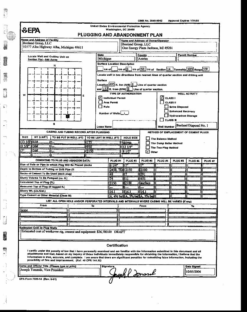
1-St . .
. li. llj11!,,
i::it:.,:i:1
wffiIH#c
sli}
fi; i
Approvrl Explr.l a6!/O!
Unlt.d St lls Envtronrnentll Plotscrlon AgoncyW6shln0ton, OC 20460
PLUGGING AND ABANDONMENT PLAN
Beeland Grcup, IIC10577 Alba Highway Albs, Michigan 4961 |
Locrle Well rnd Outttn. Unlr onsectbn Pbt. 64{t acres
N
_I_L l_t t l-r-F+-
l_L l_t t l
l_L l_I t t
+-F+-l_L_1_rr l
l_L_t_rt t
+-F+-l_L_r_rt l
I_LJ-r t l
+-F+-l t r
1-t1-3
ra orLJrra orfl ua or[fl rn or s"cu". Er"-'.r'rp@lR.'s,lsw lLocd. u/.ll In two dlrec oft lrom ne|'eEt ll'|.i ot qur.lrr ..ctloh .nd dlrlhg untr
Surtrc.
.t. tlm {l,lrs) ll-l Llne ot su.n ' r.clon.nd L!!4 fL trorn (E[Yl lu Um ot qu.rter r.calon.
TYPE OF AUTHORZATDN
E Indlvtdlrt F.inx
fl &o! Pe'nn
I aur"
lumtrr or wrtt[J
WELL ACTMTY
B cuss rf] cuss rr
fl a,h. Dtsposll
E enlrncco rccovrry
EJ Hydroc$lon s.olaee
I cr-ass n
UETHOD OF EIIPLACEMEM OF CEMENT PLUGS
E The ad.nc. Method
E Tho Dulnp B.tt.r M.thod
D rtre rwo-Ptus uslhod
El oo'.'
TO AE PUT I}I WEL|. (FD rO BE LEFI N WELL IFI)
CEIIENNNG IO PI-U6 Ar|O AEANDO}I DAT',:of Hole or Plp. lD rrhtch ptug WIt Br pt.G.d (tnch.
to Botlom ot Tqbtng oa Di t ptp. (tl
Sick! olc.mont To 8e U..d ( ch ptug)
Sluny Volumc To 8e Puht.d
ile.tu.3d fop ol Plut (ll t Cg.d ltj
L| T ALL OPE IOI.-E ATID,oR PERFORATED I}ITERVATA ANO WfERVAI! WHERE CASNG WILL BE VARIED II'.iy}
CertiffcatlonI ce.llfv und.. th. !,r,.|tllty ot llw th.t I hrve p€rron lly ox.mlmd .nd !m frmlllat wlrh tt. Inforrnrrron .ubmld.d In thlr docurn.r|l lnd ltlrarrchm..rt .nd th.t, b.r.d on my lnqulry ol tho.. l;dMdulls lmm.dbt.ly r..pon.lbl. lor obblnlnC tn. ldto.d.tton, I b.ll.ve th.t theInto.m.tlon l. uua, rccu.rl., rnd compl.t.. I rm rw..e lhrl ll|..e |I. rhnltlclnt lenrlths lor rubmttttns t lie |rform3don, Inctudlos th.por.lblllty of llnq rnd tmFrt.onn.nt. (Rct, 40 cFR t,{4.!2,
EPA Fom 7520.t4
oltlg No. 2t,(}{942
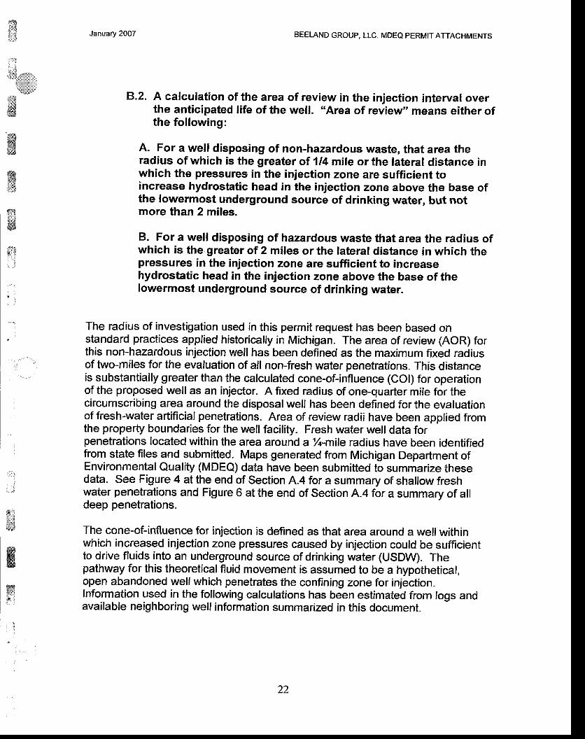
ffi::1
,lil,*,,,t:*iti.Kit
*w
January 2OO7 BEELAND GROUP, LLC. MDEQ PERMIT ATTACHMENTS
El.2. A calculation of the area of review in the injection interval overthe anticipated life of the well. .'Area of review" means either ofthe following:
A. For a well disposing of non-hazardous waste, that area theradius of which is the greater of 1/4 mile or the lateral distance inwhich the pressures in the injection zone are sufficient toincrease hydrostatic head in the injection zone above the base ofthe lowermost underground source of drinking water, but notmore than 2 miles.
B. For a well disposing of hazardous waste that area the radius ofwhich is the greater of 2 miles or the lateral distance in which thepressures in the injection zone are sufficient to increasehydrostatic head in the injection zone above the base of thelowermost underground source of drinking water.
The radius of investigation used in this permit request has been based onstandard practices applied historically in Michigan. The area of review (AOR) forthis non-hazardous injection well has been defined as the maximum fixed radiusof two-miles for the evaluation of all non-fresh water penetrations. This distanceis substantially greater than the calculated cone-of-influence (COl) for operationof the proposed well as an injector. A fixed radius of one-quarter mile for thecircumscribing area around the disposal well has been defined for the evaluationof fresh-water artificial penetrations. Area of review radii have been applied fromthe property boundaries for the well facility_ Fresh water well data forpenetrations located within the area around a y1-mlle radius have been identifiedfrom state files and submitted. Maps generated from Michigan Department ofEnvironmental Quality (MDEQ) data have been submitted to summarize thesedata. See Figure4 attheend of Section A.4for a summary of shallow freshwater penetrations and Figure 6 atthe end of Section A.4 for a summary of alldeep penetrations.
The cone-of-influence for injection is defined as that area around a well withinwhich increased injection zone pressures caused by injection could be sufficientto drive fluids into an underground source of drinking water (USDW). Thepathway for this theorelical fluid movement is assumed to be a hypothetical,open abandoned well which penetrates the confining zone for injection.Information used in the following calculations has been estimated from logs andavailable neighboring well information summarized in this document.
ffiffiqI
Mill
:.. .l
$iffiry
i
22
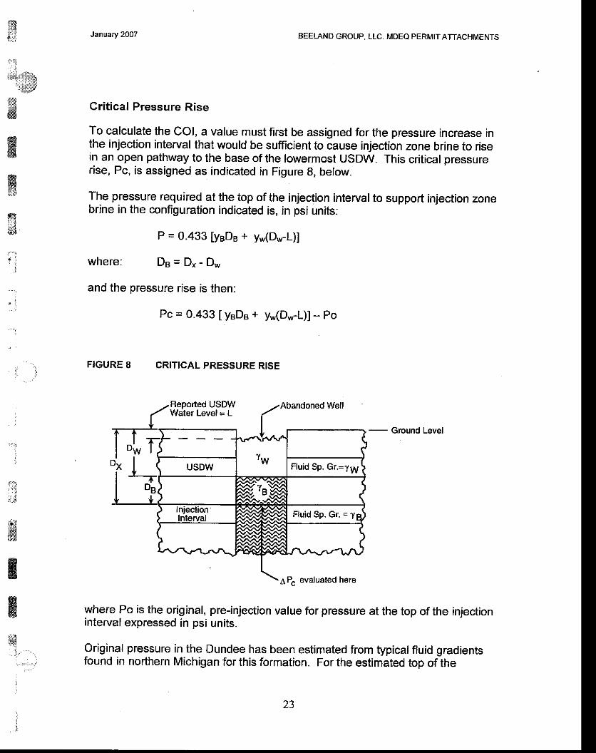
fis|;J?ri9..:!
&ffi
ffiffi
ffi: l
s& '
i r l' :
:'
. . 1
:
j
:::.J
! iffi
ffi
January 2OO7 BEELAND GROUP, LLC- MDEQ PERMITAfiACHMENTS
Critical Pressure Rise
To calculaie the COl, a value must first be assigned for the pressure increase inthe injection interval that would be sufficient to cause injection zone brine to risein an open pathway to the base of the lowermost USDW. This critical pressurerise, Pc, is assigned as indicated in Figure B, below.
The pressure required at the top of the injection interval to support injection zonebrine in the configuration indicated is, in psi units:
where:
P = 0.433 lyeDe + y,,(Dl,v-L)]
Ds=Dr -Dw
and the pressure rise is then:
Pc = 0.433 [yeDe + y*(D*-L)] - Po
FIGURE 8 CRITICAL PRESSURE RISE
Water Level = L
DW
DB
L---I
(
"rwUSDW Fluid Sp. Gr.=1y1
T"-xLr-v
Iniectionlnterval Ftuid sp. Gr. = 1ql
I- .r\.r/t_.^.^-
tt
ft a,- ^ t-'l n\
APc evaluated here
Reported USDW Abandoned Well
- Ground Level
DX
9:l. . i , : ' : :
where Po is the original, pre-injection value for pressure at the top of the injectioninterval expressed in psi units.
Original pressure in the Dundee has been esiimated from typical fluid gradientsfound in northern Michigan for this formation. For the estimated top of the
z3
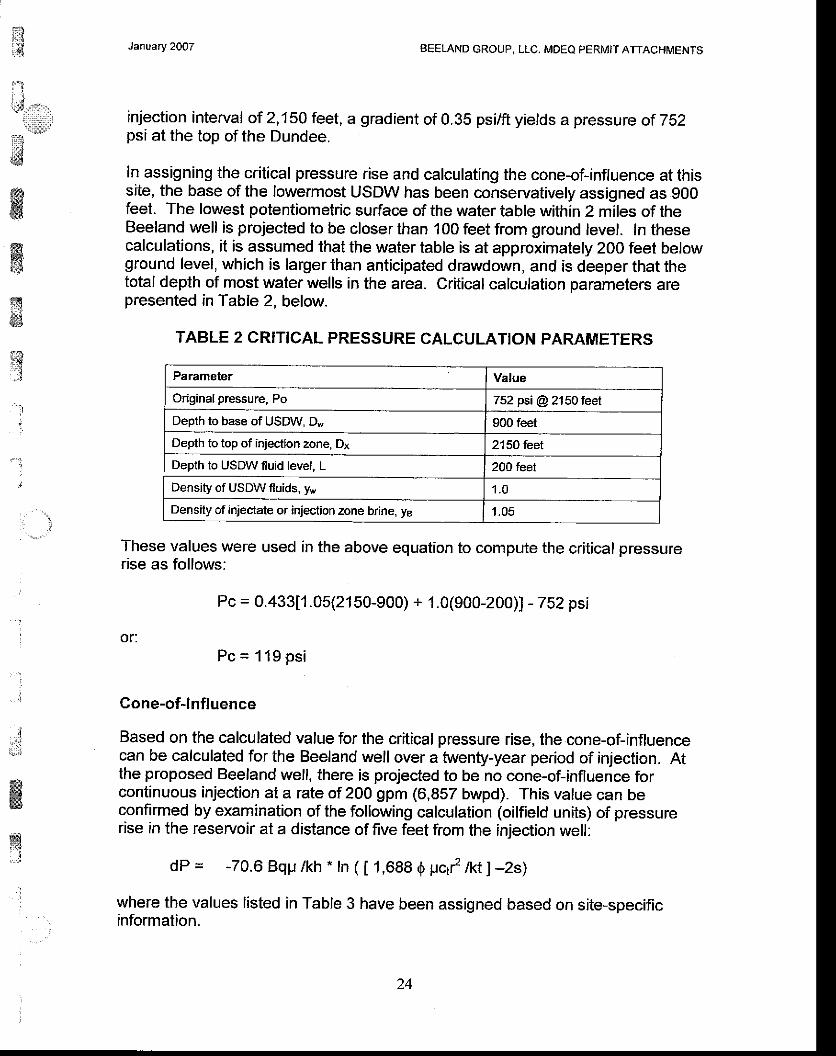
$
' ,:,,,'i1l:::lr'
#ffiffi{s
{frei
January 2007 BEELAND GROUP, LLC. MDEO PERMIT ATTACHMENIS
injection interval of 2,'150 feet, a gradient of 0.35 psi/ft yields a pressure of 7b2psi at the top of the Dundee.
In assigning the critical pressure rise and calculating the cone-of-influence at thissite, the base of lhe lowermost USDW has been conservatively assigned as 900feet. The lowest potentiometric surface of the water table within 2 miles of theBeeland well is projected to be closer than 100 feet from ground level. ln thesecalculations, it is assumed that the water table is at approximately 200 feet belowground level, which is larger than anticipated drawdown, and is d-eeper that thetotal depth of most water wells in the area. Critical calculation narameters arepresented in Table 2, below.
TABLE 2 CRITICAL PRESSURE CALCUL.ATION PARAMETERS
Parameter Value
Original pressure, Po 752 psi @ 2150 leet
Deplh lo base of USDW, D* 90O feet
Depth to top of injection zone, Dx 2150 feet
Depth to USDW fluid level. L 2OO teet
Density of USDW fluids, yw '1.0
Density of iniectate or injection zone brine, yB, 1
,ryl
:
i
.. ',]
ffit&ry
These values were used in the above equation to compute the critical pressurerise as follows:
Pc = 0.433[1 .05(2150-900) + 1.0(900-200)] - 752 psi
or:Pc=119ps i
Cone-ofJnfluence
Based on the calculated value for the critical pressure rise, the cone-of-influencecan be calculated for the Beeland well over a twenty-year period of injection. Atthe proposed Beeland well, there is projected to be no cone-of-influence forcontinuous injection al a :.ate of 200 gpm (6,857 bwpd). This value can beconfirmed by examination of the following calculation (oilfield units) of pressurerise in the reservoir at a distance of five feet from the injection well:
dp = -70.6 Bqp /kh . In ( [ 1,688 O uql nt ] -zs)
where the values listed in Table 3 have been assigned based on site-specific'. information.
24
ntt.t
lil;.ts,,,,,''.''i:r:rr,':r*":liil}'
ii
ffi
ffiwE}
f&ffi
i:
" .
'],..::.
*
ftm@
ffig:
January 2OO7 BEELAND GROUP, LLC, MDEQ PERMIT ATTACHMENTS
The above calculation for pressure rise due to twenty years of injection at a rateof 200 gpm yields an increase of approximately 1 15 psi. This value is smallerthan the conservatively calculated critical pressure, Pc, of 119 psi which wouldbe necessary before there is potential for upward fluid movement to the base of aUSDW if an open pathway were present. Therefore the cone-of-influence at thissite is less than 5 feet, even under a conservative scenario. Due to the relativelyhigh permeability and relatively low original pressure of the Dundee Limestoneinjection formation atthis site, there exists no potential for contamination ofUSDW resources due to improperly completed or abandoned wells within thestatutory minimum 2-mile radius area of review.
TABLE 3 CONE-OFjNFLUENCE P.ARAMETERS
Parameter Calculation Value
Flow rate, q 200 gpm .1 ,140 min lday' bbll42 gal 6,857 bbvd
Thickness, h 10O feet
Formation Volume Factor,B
1.O15
Porosity, 0 0. '10
Permeability, k 1.0O0 millidarcies
Viscosity. p 1.05 centipoise @ 72 degrees FTotal Compressibility, C, 3.2x10€ psi-r + 4.8xlo€ psi-1 8x10⁶ psi-t
Radius, r 5 feet
Time, t 20 years x 365.25 dayslyt' z4hrlday 175,320 hours
25
ffi January 2OO7 BEELAND GROUP. LLC. MDEQ PERMIT ATTACHMENTS
8.3. A discussion of the affect of injection on the present andpotential mineral resources in the area of review.
Mineral resources in the AOR may include natural gas reservoirs within theAntrim Shale and/or Traverse Limestone. Figure 9 at the end of this Section(B.3) presents the stratigraphic column in the area, and shows the proximity ofthese potential gas bearing zones to the injection zone. As shown in this Figureand as verified through well construction (Figure 7, Section A.'ll), the DisposalWell will be cased and cemented through both the Antrim and TraverseLimestone prior to drilling to the Dundee- This action will sufficiently isolate thesepotential gas bearing zones, so the well will have no affect on the zones duringdrilling. Regular mechanical integrity testing and monitoring will veriff proper wellfunction during waste injection, also ensuring that zones with potential mineralresources are unaffected by well operations. Well abandonment, upon cessationof the use of the well for injection will be performed in accordance with applicablestate and federal regulations.
#'nffiwss#
3
' ' l
. i
-1
.:.
'i'i
iilwKw
ffinill
ait:tl
a::i::.,':
:
lI
zo
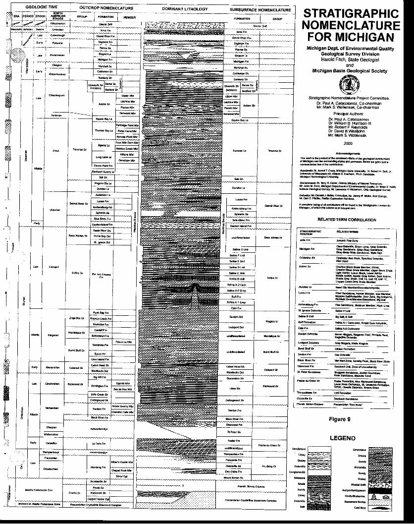
9a:1"",: lll,_, - OUrcRop No ENCLATUEE Doi NANT LrrHoLoGy sussuRFAcE NoMENclaruREn F tuDi+dr
i .---i*^*; -" t---
I
STRATIGRAPHICNOMENCLATUREFOR MICHIGANMichigan Dept ot Environrnental Quatity
Geologlcal Survey DivisionHarold Fitch, Sliate G€otogist
andMichigan gasln Geological Soctety
@Shalg.sphicNomendr||jle PlEjedConminee]
or Paul A. Calaco6i.os. Co<harnanMr lr5fi s \ b 6n5ak, c+chatrman
PdnciPat A!tno6O. PaulA. cata@iitusDr vM ian B Hanison fllM. Rob€rt F R€vnotdsor David 8.\ bsiiohnMr Marr S. Vlbldnssk
?000
dEr9Dahoi ' 'sofudF!!|E.
f f i D M r c q & ! ! . . elkydfu'denoEf,fu'hooff i
f f idLDEc|c'fud!kble' l9rcshFfurdhhbful lb9rE7,LEEHkfu
ddyjrrhdr &&1.tfu1L.
^6!d. lHDdJfud'bM
REIATEDTERI' CORRELATION
I,l..
#
r Figurc I
LEGEND
1!::.il{.:-i
iliii:rrrirll::lll:r:l
i:E1i;l:ip',"ffi
January 2007 BEETAND GROUP, LLC. MDEO PERMIT ATTACHMENTS
ffi{&}
ffi{?#a ' i
:
:
, ] :
ffiw
8.4. A plat which shows the location and total depth of theproposed well, shows each abandoned, producing, or dry holewithin the area of influence, and each operator of I mineial oroil and gas well within the area of influence.
Figures 4 and 6 show the location of water welrs and oil and gas welrs in thevicinity of the proposed Disposal Well, as presented in Section A.4.
I27
t ;
iti!:a:_1,:]:,
'{llls}'
iti ls
mffi6
ffi€,
wffi
{i
$mry&
' . :
January 2007 BEETAND GROUP, LLC. MDEQ PERMIT ATTACHMENTS
B,5. lf a well is proposed to be converted to a disposal well, a copyof the completion report, together with the written geologicdescription log or record and borehole and stratum evaluationlogs for the well.
Conversion of an existing well is not proposed. Upon installation of the new well,copies of the written geologic description and all log data collected from the wellwill be submitted to MDEQ
28
itta,i
ti*,,,{3;,
;xffi&ffi
wii:3
ry{i{
't
":
-l
: :
January 2007 BEELAND GROUP, LLC- MDEQ PERMIT ATTACHMENTS
r*si
ffiw
Lt
lil:r:l:r,-,'
. . :
j
8.6. Plugging records of all abandoned wells and casing, sealing,and completion records of all other wells and artificialpenetrations within the area of influence of the proposed welllocation and a map identifying all such artificiat penetrations.An applicant shall also submit a plan reflecting the steps ormodifications be-lieved necessary to prevent proposed injectedwaste products from migrating up, into, or throughinadequately plugged, sealed, or completed well-,
Topographic Map
A copy of the USGS Topographic map avairabre from the area of review with theoutline of the minimum two-mile radius area of review and an injection wellsymbol representing the facility superimposed on the map is inc-luded as Figure 3(see Section A.4).
T-his topographic map extends in excess of 1 mile beyond the Beeland site in alldirections. The Beeland property encompasses an irregular rectangular area ofapproximately 60 acres in the southeast quarter of section 14. In aldition, themap shows the location of all known surface bodies of water, springs, mines,quarries, residencies and roads. separate additional maps submittld in thisResponse present water wells and deeper artificial penetrations. A listing ofneighboring property owners within a Zz mile radius'has been also beendeveloped and submitted with this application for the well permit. No knownhazardous waste treatment storage or disposal facilities are present within theAOR based on available state of Michigan permit information.
Artifi cial Penetrations
There are a number of artificial penetrations identffied in the area of reviewconducted for a two-mile radius surrounding the proposed Beeland disposal well.However, a.vast majority of the wells permitted and/or drilted in the vicinity of theBeeland well only penetrate the Anlrim shale forthe purpose of gas production.These wells are typically drilted to a depth of beiween t,ZSO anJl,ZbO feetbelow ground level (BGL) and are not potential pathways for fluid migration out ofthe permitted injection zone, since they do not penetrate through the-confining,arestment or injection intervals. An examination of a availabl-e records at th-eMichigan Department of Environmental euality (MDEo) has been accomplishedas of october 2006 to evaluate these wells. Data for ali deep wells which havebeen drilled within a two-mile radius of the Beeland well are summarized in theTables.4 and 5 and copies of pertinent MDEe completion or prugging recordsregarding wells which penetrate into the injection inierval of the p]6poiseaBeeland well are also presented atthe end of this section and in Atiachment c.
29
$gid
53i$"::.
i , . . . 1aif,
tswffiffis
$1iid
:-Lr,l
..:
j
- l
-,.:
.,.-l
li*+'trsiiit?
&E
ws
January 2OO7 BEELAND GROUP, LLC. i/DEO PERMIT ATTACHII'ENTS
Figure 6 (Section A.4), a map generated with the PETRA soft\/are program fromdata provided by the state of Michigan in October of 2006, shows the location ofall non-fresh water artificial penetrations in the state oif and gas well databasewithin the required two-mile AOR. Permit numbers are shown at each wellsymbol. The Proposed Beeland Well No. 1 is designated as an injection well(also labeled with the well name), and is located in the southeast quarter ofSeclion 14. General geographic features and the outline of the required two-mileAOR are also shown on the map. Index lines showing cross sections are alsoshown, with summaries of relevanl formation tops from the MDEe database.The "legend" on this map contains pertinent information designating all otherwells with the area of review.
Figure 4 (Section A.4), a map modified from data generated by the state ofMichigan in October of 2006, presents the location of all local freshwater wellpenetrations in the state water well database. Note that fresh water penetrationsin the area of review typically range from approximately 50 to 200 feet, and arenot critical with regard to the fluid injection at the Proposed Well No. 1. Copies ofselected water well records for freshwater penetrations are submitted here.
According to the MDEQ records, there are 109 wells located within the two-mileAOR. Only four of these wells penetrated into the Bell Shale or the DundeeLimestone. Three of these penetrations are active Class ll brine disposal wells(#41955, #42680, and#46244), and one well was plugged in 1969 as a dry hote(#27750). The remaining 105 wells only penetrate to the Antrim or TraverseGroup, and do not penetrate the arrestment or injection interval for the proposedBeeland well. There have been no Class I dispoial wells drilled within ihe'areaof review. Well#27750 in Section 26 of T30N-R5W, which had been listed as adry Niagaran exploratory well with a TD of 6,550 feet, was plugged according toapplicable siate standards and a plugging record is available for this well. TheDundee is isolated from deeper formations by cement plugs, and is isolated fromshallower formations by multiple cement plugs and cemented casing that was leftin the well. Class ll brine disposal wells (#419Sb, #42680, and #46244), areeach completed according to current state and federal regulatory requirementsand have long-string casing cemented to isolate the Dundee injection intervalfrom overfying formations and fresh water resources. Records for permit #56773in Section 10 of T30N R5W are presented showing that the formation at TD is theTraverse Limestone despite a total depth of 2,200' reported in the MDEedatabase.
Due to the small pressure rise associated with projected injection activities andthe corresponding limited cone-of-influence, it is noted that none of the wellswithin the regulatory minimum two-mile AOR could have the potential for causingany endangerment to USDW resources in the vicinity.
J U
f*t:i:f . i
t.li:r!:'';q;lt',l3SF
M
ffi_ryffit..:
" )
* l
::
ffiw3 .
January 2OO7 AEELAND GROUP, LLC, MDEO PERIVIIT ATTACHMENTS
Corrective Action
A corrective action plan is not required for any of the artificial peneirations withinthe proposed Beeland well AOR because, based on calculations, there is nocone-of-influence and there are no artificial penetrations to the injection zonewithin the area of review that have the potential for allowing injection activities tohave an impact on the USDW. lf a corrective action plan for any neighboring wellbecomes necessary in the future, it will be developed according to appropriateregulatory standards and guidelines.
The corrective action plan which would be proposed by Beeland, should thepotential for fluid migration to occur through the confining layer develop via anyfuture well, will include the following:
1. Beeland Group, LLC injection well will be shut-in.2. The USEPA, Region 5 UIC Section and the MDEQ will be notified.3. Following well shut-in, waste will be shipped to alternative permitted
facilities for off-site treatment and/or disposal as necessary.4. A contingency plan will be prepared as follows:
Locate well and identiff present operator or owner, if any.ldentify mode of failure.Prepare remedial plan outlining course of action.The remedial plan will be submitted to the USEPA, Region 5 andMDEQ for approval.
e. Upon authorization, the remediation plan will be implemented.
Area of Review Oil and Gas Well Data
Data regarding artificial penetrations collected for wells within the area of reviewhave been categorized and are listed by well type. Oil and gas industry (non-fresh water) well locations are shown on Figure 6 (See Section A.4). Oil and gaspermitted wells drilled into or deeper than the injection zone and subsequentlyabandoned, wells drilled through the injection zone that are still active producers,and temporarily abandoned wells that penetrate to the injection zone are listed inTable 4. Wells are labeled with MDEQ permit numbers. Following this table is alisting of oil and gas wells permitted by the MDEQ that have been drilled todepths, which do not penetrate the injecfion zone (Table 5). Typically, thesewells are Antrim gas wells that reached a total depth within the Antrim Shale orthe top of the Traverse Limestone. Dala presented in this table regarding wellswithin the area of review include MDEQ permit number, location, totat depth,status, construction, and completion or plugging date. Figures 10 through 13 atthe end of this Section (8.6) present summaries of the wellbore configurations foreach of the wells that penetrate to the proposed injection interval.
a.b .
d .
31
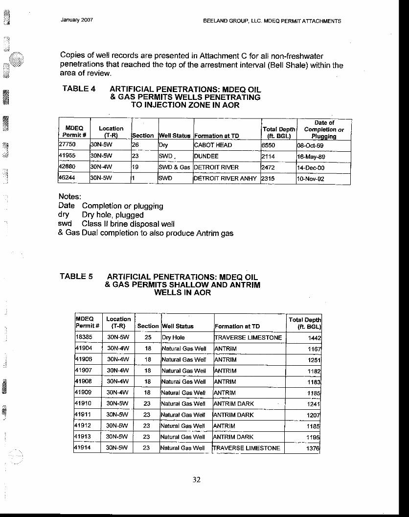
${i.l;
. ' : l
:'.!ll'"'r,
it::'.x'd,
ffiffi
ffis{Er*
J:
i
.:
:
ffi
January 2OO7 BEELAND GROUP, LLC. MDEQ PERMIT ATTACHMENTS
Copies of well records are presented in Attachment C for all non-freshwaterpenetrations that reached the top of the arrestment interval (Bell Shale) within thearea of review.
TABLE 4 ARTIFIcIAL PENETRATTONS: MDEQ OtL& GAS PERMITS WELLS PENETR^ATING
TO ]NJECTION ZONE IN AOR
Notes:Date Completion or pluggingdry Dry hole, pluggedswd Class ll brine disposal well& Gas Dual completion to also produce Antrim gas
TABLE 5 ARTIFICIA,L PENETRATTONS; MDEQ OIL& GAS PERMITS SHALLOW A,ND ANTRIM
WELLS IN AOR
MDEQPermit #
Location(T-R) Section Well Statis Formation at TD
Total Depth(ft BGLI
Date ofCampletion or
Plugging27750 30N-sW Dry CABOT HEAD 5550 c8-od-6941955 30N-5W SWD . DUNDEE 21't4 l&.May-89
42680 30N-4W 1 9 SWD & Gas DETROIT RIVER 2472 14-Dec-00
46244 30N-5W SWD DETROIT RIVER ANHY 2315 10-Nov-92
IIilDEQPermit #
Locationtr-R) Section Well Status Formation et TD
Total Depti(fL BGLI
18385 30N-5W 25 Dry Hole TRAVERSE LIMESTONE 1442
41904 30N-4W 1 8 Natural Gas Well ANTRIM 1167
41906 30N-4W 1 8 Natural Gas Well ANTRIM 1251
419o7 30N-4W 1A Natural Gas Well ANTRIM 1142
41908 30N-4W 1 8 Natural Gas Well 4NTRIM 1 1 8 :
41909 30N-4W 1 8 Natural Gas Well ANTRIM 1185
4 1 9 1 0 30N-5W 23 Natural Gas Well ANTRIM DARK 1241
41911 30N-sW 23 Natural Gas Well ANTRIM DARK 1207
41912 30N-5W 23 Natural Gas Well {NTRIM 1 1 8 €
4 1 9 1 3 30N-sW 23 Natural Gas Well ANTRIM DARK '1 'tsa
4't914 30N-5W 23 Natural Gas Well IMVERSE LIMESTONE 137e
J L

BEELAND GROUP, LLC. MDEO PERI\4IT ATTACHMENTSJanuary 2OO7
: _:i
l l
4
iir;i
i:!1idtc
&
ffiw:i.1
#ffiffi3d
MDEQPermit #
Location(T.R) Section Wall Status Fonnation at TD
Total Depth(ft. BGL)
4 1 9 1 5 30N-sW Natural Gas Well ANTRIM DARK '| 1S3
41916 30N-5W Natural Gas Well ANTRIM DARK 120a
41917 30N-slr'r' 1 4 Natural Gas Well TRAVERSE LIMESTONE 1432
4 1 9 1 8 30N-51 ,/ 1 4 Natural Gas Well TMVERSE LIMESTONE 138S
419'19 30N-5W 1 4 Natural Gas Well ANTRIM DARK 1J93
41920 30N-5W Natural Gas Well qNTRIM DARK '1218
41921 30N-5\ / 23 Natural Gas Well IMVERSE LIMESTONE 1394
41922 30N-5W 1 3 Natural Gas Well TRAVERSE LIMESTONE l Joc
41923 30N-5W 1.1 Natural Gas Well qNTRIM DARK 1 1 9 0
41924 30N-5W Natural Gas Well ANTRIM BARK 2101
41925 30N-5W 14 Nalural Gas Well IRAVERSE LIMESTONE .139C
41526 30N-5W 24 Natural Gas Well ANTRIM DARK 1 188
41927 30N-5W 24 Natural Gas Well CNTRIM DARK
42069 30N-sW 23 Natural Gas Well ANTRIM 11A1
42162 30N-5W 1 4 Natural Gas Well ANTRIM DARK 121A
42681 30N-4W l o Natural Gas Well IRAVERSE FORMATION 1341
43538 30N-4W 30 Natural Gas Well TRAVERSE LIMESTONE 138l
43539 3ON4W Natural Gas Well ANTRII\4
43597 30N-4W 1 9 Natural Gas Well IMVERSE LIMESTONE 1397
43598 30N-4W 1 9 Natural Gas Well TMVERSE LIMESTONE 136€
13600 30N-4W 30 Natural Gas Well IMVERSE LIMESTONE 1367
43601 30N-4W 30 Natural Gas Well TMVERSE LIMESTONE J39r43602 30N-4W 30 Natural Gas Well TRAVERSE LIMESTONE 14'ta
43603 30N-4W 1 9 Natural Gas Well TRAVFRSE FORMATION 1344
43606 30N4W Natural Gas Well TMVERSE FORMATION 1332
43608 30N-4W 1 9 Natural Gas Well TRAVERSE LIMESTONE 1402
43609 30N-4W 1 9 Natural Gas Well IRAVERSE FORMATION 1353
46241 30N-5W Natural Gas Well IMVERSE LIMESTONE 138€
46496 30N-5\^/ 2 Natural Gas Well IRAVERSE LIMESTONE I JOL
46498 30N-5W t 1 Natural cas Well IRAVERSE LIMESTONE 't 368
46459 30N-5W 1 1 Natural Gas Well IRAVERSE LIMESTONE 1405
46505 30N-5W 2 Nalural Gas Well TMVERSE LIMESTONE 1429
47373 30N-5W 25 latural Gas Well TMVERSE LIMESTONE 't469
47606 30N-sv1r' 1 3 Natural Gas Well IMVERSE LIMESTONE 1408
47607 30N-5W 1 3 Natural Gas Well TRAVERSE LIMESTONE 139€
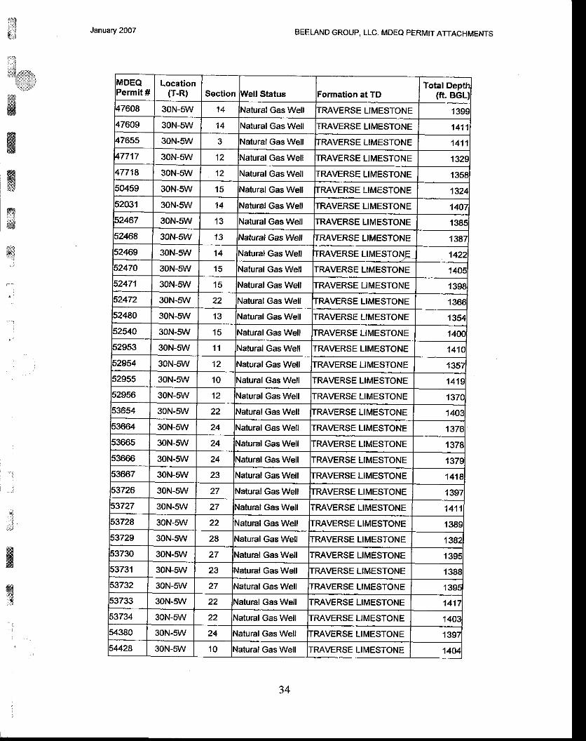
BEELAND GROUP, LLC. MDEO PERMIT ATTACHMENTSJanuary 2007
i:iIi:i.Slr.
?::*irs&wffistJ
s&d
s' .
..a
4'
,:;
sssff
ffitcr.*
MDEQPermit #
Location(T-R) Section Well Status lFolmation at TD
Total Deptfi(ft. BGLJ
47608 30N-5W 1 4 Nalural Gas Well IRAVERSE LIMESTONE 139€47609 30N-sW 1 4 latural Gas Well ITMVERSE LIMESTONE 1411
47655 30N-5W NaTuraI Gas WeII ITRAVERSE LIMESTONE 14't 147717 30N-sW 12 Natural Gas Well IMVERSE LIMESTONE 1329,477'18 30N-5W 12 latural Gas Well ITRAVERSE LIMESTONE 1358
50459 30N-5W 1 5 \,latural Gas Well IrRAVERSE LIMESTONE 132452031 30N-5W 1 4 Nalural Gas Well IMVERSE LIMESTONE 140752467 30N-sW \atural Gas Well TTMVERSE LIMESTONE 138552468 30N-5W 1 3 Natural Gas Well |TRAVERSE LIMESTONE 138752469 30N-5W 1 4 Natural Gas Well TMVERSE LTMESTONJ= 142252470 30N-sW '15 \atural Gas Well TMVERSE LIMESTONE
5247'l 30N-5W 1 5 Natural Gas Well TMVERSE LIMESTONE I 139852472 30N-5W 22 lNatural Gas Well TRAVERSE LIMESTONE 136€52480 30N-sW 13 lNatural Gas Well IMVERSE LIMESTONE '1354
52540 30N-5W 15 lNatural Gas Well TRAVERSE LIMESTONE 140C52953 30N-sW 1 1 Nalural Gas Well IRAVERSE LIMESTONE 141C
52554 30N-5W Natural Gas Well IMVERSE LIMESTONE 135752955 30N-5W 10 Natural Gas Well IMVERSE LIMESTONE 141e52956 30N-5W 't2 Natural Gas Well IRAVERSE LIMESTONE 137C
53654 30N-5\ / 22 Natural Gas Well TRAVERSE LIMESTONE '1403.
53664 30N-sW 24 Natural Gas Well TRAVERSE LIMESTONE 137653665 30N-5W 24 Natural Gas Well IMVERSE LIMESTONE 1378s3666 30N-5W 24 {atural Gas Well IRAVERSE LIMESTONE 137953667 30N-5W 23 Natural Gas Well TRAVERSE LIMESTONE 1418
53726 30N-5\ / Natural Gas Well TRAVERSE LIMESTONE 1397
30N-5W 27 Natural Gas Well IMVERSE LIMESTONE 1411
53728 30N-sli{/ Natural Gas Well TRAVERSE LIMESTONE 138S53729 30N-5\A/ 2A Natural Gas Well TRAVERSE LIMESTONE 138253730 30N-5W Natural Gas Well IMVERSE LIMESTONE r39E53731 30N-5W 23 Natural Gas Well TMVERSE LIMESTONE 1388i3732 30N-5W Natural Gas Well TRAVERSE LIMESTONE 1395
53733 30N-5W 22 Natural Gas Well TMVERSE LIMESTONE 1417
53734 30N-5\ / Natural Gas Well TRAVERSE LIMESTONE 140354380 30N-5W 24 Natural Gas Well TMVERSE LIMESTONE 139i54428 30N-5W 1 0 Natural Gas Well IRAVERSE LII\4ESTONE '14D4
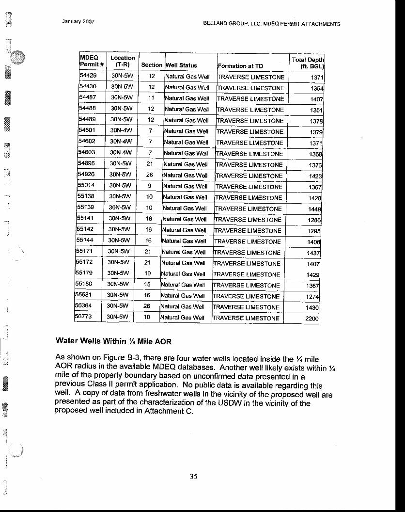
:
Itl!r{:::,,
l t:::l:li
t's6W
January 2OO7 BEELAND GROUP, LLC- MDEQ PERMITATTACHMENTS
MDEQPermit #
Location(T-R} Section Well Status Formation at TD
Total Depth(ft. BGL)
54429 30N-5W 12 Natural Gas Well TRAVERSE LIMESTONE 13715/,430 30N-sW 12 Vatural cas Well TRAVERSE LIMESTONE 1354
54487 30N-5W 1 1 Natural Gas Well TRAVERSE LIMESTONE 14079488 30N-5W 12 Vatural Gas Well IRAVERSE LIMESTONE 13515.1489 30N-5W 't2 Natural Gas Well TRAVERSE LIMESTONE 13785460'l 30N-4W 7 Natural Gas Well IRAVERSE LIMESTONE 137954602 30N-4W 7 Natural Gas Well TMVERSE LIMESTONE 1371
54603 30N-4W 7 Natural Gas Well TRAVERSE LIMESTONE 135954896 30N-5W 21 Natural Gas Well TMVERSE LIMESTONE 137e54926 30N-5W 26 Natural cas Well TRAVERSE LIMESTONE 142255014 30N-sW I Natural Gas Well IMVERSE LIMESTONE 136155138 30N-s\r'V 1 0 Nalural Gas Well TRAVERSE LIMESTONE 't428
6 6 1 ? O 30N-sW 1 0 Natural Gas Well IMVERSE LIMESTONE 1445
55141 30N-sw 1 6 Nalural Gas Well IRAVERSE LIMESTONE 128655142 30N-S/lr' 1 6 Natural Gas Well TRAVERSE LIMESTONE 1294
55144 30N-5W 1 6 Natural Gas Well TRAVERSE LIMESTONE 140655171 30N-5W 21 Nalural Gas Well IMVERSE LIMESTONE 1431
55172
55179
30N-sW
30N-5W
21
1 0
Natural Gas Well
Natural Gas Well
TRAVERSE LIMESTONE
TRAVERSE LIMESTONE
140i
1429
55180 30N-sW 1 5 Natural Gas Well TRAVERSE LIMESTONE 136755581 30N-5W 1 6 Natural Gas Well TMVERSE LIMESTONE 't?74
56364 30N-sW 26 \atural Gas Well IMVERSE LIMESTONE 143Cs6773 30N-s\r'|/ 1 0 Natural Gas Well TRAVERSE LIMESTONE 220C
j
t:
, l
ffiw
ffiryiii$
''i
ffiw.:g
!
WaterWells Wilhinl/+ Mile AOR
As shown on Figure B-3, there are four water wells located inside the % mileAoR radius in the available MDEe databases. Another well likely exists within %mile.of the property boundary based on unconfirmed data presenied in aprevious class ll permit application. No public data is available regarding thiswell. A copy of data from freshwater wells in the vicinity of the proposed-well arepresented as part of the characterization of the USDW in the vicinity of theproposed well included in Attachment C.
J f
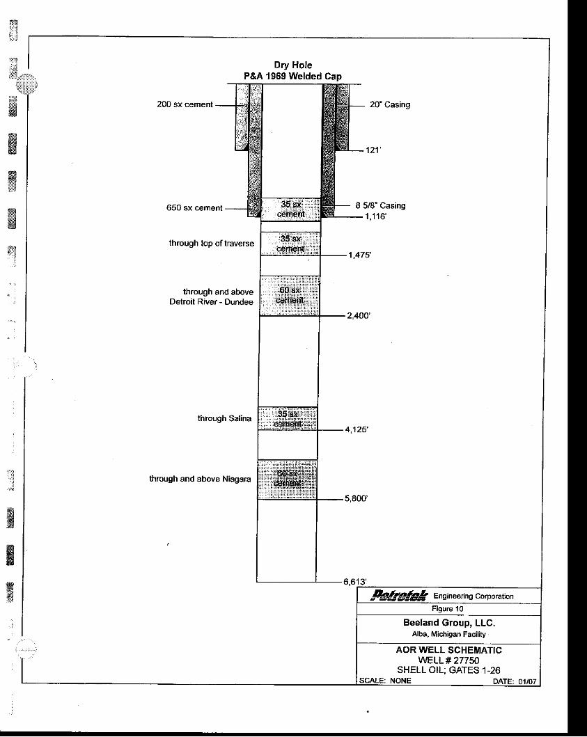
Dry HoleP&A 1969 Welded Cap,rr.r*-""rffirr;,"""-
uu'".""'""",ffi1x;3:",,throush rop ortrave,""
L$f ,,0,u,
through and above I og,sx,, ' fDetroit River- Dundee
J O-a* ., .l
ltthroushsarinaWf
.,r'
throush and above Niasara tffill
11..,,kgglgk Ensrneenns corporatrcn
Figure 10
Beeland Group, LLC,Alba, Michigan Facility
AOR WELL SCHEMATIGWELL# 27750
SHELL OIL: GATES 1-26SCALE: NONE DATE: 01/07
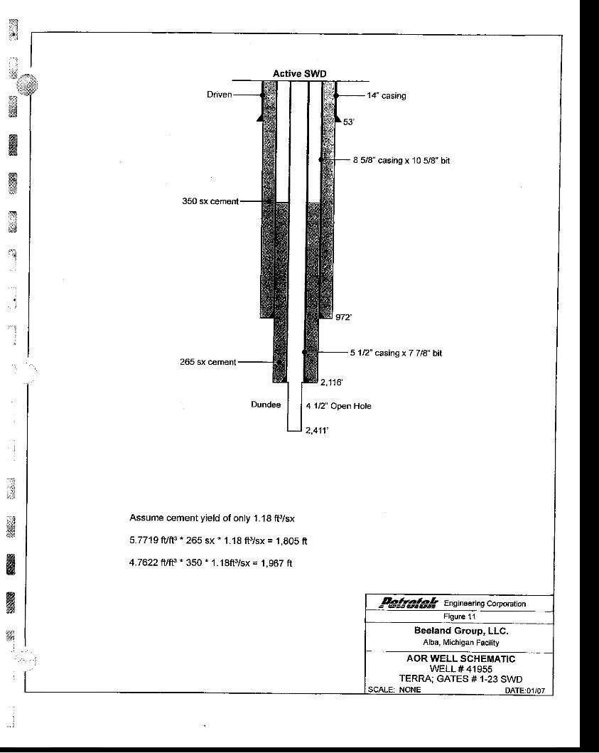
Itrrd
'1
$
ffiffix'1
i
.
.t::i
&ffi'#
;
Active SWD"ffi:: ,.,,,.
L1,,0,,,,
Assume cement yield of only 1.18 ff/sx
5.7719 fuft3 * 265 sx * 1 .'18 ff/sx = 1 ,805 fi
4.7622 frltts - 350 ' 1.18fi3/sx = 1,967 ft
-+gg!€g Ensrneerin g corporarionFigure 1'1
Beeland Group, LLC,Alba, Michigan Facility
AOR WELL SCHEMATIGWELL # 41955
TERRA; GATES # 1-23 SWDSCALE: NONE DATETO1/o7

tTr.*
:]:
"i
ii*
#
w@sga
*
'{
j
"
!. i
*
&
&
Active SWD
:W::-&ffi
12casnsx778b,"'-*'.-ru
ffi-
1p" casinsx77'"bi'I
, " , - : : , | ] ; ' -
&>*k Ensineerins corporationFigure 12
Beeland Group, LLC.Alba, Michigan Facility
AOR WELL SCHEMATICWELL#46244
TERRA; ESTELLE Dl-1SWDNONE DATE:01i07SCALE:
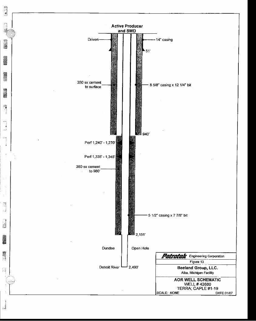
#ffiffiffi,rs
i
;
Active Producerand SWD
.,, ':;'-,,.,"m ffi-""-r--€
fu 1ncasnsx77,.bi,
Dundee | |
oo"" "o,"
tl gg@gk Engrneenns corporarion
Deimit River ! ,,oro'Figure 13
Beeland Group, LLC.Alba, Michigan F.cility
AOR WELL SGHEMATICWELL # 42680
TERRA; CAPLE #1-19NONE DATE:01/07SCALE:

m:.r.t:i:
#{ 'r{".
: ' . : ,*::11$'
:M@sffi$rJ
ry3.dffi
;l. . 1
r i
January 2oO7 BEELAND GROUP, LLC, MDEQ PERMIT ATTACHII/ENTS
8.7. A map showing the vertical and areal extent of surface watersand subsurface aquifers containing water with less than10,000-ppm total dissolved solids. A summary of the presentand potential future use of the waters must accompany themap.
Figure 3 (Section A.4) is a topographic map of the disposal well area, and showsthere to be no mappable surface water features. Absence of surface waterfeatures was verified through survey (Attachment A). Figure 9 (Section 8.3)presents the stratigraphic column underlying the Disposal Well area. TheMichigan Groundwater Atlas discusses aquifers present in Michigan (Olcott,1992). Data from this source indicates that the Beeland Site is underlain by thefresh water Glacial Till aquifer, Figure 14 at the end of this Section (8.7), butthere are no Cretaceous through Mississippian rocks present due to erosionalremoval of these units. The next water bearing interval below the Glacial Till isthe Siluro-Devonian units, but as shown on Figure 15 at the end of this Section(8.7), this unit exhibits TDS greater than 10,000 ppm in the Disposal Well area.
In Michigan, the Glacial Till and/or unconsolidated material is a source of freshwater for domestic, industrial, and agricultural purposes (Olcott, 1992). Based onavailable dala, this unit is anticipated to be the lowermost USDW. This will beconfirmed during installation of the proposed well.
;:r:a;i
$gw
l
;*
: ' -
t ' l
, l
36
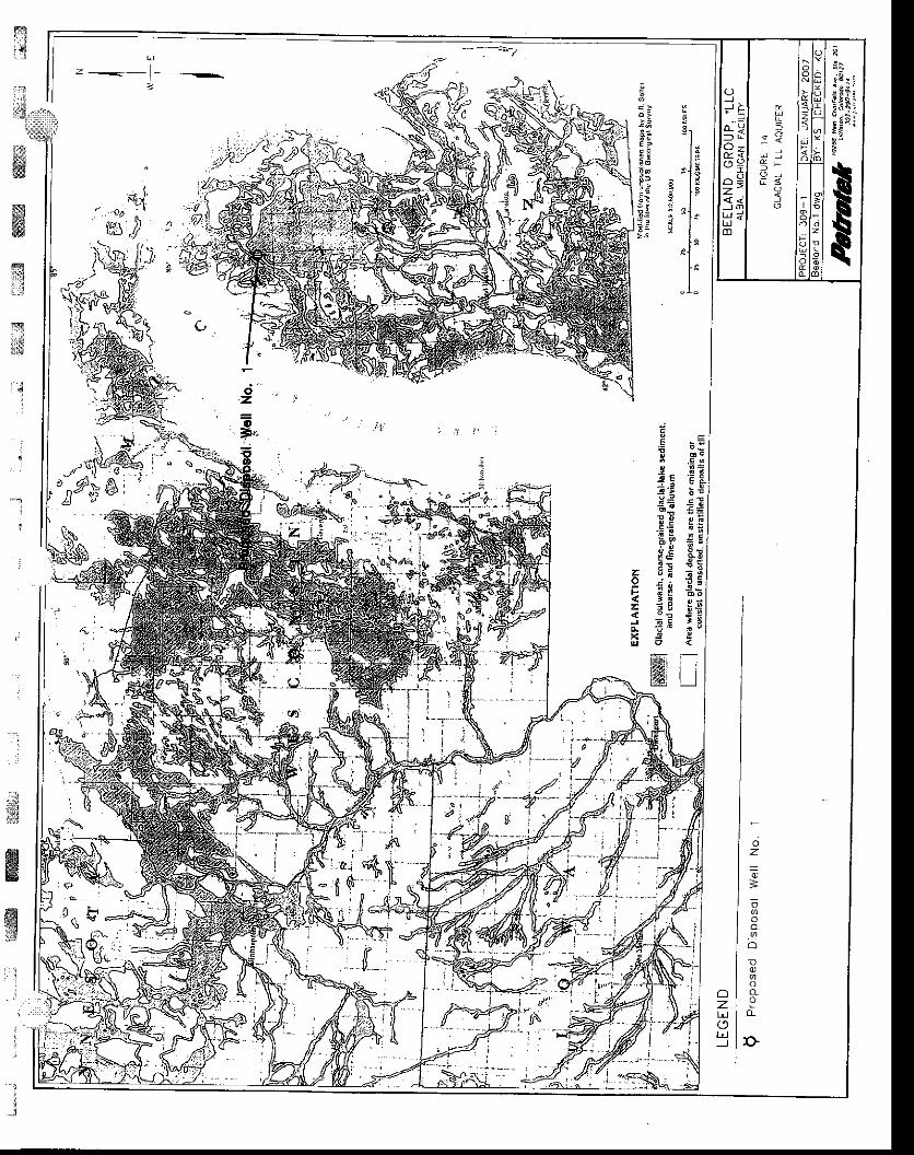
.!
d E t
; ; 1 8; . t l i
1 1 : 1 4F i . l :: i - q l c: i i Ix=! ; r'l -
t rII
" 1 -
;sE !
c g
! zicn 2! :2 6--! E' 6
g
i-lt ll l
zIg! E'".t! =
T q; s
flG
t r i5 ;; !
EE
6B
ozO
_)
' :
.;
'-u
sflf,ffiE
ffi, . !
' l
:
:.J
3
s.J".. oo i'\%)J
ffiffi:ifr' i
-:';'
F
z
oz
=
E
o.vlo
D
D
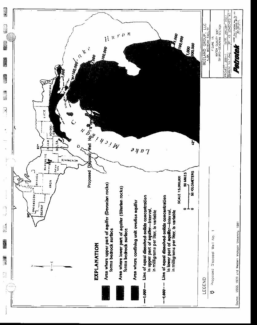
. , I t n1 1 l t t ' '
)
/
t
\
q
\C,n i*,-
1."/",AryD'I
g
tgfEIt
1.
- r.a
{T* *
c l-9rf i i l!c - c t
ETfFggrE '? >I J .sR;l xi3gta ttt r-
i:i3e55rar8Eo s .goc*!
II
Et'I
co
T9lxs$€EgEt€t$E Eg rsgFEos- !oq
J
I$I
.g
ii
d
.
.
rf.v)al
o
0
- l- - l
:
;1ffi&ffi
. ' : ozotrJ
"T- ' ' :
! r i
_ ; , - \: l'.,-
; I iE
cIto6I
tI
o
EaItcc
Ica,
'
E-
II
65
Hg
€EIa,ItirE t 9
r.Er iE-3
EZ9 a82t t s
:Eg
QJ
E5c36:|,,
e' lJ'
o8
FA
$$9 abt€ t
:Ea
rI
zoEE-JoxEI
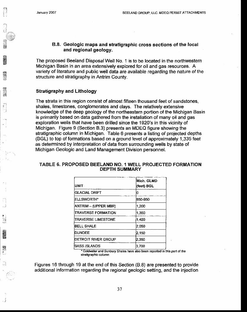
"' l
! t.",.,,.,..r : r : r : t l111i :
;ri:::lli!t':;.1;n
. :
January 2OO7 BEELAND GROUP, LLC, MDEQ PERMIT ATTACHMENTS
8.8. Geologic maps and stratigraphic cross sections of the localand regional geology.
The proposed Beeland Disposal Weil No. 1 is to be located in the northwesternMichigan Basin in an area extensively explored for oil and gas resources. Avariety of literature and public well data are available regarding the nature of thestructure and stratigraphy in Antrim County.
Stratigraphy and Lithology
The strata in this region consist of almost fifteen thousand feet of sandstones,shales, limestones, conglomerates and clays. The relatively extensiveknowledge of the deep geology of the northeastern portion of the Michigan Basinis primarily based on data gathered from the installation of many oil and gasexploration wells that have been drilled since the 1920's in this vicinity ofMichigan. Figure 9 (Section 8.3) presents an MDEQ figure showing thestratigraphic column in Michigan. Table 6 presents a listing of projected depths(BGL) to top of formations based on a ground level of approximately 1,335 feetas determined by interpretation of data from surrounding wells by state ofMichigan Geologic and Land Management Division personnel.
rABLE 6. PRoPoSED "==btH?J3uiriltfti
pRoJEcrED FoRMAfloN
UNITluich. GLMD(feet) BGL
GLACIAL DRIFT J
ELLSWORTH' 950-950
\NTRIM _ (UPPER MBR) 1,200
TRAVERSE FORMATION 1,350
TRAVERSE LIMESTONE 1,400
BELL SHALE 2,050
DUNDEE 2,150
DETROIT RIVER GROUP 2,350
BASS ISLANDS 3,700and Sunbury Shales have also been repo.ted in this part of the
stratigraphic column
Figures 1 6 through 19 at the end of this Section (8.8) are presented to provideadditional information regarding the regional geologic setting, and the injection
ttl:i-,.)
ffi'.
) t
fi]]!{
' f ' )
il, Jw
January 2007 AEETAND GROUP, LLC, MDEQ PERMIT ATTACHMENTS
and arrestment intervals. Figures 20 and 21 at the end of this Section (B.8)present local cross-sections to the base ofthe proposed injection interval basedon data from the MDEQ well database- An index of these cross-sectionorientations is presented in Figure 6 (Section A.4). From the base of the injectionzone upward, the following major intervals are anticipated to be penetrated at theProoosed Beeland Well No. 1 location:
Detroit River Group (lower injection and arrestment)
It has been cuslomary to include the Devonian-age Bois Blanc, Sylvania,Amherstburg, Lucas and Anderdon Formations in the Detroit River Group. Thebase of the openhole completion of the Beeland Well No. 1 will be completedwithin the Detroit River Group above the top of the Amherstburg Formation. TheAmherstburg is typically a dark brown to black carbonaceous limestone. lt ispoorly bedded, dense and may be up to 200 feet thick in the vicinity of theproposed well. Where dominated by limestone, it is an aquiclude and typicallyhas low effective porosities and permeability. General practice has been to callihe portion of the column between the top of the Amherstburg and the base ofthe Dundee Limestone the "Detroit Rivef although it is also known as the Lucasand/or Anderdon Formations to the east of the site and includes a wide variety oflithologies and several distinct members. For example, the Richfield Zone hasbeen described as a basal member of the Lucas/Detroit River sequence and iscomprised of interbedded limestone dolomite and anhydrite. Above the Richfieldis the Massive Anhydrite that is, in turn, overlain by a thick halite-bearingevaporite sequence, the Horner Member of the Lucas Formation. In the vicinityof the Beeland well, the Horner Member likely consists of a series of limestoneand anhydrite layers with limited dolomite stringers. The dolomite stringers canhave low, but measurable permeability, but the majority of the interval that iscomprised of limestone, anhydrite and halite serves as an excellent confiningunit. The top of the Detroit River can be difficult to determine both on logs and insamples. In the local vicinity of the Beeland Well No. 1 area, the unitsimmedialely below the Dundee (i.e. upper Detroit River of Lucas) have beendescribed as light to dark brown limestones and dolomites that are microcryslalline to very finely crystalline with traces of intercrystalline porosity.
Dundee Limestone (iniection interval)The Devonian age Dundee is predominately a carbonate section ranging fromdense, fine-grained, light colored limestones on the east side of the state tocoarse-textured bioclastic limestone (with portions secondarily dolomitized) in thecentral part of the state. The top of the Dundee is easily picked on geophysicallogs in the area of the proposed well because the Bell Shale is present. In thevicinity of the Proposed WDW Beeland Well No. 1, the Dundee has beenreported as a predominantly limestone formation that ranges from a light to darkbrown with a basal dolomite section. Figures 16 and 17 at the end of this Seciionpresent regional Dundee information.
ffiffiryKJ
,
a!
.,,)
:
i.r*itrffi
&&
wiit
i . , t . . r .
' ::,..". ' .!
38

i'li
t ' :
''..ll'.l..i:t:t:r
l::i
w
w)SX{t
@ffi
t*
'j
, :
. :
l
€ew
1
January 2OO7 BEELAND GROUP, LLC. MDEO PERMIT ATTACHMENTS
Bell Shale (arrestment interval)The Devonian age Bell Shale is typically a soft, gray, gummy and silty shalecontaining scattered fossil fragments. In the local vicinity, the Bell Shale isprojected to be comprised of almost 75 to 100 feet of medium green to green-gray shale overlain by a sequence that transitions to a limestone and dolomitedominated sequence. Transmissive fractures are not known to be present in thisshale.
Traverse Group
The Traverse Group occurs above the Bell shale, and includes what is locallydescribed as the Traverse Limestone and Traverse Formation. Figures 18 and19 present regional Traverse information. Both formations are described below.
Traverse LimestoneIn the western part of the State, the Devonian-age Traverse Limestone isdominantly gray to gray-grown limestone with lesser gray shales. A fewanhydrite stringers may also be present. To the east, the Traverse Limestonebecomes increasingly shaley, and in southeastern Michigan the unit is composedalmost entirely of shale. The Traverse Limestone is a poor marker both on logsand in samples. In the vicinity of the proposed Beeland Well No.1 , the TraverseLimestone is described as a thin buff to brown, medium to very finely crystallinelayer that overlies a 350-foot plus clean, thick tan to brown very fine tomicrocrystalline limestone with a trace crystalline porosity and trace of pyrite.
Traverse FormationAbove the Traverse Limestone is the Traverse Formation, which is comprised ofa 50-foot thick interbedded limestone and shale that is described as gray-tan andcalcareous. Within the Traverse Formation there exist limestone stringers thatmay make picking the underling Traverse Limestone difficult, and the TraverseFormation is also sometimes interbedded with the overlying Antrim shale.
Antrim ShaleThe Devonian age Antrim Shale is typically a black to brown, briftle, platy shale.It is characterized by high radioactivity and is easily recognized on gamma raylogs, and can be identified on electric logs by its unusually high resistivity. tn thesoutheastern part of the state, several large tongues or interbeds of gray shaleare present in the middle part of the Antrim. Locally, near the proposed BeelandWell No. 1 location, the Antrim (sometimes referred to as the Ankim-Dark) isgray-brown to gray-green and blocky, with both silt interbeds and significantlimestone interbeds. The upper member of the Antrim is reported as a 1O0-footplus thick blocky gray-brown shale, pyritic, with scattered tasmanites.
39
ffi*d
ffisl
tr$$
;:
.
'Tt iil
i"rll.,,,,lr
ijiu:,:llril
M
t:i
_ . i ' i . . ._, .
January 2OO7 BEELAND GROUP. LLC. MDEO PERMIT ATTACHMENTS
Devonian-Mississippian ShalesLocal geologic data suggest that a shale sequence occurs between the tops ofthe Antrim and base of the Glacial Drift. Available geologic data indicate that theEllsworth (Bedford) shale is likely present immediately above the Antrim, andsuggest that the Ellsworth may either extend to the Glacial Drift, or may becapped by the Coldwater/Sunbury Shales. Both the Ellsworth andColdwater/Sunbury are described below, noting that regardless of nomenclature,both units are predominantly shale and provide additional confinement betweenthe Dundee Formation and Glacial till.
Ellsworth (Bedford)The Devonian Ellsworth is a greenish-gray shale that occurs in the westernportion of the state. The Bedford shale occurs in the eastern portion of the state,and may inter-tongue with the Ellsworth Shale in the vicinity of Alba several milesfrom the proposed Beeland Well No. 1 location. The Bedford is a gray shaleimmediately overlying the radioactive Antrim shale in the eastern half of thebasin. The Bedford has a fairly uniform, moderate shale response on gamma raycurves. Although the Bedford is listed here under the Devonian, it may well be ofMississippian age.
Coldwater and Sunburv ShalesThe Mississippian age Sunbury and Coldwater shales are described as twodistinct intervals. The Coldwater is locally an interbedded light to medium grayfirm, flaky and platy shale with a trace of pyrite and a brown very finely crystallineargillaceous limestone at its base in the vicinity. The deeper Sunbury, wherepresent in the vicinity of the proposed Beeland Well No. 1 location, is likely to bea dark brown firm, brittle, carbonaceous shale with a trace of fluorescence.
Faulting
There is no evidence of significant faulting in the immediate vicinity of theProposed Beeland Well No. 1. The Hydrogeologic Atlas of Michigan (Plate 16) isreferenced regarding this matter. Additionally, Ryder (1996) constructed astructure contour map on the Traverse in Antrim County. This map showed thereto be no mappable faults transecting the Traverse at the proposed well location.
Seismic Activity
The Alba area of northwestern Michigan Basin has been designated as arelatively minor seismic risk area by the USGS as presented at the website:http://earthquake.usqs.qov/reoional/states/michigan/hazards.php. The proposedarea has a peak acceleration of 0-2 percent g, and no earthquakes have beenidentified in the Alba area over the past 100 years. A category Vl earthquake
i.':
i*
ffiffifi
i40
t$t:!s
ffiffi"rlln.
i . . ,:,$wffiffi
ffi{dt
x;uj*.tl,]
j
:
,ll:..J
..im
ffiffi*6
H
January 2007 BEELAND GROUP, LLC. MDEQ PERMIT ATTACHMENTS
occurred in southern Michigan in 1g47, but USGS data do not suggest that thisevent was felt north of Cadillac, Michigan.
References:Ryder, Robert T, Fracture Pafterns and their Origin in the Upper Devonian AntrimShale Gas Reservoir of the Michigan Basin: a Review, USGS Open File Report96-23, 1996.
Ground Water Atlas of the United States, lowa, Michigan, Minnesota, Wisconsin,USGS Document HA 730J, Perry G. Olcoft, 1992
41
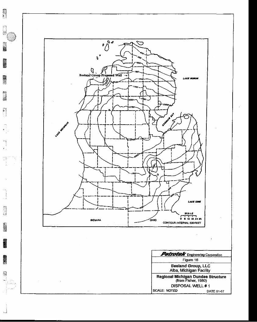
j"l
lli i,i1\ii*ljf
:
::::
;i
tittw6&
Gg*s
ii;. . :
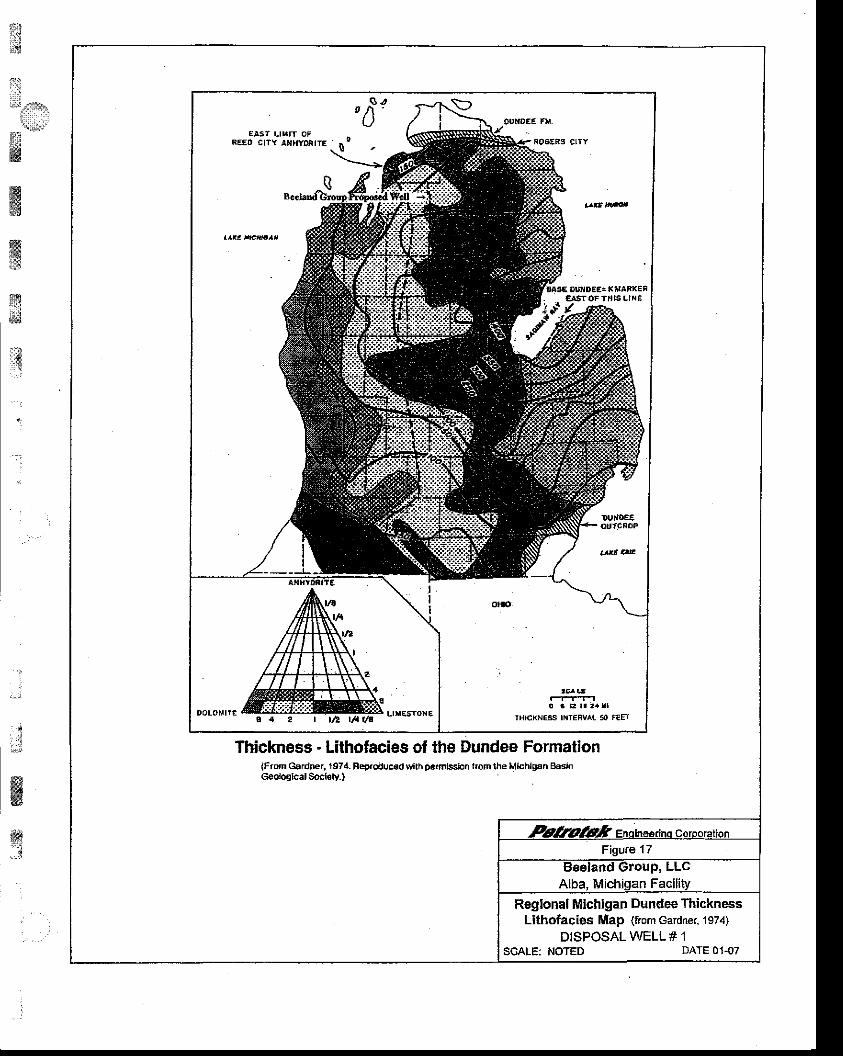
u:*
IJ:1,*gr
_i;,.ffiffiffi
ffi...'i
ry,*
r.$
t.
.
i'l rl
ffiffitgd
!1i*ai, !
Thickness - Lilhofacies ol the Dundee Formation(From Gardner, 1974. Feproduccd \tlth pe.mlBsion Irom the Mlchl!€n BaeinGoological socl€ly.)
Regional Michigan Dundee ThicknessLithofacies Map (from Gadner, 1s74)
DISPOSAL WELL # 1SCALE: NOTED DATE 0'l-07
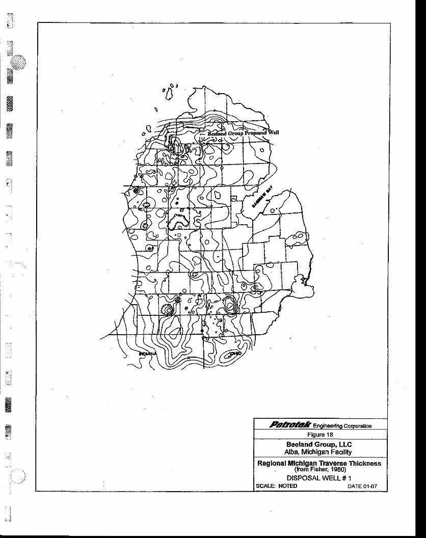
:li..i
ilI1 i
ffiffi
ffiffiffi. . .
" .
- :
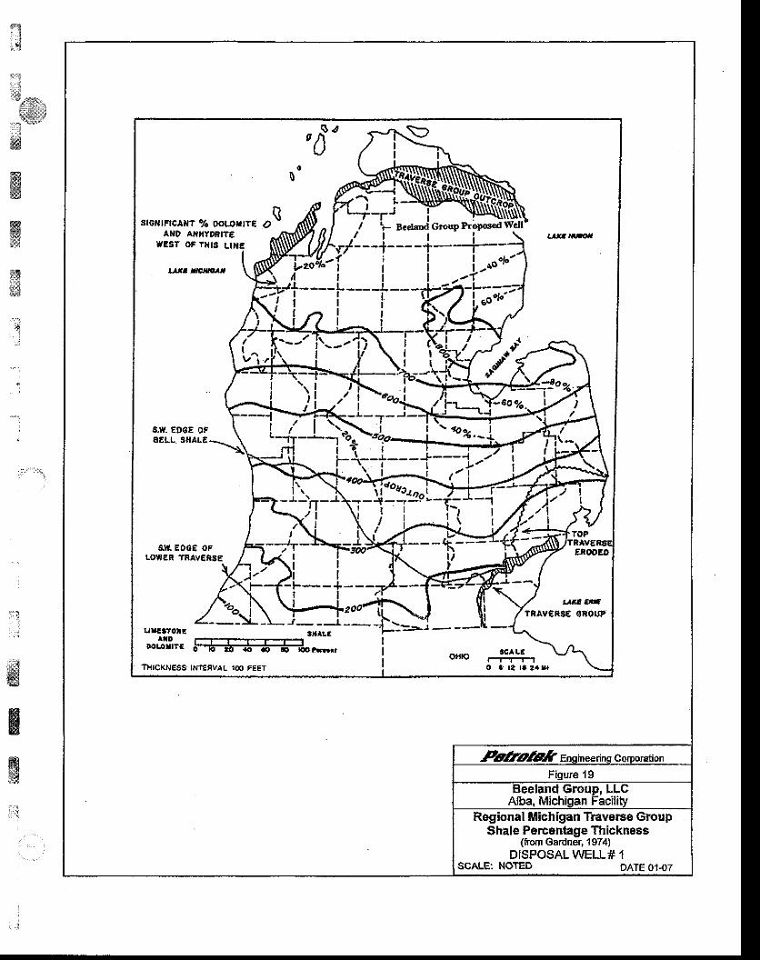
t;
:jli*
ffilie,d*ffi
@slg
gs1i3&$
I
. " :
:r1
,:.iffi
EIg
wRegional Michigan TEvsi66 Group
thale Percenhge Thickness(tofi Gardrer, 1974)
DISPOSALWELL# 1SCALE: NOTED DATE 0147
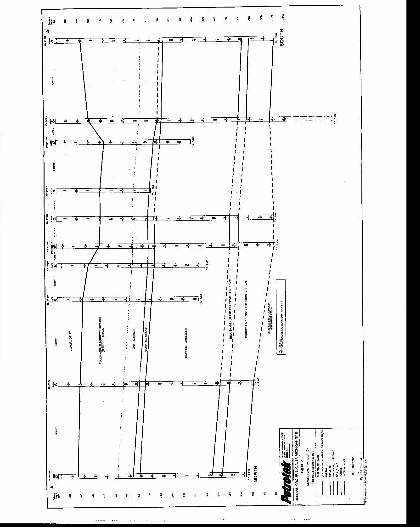
t i{
a *
I
55Ei ;EZ
I
1 4 "
qti:; q - bT E
s=I
9
5
t
3 fr O
! iI : !3 i , ;
!iil
IIIII
ItI
1fr
x k- z
E
cz
I
III ,r 5
t 7r ; rl s lI R l
e l
t l
6
a
El
TII
EEj
3
Ii
jie ilrq t
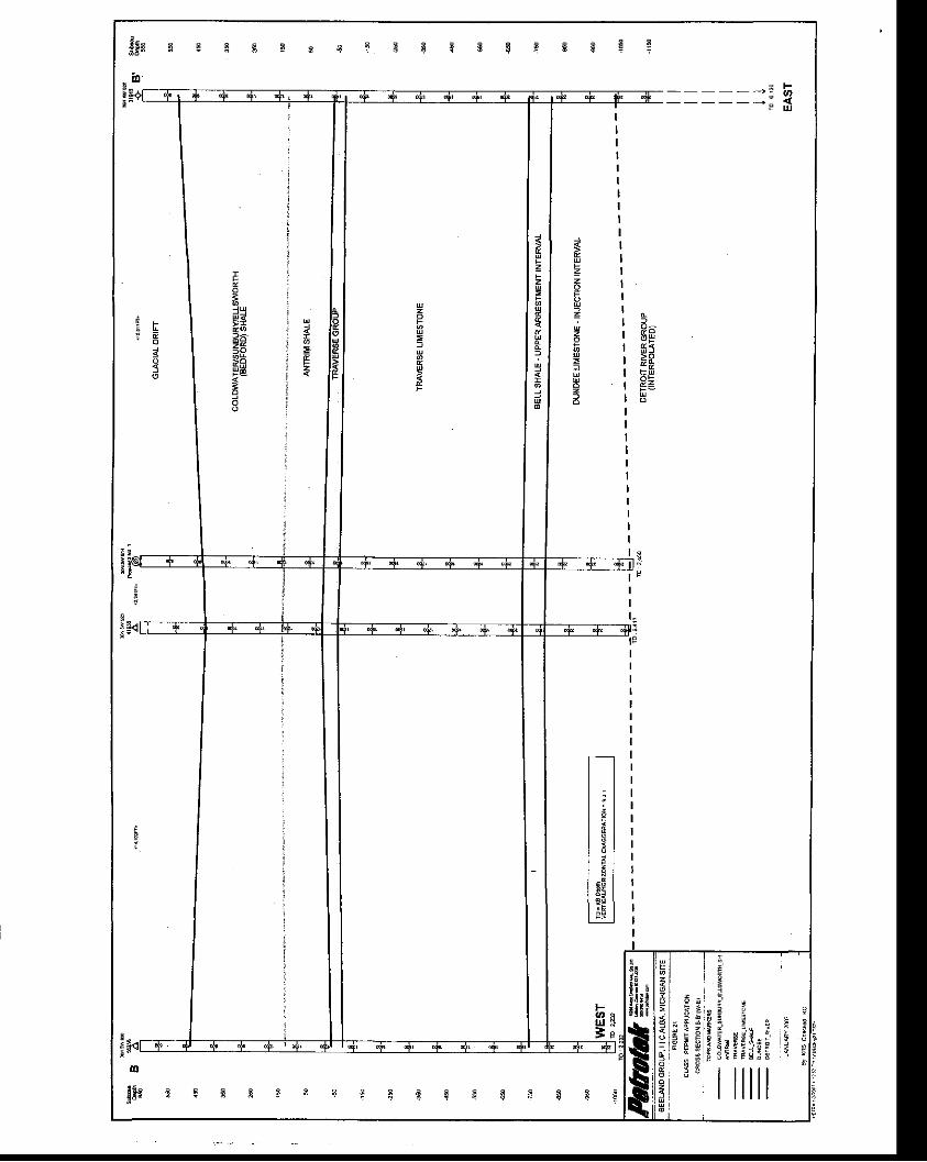
: <
Jpb
o
13"
P6
&z
iIt,:
i::S ,,,,.,
l:t:r:ul:J
;,dffi
January 2007 BEELAND GROUP. LLC. MDEQ PERMIT ATTACHMENTS
El.9. Chemical, physical and bacteriological characterizations of thewaste stream before and after treatment and/or filtration.lnclude a characterization of the compatibility of the injectatewith the injection zone and the fluid in the iniection zone alongwith a characterization of the potential for multiple wastestreams to react in the well bore or in the injection zone.
Injectate Characteristics
The proposed injectate is non-hazardous waste from a groundwater remediationproject that will be brought to the Alba, Michigan facility from a single remediationproject/area. Fluid from the remediation project will be sampled on a quarterlybasis as specified in the attached Waste Analysis Plan (see Attachment B).Typical injectate composition for the remediation project fluids with regard tochemical and physical characteristics is presented in Tables 7Aand78.Historically, fluids from this remediation project have been managed as non-hazardous via both injection into an offsite non-hazaldous disposal well andsurface discharge through a POTW after treatment. Fluids typically havecontained various levels of total dissolved solids and are expected to range from2,500 mg/l to 25,000 mg/|. As noted in the following tables, only limitedsuspended solids have historically been encountered. Specific gravity isexpected to range from 1.00 to 1.05, and pH is typically expected to range fromapproximately 7.0 to 10.0.
'- .l
ffiffiffi&
il' 'a
- - l
t :
ffigf
42

ffitw
:::'#r:,,,.
i3!iP'wffiffi
tr, :
trt*
January 2007 BEETAND GROUP, LLC, MDEQ PERMITATTACHMENTS
TABLE 7A EXAMPLE ANALYSIS OF INJECTATE FROM BAY HARBOR,MICHIGAN REMEDIATION. 2OO4
,t
"11
,:i'
wffiw1,i1
Parameter Units Results Method Date AnalystOxidation ReductionPotential MV 296 Field 9t28t2004 EBPH s-u- 7.42 Field 9t28t2004 EBfemperature "c 19.1 Field 9t28t2004 EB
Alkalinity-Phenolphthalein mg/L U 310.1 w30no04 REGAlkalinity-Total mg/L 1,620 310.1 9t30t2004 REG
Carbonate Alkalinity mg/L 0 Calc. 9t30t2004 REG
Bicarbonate Alkalinity mg/L 1,620 Calc. 9t30t20u REGHydroxide Alkalinity mglL 0 Calc. 9t3012004 REG
fotal Organic Carbon mg/L 260 415.1 10t5t2004 BA
fotal lnorganic Carbon mg/L 88 415.1 10t5t2004 BA
Total Dissolved Solids mg/L 32,800 160.1 9t25t2004 REG
fotal Suspended Solids mg/L 123 160.2 9t29t2004 REG
Biochemical Oxygen mg/L 405.1 10t8t2004 D t a
Ohemical Oxvqen Demand mg/L 992 410.1 9t30t2004 REG
fotal Phosohorus mg/L 1-4 365.2 9t30t2004 REGPhosohate. Orhto mg/L <1 300 9n9no04 DMJ
Niirate-N itrogen mg/L 0.97 300 9t29t2004 DMJ
Nitrite-Nitroqen mg/L o.74 300 9n9t2004 DMJ
Ammonia-N itrogen mg/L 8.5 350.1 1U1nO04 BEKfotal Kjeldahl Nitrogen mg/L 29 351.2 10t1t2004 BA
Aluminum mg/L 19.8 6020 10t3t2004 EB
Antimony mg/L < 0.05 6020 10t3t20M EB
Arsenic mg/L 0.237 6020 101312004 EB
Barium mg/L 0.017 6020 10t312004 EBBeryllium mg/L < 0.005 6020 10t3t2004 EB
Cadmium mg/L < 0.001 6020 10t3t2004 EB
Chromium. Total mglL 0.029 6020 10t3t2004 EB
Cobalt mg/L < 0 .015 6020 10t3t2004 EB
Copper mg/L 0.024 6020 10t3t2004 EB
ron mg/L 1.42 6020 10t3t2004 EB
Lead mgil < 0 .001 6020 10t3t2004 EB
43

BEELAND GROUP, LLC. MDEQ PERMIT ATTACHMENTSJanuary 2OO7
{:lti1;rj
i''li i
a
smffi
Hts$i!ts
g*&d
;.i' :J
' ,
a
' :
a*,3d*3
trbggE
ffis,"
Parameter Units Results Method Date Analyst
Meisury mg/L 0.0008 245.1 10t20t2004 MeritlVlanganese mg/L 0.088 6020 10t3t2004 EBNickel mg/L 0.223 6020 10t3t2004 EBSelenium mg/L 0.063 6020 10Bnoo4 EBSilver mg/L 0.0005 6020 10t3t2004 EBStrontium mg/L 0.034 6020 10t3t2004 EBZinc mg/L 0.019 6020 10t3t20u EB
Silica, Reactive as SiO2 mg/L 16.8 370.1 10t4t2004 REGfotal Silicon as SiO2 mg/L 66.3 6020 10t2t2004 EB
Salcium mg/L 12.1 6020 10t3t2004 EBNilagnesium mg/L < 0.5 6020 1U32OO4 EBPotassium mglL 13.800 6020 10t3t20u EBSodium mg/L 889 6020 10t3t20w EB
Bromide mg/L 15.2 300 9t29t2004 DMJhloride mg/L 1,730 300 9t29t2004 DMJ
Fluoride mg/L 18.1 300 912912004 DMJSulfide ms/L 1.29 376.2 't0t5t2004 MeritSulfate mg/L 14,500 300 9t29t2004 DMJ
44
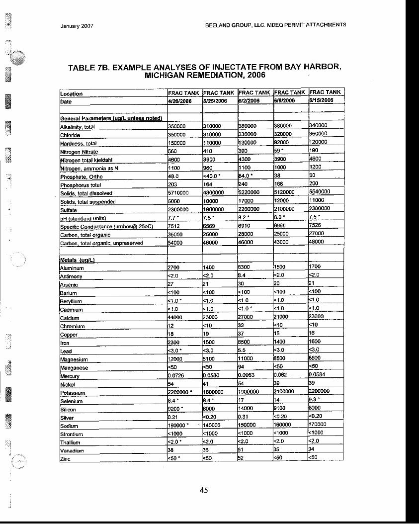
Jan\ary 2Oo7 BEELAND GROUP, LLC. MDEQ PERMIT ATTACHMENTS
TABLE 78, EXAMPLE ANALYSES OF INJECTATE FROM BAY HARBOR,MICHIGAN REMEDIATION. 2006
j
l:;!-***.
tiitllta!#
ffi@igd::}
x{x
1.
.t '
: : l
ja:.8l:i.:
dnmww:3
: l l j
t - - - : :
Location FRAC TANK FRAC TANK FRAC TANK FRAC TANK FRAC TANK
Date 4t26t2006 ,n 2006 irzt2006 i/9/2006 ifi 512006
General Paramete6 [uqrL unless notedl350000 tl0000 ,80000 t80000 140000
Chloride 350000 310000 ]30000 320000 150000
{ardness. total 50000 10000 30000 12000 20000
Nitrogen Nitraie f10 i90 5 9 "
Nitroqen total kieldahl 4600 t900 4300 1900 4600
Nitroqen. ammonia as N 100 160 100 1000 1200
Phosphate, Odho {8.0 <40.0 ' u .o , 38 i0
PhosDhorus total 203 t64 740 t68 200
Solids. totaldissotued 5710000 4800000 i220000 5120000 i540000
Solids. total susDended ifi)o t 0000 7000 r2000 1000
Sulfate 2300000 9t)0000 2200000 2r 00000 2300000
)H (standard units) t_7" 7.5 " 3.2 " t . 5 '
Speciflc conductance (umhos@ 25oC) t512 i569 i 910
larbon, totalorganac 15000 !5000 28000 t5000 27000
larbon. total orqanic, unpreserved i4000 46000 46000 t3000 t8000
Metals auo/Ll
4luminum 2700 t400 i300 | 500 t700
Antimonv <2.0 <2-0 ,.4 <2.O <2.0
Arsenic 27 21 t0 20
Barium <100 < 1 0 0 <100 < 100 <100
Bervllium <1 .0 <1 .0 <1_0
Sadmium <1 ,0 <1 .0 < 1 . 0 - <1 .0 <1.0
Calcium 44000 23000 27000 21000 23000
lhromium <'10 ,2 <10 <10
Copper I E t o t7 ! 6 I 6
ron !300 | 500 1500 t400 t600
-ead <3.0 ' <3.0 t.5 <3.0 <3.0
\raqnesium t2000 3100 | 1000 3500 1500
lilanqaoese <50 <50 t4 <50 <50
\rercury ).0726 )_0580 t.0963 J.062 1.0584
!ickel i4 A 39 l9)otassium 2200000 " 1800000 900000 2100000 ?200000
Selenium 1.4 * 3-,t * 9_3 '
Silicon 1200 ' t000 4000 ,100 t000
Silver <o.20 ).31 <0.20 <o.20
iodium | 90000 * 40000 | 50000 160000 t70000
Strontium 1000 <1000 <1000 <1(X)0 <1000
fha ium < 2 . O ' <2_0 <2.O <2_O .2.O
Vanadium 1 A
Zinc <50 ' <50 <50
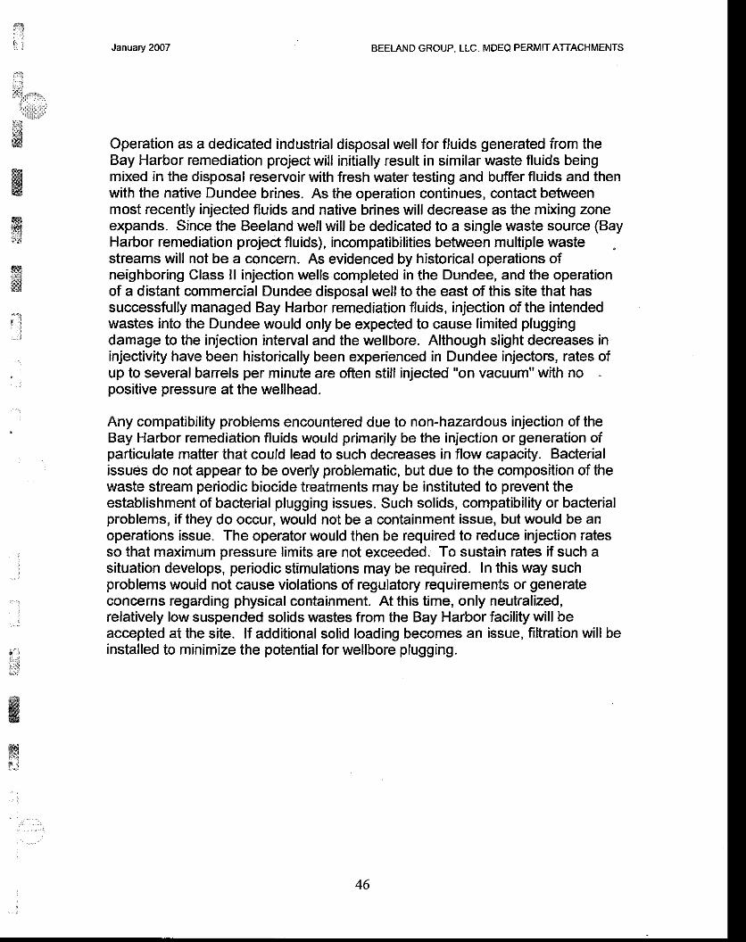
ry!, j
il:
tiT,{3r.,i1i:li;r:iffi!j*w
ffiwrli{ia
@$$
:l
:
- . :
, : t
t,{i;:ll
,$$
ffis
m?:,
January 2OO7 BEELAND GROUP, LLC. MDEQ PERMIT ATTACHMENTS
Operation as a dedicated industrial disposal well for fluids generated from theBay Harbor remediation project will initially result in similar waste fluids beingmixed in the disposal reservoir with fresh water testing and buffer fluids and thenwith the native Dundee brines. As the operation continues, contact betweenmost recently injected fluids and native brines will decrease as the mixing zoneexpands. Since the Beeland well will be dedicated to a single waste source (BayHarbor remediation projeit fluids), incompatibilities between mulliple wastestreams will not be a concern. As evidenced by historical operations ofneighboring Class ll injection wells completed in the Dundee, and the operationof a distant commercial Dundee disposal well to the east of this site that hassuccessfully managed Bay Harbor remediation fluids, injection of the intendedwastes into the Dundee would only be expected to cause limited pluggingdamage to the injection interval and the wellbore. Although slight decreases ininjectivity have been historically been experienced in Dundee injectors, rates ofup to several barrels per minute are often still injected "on vacuum" with nopositive pressure at the wellhead.
Any compatibility problems encountered due to non-hazardous injection of theBay Harbor remediation fluids would primarily be the injection or generation ofparticulate mafter that could lead to such decreases in flow capacity. Bacterialissues do not appear to be overly problematic, but due to the composition of thewaste slream periodic biocide treatments may be instituted to prevent theestablishment of bacterial plugging issues. Such solids, compatibility or bacterialproblems, if they do occur, would not be a containment issue, but would be anoperations issue. The operator would then be required lo reduce injection ratesso that maximum pressure limits are not exceeded. To sustain rates if such asituation develops, periodic stimulations may be required. In this way suchproblems would not cause violations of regulatory requirements or generateconcerns regarding physical containment. At this time, only neutralized,relatively low suspended solids wastes from the Bay Harbor facility will beaccepted at the site. lf addiiional solid loading becomes an issue, filtration will beinstalled to minimize the potential for wellbore plugging.
46
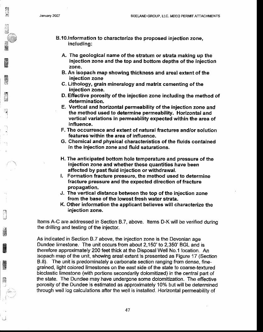
rui.,.j
i;lit.cn::
,,lidlllkl*lw
ffiffi*
t;
January 2007 BEELAND GROUP, LLC. MDEQ PERMIT ATTACHIUENTS
B.lO.lnformation to characterize the proposed injection zone,including:
A. The geological name of the stratum or strata making up theinjection zone and the top and bottom depths ofthe injectionzone.
B. An isopach map showing thickness and areal extent of theinjection zone
C. Lithology, grain mineralogy and matrix cementing of theinjection zone.
D. Effective porosity of the injection zone including the method ofdetermination.
E. Vertical and horizontal permeability of the injection zone andthe method used to determine permeability. Horizontal andvertical variations in permeability expected within the area ofinfluence,
F. The occurrence and extent of natural fractures and/or solutionfeatures within the area of influence.
G. Ghemical and physical characteristics of the fluids containedin the injection zone and fluid saturations.
H. The anticipated bottom hole temperature and pressure of theinjection zone and whether these quantities have beenaffected by past fluid injection or withdrawal.
L Formation fracture pressure, the method used to determinefracture pressure and the expected direction of fracturepropagation,
J, The vertical distance between the top of the injection zonefrom the base of the lowest fresh water strata.
K. Other information the applicant believes will characterize theinjection zone.
Items A-C are addressed in Section 8.7, above. ltems D-K will be verified duringthe drilling and testing of the injector.
As indicated in Section 8.7 above, the injection zone is the Devonian ageDundee limestone. The unit occurs from about 2,150'to 2,350' BGL and istherefore approximately 200 feet thick at the Disposal Well No.1 location. Anisopach map of the unit, showing areal extent is presented as Figure'17 (Section8.8). The unit is predominately a carbonate section ranging from dense, fine-grained, light colored limestones on the east side of the state to coarse-texturedbioclastic limestone (with portions secondarily dolomitized) in the central part ofthe state. The Dundee may have undergone some dolomitization. The effectiveporosity of the Dundee is estimated as approximately 10% but will be determinedthrough well log calculations afier the well is installed. Horizontal permeability of
' t
:J
;Bffi
rEs
w&;F
*t,tril
47
$&$
rx'Se$.,
s* -"'
ffi
January 2OO7 BEELAND GROUP, LLC. MDEQ PERMIT ATTACHMENTS
the injection interval is esiimated as approximatelyl Darcy, and verticalpermeability is unknown. The occurrence and extent of fracturing specific to theDisposal well location will be assessed through drilling and wireline logging of thehole. Likewise, formation fluid information will be obtained through samplingand analysis atthe time of drilling, although the unit is expected to exhibit a TDSof much grealer than 10,000 ppm (see Figure 15, which is from the MichiganGroundwater Atlas). The anticipated downhole temperature is estimated asapproximately 77" F based on a temperature of 45"F belowthe seasonal effectand a temperature gradient of 1.5" F/100 feet of depth; downhole temperaturewill be verified after drilling. Formation fracture pressure is estimated as aminimumof 1,259psi at2,150feetBGL. SeeSection 8.11 for addit ionalinformation. The top of the injection zone is over 1 ,000 feet below the base of thelowest fresh water aquifer; the top of the Dundee is projected to occur at about2,150ft BGS, while the base of the lowermost aquifer is projected to occur about900 feet BGS (Glacial Till aquifer).
ffiffii:il
?R:*E'S
',.q
:.J
:a;l'#
ffi
ffi
wirl
48
$, rt i
q.,llli:,1.,.:tttt]:,:
i*i&ffiffigE
ffit:
?\]j.]ti#
t ' l
' i
:
#ffiw
*itr
January 2007 BEELAND GROUP, LLC. IUDEO PERMIT ATTACHMENTS
B.l l.lnformation to characterize the proposed confining zone,ineluding:
A. The geological name of the stratum or strata making up theconfining zone and the top and bottom depths of the confiningzone.B. An isopach map showing thickness and areal extent of theconfining zoneG. Lithology, grain mineralogy and matrix cementing of theconfining zone,D. Effective porosity of the confining zone including the methodof determination.E. Vertical and horizontal permeability of the confining zone andthe method used to determine permeability. Horizontal andvertical variations in permeability expected wiihin the area ofinfluence.F. The occurrence and extent of natural fractures and/or solutionfeatures within the area of influence.G. Chemical and physical characteristics of the fluids containedin the confining zone and fluid saturations.H. Formation fracture pressure, the method used to determinefracture pressure and the expected direction of fracturepropagation.l. The vertical distance between the top of the confining zonefrom the base of the lowest fresh water strata,J. Other information the applicant believes will characterize theconfining zone.
Items A-C are addressed in Section B.7, above. ltems D-J will be verifiedthrough drilling. The confining zone includes all rock units from the Antrim tothe top of the Dundee, including the base of the Antrim Shale, TraverseGroup, Traverse Limestone, and Bell Shale. Lithologic characteristics ofthese units are described in section B.7, above. Effective porosities of eachzone are estimated as between 2 and 2oo/o. The vertical and horizontalpermeability of the confining zone is estimated as being substantially lessthan 0.1 md. Formations included as part of the confining zone are expectedto be laterally continuous in the Disposal Well No. 1 area, and are notexpected to exhibit extreme variatt'ons in effective permeability within the areaof influence. The occurrence and extent of natural fractures and/or solutionfeatures within ihe area of influence will be assessed through wireline loggingduring drilling. The vertical distance between the top of the confining zone tothe base of the lowest fresh water strata is about 300 feet.
l;'.;: ..,:
49
ffi: - l' l
; . - l
:il;
January 2007 BEELAND GROUP. LLC. MDEO PERMIT ATTACHMENTS
B.l2.lnformation demonstrating injection of liquids into theproposed zone will not exceed the fracture pressure gradientand information showing injection into the proposed geologicalstrata will not initiate fractures through the confining zone-Information showing the anticipated dispersion, diffusionand/or displacement of iniected fluids and behavior of transientpressure gradients in the injection zone during and followinginjection.
Maximum Injection Pressure
The well has been designed for operation on a vacuum or with a small injectionpump. lt is probable that no injection pump will be required to dispose of desiredvolumes of fluid. However, a pump may be installed to increase capacity ifnecessary. Although no site specific data are available, Region 5 Guidanceincludes a value of 0.8 psi for the fracture gradient of the Dundee Limestone. lfinjection fluid is assumed to be comprised of a brine with a maximum specificgravity of 1 .15 that fills the tubing from the surface to a depth of 2,1 50 feet, amaximum allowable wellhead injection pressure of 649 psi is calculated based onthis Region 5 assigned gradient. No allowances for tubing friction are included inthis calculation. Note that the average specific gravity is expected to be in the1.01 to 1.05 range.
Based on a calculated wellhead fracture pressure value of 648 psi (assuming amaximum continuous specific gravity of 1.15), it is requested that a maximumwellhead injection pressure of 150 psi be authorized for future injection activitieswithout additional testing.
Estimates of general conditions have been used with Eaton's formula to preparea worst-case estimate of fracture pressure. This formula is widely referencedand discussion can be found regarding the formulation on page 291 of "AppliedDrilling Engineering," Bourgoyne, A.T. et al, SPE, 1991 . The pressure (Px)necessary to initiate a fracture is given as:
P t = P , + o - ' n
where: P,. is reservoir pore pressure (752 psi at 2,150 f,eet BGL) and o'1n ishorizontal matrix stress defined as:
omin = o/(l-u) (+o.b - P' )
where: u = Poisson's ratio estimated as 0.3 a limestone in-situ and 6ob estimatedas depth times a minimum overburden gradient of 0.9 psi/ft. Historically, anoverburden gradient of 1.0 psift has been applied for oil and gas reservoirs onland (Bourgoyne, et al, 1991). Work by Eaton ('1969) suggested thattheoverburden gradient could range from 0.85 psi/ft at a depth of 100 feet to 1.0
ffi
ffiwimffi
qtt,:J
. {
' i
t :
trffiM- : i
50
sr,t
' i l
t*?t,ltlirr
q!
wffitrfidit
'i' :
-:
:
".:
iit
;,j
*1,jl:]
roffi
ffiFA{
Jan\ary 2OO1 BEELAND GROUP, LLC, MDEQ PERMIT ATTACHMENTS
psi/ft at 20,000 feet; as a case example, the author stated that the overburdengradient in the santa Barbara channel ranges from 0.89 psi/ft at 100 feet to 1 .02
[si/ft at 1 0,000 feet (Eaton, 1969). Since there are very few specific data ,on thebundee gradient, a conservative overburden gradient of 0.90 psift at 2,150 feethas been applied based on information presented in these two references'Based on this overburden gradient, aL2,15O feet BGL (approximate top of theInjection Interval at the Beeland well), the calculated overburden pressure wouldbe 1,935 psi.
substituting 0.3 for Poisson's ratio and estimated original reservoir pressure of752 psi,Pe= p, + o6;n or P6 = 752 + 5o7 = 1,259 psi' The maximum pressureexeried by injectate at the base of the casing (2,150 feet BGL) is not likely toexceed 978 psi, well below the calculated Pn of 1,259 psi with friction lossesneglected, thus offering a significant safety margin. Should an injection pump beutilZed, a wellhead pressure of 281 psi would be acceptable (with a specificgravity injectate of 1.05) based on these calculations. A maximum pressure ofiSO p'si nas been requested. Fracture pressure is included for completeness,since it is not a critical factor at the proposed Beeland facility with fluid likely to beinjected "on vacuum" via gravity flow.
lf necessary, subsequent testing may be conducted in the future to justify the useof pressureJ above 1S0 psi at the wellhead during future disposal operations. Atthe current time, it is believed that restriction to flow under gravity conditions arelikely to provide for insufficient operational flexibility and could contribute tounwarranted compliance complications.
Average Rates, Volumes and Pressures
The range of injection rates and pressures is expected to fluctuate depending onthe deminds oi the groundwater remediation project along with variables relatedto the well and the reservoir conditions. Injection rates are projected io averagebetween 50 and 200 gpm based on continuous operations. However, injectionmay occur in a periodic or "batch mode" depending on demand
Average injection pressures during active operations are expected to range fromapproiimaiely -12 to 100 psi depending on the history of recent well capacitydbinanOs and the condition of the well and the injection reservoir'
The well is to be operated, and operating data reported, according to thefollowing requirements:
TABLE 8 OPERATING, MONITORING AND REPORTINGREQUIREI'ENTS BEELAND GROUP, LLC
DISPOSAL WELL NO. 1s
'f.: :
..
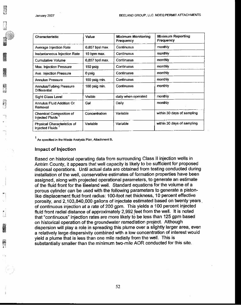
,ffi{;
:':.J;
.,rllllll'lr!
B r 'w
January 2OO7 BEELAND GROUP, LLC. MDEQ PERMIT ATTACHIIIENTS
1 As specified in the Waste Analysis Plan, Attacfiment B.
lmpact of lnjection
Based on historical operating data from surrounding Class ll injection wells inAntrim County, it appears that well capacity is likely to be sufficient for proposeddisposal operations. Until actual data are obtained from testing conducted duringinstallation of the well, conservative estimates of formation properties have beenassigned, along with projected operational parameters, to generate an estimateof the fluid front for the Beeland well. Standard equations for the volume of aporous cylinder can be used with the following parameters to generate a piston-like displacement fluid front radius: 1O0-foot net thickness, 1 0 percent effectiveporosity, and 2,'l 03,840,000 gallons of injectate estimated based on twenty years .of continuous injection at a rate of 200 gpm. This yields a 100 perceni injectedfluid front radial distance of approximately 2,992 leet from the well. lt is notedthat "continuous" injection rates are more likely to be less than 125 gpm basedon historical operation of the groundwater remediation project. Althoughdispersion will play a role in spreading this plume over a slightly larger area, evena relatively large dispersivity combined with a low concentration of interest wouldyield a plume lhat is less than one mile radially from the well. This issubstanlially smaller than the minimum two-mile AOR conducted for this site.
ffiw*3;J
a:
. ;
ffiHl{ir'liJ
Charaeteristic Value Minimum MonitoringFrequency
Minimum ReportingFrequency
Average Injec'tion Rate 6,857 bpd max. Continuous monthly
Instantaneous Iniection Rate 10 bpm max. Continuous monthly
Cumulative Volume 6,857 bpd max. Continuous monthly
Max. Inieclion Pressure 150 psig Continuous monthly
Ave. lniection Pressure 0 psig Continuous monihly
Annulus Pressure lOO psig min. Continuous monthly
Annulus/Tubing PressureDifferenlia I
100 psig min. Conlinuous monthly
Sight Glass Level Visible daily v/hen operated monthly
Annulus Fluid Addition OrRemoval
Gal Daily monthly
Chemical Composition otInjected Fluids '
Concenlration Variable within 30 days of sampling
Phvsical Characieristics oflni;cted Fluids 1
Variable Variable within 30 days of sampling
52
:i
**
Jenuary 2007 BEETAND GROUP. LLC. MDEQ PERMIT ATTACHMENTS
B-13.Proposed operating data including all of the following data:A. The anticipated daily injection rates and pressures.B. The types of fluids to be injected.C. A plan for conducting mechanical integrity tests.
See ltem 8.8 and B.11 for information pertaining to daily injection rales/pressureand the types of fluids to be injected.
Mechanical integrity demonstration for the well will be accomplished via anapproved test method(s) such as temperature log, or noise log, or oxygenactivation log. The Beeland Group will provide the MDEQ with a notice of Part lltesting to allow the agency to witness data collection activities. AlthoughBeeland may ulilize any acceptable method per MDEQ procedure approval, atthis time it is proposed that temperature logging be utilized for future mechanicalintegrity testing. Differential temperature logging to be conducted as follows:
1. Conduct Differential Temperature Log.A. Shut-in well for stabilization (minimum of 24 hours) prior to
running base temperature log.B. Rig-up temperature log and run base log from surface to total
depth. Pull tool to surface and shut-in master valve.C. Rig down equipment and return the well to normal operaiions.
ffiffiq.x*{
t'':
. :
j
il;;
K@*.:
:
53
ru,,.4
ffiffiwffi*rtltEl
tx. . . ,
' l
it";
wwws
January 2007 BEETAND GROUP, LLC- iJDEQ PERMIT ATTACHMENTS
B.'l4.For a proposed disposal well to dispose of waste products intoa zone that would likely constitute a producing oil or gas poolor natural brine pool, a list of all offset operators andcertification that the person making application for a well hasnotified all offset operators of the person's intention bycertified mail. lf within 21 days after the mailing date an offsetoperator files a substantive objection with the supervisor, thenthe application shall not be granted without a hearing pursuantto part 12 of these rules, A hearing may also be scheduled bythe supervisor to determine the need or desirability of grantingpermission for the proposed well,
While the Dundee has produced elsewhere in the state of Michigan, productionfrom this interval has not been identified in the vicinity of the Disposal well. AIIneighboring use of the Dundee Formation is for Class ll disposal of oilfield brines.Therefore, a list of offset operators is not required.
< A
t, ]
'K } l\8:,'
ffi
January 2007 BEELAND GROUP, LLC. MDEQ PERMIT ATTACHMENTS
B,15.A proposed plugging and abandonment plan
The following is the proposed plan for plugging and abandonment of theproposed Beeland Group, LLC non-hazardous I Well.
1. Install a tesl gauge on the annulus to perform a static pressure test.Ensure that the annulus is fluid filled and that the well has been shut-infor a minimum of 24 hours. Pressurize annulus to approximately 500psig and isolate from the annulus syslem. Monitor annular pressurefor one hour. The test will be successful if the pressure change is lessthan 3 percent of the starting pressure.
2. Prepare well and location for plugging. Remove wellhouse, wellmonitoring equipment and wellhead injection piping.Move in and rig-up workover rig, mud pump, circulating pit and piperacks as necessary. Flush well with approximately 100 bbl fresh water.Remove wellhead and release slips.Release injection packer. Displace annular fluid from well into injectionformation by flushing with approximately 100 bbls fresh water.Pull and lay down the injection tubing and packer.Run cement retainer to approximately 2,1 00 feet.Pump approximately 55 sacks of Class A cement with 4 percentbentonite (14.1 ppg, 1.55 cflsx yield) below cement retainer and into 6%-inch openhole.
9. Tag cement on top of retainer ai approximately 2,100 feet.10. Stage cement remainder of casing to surface in approximately 500 foot
stages using the balanced plug method. Pump approximately 291sacks of Class A cement (Michigan Equivalent) with 4 percentbentonite (14.1 ppg, 1.55 cflsxyield).
'11. Cut off wellhead approximately 3 feet BGL and weld cap withpermanent marker on casing.
12. Rig down and move out pulling unit and equipment.13. Submit required plugging records to USEPA and MDEQ.
Post-Closure Care Requirements
Beeland will provide notification of closure to USEPA, Region 5, the MDEQ andthe local zoning authorities. Included with the notification will be informationregarding the nature of the injected waste stream, identification of the depths ofthe injection and confining zones, well schematics and plugging records. Beelandwill retain, for a period of three years following the well closure, records reflectingthe nature, composition and volume of all injected fluids. At the discretion of theMDEQ and the director of USEPA, Region 5, Beeland will then deliver therecords to the appropriate regulatory entity at the conclusion of the retentionperiod, or dispose of such records upon wriften approval of the MDEQ.
a
4.5 .
6 .
L
ffi
$'a
i. '.-,i
*ig
ffiffi
3:
55
ilt j
i.:lii;r.*
!*ii|j-;i&
ffis&ffi
$ii
' ]
*twBgTEd
*d
Janvary 2OO7 BEETAND GROUP, LLC. IVDEQ PERMIT ATTACHMENTS
B.1G.ldentify the source or sources of proposed injected fluids'ldentify if injected fluids will be considered hazardous ornon-hazardous as defined by Part 111, Hazardous WasteManagement, of the Natural Resources and EnvironmentalProtection Act, 1994 PA 451, as amended (NREPA)
The Beeland Group, LLC is a privatety owned Michigan LLC that is wholly ownedby CMS Land Company that in turn, wholly owned by CMS Energy . The limitedIiability company purchased the Beeland property near Alba, Michigan in 2006 forthe sole purpose of installing and operating a non-commercial injection well.Approval is being requested to install this well to inject non-hazardous fluidsgenerated from the remediation of groundwater and surface water at the BayHarbor, Michigan facility.
Historically, fluids from this remediation project have been managed as non-hazardous via both injection via Class | (Mineral Well) disposal facilities andsurface discharge afler treatment to a POTW. Fluids typically have containedvarious levels of total dissolved solids and are expecied to range fromapproximately 2,500 mg/l to 25,000 mg/|. Specific gravity is expected to rangefrom 1 .00 to 1.05, and pH is typically expected to range from 7.0 to 10.0.
B.17.Whether the well is to be a multisource commercial hazardouswaste disposal well.
The well will be operated as a single source well, not as a multisourcecommercial hazardous wasle disposal well.
56
i i
. a
ir:ll:':r:lll;r,;t*-
tt. - r l
ffiffitrl*$
fr
n ,
.'-j
ffiffitsl
ssiiit:b . :
January 2007 BEETAND GROUP, LLC. MDFQ PERMIT ATTACHMENTS
B.l S.Additional information required for an application for a permitto drill and operate a storage well or to convert a previouslydrilled well to such a well:
For an application to drill storage well or to convert a previously drilled wellto a storage well, also submit the following information in addition to thatsubmifted in the previous section for a disposal well. In the previoussections instructions, replace the term 'disposal'with 'storage' and 'waste'
with 'stored product,'
L The name and chemical formula of the product to be stored, and acharacterization of the physical, chemical, and hazardous or toxicproperties of the product.
2. The anticipated vertical and horizontal dimensions and volume of thecompleted underground storage cavity,
3- The anticipated operating life of the underground storage cavity.
4. The method to be used to create the underground storage cavity.
5. The name of the geological stratum in which the underground storagecavity will be created,6. A schematic diagram of the well bore showing the proposedarrangement and specifications of the down hole well equipment.
7. lf the underground storage cavity is to be formed by solution miningbedded salt, then all of the following information shall be included:
8. The plan for disposal of brine produced during solution mining of theunderground storage cavity and for the operating life of the undergroundstorage cavity.
9. The expected starting and ending dates of the solution mining.
10. The range of anticipated operating pressures ofthe undergroundstorage cavity.
11. The anticipated range of operating iniection pressure.
12.'fhe proposed method of displacing stored product.
13. A plan for testing the mechanical integrity of the underground storagecavity as provided in R 299.2392 and R 299.2393.
57
January 2007 BEETAND GROUP, LLC. MDEO PERMIT ATTACHMENTS
N/A. This application is not being submitted for a permit to drill and operate astorage well or to convert a previously drilled well to such a well.
$Bwil**rll.,.
a.:rrr::]rrrl
M
ffiffi.f3
ffi*s
. {
a
. i
.lt#
tg
fi
ffi
a,*
, t l ' i r . :
.
l
: ,
rqfr:
&,',*:t:it
i:wf9
ffiw
j
r$
*
t
.,
Jantary 2OO7 BEELAND GROUP, LLC. MOEQ PERMIT ATTACHMENTS
B,lg.Additional information required for an application for a permitto drill and operate a well for the production of artificial brine orto convert a previously drilled well to such a well:
For an application to drill and operate a brine well for production ofartificial brine or to convert a previously drilled well to a well for productionof artificial brine, submit in addition to the information in the first section,all of the following proposed information:
1. lf the well will be drilled into an existing cavern' the number of wells inthe cavern, the present extent of the cavern, and the purpose of theproposed well.
2. The name of the geological stratum or strata to be mined, the top andbottom depths of the mined zone, the gross and net mineable thickness,and the mineral or minerals to be recovered by solution mining'
3. An isopach map showing thickness and areal extent of the strata to bemined.
4. A sketch showing the extent of the planned mine area'
5, The geological strata to be left in place for roof support-
6, A diagram showing the well bore with the proposed casing programand its relationship to the stratum or strata to be mined'
7. A plan for conducting subsidence monitoring as required in R 299.2407or a rationale for not conducting subsidence monitoring'
N/A. This application is not being submitted for a permit to drill and operate a wellfor the production of artificial brine or to convert a previously drilled well to such awell.
i,.:,l!
: ! i{{i
ffimE
w
59
ffili#
trLSrllEi.
E&trffiw
ffi&,#
rE
January 2OO7 BEEI,AND GROUP, LLC. MDEQ PERMIT ATTACHMENTS
A public hearing may be scheduled by the Supervisor of Mineral Wells totake public comment on the proposed well. lf such a hearing is scheduled,the applicant will be responsible for the scheduling and preparation andpublication of the notice,
Please collate the above documents into a set and mail the original and twocopies of the application (total of 3 sets) plus 3 additional copies of formEQP 7200-1 to;
Department of Environmental QualityOffice of Geological SurveyP.O. Box 30256Lansing, Michigan 48909
The above documents have been collated and appropriate numbers of documentand form copies have been sent to the above address.
..;
*gfr-q
{*
::11,,,,,,,,]
I. . . i
60

:':
x,iffi
Ing
ffiq
, . t
*i DE{o MrcHrc'AN DEpARTMENT oF ENVTRoNMENT
SURVEY RECORD OF WELL LOCATION
This info.malion is requirod by suthotlty ot Part 61 5SupoMsor ot Wells, or Part 625 Minaral wells, of Ac-t 451PA 1994. as amendsd, in o.d6t to obtain a dtillhg permit.
Appllcant
Beeland ( rp, LLC.irot
Well name a.rd numb€r
Beeland GrouP DisPosal Well No.1
To|/r|ship
Stiar
1a. Surfaoe locatign
SE 114 ot SW l/4 of
County
SE 1/4 ot 6€ction 14 T30N RsW Antrim
1b. lf thls is a directloalal we[. bottom hole tocaUon wlll b€ | owEmp w'(t
1l4ol 1l4ot 1/4 of ssction T R
tngrnralons: outllne drllllng unlt for oiugas wdls (Pan 615) or pfoperty boundary tor ntlnefal t€lls (Pa ttz5) ano spot e'e|| rocauor! onPrcHpwr
the well ln two direc{ions trom fie nearect sectbn, quatbr 6scton, and rnlt (or prop€rty, Part 625) llnesl - -...----
2- The surfaco location la
495-ft. fiom neer68t (l,ys) S section line
lg2Q-------ft. lrom neat€st (E/w) E secdon lineand
ft. from ngar€st (i.L/S) -quartar Ee6{on lln€
ft. trom nearest (E/W) -gusnsr soGlion lin6
Saaort 14PLAT BELOW REPRESENTS ONE FULL SECTION
(1 MILE souARE) N t
3. Bottom hol€ wlll be (it drecUonal)
-ft- trom nearesl (lVS) sectioo line
-ft. Irom nearest (E/W) ---section lineand
"r-fi. ftom nearest (N/S) ----------quarter sectiofl lin6
ft. from nearest(EM) quaier soction line
6*T€S eh,
r)\
IaH0 r\
Y3
4. Bottom holo wlll be (direc{ional or shight)
1!!f-ft. ftom nea.esl (l.US) S--ddllirE unlt lino
1320 ft. trom near€st (E/W) E dtilling unit line
5. Show acc€ss io sl,ake on dat and desctibe il it is not readllyaccessible.
N _+lI
c426, Zoning LJ Re€idential, effec-tve dataInifial dat€ of resid€nt8l zoningEl o*'.' Aoridrltural
A. A't roads, power no, OunOrng", ;i i"n;;, tresh ,ate.,r"ab, and othe. man-made features, Mthin 6{n t6et oJ th6 stak6.
B. 41 takes, st eams. w"6"n6", 6tfu[!u"*yi, iooapbins, envlronmontally sensitive 6reas' mtuml riv6r5, critical dune aGas. and threaloned or
endangered spe€ies Mthin 1 320 t€€t of lh6 shko.c. 41 rypo I and 1s putri" ,r-t", *pi'[i"il"1i6in looo raet ana att type llb and lll public watar supply w€lls within 8(x) feet of the well steke
Nam€ of indivldual who sirvoysd slteGerald Li-ra Inl.and
ffiI Addressr,: P0 Box 6820 / Traverse Ctty / MI / 49696-6820
",^--,...- ^,,1:3T,^',:,:.*5..'lf *y%f 19 *D TBE IE T'F MY I(.Ltffifdll
,EDGE AND BELIEF-
i *n /-4-o7i'=);ryn ti' . | ;lirnvErrtr-WLAbziWry".?WITH APPLTCATIONEQP 720G2 (rev. 01/2005)
\3GECF
ffiwffiss#
"l
:
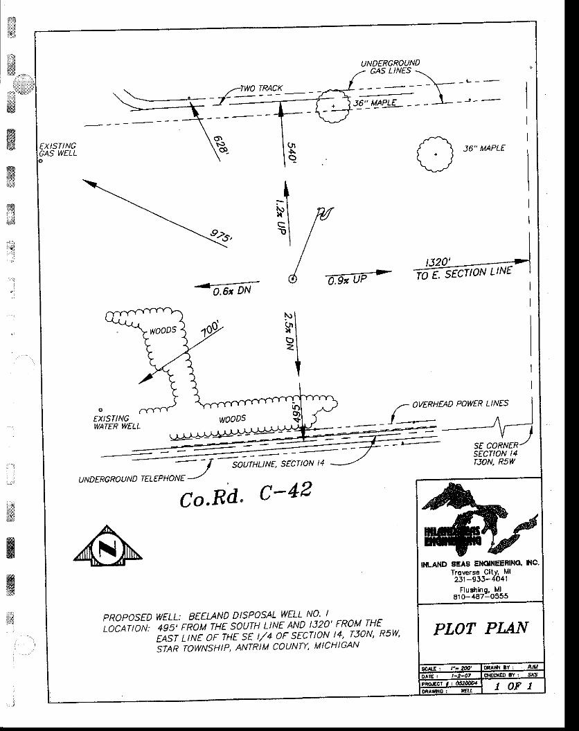
€xlsflNGCAS WELL 36" MAPLE
92c,
Ir - lNI Msl I
6 do;oe'->td^a, -DN
EXISTINGWATER WELL
/- )VERHEAD POWER LINES
lA
SE CORNERsEcTtoN t4rJON, RsWsourHuNE, SECTtoN t4
U N D E RC RO U N D TEL E P H O N E ...-''
Co'Rd' C-42
PROPOSED WELL: BEELAND DTSPOSAL WELL NO'
to-Cnfro* lsi rEou THE saurH L:NE AND t320' FRoM-rHE' rAsr ttNr oF THE sE t//4 oF sECTtoN t4'-T30N' Rsw'irtn rowNsutp' ANTRIM couNTY, MtcHIGAN
_E. ,ECTION LINE
INLAT{D 8EAA EI{OINEENNO. INC.Troverse CitY, Ml231-933-4041
Flushinq. Ml810-487-0555
,..]
$
ffiwi*
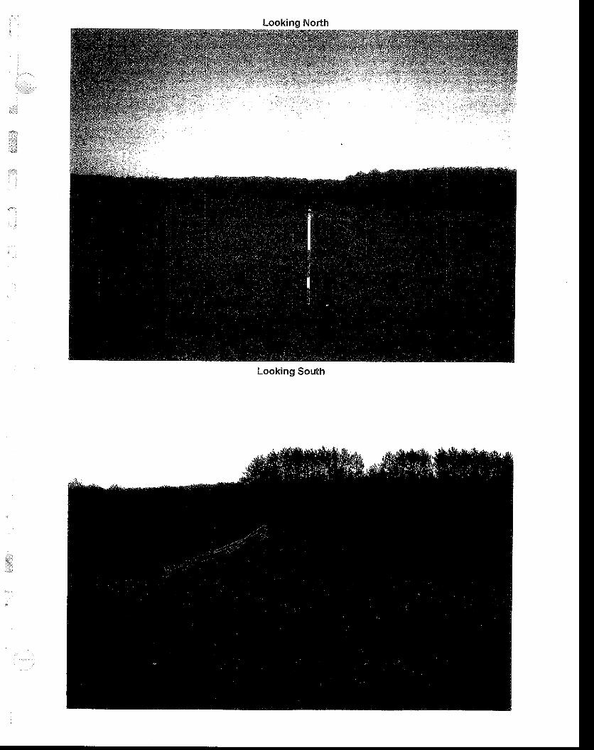
Looking South

Jt l;
,,ll:riri
...i
' ' j
i i
{;
iai:J
;
lrllturtr:ri'iiu1::,
$*
ffiffiffi
s;$
i.ttl!,iir ' . . j
.:
w6llw$
,'.;
:
WASTE ANALYSIS PLAN
Class I Non-Hazardous Injection Well
Beeland Group, LLC
Alba, Michigan Facil i ty
Antrim County
T30N, RsW, Section 14, SE % Section
EPA Permit # TBD
October 6, 2006
Prepared By:
=o_ng_ta!€EPetrotek Engineering Corporation
9088 S. Ridgeline Boulevard, Suite 105Littleton. colorado 80'129
Phone: (303) 290-9414Fax: (303) 290-9580
r&;"1
ffi'?r*,,,,,&&llir:rJ
- { ;
ffi
ffiffiri4,,":
i . l
. '..:
TABLE OF CONTENTS
2.A Volume Moni tor ing. . . . . . . . . . . . . . . . . . . . . . . . . . . . . . . .2 -1
2.8 Waste Character iza t ion. . . . . . . . . . . . . . . . . . . . . . . . . . . . . . . . . . . . . . . . . . . .2 -1
2.C Sampl ing and Analys is . . . . . . . . . . . . . . . . . . . . . . . . . .2-3
3.0 Quality Assurance/Quality Controi .........3-1
3.A General Sampling and Analytical lnformation...... .........3-1
?
ffinsx&s
. !j
October. 2006 Waste Analvsis Plan Beeland Group, LLC =-De,7.g!e!
ij
Ii'i""",,.
-&iM
ffiffiry;*
Page l -1
1.0 INTRODUCTION
1-A. Background
The purpose of this Waste Analysis Plan (WAP) is to characterize the non-hazardouswaste-water that is injected into the proposed new Beeland Group, LLC (Beeland) No1 well at the Alba, Michigan facility. Beeland will be responsible for ensuring this WAPis implemented. The well is a proposed as a non-hazardous, non- commercial Class Iindustrial disposal well that is to be dedicated to the injection of fluids generated inassociation with a groundwater remediation project-
Beeland will operate the well underthis Waste Analysis Plan in accordance with Title40 of the Code of Federal Regulat ions (40 CFR), Section 146.13 that requiresoperators of Class I underground injection wells to monitor and analyze the fluidsinjected into the well "to yield representaiive data of their characteristics " This WasteAnalysis Plan has been prepared to fulfill the specifications of 40 CFR 146.68 such thatthe plan presents parameters for which the waste will be analyzed, methods thatwill beused to test for these parameters, and methods that will be used to obtain arepresentative samples of the waste to be analyzed.
1.8. Waste Source
The Class I non-hazardous waste io be injected into the Beeland Well No. 1 underthisWaste Analysis Plan include fluids that are to be recovered atthe Bay Harbor, MichiganRemediation Project along with fluids generated at the disposal well facility operationitself. These fluids are to be comprised of recovered groundwater and surface waters,both treated and untreated, storm-water run-offfrom the Bay Harbor project and at thewell facility, along with any fluids generated during the operation and maintenance ofthe Class I injection well and the related unloading pad and surface facilities. Nocommercial or oilfield waste is to be managed at the facility.
1.C. Summary
Major portions of the Beeland waste characterization and monitoring program related tothe acceptance and injection of off-site fluids consist of:
Volume MonitoringGeneraior CertificationSampling and AnalysisQuality Assu rancei Q uality Control
October, 2006 Waste Analysis Plan Beeland Group, LLC
i',i,:ii1.,;
$96
ffiw
4alrelek
$,lii,r*
ffi$r#w
ffit
ffi&
Page 1-2
The WAP may be reviewed and, if necessary, revised. Revisions to the WAP, uponapproval, will become part of the administrative record and constitute a minormodification of the permit
Compatibility problems between the waste and the injection or confining zonelithologies or with the well construction materials are not anticipated. The fluids havebeen previously managed at both POTW and injection well locations successfully.Limited filtration or additives may be required, and stimulation of the well may also berequired.
Data appropriate to evaluate compatibility will be collected only when deemednecessary by Beeland through identification based on specific process orcharacterization data that is collected during operations. Possible issues could includethe potential for scale and corrosion problems from wastes with high pH (above 10).However, the intended operating parameters include a pH range of 7 to 10. lfproblematic wastes are encountered on a regular basis, periodic metal thicknessmonitoring via coupons or non-invasive electrical or magnetic monitoring may beimplemented. Economic and well performance issues regarding well flow rate capacityand maintenance will be addressed, if necessary, by utilizing additives, settling and/orfiltration of the waste prior to injection. No waste treatment at the wellsite for regulatorypurposes is anticipated.
l
ffiryJ
October. 2006 Waste Analvsis Plan Beeland Group, LLC IlalttslaL
f;
ffiffiw$t ' :' j
':
Page 2-1
2.0 PROCEDURES
2.4. Waste Unloading and Volume Monitoring
Offloading of fluid transports delivered from the Bay Harbor collection facilities will onlybe conducted with a trained operator physically present on site, A log sheet will bemaintained on the site documenting that a trained well operator allowed waste to beunloaded. At a minimum, log sheet entries are to include operator name, date, time,approximate volume, truck or transport identification. Similar data may be obtained andrecorded by filing manifest forms for the deliveries. The log sheet(s) and/or manifestswill be considered part of the plant monitoring records regarding the injection well,
As discussed in the main text of the permit application, a recorder will be utilized tocontinuously monitor injection pressure, annulus pressure, flow rate and totalizedcumulative volumes. A summary of recorded data will be provided to the EPA and/orMDEQ per applicable permit requirements. Records of daily volume accepted from theremediation project and any fluids managed from the onsite facility will be recorded anda total monthly volume of injectate calculated based on data maintained in the recordswill be noted in the monthly well reports made to EPA.
2.B. Waste C haracterization
At a minimum, the following composition parameters will be monitored once quarterlyfor any quaderly period that fluid is injected. These parameters shall include:
pHtotal dissolved solidstotal suspended solidsspecific gravityspeciflc conductancetotal organic carbonBTEX (if unloading pad fluids are being actively managed)aluminumarsenicbicarbonate alkalinitybromidecalciumchloridechromiumflourideironmercury
October, 2006 Waste Analysis Plan
' : i
* . 1
;-j
ffi&T
:
Beeland Group, LLC &elre!*-4
nr.Q
: fri
Sii;::ll.'{!p
*ffi
gi
ffi
ffi'.;
rysri
.l
:
Page 2-?
DOtaSSlUmsi l icasod iums u lfate
For the purpose of this Waste Analysis Plan, the first quarter shall be considered the
first three calendar months of the year, and the remaining quarters shall be considered
subsequent divisions of the year into three-month segments. lf fluids are not injected
into the Beeland well during a calendar year, sample or analyses wil l be required.
. :
,..tir' i
s6fiI
ffiI
October, 2006 Waste AnalYsis Plan Beeland Group, LLC ,-De-!?stek
i.ri!,.n
,L[, . i
lSN.,:::.,i,,,::lll,:1,:
:l;w
Page 2-3
2-C. Sampling and Analysis
Beeland, or contracted personnel will collect necessary waste stream samples- All
sampling procedures will be conducted at the direction of the selected, certifiedanalytical laboratory and in accordance with acceptable US EPA procedures. Thesampler's name, sampling point, and date sampled will be documented in chain-of-custody paperwork. Samples will be collected with the grab method.
The table included below summarizes the analytical method and sampling frequency fortypical parameters that may be included in the waste sampling for a particular wastesource.
WASTE SAMPLING METHODS
Test Parameter TestMethod
Units
Total Dissolved Solids, TDS; EPA'160.1 mg/L
Total Suspended Solids, TSS EPA 160.2 mg/L
Specific Gravity ASTM 2710 F
Total Orqanic Carbon. TOC 415.1 ,415.2 mgiL
Soecific Conductance 120.1
Sodium EPA 601OB mgiL
Calcium EPA 601OB mgil
Bicarbonate EPA 3't0.1 mg/L
Sulfate EPA 300.0 mg/L
Chloride EPA 325.3 mg/L
BTEX EPA 5030/8020 ug/l
lron (Fe) EPA200.7 mgiL
ffi&€frwF.t
,.q1l.lill*$
l : . li 1
'l
{::*
K
ffi1:tl
October. 2006 Waste Analvsis Plan Eeeland Group, LLC Dareztlab

:\
i.**,,,.i,.l,:i.rllril!*rs]:':
li:9
*d
Page 2 '4
Mercury (Hg) EPA747O mgiL
Arsenic (As) EPA 601OB mg/L
Chromium (Cr) EPA 601OB mg/L
Corrosivity (D002) sw-8461110,9045
pH units
Notes: Beetand reserves the right to select use oflhe cited method or method with equal or greater detection l imat
Samples will be collected at the point of generation or at the Beeland facility fromtransport tanks prior to unloading wastes into the storage or injection facilities.
ffiffis
ry&i
.'j
:
:
l:._::
wlrb, - i
'I
' l
:
October. 2006 Waste Analvsis Plan Beeland Group, LLC -zetsstek
'j
t i
"',s*sJ : - : -1
|:;::.*
Page 3-1
3.0 QUALITY ASSURANCE/QUALITY CONTROL
3.A. General Sampling and Analyt ical Information
The sampling protocol will be followed by properly trained personnel conducting thesample collection and analysis. Beeland will adhere to guidelines set forth in "TestMethods for Evaluating Solid Waste", SW-846 and 'Methods for Chemical Analysis ofWater and Wastes", EPA 600/4 -79lO2O as appropriate. Approved sample preservationtechniques from 40 CFR 136.3 will be followed as appropriate These will includepreservation in plastic or glass sample containers provided by the laboratory andstorage in a sample refrigerator or cooler for shipment to the laboratory. Beelandreserves the option to choose suitable laboratories for testing provided equivalentQA./QC standards are met.
Standard chain of custody protocols will be followed for waste collection, transport andanalysis- Below are summaries of the minimum sampling and analysis protocols whichwill be followed for each characterization parameter:
La bel ing
1. Sample name, date and t ime2. Name of sample col lector, ( include sampling company name if not Beeland);3. Sample collection method;4. Sample col lect ion point;
Reporting
1. Sample preservation technique, as appropriate;2. Analytical method for parameier detection/quantification;3. Analytical method accuracy and quantification limits; and4. Field documentation of sampling.
The following are Q.A,/QC parameters which will be followed to ensure the adequacy ofthe sampling and analyticaltechniques forwellhead sampling and analysis described inthis olan.
3.8. Sampling Gontrols
1. Equipment Blanks
lf possible, samples will be obtained directly from the sample tap or valve being used to
ffiffiru$
ry&
' , ' :
I
!a:)
w,w
october. 2006 Waste Analvsis Plan Beeland Group, LLC IloltalaL

ff
ct!}w
ffim8;
$$i ]
Page 3-2
access the tank or containment vessel and not be transferred to any secondarycontainer or device before being stored in the sample container to be shipped to thelaboratory. In this case, no equipment blanks wil l be required. l f not, equipment blankswill be taken as deemed appropriate by Beeland for the purpose of detecting potentialcross contamination due to improper decontamination of sampling equipment_ Aftersampling, any secondary container or sampling device used will be decontaminatedaccording to the sampling plan protocol. The sampling device wil l then be r insed withdeionized water and the rinsate collected in a sample container for transport to thelaboratory for analysis of, at a minimum, the same parameters chosen in the samplingplan above.
2. Trip Blanks
In the case of suspect analysis from any laboratory, trip btanks will be used and will besample containers filled with Type ll reagent grade water at the laboratory, sealed aithe laboratory, which accompany the sample containers used throughoui the samplingevent. The sample containers shall be handled in the same manner as the samoles.Trip blank(s) will be sent to the laboratory for analysis of, at a minimum, the sameparameters chosen in the sampling plan above. A minimum of one (1) tr ip blank persampling event will be utilized, if necessary.
3. Sample Duolicates
On advance written demand of EPA, duplicate samples will be taken to assess theQA/QC of the laboratory conducting the analysis. Such samples will be drawn from thesame site from which primary samples are taken. Duplicate samples, if taken, will besplit from the original sample in a manner to emphasize sample representativeness.The duplicate will be labeled with a sample number that will not conflict with the othersamples, but will not be discernable to the laboratory as a duplicaie sample. lfrequested by EPA or MDEQ, one duplicate sample per sampling event will be takenand analyzed for the same parameters listed in the sampling plan.
4. Sample Chain-of-Custody Protocol
Sample chain-of-custody will be followed at all times during the sampling andsubsequent analysis. Chain-of-custody will be used to document the handling andcontrol necessary to identifiT and trace a sample from collection to final analyticalresults.
]
- 1t
*
mrH
w13
l
October, 2006 Waste Analvsis PIan Beeland Group, LLC -:-D--#g!e*
ffi,:rs*.i
l]l$il1,it1:.6if
' i
fffl8
ffi
ffi1{
3&*,t
a
.
Page 3-3
3.C. Analytical Controls
'1 . Equipment Calibrat ion
Selected laboratories will maintain QA/QC data in accordance with that laboratory's Q/Aplan regarding the frequency and type of instrument calibration performed at thelaboratory and in the field. Any calibration of thermometers, gauges, chromatographs,spectrometers and other meters will be conducted according to appropriate instrumentmanufacturer specifications and manufacturer recommended frequencies or as dictatedby applicable laboratory QiA plans.
2. Data Reduction
The process of transcription of the raw data into the reportable units will be conductedby the laboratory in accordance with that laboratory's Q/A plan. Data reduction utilizedin the analysis and reporting process will be presented in the reports to the US EPA foreach sampling event and parameter tested by the specific laboratory used at the time.
3. Data Verification
Data verification will be conducted in accordance with the selected laboratory's Q/Aplan after each sampling event by assigned laboraiory personnel. Typical procedureswill include review of chain-of-custody forms, equipment calibration records and datacompleteness. Spot checks of raw data versus reported data may be performed toreview math accuracy, significant numbers and repoding units. ln addiiion, certifiedlaboratory standard quality assurance/quality control checklists will be utilized per theselected laboratory's QiA plan for individual test methods such as blanks, standards,and comparisons of internal lab test duplicate results. Problems with any of these itemswill be indicated in the report to the agency.
4. Internal Quality Control
Certified quality control samples may be run periodically in accordance with theselected laboratory's Q/A plan with sample batches obtained from appropriatecommercial sources, or appropriate regulatory entities. Internal quality control will beaddressed as required by the selected laboratory's Q/A plan and will typically includedisclosure of the laboratory's use of blanks, blind standards, matrix spikes and matrixspike duplicates, preparation of reagents, and laboratory duplicate or replicateanalvses.
l
,rt*swl
E
ffia3
Ociober, 2006 Waste Analvsis Plan Beeland Group, LLC Peltalek
$ry|d
i:iidl
@l*it$wffiffi#S1t
. :
; '
e !
l':'j
&RI
w
j
:.:l
: ..:
page 3-4
3.D. Actions
1. Corrective Actions
corrective actions will be implemented by laboratories if the analytical or samplingmethod does not achieve laboratory standards or Beeland objectives. Actions mayentail re-sampling the waste stream and/or re-analyzing the fluid for a particularparameter, re-calibrating an analytical device, or other appropriate actions. Actionlevels will be taken in accordance with SW 846 or other approved EpA methods.
2. Reports to US EPA, Region 5 and MDEQ
Reports to US EPA and MDEQ will contain results, data and sampling descriptionsregarding the accuracy, completeness and repeatability of the reported analyticalresults. The report will contain a table that specifies the type of sample (blank, waste,etc,), sampling date, sampling location, analytical method, method detection limit andanalytical result. The results of analyses and all accompanying data, including chain-of-custody forms, will be reported to US EPA with the next monthly operating reportsubmitted to the agency after the receipt of the final sample analysis report from thelaboratory. This submittal to the agency will typically be within sixty (60) days of thesampling event, unless prior arrangements have been made with the agency due toconditions beyond the control of the operator that prohibit such reporting.
October. 2006 Waste Analvsis Plan Beeland Group, LLC Dafualab
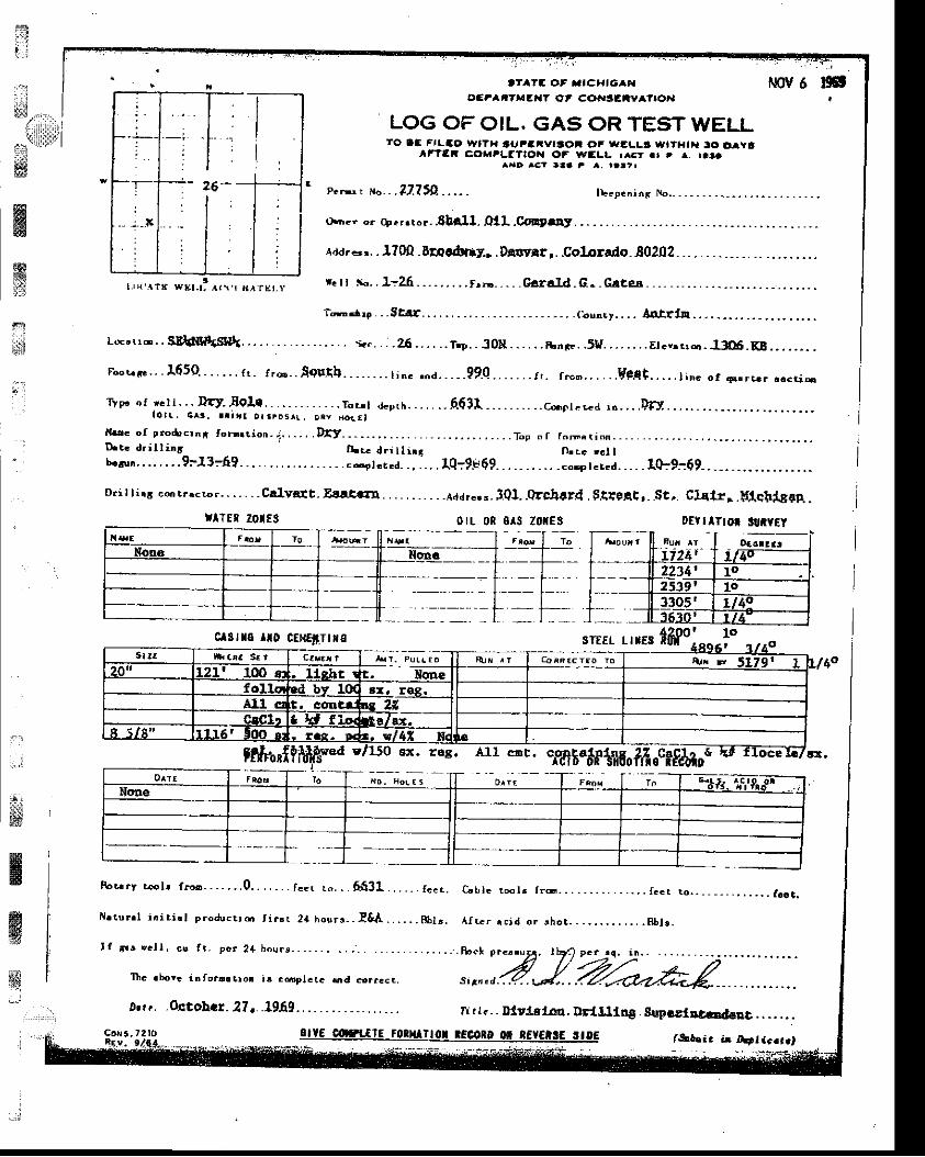
frt . :
$ll*1ffiffiJF
't fZ OF ,4ICHIGA'{o:?arTxEaaT Qt cotr €tY^r|or{
LOG OF OIL. GAS OR TEST WELLTO lC Fr|-ao wtTx tuFSivrtoi oF WELL! fttl{t|. to lravt
lt'?Er Cgra?LfTtOH C'f wtrLL r^Gr.t r a. raraarD lc? taa , a, rattr
T-.r+ . .,Strr,,. -. .r 'ouacy.. . . A,ntrln
T r p " " f
' c l l - . - D r y . , B O I C . . . . - . . . . . . . . r . r . 1 a . p r r r . . . . . . _ 6 5 3 1 - . . . . . . . . . c * e r . " . d i r . . . . l f y .l o . . 6 r t . a a t i ! o t t p o s l ! . a t y B o { f }
l { u c o f g m d r c i r 6 t o r ' r t i o n - , i . , . . . . D f t _ - - - - . , , . . . . . . . . . . . , . . . . , - . . . T o t o r r . r . r i q . . . - . . ,D . ! . d . i l . l i r r f | . r c d r i l l r n ; n . L c , . l lu o 6 u a . . . . . . . . 9 : - 1 3 : 6 ? . . . - . . . . . , . . . . - , . . c o p l e t d . . . . . . . t Q ; 9 F 6 9 . . . . . . . . . . . c o . e t c r c d . . . . . 1 0 : 9 : 6 9 - . . _ . _ , - _ . . . . - - - . . .
Dri t t ina conrr rcr l r . . . . . . - Cr lvsr t_ prr . t ' ra . . . . , . ,_ . . .uar" . "_ JOl . .erchcrd. $.qr9Aq,_St , . CIEl r , .g{qt r fuap. .
p ' - , . n " . . . 32?50 . . . . .
o'rcr o. +.'.ro!..8ball. OlL.Co'!Dst
raa'-,. . l?oQ . Drpr6|rt, . Dflt9rr,. .Colorado. 80202.
r. t r tr,-. 1:26. -. -... .. rrI!-. . - . Garaf-d. c. - Crte.6.
orl 0R 0^s z0(E3
rts* r,rg tfifo]
fl
*i
:lTEn z0tE3 DEVIITI TTITYEY
clstt6 lI0 cEta€tTtxs
tffitrI?ft
R o t r r y r r o l r r r " - - - . - . . . 0 . . . , . . . r o . t t " . . . 6 f , 3 1 . . . . - . r . . . .
H r t$ ! . 1 i ' i t i . t p roduq r i d r t i r r r 24 hou rs_ - !& i1 , . . . . . . 8b1 r .
*:lw
ffiffiw
Ex. r6s. All c't' Tff5"6pt+6ofifi.clfJtr
G b l e i . @ l ! f r 6 . . . . - . . . . . . - . . . f . . r
A f r c r a c j d o r ! h o t . . . . , . . . . . . . . H f , I r
. o . . _ - _ - - . , . . , . . f a o t .
a&hir ir Artlc.t.,c o { t , 7 ? t o olIE corxtlE rotu o| rEcorD o* t[f€t!€ rtoE
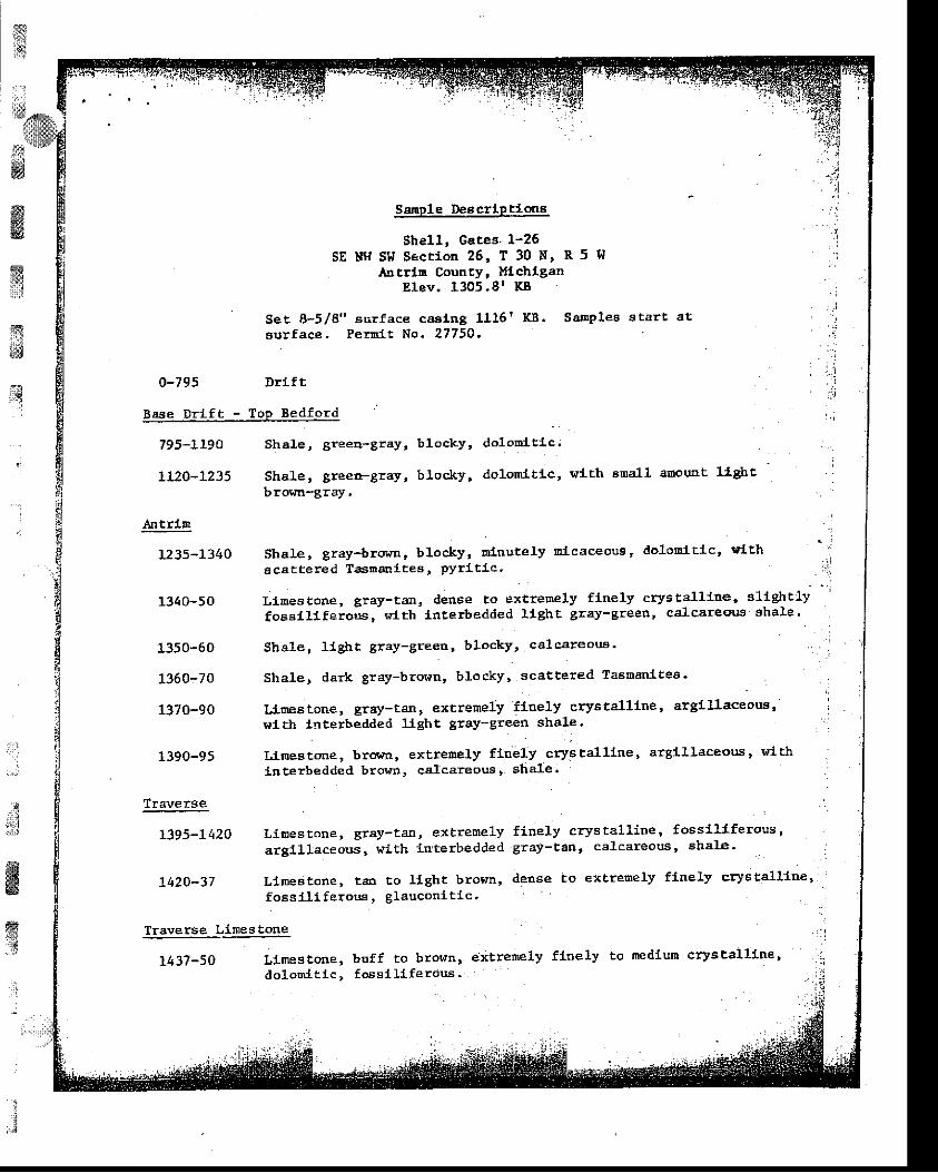
ff, . 1,,s
iI
tr**
ffi.
ffii{
i.:r:
f,i
ffiwx
a
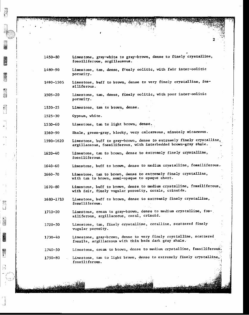
1450-80
1480-90
1490-1505
1505-20
L520-25
1525-30
1530-60
1560-90
1590-1620
L620-40
1640-60
L660-70
1.6 70-80
16 80-1710
t 710-20
7720-30
1130-40
r7 40-50
1750-80
LlDes tone, glay-white to gray-brolrn' denae to flnely crystalllne'f oesll lferoos, argl.l laceols.
Llnea tone, ta, dm6e, ftnely oollt lc, t irt th fair lnter-oollt lcporoaity.
LiDeg tone ,ai l l ferous,
lLoes tone rp0106lty.
foasll lferoEs.
Ll"Eestone, buff to
LlEestone, t:! to
browrr, denge to rnedfilu eryata1l1ne, fossll l feroug'
brown, dense to extreo€ly fhe]-y erya talllne '
b|Jff, to browrr, den8e to very flnely cr-vstallloe' fos-
te, deDse, flnely oolit lc, !t-1. th poor lnter-oolltLc
Linea toDe, ta to brottn, dense'
Gyp6un, whl. t€.
LlEEstoEe, ta Eo llght brown, dense'
sbale, gree8-gray, blocky, very calcareous ' nll.autely lllcaceous.
LlmeBtone, buff to gray-brown, derse !o extrenely f1ne1y crys laLlllre 'a rg111aceor r .s , fose i11 ferous ,w1th1nterbeddedbrorm-graysha1e.
LlEeatoDe, tarl to brown' dense to extrenely finely crys aaLatne '
I;"J
il*1$
@w&
wgl
..:
.;,t,1..,J
i!
' ' . ',
lrltfi lan to brown, selrl.-opaque to oPaque cherc.
Limestone, buff to bronn, dense to Eediu$ cryg tall lne, fossil l ferous,wlth fa1r, t lnely vugular poroalty' cor8ls, crtnolds.
Llnestooe, buJf to brorrn, ilens e to exlreDely f1nely crys talllne 'fcsell lferous,
Lls|estoDe, creEm to gray-brovn, den6e to EediuE crys talliDe' foa-Eil iferous, argll laceous, cora1, crlnold '
Llmestone, car, f lnely crys lall ine, corall ine, scattered finelyvuBular porosity.
Llme€lone, gray-bronn, dense to very flnely crys tall iner scatteredfoss1ls, argil laceous wLth thln beds dark gray shale'
Llmestone, creaJE to brovn, dense to Dedlurl crystall lne, fosst]lferoui;
Ltbestooe, tan to l lghc brown, dedse to extrenely flnely crystalltner:fossll l ferons.
:"' ',:
i:i{t l
:.,1
l:i,L;r,,,:t l:'.''':l''ii*,
:.J*3
ffi$
ffi;1:
;*
;'i
,1780-1800
1800-20
1820-30
1830-50
1850-r9 75
L97 5-90
L990-207 0
.2070-ao
2080-98
Bel1
2098-2L72
Drmdee
2Lt2-2240
1240-50
2250-60
2260-70
2270-80
2280-90
2290-2300
LlneaEone, creafi to llghtfoeel.l i feroos.
brom, denee to ftnely cryJtallLae,
extreoely flnely crys ta.l-line,toLioeE tone, ta! tofoE8ll1fero s.
I. l,oe6tone, ta tovugirlar porclty.
brown, dense
brovn, . ienae, fi-nely oolltlc snd fl.nelytrace
Linestone, ta !o gray-brown, den6e to extreoely ftDely crJrstalllDe'slLghtly foeelllferous, argillaeeous, l'lth dark Br6y 3ha1-e PartlEgs.
Shale, 'ledlid gray, blocky, very'caleaieous, mlnutely ol'caceoti ' '
-t i d c e g l a u c o l ' t e . : : . , , . . : l
Lfu0estqoe, buff to broFn, denae to flne1y cryEtalllne' fosslllferous r.
Lr-Eeatone, taa to bro[rn,s11ght1y fo€sIJ.lferoua.
den6e to extrernel-y flnely crys tallitre'
erlnold, cora.l, I,r l th acattered argll laceous partlBgs.
LiEeatoDe, aa above, vith scattered quartz cry6ta1s fto,E E1O to2090 .
Do!'oDlte, brown, veryteEed lrhl te hedlum to
Shale, redfts gray to green-gray, calcareous, f ossl.l l f erouE.
f,l,neLy 6ucrosLc to floely rhoobtc' r. lthcoarse crya te15.
!-I th
....i
ffiE!
ffii,i
:
LIEdE loBe, bufft tapore eases",
to bro{n, dense, fossll l ferous, crlnoids, scattered
vlth trace llter-Dolo[fte, brrffn, very flnely to flnely sucrosic,cryatall ine and finely vugular poroslty'
DoloDl'te, buff to brown, very finely' sucroslc, trace flI le.l.tporos l ty .
DolonLte, brrnm, flnely rhornbic, I{lth fair tntercrys talllBevugular porclty,
Do1ofi1te, buff to ta!, very finely sucrosLc.
Do].oElte, boff to tan, f lnely sucroslc to flnely rhonblc,zoFtea oE fd.r ln te rcrys talline poroglcy.
Lrl#-stone n buff ro brown, denee, sllghtly fossll l ferous.
T
Dolomlte, tajrvug8, probably
to brorm, Yery ftnely aucro6ic' r^'IEh scatCerEd flne
sa l t f i l l ed .ffiffiTrs.::3
df,wsi
,i4. :;:tj
;.J
2780-98
2794*2840
2840-7 0
2870-90
2890-2900
2900-90
2990-3020
3020-3340
3340-80
3380-3490
3490-3530
3530-50
3560-3620
3520-40
3640-60
3650-90
3690-3710
37 LO- 40
37 4C-69
Bass Isl and
3769-80
3780-4012
S a l t ,
Anhyd;lte ,rith lnterbedded dolornlte, tan, very flnely sucroslc'
Anhydrl te.
Doloml.te, buff to tan, very flnely 3ucroslc'
Anhydrlt4,
Ll.rDescone, buff to l lght brorrr' dense' sllghtly doldEltic'
Dolon.lte, buff Eo broltn, very ftnely gucroslc' anhydrit lc'
I,ineE !one, buff to grey-bror,m, dense to very f1nely crystalline'
sllShtly io]-oot ttc, -foeel1lferous,
wl. Eh Ecattered dark gray shale
partlngs,
Lfinestoue, buff to gray-brqtr'n' dense to v-ery -finelt crysta].
;1.3|;
f i
i i
*'l{wi:g
ffi
ffiffi
G
4072-4LOO
Sa11na
Dololnlfe, Ereen-grayl d€nse, earthy, verY
green-gray, dense, earthy, very argll laceous.
,.x/rl0O-4166
4L55-4340
4340-50
4350-66
4366-85
4345-92
4392-4470
44rO-77
4477-4503
4503-4634.
4634-52
4652-A7
4687-47L8
47r8-88
47AA-4422
4422-49L2
Sallpa E
4912-58:
, . j
''
I.,!j
. - r
, ;' i
Sa1t .
Anhydrl te .
S El.t.
,Anhydrtte, t'hite to broirn,dense to extreDely flnely
wtth, s treskssuc ios l .c . .
of doloDlte, tau to
4958-66
4966-5066
saLina D
5066-84
salina c
Sa1t .
Anhydrlte @d dolostlte, as atffiry
3
dblirtnlttc,
f!$ -',*
1..!idttrffi
: q
i i
5706-27
5727-45
5745-sO
5750-6t
5't6L-72
5772-96
w ssllna B
5204-5572 Sa1t.
Sa11na A-2 Carbonite - Nlagaran
55LZ-26 ltolonite, ta !o br@rlr, dense to extreDely flnely eucroelc' flneaalt-f i l led vuBs .
5526-56L7 Doloqfte, bror,ro., dense to extrenely fltely aucroalc
gq#
. l
core #I - 5617-5 706
5617-30 nolcinl. ie, h8e, very fr..ely ]-arol'aited' alhydrlt lc lso6es'
c&rboDate Partlngs.. : , : ,
i , _ . - . .
: ,
5630-40 Dolomtte' aa above, alhydrlttc 6hale partlnga Ln top foot.
5640-73 Dolool-te, rEry thlnf.y la.nluated' dtps of 3Oo, fl11ed fracEri5662 and 5557, bleeding o1!-'
5673-81 Dolo[0l.te ' ltght gray, Eottled' flnely to coarsely aucroslc-
5681-5706 Doloolte, as above' Pen poht to l" vugs, occa'slotral haLrllae
gUCrOSiC,Polonite, tlnely to nediulopLD pofnt poroslly.
DoLoudte, as above, ooresty1ollt lc, eorals.
DoloaLte, as above, !t-l th
Dolonlte, a.s above, veryf1l.]-ed vugs ,
Dolonl.te, a.s above,
oolopIte, as above,
anhydrit lc,
lncreaslng poroa1tt,
foss i l s .
porosity.
&w,!
Core #3 - 5796-5884
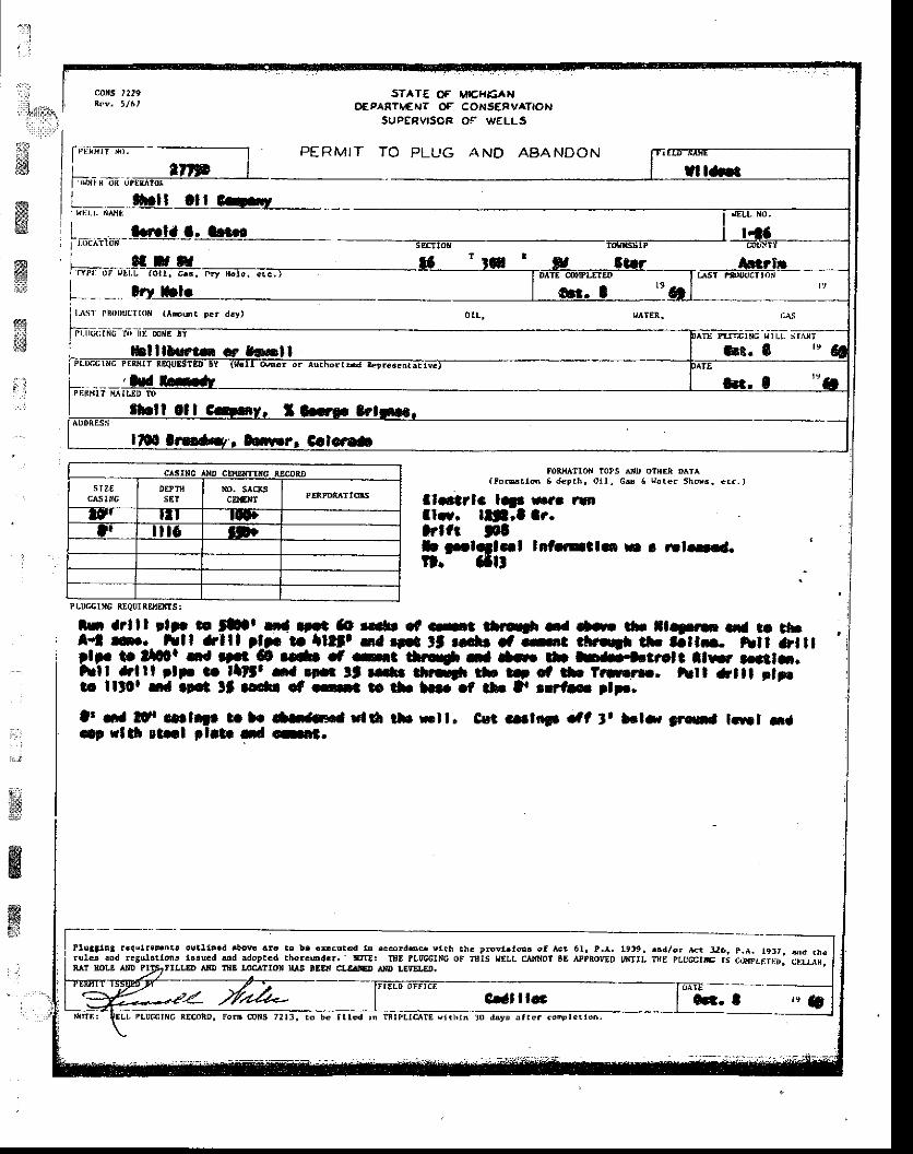
II
;
t l
ill{,},,1ri. , , , , ,1,, i
ltMffiffiYKI6&1
ta@1t
u
co[s t2r9 STATE OF MICHEANOEPAFII,€ AIT OF CONSERVATION
SUPERVISCR Oi W€LLs
PERMIT TO PLUG AND ASANDON
tt ll ttl Grl
i af,.la a. afl6-l.oc^11irix - -----
qlsrtc ltD cEHEtfn{c REooiDs laa
CAsIIIGDEPTIIsEt
NO. SICKScllGIt
ltl l t l l0ltl i l t6 ltt
( F o @ . ! 6 E d € p . ! , o t l , C d 6 H a t e r 5 h d 6 , . r . . )
ItArlc lt|' f,t rulll.r. lll,f lr.lrltt ftb plfl.|l lnt rrcl.. n r r.l--.tl. aflt
ln a?lf f rltr o lLr |'a |'.t aa t.afr d.rt |lrr* ia a-. rtr lltr .|. t| thl*t n ._ hlf &lll tlF t lltlt Ga |'.9 tt r.cfr d -it rl|f*tD th -flr- tn ar ltlp tt tllor 5d |'!t ag r.- .f -ra tbrjf rf --. h har'.|.t'ol t llF' r||cl-.hll-tltl qlt tr_ F6t_ s-3rn tt rC $rr||l tb !!| et b ?rufi, hll -f tl ptpolo llt0r ta.!.r lt aodr cf .Ct E tll. lB. .f tl. D trfs rlr.
It d ltr ..rlilo t b rl-Jrs.t dtt tb Ftl. C{r cate6 .'l t, tclr, $'s t.|rt xaql r|tf stxl plrt rd .-et.
it,';wffiffii$
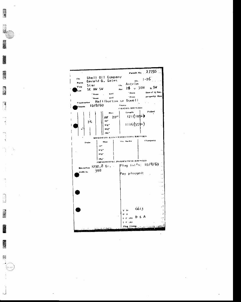
t$i:il
4,*iffiffiffiffi
#
ft
. Irerl'II
^lt. 20,1 rz r ( ro$ i |
r r ro (51i* )
I E r r l . l t l l l r A t P i '
tz,)z,B E, .906
| lM, | , | . ro l r r t tE tn t l l l t
t u q t r , t l . : i o 1 8 / 6 !
ay p l r r r l , - l e t l :
I
-.:
.:,.J
d-"-
$
&ww
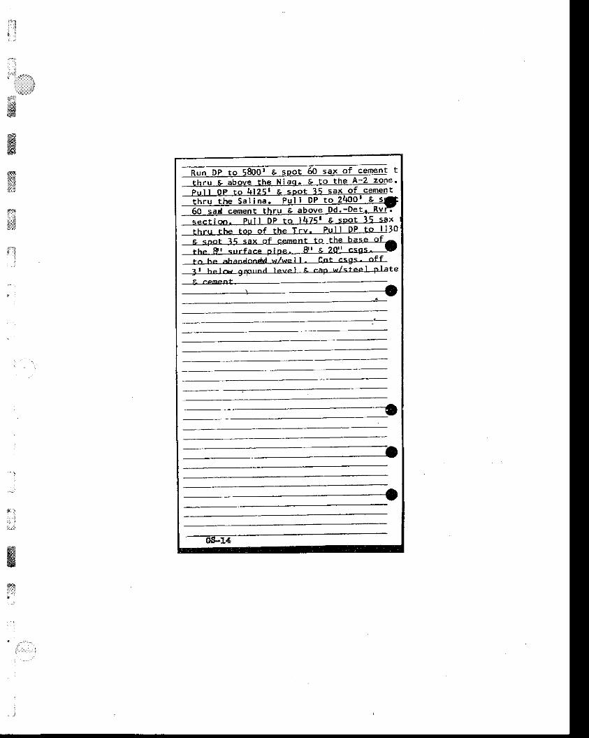
:1
l"'f:r , l l' i :111
'i;iilii$t'tsit6
ffiffiffi
@tl!t;
nils
t
o u s a l c e m e D E l n r u 6 e 9 u v E e v ' e e ! ' t ' ! t I
sec t iq ! . Pu l l DP to 14751 E sPot 15 saxt h r u t h e t o p o f t h e T r v . P u l l D P t o l l 3 0
t r ' he al ' ih ' lnn*d w/wel l - e ' r t c<g<' of f
3 r h . l & 9 , ' n " n . l l e v e l E . F P - w l < r e p l F l i t e
t4s*HdE
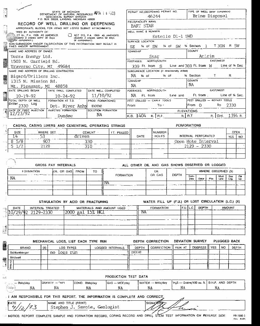
r"lt!i
€w
CASING, CASJNG LINEFS AND CEMENTING, OPERATING STFINGS PERFORATIONS
S T A I E O T M I L 8 I G T N T : - , . ' J A T__ DFPAFTMENT oa r \^ru8At Afsol lAcEs a r \ ' | ' r )D
€or.ocrcAL suRveY 0rvrsroNFO. AOX 30028_ LANSTNO. MTCH|GAN d8909
RECORD OF WELL DRILLING OR DEEPENINGI APPFOPFIATE ALOCSS, FOF IiEMS NOT LIST€O SLJAMIT ArI Ci{T€NIS
- , , . rnEo av auTHoRr tY oF' : c T 6 t , P A r 9 J 9 . A S A M I N O I D - A C r l l 5 , P ^ 1 9 6 9 ̂ S A M E N O a O'
- ---Subn'r 2 coor€t w{h'r 30 d"ys -
tsubmrt ? cop'6s $En 60 davs
- \ lb ' codpre 'on) o r comor€non. l
]J.]: NON SIJBMISSION A1'TO/OF 'ALSIFICATION OF THIS INFORM^TJON M^Y F€SULT IN;i$ FrNES ^NO/OR rMPFI'SO!rMENi
PEFMII NO,/OEEP€XII'JO F€F^JIT I'JO.
46244
'rYP€ OF Wgl {1116r coDplor'on)
P F i ^ a n i < h ^ q A 1
FIELO/FACILJTY NAME
BATT STARWELT
Este l ] e D1-1 SWDSL]AF^CE LOCATION
SE v. or St^l va of Si{ % Seclion I T 3ON n 5W
wcg
rew:1
AOOBESS
Terra Eherg-y Ltd .1503 N. car f ie ld Rd.Traverse Citv, MI 49684
Star
COL]NTY
Ar--'-rimFOOTAGES: NOFTH/SOUTH EAST,^I,EST
339 Ft. l rom S Line and769 Ft- fro.n W Line ot / i Sec.
NAME AND AOORESS OF
brqard/ rjrl l lers _Lnc.] 3 1 5 N . M i s s i o n R d .Mt. P leasant , MI 48858
S U € S U R F A C E L O C A I I O N l ' l d t r e c n o n a l l r d r i l l 6 l
NA Y. ol u4 ol Ya Section T R
NACOUNTY
NADATE OBILLING BEGAI"I
10-19,92
OATE DBILL. COMPIETEO
L0-24-92OAI€ InlEI! COMPLEIED
t1,/70/97FOOTAG€Sj NOFTH/SOUIH E AST,4 JEST
NA Ft. {rom Lrne and Ft. from . Line of ya Sec.
TOTAI DEPTI I Of WELLDri, ler - - -^ Log
FOFMATION AT T.O.
Det. River A]]hIPROO FoIRT.TAJTON(S)
noneFE-EI ORILLEO _ CABLE IOOLS
From To l
FEET ORIL!g _ NOIAFY TOOLS
From 0 To 2330DATE Of 'IFST INJECTION
12/23/92INJ€CT€O FOAM^'T|oN
DturdeeSOLUTIOITI FOAMAJION
l\;,,\ELEVATIONS
r<.e. 1404 tr . ln.r r i . R,r fi. I crd. 7394 n.
l GROSS PAY INTERVALS ALL OTHER OIL AND GAS SHOWS OBSENVED OR LOGGED
s tzE WHERE SET CEMENT FT. PULLEDDATE
NUMAERHOLES INTERVAL PERFOFATED
OPEN
l 4 53 oI]'ven YES NO
I 5 / 8 907 330 oDen Hole Tn:erval5 7 / 2 2L29 310 2129 - 2330
FORMATION OIL OR GAS F R O M TOFOBMATION
orLOF GAS DEPTH
wr+EFE OBScRVED (X)
NAL\A
S'IMULATION BY ACIO OR FRACTURING waTER F|LL UP (F.U.) OR LOST CInCULATION (1.C.) (X)
DATE INTEFVAL TREATED MATEHIALS AND AMOUNT USED FORMATION F.U. L.C. OEPTH AMOUNT
Lo/29/2 2129-2330 2000 gal 152 HcI L\A
MECHANICAL LOGS, LIST EACH TYPE RUN DEPTH CORRECTION DEVIATION SURVEY PLUGGED BACK
AflANO tx) LOG TYPES LOGG€D INTERVALS DEPTH CORRECTION DEGRE:s Y€S NO OEPIH
Schlumberqer no logs run noneBirdwell
PRODUCTION TEST DATA
.. - - Bbls/day
NACOND. Bbls/day
NAGAS - MCF/day
NA
WATEB _ abts/day
NAH,S - Grains/l0o cu, it
NAB.H.P. AND DEPTH
NA
I AM BESPONSIBLE FOB THIS REPOFT. THE INFOFMATION IS COMPLETE AND CORRECT
NAME AND TILE (PFINT)
S tephen J. Savoie, Geologist
NOTICE: REPOBT COMPLETE SAMPLE AND FOHMATION RECOFD, CORING RECORD ANO TEST INFORMATION ON R€VERSE sIOE, PN72OO'
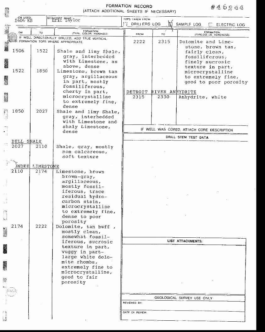
il]
: " \' jNDE
2 t ) " 0
' i
- . ? t 7 4"*is
HE
ffiw:;1
a "' ':-'
FORMATION FECORD(ATTACH ADDITIONAL SHEETS IF NECESSAFIY)
# 4'a 2 '1 zla
,t1 , r" | 'o I ,,,". J3l#'i%o".,,4
. " .Pt : r l i FORMATION IOPS WHTBE ApoHOpBtATE.
dt lM 1 5 0 6 | 1 5 2 2 I S h a l e a n d l i m y S h a 1 e ,
1f64':'fB
2027
TOPS TAX€N TROM
I I D R I L L E R S L O G SAMPLE LOG J ELECTRIC LOG
FOE."'ATIONITYPE,COL:e . HAFONESS)
D o l o m i t e a I r d L i m e -s t o n e , b r o v n t a n .f a i r l y c l e a n ,f o s s i l i f e r o u s ,f i n o l v q r r n r n q i r
t ex l ru re i n pa r t ,- i - - ^ - - . , - ! - 1 r ; - ^! L r L ! v L r - ) ' - u o f r r r r q
t o e x t r e E e l y f i n e ,g o o d t o p o o r p o r o s i t y
f f i | | v r j t h L imesLon€ , asWl l above ,dense
1 5 2 2 | 1 8 5 0 | L i m e s t o n e . b r o y n t a n
f f i | | g r a y , a r g i l l a c e o u s
13 | I ln p?r l , nosrry
g r a y , i n t e r b e i d e d
f o s s i l l f e r o u s ,c h e r t y i n p a r t ,
d e n s e
v i t h L i . n e s t o n e a n ds h a l y L i m e s t o n e ,
S h a 1 e . g r a y . m o s - l l yr r u r r L d - L L d ! s ( r u > ,
so f t t ex tu re
L i m e s t o n e , b r o mb r o w n - g r a y ,a r g i l l a c e o u s ,m o s L l y f o s s i l -i f e r o u s , t r a c er e s i d u a l h y d r c -c a r b o n s t a i n ,m i c r o c r y s t a l l i n eto ex l r remely f ine,d e n s e t o p o o rp o r o s i t y
D o l - o m i t e , t a n b u f f ,r L r u D r , _ L I u _ L c c l l l ,
s o m e w h a t f o s s i 1 -. ! F ^ f ^ , - - ^ , , ^ - ^ ^ . i ^
t ex tu re i n pa r t ,vuggy i n pa r t -l a rge wh i te do lo -n i t e rhonbsa Y + r a h 6 l i r € i h - + ^
Y - L d _ ! r r r r E .
g o o d t o f a i rp o r o s t t y
A n h y d r i t e , w h i t e
IF WELL WAS CORED, ATTACH COBE OESCRJPTION
DRILL STEM TESI OATA
A | | m ic roc rys ta t r ineS l | | t o e x t r e m e l y f i n e ,
t : 1850 | 2O2 l I Sha re and l imy Sha1e ,t , L l I g ray , - i n t e rbecded
_ | | 5 r r . 1 _ ! y
| | d e n s e
A L E2t r0
21'14
2222
F O F M ^ I I O NI T Y P E . C O L O F . H A F O N i : - ' I
DETRO I T2 3 1 5
LIST ATTACHMEMS:
GEOLOGICAL SURVEY USE OI.ILY

'ffi!ri
ffi
! t j
wffi
ELEVA-TIOIJ
#46?"44us€o:
KB
IF WELL OIHECTIONALLY DRILLED. ADD TFIUE VERTICATFOqMATION TOPS WHE8f, APPROPRIA] F.
FORMATION FECOffD(ATTACH ADDITTONAL SHEETS IF NECESSARY)
TOPS T^K€N FROM:
N DRILLEFS LOG
I F T800
SHALE9 5 0
S a n d , g r a v e l a n db e d s
Sha l -e . b lack -ve ryda rk b rown , ca rb -
. t i - - 1 ^
S h a l e , g r a y - b r o r ng r a y - g r e e n g r a y ,v e r y b a n d e d , s i l t Yi n p a r !
Shale/ b lac l<-verYdark brown r ver |c a r b o n a c e o u s , n o n -c a l c a r e o u s . g r a i n yl e x t u r e , f i s s 1 e ,t r a c e d i s s e m i [ a t e dp y r i t e , 7 % t o l O %g o l d s p o r e f l u o r -e s c e n c e
shale. gray bro-r .n-g r a y g r a y - g r e e n ,l i m y i n p a r t , c l a yr i c h , c a r b o n a c e o u si n p a r t , 1 % g o l ds p o r e f 1 u o r .
s h a l e , b l a c k , Y e r ycarbonaceous ' non-c a l c a r e o u s , g r a i n Yt e x l u r e , f i s s 1 e ,minor d i sseminatedp y r i L e , L O % E o 2 0 %g o l d s p o r e f 1 u o r .
Sha le , b roT in -g ray ,mos t l y caLca reous /r r r L r ) . r I l P a ! u
SAMPLE LOG ELECTFTIC LOG
(TYPE.COLG" HAAONESS)
L i m e s t o n e , b r o w n - g r a Y ,a r q i l l a c e o u s , f o s s i l -f e r o u s , m i c r o c r Y s b -a 1 1 i n e , p y r i t ei n c l u s i o n s , d e n s e
S h a l e a n d 1 i m y s h a l e 'gray gray-bro 'wn,i n l e r b e d d e d v i t h s h a 1 YL i m e s L o n e a n d L i m e -s l o n e , b r o , . r n - g r a Y , d e n s (
L i m e s t o n e , b r o w n - g r a Y ,a r g i l l a c e o u s , f o s s i 1 -
^ ! ^ ^ - 1 , , i nr L r r s ! L f r r r
pa r t , a l ga l ma ts ,m ic roc rys ta 11 ine toex t rene ly f i ne , dense
se SUNB5 Boo
i . ' i :l
..J ELLSWO9 5 0
t l 80
1256
r''l 1296,'j
]!i;is; _
AN IF WELL WAS CONED. ATTACH CORE DESCBIPTION
DRILL STEM TEST OATA
1319 t37 5
E , T a y l o r
F O F M A I I O Ni I Y P E , C O L O F , H A B O R S S '
t T t J
r404
GEOLOGICAL SUBVEY USE ONLY
SHALEI L 3 O
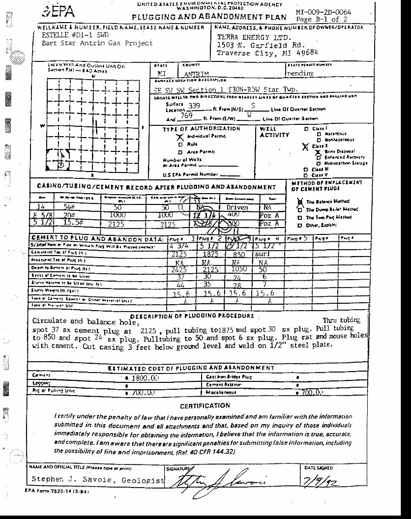
sEPAuxrrrD 5r^rrs f-vvrf""JI;,f i:l.To?l!-ro}l ro r. Hcy
FLUGGTNG AFJD ABAHDOI ' IMENT PLANMr-009-2D-0064fi
!
i;'l
B-L of 2
i":,rr,ttl.
. l ;
ffi
$ l tL , . i IMI I l . lu rJ . t tR . t l tLD A AHt , t t ^ ! [ A lHt I r ,ugEEAESTILE #D1-1 SWDBart Star Anrr im Gas Projecr
w,ffi$it
ffip
l i l t { t . l lDDRtS J, t tBOA! rrUr.. ! lA Ot OYr. ' l t f , /OlI t l I0A
TLRRA ENERGY I,TD.15 03 1 { . Gar f l e ld Rd .Traverse City, J ' l I 4 9681r
lD( | r , wr l l l 'nd Ovtt ,^r Untt O. |J.c l on r t r t - 6 l r ) arra l
ll
:-t--i+'T++r
r l l-+++-+II
i i iiTTT
r t ll r l-l-TT-
'TI- i'--'ta'T--f -I Y t I
t+j-j-:-+++-H+
I
lllTl rt rr,'l rrJ{rl r
. r r0 . t r r t t r !11?Dr
l-tt"::g t. tru llrrst-l- [i6. ot ourdo' Secirrr
^* 769 n- t.-, n* H Lh. or ou'rro. t Fr.^
t l t r t ! r t t - t l t t :0 Dlr I F ' roat t rat i t .^rr r r ! r r t ca ! ! rar l r atcnor .n! ar t lu 's urn
Wt lL D cr,rr IACTIVITY El nrlr,nrot
O lldtltrbet
Y cut t r" I !in. D'l'<ttl
'd tn^.'ird r|cFr",
. O Xt{t<.tb" tlotrg.
D CL|' !!
TYtt o t au?HoRlz l . l lo l i
X r6d;d,,rt t.''inD iulo
O l.r . l r t t i l l
,\ taa l artrirl
U.5 tt fr"i;l trrnb.' -
c^l lH0/TU t t lJ O,/CC H rHt IEEoRD aFrrt r luborrJ0 A D l l lHDof i A{EHTr l txoD or I r t l c t l l r lot clr llJt tluol
! rx lrrrrr lrrla/Et
th. Drr.ro l,'trt llrtrr(
E tlr lF tl|,f u.tltd
E Oth..,Ittth:
M t ' T T T O F T U O I 6 A N D O H D T A ;Si l.rfr.l ' l+. |^ w".^..!t *;T, r,*,.,,*-"Caklrr r r l ! * . c l r lv l t i I} { . r r \ r . { I r r d hsf t \ |Orttt\ h L..n tr '.93f|r t-I r r r t d ( r i r^r la r Ul ;lrrr v.',.y . rr ut rclc"-rr r-l \ t r ' r l r l 'n tb / l r r I
r-< ' c.-nr rr,,,, iEiEiFffiirtFr t hr 'rrr !,|r
circurale and barance ho*ttc^tPrto' ot Pruool*c tBocEDUn[
ftru tubingspot 37 sx cement Dlup at 2125. u.rll tubing to1875 and spot 30 sx plug' h:11 tubingto 850 and =;i-24';I"i;.-hrll;"[t; i; 5o"and-spot 6 sx'plug' PIug rit and rnouse holuith cernent.- g1rt casini 3-feei beton iround level and ueld on 7/2" steel Plate'
G 3 I I H A I T D C O ' ' O I I l U 6 G ' H O A I i D A I A H D O X T ' f H Tcr- 'nr J lgm.of C.|rt h.r a'ldfr llrrc
o. t utr'.i una ....-"........-_-
CEBTIF'CATIONI cenily under the penahy of law that I have perconallf extmined and dm lamiliar with the inlorma onsubmttted in this document tnd sll attachm9nts and that. based on my inquiry ol those individualsimmediatelf responsib!e for obtaining the informttion, ! helieye that the inlormation is true. accuale.End complete. I sm awEre lhst there ue signilicant penahies lor submitting false inlormatio4 includingthe possibilhy ol line tnd imprisorynena- (Ref. ttO CFR t 44.32)
|l ME ANO OFffC!AL TITIE tpt..t. .rr,. , p.,n)
Stepher - , i . Savo ie , Geo log l sEPA ForD 7620-r! t3.Ar )
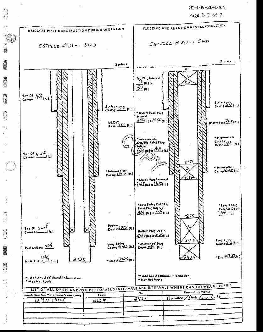
1:i '
Ii llllr.
. l: - '
:,:r1- ;ss
ws4fryri
sili , i tsil
f . i
,1
MI-o09-2D-0064
Page B-2 of 2
o r l o l l i l r w t L l E o l i t l r u c l l o t i D U R t t ' G o r I r a l l o H
ES'[E1LE #Dt - t S' ,Jg
'tl3.,MA,*,
l r r o , < r / tc. ' i r t t"- l}Ll
f\ o r O t 5 v t tCrnlrrt- l t t- l
lv l t t t 1- ncr.hc j- : l l t . l
ll,il-'".,u.r
E'r^r J99.alh l
',!iii@.".,
!;i"f Ehsr,,.r'l7l
H o l t l t l l l n . l
. 'Ara l* ' datb.r. l lnl o<rn r r jon' t l . r H . l l r l t
ta r ra t^ " , ' ^ "
^ "^*Doxx tRr !Dh! r lu c t loh
trs-r€LI.E #b t - l s t"-D
lRtlur hrrrrrI: l l l t ro9r" t
3\r1t . r ( - rJC!r lngj l - ! l I tL)
. USOfl trrr t i ,9
.Eflrt1 r/e-|o,ut.t
A,VrE t.lnl tl',9
ffi*,uu,?,i$)rr
")Fe"'
HiWL-u',
C.tiny'O92- ltt l
'Ugdl. trrt tnr.drl
rtur$LE?Xtr.l
. t r6 l 3 r ' l i t Cul /Rlptd"l tlel l^lr-,/' -
Att-ttttu l:%-ttt.l
a!rtr6lrrf Dtt lh
' tont I I ' l ' iCv l / i s D . t ! t'1@1rr_r
ulllSttr.l
' l . . r [ r . ] t r t r "Dtlr;.OCe- llr.l
lT-lHtrr,'.'.o,r,dj-li,,r
. r ldJ lnr l ddI tonr . to 'nr . t ]o^
. }.|, t. l I rr,,r
f tn t t to^ a ida r J , D F f b " ? r * h t l J , 4
I urlr. t
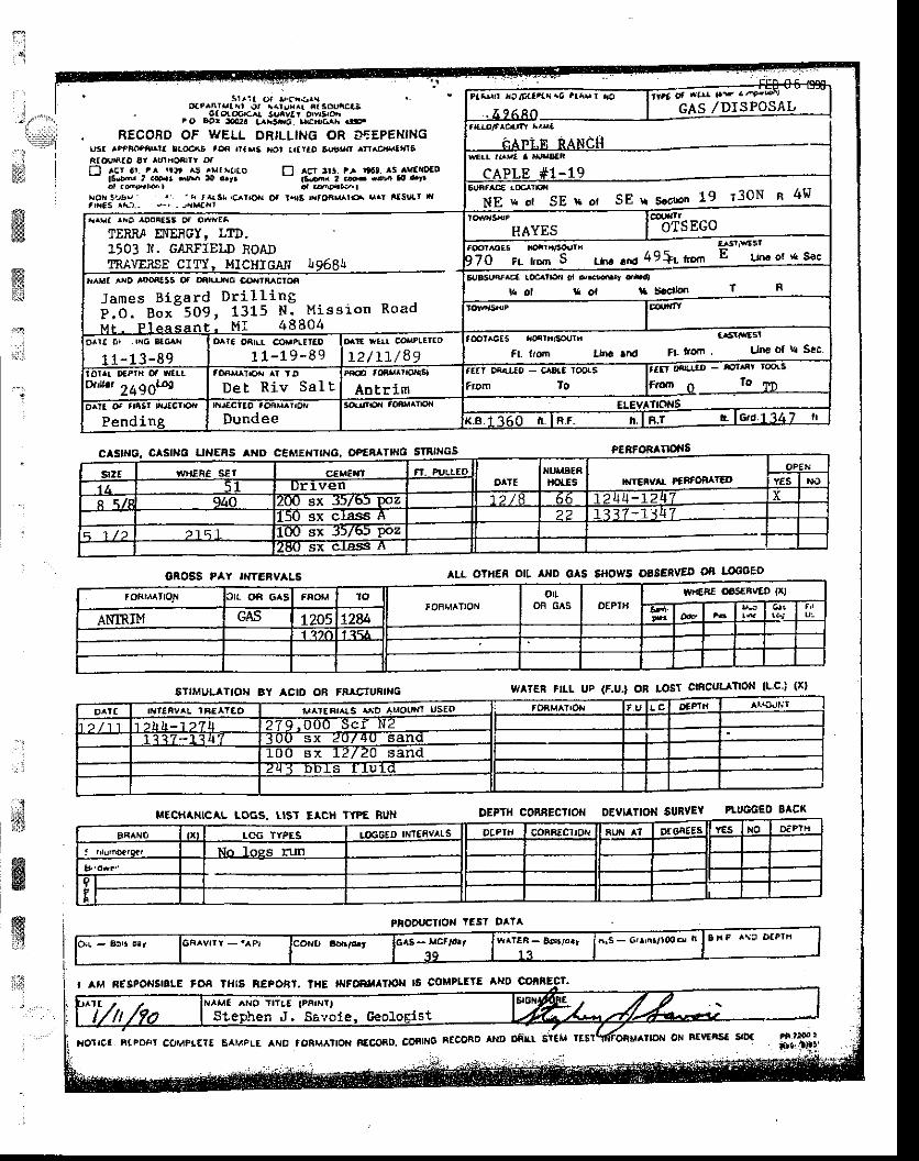
T
j,'::l. -q*ti'*iffiffitr.:
,r:ll
I
C SFIG. CASIITO UNERS ND CEMEHTTNG. OP€ETT|H6 SINNGS
GAOSS FAY IIITCRVALs
GTIMULATIOH BY ACID OB FR TUFING
lltECHtt.|ICAI LOGS. LISI EACH TYP€ hUII
PioouclloN lEsl oal^
PEBFO TTOi{S
aLL OTHEn O[ INO GAS 6HOWS OSSEiVED Oi lltcGED
warER FIL UP (F.U.] On rosf aficul noN (l.c-i (xt
OEPTfl CONBECTIOI{ DEVIATIOiI SURVEY PU'GCEO SACX
r ria or I,ciarrDat^nrltrl or i(r!r.r nt Sontoai
- 6lo(oo'c{ Sunvat Otvrsrctrt o Eor :m.?a t^r3hr6 urcEG^N ..t-.
. RECOBD OF WELL ORTLLIHG OR IfEPENINGusr ^tPtoP^r^rt llocaS a* |l(s6 ,l<rr trataD 6uor.n ^rr.c,J!.atllEAlourAlD er lttlFoarrY otf-l ^Er ar. t^ !r!, a5 . r|lJ(o f'l ^Er rr! fr rt6t. ^s avattDlo-
t6lD,tu' .l .oF.r $rEr lO or. - |tt3nr t 6.cvt aO..rrd uol' nr
xolr 3!a! ' r' 'r t*.sr. icrrorr oI l{|a 8,(tir.^r6 s.Y ilst]tt rrfrilEs .A3.- s_r . Jd|.trrr
rrrr,o r,Ofltxr.O trh!rFTtitt ot *lr|' |.t ' r'9<drI 3AS, /DISPOSAL. 4 t 6 8 0 I ' .
irAPi.f,l RANCII -*rr tr el a x.JraEn
cAPr.E #1- 19
SE r sotron 19 T30N u 4!6'd;C.6iF-N E r . o t S E * o f
,r^r.! ^iD rDoi[ts Of O]+riEl
TERRI E{EFGY, LTD.t503 N. G,AXFTET,D ioAD' INAVERSF CTTY. MlcHTcalJ To6R[
IIAYESffii
OTSEGO,@r^oEs to.tintor,rrh LrS|ltsl
;7if--*';;- S- Lir. rr*l 49+t tu.n E !4." ot '{ sac
x^r|a ^xo aDl)filt5 ot o6(rrrc @.rtMctoe
J a m e s B i g a r d D r i l l i n gP l o . n o t " S O S , 1 3 1 5 N : M i s s i o n R o a dM t - P l e A s a n t . M I 4 8 8 0 4
E{,A$,r ^c€ @crrE r ql o,.m.r drr,l
U ol I ol lt Scdlon T F
orrt or . r,{6 ltclr
11- 13 -8 9ortc oaLr @raPl,E aD
11 -19 -89oaE walr co PLElaD
L2 / L r /89t@t^cEs rio4rnlsouri
"sll*Es!ft- t,om lh6 ar6 Fl fom Utto ol ld Sec
wun'24go4 Det Riv Sal t Antrirn FromfEET OintEO - CADIE TOO!5
To;ZE a}l&rt-o - El^tlt roo(5
F.o.r o lo lD
o^la ot trist lrJfcr|oar
PendingxrJ€CilO tOAM.Irofr
DundeeSoutrro.i toer|^tror{ ELEVAttOttS
ffiTj6o tr TRr. trTF.t r lcrd 1347 t'
srzt wilEi€ sEt c,EM€XT FI. AJLLEDo f E
TUI,AEAlrotEs D{rEnva PfffO€aIED
oPEr,r
1 t r 5 1 Dr tven YES r,lO
I \ f t 940 200 sx J)/bJ Poz 7 2 / 8 6 6 -L24
15O sx class A 2 2 1 3 1 7 - 1 J 4
1 1 / 2 215 ' I 10O sx 3516) Poz2E() sx crass A
foFrrllror{ lrr of, GAs faoM ro'OF,JATION
oIOF G S OEPTTi
I|rcBE C|6SEBVED {xl
ANIRI}I GAs L205 I?atl
oatt I||'IFV L 'BE TEO d,^ttFr^!s ^rso AMOUTJT UsEo !EFtl
) / 1 1 )Ll t -1 ) ' l l t 7q:ooo--sal l,r2I 1 3 / - | < 4 / 0O--sx
-Z(IZflI sandliiT sx :[Z/20 sand7[T-EETs TItril_
tx l ICG TYPES !(,6GEO lNrtav ls DlFlli COBAECITOtT RUN A1 Dr6aE!! Y€5 to D._Pln
No loss rrm
It
Stephen J. SEvole. ceoloElst
.: I
$ffig
ffi{
t,l I aM f,ESPOrJS|or€ tOA ?Hlg REpOBl. IHE lrlFwllloll ls collPLElE aND
BlpoFr c(,uFlEIf EAraplE AhD roBM^tton n€coao. CoFTNG ntcoaD llrD Dill't EllM
GRAVTIT -.aPr lcofltl 6Dr!/.E
-q9 l ?hrs - Gtr'n3r!0od n 3xa A\C o€Plf l
t{orrcr ot BtvERst siD:
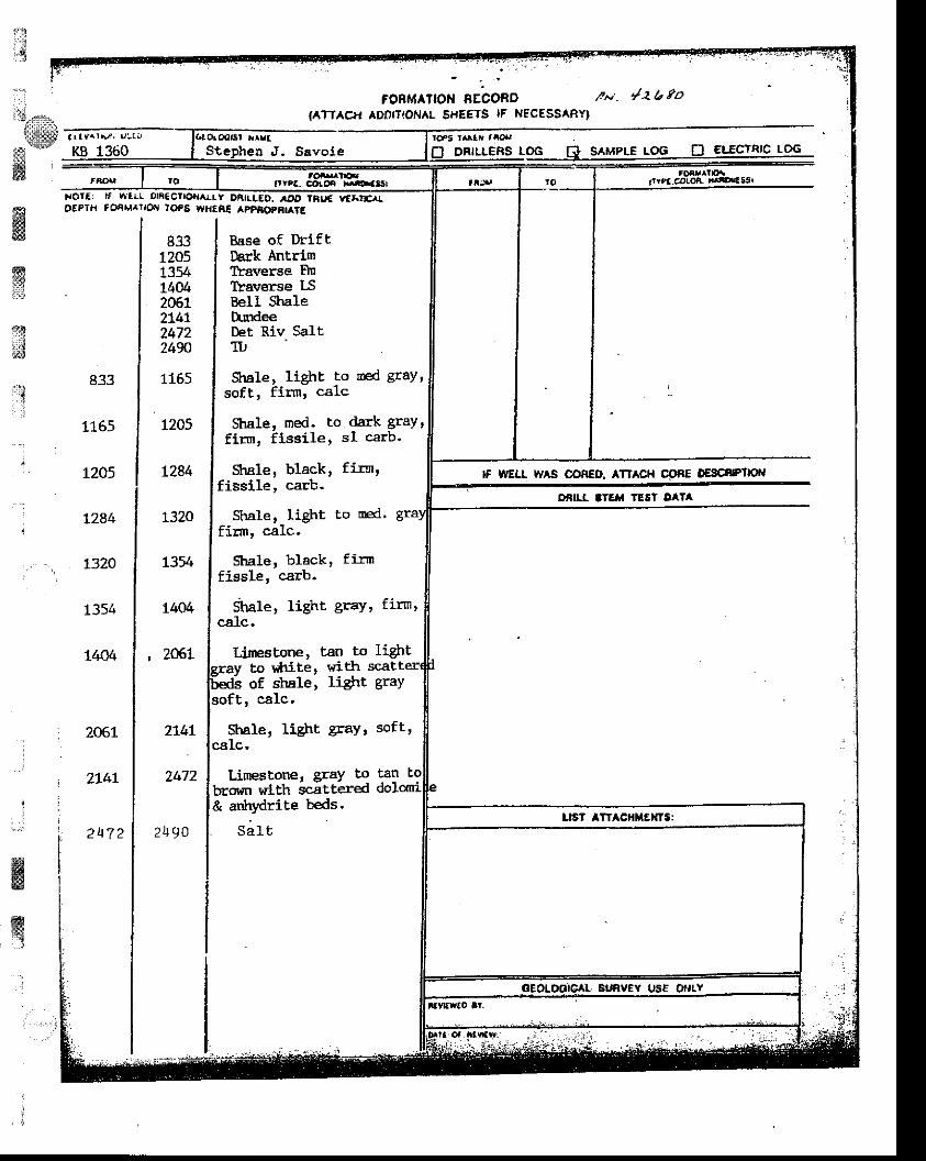
I
l$iitrEI&
w'',:
ir'!
il
ffiwffie&
dJ
:rtll.-.{
:
833
1165
L205
t284
1320
I354
1404
206L
?.747
2u7 2
FoRMAtloH BEconD t*. y'ab 9o{ATTAC+. ADDTTTONAL SHFETS lF NSC€SSARY|
xoTf: rf vllrl on€ctlorar.rr oAtLlEo. ,!o tFuE r/f*rrrrotPIH foati^lrcni IoPs writAE appf,oParaTE
83312051354L40420612L4l247224W
1165
1205
L284
1320
L354
L404
, z06.L
Base of DriflDark AntrimIYaverse FlnTlaverse l-SBell $aleD:rdeeDet Rlv SaltTTJ
Sule, light to sed gray '
274t
2472
2)t90
to ailaite r ltittrof strale ' liglrt, calc.
Strale, liglrt gray ' softtcalc.
LimeBtone ' SraY t9 Flbrown wlth scittered dor& ar*rydrile beds.
S a l t
soft, firm, calc
Stnle' med. toflrm, fissile t
Shale, black,fissile, carb-
S'trale, liglrt ro oed.firrn, calc'
Shale, black' firnfissle, carb.
Stale r liSht gra'1, firn,calc,
Lfunestfie ' tan to lieht
dark graY 's1 carb.
fir$,
gray
tes tallr lloM
D pntrlEFs LOG B S^MPLE LOG 0 EIICTRTC LOG
lf mu tv s ooFEo. ATtAcH DESC8P']|oI{
OiIl'I 'IEfi TE6I DA'A
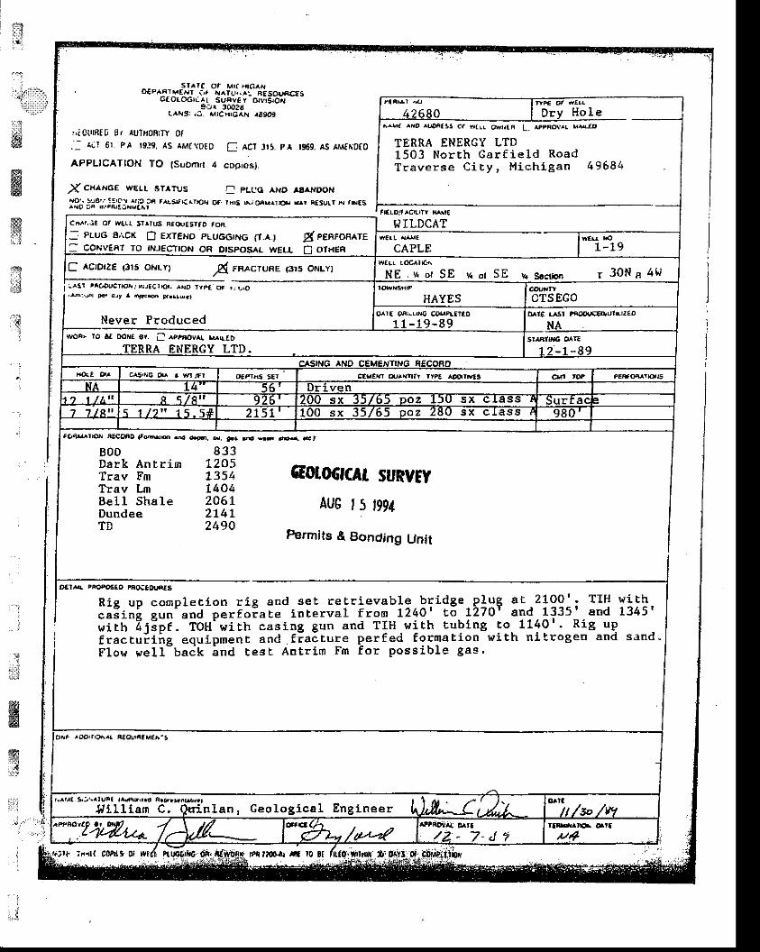
fi
ffiffi'T3
star( of Mr(r tc^, !, oE"^4rMErvl t,. Ar^r!Lt.._ AESO!,fi€:E5Gtoro6rLrL suFvr y ol|aarbi
Btr 3!O?CL^risj /5. ^rtcxrc^lt| 10909
ri Cl.'ntE 8r AU'lfioBtTY 0f
.- alr 6r PA tg-!l. ts aMa\oEo I AcI Jts. pr 1969. AS tllrffiOfo
APPLICATTON TO (Suorn' r { copros).
X CHAN6€ rvELL sTlTUs I plco aHo asanooH
l$;t*i;li.l"i:a?i" rat''('r.o'r .)' rH's 6; oau^I.F s' t.tu!' '{ 'd.s
C AcrorzE (3rs oHrY)A rnecrune (3r5 oflLY)
:^sr 'r€'oucTrcrr! Eraclor. ^!o ryF€a .F.|6 F.Brdrr
Never Produced
rca4arrrox Flctlno t M .4 4.?o, d. !.. d rE dE< dt
W ILDCAT
CAPLE
BODDark An t.rirnTrav EmTrav LmBel l ShaleDundeeTD
833L205t3541404206L214 l2490
o€lAA PFO9OEaO rnCECorufiES
r0 !t
^^!a ^Bo roofiass ca B(rL Owrt6 L. ^rPnol,r! s^4lD
TERRA ENERGY LTD150 3 North Garf ie ld RoadTraverse CiEy, Michigan 49684
c^^r.,ic oF !ra!t tr^rus F5(t asrtD roB
: PLUG a,icK B ExrENo PLuGGTNG O.ar gl eearoasteI 6o^ivEAT To ftJEgTtoN oR otsposAr wEtr 0 oTtrER
NE . 'r or SE 'n or SE 'r. seaim r 30N s 4tl
t/yoF| ro .t DorJa or. I ^''nov^r. M^[ED
cr5tE6 0r a $4 /r'l
cotocrcAt SURYwAU6 t5 t991
Permits & Bonding Unit
R i e u o c o m o l e E i - o n r i p s n d s e t r e t r i e v a b l e b r i d g e P l u g a t 2 1 0 0 ' - T I H w i E h. l? r I I L l ^ ' " . ; - ; ; - ; ; ; " ; ; ; i i " ' . , " i r , " i rz r ,o ' E6 !27or and 1335r and 1345R i e u o c o m p l e E i - o n r i R a n d s e t r e l r i e v a b l e b r l d g e P l uc . 5 i n i g u n ' a n d p e r f o ; a E e i n t e r v a l f r o m 1 2 4 0 ' E o ! 2 7 Ow i r h 4 j i p f . T O H - w i l h c a s i n g g u n a n d T I H . ! t i t h E u b l n g
1335 | and 1345'r o 1 1 4 0 | . R i g u p
fractu i i i rg equipmenL and f ia i rure per fed format ion vr i th n i t rogen and sand"Flow wel l -ba ik ind cest Antr im Fm for possib le gas '
oer riD'tra*r^( l€oUliav€a.s
k^tta tt\^luel tr'nB,r.a
Jrl i 11 iam n l a n , G e o l o g i c a l E n g t n e e r
iirlt C0t{ 3 0I Iri t?s{ ra
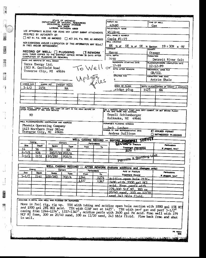
i1rrjl
'..l
,r]i,*l*..1t::r,r ' .,-1,r:;li:t;f-
iriw."ssffi:,.r
E*ir - l
o."^"t",8lltotroi.|lHlo^*oEoLootc^L
".truartffs..^ngnuTJ,"ffif" .*0,UST APOROPBIATE SIOCI(S. FOH TTIMS TOr LISTEI, S.8I,III ATIACHMEfi,S,EEOUIBID BY AUTTIOBI]Y OF:X AcI 61. p.A t939. As AMENoEo E Acr 315. p,' ,s60. As arrENoED
jlli,il3"lill$r1lllff1 r-nsrFrcATroN oF Tr{rs wrB&{loN MAy B€sdLT
L-Eggl^g-o_f_yE!r_: fl PLUGGING f:tnEwoRK{MrlL T]|AEE COPTES TO THE OtSIR|ct ctfFrcE v,rrror-6 orvs rrrenCOMPITTION OF PLIJGGIi'G OF NEU/ORXIN.^ME l'D ^OOAESS Ot wE!L Cltt{€R
Terra Energy LEd.1503 N. Garfield RoadTraverse City, MI 49684 1i Wql\
\^r1ffi.A,
:-.'.:
wK
!
o€scRra€ oE ^[ HG'|Y
r'ove in Poor rie. rie uo. fiH-_r.rith. rubing and acidize open hore section with 1000 gar 152and 100o gal 2az HCr-icid. -rlr.Y+th ciBi;-";;;?iit.^.rr wirh perr sun and perr 5-r,r2,1casing frqn L244-7274', r3i7-r347',. acrdize peiis-wiirt p4o gar Fe acid. Frac r+ilr wirh 279ffo#irl*'
3oo sx2a/4o sand, 100 "* ii7io",J,"i+I uur" Ei"ii. -ri."il;
il; and shur
t!i!n xo- ffi
;*1ffii#Wildoat
w€r !H i rE l i xur rgEF
Caple #1-19wEtt Loc,rno{
-4--i1-g!--E--1arl!4 n s".riq" 19 r 30N a 4tlroerrttsrirP
H,:ves
?t'90rrc/tlEwarnx s?AF rlo oArEt7-Rq
, - t \ f " - '
q€Eoit River SaltFrJjcAndrnErq cotttPtE ox o rE
L2-L2-89rIEOIA'IEAL !G FUX
GR,/CCLFOFTUA'Efi A''I :'NE
Antrim Shale
1ffi,'llp11".,"?lllpr g'^r.osr on ffirrc ,q-e
Dowell SchlunbergerKalkaska, MI 49646
wql rtucclr{€vFEwarFK cor,nercron rnoEnEssPhoenix Operating CqnDanv1623 Northern Stir DRive-Iraverse City. MI 49684
oF mri a€rAEstrLrr^rrvE wH.L E ISSuO pgnUnAndrea Sullivan n w,rreso
Ca,narnSt Ls I fyp€
Parb.|rbr'FlEn I ro
$rt I ElsotrTrrrtmar R6aar!
F.ttoratbtr3r 9b9€.d. hor?5-1 /7 T t L l N/280 nz/A a2lt 274
1 l j 347 .laqn ui rh "rno
oal Fnt
f*#:xFxLfnr l ,n <^nA 7n <y l i l ihsqn.l 76i ht! l s Flrr i . l .
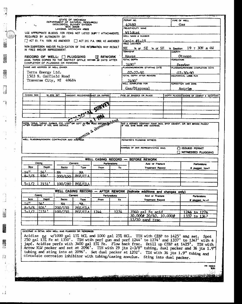
S'ATE OF MICH|qAI{. O€PAAIMENT OF NAIUB L tEsc|lJrcls
- cl€oLootcaL suHv€Y orvtsDx- gox 3dar28l".^NstNo. MtcHrcAN .t909
UST APPfiOPCJATE SLOCXS, fON ITEMS O: LISTED SIF.'I ATTACHM€MTS,AEOUIR€O 8Y AUTHOBITY OF:! acT 61. p.A. rggs. as aMENDED D Att 3t5. pl. 196s, as aME t€D
Nofi.SUBMlSSloil At{D/04 FALSTICATIOI'I 0F THIS rffitltoN MAy RESULT[', rlriEs Al{0/0R tMPn|soNM€fiT.
EECOFD OF WELI-: E PLUGGING E REWORK{MAIL THFEE COPIES rO t}|E dSTRlCt OFFi'"E wl'ls 3t O/|YS ^FTERCOMPL€TION OF PLUGSING OB FEWORXI
CasnELO/f^OUtr Xrrr€
l{ildcatWELL XAA{E I HUMBET
NE s ot SE :t o. SE ,a Sccton 19 r 30N n 4W
Hevel Otseso
NAME lro rOOFE9S Oa W€!! OWX€F
Terra Energy Ltd.1503 N. Garfield RoadTtaverse City, MI 49584
PlUO&Nq/nErEn* COUP|fnOr{ OAT€
n7- ?at-dltotat oE tH trEt eawoBx nEe{rx|G t |.cEa Fi,rr
war @kDt-Er€o toF
Gas,/Disrznsal
FOnMATlol{ {.O IE|ll€
Anlrim
ll1'
trr,t-iFf rI . L
irt lilFL
crsxc sz: I w.,:ne so
I | - r t r L ' II I -r +Tri | .tAl | | | I
. -$o' | |ir\E IflELL pluco'rrGiREwonx Ca,Mrr^Ctoi ^xo ^Ott€SS lpEF lrEEs pu/o6t C wrNESs I
| . tr wrrrressEp pLuGG,NG I
. , wEl,_r- c^srr*g REcoRc.3r9 | C€menr I
p€rror.doii I Add q Fr.cn. I prro.do.E I
srs I
oadn I s..ks I rreo I F.Eln I ro I r.sdr,€n,8..od I retueeld. Ld,? |
lZ::_ I qAr I N^ | N^ | | |r - q /R I 016 ' I r r ' ' ^ / r q ^ lF r t l r : IA l I | | |
r-rlz I zrsr' I rmlzeo I pozzcxa I I | , -----]
ca:'g I C.ttErn I P.rlo6do.t! J Acid o. F.scfir. I rr.|.rrtoar I
$r. I oopd' I sek3 I tyF I Fon I To I r.r.|n,€.tt F.cord I rotuEa.d. hcr? |
A-5/A 1916' llfflllS0 | Po7.lfiJ\l | | | |s-t tz l^rqr' Vmrtso I pffi,m a I ttrlr, I tzzr, I T(,O eat re acid----f-7iu/--to-17'i--l
| | | | I l fg'gpq_+19:_10.000#[133?rolEz_!
i?scAcidize Dd /1O@ gal 152 HCL ard 1000 gal 252 116-. TIH with CIBP ro 1425' and set, SDot I250 gaL 157" Fe ar 1350'. TtH wrih perf gun and perf L244' to L274t and 1337' to lg7r h'Lih 4 |jspf. Acidize perfs wiLh 3400 gal 15% Fe. Elow back frac. Drill up CIBP at 1425', TIH wi th IArroor XLl.t packer and set at 2096'. TIH wirh 29 its Z-3/8" rubing, dual packer and 36 its 1.9"1tubing and sting into aL 2096'. set dual _packer at 1202r. TrH wi r.h 3E jEs 1.9,. Eubi; anr Icirculale eotosion inhibitot with rubin&/casing annulus. stlng inro duil packer--"''s
-'"
IPB 'I'G.lr4
fi,4 i
i
-it
,].!.{i*l
gwruffiit:'
;
dwffi:*
;j"l
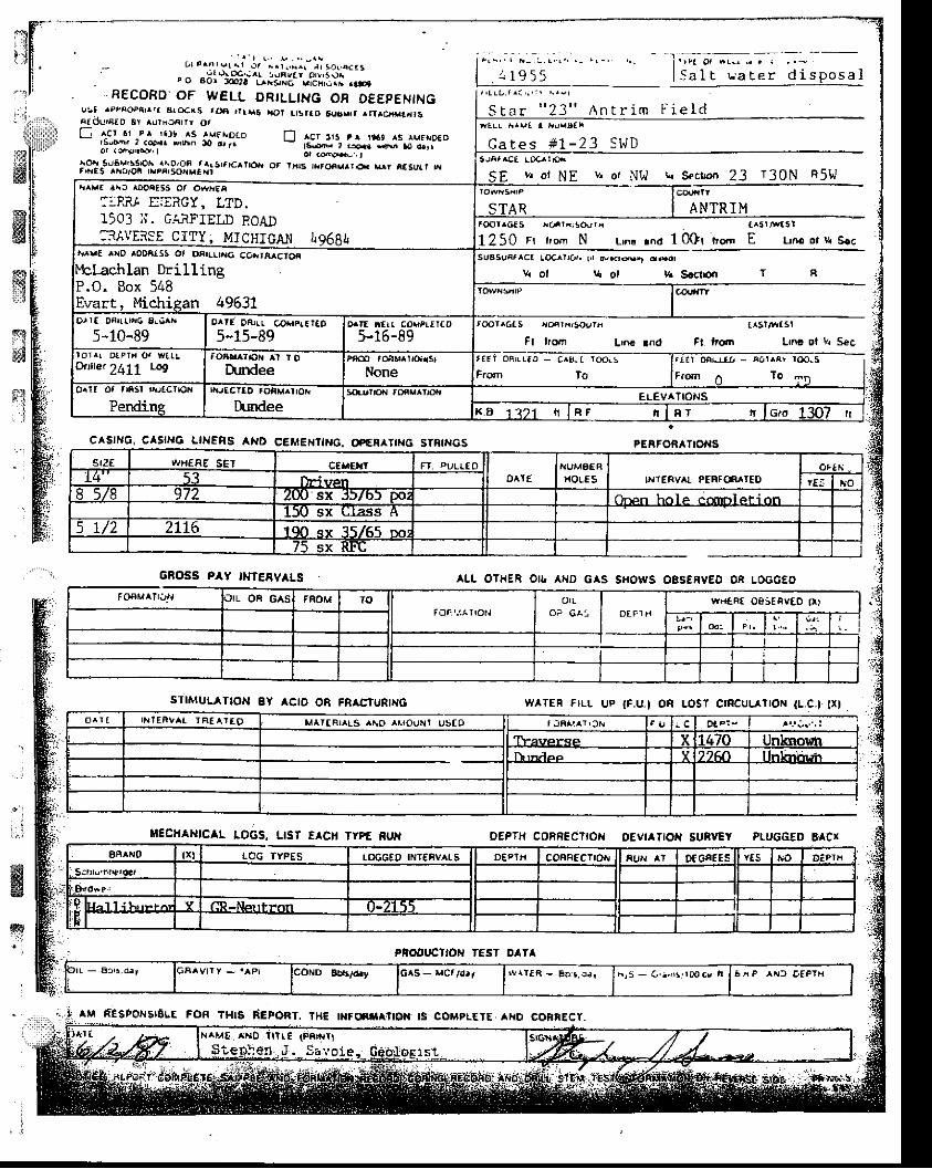
- L t . . i . r e l a r i r / ^ . t . , h ^ r r , ( D ( , A c r s
F o "5i"$fiit:;in[.'"i:tili: ..s
, RECOffD.OF WELL DRILLING ON OE€PENINGu5t TPPAODtu^lt SrCrC{S roe ,lr*! tot lrsrao 5ir3s,, ^nrcra.tdtSntcr!'E[o ar ^uricfillr ot! - - i , :Ct . r -Pr ' i l , ^S rMFtrDaD f l ^cr r ts e^ !*9 ^s rur i roED
!:"?y,i,:r. F,'n ro @,r _ ,s"i;;ii;;;_r a;;_-
i3!s51".!l.o?ioM;%"fir^rsrr'crt'ox o. r,r!s rNron.ur€r e^y ̂ .surr 'AE v. oi N E v, or Ntt k S.cbn 23 13 0N R5W
t r t a ( ' . L r .
S a l E L a t e r d i s p o s a lIrfLL ..ava I ,rus5ai
"23 " n nL r im F i e I d
ANTR I M
C a t e s # 1 - 2 3 S I . J D
From to
Lma ol v| Sec
F@r^6t5 *cn l i ; !0 [J r i
tn S.cltoar T g
tcprrcls rroirnrsosrn
Ft lrorn
1250 rr lrom N Lrnc rno 10Or t 'o.l l E Lrloortt s.csua5uRrlct toc.^Yror.
L'o€ rnd Ft ttcrn
To
CASING, CASINo L'}IERS AND CEME}IIIHG. OP€A TII{G STBI|{GS
6ROSS Pr'Y IMfEEVALS
STIMULATION EY ACIO OR FR^C'URII{6
}IECHANICAL LOGS. IIST E CII TYPf RUrl
ptoltuctroH T€sT oATl
aLL OTHER Otb AflD G S S|{OWS OBS€f,Vgo 0n LOCGEO
wlTEn FILL Up tF.U_l OE LOST Crf,CULArrOfl (L.C.l tr l
OEPTH COBNECTIO}' OEVI TIOIT SUSYEY PLUGG€D EICX
PEBFORATIO'IS
' . :
&I
,r^Irt 4rc rAOeEsS Oa o*rEAF: F?t t'::;"nY I Trr' I
S n ? : i a . r " F T F T n D ^ ^ n
-,AYEISE CITY, MICHICANtr^rrE rtro looalss ot oarll-lnc ca,erA^ctoi
o, rt DAru.t'ro 8ei^x
5-10-89o^rt ifrr aoePr,tT(o
5-15-89
Ortre.2411 r-o9
sr.:f wdeAg SEI c€ll€r,t FT ')U!I.EOOAI€
KUMgER|rotEs INTERVAL PEBf frIIEO
oF IriIt-i ven rEi ho
97i zw sx J)/b) or,cn hol e ccrrrrl et i on150 sx clrss A
5 1/2 2LI6 190 sx 35/65 oor75 sx RFC
o^ r t r r , r lERvAt rA€arfo MATfAT !5 ^^O r . rouxl uS[O
Tlaverse X l+7O (no$h|t rndep Y 21An nhiirllr
4M ntstorsrgLE FoR THE I}|f(NSA'IOH IS COHPLEIE AXO COBRECY.
coNO BbB/d,t GAS - MC,,,.,rr h:5 - G ' . r ' , s , t lo cv n 6 ^ P ^ N f , O E P T H
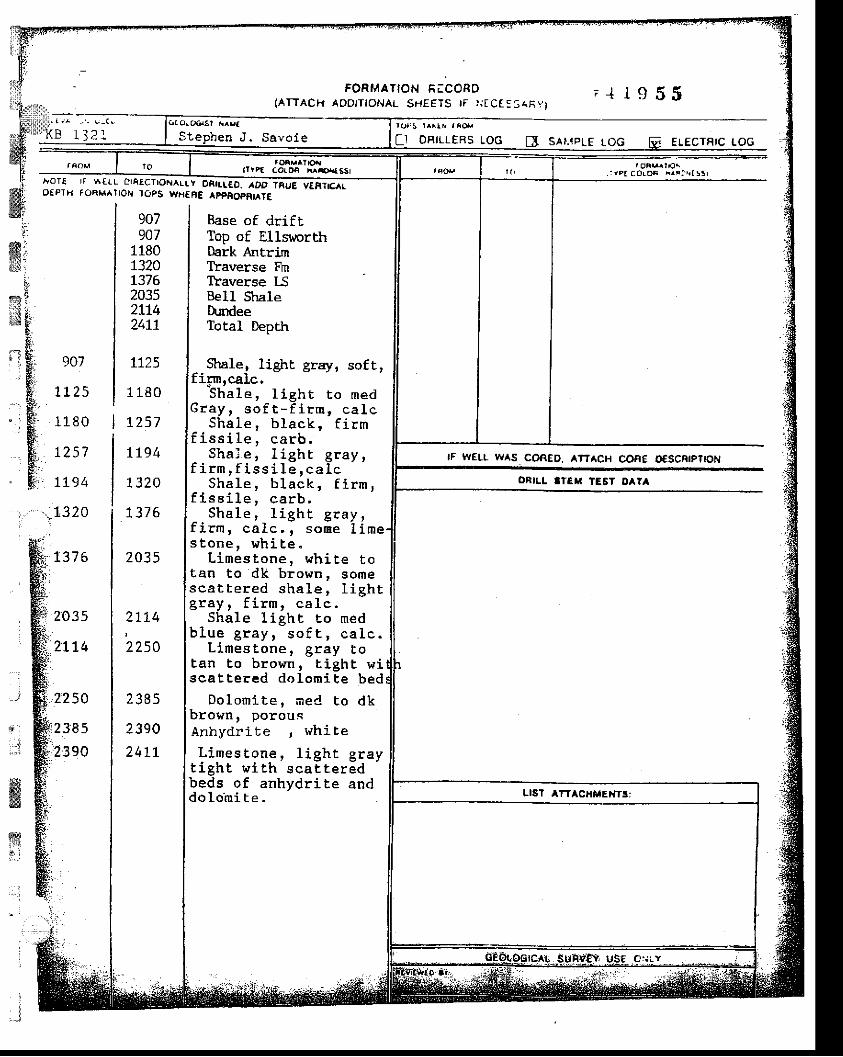
FORMATION FICOND(ATrAC| l AooIT tONAL SHEETS rF r i tC t :S(Ay l
. + 1 : J O J
1 l2 l
r oT Io€PTri
I I \A€I-L CISECTTORALLY OAI! !€0. .D'TRUE VEFTCT(f oaM^Jrotr loPs wsfAE lpFAopntATE
r OBILLERS LOG sAt.tpLE LoG ELECTRIC I.OG
i rpa co lo* Mr : r tss l
rF WELL WAS COR€D, ATTACH CORE OeSCntpttON
ORILI ITEH IE6T D ?A
:.I:
ffiis.rl1
i.ryiiaL
Y.
r't E&:.ff:a
v ;4 ' Et '
B
ft.E..F:
wtr
907
7L25
1180
1257
7t94
90711807320t3J620352174zqrl
1725
1180
I757
7794
1320
Base of driftTop of EllsworthDark AntrirllYaverse FmTraverse lSBeIl Str,alehrndeeTotal DepEh
Stule, light gray, soft,fi5m,calc.
Sha le , l i gh t t o medGray , so f t - f i rm , ca l c
Sha le , b lack , f i rmf i ss i l e , ca rb .
Sha l e , l i gh t g ray ,f i rm , f i s s i I e , ca l c
Sha le , b l ack , f i rm ,f i s s i l e , ea rb ,
Sha Ie , l i gh t g ray ,f i rm , ca I c . , sone l imes tone , wh i te .
L imes tone , wh i te tolan to dk brown, somesca t te red sha le , l i gh tg ray , f i rm , ca 1c .
Shale l ieht ro medb lue g ray , - so fE , ca l c .
L imes tone , g ray totan !o brown, t ight wiscattered do lorai te bed
Dolomite, "-red to dkbrown, porousAnhydri te , whi. te
L imes tone . l i eh t s ravf i eh t l r i t h ' s ca l t e r i d 'beds of anhydri te anddo lo in i t e .
l - . r1320
r37 6
2:O35
2tL4
2250
238 5
390
7376
2035
2LL4
2250
t l R q
, 1 q o
24LL
Stephen J . Savo i e
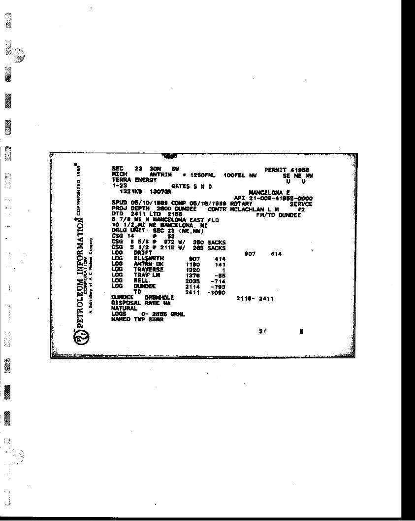
tr$",',,'r,:tllllli;l
ffiffiffi@
ffit:
" .
a
w)9
g
st
:1i
It
EE|,E
t(tzo
3r: l rENOzcts3iEf .
F* :i J o ,
5"iofd .Eg
-$!-q . e3 r* & PEFHTT 4rr!q!!_q _ _-!r.rrlr . ulomL rooFll fr
'---'-is'*i w
TERNA BGNd _U '_U
1.29 OATES S H Dr32rKt rgr* rrrEllq{a E!g4q lE1lol rl!. w 6/ fi / 1e.0. #L?
| -oot-'l'lE-oo0o
?!gJ DePrH raoo q.iDEE @ rn" rcLrcHLA L H --iz--
qTD 2'II LTD AIIE F /TD q'DEEs 7/a tt H nEtlql Erst FLDro I f2-nt tE rr|ttLoxA. IIDlLo LNIT; SS 23 (iG.afi)c30 ra o t3996 ! r/r O t72 rt o srExs8 A ll2 a 2113 tl 2tE SA€KSLOO ruFt eo7 a r aLOO ELtSnflr 67 11.LOO |rfitr-X fito ralLOO TXlErsE 1320 ILOO TRAVJ: I,I i3i'G -!rLOC lEtL, 203! -7 raLOO UfG 2111 -793
T0 24l l -totoclpEl oaGrsLE 211a- 2.11olsFost|. rc xAlraTutAtLlrF o-t5Et ffi.XIIED TIP S'*
2 1
tt8tla
" . - ' " i . ' q l . : ' . i . . 1 .
grEPr*H g CthlsrElff;fltrlroYrelt1lir'al RFlElo DtrriiffitE CtrY, rltE eal-?tt9t&l1at9l
OEOL
@lo1
rutn..:n
d,'{},,'uriiililti
t!:w
ffiffir?
gB
t$ri
,
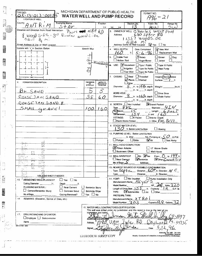
:".:. l
l-:i\i l
l:irjiw
MICHIGAN DEPARTMENT OF PUBLIC HEALTHWATER WELL AND PUMP FECOFD
Thi6 wetlwrs d.ill€d under my iuisdiction and lhis.6po.t is true
Sign€d
(rl:Olc)Gl(.,t\l 5URVEY COi)Y
ffiffiif
$:g&iil
1l. '
. :
ii
ffi%.:::
7!,i?.)t,
Counry ^
HMI HtDlsranc€ and Di 'ocr,on hom Hoao Inr€/socr'n
Tr,rt t d Al.611 1
{ w" r ,0 s , t t - ' 3 i r f ' o , r - r 6 , , r , , i : oo .41r..,.tr +t h,
Locsrs vJ(h x in secrion Eslow skerch t\,4ap
+ -t- f .i t t
T_T -T+-t-L
r I l
F_, j . I
;; - ' l Y
1€,1
t
t r3J? wo7DS,oe.^***,"^€J"4S,""#"i s,,* r ""
d WELL OEPTH:
s. [caob root Efnorury E ori*n! Holtola Rod tlauseaeorea ! leuad
D oreD
usE: EfHousohord !rype I pubtis lJ typ" 11 r,uor'"I trrigarbn I rype tta P'rbric DH6al PulnpU T""r wurr D Type b pubtic !_
7. cAslNG: D steet !rhreaaeo[l ptagtic ! waasaDo,r'"'
Dr"..'-, *j-- - i;. ;lE{r,. d"orh__ . , ._ , rn. ro._-- . - t r . doplh
SORE HOLE:oiamerer I i. o L6Ar. o"pr
_in. ro. _lr. deprh
Waigh l i_ lbs / i t
f lsr"t" p*t',
su,raco::Lrr
lehni( rtove screen n an", Q !.t(. !]F
9 STATIC WATER LEVEL:8€low Land Surlacd ! tb*ing
10. PUMPING LEVEL: 8€low Land Sur,acsI A e' --hrs. Pu,"p'.s u' -jia c.p.t.l
I errns"' ! 8"1", Mor' E resr lump
1 l . WELL HEAD COMPLETIONI
SPiiess Aaapter D 12' Abovs cradoD Basenenr ottser D w"ttt-tou."
12. wE[cnourED? trru" tr1* l ,g^-L, t 7'/ u.I near cemelt E6"nlonit"No.ofBaos.5 Addiriws
Eotnu,EutuLL:
13, NEAREST SOURCE OF POSSIBLE CONTAMINATON:. rype S{J2}rr oi"*"".-fiB{.1. oir" clouM E-
Type t DisIance___tt. Diroclion_,
14. PUMP: D Nol Insralt€d
Model Number-l tQ-:LCapaciry
InstallElion Oflly
r"ng,noro,op;;El=.TYPEi Elsunmersitta ! ler
HPcapaciv
I on"'
rs. - leAmoruro welLllucceor ! v"" D uoCasiag Diem€ror _in. oopth___tt.PIUGGING MATE FIAL: D Near Cenr€nr O sonronib Stu,rvfl cernenvBenronire Sturry f] Concrere crour I BentDnir€ chipsNo,ol8ogs__-.-_ _-_ casing Romov€az I v"" [ ruo
16. BE[,4ABKS: (Elevation, Source ol Oala, stc.)
I 7 DRITLING MACHTNE OPEBATOR:Ienrptoyea D suo"on,.""ro,Nam€
15. WA-TER IVELL CONTBACTOB'S CERTIFICATION:
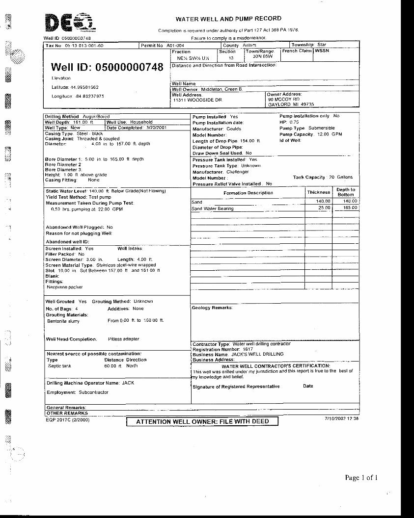
$ ffi€. WATER WELL AND PUMP
Complet ion s req!red under aulho.r ly o l Pa. l
RECORD
1 2 l A c l 3 6 8 P A 1 9 7 8
a:3, {
i;1t;.,
ffiryx
. l
,]
wi'.llr!
ffi
Well lD 050000007a8 Far lure io comolv rs a mrsdemeanor
T a x N o 0 5 1 3 0 1 3 0 0 1 ' 6 0 I Permit No A0 r-004 f-orrry enr, ' l .n lTownship Sta.
Well lD: 05000000748Elevalion
Lal i lude 44 99541562
longrtude 84 86237975
tm lF 'e "chc ta i ' lwssN
Distance and Direct ion f rom Road Intersectaon
Welt Owner Middle lon. Green B
11311 WOODSIDE DR 90 t\rccoY RoGAYLORD MI 49735
Pump tnstal led Yes Pump Instal lat ion only No
Pump tnstal lat ion date HP o 75
Manutacturer Goulds Pump Type Submersrble
Mo.te l Numbei Pump Capaci ly 12.00 GPM
Length of Drop Pipe 15400 t t ldolwel l l
Diameter o l Drop PipeDra\i/ Down Seal lJsed No
Casing Joint : Threaded & coupledDiarneter : 4.00 io. lo 157.00 f t . deplh
Bore Diameter 1: 5 O0 In to 165 00 fl deplhBore Diameter 2Bore Oiameter 3:Height 1 00 ft above gradeCasjng Fi t l inq None
Pressure Tank lnstalled YesPressure Tank Type UnknownManufacturer Chai lengerModet Number Tankcapaciv 20 Gallons
Pressure Rel ief Valve lnstal led. No
static waler Level 140.00 ft aelow Grade(Nol Flowinq)Yield Test [rtethod: Tesl pumpMeasur€ment Taken Dur ing Pump Tesr:
0.50 hrs. pumping al 2200 GPM
Abandoned Wel l Plugged: NoReason for not p lugging Wel l
Abandoned wel l lD:
scr€en lnsla l led Ye. wel l Intake
Scr€en Diameter: 3.00 in. Lengthr 4.00 i iScr€en l$aterial Type: Slainless sleelwite wrappedslot 10 00 in set Between 1s7 00 f t and 161 00 f lBlank:Fi t t ings:
Wei lGrouted Yes Grout ing Method: Unknol tn
No. of Bags: 4 Addi t ives: NoneGrouting Materials:Bentonite slurry From 0.00 ft to 150 00 tt
Well Head Completion: Pitless adapler
Business Name: JACK'S WELL DRILLINGNearest source of possib le contaminat ioniType Distance DirectionSeptic tank 60 00 lt Norlh WATER WELL CONTRACTOR'S CERTIFICATION:
Ihis wel lwas dr i lJed under mY jur isdjc l ion and lh is tepor l is hue to the beslofny knowledge and belief.
Signature of Registered Reprcsentative DateDri l l inq Machine Operator Name: JACK
Employment: Subcontraclor
ATTENTION WELL OWNER: FILE WITH DEEDE Q P 2 0 1 7 C(2/2000)
Page I of I
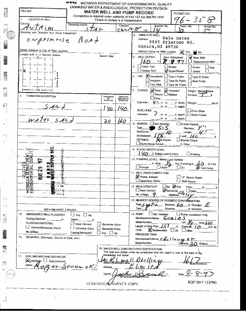
1?i:.l
i'!3r?*',t
ii'r:w
**
j:l
" r . ' . " ,
r.Et. MICHIGAN DEPARTIVTENT OF ENVIRON[IENTAL QUALIryDRINKING WATER & RADIOLOGICAL PROTECT/ON DIVISION
WATER WELL AND PUMP REGORDComplelion is required under authority of part .l ZZ Act 368 pA t97O
Falurc to compty is a misdemeanor
ffiffi
ffiFg
,dfuM-, -"*f-,8-z>
Distanco and DksclDn lronr ftaail tdrsrsoction
a-ft"/ tnt."se ( l .uA{
Locate wilh x ,n Secrio^ Botow skdtch Map
-+ -t- l_t r lr *T-
i-|_ t_Lt l l
F-- '.:. ------J
Address Da16 Gates9 9 9' l Pr lmrose Rd .
l i lm l ra , M I 49730Add'ess Sam€ aE W€[ Locaion l/ ves 4 lto
S H"'n w"rrD Fepiacem6nl Wetl
r . [ l cou t " too , !ao , " ,y Do, , * " no ,ofl rqotro*, too Q nueeraoreri I Leued tl
6. usE: m Househotd n Type I Fublic I Typ€ Il pubticfJ r"'sar,on I ryp€ rra pubrrc IrisarpumoI lesr Wett lType ltb pubhc D
7. cAsrNG. p s'""r prr""oo"oLl Plasr,c { lWelded
. [on*_Dianrels/ : f_ i ' in ro. . _, t deprh
in lo ft deprhBOBE HotE: 1Dianleror: -;l_in. ro tt. depth
._ _ in. to _iL. dsplh
He|ohr: Abov€/Belows,.L"".lZ__"
Weighr:____lbs-/h.
I Drtve shoe[sl"r" p""t u,
8. scffEEN: f] Not Insraled f]o."u"t.r*l"a
Ilf.;*r-*' - Tff:'sld'cau/e- '^* gf*' r"**" - f .-fid_-n .u. "i
" 14 o _ n
FITTINCS AIK-PBcxor Ll Brom€r cnecKLJElankAbovs Screan _ .- _ tr. Orher
9 STATJC WATEFi LEVEL:
I Y0 .n. eaow tana su,rac" D r,o*,ns10. PUMPTNG LEVEL. B€rovJ Land Surtacs
I 1 , WELL HEAD COMPT€TIONJ,E Pirtess loapre, D lz Above G€deLl BaEem€nt ollser L J w€[ Hous€
r2. wELLoRor.JftD? Uruo mves From! tear cemenr ffisenronirc --, lo,r,",
- - -
No orBass f __ xan*""!! {,gl- -
13, NEARESTSOIJRCE OF POSSIBLE CONT
1L oisbnce fu .-t. U,ecton if.._._. Disranca_ lt. DrscrionIISE A2NO SHEET ]F NEEDED
llo ol&19s... -- ._ casing R€moved? [ v"" ! r,ro
rs. AMNDoNEDWELL pLUGGED? ! v.s n ruoCasing Diam€Er -- - _.__in Dsprh-- ,_[.pLUc6 tNG MATEATAL: I atoar c6nrcnt fJ Benronire srtrryn cBmsn/Bonenire Sturry D concrete cmur |] a*rontre ctrip" TYF€: Ssuuneisiuire U:"r tl or'"i
r 4. PUMP: D No( Instrl€d I pump rnsrartaton ontyr/bn,facru6r's Mme sO-g-t d 5
lf"Xl'^11Tj;" trv : _;, i!;#f-1 f9., *PBESSURETANK:
16. REMARKS: (Et€vation. Source ot Dala, erc.)
r7. DRILLING MAcHINF oPEFAToH:
Na.e 4-d* v y--$-P u-e+,- 5 L( |
c;l1()t"(JcleA giJFiVt-]V l ioltv EQP 20 r7 ( t2le6)
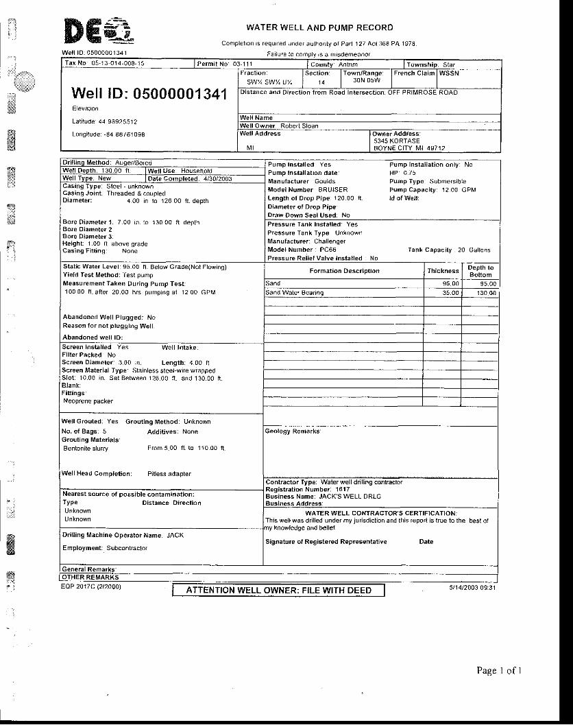
;:ii$Irii::. r'rl,:ll'iqFirl
ii::
!i*;s]
i lI JJ ; ffiffi&
Well lD 0500000 r 341
WATER WELL AND PUMP RECORD
Complelron rs requrred under aulhorr ty ot Par l 127 Acl 368 PA 1978
F3l lufe to comply rs a msdemeanor
tr'gls
$qe;t;lnt
fr
- :
ffi,.q
Tax No 05-13-014-008-15 I Permit No os 111 I counry AnFrm I Township. Star
Well lD: 05000001341ElevatrDn
Lal i lude 44 9892551?
Longi tude: -84 8476r 098
"3i.i1i.".*, u, l'"'']i" l-:y,58ifli I F'|ench craim
lwssNDistance and Direct ion f rom Road In lersect ion OFF PRl l \ , lROSE ROAD
W e l l N a m eWel l Owner: Robert Sloan
Nt l5345 KORTASEaoYNE CITY l \41 49712
Pump Instal led Yes Fump Instal lat ion only: NoPump Instal lat ion date HP o 75Manufacturer Goulds pump Type Submersib leModelNurnb€r BRUISER Pump Capaci ty: 1200 GPMLength of Drop Pipe 120 0O f l ld of Welt :Diam€ter ol Drop Pipe:Draw Down Seal Used: No
Casang Typer S{eel - unknownCasing Joint : Threaded & coupledDiameter: 4 O0 in lo 126 OO t l . deplh
Bote Diamete. l 7 00 in. io 130 O0 f t deplhBore Oiameter2Bore Diameter 3Height 1.o0 f l above gradeCtssing Fitting None
Pressure Tanl( Installed: YesPressure Tank Type UnknownManutacturer : Chal lenqerlv lodelNumber r PC66 Tanl capaci ty 20 Gai lonsPressure Rel ief Valve lnsla l led No
Static Water Level: 95 O0 fi Below Grade(Nol Ftowing)Yield Test Method: Tesl pumpMeasurement Taken Dur ing Pump Test :1o0 0O f t . af ler 20.00 hrs pumpang al 12.00 GPIM
Abandoned Wel l Pl0gged: NoReason for not ptugging W€t l
Abandoned wel l lD:Screen Instal led. Yes Wel l lntake.Fl l ter Packedr NoScreen Diameter: 3 00 in Length: 4 00 fiScreen Material Type Slainless sleel-wire wlappedSlot : 1000 in. SetBetween 12600 f t . and130.00 f rBlank:Fiftingsl
well Grout€d: Yes Groutlng tvtethod: Unknown
No. of Bags: s Addit'ves: NoneGrouting Materials'Bentoni te s lurry From5.00 f l . to 110.00 f t
W€ll Head Completion: Pitless adapler
Registration Numb€r: 1617Business Name: JACKS WELL DRLGNearest source ot possib le coniaminat iani
TYPe Distance Direct ion
Signature ot Registered Representatiye Date
WArER WELL CONTRACTOR S cERTIFICATIONiThis wellwas drilled under my jurisdiction and this report as true to the best ol
Dr i l l ing Machine Operator Name. JACK
Employment: Subconkaclor
ATTENTION WELL OWNER: FILE WITH DEEDEQP 2Ot7C lzt2OAO)
Page I of I

TDElr MtcHIGAN DEpARTMENT oF ENVTRoNMENTAL euALtry
DRINKING WATER & RADIOLOGICAL PROTECTION DIVIS]ONWATER WELL AND PUMP RECORD
Complotion is requjred under aothority of Part 127Act 368 pA 1978Failur€ to comply is a misdemeanor
18, WATEF WELL CONTRACTOR'S CEFTIFICATION:fhis well was dfllted vnder my iurlsdidion 4nd lh s r€porr is lrue ro he bosr ol my.
:i,r:;,,:i
iititiii[]
**w44Sw:rii
i1;
id
ltt:,;"
*iigit{j!
ffiffi
TAX NO.05-13-014-00?-00
Disrance and Drrecxon lrom Foad InterseciDn
o' we1 Locar.n 10303 ALba It^ty.Locar€ with j( ln Sectjon Be,ow
J . - t - - L-r _'l-' I-.r -l- L
1 . t l
3. OWNER OF WELLAddress CI{IPPA, $IIG
10303 AI,BA }IWY.trMIFA IUI 49730
Addr6ss Sams as wett Locarion E ves fl to
! u*, w"rtE Aepiacement we||
5 ncabr6roor ! not"'y Io,,ru,n [Jo,sE Hotm, noa E A'ros'/Bo.€d D J€ued tr__-_
6. UsEr ElHous€hold [Typo I Pubr.c
! lrigarion ! Typ6 lla Public
I Iesf W€rl nrype tth Pubtc
D rypo lll PubtlcfJ near eumpD
7. CASING: ESleet Elhreadodf lPta"ric f lw"t"anornr'-- - -. ,,y
o,anrere,. ./ In. to lHs:rr. detff._. .__n, to__, ,1r , deprh
BORE HOLE:Diarnorer: 7 in. ro .lll?rr. deprh
Hoisht: Abov€/8EbtaSur,rcsi / fl
we,shr:l/g,,bs-/h.
Porrve srrooI sut p""r".
SCBEEN: ! Nor hs|alred .r Dcraver.Pac.eoryrs fr/'ts C4A6 " Di-,.r", 3::,
.. - ,- Lenst-', 4 '__-
sorBetween /;l5.- . -Jr.and_ /aP _,. 'r.FlTTlNcs: ,Ax-Packe' [ ] arome' chock
9, STATIC WATEH LEVET]Betow Land Suri;c6 fj rtoring
10. PUMPING LEVEL: B€low Land Surlace
. :j!;):i-tl Attet . ./- .. ---hrs. Punrptn! ar -G. p.M.
f)euns", I g"i,n,, I n'.' presr eump
i \ 1 r ; l \
I 1. WELLHEADCOMFLETION.
E citt""s ao.orn, Soln E '2" ruon" e,"oeL.l Esssmsnt Olls€t L l ttell Hous€
12. \'./ELL GRouTED? D r,ro pvas Ftorn J!14{to LtLL l N6ar c6m€nt Ld genron,re L-lorn"'
I3. NEARESTSO{JRCE OF POSSIBLE CONTAMNATION:
\pelE#;6--. Dislance-dijf ,.-r. Dr€ cron_6:_TypB _ _ Drsranc€_fi. Dirscrjon___-
USE A 2NO SHE€T IF NEEO€O
Moder Number_ld /Q - : a./-J capaory
ra, PUMP: flNot Instal€d n er.p rn"torr"rion ootyMa.utacrur6/sNarE_lg oUJlbS_ , , ,a." ul
/rn"W#",*?fFf; i'i;f""*""-iff-rYPE: FsubdsrsiDl" Il"r !orr'",-PNESSUFiETANK:r,tanu{ac1ur€is Nam€ - IL^XXj--.J,^S
1s. ABANDoNFo wElr pruccED" fl v"" E/r,roCasing oianlgrar ___, -. -in Oeplh ____,._ _,.i1PLLTGCINGIrAIEP]A!: I Near c6nrenr ! aenronna SturryD CemenvBenronhe Sturry fl Conc/"re Crour E e.nronir" Ctip"No.otBags. _ __ . Casing R€moved? n V"" I to
16 BEMABI(S: (Etsvation, Sourc€ ot Dara, etc_)
17. DAJLLING MACHINE OPENATOR:
@empryae I suo-nr.u"ro,N""' K.d_.&.aaa"(SkL ./t_
'o4- and boliol
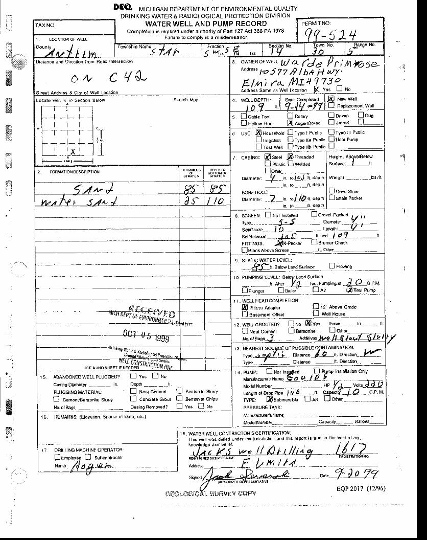
: 1t :
i"iilL.:t.,,,
€'*lllt$ii
&
DEO rvrtcHrcaru DEpARTMEN r oF ENVTRoNMENTAL ouAl'ryDRINKING WATER & RADIOLOGICAL PROTECTION DIVISION
WATER WELL AND PUMP RECORDComplelion is roquired under authorily of Pa.t't27 Act 368 FA 1978
Faiiure to comDlv is e misd€meanol
1€ WATERWETLCOMTRACTOR'SCERTIFICATION:This wsll was dtilled lnder lny iurlsdiclion a.d lhis tepo is rrue |o the b€st ol my
.,.i
wrysd
9 t
W.ffi;
1, LOCATION OF WELL
" ?y.*llo' *,,: uJ + (de / r i n Ftt5e-aoor"" 1.rt57T r? lt* 1l wy'
E/n) ra- ft\au !z3lidd,;ss same as w6rl to"ar,on Fl Vus J r'lo
Distancs afd Dkec on kom Road htetsedD.
Locare \,virh x in Socrion 86low Skalch b19p
+-r - l-T -_r- r_f -r- L
I l v I
s d cou" root D no,",y fl onu"nI Holtow Rod fi luscaao,eo ff .l"lrea
6 Us€: E Household D Type I Public nType lll Pubtic
! ruroanon Eryps tta Publc flH€ar Pump
I t""r t^rett lTyp€ tlb Publc L] -
H€iSht: Abgvo/tselowSurlacoi I ll
Wsighr:__lbs. / l l -
D D/v€ shooIsnate Pacto,
7 CASING: E sleel FThreadodfl piu.ri" [woa.oDpt",- -- - --
o "n "r.,. -$_.. rol4J tr oeptrr
. - . i^ Io - . - -h- dePlh
BOFE I]OLE:
ni"mere,: --]-in. bUA\. dlpth
. - in to -ll daplh
2. FORMATO^|O€SCRTPTTON
B scnEEN. n Nor t^srar{ed
9. STATIC WATER LEVEL:h. Bslow Land surfaca D rtowing
ro PUMPING I EVEL. Ealoy Land Surlacd
, o'* .4- no. eu n'o,"n", *Lc,r.tl","n"' D a.F Der' firesr eump
1 I . WELL HEAD COMPLEfION:
& Pi ess Adapl€( D rz'nlove craaeflBaeemenr otfser Ll We Hous6
D r.ro Bvu. F'om---io---ft.Ll Ben|ontle l-l oLhar
1s NF^RFsl souBcE oF PosslBr E cpNrAMlNArl."l;" fr-typ" tggll L- oi"".. l-L
Iyp"--L -- Disbnce -..lt Drsction-IJSE A 2NO SI-IEEI IF
14. PUMP: I Nor Ins,liriledManuladursr's Namo FA !tModelNumber
PHE SSURE lAl.lKl
Manulacurer's Name-
ModdNumber- .-- -- - - --Capacitv--, - Gallons--
tenoth ol D.op Pip€ tl?! -...TYPE L{ submercible L-.1J
15. AaANDoNED wELL pLUGGED? fl v* U n"
Caslno Diam€ter -,, --in- Oeplh --- -..11
PLUGGING MATERIAL: ! Neat c'snrent fl Be^tonile Slurry
E cern€nvB€ntonire slu.ry n con"r"t" ctour n asntonio chips
No. ol Baos---- -- - casinq R€mov€d? [ v* ! ru"
16. nEMARXS: (El6varion, Sourc€ oJ Dala, elc-)
17 O' I ILTINJG MACHINE OPERATOR:
qECISI€F€O BUSIN€SS XAME
TUTHOFJzEd'.,R€3ENT^1 E
EQP 20r7 (t2196)

ql ;
*j1,r,,,',l'liri|ll,fi
qx
&
ffiffi#;,,i
i:i
ffe-d WATER WELL AND PUMP RECORD
Compretroo is requrred under auihor i ty o l Part 127 Acl 368 PA 1978
Wel l lD 05000000682
Ktr
T a x N o 0 5 - t 3 - 0 1 5 - 0 0 3 0 5 lPermil No A0o 5et I r ; nsh j p s ra l
Well lD: 05000000682Eleval ion
tatr lude 44 99308632
Longr luder -84 8a885784
Fract lonr lSect ion lTown/Range lFrench c la, lh IWSSNNFjy. sEy. uy. I rs | 30N 05W | |
Distance and Direct ion f rom Road !ntersect ion
W e l l N a m e lWell Owner: Jeny & Welllayfer Broods
11050 Sprucedale€hira Ml 49730
Pump lnstal led: Yes Plmp Instal lat ion only NoPump lnstal lat ion date: HP o 75Manufacture.' Goulds Pump lype: SubmercrbieModel Number Pump Capaci tyr 10 O0 GPML€nqth of Drop Pipe: 14000 t l . ldof Wel lDiameter of Drop Pipe:Draw Down Seal used: No
Casing Joint Threaded I couptedDiameter: 4 0O in to 14000 f l depth
Bore Diameter 1: 800 In to 150.00 f t depthBore Diameter 2Bore Diameter 3Height 1 00 ft above gradeCasing Fi t t inq None
Pressure Tank lnslalled: YesPressure Tank Type: UnknownManulacturer ChallengerModel Number: V 60 Tank Capaci ty r 20 cal lonsPressure RelaetValve lnstal led : No
Static Water Levet: 125 00 lt Bet(lw Grade(Not Flowrng)Yield Test Method: Test pumpMeasurement Taken During Prrmp Test
0 50 hrs. pumping at 22 00 GPM
Abandoned Wel l Ptugge.t : NoReason for not p lugging Wel l
Abandoned wel l lO:
Fi l ter Packed: NoScreen Diameter: 3.00 in Length 400 i tScteen Materiat Type Stainless sleel,wie wrappedS I o t : 1 0 0 0 i n S e t B e t w e e n 1 4 6 0 0 f l a n d i 5 O O O t tBlanklFitt'ngs:
reen Instal led Yes Welt tnrake
Wel lGrol ted. Yes Grout ing Method: UnknownNo. of Bags: 4 Actdi t ives: NoneGrouting Materiats:Benloni te dry granular Fromoo0 f t . to 150.00 f r .
Well Head Completion: Piljess adapler
Registration Number: 1617Business Name: Jack's Well DrillingBusiness Address:
Nearest source of posslble contalnination:Type Distance Direct ionSeptic tank 70OO fl. West WATERWELL CONTRACIOR'S CERTIFICATION:
This wellwas drilled under myjurisdjction and lhis reporl is true lo the beslot
Signature of Registered Representative DateDri l l ing Machine Op€rator Name Jack
Employment: Subcontractor
ATTENTION WELL OWNER; FILE WITH DEED 612012002 OA:47EOP 2017C (2/2000)
Page I of I
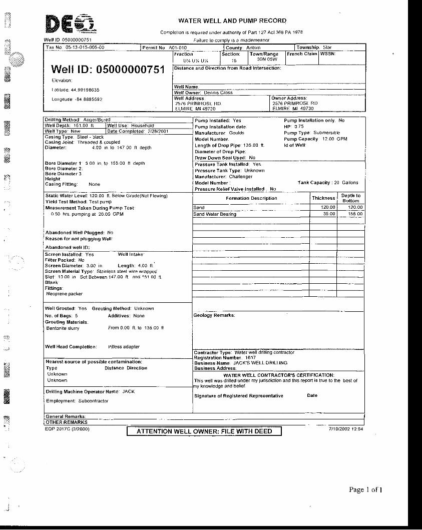
ffi€9--eWell lD 05000000751
WATER WELL AND PUMP RECORD
Complelron rs requrred under authoalv of Par l 127 Act 368 PA 1978
.'.::
li€"..,.il.s
{i'*ffi
ffiwe3g
t
:.1'a
#ffi&
-ry
, , i
loTax No 05 13 015-005-00 l P e r m i t N o A O 1 - 0 1 0 lcountv Antnm lTownship Slar
Well lD: 05000000751Elevation:
Latr lode 44.99198635
Longi tude -84 8485592
""ljl)u,un l'*';T' l*:l',f3lff lFrenchc'aimlwssNDistance and Direction from Road Intersection:
r l l NameWell Owner: Oennis C.oss
2576 PRIIVROSE RDELt\4tRE Mt49730
2576 PRIMROSE RDELMIRE MI 49730
Pump lnstal led: Yes Pump Instal lat ion only: NoPomp Instal lat ion date HP 0 75l/lanufacturer Goulds Pump Type SLrbme.srbleModel Number Pump capaci ty: 12 00 GPlv lLength of Drop Pipe 13500 n ldof WelrDiameter of Drop Pipe:Draw Down Seal Used: No
Casing Jdn! Threaded & coupledDiameter i 4.00 in 1o 14700 l l depth
Bore Diameter 1 5 00 in. to 155 00 f l depthBo.e Diameter 2:Bore Diameter 3Helght:Casing Fir f ing: None
Pressure Tank Installedr YesP.essure Tank Typer L,nknownManulacturer: ChallengerModelNumber Tank capaci ty : 20 Gal lonsPressure Rel iefValve lnstal led No
Static Water Level 120 O0 fl. gelow Grade(Nol Flowing)Yield Test Method: Test purnpMeasurement Taken Dur ing Pump Test :
0 50 hrs pumping at 20 00 GPM
Abandoned Wel l Pl0gged: NoReason for not p lugglng Wel l :
Abandoned wel l lD:Screen lnstal led: Yes Wel l IntakelFilter Packed: NoScreen Diameter: 300 in Lengthr 4.00 f l .Screen Material Type Slainless sleel-wrre wrappedS l o t : 1 0 0 0 i n S e t B e t w e e n 1 4 7 0 0 f t a n d 1 5 1 0 0 f lBlank:Fittinqs
Wel lGrouted Yes Grout ing Method unknown
No. ofBags: 5 Addi t ives: NoneGrouting Materials:Bentoni ie s lurry Ffom 0.00 f t lo 13500 l t
Well Head Completioo: Pitless adapterContractor Type Waler well drilling conlraclolRegis i rat ion Number: '1617Business Name: JACK'S WELL ORILLINGBusiness Address:
Nearest source o[ possible contamination:fype Distance Direction
WATERWELL CONTRACTOR'S CERTIFICATION:This well was dnlled under my jurisdiclion and this repon as lrue lo lhe best ofny knowledge and belief.
Signature of Reglstered Representative DateDrilling Machine Operator Name: JACK
Employment: Subcontractor
ATTENTION WELL OWNER: FILE WITH DEED 71101200212:54EAP 2017C l2l2OOO)
Page I of I
I Locr t ro l or weLr)
L:ili
ux&t
ffiwffist:l
:il*t
' ,
cEoLoGrcAL suRvEy sAMpL€ - , L , ' - l
Rroor ls , o l !vor too . sourco Df dd to , ! t . ,I
WATER WELL RECORDAcl 194 PA 1965
GEOTO6ICAL SIJRVEY COPY
I / W A T E R W E L L C O N T R A C T O R ' S C E R T I F I C A T I O N :
Thl i w6 l l *d r d r l t l cd ' rnder t t y lu . l sd l€ t lon dnd rh l i r€por t i s l ru .
tnLlli]i_nm[TlI I ICH ICAN DEPARTMENT
O FP U E L I C H E A L T H
AOOTD II{fO. IIY DRIUER' ITEN NIL
rCORR€CIED BY:
,r1,AD$ll l0N 0Y,
O ts(
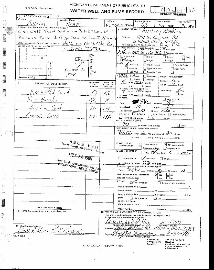
llit l
"a*,l:d*d
.'?l&f*w
M.s
€id1*11
$:
l
_, l MicHtcAN DEPARTMENT OF puBLtc HEALTHr i l o r o 6 r C A L s u n v f y N ( l I I
I J WATER WELL AND PUMP RECORD
ffig
'.. o67d 2/SS
] L O C A T I O N O f W
":JtuIA " l_"-^'drl _- Nr-'2.3 4 <f- vo Ndu^ 4o rrvs 4 lw. ' ' t ' \ ' ' . ! r ' 1.+ Ft i+ \ r r . : ) r I';: ]
7 t b ( \ ' , , 1 t > t t t )
Sr ,eer Ad. r resr a { j , rv o , ! r1 o . . , ! w t h \ f , q e ( r " r r r
l,rJ --'^,rn ..^ ?." l.
N i , J s 5 t . ) c . 1 ^ t ' . J t : , 1
a,,".",,,, s^14./.f ...rr f Jar ],l ('.l ls
) r tJ< .
f ) l
--a:t
-
3 OWr'LF 4F \^ / [ r t ,4 , / 4 l . ,ff N thonT lir'At1t It 7
Add,eqs /qr/ s" 4",:,,,8 t?] .(: )t/ar/) i l,i /'. <777-7',
aao'oss sroe.r{w"rr r/c"',"., n "..
L_J-6
,*-Jti::J-
\-"\f1L,r):L-
l'['r'' 'tu'it- /'u
/'f;{'
T-I
I
4 wtLL OtPrH 'Da@ C64ttot64 ' f.,/. , l
/Db r OD b ;JLi TLilFep,dce,hen, we,,lr\
-.1.*I - ,l l \
| ?"ii
5 Ll c9o'" - ' ! Fo,.,, ' I o,-" ! o,"
_y:y,* !o.* [-1., ' . . . _ t ]_- " "
Lg DomEs , c LJ rvoe rpu l , , . l l r yp " r , , e , , r , r , .I r,,,esr,". [f rvpe ra ptrbr,c D r"a, p,mp! tefyflL ! rvpn lb r,lbrc fl'bl'J:€, tj<'"", llfn-ua,. fl pr..,,. trl *-""'
.r I
rle,(l abDve/0cair.
t s , , , r . " .JL l r ,I *" on, JL,o' r'2 F O R M A I I O N D E S C R I P T I O N a-._,, -tao,li.,,u,
i n r o _ I d e o r h
tuuu ilLa:;,,,,( c /t/{;2fi':"':Wtr")::',^ io"'"sr'oo W"*- ,n ro - - r r derrh | ! rvo
| ,, r 5rt,nI //n /t 8 S C F E E N
Q o'*u",,l-u-r lt, J,,,,,i I'a / r . [
/M9 STAI IC WATEI I LEVEL,
- -- l ,O t ' .oorowrandsu,race Lll 0 PUMPI IVG LEVEL: be low rond sur taco
- 1 f 1 , , ^
W-U), -", e_ ",. o"-,,0.,_j!-]20",t r a t t6 r _ t , , s . , j r rn r .no 4r _ _ 6 p V
li * Ii,ji,l1',i& _t:1"":":::::, gJ|;":"-.lT
__ 0Cr. u ̂,r*Eiforoutff i
_'/LJ N.nr cemen, l t tBo",on.re n o,n*
- 4196
""r^n1irit.,HEAI
: : Ir i l r . . . .Itt-,:;.jil\
l 3 Neores t ourco or poss ib ts .on tomrnat , ; ^
' '"" ,,Zfir<- o'*a".. 7D r.0"".uo,, _r.r-)wcrr d,sin{ccred upon .ompror'enr E !"" n ru.was ori wel prusgedt D v* !
""14 PUMP: d4r rnsrorrea I Puhp hrsr . r tar ion Onry
Manuloc t f6as name
HP - voks --rengrh o i Orop P ip€ - - h . canacr ry _ G.p MrYPE ! subm€'sibre f] t",PBESSI I I I€ TAN( .Manfllactu.er'5 ^.he
l 5 B e m a r l s c l e v a r , o n , s o L r c € o r d a r a , c t , ] 6, WATER WELL CONTflACTOR'S CEffTJFICAIION:Thrs w€r l w.5 d. i r l6d undor my )ur isdict io. and th is reDo,r is t tuero.r)..nesr o{ hy l.owrld9o,anjl]rotiel../
"J ( ) '7
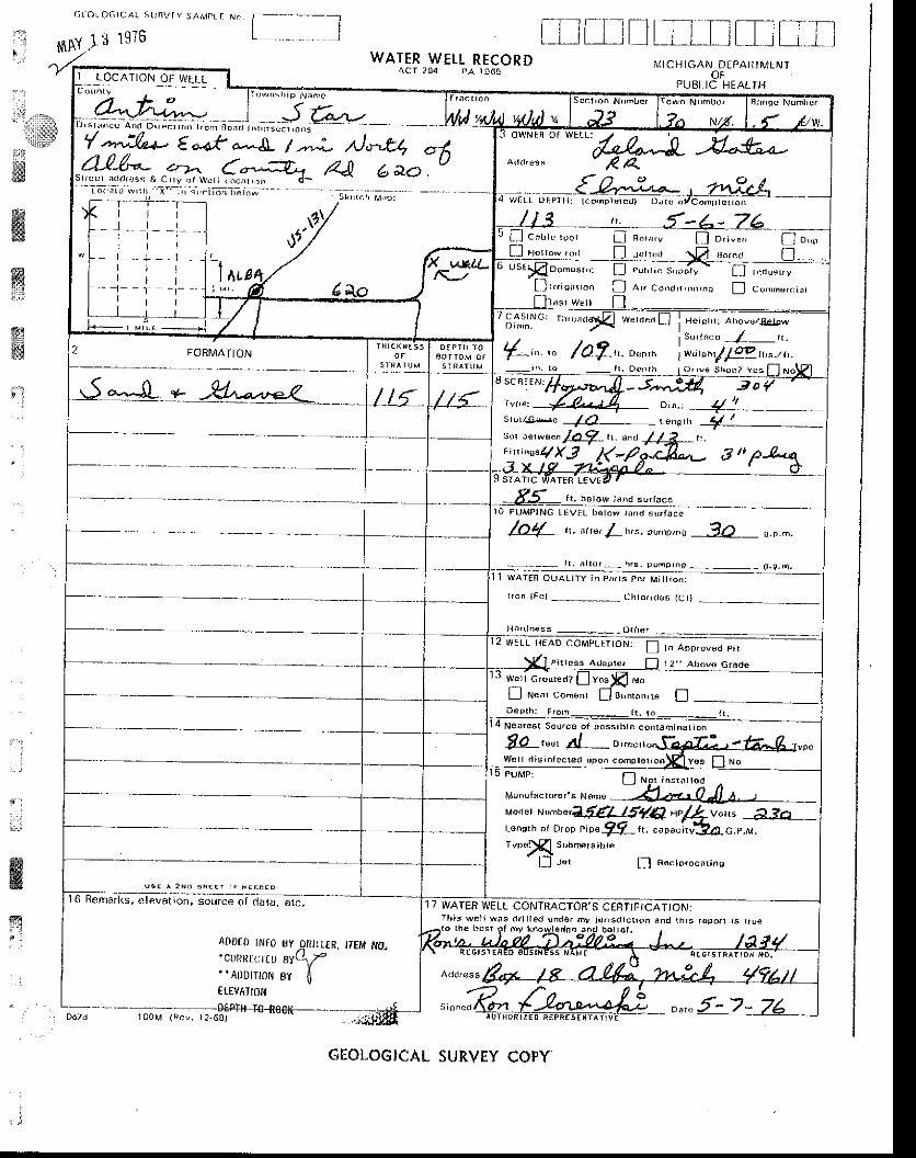
G t j o T Q C I C A ! S t i n V I Y S / \ M F L F N . .
l , _ $ArJ r 1sr6WATERWEt t RECOR D
f-Ilti,r.!L-LL-IItL-[fI ICH IGAN DEFABTII4LNT
OFPLJBI IC HEALIH
' I
tlarlgirilitiii
-'dld&:
wffiffil#gi'l
i
w&r l
621a(rrHoR I z E o R€FREs-triilt;
r l
] L O C A T I O N O F W E L L
'4^A*e
cabrc roor n Fo!.,v f- j o,r.n" U o*,r .w 'd, r L l r . r r " , r \Zt Bor.doomlsr. L_J pur'r i . s.p;rv
- LJ rua,"r,v
t l r r r i s a ' | o n L l ^ " c o n d , i . o , , , n a L J c . - . " , . , d ,
cAsrNG: r t r .cadd* ) . r I WFtd . . i Horlllrl: Abovc4glpw
s " , r ac . J_ r r .
wt ' tEh\4l4tt)s-/ t i .{-,",. la?-,'.,.,'^F O R M A T I O N
sc qtt N: /.l 4Lt?'1Jl - 5^^:H. 3o,.*, {j - 14 o,^., .__4,t_.._sr"rts*e / O- te"et, tt
r'sor uer*a". zkLT_ rr. a"a //2 n.,:,^*qx3 1(*?
r t , t ro ro" r ' ld^d ser facoro puMprNG LEVIL be tow I rnd s r . faco
/n4 ,. .r'", 1Lr,".,u.o,.q .?A n.o.-.
pumpino - - o .p .h ,WATEF Oua l lTY in Phr ts Pe. Mi l l ion :
i r o h l F c l - - - . ' - c h t o r a d e l i l c r ,
! !FLL BrAD cOMpr LTtON. f ] r . aoo,o,"o e,r
Pi r rcas a opre , L l r 2 " Ahovo c r ido
w€rl GroutedT I ly€s
L-J Nenr con. t r r L lBcn l . t r , re L lDepth : From_ f t . to
Ne. ,es t 5du.cc o f oossabre conr6h ina l iDn
8 a, *' Al- "i,,*,i",,fc&2-:weI . t is ,nrucret t ,pon comp ror , onlEl vos Fl woPUMP:
! r . r , n . , , , r r uaMJnurscru'or 's
""-"
-4+,,OJl
a,,-uoaer w"rttlf,flllg{Q,c/..,1v"n, A.?o _Lo^sf h Dr D,op pip6 ?7 fi..oou"i,u?a c.".r.T"D<}E] sDbmrs,h, .
a _ \l _ l r c t I t A 6 c r D r o . , 1 r i n s
l6 Remarl(s, etevation, sorrrce oiaata, orc.
Ar)Dt0 INF0 SYn itLtR, tr fM tfo'cOnRrurru 8YL1r"luorrrol ev I€rEvATt0I{
17 WATER WELL CONTRACTOE'S CEBTIFICATIONJIh iB we lJ wns dr i t led und€r my iu r isd ic l ron 6nd rh rs r€por r j s l lue
r ?-6al
GEOLOGICAL SURVEY COPY
-7*
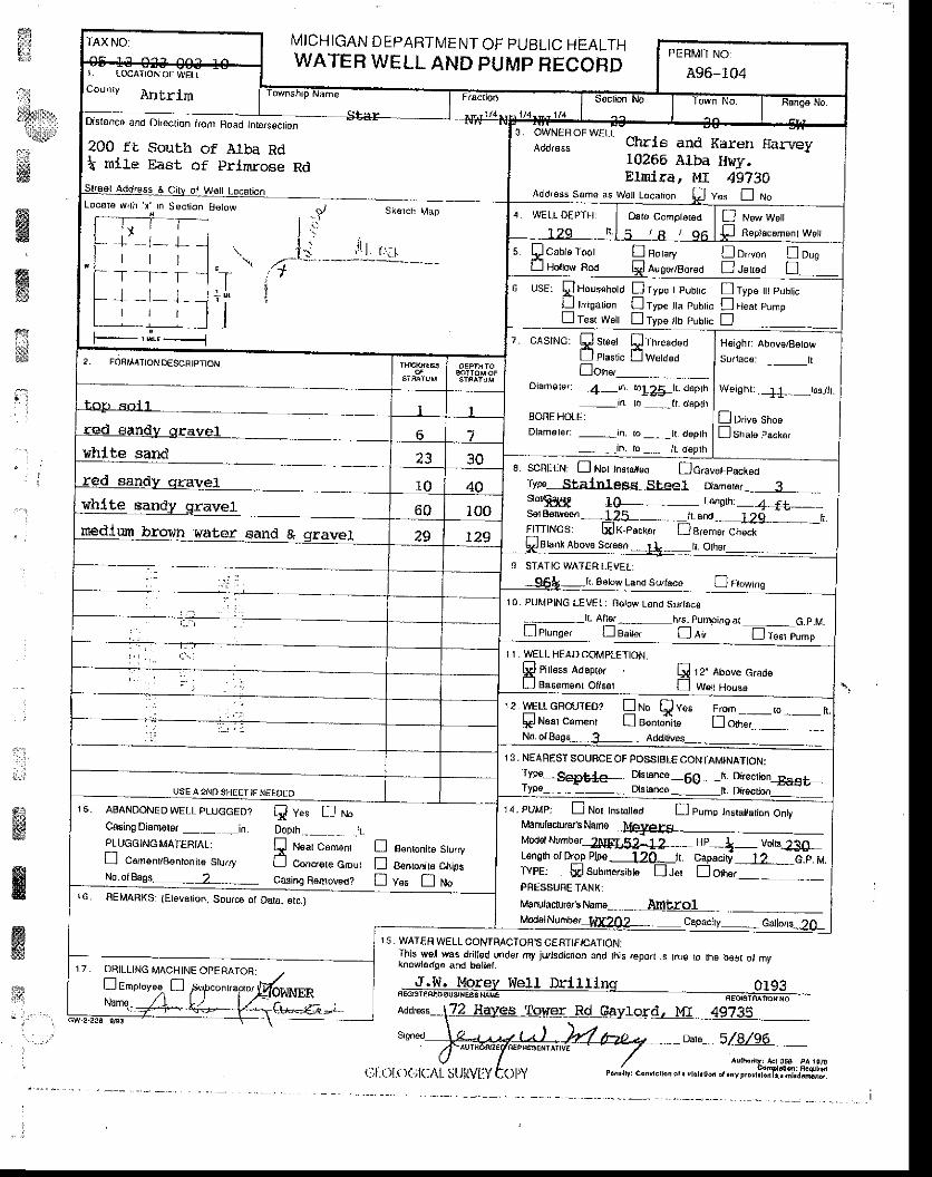
ffiil${}trt*rir
ia$
ffiffiffia l
TAX NO: MICHIGAN DEPARTMENT OF PUELIC HEALTHWATER WELL AND PUMP HECORD
PERMIT NO
A96-104l . LocaI toN oF wEtLcounrv futbrim rownshp t'tanre-.....----
- q | 5 r
uscr'on No I
'rown No.
l---ffi;; Not - ^ t - - _
Locoro wrtn x rn S€ct ion Bolow
+ - t- ]_r t l
T . l - r, f _l_ L
t r l
F--"i*-----l
200 ft South of Alba Rdt mlle East of prin-rose RdSu€sl Addrcss A Citv oi W€l| Locarbn
| : "
l . . , r l l .\ ,
/ - t _ - - ' - - - - -
ii
3 OWNEBOFWELL _Ador€ss cnrl6 and Ka.ren Harvey
10266 Alba Hwy.Elmlra, MI 49?30
Add'€ss Same as wol Locarion p v". n No
!, WELL D€PTI] ]
129 f l .Oat6 Compl€r€d
5 / A / Q 6D tt"'u wunE Rap'rcamsntwoJr
r.'i I. s !coore toor ! nor " ,y Qo, "e^ !o*Ll Holow Rod Qi ar,goaso,eo n.lerro,i n _
o use, !tor""r'oro Etrou,"rou" nrypg lt pubrcLJ r,usauon Ll rype a pubhc ! Hea! purpn lest w6n D ryp€ lb pubric fl
?. 0ASTNG: Q sreer flrn,eaoooLJ Plaslrc L lwerdod[on*--- --
Diamers,; _4_m. lo!25_h. ii6ph
-.in r) _ _lt doplhBOREHOLE:Dlamorer: _,rn, to _, ._t t deplh
__in. to _ tt. d€pth
H€ighr' Above/B€tow
W6ighr:._+!__tbs,/lr.
D Drive Shos!srrau pacrer
2, FOFMI4'IONDESCFIPIION
toF Rnl l ... ----- -'-_-.
red €and:/ qravel 6 7vhlte sand
red sandv dravel
whlte Bandy qravel-medlwn bro!,,n wat6r gand & gravel
23L SCnEEN: ! Nor Jnstrltod DGraverFacrco
Typ€- Stal yrt ea!, .Ste6l Dlam€t€r._ 3 _,srot$Sd€ 10- . - L6nerhi_ 4 ft __sor Br€rwssn _L25__ rr and-_ I2g. _h.flTTlNcS LXjK-pack6r L_.lBremsrCh€ckFBbnk Abov€ scr€sn -.JlE- r. Ohsr_
1 0 4060 100
29 r29
USE A 2NTO SHEET IF NEEOEO
g STATIC WATER LEVEL.
_95L _ft. ssrow Lsnd suraco n r ro,n,ne
10. PUMPING LEVELT Eotoe/ rand Surtace
;-- - r I Al lg - - - - h.s. Pumoineat _ G.p.ML iPrunee, [_l ea'Ie, L_J a" n rssr pump
1 I . IVEIL HEAD COMPLETION:
F Piltess Adsprer A 12. Abovc crad6Ll Bacemsnr Ollset f] w.u Hor""
.2 wELLGRo{.jrFo? !ru" Qv". Fun _o _tr.lr€l NBar csm€nt Ll Bonronir€ L_.1orr.,",No o/ BagE _ X_, Addrtivesj
13, NEAFESTSOUFCEOFPOSSIBIECONTAMINATION:Tvce ****- Dkbncg _6€_fi Dkecrion_Sa6+r yr-!. _ -_ LrErence_ _lt. Diroctjon
15, ABAND. JEDWELL 'LUGGED? A; n *-Cssing Djamoter _._,_in D6pth.-_ _ .h.pLUGGING MAIERTAL:
Q ruear cenrenr ! eenonire Sru.ryL l c6msn/8€n|onil€ Stu/ry LJ Concrere Cmr:r ! AantlJn,r" Cl,,psNo.olBass_ _ -2___ casing Rolno!€d? n v"" n no
Moder Numb€r_tBErI$;?-.:L:: ___ Hp _l_ vorB:_i+L€nsrh ot ftop Pjpo 'l ?O_tr. capaoi I ? e.P. MTYPE: *lsubme/srbtd Ll ler Ll orrre.
r 4. FUMP: ! Nor tnsrartea n pump hsra ationOnlyManulaclurcr3Namo Mav6i.e
PFESSUHETANXI
Manulac&r€r's Nam6__ - _,_ AmtgSl ,McdslNunbe, Vff2OZ__. capaciry _ cattom ?f)
16. REMARXS: (Elevarion. Sourc€ ot Dara, src.,
f,' "*.*',.r-"*tI This wsll was dillsd uACTOn S CEnTtFICATION:
n and his.epon rs tru€ ro lhB b9s( o, my
.Ilnq or q3I7 DHILLING MACHINE OPFRATOR:. /Lr rmproyesr LJ ffco.r'airo,gohNERNan€.-f-+\ .&:r--. l/-, C.t^ "=":. =ttu
FEGTTTEREoMorey We1l Dril
ausrese xr-rle. ---_-------FEcErmii.irc -
\72 Hayes Tof{_e-r LLqAylo_rcl_ },'I- 49?3n __Srgned
,UTHOft?E'FEPNg3EdIAI
(.;l:olt)ol(:AL
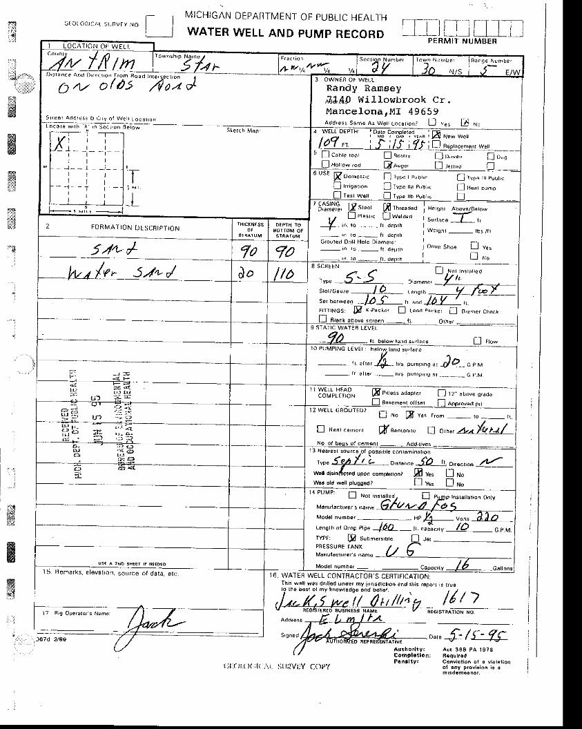
Gror o6r.^L .,,"ur" ro [-__J
17 Rtg ODera tor ' s N3mc:
MICHIGAN
WATERDEPARTMENT OF PUBLIC HEALTH
WELL AND PUMP RECORD
rTI
iTt$
14{ :,'r.llil;'
lsffi
ffiw
ffi*J
$
ffiwfr
16 WATER WELL CONTRACTOR'S CEFIIFICATION
'r:. I . .roza see ,"," {- /r- 7S-Conv ic l ion o i ! v lo r . r roaol a.y provilio^ i. 6
D, r - rnn .e a 'd Dt rs r , , f ,m n" io , * r . " . r -
C) 4.. o/is"""'i;; J
S r r e B , A i J n r . s s 6 C L y o r w c ) r I o c r l r o , rr r i * , i h , - . e c ' . . f i o -
3 OWNEN OF WEI ,L
Randy Ranaeya?J,40 Willor.rbrook Cr.Mance lona rM l 49659add'eis samo s w.rJ Lo.u, 'o" , LJ ' " , D r"
J - - t - I -r t ll t l- - l - - T r - -l r l
" L l c r n , e ' o o L l n o F , v l l D , - e , . L , " . 0Horrow ,od LEr 'q" , I I rerr"o
6 us€ [oo-0", " ! rypc r euur,c
I r " ie"un. ! ryp. r ra c"rL,cf rvln n pur,r,.
l l r "or o,n 'pTesr W€I L l ren . b pub ,c
? fi[sj][; Isr*r ffi l,**",r
_r ̂ :'1"'- ,:#1""B e i ! l h t A b o v A / 0 a t o w
s,,,ac6 __L_ rl
Wcrqhr _ rbs /h
onve shoe tr '.,
[ ,'ro
- x\ ro ,- n .renrh6roured Dn l l l . l6 le D iamercr- In ro _ i l der r r
2 F O R M A T I O N D E S C R I P T I O N
5n4- /(r 5./* /
ser berweeo / / r 5 h a"d lO Y \. ' r r , "cs El r 'p""r - ! r . .d pa.Lc ' f l 0," - . , o io.r
9 STI\TIC WATEB I,EVEL
r r b€row tJrd 5 ' ' rac€ L] a '*r0 PUMPING TEVEL: bprow t t rnd eu / ta . .
- - i l u^ , & u^ o - " .0 , , JD . .o , *prmp, rg i t __ C p M
" yj;|."ir'i3" Fpi,r6ss adapre, D 'r - "r,*" s,"a"
[ ^ " f f i Ye r Fom - t o - ' r .
I r"or ce-".r ff*^*," a o^* *.{uu/
r , !oar€3r sourcp or oossrDte contsh ina t ron
vp.L%LL o,.,,^". f0 ,,.o,,..,,"^L
1 4 p U M p : ! l o r
' u,s,n nr o,", np. f 6h ,. ""*",,, lD o,,rrPt p s,r,-.*'r,r. Dr,PNESSIJFE ]ANXM€nulacrr,e..s ^a,ne
Mod€f number :: caooc,Ly / ? -catrs"sl5 Bemarks el€valron. source ol dala, etL,
t) l :arr.( X ; l( : , \ i . S; lr ; , lVi:Y C{IPY

ijt.:-*
t$yyr
:41!;M
ffi.w" l
gs;g
xl
,.1:
j
ffii;a
i i
t : i r . , , . - , . i
ffiffi.Well lO 05000000600
WATER WELL AND PUMP RECORD
complel ion rs requ ed under author i ty of Pad 127 Act 368 PA 1978
*:3
ffi
Tar No 05-13-024,008 20 Ie*''n, ro ooTE3 County: Anlrim I Township. Slar
Well lD: 05000000600Elevalion
Lal i lude 44 98354657
Longi tude: 84 86856011
Fraction: lSection lTown/Range TFrench ctaimJwssNswz swz wwz I zr | 30N 05W | |
Distance and Direct ion f rom Road Intersect ion:4/10 MtLE SOUTH OF C-42
Owner Harvey Britton
3455 PATTERSON ROAD 5765 OtD ALBA ROADGAYLORD MI 4S735
Pump lnstal led Yes pump Instal tat ion onlyr NoPump Instal lat ion date Hp 075Manufacturer: Gourds pump Type SubmersibteModel Number: 1058054?2 Pump Capaci ty: 10.00 GpMLength of Drop Pipe: 104 00 il. td of Well:Diameter of Droo Pioe: Unknown ioDraw Down Seal Used: No
Diameter: 4 00 in lo 109 0O tt deprn
Bore Diameter I 7 0o In ro 113 00 f l depihBore Diameter 2Bore Diameter 3:Height 1.00 f t . above gBdeCasing Fi t thg: None
Pressure Relief Valve lnstalled : No
Pressure Tank lnstalled: YesP.essure Tank Type: UnknownManufacturer GouldsModel Number : V-60 Tan* Capacity : 9999 Ga|ons
Yield Test Method: Tesl pumpMeasurement Taken Dur ing Pump Test .88 00 ft. at{er 1 o0 hrs pumping a1 j6.00 GpM
Abandoned Wel l Pluggedr NoReason for not p lugging Wet l
Abindoned wet l tD:
Static Water Level 87.00 ft. gelow Grade(Not Ftowing)
Screen Instal ledr Yes Wel l tntakeFilter Packed: NoScreen Diameter ' 3 00 in Lengthr 4 oO r t .ScreeD Material Iype. Slai'rless sieet-wire wrappedslot r0.00 in Set Eetween 109.00 f l and113o0 t iBlank: 050 f t AboveFi t t ings:
Wel lGrouted: Yes Grout ing Method: UnknownNo. of Bags: 5 Additives: OtherGrouting Materiats:Bentonite slurry From 5.00 ft to 99 O0 tt
Well Head Completion: Pitless adaptergontractor Type: WaterwlRegistration Number: 517Business Name; X&T DRLG,INC
Nearest source of possibte contamination:Type Distance DirectionSeplic tank 70 o0 ft Norlheast WATER WELL CONTRACTOR'S CERTIFICATION:
This well was drilled under my jurisdiction and this report is true to the best of
Slgnatur€ of Registered Representattve Date
Dri l l lhg Machine Operator Name: KEN KOSCTELNIAK
Employmenti Employee
ATTENTION WELL OWNER: FILE WITH DEED Z14l2oo208:16EQP 2017C lzt2OOO)
Page I of I

{i
.-i
:-',{li},
-, i;lip
lli*;ii
ffiffi
&t,&'r{
iElliisj
,&t..rl
DE€' i/1gHlou D€pARTMENT oF ENVTRoNMENTAL ouALrryDRINKING WATER & RADIOI.OGICAL PROTECTION DIVISION
WATERWELL AND PUMP RECOROC€mplotlon b tEqirEd undor authority of part 1 2Z Act 36S pA 1 978
Fafuro to comply ls a mi6d€m6eno.
18, WATER WELI CONTFACTOR'S CE BTJFICATION. \This wsl was drilled undor nry ju.isdic-tjon and lhis rupod is lrus to lh€ bcd ol rhy.
&ry
-*,-B- -8:-7)Fr)P 10t'1 (l2tr6)
?6 _ Jc- 6lD6tanco and Di.€{tiofl kom Soad Inrcrsgctkr^
O ̂..(hh/m /'oJ e fi ur, tr ooor" . . DaIo Gatee9991 Prlmroae Rd,
E lm l ra ,MI 49730add'sss Sa^le a6 wo0 Locaton lfl ves Li m
Localo wlrh x in Sscrlon 86low
-{ ' -t- . lr t l-T - f r -
- r , l -Lr r l
Q reu, wettE FEFlacornont W€ll
:. flc"u"r*r D no,"'1 [ o'i*^ OougD xoltr* noa G nus€/ao'eo fl J*ed D-
s. USE: EHousoho|d Dlype t puutc Crp.l tprl tc! tftsarbn fJ-typ6 rla Pubric lned Pumpn Tesr woll lType llb Pubtrc !
7. cASrN6. ffi sreet Prnreaucolf pr"u" flw"uuoDorr*
Dtamoror: y-t-, ..l" --,r o"po'_in- ro *-_n. d6plh
BORE HO[E: -!Diamala,: l|_ln- !o _'L d6pth
Heire Abov€/B€lowSurb: / ,t
Weaic____1b3fi.
! an* sno"D sr* pacrer
2. FO8MATTON oESCFIPITON l
s. SCREEN: fl Nor lnslall6<1
9. STATIC WATEF TEVELi
- I rya n. B€row tand surracE ! n-,'.s
r 0. PUMPING LEVEL: S€lo,,.v !9nd Surlace
..tr. Afror '[n-.
no.eu^{nsa Ab e.e.u.Dprunsu, Is",t6, r D al fi r"ar a,'p
1 1. W€LLHEADCOMPIETION:
FPi oss Adopro/ D tz'luore eraaefl Baa€msnr ottr*r D wd Hoo
I2. WELL GRC{JTED?
I N*t cement
lHo Pv"" Froir -- ro - tt.
w*iyc6flY'-13, NEAREST SOURCE OF POSSIBLE CONTAMTUION:
typl+ae/i. Diata,,ce -64--r ttvr:ud EIyw --t_-. _ D|sranc€ _i. *sction_ _
USE A2NO SHEET IF
14. PL'MP: I Not Inslallsd
ds
irodat ifutnb€r_renerr ot orop Plpe-.,ili |. . . -l!TVPE: E Submer6iblr DJetPAESSUEETANK:
AEANDoN€DwEtr pLUGcED? fl v* ! mCasiru Dhm€l€r __ in D6ph_.,__tlPLUGGINGMATERIALT I r:oar ciinent [l e'nr*it* srr,ryf] cemenuaentonns stLr,ry [ concrer" c,o,,e C arnt*1rc cnp"Itr.olBags---. --- casino nemovod? C y"" E Ho
16. REIIARKS: {ElBvadon, Sourc€ ol D6|E, etc.}
I7. DNILLINC MACHINE OPERATOR|
c.' i,OLtlCilC

'Ti . l
*,,,,*..r,ltll;l,tx
ffiMs
i l
s€€ utcntce* oEpARTMENT oF ENVTRoNMENTAL ouALrryDRINKING WATR & RADIOLOGICAL PROTECTION DIVISION
WATER WELL AND PUMP RECORDCompl€Uon i5 rEqlrsd und€r euthorily ol Part 127Act 36E PA t978
Fallro lo cornolv is a rnisdomeanor
x
4.,!s
ffiffi{+
:
: ,:,,:,,,i'.
1 8. WATER WELLCOI{THACTOR'SCERTIFICATION:Ihis w€ll was ddlt€d vMer ny jurisdiclion qnd lh5 ,oporl is tr,.re to fte Uel ot my
39nsd
*_ ,__ 4a( t l_D^" 4:_lE:34
Olstanco afd Dir€c on lrom Road tntersec on
10303 Alba Bry.
3. OWNEROFWELLadd,ess CHIPPA. II{IKE
].0303 BLBA ffi.If,MINA t.{I 49?30
Addr€ss s!'l€ €s woll Lo.a", B ves I No
Lo.at€ wrth r ' In S€cnon Berow
t t l
- i . * t - - t -t t l-T --T-- r
_t -t- L
n r*' w"ttEl kdscomant wsll
s. tl caute roor D nou'y n u*n I ougn gottow noa D nused8oreo E.b€a
6. USE: ElHousohold nTyp€ I PublicD lffioarron ITyp€ lla Publicn rosr wcll [Type llb Pubtic
nryr" tttPrttt"n *a purpD
7 ca-atNc: Es,*t Ell'".0"aD Pt""u" I w"r"oUou*,----2
o,slnoror r/ n. ro .l!|]!tr. aecH.-.-in, l0 --lt, doplh
EORE HOLE:otanew: 7 rn. io Jll9rr. doph
Hachr AbovoiRql$rswb: ,/ it
w€btE // g
lbs,/h.
Pfcr"e snoe
S€tB€twesnFITTINGS:
$BEEN: D Nor rtur.r|lu r [eravsl-pacraarua_ftLrsp9ps'-- lly 4: -
--92-rte.an t^nasu,la* E n",,ine9. STATIC WATEF LEVELI
10- PUMPING L€vEL: B€low Land Surlac€
led.r .^na, . - ,L- . , -h l3.Pumprrda : : : G,P.M.
Derunga ne"'t", I an Zt""' tr.o
I I . WELL HEADCOMPLETION:
Q auss taapor 6o)4 D t z llots c,aaeI lBaEsrnent Ollset L-l Wel lkse
MAY 7,7
r2. W€LLGROTJTED? lro Elv""D Near cament E s"ntonire
F.dr l1s:to o tL[] or-
13, NEAREST So{JFCE OF POSSIBLE CONTAMT{ATbN:
rws #Flit- DBlanca -t!f - .-n. L\i€cdon-t:rype-:-- DisBncs -L rtrEcliln----
UAEA 2NOSHEET IF NEEOEO14. puMp: fl Not tnsFlt€d n pump tn*tron Only
i,.bnuhct.to',s Nartelg Orlt +g_,,*W:*, lASEiEIi'{. ue --1[1"- v au ;rv3t | -\,/fdd,#{u''ibat Ub58:J512;L-HPJL74- vdBJ)AB
l /fl;ifrA orce,Aee / / Lrr. cro€dry _o.F- M.wpl: Fsumersru" n r", ! oc""PRESSURETANK:tial|t'loij'-re1wn0- ELEY ( A)
Dsprh_ 1
I usar c'onronr ! senonita sturryI conclrr" c*" ! Ecnronhe chip6caslns Romore{,? ! V"r I no
ABANDONED WELL PLUGGEO?Caslng Olam€lar ___ _,in.PLUGGINGi'ATERIAL:! c€menv8€ntonh€ slurry
16. RElvlABl(S: (Eleve{on, S'ourc€ ol Oaro, ec.}
I7. DRITLINGMACHINEOPEBATOR:
e:,E0LO(iie,Ai" gtJRVEV e0PYEQP 20 t7 (r2196)
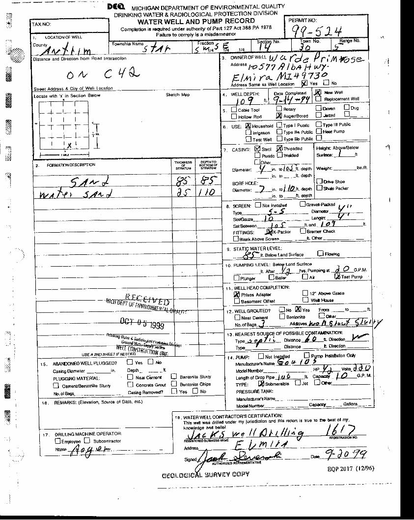
t1l
:-":i.*&,
u*ww
DCQ rr,rrcnrgex DePARTMENT oF ENVTRoNMENTAL ouALlryDRtNKtNG WATER & RADIOLOGICAL PROTECTION DIVISION
WATER WELL AND PUMP RECORDCompl€lhn it r4trod undo. authority o( Part 127 Acr 388 PA ts78
Faifur6 to comov is a mlad6meano(
1S . WATER WELL CONIRACTOR'S CEflTIFICATION:
iil" -Jnil?i'iiJ
"J", mv lwisocrton ano rhls r€porr is rru6 ro f,E !'st or mv'
Sigr'€d ffi;'ffififr;-
, t
:.qi
,rcff
.'ti: ,
. : -
;
g
E.
ffiX
' !
i o.rcqor*rr'- UJ a de P ri nFoSe*o*'n"" to 5 7 T ,9 I b,+ 1+ ut7 '
Eln) ta- t/lt-+2tSailLl"" d"r" * wai L"""uon p v"" ll rlo
Dislanca and Dir€ctlon |tom Road Inlersec||on
Locats wlrh,x.in S€crion Below Skstch M9p
+-1- l -l l l.T T_T
-f - l- LI l v l
in-"oo'" t*' I noo'Y Li o"'"n! nouo* ** E auoa./Bo'od D JeE6d
6 usE: qlHousohord flryp. I Publrc
f) lrbsr,on DrYP€ rra Publlc
I T€sr Woll n TYPa llb Publlc
Cryp. ttt erut"fln a P,.p
W€rghrr -lb!lli
Do* sno'Ds'd" Pu"t",
7. cAslNG: @ sr"et frrweaaeoi Pru"ri" ! waaualpu'*,__- _-,-
oumersr: -!1-'n. 'o lP'Lit a"Pr'-- . in lo ---lL deplh
BOBE HOIE:
r:ri..ora.: 7 'n. rc lQn- aaen_in- lo n- doPlh
2, rcNMATloNOESCFIPTION
scBEEN: E No! lnststt€d Ecravsl-t'dGd
ww-'. d'5 -- - otsr@sloicalz€ tD - - - - LorEst-sateel,€€n-- J-A''L' -r: ,'a -1-8)ItITTINGS: .EX-pacxer L-lErenFrC'n€d{
lehnk ltoue scre"n - . -ll. clt]€.:
S. STATIC WATER I-EVEI:Bslow Land Sllaca D ru"ing
10. PUMPING LEVEL: Beldfl Lond Sutlace
- .-n. enn - fry-,n's PumFi'E *L J etung"r L] aaite. Ll Alr
1 1. WELLHEADCOMPLETNN:m Phtoa( a.iroter L-l 1? abog Gtadoffi Pll",* Acnlt", L-l 1? aboa (
f]Bsssm€nl ollsal LJ w€l lbreo
I 2 . WELL GAOUTED? u No lal Yos Frsn -- !o - n'
fl Near cen4nr Ll Bsfltoniro +u$t----, --'t---
" i,?5Hff:ill,?":lrus,l2i- tsIyp.- f ....- ssbnc€ - L Dllec on -
1 . . PUMP, n Not InsjgJsd . fl Pyntp heallollon onlv
ffiL,H.HBE*-&'YTYP€: E Subn€rsibl;i.J;;;;;,.*tL; esry f Q--ae urvpF m subn€rsible Ll.,rer Ll Os.- -
PRESSUAETANK:
fibnuladr€/s Nan€ - -
Mod€l Nurr$€r- ,--- , -Cap-'1' - - Gdloru-
15, AMNDONEO WELL PLUGGED?
Casing Diam€ler ---in.
PLUGGhIG MATERIAL:
fl coflenuBsntonhe slurry
C v * ! r sOepth __ _ED N."r ci;tners ! sEnlonits Slurry
C concra" cro, f] B€ntonilo chiPg
casino Rernov€dt Dv"" !no
10. nEMABKS: (Elovation, Sourcs ol Dala elc)
ONILLING MACHINE OPERATOR:
Ctrptoy* D sub"onn."to, tr::l: E hn u't--EQP20lT ( l2p6)
cEOi. freiiGxL SirFivEY G$FiY
\'t:", : . r . ' 'I
iit .....i:lir,ria$ip-
1:ffi
wKi.d
5S:slff
nt€
"j
..,tJ
: i
tff&Fol't '',1
TEST
RPERMANENT
$
ffir
@ NoBTnEBN""coMPAwv
I X D I A N A P O L I S . M I S H A W A K A . L A N S I N G
I,occtloD
From Iond DoscrlDtlon
froE Slr€st o(
Pumplng tsri \ ..-qnn . cPM d.qr.down lo ------59- fsot oft"r 48 t"": oj{g
n ; , n ' "
l , - J z o J t )lob No-
WELL toc uo I Ctty ALM Countv---AI[I-BI-t!---
g1o1^ MTCHf GAN .
FORMANON FOUND - DESCRIBE FUII.Y
FROM NATURAL @OUND LEVEL
S and 21 23
Fine qtavel & s and 7.3 .'
Coarse graveL & sand 26 5 7 l _ L
Clay & gravel a t 61, 4
Clay very l i t t le gravel O I 6 9 6
Clay e qravel 6 q 81
Gravel & some c lay 81 8 6 E
c l a y & q r a v e l e6 l .o l I 1
eoarse qravel very l i t t le c lay t03 1 0 5
coarse clean g rave I 1 0 5 1 3 6 25'-L"
clar i a qravel t J o 7
Dofe Comolobd Q /-11.11-9- oallar

l:lf,l
*:t.1it#
xffi$
ffiffi
ffi1il::
rt.l:-iitt
ffi;.]
R
':
G€OLOGTCAL .U ",rr" "O
f- l
MICHIG.AN DEPARTMENT
WATER WELL AND
OF PUBLIC HEALTH
PUMP REC,ORD ttlj trt[trPERMIT NUMBEN
Celclio. ol . vlolltlonof 6t provlllotr ir .
ffiq{: i
{
l
]6, WATER WELL CONTFACTOF'S CERTIFICATION:
5 f.tr| J t s r , r ^ c e A n d O ' i o c r r o . , . o h A o a d h r s 6 . n o n" " () ;" ";" l'il;"'" "i;2 J
SrEo l Addr€ss 6 C ' rV o l v {e i r Locr r 'o .
3 owNEn of WELL
Randy Ramgoyn?J,40 t{il lowbrook Cr,MancelonarMl 49659Add,ass sam6 As werr Lo. . ronl O
""" [4 nro
r r o w ' r h _ X ' n 5 6 ( r L o . B e r o w
t t l
r-l - -i- -i- -r t i
- - . .r- - + - l--l l ll t r- - - - T _ - l - -, t l
5 l cao te ro " t On - " ' v ! o - * . [ o ' oHorow 'od Dlto" ' ! r . '*
6 us€' S oo-or"" n lypo I puD,'c ! ryrr6 rrr puur,c
f] t,'ie"t,on ! rvoe rri prbr'c ] rtor pumpT35r Ws[ | j I vD€ [b P lb t ' c
;lsj![; Ss,*r ffirr,*",r"0
-r,^H""*' ,:;,1"*H6'ohr A5ov6/0elow
Suiracr , tu
worghr - lbs / l r
oave $e f] v*
Dr "
- tri. ro - lt. d6PlbGtarred Orlt Holo Oaamatol- in ro - I r . d€Drh
2 FORMATION OTSCRIPT ION
(r Sr/'t- /
. , t t ' rcs, F r .Pacto, ! t .od Pd.ko, L l a,dmor chocl
r r boros r ind su, tac. L] no*IO PTJMPING ITVEI .
-, ^*, f !& n* o,,no,.oo, Ja o,". t ro r _ t '3 . pumprdq ar _ G.p M
" i'i;!i,'fs", fficirrors a'r"pre' f l r : 'abovo sraaoasseh6nr olls.r LlA.'prov€d nrl
r 2 WEIL GROUTEDILl r '1o Ul Y6r F 'om - io - r l
fJ r"o,ce.o"r f[e"^*'," D o,,* *'{rtu/
13 Noarssr soorc . o l oo i i rb l6 .on l .h in l r ton
,rr..1era/r L o*,o^". fb ,, "*",t.^
F-81"* En"I v * ] " "
14 puMp: I uot
PNESSUAE TANK:M!^utrcxtr.re rdd.
^umbe. .............'..........- C^oactry I Gi. callons
15. f femarks, e lsvat ion, source ol data, 6tc
1?. F is 0e6raror ' s Ndtu :
o47d aoe
(; l : f .Ji .( X;l( : . \1. ! i l Ji lVl jY COP'/
fii "d
A t l t j i L t r . , : : ; ) ! t i . i i , .1 ! : t t : i t t r . . : t i i : !
Parcel 05-f 3-01 3,00,1 -20f:i , , , } a :Jo ! , r
' f i | i , : \ , I : r ( t , : , j . .
: : , ,& Antnm County parcel In format ion for 2006 Assessment year'l {g
: : Jur isd ic t ion: Star Twpf f i Owner Name(s) : BIEHL LARRY R
:s!
ffiwSBd$
Proper ty Address: 11290 WOODSIDE STREETFLMiRA, MI 49730
Mai t ing Address: 1O7O SOUTH RIDGETRAVERS E CIry, MI 49686
Proper ty I n format ion
Current Taxable Value: g3,3 54
Current Assessment : $4,200Current Homestead: Oql,
Current Property Class: 4O Residential
Last Year 's Assessment : $4,05OLast Year's H omestead: Og0
Last Year's Propeny Class: 40 - RestdentialProper ty Tax Informat ion
Taxable year : 2005Summer Tax: $25
Vi l lage Tax: $0Township Tax: g 111
Proper ty Sale I n form at ion
Sate Date: 6/ n/ f995Sale Amount : 99,5OO
Liber and page: 436_398
Legal Description
PARCEL 201-4. .coM AT THE E 1/4 coR oF sEc 13; rH s 163.88 FT; TH N 88 DEG w 3539.36 FT ToPOB; TH CONT N 88 DEG W 150.40 FT; TH S 200 FT; TH N 88 DEG E 150.40 FT; TH N 2OO FT; TH S88 DEG E 170 FT TO pOB SEC 13 T30N R5W 0.69 A M/L
l 'o \^ :er . l l i rJ , Corr in lLrr l i ty Ce ter" sof l l rare f roJl ' i t - i rc Ldnd ipfornrat ion Aaccss / i !sociat ion
{
i - 'l
iI
i
*
ffi A t t l r , i t ( . a ! t : . r ' . i . J , . r , r , j : i I r ' . i ) i . :
Parce l 05 -13 -0 '13 -UC l -55
Clc .<L : j l r r . i i : r r : r ' j , , r r
Ant r im County Parce l ln fo rmat ion fo f 2006 Assessment Year
J urisdiction: Star Twp
Owner Name(s) : WESTPHAL CHARLES E & AGNES .
Proper ty Address ; 11357 WOODSiDE STREETE L t \4 I RA, MI 49730
Mai l ing Address : 1135 7 WOODSIDE 5TELIVI IRA, MI 49730
Proper ty In fo rmat ion
Cur ren t Taxab le Va lue : g3 6 ,595
Cur ren t Assessment : $5 1 , 250
Current Homestead; 100o/oCurrent Property Class: 40 - Residential
Last Year's Assessment: $48,3 50
Last Year's Homestead: 100o/o
Last Year's Property Class: 40 - Residential
Property Tax lnfo rmation
Taxable Year: 2005
Summer Tax : $278Village Tax: g0
Townsh ip Tax : 9579
Legal Descr ip t 'on
PARCEL 121 COM AT E 7/4 COR, TH S 163.88 FT, TH N BB DEG W 2759.7 FT FOR POB, TH N 1406 FT,TH N 88 DEG W 310.22 FT, TH S 1406 FT, TH S BB DEG E 31.0,22 FT TO POB SEC 13 T3ON R5W 10 AM / L
=
ffiffiffiffit $
:lt
P') \ ' r f : re( , i bv { - i ! i ra l n i lv LaDterr ! scf l , } rare f ron: t l le lani infot ,nat ion Aa,cess A:socr ia i ion
ffi${w/1\,
l::rrl::tlrm''*'w
ffiw.ql
. t ' t 1 a r ' ; | t l _ L ' . t . : r i - . , , j j j : t J r . i / . i _ i , i i , l
Parcei 05-13 -01: i .J01 -5f l
a lo i , r l . f t . : . , . . , r , r r : j r . r j
Antr im County Parcel ln formatron for 2006 Assessmenl year
Jurisdiction: Star Twpowner Name(s) : wESTPHAL CHARLES E & AGNES V
Proper ty Address: 11345 WOODSIDE STREETELMIRA, Ml 49730
Mai l ing Address: 11357 WOODSIDE STELMIRA, MI 49730
Prope r ty ln f or mdtron
Current Taxable Value: $4,459
Current Assessment : $1 2,500Current Homestead:. IOOo/o
Current Property Class: 40 - Residential
Last Year 's Assessment : $11,S00Last Year's Homestead: 1O0o/o
Last Year's Property Class: 40 - Residential
Proper ty Tax I n format ion
Taxable Year : 2005Summer Tax: $34
Village Tax: $0Township Tax: $70
Legal Descr ip t ion
PARCEL 122 COM AT E l/4 COR, TH 5 163.88 FT,FT, TH N BB DEG W 370.22 FT, TH S 1406 FT, THA M/L
TH N BB DEG W 3069.32 FT FOR POB, TH N 1406S BB DEG E 3I0,22 FT TO POB SEC 13 T3ON RsW1 0
Fouerec l:y Cafir rnity (:citr:r"' :icihrarit frDjrr tlrc laDd IlliqrIillo! Aeqess4ssACle-ttSC
ilii,'..ipir,il$Pw
ffi,ffi$ii
l r ) i r , . r , r . r . . , r r . : r , : . r i l | : r r : i : . r i , - r
Pafcc l 0 5 -1 3 -01 3 . i l 01 -60a l o t . . l l , ' - j r j i , . .
Antr im County Parcel In lormat ion for 2006 Assessment year
Jur isd ic t ion: Star TwpOWNET NAME(S): MIDDLETON GREEN B & JACQUFLINE
Proper ty Address: 11311 WOODSIDE STREETELMIRA, MI 49730
M a i l i n g A d d r e s s : 1 1 3 1 1 W O O D S I D E 5 TELMI RA, MI 49730
Proper ty In format ion
C urrent Taxable Value'. 97 | ,774
Current Assessment : $72.900Current Homestead: 100Vo
Current Property Class: 40 - Residential
Last Year's Assessment: $69,050Last Year's Homestead: 100o/o
Last Year's Property Class:40 - Residential
Proper ty Tax I n form at ion
Taxable Year : 2005Summer Tax: $540
Village Tax: g0Township Tax; $ 1,125
Proper ty Sa le In fo rmat ion
Sate Date: 6/2f /2OOOSale Amount : $ 18,000
Liber and Page: 549-1727
Legal Descr ip t ionPARCEL 123 COM AT E 1/4 COR, TH 5 163.88 FT, TH N 88 DEG W 3379.54 FT FOR pOB, TH N 1406FT, TH N 88 DEG W 370.22 FT, TH S 1406 FT, TH S 88 DEG E 310.22 FT TO POB SEC 13 T3ON R5W 10A M/L
EF'
{ \ rwpr!4 l ry a iJf rnrLrr i ly C{rnler" ' sc i t t lara f ro;y! L l re L ind Inforntai io i t Access J\ssociaLior :
m1:{
i :
1tlt:titl$*l
'!-{
*3#
ffit 4
ffi
ffi**!i
.rc;,t
';1
ii
:.:
.
, r | : l , , r , , : , , , ; 1 , . i r ' : ; ; , J i . ; , , r ! r _ r ' , i I i
Pa ice i 05 -1 3 - t ) I 3 -U01 -63
! . l t : . , r i : - r ' . ' . ' : : : r11 ' . .
Antr im County Parcel ln format ion for 2006 Assessment Year
Jurisdiction: Star TwpOwner Name(s) : BARRFTT JULIE K & RODNEY A
Proper ty Address: 113 52 WOODSIDE STREETELMIRA, [4 I 4973 O
Mai l ing Address: 22503 DOWNTNGST CLAIR SHORES, f ' l l 4BOBO
Proper ty I n form at io n
Current Taxable Value: $12,500
Current Assessment : $1 2,500Current Homestead: 0Yo
Current Property Class: 40 - Resjdential
Last Year 's Assessment : $11,500Last Year's Homestead: 0o/o
Last Year's Property Class: 40 - Residential
Property Tax Information
Taxable Year; 2005Summer Tax: $58
Vi l lage Tax: $OTownship Tax: 9253
Proper ty Sale In format ion
sate Date: 9/24/2OO5Sale Amount : 925,000
Liber and Page: 741-1156
'Sate Date: S/5/ZOO3
Sale Amount : $10,000Liber and Page: 664-433
sate Date: 7 /79/20OOSale Amount : 910.000
Liber and Page: 615-374
I F d r l n F c . r i h t i ^ n
PARCEL 202. .COM AT THE E 1/4 COR OF SEC 13; TH S o DEG W 163 88 FT ALG E SEC LINE; TH N 88DFG W 2996.60 FT TO POB; TH S 0 DEG W 1169.49 FT; TH N 88 DEG W 372.78 FT; TH N 0 DEG E1170.51 FT; TH S 88 DEG E 372.80 FT TO POB SEC 13 T30N R5W 10,01 A M/L
Po! ' \ ic .cc iy { -3nirnL.ni ly i - rnLcr ' sc i t ! :a 3 l ro| r . r .1r L in( i in fornln i ior Access Associ . i iorr
Ed.

ffi / \ 1 ; i : : i ) . ( 1 i t , l . . . , : 1 , | ! . : : t t , . t t . t . . :
Parce l 05 - l 3 -01 3 -001 -65t :1. r . , . ; i l : r . : ' , i ' r r i ' . , : r
Antr im County Parcel In format ion for ?006 Assessment Year
Jur isd ic t ion: Sta r TwpOwner Name(s) : WORKMAN JIM F JR
Proper ty Address: 11450 WOODSIDE STREETEL[ \4IRA, MI 49730
Mai l ing Address: 1328 S HOLLy RDF E N T O N , M I 4 B 4 3 O
Properry I n fo r mal ron
Current Taxable Value: $9,28 5
Current Assessment : $20,0O0Current Homestead: 0Yo
Current Proper ty Class: 40 Resident ia l
r i
{l:lil::::
lrX
d$
ffi
ffiffi
ltLast Year's Assessment:
Last Year's Homestead:
Last Year's Property class:
Proper ty Tax In fo rmat ion
Taxable Year:
Summer Tax :
V i l lage Tax :
Township Tax:
Proper ty Sa le In fo rmat ion
Sale Date:
Sale Amount:
Liber and Page:
$ 1 8 , 6 0 00 o/o
40 - Resident ia I
2005
$70$0$ 3 0 8
8/78/7998
$ 1 0 , 1 0 0496-395
Legal Descr ip t ion
PARCEL 203 COM AT E 1/4 COR, TH S 163.88 FT, TH N 88 DEG W 2623.6 Fr FOR POB, TH CONT N 88DEG W 373 FT, TH S 1169.49 FT, TH S 88 DEG E 372,9A FT, TH N fi69.47 FT TO POB SEC 13 T3ONR5W 10 A M/L
fro\l'3re,:i :r! Coiri L It.,/ C.:rtter"'scil.xare frriri ihc tll]ll:ltlfqlll4lilll4qeei5jis5o{Eliol]
, . 1 ,
ri ! : t : l t ;n : 4 . : - . ! t , : , i j , j t i i ' : J ! ) t l i aa , t i l
Pa rce t 05-1 3-01 3-001 -Efr
Clcs, : - i l r , i
i ' : j in( icrr
Antr im County Parcel ln format ion for 2005 Assessment Year
Jur isd ic t ion: Star TwpOwner Name(s) : PATTEN DAVID & KI I4BERLY A
Proper ty Address: 11560 WooDSIDE STREETELF4IRA, MI 49730
Mai l ing Address: 11535 WILLIAI .4TAYLOR, MI 48180
Property I nform atio n
Current Taxable Valuet $7 ,736
Current Assessment : $ 15,200Current Homestead: 0olo
Current Property Class: 40 - Residential
Last Year's Assessment: $ 14,050Last Year's Homestead: 0olo
Last Year's Property Class; 40 - Residential
Proper ty Tax ln format ion
Taxable Year: 2OO5Summer Tax: $59
Village Tax: $OTownship Tax: 9256
Proper ty Sale In format ion
Sale Date: 9/30/7995Sale Amount : $11,O00
Liber and Page: 434-79I
Lsgdr r r t rsLr ruLru
PARCEL 204; coM AT E 1/4 COR, TH S 163.88 FT, TH N 88 DEG W 2250.1 FT FOR POB, TH coNT N 88DEG W 393.5 FT, TH S 7168.47 FT, TH S 88 DEG E 373.48 FT, TH N 1167.35 FT TO POB SEC 13 T30NR5W 10 A M/L
f ro$erca! i ry Ccjr r l r t jn i ty Cel tcr"" sof tware l ro i l r l f ie Lanci Infor ra: jon Access Assoclat lot )
-:a , il : . : :
:34!g
ffiffi
!
,rl:i:rl:::'
ii j , ! , : . . : , r , : \ , i . r j . j r r : , . , 1 , i
i ja |c ei 05-'1 il-(l ' i 3 -iJil '1 -i]5
_ t i : . ; , - ! r .
Ant r im County Parce l In fo rmat ion fo r 2006 Assessment Year
Jur isd ic t ion : S tar Twp
Owner Name(s) : B IEHL LARRY R
Mai l ing Address : 1O7O SOUTH RIDGETRAVERSE CITY, MI 49686
Prope r ty In fo rmat ion
Cur ren t Taxab le Va lue : $4 ,761
Cur ren t Assessment : $9 ,400Current Homestead: 0olo
Cur ren t Proper ty C lass : 40 - Res ident ia l
Last Year's Assessment: $8,400Last Year's H omestead: 09o
Last Year's Property Class: 40 - Residential
Proper ty Tax I n fo rmat iDn
Taxab le Year : 2O05
Summer Tax : $36Vi l lage Tax : $0
Township Tax: $ 158
Legal Descr ip t ion
PARCEL 201-B. .CON4 AT THE E 1/4 COR OF SEC 13; TH S 163.88 FT; TH N 88 DEG W 3369.4 FT FOR
POB; TH CONT N 88 DEG W 170 FT; TH S 200 FT; TH N 88 DEG W 150.40 FT; TH S 00 DEG W 971'39
rr ; in s 88 DEG E 320.33 FT; TH N 00 DEG E 1170.51 FT TO pOB SEC 13 T30N R5W 7.92 A M/L
i ro lvere( i ry Ccfn luniLy Centef ' , 's i r l t r !arc f rom t- l te L. ]nd in l ' . , r r1 l - i la ion Acccss Assqcia l io. l
=e, , t i
liiltiilf: *'
#
ffiwffi
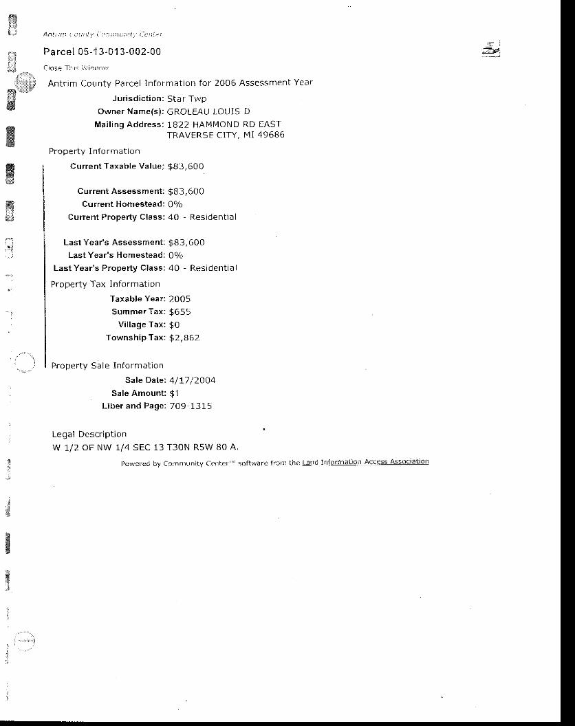
$,t*ufi
ffi
3
l \ n l t ; t ! : : . : t 1 ! t l r . i - r ' : ) t ; : t r ; r t l t - : : , 1 1 r 1
Pa rcel 05- 13-G1 3 -002-00
i lc :e 1 l r . : r r . , i l r l { r ' i ,
Antr im County Pa.cel In format ion for 2006 Assessment Year
Jur isd ic t ion: Star TwpOwner Name(s) : GROLEAU LOUIS D
Mai l ing Address: 1822 HAMI4OND RD EASTTRAVERS E CITY, I4I 49686
Proper ty I n fo rmat ion
Current Taxable Value: $83,600
Current Assessment : $B 3,600Current Homestead: 0olo
Current Property Class: 40 - Residential
wffi,;j
.':
Last Year's Assessment:
Last Year's Homestead:
Last Year's Property Class:
Property Tax lnformation
Taxable Year:
Summer Tax :
Vil lage Tax:
Township Tax:
Proper ty Sa le In fo rmat ion
Sale Date:
Sale Amount:
Liber and Page:
$ 8 3 , 6 0 0Oo/o
40 - Res ident ia I
2005
$6ss$092,862
4/17 /2OO4$ 17 0 9 1 3 1 5
13 T3ON R5W BO A.
by Cclnrrrunity C{rr1ler" ' soft}rar{ i l r-cnr the l-arr. i Informalioi l Access Associat iol l
Legal Description
w 1/2 OF NW 1/4 SEC
I)owcred
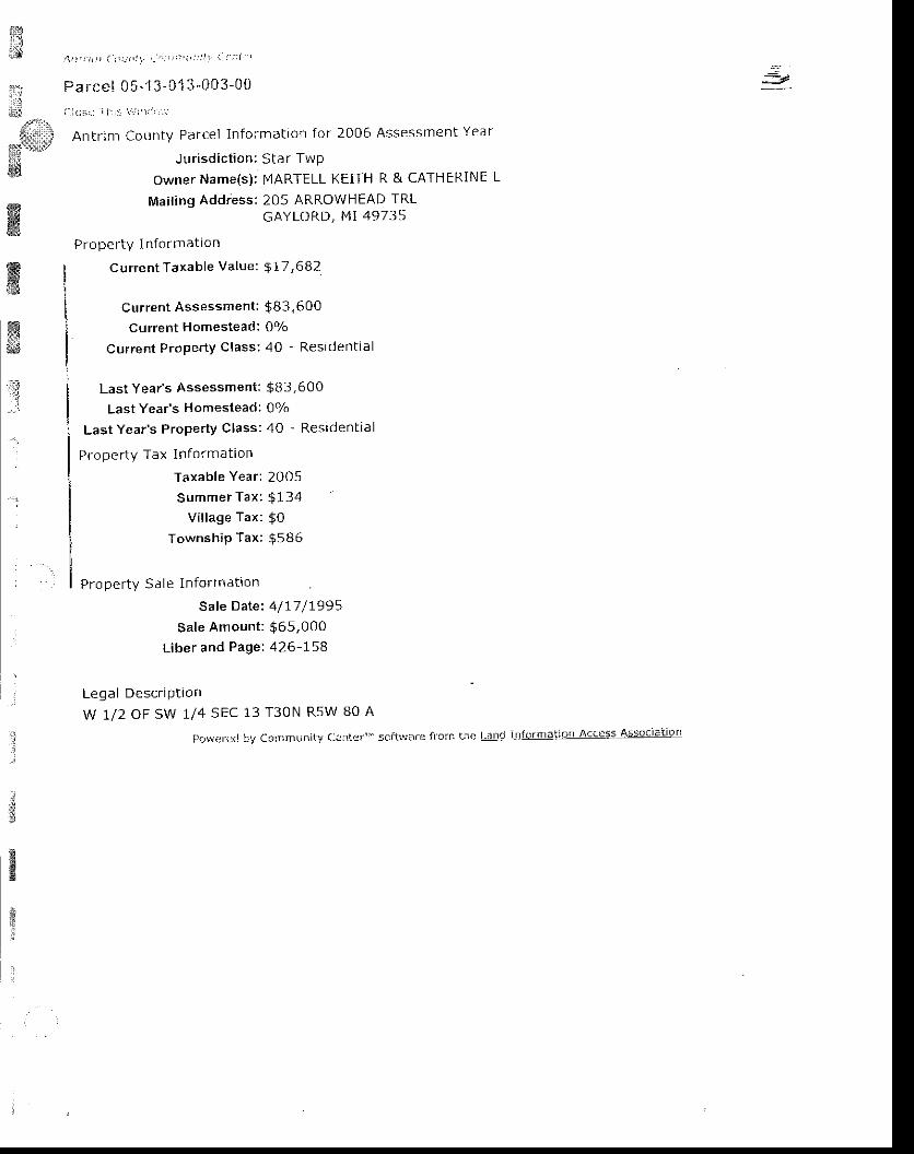
i:ij=i
atd*
;jri*
;{:rr&ia:ll]li
i{*tl::irY
ffi
:*
ffiffiffi*i;$
1 t 1 t t ; , , ! l t : : ) t t ! r , - " , . ' i , ' : j ' r ' r : ' i i l '
Parce! 05^' l 3-01 3-003-r j i l
i _1( j : r , . j i | . r t \ . r :1 r1 , , . , '
Antr im County Parcel In fDrmataon for 2006 Assessment Year
J ur isd ic t ion: Star Twp
owner Name(s): I"IARTELL KEiTH R & CATHERINE
Mai l ing Addiess: 205 ARROWHEAD TRLGAYLORD, M' 49735
Proper ty I n format ton
current Taxable Value: $ 17,682
Current Assessment : $83,600Current Homestead: 0Vo
Current Property class; 40 - Residential
l
Last Year's Assessment:
Last Year's Homestead:
Last Year's ProPerty Class:
Pro per ty Tax ln fo rmat ion
Taxable Year;
Summer Tax :
V i l lage Tax :
TownshiP Tax:
Proper ty Sa le ln fo rmat ion
Sale Date:
Sale Amount:
L iber and Page:
$ 8 3 , 6 0 0Oo/o
40 - Res ident ia I
2005
$ 1 3 4
$0$586
4/17 /1995$6s,0004 2 6 - r 5 8
Leqal Descriptionw t /2 oF sw u4 sEC 13 T30N RsW B0 A
I)qv1.rr i ]dt]yCcn}munityCl:1|cr ' . . 'sc:f t ! . iorf: f l ,c|r: t i re| 'anclnforrna| ' ia, lAcccssAssociat ior|
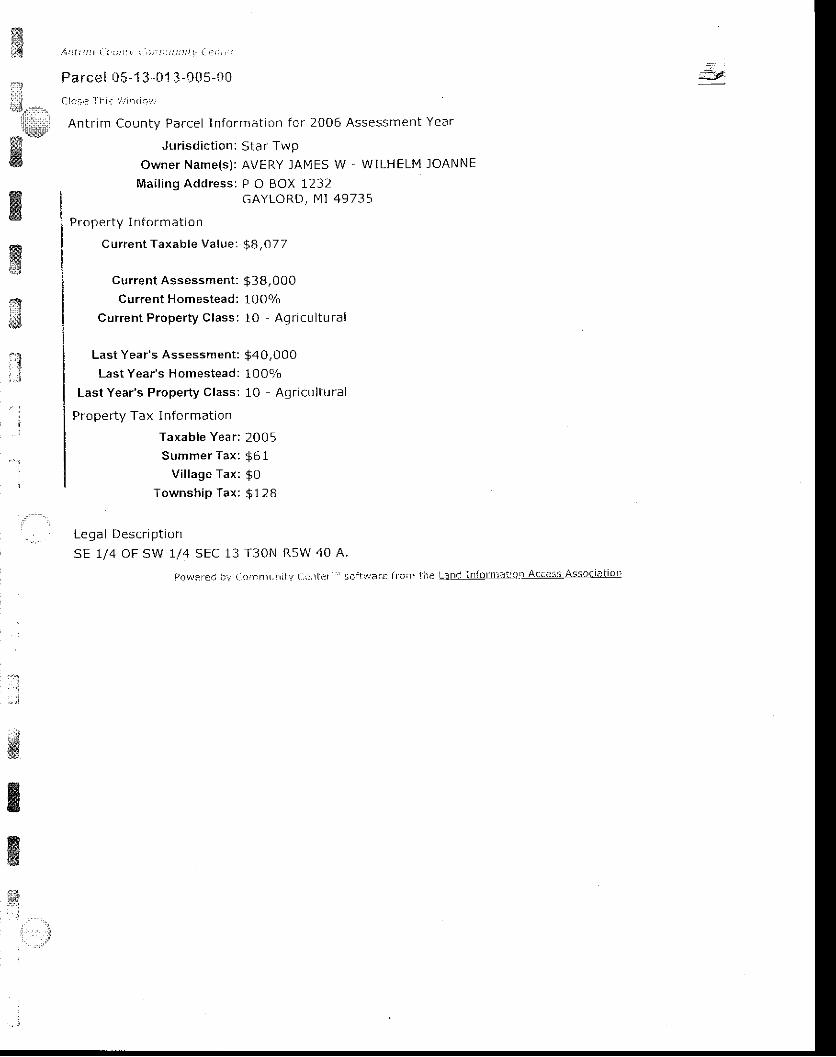
mi;B l r ) I r , r t : r r r r , r r ' , . t t ; : t : : : t i r ' . . t : . ' : . '
Parcel 05-1 3-01 3-C05-t l0. . . , . : . : - 1 , : i . , r . . .
Antr im County Parcel ln format ion for 2006 Assessment Year
Jur isd ic t ion: Star Twpowner Name(s) : AVERY lAl \1ES W - WILHELM IOANNE
Mai l ing Address: P O BOX 1lJ lGAYLORD, [4I 49735
Prope r ty I n form at io n
C urrent Taxable Value: $8,07 7
.--'
l.,it'li',*|ilw'ffi
wffit*9
xcurrent Assessment:
Current Homestead:
Current Property Class :
Last Year's Assessment:
Last Year's H omestead:
Last Year's Property Class:
Prope rty Tax I nformation
Taxable Year:
Summer Tax :
V i l lage Tax :
Township Tax:
$ 3 8 , 0 0 010Oo/o
1O - Agr icu l tu ra l
$40,00010 0 o/o
10 Aqr icu l tura l
2005
$ 6 1$0$ 1 2 8
,rtrJ
Leoal Descr io t ion
sE 1/4 OF SW 1/4 SEC 13 T30N RsW 40 A.
povraren i l , i ( .aI t :nt l , t - r i i ! a. i : t t r i r " i $c i ! : ! r ror€ f fc i :1e LanC inforn ' .J i :on AcaesS A55o( i l i io ' '
:
s&ffi
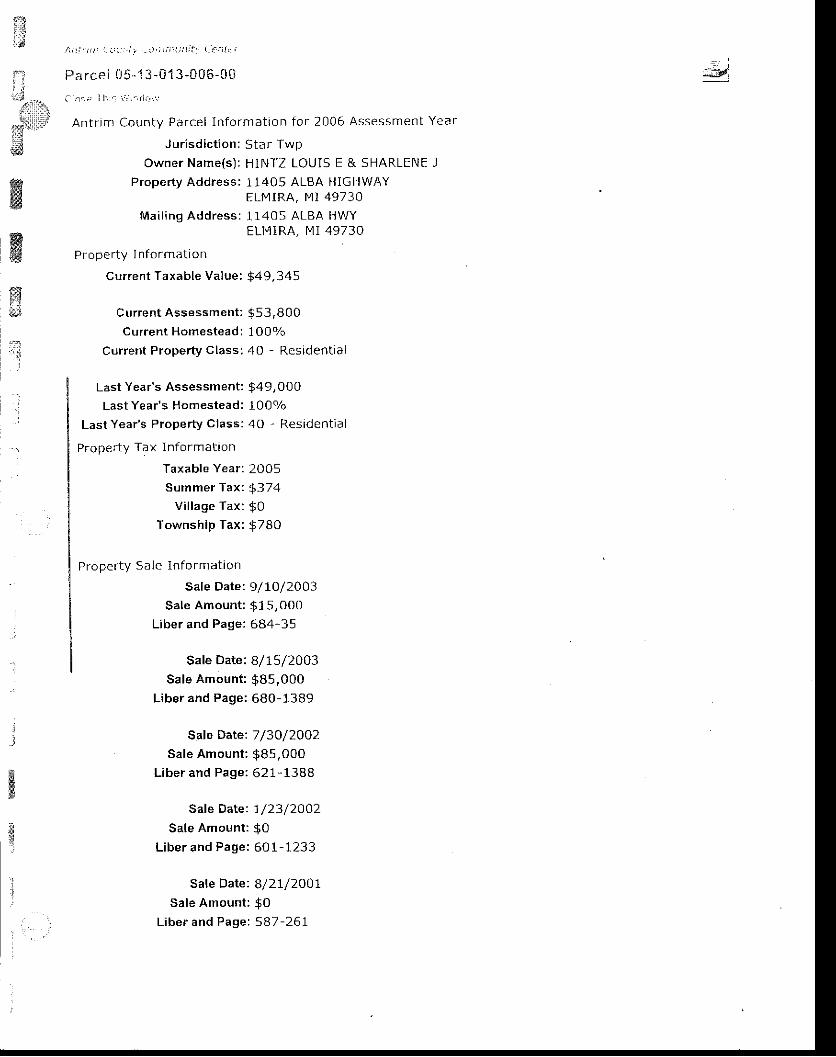
x1.&
. i ! t t : ; : t ' . : , t , : : r - J , r i ; i l t r l ; 1 1 L - a l ' i r r
Fa rcei 1l5-" i3 -013-005-0r j
a l . ( : ' I l r a \ ' : r r - ( l . j . r ,
Antr i rn County Parcel In format ion for 2006 Assessment Year
Jur isd ic t ion: Star Twpowner Name(s) : HINTZ LOU15 E & SHARLENE l
Proper ty Address: 11405 ALBA HIGHWAYELMIRA, MI 49730
Mai l ing Address: 11405 ALBA HWYELMIRA, I.1I 49730
PrDperty In f or mat ion
Current Taxable Value: $49,345
Current Assessment: $53,800current Homestead: 100q/o
Current Property class: 40 - Residential
':=41I
*..rtd{lil:t
#
ffiffiffi
.Last Yeais Assessment;
Last Year's Homestead:
Last Year's Property Class:
Proper ty Tax In fDrmat ion
Taxable Year:
Summer Tax :
V i l lage Tax :
Township Tax:
Property Sa le lnformation
Sale Date:
Sale Amount:
Liber and Page:
$49,000lO0o/o40 - Resident ia l
2005
$374$ 0$780
9/10/2003
$1s,ooo684-35
Safe Date: B/75/2003Sale Amount : $85,000
Liber and Page: 680-1389
Saf e Date: 7 /3O/2O02Sale Amount : $85,000
Liber and Page: 621- 1388
Safe Date: 7/23/2OO2Sale Amount: $0
Liber and Page: 601- 1233
Sale Date: 8/2I/2OO7Sale Amount: $0
Liber and Page: 587 -261
_i
. . :
ffirt
*lll\lrlliii$
ffiffi&ffi
ffi
Legal Descf lp t io n
PARCEL A. -BEG AT THE s 1/4 coR oF SEC 13; TH N 0O DEG E 420 FT ALG N'S 1/4 LINE; TH S BB DEG
E 300 FT; TH S 0O DEG W 420 FT; TH ru Bg DEG W 3Oo FT ALG S SEC LINE & C/L OF ALBA HWY TO
POBj BEING PART OF THE SW 1/4 OF THE 5E 1/4 sEC 13 T3ON R5W 2.892 A MIL
pcr;r r : ' , i : : r ' , : : t .n l t i r a. i - i r . r ' i i : i i r iar , : : l r ' r ) ' r - i - ! i : l=: j l l l : . r l f i l l lq . i l ! l9 i l l ! ! . : l is i ; :oc 'arro i
1
ar:;l-t

,'l,^nt t t : r r ) i . : t , : , i r a j ' r i i r r i . r r r r l ! ' . ' i r l , :
Pa rce I 05-13-013-Ci '16-511
i -1ai f T i , r . : i , ' j t 1 l i , l r ,
Antr im County Parcel ln format ion for 2006 Assessment Year
Jur isd ic t ion: Sta r TwpOwner Name(s) : STAPLEToN JOHN C & ELAINE L
Mai l ing Address: 7O827 ROlv lEO PLANK RDARMADA, IV1I 4 8OO5
Proper ty ln format ion
Current Taxable Value: $ 14,513
Current Assessment : $ 14,7 50Current Homestead: 0olo
cuffent Property class; 40 - Residential
LastYear 's Assessment : $ 14,050Last Year's Homestead: 0olo
Last Year's Property class: 4O Residential
Propefty Tax Inform ation
Taxable Year : 2O05S u m m e r T a x : $ 1 1 0
Vi l lage Tax: $OTownship Tax: $481
Proper ty sa le In fo rmat ion
Sa le Date : l l12 /2OO4
Sale Amount : $32,5OOLiber and Paget 699-972
=8,
*illll:,i:'l:a:l:illru*'
$l
ffiKffiq..]-
q :
)
Legal Descr ip t ion
PARCEL F..COM AT THE S 1/4 COR OF SEC 13; TH N 00 DEG E 42Q Fr ALG N-S 1/4 LINE TO THE POB;
TH CONT N OO DEG E 906.89 FT; TH S 88 DEi E 4a3.O2 FT| TH S OO DEG W 776.30 FT; TH s 88 DEG
E 136.26 FT; TH 5 OO DEG W 13b fl; TH N BB DEG W 685 FT TO THE POB; BEING PART OF THE SW
1/4 OF THE SE 1/4 sEC 13 T30N R5W 11.829 A M/L
PoLl.rrea hY Ccfi inlunity Center" ' scl l ' " iar€ h om t:re t int i inlbrnlarlon Access AssociaLio' l
:nI
i1
sftt! 4 t t / : , : , ( i . : j 1 t t , t , t ) " t ' . : t : : : i i t t - . : ' : ! . '
Parcel 05-1 3'0 I 4-Cft ?-C0
i . lo : i r I l i : : , i ! r ' r ( i r ,J ,
Antr im County Parcel In format ion for 2006 Assessment Year
Jur isd ic t ion: Star TwpOwner Name(s): MARSHALL ROBIN & IACALYN l
Property Address: 2342 PATTERSON ROADELMIRA, MI 49730
Mai t ing Address: 2342 PATTERSON RDELMI RA, MI 49730
Pr ope r ty I n [ormat ion
C urrent Taxable Value: $18,694
Current Assessment : $43,550Current Homestead: 1007o
Current Proper ty Class: 40 - Resident ia l
Last Year's Assessment: $40,150Last Year's Homestead: 100Y0
Last Year's Property Class: 40 - Residential
Proper ty Tax I n form at ion
Taxable Year: 2005Summer Tax: $142
Vi l lage Tax: $0Township Tax: $296
Proper ty Sa le In format ion
Sale Date: 3/24/2004Sale Amount : 937,500
Liber and Page: 708-806
Sate Date: IO/5/L998Sale Amount : $37,50O
Liber and Page: 500-1378
Sale Date: 5lI2/I998Sale Amount : $132,000
Liber and Page: 488-936
Legal Descr ip t ion
CON1 330 FT SOUTH OF NE COR OF SE T/4 OF NE 1/4, TH W 330 FT, TH 5 264 FT, TH E 330 FT, TH N
TO POB SEC 14 T3ON R5W 2 A M/L
I r:lii:: ,..,,.
E::]];t': JW
ffi,ry,1X?::!jwflr',.i
'
. :. ' :
wffillg
I
ffi$
i",,:
l ro l r i . ] |e i i r i , Cor i f i r r :n i tv Cantcr '_ 's ; - r i l r r i r : i ro: r i l : re Lan<i in l i r rn ' le l iu: r Accesg AssLic ia l iGn
ff3;ill
il'J
wffi
/ \ r ! t t ; t r ( . : : i j : , , : r I I : r j : , - , . i : . : . r
Pa rce l 05 -13 -01 4 -0A2-1A
Clo : i r I l : : t ' 1 r r ' i t l L i . .
Antr im County Parcel In format ion for 2006 Assessment Year
J urisdiction: Sta r Twp
Owner Name(s) ; ACER PARADISE INC
Mai l ing Address : p O BOX 758MANCELONA, MI 49659
Proper ty I n fo rmat ion
Cur ren t Taxab le Va lue : $ 15 ,4 77
/ - ' 1
Curren t Assessment l $40,00qCurrent Homestead: OVo
!
Cur ren t Proper ty C lass : 40 - Res ident ia l
Last Year's Assessment: $40,000Last Year's H omestead: 0olo
Last Year's Property Class: 40 - Residential
Prope rty Tax lnformation
Taxable Year: 2005
Summer Tax : g 117
Village Tax: g0
Township Tax: 9513
Proper ty Sa le In fo rm a t ion
Sale Date: 5/ IZ l1998Sale Amount : $ 132,000
Liber and Page: 48B-936
Legal Description
sE 1/4 OF NE 1/4 EXC COM 33O FT S OF NE COR FOR pOB, TH W 330 FT. TH S 264 FT, TH E 330 FT,TH N TO POB SEC 14 T30N RsW 38 A N4/L
ffitr
Pr)'.a'ereri iry Ccnri]!|]ni[:r (:entef" scftlrrrr: fronr t|i: Li]trj_!!1[Lr!ifj]_Ag!!S5 lSliEilAn
'::f'',
: . :
=9
I. {
:-i::&lllbl
1:triri!.id
,affi
,-"1: r l
A t l l t , 1 t a ' . . 1 t : | i r i , , , ; i ' : , - ' r , , I : . ! : . r i i ! : r
Parcel 05- l :J- i l1 4-003..C0
Clo : * _ I f , l r
L : : , i i t1 i , . .
Antr im County Parcel In format jon for 2006 Assessment Year
J ur isd ic t ion: Sta r TwpOwner Name(s) : CHIPPA MICHAEL A & JANICE K
Mai l ing Address : 10303 ALBA HWYELMIRA, MI 49730
Proper ty I n fo rmat ion
Cur ren t Taxab le Va lue : $8 ,530
ffirygxw
Current Assessment:
Current Homestead:
Current Property Class:
Last Year's Assessment:
Last Year's Homestead:
Last Year's Property Class:
Property Tax I nform ation
Taxable Year:
Summer Tax :
V i l lage Tax :
Township Tax:
$ 3 8 , 0 0 01 0 0 %10 - Agr icu l tu ra l
$40,0o0lOOo/a1O - Ag r icu l tura l
2005
$ o l
$0$135
:
Legal Descr ip t io n
sw 1/4 oF NE 1/4 SEC 14 T30N R5W 40 A.
[ ,n\^Eren t i j lo , r ]n l j l l i iy a-r ] i r ler " ' s i : ' r ' t ,1,arc f ro i l - - the Lanc Infornla i ion AccesI i \ssoaial ior l
$
&{*
j

tr / , a i ; i i ' : t . : : : n t , , .
Parcel 05-1 3-0' !4"0i l6-Stt
i : i j r ' : ' l i ' r : . : ! l i d , i
Antr im County Parcel in format ion for 2006 Assessment Year
Jur isd ic t ion: Star TwpOwner Name(s): CROFT LLC
Mai l ing Address: 121 E FRONT ST sTE 200TRAVERSE CITY, MI 49684
Proper ty I n fDrm at to n
Current Taxable Value: $ 17,508
Current Assessment : $76,000Current Homestead: O9o
Current Proper ty Class; 40 - Resident ia l
Last Year's Assessment: $76,0O0Last Year's H omestead: 0o/o
Last Year's Property class: 40 Residential
Propefty Tax Info rmation
Taxable Year: 2005Summer Tax: $ 133
Vi l lage Tax: $0Township Tax: $580
Proper ty Sa le In format ion
Sale Date: I2/3I/2OO4Sale Amount: $O
Liber and Page: 728-2462
Legal Descr ip t ion
S L/2 OF NW 1/4 SEC 14 T3ON RsW BO A [4/L
PoYJeIcd.yco;nInUlr j tYCenter ' ' . .sor tu/aref | 'c l r l thel '4 l ld inForf i rat ionAc.essAs5ociat ion
. - :
tr{it: *.
;$ffiirilt$€ig
ffi
ffiffi
Kffi
i

ffi
{,,:; / r , : i , r ; , r ; : , , , r , ' I ; i i j i , i i l : , i . , , ' r : 1 I
Fa rc el l )5-1 3 -( i i4- 'J07 -r lC
r_ lor a ;1. . r , r r r r i . , . '
Antr im County Parcel In format ion for 2006 Assessment Year
Jur isd ic t ion: Star Twp
owner Name(s) : CHIPPA MICHAEL A & JANICE K
Property Address: 10303 ALBA HIGHWAYELMIRA, MI 49730
Mai l ing Address: 10303 ALBA HWYELMIRA, MI 49730
Proper ty I n format ion
Current Taxable Value: $47 ,064
Current Assessment : $ 115,300current Homestead: 100o/o
Current Property Class: 10 - Agricultural
Last Year 's Assessment : $ 113,3 50
Last Year's Homestead: 100o/o
Last Year's Property Class: 10 Agricultural
Property Tax Info rmation
Taxable Year : 2005Summer Tax: $357
Vi l lage Tax: $0Township Tax: $744
Legal Descr ip t ion
E 7/2 OF SW 1/4 SEC 14 T30N R5W 80 A.
l )$\ , rcred t )y ao.nmuni ty t -1" : tLcr ," sc i ty . / i t f ! l roni t ; r r l L i ] . r rd in l 'or i ls l ;on Acces-s / ,ssoci i rL lon
- ' t
;€d
ffi
ffiffiffis3
. l
A i i l i n I t : . | : : i t r , - . i , : r ; , ) - r j r i : 1 a . r i ' i - J
Parcel 05- '13-01 4-008-0*
i l l os , : I f r . i i r , td - , . i
Antr im County Parcel In format ion for 2006 Assessment Year
Jurisdiction: Star TwpOwner Name(s) : POMEROY PEN NY
Property Address: 10085 ALBA HIGHWAYELN4IRA, MI 49730
Mai l ing Address: 10085 ALBA HWYELMIRA, MI 49730
Proper ty I n format ion
current Taxable Value: $36,646
Current Assessment: $39,600current Homestead: 1 0Oo/o
Current Proper ty Class; 40 - Resident ia l
Last Year's Assessment: $36,3O0Last Year's Homestead: 100Vo
Last Year's Property Class: 40 - Residential
Property Tax Info rmation
Taxable Year : 2005Summer Tax: $278
Vi l lage Tax: $0Township Tax: $579
Proper ty Sale In fo rmat ion
Sale Date: 6/1,6/2003' Sale Amount: $O
Liber and Page: 669-320
Sale Date: I/29 /2OOzSale Amount: $67,900
Liber and Page: 603-905
Legal Description
c o M A T T H E s W c o R o F T H E W I / 2 o F T H E S W I / 4 o F S E c 1 4 ; T H E 3 5 5 F I A L G S S E c L I N E T oPOB; TH N 350 FT; THE E 270 FT; TH 5 350 FT; TH W 270 FT TO THE POB; BEING PART OF THE SW
r/4 oF rHE SW 1/4 SEC 14 T30N R5W
t)o\.re|ed tJy Cc:rnrL!nity C('ater ' ' ' sci ' twart frL' in thc Ltnc informs' ' icr ir Acccss Asso' iat io
=3r'.r.rll
{l,;:iiT\:lllr.i,.:j l
sit
ffi
ffi
&4.t,
,:'.:,lt,tl l:
*9ltli t { l
Ar i t : t t . : , . , : .
ffi Pa rce I il5-1 :j -r.) j 1,.-U0fi"C5rs
i i l i i , . , . * . . . Clos+ i l r . i : r '1r i , , : "
Antf lm Countv Parcel ln format ion for 2006 Assessment Year
kd J ur isd ic t ion: Star fwp
: _ ::EAi
ffiOwner Name(s) : SLOAN DONNA l
Property Address: 2977 PRIIVIROSE ROADELMIRA, MI 49730
Mai l ing Address; 2977 PRII4ROSE RDELMIRA, MI 49730
Proper ty I n format ion
Current Taxable Value: $36,614
Current Assessment : $4 1,650Currenl Homestead: l OOo/o
Current Property Class: 40 Residential
Last Year 's Assessment : $3 7,100Last Year's Homestead: 100o/o
Last Year 's Proper ty Class: 40 - Resident ia l
Property Tax Inform ation
Taxable Year: 2005Summer Tax: $278
Vi l lage Tax: $0Township Tax: $579
Proper ty Sale I n fo rmat ion
Sale Date: 8/28/2OO2Sale Amount : $11,00O
Liber and Page: 625-645
Legal DescriptionBEG AT THE SW COR OF THE W 1/2 oF THE SW 1/4 oF SEC 14; TH N 350 FT; TH E 355 FT; TH s 350FT; TH W 355 FT TO POB; BEING PART OF THE SW 1/4 OF THE 5W 1/4 SEC 14 T30N R5W 2.8 A M/L
l)o'."rsrcc lrt Cltii:ffunily Cr:nLc,_"' scitv/ar ir {roni the L3nc lnforfial'on A(cess AssociaLion
ffi
. :
:
W
]..::
t:'t:iit:t'i
-_-!;iiii/ltt!iltffi
:,;
' '"j
i
A n t i t ! t ) i . . . , r i f , r ' i : ; r r i r , r , : ! i - i : : r ,
Parcel 05-1 ;J-{11 4-008-"1 0
C l o ; ' : T r r i i 1 : r 1 l i . ,
Antr im County Parcel In format ion for 2006 Assessment Year
Jur isd ic t ion: Star TwpOwner Name(s); CROFT LLC
Mai l ing Address: 121 E FRONT ST STE 200TRAVERS E CITY, MI 49684
Proper ty ln forn lat ion
Current Taxable Value: $13,331
Current Assessment: $60,800Current Homestead; 0olo
Current Proper ty Class: 40 , Resident ia l
Last Year's Assessment: $60,8O0Last Year's Homestead: OVo
Last Year's Property Class: 40 - Residential
Properiy Tax I nformation
Taxable Yean 2005Summer Tax: g 101
Vi l lage Tax: g0Township Tax: $442
Proper ty Sale In format ion
sate Date: 12/31/2OO4Sale Amount: $0
Litrer and Page.. 728-2462
I p n a l n p q . r i n t i n n
THE W 1/2 OF THE 5W 1/4 OF SEC 14. EXC COM AT THE SW COR OF W 1/2 OF SW 1/4 DESC AS COMAT THE 5W COR OF SEC, TH N 350 FT, TH E 625 FT, TH S 350 FT, TH W 625 FT TO POB, ALSO EXCcot4 AT THE NW COR OF THE W 1/2 OF SW 1/4 SEC 14, TH E 860 FT, TH S PARA TO THE W LINE 540F]" TH W 860 FT TO W SEC LINE, TH N TO POB, BEING PART OF THE W 1/2 OF THE SW 1/4 SEC 14,T30N, R5W 64.32 A M/L
Pov,rercaj iry CarrlrnurTiLy acnLcr''' 1Dit!.,,ari lrcl| l.rc tellll'i]lq]ll?t:c:r Acccss Assoclatlon
&wt*s
, t . . ,',:' ' ',:,::,
{!}
ffi
il**liiillt
($
H
, / ; , I t : ) ) a : : | ) : i : . . : ! j ; j i : j i t j i t l \ , t , : : . t I i \ j
Parcel 0 5-1 3 -014-t i08-2S
a i c s i i : r . r . ! ! f r r - r : l
Antr im County Parcel In format ion for 2006 Assessment Year
J ur isd ic t ion: Star TwpOwner Name(s) : GATES DALE E
Property Address: 2525 PRIMROSE ROADELMIRA, N, l I 49730
Mai l ing Address:2525 pRI t4ROSE RDELMIRA, F4I 49730
P r o p e r t y I n f o r m a t i o n
Current Taxable Value: $44,5 3O
Current Assessment: $65, 6O0Cutrent Homestead: 1007o
current Proper ty Class:40 - Resident ia l
ffiffi;
fi
,q7
:3
Last Year's Assessment:
Last Year's H omestead:
Last Year's P.operty Class:
Proper ty Tax InForm a t ion
Taxable Year:
Summer Tax :
V i l lage Tax :
Township Tax:
$62,0s01 0 0 %40 - Resident ia l
2005
$ 3 3 8$09704
I F n r l n F < . r i n t i n n
C O M A T T H E N W C O R O F T H E W I / 2 O F T H EFT TO W LINE OF SEC, TH N 540 FT TO POB,R5W 10.68 A M/L
SW 1/4 OF SEC 14 TH E 860 FT, TH S 540 FT, TH W 860BEING PART OF THE W I /2 OF IHE SW 1/4 SEC 14 T3ON
Por.!erei !)y Coi nunity L:rnter '" soitvrafe fronr Inc L.and InfonnaiioLAcaess A5socr-t ior i
&
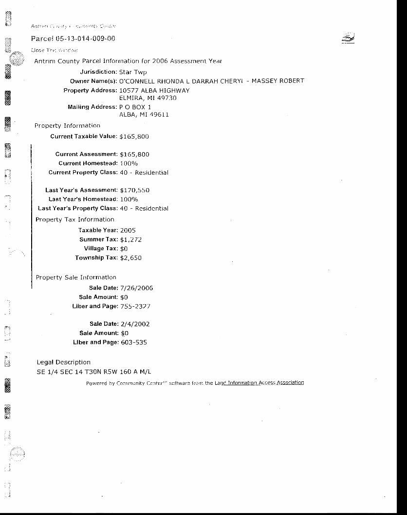
;iiil*1,*o:',.
l,:l'::r,,1e*
q':r
*&ffi
ffiffi5l : ,
"l
. . i
' :
: ] , ) a r , , j , I r , ; ! . ' ; , t t ) t , : \ t ! . t : . . , : : , \ :
Pa rc€, { . i5- j 3-014-009.00( , io: , : : l r r . i . ' - , f , , - . :
Antr inr County Parcel ln format ion for 2006 Assessment Year
Jur isd ic t ion: Star TwpOWNET NAME{S): O'CONNELL RHONDA L DARRAH CHERYL - MASSEY ROBERT
Proper ty Address: 10577 ALBA HIGHWAYELIY I RA, MI 49730
Mai l ing Address: P O BOX 1ALBA, 14t 4961 1
Proper ty In format ion
Current Taxable Value: $165, BOO
Curren t Assessment : $ 165,800
Current Homestead: 1000/o
Current Property Class: 40 - Residential
: i
i6d
I: , 1
Last Year's Assessment:
Last Year's Homestead:
Last Year's Property Class:
Property Tax Information
Taxab le Year :
Summer Tax :
V i l lage Tax :
Township Tax:
Proper ty Sa le In fo rmat ion
Sale Date:
Sale Amount:
Liber and Page:
$ 1 7 0 , s s O10 09040 Resident ia l
2005
$ r , 2 7 2$052,6sO
7 /26/2006$ 0755-7327
Sate Date: 2/4/2002Sale Amount: $O
Liber and Page; 603-535
I odA l | - lac r r ih l - idn
SE 1/4 SEC 14 T3ON R5W 160 A M/L
ffi PcrF ered by Co:rmljnitv C.rffl '' iciit,jars fr(liri !he Lanc Intorlnat:ot Acaess As.lflltigil
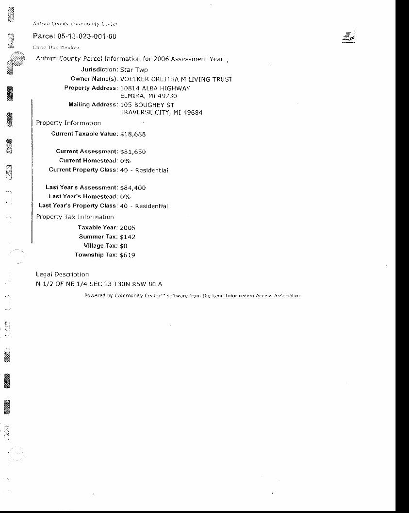
t&lJ
::':l
;lir1
l \ / t l t ' l n ( t : t : t t l , ' I I i i ) ! | ) : | | 1 ] | \ . i , 1 : , j ! , : l
Parcel 05'1 3-023-001 "i i0l lo :e I | , : : i t r r ( ! ( r i ] ,
Antr im County Parcel In format ion for 2006 Assessment year
Jur isd ic t ion: Sta r TwpOwner Name(s) : VOELKER OREITHA M LIVING TRUST
Proper ty Addressi 10814 ALBA HIGHWAYELMIRA, I4 i 49730
Mai t ing Address: 1O5 BOUGHEy STTRAVERSE CITY, N1I 49684
Proper ty I n lor mdtron
Current Taxable Value: $18,688
Current Assessment : $81,650Current Homestead: OYo
Current Property Class: 40 - Residentjal
Last Year's Assessment: $84,4O0Last Year's Homestead: 0qo
Last Year's Prop;rty Class: 40 - Residential
Proper ty Tax Inform at ion
Taxable Year: 20O5Summer Tax: $142
Village Tax: $0Township Tax: $619
Legal Descr ip t ionN 1/2 OF NE 1/4 SEC 23 T30N R5W B0 A
w:
ffiffi$l
wai
tr)
i'i
l )o$,er td l iv Coirrn luni t / Ccnter" 'soatyrare f rcm t l le Land I r ) fof lnai ion Acccss / \ssociaLior l
ir:- : i
,.::
&
ffiffi
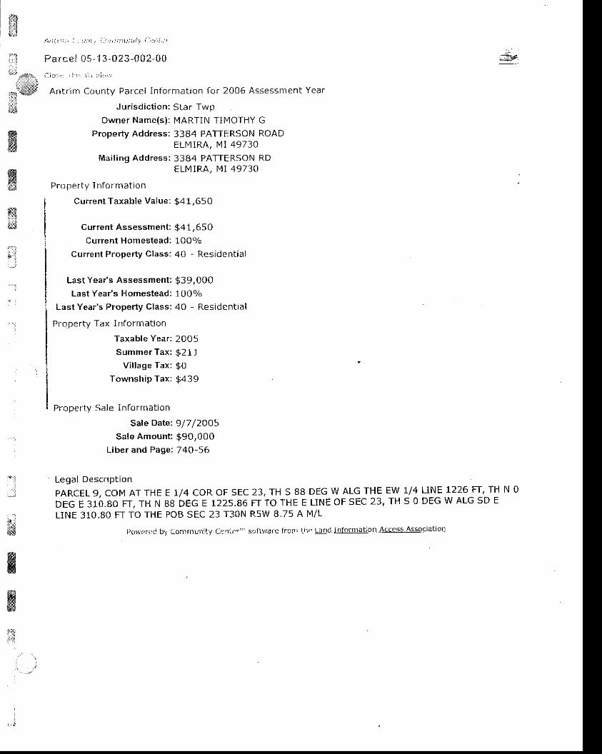
f,$gs.ii*,,
rswtd
, i \ t ) ! i : t ) , a : : : t t . i i . , , j ; : i u t t : 1 , i t \ . i , . ' i
Pa rcel C5-13 -U Z3-002-00
1 : i o : - r l ! r ' , , : / r i , . :
Antr im County Parcel In format ion for 2005 Assessment Year
J ur isd ic t ion: Star TwpOwner Name(s) : MARTIN TIMOTHY G
Property Address: 3384 PATTERSON ROADELIYIRA. MI 49730
Mai l ing Address: 3384 PATTERSON RDELMIRA, MI 49730
Proper ty I n lormat io n
Curreni Taxable Value: $41,65O
Current Assessment : $41,65 0Current Homestead: lOOo/o
Current Property class: 40 - Residential
Last Year's Assessment: $39,0O0Last Year's Homestead: 100o/o
Last Year's Property Class: 40 - Resident,al
Proper ty Tax I n format ion
Taxable Year: 2005Summer Tax: $21 1
Village Tax: $OTownship Tax: $439
Property Sale Information
Sale Date: 9/7 /2OO5Sale Amount : 990,000
Liber and Page; 740-56
ffiffiry
i:-':
.;
ffid&s
4ITKw
Legal Descfl ption
PARCEL 9, COM AT THE E 1/4 COR OF SEC 23, TH S 88 DEG W ALG THE EW 1/4 LINE 1226 FT, TH N 0
oec r grb.ao FT, TH N 88 DEG E 1225.86 FT To rHE E LINE oF sEc 23 ' TH s 0 DEG w ALG sD E
LINE 310.80 FT TO THE POB SEC 23 T3ON R5W 8,75 A N4/L
t)o\,,rcr.'d by CorrfltunlLy Ccntcr"' software frcryi Lne tAnii lnformatlon Access Association
iI
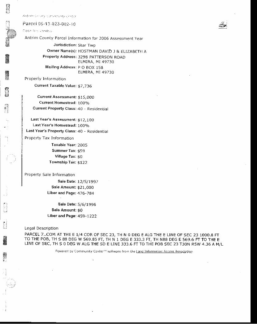
l$! ! t ! ! t t ; 1 ) . . i , ) ! , . ' . , ) . t : 1 1 t , : j i \ . , . , . : t . t
Parce i ij 5-J 3,.. i];i:l-$A-i--1iJ = ,#
a O - : - I
ffi$mtr
ffi
;]: i
Anir im County Parcel In format ion for 2006 Assessment year
J urisdiction: Star TwpOwner Name(s) : HOSTIqAN DAVID J & ELIZABETH
Property Address: 3298 PATTERSON ROADELMIRA, MT 49730
Mai l ing Address: p O BOX 158ELMIRA, I .4 I 49730
^ : - -Proper ly I n to rmat |on
current Taxable Value: $7,736
Current Assessment: $1 5,000Current Homestead: 100o/o
Current Property Class: 40 Residential
Last Year"s Assessment : $12,100Last Year's Homestead: 1OO!/o
Last Year's Property Class: 40 - Residential
Property Tax Information
Taxable year: 2005Summer Tax: $S9
Village Tax: $0Township Tax: $ 122
Proper ty Sale In format ion
Sate Date: tz/s/ 1997Sate Amount : $21,000
Liber and paget 476,784
Sate Date: 5/6/1996Sale Amount: g0
Liber and page: 459-L?22
I o f , : l n a c ^ r i n t i ^ n
PARCEL 7. .CON4 AT THE E 1/4 COR OF SEC 23, TH N O DEG E ALG THE E LINE OF SEC 23 1OOO.B FTTO THE POB, TH S 88 DEG W 569,85 FT, TH N 1 DEG E 333.3 FT, TH N88 DEG E 569.6 FT TO THE ELINE OF SEC, TH 5 O DEG W ALG THE SD E L iNE 333.6 FT TO THE POB SEC 23 T3ON R5W 4.36 A M/L
! , .r i
ffiliJ
Po!.rerec ay tc l |1tnLir r iLv C3nler ' ' sc i twi t re f rg i r the Lasc informa' i io i t A(ccss Assol iEt io i i
f!a : 1
tj.*.,,;1r,:l'il::r,:::r:tj
f,t '"'
ffii
ffiffi{,?
e;t:I
A4t t i t , l ( a t ; ! ' a ' / i : r i r t t ; ) r r t ! ! t ia t i ! , 1
Parcel 05- 1 3-0 ?-3-ADZ-ZA
a:!o,cr ' l l , r : * r .1( l i , r '
Ant r im County Parce l In fo rmat ion fo r 2006 Assessment Year
Jur isd ic t ion ; S tar Twp
OWNET NA]nE(S) : HOSTMAN DAVID J & ELIZABETH
Property Address: 3352 PATTERSON ROADELMIRA, I ' l i 4 9730
Mailing Address: P O BOX 158ELIV] IRA, MI 49730
Property I nFo rmation
Current Taxable Value: $15,OO1
Current Assessment; $22,900Current Homesfead: l OOizo
Current Property Class: 40 - Residential
Last Year's Assessment: $ 19,5 50Last Year's Homestead: l OOo/o
Last Year's Property Class: 40 - Residential
Pro perty Tax Information
Taxable Year: 2O05Summer Tax: $ 114
Vi l lage Tax: $0Township Tax: $237
Proper ty Sale I n format ion
Sale Date: 72/5/1997Sale Amount : $21,000
Liber and Pagei 47 6-784
Legal Description
PARCET 6 COM AT E 1/4 CORNER, TH N oW 570.63 FT, TH N l DEG E 333.3 FT, THLINE 333.6 FT TO POB SEC 23 T3ON RsW
DEG E ALG EAST SEC LINE 667.2 FT TO POB, TH S 88 DEGN 88 DEG E 569.85 FT TO E LINE OF SEC, TH 5 ALG E SEC4.37 A t t l /L
ffitrl
i:
ffil:,(x;ere(! i1v Ccn|Du|]i!,/ Crnter' ' scfL?rar.i lror] thc Lltlllli0lsMgilqll-Aelesg-Al
$t*
,t"':t\r
tedquutrii:i!#s
ffiK€$&3
i . t : ! 1 , t : . i . i . ; : t ! r t . t . : ; : i t t : t t t . \ . . t : l t j l
Parcei 05- ' i 3-r)2f , . -0i l : i -?5
a l . j . < r : i I , : r i . r r - l r , : : ;
Antr im County Parcel ln format ion For 2006 Assessment Year
Jur isd ic t ion: Star Twpowner Name(s) : WARREN t4ICHAEL I & ROBIN R
Property Address: 3376 PATTERSON ROADELN1IRA, MI 49730
Mai l ing Address: 3376 PATTERSON RDELN4IRA. MI 49730
P r o p e r l y I n f o r m a l i o n
Current Taxable Value: $9,8 7 5
Current Assessment : $1 8,050Current Homestead: IOOV,
Current Proper ty Class: 40 - Resident ia l
Lasi Year's Assessment: $3 5,900Last Year's Homestead: 10Oo/o
Last Year's Property Class: 40 - Residential
Proper ty Tax Informat ion
Taxabte year : 200 5Summer Tax: g 186
Vi l lage Tax: g0
Township Tax: $387
Proper ty Sale I n format ion
Sate Date: Z/ZB/1995Sale Amount: $0
Liber and Page: 424-665
Legal Description
PARCEL 5-1. .CoM AT THE E 1/4 COR OF SEC 23; TH N 00 DEG E 310.80 FT ALG E SEC LINE TO POB;TH S BB DEG W 1225.88 FT; TH N01 DEG E 355.21 FT; TH N 88 DEG E 1025.03 FT; TH S 0O DEG W150 FT; TH N BB DEG E 200 FT TO E SEC LINE; TH S 00 DEG W 206.40 FT TO POB; BEING PART OFTHE NE 1/4 SEC 23 T30N RsW 9.31 A M/L
lr;l:.:J
l \ rrncra, 'c! l ry Co.rdrL,nlt-v {-. i rntcr ' ' ' scityrarc ircn; thcr t=rod lr ' t fTJrnrir l lor Accass Assocratror,
,j

$€iii$
ila:;
,.lii::r,
**s;rffiffiffi
ffii.,.{H
i1
A ' . , i r ' ; t , i ! t t l t . . : . ' i t : : : i t i i t l ' , ' . ! : t t i . ;
Pa rcei 0$- t 3- i i23-00?-: l i . !i l i o r : . i I i : i ' r j r r , i r , r
Antr im County Parcel In format ion for 2006 Assessment Year
Jur isd ic t ion: Star Twpowner Name(s) : BRADLEY ANTHONY W
Property Address: 3322 PATTERSON ROADELMIRA. I4I 49730
Mai l ing Address: 3322 PATTERSON RDELMIRA, IVI I 49730
Proper ty I n fo rmat ion
Cur ren t Taxab le Va lue : $24,159
Current Assessment: $33,400Current Homestead; 0olo
Current Property Class: 40 - Residential
Last Year's Assessment: $31,8 50
Last Year's Homestead: Oo/o
Last Year's Property Class: 40 - Residential
Proper ty Tax In fo rmat ion
Taxab le Year : 2005
Summer Tax : $183Vi l lage Tax : gO
Townsh ip Tax : gB01
Legal Descr ip t ion
PARCEL 11 COM AT THE E 1/4 COR OF SEC, TH S 88 DEG W ALG E-W 1/4 t lNE 1226.6 FT, TH N 01DEG E 666.01 FTTO POB, TH S 88 DEG W 655 FT, TH N 01 DEG E 665.42 Fr , TH N 88 DEG E 655 FT,TH S 01 DEG W 666.01 FT TO THE POB SEC 23 T3ON R5W 10.01 A IVI /L
: : :
pLrwcreo bv [ : rn iml :n i fv Cer i i r r ' " sc i iv ;ar 'e f r r l r ) lhc Lano lnformai ion Aa4ess Assocl ; ] t r in
iT;,,,i
mi*i:'w&&
Hqs
ffi
, ? l , l i i . f ; _ . L a i : , i : ' j i : t : ; : t ; l t , t - t ' i t t r l
Farcet U5-1 3 -023 -tl\z -+tJ
i l l o l i . i i : , : 1 " , r , . r r , , , f l
Antr im County Parcel In format ion for 2006 Assessment Year
Jur isd ic t ion:5tar Twpowner Name(s) : HOSTMAN DAVID I & ELIZABETH A
Mai l ing Address: P O BOX 158ELMIRA, MI 49730
Proper ty I n format ion
Current Taxable Value; $5,O57
Current Assessment : $1 1,000Cu rrent Homestead: oVL
Current Propefty Class: 40 - Residentjal
Last Year's Assessment: $ 10,500Last Year's Homestead: OVo
Last Year's Property Class: 40 - Residential
P l oper l y Tax Informat ion
Taxat l le Year ?00 5Summer Tax: $38
Vi l lage Tax: $0Township Tax: $168
Proper ty Sale I n format ion
Sate Date: IO/27 /7004Sale Amount: $8,500
Liber and Page: 725-797I
Sale Date: 9/24/f998Sale Amount : $8.500
Liber and Page: 499-860
I c d > l n p < . r i n t i n n
PARCEL 8 COFI AT THE E 1/4 COR OF SEC 23, TH N O DEG E ALG E SEC LINE 667.2 FT, TH S 88 DEGW 570.63 FT TO THE POB, TH CONT S 88 DEG W 654.4 FT, TH N 01 DEG E 666.01 FT, TH N 88 DEG E654,4 FT, TH S 01 DEG W 666,6 FT TO THE POB SEC 23 T3ON R5W 10.01 A M/L
Por"rerei bv Co.rnunity fient,rr"' scft!n/.3fe froi: t:le Lani info naiion Access Associdtion
: ' ::;i*
l,:i
l

n/ j t | ! t i | ! ' i : : L ! ! t I r i - . ) , ' : : : - : : i : i . - , : l
Fa rcel 05-t 3 -D 2 3 -3 ti)i,-ii)
ato.,r a; :-r \ ,rr :) . tr . f .
Antr im county Parc€l ln format ion for 2006 Assessment Year
J ur isd ic t ion : S tar Twp
Owner Name(s) : KASSUBA EVELYN M
Mai l ing Address : 520 N TOWNLINE RDGAYLORD, MI 49735
Proper ty In fo rmat ion
Cur ren t Taxab le Va lue ; $2 ,489
Cur ren t Assessment : $ 1 1 ,000
Current Homestead: OVo
Current Property Class: 40 - Residential
Last Year's Assessment: $ 10,500
Last Year's Homestead: 0olo
Last Year's Property Class: 40 - Residential
Property Tax I nform ation
Taxable Year : 20O5Summer Tax: $19
Village Tax: $0Township Tax: $82
ffi68;s
trri
:
::
Legal Descr ip t ion
PARCEL 10 COM AT THE E 1/4 COR OF SEC 23, TH S 88 DEG W ALG EW 1/4 LINE 1226'6 FT TO THE
PoB, TH coNT 5 BB DEG W ALG EW 1/4 LINE 655 FI , TH N 01 DEG E 665.4 FT' TH N 88 DEG E 655
F T , T H S O l D E G W 6 6 6 . 0 l F T T O T H E E W l / 4 L I N E A N D P O B S E C 2 3 T 3 O N R 5 W l O . O l A M / L
l ,owcrer i ! , r , aJ,r i rnurr ly L,rn lcr" s l r i l l tarL= f ra i r l Lhrr Land infornlat ion Aacess / issociat ior l
ffir
ffi
i'lt l
ffiffitr
Ar , t : ;n | ( t , ! . ) t ' / i . , . ) . : j , j ' r , ! r i -_a | l _ r
Pa lce l 5 -13^023-0C2-6 t )r : lo:_. . i l ' r : : ! " i rn l i . , , : l
Ant f lm County Parce l ln fo rmat ion fo r 2006 Assessment Year
Jur isd ic t ion : S tar Twp
Owner Name(s) : LAMOREAUX DAWN
Maal ing Address : 1906 SPRUCE STWEST POINT, GA 31833
Propef ty In fo rmat ion
Cur ren t Taxab le Va lue : $5 ,05 7
Cur ren t Assessment : $1 1 ,000Current Homestead: OVo
Current Property Class: 40 - Residential
Last Year's Assessment: $10,500Last Year's Homestead: OVo
Last Year's Property Class: 40 , Residential
Prope rty Tax Information
Taxable Year: 20O5Summer Tax: $38
Village Tax: g0
Township Tax: 9168
Proper ty Sale In format ion
Sale Date: 5/J.5/2OO2Sale Amount : 97,500
Liber and Page: 618,476
Sate Date: 9/4/1998Sale Amount : $7.500
Liber and Page: 502-563
Sate Date: 9/16/1998Sale Amount: $0
Liber and Page: 502-562
Legal Descr ip t ion
PARCEL 13 COM AT THE E 1/4 COR OF SEC 23, TH 5 88 DEG W ALG EW 1/4 LINE 1881.6 FT TO THEPOB, TH CONT S 88 DEG W ALG SD EW 1/4 LINE 655.6 FT TO THE CENTER 1/4 COR OF SD SEC, TH N01 DEG E ALG THE NS 1/4 LrNE 664.83 FT, TH N 88 DEG E 655.6 FT, TH S 01 DEG W 665.42 FT TOrHE EW 7/4 LINE AND THE POB, BEING PART OF THE SW I /4 OF THE NE 1/4 SEC 23 T3ON R5W 10,01A M/L
.
it;!
wa*a$:,l.'
, i
I
W5
powereci '1 ' ac. i :n luni ly Cejr ter" 'sc iLHare fTcir ! l i lc L3n. i i i l formi l i io i l Accass As$ociat ion
,nt
*,;,.:3r!
*rsiiil''i':lffi,
ffiw,a
A r , t i ; t : ( ! t : . ; . . : ; : i i . , r i r . t , L , : i ; { . j r
Pa rcei 05- l l l - t ;?3, i02-7i)( ' k ) r i , I I r i i r ; , - , . i i , ,
Antr im County Parcel In format ion for 2006 Assessment Year
J urisdiction: Sta r TwpOwner Name(s): KASSU BA EVELYN lY
Mai l ing Address: 520 N TOWNLINE RDGAYLORD, Ml 49735
Proper ty I n format io n
Current Taxable Value: 92,489
Current Assessment : $ 11,O0OCurrent Homestead : 0olo
Current Property Class: 40 - Resjdential
Last Year 's Assessment : $10,500Last Year's H omestead: 09/o
Lait Year's Property Class: 40 - Residential
Property Tax I nform ation
Taxable Year : 2005Summer Tax: $19
Vi l laqe Tax: $0Township Tax: $82
Legal Descr ip t ion
PARCEL 12 COM AT THE E 1/4 COR OF SEC 23, TH S 88 DEG W ALG THE E-W 1/4 LINE OT SD SFC655.6 FT TO THE N-S 1/4 LINE OF SEC, TH N 01 DEG E ALG N-S 1/4 LINE 664.83 FT, TH N 88 DEG E655.6 FT, TH S O1 DEG W 665.23 FT TO THE POB SEC 23 T3ON RsW 10,01 A M/L
ff
fi
' ) ( r \ . i : ) r . lc ! : a.Jrrxr t r r r i t - t CenLar ' ' ' 5c i1Bare l ro i ! : t l rc LLInC :n lornla i lon Acc3s5 i ' .ssociat ior :
ffiwt:&
mti,.:
lifa,;j1rl5
ns#w
Rffi
ffit---1
ryd
fr, .
' 1
'};
. 4 t : ! i ; , ' , ( . . : | : : t i ' / - j ' : , , , ; i . r r r r ' , , . _ a , , 1 1 .
Parcel 05"1 3-C23-t)03 G{)a lo : : ' : I i : i i j i r j rd . ] f .
Antr tm County Parcel ln format ion for 2006 Assessment Year
. - i
#F:
Jurisdiction:
Owner Name(s):
Property Address:
Mai l ing Address :
Proper ty I n loTm a c lon
Current Taxable Value:
Current Assessment:Current Homestead:
Current Property Class:
Star TwpCROFT LLC10426 ALEA HTGHWAYELN4IRA, [4 I 49730121 E FRONT ST STE 2OOTRAVERS E CITY, MI 49684
$ 2 2 , 2 4 4
$ 1 1 8 , 1 0 0Oo/o
30 - lnd ust r ia l
ffiii*
t1-
l
Last Year's Assessment: $ 124,300Last Year's Homestead: 0ol,
Last Year's Property Class: 3O Industrial
Property Tax Information
Taxable Year: 2O05Summer Tax: $169
Vi l lage Tax: gO
Township Tax: 973 7
Proper tv Sale In fo rmat ion
Sale Date: t2/31/2O04Sale Amount: $O
Liber and Page: 0-0
Legal Description
THE N 3/4 OF E L/2 OF W L/2 EXC COM AT THE N 1/4 POST OF SEC 23, TH S 87 DEG W 828,6 FT FORPOB, TH S 87 DEG W 436,28 FT, TH S 1 DEG W ON THE W 1/B LINE OF SD SEC 5OO FT, TH N 87 DEGE 436,28 FT, TH N 1 DEG E 5OO FT TO THE POB, BEING PART OF THE NE 1/4 OF THE NW 1/4 EXCcoM AT N 1/4 COR OF SEC 23, TH S 87 DEG W ALG N LINE 50.05 FT TO NE COR FOR POB, TH S 0DEG W 295.17 FT, TH S 87 DEG W 295.77 FT, TH N O DEG E 295,L7 FT TO A PT ON N LINE OF SDSEC 23, TH N 87 DEG E ALG N SEC LINE 295.17 FT TO POB., . . . . . . . SEC 23 T3ON R5W.. . , .113 A M/L
Po8cred bv Ca:r:rnr-nitv Ceitr:r" ' sci i ' r3re fr.rni fne l . .anci infofmai:ot Aacess Associet ion

ffi
hffiffiK!s
ffi*r,
qi
t;
&
/ . i 1 t t j i : t _ i : : , : ; , i , . : j . . r , t i : : - , : , r - . ' : , 1 '
Parcei 05- ' i 3 - f i?3-003- i i l
aloa. i i j : r : , r , : r . ' ( ln l i
Antr im County Parcel In format ion for 2006 Assessment Year
Jur isd ic t ion: Star TwpOwner Name(s) : CHIPPA MICHAEL A & REBECCA [4
Proper ty Address: 10266 ALBA HIGHWAYELMIRA, 14I 49730
Mai l ing Address: i 0266 ALBA HWYFLIYI RA, 14l 497 30
Proper ty I n form at ion
Current Taxable Value: $30,835
Current Assessment: $34, 300Current Homestead: lOOo/o
Current Property Class: 10 - Agracultural
Last Year's Assessment: $29,850Last Year's Homestead: 100o/o
LastYear 's Proper ty Class: l0 - Agr icu l tura l
Property Tax Information
Taxable Year: 2005Summer Tax: $234
Vi l lage Tax: $OTownship Tax: $487
Proper ty Sa le In format ion
Sale Date: 7 / 78/ 1997Sale Amount : $7,000
Liber and Page: 466-1402
Sale Date: 2/23/1996Sale Amount : $21,000
Liber and Page: 441- 1164
Legal Descr ip t ion
coM AT THE N 1/4 POST OF SEC 23, TH S 87 DEG W ON SEC LINE 828.6 FT FQR POB, TH S 87 DEG
w 436,28 FT, TH S 1 DEG W ON THE W r/8TH LINE OF SD SEC 500 FT, TH N 87 DEG E 436.28 Fr, IH
N 1 DEG E 500 FT TO POB, BEING PART OF THE NE 1/4 OF THE NW 1/4 SEC 23 T30N SEC 23 T30N
R5W 5 A M/L
P!wL_r i :c i jy { - . i : l r r t l in i t : / f :s l r l t r ' " scf t r ' rnrc l rc ' t t le Ltnd I l r format;o;r Access Ajsocretro ' -
=
ffi
fr
' .::
i:{a t . l t ; , ; ' ! : \ , t : . . . , . , , ' t , : t : , : : ' , , . . , : , . ,
. j Prr .* i05-13-023-i i0:1-. , l i j
*,]{dtr lb{ ar. j : ' .r i ' : :
, :r , ' , , j i .
Antnm County Parcel In format ion for 2006 Assessment Year
; ; J u r i s d i c t i o n : S t a r T w ptsOwner Name(s) : THURSTON TODD t4 & DEANNA L
f f i Proper ty Address : 10464 A l BA HIGHWAY
f f i Fl MIRA, N4t 49730M a i l i n q A d d r e s s : 6 1 5 W S H E L D O N S T
&t GAYLORD, Ml 49735
isq{ Properry r nrorma on
Current Taxable Value: 916,400
:;9'''-.
;3 Current Assessment : $ 16.400Current Homestead: 1 OOo/o
current Proper ty c lass: 40 - Resident ia l1'"i'i l
Last Yeaas Assessment:
Last Year's Homestead:
Last Year's Property Class:
Proper ty Tax I n fo rmat ion
Taxable Year:
Summer Tax :
V i l lage Tax :
Township Tax:
Proper ty Sa le I n fo rmat ion
Sale Date:
Sale Amount:
L iber and Page:
Sale Date:Sale Amount:
Liber and Page:
$ 1 3 . 6 0 01O O o/o
40 - Resident ia l
2005
$ 7 0$ 0$ 1 4 6
12/27 /2O0s$3s,450745-3L3
12/17 /2OOr$0597 -435
I
!i!. . t l].
f,iffi
8{d@
wffi
til
Sale Date: 3/16/2000Sale Amount : $15,000
Liber and Page: 543^85
Legal Description
COM AT N 1/4 COR OF SEC 23, TH 5 87 DEG W ALG N LINE OF 5D SEC 50.05 FT FOR POB, TH S ODEG W 295.17 FT, TH S 87 DEG W 295,17 FTTH N O DEG E 295.17 FT TO A PT ON N SEC LINE, TH N87 DEG E ALG N sEC LrNE 295.17 FT TO POB, BEING PART OF NE 1/4 OF NW 1/4. . . , . . SEC 23 T30NR 5 W . . . . . 2 A M / L
I ro\ ' ! : f r ' { : i 'J i . r ) , r : r r r r , r lv l : ! i r l . i r " sc i l r / .1r4 f r r )n: l , re ! . .1!a, ! r r l -o l1 l1ar ' i iar Acc{rss Assoar.3trarr :
rui . i
;iii l ry"
"* st
wffif#
ffiiill ,
{x&il
ffia.. :
,s
i
- ' i
;.-,1
i . . l1A
&w
ffi[ . i
I
Jur isd ic t ion: Star TwpOwner Name(s): CROFT LLC
Mai l ing Address: 121 E FRONT ST STE 200TRAVERS E CITY, MI 49684
Proper ty I n form at ion
current Taxable Value: $ 1,592
Curren t Assessment : $31,3 5 0
Current Homestead: 0olo
Cur ren t Proper ty C lass : 40 - Res ident ia l
Last Year's Assessment: 541,25OLast Year's H omestead: 0o/o
Last Year's Property Class: 40 - Residential
f , roper ly tax I n ro Tma on
Taxab le Year : 2005
Summer Tax : 912Village Tax: $0
Township Tax: $5 3
Proper ty Sa le In fo rmat ion
Sa le Date : 12 /3 I /2OO4
Sale Amount: $0Liber and Paget 728,2464
sate Date: t2/ZO/1996
Sale Amount: $0Liber and Page: 457 -1386
Lega l Descr ip t ion
SW 1/4 OF THE NW i /4 j EXc rHE N 1 /2 oF THE N t /2 OF rHE sW 1/4 OF THE NW 1/4 sEc 23 T30NR5W 30 A M/L
Parcel ln format ion for 2006 Assessment Year
pnl1rre i i , .v C. , : r ' rnrr i i lv t - i r i fer ' ' ' scf l , l , /arp f rotr tne Lrni InForrni i lo$ Acacss Aasociat i ! , !
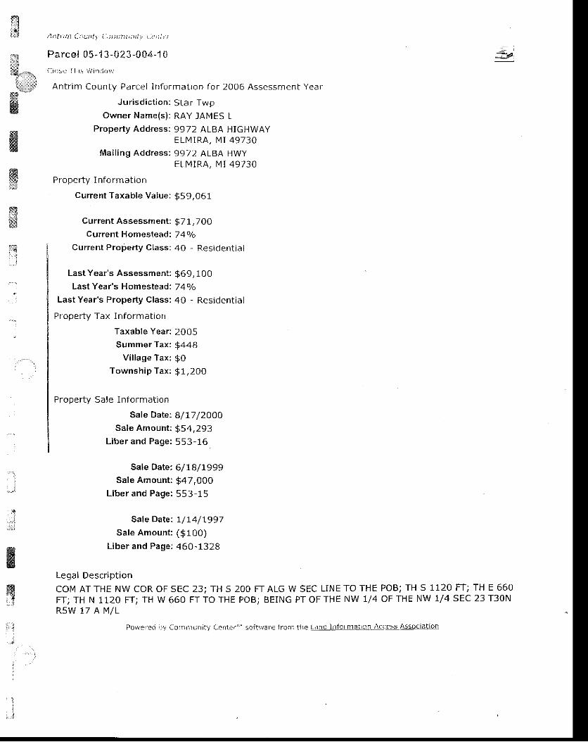
3l*1,,,*
i,,llr:ll]
*g
K
/ \ t ) t t ;n1 ( : .u t t ( , . i t i , , i r?? l , r ) r r : ] ' r? , : i " /
Parcel 05-1 3-$23-$04-1 0ai ia i , : r I I r i L. ' ' ] r : l r in ! , '
Antr im County Parcel ln formatron for 2006 Assessment Year
Jur isd ic t ion: Star TwpOwner Name(s) : RAY IAMES L
Property Address: 9972 ALBA HIGHWAYELMIRA, MI 49730
Mai l ing Address: 9972 ALBA HWyELI4IRA, N1I 49730
Property I nfo rmation
Current Taxable Value: 959,061
Current Assessment: $7 1,700Current Homestead: 7 4o/o
Current Property Class: 40 - Residential
Last Year's Assessment: $69,100Last Year's Homestead: 74 o/o
Last Year's Property Class: 40 - Residential
Property Tax Inform ation
Taxable Year : 2005Summer Tax: $448
Village Tax: g0
Township Tax: $1,20O
Property Sale Information
Sale Date: a/17 /ZOOOSale Amount : 954,293
Liber and Page: 553-16
Sale Date: 6/t8/1999Sale Amount: 947,000
Liber and Page: 553- 15
Sale Date: t/ 14/1997Sale Amount : (g 100)
L iber and Page: 460-1328
I F n . a l n F < . r i r ' t i n n
COM AT THE NW CoR oF SEC 23; TH S 200 FT ALG W SEC LINE TO THE POB; TH S 1120 FT; TH E 660FT; TH N 1120 FT; TH W 660 FT To THE PoB; BEING PT OF THE NW 1/4 OF THE NW 1/4 SEC 23 T30NRsW 17 A M/L
Polrarc( : i r aoir \nrr i r t i l l L . r rJ l . i i r ' ' ' sc i t rare f ro i r ' . f i le Lan( i r r lofmai lJr Access r issDclr l t lon
&,:3
&
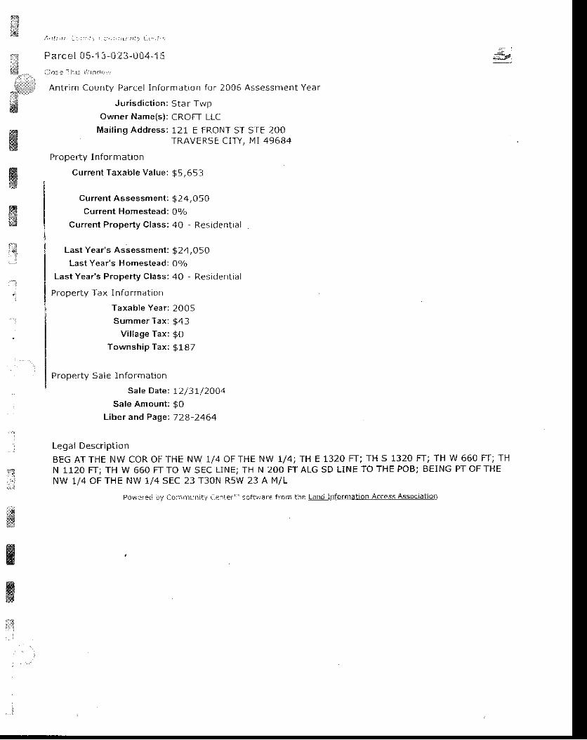
#i*
..',r,S,illlllll'w
ffiWffi
/ . ' ) L t . 1 t : . : i ! . , - , ; ; i j ; L r ' , , r , ( - t , . i . i
Parcel 0S- ' i 3- i . i23-1i04-1 :i l :n : l I l_ r ! i r , r i .1 , : ' r r r l
Antr im County Parcel In format ion for 2005 Assessment Year
Jur isd ic t ion: Star TwpOwner Name(s) : CROFT LLC
Mai l ing Address: 121 E FRONT ST STE 200TRAVERSE CITY, MI 49684
Proper ty I n format ion
Current Taxable Value: g 5,653
Current Assessment : $ 2 4,050Current Homestead: 0V(,
Current Proper ty Class: 40 - Resident ia l
Last Year's Assessment: $24,05OLast Year's H omestead: OYo
LastYear 's Proper ty Class:40 - Resident ia l
Property Tax I nfo rmation
Taxable Year ; 200 5Summer Tax: $43
Village Tax: $OTownship Tax: g 187
Proper ty Sa le In format ion
Sale Date: I2 /3 j - /2OO4Sale Amount: $O
Liber and Page'. 72a-2464
Legal Description
BEG AT THE NW COR OF THE NW 1/4 OF THE NW 1/4; TH E 1320 FT; TH S 1320 FT; TH W 660 FT; THN 1120 FT; TH W 660 FT TO W SEC LINEJ TH N 2OO FT ALG SD LINE TO THE POB; BEING PT OF THENW 1/4 OF THE NW 1/4 SEC 23 T30N R5W 23 A M/L
Pow?r eC iry Con:ilr j n iti (,{r rl er "' s of t!1ar€ f rc m tlr e te-[d-idSI!lAti9[A!ee554
tu"
'4
5.:i.l
wffiffirj
. . :
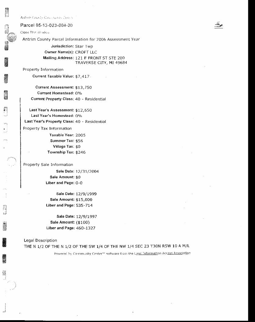
l*:""tr.
- . . t- i "
"'t:lffi
; 1 ' r i r r i ) , i i r r , ! r 1 . . , r r j , ! r , ; 1 , : 1 ' : . j
Parcel 05-1-1^0?3-0 04 -? l : r
C1o- '< . : - f l ' l : : ! : r : r _ i d . t r , r
Antr im County Parcel In format ion for 2006 Assessment Year
J ur isd ic t ion: Star TwpOwner Name(s): CROFT LLC
Mai l ing Address: 121 E FRONT ST STE 200TRAVERS E CIry , MI 49684
Proper ty I n format ion
Current Taxable Value:. $7 ,4L7
Current Assessment : $ 13,750Current Homestead: 09o
Current Property Class: 40 - Residential
Last Year's Assessment: $ 12,650Last Year's Homestead: OVo
Last Year's Property Class; 40 - Residential
Property Tax Inform ation
Taxable Year: 2005
Summer Tax : $55Vi l lage Tax : $0
Township Tax: $246
Proper ty Sa le In format ion
Sale Date: 12/3I /ZOO4Sale Amount: $0
Liber and Page: 0-0
Safe Date: I2/9/L999Sale Amount : $15,000
Liber and Page: 535-714
Saf e Date: t2/9/1997Sale Amount : (9100)
L iber and Page: 460-1327
Legal Descr ip t ion
THE N 1/2 OF THE N 1/2
:3
ffiffimffi
I'j
,$
ffiffilii
:
r',t
OF THE SW 1/4 OF THE NW 1/4 SEC 23 T3ON R5W 10 A I ' I /L
aJirmLir ' r i ty Crnter ' ' ' scfhrare f r i :? i t re L:r t r : l l l for l r l . l l :o ! l Access assoclat ]Ql
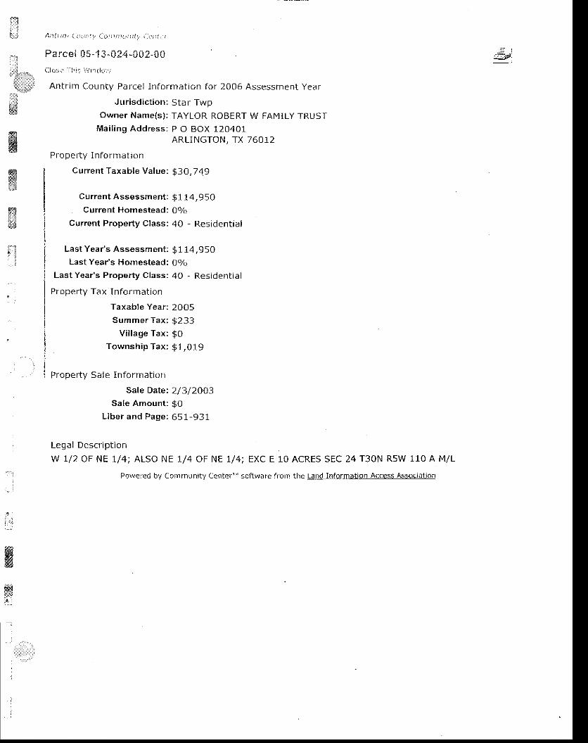
friii
ir'l
'iiiJilr'
tl::ii
ffiffiffi
Ai t i t ' , r t 1 , i : \ : j | | i , i , r i r r i r l r l j . , , . ; i . . r
Parce { 05 -1 3 -02 4 -Cg2- f r0Clai ; . - - a l : r : i r , r r r ( l rL. l
Antr im County Parcel In format ion for 2006 Assessment Year
J urisdiction: Star TwpOwner Name(s): TAYLOR ROBERT W FAMILY TRUST
Mai l ing Address: P O BOX 120401ARLINGTON, IX 76012
Proper ty I nFormat ion
C urrent Taxable Value: 93O,749
Current Assessment: $1 14,950Current Homestead: 0olc,
Current Property Class: 40 - Residential
Last Year 's Assessment ; $114,950Last Year's Homestead: 07r,
Last Year's Property Class: 40 - Residential
Property Tax I nformation
Taxat le Year: 2005Summer Tax: $233
Vi l lage Tax: $OTownship Tax: 91,019
Property Sale Information
Sale Date: 2/3/2OO3
Sale Amount: $OLiber and Page: 651-931
Legal Descr ip t ion
W 1/2 OF NE 1/4; ALSO NE 1/4 OF NE 1/4; EXC E 10 ACRES SEC 24 T30N R5W 110 A M/L
Pow,jrrci bV Cc,nrnJn,L / L.rrfcr " scftlvnrc frorn thc LlllllllllormAllll]\lless /\!5a!!alj!n
rlE:
:1i i
l,':1
:
ffifl

x l : , 1 t 1 1 . | , t , r i / , i r ; , ) r ; r 1 r j r i J . . i _ . ' - ; ' -
Pa rce! 0 5-13-024-005-00f - l r r : . , : i j : t j ._ r i r i td j ,
Antr im County Parcel In format ion for 2006 Assessment Year
Jur isd ic t ion: Star TwpOwner Name(s) : VOELKER OREITHA t ,1 LTVING TRUST
Mai l ing Address: 105 BOUGHEy STTRAVERSE CITY, MI 49684
Proper ty I n format ion
Current Taxable Value: g 10,631
current Assessment: $37,700Current Homestead : 0olo
Current Proper ty Class: 40 - Resident ia l
Wi
ww&sg
'1
i
*i
Last Year's Assessment:
Last Year's Homestead:
Last Year's Property Class:
Property Tax Information
Taxable Year:
Summer Tax:
V i l lage Tax :
Township Tax:
$42,65OOo/o
40 - Resident ia I
2005
$ 8 1$o{ ? q )
l F n : l n p < . r i n t r ^ n
NW 1/4 OF NW 1/4 EXC IHE W I /2 OF NW 1/4 OF NW 1/4 OF NW 1/4 SEC 24 T30N R5W 35 A M/L
po\!.fca l'J'; (-rrrLntL-nit? Caitter'" :oit!./arc lt':iin !he Lan.j irrf,)r ai,o) Accets_4ssOetetjgl_l
ffi&
ry
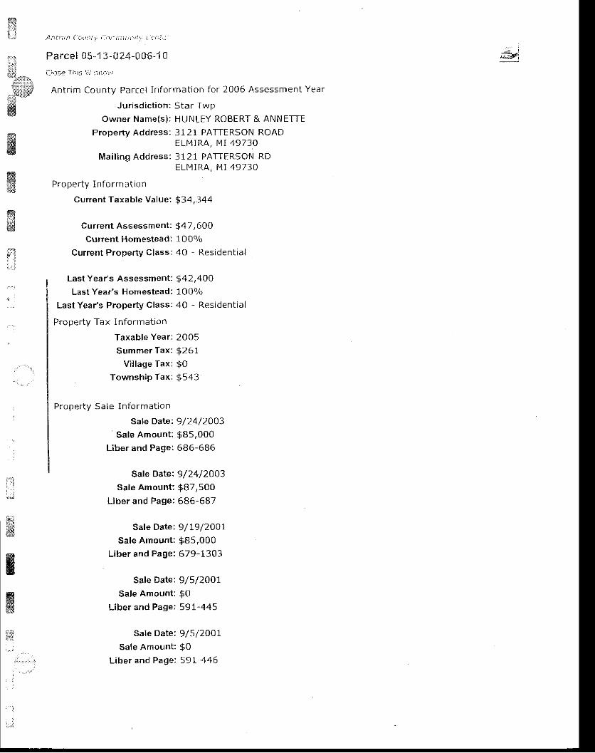
ts!
i: A! : i i ; i t \ ( a . t ta ! , i - l : ) r_ i i i ) r , i ' r l . - r - r i ; : . : j
Parcel 05-1 3-UZ4-006-1 C
Clo59 I l i ra ' , r , r r i i1 , . . ' /
Antr im County Parcel In format ion for 2006 Assessment Year
Jur isd ic t ion: Star Twpowner Name(s) : HUNLEY ROBERT & ANNETTE
Property Address: 3121 PATTERSON ROADELMIRA, MI 49730
Mai l ing Address: 3121 PATTERSON RDE L M I R A , M l 4 9 } 3 0
Proper ty I n form at ion
Current Taxable Value: $34,344
current Assessment : $47, 600Current Homestead: 1 00o/o
Current Property Class: 4O - Residential
;;yl
ffiffi**
ffi
t;;
#@rffi
iI
a'rl
Last Year's Assessment:
Last Year's Homestead:
Last Year's Property Class:
Pfoperty Tax l nformation
Taxable Year:
Summer Tax :
V i l lage Tax :
TownshiP Tax:
Proper ty Sa le In fo rmat ion
Sale Date:
Sale Amount:
Liber and Page:
$42,4OO10 0olo4O Resident ia l
2005
9267$o$s43
9/24/2OO3$8s,000686-686
Safe Date: 9/24/2003sale Amount; $87,500
Liber and Page: 686-687
Safe Date: 9/L9/2OO1Sale Amount : $85,000
Liber and Page: 679-1303
Safe Date: 9/5/2OO7Sale Amount: $0
Liber and Page; 591-445
sale Date: 9/5/2Oo1,sale Amount: $o
Liber and Page:. 59L-446
ffiffie;d
H
ffiffig#
n
Sale Date: 6/9/ZOOOSate Amount : $ 10 ,900
L iber and Page: 548-156
Sale Date : I /L / 1999
Sale Amount: $0Liber and page:. 52t-892
Sate Date: 6/23/1999
Sale Amount : 95 ,700L i b e r a n d p a g e r 4 9 8 1 3 5 5
Lega l Descr ip t ion
THE W 1/2 oF THE NW 1/4 oF THE NW 1/4 OFTHE NW 1/4 ; EXC THE N 250 FT OF THE w 174.24oF THE W 1/2 OF NW 1/4 OF NW 7/4 OF THE NW 1/4 SEC 24 T30N R5W 4 A M/L
f i i . ,a, :a - - : ! i - l . : r r i r ' !L r : i ty / : : - " : r tef ' " s . ) i ivr i e l ror . ! i re !3! ! lado4n?j ie t i \ r r :Ei . ; As: , ' r . r , : l i { r f '
$w
ffiwiil
:

f$ L . t - t . t : a . ' t t t ' i . I . t : , : , , r . , , ; , i : ( . a , ' 1 :
Parce l C5- ' i 3 -0?4-000-1 5L- lo rp I i : i : i ; : rL r i . r : .
Antr im County Parcel ln format ion for 2006 Assessment Year
Jur isd ic t ion: Star TwpOwner Name(s) ; MILBOCKER
Property Address: 11030 ALBAELMIRA, MI
Mai l ing Address: 11030 ALBAE L M I R A , M I
Proper ty I n format ion
Current Taxable Val!.le: i25,297
Curren t Assessment : $53,050
Current Homestead: 1007o
Current Property Class: 40 Residential
ffi
itGr*lr,
, . ,FF
*g
ffi:
il
TERRANCE AA [4ATHEY CARRIEH IG HWAY
49730HWY
49730
Last Year's Assessment:
Last Year's Homestead:
Last Year's Property Class:
Proper ty Tax In fo rmat ion
Taxable Year:
Summer Tax:
V i l lage Tax :
Township Tax:
$ 5 O , 6 s 010 0 o/o
40 - Resident ia l
2 0 0 5
$ 1 9 2
$o$400
ffi. : J
.1,;'
- - i - ' t l
Legal Descr ip t ion
THE N 250 FT OF THE W r74.24 FT OF THE W r /2 OF THE NW 1/4 OF NW 1/4 OF NW 1/4 SEC 24T3ON R5W
j rd \ ra ' r . ' ( i ! r \ r La l : r : f l r i .n r l , / l - ' n ( . r '_ , r i r t r !d I i I r5 : , , 1 .1" l nJ in to r i l l " rL :CI r ACCCsS / i ssOc la t l , J I l
ffi
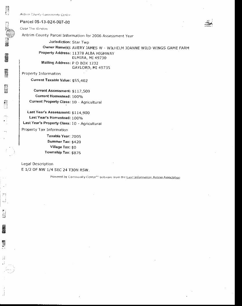
dPt
nt , :
:'&lu-?irillifi3 -:i:tw
ffiffi
si: r ' l
*
A t l I j , : ' : ( t \ | : t I t . i , o i i t : t ) i ! r i t L y t : ! i ; i t . i
Pa rc e l C5 -13 -024-007 .00
i - i ( r3e l l rs i " l ; : lc i , i r . r
Antrm County Parcel In format ion For 2006 Assessment year
Jurisdiction: Star TwpOWNET NAME(S): AVERY ]AMES W . WILHELI4 ]OANNE WILD WINGS GAME FARN4
Property Address: 11378 ALBA HIGHWAyELMIRA, NII 49730
Mai l ing Address: p O BOX 1232GAYLORD, MT 49735
Proper ty I n format jon
Current Taxable Value; $55,402
Current Assessment:
Current Homestead:
Cuffent Property Class:
Last Year's Assessment:
Last Year's Homestead:
Last Year's Property Class:
Property Tax I nformation
Taxable Year:
Summer Tax :
Vil lage Tax:
Township Tax:
Legal Descr ip t ionE L/2 OF NW 1/4 sEC
$117 ,s0010 0olo1O - A9 r icu l tu ra l
$ 1 1 4 , 9 0 0100 o/o
10 - Agr icu l tura l
2 0 0 5
5420$o$ 8 7 6
24 T3ON RsW,
i ry i -o:n rLrr i ly [ :cnfar ' ' " 5c i t r . / i i t fc l rJ | l ] l i te L,a ar int 'or f iat io l t A(aess Associat ior i
,lffiw: i
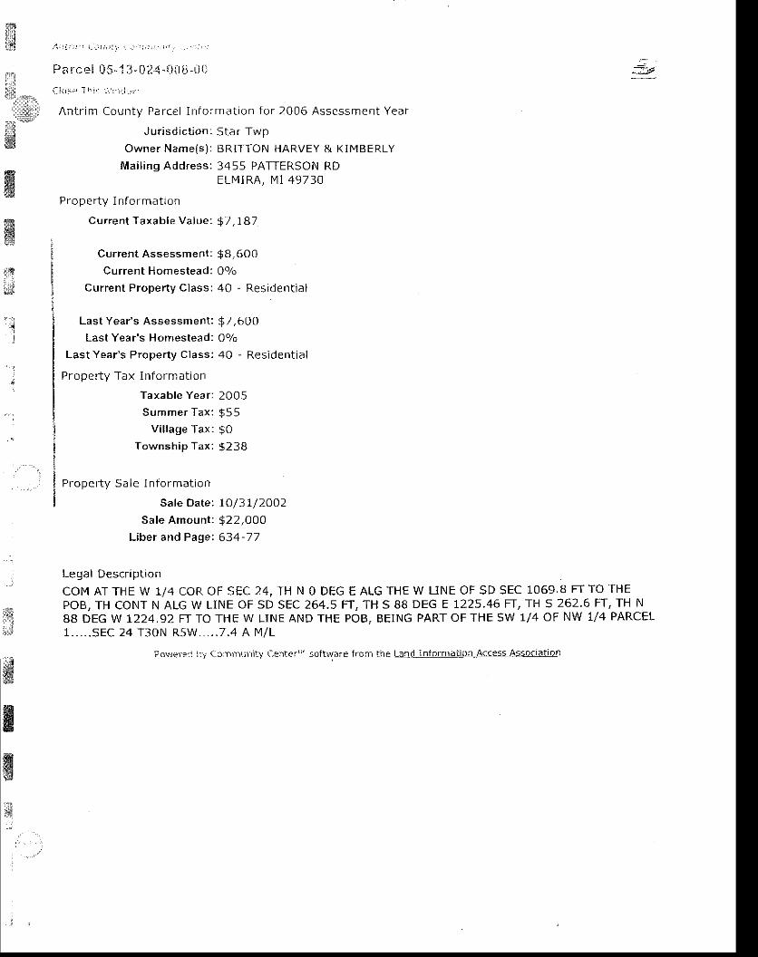
$ - 2 1 . i i i , r ' ! i _ . l r r r i t
Parcel 05-1 : j -024 - \ \ t ' - i i t )
i : l ( , | . 1 [ r ' : i ' : - ] r i L j ,
Antr im County Parcel In format ion for 2006 Assessmef l t Year
Jur isd ic t ion: Star TwpOwner Name(s) : BRITTON HARVEY & KIMBERLY
Mai l ing Address: 3455 PATTERSON RDELI4IRA, N4] 49730
Proper ty I n fo rmatron
Current Taxable Value: $7 ,787
Current Assessment: $8, 600Current Homestead: 0o/o
Current Property Class: 40 - Residential
Last Year 's Assessment : $7,600Last Year's Homestead: Oolo
Last Year's Property Class: 40 - Residential
Propef ty Tax Informat ion
Taxable Year : 2005Summer Tax: $55
Vi l lage Tax: $0Township Tax: $2 38
Proper ty Sa le I n fo rmat ion
Sale Date: 7O/31/2OO2Sale Amount : $22,000
Liber and Pagei 634-77
Legal Descr ip t ron
COM AT THE W 1/4 COR OF SEC 24, TH N O DEG E AtG THE W LINE OF SD SEC 1069.8 FT TO THEPOB, TH CONT N ALG W L1NE OF SD SEC 264.5 FT, TH 5 88 DEG E 1225.46 FT, TH 5 262.6 FT, TH N88 DEG W 1224.92 FT TO THE W LINE AND THE POB, BEING PART OF THE SW 1/4 OF NW 1/4 PARCEL1 . . . . . S E C 2 4 T 3 0 N R 5 W . . . . . 7 . 4 A F 1 / L
-_r
$xffiffit9#
. :
'1
lli
t'lsl,.l
#&ffi
Povrer?a ir'r (.c:r:r'l]\jlril) C-eilter"'soltware frofi lhe Lal.d- !!igllli:ij!!-Ae(e$qA599{l?tDll
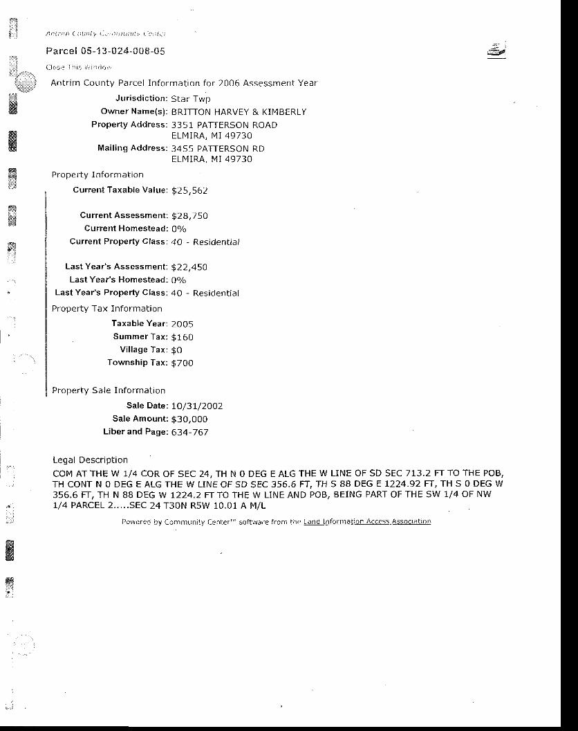
i$- t . i
j \ r a : i t ] ) i : 1 ! t l t t , i I . . . ' , r ! ; , r ; ; r / i r r - . : ' : ; i , r
Parcel 05-1 3-024-0t8-05'ii:
, , . , ! ( l l . ! . . r i i i i : , i ; , , : , r t i . r f :.!:jiil:ll!.
Antr im County Parcel ln format ion for 2006 Assessment Year
$i& Owner Name(s) : BRiTTON HARVEY & KIN4BERLY
Property Address: 3351 PATTERSON ROAD
=d
q
ffi!&x4!!11;*.:$$
&ffi
ELMIRA, IVI I 49730Mai l ing Address: 34S5 PATTERSON RD
ELN4IRA, MI 49730
Pr oper ty I n format ion
current Taxable Value: $25,562
Current Assessment : $2Bi 750Current Homestead: 0o/o
Current Property Class; 40 - Residential
Last Year's Assessment; $22,45OLast Year's Homestead: 0ola
Last Year's Property Class: 40 - Residential
Property Tax Information
Taxable year ; 2005
. Summer Tax: $160Vi l lage Tax: g0
Township Tax: g7O0
Proper ty S a le I n format ion
Sate Date: lO/37/2OOzSale Amount: $30,000
Liber and Page: 634-767
Legal Descr ip t ion
COM ATTHE W 1/4 COR OF SEC 24, TH N O DEG E ALG THE W LINE OF SD SEC 713.2 FTTO THE POB,TH CONT N O DEG E ALG THE W LINE OF SD sEC 356,6 FT, TH S 88 DEG E L224.92 FI, TH S O DEG W356.6 FT. TH N 88 DEG W 1224,2 FT TO THE W LINE AND POB. BEING PART OF THE SW 1/4 OF NW1/4 PARCEL 2. . . . .SEC 24 T30N R5W 10.01 A M/L
Fo*eren D\, Con'lntunil-y (l..ter"'scft!,r',lre frcnr Inc Lg!!,idS||]lailD 4e

ffi A, | | j i ! | a : i : j1 i r l : : ) t i ) i j ) i t r . , | [ r t ,a | | ! t ' : t
Parcel 05-1 3-02+-Oua-t cf l l o < . l l : r ; ! r r r r ! i , i r r
Antr im County Parcel In format ion for 2006 Assessment Year
Jur isd ic t ion; Star Twp
Owner Name{s): HUFFN4AN TERRY L - WOOLLEY LISA
Property Address: 3393 PATTERSON ROADELMIRA, MI 49730
Mai l ing Address:4001 W SILVERSPRING BLVDOCALA, FL 34482
Pro pe f ty I n format ion
current Taxable Valve: $1O,77 6
current Assessmeni : $ 19,100Current Homestead: 10oVo
Current Property Class: 40 - Residential
Last Year's Assessment: $ 17,900Last Year's Homestead: 1O0o/o
Last Year's Property Class: 40 - Residential
Proper ty Tax Informat ion
Taxable Year: 2OO5Summer Tax: $82
Village Tax: $OTownship Tax: $170
Proper ty Sale In format ion
Sale Date: 2/23/2OOI
Sale Amount: $ 174Liber and Page: 568-803
Sale Date: I/29l2OOlSale Amount: $O
Liber and Pagei 564-733
Legal Descr ip t ion
P A R C E L 3 c o M A T T H E W I / 4 c o R o F S E c 2 4 , T H N 0 D E G E A L G W L I N E o F S E c 3 5 6 ' 6 F T T o T H EPOB. TH CONT N O DEG E 356.6 FT, TH 5 88 DEG E 1224.? FT, TH S O DEG W 355,6 FT, TH N 88 DEG
W 1223.5 FT TO THE W LINE OF SEC AND THE POB, SEC 24 T3ON R5W 10.01 A M/L
l>owerec oy Cir . r i f i lLrr r i ty Cei) ter ' ' i sc i tware f i_oin the Lani I r r forrnat io i r Access Associa l ion
=:r,i.Xli$,,1r1,
'li|i&'s&
€*tr
wffim
ffi
x*
r"l. j
!
*
wwmlt,l..:
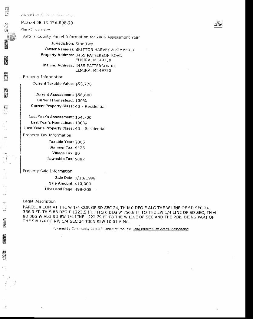
#1;j,,,.,,
;
ffi*ffiF&fig
ffi#$
it
, \ ; : ! : i . ; 1 | . ' ; ' t i . . I . j i i j , ; , r r r ; l r _ L i , . r t f r
Pa lce i 05 -1 3 -11?4-008-20i l lo : : , r r I i t , : \ , . r ' r i r r
Antr im County Parcel In format ion for 2006 Assessment year
J ur isd ic t ion: Sta r TwpOwner Name(s) : BRITTON HARVEY & KI [ lBERLy
Property Address: 3455 PATTERSON ROADELMIRA, [4 I 49730
Mai t ing Address: 3455 PATTERSON RDELMIRA, MI 49730
Proper ty In format jon
Current Taxable Value: g5 5,7 76
Current Assessment : $5 g,6OO
Current Homestead: 100o/oCurrent Property Class: 40 , Residential
Last Year's Assessment: $54,700Last Year's Homestead: 1O0o/o
Last Year's Property Class: 40 - Residential
Property Tax Information
Taxable Year: 200 5Summer Tax: $423
Vi l lage Tax: $0Township Tax: gBB2
Proper ty Sa le I n fo rmat ion
Sate Date: 9/IB/ I99BSale Amount : $1O,000
Liber and page: 499_205
Lega I DescriptionPARCEL 4 COM AT THE W 1/4 COR OF SD SEC 24, TH N O DEG E ALG THE W LINE OF SD SEC 24356.6 FT, TH S 88 DEG E 1223.5 FT, TH S O DEG W 356.6 FT TO THE EW 1/4 LINE OF SD SEC, TH N88 DEG W ALG SD EW 1/4 LINE 1222.79 FT TQ THE W LiNE OF SEC AND THE POB, BEING PART OFTHE SW 1/4 OF NW 1/4 SEC 24 T30N RsW 10.01 A Mi L
=di
#ffi
ffie&;!
l )or i '3rcc Ny Coinnruni t_v LciLerr ' " sc i tvJafc f ron' lhe t i tq! Inf . r f l rJ i ror Access Associat iO!
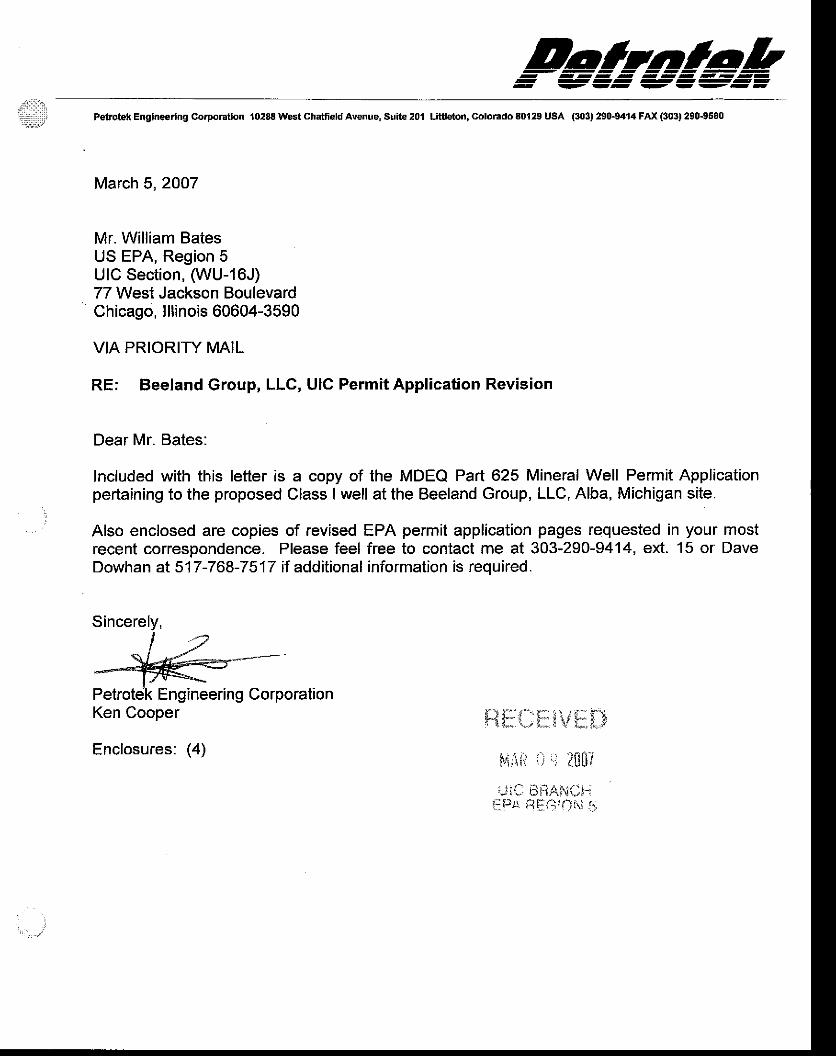
Daltnlobi:ir,iit,1;:;t Petrotek Englneerlng Corporatlon 10288 West Chatfield Avenue, Suite 201 Litfeton, Colorado 80129 USA (303) 250-9414 FAX (303) 290-9580
March 5, 2007
Mr. William BatesUS EPA, Region 5UIC Section, (WU-16J)77 West Jackson BoulevardChicago, lllinois 60604-3590
VIA PRIORIry MAIL
RE; Beeland Group, LLC, UIC Permit Application Revision
Dear Mr. Bates:
Included with this letter is a copy of the MDEQ Part 625 Mineral Well Permit Applicationpertaining to the proposed Class I well at the Beeland Group, LLC, Alba, Michigan site.
Also enclosed are copies of revised EPA permit application pages requested in your mostrecent correspondence. Please feel free to contact me at 303-290-9414, ext. 15 or DaveDowhan at517-768-7517 if additional information is required.
Ken Cooper
Enclosures: (4)
il$:**i\l*f..i
t4ti! il .r ;n[?
""riC rii:iAi',;ilh
iPa tirfi:.JN !:
Sincerely,
Petrotek Engineering Corporation
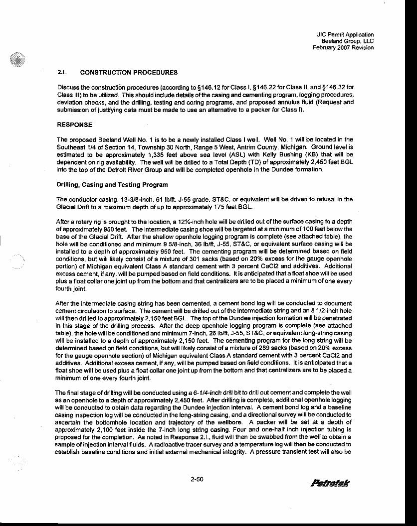
il,.,.::xil
UIC Permit ApplicationBeeland croup, LLC
February 2007 Revision
2.L CONSTRUCTIONPROCEDURES
Discuss the construclion procedures (according to 9146.12 for Class l, $146.22 for Class ll, and S146.32 forClass lll) to be utilized. This should include details ofthe casing and cementing program, logging procedures,deviation checks, and the drilling, lesting and coring programs, and proposed annulus fluid (Request andsubmission ofjusti[ring data must be made to use an alternative to a packer for Class l).
RESPONSE
The proposed Beeland Well No. 'l is to be a newly installed Class I well. Well No. 1 will be located in theSoutheast 1/4 of Sec{ion 14, Township 30 North, Range 5 West, Antrim County, Michigan. Ground level isestimated to be approximately 1,335 feet above aea level (AsL) with Kelly Bushing (KB) that will bedependent on rig availability. The well will be drilled to a Tolal Depth (TD) of approximately 2,450 feet BGLinto the top of the Detroil River Group and will be compleied openhole in the Dundee formation.
Drillingr Casing and Testing Program
The conductor casing, 13-3l8-inch, 61 lb/ft, J-55 grade, ST&C, or equivalent will be driven to refusal in theGlacial Ddfr to a maximum depth of up to approximately '175 feet BGL.
Afler a rotary rig is brought to the localion, a 12y.-inch hole will be drilled out ofthe surface casing to a depthof approximately 950 feet. The intermediate casing shoe will be targeted at a minimum of 100 feet below thebase ofthe Glacial Drift. Afrerthe shallow openhole logging program is comple€ (see attiached table), thehole wlll be conditioned and minimum I 5i6-inch, 36 lb/ft, J-55, ST&C, or equivalent suriace casing will beinstalled to a depth of approximately 950 feet. The cemenling program will be delermined based on fieldconditions, but will likely consist of a mixture of 301 sacks (based on 20% excess for the gauge openholeportion) ot Michigan equivalent Class A standard cement with 3 percent CaCl2 and additives. Additionalexcess cement, ifany, willbe pumped based on field conditions. lt is anticipated ihat a float shoe will be usedplus a float collaroneioint up from the boftom and that centralizers are to be placed a minimum of one everyfourth joint.
Afterthe intermediate casing string has been c€mented, a cement bond log will be conducted to documentcement circulation to suriace. The cementwillbe drilled out ofthe intermediate string and an 81/2-inch holewillthen drilled to approximately 2,150 feet BGL. Thetopof theDundee inieclion formation will be penetratedin this stage of the drilling process. After the deep openhole logging program is complete (see attachedtable), the hole will be conditioned and minimum 7-inch, 26 lb/fr, J-55, ST&C, or equivalent long-string casingwill be installed to a depth of approximately 2,150 feet. The cemenling program for the long string will bedetermined based on field conditions, butwill likely consist ofa mixture of2E9 sacks (based on 20% excessfor the gauge openhole section) of Michigan equivalent Class A standard cement with 3 percent CaCl2 andadditives. Additional excess cement, if any, will be pumped based on field conditions. lt is anticipated that afloat shoe will be used plus a ioat collaroneioint up from the bottom and that cenlralizers are to be placed aminimum of one every fourth ioint.
The final stage of ddlling will be conducted using a 6- 1/4-inch drill bit to drillout cement and complete thewellas an openhole to a depth of approximately 2,450 feet. Afrer drilling is complete, additional openhole loggingwill be conducted to obtain data regarding the Dundee injection interval. A cement bond log and a baselinecasing inspection log will be conducted in the long-string casing, and a directional survey will be conducted toascertain the bottomhole location and trajectory of the wellbore. A packer will be set at a depth ofapproximately 2,100 feet inside the 7-inch long string casing, Four and one-half inch injection tubing isproposed for the completion. As noted in Response 2.1., fluid will lhen be swabbed from the wellto obtain asample of injection interval fluids. A radioac,tive tracer survey and a temperature log will then be conducted toestablish baseline conditions and initial extemal mechanical integrity. A pressure transient test willalso be
2-50 k#a!*
UIC Permit ApplicatjonBeeland Group, LLC
February 2007 Revision
conducted to derive estimates of formation pressure and properties (See Response 2.1). A proposedschematic for lhe Bseland Well is presented in Figure M-1.
TABLE L-I LIST OF PROPOSED LOGSBEELAND GROUP, LLC WELL NO. I
Nature of Annulus Fluid
In the proposed Beeland well, lhe annulus space beiween the injection tubing and the well protection casingwill be sealed and filled with fresh watercontaining a corrosion inhibitor, an oxygen scavenger and a biocide.Annulus fluids will include Baker Peirolile CRW0037F or Unichem Technihib 366W conosion inhibitors andbactericides, CRW 132 oxygen scavenger 4-303 corro€ion inhibitor, Knockout 50 oxygen scavenger, andBacban 3 Biocides or suitable equivalents. No permit condilions regarding specific brands or fluid additivesare requested at this time.
Description Oepth Run
Dual Lalerolog Gamma Ray, Fonnaiion Density, and Caliper Logs (openholeb€fors intermediale casing)
'100-950'
C€ment Bond Log (intemediate casing) surf-950'
Dual Laterolog, SP, Gamma Ray, Formation Density, Compensated Neuiron, andCaliper Log (openhole before long slring casing and in openhole completion)
95&. TD(2,4s0)
lf required, Fracture Finder lD Log (openhole before long-string casing) 1,950-2,150',
Cement Bond Log, Casing Inspection Log and Directional Survey (long-stringcasing)
surf-2,150'
Temperature Log surf-TD (2,450')
Radioactive Tracer Log long string casing
Pressure,/Temoerature Gradient and Pressure Transienl Falloff test 2,150'
Pegst*
r-)l l
(t( B )
(t(9
CEI\,IEMI, VOLUMES, FLUIDS and HOLE SIZE
TUBUTARS and COMPONENTS
12 'tl4" Hole, Cemented to Surface with 301 sacks! Class A (Ml equiv.)
I 1/2" Hole, Cemented to Surface wilh 289 sacks" Class A (Ml equiv.)
Annulus Fluid: Fre6h waterwlth Inhibitor and scavenger
Completion: 6 1/4" Oper Hole, tolal deilh @ +l-2,150'
EEtilET-:-L 9 l
Surfac€ Caslngr 13 3/8". 61#,/fl ., Driven to tefiJsal a5 d66p as 175'
Intermediate Casing: g 5/8", 36 lb/ft., K-55 or .!55, Set @ approximately 950'
Long String Casing: 7", 26 lb/ft-, J-55 or K-55, Set @ approximatsly 2,150
lnjection Tubing: 4 1n", 11 .#|fr., J-55
Packer. 7' x 4 112" Large Bore, Set @ approximately 2,100'
*Cement volumes based on 20% excess tor gauge diameter openhole
Besland Group, LLc.Alba, Michigan Facility
WELL SCHEMATIGDISPOSAL WELL NO. 1
(--__/) CEMENT, VOLUMES, FLUIDS and HoLE slzE
I I TUBULARS and COMPONENTS
@ e'tn" aot , Cemerted to Surface with 3ol 6acks'
@ a ln' noru, C"mented to Surface with 289 sacks'
CC) zsl sacks cement,2,1oo'to surface
@ z s"".1" c"r"nt,2,150'- 2,100'
@ +a S".t r C"rent, 2,,150' - 2,150'+/- 850' Lowermosi USDWBase of Drift
Lfl Surface CasinS: 13 V8", Driven to retusal
El Intermediale Casing: I5/8",36lbfi., K-55 orJ€5, Set @ 950'
E Lons Stdns casingr 7", 26 lbft., J-55 or K-55, set @ 2,'150'
E ft,lechanical PIug: Set @ 2,100'on top of cement retainor or origlnat packer
:Annulus cement volumes based on 20% ex@s6 forgauge diameler openhole
Beeland Group, LLC.Alba, Mict gan Faclllty
WELL SGHEMATICDISPOSAL WELL NO. 1
SCALE: NONE DATE; Rev 2/07
Related Documents