International Civil Aviation Organization SAM/IG/21-WP/22 South American Regional Office 17/05/18 Twenty First Meeting/Workshop of the SAM Implementation Group (SAM/IG/21) – RLA/06/901 Regional Project (Lima, Peru, 21 to 25 May 2018) Agenda Item 4: Assessment of operational requirements to determine the implementation of improvements in communications, navigation and surveillance (CNS) capabilities for operations in route and terminal area CNS CAPABILITIES SURVEY OF AIRCRAFT OPERATING IN AMERICAS AND NORTH ATLANTIC (Presented by IATA) SUMMARY This working paper presents the survey on CNS Capacity of Aircraft flying in the Americas and North Atlantic and preliminary results of the percentage of aircraft capable for some CNS technologies in South America. The WP aims to discuss a strategy of how the survey could support the implementation of some CNS technologies in the SAM Region. References: -Global Air Navigation Plan (Doc. 9750) ICAO Strategic Objectives: A – Safety B – Air Navigation Efficiency and Capacity 1. Introduction 1.1 There are many technological “solutions” for air traffic services. However, unless they conform to global standards and are justified by mutually agreed cost-effective benefits and implementation plans, such technologies are of limited value to international commercial aviation. 1.2 For technologies that are being introduced, it is essential that each implementation undergo a thorough process demonstrating that it supports an agreed-upon operational concept in a cost-effective manner. Recognizing international airlines’ significant contributions to air navigation service providers (ANSPs) and airports through user charges in addition to the airline investments in on-board capabilities, operational and efficiency improvements are therefore expected from on-going and future investments on CNS technologies. This requires appropriate investment decisions and implementation strategies through collaborations among all aviation stakeholders. 1.3 One of the aspects that should be considered to implement some CNS technology is the present capacity of the aircraft fleet in the airspace in which it is intended to use it. In this regard, IATA has prepared a survey on this navigation capability that is presented below.

Welcome message from author
This document is posted to help you gain knowledge. Please leave a comment to let me know what you think about it! Share it to your friends and learn new things together.
Transcript
International Civil Aviation Organization SAM/IG/21-WP/22 South American Regional Office 17/05/18Twenty First Meeting/Workshop of the SAM Implementation Group (SAM/IG/21) – RLA/06/901 Regional Project (Lima, Peru, 21 to 25 May 2018)
Agenda Item 4: Assessment of operational requirements to determine the implementation of
improvements in communications, navigation and surveillance (CNS) capabilities for operations in route and terminal area
CNS CAPABILITIES SURVEY OF AIRCRAFT OPERATING IN AMERICAS AND NORTH ATLANTIC
(Presented by IATA)
SUMMARY
This working paper presents the survey on CNS Capacity of Aircraft flying in the Americas and North Atlantic and preliminary results of the percentage of aircraft capable for some CNS technologies in South America. The WP aims to discuss a strategy of how the survey could support the implementation of some CNS technologies in the SAM Region.
References:
-Global Air Navigation Plan (Doc. 9750)
ICAO Strategic Objectives: A – Safety B – Air Navigation Efficiency and Capacity
1. Introduction
1.1 There are many technological “solutions” for air traffic services. However, unless they conform to global standards and are justified by mutually agreed cost-effective benefits and implementation plans, such technologies are of limited value to international commercial aviation. 1.2 For technologies that are being introduced, it is essential that each implementation undergo a thorough process demonstrating that it supports an agreed-upon operational concept in a cost-effective manner. Recognizing international airlines’ significant contributions to air navigation service providers (ANSPs) and airports through user charges in addition to the airline investments in on-board capabilities, operational and efficiency improvements are therefore expected from on-going and future investments on CNS technologies. This requires appropriate investment decisions and implementation strategies through collaborations among all aviation stakeholders.
1.3 One of the aspects that should be considered to implement some CNS technology is the present capacity of the aircraft fleet in the airspace in which it is intended to use it. In this regard, IATA has prepared a survey on this navigation capability that is presented below.
SAM/IG/21-WP/22 - 2 -
2. Discussion 2.1 IATA has developed the 3rd edition of the document "User Requirements for Air Traffic Services (URATS) - Communications, Navigation and Surveillance (CNS) Technologies (July 2017), with the objective of complementing the Global Air Navigation Plan and providing guidance to aviation stakeholders based on the perspective of international airlines. This document is attached as appendix A to this working paper. URATS is a living document, which is constantly evolving, and comments from the States, ANSPs, ICAO and other aviation stakeholders are welcome. 2.2 As a complement to URATS and taking into account the importance of knowing the capacity of the fleet to support the cost-benefit analysis that must be carried out prior to the implementations, IATA has initiated a survey to verify this capacity. 2.3 The form of the aforementioned survey is attached as Appendix B to this working paper (English only), with a view to demonstrating the capabilities of the fleet investigated. 2.4 To date, 25 airlines have provided information to the survey, totaling 3,272 aircraft in the database. The airlines are the following:
a) AEROMEXICO b) AEROMEXICO CONNECT c) AIR CANADA d) AIR CANADA ROUGE e) AIR EUROPA f) AVIANCA BRAZIL g) AZUL h) CONDOR i) COPA AIRLINES j) DELTA k) ETIHAD l) FEDEX m) GOL n) IBERIA o) JETBLUE p) KLM q) LATAM r) LIAT s) QATAR AIRWAYS t) ROYAL JORDANIAN u) SAS v) SWISS w) SWISS GLOBAL x) UNITED AIRLINES y) UPS
2.5 The main CNS technologies considered in the survey were the following: 2.5.1 Communications
a) AeroMAX / WiMAX - or any form of gate link communications b) 8.33kHz VHF Transceivers
- 3 - SAM/IG/21-WP/22
c) HF Transceivers d) High Frequency Data Link (HFDL) e) ACARS f) CPDLC based on ATN/VDL Mode 2 g) CPDLC based on FANS 1/A or newer FANS standard h) Cockpit SatCom voice based on INMARSAT i) Cockpit SatCom data based on INMARSAT j) Cockpit SatCom voice based on IRIDIUM k) Cockpit SatCom data based on IRIDIUM l) Emergency Locator Transmitter(s) – ELTs
2.5.2 Navigation
a) Multi Mode Receivers - MMRs b) System (SBAS)/WAAS, EGNOS etc. c) GNSS Receivers:
TSO-C129a TSO-C145c TSO-C146c TSO-C196
o RAIM o AAIM o FDE
d) RNAV 10 (RNP 10) e) RNAV 5 / B-RNAV f) RNAV 2 g) RNAV 1 h) RNP 4 i) RNP 2 j) RNP 1 / P-RNAV k) RNP 0.3 l) RNP <0.3 m) RNP APCH n) Advanced RNP o) APV Baro VNAV p) LPV SBAS q) INS / IRU r) FMS RTA s) FMS RF t) FMS FRT
2.5.3 Surveillance
a) Mode S b) Mode S - ELS c) Mode S - EHS d) ADS-B OUT based on DO-260 e) ADS-B OUT based on DO-260A f) ADS-B OUT based on DO-260B or later g) ADS-B IN displayed on a cockpit integrated EFB
SAM/IG/21-WP/22 - 4 -
h) ADS-B IN displayed on cockpit Primary Flight Display(s) i) ADS-B IN displayed on a cockpit stand alone device, e.g. iPad j) ADS-C k) FMS WPR
2.6 Preliminary information on the capacity of the fleet for ADS-B, ADS-C and CPDLC by FIR is attached as Appendix C to this working paper. These information should be considered under the following limitations:
a) The database does not contain all the aircraft operating in the airspace considered, but only the aircraft of the airlines that have provided data to date.
b) ADS-B data considers aircraft equipped with all types of ADS-B technology, including those based on DO260, 260A and 260B
2.7 The survey could be supplemented by information from the General, Executive and Military Aviation, if the States and/or SAM Regional Office request that these aircraft operators also fill out the corresponding form. The interested States and/or SAM Regional Office could coordinate with these users the completion of the survey through the following link: https://docs.google.com/forms/d/e/1FAIpQLSdqIUDhD8rfufXrDpIv_5T8wt-ryGmW798HhCTIxTUZ-Y9AWA/viewform . 2.8 IATA could provide the information for the SAM Regional Office and/or for each State interested in receiving the results of the survey for each FIR or for the SAM Region. 3. Suggested actions
The meeting is invited to:
a) Take note of the information contained in this working paper;
b) request SAM States and ANSPs, SAM Regional Office and other Aviation
Stakeholders to provide the comments considered relevant to the URATS document;
c) develop a strategy to use the CNS capacity survey of the aircraft operating in the SAM Region and in each specific SAM FIR, with a view to supporting the corresponding implementation programs, and
d) Evaluate the feasibility of establishing a strategy for operators of general, executive and military aviation to provide data on the capacity of their fleets.
User Requirements for Air Traffic Services
(URATS)
Communications, Navigation, and Surveillance (CNS) Technologies
Edition 3.0 - JULY 2017
APENDICE A / APPENDIX A SAM/IG/21-NE/22-WP/22

URATS Edition 3.0 July 2017 © IATA (2017) 2
DISCLAIMER
The information contained in this document is subject to constant review and up-date in the light of changing government requirements and regulations. Users of this publication should not act on the basis of any such information without referring to applicable laws and regulations and/or without taking appropriate professional advice. Although every effort has been made to ensure accuracy, the International Air Transport Association shall not be held responsible for loss or damage caused by errors, omissions, misprints or misinterpretation of the contents hereof.
© International Air Transport Association. All Rights Reserved. This publication, in whole or in part, may solely be used for internal study and application purposes, and for no other purpose. In any event, no part of this publication may in any way be incorporated, distributed or otherwise used for any purpose that is commercial in character, whether or not for profit. No part of this publication may be reproduced, recast, reformatted or transmitted in any form by any means, electronic or mechanical, including photocopying, recording or any information storage and retrieval system, without prior written permission from: Senior Vice President Safety & Flight Operations International Air Transport Association 800 Place Victoria P.O. Box 113 Montreal, Quebec CANADA H4Z 1M1
APENDICE A / APPENDIX A SAM/IG/21-NE/22-WP/22

URATS Edition 3.0 July 2017 © IATA (2017) 3
DOCUMENT CONTROL
Edition Number Date of Issue
2.0 January 2010
3.0 July 2017
APENDICE A / APPENDIX A SAM/IG/21-NE/22-WP/22
URATS Edition 3.0 July 2017 © IATA (2017) 4
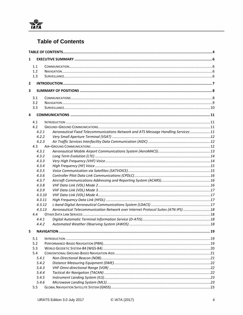
Table of Contents
TABLE OF CONTENTS .............................................................................................................................................. 4
1 EXECUTIVE SUMMARY ................................................................................................................................... 6
1.1 COMMUNICATION............................................................................................................................................... 6 1.2 NAVIGATION ...................................................................................................................................................... 6 1.3 SURVEILLANCE .................................................................................................................................................... 6
2 INTRODUCTION .............................................................................................................................................. 7
3 SUMMARY OF POSITIONS .............................................................................................................................. 8
3.1 COMMUNICATIONS ............................................................................................................................................. 8 3.2 NAVIGATION ...................................................................................................................................................... 9 3.3 SURVEILLANCE .................................................................................................................................................. 10
4 COMMUNICATIONS ..................................................................................................................................... 11
4.1 INTRODUCTION ................................................................................................................................................ 11 4.2 GROUND–GROUND COMMUNICATIONS ................................................................................................................ 11
4.2.1 Aeronautical Fixed Telecommunications Network and ATS Message Handling Services .................... 11 4.2.2 Very Small Aperture Terminal (VSAT) .................................................................................................. 12 4.2.3 Air Traffic Services Interfacility Data Communication (AIDC) .............................................................. 12
4.3 AIR–GROUND COMMUNICATIONS ....................................................................................................................... 12 4.3.1 Aeronautical Mobile Airport Communications System (AeroMACS) .................................................... 13 4.3.2 Long Term Evolution (LTE) ................................................................................................................... 14 4.3.3 Very High Frequency (VHF) Voice ......................................................................................................... 14 4.3.4 High Frequency (HF) Voice ................................................................................................................... 15 4.3.5 Voice Communication via Satellites (SATVOICE) .................................................................................. 15 4.3.6 Controller Pilot Data Link Communications (CPDLC) ............................................................................ 16 4.3.7 Aircraft Communications Addressing and Reporting System (ACARS)................................................. 16 4.3.8 VHF Data Link (VDL) Mode 2 ................................................................................................................ 16 4.3.9 VHF Data Link (VDL) Mode 3 ................................................................................................................ 17 4.3.10 VHF Data Link (VDL) Mode 4 ................................................................................................................ 17 4.3.11 High Frequency Data Link (HFDL) ........................................................................................................ 17 4.3.12 L-band Digital Aeronautical Communications System (LDACS) ........................................................... 17 4.3.13 Aeronautical Telecommunication Network over Internet Protocol Suites (ATN IPS) ........................... 18
4.4 OTHER DATA LINK SERVICES ............................................................................................................................... 18 4.4.1 Digital Automatic Terminal Information Service (D-ATIS) .................................................................... 18 4.4.2 Automated Weather Observing System (AWOS) ................................................................................. 18
5 NAVIGATION ................................................................................................................................................ 19
5.1 INTRODUCTION ................................................................................................................................................ 19 5.2 PERFORMANCE-BASED NAVIGATION (PBN)........................................................................................................... 19 5.3 WORLD GEODETIC SYSTEM-84 (WGS-84) ........................................................................................................... 20 5.4 CONVENTIONAL GROUND-BASED NAVIGATION AIDS ............................................................................................... 21
5.4.1 Non-Directional Beacon (NDB) ............................................................................................................. 21 5.4.2 Distance Measuring Equipment (DME) ................................................................................................ 22 5.4.3 VHF Omni-directional Range (VOR) ..................................................................................................... 22 5.4.4 Tactical Air Navigation (TACAN) .......................................................................................................... 22 5.4.5 Instrument Landing System (ILS) .......................................................................................................... 23 5.4.6 Microwave Landing System (MLS) ....................................................................................................... 23
5.5 GLOBAL NAVIGATION SATELLITE SYSTEM (GNSS) ................................................................................................... 23
APENDICE A / APPENDIX A SAM/IG/21-NE/22-WP/22
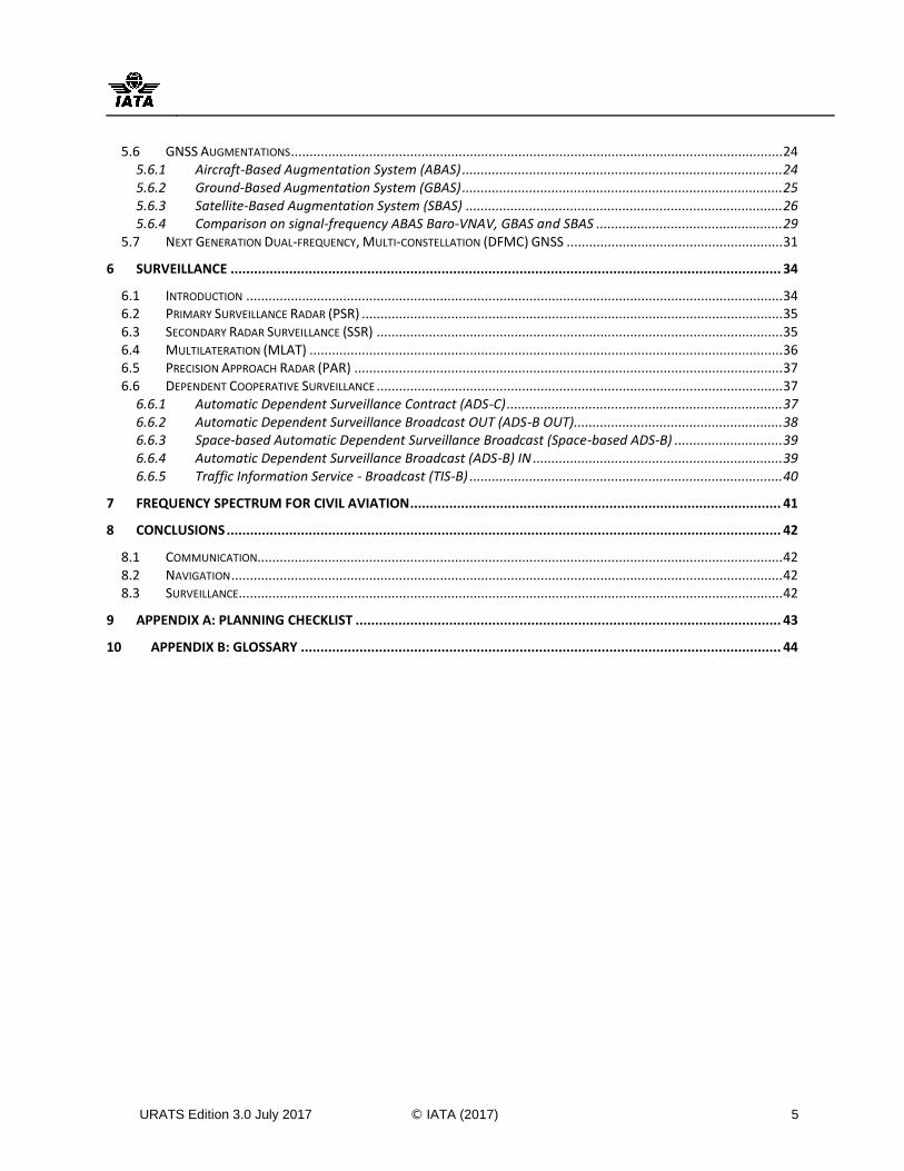
URATS Edition 3.0 July 2017 © IATA (2017) 5
5.6 GNSS AUGMENTATIONS .................................................................................................................................... 24 5.6.1 Aircraft-Based Augmentation System (ABAS) ...................................................................................... 24 5.6.2 Ground-Based Augmentation System (GBAS) ...................................................................................... 25 5.6.3 Satellite-Based Augmentation System (SBAS) ..................................................................................... 26 5.6.4 Comparison on signal-frequency ABAS Baro-VNAV, GBAS and SBAS .................................................. 29
5.7 NEXT GENERATION DUAL-FREQUENCY, MULTI-CONSTELLATION (DFMC) GNSS .......................................................... 31
6 SURVEILLANCE ............................................................................................................................................. 34
6.1 INTRODUCTION ................................................................................................................................................ 34 6.2 PRIMARY SURVEILLANCE RADAR (PSR) ................................................................................................................. 35 6.3 SECONDARY RADAR SURVEILLANCE (SSR) ............................................................................................................. 35 6.4 MULTILATERATION (MLAT) ............................................................................................................................... 36 6.5 PRECISION APPROACH RADAR (PAR) ................................................................................................................... 37 6.6 DEPENDENT COOPERATIVE SURVEILLANCE ............................................................................................................. 37
6.6.1 Automatic Dependent Surveillance Contract (ADS-C) .......................................................................... 37 6.6.2 Automatic Dependent Surveillance Broadcast OUT (ADS-B OUT)........................................................ 38 6.6.3 Space-based Automatic Dependent Surveillance Broadcast (Space-based ADS-B) ............................. 39 6.6.4 Automatic Dependent Surveillance Broadcast (ADS-B) IN ................................................................... 39 6.6.5 Traffic Information Service - Broadcast (TIS-B) .................................................................................... 40
7 FREQUENCY SPECTRUM FOR CIVIL AVIATION ............................................................................................... 41
8 CONCLUSIONS .............................................................................................................................................. 42
8.1 COMMUNICATION............................................................................................................................................. 42 8.2 NAVIGATION .................................................................................................................................................... 42 8.3 SURVEILLANCE .................................................................................................................................................. 42
9 APPENDIX A: PLANNING CHECKLIST ............................................................................................................. 43
10 APPENDIX B: GLOSSARY ........................................................................................................................... 44
APENDICE A / APPENDIX A SAM/IG/21-NE/22-WP/22
URATS Edition 3.0 July 2017 © IATA (2017) 6
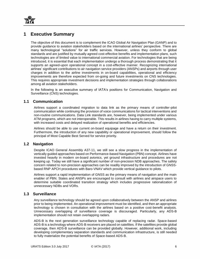
1 Executive Summary
The objective of this document is to complement the ICAO Global Air Navigation Plan (GANP) and to provide guidance to aviation stakeholders based on the international airlines’ perspective. There are many technological “solutions” for air traffic services. However, unless they conform to global standards and are justified by mutually agreed cost-effective benefits and implementation plans, such technologies are of limited value to international commercial aviation. For technologies that are being introduced, it is essential that each implementation undergo a thorough process demonstrating that it supports an agreed-upon operational concept in a cost-effective manner. Recognizing international airlines’ significant contributions to air navigation service providers (ANSPs) and airports through user charges in addition to the airline investments in on-board capabilities, operational and efficiency improvements are therefore expected from on-going and future investments on CNS technologies. This requires appropriate investment decisions and implementation strategies through collaborations among all aviation stakeholders.
In the following is an executive summary of IATA’s positions for Communication, Navigation and Surveillance (CNS) technologies.
1.1 Communication
Airlines support a coordinated migration to data link as the primary means of controller-pilot communication while continuing the provision of voice communications for tactical interventions and non-routine communications. Data Link standards are, however, being implemented under various ATM programs, which are not interoperable. This results in airlines having to carry multiple systems, with increased costs and delayed realization of operational benefits and efficiencies.
Airlines should be able to use current on-board equipage and have a return on their investment. Furthermore, the introduction of any new capability or operational improvement, should follow the principal of Most Capable Best Served for service priority.
1.2 Navigation
Despite ICAO General Assembly A37-11, we still see a slow progress in the implementation of vertically guided approaches based on Performance-based Navigation (PBN) concept. Airlines have invested heavily in modern on-board avionics, yet ground infrastructure and procedures are not keeping up. Today we still have a significant number of non-precision NDB approaches. The safety concern related to non-precision approaches can be readily improved by the introduction of GNSS-based RNP APCH procedures with Baro-VNAV which provide vertical guidance to pilots.
Airlines support a rapid implementation of GNSS as the primary means of navigation and the main enabler of PBN. States and ANSPs are encouraged to consult with airlines and airspace users to determine suitable coordinated transition strategy which includes progressive rationalization of unnecessary NDBs and VORs.
1.3 Surveillance
Any surveillance technology should be agreed upon collaboratively between the ANSP and airlines prior to being implemented. An operational improvement must be identified, and then an appropriate technology is chosen in consultation with the airlines based on a positive cost-benefit analysis. Unnecessary overlapping of surveillance coverage is discouraged. Particularly, any ADS-B implementation should not retain overlapping radars.
ADS-B is the next generation surveillance technology capable of replacing radar. Space-based ADS-B is a technology where ADS-B receivers are placed on satellites. If the satellites provide global coverage, then ADS-B surveillance can be provided globally. However, additional work, including developing complementary separation standards and communication infrastructure, is still needed to fully materialize the potential benefits of Space-based ADS-B.
APENDICE A / APPENDIX A SAM/IG/21-NE/22-WP/22

URATS Edition 3.0 July 2017 © IATA (2017) 7
2 Introduction
The objective of this document is to complement the ICAO Global Air Navigation Plan (GANP)1 and to provide guidance to aviation stakeholders based on airlines’ perspective. In general, the objectives of IATA’s positions on short to medium term Communication, Navigation and Surveillance (CNS) infrastructure improvements are to maximise the existing aircraft capabilities and to support the implementation of the supported technologies where operationally justified, in consultation with airlines. The document is organized in sections covering Communication, Navigation and Surveillance technologies. Pursuant to each technology description the IATA position is indicated.
Throughout the document, the support of any CNS technology is not an automatic global endorsement by the airline industry. Any technology will need to fulfil the following implementation requirements prior to actual funding or implementation:
1) Enable a direct and measurable operational and/or safety improvement that is required for that specific service volume and identified in collaboration with airlines operating through that specific airspace;
2) Follow a proper consultation process with the airlines and airspace users and involve airlines collaboratively at the planning and deployment stages;
3) Be aligned with the ICAO GANP;
4) Be supported by a positive a cost-benefit analysis during which the airlines were able to validate the benefits that off-set the costs; and
5) Follow ICAO principles for user charges.
Appendix A presents a checklist with some questions that ANSPs, States and international funding organizations should answer when planning and funding for the implementation of new CNS/ATM improvements.
Appendix B includes the glossary containing the explanation of all the acronyms in the document.
Any inquiries on this document may be directed to [email protected].
1 The GANP is published as ICAO Document 9750, which is available for purchase from this site: http://www.icao.int/publications/pages/publication.aspx?docnum=9750
APENDICE A / APPENDIX A SAM/IG/21-NE/22-WP/22
URATS Edition 3.0 July 2017 © IATA (2017) 8
3 Summary of Positions
This section summarizes the conclusive IATA position per CNS Technology. Each CNS technology is assigned into one of the following four (4) categories:
Support: IATA supports the implementation of these technologies as per Section 2 requirements.
Maintain: IATA recognizes on-going operational benefits from these technologies and supports the need for their maintenance. Future investments or deployment plans should be carefully considered in consultation with airspace users and alternative newer technologies should also be evaluated.
Neutral: IATA notes some operational uses for these technologies. Future investments or deployment plans should be carefully considered in consultation with airspace users and alternative technologies should also be evaluated.
Do not support: IATA does not support these technologies for mainline commercial airline operations. Costs associated to the implementation, operation, maintenance and development of these technologies should not be allocated to airlines.
Where appropriate, Notes are included providing additional information related to the technology, its deployment and IATA conditions and expectations.
Expanded descriptions and IATA positions on each technology are provided in details in the following sections of this document.
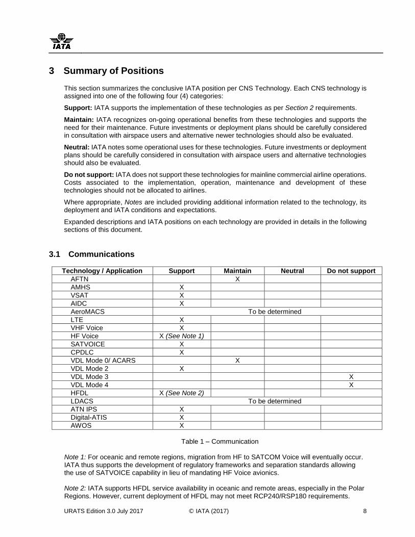
3.1 Communications
Technology / Application Support Maintain Neutral Do not support
AFTN X
AMHS X
VSAT X
AIDC X
AeroMACS To be determined
LTE X
VHF Voice X
HF Voice X (See Note 1)
SATVOICE X
CPDLC X
VDL Mode 0/ ACARS X
VDL Mode 2 X
VDL Mode 3 X
VDL Mode 4 X
HFDL X (See Note 2)
LDACS To be determined
ATN IPS X
Digital-ATIS X
AWOS X
Table 1 – Communication
Note 1: For oceanic and remote regions, migration from HF to SATCOM Voice will eventually occur. IATA thus supports the development of regulatory frameworks and separation standards allowing the use of SATVOICE capability in lieu of mandating HF Voice avionics. Note 2: IATA supports HFDL service availability in oceanic and remote areas, especially in the Polar Regions. However, current deployment of HFDL may not meet RCP240/RSP180 requirements.
APENDICE A / APPENDIX A SAM/IG/21-NE/22-WP/22
URATS Edition 3.0 July 2017 © IATA (2017) 9
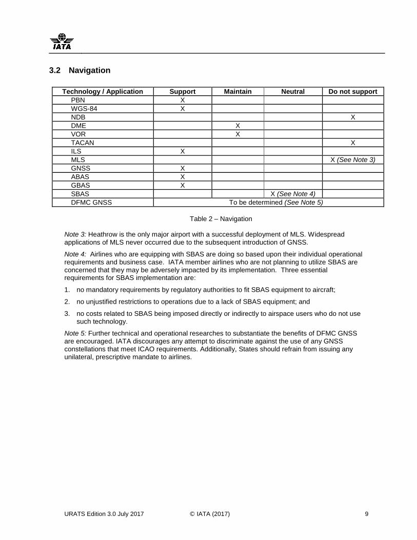
3.2 Navigation
Technology / Application Support Maintain Neutral Do not support
PBN X
WGS-84 X
NDB X
DME
X
VOR X
TACAN X
ILS X
MLS
X (See Note 3)
GNSS X
ABAS X
GBAS X
SBAS X (See Note 4)
DFMC GNSS To be determined (See Note 5)
Table 2 – Navigation
Note 3: Heathrow is the only major airport with a successful deployment of MLS. Widespread applications of MLS never occurred due to the subsequent introduction of GNSS.
Note 4: Airlines who are equipping with SBAS are doing so based upon their individual operational requirements and business case. IATA member airlines who are not planning to utilize SBAS are concerned that they may be adversely impacted by its implementation. Three essential requirements for SBAS implementation are:
1. no mandatory requirements by regulatory authorities to fit SBAS equipment to aircraft;
2. no unjustified restrictions to operations due to a lack of SBAS equipment; and
3. no costs related to SBAS being imposed directly or indirectly to airspace users who do not use such technology.
Note 5: Further technical and operational researches to substantiate the benefits of DFMC GNSS are encouraged. IATA discourages any attempt to discriminate against the use of any GNSS constellations that meet ICAO requirements. Additionally, States should refrain from issuing any unilateral, prescriptive mandate to airlines.
APENDICE A / APPENDIX A SAM/IG/21-NE/22-WP/22
URATS Edition 3.0 July 2017 © IATA (2017) 10
3.3 Surveillance
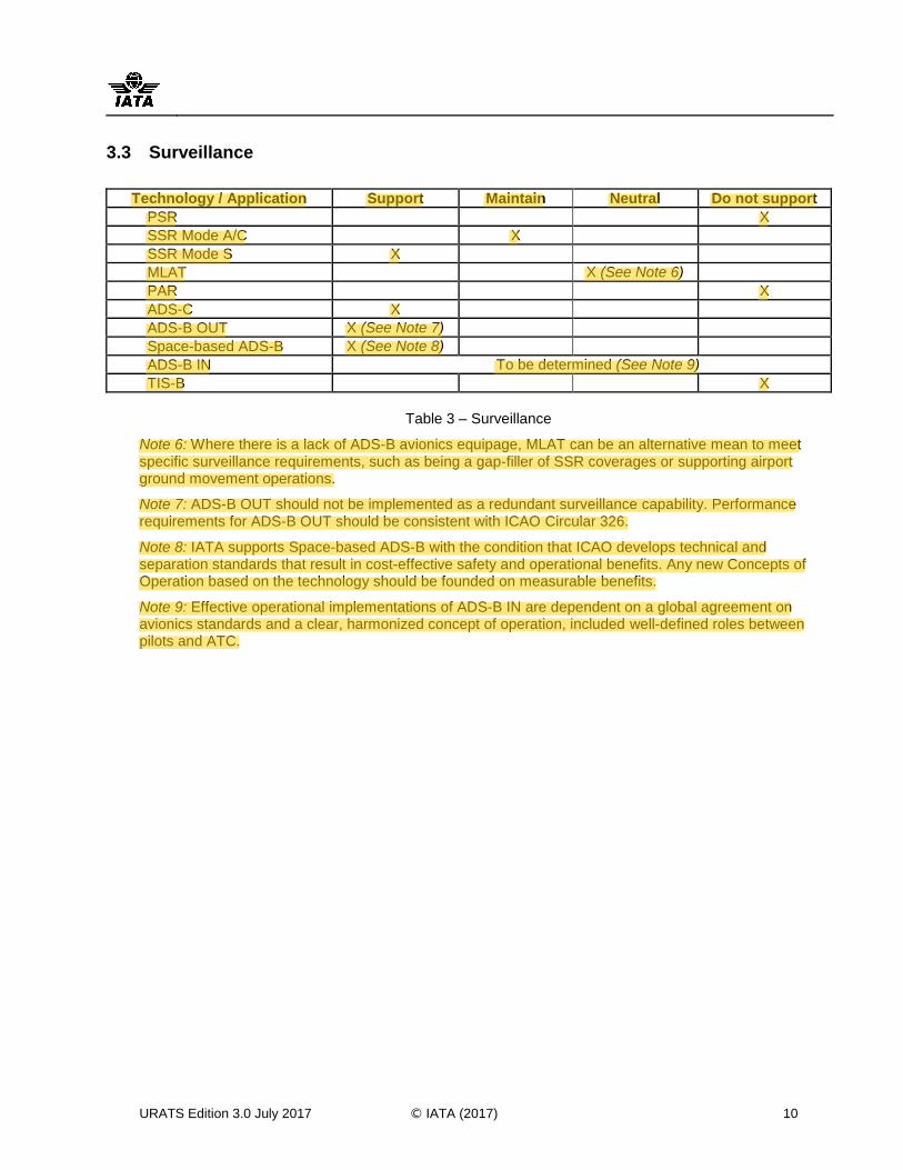
Technology / Application Support Maintain Neutral Do not support
PSR
X
SSR Mode A/C
X
SSR Mode S X
MLAT X (See Note 6)
PAR
X
ADS-C X
ADS-B OUT X (See Note 7)
Space-based ADS-B X (See Note 8)
ADS-B IN To be determined (See Note 9)
TIS-B
X
Table 3 – Surveillance
Note 6: Where there is a lack of ADS-B avionics equipage, MLAT can be an alternative mean to meet specific surveillance requirements, such as being a gap-filler of SSR coverages or supporting airport ground movement operations.
Note 7: ADS-B OUT should not be implemented as a redundant surveillance capability. Performance requirements for ADS-B OUT should be consistent with ICAO Circular 326.
Note 8: IATA supports Space-based ADS-B with the condition that ICAO develops technical and separation standards that result in cost-effective safety and operational benefits. Any new Concepts of Operation based on the technology should be founded on measurable benefits.
Note 9: Effective operational implementations of ADS-B IN are dependent on a global agreement on avionics standards and a clear, harmonized concept of operation, included well-defined roles between pilots and ATC.
APENDICE A / APPENDIX A SAM/IG/21-NE/22-WP/22
pereiraj
Highlight
pereiraj
Highlight
URATS Edition 3.0 July 2017 © IATA (2017) 11
4 Communications
4.1 Introduction
The safety and efficiency of aircraft operations is directly related to the availability and performance of aeronautical communications and the supporting infrastructure. The importance of communications is highlighted by the scope of air traffic management and airline operations that depend upon it. This scope of operations includes filing and amending flight plans, Air Traffic Services (ATS) communications, and airline operational communications. Implementations of any communication capability can have a wide-ranging effect and thus require proper multidisciplinary coordination involving aircraft operators, avionics manufacturers, flight crews, Air Navigation Services Providers (ANSPs) and other agencies providing supporting services and infrastructure.
The following sections describe the ground-to-ground and air-to-ground / ground-to-air subnetworks of the Communication Network, and the industry’s position with regards to the various technologies and their deployment.
4.2 Ground–Ground Communications
Ground-ground communications refer to exchanges of ATM-related messages linking ground-based stakeholders concerning planning and movement of aircraft. Such communications are transitioning from analog to digital format and are becoming increasingly automated.
Technologies and applications reviewed in this section include:
Aeronautical Fixed Telecommunications Network (AFTN) and ATS Message Handling Services (AMHS);
Very Small Aperture Terminal (VSAT); and
Air Traffic Services Inter-Facility Data Communications (AIDC)
4.2.1 Aeronautical Fixed Telecommunications Network and ATS Message Handling Services
The AFTN is a message-handling network that has existed for over 50 years. It is a closed network in the sense that its users belong to ATS authorities and associated organizations such as airline operators, general aviation, and meteorological offices.
The AFTN is character-based only and cannot carry bit-oriented applications.
The aviation industry has adopted AMHS to replace the AFTN. The AMHS can carry digital information such as text, graphics, images, files, databases, audio and video. ICAO has specified standards to ensure interoperability between AMHS and AFTN during the migration period.
IATA Position on AFTN and AMHS: Support a rapid transition from AFTN to AMHS. However, interoperability during transition must be ensured by interconnecting legacy AFTN terminals to the AMHS.
APENDICE A / APPENDIX A SAM/IG/21-NE/22-WP/22
URATS Edition 3.0 July 2017 © IATA (2017) 12
4.2.2 Very Small Aperture Terminal (VSAT)
A VSAT ground station uses satellites to relay voice and data from small terminals to other terminals. VSATs are typically used for communications between ATC units in areas where line connections are unreliable or uneconomical.
Usages of VSAT ground station terminals on an established network and satellite are versatile, economical and scalable. However, a deployment of new VSAT networks and satellites is considerably more expensive.
IATA Position on VSAT: Support deployment of VSAT ground terminals where operationally justified, as they offer a versatile, economical, and scalable solution for ground-to-ground aeronautical communications.
However, due to its cost implications, a proliferation of new VSAT networks and satellites should be avoided, especially where the existing ones, both national and international, can be expanded to serve new areas.
4.2.3 Air Traffic Services Interfacility Data Communication (AIDC)
AIDC is a ground-ground data link communication service that provides the capability to automatically exchange data between ATS units for notification, coordination and transfer of aircraft between flight information regions (FIRs). AIDC message format and procedures is an international standard designed for use through any ground-ground circuit, including the legacy AFTN.
AIDC greatly reduces the need for voice coordination between ATC facilities, resulting in fewer errors and reduced workload.
IATA Position on AIDC: Support AIDC deployment as the primary means of coordination between ATC facilities, while maintaining the capability for controllers to intervene via voice for non-routine communications.
4.3 Air–Ground Communications
Current controller-pilot communications use primarily voice links provided by analog radios operating in the VHF and HF bands. Aviation is moving towards a new communications infrastructure that provides superior quality through use of air-ground data link. A first generation of ATC applications was implemented using Aircraft Communications Addressing and Reporting System (ACARS) air-ground data links. ACARS now needs to transition to modern communications protocols, such as VDL Mode 2 (see section 4.3.8), in order to support increasing user traffic and provide the performance needed for today and future air traffic management (ATM).
Our objective is to adopt Controller Pilot Datalink Communications (CPDLC) as the primary means of routine communication while maintaining the requirement for voice communications for non-routine, tactical communications and as a backup.
APENDICE A / APPENDIX A SAM/IG/21-NE/22-WP/22
URATS Edition 3.0 July 2017 © IATA (2017) 13
This section provides an overview of currently available technologies supporting the following groups of applications:
Communication in the vicinity of aerodromes
Aeronautical Mobile Airport Communications System (AeroMACS)
Long Term Evolution (LTE) Voice Communication
Very High Frequency (VHF) Voice
High Frequency (HF) Voice
Voice Communications through Satellites (SATVOICE)
Data and Network Communication
Controller Pilot Data Link Communications (CPDLC)
Aircraft Communications Addressing and Reporting System (ACARS)
VHF Data Link (VDL) Modes 2–4
High Frequency Data Link (HFDL)
L-Band Digital Aeronautical Communications System (LDACS)
Aeronautical Telecommunications Network over Internet Protocol Suites (ATN IPS)
4.3.1 Aeronautical Mobile Airport Communications System (AeroMACS)
AeroMACS is intended to support on-the-ground secured communication exchanges and is based on the IEEE 802.16-20092 mobile standards for WiMAX3. The uses of AeroMACS are limited to aviation applications on the surface within the airport vicinity and can support three categories of users: ATC/ATM and infrastructure, airline operations and airport authority operations.
AeroMACS is a technology which has been standardized exclusively for aviation uses. A global frequency allocation for AeroMACS was introduced in the International Telecommunication Union (ITU) Radio Regulations for the frequency bands of 5000 – 5030 MHz and 5091 – 5150 MHz.
ICAO SARPs for AeroMACS are currently applicable and ICAO Doc 10044: Manual on AeroMACS has been published. The Airlines Electronic Engineering Committee (AEEC) is developing avionics specifications for AeroMACS and has started the development of aircraft installation architecture.
AeroMACS is a part of the Future Communication Infrastructure supporting the Airport Surface Component and is reflected within the ICAO Global Air Navigation Plan (GANP) and the ICAO Communication Roadmap in the GANP. In particular, a SESAR study indicated that AeroMACS is an enabler for ATN baseline 2 and can offload the saturated VHF datalink communications in the airport environment and support advanced surface CNS systems.
Notwithstanding the above, many airlines are using other more cost-effective, commercial solutions, such as LTE (see section 4.3.2), to support their general AOC operations.
2 A series of wireless broadband standards written by the Institute of Electrical and Electronics Engineers
(IEEE) for Local and metropolitan area networks. Part 16: Air Interface for Broadband Wireless Access Systems.
3 Worldwide Interoperability for Microwave Access, which is a standards-based technology enabling the delivery of last mile wireless broadband access as an alternative to cable and DSL.
APENDICE A / APPENDIX A SAM/IG/21-NE/22-WP/22
URATS Edition 3.0 July 2017 © IATA (2017) 14
IATA Position on AeroMACS: A positive business case for airlines, particularly regarding AOC applications, is not yet available. Relevant business cases should consider the unique technical features of AeroMACS and evaluate their necessity and incremental benefits as related to actual operational requirements. Airline equipage decisions should be voluntary. A comparative evaluation with other wireless broadband technologies should also be conducted for non-safety related applications, such as aeronautical administrative communications (AAC) and aeronautical passenger communications (APC).
4.3.2 Long Term Evolution (LTE)
LTE is a technology for 4G mobile network, similar to that being used by mobile phones. The potential services and applications of LTE for aviation are airline operations, passenger in-flight communication and airport and/or port authority operations.
Each LTE base station can cover up to 150 km distance between aircraft and a ground LTE antenna. The air-ground coverage can be extended via terrestrial cellular network. It is also feasible to extend its coverage to oceanic and remote airspace via a hybrid solution with a satellite network.
LTE was standardized in 2008 as a telecommunication standard. Currently, there is no overt progress on aviation standardization of LTE. LTE also lacks a legal protection from radio frequency interference.
LTE and its service are normally not exclusive for aviation use. During emergency situations, LTE may not guarantee prompt access to its service as its network may become 'overcrowded' by other users, such as passengers and their family members. To manage these emergencies and to ensure business continuity, a contractual Service Level Agreement between airlines and LTE service providers may be needed.
IATA Position on LTE: A formal business case for airlines is not publicly available. As LTE is not originally designed to support safety-critical applications, airlines should conduct a proper operational risk assessment and develop appropriate contingency measures/procedures in case of interruptions of LTE services.
4.3.3 Very High Frequency (VHF) Voice
VHF voice communication systems, used in the International Aeronautical Mobile Service are amplitude modulated (AM) carriers. VHF analogue radios use channels of varying bandwidth. The channel spacing can be defined as 100 kHz, 50 kHz, 25 kHz or 8.33 kHz, depending on the saturation of channels in the region of interest.
In March 2007, the ICAO European Region made the carriage and operation of 8.33 kHz radios mandatory above FL195.
IATA Position on VHF Voice: Support 8.33 kHz channel spacing implantation in regions where 25 kHz channel spacing does not provide an adequate number of frequencies. Where implemented, carriage of 8.33 kHz-capable radios should be mandatory to ensure that all potential safety and capacity benefits are realized.
APENDICE A / APPENDIX A SAM/IG/21-NE/22-WP/22
URATS Edition 3.0 July 2017 © IATA (2017) 15
4.3.4 High Frequency (HF) Voice
HF voice is used for air-ground ATC communications in remote and oceanic areas outside the range of VHF frequencies. In most cases, an HF radio operator functions as an intermediary between controllers and pilots, transcribing and relaying the contents of HF voice communications.
HF communications have long-distance coverage and aircraft can use radios operating in the HF radio band for long-range communications because signals are reflected by the ionosphere. Link quality and availability are variable, and influenced by a number of factors, including frequency congestion, sunspot activity, the eleven-year solar cycle, and day/night atmospheric and ionospheric conditions. Consequently, larger aircraft separation standards are used, thus reducing airspace capacity.
In most cases, Controller Pilot Datalink Communications (CPDLC) can replace HF voice communication.
IATA Position on HF Voice: Support CPDLC as the primary means of communication for oceanic and remote areas while continuing to provide HF voice service as a backup. Ground based HF transceivers should be equipped with Selective Calling (SELCAL).
For oceanic and remote regions, it is expected that the migration from HF to SATVOICE will eventually occur. IATA thus supports the development of regulatory frameworks and separation standards to allow the use of SATVOICE capability in lieu of mandating HF Voice avionics.
4.3.5 Voice Communication via Satellites (SATVOICE)
Voice communication via satellites (often referred to as SATVOICE) is currently used to complement other forms of long range communications, such as CPDLC and HF Voice. SATVOICE provides a means of reducing the risk of communication failures, and can improve the safety and efficiency of operations.
SATVOICE does not yet directly link pilots and controllers although there are plans to do so in the near future. Enhancement of SATVOICE is being developed to provide direct controller-pilot communications (DCPC) for more efficient ATS communications, such as in processing negotiations or requests from the flight crew. Furthermore, future capability of SATVOICE is being considered to provide an intervention capability in support of an ATS service.
ICAO is developing Satellite Voice Guidance Material (SVGM) with the aim to maximize the operational benefits of SATVOICE implementations by promoting seamless and interoperable SATVOICE operations throughout the world. The document addresses the use of SATVOICE for ATS communications, but assumes aircraft equipage and ground infrastructure will continue to maintain HF voice capability.
IATA Position SATVOICE: Where justified, support SATVOICE as a current mean of providing direct controller-pilot communications and supporting air traffic separation in areas beyond VHF voice coverage. ANSPs should implement methods to link pilots to controllers without having to relay messages via an operator. For oceanic and remote regions, it is expected that the migration from HF to SATVOICE will take place.
APENDICE A / APPENDIX A SAM/IG/21-NE/22-WP/22
URATS Edition 3.0 July 2017 © IATA (2017) 16
4.3.6 Controller Pilot Data Link Communications (CPDLC)
CPDLC refers to communications between controllers and pilots using pre-defined message sets, with a free-text option for non-routine messages.
CPDLC is a desirable form of controller-pilot communications, as it reduces voice errors and misinterpretations. It can be used for routine communications but is less suitable for tactical interventions as compared with VHF voice communications.
IATA Position on CPDLC: Support CPDLC as the primary means of communication in oceanic and remote airspace where the quality of voice communications is often poor. At the same time, CPDLC should be considered for implementation in appropriate enroute airspace in order to relieve congestion on voice channels.
4.3.7 Aircraft Communications Addressing and Reporting System (ACARS)
Aircraft Communication and Reporting System (ACARS) systems were originally used to exchange messages between aircraft and flight operations centres. Since the 1990s, the ACARS network and avionics have been used to support the exchange of pre-FANS and FANS 1/A messages (i.e. Automatic Dependent Surveillance-Contract (ADS-C) and Controller Pilot Data Link Communications (CPDLC)) between aircraft and ATS units. It is important to highlight that ACARS has not been standardized by ICAO; the technical and operational requirements are defined in a set of documents issued by ARINC.
Use of ACARS for ATS communications has reduced potential for error inherent in voice communications, and off-loaded congested ATS voice channels. ACARS is currently available via HF, VHF and satellite data links
IATA Position on ACARS: Support the use of ACARS as a basis for transition to a full-bit oriented service. ACARS is a proven technology that still meets user requirements for aeronautical communications.
4.3.8 VHF Data Link (VDL) Mode 2
VDL Mode 2 is a bit-oriented air-ground digital data link that was introduced as an VHF Mode 0 (VHF ACARS) upgrade for ATC controller-pilot data communications while still allowing ACARS equipped aircraft to use the same network. Being bit-oriented, it can transmit digital content rather than being limited to characters.
VDL Mode 2 delivers data at 31.5 Kbps, which is over 13 times faster than the VHF ACARS 2.4 kbps rate. This is the highest possible bit rate that can be supported by a 25 kHz channel while providing a range of 200 nautical miles.
VDL Mode 2 uses the Carrier Sense Multiple Access (CSMA) protocol to detect when a VHF channel is clear in order to avoid overlap with other transmissions. The VDL Mode 2 CSMA technology is superior to that of ACARS, as it detects a clear channel much quicker. This in turn results in reduced message delay and higher success rates under heavy loading conditions.
VDL Mode 2 has been accepted by the industry as the natural upgrade for VDL Mode 0 (VHF ACARS).
IATA Position on VDL Mode 2: Support upgrade of existing ACARS networks to a more efficient full-bit oriented service via VDL Mode 2.
APENDICE A / APPENDIX A SAM/IG/21-NE/22-WP/22
URATS Edition 3.0 July 2017 © IATA (2017) 17
4.3.9 VHF Data Link (VDL) Mode 3
VDL Mode 3 data link was proposed to relieve VHF voice channel congestion in the U.S. It faced competition from 8.33 kHz channel spacing, which is implemented in Europe. Because many airlines have already equipped to 8.33 kHz, the proposal for VDL Mode 3 was withdrawn.
IATA Position on VDL Mode 3: Do not support VDL Mode 3 deployment for ATS communication.
4.3.10 VHF Data Link (VDL) Mode 4
VDL Mode 4 is a bit-oriented VHF data link capable of providing air-air and air-ground communications. VDL Mode 4 supports time-critical applications and it is efficient in exchanging short repetitive messages. It is based on the Self-organizing Time Division Multiple Access (STDMA) protocol. Through this self-organizing system, the time available for transmission is subdivided into multiple time-slots. Each time slot is planned and reserved for transmission by users’ radio transponders within range of each other. This enables efficient data link use and prevents simultaneous transmission from different users. STDMA allows users to mediate access to discrete time slots without reliance on a master control station.
VDL Mode 4 was a data link candidate for ADS-B. However, 1090 MHz Mode S Extended Squitter (ES) has been chosen as the standard for international aviation.
IATA Position VDL Mode 4: Do not support VDL Mode 4 deployment for ATS communications.
4.3.11 High Frequency Data Link (HFDL)
HFDL provides data-link coverage for polar operations, where geostationary satellites have no coverage. Because of this, and the small incremental cost to implement HFDL in HF equipped aircraft, many airlines use HFDL for operational communications outside of the coverage of VHF and satellites. HFDL however does not have the communication performance of VHF or SATCOM data link and has been shown to not meet RCP240/RSP180 performance requirements.
IATA Position on HFDL: Support HFDL service availability in oceanic and remote areas, especially in the Polar Regions, to augment or to serve as a backup to other data communication methods.
4.3.12 L-band Digital Aeronautical Communications System (LDACS)
LDACS is a ground-based data link system being developed for continental airspace for en-route and terminal area communications. The technology is being developed to be accommodated in the L-band frequency which is heavily utilized by legacy navigation and surveillance aviation systems. LDACS is predicted to be part of the ATN over IP (ATN/IP) and is mainly under development by the SESAR Programme for the Future Communication Infrastructure (FCI). LDACS covers both high-rate data and voice communication and will support ICAO security requirements.
Two options for frequency multiplexing for the LDACS were identified: LDACS1 based on a frequency division duplex (FDD); LDACS2 based on time division duplex (TDD). A set of tests is being conducted to define the interference environment and the criteria for the spectrum compatibility taking into consideration legacy applications: Distance Measurement Equipment (DME), Universal Access Transceiver (UAT), and Secondary Surveillance Radar (SSR).
Besides communications, LDACS can support additional navigation functionality which aircraft can perform pseudo-range measurements to LDACS ground station, making it a potential technology for Alternative Position, Navigation, and Timing (APNT). Some research suggest the feasibility of APNT-based RNP 0.3 utilizing LDACS.
APENDICE A / APPENDIX A SAM/IG/21-NE/22-WP/22
URATS Edition 3.0 July 2017 © IATA (2017) 18
LDACS with its potential for communications and navigation can simplify deployments and usages of frequencies in L-band as it allows for a deployment/migration strategy based on a combined/holistic approach. Having the global availability of GNSS (see section 5.5 for GNSS) together with a robust and accurate APNT solution allows further reductions of conventional navigation infrastructure, such as DME. This in turn would free spectrum in L-band for additional communications usage.
IATA Position on LDACS: Taking into account on-going trials on electromagnetic spectrum compatibility, technical performance and use cases, further evaluation is required before a final recommendation. Potential uses of LDAC for APNT applications should also be further explored.
4.3.13 Aeronautical Telecommunication Network over Internet Protocol Suites (ATN IPS)
ATN is an internetwork architecture that allows ground, air-ground and avionics data sub-networks to interoperate by adopting common interface services and protocols based on the International Organization for Standardization (ISO) Open Systems Interconnection (OSI) reference model.
Since 2003, ICAO has endeavoured to transform the ATN into a modern network by specifying use of Internet Protocol Suite (IPS). The relevant ICAO standards have been adopted by the ICAO Council and became applicable in November 2008. The ICAO GANP calls for a converging transition from FANS 1/A and OSI ATN to an ATN IPS, which is a strategy IATA endorses.
IATA Position on ATN IP: Support the transition from FANS 1/A and ATN B1 to ATN IPS, as this will eliminate the current infrastructure of incompatible data networking.
4.4 Other Data Link Services
4.4.1 Digital Automatic Terminal Information Service (D-ATIS)
ATIS is predominantly a voice broadcast service over a dedicated VHF frequency that provides operational information to aircraft operating in the vicinity of an airport, eliminating the need for a controller to transmit the information to each aircraft individually. It is normally accomplished through a voice recording, updated when conditions change.
Data link is an alternative mean of transmitting ATIS to equipped aircraft. It reduces flight crew workload as D-ATIS information is printed on a cockpit printer or is recallable on a data link display.
IATA Position on D-ATIS: Support D-ATIS deployment at airports while providing dual-stack support during the transition from ATIS to D-ATIS.
4.4.2 Automated Weather Observing System (AWOS)
AWOS is a suite of sensors that measure, collect, and disseminate weather data to help meteorologists, pilots, and flight dispatchers prepare and monitor weather forecasts. The sensors identify elements such as wind velocity, ambient air and dew point temperatures, visibility, cloud height and sky condition, precipitation occurrence and type, as well as icing and freezing conditions.
In addition to safety benefits associated with weather, AWOS facilitates potential reduction in flight disruptions.
IATA Position on AWOS: When it is cost-effective, support AWOS as a replacement for human observers.
APENDICE A / APPENDIX A SAM/IG/21-NE/22-WP/22
URATS Edition 3.0 July 2017 © IATA (2017) 19
5 NAVIGATION
5.1 Introduction
Navigation infrastructures are an important backbone of Air Traffic Service (ATS) alongside communication and surveillance systems. Aircraft navigation has come a long way from those early days. From legacy ground-based navigation aids such as Distance Measuring Equipment (DME) and VHF Omni-directional Range (VOR) to satellite-based navigation aids such as the Global Navigation Satellite System (GNSS), pilots now have multiple means to safely navigate the sky.
As a score of advancements come into use, it is important to recognize that Airspace Users now operate flights globally on a daily basis. It is therefore of utmost importance that ANSPs and regulators adopt a global and regional look at route and airspace design and management, with harmonization throughout all phases of flight from gate-to-gate and a collaborative approach involving Airspace Users during all levels of decision making. This collaboration is crucial in the navigation aspect of ATS as it links directly to aircraft equipage investments, safety and efficiency in flight operations.
The following sections outline industry’s positions on different navigation infrastructures and applications.
5.2 Performance-Based Navigation (PBN)
PBN is a global set of area navigation standards, defined by ICAO, based on navigation performance and functionality required for the proposed operation. PBN concept encompasses two types of navigation specifications:
- RNAV Specification – Navigation specification based on area navigation that does not include the requirement for on-board performance monitoring and alerting, e.g. RNAV 5, RNAV 2 and RNAV 1.
- RNP Specification – Navigation specification based on area navigation that requires on-board performance monitoring and alerting, e.g. RNP 4, RNP 2 and RNP APCH.
It is expected that all future navigation applications will identify the navigation requirements through the use of performance specifications, rather than defining equipage of specific navigation sensors.
The use of PBN avoids the need to purchase and deploy navigation aids for each new route or instrument flight procedure, allows for the design of routes and procedures that are not limited by ground-based infrastructure and facilitates the operational approval process for operators by providing a limited set of navigation specifications intended for global use.
The safety benefits of PBN are significant, as even airports located in the least privileged areas of the world can have runway-aligned approaches with horizontal and vertical guidance to any runway end without having to install, calibrate and maintain expensive ground based navigation aids. In line with ICAO Assembly Resolution A37-11, Airlines support rapid deployments of vertical-guided approach procedures using RNP APCH navigation specification, enabled by GNSS4 and barometric vertical navigation (Baro-VNAV) to all instrument runways.
Despite several ICAO Assembly Resolutions, including Resolution A37-11, and an industry-wide joint declaration providing full support and calling for the rapid implementation of PBN, some States and ANSPs have been slow to act.
4 For details on GNSS, see section 5.5.
APENDICE A / APPENDIX A SAM/IG/21-NE/22-WP/22
URATS Edition 3.0 July 2017 © IATA (2017) 20
IATA Position on PBN: As a matter of high-priority, support the implementation of ICAO PBN in all phases of flight, as well as support the deployments of Approaches with Vertical Guidance (APV) based on RNP APCH procedures with Baro-VNAV. These procedures should include LNAV/VNAV minima and should not rely on ground-based conventional navigations.
Do not support mandating specific PBN navigation specifications without corresponding operational benefits. Requirements for PBN navigation specifications should be based on agreed operational and safety improvements, short and long term planning and projection of fleet equipage. While aiming towards regional and global harmonization, ANSPs and regulators should work closely with airlines and other airspace users to determine an appropriate navigation specification for specific airspace based on targeted ATM operations, airspace concept and separation standards to be applied.
Support the use of GNSS as the primary navigation infrastructure supporting current and future applications and enhancements of PBN.
5.3 World Geodetic System-84 (WGS-84)
There are many different geodetic reference datum in use throughout the world that provide reference to terrain and charting. However, the global standard for aviation is WGS-84. ICAO Annex 4 — Aeronautical Charts, Annex 11 — Air Traffic Services, Annex 14 — Aerodromes, and Annex 15 — Aeronautical Information Services state that “World Geodetic System — 1984 (WGS-84) shall be used as the horizontal (geodetic) reference system for air navigation.” These requirements became applicable on 1 January 1998.
Consequently, all aircraft navigation and terrain avoidance systems are based solely on WGS-84. All aircraft systems assume that the latitude and longitude coordinates provided are based on WGS-84. If charted coordinates are not WGS-84, then there is a positional discrepancy between where the pilot and controller thinks the aircraft is and the actual position of the aircraft itself. Such a discrepancy constitutes a safety risk which can adversely affect the safety of flight, especially at lower altitudes near terrain and obstacles. Therefore, all routes and flight procedures should be based on WGS-84 coordinates.
States that have not implemented WGS-84 are in a serious safety violation and need to implement WGS-84 as soon as possible. Additionally, WGS-84 must undergo periodic maintenance and validation, as terrain and man-made obstacles (whether temporary or permanent) do change. Incorrect publications of WGS-84 coordinates can adversely impact the safety of flight operations and travelling public.
As an exceptional basis, States who are using other geodetic reference datum which are technically equivalent to WGS-84 should do so only under a rigorous technical review process. Such States should also formally declare the technical equivalency on the States’ Aeronautical Information Publications (AIPs). (Note: In June 2016, the Federal Air Transport Agency of Russia published information on the its AIP (GEN 2.1.3 REFERENCE SYSTEM IN HORIZONTAL PLANE) noting that the coordinate systems PZ-90.11, PZ-90.02 and WGS-84 are regarded as fully identical in terms of air navigation for publication in aeronautical information documents.)
IATA Position on WGS-84: Implementation and maintenance of WGS-84 coordinates is a paramount and urgent priority due to consequential safety implications.
APENDICE A / APPENDIX A SAM/IG/21-NE/22-WP/22
URATS Edition 3.0 July 2017 © IATA (2017) 21
5.4 Conventional Ground-Based Navigation Aids
Ground-Based Navigation Aids are legacy, conventional navigation aids that came into the ATS environment in the early decades of the 20th century (earliest form of a marker beacon was flight-tested in 1918) with the advent of wireless communications and advancement of radio telephony research. Today, Ground-Based Navigation Aids are deployed and used in almost every corner of the world. These navigation aids operate on the principle of radio propagation, where aircraft calculate their positions using a combination of radio signals received. With the advancement of on-board multi-sensor avionics and Flight Management Systems (FMS), aircraft are also able to achieve a level of navigation performance required for some PBN procedures.
As they rely on radio signals that only propagates within the line-of-sight and with limited coverage, these Ground-Based Navigation Aids come with limitations and are sometimes not deployable, particularly in remote mountainous or oceanic areas. Their maintenance and flight inspection costs are generally heavy and in some cases impose signal protection requirements that penalize the efficiency of airspace or airport usage. These limitations make satellite-based navigation system a more promising technology for PBN operations.
However, while a satellite-based navigation system seems more suitable for PBN operations, reliance on GNSS as the sole means of navigation presents vulnerability to possible disruptions of the services by interferences and other atmospheric anomalies. Supported by a positive cost-benefit analysis and driven by considerations on operational and business continuity requirements, it is expected that a reduced, selected Ground-Based Navigation Aids will still remain as a back-up capability in the ATS environment.
This section provides an overview of the following ground-based navigation aids:
Non-Directional Beacon (NDB)
Distance Measuring Equipment (DME)
VHF Omni-directional Range (VOR)
Tactical Air Navigation (TACAN)
Instrument Landing Systems (ILS)
Microwave Landing System (MLS)
5.4.1 Non-Directional Beacon (NDB)
The earliest form of enroute navigation aids, NDB operates by broadcasting non-directional radio signals. The signals are picked up by antenna on an aircraft, and its information is processed and used with the Automatic Direction Finder (ADF). The NDB can also be used for non-precision approaches at some airports. The limitations of NDB lie in its non-directional and unreliable quality of signal, rendering it inferior to other en-route navigation aids such as VOR and GNSS.
Many of the NDBs in service today are deemed to be obsolete and not required in a navigational environment utilizing GNSS. The use of NDBS for en-route should be replaced by PBN waypoints.
IATA Position on NDB: Support rapid decommissioning of all NDBs for navigation services. For airports with only NDB non-precision approach, the NDB-based ADF procedure should be replaced by a GNSS-based RNP APCH with Baro-VNAV procedure. The use of NDBS for en-route should be replaced by PBN waypoints.
APENDICE A / APPENDIX A SAM/IG/21-NE/22-WP/22
URATS Edition 3.0 July 2017 © IATA (2017) 22
5.4.2 Distance Measuring Equipment (DME)
DME is a ground-based navigation aids that helps the aircraft measure its distance from the DME station by timing the propagation delay in the radio signals sent between the station and the aircraft. In area navigation, the aircraft can use multiple DME signals to triangulate its position by utilizing multiple DME-distance measurements and the published locations of the stations. Thus, DME can serve as a contingency navigation aid supplementing GNSS and is also part of navigation infrastructure that supports PBN operations down to RNAV1 specification. However, installations of additional DMEs to form DME/DME network for RNAV1 and RNAV2 operations are discouraged due to unnecessary DME costs, the global availability of GNSS and widely-equipped inertial-based navigation systems in commercial aircraft.
IATA Position on DME: Support the use of some existing DMEs as contingency navigation aids supplementing GNSS for RNAV operations. Support the use of DME as a part of ILS where applicable. Where considered economically beneficial and following a successful consultation with relevant airspace users, ANSPs are encouraged to publish a rationalization plan for unnecessary DMEs with an agreed timeline.
5.4.3 VHF Omni-directional Range (VOR)
VOR is a navigation aid that transmits VHF navigation signals 360° in azimuth angles. Using signal phase measurement comparison, the aircraft with a VOR receiver can determine its radial from the VOR ground station. When used in conjunction with a collocated DME and the published location of the station stored in the on-board database, the aircraft can determine its coordinate location and thus conforming to RNAV-5 specification. Additionally, VOR frequency may also be used for ATIS delivery.
Due to its limited capability in terms of accuracy and signal line-of-sight, VORs are legacy navigation aids that are becoming difficult to maintain. Transitions from VORs have already begun by several ANSPs.
IATA Position on VOR: Support the transition to GNSS as the primary means of navigation and recommends minimum reliance on VOR as contingency for the GNSS. Where considered economically beneficial and following a successful consultation with relevant airspace users, ANSPs are encouraged to plan and publish a rationalization plan of unnecessary VORs under an agreed timeline.
Additionally, in line with ICAO Assembly Resolution A37-11, States and ANSPs should develop a GNSS-based RNP APCH with Baro-VNAV procedure for all instrument runways with only VOR non-precision approach procedure.
5.4.4 Tactical Air Navigation (TACAN)
TACAN is a ground-based navigation aid similar to VOR used by the military for en-route, non-precision approaches and other military applications.
IATA Position on TACAN: Do not support civil implementations of TACAN because of the lack of civil aviation requirements.
APENDICE A / APPENDIX A SAM/IG/21-NE/22-WP/22
URATS Edition 3.0 July 2017 © IATA (2017) 23
5.4.5 Instrument Landing System (ILS)
ILS is a navigation aid enabling precision approach and landing to a runway by a combination of horizontal and vertical guidance. The horizontal guidance signal is transmitted from a localizer (LOC) while vertical guidance signal is transmitted from a glide slope (GS); aircraft avionics process the information and present it as course deviation indicator on cockpit Primary Flight Display (PFD). Currently, the ILS is the primary technology that enables precision approaches down to Category III limits. It is a proven technology that meets user requirements today and is still considered an essential navigation system where precision approaches are required.
Due to cost and efficiency considerations, some States are rationalizing some of their ILS infrastructure, especially at airports with limited operational usage of Category-1 ILS. This rationalization needs a careful consultation with all airspace users. It needs to be a balance between getting cost-saving benefits from decommissioning some ILSs with limited operational use, while maintaining suitable level of service and airport access for flight operations.
IATA Position on ILS: Support continued deployment and use of ILS as the primary means of precision approach. In most cases, ANSPs should continue supporting ILS operations to the highest level of service.
5.4.6 Microwave Landing System (MLS)
The MLS is a ground-based precision landing system operating in the microwave spectrum. It was intended to be the next generation precision approach system that would replace ILS.
Although some MLS systems have become operational, including a successful deployment for Heathrow Airport, widespread applications of MLS never occurred due to the subsequent introduction of GNSS. Consequentially, the majority of airlines did not equip with MLS.
IATA Position on MLS: Do not support future implementations of MLS.
5.5 Global Navigation Satellite System (GNSS)
Global Navigation Satellite System (GNSS) represents a transition from conventional Ground-Based Navigation Aids to Satellite-Based Navigation Aids, aiming to mitigate many limitations faced by the use of radio signals transmitted from ground. The GNSS concept came into being in the 1960s as part of a pilot research project and has gone through much advancement to where it is today.
GNSS relies on satellites broadcasting signals containing timing information and data messages. GNSS receivers then measure the signal propagation time from each satellite to measure the distance between the receiver and the satellite itself. By receiving a minimum number of signals from different satellites, GNSS receivers can then triangulate and derive their 3D position on a globally standardized coordinate system (WGS-84). By stringing together these continuously updated positions, the aircraft can fly on any desired flight path without the line-of-sight and radial interception restrictions associated with ground-based conventional navigation aids.
GNSS provides standardized positioning and time information to aircraft which are highly accurate. The accuracy level of GNSS and the absence of limitations previously faced by conventional navigation aids make GNSS an ideal navigation infrastructure to globally enable the full benefits from PBN, especially RNP.
APENDICE A / APPENDIX A SAM/IG/21-NE/22-WP/22
URATS Edition 3.0 July 2017 © IATA (2017) 24
Note: The threat of intentional jamming and harmful radio frequency interference to GNSS is a global concern. In accordance with ICAO ANC/12 recommendations, States and ICAO are strongly urged to urgently address this safety and security issue. Relevant mitigation measures is available in ICAO Doc 9849: GNSS Manual 2017 Edition.
IATA Position on GNSS: With the continuous advancement in GNSS technologies and its demonstrated capabilities and operational benefits, support deploying and use of GNSS as the primary radio navigation aids for all phases of flight and as the primary enabler of PBN and RNP.
5.6 GNSS Augmentations
To meet required performance for the more stringent navigational applications, such as approach with vertical guidance (APV) and precision approaches, augmentation of the GNSS signal is required in order to improve navigation accuracy and integrity.
The following sections present an overview of the industry’s positions on:
Aircraft Based Augmentation System (ABAS)
Ground Based Augmentation System (GBAS);
Satellite Based Augmentation System (SBAS)
To assist the readers in reviewing these GNSS augmentations, a comparison table is provided in section 5.6.4. Additional information can also be found in ICAO Annex 10 Vol. 1.
5.6.1 Aircraft-Based Augmentation System (ABAS)
ABAS is an aircraft-contained augmentation system that augments and/or integrates the information obtained from GNSS receivers with other navigation information available on board the aircraft. The most common form of ABAS is Receiver Autonomous Integrity Monitoring (RAIM) which monitors the integrity of the GNSS signals and automatically flags the insufficient integrity for aircraft operations. In some aircraft, ABAS also integrates information from other on-board sensors, such as Inertial Navigation System (INS) and/or barometric altimeters, with information derived from GNSS signals in updating aircraft positions. By utilizing already on-board system in a self-contained manner, ABAS is currently the most cost-effective augmentation system for GNSS. In line with ICAO Assembly Resolution A37-11, ABAS should be used in combination with Barometric VNAV (Baro-VNAV) during RNP APCH approach operations to respectively provide horizontal and vertical guidance down to LNAV/VNAV minima. This combination of ABAS with Baro-VNAV is a readily-available technology which can cost-effectively manage today challenges from non-vertically-guided, non-precision approaches based on VORs or NDBs.
IATA Position on ABAS: Support using ABAS as the preferred augmentation system for en-route and terminal-area navigation using GNSS. In line with ICAO Assembly Resolution A37-11, for approach operations, ABAS should be used in combination with Baro-VNAV to provide horizontal and vertical guidance, respectively.
APENDICE A / APPENDIX A SAM/IG/21-NE/22-WP/22
URATS Edition 3.0 July 2017 © IATA (2017) 25
5.6.2 Ground-Based Augmentation System (GBAS)
GBAS is a system that provides differential corrections and integrity monitoring of GNSS via a ground-based VHF Data Broadcast (VDB). The differential corrections are generated from a set of GNSS receivers, which are installed at known locations within the airport. With all common errors affecting both the aircraft and the reference stations, such as ionospheric delays, are eliminated, GBAS can provide the aircraft with very high accuracy three-dimensional positioning.
GBAS is a matured and evolving augmentation system that enables GNSS for precision approach, with operational certifications currently down to Category I Precision Approach. GBAS provides geometric vertical guidance for precision approaches.5 Additionally, GBAS supports additional operational flexibility through provision of displaced thresholds and multiple glide path approaches. A GBAS, unlike an ILS, can provide precision approach capability to multiple runway ends at an airport. In 2015, at least 24 States have reported GBAS-related activities.
As of June 2017, airline fleets which can be equipped with GBAS Category 1 avionics, also known as GNSS/GBAS Landing System (GLS), include A320 family, A330 family, A350 family, A388, B737NG series, B737 Max series, B748, B787 series. GLS avionics is a standard equipment for B787, B747-8 and B777X. It is a cost option for B737NG and B737Max. Aircraft manufacturers reported an increasing GLS customer base and GBAS-equipped aircraft sales, with Boeing reporting over 1900 equipped aircraft and over 100 airlines choosing the GLS option. Airbus delivered GLS aircraft to 45 customers. Airlines with GLS avionics should approach their regulators to obtain operational approval as necessary.
To be applicable in November 2018, ICAO SARPs for GBAS6 is extended to support Category I/II/III precision approaches, landing, guided take-off, departure, and surface operations. RTCA MOPS for GBAS Category II/III avionics is scheduled for 2017. A 2016 SESAR study demonstrated that, under Low Visibility Conditions, GBAS CAT II/III L1-only solution enables GBAS Automatic Approach and Landing down to Cat IIIb minima for mainline aircraft with automatic roll-out with a DH below 50 ft down to no DH and RVR between 50m and 200m. The solution also supports GBAS guided take-off. ICAO is developing a flight procedure design criteria for GBAS CAT III.
As of June 2017, no certified GLS CAT II/III avionics are available and the market size will influence the avionics cost. Starting 2019, Boeing will provide an option for GLS CATII/III on B777X EIS.
ANSPs who are considering deployments of GBAS ground station should consult with airspace users and operators prior to making the investment decisions. Where applicable, ANSPs should ensure system interoperability among ILS localizer, VOR and GBAS VDB operating at the same airport by performing an appropriate frequency coordination and technical validation. Once GBAS CAT II/III becomes commercially available, options to upgrade the GBAS Category I ground station to CATII/III should be evaluated in coordination with airports and operators.
Developments for dual-frequency, multi-constellation (DFMC) GNSS capability upgrade for GBAS are on-going. Notable DFMC GBAS programs include Honeywell SLS-5000, European SESAR, Russian GBAS and Japan ENRI. ICAO is considering additional SARPs for DFMC GBAS.
IATA Position on GBAS: Support GBAS with geometric vertical guidance as a viable candidate to supplement ILS for Precision Approach Operations. GBAS infrastructure and GLS procedures should be implemented as appropriate based on a positive business case and consultation with airlines. Airlines with GLS avionics should approach their regulators to obtain operational approval as necessary.
5 Geometric vertical-guided approach operations do not rely on QNH-setting by pilot.
6 ICAO Annex 10 Vol. 1 Amendment 91, applicable in November 2018
APENDICE A / APPENDIX A SAM/IG/21-NE/22-WP/22
URATS Edition 3.0 July 2017 © IATA (2017) 26
5.6.3 Satellite-Based Augmentation System (SBAS)
SBAS is a satellite-based augmentation system in which the user receives augmentation information from a satellite. SBAS comprises a network of ground reference stations to monitor satellite signals; master stations to process data from ground reference stations and generate SBAS signals; uplink stations to send messages to geostationary satellites, and satellite transponders to broadcast integrity and correction messages to aircraft. SBAS implementation requires a high-speed communication among SBAS ground facilities.
There are four operational SBASs for aviation. These are the Wide Area Augmentation System (WAAS) in North America, the European Geostationary Navigation Overlay Service (EGNOS) in Europe, the Multi-functional Satellite Augmentation System (MSAS) in Japan, and the GPS Aided GEO Augmented Navigation (GAGAN) in India. The System for Differential Corrections and Monitoring (SDCM) is an SBAS being deployed by Russia. China and Republic of Korea are separately developing BeiDou Satellite-Based Augmentation System (BDSBAS) and Korea Augmentation Satellite System (KASS), respectively, which are scheduled to become operational after 2022. Other SBASs are under consideration.
ICAO SARPs supporting the use of SBAS to augment single-frequency GPS are well matured and currently effective. The dual-frequency, multi-constellation (DFMC) GNSS capability upgrade for SBAS are now being developed under ICAO and should be available by 2025.
a) Equipage
As of November 2016, the A320 family and A350 family offer SBAS equipage as an option. Boeing is advertising the availability of SBAS Multi Mode Receivers as options on some B737 models and the B777 with effect 2017/2018. Bombardier CS100 and CS300 are factory-fitted with SBAS receivers. Additionally, several manufacturers of regional commuters and business jets, such as Embraer and Mitsubishi, provide options to support SBAS in some of their aircraft.
b) Satellite Coverage Areas and Integrity
SBAS intended service areas, which are dependent on the geographical distribution of ground reference stations, are smaller than their coverage areas which are the footprints of the SBAS geostationary satellites.7 This situation can result in aircraft with certain SBAS receivers automatically receiving and unintentionally using SBAS signal when flying outside the SBAS intended service area. To ensure the integrity and safety of SBAS navigation outside the service area, current operational SBASs are broadcasting Message Type 27 or 28.8 To process these
7 The intended service area of MSAS currently only includes the Japanese FIR, while the MTSAT footprint covers most of the Asia-Pacific. ICAO Annex 10 Vol. 1 Amendment 91, which will become applicable in 2018, defines SBAS coverage area as the “area within which the SBAS broadcast can be received.” The Annex further differentiates SBAS coverage area and SBAS service area and requires that “an SBAS service area for any approved type of operation shall be a declared defined area within an SBAS coverage area where SBAS meets the corresponding requirements of [ICAO Annex 10 Vol. 1 Section 3.7.2.4]“
8 ICAO Annex 10 Vol. 1 Amendment 91 to be applicable in November 2018 is recommending that SBAS Message Type (MT) 27 or 28 should be broadcasted by every SBAS service providers. MT 27 is used to increase the UDRE values over selected areas. It aims to improve SBAS navigation integrity outside primary service areas or to inform about localised degradations. MT 28 contains the relative covariance matrix for clock and ephemeris error. It expands the UDRE by scaling it depending on the user location. This aims to increase availability inside the service area while ensuring integrity outside. The applicability of MT 27 and 28 needs to extend beyond each SBAS’ intended service area and cover its entire satellite footprint. GAGAN, MSAS and WAAS are using MT 28 and EGNOS is using MT 27.
APENDICE A / APPENDIX A SAM/IG/21-NE/22-WP/22
URATS Edition 3.0 July 2017 © IATA (2017) 27
messages, (E)TSO 145a/146a avionics meeting all requirements in RTCA MOPS DO 229-D or later version are required.
c) SBAS for LNAV/VNAV vs SBAS for LPV
There are two types of vertically-guided approach operations that can be enabled by SBAS, namely Localizer Performance with Vertical Guidance (LPV) and LNAV/VNAV. 9 LPV operations enabled by SBAS utilize geometric vertical guidance using altitude information derived from augmented GNSS and do not rely on QNH-setting by pilot. As of November 2016, MSAS and GAGAN are supporting LPV approach operations with the minimum decision height of 250 feet. WAAS and EGNOS are supporting LPV-200 operations with a lower minimum decision height of 200-foot.
For any airspace under the satellite footprints of multiple SBASs (see section b), some SBAS avionics are currently unable to select the authorized SBAS signal when flying LNAV/VNAV procedures. This can create a regulatory issue for airspace users if an unauthorized SBAS signal is inadvertently used to fly LNAV/VNAV procedures.10 States under the coverage areas of multiple SBASs therefore should not selectively authorize specific SBAS for LNAV/VNAV procedures.11 Instead, for any approach operations to be flown using SBAS, States should publish LPV minima with a dedicated and authorized SBAS.
This issue related to overlapping SBAS signals is associated only with SBAS for LNAV/VNAV procedures and does not apply to the use of SBAS for LPV procedures. LPV procedures contain Final Approach Segment (FAS) data block which clearly specifies the appropriate SBAS to be used. Airbus and Boeing aircraft have a capability to restrict the use of SBAS to LPV operations only. Future DFMC SBAS avionics standards are being considered to include a selection capability for a suitable SBAS signal when not flying LPV procedures.
IATA therefore does not support the use of SBAS to fly LNAV or LNAV/VNAV minima and recommends State to publish LPV minima for every approach procedures to be flown using SBAS.
Additionally, IATA recommends that, for runways serving IATA-member airlines, all procedures with SBAS LPV minima should also include ABAS Baro-VNAV LNAV/VNAV minima.
9 LNAV/VNAV minima can be flown either by using SBAS or ABAS Baro-VNAV. See section 5.6.1 for more information on ABAS Baro-VNAV.
10 Unlike LPV operations, LNAV/VNAV operations do not require a Final Approach Segment (FAS) data block which specifies the SBAS to be used. Instead, they rely on a database entry based on the ARINC 424 format. This format provides a means to specify whether SBAS can be used, or not, but it does not provide a mean to specify which SBAS to be used. Therefore, it is possible that, in an airspace located within the overlapping coverage areas of several SBASs, an aircraft may conduct an approach with LNAV/VNAV minima using an SBAS whose declared service area does not include that airspace (even though its coverage area does). Thus, States or operators may choose to disable the use of any SBAS for a specific LNAV/VNAV approaches by coding into ARINC-424 database.
11 European Satellite Service Provider (ESSP) reported in September 2016 that 88 LNAV/VNAV procedures were EGNOS-enabled. (Source: https://egnos-user-support.essp-sas.eu/new_egnos_ops/sites/default/files/workshop2016/02.%20GSA%20-%20EGNOS%20Market%20Achievements%20and%20Strategy.pdf; Slide 2)
APENDICE A / APPENDIX A SAM/IG/21-NE/22-WP/22
URATS Edition 3.0 July 2017 © IATA (2017) 28
d) Adoption
In line with institutional requirements established by the ICAO Convention, ICAO indicates that each State is responsible for approving SBAS-based operations within its airspace and for ensuring that all SBAS signals approved for operations meet all safety and performance requirements.12 It is therefore important to note that aircraft with certified SBAS avionics are not automatically qualified for any approach operations using SBAS unless they are flying within the declared service area of an SBAS and the State responsible for that airspace has authorized the use of such SBAS through published procedures.
Airlines are equipping with SBAS based upon their own requirements and business case. As there are several acceptable enablers for vertical-guided approaches in compliance with ICAO Assembly Resolution A37-11, airlines who are not equipping with or planning for SBAS have a significant concern about any unilateral mandate of SBAS equipage by States13 and any unjustified operational restrictions that States may impose due to the lack of SBAS equipment. Retrofitting or equipping with SBAS avionics without operational need will incur substantial cost to airlines. Unnecessary overlapping of SBAS satellite coverage areas will also incur needless infrastructure and operational costs to SBAS service providers.14 Considering that airlines should not pay for costs related to services they are not using, operations and infrastructure for SBASs should not be funded through charges that are applied to all airlines, such as ANSP or airport charges.
IATA Position on SBAS:
Airlines who are equipping with SBAS technology are doing so based upon their individual operational requirements and business case.
IATA member airlines who are not planning to utilize SBAS are concerned that they may be adversely impacted by its implementation. Three essential requirements for SBAS implementation are:
1. no mandatory requirements by regulatory authorities to fit SBAS equipment to aircraft; 2. no unjustified restrictions to operations due to a lack of SBAS equipment; and 3. no costs related to SBAS being imposed directly or indirectly to airspace users who do
not use such technology.
12 ICAO Annex 10 Vol. I Attachment D 6.2.4, states that “Each State is responsible for approving SBAS-based operations within its airspace” and “each State is responsible for ensuring that SBAS meets the requirements of [ICAO Annex 10 Vol. I] Chapter 3, 3.7.2.4, within its airspace.”
13 India has mandated GAGAN equipage on new aircraft being registered in India after 1 January 2019. (Source: NSP/3-IP/42, November 2016 presented by Airport Authority of India)
14 Geostationary satellite footprints of Japanese MSAS and Indian GAGAN have significant overlap in the Asia Pacific. Additionally, while GAGAN footprint covers Asia, Africa and Europe, EGNOS footprint extends beyond Europe and reaches part of Africa. This overlapping issue will exacerbate especially in the Asia Pacific once China’s BDSBAS and Republic of Korea’s KASS are introduced.
APENDICE A / APPENDIX A SAM/IG/21-NE/22-WP/22
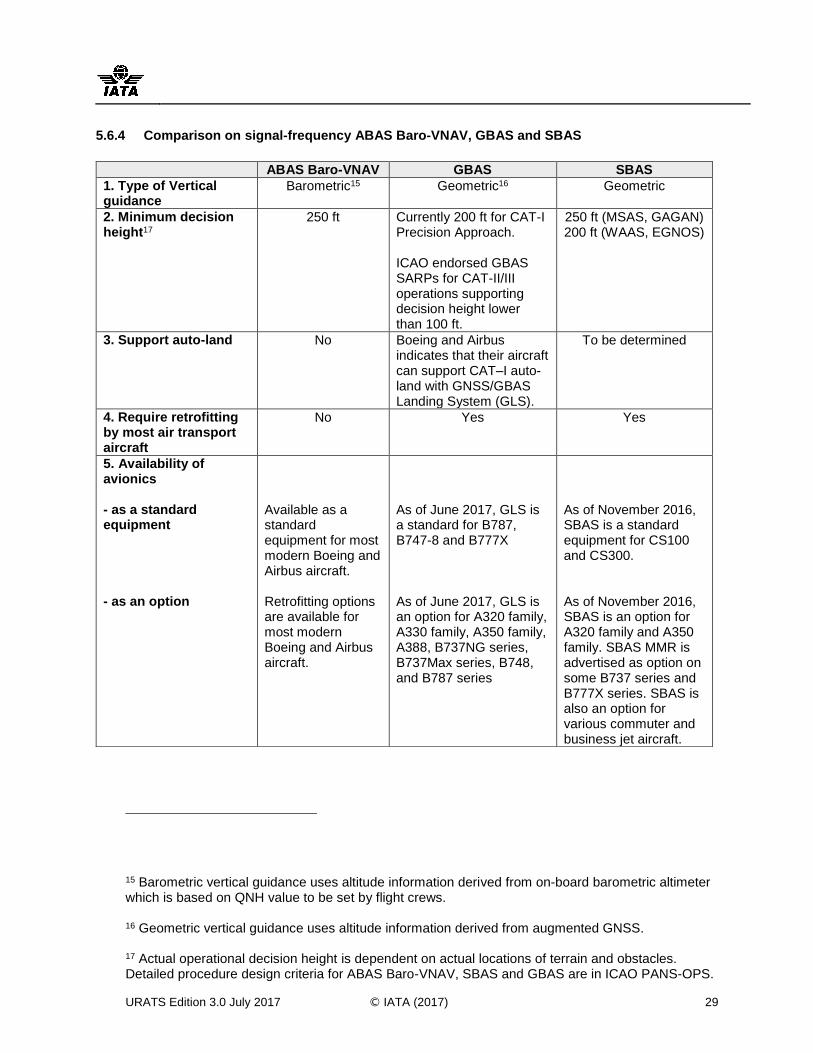
URATS Edition 3.0 July 2017 © IATA (2017) 29
5.6.4 Comparison on signal-frequency ABAS Baro-VNAV, GBAS and SBAS
15 Barometric vertical guidance uses altitude information derived from on-board barometric altimeter which is based on QNH value to be set by flight crews.
16 Geometric vertical guidance uses altitude information derived from augmented GNSS. 17 Actual operational decision height is dependent on actual locations of terrain and obstacles. Detailed procedure design criteria for ABAS Baro-VNAV, SBAS and GBAS are in ICAO PANS-OPS.
ABAS Baro-VNAV GBAS SBAS
1. Type of Vertical guidance
Barometric15
Geometric16
Geometric
2. Minimum decision height17
250 ft Currently 200 ft for CAT-I Precision Approach. ICAO endorsed GBAS SARPs for CAT-II/III operations supporting decision height lower than 100 ft.
250 ft (MSAS, GAGAN) 200 ft (WAAS, EGNOS)
3. Support auto-land No Boeing and Airbus indicates that their aircraft can support CAT–I auto-land with GNSS/GBAS Landing System (GLS).
To be determined
4. Require retrofitting by most air transport aircraft
No Yes Yes
5. Availability of avionics - as a standard equipment - as an option
Available as a standard equipment for most modern Boeing and Airbus aircraft. Retrofitting options are available for most modern Boeing and Airbus aircraft.
As of June 2017, GLS is a standard for B787, B747-8 and B777X As of June 2017, GLS is an option for A320 family, A330 family, A350 family, A388, B737NG series, B737Max series, B748, and B787 series
As of November 2016, SBAS is a standard equipment for CS100 and CS300. As of November 2016, SBAS is an option for A320 family and A350 family. SBAS MMR is advertised as option on some B737 series and B777X series. SBAS is also an option for various commuter and business jet aircraft.
APENDICE A / APPENDIX A SAM/IG/21-NE/22-WP/22
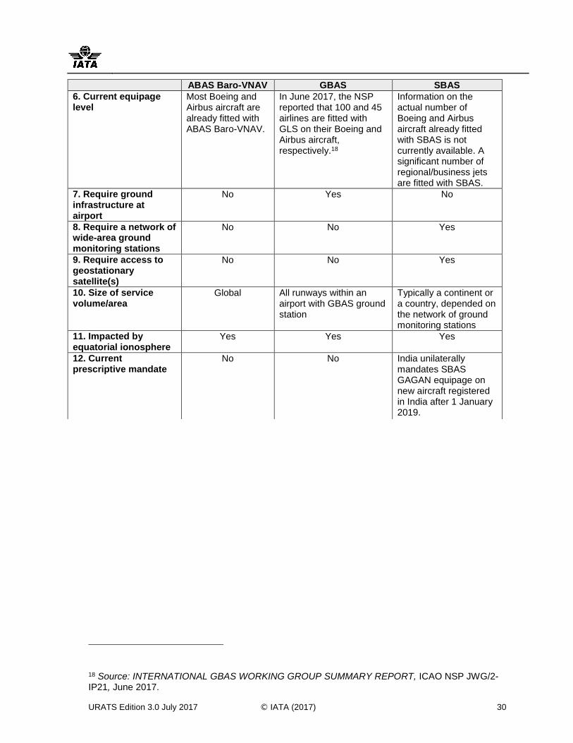
URATS Edition 3.0 July 2017 © IATA (2017) 30
18 Source: INTERNATIONAL GBAS WORKING GROUP SUMMARY REPORT, ICAO NSP JWG/2-IP21, June 2017.
ABAS Baro-VNAV GBAS SBAS
6. Current equipage level
Most Boeing and Airbus aircraft are already fitted with ABAS Baro-VNAV.
In June 2017, the NSP reported that 100 and 45 airlines are fitted with GLS on their Boeing and Airbus aircraft, respectively.18
Information on the actual number of Boeing and Airbus aircraft already fitted with SBAS is not currently available. A significant number of regional/business jets are fitted with SBAS.
7. Require ground infrastructure at airport
No Yes No
8. Require a network of wide-area ground monitoring stations
No No Yes
9. Require access to geostationary satellite(s)
No No Yes
10. Size of service volume/area
Global All runways within an airport with GBAS ground station
Typically a continent or a country, depended on the network of ground monitoring stations
11. Impacted by equatorial ionosphere
Yes Yes Yes
12. Current prescriptive mandate
No No India unilaterally mandates SBAS GAGAN equipage on new aircraft registered in India after 1 January 2019.
APENDICE A / APPENDIX A SAM/IG/21-NE/22-WP/22
URATS Edition 3.0 July 2017 © IATA (2017) 31
5.7 Next Generation Dual-frequency, Multi-constellation (DFMC) GNSS
Next generation GNSS receivers will include dual-frequency, multi-constellation (DFMC) capabilities that will increase accuracy and reliability of aircraft navigation. The dual-frequency capability will allow the aircraft receiver to significantly reduce ionospheric error, the largest error source of GNSS. Being GPS SA-Aware, the receiver will also take into account that GPS selective availability (SA) was turned off. These capabilities will enable higher accuracy for GNSS navigation globally.
Additionally, the dual-frequency capability will increase the reliability of GNSS services through enhancing the system’s robustness from harmful radio interferences. This enhanced robustness will be further improved by the use of the multi-constellation capability, in which navigation signals from multiple GNSS constellations can be concurrently used. Under the growing threats of jamming to any specific GNSS constellation, the DFMC GNSS capability should enhance the service availability and operational continuity of overall GNSS navigation as it reduces dependency to a constellation.
a) Related International and National Policies
The ICAO 12th Air Navigation Conference (ANC) in 2012 fully supported the DFMC GNSS concept and urged ICAO Member States to take advantage of the improved robustness and availability made possible by the existence of multiple global navigation satellite system constellations and associated augmentation systems. The Conference also urged States to adopt a performance-based approach with regard to the use of global GNSS, and avoid prohibiting the use of GNSS elements that are compliant with applicable ICAO SARPs and carefully consider and assess if mandates for equipage or use of any particular GNSS core constellation or augmentation system are necessary or appropriate. Additionally, the Conference urged aircraft operators to consider equipage with GNSS receivers able to process more than one constellation in order to gain the benefits associated with the support of more demanding operations.
Additionally, the development of the multi-constellation GNSS concept was highlighted in the US President’s national space policy of 2010 in which the US will continue to promote the global use of GPS by maintaining the GPS constellation consistent with published performance standards and interface specifications and allowing foreign positioning, navigation and timing services to be used to augment and strengthen the resiliency of GPS.
To support interoperability among different GNSS constellations, in June 2016, Federal Air Transport Agency of Russia published information on the Russian AIP noting that the coordinate systems PZ-90.11, PZ-90.02 and WGS-84 are regarded as fully identical in terms of air navigation for publication in aeronautical information documents. Moreover, the Russian Federation guarantees funding of the Russian GLONASS Program from the federal budget.
b) Current Deployments
Currently, the U.S. GPS is the primary GNSS constellation used by airlines. As of June 2017, the GPS Directorate is preparing a new GPS SPS Performance Standard to provide information on the modernized GPS signals and reflect overall improvements in the performance of the GPS constellation, including GPS L5. A recent satellite launch in 2016 brought the total number of healthy GPS satellites to 31 and the number of L5 capable vehicles to twelve. GPS Directorate schedule estimates predict that there will be 24 L5 capable GPS satellites by the end of 2024.
The Russian GLONASS is operational and is in compliance with relevant ICAO SARPs. As of May 2017, the GLONASS constellation consisted of 24 operational satellites. The initial service declaration for European Galileo has formally taken place in December 2016. The Chinese BeiDou is being deployed and standardized through ICAO. As of April 2016, there are more than 80 GNSS satellites in orbits broadcasting and supporting navigation and timing services. Non-aviation DFMC GNSS receivers are currently available for purchase and some modern aircraft avionics are already utilizing hardware which contains DFMC GNSS capability.
APENDICE A / APPENDIX A SAM/IG/21-NE/22-WP/22
URATS Edition 3.0 July 2017 © IATA (2017) 32
c) Progress on Standardization and Concept of Operations
The ICAO Concept of Operations (version 4.1) for DFMC GNSS has been reviewed by ICAO Air Navigation Commission and is being circulated for public consultation. Necessary international policies, global regulatory framework and appropriate technical solutions and operational procedures are being developed to accommodate the global, concurrent use of multiple satellite constellations and augmentation systems - even in the case that different States may decide to approve various GNSS elements at different time. Under this activity, the use of DFMC capability to enhance GBAS and SBAS is also being considered.
In parallel, RTCA SC-159 is now developing a Minimal Operational Performance Standard (MOPS) for DFMC GNSS avionics. RTCA MOPS for GPS/GLONASS L1-only is approved by RTCA Program Management Committee in 2017. RTCA MOPS for new airborne GNSS dual-frequency antenna is expected by December 2017. RTCA MOPS for L1/L5 SBAS is expected by 2022 and RTCA MOPS for L1/L5 GBAS by 2023. Additionally, EUROCAE WG-62 is also developing EUROCAE MOPS for GPS/GALILEO L1/L5 with SBAS with a target date of 2020.
d) DFMC GNSS Avionics
Starting in 2017, some modern aircraft GNSS avionics may include hardware capable for DFMC GNSS. Major aircraft manufacturers have estimated that next generation multimode receivers that can support geometric vertical guidance, ABAS, SBAS, GBAS and DFMC GNSS will be available by 2025. Widespread flight operations utilizing DFMC GNSS will follow.
The eventual equipment and operating costs for DFMC GNSS avionics, in conjunction with incremental operational benefits enabled by DFMC GNSS, will influence the airlines’ adoption and use of this technology. Airline operators and aircraft / avionics manufacturers are invited to monitor the progress of DFMC GNSS and to evaluate its costs / benefits when planning for forward-fittings.
e) Expectations
DFMC GNSS is considered to eventually become the navigation infrastructure supporting current and future PBN operations. Overall system robustness and redundancy from DFMC GNSS are expected to lessen the need to maintain a significant number of ground-based conventional navigation infrastructure and should improve the overall operational continuity for airlines who choose to adopt the technology. Airbus expected that DFMC GNSS will increase the robustness of GBAS CAT II/III and will support the extension of SBAS APV I and LPV 200 services areas, particularly in equatorial regions, and may support lower SBAS minima and SBAS CAT I auto-land.
To maximize the potential of DFMC GNSS, all constellations providing services in compliance with ICAO Annex 10 requirements should be authorized for operational usages in all States. Satellite service providers need to ensure technical interoperability among constellations and augmentation systems – thus allowing users to reap the benefits with a single receiver unit. Regulatory and liability issues need to be resolved globally and should not require a cost-prohibitive technical solution, complicate operational procedures or an increase in pilot workload. Further technical and operational researches to demonstrate the incremental benefits of DFMC GNSS are encouraged.
APENDICE A / APPENDIX A SAM/IG/21-NE/22-WP/22
URATS Edition 3.0 July 2017 © IATA (2017) 33
IATA Position on DFMC GNSS: Technical development of DFMC GNSS should enhance overall capability of GNSS-based navigation through increasing the system robustness and reducing operational reliance on any single constellation. Before the full adoption of this new technology, operational benefits of DFMC GNSS should be demonstrated and every relevant regulatory aspects should be properly addressed. Further technical and operational researches to substantiate the incremental benefits of DFMC GNSS are encouraged.
Discourage any attempt to discriminate against the use of any GNSS constellations that meet ICAO requirements for navigation. Providing that required navigational performance can be met, airlines should be allowed to navigate using all available on-board capability, rather than to be limited to any particular GNSS constellation or augmentation system.
Operational and technical requirements for the use of DFMC GNSS should be performance-based under a PBN framework. States should refrain from issuing any unilateral, prescriptive mandate to airlines to use or equip with any specific GNSS constellation or augmentation.
APENDICE A / APPENDIX A SAM/IG/21-NE/22-WP/22
URATS Edition 3.0 July 2017 © IATA (2017) 34
6 SURVEILLANCE
6.1 Introduction
According to ICAO Aeronautical Surveillance Manual Doc 9924, an aeronautical surveillance system provides the aircraft position and other related information to ATM and/or airborne users. In most cases, an aeronautical surveillance system provides its user with knowledge of “who” is, “where” and “when.” Other information provided by an aeronautical surveillance system may include horizontal and vertical speed data, identifying characteristics or intent. The required data and its technical performance parameters are specific to the application that is being used. As a minimum, the aeronautical surveillance system provides position information on aircraft or vehicles at a known time.
Aeronautical surveillance systems may include voice or automated position reporting, primary and secondary radar systems and advanced ATS surveillance systems that receive multiple types of data from aircraft. The more reliably, frequently and accurately ATC can be apprised of an aircraft’s position, the smaller the separation standard among aircraft can be applied. In order to be provided with surveillance-based separations, such as 3-NM or 5-NM, uninterruptible and accurate surveillance needs to be provided. This can be achieved though having either a highly reliable single layer of surveillance sensors or multiple-layers forming a single highly reliable service. Significant unnecessary overlap of redundant sensors or systems is discouraged.
ATS surveillance systems can be classified in three categories, depending on how the aircraft signals are received and processed by the ground sensors;
Independent Non-Cooperative Surveillance: The aircraft position is derived from measurement not using the cooperation of the aircraft. An example is a Primary Surveillance Radar (PSR).
Independent Cooperative Surveillance: The position is derived from measurements performed by a local surveillance subsystem using cooperative aircraft transmissions. The Secondary Surveillance Radar (SSR) is an example of this category.
Dependent Cooperative Surveillance: Dependent Cooperative Surveillance derives the aircraft position using subsystem on board the aircraft and the aircraft position is then provided to the local surveillance subsystem, possibly along with additional data. Automatic Dependent Surveillance – Broadcast (ADS-B) is an example of this category.
Independent or Dependent refers to how the aircraft position is measured; if it is from the ground it is Independent, or if the aircraft position is determined on-board then it is Dependent.
Cooperative or Non-Cooperative Surveillance refers to the requirement of aircraft equipment; if required, then it is Cooperative, if the surveillance does not require aircraft equipment then it is Non-Cooperative.
Technologies and procedures used for aeronautical surveillance are varied. Those that are currently employed include:
Procedural Position Reports;
Primary Surveillance Radar (PSR);
Secondary Surveillance Radar (SSR) – Mode A, Mode C and Mode S;
Multilateration (MLAT);
Precision Approach Radar (PAR);
Automatic Dependent Surveillance – Contract (ADS-C);
Automatic Dependent Surveillance – Broadcast (ADS-B).
APENDICE A / APPENDIX A SAM/IG/21-NE/22-WP/22
URATS Edition 3.0 July 2017 © IATA (2017) 35
ANSPs traditionally base aircraft surveillance on radar in high traffic airspace and voice or ADS-C position reports in remote and oceanic airspace. Where surveillance needs to be maintained or established, IATA views ADS-B as the preferred technology. Further details on surveillance technologies are provided in the following sections.
The use of Surveillance for ATM requires that complementary communications capability, that meets the Required Communications Performance (RCP) as required, be used to enable an operational benefit to airspace users. If surveillance-based separation services are not provided, there is no need for Surveillance for ATM.
6.2 Primary Surveillance Radar (PSR)
PSR is the only surveillance method that provides position information without any signal from the aircraft or information from the flight crew or aircraft systems. Primary radar surveillance operates by sending a signal and determining the azimuth and distance of an object from the radar site based on the direction the signal echo comes from and how long it takes to return. Primary radar systems require other systems or procedures to correlate the received “echoes” with specific flights.
The typical maximum detection range of dedicated terminal PSR systems is 60 NM. These terminal systems rely on a higher data refresh rate when using higher pulse repetition frequency (PRF) and higher antenna revolutions per minute (rpm). For most en-route PSR systems, the maximum detection range is 100 to 250 NM. These en-route PSR systems typically have lower PRF and slower rpm. For all PSR systems, the range and detection capability is subject to reflections and obstacles.
Continued use of PSR within terminal areas may assist detection and tracking of non-cooperative targets, including aircraft not equipped with SSR transponder or experiencing avionics failure.
Some ANSPs have justified PSR retention on its ability to detect thunderstorms. However, the PSR pulse has limited storm penetration and reflection and it may sometimes display rudimentary (or false) thunderstorm activity. Conversely, airborne radar systems provide accurate weather information to airlines and State meteorological services provide weather information derived from Doppler radar to ATC.
PSR remains the system of choice for the identification of unknown or unlawful airspace intrusions. This is a national security service and its infrastructure cost should be borne by the State’s national security budget and not by air navigation fees for civil aviation.
IATA Position on PSR: Do not support PSR deployment as a mean to surveil airborne civil aircraft. For this application, SSR, MLAT and ADS-B have vastly superseded this technology. Therefore, user charges associated with future upgrades or new PSR installations should be removed.
6.3 Secondary Radar Surveillance (SSR)
SSR operates by the radar site sending an interrogation signal which triggers aircraft transponders to send replying signals. Replies are used to calculate aircraft position and provide additional information such as identification and pressure-altitude reports. The “mode” of the aircraft transponder determines the information that is sent in response to the interrogation. Because they rely upon the ability to receive a signal transmitted from an aircraft, rather than a signal echoed off of an aircraft, Secondary Surveillance Radar (SSR) systems have a greater range than PSR systems, on the order of 250+ NM from the radar site.
APENDICE A / APPENDIX A SAM/IG/21-NE/22-WP/22
URATS Edition 3.0 July 2017 © IATA (2017) 36
Mode S (Selective Addressing) is now a commonly-employed SSR technique. Aircraft equipped with Mode S transponders are assigned a permanent and unique 24-bit ICAO address code. Mode S radars interrogate airframes selectively and receive individual replies. SSR Mode S improves the quality and integrity of the detection, identification and altitude reporting, overcoming some of the issues associated with Mode A/C, such as the 4096-code limitation, radio frequency (RF) pollution, and lost targets.
As compared to Mode A/C, aircraft compliant with Mode S Elementary Surveillance (ELS) provide additional automatic reporting on aircraft identity (e.g. call-sign), altitude (in 25ft intervals), transponder capability, flight status (airborne or on-the-ground) and Surveillance Identifier (SI) code.
Moreover, aircraft compliant with Mode S Enhanced Surveillance (EHS) provide the above ELS reporting functionalities plus some or all of the following downlinked aircraft parameters (DAPs):
Selected Altitude - the flight level which is manually entered in the Flight Management System (FMS) by the pilot.
Roll Angle, True Track Angle and Track Angle Rate - these parameters may be used to enhance the radar tracking capability and/or tactical trajectory prediction by ATC systems.
Ground Speed - calculated aircraft speed relative to the ground.
Magnetic Heading - the aircraft heading relative to magnetic north.
Indicated airspeed (IAS) and Mach-number - Making this information available to ATCs supports separation provision tasks, reduces the R/T and hence ATC workload.
Aircraft Vertical rate - barometric rate of climb / descent
Traffic Collision Avoidance System (TCAS) downlinked resolution advisories (RAs).
IATA Position on SSR: Support SSR Mode S over SSR Mode A/C where radar must be established or replaced. SSR Mode S improves the quality of surveillance and provides additional information compared to Mode A/C. ANSPs should make full use of their available Mode S capabilities, including information provided by DAPs.
6.4 Multilateration (MLAT)
MLAT is a cooperative aircraft surveillance technology based on the time difference of arrival principle. It is a technique where several ground receiving stations listen to signals transmitted from an aircraft; then the aircraft's location is mathematically calculated -- typically in two dimensions, with the aircraft providing its altitude. Aircraft position, altitude and other data are ultimately transmitted to an ATC automation system, both for terminal or en-route.
Wide Area Multilateration (WAM) is a term commonly used to describe the surveillance of en-route airspace, while the abbreviation MLAT tends to be employed when discussing the monitoring of terminal airspace and airport surface traffic.
MLAT global separation standards of 5 NM and 3 NM have been promulgated as being equivalent to radar. Depending upon the required number of sites and their locations, MLAT/WAM systems can cost considerably less than conventional radar to purchase, install, and maintain.
A limited number of ANSPs have deployed MLAT/WAM for ATM surveillance in combination with ADS-B or SSR to meet specific surveillance requirements. Some ANSPs are also deploying MLAT as a Precision Runway Monitor (PRM) sensor and for surveillance of airport ground movements. Additional MLAT/WAM applications include ADS-B backup and RVSM height monitoring.
IATA Position on MLAT: Where there is a lack of ADS-B avionics equipage, MLAT can be an alternative mean to meet specific surveillance requirements, such as being a gap-filler of SSR coverages or supporting airport ground movement operations.
APENDICE A / APPENDIX A SAM/IG/21-NE/22-WP/22
URATS Edition 3.0 July 2017 © IATA (2017) 37
6.5 Precision Approach Radar (PAR)
PAR allows controllers to monitor the approach path of an aircraft and provide lateral and vertical guidance by issuing instructions to pilots. PAR is still used by military organizations but airline users no longer derive benefit from this technology.
IATA Position: Do not support PAR for civil aviation. There is no airline requirement for PAR. Any user charges associated with existing PAR installations should be eliminated.
6.6 Dependent Cooperative Surveillance
IATA views ADS-B based on the 1090 Extended Squitter (ES) data link as the most desirable form of surveillance. Surveillance based primarily on ADS-B should be used, whenever operationally feasible, as the next generation replacement to radar.
Technologies reviewed in this section include:
Automatic Dependent Surveillance Contract (ADS-C)
Automatic Dependent Surveillance Broadcast (ADS-B) OUT, including space-based
Automatic Dependent Surveillance Broadcast (ADS-B) IN
Traffic Information Service Broadcast (TIS-B)
6.6.1 Automatic Dependent Surveillance Contract (ADS-C)
ADS-C provides information on aircraft positions to ATC. ICAO Performance-based Communications and Surveillance (PBCS) Manual focuses on the use of CPDLC in combination of ADS-C. ADS-C allows ATC to specify the frequency of position reports and the events that will trigger a position report. ADS-C reports are sent without flight crew intervention. Reports are automatically generated based on an electronic contract established between the aircraft Flight Management System (FMS) and a ground-based ATC installation. An aircraft typically transmits its information every 32, 27 or 14 minutes (per ICAO PANS-ATM recommendation for 50-NM or 30-NM longitudinal separation minima), as determined by the FMS electronic contract with ATC units. The contracts could be based on a specified reporting rate, event, or on-demand. ADS-C also has the ability for ATC to specify that a report be sent if certain flight profile parameters are exceeded, thereby enabling the detection of altitude and route deviations. The ICAO Separation and Airspace Safety Panel (SASP) has started evaluating reductions of separation minima for ADS-C based on increasing reporting rates and the use of other ADS-C parameters such as Extended Projected Profile (EPP).
In most cases, the position source for ADS-C reports is GNSS. The information is displayed to ATC and can also be used by automated flight tracking and monitoring systems. ADS-C reports are sent from the aircraft to ATC via a VHF or satellite data link and include position, velocity, intent, and weather.
IATA Position on ADS-C: Support ADS-C based operation for oceanic and remote airspace. ADS-C contracts should be determined with an agreed service in consultation with airspace users, and reporting periods should be limited to what is required to enable the separation minimum being applied, in accordance with ICAO provisions.
APENDICE A / APPENDIX A SAM/IG/21-NE/22-WP/22
URATS Edition 3.0 July 2017 © IATA (2017) 38
6.6.2 Automatic Dependent Surveillance Broadcast OUT (ADS-B OUT)
ADS-B OUT is a surveillance technology by which an aircraft periodically and automatically broadcasts its state vector (horizontal and vertical position and velocity) and other aircraft data such as identification. The aircraft’s ADS-B transponder uses inputs from airborne navigation sensors, including GNSS receivers, as sources for information on the aircraft’s current position, accuracy and integrity performances. Ground stations receive ADS-B OUT position reports and display them on air traffic controllers’ screens. ADS-B OUT broadcasts may also be received, processed, and displayed by other aircraft in the vicinity that are equipped with ADS-B IN.
In air transport aircraft, ADS-B broadcast signals from Extended Squitter Mode S transponders. Rather than a ground system “requesting” an aircraft signal, on-board ADS-B transponders broadcast aircraft parameters, such as identification (24-bit address and flight identification as per the flight plan), position (latitude, longitude and pressure altitude), 3-D velocity and position integrity, via a broadcast-mode data link. Aircraft identification information is broadcast every 5 seconds while aircraft position and velocity data is typically broadcast twice per second.
The flight identification included in the ADS-B signal is set per flight, making it susceptible to input errors. In general, however, there is higher reliability in positive identification if both the aircraft address and the flight identification match the flight record held by ATC. As with SSR, automated correlation of ADS-B messages with flight records relies upon ATC having supporting equipment and the ability for adjacent ANSPs to exchange detailed flight data.
Various States and Regions have implemented ADS-B aircraft equipage and performance mandates. If the mandates are necessary and justified, they should be harmonized and synchronized. Unfortunately, we see today divergence between the FAA mandates and the rest of the world including Europe’s ADS-B mandates. For all operations in the US national airspace, including enroute and international overfly, the FAA requires ADS-B performance to meet more stringent performance requirements than those suggested by ICAO Circular 326 and being implemented elsewhere. While the FAA mandate is non-prescriptive and based on a set of performance requirements, it is noteworthy that the FAA requirements were selected as “one size fits all” and were based on 2.5 NM in-trail and closely-spaced parallel operations that may not be applicable to many airspace users.
For any specific operations, States and ANSPs are highly encouraged to follow the guidance in the ICAO Circular 326 and appropriate published ICAO provisions, while considering prescribing any performance requirement for ADS-B.
IATA Position on ADS-B-OUT: Support implementation of ADS-B OUT based on Mode S Extended Squitter (1090ES) data link. ADS-B should not be implemented as a redundant surveillance capability. Provided there is a positive business case, it should replace radar, or be used in non-radar airspace to improve ATS surveillance. Transition timelines need to be determined in consultation with airspace users.
Mandating ADS-B OUT avionics equipage should be considered only for the airspace where ADS-B is planned to eventually be the only surveillance capability. Once ADS-B ground stations become operational, ANSPs should, in consultation with airlines and airspace users, publicly and transparently establish a timeline to decommission other surveillance infrastructure.
Performance requirements for ADS-B OUT should be based purely on corresponding ATM safety and separation requirements of the airspace and be consistent with ICAO Circular 326. Requiring unnecessary high levels of system performances, including accuracy, integrity and system latency, without appropriate safety rationales cannot be supported.
APENDICE A / APPENDIX A SAM/IG/21-NE/22-WP/22
URATS Edition 3.0 July 2017 © IATA (2017) 39
6.6.3 Space-based Automatic Dependent Surveillance Broadcast (Space-based ADS-B)
At the current time, ATS surveillance systems rely mostly upon ground-based infrastructures, such as SSR and ADS-B ground stations. In 2018, the first space-based ADS-B service is expected to become operational. This service will enable global coverage, with a significant reduction in “line of sight” detection limitations. The planned service will rely upon satellite reception of ADS-B messages from certified aircraft transponders.
Space-based ADS-B OUT includes the reception by a network of satellites of the ADS-B messages broadcast from aircraft. The satellite network then relays the ADS-B data to its ground stations, which then forward the data to subscribing ATC/ATM facilities. Current deployment of Space-based ADS-B OUT supports ADS-B data broadcasting on the 1090 MHz frequency.
At the 2015 World Radio Conference (WRC-15), the frequency band centered at 1090 MHz from the aircraft to space (satellite constellation) was globally protected for Space-based ADS-B applications. This was an essential milestone for the service to be operational.
For reliable satellite reception of ADS-B messages, the messages should be transmitted from a top-mounted antenna on the aircraft. To comply with ACAS equipage requirements, an aircraft must have both a top mounted and bottom mounted antenna; however, there is no regulatory requirement to verify that signals are being correctly broadcast from the top mounted antenna.
Space-based ADS-B is considered a potential enabler for reduced separations initially within oceanic and remote airspace. Appropriate infrastructure for ATC-Pilot communication and suitable regulatory and performance frameworks for space-based ADS-B will likely be needed to fully complement its capability.
The ICAO Separation and Airspace Safety Panel (SASP) is now developing new reduced longitudinal and lateral separation standards, namely Advanced-Surveillance Enhanced Procedural Separation (ASEPS), to be supported by space-based ADS-B in combination with ADS-C, CPDLC and HF.
While considering using space-based ADS-B, ANSPs are encouraged to develop new Concepts of Operation (CONOPs) which will make full use of the potential benefits enabled by a global surveillance capability. This includes air traffic flow management, air traffic service provision, flexible routings (e.g. User Preferred Routings), trajectory management, ATS contingencies and infrastructure cost efficiency.
IATA Position on Space-based ADS-B: Support with the condition that ICAO develops associated technical and separation standards that result in cost-effective safety and operational benefit. Any new Concepts of Operation should be founded on measurable benefits.
6.6.4 Automatic Dependent Surveillance Broadcast (ADS-B) IN
ADS-B IN is a surveillance technology by which an aircraft is able to broadcast as well as receive, process, and display the information broadcasted by another ADS-B equipped aircraft. Such information is shown on a Cockpit Display of Traffic Information (CDTI).
Although information obtained through ADS-B IN improves cockpit situational awareness and provides the potential for further shared air and ground separation responsibility, much remains to be accomplished in terms of system certification, application validation, human factors considerations / roles, procedures, and regulatory policies. Additionally, retrofit of existing fleets implies a major avionics upgrade and will require a lead-time of approximately ten years.
APENDICE A / APPENDIX A SAM/IG/21-NE/22-WP/22
URATS Edition 3.0 July 2017 © IATA (2017) 40
IATA Position on ADS-B IN: IATA has not yet identified ADS-B IN services for which there exists a positive business or safety case. However, ADS-B IN could be considered in the future provided that;
A global agreement is reached on the avionics requirements and standards;
There is a harmonized and clear definition of roles, responsibilities, and liabilities of pilots and air traffic controllers;
A cost and benefit analysis is conducted that presents a positive business case for airlines and ATS providers.
6.6.5 Traffic Information Service - Broadcast (TIS-B)
TIS-B enables SSR (Mode S and Mode A/C) or ADS-B surveillance data from multiple link sources to be combined and uplinked to an aircraft equipped with ADS-B IN, increasing situational awareness in the cockpit by providing the data to the Cockpit Display of Traffic Information (CDTI).
For some airspace, TIS-B is designed to support mixed surveillance environment during the transition from radar to ADS-B surveillance or in a dual link ADS-B environment.
IATA Position on TIS-B: Do not support TIS-B as IATA has not yet identified cases for which there exists a positive business case for airlines to use TIS-B.
APENDICE A / APPENDIX A SAM/IG/21-NE/22-WP/22
URATS Edition 3.0 July 2017 © IATA (2017) 41
7 FREQUENCY SPECTRUM FOR CIVIL AVIATION
Performance of CNS/ATM systems are dependent upon the availability of radio frequency spectrum that can support the integrity and availability requirements associated with aeronautical safety of life systems. Additionally, safety criticality of CNS/ATM systems demands special measures to protect aviation use of radio frequencies from any harmful radio interference.
It was recognized by the ICAO Air Navigation Conferences that new radio frequency spectrum for CNS/ATM systems will be required in addition to the current aviation requirements. Global allocations of radio frequency spectrums, including that for aviation, are agreed by the 191 member States of the International Telecommunications Union (ITU) at World Radiocommunication Conferences (WRCs), which meet every 3-4 years. The resolutions resulting from these meetings become radio regulations and, once signed by States, have the status of international treaties.
Article 4.10 of the Radio Regulations states that ITU Member States recognize that the safety aspects of radionavigation and other safety services requires special measures to ensure their freedom from harmful interference. These factors must be taken into consideration in the allocation, assignment and use of frequencies for aeronautical systems.
In preparation for each WRC, IATA actively cooperates with ICAO in the development of a common aviation position to ensure that airlines’ requirements and opinions were properly considered and the issues of importance for current and future of the aviation industry are well addressed.
The aviation industry must remain constantly vigilant on on-going threats to aviation frequency spectrum. In addition to the technical and operational aspects, there are also financial and socio-political sides of frequency allocation of which airlines need to be mindful. Radio frequency spectrum is a very scarce resource with finite capacity for which competing demands, especially from non-aviation industry such as telecommunication, are constantly increasing.
IATA Position: Support the development of a common aviation position for ITU WRCs in coordination with ICAO. Encourage States, ANSPs, airlines and aviation stakeholders to support the position and to work jointly with IATA and ICAO in promoting it.
In line with Article 4.10 of the Radio Regulations, encourage States to continue the protections of aviation frequency spectrum from harmful radio interferences from both intentional and unintentional sources.
Prior to any frequency allocations, States should ensure that the allocations are comprehensively proven not to adversely impact the aviation industry and its frequency uses.
Encourage airlines and aviation stakeholders to report cases on harmful radio interferences to aviation frequency to their national frequency and aviation authorities, ICAO and IATA.
The threat of intentional jamming and harmful radio frequency interference to GNSS is a global concern. In accordance with ICAO ANC/12 recommendations, States and ICAO are strongly urged to urgently address this safety and security issue. Relevant mitigation measures is available in ICAO Doc 9849: GNSS Manual 2017 Edition.
APENDICE A / APPENDIX A SAM/IG/21-NE/22-WP/22
URATS Edition 3.0 July 2017 © IATA (2017) 42
8 CONCLUSIONS
An introduction of any new technology must be managed in a manner that enables stakeholders to develop a positive business case with an appropriate return on investment. IATA encourages ANSPs and States to adopt only those technologies which have valid business and operational cases as agreed in consultation with airlines and other airspace users.
There are many technological “solutions” for air traffic services. However, unless they conform to global standards and are justified by mutually agreed cost-effective benefits and implementation plans, such technologies are of limited value to international commercial aviation. For technologies that are being introduced, it is essential that each implementation undergo a thorough process demonstrating that it supports an agreed-upon operational concept in a cost effective manner.
8.1 Communication
Airlines support a coordinated migration to data link as the primary means of controller-pilot communication while continuing the provision of voice communications for tactical interventions and non-routine communications. Data Link standards, however, are being implemented under various ATM programs, which are not interoperable. This results in airlines having to carry multiple systems, with increased costs and delayed realization of operational benefits and efficiencies.
Airlines should be able to use current on-board equipage and have a return on their investment. Furthermore, the introduction of any new capability or operational improvement, should follow the principal of Most Capable Best Served for service priority.
8.2 Navigation
Despite ICAO General Assembly A37-11, we still see a slow progress in the implementation of vertically guided approaches based on Performance-based Navigation (PBN) concept. Airlines have invested heavily in modern on-board avionics, yet ground infrastructure and procedures are not keeping up. Today we still have a significant number of non-precision NDB approaches. The safety concern related to non-precision approaches can be readily improved by the introduction of GNSS-based RNP APCH procedures with Baro-VNAV which provide vertical guidance to pilots.
Airlines support a rapid implementation of GNSS as the primary means of navigation and the main enabler of PBN. States and ANSPs are encouraged to consult with airlines and airspace users to determine suitable coordinated transition strategy which includes progressive rationalization of unnecessary NDBs and VORs.
8.3 Surveillance
Any surveillance technology should be agreed upon collaboratively between the ANSP and airlines prior to being implemented. An operational improvement must be identified, and then an appropriate technology is chosen in consultation with the airlines based on a positive cost-benefit analysis. Unnecessary overlapping of surveillance coverage is discouraged. Particularly, any ADS-B implementation should not retain overlapping radars.
ADS-B is the next generation surveillance technology capable of replacing radar. Space-based ADS-B is a technology where ADS-B receivers are placed on satellites. If the satellites provide global coverage, then ADS-B surveillance can be provided globally. However, additional works, including developing complementary separation standards and communication infrastructure, are still needed to fully materialize the potential benefits of Space-based ADS-B.
Any inquiries on this document may be directed to [email protected].
APENDICE A / APPENDIX A SAM/IG/21-NE/22-WP/22
URATS Edition 3.0 July 2017 © IATA (2017) 43
9 Appendix A: Planning Checklist
PLANNING CHECKLIST FOR THE IMPLEMENTATION OF NEW CNS / ATM IMPROVEMENTS
Successful collaboration and cooperation between ANSPs and airlines are paramount for the sound development of air traffic management. Consultation and cooperation increase the mutual understanding, thereby improving efficiency and cost-effectiveness in the provision and operation of air navigation services with all the parties striving to move in the same direction.
The key purpose of consultation with airlines is to ensure that their needs are considered in the context of the ANSPs’ plans. Effective consultation will help all parties involved to;
1) Prioritize investments and to ensure that adequate capacity and services will be provided to meet the demand of current and future users.
2) Support the strategic objectives of all partners in the aviation value chain.
3) Improve and support the national and regional aviation sector.
4) Enhance the understanding of capital expenditure (CAPEX) and operational expenditure (OPEX) plans to ensure cost effective solutions and projects are adopted.
Ensure interoperability through alignment with GANP/ASBUs and intra-regional harmonization of infrastructure and procedures.
In the following are some questions that ANSPs, States and international funding organizations need to answer with the airlines operating into/through the respective airspace when planning for the implementation of new CNS/ATM improvement;
1) What are the current and forecast requirements of airlines?
2) What are the benefits of this improvement/technology to airlines in terms of safety, operation and efficiency?
3) What is the timeline for realization of benefits and technology transition?
4) What is the life cycle of current technology and what is the appropriate replacement technology to ensure benefits appropriate to costs.
5) What are the system and infrastructure requirements as well as the policies and procedures necessary to enable full realization of technology benefits?
6) What is the cost to airlines in terms of increased air navigation and communication fees, on-board equipment, aircraft down time, training, maintenance, etc.?
7) When do these benefits recover the associated costs?
8) Does the technology meet existing international standards? If new standards are required, will they be ready within an appropriate timeframe?
9) Is the investment consistent with international planning, and does it contribute to seamlessness regional and global airline operations?
10) Does the technology represent the most effective use of resources?
11) Is the purchase consistent with an incremental approach to technology deployment that promises early benefits to airlines and a path to future benefits?
12) Are neighboring ANSPs and States willing to consider sharing common infrastructure projects in order to save costs and promote seamless operations?
APENDICE A / APPENDIX A SAM/IG/21-NE/22-WP/22
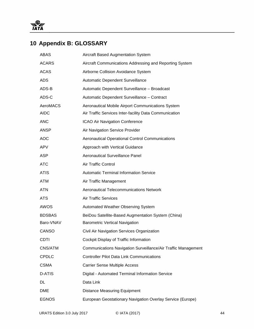
URATS Edition 3.0 July 2017 © IATA (2017) 44
10 Appendix B: GLOSSARY
ABAS Aircraft Based Augmentation System
ACARS Aircraft Communications Addressing and Reporting System
ACAS Airborne Collision Avoidance System
ADS Automatic Dependent Surveillance
ADS-B Automatic Dependent Surveillance – Broadcast
ADS-C Automatic Dependent Surveillance – Contract
AeroMACS
AIDC
Aeronautical Mobile Airport Communications System
Air Traffic Services Inter-facility Data Communication
ANC ICAO Air Navigation Conference
ANSP Air Navigation Service Provider
AOC Aeronautical Operational Control Communications
APV Approach with Vertical Guidance
ASP Aeronautical Surveillance Panel
ATC Air Traffic Control
ATIS Automatic Terminal Information Service
ATM Air Traffic Management
ATN Aeronautical Telecommunications Network
ATS Air Traffic Services
AWOS Automated Weather Observing System
BDSBAS
Baro-VNAV
BeiDou Satellite-Based Augmentation System (China)
Barometric Vertical Navigation
CANSO Civil Air Navigation Services Organization
CDTI Cockpit Display of Traffic Information
CNS/ATM Communications Navigation Surveillance/Air Traffic Management
CPDLC Controller Pilot Data Link Communications
CSMA Carrier Sense Multiple Access
D-ATIS Digital - Automated Terminal Information Service
DL Data Link
DME Distance Measuring Equipment
EGNOS European Geostationary Navigation Overlay Service (Europe)
APENDICE A / APPENDIX A SAM/IG/21-NE/22-WP/22
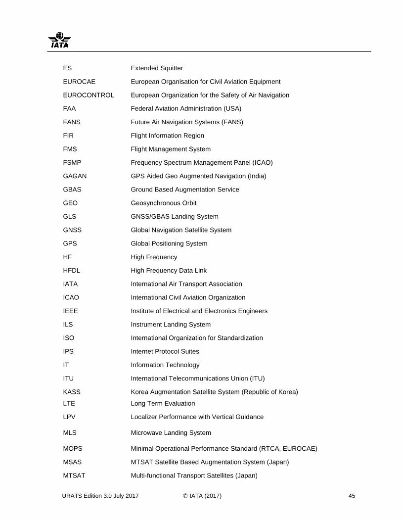
URATS Edition 3.0 July 2017 © IATA (2017) 45
ES Extended Squitter
EUROCAE European Organisation for Civil Aviation Equipment
EUROCONTROL European Organization for the Safety of Air Navigation
FAA Federal Aviation Administration (USA)
FANS Future Air Navigation Systems (FANS)
FIR Flight Information Region
FMS Flight Management System
FSMP Frequency Spectrum Management Panel (ICAO)
GAGAN GPS Aided Geo Augmented Navigation (India)
GBAS Ground Based Augmentation Service
GEO Geosynchronous Orbit
GLS GNSS/GBAS Landing System
GNSS Global Navigation Satellite System
GPS Global Positioning System
HF High Frequency
HFDL High Frequency Data Link
IATA International Air Transport Association
ICAO International Civil Aviation Organization
IEEE Institute of Electrical and Electronics Engineers
ILS Instrument Landing System
ISO International Organization for Standardization
IPS Internet Protocol Suites
IT Information Technology
ITU International Telecommunications Union (ITU)
KASS
LTE
Korea Augmentation Satellite System (Republic of Korea)
Long Term Evaluation
LPV Localizer Performance with Vertical Guidance
MLS Microwave Landing System
MOPS Minimal Operational Performance Standard (RTCA, EUROCAE)
MSAS MTSAT Satellite Based Augmentation System (Japan)
MTSAT Multi-functional Transport Satellites (Japan)
APENDICE A / APPENDIX A SAM/IG/21-NE/22-WP/22
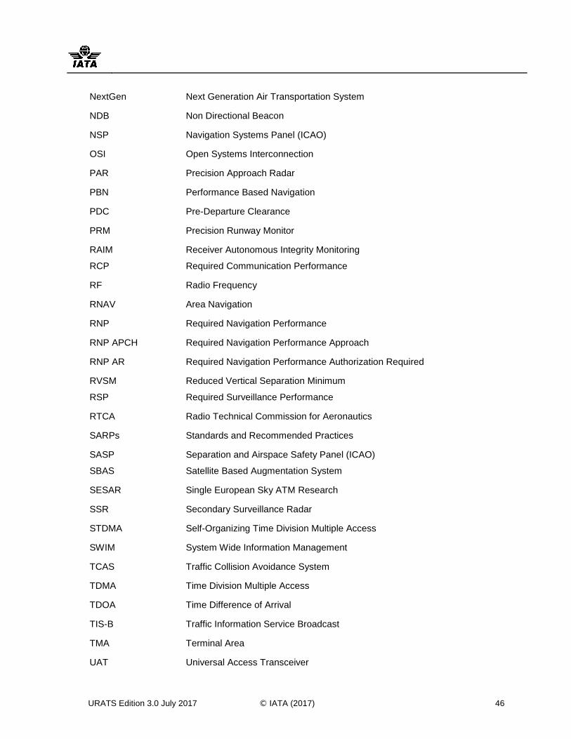
URATS Edition 3.0 July 2017 © IATA (2017) 46
NextGen Next Generation Air Transportation System
NDB Non Directional Beacon
NSP Navigation Systems Panel (ICAO)
OSI Open Systems Interconnection
PAR Precision Approach Radar
PBN Performance Based Navigation
PDC Pre-Departure Clearance
PRM Precision Runway Monitor
RAIM
RCP
Receiver Autonomous Integrity Monitoring
Required Communication Performance
RF Radio Frequency
RNAV Area Navigation
RNP Required Navigation Performance
RNP APCH Required Navigation Performance Approach
RNP AR Required Navigation Performance Authorization Required
RVSM
RSP
Reduced Vertical Separation Minimum
Required Surveillance Performance
RTCA Radio Technical Commission for Aeronautics
SARPs Standards and Recommended Practices
SASP
SBAS
Separation and Airspace Safety Panel (ICAO)
Satellite Based Augmentation System
SESAR Single European Sky ATM Research
SSR Secondary Surveillance Radar
STDMA Self-Organizing Time Division Multiple Access
SWIM System Wide Information Management
TCAS Traffic Collision Avoidance System
TDMA Time Division Multiple Access
TDOA Time Difference of Arrival
TIS-B Traffic Information Service Broadcast
TMA Terminal Area
UAT Universal Access Transceiver
APENDICE A / APPENDIX A SAM/IG/21-NE/22-WP/22
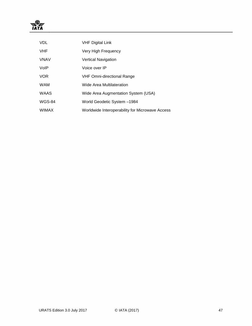
URATS Edition 3.0 July 2017 © IATA (2017) 47
VDL VHF Digital Link
VHF Very High Frequency
VNAV Vertical Navigation
VoIP Voice over IP
VOR VHF Omni-directional Range
WAM Wide Area Multilateration
WAAS Wide Area Augmentation System (USA)
WGS-84 World Geodetic System –1984
WIMAX Worldwide Interoperability for Microwave Access
APENDICE A / APPENDIX A SAM/IG/21-NE/22-WP/22

SAM/IG/21-NE/22-WP/22
APÉNDICE B / APPENDIX B
Airframe Equipage and Capability - The
Americas and North Atlantic
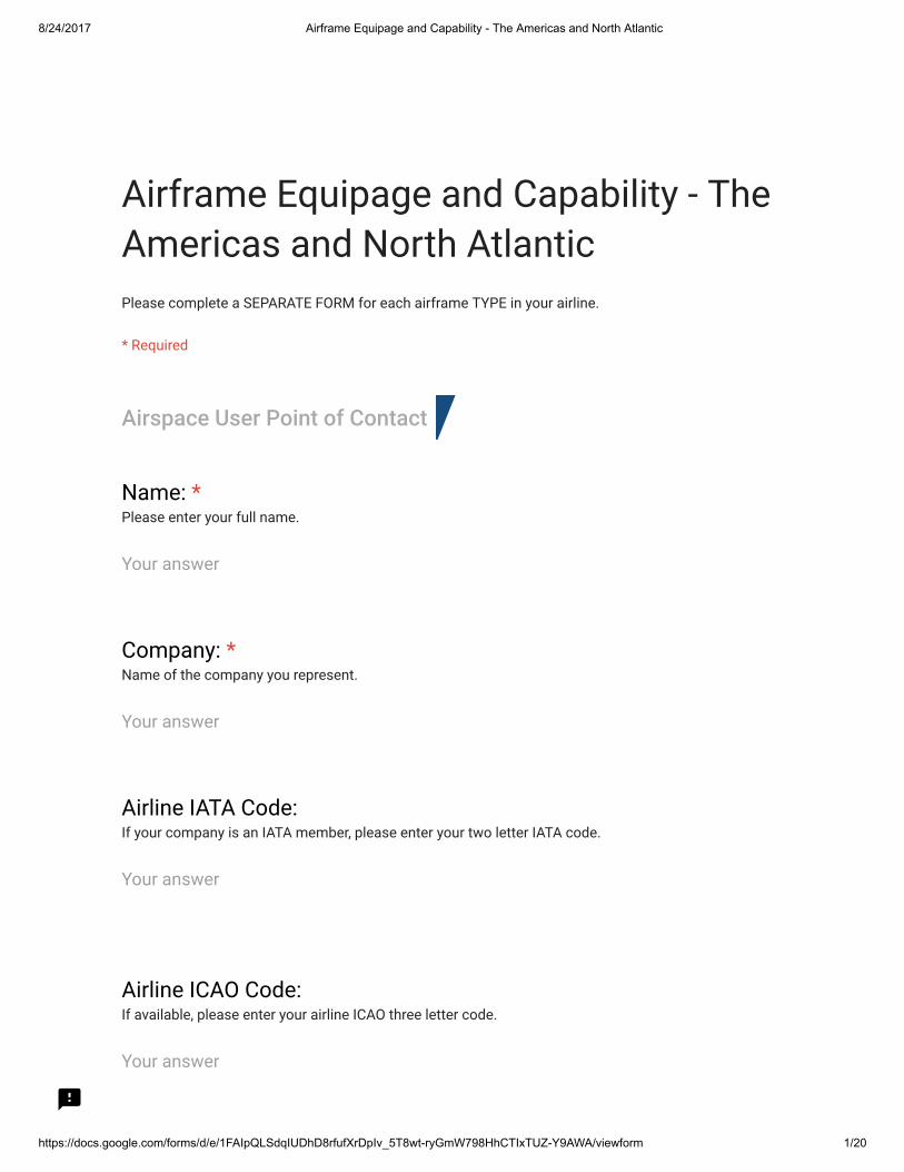
8/24/2017 Airframe Equipage and Capability - The Americas and North Atlantic
https://docs.google.com/forms/d/e/1FAIpQLSdqIUDhD8rfufXrDpIv_5T8wt-ryGmW798HhCTIxTUZ-Y9AWA/viewform 1/20
Airframe Equipage and Capability - TheAmericas and North AtlanticPlease complete a SEPARATE FORM for each airframe TYPE in your airline.
* Required
Airspace User Point of Contact
Name: *Please enter your full name.
Your answer
Company: *Name of the company you represent.
Your answer
Airline IATA Code:If your company is an IATA member, please enter your two letter IATA code.
Your answer
Airline ICAO Code:If available, please enter your airline ICAO three letter code.
Your answer

8/24/2017 Airframe Equipage and Capability - The Americas and North Atlantic
https://docs.google.com/forms/d/e/1FAIpQLSdqIUDhD8rfufXrDpIv_5T8wt-ryGmW798HhCTIxTUZ-Y9AWA/viewform 2/20
Company address - line 1:Please enter your company address - �rst line.
Your answer
Company address - line 2:Please enter your company address - second line.
Your answer
City:Please enter the city name or location where your company is based.
Your answer
State or Province:Please enter the State or Province where your company is based.
Your answer
Post Code / ZIP Code:Please enter your company HQ postal code / ZIP code.
Your answer
Country:Please enter the country where your company HQ is located.
Your answer
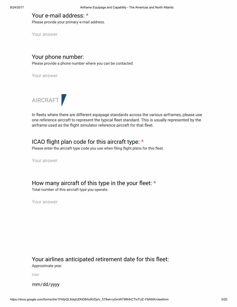
8/24/2017 Airframe Equipage and Capability - The Americas and North Atlantic
https://docs.google.com/forms/d/e/1FAIpQLSdqIUDhD8rfufXrDpIv_5T8wt-ryGmW798HhCTIxTUZ-Y9AWA/viewform 3/20
AIRCRAFT
In �eets where there are different equipage standards across the various airframes, please use one reference aircraft to represent the typical �eet standard. This is usually represented by the airframe used as the �ight simulator reference aircraft for that �eet.
Your e-mail address: *Please provide your primary e-mail address.
Your answer
Your phone number:Please provide a phone number where you can be contacted.
Your answer
ICAO �ight plan code for this aircraft type: *Please enter the aircraft type code you use when �ling �ight plans for this �eet.
Your answer
How many aircraft of this type in the your �eet: *Total number of this aircraft type you operate.
Your answer
Your airlines anticipated retirement date for this �eet:Approximate year.
Date
mm/dd/yyyy
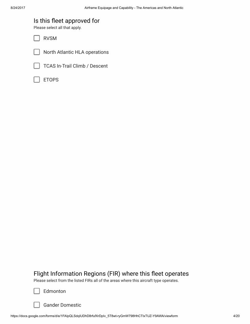
8/24/2017 Airframe Equipage and Capability - The Americas and North Atlantic
https://docs.google.com/forms/d/e/1FAIpQLSdqIUDhD8rfufXrDpIv_5T8wt-ryGmW798HhCTIxTUZ-Y9AWA/viewform 4/20
RVSM
North Atlantic HLA operations
TCAS In-Trail Climb / Descent
ETOPS
Edmonton
Gander Domestic
Is this �eet approved forPlease select all that apply.
Flight Information Regions (FIR) where this �eet operatesPlease select from the listed FIRs all of the areas where this aircraft type operates.

8/24/2017 Airframe Equipage and Capability - The Americas and North Atlantic
https://docs.google.com/forms/d/e/1FAIpQLSdqIUDhD8rfufXrDpIv_5T8wt-ryGmW798HhCTIxTUZ-Y9AWA/viewform 5/20
Moncton
Montreal
Toronto
Vancouver
Winnipeg
Albuquerque
Anchorage
Atlanta
Boston
Chicago
Cleveland
Denver
Forth Worth
Houston Domestic
Indianapolis
Jacksonville
Kansas City
Los Angeles
Memphis
Miami Domestic
Minneapolis
New York Domestic
8/24/2017 Airframe Equipage and Capability - The Americas and North Atlantic
https://docs.google.com/forms/d/e/1FAIpQLSdqIUDhD8rfufXrDpIv_5T8wt-ryGmW798HhCTIxTUZ-Y9AWA/viewform 6/20
Oakland Domestic
Salt Lake City
Seattle
Washington
Curaco
Habana
Kingston
Nassau
Piarco
Port Au Prince
San Juan
Santo Domingo
Central America
Mexico
Panama
Amazónica
Antofagasta
Asuncion
Barranquilla
Bogota
Brasilia
Comodoro Rivadavia

8/24/2017 Airframe Equipage and Capability - The Americas and North Atlantic
https://docs.google.com/forms/d/e/1FAIpQLSdqIUDhD8rfufXrDpIv_5T8wt-ryGmW798HhCTIxTUZ-Y9AWA/viewform 7/20
Comodoro Rivadavia
Cordoba
Curitiba
Ezeiza
Georgetown
Guayaquil
La Paz
Lima
Maiquetia
Mendoza
Montevideo
Paramaribo
Puerto Montt
Punta Arenas
Recife
Resistencia
Rochambeau
Santiago
Atlantico Oceanic
Bodo Oceanic
Gander Oceanic
Houston Oceanic
Mazatlan Oceanic
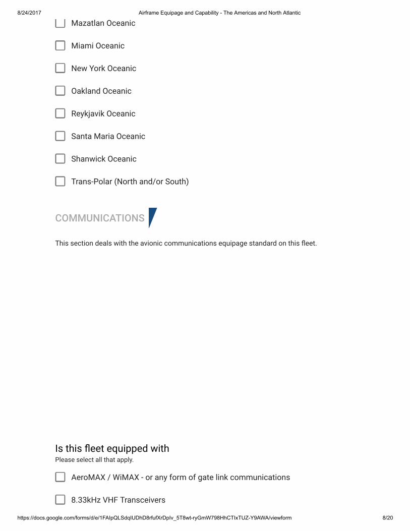
8/24/2017 Airframe Equipage and Capability - The Americas and North Atlantic
https://docs.google.com/forms/d/e/1FAIpQLSdqIUDhD8rfufXrDpIv_5T8wt-ryGmW798HhCTIxTUZ-Y9AWA/viewform 8/20
Mazatlan Oceanic
Miami Oceanic
New York Oceanic
Oakland Oceanic
Reykjavik Oceanic
Santa Maria Oceanic
Shanwick Oceanic
Trans-Polar (North and/or South)
COMMUNICATIONS
This section deals with the avionic communications equipage standard on this �eet.
AeroMAX / WiMAX - or any form of gate link communications
8.33kHz VHF Transceivers
Is this �eet equipped withPlease select all that apply.
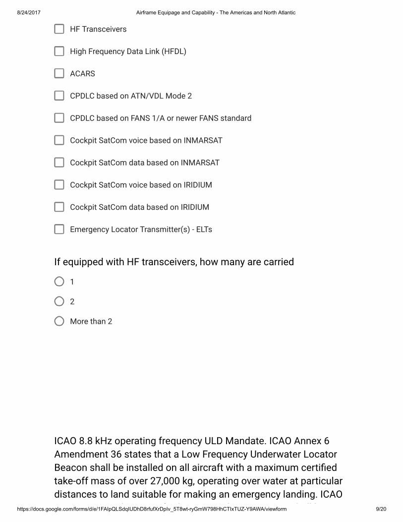
8/24/2017 Airframe Equipage and Capability - The Americas and North Atlantic
https://docs.google.com/forms/d/e/1FAIpQLSdqIUDhD8rfufXrDpIv_5T8wt-ryGmW798HhCTIxTUZ-Y9AWA/viewform 9/20
HF Transceivers
High Frequency Data Link (HFDL)
ACARS
CPDLC based on ATN/VDL Mode 2
CPDLC based on FANS 1/A or newer FANS standard
Cockpit SatCom voice based on INMARSAT
Cockpit SatCom data based on INMARSAT
Cockpit SatCom voice based on IRIDIUM
Cockpit SatCom data based on IRIDIUM
Emergency Locator Transmitter(s) - ELTs
1
2
More than 2
If equipped with HF transceivers, how many are carried
ICAO 8.8 kHz operating frequency ULD Mandate. ICAO Annex 6Amendment 36 states that a Low Frequency Underwater LocatorBeacon shall be installed on all aircraft with a maximum certi�edtake-off mass of over 27,000 kg, operating over water at particulardistances to land suitable for making an emergency landing. ICAOAnnex 6 Amendment 36 further states that an LF-ULB shall be
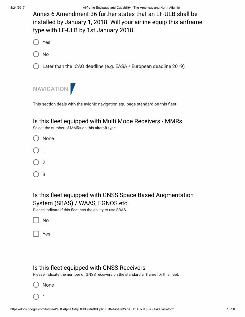
8/24/2017 Airframe Equipage and Capability - The Americas and North Atlantic
https://docs.google.com/forms/d/e/1FAIpQLSdqIUDhD8rfufXrDpIv_5T8wt-ryGmW798HhCTIxTUZ-Y9AWA/viewform 10/20
Yes
No
Later than the ICAO deadline (e.g. EASA / European deadline 2019)
NAVIGATION
This section deals with the avionic navigation equipage standard on this �eet.
None
1
2
3
No
Yes
None
1
Annex 6 Amendment 36 further states that an LF-ULB shall beinstalled by January 1, 2018. Will your airline equip this airframetype with LF-ULB by 1st January 2018
Is this �eet equipped with Multi Mode Receivers - MMRsSelect the number of MMRs on this aircraft type.
Is this �eet equipped with GNSS Space Based AugmentationSystem (SBAS) / WAAS, EGNOS etc.Please indicate if this �eet has the ability to use SBAS.
Is this �eet equipped with GNSS ReceiversPlease indicate the number of GNSS receivers on the standard airframe for this �eet.
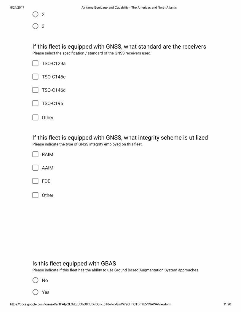
8/24/2017 Airframe Equipage and Capability - The Americas and North Atlantic
https://docs.google.com/forms/d/e/1FAIpQLSdqIUDhD8rfufXrDpIv_5T8wt-ryGmW798HhCTIxTUZ-Y9AWA/viewform 11/20
2
3
TSO-C129a
TSO-C145c
TSO-C146c
TSO-C196
Other:
RAIM
AAIM
FDE
Other:
No
Yes
If this �eet is equipped with GNSS, what standard are the receiversPlease select the speci�cation / standard of the GNSS receivers used.
If this �eet is equipped with GNSS, what integrity scheme is utilizedPlease indicate the type of GNSS integrity employed on this �eet.
Is this �eet equipped with GBASPlease indicate if this �eet has the ability to use Ground Based Augmentation System approaches.
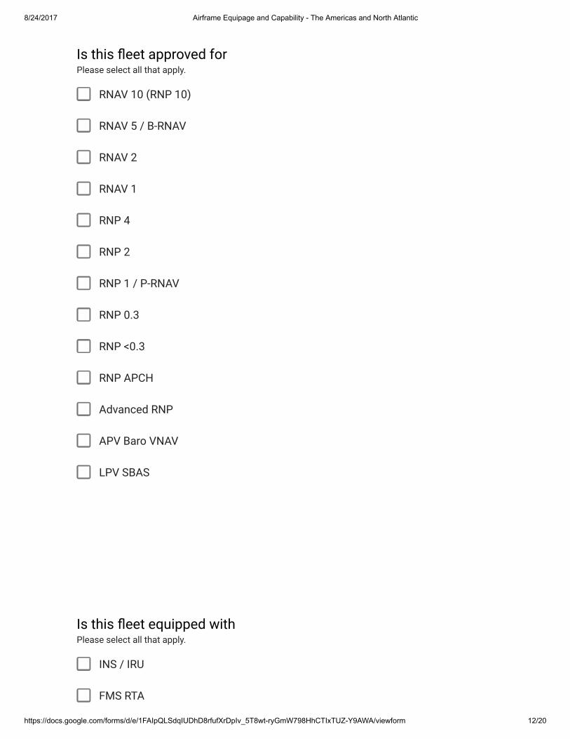
8/24/2017 Airframe Equipage and Capability - The Americas and North Atlantic
https://docs.google.com/forms/d/e/1FAIpQLSdqIUDhD8rfufXrDpIv_5T8wt-ryGmW798HhCTIxTUZ-Y9AWA/viewform 12/20
RNAV 10 (RNP 10)
RNAV 5 / B-RNAV
RNAV 2
RNAV 1
RNP 4
RNP 2
RNP 1 / P-RNAV
RNP 0.3
RNP <0.3
RNP APCH
Advanced RNP
APV Baro VNAV
LPV SBAS
INS / IRU
FMS RTA
Is this �eet approved forPlease select all that apply.
Is this �eet equipped withPlease select all that apply.
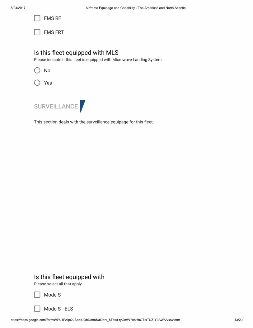
8/24/2017 Airframe Equipage and Capability - The Americas and North Atlantic
https://docs.google.com/forms/d/e/1FAIpQLSdqIUDhD8rfufXrDpIv_5T8wt-ryGmW798HhCTIxTUZ-Y9AWA/viewform 13/20
FMS RF
FMS FRT
No
Yes
SURVEILLANCE
This section deals with the surveillance equipage for this �eet.
Mode S
Mode S - ELS
Is this �eet equipped with MLSPlease indicate if this �eet is equipped with Microwave Landing System.
Is this �eet equipped withPlease select all that apply.
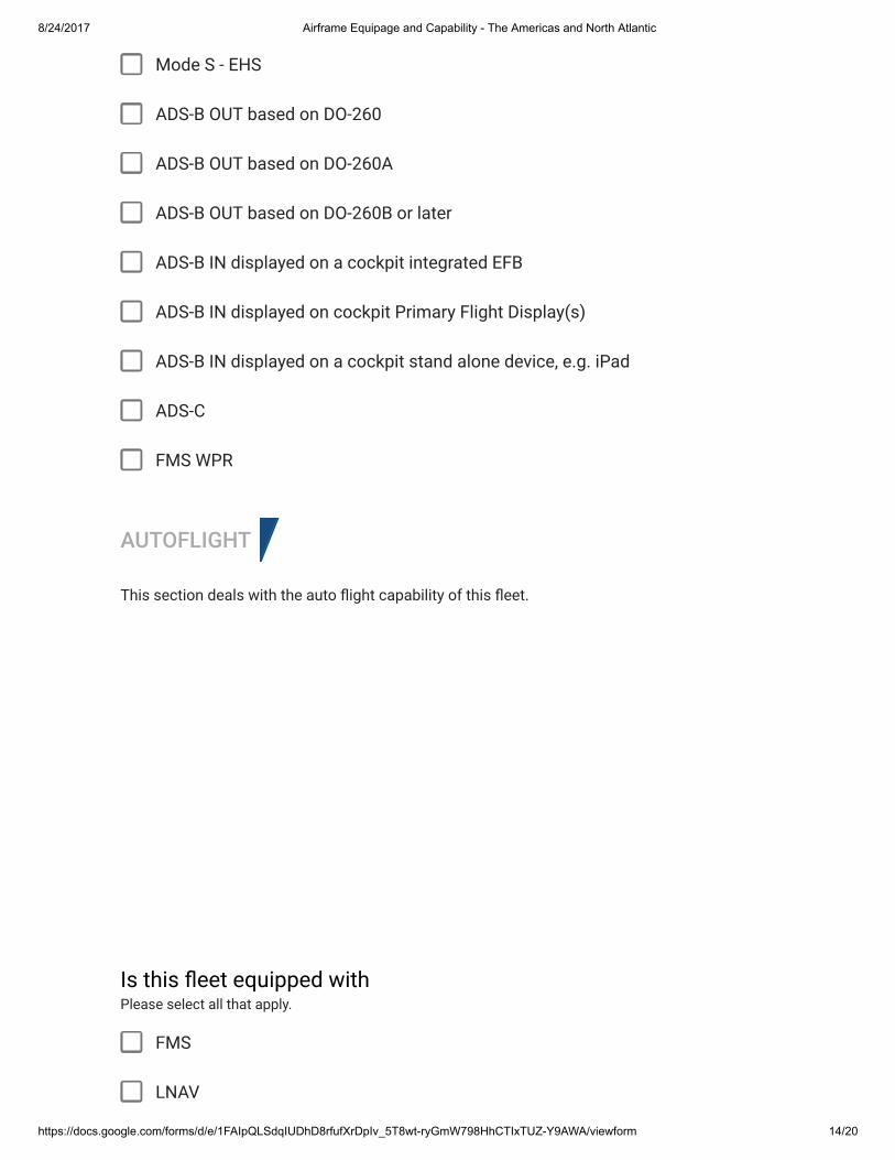
8/24/2017 Airframe Equipage and Capability - The Americas and North Atlantic
https://docs.google.com/forms/d/e/1FAIpQLSdqIUDhD8rfufXrDpIv_5T8wt-ryGmW798HhCTIxTUZ-Y9AWA/viewform 14/20
Mode S - EHS
ADS-B OUT based on DO-260
ADS-B OUT based on DO-260A
ADS-B OUT based on DO-260B or later
ADS-B IN displayed on a cockpit integrated EFB
ADS-B IN displayed on cockpit Primary Flight Display(s)
ADS-B IN displayed on a cockpit stand alone device, e.g. iPad
ADS-C
FMS WPR
AUTOFLIGHT
This section deals with the auto �ight capability of this �eet.
FMS
LNAV
Is this �eet equipped withPlease select all that apply.
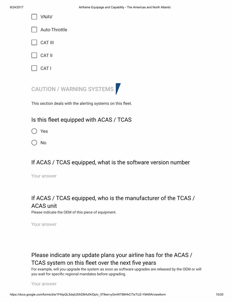
8/24/2017 Airframe Equipage and Capability - The Americas and North Atlantic
https://docs.google.com/forms/d/e/1FAIpQLSdqIUDhD8rfufXrDpIv_5T8wt-ryGmW798HhCTIxTUZ-Y9AWA/viewform 15/20
VNAV
Auto-Throttle
CAT III
CAT II
CAT I
CAUTION / WARNING SYSTEMS
This section deals with the alerting systems on this �eet.
Yes
No
Is this �eet equipped with ACAS / TCAS
If ACAS / TCAS equipped, what is the software version number
Your answer
If ACAS / TCAS equipped, who is the manufacturer of the TCAS /ACAS unitPlease indicate the OEM of this piece of equipment.
Your answer
Please indicate any update plans your airline has for the ACAS /TCAS system on this �eet over the next �ve yearsFor example, will you upgrade the system as soon as software upgrades are released by the OEM or willyou wait for speci�c regional mandates before upgrading.
Your answer
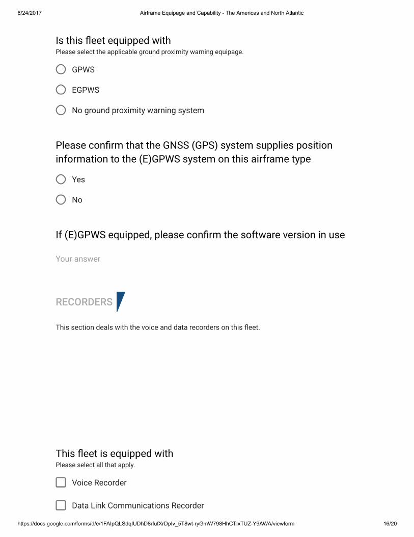
8/24/2017 Airframe Equipage and Capability - The Americas and North Atlantic
https://docs.google.com/forms/d/e/1FAIpQLSdqIUDhD8rfufXrDpIv_5T8wt-ryGmW798HhCTIxTUZ-Y9AWA/viewform 16/20
GPWS
EGPWS
No ground proximity warning system
Yes
No
RECORDERS
This section deals with the voice and data recorders on this �eet.
Voice Recorder
Data Link Communications Recorder
Is this �eet equipped withPlease select the applicable ground proximity warning equipage.
Please con�rm that the GNSS (GPS) system supplies positioninformation to the (E)GPWS system on this airframe type
If (E)GPWS equipped, please con�rm the software version in use
Your answer
This �eet is equipped withPlease select all that apply.
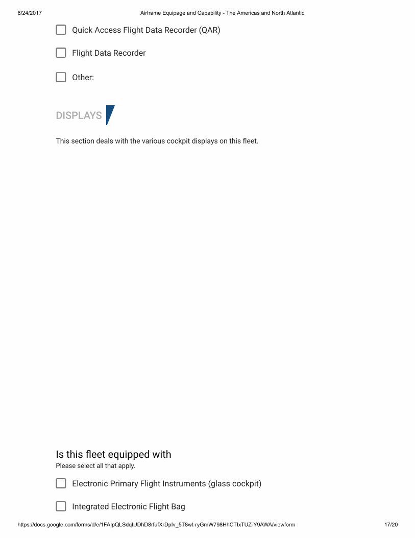
8/24/2017 Airframe Equipage and Capability - The Americas and North Atlantic
https://docs.google.com/forms/d/e/1FAIpQLSdqIUDhD8rfufXrDpIv_5T8wt-ryGmW798HhCTIxTUZ-Y9AWA/viewform 17/20
Quick Access Flight Data Recorder (QAR)
Flight Data Recorder
Other:
DISPLAYS
This section deals with the various cockpit displays on this �eet.
Electronic Primary Flight Instruments (glass cockpit)
Integrated Electronic Flight Bag
Is this �eet equipped withPlease select all that apply.
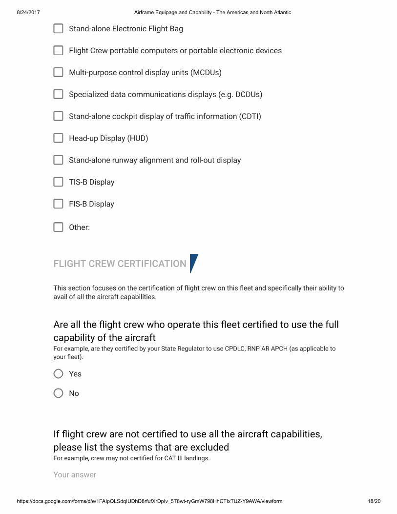
8/24/2017 Airframe Equipage and Capability - The Americas and North Atlantic
https://docs.google.com/forms/d/e/1FAIpQLSdqIUDhD8rfufXrDpIv_5T8wt-ryGmW798HhCTIxTUZ-Y9AWA/viewform 18/20
Stand-alone Electronic Flight Bag
Flight Crew portable computers or portable electronic devices
Multi-purpose control display units (MCDUs)
Specialized data communications displays (e.g. DCDUs)
Stand-alone cockpit display of tra�c information (CDTI)
Head-up Display (HUD)
Stand-alone runway alignment and roll-out display
TIS-B Display
FIS-B Display
Other:
FLIGHT CREW CERTIFICATION
This section focuses on the certi�cation of �ight crew on this �eet and speci�cally their ability to avail of all the aircraft capabilities.
Yes
No
Are all the �ight crew who operate this �eet certi�ed to use the fullcapability of the aircraftFor example, are they certi�ed by your State Regulator to use CPDLC, RNP AR APCH (as applicable toyour �eet).
If �ight crew are not certi�ed to use all the aircraft capabilities,please list the systems that are excludedFor example, crew may not certi�ed for CAT III landings.
Your answer
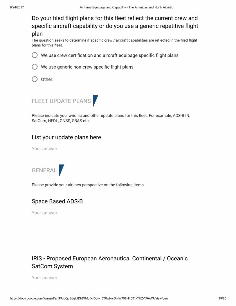
8/24/2017 Airframe Equipage and Capability - The Americas and North Atlantic
https://docs.google.com/forms/d/e/1FAIpQLSdqIUDhD8rfufXrDpIv_5T8wt-ryGmW798HhCTIxTUZ-Y9AWA/viewform 19/20
We use crew certi�cation and aircraft equipage speci�c �ight plans
We use generic non-crew speci�c �ight plans
Other:
FLEET UPDATE PLANS
Please indicate your avionic and other update plans for this �eet. For example, ADS-B IN, SatCom, HFDL, GNSS, SBAS etc.
GENERAL
Please provide your airlines perspective on the following items.
Do your �led �ight plans for this �eet re�ect the current crew andspeci�c aircraft capability or do you use a generic repetitive �ightplanThe question seeks to determine if speci�c crew / aircraft capabilities are re�ected in the �led �ightplans for this �eet.
List your update plans here
Your answer
Space Based ADS-B
Your answer
IRIS - Proposed European Aeronautical Continental / OceanicSatCom System
Your answer
AeroMAX - air�eld WiFi / Gate Link
8/24/2017 Airframe Equipage and Capability - The Americas and North Atlantic
https://docs.google.com/forms/d/e/1FAIpQLSdqIUDhD8rfufXrDpIv_5T8wt-ryGmW798HhCTIxTUZ-Y9AWA/viewform 20/20
Never submit passwords through Google Forms.
This content is neither created nor endorsed by Google. Report Abuse - Terms of Service - Additional Terms
AeroMAX - air�eld WiFi / Gate Link
Your answer
Use of Internet Protocol (IP) for AOC data communications
Your answer
ICAO Future Communications System - LDACS
Your answer
Cockpit Synthetic Vision Systems
Your answer
Any additional comments you wish to add...
Your answer
SUBMIT
Forms
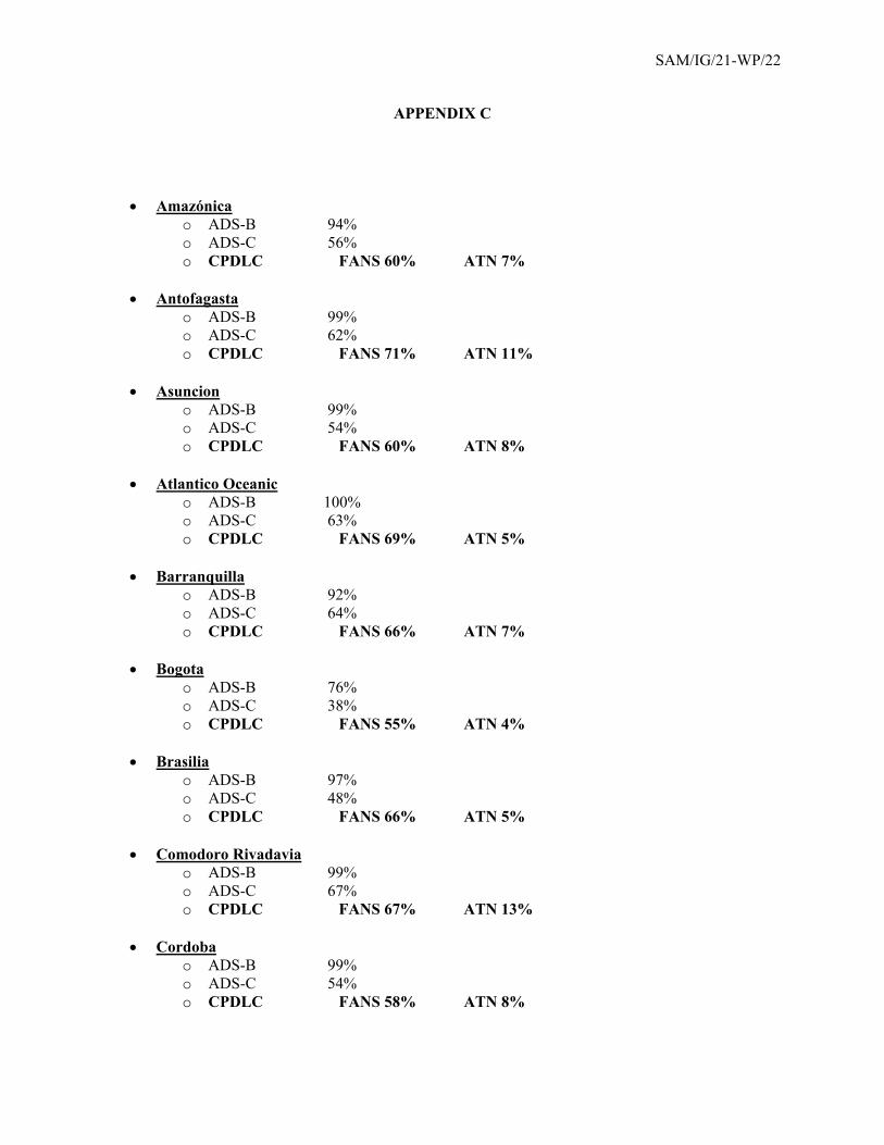
SAM/IG/21-WP/22
APPENDIX C
Amazónica
o ADS-B 94% o ADS-C 56% o CPDLC FANS 60% ATN 7%
Antofagasta
o ADS-B 99% o ADS-C 62% o CPDLC FANS 71% ATN 11%
Asuncion
o ADS-B 99% o ADS-C 54% o CPDLC FANS 60% ATN 8%
Atlantico Oceanic
o ADS-B 100% o ADS-C 63% o CPDLC FANS 69% ATN 5%
Barranquilla
o ADS-B 92% o ADS-C 64% o CPDLC FANS 66% ATN 7%
Bogota
o ADS-B 76% o ADS-C 38% o CPDLC FANS 55% ATN 4%
Brasilia
o ADS-B 97% o ADS-C 48% o CPDLC FANS 66% ATN 5%
Comodoro Rivadavia
o ADS-B 99% o ADS-C 67% o CPDLC FANS 67% ATN 13%
Cordoba
o ADS-B 99% o ADS-C 54% o CPDLC FANS 58% ATN 8%
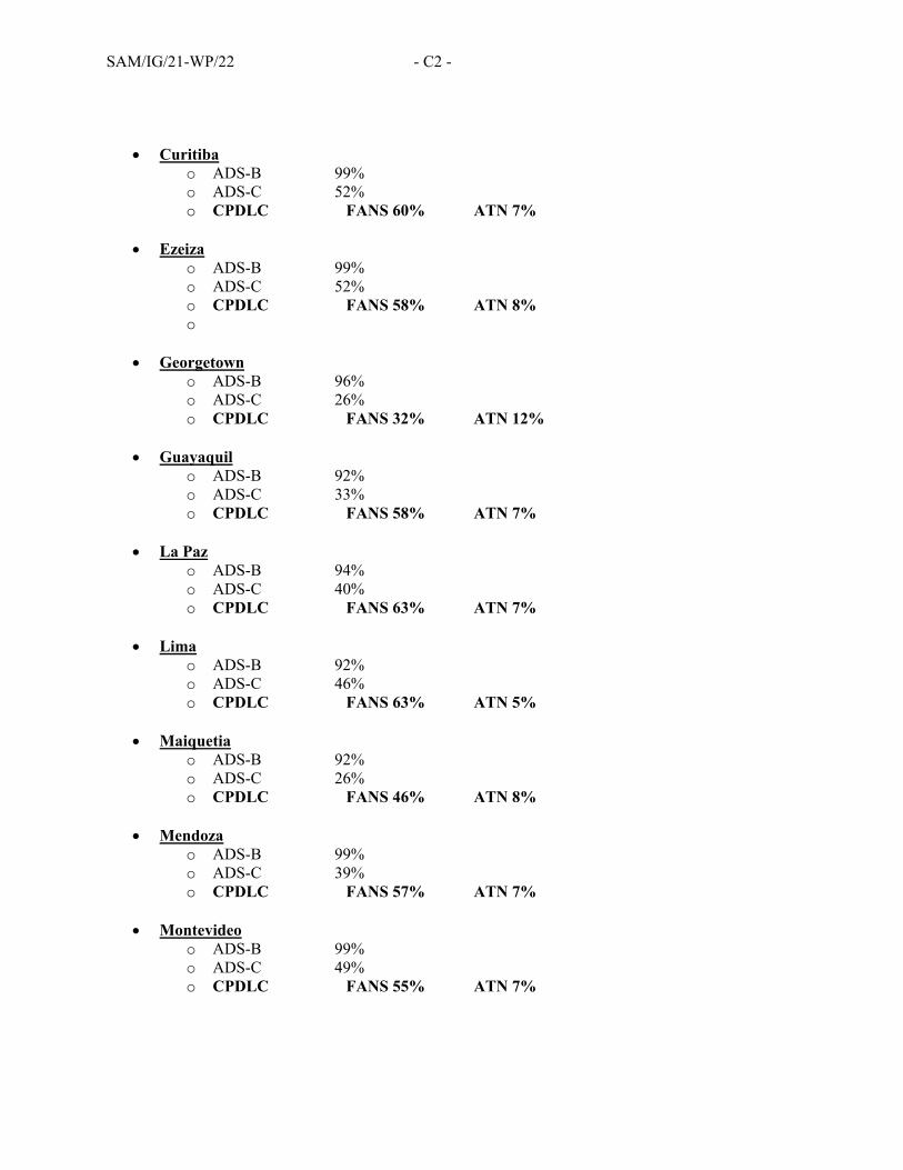
SAM/IG/21-WP/22 - C2 -
Curitiba o ADS-B 99% o ADS-C 52% o CPDLC FANS 60% ATN 7%
Ezeiza
o ADS-B 99% o ADS-C 52% o CPDLC FANS 58% ATN 8% o
Georgetown
o ADS-B 96% o ADS-C 26% o CPDLC FANS 32% ATN 12%
Guayaquil
o ADS-B 92% o ADS-C 33% o CPDLC FANS 58% ATN 7%
La Paz
o ADS-B 94% o ADS-C 40% o CPDLC FANS 63% ATN 7%
Lima
o ADS-B 92% o ADS-C 46% o CPDLC FANS 63% ATN 5%
Maiquetia
o ADS-B 92% o ADS-C 26% o CPDLC FANS 46% ATN 8%
Mendoza
o ADS-B 99% o ADS-C 39% o CPDLC FANS 57% ATN 7%
Montevideo
o ADS-B 99% o ADS-C 49% o CPDLC FANS 55% ATN 7%
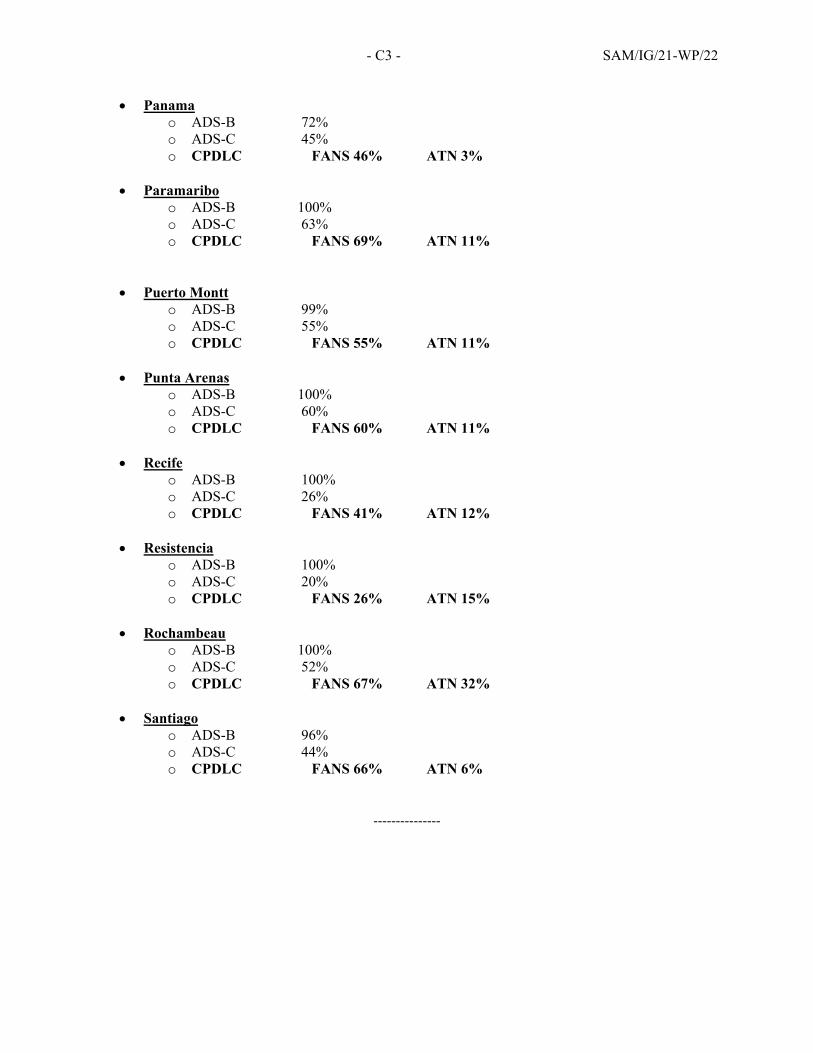
- C3 - SAM/IG/21-WP/22
Panama o ADS-B 72% o ADS-C 45% o CPDLC FANS 46% ATN 3%
Paramaribo
o ADS-B 100% o ADS-C 63% o CPDLC FANS 69% ATN 11%
Puerto Montt o ADS-B 99% o ADS-C 55% o CPDLC FANS 55% ATN 11%
Punta Arenas
o ADS-B 100% o ADS-C 60% o CPDLC FANS 60% ATN 11%
Recife
o ADS-B 100% o ADS-C 26% o CPDLC FANS 41% ATN 12%
Resistencia
o ADS-B 100% o ADS-C 20% o CPDLC FANS 26% ATN 15%
Rochambeau
o ADS-B 100% o ADS-C 52% o CPDLC FANS 67% ATN 32%
Santiago
o ADS-B 96% o ADS-C 44% o CPDLC FANS 66% ATN 6%
‐‐‐‐‐‐‐‐‐‐‐‐‐‐‐
Related Documents