NHESSD 2, C2642–C2668, 2014 Interactive Comment Full Screen / Esc Printer-friendly Version Interactive Discussion Discussion Paper Nat. Hazards Earth Syst. Sci. Discuss., 2, C2642–C2668, 2014 www.nat-hazards-earth-syst-sci-discuss.net/2/C2642/2014/ © Author(s) 2014. This work is distributed under the Creative Commons Attribute 3.0 License. Natural Hazards and Earth System Sciences Open Access Discussions Interactive comment on “Secondary lahar hazard assessment for Villa la Angostura, Argentina, using Two-Phase-Titan modelling code during 2011 Cordón Caulle eruption” by G. Córdoba et al. G. Córdoba et al. [email protected] Received and published: 3 December 2014 [nhess]copernicus [1]G. Córdoba [2]G.Villarosa [3]M. F. Sheridan [4]J. G. Viramonte [2]D. Beigt [5]G. Salmuni [1]Universidad de Nariño, Colombia [2]Universidad del Comahue, INIBIOMA, Bar- iloche, Argentina [3]SUNY University at Bufalo, USA [4]Universidad Nacional de Salta, INENCO-GEONORTE-UNSa-CONICET, Argentina [5]Comisión Nacional de Activi- dades Espaciales, CONAE C2642

Welcome message from author
This document is posted to help you gain knowledge. Please leave a comment to let me know what you think about it! Share it to your friends and learn new things together.
Transcript
NHESSD2, C2642–C2668, 2014
InteractiveComment
Full Screen / Esc
Printer-friendly Version
Interactive Discussion
Discussion Paper
Nat. Hazards Earth Syst. Sci. Discuss., 2, C2642–C2668, 2014www.nat-hazards-earth-syst-sci-discuss.net/2/C2642/2014/© Author(s) 2014. This work is distributed underthe Creative Commons Attribute 3.0 License.
Natural Hazards and Earth System
Sciences
Open A
ccess
Discussions
Interactive comment on “Secondary lahar hazardassessment for Villa la Angostura, Argentina,using Two-Phase-Titan modelling code during2011 Cordón Caulle eruption” by G. Córdoba et al.
G. Córdoba et al.
Received and published: 3 December 2014
[nhess]copernicus
[1]G. Córdoba [2]G.Villarosa [3]M. F. Sheridan [4]J. G. Viramonte [2]D. Beigt [5]G.Salmuni
[1]Universidad de Nariño, Colombia [2]Universidad del Comahue, INIBIOMA, Bar-iloche, Argentina [3]SUNY University at Bufalo, USA [4]Universidad Nacional de Salta,INENCO-GEONORTE-UNSa-CONICET, Argentina [5]Comisión Nacional de Activi-dades Espaciales, CONAE
C2642

NHESSD2, C2642–C2668, 2014
InteractiveComment
Full Screen / Esc
Printer-friendly Version
Interactive Discussion
Discussion Paper
Study of lahar hazards at Villa la Angostura
G. Córdoba et al.
Gustavo Córdoba ([email protected])
26421
C2643

NHESSD2, C2642–C2668, 2014
InteractiveComment
Full Screen / Esc
Printer-friendly Version
Interactive Discussion
Discussion Paper
Secondary lahar hazard assessment for Villa laAngostura, Argentina, using Two-Phase-Titan
modelling code during 2011 Cordón Caulle eruption
3 December 2014
Abstract
This paper presents the results of lahar modelling in the town of Villa La Angos-tura town (Neuquén-Argentina) based on the Two-Phase-Titan modelling computercode. The purpose of this exercise is to provide decision makers with a useful toolto assess lahar hazard during the 2011 Puyehue-Cordón Caulle Volcanic Complexeruption. Possible occurrence of lahars mobilized from recent ash falls that couldreach the city was analized. The performance of the Two-Phase-Titan model us-ing 15 m resolution DEMs developed from optical satellite images and from radarsatellite images was evaluated. The output of these modellings showed incon-sistencies that, based on field observations, were attributed to bad adjustment ofDEMs to real topography. Further testing of results using more accurate radarbased 10 m DEM, proved more realistic predictions. This procedure allowed usto simulate the path of flows from Florencia, Las Piedritas and Colorado creeks,which are the most hazarddous streams for debris flows in Villa La Angostura. Theoutput of the modelling is a valuable tool for city planning and risk management es-pecially considering the glacial geomorphic features of the region, the strong urban
C2644

NHESSD2, C2642–C2668, 2014
InteractiveComment
Full Screen / Esc
Printer-friendly Version
Interactive Discussion
Discussion Paper
development growth and the land occupation that occurred in last decade in VillaLa Angostura and its surroundings.
[Introduction] After decades of quiescence, the Cordon Caulle volcanic complex in theChilean Southern Andes began an eruptive process at 14.45 LT on 4 June 2011 (Elis-sondo et al., 2011) from the new vent named We Pillan ( New Crater in Mapuche lan-guage) (Collini et al., 2012). This vent is located in the Southern Volcanic Zone (SVZ)at 40.58 S and 72.13 W, and 2240 m a.m.s.l. (above mean sea level) (Lara and Moreno, 2006). The sub-plinian eruption produced a large plume of gases and ash particlesthat reached 12 km in height (Figure 4) which eventually circled the Southern Hemi-sphere disrupting air travel on several continents. As typically occurs in mid-latitudeCentral and South Andean eruptions (Villarosa et al., 2006; Folch et al., 2008; Colliniet al., 2012), the dominant regional winds directed the ash clouds over the Andes andcaused abundant ash fallout across the Argentinean provinces of Río Negro, Neuquénand Chubut (affecting the more proximal areas in Chile as well). Large quantities ofash fell in the nearby regions until the end of July, causing major problems in villagesand cities of the Patagonian Andes and permanent closure of airports. Villa la Angos-tura, one of the most touristic areas of Patagonia , located near the Argentine-Chileanborder and a short distance from the new vent, was one of the most affected cities bythis eruption.As a consequence of these ash fall events, thick deposits of tephra and snow accu-mulated during the winter covering extensive areas surrounding Villa La Angostura.This resulted in a lahar hazard for the town, as the snow began to melt during thespring ans summer seasons. This paper analyzes the hazard posed by the snow-ash deposits/pack that could contribute to lahars formation potentially affecting Villa LaAngostura.
C2645

NHESSD2, C2642–C2668, 2014
InteractiveComment
Full Screen / Esc
Printer-friendly Version
Interactive Discussion
Discussion Paper
1 VOLCANIC EVENT AND DEPOSITS
On April 27, 2011 the argentinean OVDAS-SERNAGEOMIN institute (OVDAS-SERNAGEOMIN, 2011a) reported that a swarm of volcano-tectonic earthquakes, cen-tered on the Cordón Caulle fissure zone, were detected. These earthquakes continuedto increase in magnitude and frequency until Saturday 4th of June, when the eruptionsequence began (OVDAS-SERNAGEOMIN, 2011b). At 13 LT, an earthquake followedby a strong blast surprised neighbors at Villa La Angostura, 45 Km East-South-East ofthe vent, and a 5 Km-wide ash and gas plume rose to more than 12 km height (Figure4). Then, coarse ash fall occurred soon after in the villa and by 16:30 LT the plumereached San Carlos de Bariloche, located 100 km SE of the vent producing a densecoarse ash seized pyroclastic fall. A sampling network was set up to collect direct falltephra from the beginning of the eruption, covering a transect from Paso Puyehue, atthe Chile-Argentina border, Villa La Angostura, Bariloche and to the steppe as far asIngeniero Jacobacci in Río Negro province.Over 400 thickness data were plotted to make an isopach map (Figure 4). The mostrelevant characteristic of the first pulses of the eruption that comes up clearly from themap is a distribution pattern showing three main deposition axes that correspond tothe dispersion directions of the main plumes at 90o, 110o and 130o. Deposited materi-als during the period June - October 2011, affected more than 1450 Km2 with at least10 cm thick ash and 170 Km2 were covered by more than 30 cm thick tephra.Direct tephra fall in the basins of the streams draining towards Villa La Angostura ac-cumulated more than 15 cm (up to 30 cm in some cases) forming thick deposits alongthe dispersion axis. Soon after deposition, remobilization of tephra by wind and rain inhigh slopes was evident.Tephra deposited during the first eruptive pulse was characterized by well-sortedcoarse ash and lapilli layers composed of high vesicular pumice with subordinatedlithics. The deposit formed during the first days of the eruption was coarse-grained,mainly composed of lapilli and coarse ash with the main fraction in the range 500 µm
C2646
NHESSD2, C2642–C2668, 2014
InteractiveComment
Full Screen / Esc
Printer-friendly Version
Interactive Discussion
Discussion Paper
to 1, 5 mm. By June 8 samples was finer-grained with almost 50% of particles between500 µm and 63 µm. The grain size distribution of samples collected during 12-14 Junewas even finer, with almost 40% of particles < 63 µm.Subsequent explosive pulses produced several coarse to fine ash tephra deposits,frequently separated by thin compact, very fine ash layers. This alternation of thick,coarse unconsolidated and well-sorted tephra with thin, fine, compacted ash showeddifferent degree of stability in high slopes and differential behavior when exposed toerosion.The eruption occurred during the austral winter that is the rain season in the AndeanNorth Patagonia region (average rainfall between 4.000 to 2.500 mm/yr, Barros, et-al.(1983). Important masses of unconsolidated ash deposits were remobilized by rainand wind and were covered by snow soon after the deposition, conforming a snowpackcharacterized by several centimeters to tens of centimeters thick snow layers interca-lated with subcentimeter to 5 cm thick ash/lapilli layers. According to traditional snowavalanche tests performed in the field, (shovel shear and stability tests Villarosa, et-al. (2012) these snow/tephra deposits proved to be very unstable. Well-sorted coarseash and lapilli tephras are low cohesive layers that frequently work as failure layers inthe snowpack, producing snow avalanches that carry and deposit downhill importantmasses of tephra. The instability of the ash and snow deposits in the upper basins,characterized by high slope valley-walls of glacial origin, was later confirmed by sev-eral snow and ash avalanches that were recorded in the area during July and August2011. In those environments, mobilization of tephra occurred rather quickly, accumulat-ing reworked materials on the valley floor, 2 or 3 times thicker than the original deposits.On the other hand, fine ash frozen layers were identified as low permeability horizonsthat prevent infiltration and enhance surface runoff. These factors could result in acombination of processes that lead to the generation of secondary lahars triggered byintense rainfall events. Rainfall accelerates snow melting; increased runoff produceshigh volumes of running water in the high fluvial basins; snow/ash avalanches and re-deposited tephra in the valley floor make solid phase available for mass mobilization.
C2647

NHESSD2, C2642–C2668, 2014
InteractiveComment
Full Screen / Esc
Printer-friendly Version
Interactive Discussion
Discussion Paper
By the end of the spring most snow disappeared, the pyroclastic material contained inthe snowpack was almost completely transported downhill into the floor of the valleysand the finer fractions were intensely reworked by wind. As a result, thicknesses var-ied significantly compared to the original deposit, particularly in the heads of these Ushaped valleys, determining a change in the original conditions used for the modeling.The resulting isopach map using data collected up to November 2012 shows thesevariations (Figure 4).Therefore, results presented here are only valid for the dominat-ing conditions during 2011 winter and spring, when secondary lahars were consideredas a real hazard.
2 LAHAR HAZARD ASSESSMENT
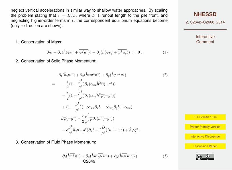
In order to provide the decision makers with a reliable forecast of possible laharsfrom Florencia, Piedritas and Colorado creeks, we chose a modeling method, whichaccounts for the current topography and uses geological records as initial conditions.Due to the two-phase characteristics of debris flows, the chosen model must accountfor the two phase behavior of lahars (Iverson, 1997). In this case we used theTwo-Phase-Titan model (Cordoba, et-al., 2015) (this issue) which was developed atSUNY University at Buffalo. For the solids phase, this model is based on the earlywork of Savage and Hutter (1989), Iverson (1997) and Iverson and Denlinger (2001),who arrived at the insight that very large dense granular flows could be modeled asincompressible continua governed by a Coulomb failure criterion (Coulomb, 1773).The fluid phase uses the typical hydraulic approach (Chow, 1969; Guo, 1995) togetherwith the Colebrook-White equation (Colebrook and White, 1937) for the basal friction.The phases interact through a phenomenological interphase drag and a buoyancyterm.Further, the equations of motion are depth averaged, by assuming that the flow depthis very small in comparison to the runoff. This mean that the resulting equations
C2648
NHESSD2, C2642–C2668, 2014
InteractiveComment
Full Screen / Esc
Printer-friendly Version
Interactive Discussion
Discussion Paper
neglect vertical accelerations in similar way to shallow water approaches. By scalingthe problem stating that ε = H/L, where L is runout length to the pile front, andneglecting higher-order terms in ε, the correspondent equilibrium equations become(only x direction are shown):
1. Conservation of Mass:
∂th+ ∂x(h(ϕvx + ϕfux)) + ∂y(h(ϕvy + ϕfuy)) = 0 . (1)
2. Conservation of Solid Phase Momentum:
∂t(hϕvx) + ∂x(hϕvxvx) + ∂y(hϕvxvy) (2)
= − ε
2(1− ρf
ρs)∂x(αxxh
2ϕ(−gz))
− ε
2(1− ρf
ρs)∂y(αxyh
2ϕ(−gz))
+ (1− ρf
ρs)(−εαxx∂xb− εαxy∂yb+ αxz)
hϕ(−gz)− ε
2ρf
ρsϕ∂x(h2(−gz))
− ερf
ρshϕ(−gz)∂xb+ (
D
ρs)(ux − vx) + hϕgx .
3. Conservation of Fluid Phase Momentum:
∂t(hϕfux) + ∂x(huxϕfux) + ∂y(hϕfuxuy) (3)C2649

NHESSD2, C2642–C2668, 2014
InteractiveComment
Full Screen / Esc
Printer-friendly Version
Interactive Discussion
Discussion Paper
= − 12ε∂xh
2ϕf (−gz)− (D
ρs)(ux − vx)
+ hϕfgx + ϕfCfux||u|| .
Where ϕ is the solids volumetric concentration, and ϕf = 1 − ϕ. φint and φbed
represent basal and internal friction angles, αxy = −sgn(∂yv), αxx = kap,αxz = −v∗tan(φbed)/||v||, where kap relates the normal and tangential stresses.h represents the depth of the flow, vx and vy the solids velocity field, ux and uy the fluidvelocity field, ρs and ρf the solids and fluid densities. ε is the ratio flow depth to flowlength, g is the gravity, Cf is the friction factor, and D is the interphase drag coefficient.The solids and fluid momentum equations in y direction have a similar form. Note thatif ϕf → 1 equation 3 becomes the typical shallow water approach of hydraulics (Chow,1969). This mean that the program can be used in both extremes, from a maximumpack concentration of ϕs = 0.65 to concentrations as low as ϕs = 10−8 (almost purewater).
The model has the additional advantage of saving computer power, because it is apseudo-3D approach, which is also due to its mesh adapting capabilities. Through theextended use of this program in real scale problems, it has shown its reliability androbustness (Córdoba et al., 2010; Sheridan et al., 2011; Cordoba, et-al., 2015). Thus,in this work we use Two-Phase-Titan as the computational tool to study and forecastthe lahar hazard in Villa la Angostura.
2.1 Initial conditions
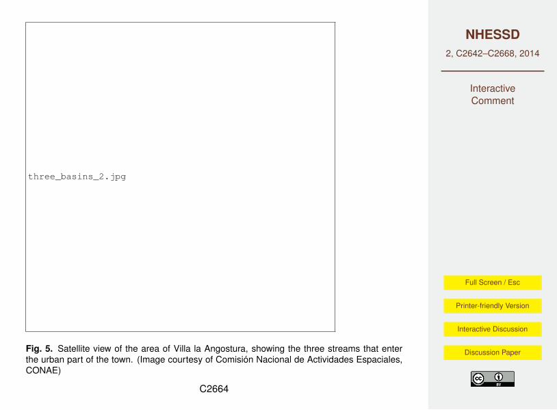
We analyzed the lahar hazard at Villa La Angostura from three drainages whosestreams flow directly toward the urban area of the town. As can be seen in Figure4 they are Las Piedritas creek, which have a catchment area of 7.75 Km2, Colorado
C2650

NHESSD2, C2642–C2668, 2014
InteractiveComment
Full Screen / Esc
Printer-friendly Version
Interactive Discussion
Discussion Paper
creek, with a catchment area of 3.8 Km2 and Florencia creek, with a catchment areaof 1.3 Km2 (Baumann et al., 2011). The program Two-Phase-Titan needs the locationof the piles, their initial volumes, the pile height and initial concentration of solids asinitial conditions.
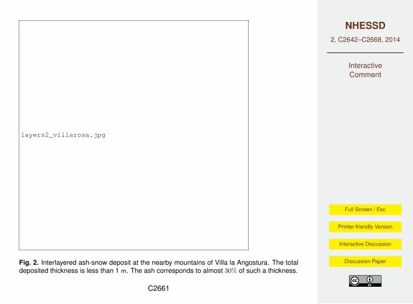
In order to set the initial volumetric fraction of solids, we used the actual ratio of snowand ash deposits from the eruption. Figure 4 shows several interlayered ash-snowdeposits from the Cordón Caulle eruption. They show that almost 30% of them consistof the deposited ash. However, water rain and water of the streams added to thelahar reduce this fraction, but later erosion incorporates solid particles to the lahar,resulting in the opposit effect. Thus, we postulate that these effects become balancedor negligible which allow us to use as initial solids volumetric concentration ϕs = 0.3for all the initial piles.
The needed data to set the initial volumes was taken from the Elissondo et al. (2011)andBaumann et al. (2011) reports, which analyzes the deposits of the ash fall from the4 of July 2011 eruption of Cordón Caulle volcanic complex on the nearby mountains.Elissondo et al. (2011) estimated the amount of deposited material at each basin andBaumann et al. (2011) estimated the depth of the respective deposits. Two caseswhere analyzed for each creek, a high and a medium volume. As it is unlikely that allof the deposited material to instantaneously become a lahar in large catchments, weassumed different fractions of the total deposited volumes as initial volumes for eachcatchement. In the case of Las Piedritas basin, we assumed as high initial volumethe 50% of the total deposited material, and the quarter of all the deposited materialas a medium volume. In case of medium size catchment areas like Colorado, 75%of the deposited material is assumed as high volume. Finally, we assume that fromthe material deposited on small catchment areas, 90% could become part of the lahar.An other initial condition is the pile height. In this paper we use the reported material
C2651

NHESSD2, C2642–C2668, 2014
InteractiveComment
Full Screen / Esc
Printer-friendly Version
Interactive Discussion
Discussion Paper
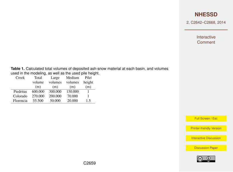
deposited depth, which are less than 1 m in all the basins (Elissondo et al., 2011;Baumann et al., 2011). However, we increased these values by a security factor, inorder to account for other uncertainties. Table 4 summarize the high and mediumvolumes, as well as the pile height used as initial conditions in our modeling.
The location of the initial piles of material were chosen at great distances from eachoutlet basin. In the case of Las Piedritas, we tested several initial locations. One fromthe farthest place on the basin, others from the lateral walls. All of them resulted inalmost the same pile height and flow velocity at the basin outlet. The basin of Coloradoreceived the Florencia-North stream as well. Thus, we locate piles both at the topof the Colorado basin and at the top of the Florencia-North stream. In the case ofFlorencia-South, the initial pile was located at the top of its basin.
An additional pile was located at the top of the La Ponderosa basin, just to test if laharscan reach the town. However, this site has no collected data about the deposited ashvolumes. We assumed the same volumes as in Florencia creek due to the size of thisbasin is similar.
3 Results
In order to run Two-Phase-Titan, a Digital Elevation Model (DEM) is needed. TheArgentine Comisión Nacional de Actividades Espaciales (COANE) initially providedus with two 15 m resolution DEMs. One of them was developed from optical satelliteimages and the second one from radar satellite images.
In order to test the DEMs, we used the initial data set for Florencia creek. Orangecontours in Figure 4, shows the predictions of Two-Phase-Titan using the DEM basedon optical sensors, and the red contours shows the prediction using the DEM build
C2652

NHESSD2, C2642–C2668, 2014
InteractiveComment
Full Screen / Esc
Printer-friendly Version
Interactive Discussion
Discussion Paper
from radar sensors. The Google-Earth image shows a widespread forest that hidesthe Florencia stream from view. The optic DEM reproduces this effect showing theterrain flatter than it actually is. For this reason the model predicts that the lahar will bewidely spread from the beginning. In contrast, using the radar sensor based DEM, theflow follows the actual natural channel hidden by the trees. In addition, the boundaryof the forest is represented in the model as an abrupt change in the topography. Thisis the case for some locations in Villa la Angostura, where patches of more than 30 mhigh forest have been cleared to allow human settlements. Thus, the program predictsa diversion of the flow where such a barrier is reached (see the arrow in Figure 4 ),while the flow just follows the natural channel in the prediction done by the programusing the radar based model.
Therefore, the optic sensor based terrain model was replaced by the more accurateradar sensor based DEM. As explained above, we use two initial conditions. Onewith high volumes and the second one with medium volumes (see values in Table4 ). Figure 4 shows the prediction of Two-Phase-Titan for the medium volumes. Inthis case, none of the flows reach the urban area. Nevertheless water treatmentfacilities and spare living houses could be inundated. For the volume used in LaPonderosa creek, Two-Phase-Titan predicts that the flow could inundate the main roadand structures built near it. It is informative to see that the flow from Piedritas creekinundates part of a planned urban expansion zone. However, the flow is diverted in analmost 90o angle seemingly by a topographic barrier.
In the case of high volumes, the urban area is shown to be reached by the flows fromFlorencia creek (see Figure 4). We should pay special attention to the possibility thatthe school named School 186 might become affected, as shown by the circle filled inblue. Based on such prediction of the program, we advised the local governmentalauthorities of the city to take appropriate decisions about that possibility. Then, the
C2653
NHESSD2, C2642–C2668, 2014
InteractiveComment
Full Screen / Esc
Printer-friendly Version
Interactive Discussion
Discussion Paper
Mayor ordered to temporary relocate the children to another school located in a saferplace. In the cases of Colorado and La Ponderosa, the runout of the flow is almostthe same of the medium volume case. Nevertheless, they tend to inundate in amore expanded way, showing larger inundation areas than in the case of medium vol-umes. Fortunately, these increase in the inundation area occur in low population zones.
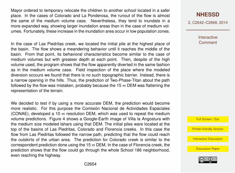
In the case of Las Piedritas creek, we located the initial pile at the highest place ofthe basin. The flow shows a meandering behavior until it reaches the middle of thebasin. From that point, its behavioral characteristics become similar to the case ofmedium volumes but with greateer depth at each point. Then, despite of the highvolume used, the program shows that the flow apparently diverted in the same fashionas in the medium volume case. Field inspection of the place where the modeleddiversion occcurs we found that there is no such topographic barrier. Instead, there isa narrow opening in the hills. Thus, the prediction of Two-Phase-Titan about the pathfollowed by the flow was mistaken, probably because the 15 m DEM was flattening therepresentation of the terrain.
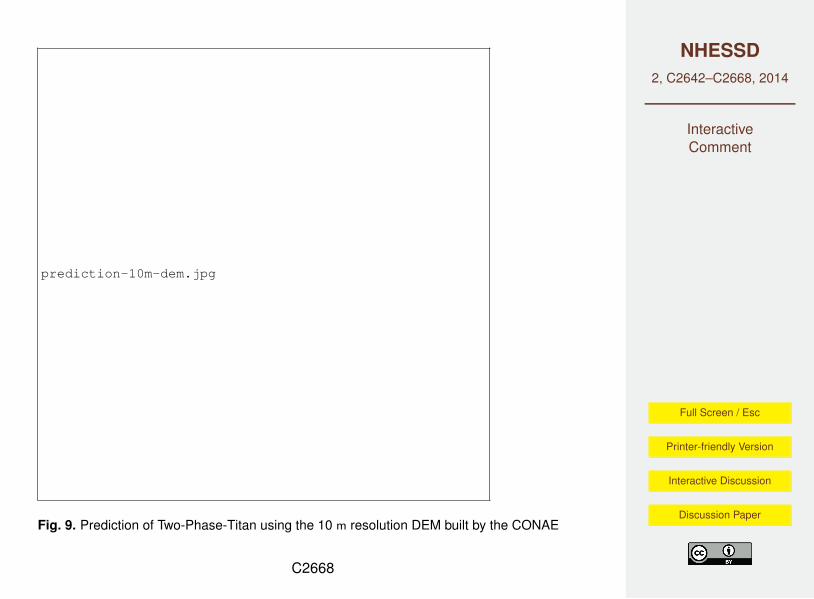
We decided to test if by using a more accurate DEM, the prediction would becomemore realistic. For this purpose the Comisión Nacional de Actividades Espaciales(CONAE), developed a 10 m resolution DEM, which was used to repeat the mediumvolume predictions. Figure 4 shows a Google-Earth image of Villa la Angostura withthe medium size modeled lahars using that DEM. The initial piles ware located at thetop of the basins of Las Piedritas, Colorado and Florencia creeks. In this case theflow from Las Piedritas followed the narrow path, predicting that the flow could reachthe outskirts of the urban area. The prediction for Colorado creek is similar to thecorrespondent prediction done using the 15 m DEM. In the case of Florencia creek, theprediction shows that the flow could go through the whole School 186 neighborhood,even reaching the highway.
C2654

NHESSD2, C2642–C2668, 2014
InteractiveComment
Full Screen / Esc
Printer-friendly Version
Interactive Discussion
Discussion Paper
[Conclusions]
Though Villa La Angostura is located in a mountainous environment and conditionsfor secondary lahars were present, only minor mass waste events were recorded.Destructive mass waste events involving tephra deposits triggered by intense precipi-tations were reported in distal locations in the Patagonian steppe (100 km east of VillaLa Angostura) where annual average rainfall is less than 600 mm (Wilson et-al., 2013).
This work draws the attention to secondary lahars as a real hazard not only in volcanicproximal areas, but also in broad regions of Andean Patagonia under the influence ofexplosive volcanic activity, even though from the volcanological and the tephra depositsperspective, they are considered as medial to distal facies. It also proposes a validmethod to evaluate critical hazardous areas in dense forested urban environmentsthat are typical in the region.
Although at this point this is not a probabilistic tool, results of the presented modellingprovide a good evaluation of lahar susceptibility and have set the basis for futuredevelopment of a probabilistic approach.
The output of the modelling is a valuable tool for city planning and risk managementespecially considering the physical characteristics of Villa La Angostura area, thestrong urban development growth and the land occupation tendencies observed in thelast decade.
In forested areas, the availability of a DEM produced from good radar data is criticalin order to get the minimal resolution required for the modelling. In addition, throughour numerical experiment results, we support the work of (Capra et-al., 2011) and (Ste-fanescu et-al, 2012) related to the importance of the precision of the DEM in forecasting
C2655
NHESSD2, C2642–C2668, 2014
InteractiveComment
Full Screen / Esc
Printer-friendly Version
Interactive Discussion
Discussion Paper
the spread and runout distances of modeled flows.
4 Authors contribution
Gustavo Córdoba and Michael Sheridan developed the program TWO-PHASE-TITAN.In addition, Dr. Córdoba worked in the modeling with Gustavo Villarosa and DeboraBeigt. Gustavo Villarosa conducted field work and contributed with the geological back-ground and data interpretation. Debora Beigt cooperated with photo-interpretation andGIS mapping. Jose Viramonte helped in the geologic interpretation. Graciela Salmunideveloped the Digital Elevation Models at CONAE.
The authors wish to thank Marcos Arretche, David Tressens, Emilio Molla and staffof Civil Protection Agency, who supported this study. The Argentinean AerospaceAgency (CONAE) developed and allowed Dr. Salmuni to provide us with the requestedDEMs. The Universidad de Nariño, Colombia, allowed the mobility of Dr. Cordobaand gave him the necessary dedication time for this research. Project 04 B155 fundedby Universidad Nacional del Comahue partially covered field work and initial on sitemodellings. Aerolineas Argentinas provided the return trip of Dr. Córdoba to travelfrom Colombia to Bariloche, Argentina.
References
Capra, L., Manea, V.C., Manea, M., and Noromi, G.: The importance of digital elevation modelresolution on granular flow simulations: a test case for Colimavolcano using TITAN2D com-putational routine, Nat. Hazards, 59, 665-680, 2011.
Stefanescu, E.R., Bursik, M., and Patra, A.K., Effect of digital elevation model on Mohr-Coulomb geophysical flow model output, Nat. Hazards, 62, 635-656, 2012.
Villarosa, G., Schneider, M., Outes, V., López, E., Dzendoletas, M.A., Beigt, D., Villarosa, F.,
C2656

NHESSD2, C2642–C2668, 2014
InteractiveComment
Full Screen / Esc
Printer-friendly Version
Interactive Discussion
Discussion Paper
Galosi, C., and Ruiz, M.: Estudio de Peligrosidad de avalanchas en el Parque Nahuel Huapivinculados a la erupción del Cordón Caulle (CC), Informe Final, pp 81, Asesoría Institucional,Convenio CONICET-Administración de Parques Nacionales, 2012.
Cordoba, G., Sheridan, M.F., and Pitman, B., A pseudo-3D Model of 2-phase Debris Flows,Submited to Natural Hazards and Earth System Sciences, 2015.
Barros, V.R., Cordon, V.H., Moyano, C.L., Méndez, R.J., Forquera, J.C., and Pizzio, O., Cartasde precipitación de la zona oeste de la Prpvincia de Rio Negro y Neuquén, Informe de laFacultad de Ciendcias Agrarias, Universidad Nacional del Comahue, Neuquén, Argentina,1983.
Wilson, T., Stewart, C., Bickerton, H., Baxter, P., Outes, V., Villarosa, G. and Rovere, E.: Im-pacts of the 2011 Puyehue Cordón Caulle volcanic complex on urban infrastructure, agri-culture and public health. GNS Science Report 2012/20, 88 pp. ISSN 1177-2425, ISBN978-1-972192-02-3, 2013.
Baumann, V., Elissondo, M., Fauqué, L., and Gonzáles, R.: Peligro de generación de flujos dedetritos o lahares secundarios en Villa la Angostura, Informe preliminar, Servicio GeológicoMimero Argentino, SEGEMAR, internal Report, 2011.
Chow, V.: Open channel hydraulics, McGraw Hill, New York, 1969.Colebrook, C. and White, C.: Experiments with fluid friction in Roughened pipes, Proc. R. Soc.
London, 161, 367–381, 1937.Collini, E., Osores, M. A., Folch, A., Viramonte, J. G., Villarosa, G., and Salmuni, G.: Volcanic
ash forecast during the June 2011 Cordón Caulle eruption, Natural Hazards, 66, 389–412,2013.
Córdoba, G., Sheridan, M., and Pitman, B.: A two-phase, depth-averaged model for geophysi-cal mass flows in the TITAN code framework, CMG-IUGG, Pissa, Italy, 2010.
Coulomb, C.: Mémoires fe Mathematique et de Physique, vol. VII, chap. Essai sur une ap-plication des règles de maximis and minimis à quelques problèmes de statique, relatifs àl’architecture, pp. 343–382, Annèe, Paris, 1773.
Elissondo, M., Gomzales, R., Sruoga, P., Fauqué, L., Tejedo, A., Alonso, S., Carrizo, R., Her-rero, J., Murruni, L., Ojada, E., Sánchez, L., and Costado, C.: Erupción del 4 de Junio de2011 del Cordón Caulle, Chile y su impacto ambiental en territorio argentino, Tech. rep., Ser-vicio Geológico y Minero Argentino, SEGEMAR, Buenos Aires, Argentina, internal Report,2011.
Folch, A., Costa, A., and Macedonio, G.: An automatic procedure to forecast tephra fallout,
C2657

NHESSD2, C2642–C2668, 2014
InteractiveComment
Full Screen / Esc
Printer-friendly Version
Interactive Discussion
Discussion Paper
Journal of Volcanology and Geothermal Research, 177, 767–777, 2008.Guo, Z.: Velocity-depth coupling in shallow-water flows, Journal of Hydraulic Engineering, 121,
717–724, 1995.Lara, L.E. and Moreno, H. Geoloía del Complejo Volcánico Puyehue-Cordón Caulle, Región
de Los Lagos, Chile, Carta geológica de Chile, Serie Geología Básica No. 99, ServicioGeoógico y Minero de Chile, 2006.
Iverson, R.: The physics of debris flows, Reviews of Geophysics, 35, 2454–296, 1997.Iverson, R. and Denlinger, R.: Flow of variably fluidized granular material across three-
dimensional terrain 1: Coulomb mixture theory., J. Geophys. Res., 6, 537–552, 2001.OVDAS-SERNAGEOMIN: Reporte Especial de Actividad Volánica, Internal report 13, OVDAS-
SERNAGEOMIN, Chile, 2011a.OVDAS-SERNAGEOMIN: Reporte Especial de Actividad Volánica, Internal report 28, OVDAS-
SERNAGEOMIN, Chile, 2011b.Savage, S. and Hutter, K.: The motion of a finite mass of granular material down a rough incline,
J. of Fluid Mechanics, 199, 177–215, 1989.Sheridan, M., Córdoba, G., Pitman, E., Cronin, S., and Procter, J.: Application of a wide-ranging
two-phase Debris Flow Model to the 2007 Crater Lake break-out lahar at Mt. Ruapehu, NewZealand, vol. V53E-2691 of Fall Meeting, American Geophysical Union, San Francisco (CA),5-9 Dec., 2011.
Villarosa, G. and Outes, V.: Efectos de la caída de cenizas del Complejo Volcánico Puyehue(CPCC) sobre la región del lago Nahuel Nuapi., chap. La erupción del Cordón Caulle del 4 dejunio de 2011: Mapa de distribución, características de la ceniza volcánica caída en la regióne impactos en la comunidad (in Spanish), pp. 12–59, Universidad del Comahue, Bariloche,Argentina, convenio de Asistencia Técnica Centro Regional Universitario Bariloche, 2013.
Villarosa, G., Outes, V., Hajduk, A., sellés, D., Fernández, M., Montero, C., and Crivelli, E.:Explosive volcanism during the Holocene in the upper Limay river basin: The effects ofashfalls on human societies. Northern Patagonia, Argentina, Quaternary International, 158,44–57, 2006.
C2658
NHESSD2, C2642–C2668, 2014
InteractiveComment
Full Screen / Esc
Printer-friendly Version
Interactive Discussion
Discussion Paper
Table 1. Calculated total volumes of deposited ash-snow material at each basin, and volumesused in the modeling, as well as the used pile height.
Creek Total Large Medium Pile|volume volumes volumes height
(m) (m) (m) (m)Piedritas 600.000 300.000 150.000 1Colorado 270.000 200.000 70.000 1Florencia 55.500 50.000 20.000 1.5
C2659

NHESSD2, C2642–C2668, 2014
InteractiveComment
Full Screen / Esc
Printer-friendly Version
Interactive Discussion
Discussion Paper
fall3d_pred.jpg
Fig. 1. Fall3D program ash dispersion modeling of the Cordón Caulle complex 2011 eruption.The colored representation shows its subplinian plume dispersion for 9th of June (After Colliniet al. (2012)).
C2660
NHESSD2, C2642–C2668, 2014
InteractiveComment
Full Screen / Esc
Printer-friendly Version
Interactive Discussion
Discussion Paper
layers2_villarosa.jpg
Fig. 2. Interlayered ash-snow deposit at the nearby mountains of Villa la Angostura. The totaldeposited thickness is less than 1 m. The ash corresponds to almost 30% of such a thickness.
C2661

NHESSD2, C2642–C2668, 2014
InteractiveComment
Full Screen / Esc
Printer-friendly Version
Interactive Discussion
Discussion Paper
isopach1_villarosa_gus.jpg
Fig. 3. Isopach and affected area by the end of October 2. The yellow lines are the isopachcontours. The dots are the sampling sites. (After Villarosa and Outes (2013))
C2662

NHESSD2, C2642–C2668, 2014
InteractiveComment
Full Screen / Esc
Printer-friendly Version
Interactive Discussion
Discussion Paper
isopach2_villarosa.jpg
Fig. 4. Distribution of tephra deposits modified by erosion and remobilization by November2012, thicknesses expressed in centimeters (after Villarosa and Outes (2013))
C2663
NHESSD2, C2642–C2668, 2014
InteractiveComment
Full Screen / Esc
Printer-friendly Version
Interactive Discussion
Discussion Paper
three_basins_2.jpg
Fig. 5. Satellite view of the area of Villa la Angostura, showing the three streams that enterthe urban part of the town. (Image courtesy of Comisión Nacional de Actividades Espaciales,CONAE)
C2664

NHESSD2, C2642–C2668, 2014
InteractiveComment
Full Screen / Esc
Printer-friendly Version
Interactive Discussion
Discussion Paper
dem_comp_arrow.jpg
Fig. 6. Two-Phase-Titan predictions using two DEMs on a Google-Earth image. The orangecontours shows the prediction of the lahar inundation using the DEM based on optical sensors.The red contours shows the prediction of the lahar inundation using a DEM developed fromradar sensors. The white arrow points to a beginning of the forest that seems to divert the flow,because it is seen by the optic sensor based DEM as a wall.C2665

NHESSD2, C2642–C2668, 2014
InteractiveComment
Full Screen / Esc
Printer-friendly Version
Interactive Discussion
Discussion Paper
flujos_medios.jpg
Fig. 7. Predictions of Two-Phase-Titan for medium size volumes.
C2666

NHESSD2, C2642–C2668, 2014
InteractiveComment
Full Screen / Esc
Printer-friendly Version
Interactive Discussion
Discussion Paper
flujos_altos.jpg
Fig. 8. Predictions of Two-Phase-Titan for large size volumes.
C2667
NHESSD2, C2642–C2668, 2014
InteractiveComment
Full Screen / Esc
Printer-friendly Version
Interactive Discussion
Discussion Paper
prediction-10m-dem.jpg
Fig. 9. Prediction of Two-Phase-Titan using the 10 m resolution DEM built by the CONAE
C2668
Related Documents