INSPIRE Strengths, Weaknesses, Opportunities & Threats (SWOT) & Way Forward Dara Keogh GeoDirectory, Ireland and Bruce McCormack Bruce McCormack Consulting, Ireland Presentation to the INSPIRE 2017 Conference 7 September 2017

Welcome message from author
This document is posted to help you gain knowledge. Please leave a comment to let me know what you think about it! Share it to your friends and learn new things together.
Transcript

INSPIRE Strengths, Weaknesses, Opportunities &
Threats (SWOT) & Way ForwardDara Keogh
GeoDirectory, Ireland and
Bruce McCormack Bruce McCormack Consulting, Ireland
Presentation to the INSPIRE 2017 Conference 7 September 2017
THE PRESENTERS• DARA KEOGH
• CEO GeoDirectory• GeoDirectory provides over 2.2m address points at 1m spatial accuracy, updated quarterly • Provides the basis for Irish postcodes
• BRUCE McCORMACK• Land use planning and spatial information consultant• Involvement in INSPIRE from early days• EUROGI Past President, current IRLOGI President
PRESENTATION AIMS
• Review some aspects of data availability on the INSPIRE geoportal
• Present a SWOT evaluation of INSPIRE on the basis of responses to a questionnaire sent to a small sample of persons
• Make some suggestions at a broad strategic level regarding the way forward for INSPIRE
PRESENTATION OUTLINE
• Data on INSPIRE Geoportal
• SWOT
• Way Forward
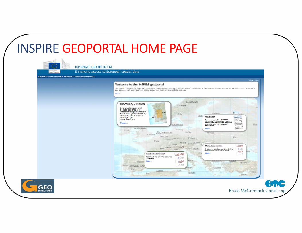
INSPIRE GEOPORTAL HOME PAGE
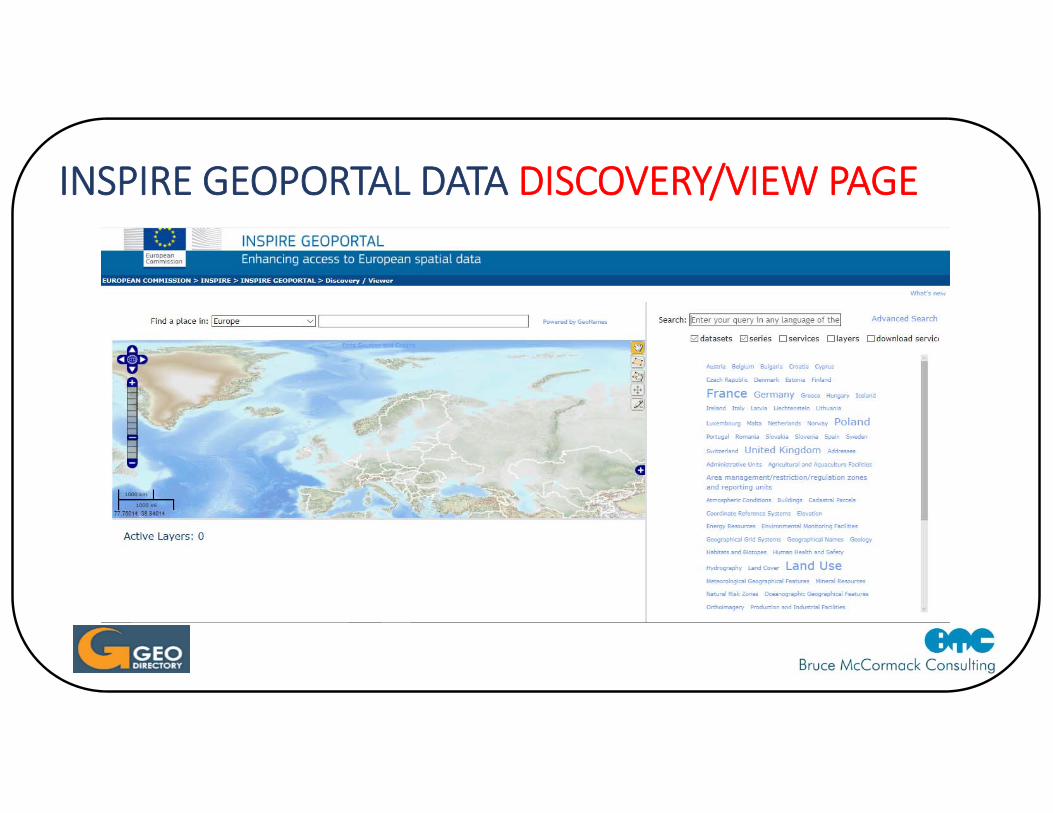
INSPIRE GEOPORTAL DATA DISCOVERY/VIEW PAGE
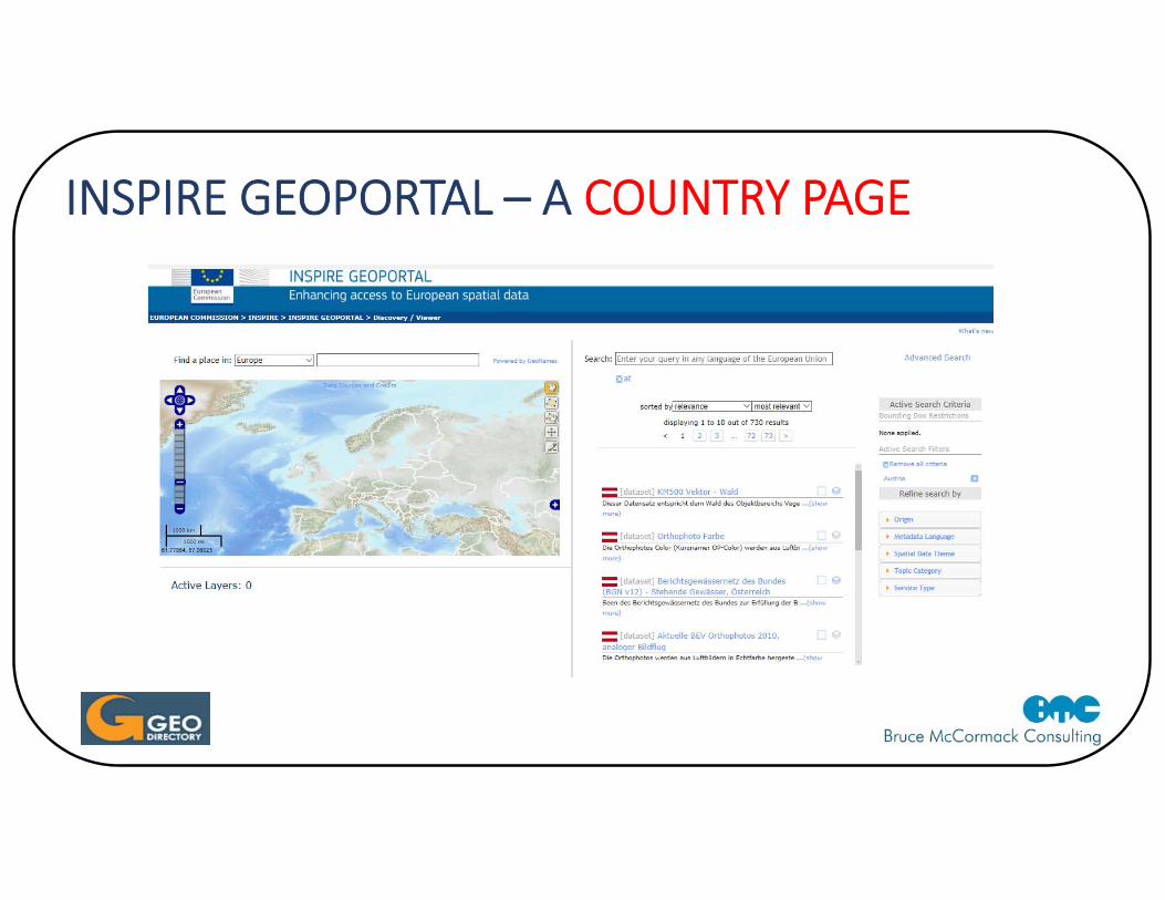
INSPIRE GEOPORTAL – A COUNTRY PAGE
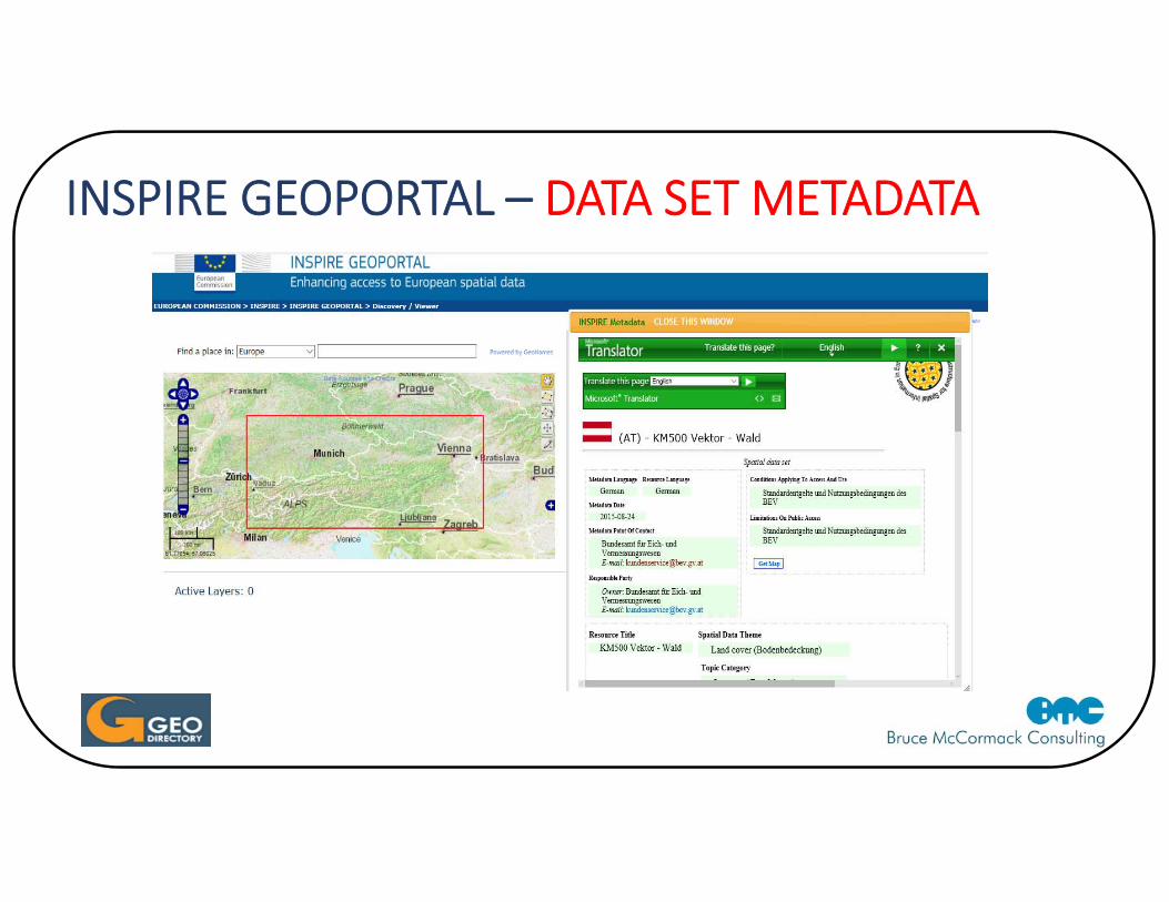
INSPIRE GEOPORTAL – DATA SET METADATA
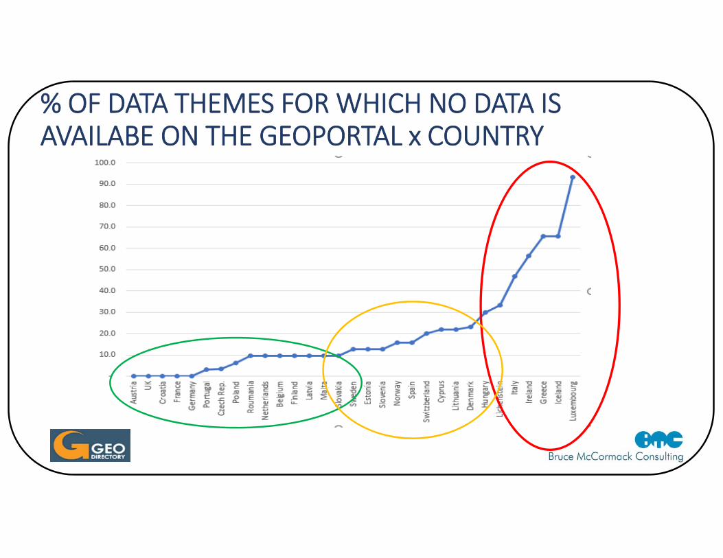
% OF DATA THEMES FOR WHICH NO DATA IS AVAILABE ON THE GEOPORTAL x COUNTRY
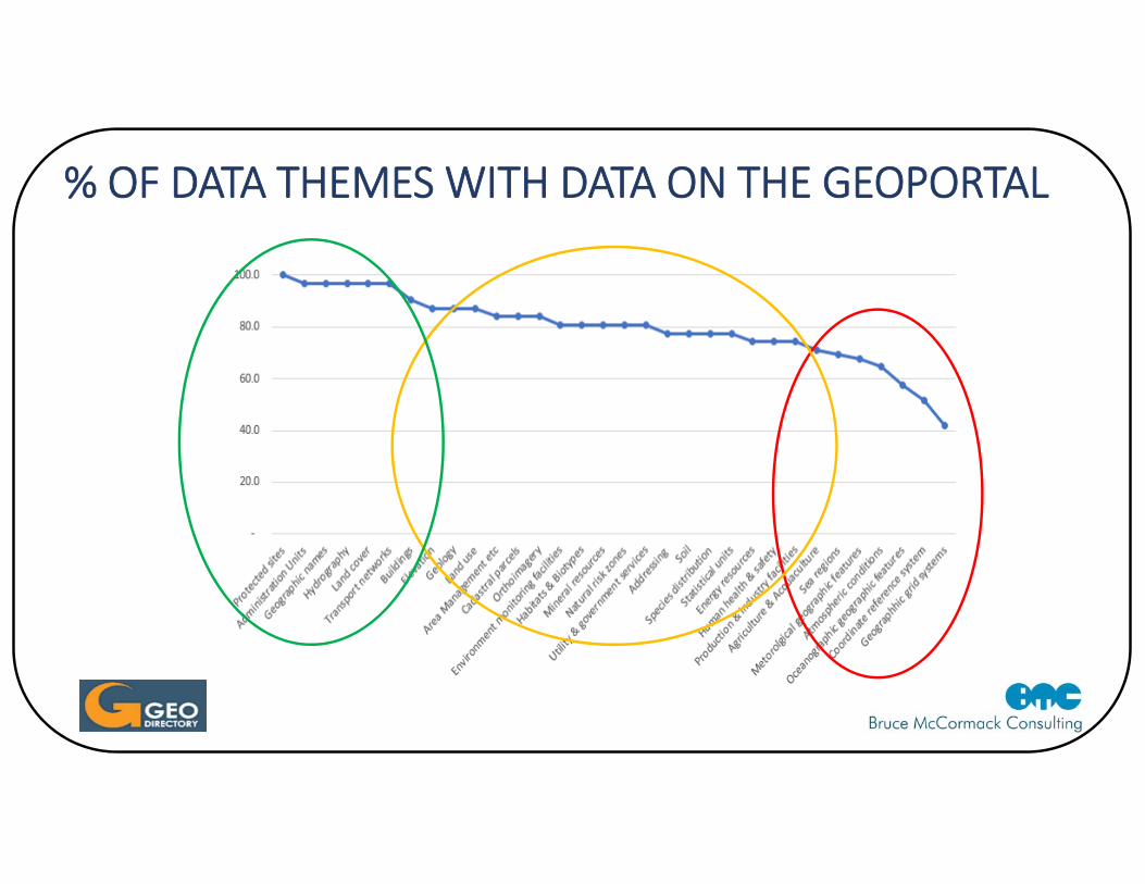
% OF DATA THEMES WITH DATA ON THE GEOPORTAL
GEOPORTAL DATASETS ‐ CONCLUSIONS
• Very limited focussed review
• Quite a bit of
• Wider review needed
INSPIRE SWOT QUESTIONNAIRE• Questionnaire sent to a small sample of colleagues who have been involved directly in
INSPIRE over a number of years• 11 colleagues responded, in 6 European countries, includes state sector, academic and 1
business person• Responses give a snapshot view … certainly not a rigorous survey• Questions
• What in your view are the main Strengths associate with INSPIRE? Please list.• What do you consider are the main Weaknesses regarding INSPIRE? Please list.• What do you regard as the main Opportunities opened up by INSPIRE? Please list.• What do you consider to be the main Threats which could impact on INSPIRE? Please list• Have you been directly involved in any aspect associated with the preparation of the INSPIRE
Directive or its implementation (yes or no) and if yes could you briefly indicate what type of involvement you have had
• What sector are you in … public, private, academia, NGO, other?
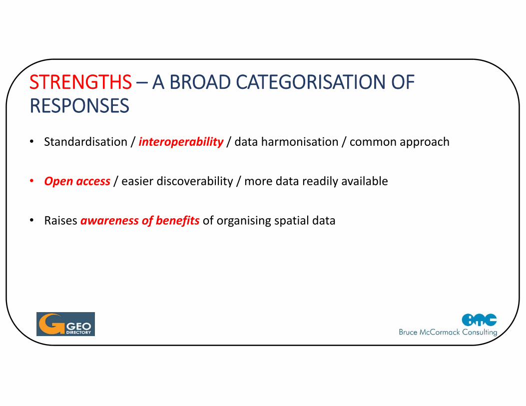
STRENGTHS – A BROAD CATEGORISATION OF RESPONSES• Standardisation / interoperability / data harmonisation / common approach
• Open access / easier discoverability / more data readily available
• Raises awareness of benefits of organising spatial data
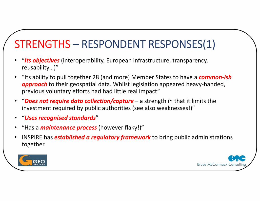
STRENGTHS – RESPONDENT RESPONSES(1)• “Its objectives (interoperability, European infrastructure, transparency,
reusability…)”• “Its ability to pull together 28 (and more) Member States to have a common‐ish
approach to their geospatial data. Whilst legislation appeared heavy‐handed, previous voluntary efforts had had little real impact”
• “Does not require data collection/capture – a strength in that it limits the investment required by public authorities (see also weaknesses!)”
• “Uses recognised standards”• “Has a maintenance process (however flaky!)”• INSPIRE has established a regulatory framework to bring public administrations
together.
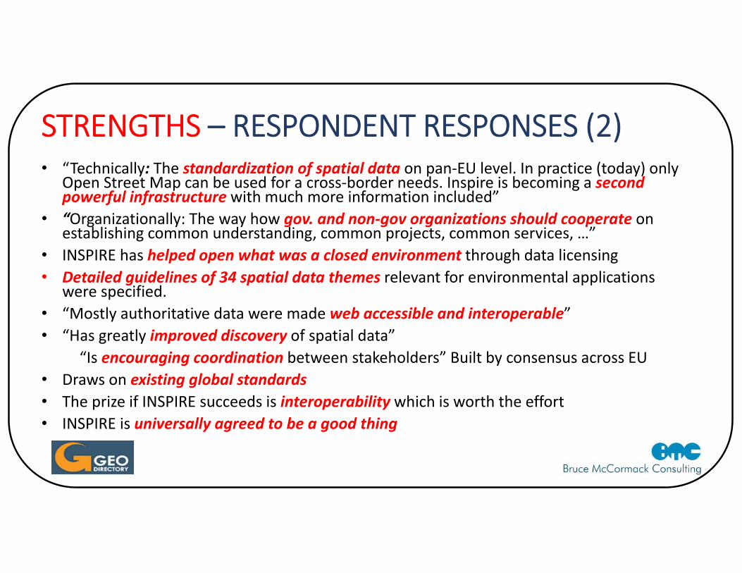
STRENGTHS – RESPONDENT RESPONSES (2)• “Technically: The standardization of spatial data on pan‐EU level. In practice (today) only
Open Street Map can be used for a cross‐border needs. Inspire is becoming a second powerful infrastructure with much more information included”
• “Organizationally: The way how gov. and non‐gov organizations should cooperate on establishing common understanding, common projects, common services, …”
• INSPIRE has helped open what was a closed environment through data licensing• Detailed guidelines of 34 spatial data themes relevant for environmental applications
were specified.• “Mostly authoritative data were made web accessible and interoperable”• “Has greatly improved discovery of spatial data”
“Is encouraging coordination between stakeholders” Built by consensus across EU• Draws on existing global standards• The prize if INSPIRE succeeds is interoperability which is worth the effort• INSPIRE is universally agreed to be a good thing
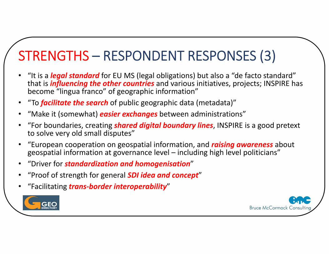
STRENGTHS – RESPONDENT RESPONSES (3)• “It is a legal standard for EU MS (legal obligations) but also a “de facto standard”
that is influencing the other countries and various initiatives, projects; INSPIRE has become “lingua franco” of geographic information”
• “To facilitate the search of public geographic data (metadata)”• “Make it (somewhat) easier exchanges between administrations”• “For boundaries, creating shared digital boundary lines, INSPIRE is a good pretext
to solve very old small disputes”• “European cooperation on geospatial information, and raising awareness about
geospatial information at governance level – including high level politicians”• “Driver for standardization and homogenisation”• “Proof of strength for general SDI idea and concept”• “Facilitating trans‐border interoperability”
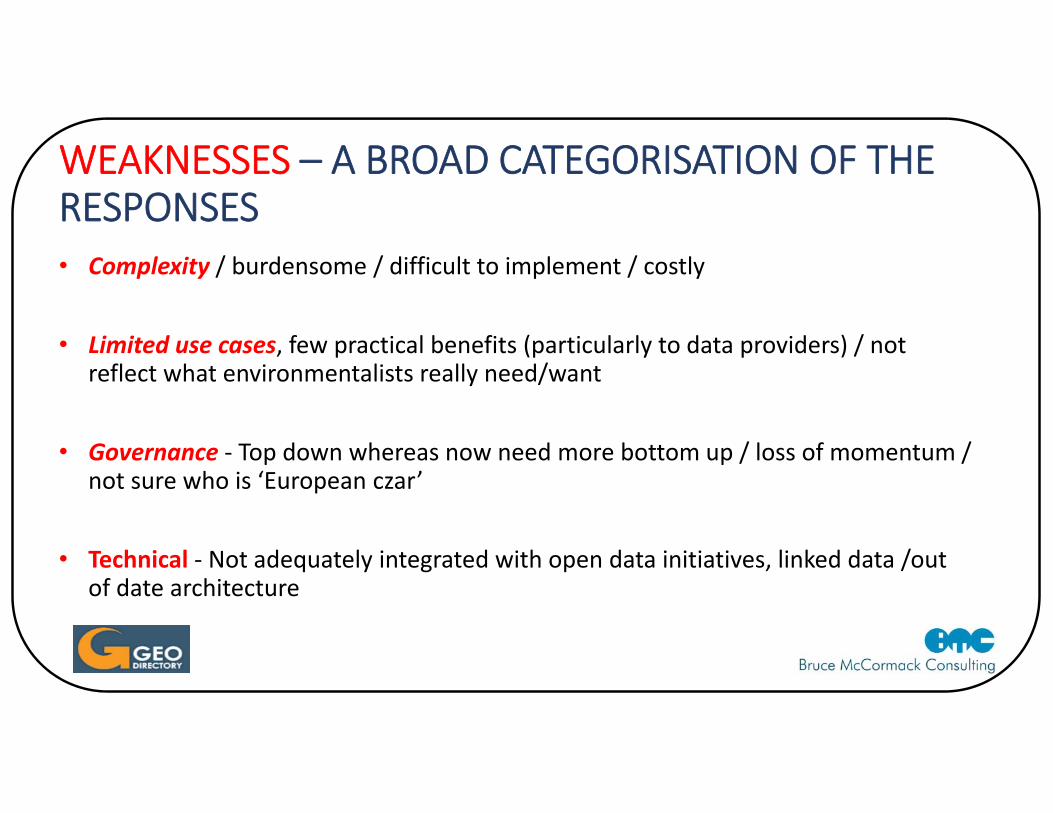
WEAKNESSES – A BROAD CATEGORISATION OF THE RESPONSES• Complexity / burdensome / difficult to implement / costly
• Limited use cases, few practical benefits (particularly to data providers) / not reflect what environmentalists really need/want
• Governance ‐ Top down whereas now need more bottom up / loss of momentum / not sure who is ‘European czar’
• Technical ‐ Not adequately integrated with open data initiatives, linked data /out of date architecture
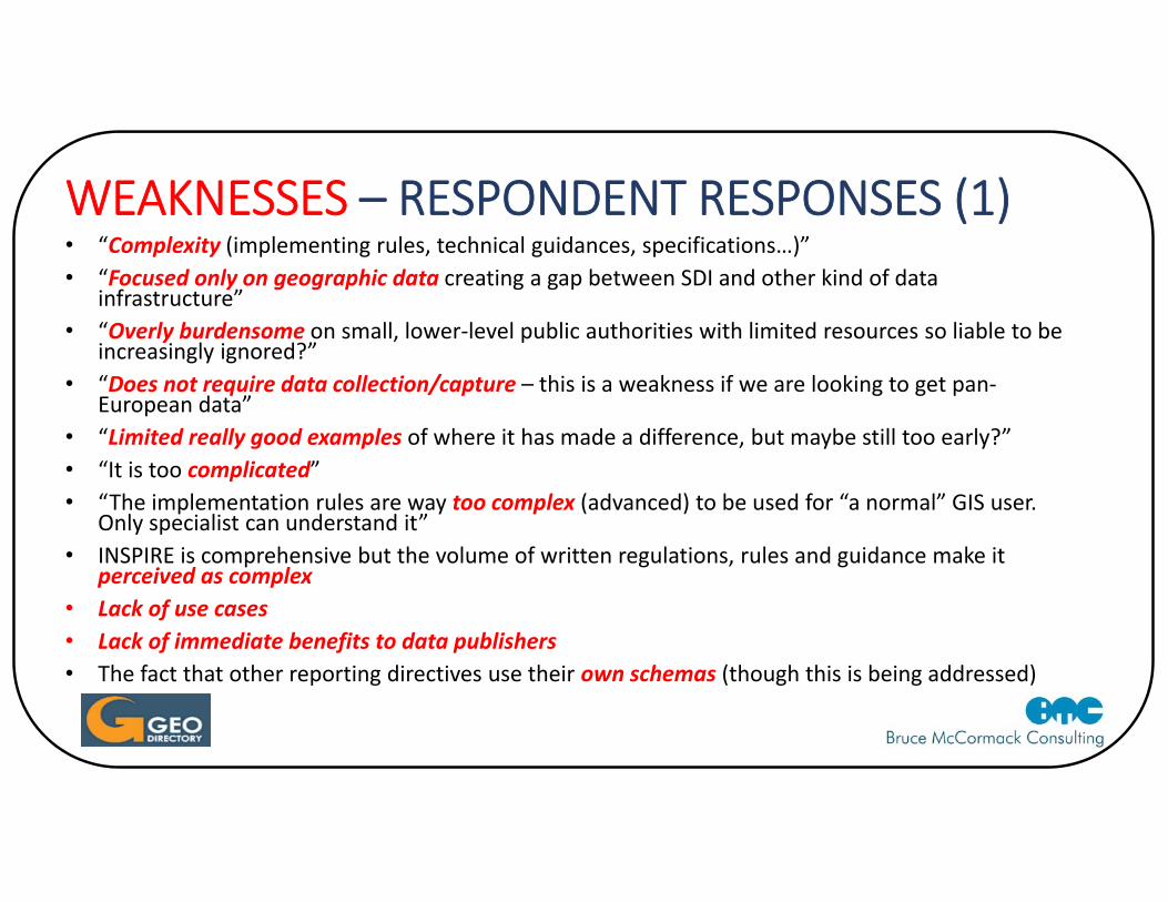
WEAKNESSES – RESPONDENT RESPONSES (1)• “Complexity (implementing rules, technical guidances, specifications…)”• “Focused only on geographic data creating a gap between SDI and other kind of data
infrastructure”• “Overly burdensome on small, lower‐level public authorities with limited resources so liable to be
increasingly ignored?”• “Does not require data collection/capture – this is a weakness if we are looking to get pan‐
European data”• “Limited really good examples of where it has made a difference, but maybe still too early?”• “It is too complicated”• “The implementation rules are way too complex (advanced) to be used for “a normal” GIS user.
Only specialist can understand it” • INSPIRE is comprehensive but the volume of written regulations, rules and guidance make it
perceived as complex• Lack of use cases• Lack of immediate benefits to data publishers• The fact that other reporting directives use their own schemas (though this is being addressed)
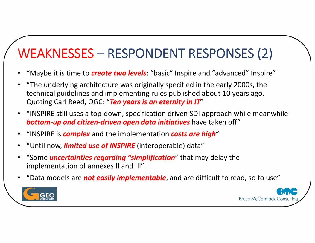
WEAKNESSES – RESPONDENT RESPONSES (2)• “Maybe it is time to create two levels: “basic” Inspire and “advanced” Inspire”• “The underlying architecture was originally specified in the early 2000s, the
technical guidelines and implementing rules published about 10 years ago. Quoting Carl Reed, OGC: “Ten years is an eternity in IT”
• “INSPIRE still uses a top‐down, specification driven SDI approach while meanwhile bottom‐up and citizen‐driven open data initiatives have taken off”
• “INSPIRE is complex and the implementation costs are high”• “Until now, limited use of INSPIRE (interoperable) data”• “Some uncertainties regarding “simplification” that may delay the
implementation of annexes II and III”• “Data models are not easily implementable, and are difficult to read, so to use”
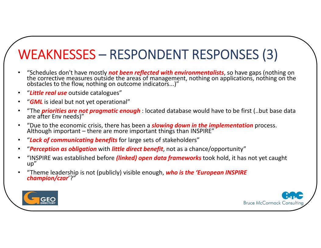
WEAKNESSES – RESPONDENT RESPONSES (3)• “Schedules don't have mostly not been reflected with environmentalists, so have gaps (nothing on
the corrective measures outside the areas of management, nothing on applications, nothing on the obstacles to the flow, nothing on outcome indicators...)”
• “Little real use outside catalogues”• “GML is ideal but not yet operational”• “The priorities are not pragmatic enough : located database would have to be first (..but base data
are after Env needs)”• “Due to the economic crisis, there has been a slowing down in the implementation process.
Although important – there are more important things than INSPIRE”• “Lack of communicating benefits for large sets of stakeholders” • “Perception as obligation with little direct benefit, not as a chance/opportunity”• “INSPIRE was established before (linked) open data frameworks took hold, it has not yet caught
up”• “Theme leadership is not (publicly) visible enough, who is the ‘European INSPIRE
champion/czar’?”
OPPORTUNITIES – A BROAD CATEGORISATION OF RESPONSES• More spatial data readily available > more uses possible, including into non‐
environmental fields / development of apps
• Governance – better decision‐making, coordination could make a difference
• Better awareness of benefits of interoperability and open data, of spatial data
• Open data initiatives
• Support Single Digital Market, SDG monitoring
• Creates more research opportunities
OPPORTUNITIES – RESPONDENT RESPONES (1)• “Generalisation of the use of geographic information (in all kinds of economic activities)”• “Growth of the open data initiatives”• “Better policy and decision‐making across Europe”• “Europe as an exemplar to the rest of the world – opportunity to export European
experience and expertise. For example, Europe is now seen as a leader on the global stage e.g.UN‐GGIM”
• “Its very existence has stimulated discussion about geospatial across Europe and the world. Countries have developed geospatial strategies and have plans in place”
• “Spatial data becoming standardized and available (more and more open) to many users. This is important for pan‐EU, global questions”
• “INSPIRE has forced authoritative data custodians to rethink how to make their data available, i.e. open and interoperable”
• “INSPIRE is linking to other initiatives like e.g. Copernicus or GEOSS”
OPPORTUNITIES – RESPONDENT RESPONSES (2)• “Significant step to get easily accessible and interoperable, harmonised data from
national and local authoritative data providers in whole Europe”• “Possibility to get more harmonised methodologies for reporting, to compute
indicators for European Directives and other initiatives (as UN Sustainable Development Goals)”
• “Interoperable data should facilitate the development of applications on the European market”
• “Likely, big opportunity for research in Europe”• “Little real use outside catalogues”• “Creation of interoperable infrastructure”• Understanding what users want and need from the European SDI
OPPORTUNITIES – RESPONDENT RESPONSES (3)• “Even the partly implementation of the INSPIRE directive will facilitate easier
transnational cooperation regarding environmental protection, infrastructure works, climate change adaptation, etc. Besides, the the INSPIRE Directive will build a foundation for the implementation of the EU Digital Single market. Software developed in one country can be used across the whole Europe”
• “Establishing geospatial services as foundation for various application domains”• “Contribution to European integration, and to highlight European leadership in
this field”• “Turn perception from ‘this has to be done because of EC’ towards ‘this is a great
benefit we get from EC”
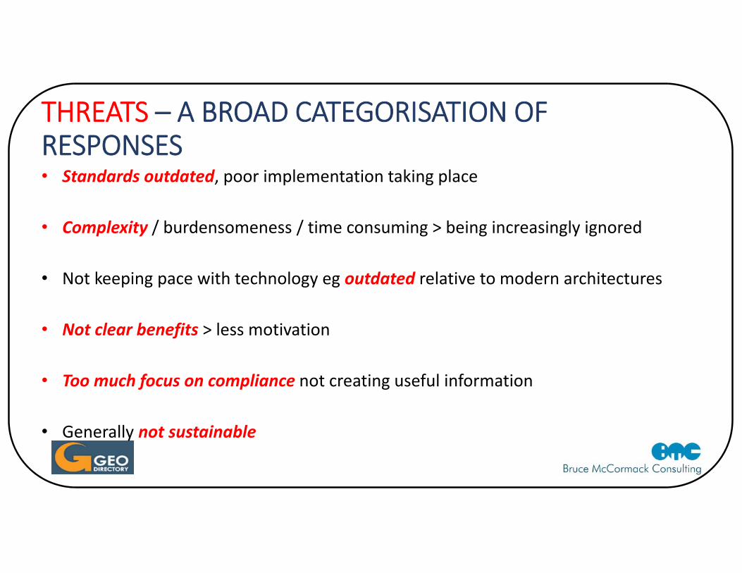
THREATS – A BROAD CATEGORISATION OF RESPONSES • Standards outdated, poor implementation taking place
• Complexity / burdensomeness / time consuming > being increasingly ignored
• Not keeping pace with technology eg outdated relative to modern architectures
• Not clear benefits > less motivation
• Too much focus on compliance not creating useful information
• Generally not sustainable
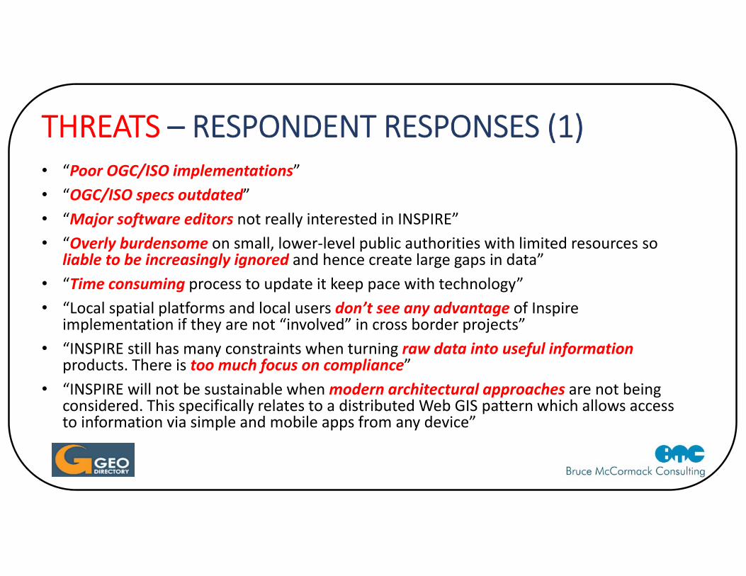
THREATS – RESPONDENT RESPONSES (1)• “Poor OGC/ISO implementations”• “OGC/ISO specs outdated”• “Major software editors not really interested in INSPIRE”• “Overly burdensome on small, lower‐level public authorities with limited resources so
liable to be increasingly ignored and hence create large gaps in data”• “Time consuming process to update it keep pace with technology” • “Local spatial platforms and local users don’t see any advantage of Inspire
implementation if they are not “involved” in cross border projects”• “INSPIRE still has many constraints when turning raw data into useful information
products. There is too much focus on compliance”• “INSPIRE will not be sustainable when modern architectural approaches are not being
considered. This specifically relates to a distributed Web GIS pattern which allows access to information via simple and mobile apps from any device”
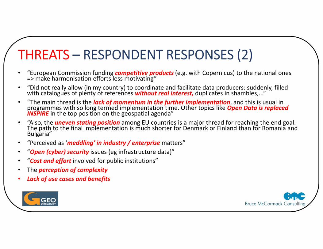
THREATS – RESPONDENT RESPONSES (2)• “European Commission funding competitive products (e.g. with Copernicus) to the national ones
=> make harmonisation efforts less motivating”• “Did not really allow (in my country) to coordinate and facilitate data producers: suddenly, filled
with catalogues of plenty of references without real interest, duplicates in shambles,...”• “The main thread is the lack of momentum in the further implementation, and this is usual in
programmes with so long termed implementation time. Other topics like Open Data is replaced INSPIRE in the top position on the geospatial agenda”
• “Also, the uneven stating position among EU countries is a major thread for reaching the end goal. The path to the final implementation is much shorter for Denmark or Finland than for Romania and Bulgaria”
• “Perceived as ‘meddling’ in industry / enterprise matters”• “Open (cyber) security issues (eg infrastructure data)”• “Cost and effort involved for public institutions”• The perception of complexity • Lack of use cases and benefits
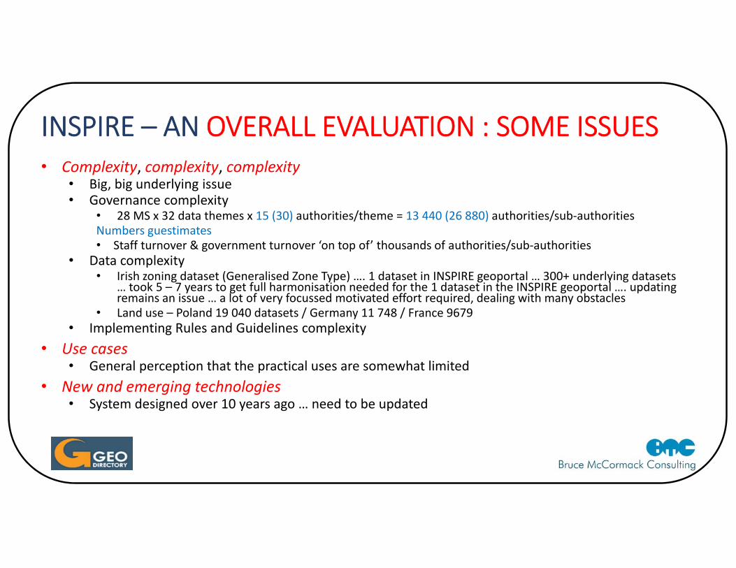
INSPIRE – AN OVERALL EVALUATION : SOME ISSUES• Complexity, complexity, complexity
• Big, big underlying issue• Governance complexity
• 28 MS x 32 data themes x 15 (30) authorities/theme = 13 440 (26 880) authorities/sub‐authoritiesNumbers guestimates• Staff turnover & government turnover ‘on top of’ thousands of authorities/sub‐authorities
• Data complexity• Irish zoning dataset (Generalised Zone Type) …. 1 dataset in INSPIRE geoportal … 300+ underlying datasets
… took 5 – 7 years to get full harmonisation needed for the 1 dataset in the INSPIRE geoportal …. updating remains an issue … a lot of very focussed motivated effort required, dealing with many obstacles
• Land use – Poland 19 040 datasets / Germany 11 748 / France 9679• Implementing Rules and Guidelines complexity
• Use cases• General perception that the practical uses are somewhat limited
• New and emerging technologies• System designed over 10 years ago … need to be updated
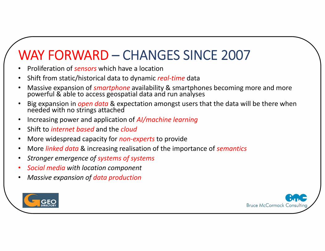
WAY FORWARD – CHANGES SINCE 2007• Proliferation of sensors which have a location • Shift from static/historical data to dynamic real‐time data• Massive expansion of smartphone availability & smartphones becoming more and more
powerful & able to access geospatial data and run analyses• Big expansion in open data & expectation amongst users that the data will be there when
needed with no strings attached• Increasing power and application of AI/machine learning• Shift to internet based and the cloud• More widespread capacity for non‐experts to provide • More linked data & increasing realisation of the importance of semantics • Stronger emergence of systems of systems • Social media with location component• Massive expansion of data production
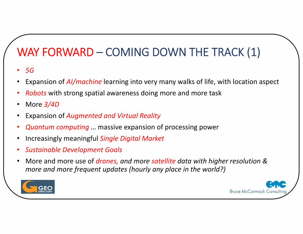
WAY FORWARD – COMING DOWN THE TRACK (1)• 5G• Expansion of AI/machine learning into very many walks of life, with location aspect• Robots with strong spatial awareness doing more and more task• More 3/4D• Expansion of Augmented and Virtual Reality • Quantum computing … massive expansion of processing power• Increasingly meaningful Single Digital Market • Sustainable Development Goals • More and more use of drones, and more satellite data with higher resolution &
more and more frequent updates (hourly any place in the world?)
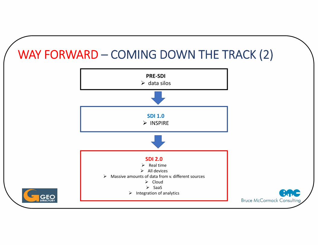
WAY FORWARD – COMING DOWN THE TRACK (2)PRE‐SDI data silos
SDI 1.0 INSPIRE
SDI 2.0 Real time All devices
Massive amounts of data from v. different sources Cloud SaaS
Integration of analytics
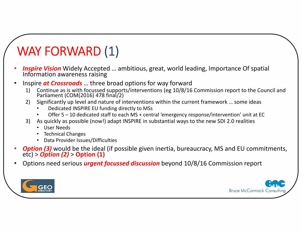
WAY FORWARD (1)• Inspire Vision Widely Accepted … ambitious, great, world leading, Importance Of spatial
Information awareness raising • Inspire at Crossroads … three broad options for way forward
1) Continue as is with focussed supports/interventions (eg 10/8/16 Commission report to the Council and Parliament (COM(2016) 478 final/2)
2) Significantly up level and nature of interventions within the current framework … some ideas• Dedicated INSPIRE EU funding directly to MSs • Offer 5 – 10 dedicated staff to each MS + central ‘emergency response/intervention’ unit at EC
3) As quickly as possible (now!) adapt INSPIRE in substantial ways to the new SDI 2.0 realities • User Needs• Technical Changes• Data Provider Issues/Difficulties
• Option (3) would be the ideal (if possible given inertia, bureaucracy, MS and EU commitments, etc) > Option (2) > Option (1)
• Options need serious urgent focussed discussion beyond 10/8/16 Commission report
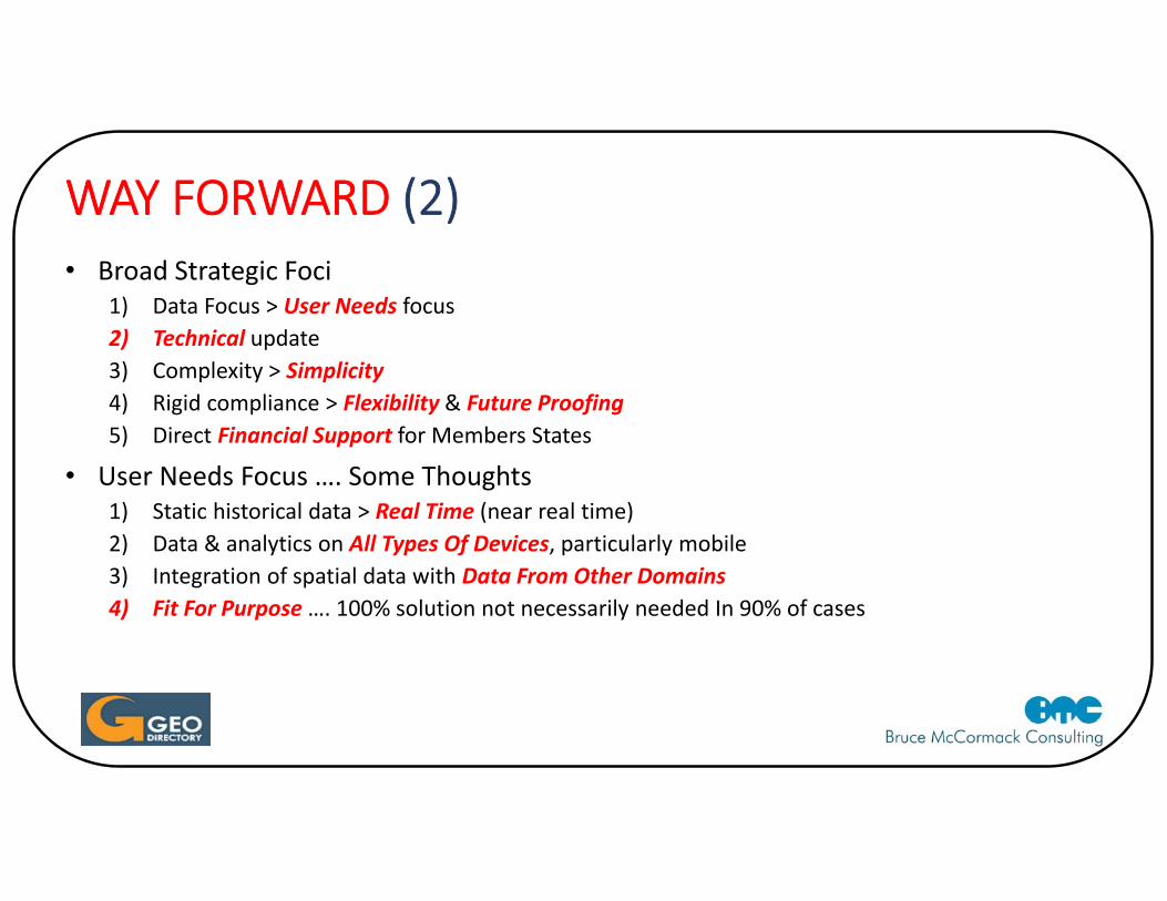
WAY FORWARD (2)• Broad Strategic Foci
1) Data Focus > User Needs focus 2) Technical update 3) Complexity > Simplicity4) Rigid compliance > Flexibility & Future Proofing5) Direct Financial Support for Members States
• User Needs Focus …. Some Thoughts 1) Static historical data > Real Time (near real time)2) Data & analytics on All Types Of Devices, particularly mobile3) Integration of spatial data with Data From Other Domains4) Fit For Purpose …. 100% solution not necessarily needed In 90% of cases
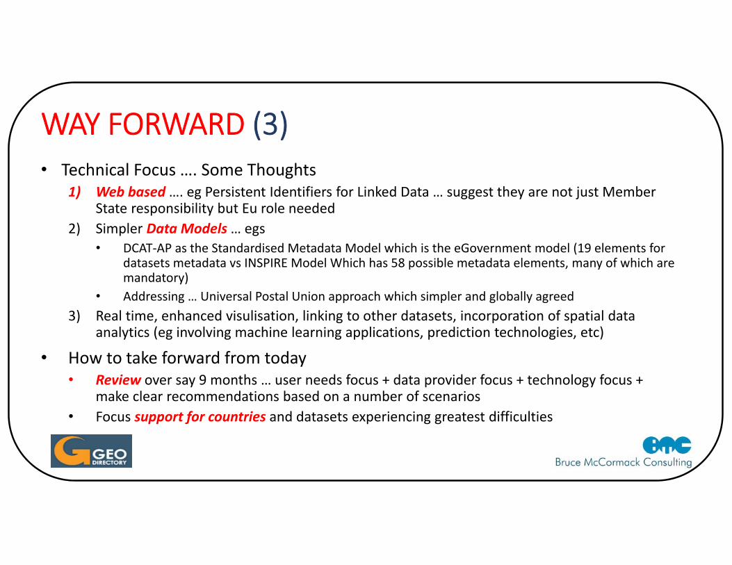
WAY FORWARD (3)• Technical Focus …. Some Thoughts
1) Web based …. eg Persistent Identifiers for Linked Data … suggest they are not just Member State responsibility but Eu role needed
2) Simpler Data Models … egs• DCAT‐AP as the Standardised Metadata Model which is the eGovernment model (19 elements for
datasets metadata vs INSPIRE Model Which has 58 possible metadata elements, many of which are mandatory)
• Addressing … Universal Postal Union approach which simpler and globally agreed3) Real time, enhanced visulisation, linking to other datasets, incorporation of spatial data
analytics (eg involving machine learning applications, prediction technologies, etc)
• How to take forward from today• Review over say 9 months … user needs focus + data provider focus + technology focus +
make clear recommendations based on a number of scenarios• Focus support for countries and datasets experiencing greatest difficulties
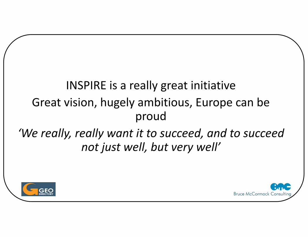
INSPIRE is a really great initiativeGreat vision, hugely ambitious, Europe can be
proud ‘We really, really want it to succeed, and to succeed
not just well, but very well’

THANK YOU
Related Documents