Government of India Ministry of Water Resources River Development & Ganga Rejuvenation Central Ground Water Board GROUND WATER YEAR BOOK OF KARNATAKA, 2016-17 CENTRAL GROUND WATER BOARD SOUTH WESTERN REGION BANGALORE October 2017 For official use only No. YB – 02/2017-18

Welcome message from author
This document is posted to help you gain knowledge. Please leave a comment to let me know what you think about it! Share it to your friends and learn new things together.
Transcript
Government of India Ministry of Water Resources
River Development & Ganga Rejuvenation Central Ground Water Board
GROUND WATER YEAR BOOK OF KARNATAKA, 2016-17
CENTRAL GROUND WATER BOARD SOUTH WESTERN REGION
BANGALORE October 2017
For official use only No. YB – 02/2017-18
GROUND WATER YEAR BOOK 2016-17 SOUTH WESTERN REGION, KARNATAKA
C O N T E N T S
Sl. No.
Item Page Nos.
1.
FOREWARD ABSTRACT
GENERAL FEATURES
1.1 Introduction 1.2 Physiography 1.3. Drainage 1.4. Hydrogeological Conditions
1 - 11
2.
RAINFALL DISTRIBUTION IN KARNATAKA STATE-2016
2.1 Pre Monsoon Season -2016 2.2 South west Monsoon Season - 2016 2.3 Northeast Monsoon Season - 2016 2.4 Annual rainfall
12 - 20
3.
GROUND WATER LEVELS IN KARNATAKA DURING WATER YEAR 2016-2017
3.1 Depth to Ground Water Levels 3.2 Fluctuations in the ground water levels
21 - 32
4. HYDROCHEMISTRY 33 - 35
5. CONCLUSIONS 36 - 37
List of Figures
Fig. 1.1: Agroclimatic Zones
Fig. 1.2: Drainage Fig. 1.3: Geology Fig. 2.1: Percentage departure from its normal for the Pre monsoon season 2016 Fig. 2.2: Percentage departure from its normal for the South West monsoon season 2016 Fig. 2.3: Percentage departure from its normal for the Post-monsoon season 2016 Fig. 2.2: Percentage departure from its normal for the Year 2016 (Annual period) Fig. 3.1: Depth to water level, May 2016 Fig. 3.2: Depth to water level, August 2016 Fig. 3.3: Depth to water level, November 2016 Fig. 3.4: Depth to water level, January 2017 Fig. 3.5: Ground water fluctuation May 2016- November 2016 Fig. 3.6: Ground water fluctuation May 2016 - January 2017 Fig. 3.7: Ground water fluctuation May 2015 - May 2016 Fig. 3.8: Ground water fluctuation August 2015 -August 2016 Fig. 3.9: Water level fluctuation November 2015 -November2016 Fig. 3.10: Water level fluctuation January 2016- January 2017 Fig. 3.11: Change in groundwater level Mean (May 2006 to May 2015) – May 2016 Fig. 3.12: Change in groundwater level Mean (August 2006 to August 2015) – August 2016 Fig. 3.13: Change in groundwater level Mean (November 2006 to November 2015)- November 2016 Fig. 3.14: Change in groundwater level Mean (January 2007 to January 2016) – January 2017
Fig. 4.1: Distribution of EC in Karnataka State (May 2014) Fig. 4.2: Distribution of Chloride in Karnataka State (May 2014) Fig. 4.3: Distribution of Nitrate in Karnataka State (May 2014) Fig. 4.4: Distribution of Fluoride in Karnataka State (May 2014)
List of Tables
Table 1.1: District wise distribution of NHS in Karnataka
Table 1.2: Agroclimatic zones and Area, Karnataka
Table 1.3: Basin sub basin and Drainage Area
Table 1.4: Basin wise distribution of NHS stations
Table 1.5: The geological succession in Karnataka State
Table 1.6: Formation-wise distribution of Hydrograph Network Stations.
Table 2.1: District-Wise Cumulative Rainfall and Departure During Pre-Monsoon Period 2016 Table 2.2: District-Wise Cumulative Rainfall and Departure During South-West Monsoon Period 2016
Table 2.3: District-Wise Cumulative Rainfall and Percentage Departure During North-East Monsoon Period 2016
Table 2.4: District-Wise Cumulative Rainfall and Departure During 2016 Annual Period Table 3.1: Depth to Water Table Distribution of Percentage of Observation Wells -May 2016
Table 3.2: Depth to Water Table Distribution of Percentage of Observation Wells -August 2016
Table 3.3: Depth to Water Table Distribution of Percentage of Observation Wells -November 2016
Table 3.4: Depth to Water Table Distribution of Percentage of Observation Wells -January 2017
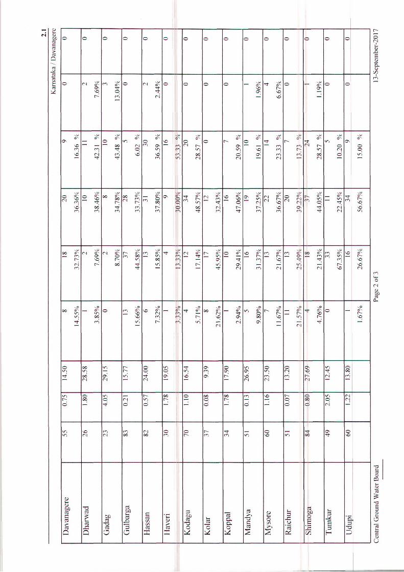
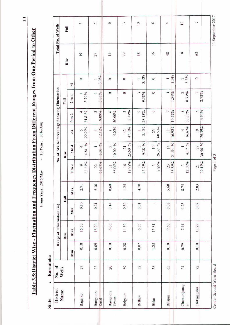
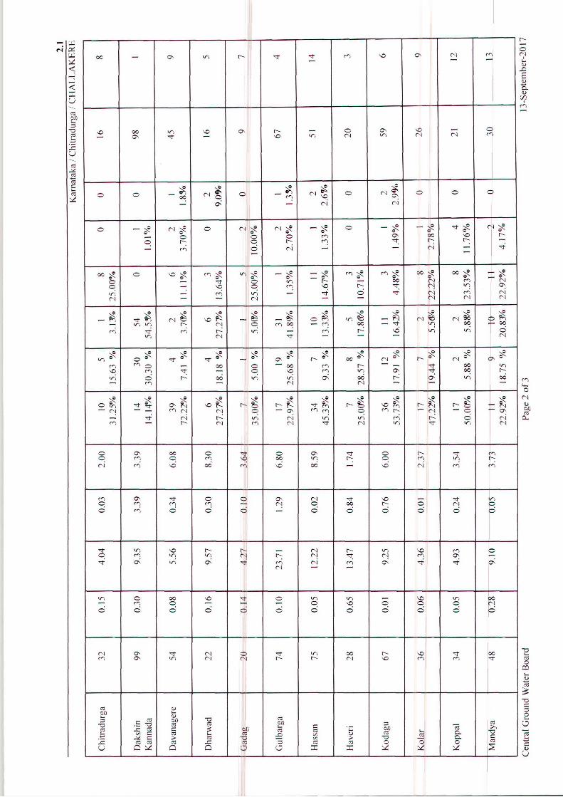
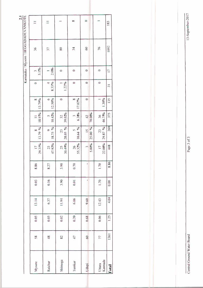
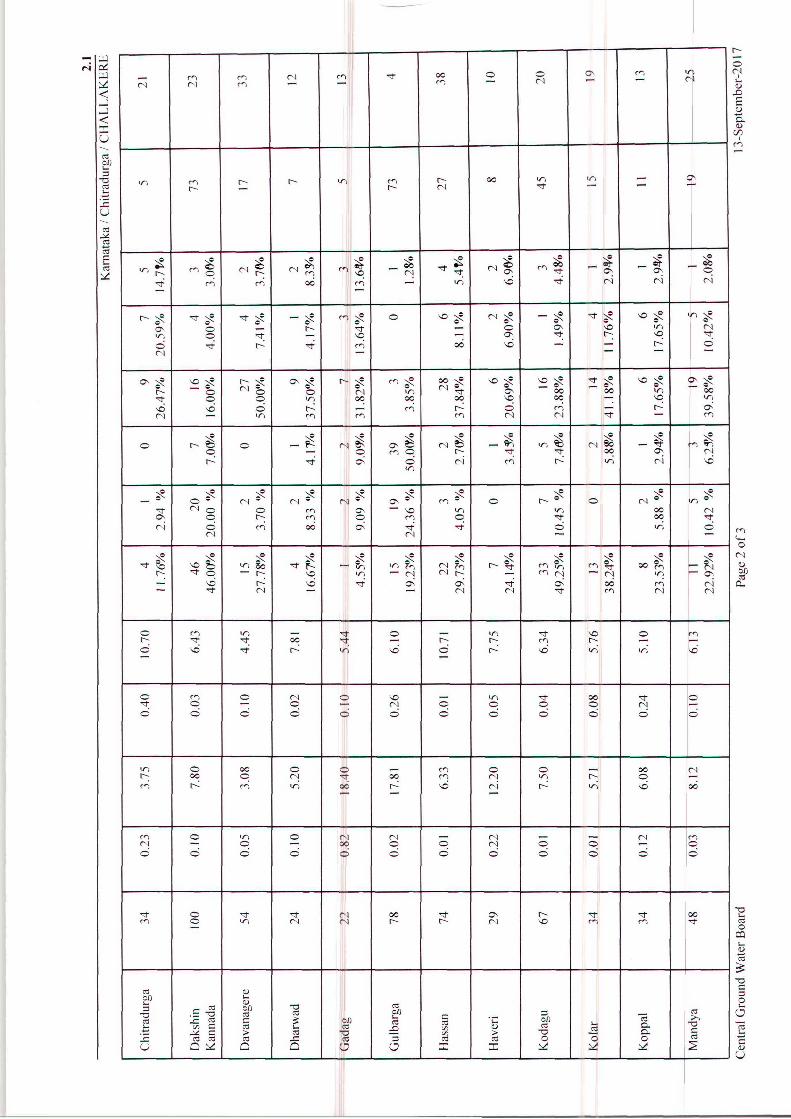
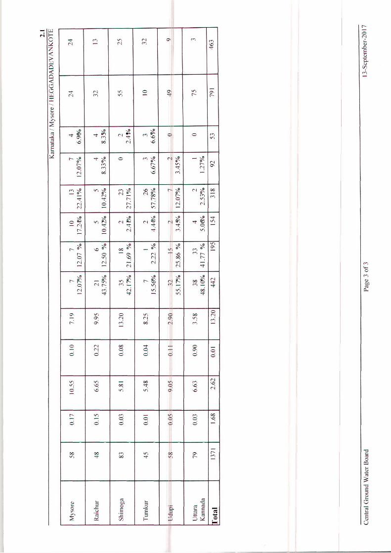
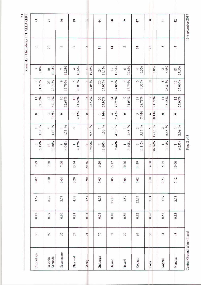
Table 3.5: District Wise - Fluctuation and Frequency Distribution From Different Ranges from May 2016 to Aug 2016
Table 3.6: District Wise - Fluctuation and Frequency Distribution From Different Ranges from May 2016 to Nov 2016
Table 3.7: District Wise - Fluctuation and Frequency Distribution From Different Ranges from May 2016 to Jan 2017
Table 3.8: District Wise - Fluctuation and Frequency Distribution From Different Ranges from May 2015 to May 2016
Table 3.9: District Wise - Fluctuation and Frequency Distribution From Different Ranges from Aug 2015 to Aug 2016
Table 3.10: District Wise - Fluctuation and Frequency Distribution From Different Ranges from Nov 2015 to Nov 2016
Table 3.11: District Wise - Fluctuation and Frequency Distribution From Different Ranges from Jan 2016 to Jan 2017
Table 3.12: District Wise - Fluctuation of Water Level With May 2006-2015 Mean and May 2016 Table 3.13: District Wise - Fluctuation of Water Level With Aug 2006-2015 Mean and Aug 2016
Table 3.14: District Wise - Fluctuation of Water Level With Nov 2006-2015 Mean and Nov 2016
Table 3.15: District Wise - Fluctuation of Water Level With Jan 2007-2016 Mean and Jan 2017
List of Annexures
Annexure-I General Details of GWMS
Annexure-II District and Taluk wise Normal and Actual Rainfall 2016
Annexure-III Hydrochemical Data of GWMS
CONTRIBUTORS’ PAGE
PRINCIPAL AUTHORS
Sri H.P.Jayaprakash, Scientist-C Smt. Rakhi U.R, Scientist-B
Ms Caroline Louis, Scientist-B Dr. Lubna Kouser, AHG Smt.
Smt. V.Hemalatha, STA DATA COLLECTION HYDROCHEMISTRY Sri M.Muthukannan, Scientist –D Sri Rahul Vasisht, STA(Ch) Sri S.S.Hegde Scientist-D Smt. Lalitha B.H, STA(Ch) Dr. A.Asokan Scientist -D Sri T.Rajendiran Scientist-D Dr. M.A.Farooqi Scientist-D Sri L.J.Balachandra, Scientist-D Sri J.Benjamin Vedanayagam, Scientist-D Sri K.Koti Reddy, Scientist-D Sri K.T.Suresha, Scientist-D Sri Sri A.Suresha, Scientist-D Sri G.Krishnamurthy, Scientist-D Sri H.P.Jayaprakash, Scientist-C Smt. Sandhya Yadav, Scientist-D Sri B.V.Chinagudi, Scientist-B Dr. J.Davithuraj, Scientist-B Smt. Rakhi U.R, Scientist-B Ms. Caroline Louis, Scientist-B Smt. Sangita P.Bhattacharjee, AHG Smt.Veena R.Achutha, AHG Smt. Bijimol Jose, AHG Sri J.Sivaramakrishnan, AHG Dr.S.Sreenivasa Vittala, AHG Dr. Lubna Kouser, AH Smt.P.Vijayalakshmi, Chief Draftsman Smt. V.Hemalatha, STA Sri P.S.Prasad, Surveyor Sri P.Narahari, Surveyor Sri N.Ravikumar Surveyor
SCRUTINY & ISSUANCE Dr. M. A. Farooqi Scientist-D
Dr. Lubna Kouser, AH Report Processing Section
CGWB, SWR, BANAGALORE

FOREWORD Groundwater is a dynamic and replenishable precious natural resource, it requires to be
monitored regularly and also to be appraised of the changes that are taking place in its
regime. In this regard, Central Ground Water Board collects the groundwater level and
quality data from the National Hydrograph Network Stations. The water levels are monitored
four times a year during the months of May, August, November and January and the samples
for determination of the quality of groundwater are collected once a year during the month of
May. This report consists of the ground water levels for the year 2016-17 and chemical
quality data collected during the year 2014. Maps showing the depth to groundwater level in
different parts of Karnataka and the changes observed in the water level in the last one-year
and last one decade are included and discussed in the report. Ground water stress areas
where water levels are depleting as interpreted from the available data are also delineated.
The report also consists of the discussions on distribution and variation of rainfall in the
state for the year 2016. Chemical quality of ground water on the basis of the samples
collected during May 2014 and the interpretation of the data is included in the report. The data has been compiled and interpreted by Shri. H. P. Jayaprakash., Scientist ‘C’, Smt.
Rakhi U.R., Scientist ‘B’, Miss Caroline Louis, Scientist ’B’, Dr. Lubna Kouser, Assistant
Hydrologist, Smt. V. Hemalatha, STA (HG). Lot of efforts have been put in by various
personnel of SWR, Bangalore and WKSU Belgaum offices for the collection of field data. The
water samples were analysed at the Regional Chemical Laboratory by Shri Rahul Vashist,
STA (Chem.) and Smt. Lalitha B.H., STA (Chem.) to bring out the aspects of ground water
quality. Dr. M. A. Farooqi Scientist ‘D’ of Report Processing Section has carried out the
necessary processing of the report to bring the report to the final stage. It is hoped that the information contained in this Yearbook will be useful for planners,
administrators and other user agencies associated with development and management of
water resources in the state.
(K. M. Viswanath) Regional Director
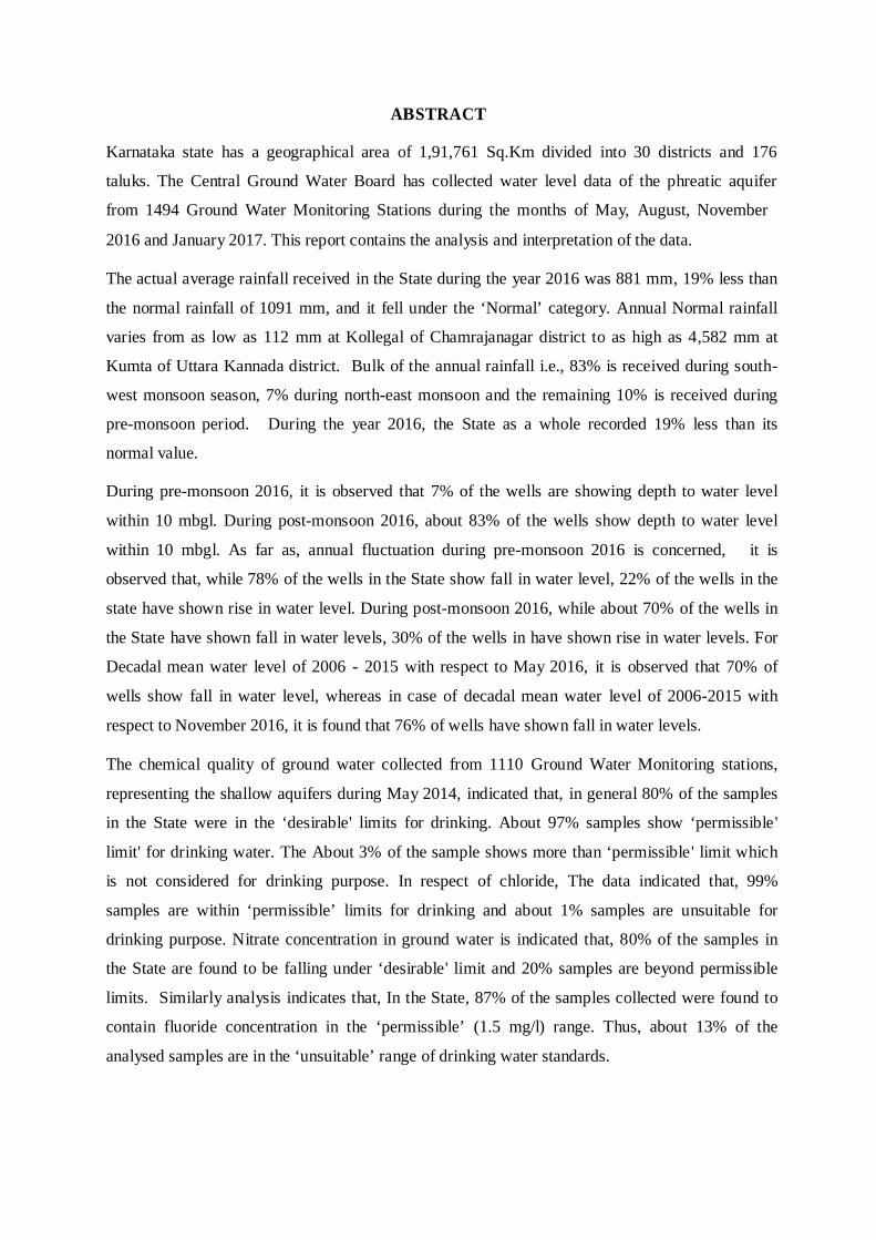
ABSTRACT Karnataka state has a geographical area of 1,91,761 Sq.Km divided into 30 districts and 176
taluks. The Central Ground Water Board has collected water level data of the phreatic aquifer
from 1494 Ground Water Monitoring Stations during the months of May, August, November
2016 and January 2017. This report contains the analysis and interpretation of the data. The actual average rainfall received in the State during the year 2016 was 881 mm, 19% less than
the normal rainfall of 1091 mm, and it fell under the ‘Normal’ category. Annual Normal rainfall
varies from as low as 112 mm at Kollegal of Chamrajanagar district to as high as 4,582 mm at
Kumta of Uttara Kannada district. Bulk of the annual rainfall i.e., 83% is received during south-
west monsoon season, 7% during north-east monsoon and the remaining 10% is received during
pre-monsoon period. During the year 2016, the State as a whole recorded 19% less than its
normal value.
During pre-monsoon 2016, it is observed that 7% of the wells are showing depth to water level
within 10 mbgl. During post-monsoon 2016, about 83% of the wells show depth to water level
within 10 mbgl. As far as, annual fluctuation during pre-monsoon 2016 is concerned, it is
observed that, while 78% of the wells in the State show fall in water level, 22% of the wells in the
state have shown rise in water level. During post-monsoon 2016, while about 70% of the wells in
the State have shown fall in water levels, 30% of the wells in have shown rise in water levels. For
Decadal mean water level of 2006 - 2015 with respect to May 2016, it is observed that 70% of
wells show fall in water level, whereas in case of decadal mean water level of 2006-2015 with
respect to November 2016, it is found that 76% of wells have shown fall in water levels.
The chemical quality of ground water collected from 1110 Ground Water Monitoring stations,
representing the shallow aquifers during May 2014, indicated that, in general 80% of the samples
in the State were in the ‘desirable' limits for drinking. About 97% samples show ‘permissible'
limit' for drinking water. The About 3% of the sample shows more than ‘permissible' limit which
is not considered for drinking purpose. In respect of chloride, The data indicated that, 99%
samples are within ‘permissible’ limits for drinking and about 1% samples are unsuitable for
drinking purpose. Nitrate concentration in ground water is indicated that, 80% of the samples in
the State are found to be falling under ‘desirable' limit and 20% samples are beyond permissible
limits. Similarly analysis indicates that, In the State, 87% of the samples collected were found to
contain fluoride concentration in the ‘permissible’ (1.5 mg/l) range. Thus, about 13% of the
analysed samples are in the ‘unsuitable’ range of drinking water standards.
1
GROUND WATER YEAR BOOK OF KARNATAKA STATE
2016-17
1. GENERAL FEATURES
1.1. Introduction:
Central Ground Water Board, South Western Region, Bangalore, is monitoring water levels in
the State of Karnataka from the established network of 1936 monitoring stations, as a part of
‘Ground Water Monitoring’ program. This monitoring is done four times in a water year during
May, August, November and January for water level. Water samples from these stations are
collected once in a year during the month of May to assess the ground water quality.
The Karnataka State, situated between 11o31′00″ and 18
o45′00″ north latitudes and 74
o12′00″
and 78o40′00″ east longitudes in the west-central part of peninsular India has a total
geographical area of 1,91,791 sq. km which is administratively divided into 30 districts and 176
taluks (Fig 1.1). The district wise distribution of number of Groundwater Monitoring Stations in
the State is given in Table 1.1.
The water levels monitored are analyzed to know the variations in ground water levels in space
and time. This report discusses the regional behavior of ground water levels for the period
between May 2016 and January 2017. Based on the data from the Ground water monitoring
stations, the status of ground water development in the State is being assessed.
1.2. Physiography:
Physiographically the State is divided into four regions as below:
a) The narrow Coastal plain along the west coast running to about 300 km from Karwar in the
north to Mangalore in south. The tract is quite narrow reaching maximum width of about 40 km
at places. The general elevation of the ground varies between 0 to 200 m above mean sea level
(amsl). The rivers draining the area have a westerly course.
b) The Malnad region with steep mountain ranges and valleys lying immediately east of the
former. The general elevation of the area varies from 200 m amsl along the boundary with the
coastal plain to 1872 m amsl at Kudremukh. Its width varies from 50 to 100 km. Several rivers
like Cauvery and Tungabhadra originate from this region.
c) The Northern part of the State comprises a table-land and its general elevation ranges from
300 to 350 m amsl.
2
d) The Eastern districts towards south form a plateau, which is characterized by rolling
topography with sporadic hills. The general elevation in this track varies from 600 to 1000 m
amsl.
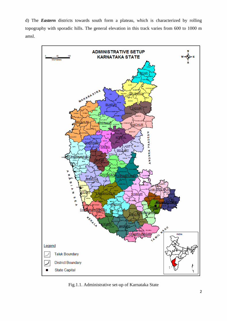
Fig.1.1. Administrative set-up of Karnataka State
3
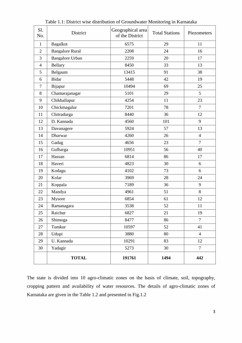
Table 1.1: District wise distribution of Groundwater Monitoring in Karnataka
Sl.
No. District
Geographical area
of the District Total Stations Piezometers
1 Bagalkot 6575 29 11
2 Bangalore Rural 2208 24 16
3 Bangalore Urban 2259 20 17
4 Bellary 8450 33 13
5 Belgaum 13415 91 38
6 Bidar 5448 42 19
7 Bijapur 10494 69 25
8 Chamarajanagar 5101 29 5
9 Chikballapur 4254 11 23
10 Chickmagalur 7201 78 7
11 Chitradurga 8440 36 12
12 D. Kannada 4560 101 9
13 Davanagere 5924 57 13
14 Dharwar 4260 26 4
15 Gadag 4656 23 7
16 Gulbarga 10951 56 40
17 Hassan 6814 86 17
18 Haveri 4823 30 6
19 Kodagu 4102 73 6
20 Kolar 3969 28 24
21 Koppala 7189 36 9
22 Mandya 4961 51 8
23 Mysore 6854 61 12
24 Ramanagara 3538 52 11
25 Raichur 6827 21 19
26 Shimoga 8477 86 7
27 Tumkur 10597 52 41
28 Udupi 3880 80 4
29 U. Kannada 10291 83 12
30 Yadagir 5273 30 7
TOTAL 191761 1494 442
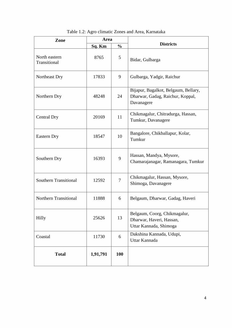
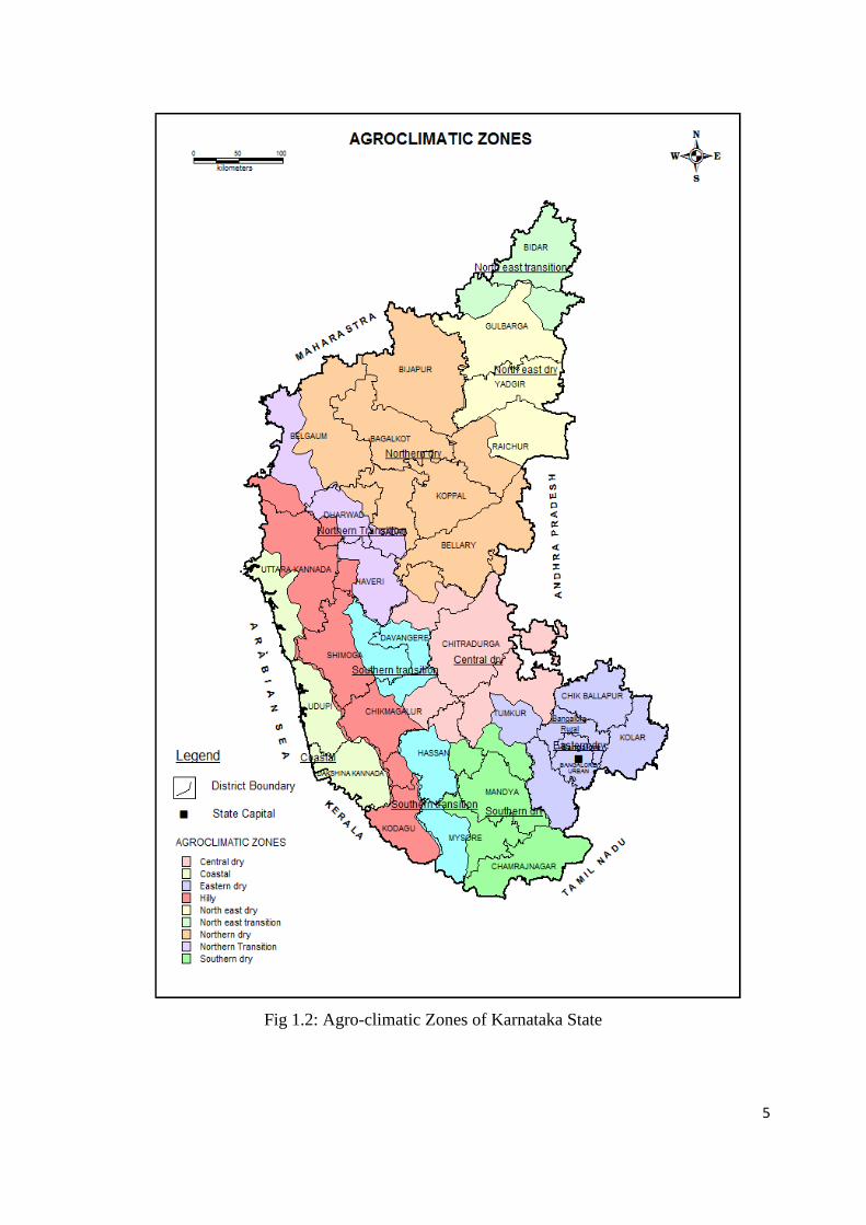
The state is divided into 10 agro-climatic zones on the basis of climate, soil, topography,
cropping pattern and availability of water resources. The details of agro-climatic zones of
Karnataka are given in the Table 1.2 and presented in Fig.1.2
4
Table 1.2: Agro climatic Zones and Area, Karnataka
Zone Area Districts
Sq. Km %
North eastern
Transitional 8765 5
Bidar, Gulbarga
Northeast Dry 17833 9 Gulbarga, Yadgir, Raichur
Northern Dry 48248 24
Bijapur, Bagalkot, Belgaum, Bellary,
Dharwar, Gadag, Raichur, Koppal,
Davanagere
Central Dry 20169 11 Chikmagalur, Chitradurga, Hassan,
Tumkur, Davanagere
Eastern Dry 18547 10 Bangalore, Chikballapur, Kolar,
Tumkur
Southern Dry 16393 9 Hassan, Mandya, Mysore,
Chamarajanagar, Ramanagara, Tumkur
Southern Transitional 12592 7 Chikmagalur, Hassan, Mysore,
Shimoga, Davanagere
Northern Transitional 11888 6 Belgaum, Dharwar, Gadag, Haveri
Hilly 25626 13 Belgaum, Coorg, Chikmagalur,
Dharwar, Haveri, Hassan,
Uttar Kannada, Shimoga
Coastal 11730 6 Dakshina Kannada, Udupi,
Uttar Kannada
Total 1,91,791 100
5
Fig 1.2: Agro-climatic Zones of Karnataka State
6
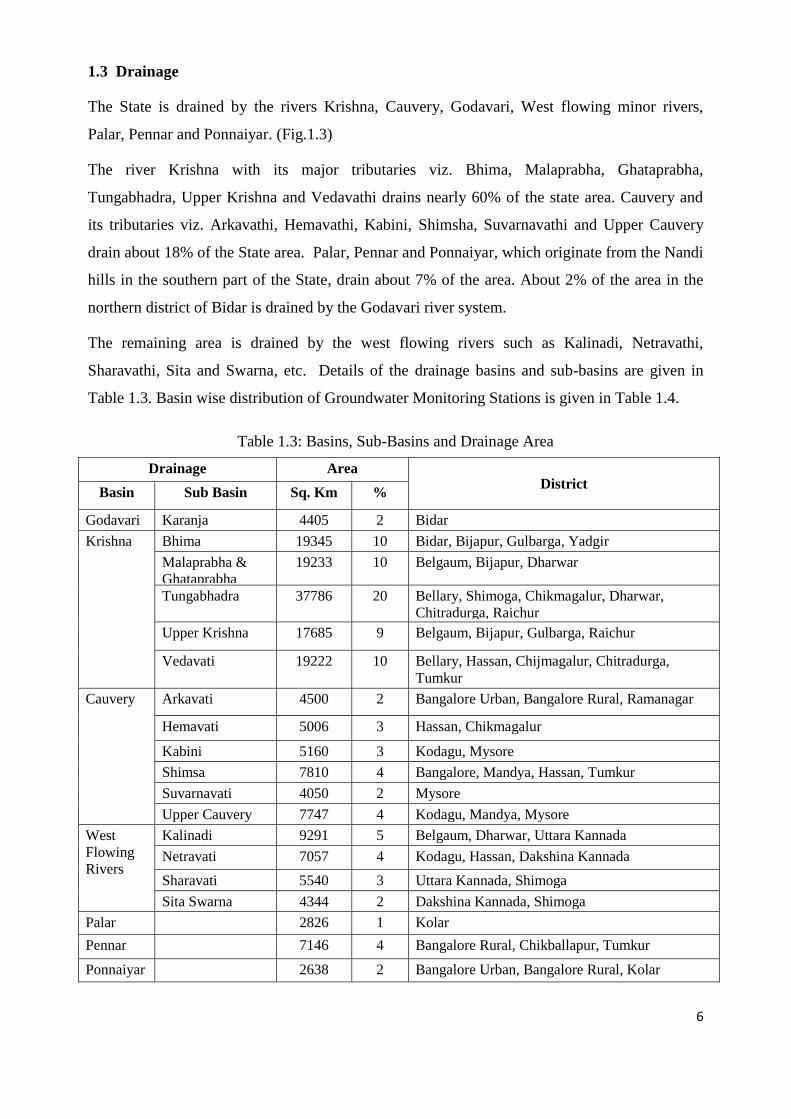
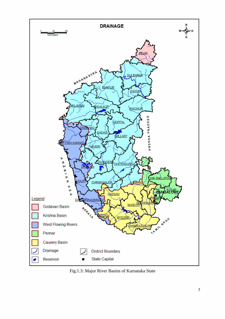
1.3 Drainage
The State is drained by the rivers Krishna, Cauvery, Godavari, West flowing minor rivers,
Palar, Pennar and Ponnaiyar. (Fig.1.3)
The river Krishna with its major tributaries viz. Bhima, Malaprabha, Ghataprabha,
Tungabhadra, Upper Krishna and Vedavathi drains nearly 60% of the state area. Cauvery and
its tributaries viz. Arkavathi, Hemavathi, Kabini, Shimsha, Suvarnavathi and Upper Cauvery
drain about 18% of the State area. Palar, Pennar and Ponnaiyar, which originate from the Nandi
hills in the southern part of the State, drain about 7% of the area. About 2% of the area in the
northern district of Bidar is drained by the Godavari river system.
The remaining area is drained by the west flowing rivers such as Kalinadi, Netravathi,
Sharavathi, Sita and Swarna, etc. Details of the drainage basins and sub-basins are given in
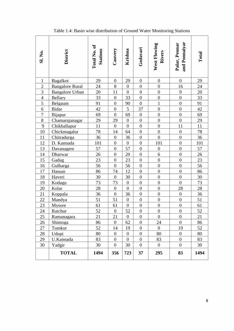
Table 1.3. Basin wise distribution of Groundwater Monitoring Stations is given in Table 1.4.
Table 1.3: Basins, Sub-Basins and Drainage Area
Drainage Area District
Basin Sub Basin Sq. Km %
Godavari Karanja 4405 2 Bidar
Krishna Bhima 19345 10 Bidar, Bijapur, Gulbarga, Yadgir
Malaprabha &
Ghataprabha
19233 10 Belgaum, Bijapur, Dharwar
Tungabhadra 37786 20 Bellary, Shimoga, Chikmagalur, Dharwar,
Chitradurga, Raichur
Upper Krishna 17685 9 Belgaum, Bijapur, Gulbarga, Raichur
Vedavati 19222 10 Bellary, Hassan, Chijmagalur, Chitradurga,
Tumkur
Cauvery Arkavati 4500 2 Bangalore Urban, Bangalore Rural, Ramanagar
Hemavati 5006 3 Hassan, Chikmagalur
Kabini 5160 3 Kodagu, Mysore
Shimsa 7810 4 Bangalore, Mandya, Hassan, Tumkur
Suvarnavati 4050 2 Mysore
Upper Cauvery 7747 4 Kodagu, Mandya, Mysore
West
Flowing
Rivers
Kalinadi 9291 5 Belgaum, Dharwar, Uttara Kannada
Netravati 7057 4 Kodagu, Hassan, Dakshina Kannada
Sharavati 5540 3 Uttara Kannada, Shimoga
Sita Swarna 4344 2 Dakshina Kannada, Shimoga
Palar 2826 1 Kolar
Pennar 7146 4 Bangalore Rural, Chikballapur, Tumkur
Ponnaiyar 2638 2 Bangalore Urban, Bangalore Rural, Kolar
7
Fig.1.3: Major River Basins of Karnataka State
8
Table 1.4: Basin wise distribution of Ground Water Monitoring Stations
Sl.
No.
Dis
tric
t
Tota
l N
o. of
Sta
tion
s
Cau
ver
y
Kri
shn
a
God
avari
Wes
t F
low
ing
Riv
ers
Pala
r, P
enn
ar
an
d P
on
naiy
ar
Tota
l
1 Bagalkot 29 0 29 0 0 0 29
2 Bangalore Rural 24 8 0 0 0 16 24
3 Bangalore Urban 20 11 0 0 0 9 20
4 Bellary 33 0 33 0 0 0 33
5 Belgaum 91 0 90 0 1 0 91
6 Bidar 42 0 5 37 0 0 42
7 Bijapur 69 0 69 0 0 0 69
8 Chamarajanagar 29 29 0 0 0 0 29
9 Chikballapur 11 0 0 0 0 11 11
10 Chickmagalur 78 14 64 0 0 0 78
11 Chitradurga 36 0 36 0 0 0 36
12 D. Kannada 101 0 0 0 101 0 101
13 Davanagere 57 0 57 0 0 0 57
14 Dharwar 26 0 20 0 6 0 26
15 Gadag 23 0 23 0 0 0 23
16 Gulbarga 56 0 56 0 0 0 56
17 Hassan 86 74 12 0 0 0 86
18 Haveri 30 0 30 0 0 0 30
19 Kodagu 73 73 0 0 0 0 73
20 Kolar 28 0 0 0 0 28 28
21 Koppala 36 0 36 0 0 0 36
22 Mandya 51 51 0 0 0 0 51
23 Mysore 61 61 0 0 0 0 61
24 Raichur 52 0 52 0 0 0 52
25 Ramanagara 21 21 0 0 0 0 21
26 Shimoga 86 0 62 0 24 0 86
27 Tumkur 52 14 19 0 0 19 52
28 Udupi 80 0 0 0 80 0 80
29 U.Kannada 83 0 0 0 83 0 83
30 Yadgir 30 0 30 0 0 0 30
TOTAL 1494 356 723 37 295 83 1494

9
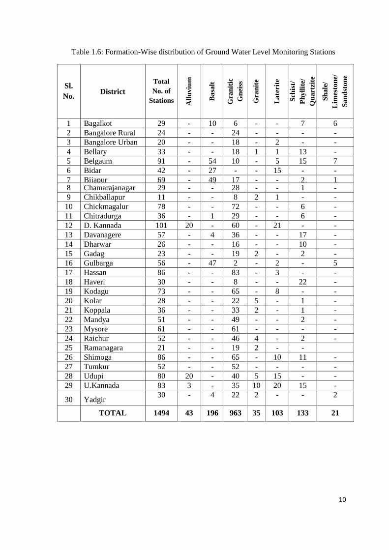
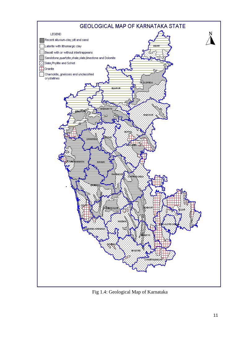
1.4 Geology
Karnataka State is underlain by rock types ranging in age from Archaean to Recent. Major
portion of the State is covered by Peninsular Gneisses, Granites and Dharwarian Schists of
Archaean age. Substantial area in the northern part of Karnataka is underlain by basalts, which
form a continuation of the Deccan Traps occurring in Maharashtra. The sedimentaries
comprising Bhima and Kaladgis occupy a small area in the northern districts. The recent
alluvium is restricted to a narrow belt in the coastal area and along stream courses (Fig.1.4). The
geological succession in the State is presented in Table 1.5. Formation-wise distribution of
Ground water monitoring stations in the State is shown in Table 1.6. Majority of the stations
are located in Granitic Gniessic region.
Except for the alluvium, which occurs in a limited area, the State is occupied mainly by
crystalline rocks and consolidated sedimentaries, which do not possess primary porosity except
for the Basalts, which have a limited primary porosity in the form of vesicular zones. Secondary
porosity introduced in them through weathering, fracturing and jointing produces the void
spaces to hold and transmit ground water. Solution cavities in the limestones, when sufficiently
large can form good aquifers.
Table 1.5: Geological succession in Karnataka state
Age Series/System Formation
Recent Soil & Alluvium Sand and Clay
Pliestocene Laterite Laterite
Tertiary to Mesozoic Deccan Trap Basalt Hard massive & vesicular Basalts
~~~~~~~~~~~~~~~~~~~~~~~~ UNCONFORMITY ~~~~~~~~~~~~~~~~~~~~~~~
Lower Paleozoic to upper
Precambrian
Bhima Series Quartzites, Sandstone, Limestone,
Shale and Conglomerates
~~~~~~~~~~~~~~~~~~~~~~~~ UNCONFORMITY ~~~~~~~~~~~~~~~~~~~~~~~
Upper Precambrian Kaladgi Series Quartzites, Sandstones, Limestones,
Shale and Conglomerates.
~~~~~~~~~~~~~~~~~~~~~~~~~ UNCONFORMITY ~~~~~~~~~~~~~~~~~~~~~~~
Lower Precambrian Dharwar system
volcanics Greenstone,
metasediments
Dharwar Schists meta sediments
Greenstone formations
~~~~~~~~~~~~~~~~~~~~~~~~~ UNCONFORMITY ~~~~~~~~~~~~~~~~~~~~~~~
Archaean Peninsular Gneissic
complex
Gneisses, Granites, Charnockites,
Khondalites
10
Table 1.6: Formation-Wise distribution of Ground Water Level Monitoring Stations
Sl.
No. District
Total
No. of
Stations All
uviu
m
Ba
salt
Gra
nit
ic
Gn
eiss
Gra
nit
e
La
teri
te
Sch
ist/
Ph
yll
ite/
Qu
art
zite
Sh
ale
/
Lim
esto
ne/
Sa
nd
sto
ne
1 Bagalkot 29 - 10 6 - - 7 6
2 Bangalore Rural 24 - - 24 - - - -
3 Bangalore Urban 20 - - 18 - 2 - -
4 Bellary 33 - - 18 1 1 13 -
5 Belgaum 91 - 54 10 - 5 15 7
6 Bidar 42 - 27 - - 15 - -
7 Bijapur 69 - 49 17 - - 2 1 8 Chamarajanagar 29 - - 28 - - 1 -
9 Chikballapur 11 - - 8 2 1 - -
10 Chickmagalur 78 - - 72 - - 6 -
11 Chitradurga 36 - 1 29 - - 6 -
12 D. Kannada 101 20 - 60 - 21 - -
13 Davanagere 57 - 4 36 - - 17 -
14 Dharwar 26 - - 16 - - 10 -
15 Gadag 23 - - 19 2 - 2 -
16 Gulbarga 56 - 47 2 - 2 - 5
17 Hassan 86 - - 83 - 3 - -
18 Haveri 30 - - 8 - - 22 -
19 Kodagu 73 - - 65 - 8 - -
20 Kolar 28 - - 22 5 - 1 -
21 Koppala 36 - - 33 2 - 1 -
22 Mandya 51 - - 49 - - 2 -
23 Mysore 61 - - 61 - - - -
24 Raichur 52 - - 46 4 - 2 -
25 Ramanagara 21 - - 19 2 - -
26 Shimoga 86 - - 65 - 10 11 -
27 Tumkur 52 - - 52 - - - -
28 Udupi 80 20 - 40 5 15 - -
29 U.Kannada 83 3 - 35 10 20 15 -
30 Yadgir 30 - 4 22 2 - - 2
TOTAL 1494 43 196 963 35 103 133 21
11
Fig 1.4: Geological Map of Karnataka
12
2.0 RAINFALL DISTRIBUTION IN KARNATAKA STATE-2016
The year is generally divided into four seasons. These are: dry season (January - February),
pre-monsoon season (March - May), Monsoon season (June - September) and post-monsoon
season (October - December). The pre monsoon season is characterized by squally weather
resulting in heavy rains often accompanied by hail. The Indian summer monsoon, the
harbinger of hope for the farmers, normally sets in the State by the first week of June and
covers the entire state in about two weeks time. It starts withdrawing by the end of
September and totally goes out of the State by the middle of October. Bulk of the annual
rainfall is contributed by the summer monsoon. It is replaced by the winter monsoon, which is
relatively dry. Significant rainfall occurs due to passing depressions/cyclones. The annual
rainfall during the year 2016 varied from about 112 mm (at Kollegal of Chamrajnagar
district) in the southern parts to over 4582 mm (at Kumta of Uttar Kannada district) over the
Ghats in the west averaging 881 mm. Bulk of the annual rainfall i.e., 83% of rainfall received
during south-west monsoon season, 7% during north-east monsoon and the remaining 10%
received during pre-monsoon period.
The rainfall in various districts/regions/taluks has been classified as Excess (E) Normal (N) and
Deficit (D) as per following criteria.
Excess -- 120% of normal or more
Normal -- 81% to 119% of normal
Deficit -- 80% of normal or less
Based on the above classification, districts falling under the above-mentioned three
categories and as well as for the whole of Karnataka State as for 2016 has been presented
below.
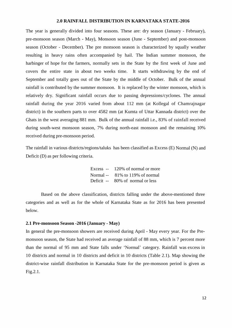
2.1 Pre-monsoon Season -2016 (January - May)
In general the pre-monsoon showers are received during April - May every year. For the Pre-
monsoon season, the State had received an average rainfall of 88 mm, which is 7 percent more
than the normal of 95 mm and State falls under ‘Normal’ category. Rainfall was excess in
10 districts and normal in 10 districts and deficit in 10 districts (Table 2.1). Map showing the
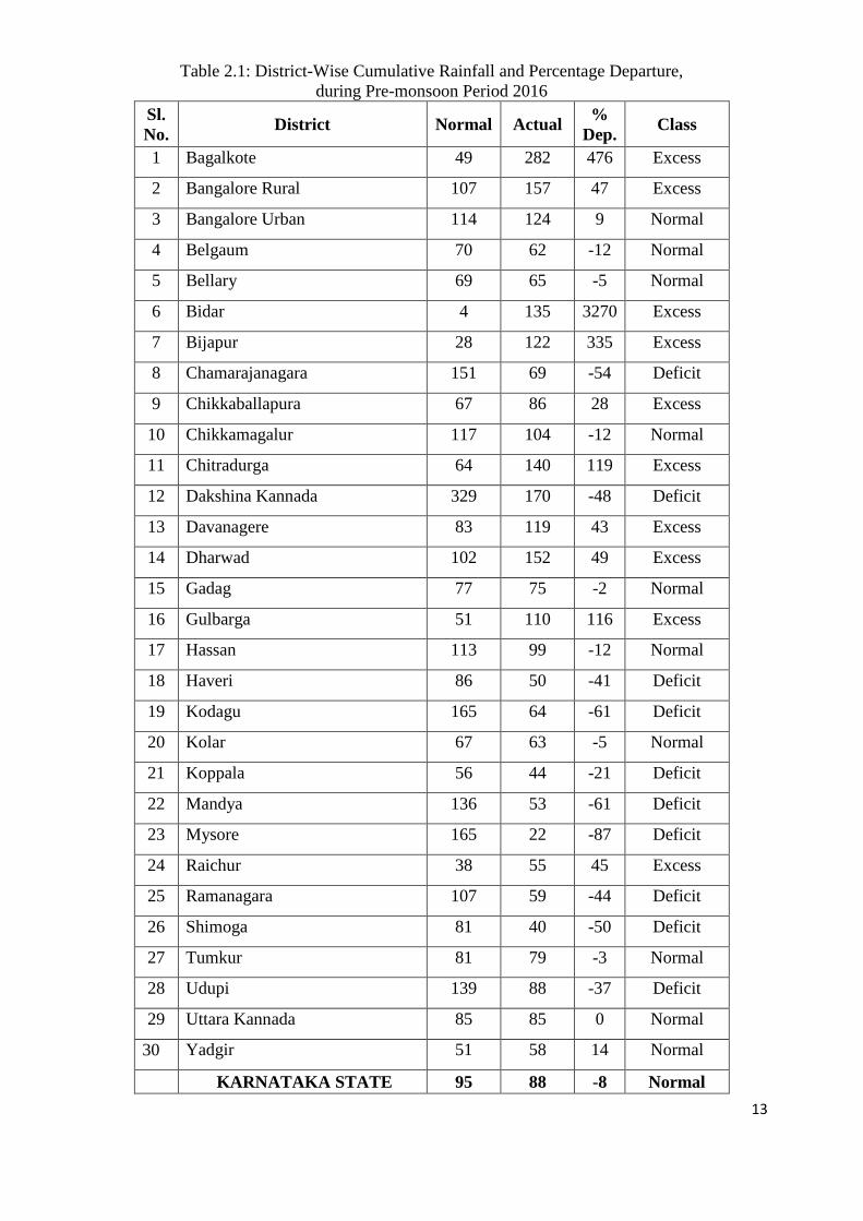
district-wise rainfall distribution in Karnataka State for the pre-monsoon period is given as
Fig.2.1.
13
Table 2.1: District-Wise Cumulative Rainfall and Percentage Departure,
during Pre-monsoon Period 2016
Sl.
No. District Normal Actual
%
Dep. Class
1 Bagalkote 49 282 476 Excess
2 Bangalore Rural 107 157 47 Excess
3 Bangalore Urban 114 124 9 Normal
4 Belgaum 70 62 -12 Normal
5 Bellary 69 65 -5 Normal
6 Bidar 4 135 3270 Excess
7 Bijapur 28 122 335 Excess
8 Chamarajanagara 151 69 -54 Deficit
9 Chikkaballapura 67 86 28 Excess
10 Chikkamagalur 117 104 -12 Normal
11 Chitradurga 64 140 119 Excess
12 Dakshina Kannada 329 170 -48 Deficit
13 Davanagere 83 119 43 Excess
14 Dharwad 102 152 49 Excess
15 Gadag 77 75 -2 Normal
16 Gulbarga 51 110 116 Excess
17 Hassan 113 99 -12 Normal
18 Haveri 86 50 -41 Deficit
19 Kodagu 165 64 -61 Deficit
20 Kolar 67 63 -5 Normal
21 Koppala 56 44 -21 Deficit
22 Mandya 136 53 -61 Deficit
23 Mysore 165 22 -87 Deficit
24 Raichur 38 55 45 Excess
25 Ramanagara 107 59 -44 Deficit
26 Shimoga 81 40 -50 Deficit
27 Tumkur 81 79 -3 Normal
28 Udupi 139 88 -37 Deficit
29 Uttara Kannada 85 85 0 Normal
30 Yadgir 51 58 14 Normal
KARNATAKA STATE 95 88 -8 Normal
14
Fig. 2.1: Pre-monsoon (2016) rainfall distribution in Karnataka State
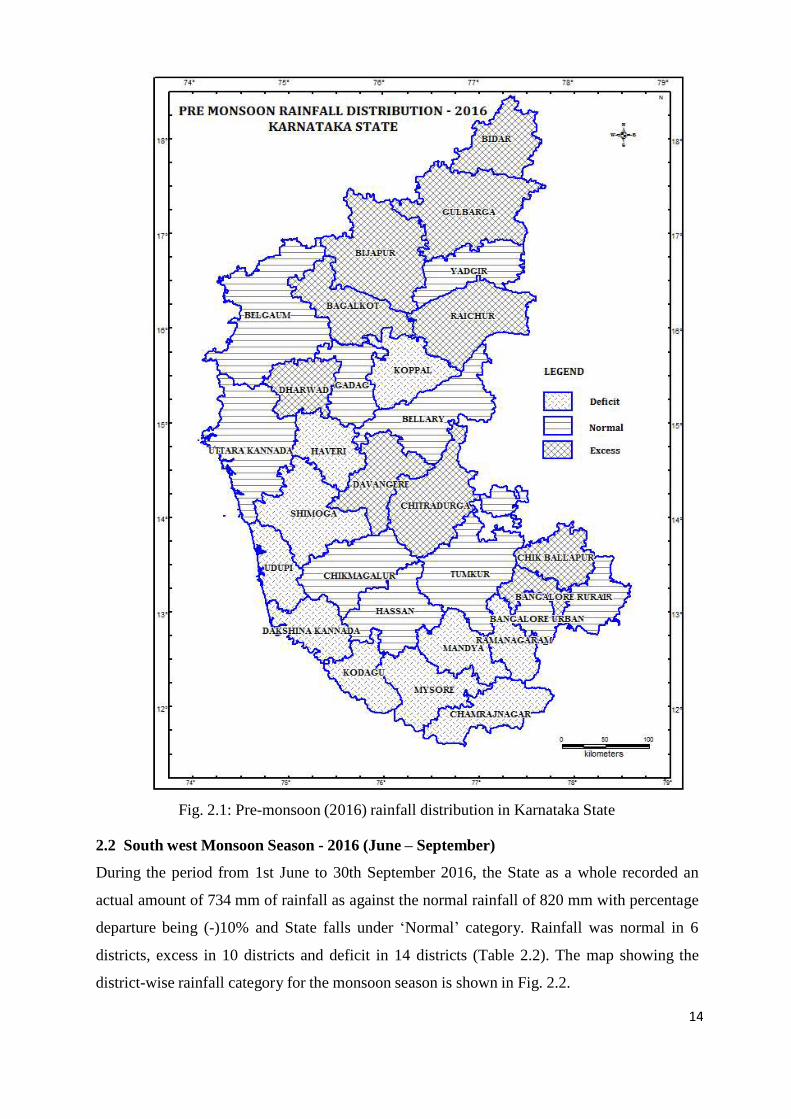
2.2 South west Monsoon Season - 2016 (June – September)
During the period from 1st June to 30th September 2016, the State as a whole recorded an
actual amount of 734 mm of rainfall as against the normal rainfall of 820 mm with percentage
departure being (-)10% and State falls under ‘Normal’ category. Rainfall was normal in 6
districts, excess in 10 districts and deficit in 14 districts (Table 2.2). The map showing the
district-wise rainfall category for the monsoon season is shown in Fig. 2.2.
15
Table 2.2: District-Wise Cumulative Rainfall (mm) and Percentage Departure
during South- West Monsoon Period 2016
Sl.
No. District Normal Actual
%
Dep Class
1 Bagalkote 361 778 115 Excess
2 Bangalore Rural 426 480 13 Normal
3 Bangalore Urban 460 350 -24 Deficit
4 Belgaum 561 205 -64 Deficit
5 Bellary 387 350 -10 Normal
6 Bidar 705 239 -66 Deficit
7 Bijapur 428 324 -24 Deficit
8 Chamarajanagara 315 1355 330 Excess
9 Chikkaballapura 412 286 -31 Deficit
10 Chikkamagalur 1506 130 -91 Deficit
11 Chitradurga 283 1388 390 Excess
12 Dakshina Kannada 3338 2707 -19 Normal
13 Davanagere 360 516 43 Excess
14 Dharwad 478 1753 267 Excess
15 Gadag 365 265 -27 Deficit
16 Gulbarga 640 205 -68 Deficit
17 Hassan 583 3341 473 Excess
18 Haveri 484 273 -44 Deficit
19 Kodagu 2129 1021 -52 Deficit
20 Kolar 362 763 111 Excess
21 Koppala 383 560 46 Excess
22 Mandya 295 286 -3 Normal
23 Mysore 335 400 19 Normal
24 Raichur 479 311 -35 Deficit
25 Ramanagara 425 619 46 Excess
26 Shimoga 1483 388 -74 Deficit
27 Tumkur 362 340 -6 Normal
28 Udupi 3670 277 -92 Deficit
29 Uttara Kannada 2537 417 -84 Deficit
30 Yadgir 640 2355 268 Excess
KARNATAKA STATE 820 734 -10 Normal

16
Fig 2.2: South –West monsoon (2016) rainfall distribution in Karnataka State
2.3 Northeast monsoon Season - 2016 (October – December)
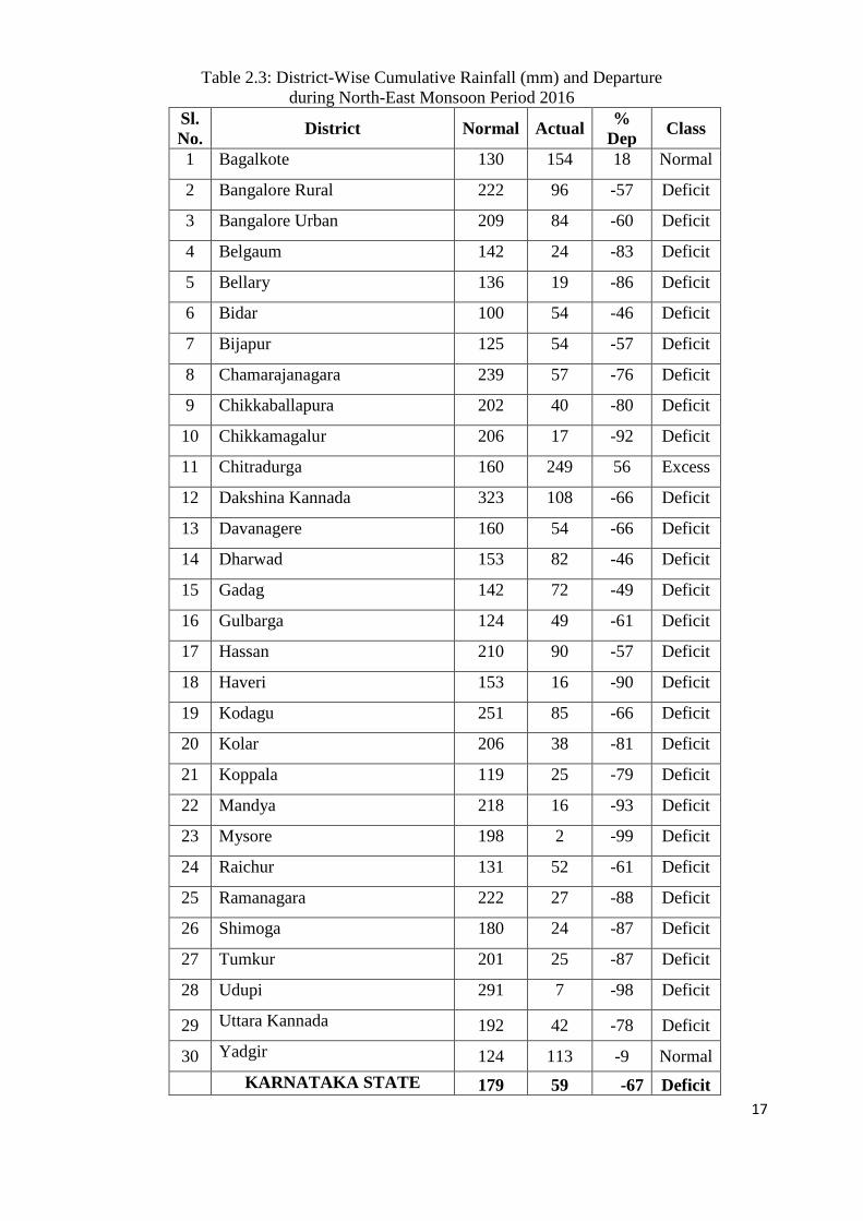
During the period from 1st October to 30th December 2016, the State as a whole recorded an
actual amount of 59 mm of rainfall as against the normal rainfall of 179 mm with percentage
departure being (-) 67% and State falls under ‘Deficit’ category. Rainfall was excess in 1
district, normal in 2 districts and deficit in 27 districts (Table 2.3). The map showing the
district-wise rainfall category for the season is shown in Fig. 2.3.
17
Table 2.3: District-Wise Cumulative Rainfall (mm) and Departure
during North-East Monsoon Period 2016
Sl.
No. District Normal Actual
%
Dep Class
1 Bagalkote 130 154 18 Normal
2 Bangalore Rural 222 96 -57 Deficit
3 Bangalore Urban 209 84 -60 Deficit
4 Belgaum 142 24 -83 Deficit
5 Bellary 136 19 -86 Deficit
6 Bidar 100 54 -46 Deficit
7 Bijapur 125 54 -57 Deficit
8 Chamarajanagara 239 57 -76 Deficit
9 Chikkaballapura 202 40 -80 Deficit
10 Chikkamagalur 206 17 -92 Deficit
11 Chitradurga 160 249 56 Excess
12 Dakshina Kannada 323 108 -66 Deficit
13 Davanagere 160 54 -66 Deficit
14 Dharwad 153 82 -46 Deficit
15 Gadag 142 72 -49 Deficit
16 Gulbarga 124 49 -61 Deficit
17 Hassan 210 90 -57 Deficit
18 Haveri 153 16 -90 Deficit
19 Kodagu 251 85 -66 Deficit
20 Kolar 206 38 -81 Deficit
21 Koppala 119 25 -79 Deficit
22 Mandya 218 16 -93 Deficit
23 Mysore 198 2 -99 Deficit
24 Raichur 131 52 -61 Deficit
25 Ramanagara 222 27 -88 Deficit
26 Shimoga 180 24 -87 Deficit
27 Tumkur 201 25 -87 Deficit
28 Udupi 291 7 -98 Deficit
29 Uttara Kannada 192 42 -78 Deficit
30 Yadgir 124 113 -9 Normal
KARNATAKA STATE 179 59 -67 Deficit

18
Fig. 2.3: North-East monsoon (2016) rainfall distribution in Karnataka State
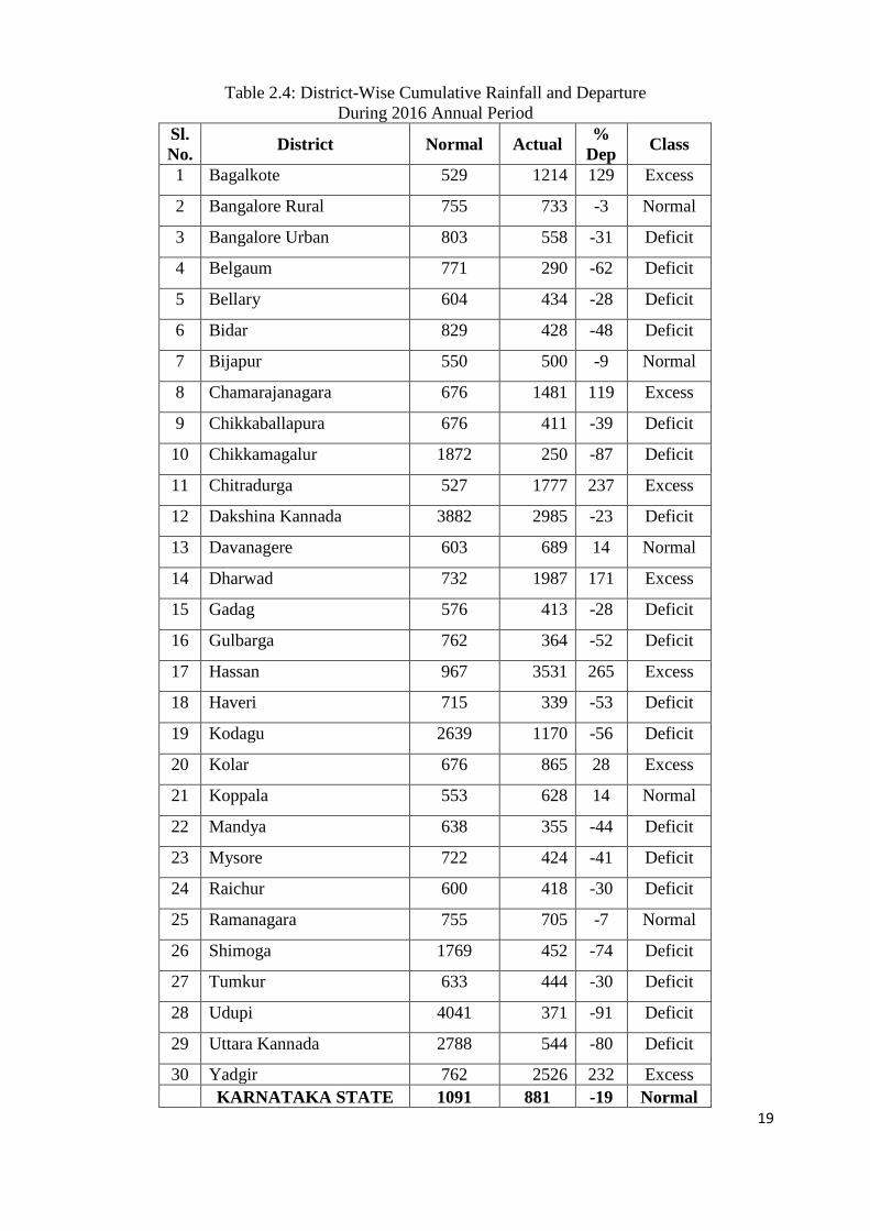
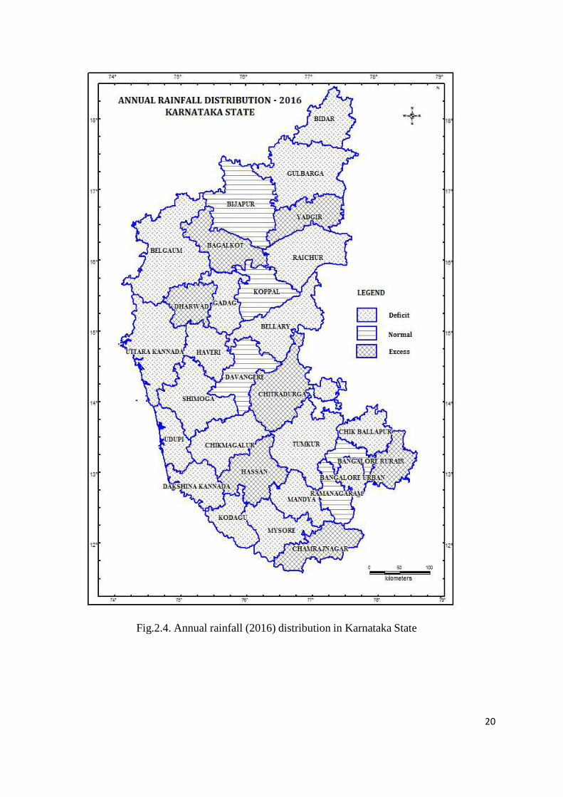
2.4 Annual rainfall 2016 (January to December)
The actual average rainfall received in the State during the year 2016 is 881 mm, 19 per cent
less than the normal rainfall of 1091 mm and which fell under the 'Normal' category. At
district level, out of 30 districts in the State, 5 districts had normal rainfall, 7 districts excess
rainfall and in the remaining 18 districts had deficit rainfall. So, State as a whole under the
‘Normal’ category. District-wise cumulative rainfall and percentage departure from its normal
for the year 2016 is given in Table 2.4 and district-wise rainfall distribution is presented
in Fig. 2.4.
19
Table 2.4: District-Wise Cumulative Rainfall and Departure
During 2016 Annual Period
Sl.
No. District Normal Actual
%
Dep Class
1 Bagalkote 529 1214 129 Excess
2 Bangalore Rural 755 733 -3 Normal
3 Bangalore Urban 803 558 -31 Deficit
4 Belgaum 771 290 -62 Deficit
5 Bellary 604 434 -28 Deficit
6 Bidar 829 428 -48 Deficit
7 Bijapur 550 500 -9 Normal
8 Chamarajanagara 676 1481 119 Excess
9 Chikkaballapura 676 411 -39 Deficit
10 Chikkamagalur 1872 250 -87 Deficit
11 Chitradurga 527 1777 237 Excess
12 Dakshina Kannada 3882 2985 -23 Deficit
13 Davanagere 603 689 14 Normal
14 Dharwad 732 1987 171 Excess
15 Gadag 576 413 -28 Deficit
16 Gulbarga 762 364 -52 Deficit
17 Hassan 967 3531 265 Excess
18 Haveri 715 339 -53 Deficit
19 Kodagu 2639 1170 -56 Deficit
20 Kolar 676 865 28 Excess
21 Koppala 553 628 14 Normal
22 Mandya 638 355 -44 Deficit
23 Mysore 722 424 -41 Deficit
24 Raichur 600 418 -30 Deficit
25 Ramanagara 755 705 -7 Normal
26 Shimoga 1769 452 -74 Deficit
27 Tumkur 633 444 -30 Deficit
28 Udupi 4041 371 -91 Deficit
29 Uttara Kannada 2788 544 -80 Deficit
30 Yadgir 762 2526 232 Excess
KARNATAKA STATE 1091 881 -19 Normal
20
Fig.2.4. Annual rainfall (2016) distribution in Karnataka State
21
3.0 GROUND WATER LEVELS IN KARNATAKA
DURING WATER YEAR 2016-17
Central Ground Water Board, South Western Region, Bangalore has a network of 1936
stations in Karnataka under the program ‘Ground Water Regime Monitoring’ of the Board
which works out to be one Groundwater Monitoring station in 101 Sq. Km.
The above network comprises 1494 stations, which are predominantly domestic dug wells
and are monitored four times a year during the months of January, May, August and
November for water levels and once a year for quality during May. The wells are monitored
between 1st to 10
th during January and November and between 20
th and 30
th during May and
August.
In addition, the Central Ground Water Board has a network of 442 piezometers drilled under
Hydrology Project and other activities of the CGWB in the State. These piezometers are also
monitored manually for water levels along with the dug well network four times a year.
However the piezometers water levels are not incorporated in preparation of the water level
and fluctuation maps.
Sample collection for quality monitoring is done along with water level monitoring during
the month of May. Samples are collected from the dug wells in the above network, but the
samples from piezometers are not being collected at present.
The analysis of the data collected and the findings are as follows:
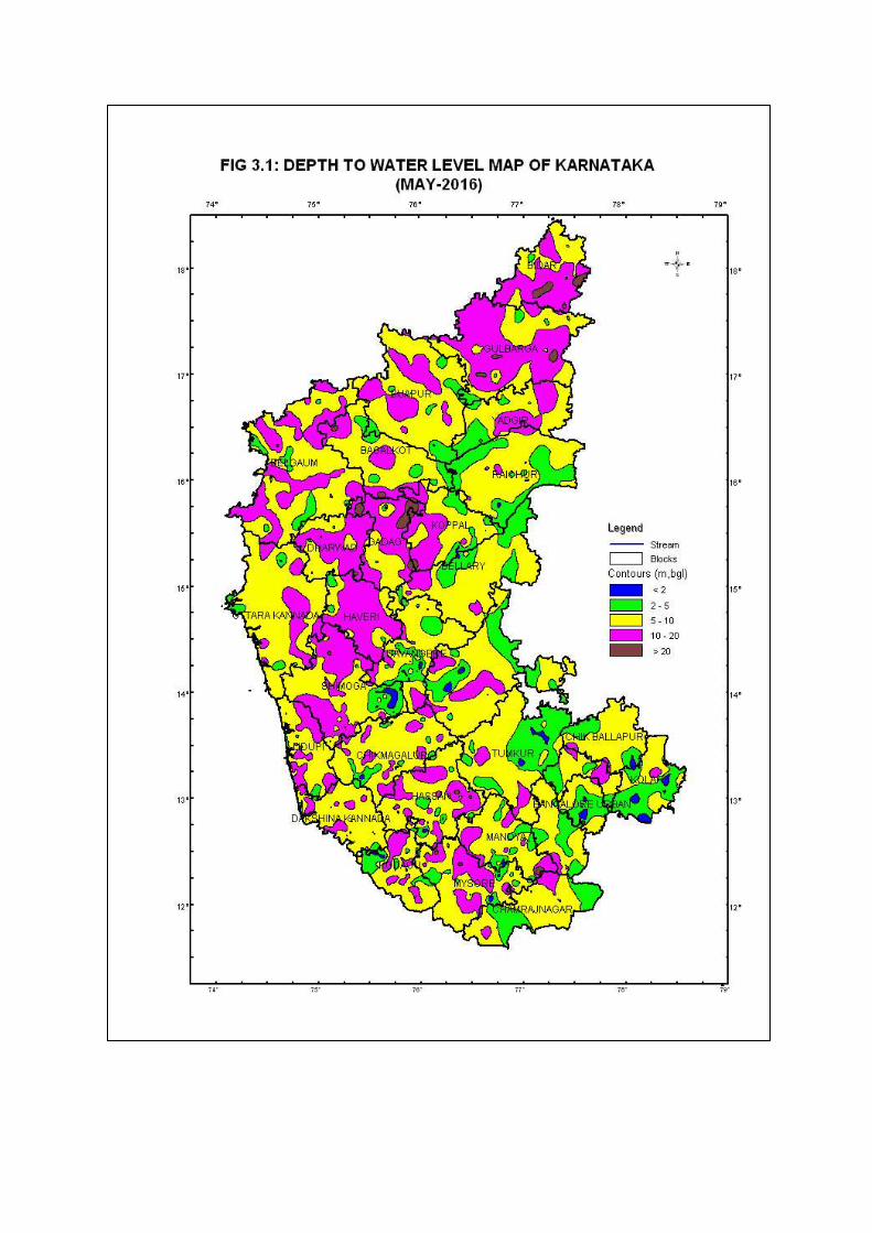
3.1 Depth to Ground Water Levels
Monitoring of Groundwater Monitoring Stations in Karnataka was carried out during May,
August, November 2016 and January 2017.
Depth to Water Level, May 2016
The depth to water level recorded in the State during May 2016 ranged from 0.01 mbgl to
26.95 mbgl. A total of 1488 stations are monitored and 4 new water level stations are
established during this monitoring season. Out of these 1415 wells analysed, 5% wells have
water level less than 2 mbgl, 21% have water level in the range of 2 to 5 mbgl and 45% of the
wells have water level in the range of 5 to 10 mbgl. Thus, about 71% of the analysed wells
have water level within 10 mbgl. Moderately deep water levels of 10 to 20 mbgl are seen
in 27% of the wells and deep water levels of > 20 m is found in about 2% of the analysed
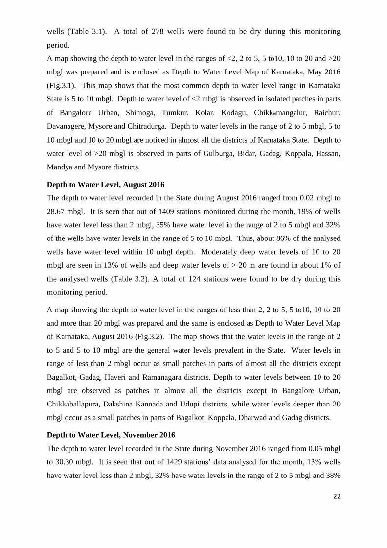
22
wells (Table 3.1). A total of 278 wells were found to be dry during this monitoring
period.
A map showing the depth to water level in the ranges of <2, 2 to 5, 5 to10, 10 to 20 and >20
mbgl was prepared and is enclosed as Depth to Water Level Map of Karnataka, May 2016
(Fig.3.1). This map shows that the most common depth to water level range in Karnataka
State is 5 to 10 mbgl. Depth to water level of <2 mbgl is observed in isolated patches in parts
of Bangalore Urban, Shimoga, Tumkur, Kolar, Kodagu, Chikkamangalur, Raichur,
Davanagere, Mysore and Chitradurga. Depth to water levels in the range of 2 to 5 mbgl, 5 to
10 mbgl and 10 to 20 mbgl are noticed in almost all the districts of Karnataka State. Depth to
water level of >20 mbgl is observed in parts of Gulburga, Bidar, Gadag, Koppala, Hassan,
Mandya and Mysore districts.
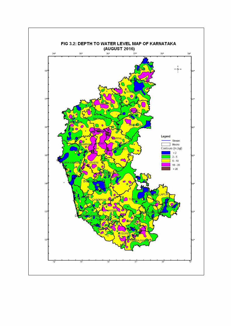
Depth to Water Level, August 2016
The depth to water level recorded in the State during August 2016 ranged from 0.02 mbgl to
28.67 mbgl. It is seen that out of 1409 stations monitored during the month, 19% of wells
have water level less than 2 mbgl, 35% have water level in the range of 2 to 5 mbgl and 32%
of the wells have water levels in the range of 5 to 10 mbgl. Thus, about 86% of the analysed
wells have water level within 10 mbgl depth. Moderately deep water levels of 10 to 20
mbgl are seen in 13% of wells and deep water levels of > 20 m are found in about 1% of
the analysed wells (Table 3.2). A total of 124 stations were found to be dry during this
monitoring period.
A map showing the depth to water level in the ranges of less than 2, 2 to 5, 5 to10, 10 to 20
and more than 20 mbgl was prepared and the same is enclosed as Depth to Water Level Map
of Karnataka, August 2016 (Fig.3.2). The map shows that the water levels in the range of 2
to 5 and 5 to 10 mbgl are the general water levels prevalent in the State. Water levels in
range of less than 2 mbgl occur as small patches in parts of almost all the districts except
Bagalkot, Gadag, Haveri and Ramanagara districts. Depth to water levels between 10 to 20
mbgl are observed as patches in almost all the districts except in Bangalore Urban,
Chikkaballapura, Dakshina Kannada and Udupi districts, while water levels deeper than 20
mbgl occur as a small patches in parts of Bagalkot, Koppala, Dharwad and Gadag districts.
Depth to Water Level, November 2016
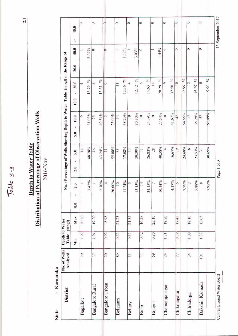
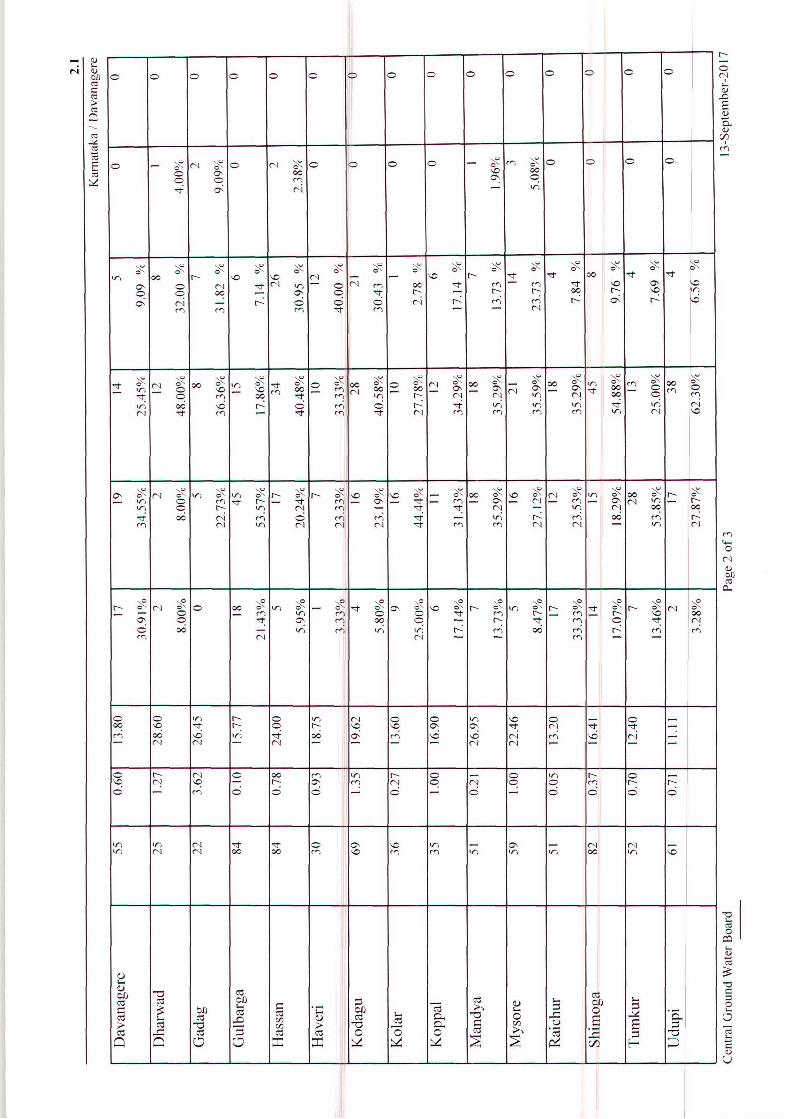
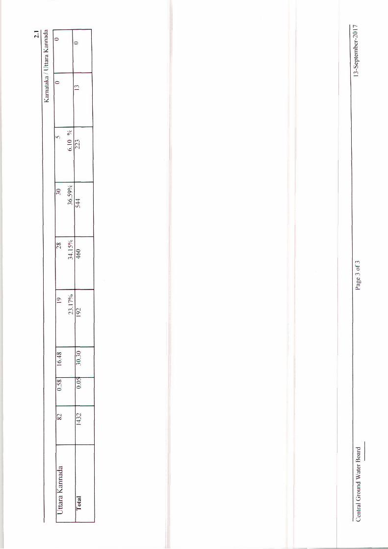
The depth to water level recorded in the State during November 2016 ranged from 0.05 mbgl
to 30.30 mbgl. It is seen that out of 1429 stations’ data analysed for the month, 13% wells
have water level less than 2 mbgl, 32% have water levels in the range of 2 to 5 mbgl and 38%

23
of wells have water levels in the range of 5 to 10 mbgl. Thus, about 83% of the analysed
wells have water level within 10 mbgl. Moderately deep water levels of 10 to 20 mbgl are
seen in 16% of the wells and deep water levels of > 20 m are found in about 1% of the
analysed wells (Table 3.3).
A map showing the depth to water level in the range of < 2, 2 to 5, 5 to10, 10 to 20 and more
than 20 mbgl was prepared and the same is enclosed as Depth to Water Level Map of
Karnataka, November 2016, (Fig.3.3). Water levels in range of less than 2 mbgl occur as
small patches in almost all the districts of Karnataka State except Gadag, Dharwad, Haveri,
Bagalkot, Mysore, Chamarajnagar, Kodagu, Hassan, Ramanagara and Dakshina Kannada
districts. The map shows that the water levels in the range of 2 to 5 and 5 to 10 mbgl are the
general water levels prevalent in the State. Depth to water level between 10 to 20 mbgl is
observed as small patches in almost all the districts except in Bangalore Urban,
Chikkaballapura and Udupi districts and water level deeper than 20 mbgl occur as a small
patches in Gadag, Koppala, Bagalkot and Dharwad districts.
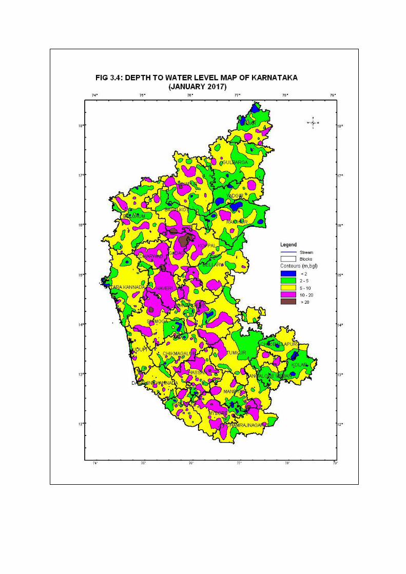
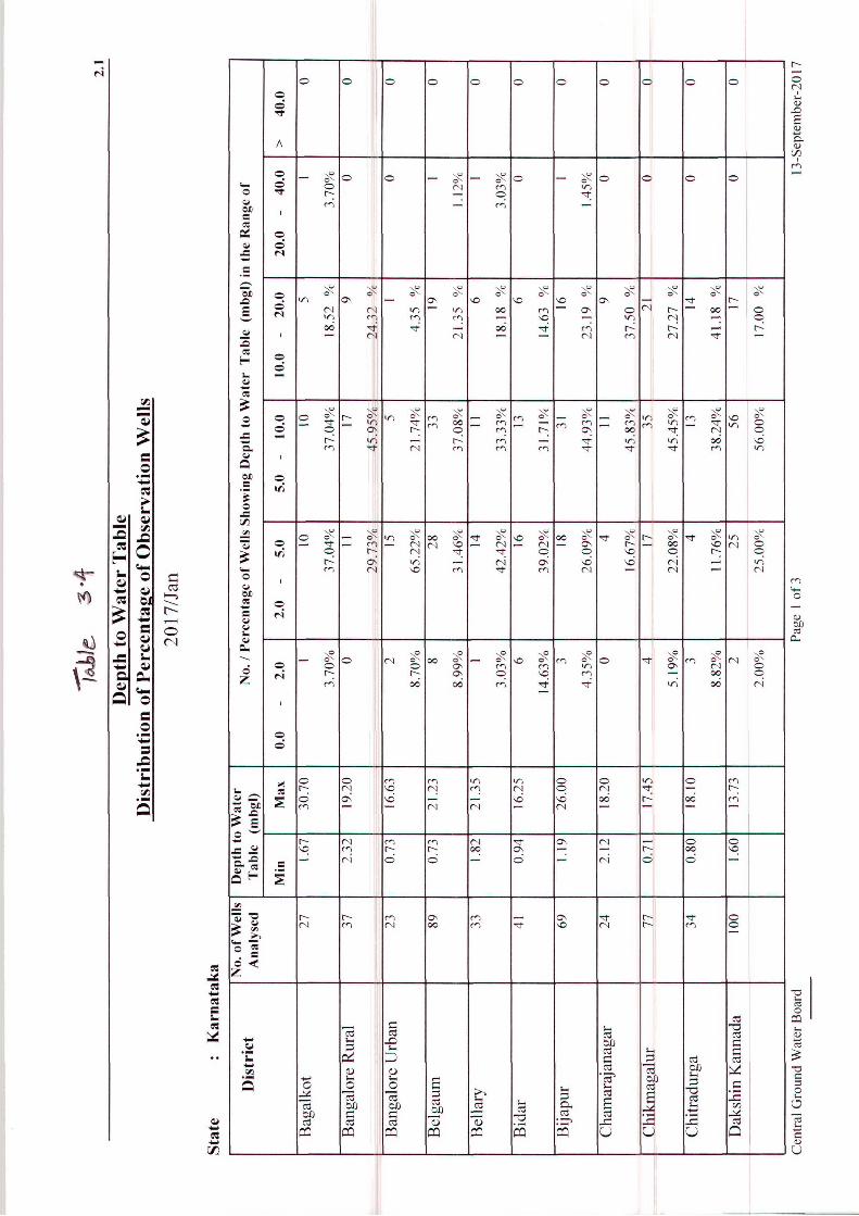
Depth to Water Level, January 2017
The depth to water level recorded in the state during January 2017 ranged from 0.07 mbgl to
30.70 mbgl. It is seen that out of 1430 stations’ data analysed for the month, 7% of the wells
have water level < 2 mbgl, 29% have water levels in the range of 2 to 5 mbgl and 41% of the
wells have water levels in the range of 5 to 10 mbgl. Thus, about 77% of the analysed wells
have water level within 10 mbgl. Moderately deep water levels of 10 to 20 mbgl are seen
in 22% of wells and deep water levels of > 20 m are found in about 1% of the analysed
wells (Table 3.4). A total of 178 stations were found to be dry during the period.
A map showing the depth to water level in the ranges of < 2, 2 to 5, 5 to10, 10 to 20 and > 20
mbgl was prepared and the same is enclosed as Depth to Water Level Map of Karnataka,
January 2017 (Fig.3.4). The map shows that the water level in the range of 5 to 10 mbgl is
the general water level prevalent in the State. Water levels in range of less than 2 mbgl occur
as tiny patches in parts of almost all the districts of Karnataka State except Bangalore Rural,
Chamarajnagar, Gadag, Dharwad, Haveri, Tumkur and Udupi districts. Depth to water level
in the range of 2 to 5 mbgl is observed in all the districts of Karnataka State. Depth to water
levels between 10 to 20 mbgl are observed in almost all the districts except in Bangalore
Urban district and water level more than 20 mbgl occur as small patches in Bagalkot, Bijapur,
Dharwad, Gadag, Hassan and Mysore districts.
24
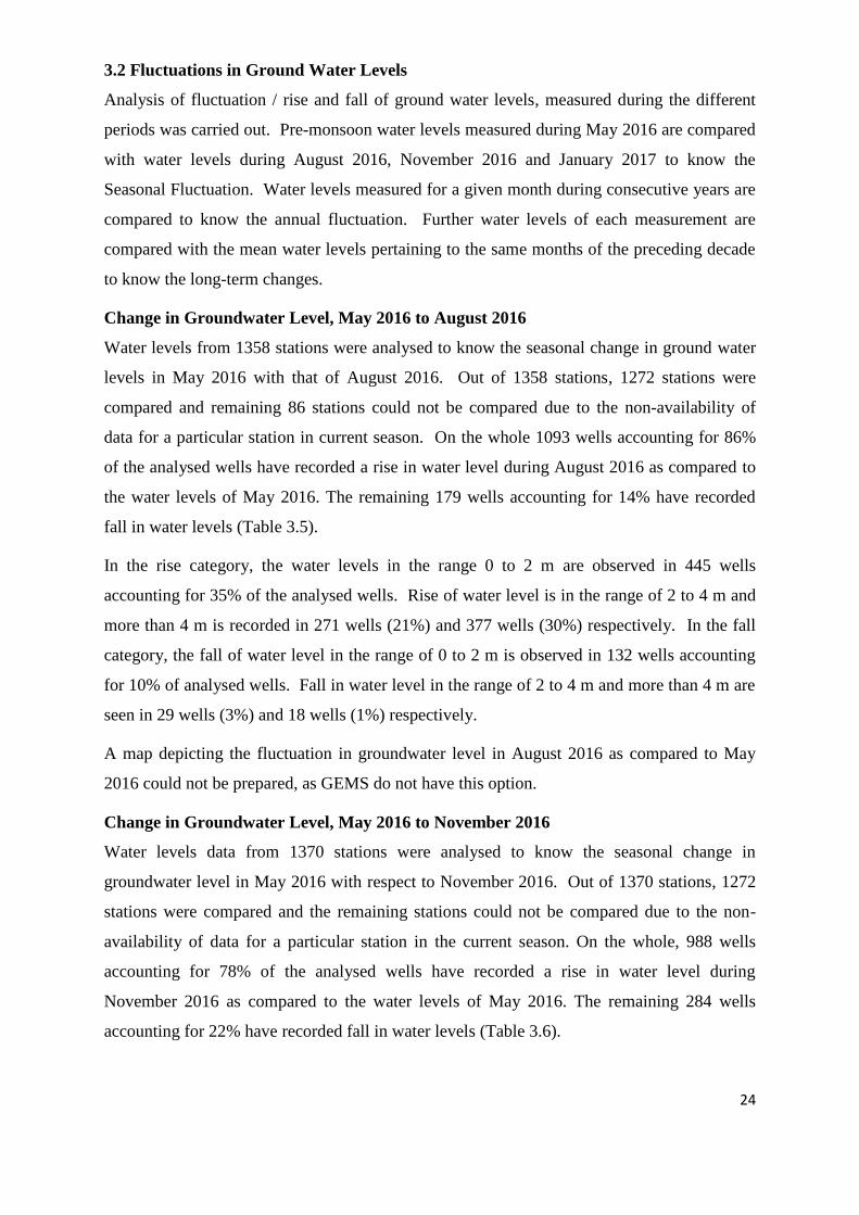
3.2 Fluctuations in Ground Water Levels
Analysis of fluctuation / rise and fall of ground water levels, measured during the different
periods was carried out. Pre-monsoon water levels measured during May 2016 are compared
with water levels during August 2016, November 2016 and January 2017 to know the
Seasonal Fluctuation. Water levels measured for a given month during consecutive years are
compared to know the annual fluctuation. Further water levels of each measurement are
compared with the mean water levels pertaining to the same months of the preceding decade
to know the long-term changes.
Change in Groundwater Level, May 2016 to August 2016
Water levels from 1358 stations were analysed to know the seasonal change in ground water
levels in May 2016 with that of August 2016. Out of 1358 stations, 1272 stations were
compared and remaining 86 stations could not be compared due to the non-availability of
data for a particular station in current season. On the whole 1093 wells accounting for 86%
of the analysed wells have recorded a rise in water level during August 2016 as compared to
the water levels of May 2016. The remaining 179 wells accounting for 14% have recorded
fall in water levels (Table 3.5).
In the rise category, the water levels in the range 0 to 2 m are observed in 445 wells
accounting for 35% of the analysed wells. Rise of water level is in the range of 2 to 4 m and
more than 4 m is recorded in 271 wells (21%) and 377 wells (30%) respectively. In the fall
category, the fall of water level in the range of 0 to 2 m is observed in 132 wells accounting
for 10% of analysed wells. Fall in water level in the range of 2 to 4 m and more than 4 m are
seen in 29 wells (3%) and 18 wells (1%) respectively.
A map depicting the fluctuation in groundwater level in August 2016 as compared to May
2016 could not be prepared, as GEMS do not have this option.
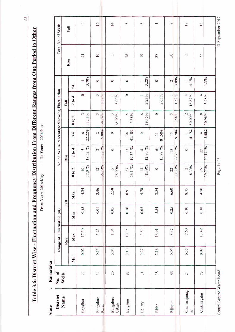
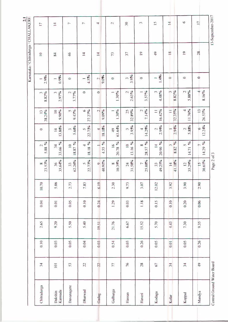
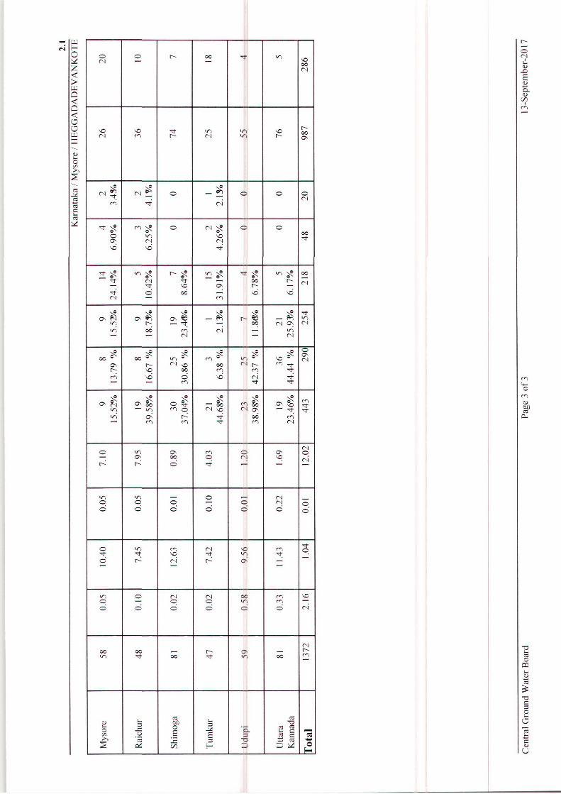
Change in Groundwater Level, May 2016 to November 2016
Water levels data from 1370 stations were analysed to know the seasonal change in
groundwater level in May 2016 with respect to November 2016. Out of 1370 stations, 1272
stations were compared and the remaining stations could not be compared due to the non-
availability of data for a particular station in the current season. On the whole, 988 wells
accounting for 78% of the analysed wells have recorded a rise in water level during
November 2016 as compared to the water levels of May 2016. The remaining 284 wells
accounting for 22% have recorded fall in water levels (Table 3.6).
25
In the rise category, the water level in the range 0 to 2 m is observed in 444 wells accounting
for 35% of the analysed wells. Rise in water level in the range of 2 to 4 m and more than 4 m
is recorded in 290 wells (23%) and 254 wells (20%) respectively. In the fall category, the fall
of water level in the range of 0 to 2 m is observed in 216 of wells accounting for 17% of
analysed wells. Fall in water level in the range of 2 to 4 m and more than 4 m are seen in 48
wells (4%) and 20 wells (1%) respectively.
A map depicting the fluctuation in groundwater levels in November 2016 as compared to
May 2016 showing rise/fall in the ranges of 0 to 2 m, 2 to 4 m and >4 m was prepared and the
same is enclosed as Water Level Fluctuation Map of Karnataka May 2016 to November 2016
(Fig.3.5). The map shows that rise in ground water level in the range of 0 to 2 m is observed
in major part of Karnataka State. Rise of water level in the range of 2 to 4 m is observed as
patches in almost all districts of Karnataka State. Rise of more than 4 m is noticed in all
districts of Karnataka State except Bellary, Chitradurga, Bangalore Urban, Chamarajnagar
and Kolar districts. Water level fall of less than 2 m is recorded in parts of all the districts of
the State except Bidar and Yadgir districts. Water level fall in the range of 2 to 4 m is noticed
in parts of Bagalkot, Bidar, Bellary, Bijapur, Chamarajnagar, Chikkamangalur, Chitradurga,
Dharwad, Davanagere Gadag, Gulbarga, Hassan, Kodagu, Koppala, Kolar, Mysore, Mandya,
Ramanagara, Raichur, and Tumkur districts. Fall in water level of more than 4 m is observed
in parts of Bagalkot, Bellary, Gadag, Chitradurga, Mysore, Bijapur, Hassan, Kodagu and
Raichur, districts.
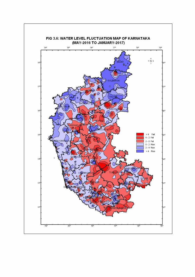
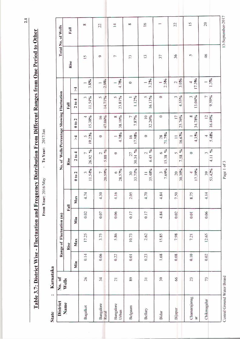
Change in Groundwater Level, May 2016 to January 2017
Water levels data from 1368 stations were analysed to know the seasonal change in
groundwater level in January 2017 with that of May 2016. Out of 1368 stations, 1251
stations were compared and the remaining stations could not be compared due to the non-
availability of data for a particular station in the current season. On the whole, 790 wells
accounting for 63% of the analysed wells have recorded a rise in water level during January
2017 as compared with the water level of May 2016. The remaining 461 wells accounting for
37% have recorded fall in water levels (Table 3.7).
In the rise category, the water level in the range 0 to 2 m is observed in 441 wells accounting
for 35% of the analysed wells. Rise in water level in the range of 2 to 4 m and more than 4 m
is recorded in 195 wells (16%) and 154 wells (12%) respectively. In the fall category, the fall
of water level in the range of 0 to 2 m is observed in 317 wells accounting for 25% of

26
analysed wells. Fall in water level in the range of 2 to 4 m and more than 4 m are seen in 92
wells (8%) and 52 wells (4%) respectively.
A map depicting the fluctuation in groundwater level in January 2017 as compared to May
2016 showing rise/fall in the ranges of 0 to 2 m, 2 to 4 m and >4 m was prepared and is
enclosed as Water Level Fluctuation Map of Karnataka May 2016 to January 2017 (Fig.3.6).
The map shows that rise in ground water level in the range of 0 to 2 m is observed in major
part of Karnataka State. Rise of water level in the range of 2 to 4 m is observed as patches in
almost all the districts except Chamarajnagar and Kolar districts. Rise of more than 4 m is
noticed in all the districts of Karnataka except Bangalore Rural, Bellary, Chitradurga and
Davanagere districts. Water level fall of less than 2 m and 2 to 4 m is observed in parts of all
the districts except Bidar. Fall in water level of more than 4 m is observed in all the districts
except Bangalore Urban, Belgaum, Udupi and Uttara Kannada districts.
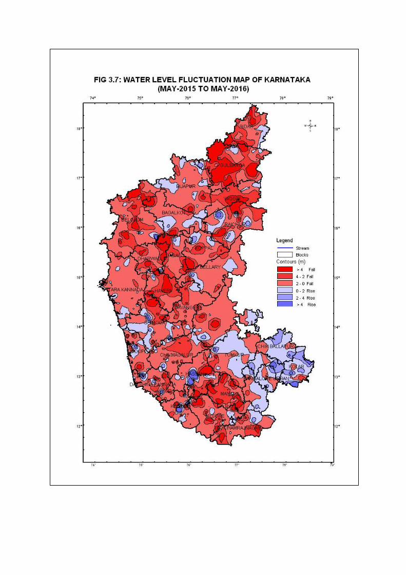
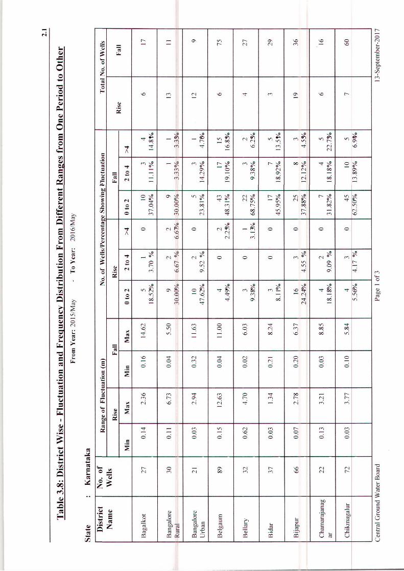
Change in Groundwater Level, May 2015 to May 2016
Water levels from 1339 stations were analysed to know the annual change in groundwater
level in May 2016 with respect to May 2015. On the whole 278 wells accounting for 22% of
the analysed wells have recorded a rise in water level during May 2016, as compared with the
water level of May 2015. The remaining 971 wells accounting for 78% have recorded a fall
in water level (Table 3.8).
In the rise category, the rise of water level in the range of 0 to 2 m is observed in 199 wells
accounting for 16% of analysed wells. Rise of water levels in the range of 2 to 4 m is
observed in 45 wells (4%), while more than 4 m is seen in 34 wells (2%).
In the fall category, the fall of water level in the range 0 to 2 m is observed in 596 wells
accounting for 48% of the analysed wells. Fall in water level in the range of 2 to 4 m is
observed in 204 wells (16%) and more than 4 m is recorded in 171 wells (14%).
A map depicting the fluctuation in groundwater level in May 2016 as compared to May 2015,
showing rise/fall in the ranges of 0 to 2 m, 2 to 4 m and >4 m was prepared and is enclosed as
Water Level Fluctuation Map of Karnataka May 2015 to May 2016 (Fig.3.7). Rise in water
level in the range of 0 to 2 m is observed in Bangalore Urban, Kolar and Chamarajnagar and
as small patches in other districts of Karnataka State. Rise in water level of 2 to 4 m is also
noticed as patches in almost all parts of the State. Localized patches of >4 m rise in water
level is noticed in parts of Bangalore Rural, Belgaum, Bellary, Dakshina Kannada, Dharwad,
Gulbarga, Hassan, Kodagu, Kolar, Raichur, Shimoga, Tumkur and Udupi. Fall in water level
in the range of 0 to 2 m is observed in almost all parts of the State. Fall in water level in the
27
range of 2 to 4 m is noticed in all districts of Karnataka state. Fall in water level of > 4 m is
noticed in all the districts except Bangalore Urban, Kolar and Bellary districts.
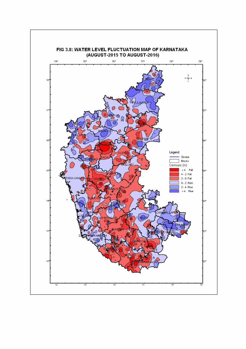
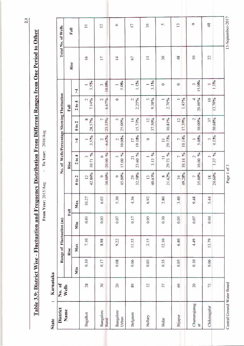
Change in Groundwater level, August 2015 to August 2016
Water levels from 1315 stations were analysed and about 1262 stations were compared to
know the annual change in groundwater level in August 2016 with that of August 2015. On
the whole 704 wells accounting for 56% of the analysed wells have recorded a rise in water
level during August 2016 as compared with the water level of August 2015. The remaining
558 wells accounting for 44% have recorded a fall in water level (Table 3.9).
In the rise category, the rise in water level in the range of 0 to 2 m is observed in 464 wells
accounting for 37% of the analysed wells. Rise in water level in the range of 2 to 4 m and
more than 4 m is recorded in 147 wells (12%) and 93 wells (7%) respectively. In the fall
category, the fall in water level in the range of 0 to 2 m is observed in 390 wells accounting
for 31% of analysed wells. Fall in water level of 2 to 4 m and more than 4 m is recorded in
105 wells (8%) and 63 wells (5%) respectively.
A map depicting the fluctuation in groundwater level in August 2016 as compared to August
2015, showing rise/fall in the ranges of 0 to 2 m, 2 to 4 m and more than 4 m was prepared
and is enclosed as Water Level Fluctuation Map of Karnataka Aug 2015 to Aug 2016
(Fig.3.8). The map shows that fall and rise of 0 to 2 m range covers the maximum area of the
Karnataka State. Fall in water level 2 to 4 m is observed in almost all the districts of
Karnataka State except Uttara Kannada, Udupi, Dakshina Kannada, Chikkaballapura and
Bangalore Rural district. Fall in water level of more than 4 m is recorded in all districts
except Bangalore Rural, Chikkaballapura, Dakshina Kannada, Udupi and Uttara Kannada
districts. In the rise category rise in water level of 0 to 2 m is recorded in almost all parts of
Karnataka. Rise of 2 to 4 m is observed in parts of Gulbarga, Bidar, Bijapur, Belgaum,
Bagalkot, Bangalore Urban, Bangalore Rural, Chikkamagalur, Chitradurga, Chikkaballapura,
Chamarajnagar, Kolar, Koppala, Mandya, Mysore, Dakshina Kannada, and Tumkur, Uttara
Kannada, Udupi and Yadgir districts and more than 4 m is noticed in all districts except
Davanagere, Haveri, Kodagu, Koppala, Mandya, Mysore, Uttara Kannada and Yadgir
districts.
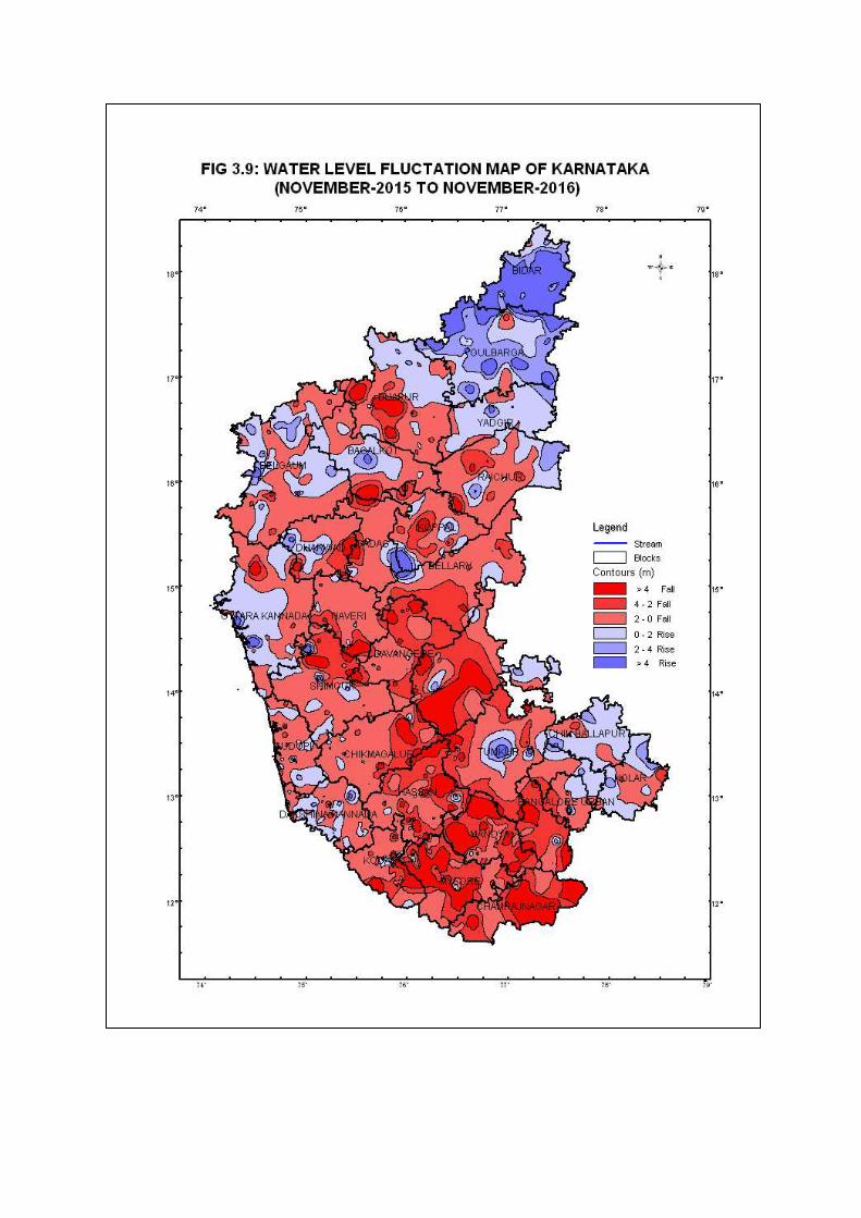
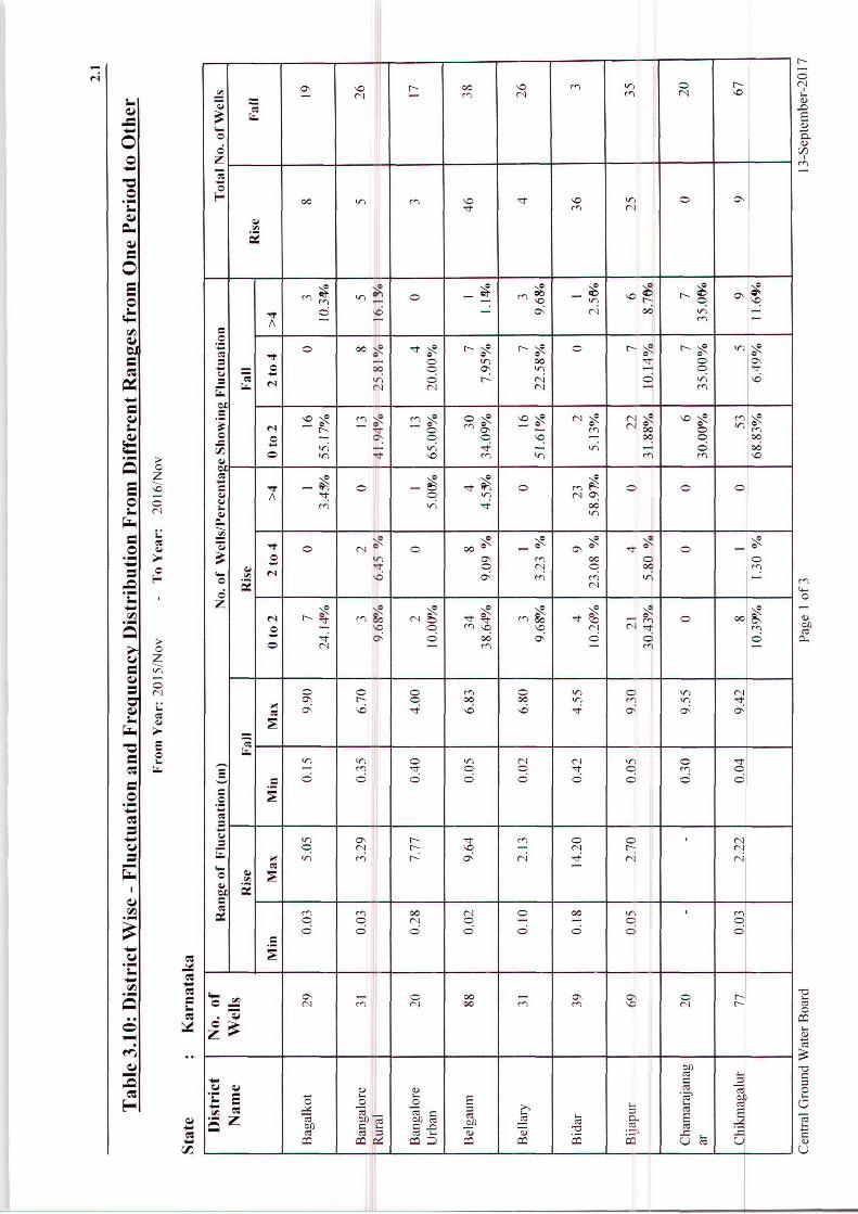
Change in Groundwater Level, November 2015 to November 2016
Water levels from 1373 stations were analysed and 1322 stations were compared to know the
annual change in groundwater level in November 2016 with that of November 2015. On the
whole, 392 wells accounting for 30% of the analysed wells have recorded a rise in water level
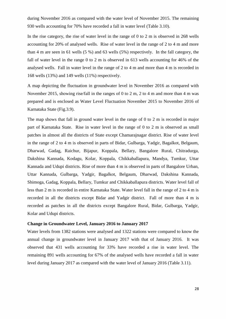
28
during November 2016 as compared with the water level of November 2015. The remaining
930 wells accounting for 70% have recorded a fall in water level (Table 3.10).
In the rise category, the rise of water level in the range of 0 to 2 m is observed in 268 wells
accounting for 20% of analysed wells. Rise of water level in the range of 2 to 4 m and more
than 4 m are seen in 61 wells (5 %) and 63 wells (5%) respectively. In the fall category, the
fall of water level in the range 0 to 2 m is observed in 613 wells accounting for 46% of the
analysed wells. Fall in water level in the range of 2 to 4 m and more than 4 m is recorded in
168 wells (13%) and 149 wells (11%) respectively.
A map depicting the fluctuation in groundwater level in November 2016 as compared with
November 2015, showing rise/fall in the ranges of 0 to 2 m, 2 to 4 m and more than 4 m was
prepared and is enclosed as Water Level Fluctuation November 2015 to November 2016 of
Karnataka State (Fig.3.9).
The map shows that fall in ground water level in the range of 0 to 2 m is recorded in major
part of Karnataka State. Rise in water level in the range of 0 to 2 m is observed as small
patches in almost all the districts of State except Chamarajnagar district. Rise of water level
in the range of 2 to 4 m is observed in parts of Bidar, Gulbarga, Yadgir, Bagalkot, Belgaum,
Dharwad, Gadag, Raichur, Bijapur, Koppala, Bellary, Bangalore Rural, Chitradurga,
Dakshina Kannada, Kodagu, Kolar, Koppala, Chikkaballapura, Mandya, Tumkur, Uttar
Kannada and Udupi districts. Rise of more than 4 m is observed in parts of Bangalore Urban,
Uttar Kannada, Gulbarga, Yadgir, Bagalkot, Belgaum, Dharwad, Dakshina Kannada,
Shimoga, Gadag, Koppala, Bellary, Tumkur and Chikkaballapura districts. Water level fall of
less than 2 m is recorded in entire Karnataka State. Water level fall in the range of 2 to 4 m is
recorded in all the districts except Bidar and Yadgir district. Fall of more than 4 m is
recorded as patches in all the districts except Bangalore Rural, Bidar, Gulbarga, Yadgir,
Kolar and Udupi districts.
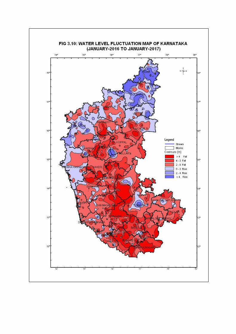
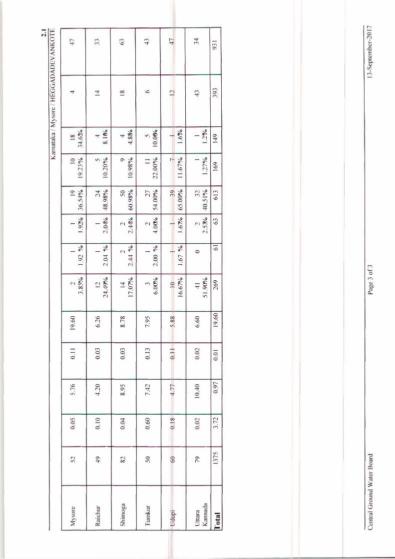
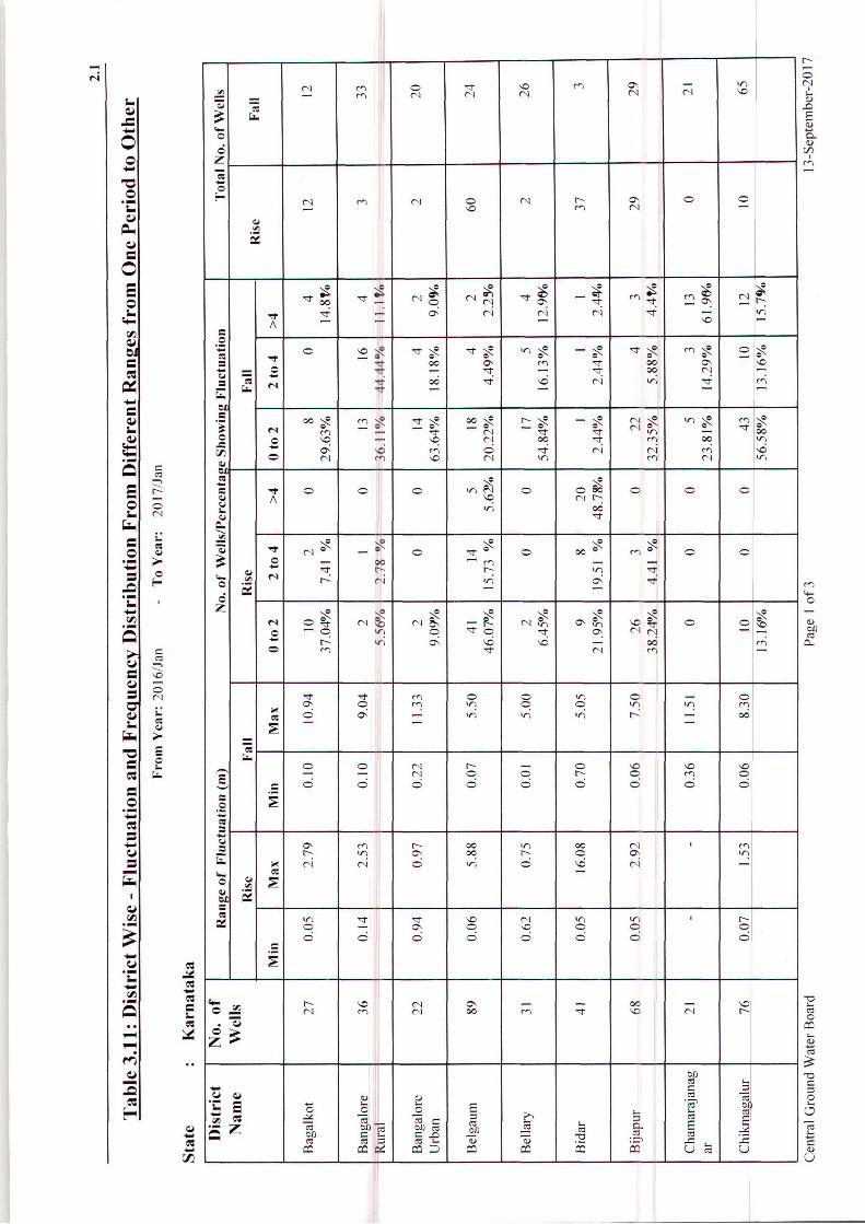
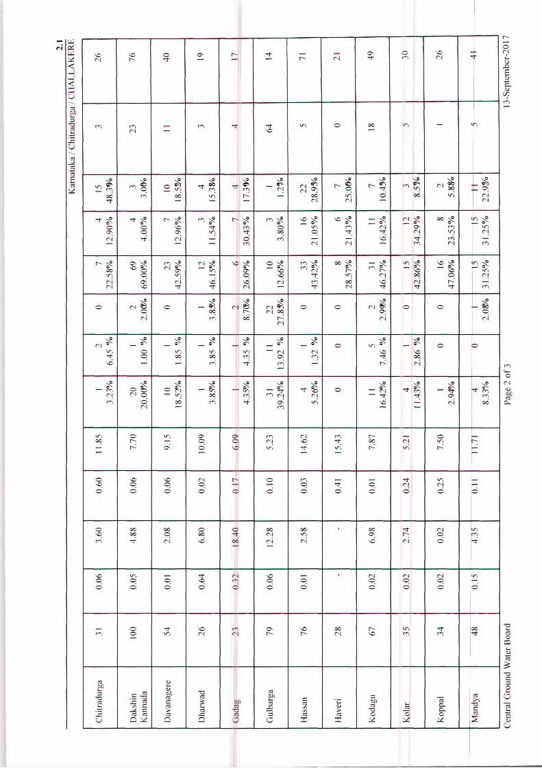
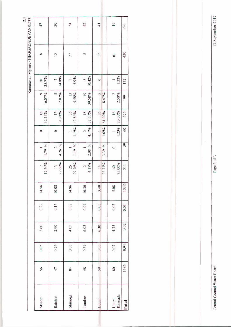
Change in Groundwater Level, January 2016 to January 2017
Water levels from 1382 stations were analysed and 1322 stations were compared to know the
annual change in groundwater level in January 2017 with that of January 2016. It was
observed that 431 wells accounting for 33% have recorded a rise in water level. The
remaining 891 wells accounting for 67% of the analysed wells have recorded a fall in water
level during January 2017 as compared with the water level of January 2016 (Table 3.11).
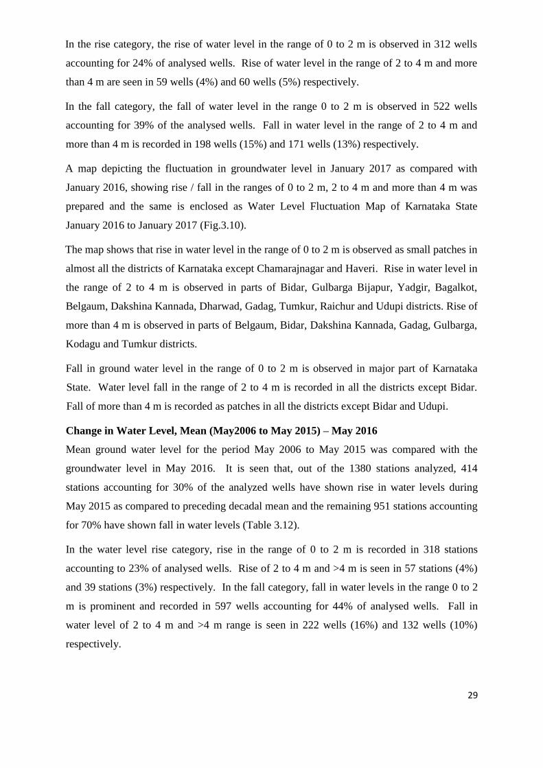
29
In the rise category, the rise of water level in the range of 0 to 2 m is observed in 312 wells
accounting for 24% of analysed wells. Rise of water level in the range of 2 to 4 m and more
than 4 m are seen in 59 wells (4%) and 60 wells (5%) respectively.
In the fall category, the fall of water level in the range 0 to 2 m is observed in 522 wells
accounting for 39% of the analysed wells. Fall in water level in the range of 2 to 4 m and
more than 4 m is recorded in 198 wells (15%) and 171 wells (13%) respectively.
A map depicting the fluctuation in groundwater level in January 2017 as compared with
January 2016, showing rise / fall in the ranges of 0 to 2 m, 2 to 4 m and more than 4 m was
prepared and the same is enclosed as Water Level Fluctuation Map of Karnataka State
January 2016 to January 2017 (Fig.3.10).
The map shows that rise in water level in the range of 0 to 2 m is observed as small patches in
almost all the districts of Karnataka except Chamarajnagar and Haveri. Rise in water level in
the range of 2 to 4 m is observed in parts of Bidar, Gulbarga Bijapur, Yadgir, Bagalkot,
Belgaum, Dakshina Kannada, Dharwad, Gadag, Tumkur, Raichur and Udupi districts. Rise of
more than 4 m is observed in parts of Belgaum, Bidar, Dakshina Kannada, Gadag, Gulbarga,
Kodagu and Tumkur districts.
Fall in ground water level in the range of 0 to 2 m is observed in major part of Karnataka
State. Water level fall in the range of 2 to 4 m is recorded in all the districts except Bidar.
Fall of more than 4 m is recorded as patches in all the districts except Bidar and Udupi.
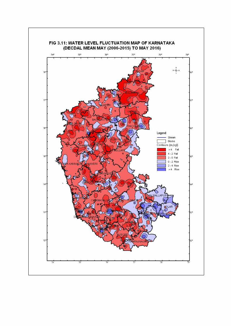
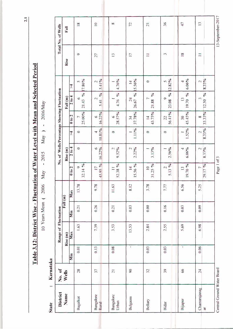
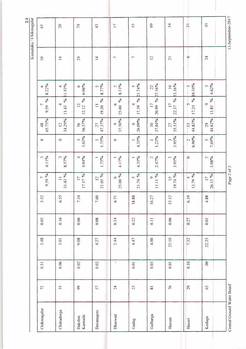
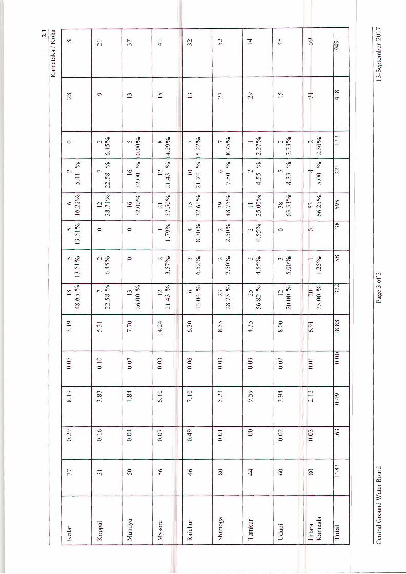
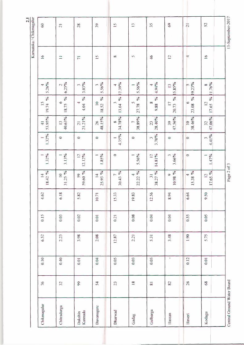
Change in Water Level, Mean (May2006 to May 2015) – May 2016
Mean ground water level for the period May 2006 to May 2015 was compared with the
groundwater level in May 2016. It is seen that, out of the 1380 stations analyzed, 414
stations accounting for 30% of the analyzed wells have shown rise in water levels during
May 2015 as compared to preceding decadal mean and the remaining 951 stations accounting
for 70% have shown fall in water levels (Table 3.12).
In the water level rise category, rise in the range of 0 to 2 m is recorded in 318 stations
accounting to 23% of analysed wells. Rise of 2 to 4 m and >4 m is seen in 57 stations (4%)
and 39 stations (3%) respectively. In the fall category, fall in water levels in the range 0 to 2
m is prominent and recorded in 597 wells accounting for 44% of analysed wells. Fall in
water level of 2 to 4 m and >4 m range is seen in 222 wells (16%) and 132 wells (10%)
respectively.

30
A map in respect of the change in water levels showing rise / fall in the ranges of 0 to 2 m, 2
to 4 m and >4 m has been prepared and enclosed as Water Level Fluctuation Map of
Karnataka, Decadal Mean (May 2006 to May 2015) – May 2016 (Fig.3.11).
Rise in water level in the range of 0 to 2 m is observed in all parts of the Karnataka State. A
rise in water level of 2 to 4 m is noticed as patches in almost all parts of the State except in
the Bagalkot and Mandya districts. Rise in water level of >4m is noticed as small patches in
all the districts except Gulbarga, Uttara Kannada, Bagalkot, Bidar, Bijapur, Bellary, Mandya,
Chitradurga and Raichur. Fall in water level of <2 m is noticed in almost all parts of the
State. Fall in Water levels in the range of 2 to 4 m is also noticed in almost all parts of the
State. Fall in water level of >4 m is noticed as small patches in almost all parts of the State
except Bangalore Urban, Bellary Kolar districts.
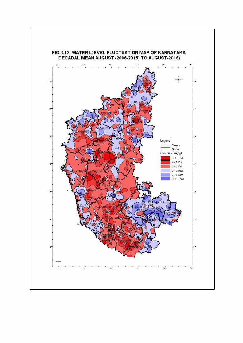
Change in Water Level, Mean (Aug 2006 to Aug 2015)-Aug 2016
Mean groundwater level for the period August 2006 to August 2015 is compared with the
groundwater level in August 2016 for 1388 stations out of 1383 stations analysed. It is seen
that out of the 1383 stations compared, 625 stations accounting for 45% have shown a rise in
water level during August 2016 as compared to preceding decadal mean and the remaining
758 stations accounting for 55% have shown a fall in water level (Table 3.13).
In the water level rise category, a rise of 0 to 2 m range is prominent and is recorded in 468
stations accounting to 34% of analysed wells. The rise of 2 to 4 m and more than 4 m is seen
in 111 stations (8%) and 46 stations (3%) respectively.
In the fall category, fall in water level in the range of 0 to 2 m is recorded in 498 wells
accounting for 36% of analyzed wells. Fall in water level of 2 to 4 m and more than 4 m
range is seen in 168 wells (12%) and 92 wells (7%) respectively.
A map for the change in water levels showing rise/fall in the ranges of 0-2 m, 2-4 m and >4
m was prepared and enclosed as “Water Level Fluctuation Map of Karnataka (Decadal Mean
of August 2006-2015 to August 2016)” (Fig.3.12).
Major part of the State is showing fall in water level compared to decadal mean water level of
2006-2015 with respect to August 2016 water level. In the rise category, water level less than
2 m rise observed in parts of Bijapur, Belgaum, Udupi, Raichur, Koppala, Haveri, Dharwad,
Chitradurga, Tumkur, Bangalore Urban, Bangalore Rural, Mandya, Chamarajnagar and Kolar
districts. Rise of 2 to 4 m is observed in parts of almost all the districts except Bellary,
Davanagere, Gadag, Haveri, Mysore and Uttara Kannada, districts. More than 4 m rise is
observed as small patches in Bangalore Urban, Bangalore Rural, Belgaum, Bijapur, Bidar,
31
Chamarajnagar Dharwad, Chikkaballapura, Kolar, Raichur, Ramanagara, Shimoga, Tumkur
Udupi and Yadgir districts.
Fall in water level of less than 2m and 2 to 4 m is recorded in parts of almost all the districts
of Karnataka State. Fall in water level of more than 4 m is observed in parts of almost all the
districts except Chikkaballapura, Dakshina Kannada, Kolar, Bangalore urban and Tumkur,
Udupi and Uttara Kannada.
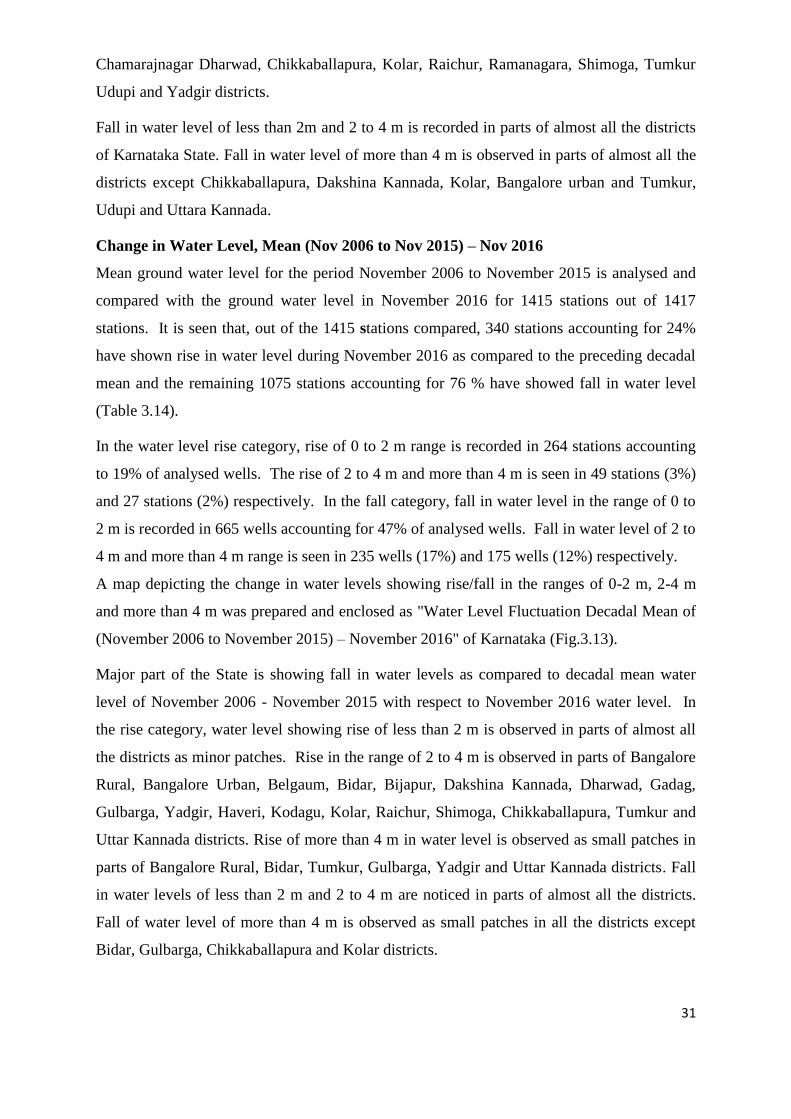
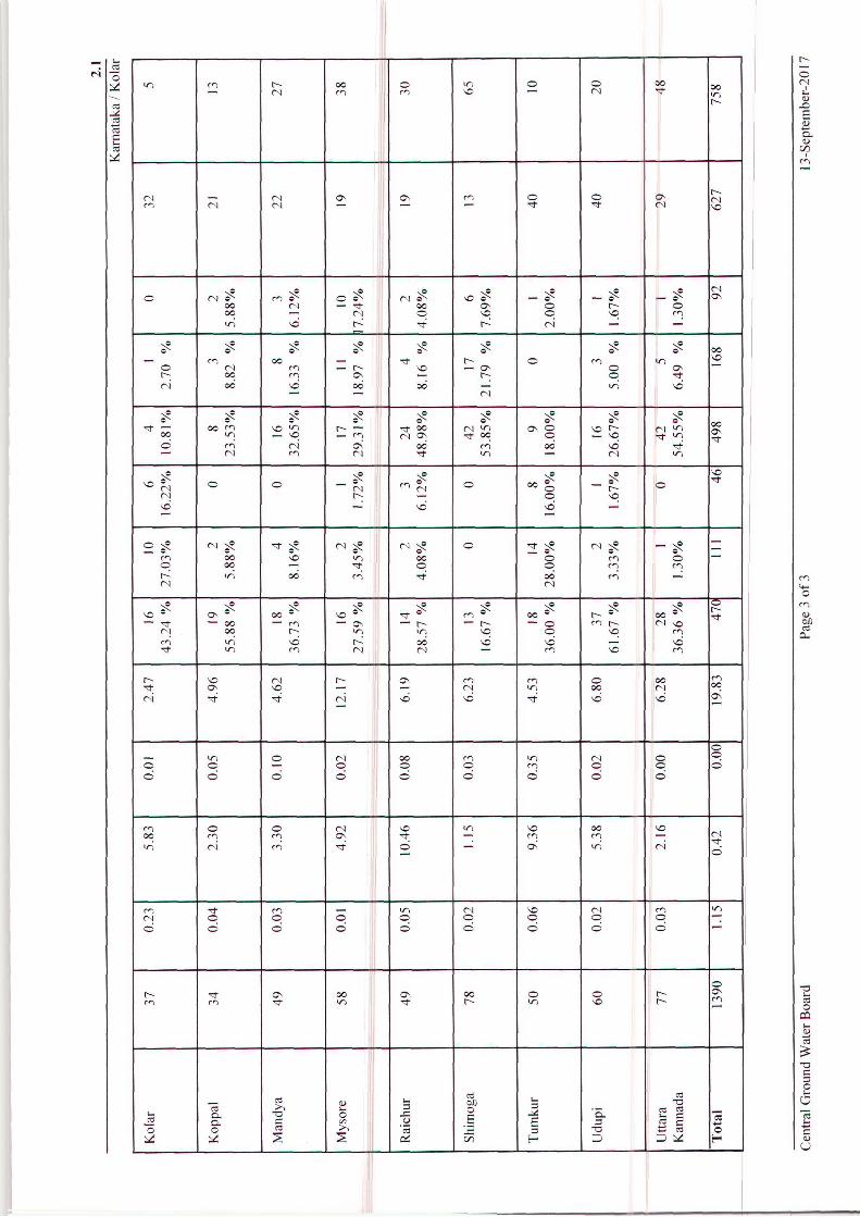
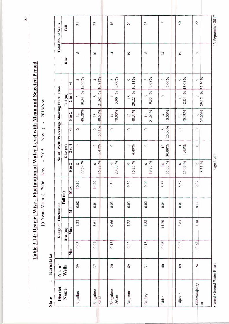
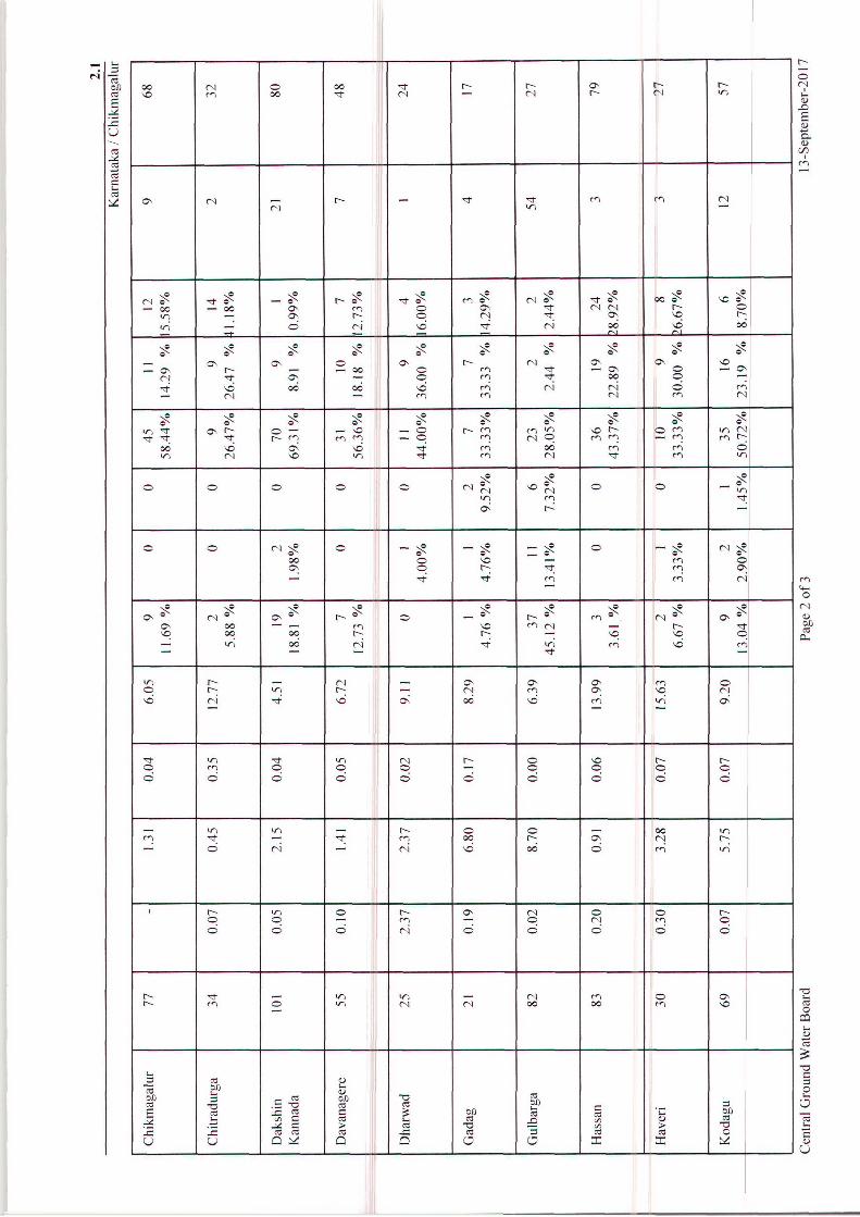
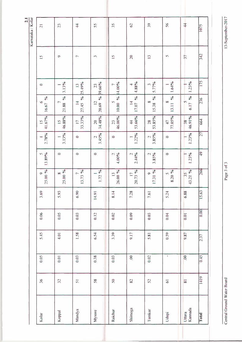
Change in Water Level, Mean (Nov 2006 to Nov 2015) – Nov 2016
Mean ground water level for the period November 2006 to November 2015 is analysed and
compared with the ground water level in November 2016 for 1415 stations out of 1417
stations. It is seen that, out of the 1415 stations compared, 340 stations accounting for 24%
have shown rise in water level during November 2016 as compared to the preceding decadal
mean and the remaining 1075 stations accounting for 76 % have showed fall in water level
(Table 3.14).
In the water level rise category, rise of 0 to 2 m range is recorded in 264 stations accounting
to 19% of analysed wells. The rise of 2 to 4 m and more than 4 m is seen in 49 stations (3%)
and 27 stations (2%) respectively. In the fall category, fall in water level in the range of 0 to
2 m is recorded in 665 wells accounting for 47% of analysed wells. Fall in water level of 2 to
4 m and more than 4 m range is seen in 235 wells (17%) and 175 wells (12%) respectively.
A map depicting the change in water levels showing rise/fall in the ranges of 0-2 m, 2-4 m
and more than 4 m was prepared and enclosed as "Water Level Fluctuation Decadal Mean of
(November 2006 to November 2015) – November 2016" of Karnataka (Fig.3.13).
Major part of the State is showing fall in water levels as compared to decadal mean water
level of November 2006 - November 2015 with respect to November 2016 water level. In
the rise category, water level showing rise of less than 2 m is observed in parts of almost all
the districts as minor patches. Rise in the range of 2 to 4 m is observed in parts of Bangalore
Rural, Bangalore Urban, Belgaum, Bidar, Bijapur, Dakshina Kannada, Dharwad, Gadag,
Gulbarga, Yadgir, Haveri, Kodagu, Kolar, Raichur, Shimoga, Chikkaballapura, Tumkur and
Uttar Kannada districts. Rise of more than 4 m in water level is observed as small patches in
parts of Bangalore Rural, Bidar, Tumkur, Gulbarga, Yadgir and Uttar Kannada districts. Fall
in water levels of less than 2 m and 2 to 4 m are noticed in parts of almost all the districts.
Fall of water level of more than 4 m is observed as small patches in all the districts except
Bidar, Gulbarga, Chikkaballapura and Kolar districts.
32
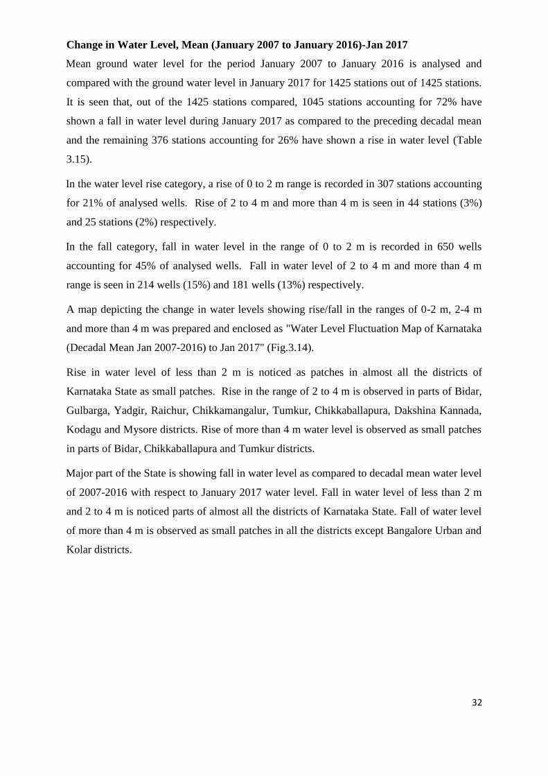
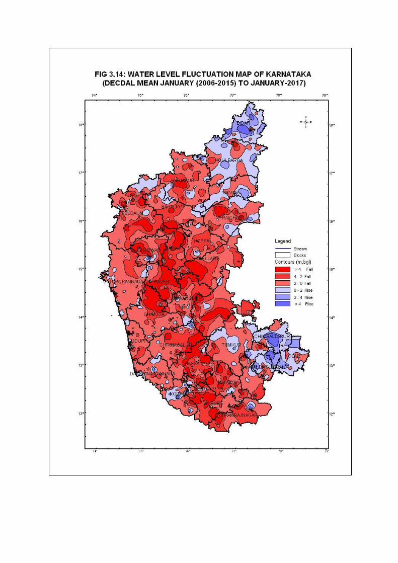
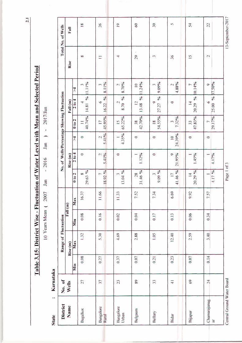
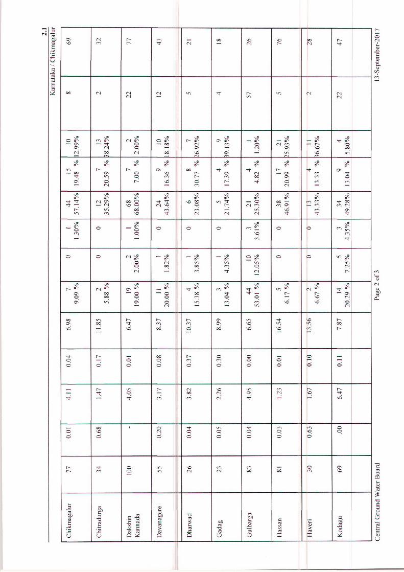
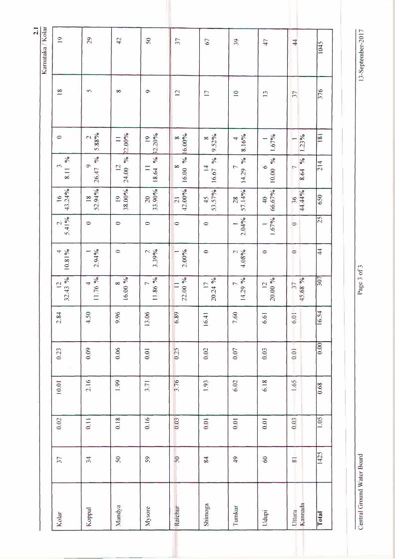
Change in Water Level, Mean (January 2007 to January 2016)-Jan 2017
Mean ground water level for the period January 2007 to January 2016 is analysed and
compared with the ground water level in January 2017 for 1425 stations out of 1425 stations.
It is seen that, out of the 1425 stations compared, 1045 stations accounting for 72% have
shown a fall in water level during January 2017 as compared to the preceding decadal mean
and the remaining 376 stations accounting for 26% have shown a rise in water level (Table
3.15).
In the water level rise category, a rise of 0 to 2 m range is recorded in 307 stations accounting
for 21% of analysed wells. Rise of 2 to 4 m and more than 4 m is seen in 44 stations (3%)
and 25 stations (2%) respectively.
In the fall category, fall in water level in the range of 0 to 2 m is recorded in 650 wells
accounting for 45% of analysed wells. Fall in water level of 2 to 4 m and more than 4 m
range is seen in 214 wells (15%) and 181 wells (13%) respectively.
A map depicting the change in water levels showing rise/fall in the ranges of 0-2 m, 2-4 m
and more than 4 m was prepared and enclosed as "Water Level Fluctuation Map of Karnataka
(Decadal Mean Jan 2007-2016) to Jan 2017" (Fig.3.14).
Rise in water level of less than 2 m is noticed as patches in almost all the districts of
Karnataka State as small patches. Rise in the range of 2 to 4 m is observed in parts of Bidar,
Gulbarga, Yadgir, Raichur, Chikkamangalur, Tumkur, Chikkaballapura, Dakshina Kannada,
Kodagu and Mysore districts. Rise of more than 4 m water level is observed as small patches
in parts of Bidar, Chikkaballapura and Tumkur districts.
Major part of the State is showing fall in water level as compared to decadal mean water level
of 2007-2016 with respect to January 2017 water level. Fall in water level of less than 2 m
and 2 to 4 m is noticed parts of almost all the districts of Karnataka State. Fall of water level
of more than 4 m is observed as small patches in all the districts except Bangalore Urban and
Kolar districts.

33
4.0 HYDROCHEMISTRY
Water samples from the Ground Water Level Monitoring Stations (GWMS) are collected
once in a year during the month of May. The assessment of chemical quality of ground water
samples from GWMS of Karnataka State for the year 2014 is presented berlow.
The water samples from 1110 shallow aquifers of GWMS from 30 districts were collected in
the month of May 2014 and analysed in the Regional Chemical Laboratory for pH, Electrical
Conductivity (EC), Chloride, Nitrate and Fluoride by employing Standard methods. Based on
the hydrochemical data, the portability of these samples has been assessed as per the
Standards prescribed by the Bureau of Indian Standards (IS 10500: 2012) and categorized
into ‘Desirable’, ‘Permissible’ and ‘Unsuitable’ classes.
Distribution of pH
The hydrogen ion concentration (pH) of water is a measure of its acidity or alkalinity. A
neutral pH, neither acid nor alkaline, is 7.0; water with pH below 7 is acidic and above 7 is
considered as alkaline.
The perusal of the data indicates that the distribution of pH in the State shows wide variations
from 6.6 to 9.7. The maximum value for the parameter was recorded in the sample collected
from Kammaraghatta, Davanagere district. In Karnataka, 80% of the samples collected were
found well within the permissible limit for drinking water standards. The data shows that
20% of the samples collected from Bagalkot, Bijapur, Belgaum, Bidar, Bellary, Bangalore
Urban, Bangalore Rural, Koppala, Shimoga, Dakshina Kannada, Udupi, Raichur, Yadgir,
Chikkamagalur, Dharwad, Gulbarga, Hassan, Haveri, Kolar, Tumkur, Uttar Kannada districts
showed pH above 8.5 rendering them unsuitable for drinking purpose. The high pH causes a
bitter taste, and due to high pH, the water pipes and water-using appliances become
encrusted.
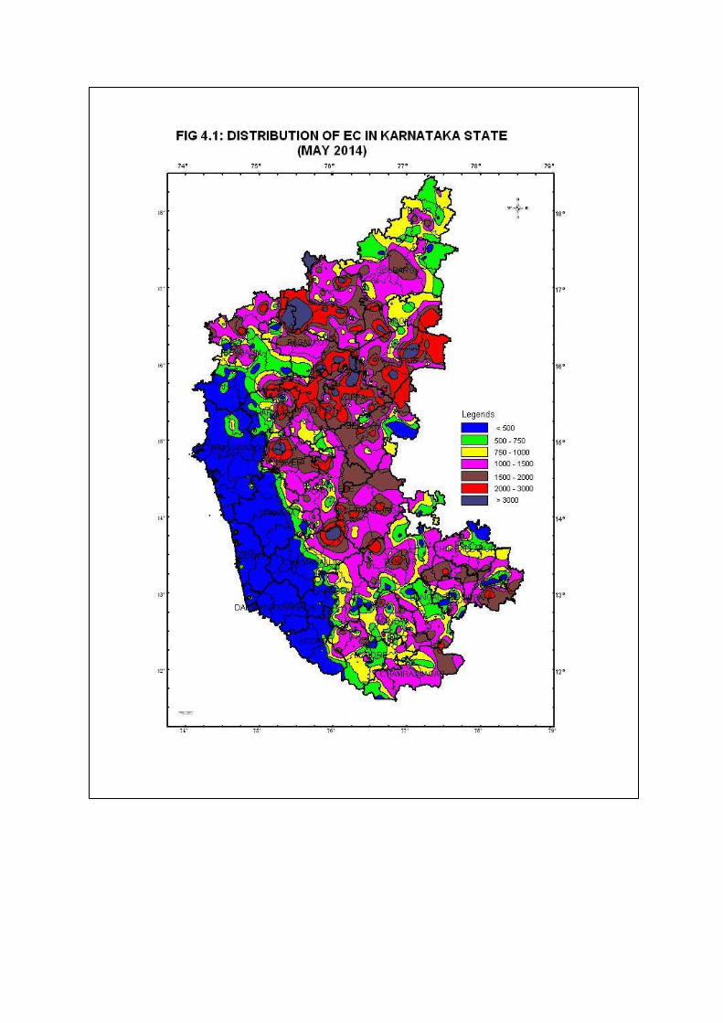
Distribution of Electrical Conductivity
The electrical conductivity in water samples is an indication of total dissolved ions. Thus the
higher the EC, the higher the levels of dissolved ions in the sample. The perusal of the data
indicates that the distribution of electrical conductivity in the State shows wide variations
(50-8260 μS/cm at 25˚ C). The maximum value for the parameter was recorded in the sample
collected from Algur, Bagalkote district. The EC values of samples collected from coastal
districts such as Dakshina Kannada, Uttara Kannada and Udupi were generally below 750
μS/cm at 25˚C, rendering the samples suitable for drinking purpose. About 97 % samples
show ‘permissible limit for drinking water. About 3% of the samples in the State (Bijapur,
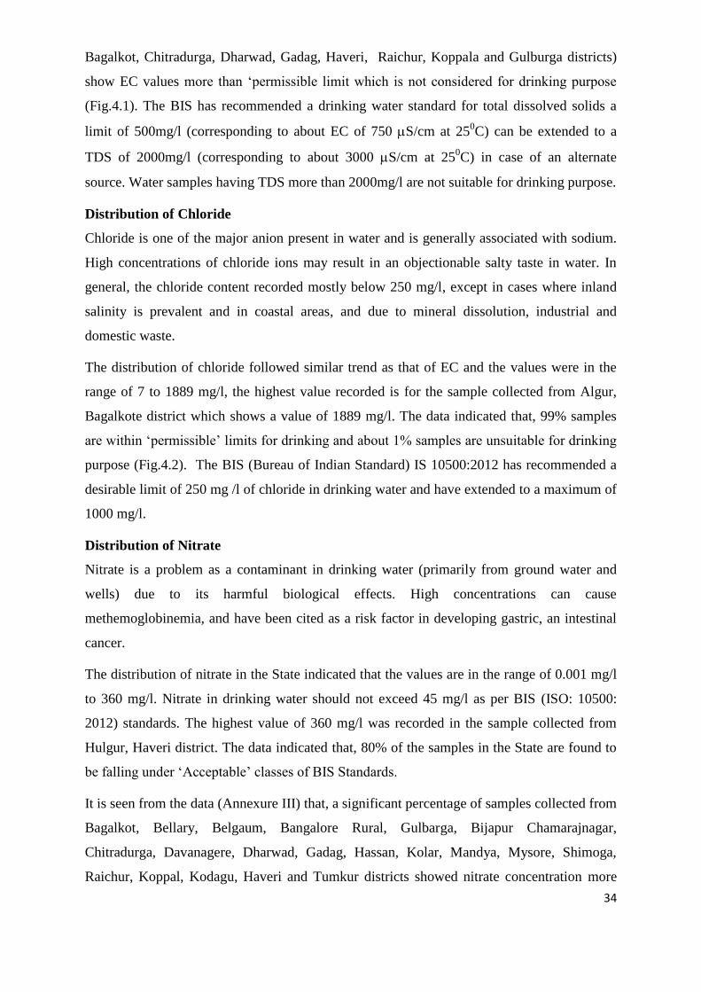
34
Bagalkot, Chitradurga, Dharwad, Gadag, Haveri, Raichur, Koppala and Gulburga districts)
show EC values more than ‘permissible limit which is not considered for drinking purpose
(Fig.4.1). The BIS has recommended a drinking water standard for total dissolved solids a
limit of 500mg/l (corresponding to about EC of 750 S/cm at 250C) can be extended to a
TDS of 2000mg/l (corresponding to about 3000 S/cm at 250C) in case of an alternate
source. Water samples having TDS more than 2000mg/l are not suitable for drinking purpose.
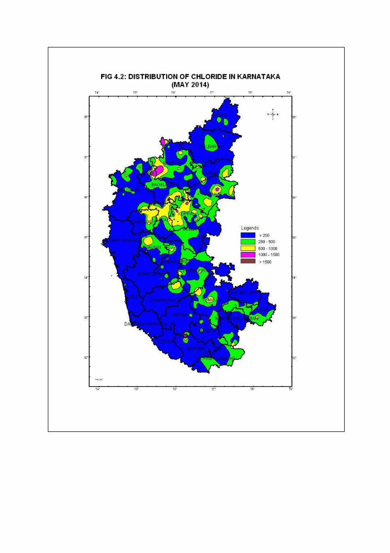
Distribution of Chloride
Chloride is one of the major anion present in water and is generally associated with sodium.
High concentrations of chloride ions may result in an objectionable salty taste in water. In
general, the chloride content recorded mostly below 250 mg/l, except in cases where inland
salinity is prevalent and in coastal areas, and due to mineral dissolution, industrial and
domestic waste.
The distribution of chloride followed similar trend as that of EC and the values were in the
range of 7 to 1889 mg/l, the highest value recorded is for the sample collected from Algur,
Bagalkote district which shows a value of 1889 mg/l. The data indicated that, 99% samples
are within ‘permissible’ limits for drinking and about 1% samples are unsuitable for drinking
purpose (Fig.4.2). The BIS (Bureau of Indian Standard) IS 10500:2012 has recommended a
desirable limit of 250 mg /l of chloride in drinking water and have extended to a maximum of
1000 mg/l.
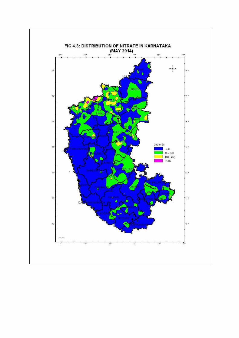
Distribution of Nitrate
Nitrate is a problem as a contaminant in drinking water (primarily from ground water and
wells) due to its harmful biological effects. High concentrations can cause
methemoglobinemia, and have been cited as a risk factor in developing gastric, an intestinal
cancer.
The distribution of nitrate in the State indicated that the values are in the range of 0.001 mg/l
to 360 mg/l. Nitrate in drinking water should not exceed 45 mg/l as per BIS (ISO: 10500:
2012) standards. The highest value of 360 mg/l was recorded in the sample collected from
Hulgur, Haveri district. The data indicated that, 80% of the samples in the State are found to
be falling under ‘Acceptable’ classes of BIS Standards.
It is seen from the data (Annexure III) that, a significant percentage of samples collected from
Bagalkot, Bellary, Belgaum, Bangalore Rural, Gulbarga, Bijapur Chamarajnagar,
Chitradurga, Davanagere, Dharwad, Gadag, Hassan, Kolar, Mandya, Mysore, Shimoga,
Raichur, Koppal, Kodagu, Haveri and Tumkur districts showed nitrate concentration more
35
than 45 mg/l, rendering them unsuitable for drinking (Fig.4.3). The contamination of ground
water by nitrate is mainly due to anthropogenic causes, owing its origin to septic systems,
fertilizers and livestock wastes. It is usually difficult to assess the particular nitrate source,
since; often the contamination is a result of many sources.
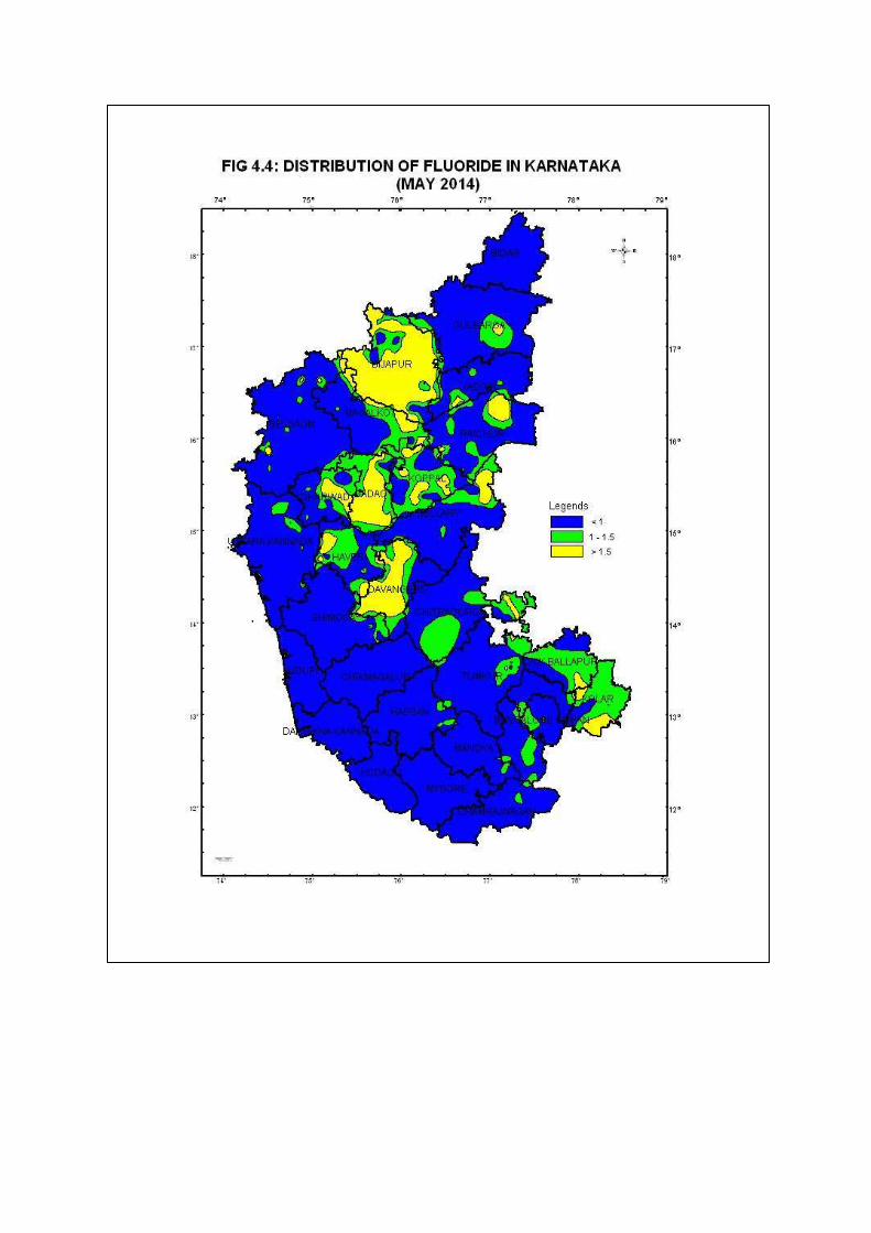
Distribution of Fluoride
One of the essential elements for maintaining normal development of healthy teeth and bones
is Fluoride. Lower concentrations of fluoride usually below 0.6mg/l may contribute to dental
cavities. However, continuing consumption of higher concentrations, above 1.2 mg/l,
however, cause dental fluorosis and in extreme cases even skeletal fluorosis. Most of the
fluoride found in ground water is of geogenic origin.
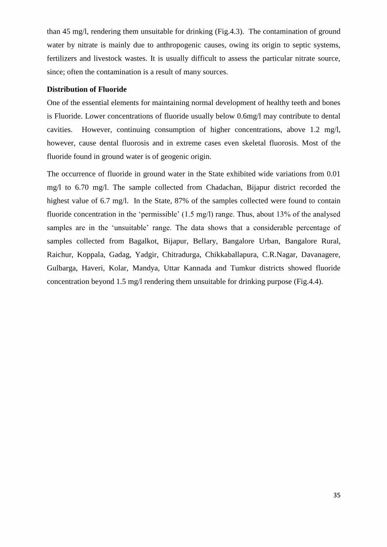
The occurrence of fluoride in ground water in the State exhibited wide variations from 0.01
mg/l to 6.70 mg/l. The sample collected from Chadachan, Bijapur district recorded the
highest value of 6.7 mg/l. In the State, 87% of the samples collected were found to contain
fluoride concentration in the ‘permissible’ (1.5 mg/l) range. Thus, about 13% of the analysed
samples are in the ‘unsuitable’ range. The data shows that a considerable percentage of
samples collected from Bagalkot, Bijapur, Bellary, Bangalore Urban, Bangalore Rural,
Raichur, Koppala, Gadag, Yadgir, Chitradurga, Chikkaballapura, C.R.Nagar, Davanagere,
Gulbarga, Haveri, Kolar, Mandya, Uttar Kannada and Tumkur districts showed fluoride
concentration beyond 1.5 mg/l rendering them unsuitable for drinking purpose (Fig.4.4).
36
5.0 CONCLUSIONS
Central Ground Water Board, South Western Region, Bangalore, has a network of 1494 Dug
wells and 442 Piezometers as Groundwater monitoring stations in Karnataka state under the
program of Ground water Regime monitoring. The number of wells per Sq. Km works out to
be one well per 100 Sq. Km. These monitoring stations are monitoring four times during
January, May, August and November.
About 48% of the wells are represented by Krishna basin and the remaining 52% represents
Cauvery, Palar, Pennar, West flowing and Godavari.
Granitic Gneiss formation has a representation of 65% wells in the State. Remaining
formations like Basalt, Schist, Laterite, Granite, Alluvium and Slate/Limestone/Sandstone
represents 13, 9, 7, 2, 3 and 1 respectively.
The rainfall received in the State during the year 2016 was 881 mm, Annual Normal rainfall
varies from as low as 112 mm at Chamrajanagar district to as high as 4582 mm at Uttara
Kannada district. Bulk of the annual rainfall i.e., 83% is received during south-west monsoon
season, 7% during north-east monsoon and the remaining 10% is received during pre-
monsoon period. During the year 2016, the State as a whole recorded 17% of the district
shows normal rainfall and 23% of wells show excess rainfall and 60% shows deficit rainfall.
During pre-monsoon 2016, shows about 71% of the wells are showing depth to water level
within 10 mbgl. During post-monsoon 2016, about 83% of the wells showing depth to water
level within 10 mbgl.
Annual fluctuation during pre-monsoon 2016 it is observed that, 78% of the wells in the State
showing fall in water level and 22% of the wells in the state showing rise in water level.
During post-monsoon 2016 about 70% of the wells in the State is showing fall in water levels
and 30% of the wells in the State is showing rise in water level.
Decadal mean water level of 2006-2015 with respect to May 2016, 70% of wells showing fall
in water level and 30% of the wells showing rise in water level in Karnataka State. Decadal
mean water level of 2006-2015 with respect to November 2016, 76% of wells showing fall in
water level and 24% of the wells showing rise in water level in Karnataka State.
The chemical quality of ground water collected from 1110 GWM stations representing the
shallow aquifers during May 2014 indicated that, In general 80% of the samples in the State
were in the ‘desirable limits for drinking. About 97% samples show ‘permissible limit for
drinking water. The About 3% of the sample shows more than ‘permissible’ limit which is

37
not considered for drinking purpose In respect of chloride, The data indicated that, 99%
samples are within ‘permissible’ limits for drinking and about 1% samples are unsuitable for
drinking purpose. Nitrate concentration in ground water is indicated that, 80% of the samples
in the State are found to be falling under ‘permissible’ and 20% samples are beyond
permissible limits. Similarly analysis indicates that, in the State, 87% of the samples collected
were found to contain fluoride concentration within the ‘permissible’ (1.5 mg/l) range, and
13% of the analysed samples are in the ‘unsuitable’ range of drinking water standards.


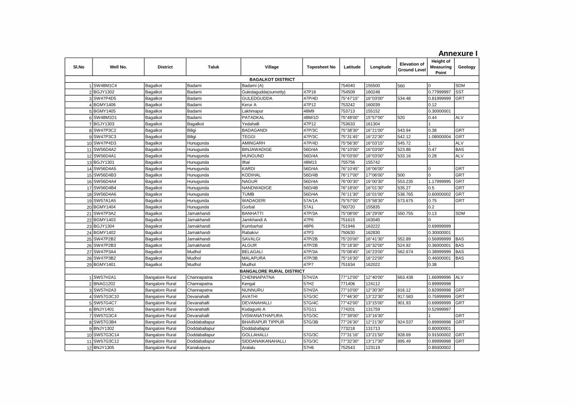
Sl.No Well No. District Taluk Village Toposheet No Latitude LongitudeElevation of
Ground Level
Height of
Measuring
Point
Geology
1 SW48M1C4 Bagalkot Badami Badami (A) 754040 155500 560 0 SDM
2 BGJY1302 Bagalkot Badami Guledagudda(sumetty) 47P16 754509 160248 0.77999997 SST
3 SW47P4D5 Bagalkot Badami GULEDGUDDA 47P/4D 75°47'15" 16°03'00" 534.48 0.81999999 GRT
4 BGMY1406 Bagalkot Badami Kerur A 47P12 753242 160039 0.12
5 BGMY1405 Bagalkot Badami Lakhmapur 48M9 753713 155152 0.30000001
6 SW48M1D1 Bagalkot Badami PATADKAL 48M/1D 75°48'00" 15°57'00" 520 0.44 ALV
7 BGJY1303 Bagalkot Bagalkot Yedahalli 47P12 753633 161304 1
8 SW47P3C2 Bagalkot Biligi BADAGANDI 47P/3C 75°38'30" 16°21'00" 543.94 0.38 GRT
9 SW47P3C3 Bagalkot Biligi TEGGI 47P/3C 75°31'45" 16°22'30" 542.12 1.08000004 GRT
10 SW47P4D3 Bagalkot Hunugunda AMINGARH 47P/4D 75°56'30" 16°03'15" 545.72 1 ALV
11 SW56D4A2 Bagalkot Hunugunda BINJAWADIGE 56D/4A 76°10'00" 16°03'00" 523.88 0.47 BAS
12 SW56D4A1 Bagalkot Hunugunda HUNGUND 56D/4A 76°03'00" 16°03'00" 533.16 0.28 ALV
13 BGJY1301 Bagalkot Hunugunda Ilhal 48M13 755756 155742
14 SW56D4A5 Bagalkot Hunugunda KARDI 56D/4A 76°10'45" 16°06'00" 0 GRT
15 SW56D4B3 Bagalkot Hunugunda KODIHAL 56D/4B 76°17'00" 17°06'00" 500 0 GRT
16 SW56D4A4 Bagalkot Hunugunda NAGUR 56D/4A 76°00'30" 16°00'30" 553.235 1.17999995 GRT
17 SW56D4B4 Bagalkot Hunugunda NANDWADIGE 56D/4B 76°18'00" 16°01'30" 535.27 0.5 GRT
18 SW56D4A6 Bagalkot Hunugunda TUMB 56D/4A 76°11'30" 16°01'00" 538.765 0.60000002 GRT
19 SW57A1A5 Bagalkot Hunugunda WADAGERI 57A/1A 75°57'00" 15°58'30" 573.675 0.75 GRT
20 BGMY1404 Bagalkot Hunugunda Gorbal 57A1 760720 155835 0.2
21 SW47P3A2 Bagalkot Jamakhandi BANHATTI 47P/3A 75°08'00" 16°29'00" 550.755 0.13 SDM
22 BGMY1403 Bagalkot Jamakhandi Jamkhandi A 47P6 751615 163045 0
23 BGJY1304 Bagalkot Jamakhandi Kumbarhal 48P6 751946 163222 0.69999999
24 BGMY1402 Bagalkot Jamakhandi Rabakivi 47P3 750630 162830 0.30000001
25 SW47P2B2 Bagalkot Jamakhandi SAVALGI 47P/2B 75°20'00" 16°41'30" 552.89 0.56999999 BAS
26 SW47P2B3 Bagalkot Jamakhandi ALGUR 47P/2B 75°18'30" 16°32'00" 524.92 0.36000001 BAS
27 SW47P3A4 Bagalkot Mudhol BELAGALI 47P/3A 75°08'45" 16°23'00" 562.674 0.38999999 BAS
28 SW47P3B2 Bagalkot Mudhol MALAPURA 47P/3B 75°16'30" 16°22'00" 0.46000001 BAS
29 BGMY1401 Bagalkot Mudhol Mudhol 47P7 751634 162022 0.38
1 SW57H2A1 Bangalore Rural Channapatna CHENNAPATNA 57H/2A 77°12'00" 12°40'00" 663.438 1.66999996 ALV
2 BNAG1202 Bangalore Rural Channapatna Kengal 57H2 771406 124112 0.89999998
3 SW57H2A3 Bangalore Rural Channapatna NUNNURU 57H/2A 77°10'00" 12°30'30" 616.12 0.82999998 GRT
4 SW57G3C10 Bangalore Rural Devanahalli AVATHI 57G/3C 77°46'30" 13°22'30" 917.583 0.75999999 GRT
5 SW57G4C7 Bangalore Rural Devanahalli DEVANAHALLI 57G/4C 77°42'00" 13°15'00" 901.93 0.69999999 GRT
6 BNJY1401 Bangalore Rural Devanahalli Kodagurki A 57G11 774201 131759 0.52999997
7 SW57G3C4 Bangalore Rural Devanahalli VISWANATHAPURA 57G/3C 77°39'00" 13°16'30" 1 GRT
8 SW57G3B4 Bangalore Rural Doddaballapur BHAIRAPUR TIPPUR 57G/3B 77°26'30" 12°21'30" 924.537 0.89999998 GRT
9 BNJY1302 Bangalore Rural Doddaballapur Doddaballapur 773218 131713 0.80000001
10 SW57G3C14 Bangalore Rural Doddaballapur GOLLAHALLI 57G/3C 77°31'16" 13°21'50" 928.69 0.91500002 GRT
11 SW57G3C12 Bangalore Rural Doddaballapur SIDDANAIKANAHALLI 57G/3C 77°32'30" 13°17'30" 895.49 0.89999998 GRT
12 BNJY1305 Bangalore Rural Kanakapura Aralalu 57H6 752543 123119 0.85000002
Annexure I
BAGALKOT DISTRICT
BANGALORE RURAL DISTRICT
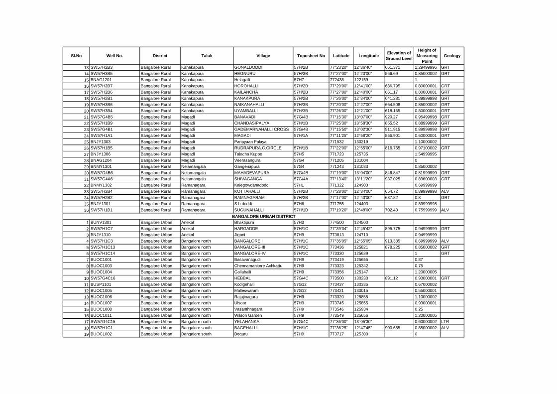
Sl.No Well No. District Taluk Village Toposheet No Latitude LongitudeElevation of
Ground Level
Height of
Measuring
Point
Geology
13 SW57H2B3 Bangalore Rural Kanakapura GONALDODDI 57H/2B 77°23'20" 12°36'40" 661.371 1.29499996 GRT
14 SW57H3B5 Bangalore Rural Kanakapura HEGNURU 57H/3B 77°27'00" 12°20'00" 566.69 0.85000002 GRT
15 BNAG1201 Bangalore Rural Kanakapura Helagalli 57H7 772438 122159 1
16 SW57H2B7 Bangalore Rural Kanakapura HOROHALLI 57H/2B 77°29'00" 12°41'00" 686.795 0.80000001 GRT
17 SW57H2B6 Bangalore Rural Kanakapura KAILANCHA 57H/2B 77°27'00" 12°40'00" 661.17 0.80000001 GRT
18 SW57H2B1 Bangalore Rural Kanakapura KANAKPURA 57H/2B 77°26'00" 12°34'00" 641.281 0.89999998 GRT
19 SW57H3B6 Bangalore Rural Kanakapura NAIKANAHALLI 57H/3B 77°20'00" 12°27'00" 664.508 0.85000002 GRT
20 SW57H3B4 Bangalore Rural Kanakapura UYAMBALLI 57H/3B 77°26'00" 12°21'00" 618.165 0.80000001 GRT
21 SW57G4B5 Bangalore Rural Magadi BANAVADI 57G/4B 77°15'30" 13°07'00" 920.27 0.95499998 GRT
22 SW57H1B9 Bangalore Rural Magadi CHANDASIPALYA 57H/1B 77°25'30" 13°58'30" 855.52 0.88999999 GRT
23 SW57G4B1 Bangalore Rural Magadi GADEMARNAHALLI CROSS 57G/4B 77°15'50" 13°02'30" 911.915 0.89999998 GRT
24 SW57H1A1 Bangalore Rural Magadi MAGADI 57H/1A 77°11'25" 12°58'20" 856.901 0.60000001 GRT
25 BNJY1303 Bangalore Rural Magadi Panayaan Palaya 771532 130219 1.10000002
26 SW57H1B5 Bangalore Rural Magadi RUDRAPURA.C.CIRCLE 57H/1B 77°22'00" 12°55'00" 816.765 0.97100002 GRT
27 BNJY1306 Bangalore Rural Magadi Talacha Kuppe 57H5 771723 125735 1.54999995
28 BNAG1204 Bangalore Rural Magadi Veerasangura 57G4 771205 131004 0
29 BNMY1301 Bangalore Rural Nelamangala Gangenapura 57G4 771243 131033 0.85000002
30 SW57G4B6 Bangalore Rural Nelamangala MAHADEVAPURA 57G/4B 77°19'00" 13°04'00" 846.847 0.81999999 GRT
31 SW57G4A6 Bangalore Rural Nelamangala SHIVAGANGA 57G/4A 77°13'40" 13°11'20" 937.025 0.89600003 GRT
32 BNMY1302 Bangalore Rural Ramanagara Kalegowdanadoddi 57H1 771322 124903 0.69999999
33 SW57H2B4 Bangalore Rural Ramanagara KOTTAHALLI 57H/2B 77°28'00" 12°34'00" 654.72 0.89999998 ALV
34 SW57H2B2 Bangalore Rural Ramanagara RAMNAGARAM 57H/2B 77°17'00" 12°43'00" 687.82 0.8 GRT
35 BNJY1301 Bangalore Rural Ramanagara S.b.doddi 57H6 771755 124403 0.89999998
36 SW57H1B1 Bangalore Rural Ramanagara SUGUNAHALLI 57H/1B 77°19'20" 12°48'00" 702.43 0.75999999 ALV
1 BUNV1301 Bangalore Urban Anekal Bhaktipura 57H3 774500 124500
2 SW57H1C7 Bangalore Urban Anekal HARGADDE 57H/1C 77°39'34" 12°45'42" 895.775 0.94999999 GRT
3 BNJY1310 Bangalore Urban Anekal Jigani 57H9 773813 124710 0.94999999
4 SW57H1C3 Bangalore Urban Bangalore north BANGALORE I 57H/1C 77°35'05" 12°55'05" 913.335 0.69999999 ALV
5 SW57H1C13 Bangalore Urban Bangalore north BANGALORE-III 57H/1C 773436 125821 878.225 0.85000002 GRT
6 SW57H1C14 Bangalore Urban Bangalore north BANGALORE-IV 57H/1C 773330 125639 1 GRT
7 BUOC1001 Bangalore Urban Bangalore north Basavanagudi 57H9 773419 125655 0.87
8 BUOC1003 Bangalore Urban Bangalore north Chennamankere Achkattu 57H9 773323 125342 0.75
9 BUOC1004 Bangalore Urban Bangalore north Gollahalli 57H9 773356 125147 1.20000005
10 SW57G4C16 Bangalore Urban Bangalore north HEBBAL 57G/4C 773500 130230 891.12 0.93000001 GRT
11 BUSP1101 Bangalore Urban Bangalore north Kodigehalli 57G12 773437 130335 0.67000002
12 BUOC1005 Bangalore Urban Bangalore north Malleswaram 57G12 773421 130015 0.55000001
13 BUOC1006 Bangalore Urban Bangalore north Rajajinagara 57H9 773320 125855 1.10000002
14 BUOC1007 Bangalore Urban Bangalore north Ulsoor 57H9 773745 125855 0.93000001
15 BUOC1008 Bangalore Urban Bangalore north Vasanthnagara 57H9 773546 125934 0.25
16 BUOC1011 Bangalore Urban Bangalore north Wilson Garden 57H9 773549 125656 1.20000005
17 SW57G4C15 Bangalore Urban Bangalore north YELAHANKA 57G/4C 77°36'00" 13°05'30" 0.60000002 LTR
18 SW57H1C1 Bangalore Urban Bangalore south BAGEHALLI 57H/1C 77°36'25" 12°47'45" 900.655 0.85000002 ALV
19 BUOC1002 Bangalore Urban Bangalore south Beguru 57H9 773717 125300 0
BANGALORE URBAN DISTRICT
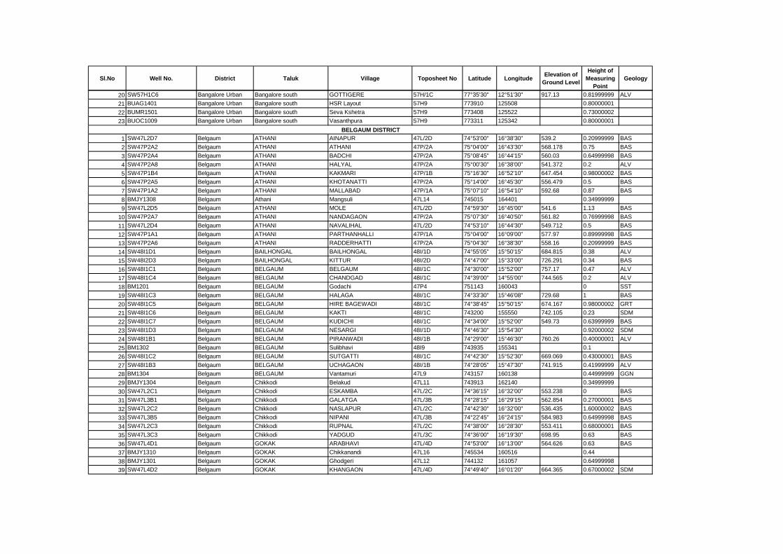
Sl.No Well No. District Taluk Village Toposheet No Latitude LongitudeElevation of
Ground Level
Height of
Measuring
Point
Geology
20 SW57H1C6 Bangalore Urban Bangalore south GOTTIGERE 57H/1C 77°35'30" 12°51'30" 917.13 0.81999999 ALV
21 BUAG1401 Bangalore Urban Bangalore south HSR Layout 57H9 773910 125508 0.80000001
22 BUMR1501 Bangalore Urban Bangalore south Seva Kshetra 57H9 773408 125522 0.73000002
23 BUOC1009 Bangalore Urban Bangalore south Vasanthpura 57H9 773311 125342 0.80000001
1 SW47L2D7 Belgaum ATHANI AINAPUR 47L/2D 74°53'00" 16°38'30" 539.2 0.20999999 BAS
2 SW47P2A2 Belgaum ATHANI ATHANI 47P/2A 75°04'00" 16°43'30" 568.178 0.75 BAS
3 SW47P2A4 Belgaum ATHANI BADCHI 47P/2A 75°08'45" 16°44'15" 560.03 0.64999998 BAS
4 SW47P2A8 Belgaum ATHANI HALYAL 47P/2A 75°00'30" 16°38'00" 541.372 0.2 ALV
5 SW47P1B4 Belgaum ATHANI KAKMARI 47P/1B 75°16'30" 16°52'10" 647.454 0.98000002 BAS
6 SW47P2A5 Belgaum ATHANI KHOTANATTI 47P/2A 75°14'00" 16°45'30" 556.479 0.5 BAS
7 SW47P1A2 Belgaum ATHANI MALLABAD 47P/1A 75°07'10" 16°54'10" 592.68 0.87 BAS
8 BMJY1308 Belgaum Athani Mangsuli 47L14 745015 164401 0.34999999
9 SW47L2D5 Belgaum ATHANI MOLE 47L/2D 74°59'30" 16°45'00" 541.6 1.13 BAS
10 SW47P2A7 Belgaum ATHANI NANDAGAON 47P/2A 75°07'30" 16°40'50" 561.82 0.76999998 BAS
11 SW47L2D4 Belgaum ATHANI NAVALIHAL 47L/2D 74°53'10" 16°44'30" 549.712 0.5 BAS
12 SW47P1A1 Belgaum ATHANI PARTHANHALLI 47P/1A 75°04'00" 16°09'00" 577.97 0.89999998 BAS
13 SW47P2A6 Belgaum ATHANI RADDERHATTI 47P/2A 75°04'30" 16°38'30" 558.16 0.20999999 BAS
14 SW48I1D1 Belgaum BAILHONGAL BAILHONGAL 48I/1D 74°55'05" 15°50'15" 684.815 0.38 ALV
15 SW48I2D3 Belgaum BAILHONGAL KITTUR 48I/2D 74°47'00" 15°33'00" 726.291 0.34 BAS
16 SW48I1C1 Belgaum BELGAUM BELGAUM 48I/1C 74°30'00" 15°52'00" 757.17 0.47 ALV
17 SW48I1C4 Belgaum BELGAUM CHANDGAD 48I/1C 74°39'00" 14°55'00" 744.565 0.2 ALV
18 BM1201 Belgaum BELGAUM Godachi 47P4 751143 160043 0 SST
19 SW48I1C3 Belgaum BELGAUM HALAGA 48I/1C 74°33'30" 15°46'08" 729.68 1 BAS
20 SW48I1C5 Belgaum BELGAUM HIRE BAGEWADI 48I/1C 74°38'45" 15°50'15" 674.167 0.98000002 GRT
21 SW48I1C6 Belgaum BELGAUM KAKTI 48I/1C 743200 155550 742.105 0.23 SDM
22 SW48I1C7 Belgaum BELGAUM KUDICHI 48I/1C 74°34'00" 15°52'00" 549.73 0.63999999 BAS
23 SW48I1D3 Belgaum BELGAUM NESARGI 48I/1D 74°46'30" 15°54'30" 0.92000002 SDM
24 SW48I1B1 Belgaum BELGAUM PIRANWADI 48I/1B 74°29'00" 15°46'30" 760.26 0.40000001 ALV
25 BM1302 Belgaum BELGAUM Sulibhavi 48I9 743935 155341 0.1
26 SW48I1C2 Belgaum BELGAUM SUTGATTI 48I/1C 74°42'30" 15°52'30" 669.069 0.43000001 BAS
27 SW48I1B3 Belgaum BELGAUM UCHAGAON 48I/1B 74°28'05" 15°47'30" 741.915 0.41999999 ALV
28 BM1304 Belgaum BELGAUM Vantamuri 47L9 743157 160138 0.44999999 GGN
29 BMJY1304 Belgaum Chikkodi Belakud 47L11 743913 162140 0.34999999
30 SW47L2C1 Belgaum Chikkodi ESKAMBA 47L/2C 74°36'15" 16°32'00" 553.238 0 BAS
31 SW47L3B1 Belgaum Chikkodi GALATGA 47L/3B 74°28'15" 16°29'15" 562.854 0.27000001 BAS
32 SW47L2C2 Belgaum Chikkodi NASLAPUR 47L/2C 74°42'30" 16°32'00" 536.435 1.60000002 BAS
33 SW47L3B5 Belgaum Chikkodi NIPANI 47L/3B 74°22'45" 16°24'15" 584.983 0.64999998 BAS
34 SW47L2C3 Belgaum Chikkodi RUPNAL 47L/2C 74°38'00" 16°28'30" 553.411 0.68000001 BAS
35 SW47L3C3 Belgaum Chikkodi YADGUD 47L/3C 74°36'00" 16°19'30" 698.95 0.63 BAS
36 SW47L4D1 Belgaum GOKAK ARABHAVI 47L/4D 74°53'00" 16°13'00" 564.626 0.63 BAS
37 BMJY1310 Belgaum GOKAK Chikkanandi 47L16 745534 160516 0.44
38 BMJY1301 Belgaum GOKAK Ghodgeri 47L12 744132 161057 0.64999998
39 SW47L4D2 Belgaum GOKAK KHANGAON 47L/4D 74°49'40" 16°01'20" 664.365 0.67000002 SDM
BELGAUM DISTRICT
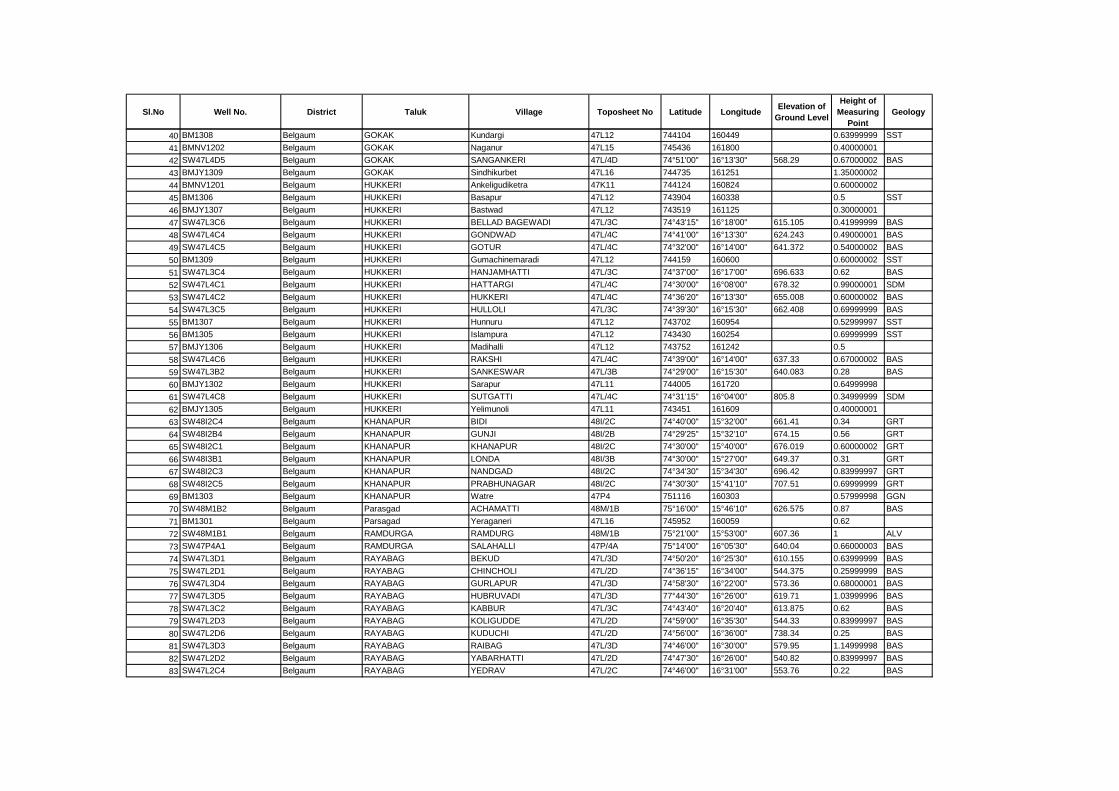
Sl.No Well No. District Taluk Village Toposheet No Latitude LongitudeElevation of
Ground Level
Height of
Measuring
Point
Geology
40 BM1308 Belgaum GOKAK Kundargi 47L12 744104 160449 0.63999999 SST
41 BMNV1202 Belgaum GOKAK Naganur 47L15 745436 161800 0.40000001
42 SW47L4D5 Belgaum GOKAK SANGANKERI 47L/4D 74°51'00" 16°13'30" 568.29 0.67000002 BAS
43 BMJY1309 Belgaum GOKAK Sindhikurbet 47L16 744735 161251 1.35000002
44 BMNV1201 Belgaum HUKKERI Ankeligudiketra 47K11 744124 160824 0.60000002
45 BM1306 Belgaum HUKKERI Basapur 47L12 743904 160338 0.5 SST
46 BMJY1307 Belgaum HUKKERI Bastwad 47L12 743519 161125 0.30000001
47 SW47L3C6 Belgaum HUKKERI BELLAD BAGEWADI 47L/3C 74°43'15" 16°18'00" 615.105 0.41999999 BAS
48 SW47L4C4 Belgaum HUKKERI GONDWAD 47L/4C 74°41'00" 16°13'30" 624.243 0.49000001 BAS
49 SW47L4C5 Belgaum HUKKERI GOTUR 47L/4C 74°32'00" 16°14'00" 641.372 0.54000002 BAS
50 BM1309 Belgaum HUKKERI Gumachinemaradi 47L12 744159 160600 0.60000002 SST
51 SW47L3C4 Belgaum HUKKERI HANJAMHATTI 47L/3C 74°37'00" 16°17'00" 696.633 0.62 BAS
52 SW47L4C1 Belgaum HUKKERI HATTARGI 47L/4C 74°30'00" 16°08'00" 678.32 0.99000001 SDM
53 SW47L4C2 Belgaum HUKKERI HUKKERI 47L/4C 74°36'20" 16°13'30" 655.008 0.60000002 BAS
54 SW47L3C5 Belgaum HUKKERI HULLOLI 47L/3C 74°39'30" 16°15'30" 662.408 0.69999999 BAS
55 BM1307 Belgaum HUKKERI Hunnuru 47L12 743702 160954 0.52999997 SST
56 BM1305 Belgaum HUKKERI Islampura 47L12 743430 160254 0.69999999 SST
57 BMJY1306 Belgaum HUKKERI Madihalli 47L12 743752 161242 0.5
58 SW47L4C6 Belgaum HUKKERI RAKSHI 47L/4C 74°39'00" 16°14'00" 637.33 0.67000002 BAS
59 SW47L3B2 Belgaum HUKKERI SANKESWAR 47L/3B 74°29'00" 16°15'30" 640.083 0.28 BAS
60 BMJY1302 Belgaum HUKKERI Sarapur 47L11 744005 161720 0.64999998
61 SW47L4C8 Belgaum HUKKERI SUTGATTI 47L/4C 74°31'15" 16°04'00" 805.8 0.34999999 SDM
62 BMJY1305 Belgaum HUKKERI Yelimunoli 47L11 743451 161609 0.40000001
63 SW48I2C4 Belgaum KHANAPUR BIDI 48I/2C 74°40'00" 15°32'00" 661.41 0.34 GRT
64 SW48I2B4 Belgaum KHANAPUR GUNJI 48I/2B 74°29'25" 15°32'10" 674.15 0.56 GRT
65 SW48I2C1 Belgaum KHANAPUR KHANAPUR 48I/2C 74°30'00" 15°40'00" 676.019 0.60000002 GRT
66 SW48I3B1 Belgaum KHANAPUR LONDA 48I/3B 74°30'00" 15°27'00" 649.37 0.31 GRT
67 SW48I2C3 Belgaum KHANAPUR NANDGAD 48I/2C 74°34'30" 15°34'30" 696.42 0.83999997 GRT
68 SW48I2C5 Belgaum KHANAPUR PRABHUNAGAR 48I/2C 74°30'30" 15°41'10" 707.51 0.69999999 GRT
69 BM1303 Belgaum KHANAPUR Watre 47P4 751116 160303 0.57999998 GGN
70 SW48M1B2 Belgaum Parasgad ACHAMATTI 48M/1B 75°16'00" 15°46'10" 626.575 0.87 BAS
71 BM1301 Belgaum Parsagad Yeraganeri 47L16 745952 160059 0.62
72 SW48M1B1 Belgaum RAMDURGA RAMDURG 48M/1B 75°21'00" 15°53'00" 607.36 1 ALV
73 SW47P4A1 Belgaum RAMDURGA SALAHALLI 47P/4A 75°14'00" 16°05'30" 640.04 0.66000003 BAS
74 SW47L3D1 Belgaum RAYABAG BEKUD 47L/3D 74°50'20" 16°25'30" 610.155 0.63999999 BAS
75 SW47L2D1 Belgaum RAYABAG CHINCHOLI 47L/2D 74°36'15" 16°34'00" 544.375 0.25999999 BAS
76 SW47L3D4 Belgaum RAYABAG GURLAPUR 47L/3D 74°58'30" 16°22'00" 573.36 0.68000001 BAS
77 SW47L3D5 Belgaum RAYABAG HUBRUVADI 47L/3D 77°44'30" 16°26'00" 619.71 1.03999996 BAS
78 SW47L3C2 Belgaum RAYABAG KABBUR 47L/3C 74°43'40" 16°20'40" 613.875 0.62 BAS
79 SW47L2D3 Belgaum RAYABAG KOLIGUDDE 47L/2D 74°59'00" 16°35'30" 544.33 0.83999997 BAS
80 SW47L2D6 Belgaum RAYABAG KUDUCHI 47L/2D 74°56'00" 16°36'00" 738.34 0.25 BAS
81 SW47L3D3 Belgaum RAYABAG RAIBAG 47L/3D 74°46'00" 16°30'00" 579.95 1.14999998 BAS
82 SW47L2D2 Belgaum RAYABAG YABARHATTI 47L/2D 74°47'30" 16°26'00" 540.82 0.83999997 BAS
83 SW47L2C4 Belgaum RAYABAG YEDRAV 47L/2C 74°46'00" 16°31'00" 553.76 0.22 BAS
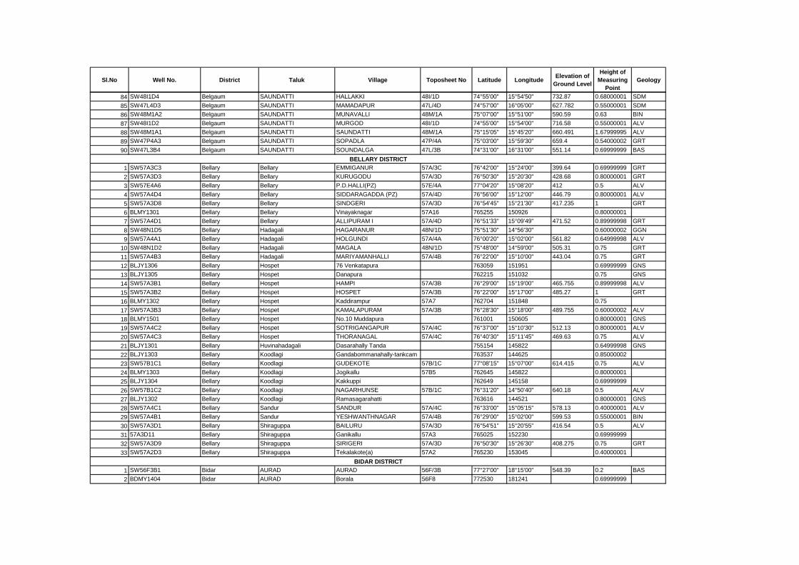
Sl.No Well No. District Taluk Village Toposheet No Latitude LongitudeElevation of
Ground Level
Height of
Measuring
Point
Geology
84 SW48I1D4 Belgaum SAUNDATTI HALLAKKI 48I/1D 74°55'00" 15°54'50" 732.87 0.68000001 SDM
85 SW47L4D3 Belgaum SAUNDATTI MAMADAPUR 47L/4D 74°57'00" 16°05'00" 627.782 0.55000001 SDM
86 SW48M1A2 Belgaum SAUNDATTI MUNAVALLI 48M/1A 75°07'00" 15°51'00" 590.59 0.63 BIN
87 SW48I1D2 Belgaum SAUNDATTI MURGOD 48I/1D 74°55'00" 15°54'00" 716.58 0.55000001 ALV
88 SW48M1A1 Belgaum SAUNDATTI SAUNDATTI 48M/1A 75°15'05" 15°45'20" 660.491 1.67999995 ALV
89 SW47P4A3 Belgaum SAUNDATTI SOPADLA 47P/4A 75°03'00" 15°59'30" 659.4 0.54000002 GRT
90 SW47L3B4 Belgaum SAUNDATTI SOUNDALGA 47L/3B 74°31'00" 16°31'00" 551.14 0.69999999 BAS
1 SW57A3C3 Bellary Bellary EMMIGANUR 57A/3C 76°42'00" 15°24'00" 399.64 0.69999999 GRT
2 SW57A3D3 Bellary Bellary KURUGODU 57A/3D 76°50'30" 15°20'30" 428.68 0.80000001 GRT
3 SW57E4A6 Bellary Bellary P.D.HALLI(PZ) 57E/4A 77°04'20" 15°08'20" 412 0.5 ALV
4 SW57A4D4 Bellary Bellary SIDDARAGADDA (PZ) 57A/4D 76°56'00" 15°12'00" 446.79 0.80000001 ALV
5 SW57A3D8 Bellary Bellary SINDGERI 57A/3D 76°54'45" 15°21'30" 417.235 1 GRT
6 BLMY1301 Bellary Bellary Vinayaknagar 57A16 765255 150926 0.80000001
7 SW57A4D1 Bellary Bellary ALLIPURAM I 57A/4D 76°51'33" 15°09'49" 471.52 0.89999998 GRT
8 SW48N1D5 Bellary Hadagali HAGARANUR 48N/1D 75°51'30" 14°56'30" 0.60000002 GGN
9 SW57A4A1 Bellary Hadagali HOLGUNDI 57A/4A 76°00'20" 15°02'00" 561.82 0.64999998 ALV
10 SW48N1D2 Bellary Hadagali MAGALA 48N/1D 75°48'00" 14°59'00" 505.31 0.75 GRT
11 SW57A4B3 Bellary Hadagali MARIYAMANHALLI 57A/4B 76°22'00" 15°10'00" 443.04 0.75 GRT
12 BLJY1306 Bellary Hospet 76 Venkatapura 763059 151951 0.69999999 GNS
13 BLJY1305 Bellary Hospet Danapura 762215 151032 0.75 GNS
14 SW57A3B1 Bellary Hospet HAMPI 57A/3B 76°29'00" 15°19'00" 465.755 0.89999998 ALV
15 SW57A3B2 Bellary Hospet HOSPET 57A/3B 76°22'00" 15°17'00" 485.27 1 GRT
16 BLMY1302 Bellary Hospet Kaddirampur 57A7 762704 151848 0.75
17 SW57A3B3 Bellary Hospet KAMALAPURAM 57A/3B 76°28'30" 15°18'00" 489.755 0.60000002 ALV
18 BLMY1501 Bellary Hospet No.10 Muddapura 761001 150605 0.80000001 GNS
19 SW57A4C2 Bellary Hospet SOTRIGANGAPUR 57A/4C 76°37'00" 15°10'30" 512.13 0.80000001 ALV
20 SW57A4C3 Bellary Hospet THORANAGAL 57A/4C 76°40'30" 15°11'45" 469.63 0.75 ALV
21 BLJY1301 Bellary Huvinahadagali Dasarahally Tanda 755154 145822 0.64999998 GNS
22 BLJY1303 Bellary Koodlagi Gandabommanahally-tankcam 763537 144625 0.85000002
23 SW57B1C1 Bellary Koodlagi GUDEKOTE 57B/1C 77°08'15" 15°07'00" 614.415 0.75 ALV
24 BLMY1303 Bellary Koodlagi Jogikallu 57B5 762645 145822 0.80000001
25 BLJY1304 Bellary Koodlagi Kakkuppi 762649 145158 0.69999999
26 SW57B1C2 Bellary Koodlagi NAGARHUNSE 57B/1C 76°31'20" 14°50'40" 640.18 0.5 ALV
27 BLJY1302 Bellary Koodlagi Ramasagarahatti 763616 144521 0.80000001 GNS
28 SW57A4C1 Bellary Sandur SANDUR 57A/4C 76°33'00" 15°05'15" 578.13 0.40000001 ALV
29 SW57A4B1 Bellary Sandur YESHWANTHNAGAR 57A/4B 76°29'00" 15°02'00" 599.53 0.55000001 BIN
30 SW57A3D1 Bellary Shiraguppa BAILURU 57A/3D 76°54'51" 15°20'55" 416.54 0.5 ALV
31 57A3D11 Bellary Shiraguppa Ganikallu 57A3 765025 152230 0.69999999
32 SW57A3D9 Bellary Shiraguppa SIRIGERI 57A/3D 76°50'30" 15°26'30" 408.275 0.75 GRT
33 SW57A2D3 Bellary Shiraguppa Tekalakote(a) 57A2 765230 153045 0.40000001
1 SW56F3B1 Bidar AURAD AURAD 56F/3B 77°27'00" 18°15'00" 548.39 0.2 BAS
2 BDMY1404 Bidar AURAD Borala 56F8 772530 181241 0.69999999
BELLARY DISTRICT
BIDAR DISTRICT
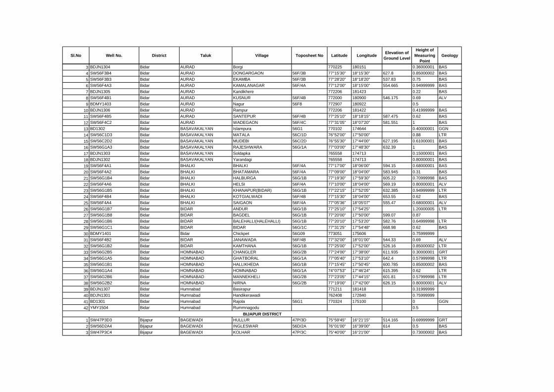
Sl.No Well No. District Taluk Village Toposheet No Latitude LongitudeElevation of
Ground Level
Height of
Measuring
Point
Geology
3 BDJN1304 Bidar AURAD Borgi 770225 180151 0.36000001 BAS
4 SW56F3B4 Bidar AURAD DONGARGAON 56F/3B 77°15'30" 18°15'30" 627.8 0.85000002 BAS
5 SW56F3B3 Bidar AURAD EKAMBA 56F/3B 77°28'20" 18°18'20" 537.83 0.75 BAS
6 SW56F4A3 Bidar AURAD KAMALANAGAR 56F/4A 77°12'00" 18°15'00" 554.665 0.94999999 BAS
7 BDJN1305 Bidar AURAD Kandikhere 772206 181423 0.22 BAS
8 SW56F4B1 Bidar AURAD KUSNUR 56F/4B 772000 180900 546.175 0.69 ALV
9 BDMY1403 Bidar AURAD Nagur 56F8 772907 180922 0.5
10 BDJN1306 Bidar AURAD Rampur 772206 181422 0.41999999 BAS
11 SW56F4B5 Bidar AURAD SANTEPUR 56F/4B 77°25'10" 18°18'15" 587.475 0.62 BAS
12 SW56F4C2 Bidar AURAD WADEGAON 56F/4C 77°31'05" 18°07'20" 581.551 1 BAS
13 BD1302 Bidar BASAVAKALYAN Islampura 56G1 770102 174644 0.40000001 GGN
14 SW56C1D3 Bidar BASAVAKALYAN MATALA 56C/1D 76°52'00" 17°50'00" 0.88 LTR
15 SW56C2D2 Bidar BASAVAKALYAN MUDEBI 56C/2D 76°55'30" 17°44'00" 627.195 0.61000001 BAS
16 SW56G1A3 Bidar BASAVAKALYAN RAJESHWARA 56G/1A 77°03'00" 17°48'30" 632.39 1 BAS
17 BDJN1303 Bidar BASAVAKALYAN Soldapka 765558 174713 0.15000001 BAS
18 BDJN1302 Bidar BASAVAKALYAN Yarandagi 765558 174713 0.80000001 BAS
19 SW56F4A1 Bidar BHALKI BHALKI 56F/4A 77°17'00" 18°06'00" 594.15 0.68000001 BAS
20 SW56F4A2 Bidar BHALKI BHATAMARA 56F/4A 77°09'00" 18°04'00" 583.945 0.31 BAS
21 SW56G1B4 Bidar BHALKI HALBURGA 56G/1B 77°19'30" 17°59'30" 605.22 0.70999998 BAS
22 SW56F4A6 Bidar BHALKI HELSI 56F/4A 77°10'00" 18°04'00" 569.19 0.80000001 ALV
23 SW56G1B5 Bidar BHALKI KHANAPUR(BIDAR) 56G/1B 77°22'15" 17°52'05" 632.385 0.94999999 LTR
24 SW56F4B4 Bidar BHALKI KOTGIALWADI 56F/4B 77°15'30" 18°04'00" 653.55 0.62 BAS
25 SW56F4A4 Bidar BHALKI SAIGAON 56F/4A 77°05'36" 18°05'07" 555.47 0.68000001 ALV
26 SW56G1B7 Bidar BIDAR ANDUR 56G/1B 77°25'10" 17°54'25" 1.20000005 LTR
27 SW56G1B8 Bidar BIDAR BAGDEL 56G/1B 77°20'00" 17°50'00" 599.07 0.87
28 SW56G1B6 Bidar BIDAR BALEHALLI(HALEHALLI) 56G/1B 77°20'10" 17°53'20" 582.76 0.64999998 LTR
29 SW56G1C1 Bidar BIDAR BIDAR 56G/1C 77°31'25" 17°54'48" 668.98 0.62 BAS
30 BDMY1401 Bidar Bidar Chickpet 56G09 773051 175606 0.75999999
31 SW56F4B2 Bidar BIDAR JANAWADA 56F/4B 77°32'00" 18°01'00" 544.33 0.69 ALV
32 SW56G1B2 Bidar BIDAR KAMTHANA 56G/1B 77°25'00" 17°52'00" 526.16 0.85000002 LTR
33 SW56G2B5 Bidar HOMNABAD CHANGLER 56G/2B 77°24'00" 17°38'00" 611.935 0.30000001 GRT
34 SW56G1A5 Bidar HOMNABAD GHATBORAL 56G/1A 77°05'40" 17°53'10" 642.4 0.57999998 LTR
35 SW56G1B1 Bidar HOMNABAD HALLIKHEDA 56G/1B 77°15'45" 17°50'45" 600.785 0.85000002 BAS
36 SW56G1A4 Bidar HOMNABAD HOMNABAD 56G/1A 74°07'53" 17°46'24" 615.395 0.62 LTR
37 SW56G2B6 Bidar HOMNABAD MANNEKHELI 56G/2B 77°23'05" 17°44'15" 601.81 0.57999998 LTR
38 SW56G2B2 Bidar HOMNABAD NIRNA 56G/2B 77°19'00" 17°42'00" 626.15 0.80000001 ALV
39 BDJN1307 Bidar Humnabad Basirapur 771211 181418 0.31999999
40 BDJN1301 Bidar Humnabad Handikerawadi 762408 172840 0.75999999
41 BD1301 Bidar Humnabad Rajola 56G1 770324 175100 0 GGN
42 YMY1504 Bidar Humnabad Rummnagodu 0.5
1 SW47P3D3 Bijapur BAGEWADI HULLUR 47P/3D 75°59'45" 16°21'15" 514.165 0.69999999 GRT
2 SW56D2A4 Bijapur BAGEWADI INGLESWAR 56D/2A 76°01'00" 16°39'00" 614 0.5 BAS
3 SW47P3C4 Bijapur BAGEWADI KOLHAR 47P/3C 75°40'00" 16°21'00" 0.73000002 BAS
BIJAPUR DISTRICT
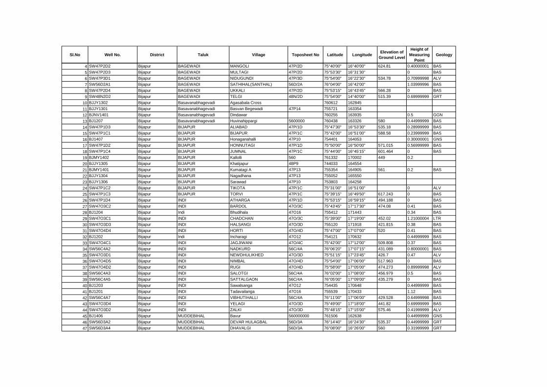
Sl.No Well No. District Taluk Village Toposheet No Latitude LongitudeElevation of
Ground Level
Height of
Measuring
Point
Geology
4 SW47P2D2 Bijapur BAGEWADI MANGOLI 47P/2D 75°40'00" 16°40'00" 624.81 0.40000001 BAS
5 SW47P2D3 Bijapur BAGEWADI MULTAGI 47P/2D 75°53'30" 16°31'30" 0 BAS
6 SW47P3D1 Bijapur BAGEWADI NIDUGUNDI 47P/3D 75°54'00" 16°22'30" 534.78 0.70999998 ALV
7 SW56D2A1 Bijapur BAGEWADI SATHIHAL(SANTHAL) 56D/2A 76°04'00" 16°42'00" 1.03999996 BAS
8 SW47P2D4 Bijapur BAGEWADI UKKALI 47P/2D 75°53'15" 16°43'45" 566.28 0 BAS
9 SW48N2D2 Bijapur BAGEWADI TELGI 48N/2D 75°54'00" 14°40'00" 515.39 0.69999999 GRT
10 BJJY1302 Bijapur Basavanabhagevadi Agasabala Cross 760612 162845
11 BJJY1301 Bijapur Basavanabhagevadi Basvan Begewadi 47P14 755721 163354
12 BJNV1401 Bijapur Basavanabhagevadi Dindawar 760255 163935 0.5 GGN
13 BJ1207 Bijapur Basavanabhagevadi Huvinahippargi 5600000 760438 163326 580 0.44999999 BAS
14 SW47P1D3 Bijapur BIJAPUR ALIABAD 47P/1D 75°47'30" 16°53'30" 535.18 0.28999999 BAS
15 SW47P1C1 Bijapur BIJAPUR BIJAPUR 47P/1C 75°42'00" 16°51'00" 588.58 0.23999999 BAS
16 BJ1407 Bijapur BIJAPUR Honaganahalli 47P10 754401 164053 0.30000001 GNS
17 SW47P1D2 Bijapur BIJAPUR HONNUTAGI 47P/1D 75°50'00" 16°50'00" 571.015 0.56999999 BAS
18 SW47P1C4 Bijapur BIJAPUR JUMNAL 47P/1C 75°44'00" 16°45'15" 601.464 0 BAS
19 BJMY1402 Bijapur BIJAPUR Kallolli 560 761332 170002 449 0.2
20 BJJY1305 Bijapur BIJAPUR Khatijapur 48P9 744033 164554
21 BJMY1401 Bijapur BIJAPUR Kumatagi A 47P13 755354 164905 561 0.2 BAS
22 BJJY1304 Bijapur BIJAPUR Nagadhana 47P13 755052 165550
23 BJJY1306 Bijapur BIJAPUR Sarawad 47P10 753803 164258
24 SW47P1C2 Bijapur BIJAPUR TIKOTA 47P/1C 75°31'00" 16°51'00" 0 ALV
25 SW47P1C3 Bijapur BIJAPUR TORVI 47P/1C 75°39'15" 16°49'50" 617.243 0 BAS
26 SW47P1D4 Bijapur INDI ATHARGA 47P/1D 75°53'15" 16°59'15" 494.188 0 BAS
27 SW47O3C2 Bijapur INDI BARDOL 47O/3C 75°43'45" 17°17'30" 474.08 0.41 BAS
28 BJ1204 Bijapur Indi Bhudihala 47O16 755412 171443 0.34 BAS
29 SW47O3C1 Bijapur INDI CHADCHAN 47O/3C 75°39'00" 17°19'00" 452.02 1.21000004 LTR
30 SW47O3D3 Bijapur INDI HALSANGI 47O/3D 755120 171918 421.815 0.38 BAS
31 SW47O4D4 Bijapur INDI HORTI 47O/4D 75°47'00" 17°07'00" 520 0.41 BAS
32 BJ1202 Bijapur Indi Incharagi 47O12 754121 170632 0.44999999 BAS
33 SW47O4C1 Bijapur INDI JAGJIWANI 47O/4C 75°42'00" 17°12'00" 509.808 0.37 BAS
34 SW56C4A2 Bijapur INDI NADKURD 56C/4A 76°06'20" 17°07'15" 431.089 0.80000001 BAS
35 SW47O3D1 Bijapur INDI NEWDHULIKHED 47O/3D 75°51'15" 17°23'45" 426.7 0.47 ALV
36 SW47O4D5 Bijapur INDI NIMBAL 47O/4D 75°54'00" 17°06'00" 517.963 0 BAS
37 SW47O4D2 Bijapur INDI RUGI 47O/4D 75°58'00" 17°05'00" 474.273 0.89999998 ALV
38 SW56C4A3 Bijapur INDI SALOTGI 56C/4A 76°02'00" 17°08'00" 456.979 0.5 BAS
39 SW56C4A5 Bijapur INDI SATTALGAON 56C/4A 76°05'00" 17°09'00" 435.279 0 BAS
40 BJ1203 Bijapur INDI Sawalsanga 47O12 754435 170648 0.44999999 BAS
41 BJ1201 Bijapur INDI Tadavailanga 47O16 755539 170433 1.12 BAS
42 SW56C4A7 Bijapur INDI VIBHUTIHALLI 56C/4A 76°11'00" 17°06'00" 429.528 0.64999998 BAS
43 SW47O3D4 Bijapur INDI YELAGI 47O/3D 75°49'00" 17°18'00" 441.82 0.69999999 BAS
44 SW47O3D2 Bijapur INDI ZALKI 47O/3D 75°48'15" 17°15'00" 575.46 0.41999999 ALV
45 BJ1406 Bijapur MUDDEBIHAL Bavur 560000000 761506 162638 0.44999999 GNS
46 SW56D3A2 Bijapur MUDDEBIHAL DEVAR HULAGBAL 56D/3A 76°14'40" 16°24'30" 535.37 0.44999999 GRT
47 SW56D3A4 Bijapur MUDDEBIHAL DHAVALGI 56D/3A 76°08'00" 16°26'00" 560 0.31999999 GRT
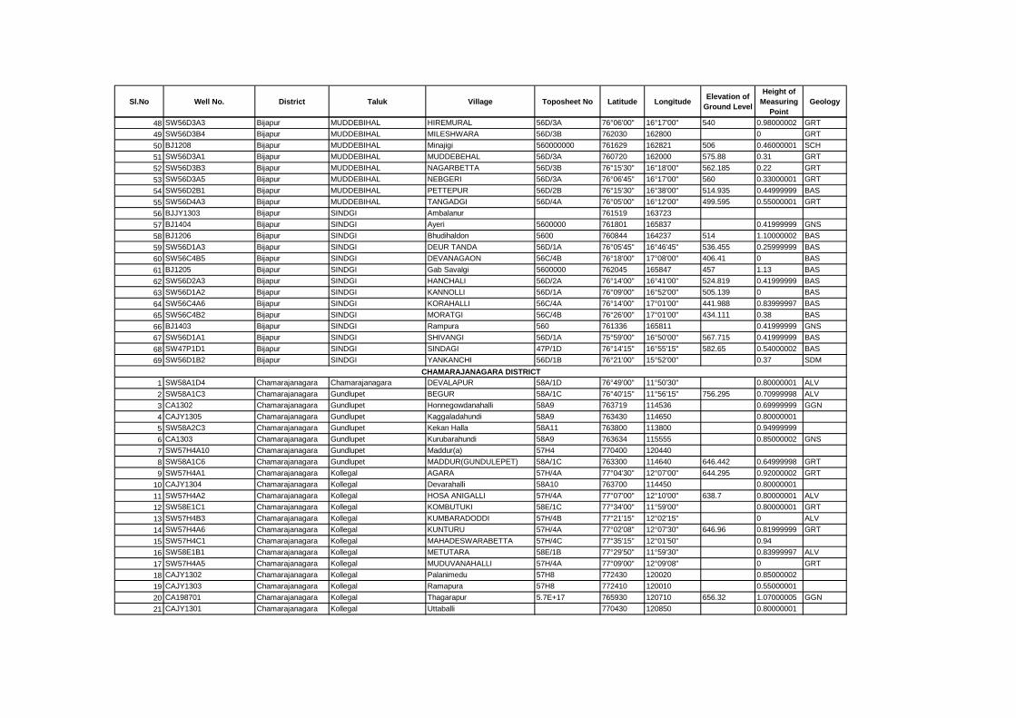
Sl.No Well No. District Taluk Village Toposheet No Latitude LongitudeElevation of
Ground Level
Height of
Measuring
Point
Geology
48 SW56D3A3 Bijapur MUDDEBIHAL HIREMURAL 56D/3A 76°06'00" 16°17'00" 540 0.98000002 GRT
49 SW56D3B4 Bijapur MUDDEBIHAL MILESHWARA 56D/3B 762030 162800 0 GRT
50 BJ1208 Bijapur MUDDEBIHAL Minajigi 560000000 761629 162821 506 0.46000001 SCH
51 SW56D3A1 Bijapur MUDDEBIHAL MUDDEBEHAL 56D/3A 760720 162000 575.88 0.31 GRT
52 SW56D3B3 Bijapur MUDDEBIHAL NAGARBETTA 56D/3B 76°15'30" 16°18'00" 562.185 0.22 GRT
53 SW56D3A5 Bijapur MUDDEBIHAL NEBGERI 56D/3A 76°06'45" 16°17'00" 560 0.33000001 GRT
54 SW56D2B1 Bijapur MUDDEBIHAL PETTEPUR 56D/2B 76°15'30" 16°38'00" 514.935 0.44999999 BAS
55 SW56D4A3 Bijapur MUDDEBIHAL TANGADGI 56D/4A 76°05'00" 16°12'00" 499.595 0.55000001 GRT
56 BJJY1303 Bijapur SINDGI Ambalanur 761519 163723
57 BJ1404 Bijapur SINDGI Ayeri 5600000 761801 165837 0.41999999 GNS
58 BJ1206 Bijapur SINDGI Bhudihaldon 5600 760844 164237 514 1.10000002 BAS
59 SW56D1A3 Bijapur SINDGI DEUR TANDA 56D/1A 76°05'45" 16°46'45" 536.455 0.25999999 BAS
60 SW56C4B5 Bijapur SINDGI DEVANAGAON 56C/4B 76°18'00" 17°08'00" 406.41 0 BAS
61 BJ1205 Bijapur SINDGI Gab Savalgi 5600000 762045 165847 457 1.13 BAS
62 SW56D2A3 Bijapur SINDGI HANCHALI 56D/2A 76°14'00" 16°41'00" 524.819 0.41999999 BAS
63 SW56D1A2 Bijapur SINDGI KANNOLLI 56D/1A 76°09'00" 16°52'00" 505.139 0 BAS
64 SW56C4A6 Bijapur SINDGI KORAHALLI 56C/4A 76°14'00" 17°01'00" 441.988 0.83999997 BAS
65 SW56C4B2 Bijapur SINDGI MORATGI 56C/4B 76°26'00" 17°01'00" 434.111 0.38 BAS
66 BJ1403 Bijapur SINDGI Rampura 560 761336 165811 0.41999999 GNS
67 SW56D1A1 Bijapur SINDGI SHIVANGI 56D/1A 75°59'00" 16°50'00" 567.715 0.41999999 BAS
68 SW47P1D1 Bijapur SINDGI SINDAGI 47P/1D 76°14'15" 16°55'15" 582.65 0.54000002 BAS
69 SW56D1B2 Bijapur SINDGI YANKANCHI 56D/1B 76°21'00" 15°52'00" 0.37 SDM
1 SW58A1D4 Chamarajanagara Chamarajanagara DEVALAPUR 58A/1D 76°49'00" 11°50'30" 0.80000001 ALV
2 SW58A1C3 Chamarajanagara Gundlupet BEGUR 58A/1C 76°40'15" 11°56'15" 756.295 0.70999998 ALV
3 CA1302 Chamarajanagara Gundlupet Honnegowdanahalli 58A9 763719 114536 0.69999999 GGN
4 CAJY1305 Chamarajanagara Gundlupet Kaggaladahundi 58A9 763430 114650 0.80000001
5 SW58A2C3 Chamarajanagara Gundlupet Kekan Halla 58A11 763800 113800 0.94999999
6 CA1303 Chamarajanagara Gundlupet Kurubarahundi 58A9 763634 115555 0.85000002 GNS
7 SW57H4A10 Chamarajanagara Gundlupet Maddur(a) 57H4 770400 120440
8 SW58A1C6 Chamarajanagara Gundlupet MADDUR(GUNDULEPET) 58A/1C 763300 114640 646.442 0.64999998 GRT
9 SW57H4A1 Chamarajanagara Kollegal AGARA 57H/4A 77°04'30" 12°07'00" 644.295 0.92000002 GRT
10 CAJY1304 Chamarajanagara Kollegal Devarahalli 58A10 763700 114450 0.80000001
11 SW57H4A2 Chamarajanagara Kollegal HOSA ANIGALLI 57H/4A 77°07'00" 12°10'00" 638.7 0.80000001 ALV
12 SW58E1C1 Chamarajanagara Kollegal KOMBUTUKI 58E/1C 77°34'00" 11°59'00" 0.80000001 GRT
13 SW57H4B3 Chamarajanagara Kollegal KUMBARADODDI 57H/4B 77°21'15" 12°02'15" 0 ALV
14 SW57H4A6 Chamarajanagara Kollegal KUNTURU 57H/4A 77°02'08" 12°07'30" 646.96 0.81999999 GRT
15 SW57H4C1 Chamarajanagara Kollegal MAHADESWARABETTA 57H/4C 77°35'15" 12°01'50" 0.94
16 SW58E1B1 Chamarajanagara Kollegal METUTARA 58E/1B 77°29'50" 11°59'30" 0.83999997 ALV
17 SW57H4A5 Chamarajanagara Kollegal MUDUVANAHALLI 57H/4A 77°09'00" 12°09'08" 0 GRT
18 CAJY1302 Chamarajanagara Kollegal Palanimedu 57H8 772430 120020 0.85000002
19 CAJY1303 Chamarajanagara Kollegal Ramapura 57H8 772410 120010 0.55000001
20 CA198701 Chamarajanagara Kollegal Thagarapur 5.7E+17 765930 120710 656.32 1.07000005 GGN
21 CAJY1301 Chamarajanagara Kollegal Uttaballi 770430 120850 0.80000001
CHAMARAJANAGARA DISTRICT
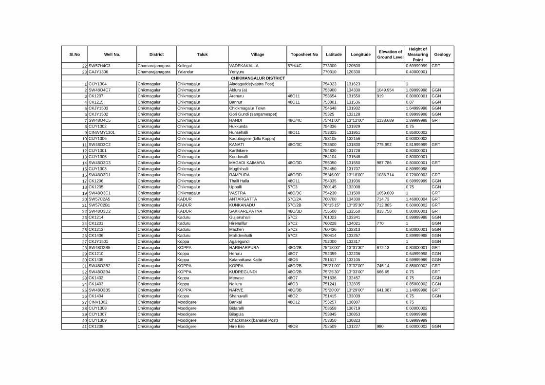
Sl.No Well No. District Taluk Village Toposheet No Latitude LongitudeElevation of
Ground Level
Height of
Measuring
Point
Geology
22 SW57H4C3 Chamarajanagara Kollegal VADEKAKALLA 57H/4C 773300 120500 0.69999999 GRT
23 CAJY1306 Chamarajanagara Yalandur Yeriyuru 770310 120330 0.40000001
1 CIJY1304 Chikmagalur Chikmagalur Aladagudde(vastra Post) 754323 131623 1
2 SW48O4C7 Chikmagalur Chikmagalur Alduru (a) 753900 134330 1049.954 1.89999998 GGN
3 CK1207 Chikmagalur Chikmagalur Arenuru 48O11 753654 131550 919 0.80000001 GGN
4 CK1215 Chikmagalur Chikmagalur Bannur 48O11 753801 131536 0.87 GGN
5 CKJY1503 Chikmagalur Chikmagalur Chickmagalur Town 754648 131932 1.64999998 GGN
6 CKJY1502 Chikmagalur Chikmagalur Gori Gundi (sangamespet) 75325 132128 0.89999998 GGN
7 SW48O4C5 Chikmagalur Chikmagalur HANDI 48O/4C 75°41'00" 13°12'00" 1138.689 1.89999998 GRT
8 CIJY1302 Chikmagalur Chikmagalur Hukkunda 754336 131929 0.75
9 CINWMY1301 Chikmagalur Chikmagalur Hunsehalli 48O11 753325 131951 0.85000002
10 CIJY1306 Chikmagalur Chikmagalur Kadubugere (billu Koppa) 753105 132156 0.60000002
11 SW48O3C2 Chikmagalur Chikmagalur KANATI 48O/3C 753500 131830 775.992 0.81999999 GRT
12 CIJY1301 Chikmagalur Chikmagalur Karthikere 754830 131728 0.80000001
13 CIJY1305 Chikmagalur Chikmagalur Kooduvalli 754104 131548 0.80000001
14 SW48O3D3 Chikmagalur Chikmagalur MAGADI KAIMARA 48O/3D 755050 131550 987.786 0.80000001 GRT
15 CIJY1303 Chikmagalur Chikmagalur Mugthihalli 754450 131707 0.89999998
16 SW48O3D1 Chikmagalur Chikmagalur RAMPURA 48O/3D 75°46'00" 13°18'00" 1036.714 0.72000003 GRT
17 CK1206 Chikmagalur Chikmagalur Thalli Halla 48O11 754335 131936 0.69999999 GGN
18 CK1205 Chikmagalur Chikmagalur Uppalli 57C3 760145 132008 0.75 GGN
19 SW48O3C1 Chikmagalur Chikmagalur VASTRA 48O/3C 754230 131500 1059.009 1 GRT
20 SW57C2A5 Chikmagalur KADUR ANTARGATTA 57C/2A 760700 134330 714.73 1.46000004 GRT
21 SW57C2B1 Chikmagalur KADUR KUNKANADU 57C/2B 76°15'15" 13°35'30" 712.885 0.60000002 GRT
22 SW48O3D2 Chikmagalur KADUR SAKKAREPATNA 48O/3D 755500 132550 833.758 0.80000001 GRT
23 CK1214 Chikmagalur Kaduru Gujjenahalli 57C2 761023 133341 0.89999998 GGN
24 CK1201 Chikmagalur Kaduru Hirenalllur 57C2 760228 134021 770 1 GGN
25 CK1213 Chikmagalur Kaduru Macheri 57C3 760436 132313 0.80000001 GGN
26 CK1406 Chikmagalur Kaduru Mallidevihalli 57C2 760414 133257 0.89999998 GGN
27 CKJY1501 Chikmagalur Koppa Agalegundi 752000 132317 1 GGN
28 SW48O2B5 Chikmagalur KOPPA HARIHARPURA 48O/2B 75°18'00" 13°31'30" 672.13 0.80000001 GRT
29 CK1210 Chikmagalur Koppa Heruru 48O7 752359 132236 0.64999998 GGN
30 CK1405 Chikmagalur Koppa Kalanaikana Katte 48O6 751617 133105 0.69999999 GGN
31 SW48O2B2 Chikmagalur KOPPA KOPPA 48O/2B 75°21'00" 13°32'00" 745.14 0.85000002 GRT
32 SW48O2B4 Chikmagalur KOPPA KUDREGUNDI 48O/2B 75°25'30" 13°33'00" 666.65 0.75 GRT
33 CK1402 Chikmagalur Koppa Menase 48O7 751636 132457 0.75 GGN
34 CK1403 Chikmagalur Koppa Nalluru 48O3 751241 132835 0.85000002 GGN
35 SW48O3B5 Chikmagalur KOPPA NARVE 48O/3B 75°20'00" 13°29'00" 641.087 1.14999998 GRT
36 CK1404 Chikmagalur Koppa Shanuvalli 48O2 751415 133039 0.75 GGN
37 CINV1302 Chikmagalur Moodigere Bankal 48O12 753257 130807 0.75
38 CIJY1308 Chikmagalur Moodigere Bidaralli 753658 130719 0.60000002
39 CIJY1307 Chikmagalur Moodigere Bilagula 753845 130853 0.89999998
40 CIJY1309 Chikmagalur Moodigere Chackmakki(banakal Post) 753350 130823 0.69999999
41 CK1208 Chikmagalur Moodigere Hire Bile 48O8 752509 131227 980 0.60000002 GGN
CHIKMANGALUR DISTRICT
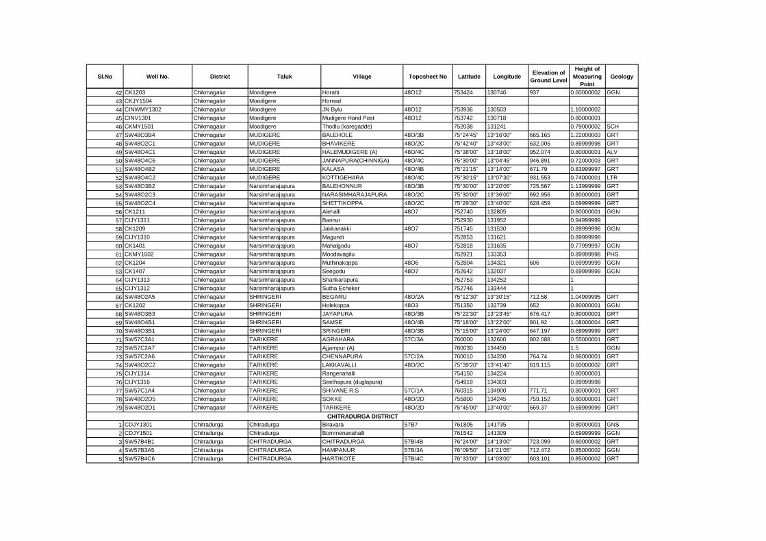
Sl.No Well No. District Taluk Village Toposheet No Latitude LongitudeElevation of
Ground Level
Height of
Measuring
Point
Geology
42 CK1203 Chikmagalur Moodigere Horatti 48O12 753424 130746 937 0.60000002 GGN
43 CKJY1504 Chikmagalur Moodigere Hornad
44 CINWMY1302 Chikmagalur Moodigere JN Bylu 48O12 753936 130503 1.10000002
45 CINV1301 Chikmagalur Moodigere Mudigere Hand Post 48O12 753742 130718 0.80000001
46 CKMY1501 Chikmagalur Moodigere Thodlu (karegadde) 752038 131241 0.79000002 SCH
47 SW48O3B4 Chikmagalur MUDIGERE BALEHOLE 48O/3B 75°24'45" 13°16'00" 665.165 1.22000003 GRT
48 SW48O2C1 Chikmagalur MUDIGERE BHAVIKERE 48O/2C 75°42'40" 13°43'00" 632.005 0.89999998 GRT
49 SW48O4C1 Chikmagalur MUDIGERE HALEMUDIGERE (A) 48O/4C 75°38'00" 13°18'00" 952.074 0.80000001 ALV
50 SW48O4C6 Chikmagalur MUDIGERE JANNAPURA(CHINNIGA) 48O/4C 75°30'00" 13°04'45" 946.891 0.72000003 GRT
51 SW48O4B2 Chikmagalur MUDIGERE KALASA 48O/4B 75°21'15" 13°14'00" 671.79 0.83999997 GRT
52 SW48O4C2 Chikmagalur MUDIGERE KOTTIGEHARA 48O/4C 75°30'15" 13°07'30" 931.553 0.74000001 LTR
53 SW48O3B2 Chikmagalur Narsimharajapura BALEHONNUR 48O/3B 75°30'00" 13°20'05" 725.567 1.13999999 GRT
54 SW48O2C3 Chikmagalur Narsimharajapura NARASIMHARAJAPURA 48O/2C 75°30'00" 13°36'00" 692.956 0.80000001 GRT
55 SW48O2C4 Chikmagalur Narsimharajapura SHETTIKOPPA 48O/2C 75°29'30" 13°40'00" 628.459 0.69999999 GRT
56 CK1211 Chikmagalur Narsimharajapura Alehalli 48O7 752740 132805 0.80000001 GGN
57 CIJY1311 Chikmagalur Narsimharajapura Bannur 752930 131952 0.94999999
58 CK1209 Chikmagalur Narsimharajapura Jakkanakki 48O7 751745 131530 0.89999998 GGN
59 CIJY1310 Chikmagalur Narsimharajapura Magundi 752853 131621 0.89999998
60 CK1401 Chikmagalur Narsimharajapura Mahalgodu 48O7 752818 131635 0.77999997 GGN
61 CKMY1502 Chikmagalur Narsimharajapura Moodavagilu 752921 133353 0.89999998 PHS
62 CK1204 Chikmagalur Narsimharajapura Muthinakoppa 48O6 752804 134321 606 0.69999999 GGN
63 CK1407 Chikmagalur Narsimharajapura Seegodu 48O7 752642 132037 0.69999999 GGN
64 CIJY1313 Chikmagalur Narsimharajapura Shankarapura 752753 134252 1
65 CIJY1312 Chikmagalur Narsimharajapura Sutha Echeker 752746 133444 1
66 SW48O2A5 Chikmagalur SHRINGERI BEGARU 48O/2A 75°12'30" 13°30'15" 712.58 1.04999995 GRT
67 CK1202 Chikmagalur SHRINGERI Holekoppa 48O3 751350 132739 652 0.80000001 GGN
68 SW48O3B3 Chikmagalur SHRINGERI JAYAPURA 48O/3B 75°22'30" 13°23'45" 676.417 0.80000001 GRT
69 SW48O4B1 Chikmagalur SHRINGERI SAMSE 48O/4B 75°18'00" 13°22'00" 801.92 1.08000004 GRT
70 SW48O3B1 Chikmagalur SHRINGERI SRINGERI 48O/3B 75°15'00" 13°24'00" 647.197 0.69999999 GRT
71 SW57C3A1 Chikmagalur TARIKERE AGRAHARA 57C/3A 760000 132600 802.088 0.55000001 GRT
72 SW57C2A7 Chikmagalur TARIKERE Ajjampur (A) 760030 134450 1.5 GGN
73 SW57C2A6 Chikmagalur TARIKERE CHENNAPURA 57C/2A 760010 134200 764.74 0.86000001 GRT
74 SW48O2C2 Chikmagalur TARIKERE LAKKAVALLI 48O/2C 75°39'20" 13°41'40" 619.115 0.60000002 GRT
75 CIJY1314 Chikmagalur TARIKERE Rangenahalli 754150 134224 0.80000001
76 CIJY1316 Chikmagalur TARIKERE Seethapura (duglapura) 754919 134303 0.89999998
77 SW57C1A4 Chikmagalur TARIKERE SHIVANE R.S 57C/1A 760315 134900 771.71 0.80000001 GRT
78 SW48O2D5 Chikmagalur TARIKERE SOKKE 48O/2D 755800 134245 759.152 0.80000001 GRT
79 SW48O2D1 Chikmagalur TARIKERE TARIKERE 48O/2D 75°45'00" 13°40'00" 669.37 0.69999999 GRT
1 CDJY1301 Chitradurga Chitradurga Biravara 57B7 761805 141735 0.80000001 GNS
2 CDJY1501 Chitradurga Chitradurga Bommenanahalli 761542 141309 0.69999999 GGN
3 SW57B4B1 Chitradurga CHITRADURGA CHITRADURGA 57B/4B 76°24'00" 14°13'00" 723.099 0.60000002 GRT
4 SW57B3A5 Chitradurga CHITRADURGA HAMPANUR 57B/3A 76°09'50" 14°21'05" 712.472 0.85000002 GGN
5 SW57B4C6 Chitradurga CHITRADURGA HARTIKOTE 57B/4C 76°33'00" 14°03'00" 603.101 0.85000002 GRT
CHITRADURGA DISTRICT
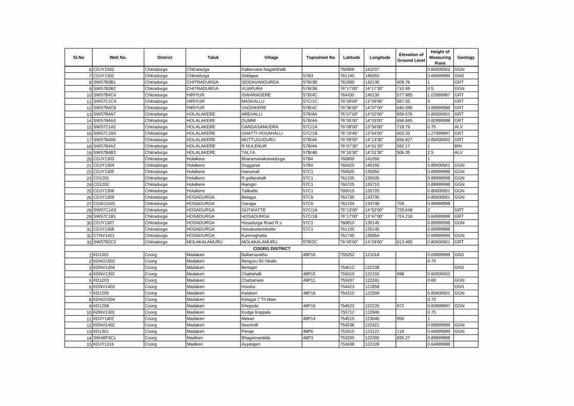
Sl.No Well No. District Taluk Village Toposheet No Latitude LongitudeElevation of
Ground Level
Height of
Measuring
Point
Geology
6 CDJY1502 Chitradurga Chitradurga Kallavvana Nagathihalli 760909 141037 0.60000002 GGN
7 CDJY1302 Chitradurga Chitradurga Siddapur 57B3 761140 145055 0.69999999 GNS
8 SW57B3B1 Chitradurga CHITRADURGA SIDDAVANDURGA 57B/3B 761900 142130 609.76 1 GRT
9 SW57B3B2 Chitradurga CHITRADURGA VIJAPURA 57B/3B 76°17'00" 14°17'30" 710.99 0.5 GGN
10 SW57B4C4 Chitradurga HIRIYUR ISWARAGERE 57B/4C 764430 140130 577.985 1.02999997 GRT
11 SW57C1C4 Chitradurga HIRIYUR MASKALLU 57C/1C 76°39'00" 13°59'06" 587.55 0 GRT
12 SW57B4C8 Chitradurga HIRIYUR VADDIKERE 57B/4C 76°36'00" 14°07'00" 640.099 0.89999998 GRT
13 SW57B4A7 Chitradurga HOLALAKERE AREHALLI 57B/4A 76°07'00" 14°02'00" 659.576 0.80000001 GRT
14 SW57B4A3 Chitradurga HOLALAKERE DUMMI 57B/4A 76°05'00" 14°03'00" 656.845 0.82999998 GRT
15 SW57C1A2 Chitradurga HOLALAKERE GANGASAMUDRA 57C/1A 76°08'00" 13°56'00" 718.79 0.75 ALV
16 SW57C1B3 Chitradurga HOLALAKERE GHATTI HOSAHALLI 57C/1B 76°18'45" 13°54'00" 603.33 1.27999997 GRT
17 SW57B4A6 Chitradurga HOLALAKERE MUTTUGUDURU 57B/4A 76°09'00" 14°13'30" 656.827 0.85000002 GRT
18 SW57B4A2 Chitradurga HOLALAKERE R.NULENUR 57B/4A 76°07'30" 14°01'30" 592.17 1 BIN
19 SW57B4B3 Chitradurga HOLALAKERE TALYA 57B/4B 76°16'30" 14°01'30" 506.35 2.5 ALV
20 CDJY1303 Chitradurga Holalkere Bharamanaikanadurga. 57B4 760800 141050 1
21 CDJY1304 Chitradurga Holalkere Dogganal 57B4 760425 140155 0.80000001 GGN
22 CDJY1305 Chitradurga Holalkere Hanumali 57C1 760505 135950 0.89999998 GGN
23 CD1201 Chitradurga Holalkere R.gollarahalli 57C1 761105 135535 0.89999998 GGN
24 CD1202 Chitradurga Holalkere Ramgiri 57C1 760725 135710 0.89999998 GGN
25 CDJY1306 Chitradurga Holalkere Talikatte 57C1 760515 135720 0.80000001 GGN
26 CDJY1309 Chitradurga HOSADURGA Belagur 57C6 761735 133735 0.80000001 GGN
27 CDAG1501 Chitradurga HOSADURGA Garaga 57C6 762104 133748 709 0.89999998
28 SW57C1A3 Chitradurga HOSADURGA GUTIKATTE 57C/1A 75°13'00" 14°52'00" 729.648 2 GRT
29 SW57C1B1 Chitradurga HOSADURGA HOSADURGA 57C/1B 76°17'00" 13°47'00" 724.218 0.64999998 GRT
30 CDJY1307 Chitradurga HOSADURGA Hosadurga Road R.s 57C1 760810 135145 0.89999998 GGN
31 CDJY1308 Chitradurga HOSADURGA Hosakudavinkatte 57C1 761105 135145 0.89999998
32 CTNV1401 Chitradurga HOSADURGA Kummighatta 761745 135854 0.69999999 GGN
33 SW57B2C2 Chitradurga MOLAKALAMURU MOLAKALAMURU 57B/2C 76°45'00" 14°29'00" 613.465 0.80000001 GRT
1 KD1201 Coorg Madakeri Ballamavathu 48P16 755252 121018 0.69999999 GNS
2 KDAG1502 Coorg Madakeri Benguru 50 Okallu 0.75
3 KDNV1404 Coorg Madakeri Bettagiri 754012 122108 GNS
4 KDNV1302 Coorg Madakeri Chattahalli 48P15 755010 122155 998 0.60000002
5 KD1203 Coorg Madakeri Chattamani 48P11 753437 122241 0.69 GGN
6 KDNV1403 Coorg Madakeri Hoodur 754423 121858 GNS
7 KD1205 Coorg Madakeri Katakeri 48P16 754210 122508 0.80000001 GGN
8 KDAG1504 Coorg Madakeri Ketagal 7 Th Main 0.75
9 KD1208 Coorg Madakeri Khegodu 48P15 754523 122225 972 0.83999997 GGN
10 KDNV1301 Coorg Madakeri Kodge Koppalu 755712 122946 0.75
11 KDJY1402 Coorg Madakeri Mekari 48P14 754515 123045 956 1
12 KDNV1402 Coorg Madakeri Neerkolli 754536 122421 0.69999999 GGN
13 KD1301 Coorg Madakeri Peraje 48P6 752615 123122 118 0.69999999 GGN
14 SW48P3C1 Coorg Madikeri Bhagamandala 48P3 753200 122300 835.27 0.89999998
15 KDJY1316 Coorg Madikeri Ayyangeri 753438 122109 0.64999998
COORG DISTRICT
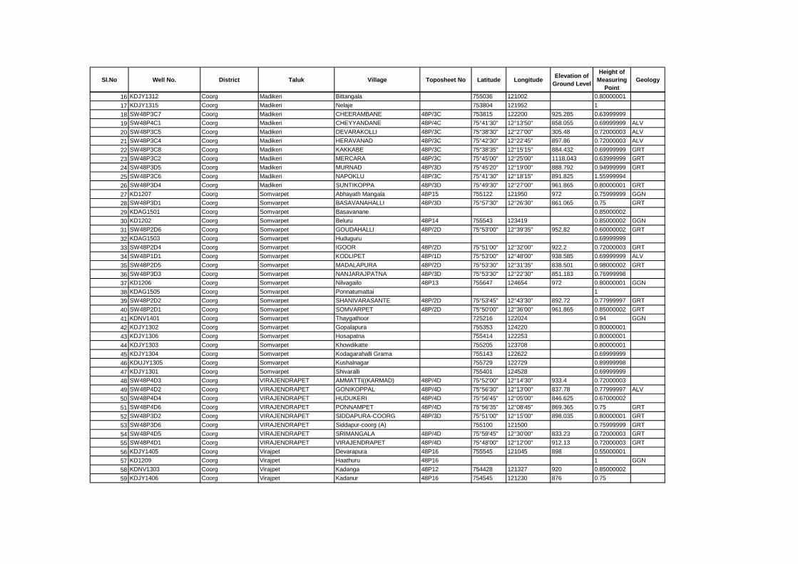
Sl.No Well No. District Taluk Village Toposheet No Latitude LongitudeElevation of
Ground Level
Height of
Measuring
Point
Geology
16 KDJY1312 Coorg Madikeri Bittangala 755036 121002 0.80000001
17 KDJY1315 Coorg Madikeri Nelaje 753804 121952 1
18 SW48P3C7 Coorg Madikeri CHEERAMBANE 48P/3C 753815 122200 925.285 0.63999999
19 SW48P4C1 Coorg Madikeri CHEYYANDANE 48P/4C 75°41'30" 12°13'50" 858.055 0.69999999 ALV
20 SW48P3C5 Coorg Madikeri DEVARAKOLLI 48P/3C 75°38'30" 12°27'00" 305.48 0.72000003 ALV
21 SW48P3C4 Coorg Madikeri HERAVANAD 48P/3C 75°42'30" 12°22'45" 897.86 0.72000003 ALV
22 SW48P3C8 Coorg Madikeri KAKKABE 48P/3C 75°38'35" 12°15'15" 884.432 0.69999999 GRT
23 SW48P3C2 Coorg Madikeri MERCARA 48P/3C 75°45'00" 12°25'00" 1118.043 0.63999999 GRT
24 SW48P3D5 Coorg Madikeri MURNAD 48P/3D 75°45'20" 12°19'00" 888.792 0.94999999 GRT
25 SW48P3C6 Coorg Madikeri NAPOKLU 48P/3C 75°41'30" 12°18'15" 891.825 1.55999994
26 SW48P3D4 Coorg Madikeri SUNTIKOPPA 48P/3D 75°49'30" 12°27'00" 961.865 0.80000001 GRT
27 KD1207 Coorg Somvarpet Abhayath Mangala 48P15 755122 121950 972 0.75999999 GGN
28 SW48P3D1 Coorg Somvarpet BASAVANAHALLI 48P/3D 75°57'30" 12°26'30" 861.065 0.75 GRT
29 KDAG1501 Coorg Somvarpet Basavanane 0.85000002
30 KD1202 Coorg Somvarpet Beluru 48P14 755543 123419 0.85000002 GGN
31 SW48P2D6 Coorg Somvarpet GOUDAHALLI 48P/2D 75°53'00" 12°39'35" 952.82 0.60000002 GRT
32 KDAG1503 Coorg Somvarpet Huduguru 0.69999999
33 SW48P2D4 Coorg Somvarpet IGOOR 48P/2D 75°51'00" 12°32'00" 922.2 0.72000003 GRT
34 SW48P1D1 Coorg Somvarpet KODLIPET 48P/1D 75°53'00" 12°48'00" 938.585 0.69999999 ALV
35 SW48P2D5 Coorg Somvarpet MADALAPURA 48P/2D 75°53'30" 12°31'35" 838.501 0.98000002 GRT
36 SW48P3D3 Coorg Somvarpet NANJARAJPATNA 48P/3D 75°53'30" 12°22'30" 851.183 0.76999998
37 KD1206 Coorg Somvarpet Nilvagailo 48P13 755647 124654 972 0.80000001 GGN
38 KDAG1505 Coorg Somvarpet Ponnatumattai 1
39 SW48P2D2 Coorg Somvarpet SHANIVARASANTE 48P/2D 75°53'45" 12°43'30" 892.72 0.77999997 GRT
40 SW48P2D1 Coorg Somvarpet SOMVARPET 48P/2D 75°50'00" 12°36'00" 961.865 0.85000002 GRT
41 KDNV1401 Coorg Somvarpet Thaygathoor 725216 122024 0.94 GGN
42 KDJY1302 Coorg Somvarpet Gopalapura 755353 124220 0.80000001
43 KDJY1306 Coorg Somvarpet Hosapatna 755414 122253 0.80000001
44 KDJY1303 Coorg Somvarpet Khowdikatte 755205 123708 0.80000001
45 KDJY1304 Coorg Somvarpet Kodagarahalli Grama 755143 122622 0.69999999
46 KDUJY1305 Coorg Somvarpet Kushalnagar 755729 122729 0.89999998
47 KDJY1301 Coorg Somvarpet Shivaralli 755401 124528 0.69999999
48 SW48P4D3 Coorg VIRAJENDRAPET AMMATTI((KARMAD) 48P/4D 75°52'00" 12°14'30" 933.4 0.72000003
49 SW48P4D2 Coorg VIRAJENDRAPET GONIKOPPAL 48P/4D 75°56'30" 12°13'00" 837.78 0.77999997 ALV
50 SW48P4D4 Coorg VIRAJENDRAPET HUDUKERI 48P/4D 75°56'45" 12°05'00" 846.625 0.67000002
51 SW48P4D6 Coorg VIRAJENDRAPET PONNAMPET 48P/4D 75°56'35" 12°08'45" 869.365 0.75 GRT
52 SW48P3D2 Coorg VIRAJENDRAPET SIDDAPURA-COORG 48P/3D 75°51'00" 12°15'00" 898.035 0.80000001 GRT
53 SW48P3D6 Coorg VIRAJENDRAPET Siddapur-coorg (A) 755100 121500 0.75999999 GRT
54 SW48P4D5 Coorg VIRAJENDRAPET SRIMANGALA 48P/4D 75°59'45" 12°30'00" 833.23 0.72000003 GRT
55 SW48P4D1 Coorg VIRAJENDRAPET VIRAJENDRAPET 48P/4D 75°48'00" 12°12'00" 912.13 0.72000003 GRT
56 KDJY1405 Coorg Virajpet Devarapura 48P16 755545 121045 898 0.55000001
57 KD1209 Coorg Virajpet Haathuru 48P16 1 GGN
58 KDNV1303 Coorg Virajpet Kadanga 48P12 754428 121327 920 0.85000002
59 KDJY1406 Coorg Virajpet Kadanur 48P16 754545 121230 876 0.75
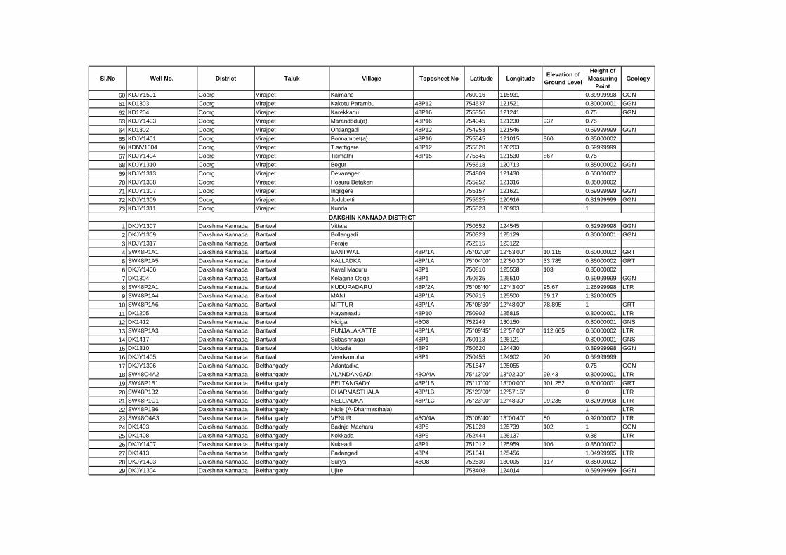
Sl.No Well No. District Taluk Village Toposheet No Latitude LongitudeElevation of
Ground Level
Height of
Measuring
Point
Geology
60 KDJY1501 Coorg Virajpet Kaimane 760016 115931 0.89999998 GGN
61 KD1303 Coorg Virajpet Kakotu Parambu 48P12 754537 121521 0.80000001 GGN
62 KD1204 Coorg Virajpet Karekkadu 48P16 755356 121241 0.75 GGN
63 KDJY1403 Coorg Virajpet Marandodu(a) 48P16 754045 121230 937 0.75
64 KD1302 Coorg Virajpet Ontiangadi 48P12 754953 121546 0.69999999 GGN
65 KDJY1401 Coorg Virajpet Ponnampet(a) 48P16 755545 121015 860 0.85000002
66 KDNV1304 Coorg Virajpet T.settigere 48P12 755820 120203 0.69999999
67 KDJY1404 Coorg Virajpet Titimathi 48P15 775545 121530 867 0.75
68 KDJY1310 Coorg Virajpet Begur 755618 120713 0.85000002 GGN
69 KDJY1313 Coorg Virajpet Devanageri 754809 121430 0.60000002
70 KDJY1308 Coorg Virajpet Hosuru Betakeri 755252 121316 0.85000002
71 KDJY1307 Coorg Virajpet Ingilgere 755157 121621 0.69999999 GGN
72 KDJY1309 Coorg Virajpet Jodubetti 755625 120916 0.81999999 GGN
73 KDJY1311 Coorg Virajpet Kunda 755323 120903 1
1 DKJY1307 Dakshina Kannada Bantwal Vittala 750552 124545 0.82999998 GGN
2 DKJY1309 Dakshina Kannada Bantwal Bollangadi 750323 125129 0.80000001 GGN
3 KDJY1317 Dakshina Kannada Bantwal Peraje 752615 123122
4 SW48P1A1 Dakshina Kannada Bantwal BANTWAL 48P/1A 75°02'00" 12°53'00" 10.115 0.60000002 GRT
5 SW48P1A5 Dakshina Kannada Bantwal KALLADKA 48P/1A 75°04'00" 12°50'30" 33.785 0.85000002 GRT
6 DKJY1406 Dakshina Kannada Bantwal Kaval Maduru 48P1 750810 125558 103 0.85000002
7 DK1304 Dakshina Kannada Bantwal Kelagina Ogga 48P1 750535 125510 0.69999999 GGN
8 SW48P2A1 Dakshina Kannada Bantwal KUDUPADARU 48P/2A 75°06'40" 12°43'00" 95.67 1.26999998 LTR
9 SW48P1A4 Dakshina Kannada Bantwal MANI 48P/1A 750715 125500 69.17 1.32000005
10 SW48P1A6 Dakshina Kannada Bantwal MITTUR 48P/1A 75°08'30" 12°48'00" 78.895 1 GRT
11 DK1205 Dakshina Kannada Bantwal Nayanaadu 48P10 750902 125815 0.80000001 LTR
12 DK1412 Dakshina Kannada Bantwal Nidigal 48O8 752249 130150 0.80000001 GNS
13 SW48P1A3 Dakshina Kannada Bantwal PUNJALAKATTE 48P/1A 75°09'45" 12°57'00" 112.665 0.60000002 LTR
14 DK1417 Dakshina Kannada Bantwal Subashnagar 48P1 750113 125121 0.80000001 GNS
15 DK1310 Dakshina Kannada Bantwal Ukkada 48P2 750620 124430 0.89999998 GGN
16 DKJY1405 Dakshina Kannada Bantwal Veerkambha 48P1 750455 124902 70 0.69999999
17 DKJY1306 Dakshina Kannada Belthangady Adantadka 751547 125055 0.75 GGN
18 SW48O4A2 Dakshina Kannada Belthangady ALANDANGADI 48O/4A 75°13'00" 13°02'30" 99.43 0.80000001 LTR
19 SW48P1B1 Dakshina Kannada Belthangady BELTANGADY 48P/1B 75°17'00" 13°00'00" 101.252 0.80000001 GRT
20 SW48P1B2 Dakshina Kannada Belthangady DHARMASTHALA 48P/1B 75°23'00" 12°57'15" 0 LTR
21 SW48P1C1 Dakshina Kannada Belthangady NELLIADKA 48P/1C 75°23'00" 12°48'30" 99.235 0.82999998 LTR
22 SW48P1B6 Dakshina Kannada Belthangady Nidle (A-Dharmasthala) 1 LTR
23 SW48O4A3 Dakshina Kannada Belthangady VENUR 48O/4A 75°08'40" 13°00'40" 80 0.92000002 LTR
24 DK1403 Dakshina Kannada Belthangady Badnje Macharu 48P5 751928 125739 102 1 GGN
25 DK1408 Dakshina Kannada Belthangady Kokkada 48P5 752444 125137 0.88 LTR
26 DKJY1407 Dakshina Kannada Belthangady Kukeadi 48P1 751012 125959 106 0.85000002
27 DK1413 Dakshina Kannada Belthangady Padangadi 48P4 751341 125456 1.04999995 LTR
28 DKJY1403 Dakshina Kannada Belthangady Surya 48O8 752530 130005 117 0.85000002
29 DKJY1304 Dakshina Kannada Belthangady Ujire 753408 124014 0.69999999 GGN
DAKSHIN KANNADA DISTRICT

Sl.No Well No. District Taluk Village Toposheet No Latitude LongitudeElevation of
Ground Level
Height of
Measuring
Point
Geology
30 DKJY1305 Dakshina Kannada Belthangady Balaalu 751947 125611 0.80000001
31 SW48L1D1 Dakshina Kannada Mangalore ADYAR 48L/1D 74°50'00" 12°58'50" 12.155 0.69999999 LTR
32 DK1201 Dakshina Kannada Mangalore Baala 48P10 744928 125853 0.75 GNS
33 DKJY1409 Dakshina Kannada Mangalore Bajpe 48L3 745310 125857 81 0.89999998
34 DKJY1413 Dakshina Kannada Mangalore Boregudda 48O4 750538 130750 116 0.5
35 DK1406 Dakshina Kannada Mangalore Elathur 48K16 744853 130545 0.75 GNS
36 SW48K4D3 Dakshina Kannada Mangalore HALEYANGADI 48K/4D 74°47'45" 13°02'30" 8.223 0.85000002
37 DKJY1411 Dakshina Kannada Mangalore Kateel 48K16 745213 130240 24 1.60000002
38 DK1308 Dakshina Kannada Mangalore Kenchanakere 48P5 744845 130420 0.85000002 GGN
39 DKJY1410 Dakshina Kannada Mangalore Kenjaru 48L13 745203 125703 26 0.60000002
40 DKJY1415 Dakshina Kannada Mangalore Kesargadde 48K16 745947 130643 109 0.89999998
41 DKJY1408 Dakshina Kannada Mangalore Kinni Kambala 48L13 745540 125805 114 0.89999998
42 DK1204 Dakshina Kannada Mangalore Kinnigoli 48K16 745115 130352 0.80000001 LTR
43 DK198101 Dakshina Kannada Mangalore Mulki 48K16 744735 130507 1874 0.87 GGN
44 DK1414 Dakshina Kannada Mangalore Padil 48L13 745305 125210 1.04999995 LTR
45 DK1415 Dakshina Kannada Mangalore Pakshikere 48K16 744933 130302 0.89999998 GNS
46 DKJY1414 Dakshina Kannada Mangalore Shirtadi 48O4 750458 130527 97 0.80000001
47 SW48L1D3 Dakshina Kannada Mangalore SURATKAL 48L/1D 74°48'00" 12°59'40" 11.28 0.80000001 ALV
48 SW48L1D5 Dakshina Kannada Mangalore THALAPADY 48L/1D 74°52'30" 12°45'45" 5.341 0.80000001 LTR
49 SW48L1D6 Dakshina Kannada Mangalore Ullal (A) 745230 124930 0.93000001 ALV
50 DKJY1321 Dakshina Kannada Mangalore Garadi 745756 130011 0.89999998 GGN
51 DKJY1311 Dakshina Kannada Mangalore Kotekar 743135 124715 0.86000001 ALV
52 DKJY1312 Dakshina Kannada Mangalore Mangalore I(kankanadi) 745035 125115 0.80000001 ALV
53 DKJY1313 Dakshina Kannada Mangalore Mangalore-ii(jappu) 745058 125103 0.69999999 ALV
54 DKJY1314 Dakshina Kannada Mangalore Mangalore-iii 744955 125147 0.69999999 ALV
55 DKJY1315 Dakshina Kannada Mangalore Mangalore-iv 745050 125140 0.60000002 ALV
56 DKJY1316 Dakshina Kannada Mangalore Mangalore-v(lalbagh) 745050 125140 0.75999999 ALV
57 DKJY1318 Dakshina Kannada Mangalore Mukka 744706 130145 0.75 ALV
58 DKJY1317 Dakshina Kannada Mangalore Panambur Beach 744826 125619 1.29999995 ALV
59 DKJY1320 Dakshina Kannada Mangalore Perar(padu-perar) 745457 125851 0.89999998 GGN
60 DKJY1319 Dakshina Kannada Mangalore Permude 745252 131013 0.89999998 GGN
61 DKJY1310 Dakshina Kannada Mangalore Ullal Beach 745021 124905 1.20000005 ALV
62 DKJY1412 Dakshina Kannada Puttur Addhole 48P9 753045 125545 121 0.55000001
63 SW48P1B5 Dakshina Kannada Puttur ALANKARU 48P/1B 75°21'20" 12°46'30" 96.535 1.16999996 GRT
64 DK1301 Dakshina Kannada Puttur Athoor Koyla 48P5 751930 124730 0.89999998 BAS
65 DK1302 Dakshina Kannada Puttur Bajthru Valau 48P5 751839 125055 0.75 GGN
66 DK1404 Dakshina Kannada Puttur Balya 48P5 752523 124617 1 LTR
67 DK1405 Dakshina Kannada Puttur Bilinele 48P10 753345 124255 0.80000001 LTR
68 DK1303 Dakshina Kannada Puttur Gerukatte 48P5 751544 125706 0.85000002 GGN
69 DK1203 Dakshina Kannada Puttur Hire Bandadi 48P5 751753 124848 0.92000002 GGN
70 SW48P2B7 Dakshina Kannada Puttur KADABA 48P/2B 75°28'00" 12°44'30" 100.06 0.74000001 LTR
71 DKJY1404 Dakshina Kannada Puttur Kalleri 48P1 751437 125241 95 1.26999998
72 DK1407 Dakshina Kannada Puttur Kanyana 48P10 753003 124440 1.5 GGN
73 DK1409 Dakshina Kannada Puttur Kudtha Muger 48P1 750254 124633 0.89999998 GNS
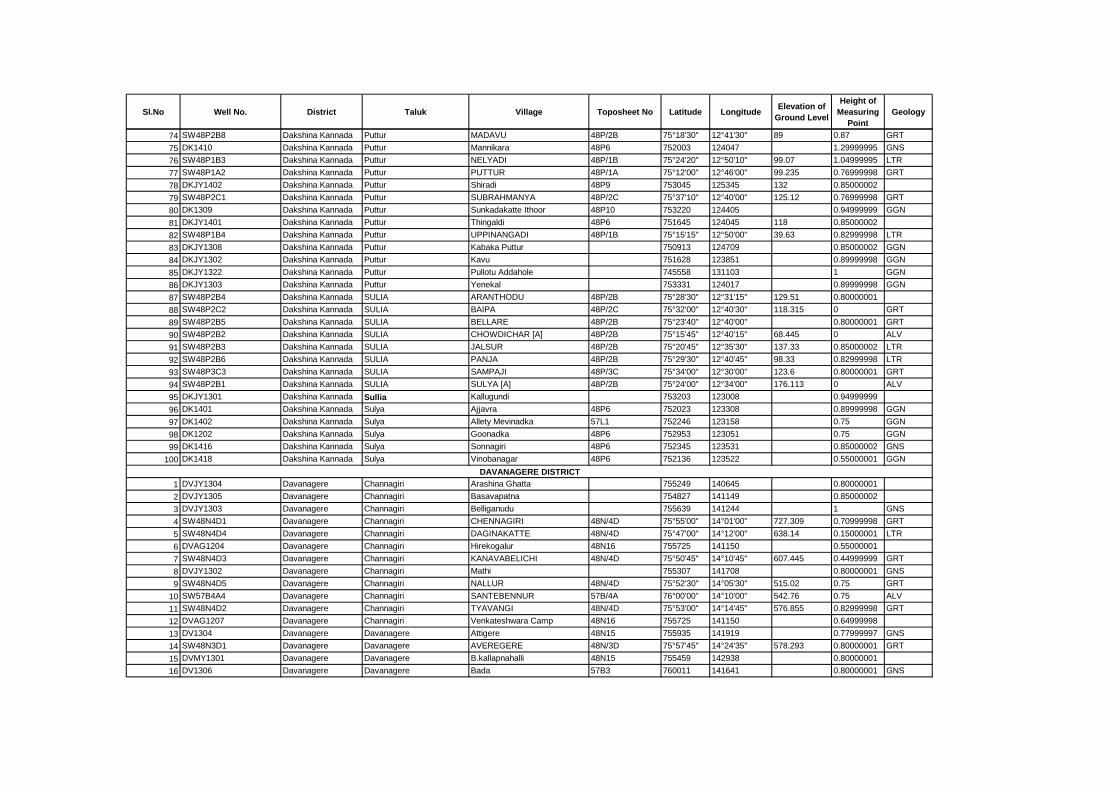
Sl.No Well No. District Taluk Village Toposheet No Latitude LongitudeElevation of
Ground Level
Height of
Measuring
Point
Geology
74 SW48P2B8 Dakshina Kannada Puttur MADAVU 48P/2B 75°18'30" 12°41'30" 89 0.87 GRT
75 DK1410 Dakshina Kannada Puttur Mannikara 48P6 752003 124047 1.29999995 GNS
76 SW48P1B3 Dakshina Kannada Puttur NELYADI 48P/1B 75°24'20" 12°50'10" 99.07 1.04999995 LTR
77 SW48P1A2 Dakshina Kannada Puttur PUTTUR 48P/1A 75°12'00" 12°46'00" 99.235 0.76999998 GRT
78 DKJY1402 Dakshina Kannada Puttur Shiradi 48P9 753045 125345 132 0.85000002
79 SW48P2C1 Dakshina Kannada Puttur SUBRAHMANYA 48P/2C 75°37'10" 12°40'00" 125.12 0.76999998 GRT
80 DK1309 Dakshina Kannada Puttur Sunkadakatte Ithoor 48P10 753220 124405 0.94999999 GGN
81 DKJY1401 Dakshina Kannada Puttur Thingaldi 48P6 751645 124045 118 0.85000002
82 SW48P1B4 Dakshina Kannada Puttur UPPINANGADI 48P/1B 75°15'15" 12°50'00" 39.63 0.82999998 LTR
83 DKJY1308 Dakshina Kannada Puttur Kabaka Puttur 750913 124709 0.85000002 GGN
84 DKJY1302 Dakshina Kannada Puttur Kavu 751628 123851 0.89999998 GGN
85 DKJY1322 Dakshina Kannada Puttur Pullotu Addahole 745558 131103 1 GGN
86 DKJY1303 Dakshina Kannada Puttur Yenekal 753331 124017 0.89999998 GGN
87 SW48P2B4 Dakshina Kannada SULIA ARANTHODU 48P/2B 75°28'30" 12°31'15" 129.51 0.80000001
88 SW48P2C2 Dakshina Kannada SULIA BAIPA 48P/2C 75°32'00" 12°40'30" 118.315 0 GRT
89 SW48P2B5 Dakshina Kannada SULIA BELLARE 48P/2B 75°23'40" 12°40'00" 0.80000001 GRT
90 SW48P2B2 Dakshina Kannada SULIA CHOWDICHAR [A] 48P/2B 75°15'45" 12°40'15" 68.445 0 ALV
91 SW48P2B3 Dakshina Kannada SULIA JALSUR 48P/2B 75°20'45" 12°35'30" 137.33 0.85000002 LTR
92 SW48P2B6 Dakshina Kannada SULIA PANJA 48P/2B 75°29'30" 12°40'45" 98.33 0.82999998 LTR
93 SW48P3C3 Dakshina Kannada SULIA SAMPAJI 48P/3C 75°34'00" 12°30'00" 123.6 0.80000001 GRT
94 SW48P2B1 Dakshina Kannada SULIA SULYA [A] 48P/2B 75°24'00" 12°34'00" 176.113 0 ALV
95 DKJY1301 Dakshina Kannada Sullia Kallugundi 753203 123008 0.94999999
96 DK1401 Dakshina Kannada Sulya Ajjavra 48P6 752023 123308 0.89999998 GGN
97 DK1402 Dakshina Kannada Sulya Allety Mevinadka 57L1 752246 123158 0.75 GGN
98 DK1202 Dakshina Kannada Sulya Goonadka 48P6 752953 123051 0.75 GGN
99 DK1416 Dakshina Kannada Sulya Sonnagiri 48P6 752345 123531 0.85000002 GNS
100 DK1418 Dakshina Kannada Sulya Vinobanagar 48P6 752136 123522 0.55000001 GGN
1 DVJY1304 Davanagere Channagiri Arashina Ghatta 755249 140645 0.80000001
2 DVJY1305 Davanagere Channagiri Basavapatna 754827 141149 0.85000002
3 DVJY1303 Davanagere Channagiri Belliganudu 755639 141244 1 GNS
4 SW48N4D1 Davanagere Channagiri CHENNAGIRI 48N/4D 75°55'00" 14°01'00" 727.309 0.70999998 GRT
5 SW48N4D4 Davanagere Channagiri DAGINAKATTE 48N/4D 75°47'00" 14°12'00" 638.14 0.15000001 LTR
6 DVAG1204 Davanagere Channagiri Hirekogalur 48N16 755725 141150 0.55000001
7 SW48N4D3 Davanagere Channagiri KANAVABELICHI 48N/4D 75°50'45" 14°10'45" 607.445 0.44999999 GRT
8 DVJY1302 Davanagere Channagiri Mathi 755307 141708 0.80000001 GNS
9 SW48N4D5 Davanagere Channagiri NALLUR 48N/4D 75°52'30" 14°05'30" 515.02 0.75 GRT
10 SW57B4A4 Davanagere Channagiri SANTEBENNUR 57B/4A 76°00'00" 14°10'00" 542.76 0.75 ALV
11 SW48N4D2 Davanagere Channagiri TYAVANGI 48N/4D 75°53'00" 14°14'45" 576.855 0.82999998 GRT
12 DVAG1207 Davanagere Channagiri Venkateshwara Camp 48N16 755725 141150 0.64999998
13 DV1304 Davanagere Davanagere Attigere 48N15 755935 141919 0.77999997 GNS
14 SW48N3D1 Davanagere Davanagere AVEREGERE 48N/3D 75°57'45" 14°24'35" 578.293 0.80000001 GRT
15 DVMY1301 Davanagere Davanagere B.kallapnahalli 48N15 755459 142938 0.80000001
16 DV1306 Davanagere Davanagere Bada 57B3 760011 141641 0.80000001 GNS
DAVANAGERE DISTRICT
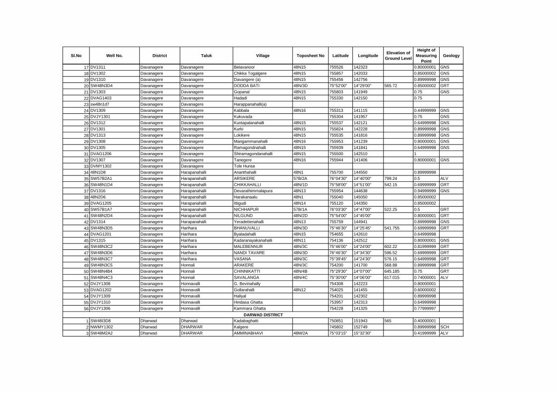
Sl.No Well No. District Taluk Village Toposheet No Latitude LongitudeElevation of
Ground Level
Height of
Measuring
Point
Geology
17 DV1311 Davanagere Davanagere Belavanoor 48N15 755526 142323 0.80000001 GNS
18 DV1302 Davanagere Davanagere Chikka Togalgere 48N15 755857 142033 0.85000002 GNS
19 DV1310 Davanagere Davanagere Davangere (a) 48N15 755456 142756 0.89999998 GNS
20 SW48N3D4 Davanagere Davanagere DODDA BATI 48N/3D 75°52'00" 14°29'00" 565.72 0.85000002 GRT
21 DV1303 Davanagere Davanagere Gopanal 48N15 755803 141949 0.75 GNS
22 DVAG1403 Davanagere Davanagere Hadadi 48N15 755330 142150 0.75
23 sw48n1d7 Davanagere Davanagere Harappanahalli(a)
24 DV1309 Davanagere Davanagere Kabbala 48N16 755313 141115 0.44999999 GNS
25 DVJY1301 Davanagere Davanagere Kukuvada 755304 141957 0.75 GNS
26 DV1312 Davanagere Davanagere Kuntapalanahalli 48N15 755537 142121 0.64999998 GNS
27 DV1301 Davanagere Davanagere Kurki 48N15 755824 142228 0.89999998 GNS
28 DV1313 Davanagere Davanagere Lokikere 48N15 755535 141816 0.89999998 GNS
29 DV1308 Davanagere Davanagere Mangammanahalli 48N16 755953 141239 0.80000001 GNS
30 DV1305 Davanagere Davanagere Ramagondnahalli 48N15 755939 141841 0.64999998 GNS
31 DVAG1206 Davanagere Davanagere Shiramagondanahalli 48N15 755500 142510 1
32 DV1307 Davanagere Davanagere Tanegere 48N16 755944 141406 0.80000001 GNS
33 DVMY1302 Davanagere Davanagere Tole Hunse
34 48N1D8 Davanagere Harapanahalli Ananthahalli 48N1 755700 144550 0.89999998
35 SW57B2A1 Davanagere Harapanahalli ARSIKERE 57B/2A 76°04'30" 14°40'00" 799.24 0.5 ALV
36 SW48N1D4 Davanagere Harapanahalli CHIKKAHALLI 48N/1D 75°58'00" 14°51'00" 542.15 0.69999999 GRT
37 DV1316 Davanagere Harapanahalli Devarathimmalapura 48N13 755954 144638 0.94999999 GNS
38 48N2D6 Davanagere Harapanahalli Harakanaalu 48N1 755040 145050 0.85000002
39 DVAG1205 Davanagere Harapanahalli Ittigudi 48N14 755120 144350 0.85000002
40 SW57B1A7 Davanagere Harapanahalli NICHHAPUR 57B/1A 76°03'30" 14°47'00" 522.25 0.5 GRT
41 SW48N2D4 Davanagere Harapanahalli NILGUND 48N/2D 75°54'00" 14°45'00" 0.80000001 GRT
42 DV1314 Davanagere Harapanahalli Yeradettenahalli 48N13 755759 144941 0.89999998 GNS
43 SW48N3D5 Davanagere Harihara BHANUVALLI 48N/3D 75°46'30" 14°25'45" 541.755 0.69999999 GRT
44 DVAG1201 Davanagere Harihara Byaladahalli 48N15 754655 142610 0.64999998
45 DV1315 Davanagere Harihara Kadaranayakanahalli 48N11 754136 142512 0.80000001 GNS
46 SW48N3C2 Davanagere Harihara MALEBENNUR 48N/3C 75°46'00" 14°24'00" 602.22 0.81999999 GRT
47 SW48N3D6 Davanagere Harihara NANDI TAVARE 48N/3D 76°46'30" 14°34'30" 596.52 0.69999999 GRT
48 SW48N3C7 Davanagere Harihara VASANA 48N/3C 75°39'45" 14°24'30" 576.15 0.64999998 GRT
49 SW48N3C5 Davanagere Honnali ARAKERE 48N/3C 754200 141700 568.88 0.89999998 GRT
50 SW48N4B4 Davanagere Honnali CHINNIKATTI 48N/4B 75°29'30" 14°07'00" 645.185 0.75 GRT
51 SW48N4C3 Davanagere Honnali SAVALANGA 48N/4C 75°30'00" 14°06'00" 617.015 0.74000001 ALV
52 DVJY1308 Davanagere Honnavalli G. Bevinahally 754308 142223 0.80000001
53 DVAG1202 Davanagere Honnavalli Gollarahalli 48N12 754025 141455 0.60000002
54 DVJY1309 Davanagere Honnavalli Haliyal 754201 142302 0.89999998
55 DVJY1310 Davanagere Honnavalli Hindasa Ghatta 753957 142313 0.64999998
56 DVJY1306 Davanagere Honnavalli Kammara Ghatta 754228 141325 0.77999997
1 SW48I3D8 Dharwad Dharwad Kadabaghatti 750851 151943 565 0.40000001
2 NWMY1302 Dharwad DHARWAR Kalgere 745802 152749 0.89999998 SCH
3 SW48M2A2 Dharwad DHARWAR AMMINABHAVI 48M/2A 75°03'15" 15°32'30" 0.41999999 ALV
DARWAD DISTRICT
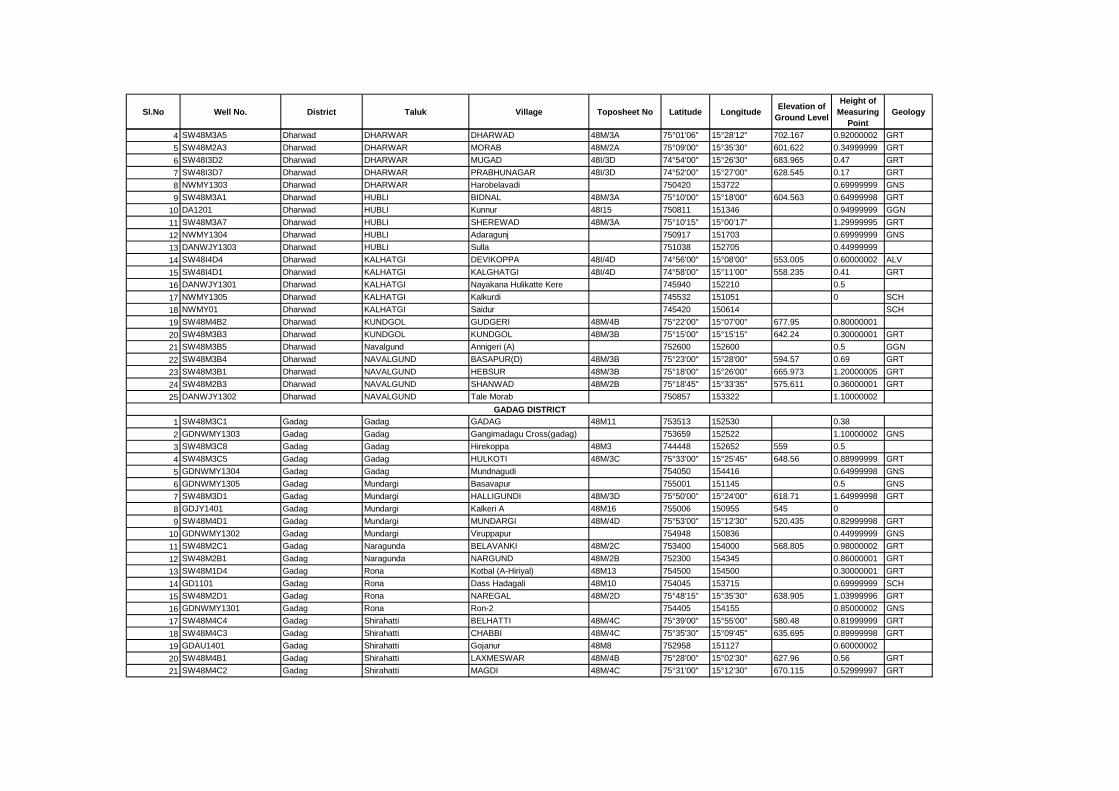
Sl.No Well No. District Taluk Village Toposheet No Latitude LongitudeElevation of
Ground Level
Height of
Measuring
Point
Geology
4 SW48M3A5 Dharwad DHARWAR DHARWAD 48M/3A 75°01'06" 15°28'12" 702.167 0.92000002 GRT
5 SW48M2A3 Dharwad DHARWAR MORAB 48M/2A 75°09'00" 15°35'30" 601.622 0.34999999 GRT
6 SW48I3D2 Dharwad DHARWAR MUGAD 48I/3D 74°54'00" 15°26'30" 683.965 0.47 GRT
7 SW48I3D7 Dharwad DHARWAR PRABHUNAGAR 48I/3D 74°52'00" 15°27'00" 628.545 0.17 GRT
8 NWMY1303 Dharwad DHARWAR Harobelavadi 750420 153722 0.69999999 GNS
9 SW48M3A1 Dharwad HUBLI BIDNAL 48M/3A 75°10'00" 15°18'00" 604.563 0.64999998 GRT
10 DA1201 Dharwad HUBLI Kunnur 48I15 750811 151346 0.94999999 GGN
11 SW48M3A7 Dharwad HUBLI SHEREWAD 48M/3A 75°10'15" 15°00'17" 1.29999995 GRT
12 NWMY1304 Dharwad HUBLI Adaragunj 750917 151703 0.69999999 GNS
13 DANWJY1303 Dharwad HUBLI Sulla 751038 152705 0.44999999
14 SW48I4D4 Dharwad KALHATGI DEVIKOPPA 48I/4D 74°56'00" 15°08'00" 553.005 0.60000002 ALV
15 SW48I4D1 Dharwad KALHATGI KALGHATGI 48I/4D 74°58'00" 15°11'00" 558.235 0.41 GRT
16 DANWJY1301 Dharwad KALHATGI Nayakana Hulikatte Kere 745940 152210 0.5
17 NWMY1305 Dharwad KALHATGI Kalkurdi 745532 151051 0 SCH
18 NWMY01 Dharwad KALHATGI Saidur 745420 150614 SCH
19 SW48M4B2 Dharwad KUNDGOL GUDGERI 48M/4B 75°22'00" 15°07'00" 677.95 0.80000001
20 SW48M3B3 Dharwad KUNDGOL KUNDGOL 48M/3B 75°15'00" 15°15'15" 642.24 0.30000001 GRT
21 SW48M3B5 Dharwad Navalgund Annigeri (A) 752600 152600 0.5 GGN
22 SW48M3B4 Dharwad NAVALGUND BASAPUR(D) 48M/3B 75°23'00" 15°28'00" 594.57 0.69 GRT
23 SW48M3B1 Dharwad NAVALGUND HEBSUR 48M/3B 75°18'00" 15°26'00" 665.973 1.20000005 GRT
24 SW48M2B3 Dharwad NAVALGUND SHANWAD 48M/2B 75°18'45" 15°33'35" 575.611 0.36000001 GRT
25 DANWJY1302 Dharwad NAVALGUND Tale Morab 750857 153322 1.10000002
1 SW48M3C1 Gadag Gadag GADAG 48M11 753513 152530 0.38
2 GDNWMY1303 Gadag Gadag Gangimadagu Cross(gadag) 753659 152522 1.10000002 GNS
3 SW48M3C8 Gadag Gadag Hirekoppa 48M3 744448 152652 559 0.5
4 SW48M3C5 Gadag Gadag HULKOTI 48M/3C 75°33'00" 15°25'45" 648.56 0.88999999 GRT
5 GDNWMY1304 Gadag Gadag Mundnagudi 754050 154416 0.64999998 GNS
6 GDNWMY1305 Gadag Mundargi Basavapur 755001 151145 0.5 GNS
7 SW48M3D1 Gadag Mundargi HALLIGUNDI 48M/3D 75°50'00" 15°24'00" 618.71 1.64999998 GRT
8 GDJY1401 Gadag Mundargi Kalkeri A 48M16 755006 150955 545 0
9 SW48M4D1 Gadag Mundargi MUNDARGI 48M/4D 75°53'00" 15°12'30" 520.435 0.82999998 GRT
10 GDNWMY1302 Gadag Mundargi Viruppapur 754948 150836 0.44999999 GNS
11 SW48M2C1 Gadag Naragunda BELAVANKI 48M/2C 753400 154000 568.805 0.98000002 GRT
12 SW48M2B1 Gadag Naragunda NARGUND 48M/2B 752300 154345 0.86000001 GRT
13 SW48M1D4 Gadag Rona Kotbal (A-Hiriyal) 48M13 754500 154500 0.30000001 GRT
14 GD1101 Gadag Rona Dass Hadagali 48M10 754045 153715 0.69999999 SCH
15 SW48M2D1 Gadag Rona NAREGAL 48M/2D 75°48'15" 15°35'30" 638.905 1.03999996 GRT
16 GDNWMY1301 Gadag Rona Ron-2 754405 154155 0.85000002 GNS
17 SW48M4C4 Gadag Shirahatti BELHATTI 48M/4C 75°39'00" 15°55'00" 580.48 0.81999999 GRT
18 SW48M4C3 Gadag Shirahatti CHABBI 48M/4C 75°35'30" 15°09'45" 635.695 0.89999998 GRT
19 GDAU1401 Gadag Shirahatti Gojanur 48M8 752958 151127 0.60000002
20 SW48M4B1 Gadag Shirahatti LAXMESWAR 48M/4B 75°28'00" 15°02'30" 627.96 0.56 GRT
21 SW48M4C2 Gadag Shirahatti MAGDI 48M/4C 75°31'00" 15°12'30" 670.115 0.52999997 GRT
GADAG DISTRICT
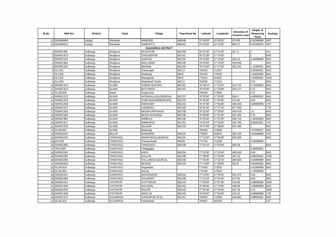
Sl.No Well No. District Taluk Village Toposheet No Latitude LongitudeElevation of
Ground Level
Height of
Measuring
Point
Geology
22 SW48M4B4 Gadag Shirahatti RAMGERI 48M/4B 75°26'03" 15°08'22" 679.89 0.82999998 GRT
23 SW48M4C1 Gadag Shirahatti SHIRHATTI 48M/4C 75°34'30" 15°13'45" 683.27 0.91000003 GRT
1 SW56C4B1 Gulbarga Afzalpura AFZALPUR 56C/4B 76°21'30" 17°12'00" 417.4 1 ALV
2 SW56C4C4 Gulbarga Afzalpura CHOUDEPUR 56C/4C 76°32'30" 17°14'30" 1 BAS
3 SW56C3A3 Gulbarga Afzalpura KARAJGI 56C/3A 76°13'00" 17°16'00" 452.31 0.44999999 BAS
4 SW56C4B4 Gulbarga Afzalpura MALLABAD 56C/4B 76°25'00" 17°14'00" 419.845 1 BAS
5 SW56C3A2 Gulbarga Afzalpura MASHAL 56C/3A 76°14'30" 17°17'30" 451.261 1.11000001 BAS
6 GL1201 Gulbarga Afzalpura Chinamgeri 56C12 763423 171257 0.30000001 BAS
7 GL1202 Gulbarga Afzalpura Ghattargi 56C8 762433 170536 1.20000005 BAS
8 GL1301 Gulbarga Afzalpura Managanal 56H2 770214 164301 0.40000001 GGN
9 GL1203 Gulbarga Afzalpura Waddahali Tanda 56C11 763526 171515 0.75 BAS
10 SW56C3C4 Gulbarga ALAND GOBUR BUZURG 56C/3C 76°38'10" 17°15'30" 414.725 0.72000003 BAS
11 SW56C3C3 Gulbarga ALAND BATTARGA 56C/3C 76°33'45" 17°23'00" 434.177 0.75 BAS
12 GLJN1302 Gulbarga Aland Darga-sirur 764440 173826 0.37 BAS
13 SW56C2C2 Gulbarga ALAND HOSAHALLI(GULBURGA) 56C/2C 76°35'00" 17°35'00" 544.3 0.80000001 BAS
14 SW56C2D4 Gulbarga ALAND KAMLANAGAR(BODHAN) 56C/2D 76°45'30" 17°34'30" 473.92 0.69 BAS
15 SW56C2D8 Gulbarga ALAND KARAHARI 56C/2D 76°47'00" 17°36'30" 496.465 0.88999999 LTR
16 SW56C2D7 Gulbarga ALAND LADMOGLI 56C/2D 76°52'30" 17°37'15" 477.553 1 LTR
17 SW56C3B3 Gulbarga ALAND MADAN HIPPARGA 56C/3B 76°23'00" 17°28'00" 455.618 1.5 BAS
18 SW56C2B2 Gulbarga ALAND MOGA BUZURGA 56C/2B 76°28'00" 17°31'00" 527.403 0.75 BAS
19 SW56C3B4 Gulbarga ALAND NIMBALA 56C/3B 76°23'30" 17°21'00" 558.725 1.45000005 BAS
20 SW56C3C7 Gulbarga ALAND NIMBARGA 56C/3C 76°34'45" 17°23'00" 442.795 0.80000001 LTR
21 SW56C2D3 Gulbarga ALAND SALGAR 56C/2D 76°47'00" 17°38'00" 541.465 1 BAS
22 GLJN1301 Gulbarga ALAND Belamagi 764440 173826 4.57000017 BAS
23 SW56H2A4 Gulbarga BELUR WADGERA 56H/2A 770600 163515 381.535 0.64999998 GRT
24 SW56G2A3 Gulbarga CHINCHOLI AINAPUR(GULBURGA) 56G/2A 77°13'30" 17°36'30" 556.585 1 BAS
25 MY1403 Gulbarga CHINCHOLI Chimanchode 56G06 771734 173100 0.63999999
26 SW56G3B1 Gulbarga CHINCHOLI CHINCHOLI 56G/3B 77°25'15" 17°25'00" 465.58 1 BAS
27 YMY1505 Gulbarga CHINCHOLI Chitaguppa 0.40000001
28 SW56G3A2 Gulbarga CHINCHOLI KADLI 56G/3A 77°12'30" 17°22'40" 485.625 0.69 BAS
29 SW56G3B2 Gulbarga CHINCHOLI KALLUR 56G/3B 77°28'00" 17°23'00" 457.42 0.80000001 SDM
30 SW56G2B4 Gulbarga CHINCHOLI KOLLUR(GULBURGA) 56G/2B 77°26'05" 17°32'10" 389.835 0.56999999 BAS
31 SW56G3A3 Gulbarga CHINCHOLI MOGHE 56G/3A 77°14'00" 17°29'00" 542.8 0.60000002 BAS
32 GLJN1303 Gulbarga CHINCHOLI Nagaidalai 772439 173252 0.41999999 BAS
33 GLJN1304 Gulbarga CHINCHOLI Narnal 771538 173022 1.70000005
34 SW56G3A1 Gulbarga CHINCHOLI SASARGAON 56G/3A 77°13'00" 17°29'45" 551.375 0.56 BAS
35 SW56G3B4 Gulbarga CHINCHOLI SULAHPET 56G/3B 77°21'20" 17°23'45" 477.65 0.69 BAS
36 SW56G4A1 Gulbarga CHITAPUR CHITTAPUR 56G/4A 77°05'00" 17°07'30" 415.68 0.89999998 SDM
37 SW56C4D6 Gulbarga CHITAPUR HALDIHAL 56C/4D 76°58'00" 17°13'30" 438.08 0.69999999 BAS
38 SW56G4A5 Gulbarga CHITAPUR RAVUR 56G/4A 77°00'30" 17°04'30" 407.16 0.75 SDM
39 SW56C4D8 Gulbarga CHITAPUR WADI.JN 56C/4D 76°59'30" 17°03'45" 419.19 0.69999999 LTR
40 SW56C3C1 Gulbarga GULBARGA GANGAPUR (R.S) 56C/3C 763520 172030 440.863 0.68000001 BAS
41 GLJN1310 Gulbarga GULBARGA Farhatabad 764952 164226 LST
GULBARGA DISTRICT
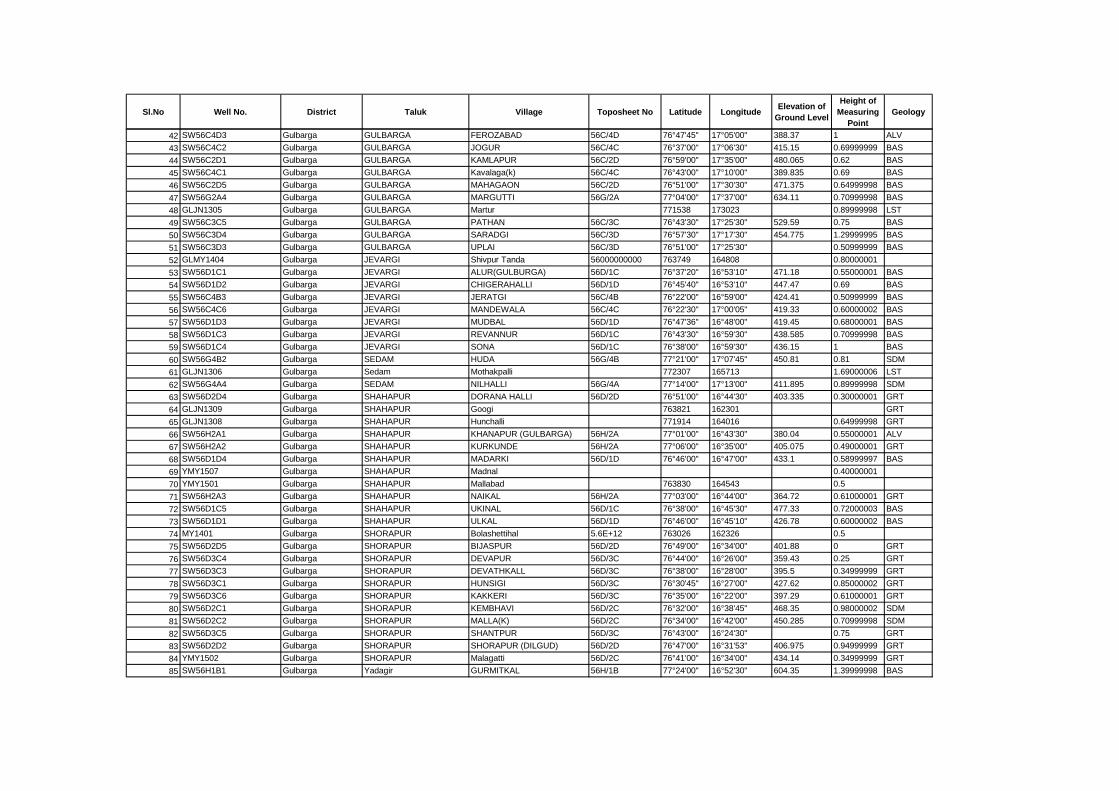
Sl.No Well No. District Taluk Village Toposheet No Latitude LongitudeElevation of
Ground Level
Height of
Measuring
Point
Geology
42 SW56C4D3 Gulbarga GULBARGA FEROZABAD 56C/4D 76°47'45" 17°05'00" 388.37 1 ALV
43 SW56C4C2 Gulbarga GULBARGA JOGUR 56C/4C 76°37'00" 17°06'30" 415.15 0.69999999 BAS
44 SW56C2D1 Gulbarga GULBARGA KAMLAPUR 56C/2D 76°59'00" 17°35'00" 480.065 0.62 BAS
45 SW56C4C1 Gulbarga GULBARGA Kavalaga(k) 56C/4C 76°43'00" 17°10'00" 389.835 0.69 BAS
46 SW56C2D5 Gulbarga GULBARGA MAHAGAON 56C/2D 76°51'00" 17°30'30" 471.375 0.64999998 BAS
47 SW56G2A4 Gulbarga GULBARGA MARGUTTI 56G/2A 77°04'00" 17°37'00" 634.11 0.70999998 BAS
48 GLJN1305 Gulbarga GULBARGA Martur 771538 173023 0.89999998 LST
49 SW56C3C5 Gulbarga GULBARGA PATHAN 56C/3C 76°43'30" 17°25'30" 529.59 0.75 BAS
50 SW56C3D4 Gulbarga GULBARGA SARADGI 56C/3D 76°57'30" 17°17'30" 454.775 1.29999995 BAS
51 SW56C3D3 Gulbarga GULBARGA UPLAI 56C/3D 76°51'00" 17°25'30" 0.50999999 BAS
52 GLMY1404 Gulbarga JEVARGI Shivpur Tanda 56000000000 763749 164808 0.80000001
53 SW56D1C1 Gulbarga JEVARGI ALUR(GULBURGA) 56D/1C 76°37'20" 16°53'10" 471.18 0.55000001 BAS
54 SW56D1D2 Gulbarga JEVARGI CHIGERAHALLI 56D/1D 76°45'40" 16°53'10" 447.47 0.69 BAS
55 SW56C4B3 Gulbarga JEVARGI JERATGI 56C/4B 76°22'00" 16°59'00" 424.41 0.50999999 BAS
56 SW56C4C6 Gulbarga JEVARGI MANDEWALA 56C/4C 76°22'30" 17°00'05" 419.33 0.60000002 BAS
57 SW56D1D3 Gulbarga JEVARGI MUDBAL 56D/1D 76°47'36" 16°48'00" 419.45 0.68000001 BAS
58 SW56D1C3 Gulbarga JEVARGI REVANNUR 56D/1C 76°43'30" 16°59'30" 438.585 0.70999998 BAS
59 SW56D1C4 Gulbarga JEVARGI SONA 56D/1C 76°38'00" 16°59'30" 436.15 1 BAS
60 SW56G4B2 Gulbarga SEDAM HUDA 56G/4B 77°21'00" 17°07'45" 450.81 0.81 SDM
61 GLJN1306 Gulbarga Sedam Mothakpalli 772307 165713 1.69000006 LST
62 SW56G4A4 Gulbarga SEDAM NILHALLI 56G/4A 77°14'00" 17°13'00" 411.895 0.89999998 SDM
63 SW56D2D4 Gulbarga SHAHAPUR DORANA HALLI 56D/2D 76°51'00" 16°44'30" 403.335 0.30000001 GRT
64 GLJN1309 Gulbarga SHAHAPUR Googi 763821 162301 GRT
65 GLJN1308 Gulbarga SHAHAPUR Hunchalli 771914 164016 0.64999998 GRT
66 SW56H2A1 Gulbarga SHAHAPUR KHANAPUR (GULBARGA) 56H/2A 77°01'00" 16°43'30" 380.04 0.55000001 ALV
67 SW56H2A2 Gulbarga SHAHAPUR KURKUNDE 56H/2A 77°06'00" 16°35'00" 405.075 0.49000001 GRT
68 SW56D1D4 Gulbarga SHAHAPUR MADARKI 56D/1D 76°46'00" 16°47'00" 433.1 0.58999997 BAS
69 YMY1507 Gulbarga SHAHAPUR Madnal 0.40000001
70 YMY1501 Gulbarga SHAHAPUR Mallabad 763830 164543 0.5
71 SW56H2A3 Gulbarga SHAHAPUR NAIKAL 56H/2A 77°03'00" 16°44'00" 364.72 0.61000001 GRT
72 SW56D1C5 Gulbarga SHAHAPUR UKINAL 56D/1C 76°38'00" 16°45'30" 477.33 0.72000003 BAS
73 SW56D1D1 Gulbarga SHAHAPUR ULKAL 56D/1D 76°46'00" 16°45'10" 426.78 0.60000002 BAS
74 MY1401 Gulbarga SHORAPUR Bolashettihal 5.6E+12 763026 162326 0.5
75 SW56D2D5 Gulbarga SHORAPUR BIJASPUR 56D/2D 76°49'00" 16°34'00" 401.88 0 GRT
76 SW56D3C4 Gulbarga SHORAPUR DEVAPUR 56D/3C 76°44'00" 16°26'00" 359.43 0.25 GRT
77 SW56D3C3 Gulbarga SHORAPUR DEVATHKALL 56D/3C 76°38'00" 16°28'00" 395.5 0.34999999 GRT
78 SW56D3C1 Gulbarga SHORAPUR HUNSIGI 56D/3C 76°30'45" 16°27'00" 427.62 0.85000002 GRT
79 SW56D3C6 Gulbarga SHORAPUR KAKKERI 56D/3C 76°35'00" 16°22'00" 397.29 0.61000001 GRT
80 SW56D2C1 Gulbarga SHORAPUR KEMBHAVI 56D/2C 76°32'00" 16°38'45" 468.35 0.98000002 SDM
81 SW56D2C2 Gulbarga SHORAPUR MALLA(K) 56D/2C 76°34'00" 16°42'00" 450.285 0.70999998 SDM
82 SW56D3C5 Gulbarga SHORAPUR SHANTPUR 56D/3C 76°43'00" 16°24'30" 0.75 GRT
83 SW56D2D2 Gulbarga SHORAPUR SHORAPUR (DILGUD) 56D/2D 76°47'00" 16°31'53" 406.975 0.94999999 GRT
84 YMY1502 Gulbarga SHORAPUR Malagatti 56D/2C 76°41'00" 16°34'00" 434.14 0.34999999 GRT
85 SW56H1B1 Gulbarga Yadagir GURMITKAL 56H/1B 77°24'00" 16°52'30" 604.35 1.39999998 BAS

Sl.No Well No. District Taluk Village Toposheet No Latitude LongitudeElevation of
Ground Level
Height of
Measuring
Point
Geology
86 GLJN1307 Gulbarga Yadagir Kalebelagundhi 771914 164016 0
87 SW56H1A3 Gulbarga Yadagir MUNDARGI 56H/1A 77°13'00" 16°46'00" 0.69999999 GRT
88 SW56H2B1 Gulbarga Yadagir SAIDAPUR 56H/2B 76°16'00" 16°33'20" 382.41 1 GRT

Sl.No Well No. District Taluk Village Toposheet No Latitude LongitudeElevation of
Ground Level
Height of
Measuring
Point
Geology
1 SW48P1D3 Hassan ALUR ALUR 48P/1D 75°59'00" 12°58'00" 964.795 1 GRT
2 HSNWMY1303 Hassan ALUR Harihalli 48P13 755121 125027
3 SW48P1D4 Hassan ALUR HOSAPALYA 48P/1D 75°57'00" 12°56'00" 955.615 0.79000002 GRT
4 SW48O4D7 Hassan ALUR KANATHUR 48O/4D 77°50'00" 13°02'00" 942.225 1.10000002 GRT
5 SW48P1D7 Hassan ALUR KENCHAMMANA HOSKOTE 48P/1D 75°51'30" 12°51'30" 796.12 1.20000005 GRT
6 HA1203 Hassan ALUR Lakkamanahalli 48O16 755345 130140 1019 0.80000001 GRT
7 HAMY1501 Hassan Arasikere Agunda Thandya(sidrahalli 761818 131938 0.81999999 GGN
8 HAMY1503 Hassan Arasikere Ahmedpur 761635 132932 0.80000001 GGN
9 HA1403 Hassan Arasikere G N Koppalu 57C8 762847 130115 0.75 GNS
10 HA1201 Hassan Arasikere Jayachamrajpura 57C7 762102 132459 0.80000001 GGN
11 HA1208 Hassan Arasikere Mududi 57C4 761116 131132 895 1 GGN
12 HAMY1502 Hassan Arasikere Yachgondanahally 762041 132932 0.88 GNS
13 HSNWJY1309 Hassan Arkalagudu Balaihana Koppalu 760253 124605 0.80000001
14 HA1404 Hassan Arkalagudu Bidurmalai Koppalu 570 760220 124605 0.94 GGN
15 HSNWJY1306 Hassan Arkalagudu Budaluru 761103 123603 0.80000001
16 HSNWJY1311 Hassan Arkalagudu Hethkondanahalli 760844 124619 0.85000002
17 HSNV1302 Hassan Arkalagudu Hulikal 5700 760235 124154 0.80000001
18 HSJY1502 Hassan Arkalagudu Kaniyar 760352 124158 0.69999999 GGN
19 HSNWJY1307 Hassan Arkalagudu Keralapura 761027 123454 0.69999999
20 HA1405 Hassan Arkalagudu Matchegowdanahalli 570 760409 124513 0.69999999 GNS
21 HSNV1303 Hassan Arkalagudu Mula Hosahalli 5700 760635 123646 0.80000001
22 HSNWJY1308 Hassan Arkalagudu Ramanathapura 760516 123638 0.55000001
23 HSNWJY1310 Hassan Arkalagudu Shirdhanahalli 755808 124520 0.60000002
24 HSNV1301 Hassan Arkalagudu Vijapura First Colony 760040 124602 0.80000001
25 SW57D1A1 Hassan ARKALGUD ARKALGUD 57D/1A 76°03'30" 12°46'30" 904.465 0.74000001 GRT
26 SW57D2A3 Hassan ARKALGUD BASAVAPATNA 57D/2A 76°07'15" 12°36'45" 821.843 0.92000002 GRT
27 SW57D2A1 Hassan ARKALGUD KONANUR 57D/2A 76°05'00" 13°37'00" 832.17 0.93000001 GRT
28 SW57D2A4 Hassan ARKALGUD NILAVAGILU 57D/2A 76°05'30" 12°40'30" 859.56 0.77999997 GRT
29 SW57D1A3 Hassan ARKALGUD VADRAHALLI 57D/1A 76°03'40" 12°48'20" 876.322 0.97000003 GRT
30 HSNWMY1304 Hassan ARKALGUD Kunigal 48P13 754600 125249 0.60000002
31 SW57C3B7 Hassan ARSIKERE ARASIKERE 57C/3B 76°17'00" 13°17'00" 799.24 0.75 GRT
32 SW57C4A3 Hassan ARSIKERE HARNAHALLI 57C/4A 76°14'00" 13°14'30" 865.05 0.69999999 GRT
33 SW57C2B2 Hassan ARSIKERE KANAKATTE 57C/2B 76°17'00" 13°31'00" 733.085 0.91000003 GRT
34 HSNWMY1302(A1) Hassan ARSIKERE Gopalapura 48P13 755130 124852 0.80000001
35 HSJY1503 Hassan Belur Agadalu 754636 131131 0.89999998
36 HAMY1504 Hassan Belur Ankihalli 755141 130137 0.88 GGN
37 HA1210 Hassan Belur Arehalli 48O10 754841 130313 0.89999998 GGN
38 SW48O4D2 Hassan Belur BELUR 48O/4D 75°53'00" 13°10'00" 983.4 0.83999997 GRT
39 HNNV1402 Hassan Belur Biccodu 755149 130440 0.75 GGN
40 HA1207 Hassan Belur Hagare 48O16 755810 130811 0.89999998 GGN
41 SW48O4D1 Hassan Belur HALEBEEDU 48O/4D 75°59'00" 13°13'00" 809.87 0.75999999 GRT
42 SW4804D4 Hassan Belur SINGAPURAPET 480/4D 75°47'15" 13°11'20" 971.335 0.86000001 GRT
43 SW57C4B4 Hassan CHANNARAYAPATNA BARGUR 57C/4B 762230 130130 863 0.83999997 GRT
HASSAN DISTRICT
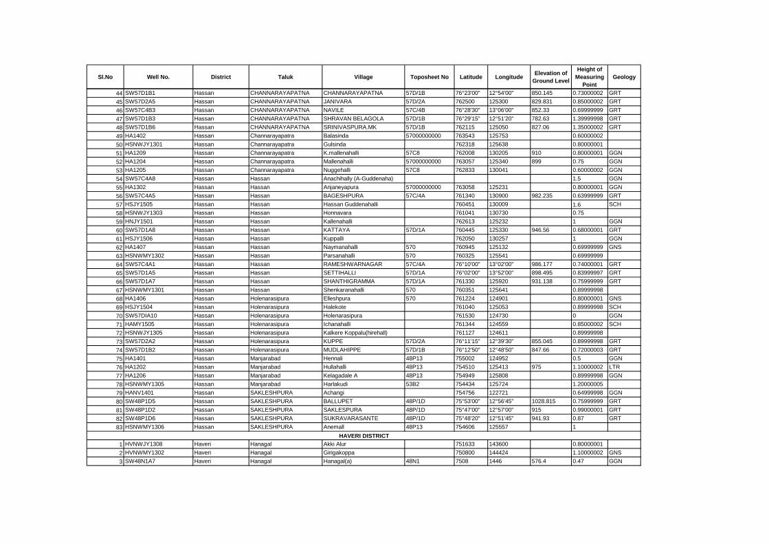
Sl.No Well No. District Taluk Village Toposheet No Latitude LongitudeElevation of
Ground Level
Height of
Measuring
Point
Geology
44 SW57D1B1 Hassan CHANNARAYAPATNA CHANNARAYAPATNA 57D/1B 76°23'00" 12°54'00" 850.145 0.73000002 GRT
45 SW57D2A5 Hassan CHANNARAYAPATNA JANIVARA 57D/2A 762500 125300 829.831 0.85000002 GRT
46 SW57C4B3 Hassan CHANNARAYAPATNA NAVILE 57C/4B 76°28'30" 13°06'00" 852.33 0.69999999 GRT
47 SW57D1B3 Hassan CHANNARAYAPATNA SHRAVAN BELAGOLA 57D/1B 76°29'15" 12°51'20" 782.63 1.39999998 GRT
48 SW57D1B6 Hassan CHANNARAYAPATNA SRINIVASPURA.MK 57D/1B 762115 125050 827.06 1.35000002 GRT
49 HA1402 Hassan Channarayapatra Balasinda 57000000000 763543 125753 0.60000002
50 HSNWJY1301 Hassan Channarayapatra Gulsinda 762318 125638 0.80000001
51 HA1209 Hassan Channarayapatra K.mallenahalli 57C8 762008 130205 910 0.80000001 GGN
52 HA1204 Hassan Channarayapatra Mallenahalli 57000000000 763057 125340 899 0.75 GGN
53 HA1205 Hassan Channarayapatra Nuggehalli 57C8 762833 130041 0.60000002 GGN
54 SW57C4A8 Hassan Hassan Anachihally (A-Guddenaha) 1.5 GGN
55 HA1302 Hassan Hassan Anjaneyapura 57000000000 763058 125231 0.80000001 GGN
56 SW57C4A5 Hassan Hassan BAGESHPURA 57C/4A 761340 130900 982.235 0.63999999 GRT
57 HSJY1505 Hassan Hassan Hassan Guddenahalli 760451 130009 1.6 SCH
58 HSNWJY1303 Hassan Hassan Honnavara 761041 130730 0.75
59 HNJY1501 Hassan Hassan Kallenahalli 762613 125232 1 GGN
60 SW57D1A8 Hassan Hassan KATTAYA 57D/1A 760445 125330 946.56 0.68000001 GRT
61 HSJY1506 Hassan Hassan Kuppalli 762050 130257 1 GGN
62 HA1407 Hassan Hassan Naymanahalli 570 760945 125132 0.69999999 GNS
63 HSNWMY1302 Hassan Hassan Parsanahalli 570 760325 125541 0.69999999
64 SW57C4A1 Hassan Hassan RAMESHWARNAGAR 57C/4A 76°10'00" 13°02'00" 986.177 0.74000001 GRT
65 SW57D1A5 Hassan Hassan SETTIHALLI 57D/1A 76°02'00" 13°52'00" 898.495 0.83999997 GRT
66 SW57D1A7 Hassan Hassan SHANTHIGRAMMA 57D/1A 761330 125920 931.138 0.75999999 GRT
67 HSNWMY1301 Hassan Hassan Shenkaranahalli 570 760351 125641 0.89999998
68 HA1406 Hassan Holenarasipura Elleshpura 570 761224 124901 0.80000001 GNS
69 HSJY1504 Hassan Holenarasipura Halekote 761040 125053 0.89999998 SCH
70 SW57DIA10 Hassan Holenarasipura Holenarasipura 761530 124730 0 GGN
71 HAMY1505 Hassan Holenarasipura Ichanahalli 761344 124559 0.85000002 SCH
72 HSNWJY1305 Hassan Holenarasipura Kalkere Koppalu(hirehall) 761127 124611 0.89999998
73 SW57D2A2 Hassan Holenarasipura KUPPE 57D/2A 76°11'15" 12°39'30" 855.045 0.89999998 GRT
74 SW57D1B2 Hassan Holenarasipura MUDLAHIPPE 57D/1B 76°12'50" 12°48'50" 847.66 0.72000003 GRT
75 HA1401 Hassan Manjarabad Hennali 48P13 755002 124952 0.5 GGN
76 HA1202 Hassan Manjarabad Hullahalli 48P13 754510 125413 975 1.10000002 LTR
77 HA1206 Hassan Manjarabad Kelagadale A 48P13 754949 125808 0.89999998 GGN
78 HSNWMY1305 Hassan Manjarabad Harlakudi 53B2 754434 125724 1.20000005
79 HANV1401 Hassan SAKLESHPURA Achangi 754756 122721 0.64999998 GGN
80 SW48P1D5 Hassan SAKLESHPURA BALLUPET 48P/1D 75°53'00" 12°56'45" 1028.815 0.75999999 GRT
81 SW48P1D2 Hassan SAKLESHPURA SAKLESPURA 48P/1D 75°47'00" 12°57'00" 915 0.99000001 GRT
82 SW48P1D6 Hassan SAKLESHPURA SUKRAVARASANTE 48P/1D 75°48'20" 12°51'45" 941.93 0.87 GRT
83 HSNWMY1306 Hassan SAKLESHPURA Anemall 48P13 754606 125557 1
1 HVNWJY1308 Haveri Hanagal Akki Alur 751633 143600 0.80000001
2 HVNWMY1302 Haveri Hanagal Girigakoppa 750800 144424 1.10000002 GNS
3 SW48N1A7 Haveri Hanagal Hanagal(a) 48N1 7508 1446 576.4 0.47 GGN
HAVERI DISTRICT
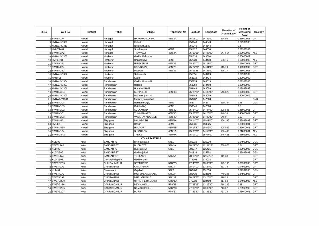
Sl.No Well No. District Taluk Village Toposheet No Latitude LongitudeElevation of
Ground Level
Height of
Measuring
Point
Geology
4 SW48N2A4 Haveri Hanagal HANUMANKOPPA 48N/2A 75°06'00" 14°42'00" 574.96 0.36000001 GRT
5 HVNWJY1309 Haveri Hanagal Kalkatti 750940 144343 0.64999998
6 HVNWJY1310 Haveri Hanagal Nitiginal Koppa 750940 144343 0.5
7 HVMY1401 Haveri Hanagal Shadukupee 48N2 751122 144030 0.69999999
8 SW48N2A2 Haveri Hanagal TILAVALLI 48N/2A 75°13'15" 14°38'00" 547.664 1.20000005 ALV
9 HVNWJY1303 Haveri Hirekerur Gudde Mallapura 751633 143600 0.60000002
10 HV198701 Haveri Hirekerur Hansabhavi 48N2 752230 143430 628.16 0.67000002 ALV
11 SW48N3B1 Haveri Hirekerur HIREKERUR 48N/3B 75°25'00" 14°27'00" 0.68000001 GRT
12 SW48N2B4 Haveri Hirekerur KOD(SG PZ) 48N/2B 75°27'30" 14°31'00" 615.74 0.94999999 GRT
13 SW48N3B2 Haveri Hirekerur MASUR 48N/3B 75°27'45" 14°23'00" 576.17 0.61000001 GRT
14 HVNWJY1302 Haveri Hirekerur Satenahalli 751851 143423 0.69999999
15 HANV15 Haveri Hirekerur Kadur 753315 142434 0.60000002
16 HVNWJY1304 Haveri Ranebennur Gudde Hosahalli 752924 143619 0.89999998
17 HVNWJY1307 Haveri Ranebennur Halgeri 752959 143403 0.89999998
18 HVNWJY1306 Haveri Ranebennur Hosa Huli Halli 754449 143059 0.69999999
19 SW48N3C4 Haveri Ranebennur KUPPELUR 48N/3C 75°39'30" 14°30'30" 548.825 0.92000002 GRT
20 HVNWJY1305 Haveri Ranebennur Makanur (hosur) 754449 143059 1.20000005
21 HVNWMY1301 Haveri Ranebennur Mallanayakenahalli 753732 142008 GNS
22 SW48N2C4 Haveri Ranebennur Ranebennur(a) 48N2 7537 1437 580.364 1.25 GGN
23 SW48N1C5 Haveri Ranebennur Rattihalli(a) 48N3 753045 142000 0.5
24 SW48N2C2 Haveri Ranebennur SULKANBIDRI 48N/2C 75°34'00" 14°34'00" 608.886 0.46000001 GRT
25 SW48N3C1 Haveri Ranebennur TUMMINKATTI 48N/3C 75°36'30" 14°25'00" 548.36 0.40000001 GRT
26 SW48N2D3 Haveri Ranebennur VADARAYANAHALLI 48N/2D 75°45'15" 14°33'30" 545.9 0.63 GRT
27 SW48M4A1 Haveri Shiggaon DHUNDASHI 48M/4A 75°14'00" 15°01'00" 666.196 0.89999998 GRT
28 HV1401 Haveri Shiggaon Hosur 48M4 750831 150025 0.30000001 GRT
29 SW48M4B5 Haveri Shiggaon HULGUR 48M/4B 75°17'30" 15°05'00" 608.565 0.86000001 GRT
30 SW48N1A4 Haveri Shiggaon SHIGGAON 48N/1A 75°30'30" 14°59'30" 596.409 0.61000001 ALV
31 SW48M4A2 Haveri Shiggaon TADAS 48M/4A 75°07'00" 15°07'00" 646.421 0.56999999 ALV
1 KL1302 Kolar BANGARPET Bhimganapalli 57L1 781010 125030 0.94999999 GGN
2 SW57L1A2 Kolar BANGARPET BUDIKOTE 57L/1A 78°07'54" 12°54'19" 788.075 0.34 GRT
3 KL1406 Kolar BANGARPET Budikunte A 57L1 780747 125421 1.29999995 GGN
4 KLJY1307 Kolar BANGARPET Gadarajahalli 781834 125752 0.89999998 GGN
5 SW57L1A6 Kolar BANGARPET TORLAKKI 57L/1A 78°09'05" 12°55'15" 819.39 1 GRT
6 KLJY1305 Kolar Chickkaballapura Gudibonde-ii 774103 134034 0 GRT
7 SW57G2D5 Kolar CHIKBALLAPUR SETTIGERE 57G/2D 77°45'30" 13°33'00" 945.185 0.89999998 GRT
8 SW57K3A1 Kolar CHINTAMANI CHINTAMANI 57K/3A 78°04'00" 13°24'00" 883.78 0.94999999 GRT
9 KL1401 Kolar Chintamani Gajahalli 57K3 780400 131853 0.89999998 GGN
10 SW57K2A3 Kolar CHINTAMANI MOTEMEKALAHALLI 57K/2A 780430 133600 740.205 0.64999998 GRT
11 SW57K3A2 Kolar CHINTAMANI MURUGUMALE 57K/3A 78°07'35" 13°26'00" 876.23 1 GRT
12 SW57G3D9 Kolar CHINTAMANI UPPARPET(KOLAR) 57G/3D 775930 132400 917.58 1.04999995 ALV
13 SW57G3B6 Kolar GAURIBIDANUR BEVINAHALLI 57G/3B 77°28'15" 13°29'30" 718.285 0.28 GRT
14 SW57G2C6 Kolar GAURIBIDANUR NAMAGONDLU 57G/2C 77°36'30" 13°35'00" 743.07 1.29999995 GRT
15 SW57G2C7 Kolar GAURIBIDANUR PURA 57G/2C 77°36'20" 13°32'20" 763.23 0.93000001 GRT
KOLAR DISTRICT
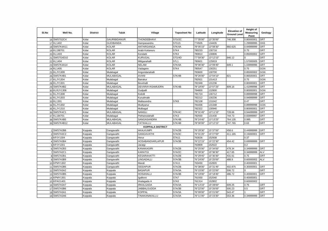
Sl.No Well No. District Taluk Village Toposheet No Latitude LongitudeElevation of
Ground Level
Height of
Measuring
Point
Geology
16 SW57G2C4 Kolar GAURIBIDANUR THONDEBHAVI 57G/2C 77°35'00" 13°35'00" 746.308 0.80000001 GRT
17 KL1402 Kolar GUDIBANDA Hampasandra 57G15 774505 134435 1.29999995 GNS
18 SW57K4A11 Kolar KOLAR ANTARGANGA 57K/4A 78°05'15" 13°08'30" 860.625 0.94999999 GRT
19 KL198701 Kolar KOLAR Arabi Kottanuru 57K4 780233 130716 0.75 GRT
20 KL1403 Kolar KOLAR Kendatti 57K4 780810 130806 0.85000002 GRT
21 SW57G4D10 Kolar KOLAR KURUGAL 57G/4D 77°59'30" 13°12'15" 846.12 0 GRT
22 KL1404 Kolar KOLAR Mitiganahalli 57L1 780601 125919 1.57000005 GRT
23 SW57K4A14 Kolar KOLAR NELAM 57K/4A 78°06'30" 13°09'45" 849.1 1.03999996 GRT
24 KL1405 Kolar KOLAR Vadagere 57K4 780547 130251 0.75 GGN
25 KLJY1309 Kolar Mulabagal Angondanahalli 783600 130700 0.85000002 GGN
26 SW57K4B1 Kolar MULABAGAL AVANI 57K/4B 78°26'00" 13°04'10" 821 0.86500001 GRT
27 KLJY1304 Kolar Mulabagal Bairakur 782921 131413 0.75 GGN
28 KLJY1301 Kolar Mulabagal Bevehalli 781948 131236 0.80000001 GRT
29 SW57K4B2 Kolar MULABAGAL DEVARAYASAMUDRA 57K/4B 78°18'00" 13°07'25" 809.16 1.41999996 GRT
30 KLRJY1306 Kolar Mulabagal Gudpalli 784800 132800 0.80000001 GGN
31 KLJY1308 Kolar Mulabagal Keilolli 781724 130712 0.89999998 GRT
32 KLJY1303 Kolar Mulabagal Kurudmale 782212 130236 0.94999999 GRT
33 KL1301 Kolar Mulabagal Mallasandra 57K8 782108 131042 0.47 GRT
34 KLJY1302 Kolar Mulabagal Mudiyanur 781836 131348 0.89999998 GGN
35 KLJY1310 Kolar Mulabagal Mulbagal 782322 130940 0.80000001 GRT
36 SW57K4C1 Kolar MULABAGAL NANGLI 57K/4C 78°31'45" 13°11'15" 728.66 0.94499999 GRT
37 KL184701 Kolar Mulabagal Pethanodahalli 57K3 782930 131430 744.73 0.83999997 GRT
38 SW57K4B5 Kolar MULABAGAL SANGASANDRA 57K/4B 78°24'40" 13°13'25" 764.135 0.995 GRT
39 SW57K4B12 Kolar MULABAGAL TATIKALLU 57K/4B 78°30'00" 13°12'15" 747.765 0.63 GRT
1 SW57A2B8 Koppala Gangavathi AKALKUMPI 57A/2B 76°29'30" 15°37'00" 458.6 0.44999999 GRT
2 SW57A3C2 Koppala Gangavathi GANGAVATHI 57A/3C 76°31'20" 15°27'00" 411.165 0.15000001 GRT
3 KPJY1304 Koppala Gangavathi Herur 57A11 763026 152938 0.37
4 SW57A3B4 Koppala Gangavathi HOSABANDIARLAPUR 57A/3B 76°22'15" 15°22'30" 454.42 0.69999999 GRT
5 KPJY1301 Koppala Gangavathi Jaratgi 763909 152522 0.2
6 SW57A2B3 Koppala Gangavathi KANAKAGIRI 57A/2B 76°25'00" 15°34'00" 478.34 0.34999999 GRT
7 SW57A2C1 Koppala Gangavathi KARATGI 57A/2C 76°39'30" 15°36'30" 417.65 0.34999999 ALV
8 SW57A2B1 Koppala Gangavathi KESARAHATTI 57A/2B 76°29'45" 15°30'30" 431.61 0.75 GRT
9 SW57A3B9 Koppala Gangavathi LINGADALLI 57A/3B 76°24'00" 15°25'00" 488.9 0.60000002 ALV
10 KPMY1302 Koppala Gangavathi Marali 57A11 763430 152820 0.40000001
11 SW57A2B5 Koppala Gangavathi SIDDAPUR 57A/2B 76°38'00" 15°31'45" 402.875 0.30000001 GRT
12 SW57A3A2 Koppala Koppala BASAPUR 57A/3A 76°15'00" 15°22'00" 506.72 0 GRT
13 SW57A3B5 Koppala Koppala HOSAHALLI 57A/3B 76°19'00" 15°18'45" 486.72 0.40000001 GRT
14 KPMY1301 Koppala Koppala Igalkere 57A7 761930 152040 0.40000001
15 KPAG1401 Koppala Koppala Irkalagada A 57A3 761314 152802 0.60000002
16 SW57A3A7 Koppala Koppala IRKALGADA 57A/3A 76°13'15" 15°28'00" 609.25 0.75 GRT
17 SW57A3B6 Koppala Koppala JABBALGUDDA 57A/3B 76°22'00" 15°26'00" 500.23 0.5 GRT
18 SW57A3A1 Koppala Koppala KOPPAL 57A/3A 76°09'00" 15°21'00" 543.47 1 GRT
19 SW57A3A6 Koppala Koppala TINAKANAKALLU 57A/3A 76°11'00" 15°23'30" 553.36 0.34999999 GRT
KOPPALA DISTRICT

Sl.No Well No. District Taluk Village Toposheet No Latitude LongitudeElevation of
Ground Level
Height of
Measuring
Point
Geology
20 KPAG1501 Koppala Kushtagi K.gonal 57A5 761730 155020 0.80000001
21 KPAG1502 Koppala Kushtagi K.hosur 57A5 761700 154940 1.10000002
22 KPAG1503 Koppala Kushtagi Kengunti 57A5 761530 154830 0.80000001
23 SW57A1A2 Koppala Kushtagi KYADIGUPPA 57A/1A 76°11'00" 15°54'00" 608.54 0.34999999 GRT
24 SW57A1B3 Koppala Kushtagi MUDENUR 57A/1B 76°17'00" 15°50'00" 570.93 0.25 GRT
25 SW57A1B1 Koppala Kushtagi TAWARGERE 57A/1B 76°25'00" 15°46'00" 549.43 0.15000001 GRT
26 SW57A1B4 Koppala Kushtagi UMALI MULUR 57A/1B 76°25'00" 15°47'00" 515.61 0.30000001 GRT
27 SW57A2A3 Koppala Yelburga BANDI 57A/2A 76°03'30" 15°44'00" 761.925 0.60000002 GRT
28 KPJY1401 Koppala Yelburga Itagi 48M15 755807 152637 0.47
29 KPJY1302 Koppala Yelburga Kuknoor 48M15 755920 152927 0.44999999 GNS
30 KP1301 Koppala Yelburga Manapura 48M15 755702 152552 0.34999999 GNS
31 SW57A2A2 Koppala Yelburga MURDI 57A/2A 76°09'00" 15°35'00" 619.73 0.89999998 GRT
32 SW57A2A4 Koppala Yelburga Rajora 48M14 755530 153230 0.40000001 GRT
33 KPJY1303 Koppala Yelburga Sanganhal 48H14 755916 153415 0.25 GNS
34 KP1401 Koppala Yelburga Talakal 57A3 760107 152239 0.30000001 BAS
35 SW57A2A1 Koppala Yelburga YELBURGA 57A/2A 76°01'10" 15°38'10" 593.61 1.39999998 GRT
1 MN1302 Mandya KRISHNARAJPET Baligatta 5.7E+11 763814 124455 0.80000001 GGN
2 MN1301 Mandya KRISHNARAJPET Maravanahalli 5.7E+11 763249 124043 0.80000001 GGN
3 SW57D2B1 Mandya KRISHNARAJPET KRISHNARAJAPET 57D/2B 76°29'00" 12°40'00" 812.388 0.53500003 GRT
4 SW 572C3 Mandya KRISHNARAJPET TENDEKERE 57/2C 76°32'00" 12°34'00" 834.606 0.82999998 GRT
5 MN1204 Mandya MADDUR Bharathinagara 57H2 770205 122803 0.80000001 GGN
6 MNJY1315 Mandya MADDUR Chapura Doddi 57H2 770112 123719 0.75
7 MN1205 Mandya MADDUR Chikka Arsinkere 57H2 770202 123103 1 GNS
8 MN1206 Mandya MADDUR Honnenayakanahalli 57H2 770535 122717 0.5 GGN
9 SW57D1D6 Mandya MADDUR KAUDLE 57D/1D 76°56'00" 12°46'00" 681.864 0.79000002 GRT
10 SW57D2D4 Mandya MADDUR KOPPA(MANDYA) 57D/2D 76°58'00" 12°43'00" 663.667 0.73000002 GRT
11 SW57H2A6 Mandya MADDUR MADDUR 57H/2A 77°03'00" 12°36'00" 627.67 0.77999997 GRT
12 MNJY1314 Mandya MADDUR Shivapura 57H2 770311 123553 0.69999999
13 SW57D2D3 Mandya MADDUR YALIYURUCIRCLE 57D/2D 76°49'50" 12°30'30" 706.295 0.815 GRT
14 MN1202 Mandya Malavalli Anchedoddi 57H2 770438 122343 1.20000005 GGN
15 MN1203 Mandya Malavalli Bachenahalli 57H2 770515 121958 1 GNS
16 MNJY1313 Mandya Malavalli Hadly 57H3 770746 122432 0.60000002
17 SW57H3A7 Mandya Malavalli HEBBANI 57H/3A 77°08'00" 12°19'30" 1.04999995 GRT
18 MNJY1312 Mandya Malavalli Hunnad Doddi 57H2 770157 123114
19 SW57H3A2 Mandya Malavalli SIVASAMUDRAM 57H/3A 77°10'30" 12°16'30" 620.98 0.80000001 GRT
20 SW57D2D6 Mandya MANDYA BASARALU 57D/2D 76°47'00" 12°43'00" 747.002 0.87 GRT
21 SW57D2D1 Mandya MANDYA BASAVANAPURA 57D/2D 76°59'30" 12°34'00" 664.355 0.85000002 GRT
22 MNJY1401 Mandya MANDYA Besegarahalli Cross 5.7E+15 765900 123800 0.76999998
23 MNJY1309 Mandya MANDYA G. Kundipatna 5.7E+15 765251 123525 0.80000001
24 MNJY1310 Mandya MANDYA Gopalpura 5.7E+15 765317 123309 0.69999999
25 SW57D2D8 Mandya MANDYA Halebundanur 57D/2D 76°57'30" 12°32'40" 665.449 0.64999998 GRT
26 SW57D2D2 Mandya MANDYA KALAHALLI MANDYA 57D/2D 76°52'00" 12°30'00" 676.45 0.81999999 ALV
27 MNJY1311 Mandya MANDYA Mandya 5.7E+15 765350 123151 0.81999999
MANDYA DISTRICT

Sl.No Well No. District Taluk Village Toposheet No Latitude LongitudeElevation of
Ground Level
Height of
Measuring
Point
Geology
28 MNJY1308 Mandya MANDYA Sundahalli 7.7E+15 764958 123021 0.80000001
29 MN1201 Mandya NAGAMANGALA Anjabhuvanahalli 57H2 770712 122822 0.1 GGN
30 SW57D1C1 Mandya NAGAMANGALA BINDIGANAVALE 57D/1C 76°38'10" 12°52'41" 873.573 0.72000003 GRT
31 MNAG1401 Mandya NAGAMANGALA Chunchunahalli 57C12 764417 150116 0.80000001
32 SW57D1D7 Mandya NAGAMANGALA DEVALAPUR 57D/1D 77°52'00" 12°50'00" 698.131 0.85000002 GRT
33 SW57D1D3 Mandya NAGAMANGALA KARADAHALLI 57D/1D 76°48'30" 12°46'30" 744.136 0.82999998 GRT
34 SW57D1D4 Mandya NAGAMANGALA NAGAMANGALA 57D/1D 76°45'30" 12°49'30" 791.752 0.79000002 GRT
35 SW57D1D1 Mandya NAGAMANGALA NELLIGERE 57D/1D 76°48'00" 12°57'00" 777.42 0.92500001 GRT
36 MNJY1305 Mandya NAGAMANGALA Tirumala Sagara Chatra 5.7E+11 764016 123255 0.80000001
37 SW57D2C2 Mandya PANDAVAPURA ANKEGOWDANAKOPPALU 57D/2C 76°33'00" 12°31'00" 803.875 0.83499998 GRT
38 SW57D2D7 Mandya PANDAVAPURA BELIDEGULA 57D/2D 76°52'00" 12°37'30" 710.281 0.755 GRT
39 MNJY1302 Mandya PANDAVAPURA Byadarahalli 5.7E+15 764517 123012 0.89999998
40 MNJY1303 Mandya PANDAVAPURA Darasaguppee (kaparna) 7.7E+12 764129 122711 0.5
41 MNJY1301 Mandya PANDAVAPURA Devagowdana Koppalu 5.7E+12 764140 122951 0.5
42 SW57D3C1 Mandya PANDAVAPURA HARAVU 57D/3C 76°37'40" 12°27'45" 671.732 0.74000001 GRT
43 SW57D2C1 Mandya PANDAVAPURA MELUKOTE 57D/2C 76°38'50" 12°14'15" 990.136 0.81999999 GRT
44 SW57D3C7 Mandya PANDAVAPURA NAGUVINAHALLI 57D/3C 76°41'00" 12°23'20" 975.748 0.69999999 GRT
45 SW57D3D5 Mandya SRIRANGAPATNA ARAKERE 57D/3D 76°48'00" 12°25'00" 703.1 0.83999997 GRT
46 MNJY1306 Mandya SRIRANGAPATNA Chikapalaya 5.7E+16 764611 122431 0.69999999
47 SW57D3C2 Mandya SRIRANGAPATNA Haralahalli 57D/3C 76°41'00" 12°29'00" 730.278 0.69999999 GRT
48 SW57D3D7 Mandya SRIRANGAPATNA KODIYALA 57D/3D 76°50'30" 12°27'30" 720.36 0.73000002 GRT
49 SW57D3D8 Mandya SRIRANGAPATNA MAHADEVAPURA 57D/3D 76°46'00" 12°24'00" 674.463 0.88 GRT
50 SW57D3D6 Mandya SRIRANGAPATNA MANDYA KOPPALU 57D/3D 764800 122330 670.918 0.80000001 GRT
51 SW57D3C4 Mandya SRIRANGAPATNA SRIRANGAPATNA 57D/3C 76°40'00" 12°23'00" 685.555 0.80500001 GRT
1 MY198601 Mysore Heggadevanakote Mullur 58A5 762845 115900 709.51 0.73000002 GRT
2 SW57D4B5 Mysore Heggadevanakote Hampapur 57D/4B 762800 120715 0.60000002 GRT
3 SW57D4B2 Mysore Heggadevanakote HEGGADEVANAKOTE 57D/4B 76°20'00" 12°06'00" 0.28999999 GRT
4 SW57D4B6 Mysore Heggadevanakote NANJANAYAKANAHALLI 57D/4B 761730 120830 742.31 0.75 GRT
5 SW58A1B2 Mysore Heggadevanakote SARGUR 58A/1B 762330 120000 693.8 1.09000003 GRT
6 SW57D4A2 Mysore HUNSUR ANECHAUKUR 57D/4A 760335 121455 883.55 0.72000003 ALV
7 SW57D3B4 Mysore HUNSUR GOWDAGERE 57D/3B 76°20'30" 12°23'45" 792.51 0.82999998 GRT
8 SW57D4A1 Mysore HUNSUR HANAGOD 57D/4A 76°11'30" 12°14'15" 803.46 0.66000003 GRT
9 MY1303 Mysore HUNSUR Hejjodlu 570000000 762225 122247 779 0.69999999 GGN
10 MYAG1501 Mysore HUNSUR Huduguru 761728 122102 0.60000002
11 sw57d3b7 Mysore HUNSUR Hunsur(a) 0.60000002
12 MSJY1401 Mysore HUNSUR Koimuthur Colony 570000000 761953 121501 0.5
13 MSJY1301 Mysore HUNSUR Rathnapuri 5700000000 762030 121420 0.63
14 MSJY1405 Mysore HUNSUR Shiriyur 570000000 762339 122256 0.69999999
15 SW57D2B3 Mysore KRISHNARAJANAGAR CHUNCHANAKATTE 57D/2B 76°17'30" 12°30'15" 782.77 0.75 GRT
16 SW57D2B6 Mysore KRISHNARAJANAGAR KALAYANAPURA 57D/2B 761700 121930 778.72 0.80000001 GRT
17 SW57D3B1 Mysore KRISHNARAJANAGAR KRISHNARAJANAGAR 57D/3B 76°23'00" 12°28'00" 793.96 1.02999997 GRT
18 SW57D2B4 Mysore KRISHNARAJANAGAR SALIGRAMA 57D/2B 76°15'31" 12°33'45" 778.73 0.70999998 GRT
19 SW57D2B5 Mysore KRISHNARAJANAGAR YELE MUDDANAHALLI 57D/2B 761800 123300 0.80000001 GRT
MYSORE DISTRICT
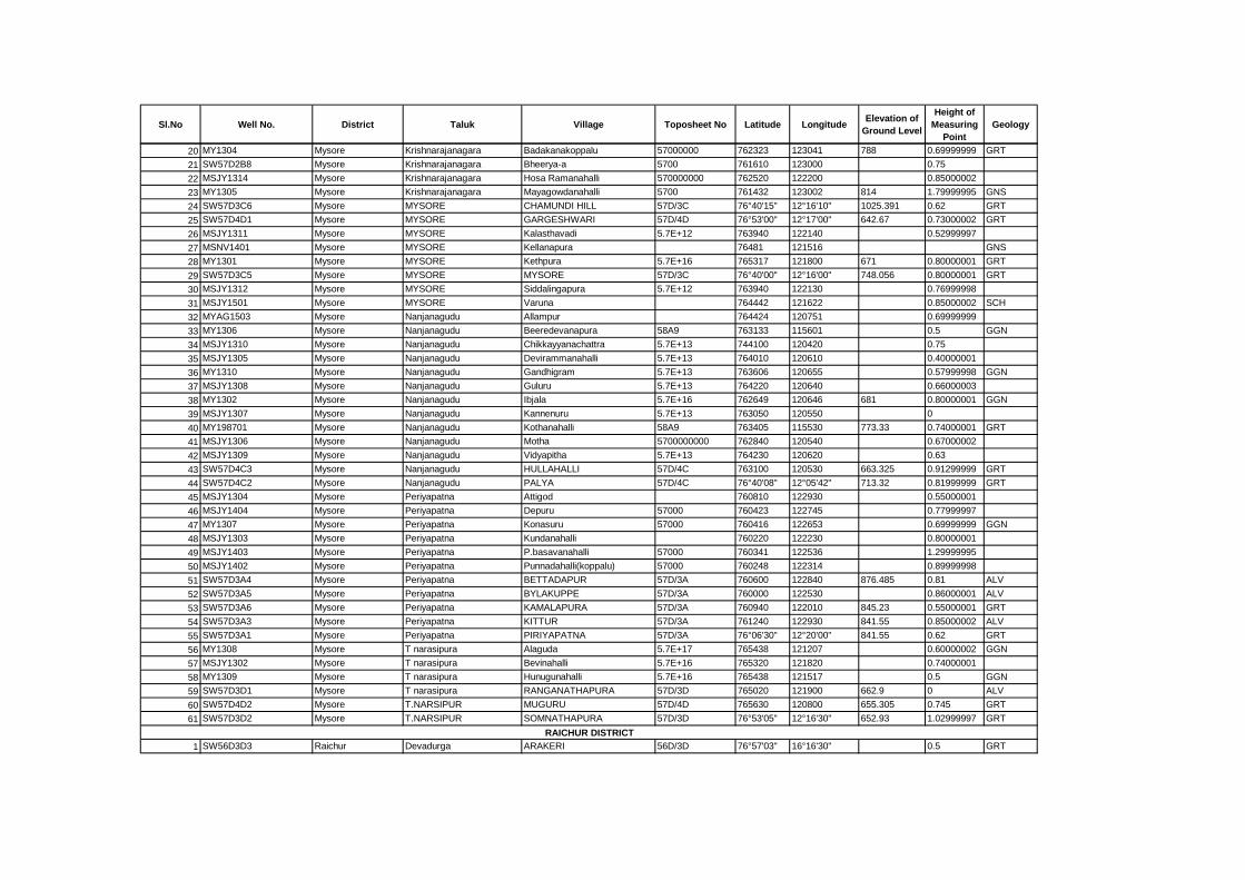
Sl.No Well No. District Taluk Village Toposheet No Latitude LongitudeElevation of
Ground Level
Height of
Measuring
Point
Geology
20 MY1304 Mysore Krishnarajanagara Badakanakoppalu 57000000 762323 123041 788 0.69999999 GRT
21 SW57D2B8 Mysore Krishnarajanagara Bheerya-a 5700 761610 123000 0.75
22 MSJY1314 Mysore Krishnarajanagara Hosa Ramanahalli 570000000 762520 122200 0.85000002
23 MY1305 Mysore Krishnarajanagara Mayagowdanahalli 5700 761432 123002 814 1.79999995 GNS
24 SW57D3C6 Mysore MYSORE CHAMUNDI HILL 57D/3C 76°40'15" 12°16'10" 1025.391 0.62 GRT
25 SW57D4D1 Mysore MYSORE GARGESHWARI 57D/4D 76°53'00" 12°17'00" 642.67 0.73000002 GRT
26 MSJY1311 Mysore MYSORE Kalasthavadi 5.7E+12 763940 122140 0.52999997
27 MSNV1401 Mysore MYSORE Kellanapura 76481 121516 GNS
28 MY1301 Mysore MYSORE Kethpura 5.7E+16 765317 121800 671 0.80000001 GRT
29 SW57D3C5 Mysore MYSORE MYSORE 57D/3C 76°40'00" 12°16'00" 748.056 0.80000001 GRT
30 MSJY1312 Mysore MYSORE Siddalingapura 5.7E+12 763940 122130 0.76999998
31 MSJY1501 Mysore MYSORE Varuna 764442 121622 0.85000002 SCH
32 MYAG1503 Mysore Nanjanagudu Allampur 764424 120751 0.69999999
33 MY1306 Mysore Nanjanagudu Beeredevanapura 58A9 763133 115601 0.5 GGN
34 MSJY1310 Mysore Nanjanagudu Chikkayyanachattra 5.7E+13 744100 120420 0.75
35 MSJY1305 Mysore Nanjanagudu Devirammanahalli 5.7E+13 764010 120610 0.40000001
36 MY1310 Mysore Nanjanagudu Gandhigram 5.7E+13 763606 120655 0.57999998 GGN
37 MSJY1308 Mysore Nanjanagudu Guluru 5.7E+13 764220 120640 0.66000003
38 MY1302 Mysore Nanjanagudu Ibjala 5.7E+16 762649 120646 681 0.80000001 GGN
39 MSJY1307 Mysore Nanjanagudu Kannenuru 5.7E+13 763050 120550 0
40 MY198701 Mysore Nanjanagudu Kothanahalli 58A9 763405 115530 773.33 0.74000001 GRT
41 MSJY1306 Mysore Nanjanagudu Motha 5700000000 762840 120540 0.67000002
42 MSJY1309 Mysore Nanjanagudu Vidyapitha 5.7E+13 764230 120620 0.63
43 SW57D4C3 Mysore Nanjanagudu HULLAHALLI 57D/4C 763100 120530 663.325 0.91299999 GRT
44 SW57D4C2 Mysore Nanjanagudu PALYA 57D/4C 76°40'08" 12°05'42" 713.32 0.81999999 GRT
45 MSJY1304 Mysore Periyapatna Attigod 760810 122930 0.55000001
46 MSJY1404 Mysore Periyapatna Depuru 57000 760423 122745 0.77999997
47 MY1307 Mysore Periyapatna Konasuru 57000 760416 122653 0.69999999 GGN
48 MSJY1303 Mysore Periyapatna Kundanahalli 760220 122230 0.80000001
49 MSJY1403 Mysore Periyapatna P.basavanahalli 57000 760341 122536 1.29999995
50 MSJY1402 Mysore Periyapatna Punnadahalli(koppalu) 57000 760248 122314 0.89999998
51 SW57D3A4 Mysore Periyapatna BETTADAPUR 57D/3A 760600 122840 876.485 0.81 ALV
52 SW57D3A5 Mysore Periyapatna BYLAKUPPE 57D/3A 760000 122530 0.86000001 ALV
53 SW57D3A6 Mysore Periyapatna KAMALAPURA 57D/3A 760940 122010 845.23 0.55000001 GRT
54 SW57D3A3 Mysore Periyapatna KITTUR 57D/3A 761240 122930 841.55 0.85000002 ALV
55 SW57D3A1 Mysore Periyapatna PIRIYAPATNA 57D/3A 76°06'30" 12°20'00" 841.55 0.62 GRT
56 MY1308 Mysore T narasipura Alaguda 5.7E+17 765438 121207 0.60000002 GGN
57 MSJY1302 Mysore T narasipura Bevinahalli 5.7E+16 765320 121820 0.74000001
58 MY1309 Mysore T narasipura Hunugunahalli 5.7E+16 765438 121517 0.5 GGN
59 SW57D3D1 Mysore T narasipura RANGANATHAPURA 57D/3D 765020 121900 662.9 0 ALV
60 SW57D4D2 Mysore T.NARSIPUR MUGURU 57D/4D 765630 120800 655.305 0.745 GRT
61 SW57D3D2 Mysore T.NARSIPUR SOMNATHAPURA 57D/3D 76°53'05" 12°16'30" 652.93 1.02999997 GRT
1 SW56D3D3 Raichur Devadurga ARAKERI 56D/3D 76°57'03" 16°16'30" 0.5 GRT
RAICHUR DISTRICT

Sl.No Well No. District Taluk Village Toposheet No Latitude LongitudeElevation of
Ground Level
Height of
Measuring
Point
Geology
2 RIMY1302 Raichur Devadurga Chikkahonakuni 5.6E+16 765930 162400 0.2
3 SW56H3A1 Raichur Devadurga GABBUR 56H/3A 77°09'30" 16°18'00" 401.015 0.40000001 GRT
4 RIJY1307 Raichur Devadurga Galarga 5.6E+16 765028 161601 0.34999999
5 RIAG1404 Raichur Devadurga Hemanur 5.6E+16 765714 162050 0.34999999
6 SW56D3D2 Raichur Devadurga JALAHALLI 56D/3D 76°47'00" 16°22'00" 386.51 0.34999999 GRT
7 SW56H3A3 Raichur Devadurga KAKARGAL 56H/3A 77°04'00" 16°21'00" 398.924 0.34999999 GRT
8 SW56H3A2 Raichur Devadurga MUSTUR 56H/3A 77°01'00" 16°18'45" 416.05 0.55000001 GRT
9 RIJY1305 Raichur Devadurga Vachanayakam Thanda 5.6E+16 765308 161710 0.5
10 RI1201 Raichur Devadurga Vanukuni 5.6E+16 765858 162402 0.94999999 GNS
11 RIJY1401 Raichur Lingasugur Ankusha Doddy 5.6E+13 763645 160204 0.25
12 CI1402 Raichur Lingasugur Asha Tanda 5600000000 762318 160323 0.40000001 GRT
13 RIMY1301 Raichur Lingasugur Bomanhal 5600000000 762040 160420 0.15000001
14 CI1301 Raichur Lingasugur Chikksarur 5.8E+13 763814 160639 0.44999999 GRT
15 RIAG1402 Raichur Lingasugur Devarabupur Vkp Camp 5.6E+13 763504 161446 0.30000001
16 RIAG1401 Raichur Lingasugur Echanal 5600000000 762644 161045 1.20000005
17 CI1401 Raichur Lingasugur Ulimeshwar 57A5 762630 155707 0.34999999 GRT
18 SW57A1B6 Raichur Lingasugur CHHATRA 57A/1B 76°27'00" 15°53'10" 526.265 0.30000001 GRT
19 SW56D4C1 Raichur Lingasugur LINGASUGUR 56D/4C 76°32'07" 16°07'06" 485.425 0.69999999 GRT
20 SW56D4D4 Raichur MANVI BAGALVAD 56D/4D 76°53'30" 16°03'00" 410.788 0 GRT
21 RIJY1306 Raichur MANVI Balatgi 5.6E+17 765723 160510 0.5
22 RIJY1303 Raichur MANVI Bhyagawat 57A13 765335 155958
23 SW56D4D2 Raichur MANVI BUDDINNI 56D/4D 76°47'00" 16°12'00" 519.375 0.80000001 GRT
24 RIAG1403 Raichur MANVI Chincherki 5.6E+17 764717 161204 0.5
25 SW57A1D3 Raichur MANVI HIRE KOTANKAL 57A/1D 76°57'10" 15°57'45" 0.15000001 GRT
26 RIJY1302 Raichur MANVI Jakkaladinni 56H4 770357 161056
27 RIJY1304 Raichur MANVI Janekal 5.6E+17 765713 160054
28 SW56H4A2 Raichur MANVI KAPGAL 56H/4A 77°08'00" 16°03'00" 363.45 0.85000002 GRT
29 SW56H4A3 Raichur MANVI KURDI 56H/4A 77°12'50" 16°03'00" 351.375 0.15000001 GRT
30 SW57E1A1 Raichur MANVI MANVI 57E/1A 77°02'00" 16°00'00" 366.607 0.40000001 GRT
31 SW56H4A5 Raichur MANVI NIRMAINVI CAMP 56H/4A 770600 160230 371.54 0.40000001 GRT
32 SW56D1D5 Raichur MANVI PAMANAKALLUR 56D/1D 76°41'00" 16°06'00" 460.4 0.34999999 GRT
33 SW57E1A2 Raichur MANVI RAJALABANDA 57E/1A 77°10'30" 15°57'30" 337.905 0.64999998 GRT
34 SW56H4A1 Raichur MANVI SIRWAR 56H/4A 77°01'15" 16°10'20" 414.255 1 GRT
35 RIJY1301 Raichur MANVI Watgal 5.6E+17 764524 160617
36 RIJY1309 Raichur Raichur Ganadala 5700000 772443 155834 0.30000001
37 RIJY1308 Raichur Raichur Genjehalli 56H8 772431 160225 0.40000001
38 SW56H4B1 Raichur Raichur RAICHUR 56H/4B 77°21'00" 16°12'30" 390.82 0.15000001 GRT
39 SW56H3B1 Raichur Raichur SHAKTINAGAR 56H/3B 77°16'15" 16°16'15" 339.22 0.75 GRT
40 SW56H4B2 Raichur Raichur YERAGERA 56H/4B 77°17'00" 16°01'00" 349.95 0.75 GRT
41 SW57A1C4 Raichur SINDHANUR GUDADUR 57A/1C 76°40'15" 15°54'45" 435.175 0.44 GRT
42 SW57A1C5 Raichur SINDHANUR GUNDA 57A/1C 77°30'30" 15°48'00" 469.31 0.30000001 ALV
43 SW57A1D1 Raichur SINDHANUR JAWALGERI 57A/1D 76°49'00" 15°51'45" 403.9 0.30000001 GRT
44 SW57A2C2 Raichur SINDHANUR KALAMANGI 57A/2C 76°32'30" 15°33'45" 447.925 0.30000001 GRT
45 SW57A1B2 Raichur SINDHANUR MAHAMPUR 57A/1B 76°27'30" 15°50'20" 0.85000002 GRT
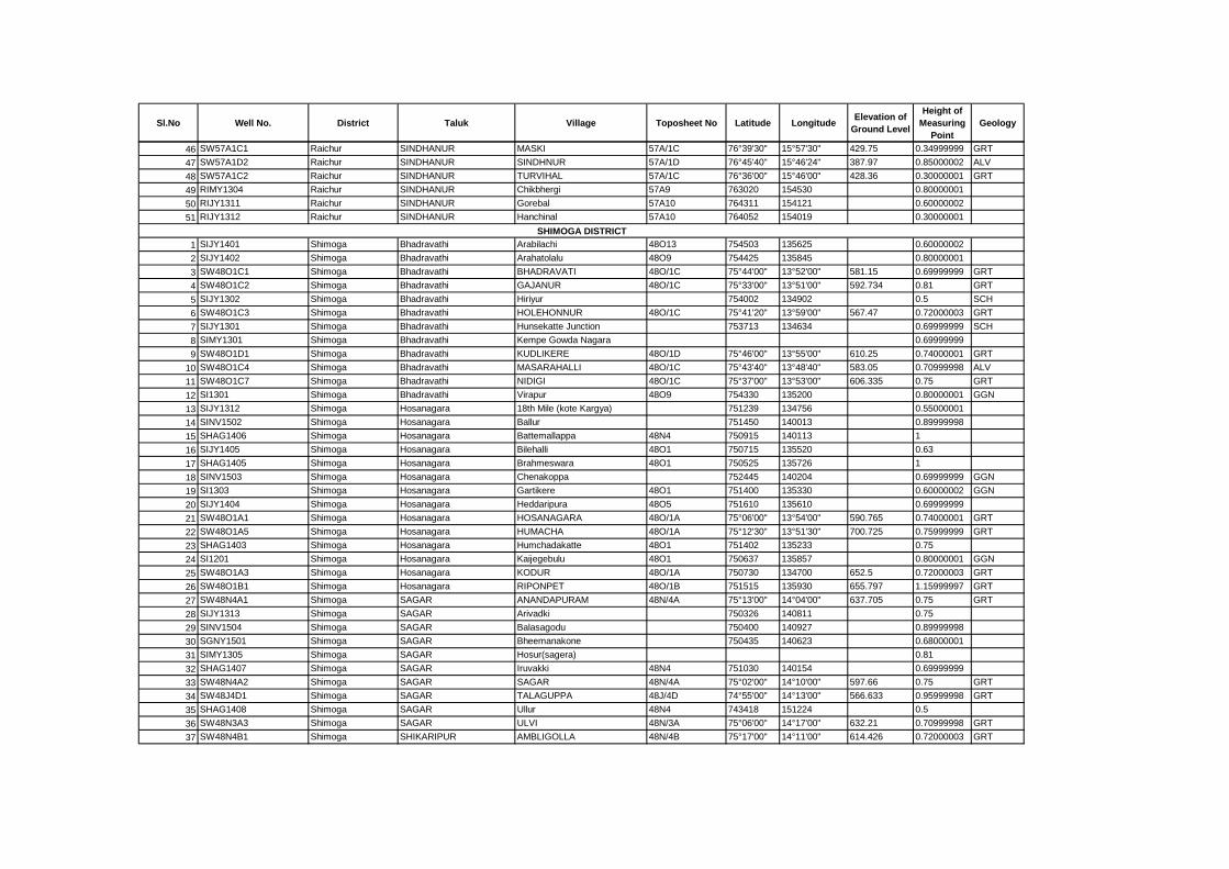
Sl.No Well No. District Taluk Village Toposheet No Latitude LongitudeElevation of
Ground Level
Height of
Measuring
Point
Geology
46 SW57A1C1 Raichur SINDHANUR MASKI 57A/1C 76°39'30" 15°57'30" 429.75 0.34999999 GRT
47 SW57A1D2 Raichur SINDHANUR SINDHNUR 57A/1D 76°45'40" 15°46'24" 387.97 0.85000002 ALV
48 SW57A1C2 Raichur SINDHANUR TURVIHAL 57A/1C 76°36'00" 15°46'00" 428.36 0.30000001 GRT
49 RIMY1304 Raichur SINDHANUR Chikbhergi 57A9 763020 154530 0.80000001
50 RIJY1311 Raichur SINDHANUR Gorebal 57A10 764311 154121 0.60000002
51 RIJY1312 Raichur SINDHANUR Hanchinal 57A10 764052 154019 0.30000001
1 SIJY1401 Shimoga Bhadravathi Arabilachi 48O13 754503 135625 0.60000002
2 SIJY1402 Shimoga Bhadravathi Arahatolalu 48O9 754425 135845 0.80000001
3 SW48O1C1 Shimoga Bhadravathi BHADRAVATI 48O/1C 75°44'00" 13°52'00" 581.15 0.69999999 GRT
4 SW48O1C2 Shimoga Bhadravathi GAJANUR 48O/1C 75°33'00" 13°51'00" 592.734 0.81 GRT
5 SIJY1302 Shimoga Bhadravathi Hiriyur 754002 134902 0.5 SCH
6 SW48O1C3 Shimoga Bhadravathi HOLEHONNUR 48O/1C 75°41'20" 13°59'00" 567.47 0.72000003 GRT
7 SIJY1301 Shimoga Bhadravathi Hunsekatte Junction 753713 134634 0.69999999 SCH
8 SIMY1301 Shimoga Bhadravathi Kempe Gowda Nagara 0.69999999
9 SW48O1D1 Shimoga Bhadravathi KUDLIKERE 48O/1D 75°46'00" 13°55'00" 610.25 0.74000001 GRT
10 SW48O1C4 Shimoga Bhadravathi MASARAHALLI 48O/1C 75°43'40" 13°48'40" 583.05 0.70999998 ALV
11 SW48O1C7 Shimoga Bhadravathi NIDIGI 48O/1C 75°37'00" 13°53'00" 606.335 0.75 GRT
12 SI1301 Shimoga Bhadravathi Virapur 48O9 754330 135200 0.80000001 GGN
13 SIJY1312 Shimoga Hosanagara 18th Mile (kote Kargya) 751239 134756 0.55000001
14 SINV1502 Shimoga Hosanagara Ballur 751450 140013 0.89999998
15 SHAG1406 Shimoga Hosanagara Battemallappa 48N4 750915 140113 1
16 SIJY1405 Shimoga Hosanagara Bilehalli 48O1 750715 135520 0.63
17 SHAG1405 Shimoga Hosanagara Brahmeswara 48O1 750525 135726 1
18 SINV1503 Shimoga Hosanagara Chenakoppa 752445 140204 0.69999999 GGN
19 SI1303 Shimoga Hosanagara Gartikere 48O1 751400 135330 0.60000002 GGN
20 SIJY1404 Shimoga Hosanagara Heddaripura 48O5 751610 135610 0.69999999
21 SW48O1A1 Shimoga Hosanagara HOSANAGARA 48O/1A 75°06'00" 13°54'00" 590.765 0.74000001 GRT
22 SW48O1A5 Shimoga Hosanagara HUMACHA 48O/1A 75°12'30" 13°51'30" 700.725 0.75999999 GRT
23 SHAG1403 Shimoga Hosanagara Humchadakatte 48O1 751402 135233 0.75
24 SI1201 Shimoga Hosanagara Kaijegebulu 48O1 750637 135857 0.80000001 GGN
25 SW48O1A3 Shimoga Hosanagara KODUR 48O/1A 750730 134700 652.5 0.72000003 GRT
26 SW48O1B1 Shimoga Hosanagara RIPONPET 48O/1B 751515 135930 655.797 1.15999997 GRT
27 SW48N4A1 Shimoga SAGAR ANANDAPURAM 48N/4A 75°13'00" 14°04'00" 637.705 0.75 GRT
28 SIJY1313 Shimoga SAGAR Arivadki 750326 140811 0.75
29 SINV1504 Shimoga SAGAR Balasagodu 750400 140927 0.89999998
30 SGNY1501 Shimoga SAGAR Bheemanakone 750435 140623 0.68000001
31 SIMY1305 Shimoga SAGAR Hosur(sagera) 0.81
32 SHAG1407 Shimoga SAGAR Iruvakki 48N4 751030 140154 0.69999999
33 SW48N4A2 Shimoga SAGAR SAGAR 48N/4A 75°02'00" 14°10'00" 597.66 0.75 GRT
34 SW48J4D1 Shimoga SAGAR TALAGUPPA 48J/4D 74°55'00" 14°13'00" 566.633 0.95999998 GRT
35 SHAG1408 Shimoga SAGAR Ullur 48N4 743418 151224 0.5
36 SW48N3A3 Shimoga SAGAR ULVI 48N/3A 75°06'00" 14°17'00" 632.21 0.70999998 GRT
37 SW48N4B1 Shimoga SHIKARIPUR AMBLIGOLLA 48N/4B 75°17'00" 14°11'00" 614.426 0.72000003 GRT
SHIMOGA DISTRICT
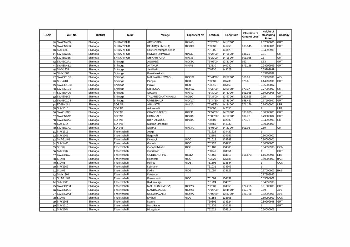
Sl.No Well No. District Taluk Village Toposheet No Latitude LongitudeElevation of
Ground Level
Height of
Measuring
Point
Geology
38 SW48N4B3 Shimoga SHIKARIPUR AREKOPPA 48N/4B 75°25'00" 14°11'00" 1.07000005 GRT
39 SW48N3C6 Shimoga SHIKARIPUR BELUR(SHIMOGA) 48N/3C 753030 141455 668.545 0.80000001 GRT
40 SIJY1303 Shimoga SHIKARIPUR Chunchanakoppa Cross 751905 141428 0.94999999
41 SW48N3B6 Shimoga SHIKARIPUR HOSUR.SHIMOGA 48N/3B 75°25'00" 14°15'30" 536.29 0.81 GRT
42 SW48N3B5 Shimoga SHIKARIPUR SHIKARIPURA 48N/3B 75°22'00" 14°15'00" 601.055 0.5 GRT
43 SW48O2A1 Shimoga Shimoga AGUMBE 48O/2A 75°06'00" 13°31'00" 662 1.13 GRT
44 SW48N4B2 Shimoga Shimoga AYANUR 48N/4B 753330 140030 673.155 0.94999999 GRT
45 SINV1505 Shimoga Shimoga Jaddihalli 750330 143027 0.69999999
46 SIMY1303 Shimoga Shimoga Kowri Nakkalu 0.69999999
47 SW48O1C5 Shimoga Shimoga MALINAHANSWADI 48O/1C 75°41'20" 13°59'00" 566.91 0.89999998 ALV
48 SI184701 Shimoga Shimoga Pilingiri 48O1 753830 135730 578.8 1.14999998 GRT
49 SW48O1C11 Shimoga Shimoga Purale 48O1 753815 135455 0.85000002
50 SW48O1C6 Shimoga Shimoga SHIMOGA 48O/1C 75°38'00" 13°55'00" 570.37 0.77999997 GRT
51 SW48N4C5 Shimoga Shimoga SUGUR 48N/4C 75°39'00" 14°30'00" 591.935 0.89999998 GRT
52 SW4801C9 Shimoga Shimoga TAVARE CHATNIHALLI 480/1C 75°37'00" 13°57'00" 580.565 0.75 GRT
53 SW48O1C8 Shimoga Shimoga UMBLIBAILU 48O/1C 75°34'30" 13°46'00" 648.423 0.77999997 GRT
54 ED48N2A1 Shimoga SORAB ANAVATTI 48N/2A 75°08'30" 14°34'00" 571.176 0.74000001 LTR
55 SIJY1315 Shimoga SORAB Ankaravalli 750006 142355 1 LTR
56 SW48J3D3 Shimoga SORAB CHANDRAGUTI 48J/3D 74°57'30" 14°26'00" 598.895 0.80000001 GRT
57 SW48N3A2 Shimoga SORAB HOSABALE 48N/3A 75°03'00" 14°19'30" 604.72 0.79000002 GRT
58 SW48N3A4 Shimoga SORAB KUPPAGADDE 48N/3A 750700 142830 579.72 0.94999999 GRT
59 SIJY1314 Shimoga SORAB Madsur Lingadalli 750459 141232 0.80000001
60 SW48N3A1 Shimoga SORAB SORAB 48N/3A 75°06'00" 14°22'00" 601.05 0.69 GRT
61 SIJY1311 Shimoga Theerthahalli Araga 751228 134422 1
62 SIJY1305 Shimoga Theerthahalli Bagavalli 752351 134252 0.80000001
63 SHAG1401 Shimoga Theerthahalli Devangi 48O6 751618 133749 0.80000001
64 SIJY1403 Shimoga Theerthahalli Gabadi 48O6 752220 134255 0.80000001
65 SI1302 Shimoga Theerthahalli Ganapathikatte 48O9 751400 134300 0.64999998 GGN
66 SIJY1307 Shimoga Theerthahalli Guddekeri 750746 133351 1 GRT
67 SW4801A2 Shimoga Theerthahalli GUDDEKOPPA 480/1A 751450 134615 666.673 1.16999996 LTR
68 SI1401 Shimoga Theerthahalli Hosahalli 48O9 753329 135135 0.60000002 BAS
69 SI1405 Shimoga Theerthahalli Hulkod 48O6 751508 133544 1 GGN
70 SIJY1309 Shimoga Theerthahalli Kalmane 751031 133906 1
71 SI1402 Shimoga Theerthahalli Kodlu 48O2 751054 133829 0.67000002 BAS
72 SIMY1304 Shimoga Theerthahalli Konandur 0.77999997
73 SHAG1404 Shimoga Theerthahalli Konandur-ii 48O5 751509 134837 0.85000002
74 SIJY1306 Shimoga Theerthahalli Kudumallige 751724 134320 0.64999998
75 SW48O2B3 Shimoga Theerthahalli MALUR (SHIMOGA) 48O/2B 752030 134350 624.255 0.91000003 GRT
76 SW48O2B1 Shimoga Theerthahalli MANDAGADDE 48O/2B 75°26'00" 13°44'00" 667.771 0.69 ALV
77 SW48O2A3 Shimoga Theerthahalli MEGARAVALLI 48O/2A 75°07'30" 13°37'30" 626.768 0.82999998 ALV
78 SI1403 Shimoga Theerthahalli Mytheri 48O2 751156 133805 0.69999999 GGN
79 SIJY1308 Shimoga Theerthahalli Naluru 750802 133524 0.89999998 GRT
80 SIJY1310 Shimoga Theerthahalli Nandikatte 751236 134031 1 GRT
81 SIJY1304 Shimoga Theerthahalli Nidagalale 752621 134314 0.60000002
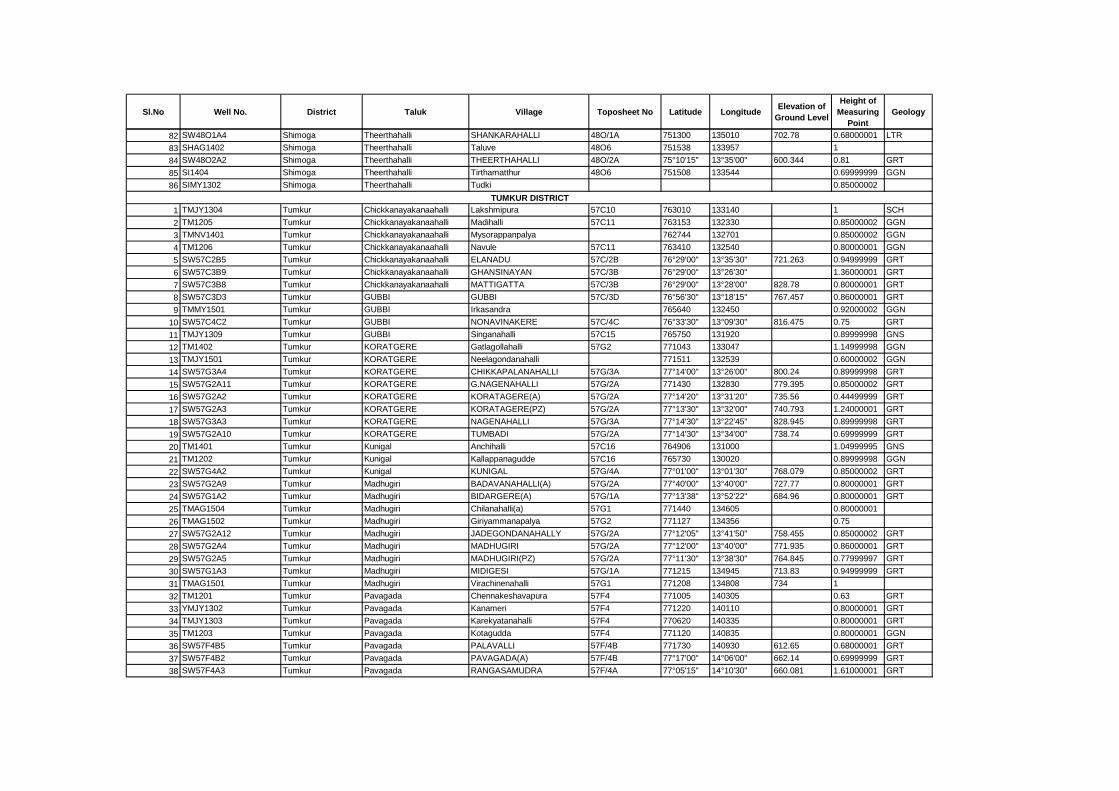
Sl.No Well No. District Taluk Village Toposheet No Latitude LongitudeElevation of
Ground Level
Height of
Measuring
Point
Geology
82 SW48O1A4 Shimoga Theerthahalli SHANKARAHALLI 48O/1A 751300 135010 702.78 0.68000001 LTR
83 SHAG1402 Shimoga Theerthahalli Taluve 48O6 751538 133957 1
84 SW48O2A2 Shimoga Theerthahalli THEERTHAHALLI 48O/2A 75°10'15" 13°35'00" 600.344 0.81 GRT
85 SI1404 Shimoga Theerthahalli Tirthamatthur 48O6 751508 133544 0.69999999 GGN
86 SIMY1302 Shimoga Theerthahalli Tudki 0.85000002
1 TMJY1304 Tumkur Chickkanayakanaahalli Lakshmipura 57C10 763010 133140 1 SCH
2 TM1205 Tumkur Chickkanayakanaahalli Madihalli 57C11 763153 132330 0.85000002 GGN
3 TMNV1401 Tumkur Chickkanayakanaahalli Mysorappanpalya 762744 132701 0.85000002 GGN
4 TM1206 Tumkur Chickkanayakanaahalli Navule 57C11 763410 132540 0.80000001 GGN
5 SW57C2B5 Tumkur Chickkanayakanaahalli ELANADU 57C/2B 76°29'00" 13°35'30" 721.263 0.94999999 GRT
6 SW57C3B9 Tumkur Chickkanayakanaahalli GHANSINAYAN 57C/3B 76°29'00" 13°26'30" 1.36000001 GRT
7 SW57C3B8 Tumkur Chickkanayakanaahalli MATTIGATTA 57C/3B 76°29'00" 13°28'00" 828.78 0.80000001 GRT
8 SW57C3D3 Tumkur GUBBI GUBBI 57C/3D 76°56'30" 13°18'15" 767.457 0.86000001 GRT
9 TMMY1501 Tumkur GUBBI Irkasandra 765640 132450 0.92000002 GGN
10 SW57C4C2 Tumkur GUBBI NONAVINAKERE 57C/4C 76°33'30" 13°09'30" 816.475 0.75 GRT
11 TMJY1309 Tumkur GUBBI Singanahalli 57C15 765750 131920 0.89999998 GNS
12 TM1402 Tumkur KORATGERE Gatlagollahalli 57G2 771043 133047 1.14999998 GGN
13 TMJY1501 Tumkur KORATGERE Neelagondanahalli 771511 132539 0.60000002 GGN
14 SW57G3A4 Tumkur KORATGERE CHIKKAPALANAHALLI 57G/3A 77°14'00" 13°26'00" 800.24 0.89999998 GRT
15 SW57G2A11 Tumkur KORATGERE G.NAGENAHALLI 57G/2A 771430 132830 779.395 0.85000002 GRT
16 SW57G2A2 Tumkur KORATGERE KORATAGERE(A) 57G/2A 77°14'20" 13°31'20" 735.56 0.44499999 GRT
17 SW57G2A3 Tumkur KORATGERE KORATAGERE(PZ) 57G/2A 77°13'30" 13°32'00" 740.793 1.24000001 GRT
18 SW57G3A3 Tumkur KORATGERE NAGENAHALLI 57G/3A 77°14'30" 13°22'45" 828.945 0.89999998 GRT
19 SW57G2A10 Tumkur KORATGERE TUMBADI 57G/2A 77°14'30" 13°34'00" 738.74 0.69999999 GRT
20 TM1401 Tumkur Kunigal Anchihalli 57C16 764906 131000 1.04999995 GNS
21 TM1202 Tumkur Kunigal Kallappanagudde 57C16 765730 130020 0.89999998 GGN
22 SW57G4A2 Tumkur Kunigal KUNIGAL 57G/4A 77°01'00" 13°01'30" 768.079 0.85000002 GRT
23 SW57G2A9 Tumkur Madhugiri BADAVANAHALLI(A) 57G/2A 77°40'00" 13°40'00" 727.77 0.80000001 GRT
24 SW57G1A2 Tumkur Madhugiri BIDARGERE(A) 57G/1A 77°13'38" 13°52'22" 684.96 0.80000001 GRT
25 TMAG1504 Tumkur Madhugiri Chilanahalli(a) 57G1 771440 134605 0.80000001
26 TMAG1502 Tumkur Madhugiri Giriyammanapalya 57G2 771127 134356 0.75
27 SW57G2A12 Tumkur Madhugiri JADEGONDANAHALLY 57G/2A 77°12'05" 13°41'50" 758.455 0.85000002 GRT
28 SW57G2A4 Tumkur Madhugiri MADHUGIRI 57G/2A 77°12'00" 13°40'00" 771.935 0.86000001 GRT
29 SW57G2A5 Tumkur Madhugiri MADHUGIRI(PZ) 57G/2A 77°11'30" 13°38'30" 764.845 0.77999997 GRT
30 SW57G1A3 Tumkur Madhugiri MIDIGESI 57G/1A 771215 134945 713.83 0.94999999 GRT
31 TMAG1501 Tumkur Madhugiri Virachinenahalli 57G1 771208 134808 734 1
32 TM1201 Tumkur Pavagada Chennakeshavapura 57F4 771005 140305 0.63 GRT
33 YMJY1302 Tumkur Pavagada Kanameri 57F4 771220 140110 0.80000001 GRT
34 TMJY1303 Tumkur Pavagada Karekyatanahalli 57F4 770620 140335 0.80000001 GRT
35 TM1203 Tumkur Pavagada Kotagudda 57F4 771120 140835 0.80000001 GGN
36 SW57F4B5 Tumkur Pavagada PALAVALLI 57F/4B 771730 140930 612.65 0.68000001 GRT
37 SW57F4B2 Tumkur Pavagada PAVAGADA(A) 57F/4B 77°17'00" 14°06'00" 662.14 0.69999999 GRT
38 SW57F4A3 Tumkur Pavagada RANGASAMUDRA 57F/4A 77°05'15" 14°10'30" 660.081 1.61000001 GRT
TUMKUR DISTRICT
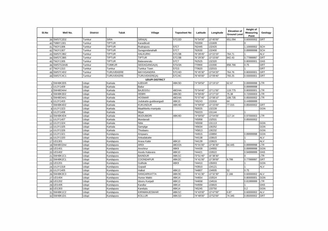
Sl.No Well No. District Taluk Village Toposheet No Latitude LongitudeElevation of
Ground Level
Height of
Measuring
Point
Geology
39 SW57C2D2 Tumkur SIRA SIRA(A) 57C/2D 76°54'00" 13°45'00" 651.094 0.60000002 GRT
40 TMMY1301 Tumkur TIPTUR Karadikodi 763359 131609 0
41 TMJY1306 Tumkur TIPTUR Rudrapura 57C7 762445 132420 1.10000002 SCH
42 TMJY1307 Tumkur TIPTUR Suragondanahalli 57C7 762630 132400 0.89999998 SCH
43 SW57C3B2 Tumkur TIPTUR HALKURKI 57C/3B 76°28'45" 13°22'15" 764.71 1 ALV
44 SW57C3B5 Tumkur TIPTUR TIPTUR 57C/3B 76°29'30" 13°15'00" 842.43 0.77999997 GRT
45 TMJY1305 Tumkur TIPTUR Balavaneralu 57C7 762525 132320 0.80000001 GNS
46 SW57G3A46 Tumkur TUMKUR SIDDAGANGA(A) 57G/3A 770900 131930 858.766 0.75 GRT
47 TMJY1310 Tumkur Tumkur Tumkur Town 57G3 770620 132015 1 GRT
48 SW57C4D2 Tumkur TURUVEKERE MAYASANDRA 57C/4D 76°45'30" 13°04'20" 764.76 0.80000001 GRT
49 SW57C4C1 Tumkur TURUVEKERE TURUVEKERE(A) 57C/4C 76°40'00" 13°09'40" 793.25 0.93000001 GRT
1 SW48K3D5 Udupi Karkala AJEKAR 48K/3D 74°59'50" 13°19'10" 62.67 0.89999998 LTR
2 UUJY1409 Udupi Karkala Bailur 0.89999998
3 SW48O4A4 Udupi Karkala BAJEGOLI 48O/4A 75°04'40" 13°11'55" 119.775 0.80000001 LTR
4 SW48K3D2 Udupi Karkala HEBRI 48K/3D 74°59'45" 13°27'15" 75.38 0.72000003 LTR
5 SW48O4A1 Udupi Karkala HOSMAR 48O/4A 75°07'40" 13°08'10" 108.735 0.85000002 LTR
6 UUJY1403 Udupi Karkala Jodukatte-guddeangadi 48K15 745243 131916 64 0.44999999
7 SW48K4D2 Udupi Karkala KUKUNDUR 48K/4D 74°59'00" 13°15'00" 77.015 0.85000002 GRT
8 UUJY1323 Udupi Karkala Maathbettu-maniyala 750025 132228 GGN
9 UUJY1408 Udupi Karkala Miyar 750223 131144 1
10 SW48K4D4 Udupi Karkala MUDUBIDRI 48K/4D 74°59'50" 13°04'05" 117.14 0.97000003 LTR
11 UUJY1407 Udupi Karkala Mundaradi 745958 132531 0.85000002
12 UUJY1324 Udupi Karkala Nitte 745558 131113 GGN
13 UUJY1325 Udupi Karkala Samplge 745634 130252 GGN
14 UUJY1326 Udupi Karkala Thodaaru 745813 130232 GGN
15 UUJY1321 Udupi Kundapura Ampaaru 744915 133850 0.89999998 GGN
16 UUJY1320 Udupi Kundapura Ankadakatte 744138 133615 1 ALV
17 UD1301 Udupi Kundapura Arasa Katte 48K10 744139 133615 1 ALV
18 SW48O2A4 Udupi Kundapura ARDI 48O/2A 75°01'00" 13°30'30" 64.445 0.89999998 LTR
19 UD1401 Udupi Kundapura Areshirur 48K9 744439 134955 0.89999998 GGN
20 UD1402 Udupi Kundapura Asodu Kalavara 48K10 744421 133522 0.94999999 GNS
21 SW48K1C1 Udupi Kundapura BAINDUR 48K/1C 73°51'40" 16°38'30" 0 LTR
22 SW48K2C1 Udupi Kundapura COONDAPUR 48K/2C 74°41'00" 13°39'00" 9.799 0.77999997 GRT
23 UD1201 Udupi Kundapura Golihole 48K9 744410 135003 1 GGN
24 UUJY1318 Udupi Kundapura Gopadi 743910 134121 1 ALV
25 UUJY1405 Udupi Kundapura Halkal 48K13 744807 134935 52 0.75
26 SW48K3C3 Udupi Kundapura HANGARKATTA 48K/3C 74°41'30" 13°32'30" 2.166 0.60000002 ALV
27 UD1404 Udupi Kundapura Hunse Makki 48K14 744654 133524 0.80000001 GGN
28 UD1202 Udupi Kundapura Idooru Kunjadi 48K13 744658 134516 0.81999999 LTR
29 UD1405 Udupi Kundapura Kandlur 48K14 744559 133815 1 GNS
30 UD1303 Udupi Kundapura Karebylu 48K14 745245 133750 0.2 GGN
31 SW48K1C2 Udupi Kundapura KIRIMANJESWAR 48K/1C 74°43'00" 13°47'00" 0.87 0.60000002 ALV
32 SW48K1D1 Udupi Kundapura KOLLUR 48K/1D 74°48'00" 13°52'00" 74.345 0.85000002 GRT
UDUPI DISTRICT
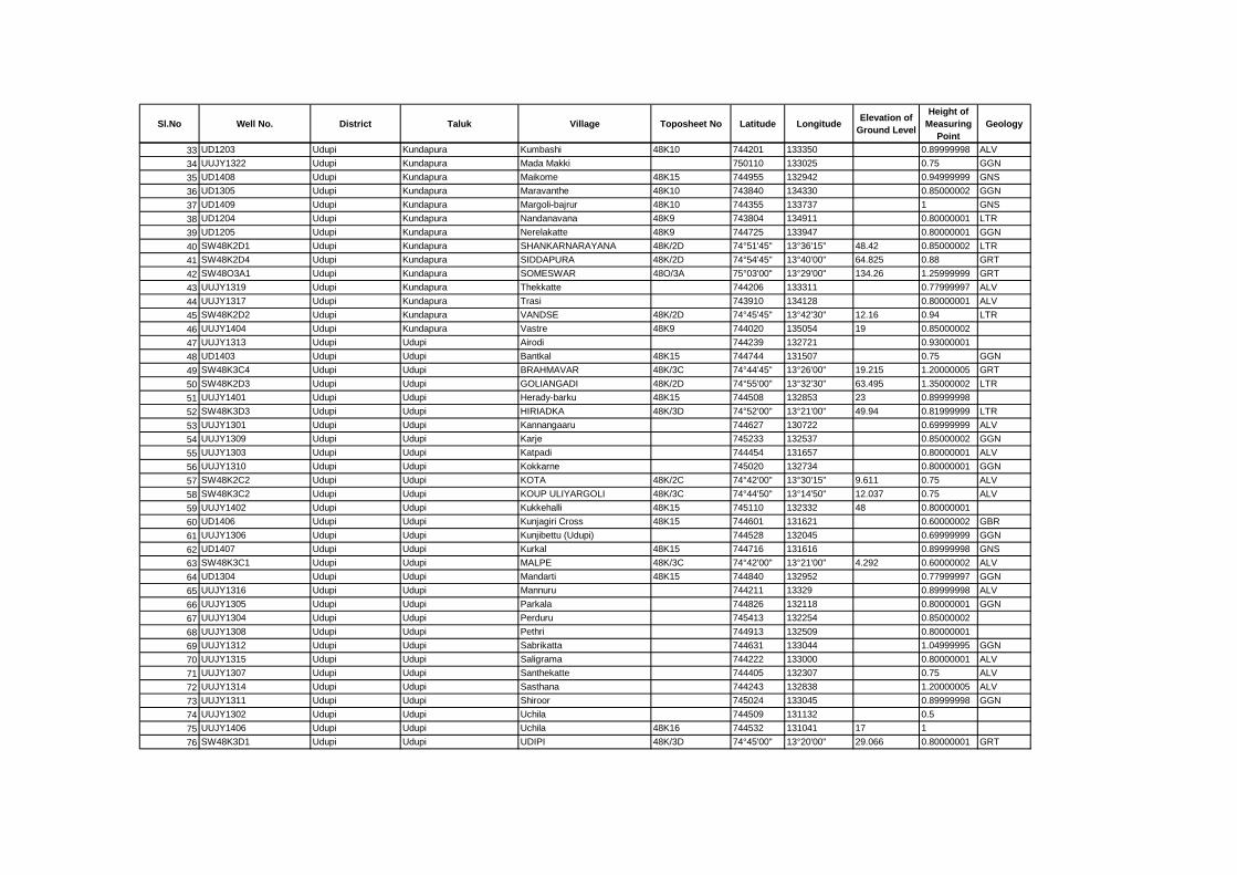
Sl.No Well No. District Taluk Village Toposheet No Latitude LongitudeElevation of
Ground Level
Height of
Measuring
Point
Geology
33 UD1203 Udupi Kundapura Kumbashi 48K10 744201 133350 0.89999998 ALV
34 UUJY1322 Udupi Kundapura Mada Makki 750110 133025 0.75 GGN
35 UD1408 Udupi Kundapura Maikome 48K15 744955 132942 0.94999999 GNS
36 UD1305 Udupi Kundapura Maravanthe 48K10 743840 134330 0.85000002 GGN
37 UD1409 Udupi Kundapura Margoli-bajrur 48K10 744355 133737 1 GNS
38 UD1204 Udupi Kundapura Nandanavana 48K9 743804 134911 0.80000001 LTR
39 UD1205 Udupi Kundapura Nerelakatte 48K9 744725 133947 0.80000001 GGN
40 SW48K2D1 Udupi Kundapura SHANKARNARAYANA 48K/2D 74°51'45" 13°36'15" 48.42 0.85000002 LTR
41 SW48K2D4 Udupi Kundapura SIDDAPURA 48K/2D 74°54'45" 13°40'00" 64.825 0.88 GRT
42 SW48O3A1 Udupi Kundapura SOMESWAR 48O/3A 75°03'00" 13°29'00" 134.26 1.25999999 GRT
43 UUJY1319 Udupi Kundapura Thekkatte 744206 133311 0.77999997 ALV
44 UUJY1317 Udupi Kundapura Trasi 743910 134128 0.80000001 ALV
45 SW48K2D2 Udupi Kundapura VANDSE 48K/2D 74°45'45" 13°42'30" 12.16 0.94 LTR
46 UUJY1404 Udupi Kundapura Vastre 48K9 744020 135054 19 0.85000002
47 UUJY1313 Udupi Udupi Airodi 744239 132721 0.93000001
48 UD1403 Udupi Udupi Bantkal 48K15 744744 131507 0.75 GGN
49 SW48K3C4 Udupi Udupi BRAHMAVAR 48K/3C 74°44'45" 13°26'00" 19.215 1.20000005 GRT
50 SW48K2D3 Udupi Udupi GOLIANGADI 48K/2D 74°55'00" 13°32'30" 63.495 1.35000002 LTR
51 UUJY1401 Udupi Udupi Herady-barku 48K15 744508 132853 23 0.89999998
52 SW48K3D3 Udupi Udupi HIRIADKA 48K/3D 74°52'00" 13°21'00" 49.94 0.81999999 LTR
53 UUJY1301 Udupi Udupi Kannangaaru 744627 130722 0.69999999 ALV
54 UUJY1309 Udupi Udupi Karje 745233 132537 0.85000002 GGN
55 UUJY1303 Udupi Udupi Katpadi 744454 131657 0.80000001 ALV
56 UUJY1310 Udupi Udupi Kokkarne 745020 132734 0.80000001 GGN
57 SW48K2C2 Udupi Udupi KOTA 48K/2C 74°42'00" 13°30'15" 9.611 0.75 ALV
58 SW48K3C2 Udupi Udupi KOUP ULIYARGOLI 48K/3C 74°44'50" 13°14'50" 12.037 0.75 ALV
59 UUJY1402 Udupi Udupi Kukkehalli 48K15 745110 132332 48 0.80000001
60 UD1406 Udupi Udupi Kunjagiri Cross 48K15 744601 131621 0.60000002 GBR
61 UUJY1306 Udupi Udupi Kunjibettu (Udupi) 744528 132045 0.69999999 GGN
62 UD1407 Udupi Udupi Kurkal 48K15 744716 131616 0.89999998 GNS
63 SW48K3C1 Udupi Udupi MALPE 48K/3C 74°42'00" 13°21'00" 4.292 0.60000002 ALV
64 UD1304 Udupi Udupi Mandarti 48K15 744840 132952 0.77999997 GGN
65 UUJY1316 Udupi Udupi Mannuru 744211 13329 0.89999998 ALV
66 UUJY1305 Udupi Udupi Parkala 744826 132118 0.80000001 GGN
67 UUJY1304 Udupi Udupi Perduru 745413 132254 0.85000002
68 UUJY1308 Udupi Udupi Pethri 744913 132509 0.80000001
69 UUJY1312 Udupi Udupi Sabrikatta 744631 133044 1.04999995 GGN
70 UUJY1315 Udupi Udupi Saligrama 744222 133000 0.80000001 ALV
71 UUJY1307 Udupi Udupi Santhekatte 744405 132307 0.75 ALV
72 UUJY1314 Udupi Udupi Sasthana 744243 132838 1.20000005 ALV
73 UUJY1311 Udupi Udupi Shiroor 745024 133045 0.89999998 GGN
74 UUJY1302 Udupi Udupi Uchila 744509 131132 0.5
75 UUJY1406 Udupi Udupi Uchila 48K16 744532 131041 17 1
76 SW48K3D1 Udupi Udupi UDIPI 48K/3D 74°45'00" 13°20'00" 29.066 0.80000001 GRT
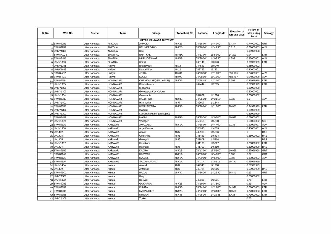
Sl.No Well No. District Taluk Village Toposheet No Latitude LongitudeElevation of
Ground Level
Height of
Measuring
Point
Geology
1 SW48J2B1 Uttar Kannada ANKOLA ANKOLA 48J/2B 74°18'00" 14°40'00" 13.344 0.74000001 GRT
2 SW48J2B2 Uttar Kannada ANKOLA BELIKERE(NK) 48J/2B 74°16'00" 14°43'30" 6.815 0.66000003 ALV
3 UKMY1309 Uttar Kannada ANKOLA Keni 1.14999998
4 SW48K1C3 Uttar Kannada BHATKAL BHATKAL 48K/1C 74°33'00" 13°59'00" 34.293 0.94 LTR
5 SW48J4B1 Uttar Kannada BHATKAL MURUDESWAR 48J/4B 74°29'30" 14°05'30" 4.592 0.33000001 ALV
6 UKJY1303 Uttar Kannada BHATKAL Shirali 743146 140140 0.69999999 LTR
7 UKNV1201 Uttar Kannada Halliyal Bhagavathi 48I12 744523 150940 0.85000002
8 UKNV1402 Uttar Kannada Halliyal Dandeli Dw 48I12 743733 151431 0.40000001
9 SW48I4B2 Uttar Kannada Halliyal JOIDA 48I/4B 74°28'30" 15°10'00" 591.705 0.74000001 ALV
10 SW48I4C1 Uttar Kannada Halliyal KULGI 48I/4C 74°38'00" 15°10'00" 488.787 0.94999999 ALV
11 SW48J3B4 Uttar Kannada HONNAVAR CHANDAVAR(MALLAPUR) 48J/3B 74°28'45" 14°24'00" 7.197 0.47999999 LTR
12 UKJY1305 Uttar Kannada HONNAVAR Dhareshwara 742442 142205 0.69999999 LTR
13 UKMY1305 Uttar Kannada HONNAVAR Dibbangal 0.89999998
14 UKMY1303 Uttar Kannada HONNAVAR Gerusoppa Kpc Colony 0.80000001
15 UKJY1304 Uttar Kannada HONNAVAR Gunavante 742809 141316 0.60000002
16 SW48J3B3 Uttar Kannada HONNAVAR HALDIPUR 48J/3B 74°25'30" 14°21'15" 5.335 0.5 ALV
17 UKMY1401 Uttar Kannada HONNAVAR Hirematha 48J7 742607 141548 1
18 SW48J3B1 Uttar Kannada HONNAVAR HONNAWARA 48J/3B 74°26'00" 14°15'00" 20.051 0.94999999 LTR
19 UKMY1306 Uttar Kannada HONNAVAR Idagunji 0.69999999
20 UKMY1302 Uttar Kannada HONNAVAR Kabbinahakkalu(gerusoppa) 0.69999999
21 SW48J4B2 Uttar Kannada HONNAVAR MANKI 48J/4B 74°29'30" 14°06'00" 10.079 0.79000002
22 UKJY1309 Uttar Kannada HONNAVAR Vadageri 750255 145230 0.60000002 SCH
23 SW48J1A3 Uttar Kannada KARWAR AMADALLI 48J/1A 74°15'00" 14°47'00" 6.033 0.83999997 ALV
24 UKJY1306 Uttar Kannada KARWAR Arge Karwar 740945 144609 0.40000001 ALV
25 UK1402 Uttar Kannada KARWAR Asnoti 48J7 740903 145256 1 BAS
26 UK1403 Uttar Kannada KARWAR Gopishitta 48J1 741433 145434 0.85000002 BAS
27 UK1405 Uttar Kannada KARWAR Gotegali 48J5 741809 145414 1 BAS
28 UKJY1307 Uttar Kannada KARWAR Hanakona 741103 145327 0.73000002 LTR
29 UK1404 Uttar Kannada KARWAR Hapkarni 48J5 741700 145410 0.69999999 BAS
30 SW48J1B2 Uttar Kannada KARWAR KADRA 48J/1B 74°13'00" 17°52'00" 10.965 0.57999998 GRT
31 SW48J1A1 Uttar Kannada KARWAR KARWAR 48J/1A 74°08'00" 14°48'00" 3.185 0.87 GRT
32 SW48J1A2 Uttar Kannada KARWAR MAJALLI 48J/1A 74°09'00" 14°54'00" 0.888 0.67000002 ALV
33 SW48J1A4 Uttar Kannada KARWAR SADASHIVGAD 48J/1A 74°07'47" 14°51'15" 15.777 0.69999999
34 UKJY1404 Uttar Kannada Kumta Alakod 48J7 742940 141900 0.69999999
35 UK1409 Uttar Kannada Kumta Antarvalli 48J7 742734 142816 0.69999999 BAS
36 SW48J3C2 Uttar Kannada Kumta BADAL 48J/3C 74°36'20" 14°25'30" 38.441 0.63 GRT
37 UKMY1307 Uttar Kannada Kumta Bargi 0.60000002
38 UKJY1302 Uttar Kannada Kumta Deevalli 743315 142501 0.75 LTR
39 SW48J2B3 Uttar Kannada Kumta GOKARNA 48J/2B 74°19'00" 14°33'00" 0.69 ALV
40 SW48J3B2 Uttar Kannada Kumta KUMTA 48J/3B 74°24'00" 14°24'00" 14.978 0.66000003 LTR
41 SW48J2B4 Uttar Kannada Kumta MADANGERI 48J/2B 74°22'00" 14°34'30" 10.665 0.72000003 LTR
42 SW48J3B5 Uttar Kannada Kumta MIRJAN 48J/3B 74°25'30" 14°29'35" 5.425 0.79000002 LTR
43 UKMY1308 Uttar Kannada Kumta Torke 0.75
UTTAR KANNADA DISTRICT
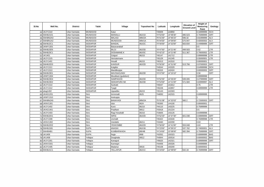
Sl.No Well No. District Taluk Village Toposheet No Latitude LongitudeElevation of
Ground Level
Height of
Measuring
Point
Geology
44 UKJY1310 Uttar Kannada MUNDGOD Katur 745609 144850 0.34999999 SCH
45 SW48J1D1 Uttar Kannada MUNDGOD MAINALLI 48J/1D 74°53'30" 14°48'30" 485.523 0.75999999 GRT
46 SW48N2A3 Uttar Kannada MUNDGOD MALAGI 48N/2A 75°01'00" 14°46'15" 596.32 0.81999999 ALV
47 SW48N1A2 Uttar Kannada MUNDGOD MUNDGOD 48N/1A 75°04'30" 14°59'00" 575.947 0.60000002 ALV
48 SW48J2C1 Uttar Kannada SIDDAPUR BANDAL 48J/2C 74°40'00" 14°32'00" 563.834 0.44999999 GRT
49 UKMY1301 Uttar Kannada SIDDAPUR Basavanabail 0.5
50 SW48J3D5 Uttar Kannada SIDDAPUR BILGI 48J/3D 74°47'50" 14°21'45" 499.503 0.62 LTR
51 SW48J3C1 Uttar Kannada SIDDAPUR DODAMANE.K 48J/3C 74°42'15" 14°21'45" 511.367 0.79000002 LTR
52 UK1401 Uttar Kannada SIDDAPUR Golgod 48J15 745147 141712 0.89999998 LTR
53 UKJY1315 Uttar Kannada SIDDAPUR Hematemane 745129 141345 0.55000001 LTR
54 UKJY1401 Uttar Kannada SIDDAPUR Hosalli 48J15 745313 141510 0.80000001
55 SW48J2D3 Uttar Kannada SIDDAPUR KANSUR 48J/2D 74°50'30" 14°31'00" 513.756 0.97000003 GRT
56 UKJY1311 Uttar Kannada SIDDAPUR Kolgibis 744544 143329 0.64999998 SCH
57 UKJY1313 Uttar Kannada SIDDAPUR Mandlikoppa 745315 142424 0.60000002 GRT
58 SW48J3D1 Uttar Kannada SIDDAPUR MAVINAGUNDI 48J/3D 74°47'00" 14°15'10" 0.56 GRT
59 UKMY1304 Uttar Kannada SIDDAPUR Moodkani (gudekeri) 0.89999998
60 SW48J3D4 Uttar Kannada SIDDAPUR SAMPAGOD 48J/3D 74°52'35" 14°26'20" 539.005 0.47999999 GRT
61 SW48J3D2 Uttar Kannada SIDDAPUR SIDDAPURA NK 48J/3D 74°54'00" 14°21'00" 571.584 0.83999997 ALV
62 UKJY1314 Uttar Kannada SIDDAPUR Sunkatti 745047 141812 0.75 LTR
63 UKJY1312 Uttar Kannada SIDDAPUR Tyagli 745228 142857 0.69999999 LTR
64 ukag1402 Uttar Kannada SIDDAPUR Uppadike 48J15 745143 142303 1
65 UKAG1201 Uttar Kannada Sirsi Amminalli 48J5 744830 142315 0.69999999
66 UKMY1310 Uttar Kannada Sirsi Arekoppa 1
67 SW48N2A5 Uttar Kannada Sirsi BANAVASI 48N/2A 75°01'08" 14°32'03" 560.2 0.72000003 GRT
68 UKNV1301 Uttar Kannada Sirsi Islur 48J4 745300 144100 0.80000001
69 UKJY1402 Uttar Kannada Sirsi Kursi 48J10 744110 143225 0.75999999
70 UKAG1401 Uttar Kannada Sirsi Pradhani 48I12 743418 151224 0.5
71 UKJY1403 Uttar Kannada Sirsi Ragi Hosahalli 48J10 743605 143125 0.64999998
72 SW48J2D1 Uttar Kannada Sirsi SIRSI 48J/2D 74°52'25" 14°37'30" 601.038 0.69999999 GRT
73 UKJY1308 Uttar Kannada Sirsi Unchalli 745422 143440 0.76999998 LTR
74 UKNV1302 Uttar Kannada Sirsi Vandatte 48J11 743440 142200 0.63
75 SW48J2D2 Uttar Kannada Sirsi YEKKOMBE 48J/2D 74°56'00" 14°41'00" 553.048 0.63 LTR
76 SW48J1B1 Uttar Kannada SUPA ANASHI 48J/1B 74°23'00" 14°59'15" 537.762 0.74000001 ALV
77 SW48I4B1 Uttar Kannada SUPA KUMBARWADA 48I/4B 74°24'00" 15°08'00" 582.394 0.75999999 GRT
78 UK1406 Uttar Kannada SUPA Nujje 48I8 742052 150323 0.69999999 BAS
79 UK1408 Uttar Kannada Yellapur Douginala 48I12 744944 150516 0.60000002 BAS
80 UKJY1301 Uttar Kannada Yellapur Kanagod 745620 142321 0.69999999 GRT
81 UKNV1501 Uttar Kannada Yellapur Kannegiri 744406 150326 0.94999999
82 UKJY1405 Uttar Kannada Yellapur Madanur 48I16 745108 150200 0.60000002
83 SW48J1C1 Uttar Kannada Yellapur YELLAPUR 48J/1C 74°44'00" 14°58'00" 542.18 0.76999998 GRT
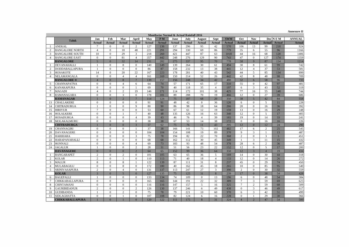
Jan Feb Mar April May P M June July August Sept SWM Oct Nov Dec N E M ANNUAL
Actual Actual Actual Actual Actual Actual Actual Actual Actual Actual Actual Actual Actual Actual Actual Actual
1 ANEKAL 7 0 0 2 127 136 137 296 95 42 570 106 13 99 218 924
2 BANGALORE NORTH 4 0 18 48 221 291 294 330 69 86 779 35 6 55 96 1166
3 BANGALORE SOUTH 10 0 29 3 218 260 421 447 87 63 1018 44 16 68 128 1406
4 BANGALORE EAST 0 0 81 4 357 442 248 276 129 90 743 47 0 127 174 1359
BANGALORE 5 0 32 14 231 282 275 337 95 70 778 58 9 87 154 1214
1 DEVANAHALLI 1 0 8 0 140 149 139 264 30 61 494 30 8 61 99 742
2 DODDABALLAPURA 1 0 0 0 86 87 158 232 13 38 441 12 4 37 53 581
3 HOSAKOTE 14 0 20 22 167 223 178 281 40 43 542 44 5 85 134 899
4 NELAMANGALA 0 0 4 4 161 169 150 214 52 26 442 42 8 48 98 709
BANGALORE ® 4 0 8 7 139 157 156 248 34 42 480 32 6 58 96 733
5 CHANNAPATNA 0 0 4 6 64 74 57 171 65 17 310 55 0 42 97 481
6 KANAKAPURA 0 0 0 1 69 70 40 118 35 4 197 6 3 43 52 319
7 MAGADI 4 0 2 19 146 171 114 172 101 38 425 77 16 55 148 744
8 RAMANAGARA 0 0 3 0 178 181 89 288 70 19 466 12 0 27 39 686
RAMANAGAR 1 0 2 7 114 124 75 187 68 20 350 38 5 42 84 558
13 CHALLAKERE 0 0 0 0 91 91 48 42 0 36 126 6 0 5 11 228
14 CHITRADURGA 1 0 0 9 80 90 86 98 18 64 266 20 0 16 36 392
15 HIRIYUR 7 0 0 0 53 60 67 61 12 19 159 13 0 16 29 248
16 HOLALKERE 0 0 1 7 40 48 135 126 16 63 340 12 0 5 17 405
17 HOSADURGA 0 0 0 4 39 43 46 76 4 39 165 19 0 14 33 241
18 MOLAKALMURU 0 0 0 0 38 38 67 53 14 38 172 0 0 16 16 226
CHITRADURGA 1 0 0 3 57 62 75 76 11 43 205 12 0 12 24 290
19 CHANNAGIRI 0 0 0 1 37 38 166 141 73 102 482 17 6 2 25 545
20 DAVANAGERE 0 0 0 0 104 104 154 108 19 89 370 9 3 1 13 487
21 HARIHARA 0 0 0 3 75 78 194 82 22 70 368 2 0 3 5 451
22 HARAPANAHALLI 0 0 0 0 68 68 162 112 30 45 349 1 3 11 15 432
23 HONNALI 0 0 0 4 69 73 183 93 48 54 378 28 6 2 36 487
24 JAGALUR 1 0 0 2 28 31 51 56 23 22 152 12 0 5 17 200
DAVANAGERE 0 0 0 2 64 65 152 99 36 64 350 12 3 4 19 434
1 BANGARAPET 2 0 2 0 101 105 63 65 36 5 169 14 0 30 44 318
2 KOLAR 2 0 1 0 110 113 71 40 18 4 133 12 0 14 26 272
3 MALUR 8 0 8 1 122 139 87 111 31 8 237 45 0 29 74 450
4 MULABAGILU 0 0 8 0 172 180 40 162 45 18 265 10 0 85 95 540
5 SRINIVASAPURA 2 0 4 0 131 137 113 247 27 3 390 2 0 30 32 559
KOLAR 3 0 5 0 127 135 75 125 31 8 239 17 0 38 54 428
6 BAGEPALLI 1 0 0 0 133 134 74 109 0 13 196 6 0 48 54 384
7 CHIKKABALLAPURA 0 0 0 0 165 165 144 191 22 32 389 7 3 59 69 623
8 CHINTAMANI 0 0 0 0 116 116 147 157 5 16 325 7 2 59 68 509
9 GAURIBIDANUR 2 0 0 2 126 130 137 246 6 49 438 0 3 46 49 617
10 GUDIBANDA 1 0 2 0 75 78 79 221 10 60 370 6 3 42 51 499
11 SIDLAGHATTA 0 0 1 0 107 108 82 124 6 16 228 0 1 29 30 366
CHIKKABALLAPURA 1 0 1 0 120 122 111 175 8 31 324 4 2 47 54 500
Monthwise Normal & Actual Rainfall 2016
Annexure II
Taluk
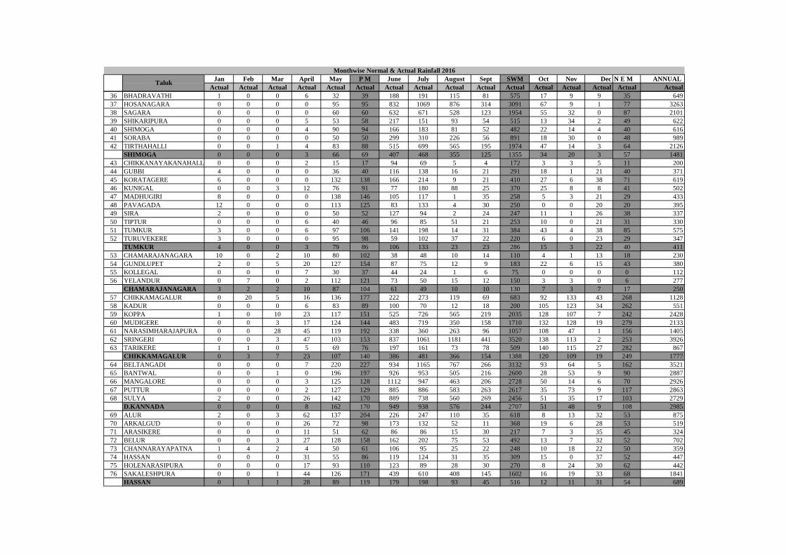
Jan Feb Mar April May P M June July August Sept SWM Oct Nov Dec N E M ANNUAL
Actual Actual Actual Actual Actual Actual Actual Actual Actual Actual Actual Actual Actual Actual Actual Actual
Monthwise Normal & Actual Rainfall 2016
Taluk
36 BHADRAVATHI 1 0 0 6 32 39 188 191 115 81 575 17 9 9 35 649
37 HOSANAGARA 0 0 0 0 95 95 832 1069 876 314 3091 67 9 1 77 3263
38 SAGARA 0 0 0 0 60 60 632 671 528 123 1954 55 32 0 87 2101
39 SHIKARIPURA 0 0 0 5 53 58 217 151 93 54 515 13 34 2 49 622
40 SHIMOGA 0 0 0 4 90 94 166 183 81 52 482 22 14 4 40 616
41 SORABA 0 0 0 0 50 50 299 310 226 56 891 18 30 0 48 989
42 TIRTHAHALLI 0 0 1 4 83 88 515 699 565 195 1974 47 14 3 64 2126
SHIMOGA 0 0 0 3 66 69 407 468 355 125 1355 34 20 3 57 1481
43 CHIKKANAYAKANAHALLI 0 0 0 2 15 17 94 69 5 4 172 3 3 5 11 200
44 GUBBI 4 0 0 0 36 40 116 138 16 21 291 18 1 21 40 371
45 KORATAGERE 6 0 0 0 132 138 166 214 9 21 410 27 6 38 71 619
46 KUNIGAL 0 0 3 12 76 91 77 180 88 25 370 25 8 8 41 502
47 MADHUGIRI 8 0 0 0 138 146 105 117 1 35 258 5 3 21 29 433
48 PAVAGADA 12 0 0 0 113 125 83 133 4 30 250 0 0 20 20 395
49 SIRA 2 0 0 0 50 52 127 94 2 24 247 11 1 26 38 337
50 TIPTUR 0 0 0 6 40 46 96 85 51 21 253 10 0 21 31 330
51 TUMKUR 3 0 0 6 97 106 141 198 14 31 384 43 4 38 85 575
52 TURUVEKERE 3 0 0 0 95 98 59 102 37 22 220 6 0 23 29 347
TUMKUR 4 0 0 3 79 86 106 133 23 23 286 15 3 22 40 411
53 CHAMARAJANAGARA 10 0 2 10 80 102 38 48 10 14 110 4 1 13 18 230
54 GUNDLUPET 2 0 5 20 127 154 87 75 12 9 183 22 6 15 43 380
55 KOLLEGAL 0 0 0 7 30 37 44 24 1 6 75 0 0 0 0 112
56 YELANDUR 0 7 0 2 112 121 73 50 15 12 150 3 3 0 6 277
CHAMARAJANAGARA 3 2 2 10 87 104 61 49 10 10 130 7 3 7 17 250
57 CHIKKAMAGALUR 0 20 5 16 136 177 222 273 119 69 683 92 133 43 268 1128
58 KADUR 0 0 0 6 83 89 100 70 12 18 200 105 123 34 262 551
59 KOPPA 1 0 10 23 117 151 525 726 565 219 2035 128 107 7 242 2428
60 MUDIGERE 0 0 3 17 124 144 483 719 350 158 1710 132 128 19 279 2133
61 NARASIMHARAJAPURA 0 0 28 45 119 192 338 360 263 96 1057 108 47 1 156 1405
62 SRINGERI 0 0 3 47 103 153 837 1061 1181 441 3520 138 113 2 253 3926
63 TARIKERE 1 1 0 5 69 76 197 161 73 78 509 140 115 27 282 867
CHIKKAMAGALUR 0 3 7 23 107 140 386 481 366 154 1388 120 109 19 249 1777
64 BELTANGADI 0 0 0 7 220 227 934 1165 767 266 3132 93 64 5 162 3521
65 BANTWAL 0 0 1 0 196 197 926 953 505 216 2600 28 53 9 90 2887
66 MANGALORE 0 0 0 3 125 128 1112 947 463 206 2728 50 14 6 70 2926
67 PUTTUR 0 0 0 2 127 129 885 886 583 263 2617 35 73 9 117 2863
68 SULYA 2 0 0 26 142 170 889 738 560 269 2456 51 35 17 103 2729
D.KANNADA 0 0 0 8 162 170 949 938 576 244 2707 51 48 9 108 2985
69 ALUR 2 0 3 62 137 204 226 247 110 35 618 8 13 32 53 875
70 ARKALGUD 0 0 0 26 72 98 173 132 52 11 368 19 6 28 53 519
71 ARASIKERE 0 0 0 11 51 62 86 86 15 30 217 7 3 35 45 324
72 BELUR 0 0 3 27 128 158 162 202 75 53 492 13 7 32 52 702
73 CHANNARAYAPATNA 1 4 2 4 50 61 106 95 25 22 248 10 18 22 50 359
74 HASSAN 0 0 0 31 55 86 119 124 31 35 309 15 0 37 52 447
75 HOLENARASIPURA 0 0 0 17 93 110 123 89 28 30 270 8 24 30 62 442
76 SAKALESHPURA 0 0 1 44 126 171 439 610 408 145 1602 16 19 33 68 1841
HASSAN 0 1 1 28 89 119 179 198 93 45 516 12 11 31 54 689

Jan Feb Mar April May P M June July August Sept SWM Oct Nov Dec N E M ANNUAL
Actual Actual Actual Actual Actual Actual Actual Actual Actual Actual Actual Actual Actual Actual Actual Actual
Monthwise Normal & Actual Rainfall 2016
Taluk
77 MADIKERI 0 0 6 35 157 198 799 762 653 307 2521 73 49 28 150 2869
78 SOMWARPET 0 0 0 6 115 121 467 537 484 188 1676 12 6 38 56 1853
79 VIRAJPET 0 0 0 5 132 137 372 389 210 92 1063 14 5 21 40 1240
KODAGU 0 0 2 15 135 152 546 563 449 196 1753 33 20 29 82 1987
80 KRISHNARAJAPET 0 0 0 1 95 96 96 77 40 25 238 51 24 30 105 439
81 MADDUR 0 5 0 14 75 94 56 174 84 35 349 30 4 50 84 527
82 MALAVALLI 0 0 0 37 55 92 71 127 31 32 261 61 0 53 114 467
83 MANDYA 1 0 0 2 47 50 39 98 75 54 266 11 3 24 38 354
84 NAGAMANGALA 2 0 0 0 54 56 55 129 42 41 267 13 2 29 44 367
85 PANDAVAPURA 5 0 0 1 58 64 77 73 58 30 238 35 0 32 67 369
86 SRIRANGAPATNA 1 0 0 5 69 75 71 105 42 20 238 14 0 38 52 365
MANDYA 1 1 0 9 65 75 66 112 53 34 265 31 5 37 72 413
87 HEGGADADEVANAKOTE 0 0 12 31 70 113 133 101 19 12 265 17 3 16 36 414
88 HUNSUR 0 0 19 3 102 124 66 78 0 0 144 0 0 18 18 286
89 KRISHNARAJANAGAR 1 0 1 0 144 146 106 87 13 8 214 18 1 26 45 405
90 MYSORE 2 0 0 11 74 87 56 125 23 8 212 23 1 31 55 354
91 NANJANAGUD 14 0 0 20 71 105 91 52 18 7 168 22 6 22 50 323
92 PERIYAPATNA 0 2 0 1 119 122 148 92 15 4 259 27 14 29 70 451
93 T.NARASIPURA 2 0 0 15 57 74 56 72 19 24 171 33 0 35 68 313
MYSORE 3 0 5 12 91 110 94 87 15 9 205 20 4 25 49 364
94 KARKALA 0 0 7 2 122 131 1168 1126 770 387 3451 86 34 7 127 3709
95 KUNDAPUR 0 0 0 0 134 134 1326 1051 656 283 3316 65 6 7 78 3528
96 UDUPI 0 0 0 0 33 33 1502 946 533 276 3257 65 0 0 65 3355
UDUPI 0 0 2 1 96 99 1332 1041 653 315 3341 72 13 5 90 3531
97 BELLARY 8 0 0 3 42 53 90 69 7 22 188 3 3 0 6 247
98 HADAGALI 0 0 0 0 38 38 146 80 65 57 348 0 0 6 6 392
99 HAGARIBOMMANAHALLI 0 0 0 1 65 66 134 47 25 65 271 0 0 10 10 347
100 HOSPET 0 0 0 0 47 47 183 64 35 35 317 3 0 1 4 368
101 KUDLIGI 0 0 0 2 32 34 113 49 15 36 213 9 1 3 13 260
102 SANDUR 0 0 0 0 31 31 125 48 28 53 254 5 0 10 15 300
103 SIRUGUPPA 1 0 2 52 29 84 49 26 46 196 317 44 2 9 55 456
BELLARY 1 0 0 8 41 50 120 55 32 66 273 9 1 6 16 339
104 AURAD 0 10 24 11 31 76 202 310 64 480 1056 84 0 0 84 1216
105 BASAVAKALYAN 0 5 12 8 27 52 192 261 80 452 985 119 0 0 119 1156
106 BHALKI 0 8 8 18 17 51 177 258 82 622 1139 50 0 0 50 1240
107 BIDAR 0 4 22 10 40 76 267 262 72 484 1085 87 0 0 87 1248
108 HUMNABAD 0 3 13 16 31 63 191 160 71 419 841 86 0 0 86 990
BIDAR 0 6 16 13 29 64 206 250 74 491 1021 85 0 0 85 1170
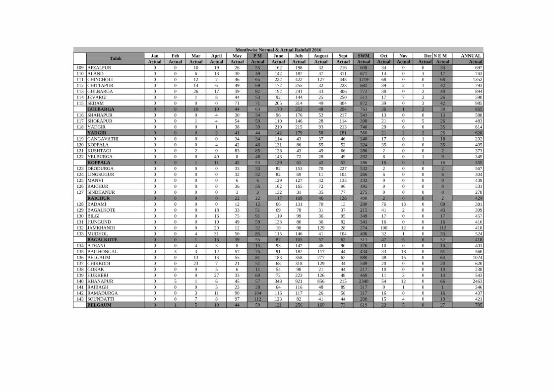
Jan Feb Mar April May P M June July August Sept SWM Oct Nov Dec N E M ANNUAL
Actual Actual Actual Actual Actual Actual Actual Actual Actual Actual Actual Actual Actual Actual Actual Actual
Monthwise Normal & Actual Rainfall 2016
Taluk
109 AFZALPUR 0 0 10 19 26 55 162 198 32 216 608 34 0 0 34 697
110 ALAND 0 0 6 13 30 49 142 187 37 311 677 14 0 3 17 743
111 CHINCHOLI 0 0 12 7 46 65 222 422 127 448 1219 68 0 0 68 1352
112 CHITTAPUR 0 0 14 6 49 69 172 255 32 223 682 39 2 1 42 793
113 GULBARGA 0 0 26 17 39 82 192 241 33 306 772 38 0 2 40 894
114 JEVARGI 0 0 1 8 44 53 92 144 25 250 511 17 7 2 26 590
115 SEDAM 0 0 0 0 71 71 205 314 49 304 872 39 0 3 42 985
GULBARGA 0 0 10 10 44 63 170 252 48 294 763 36 1 2 38 865
116 SHAHAPUR 0 0 0 4 30 34 96 176 52 217 541 13 0 0 13 588
117 SHORAPUR 0 0 1 4 54 59 110 146 28 114 398 21 0 5 26 483
118 YADGIR 0 0 0 1 38 39 219 215 93 213 740 29 6 0 35 814
YADGIR 0 0 0 3 41 44 142 179 58 181 560 21 2 2 25 628
119 GANGAVATHI 0 0 0 0 34 34 114 43 37 46 240 17 0 1 18 292
120 KOPPALA 0 0 0 4 42 46 131 86 55 52 324 35 0 0 35 405
121 KUSHTAGI 0 0 2 0 83 85 128 43 49 66 286 2 0 0 2 373
122 YELBURGA 0 0 0 40 8 48 143 72 28 49 292 8 0 1 9 349
KOPPALA 0 0 1 11 42 53 129 61 42 53 286 16 0 1 16 355
123 DEODURGA 0 0 0 0 33 33 82 153 70 227 532 2 0 0 2 567
124 LINGSUGUR 0 0 0 0 32 32 82 69 11 104 266 6 0 0 6 304
125 MANVI 0 0 0 0 6 6 129 127 42 135 433 0 0 0 0 439
126 RAICHUR 0 0 0 0 36 36 162 165 72 96 495 0 0 0 0 531
127 SINDHANUR 0 0 0 0 3 3 132 31 35 77 275 0 0 0 0 278
RAICHUR 0 0 0 0 22 22 117 109 46 128 400 2 0 0 2 424
128 BADAMI 0 0 0 0 12 12 66 131 70 13 280 76 13 0 89 381
129 BAGALKOTE 0 0 0 18 33 51 69 78 31 37 215 41 2 0 43 309
130 BILGI 0 0 0 16 75 91 119 99 36 95 349 17 0 0 17 457
131 HUNGUND 0 0 0 10 49 59 133 80 36 92 341 16 0 0 16 416
132 JAMKHANDI 0 0 0 20 12 32 19 98 129 28 274 100 12 0 112 418
133 MUDHOL 0 0 4 31 50 85 115 146 41 104 406 32 1 0 33 524
BAGALKOTE 0 0 1 16 39 55 87 105 57 62 311 47 5 0 52 418
134 ATHANI 0 0 4 3 8 15 93 147 46 90 376 10 0 0 10 401
135 BAILHONGAL 0 3 3 12 57 75 91 182 117 44 434 33 18 0 51 560
136 BELGAUM 0 0 13 13 55 81 183 358 277 62 880 48 15 0 63 1024
137 CHIKKODI 0 0 23 7 21 51 68 318 129 34 549 20 0 0 20 620
138 GOKAK 0 0 0 5 6 11 54 98 21 44 217 10 0 0 10 238
139 HUKKERI 0 0 0 27 33 60 72 223 126 48 469 11 3 0 14 543
140 KHANAPUR 0 5 1 6 45 57 348 921 856 215 2340 54 12 0 66 2463
141 RAIBAGH 0 0 0 5 23 28 64 116 48 89 317 0 1 0 1 346
142 RAMADURGA 0 0 3 11 90 104 116 117 26 58 317 16 0 0 16 437
143 SOUNDATTI 0 0 7 8 97 112 123 82 41 44 290 15 4 0 19 421
BELGAUM 0 1 5 10 44 59 121 256 169 73 619 22 5 0 27 705
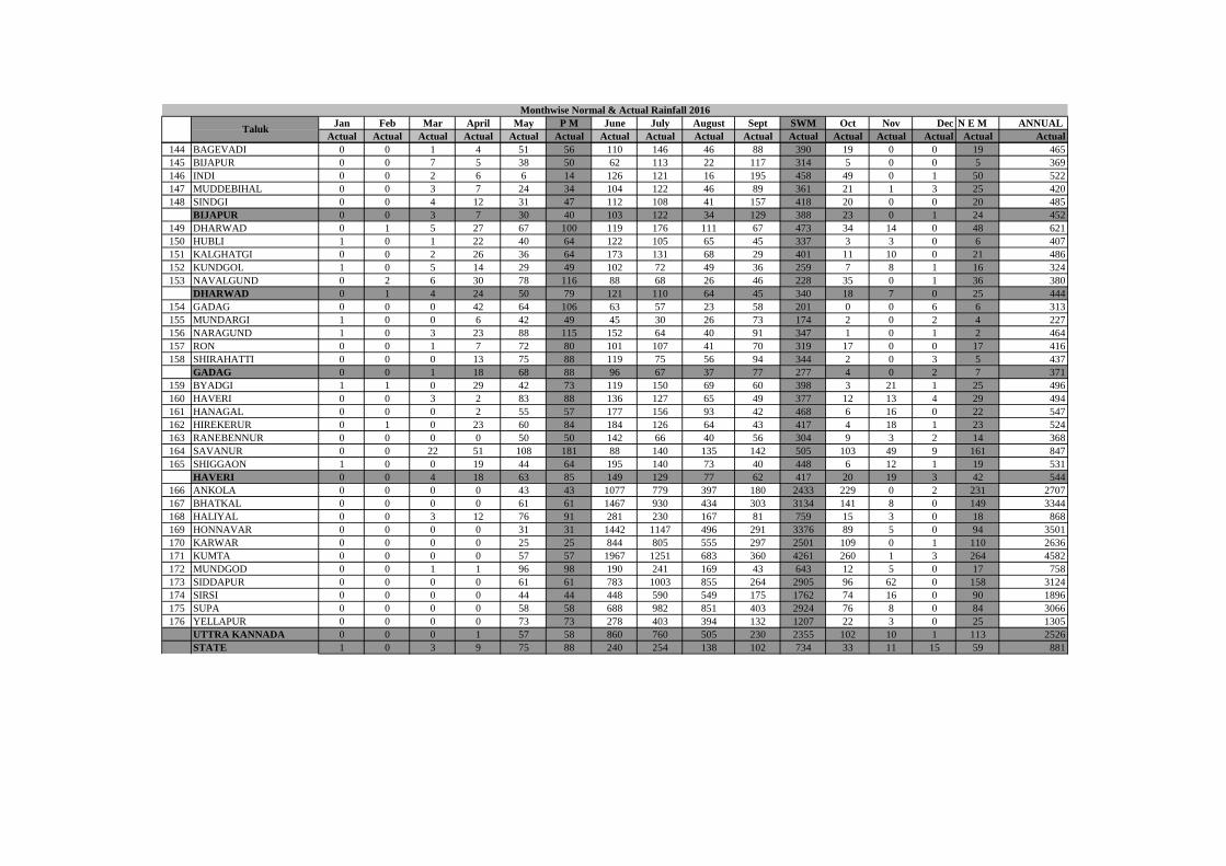
Jan Feb Mar April May P M June July August Sept SWM Oct Nov Dec N E M ANNUAL
Actual Actual Actual Actual Actual Actual Actual Actual Actual Actual Actual Actual Actual Actual Actual Actual
Monthwise Normal & Actual Rainfall 2016
Taluk
144 BAGEVADI 0 0 1 4 51 56 110 146 46 88 390 19 0 0 19 465
145 BIJAPUR 0 0 7 5 38 50 62 113 22 117 314 5 0 0 5 369
146 INDI 0 0 2 6 6 14 126 121 16 195 458 49 0 1 50 522
147 MUDDEBIHAL 0 0 3 7 24 34 104 122 46 89 361 21 1 3 25 420
148 SINDGI 0 0 4 12 31 47 112 108 41 157 418 20 0 0 20 485
BIJAPUR 0 0 3 7 30 40 103 122 34 129 388 23 0 1 24 452
149 DHARWAD 0 1 5 27 67 100 119 176 111 67 473 34 14 0 48 621
150 HUBLI 1 0 1 22 40 64 122 105 65 45 337 3 3 0 6 407
151 KALGHATGI 0 0 2 26 36 64 173 131 68 29 401 11 10 0 21 486
152 KUNDGOL 1 0 5 14 29 49 102 72 49 36 259 7 8 1 16 324
153 NAVALGUND 0 2 6 30 78 116 88 68 26 46 228 35 0 1 36 380
DHARWAD 0 1 4 24 50 79 121 110 64 45 340 18 7 0 25 444
154 GADAG 0 0 0 42 64 106 63 57 23 58 201 0 0 6 6 313
155 MUNDARGI 1 0 0 6 42 49 45 30 26 73 174 2 0 2 4 227
156 NARAGUND 1 0 3 23 88 115 152 64 40 91 347 1 0 1 2 464
157 RON 0 0 1 7 72 80 101 107 41 70 319 17 0 0 17 416
158 SHIRAHATTI 0 0 0 13 75 88 119 75 56 94 344 2 0 3 5 437
GADAG 0 0 1 18 68 88 96 67 37 77 277 4 0 2 7 371
159 BYADGI 1 1 0 29 42 73 119 150 69 60 398 3 21 1 25 496
160 HAVERI 0 0 3 2 83 88 136 127 65 49 377 12 13 4 29 494
161 HANAGAL 0 0 0 2 55 57 177 156 93 42 468 6 16 0 22 547
162 HIREKERUR 0 1 0 23 60 84 184 126 64 43 417 4 18 1 23 524
163 RANEBENNUR 0 0 0 0 50 50 142 66 40 56 304 9 3 2 14 368
164 SAVANUR 0 0 22 51 108 181 88 140 135 142 505 103 49 9 161 847
165 SHIGGAON 1 0 0 19 44 64 195 140 73 40 448 6 12 1 19 531
HAVERI 0 0 4 18 63 85 149 129 77 62 417 20 19 3 42 544
166 ANKOLA 0 0 0 0 43 43 1077 779 397 180 2433 229 0 2 231 2707
167 BHATKAL 0 0 0 0 61 61 1467 930 434 303 3134 141 8 0 149 3344
168 HALIYAL 0 0 3 12 76 91 281 230 167 81 759 15 3 0 18 868
169 HONNAVAR 0 0 0 0 31 31 1442 1147 496 291 3376 89 5 0 94 3501
170 KARWAR 0 0 0 0 25 25 844 805 555 297 2501 109 0 1 110 2636
171 KUMTA 0 0 0 0 57 57 1967 1251 683 360 4261 260 1 3 264 4582
172 MUNDGOD 0 0 1 1 96 98 190 241 169 43 643 12 5 0 17 758
173 SIDDAPUR 0 0 0 0 61 61 783 1003 855 264 2905 96 62 0 158 3124
174 SIRSI 0 0 0 0 44 44 448 590 549 175 1762 74 16 0 90 1896
175 SUPA 0 0 0 0 58 58 688 982 851 403 2924 76 8 0 84 3066
176 YELLAPUR 0 0 0 0 73 73 278 403 394 132 1207 22 3 0 25 1305
UTTRA KANNADA 0 0 0 1 57 58 860 760 505 230 2355 102 10 1 113 2526
STATE 1 0 3 9 75 88 240 254 138 102 734 33 11 15 59 881
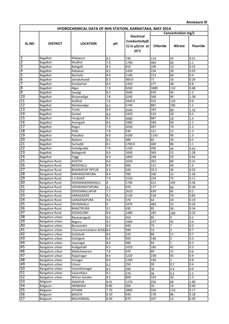
Chloride Nitrate Fluoride
1 Bagalkot Malapura 8.2 730 114 45 0.512 Bagalkot Mudhol 7.9 1790 469 60 1.13 Bagalkot Belagalli 8.3 810 106 10 0.25
4 Bagalkot Rabakavi 8.2 1430 234 30 0.93
5 Bagalkot Banhatti 8.9 1140 213 60 0.4
6 Bagalkot Jamakahandi 8.3 360.0 71 16 0.24
7 Bagalkot Kumbarhal 8.4 1450 277 48 0.8
8 Bagalkot Algur 7.9 8260 1889 110 0.68
9 Bagalkot Savalgi 8.3 2640 639 40 1.2
10 Bagalkot Binjawadige 7.8 3240 568 90 1.38
11 Bagalkot Kodihal 7.6 3440.0 923 110 0.9
12 Bagalkot Nandwadige 8.5 5740 887 106 1.5
13 Bagalkot Tumb 8.9 2540 263 80 1.5214 Bagalkot Gorbal 8.6 2420 533 20 0.5
15 Bagalkot Hungund 8.2 4080 887 18 1.416 Bagalkot Amingarh 8.6 2480 589 69 1.2
17 Bagalkot Nagur 7.9 2630 497 74 1.5
18 Bagalkot IIHAL 7.8 530 121 12 1.3
19 Bagalkot Patadkal 8.0 4100 1143 90 1.3
20 Bagalkot Badami 8.2 480 85 36 0.5
21 Bagalkot Sumaddi 8.1 1700.0 469 86 1.1
22 Bagalkot Guledgudda 7.9 1230 206 36 0.6323 Bagalkot Badagandi 8.6 1690 369 52 1.28
24 Bagalkot Teggi 8.4 1850 248 59 0.64
25 Bangalore Rural AVATHI 8.6 1650 263 80 0.31
26 Bangalore Rural BAGEHALLI 8.9 600 121 46 1.6
27 Bangalore Rural BHAIRAPUR TIPTUR 8.3 420 35.5 36 0.55
28 Bangalore Rural MAHADEVAPURA 8.4 780 106 22 1.56
29 Bangalore Rural S S GHATI 7.9 1520 234 75 0.11
30 Bangalore Rural SIDDANAIKANAHALLI 8 1740 412 105 0.36
31 Bangalore Rural VISHWANATHPURA 8.1 970 177 90 0.26
32 Bangalore Rural DODDABALLAPUR 7.7 2610 639 85 0.2
33 Bangalore Rural HARAGADDE 8.1 2130 518 70 0.85
34 Bangalore Rural GANGENAPURA 9.0 370 64 20 0.19
35 Bangalore Rural DEVNAHALLI 8 1970 483 32 0.26
36 Bangalore Rural BHAKTIPURA 9.1 430 85 36 0.34
37 Bangalore Rural KODAGURKI 8.6 1480 185 100 0.22
38 Bangalore urban Basavanagudi 8.4 450 85 9 0.239 Bangalore urban Beguru 8.1 1060 227 45 0.440 Bangalore urban Byrasandra 8.4 440 75 7 0.3
41 Bangalore urban Chennammankere Achkattu8.6 390 53 2 0.7
42 Bangalore urban Gollahalli 8.6 520 89 11 0.7
43 Bangalore urban Gottigere 8.4 920 146 2 0.3
44 Bangalore urban Jayanagar 8.6 480 64 1 0.3
45 Bangalore urban Kodigehalli 8.5 1010 185 41 0.3
46 Bangalore urban Malleshwaram 7.6 470 89 21 0.6
47 Bangalore urban Rajajinagar 8.4 1220 238 45 0.9
48 Bangalore urban Srinagar 8.0 1240 330 2 0.8
49 Bangalore urban Ulsoor 8.2 250 39 0.2 0.4
50 Bangalore urban Vasanthanagar 8.3 290 36 0.4 0.951 Bangalore urban Vasanthpur 8.1 270 36 0.2 1.252 Bangalore urban Wilson Garden 8.5 600 103 20 1.5
53 Belgaum AINAPUR 8.01 1270 256 68 1.8054 Belgaum ARABHAVI 8.90 300 50 14 0.40
55 Belgaum ATHANI 7.70 2800 550 110 0.17
56 Belgaum BADCHI 8.10 930 178 86 0.18
57 Belgaum BAILHONGAL 8.30 670 107 12 0.30
Concentration mg/LHYDROCHEMICAL DATA OF NHS STATION, KARNATAKA, MAY 2014
SL.NO DISTRICT LOCATION pH
Electrical
Conductivity(E
C) in µS/cm at
25°C
Annexure III
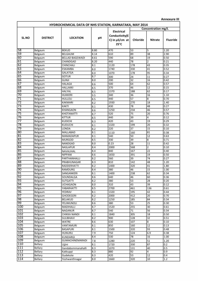
Chloride Nitrate Fluoride
Concentration mg/LHYDROCHEMICAL DATA OF NHS STATION, KARNATAKA, MAY 2014
SL.NO DISTRICT LOCATION pH
Electrical
Conductivity(E
C) in µS/cm at
25°C
Annexure III
58 Belgaum BEKUD 8.80 470 53 5 1.20
59 Belgaum BELGAUM 8.14 610 89 38 2.90
60 Belgaum BELLAD BAGEWADI 8.61 590 68 19 0.50
61 Belgaum CHANDGAD 8.20 440 78 2 0.21
62 Belgaum CHINCHALI 8.1 1120 178 43 0.35
63 Belgaum ESKAMBA 8.0 1740 330 41 0.52
64 Belgaum GALATGA 8.0 1070 178 95 0.3465 Belgaum GOTUR 8.7 300 24 11 0.2766 Belgaum GUNJI 8.0 200 32 16 0.42
67 Belgaum HALAGA 8.6 500 64 62 0.57
68 Belgaum HALLAKKI 8.5 370 46 12 0.15
69 Belgaum HALYAL 8.5 1370 188 62 0.17
70 Belgaum HUKKERI 9.5 340 36 16 1.10
71 Belgaum HULLOLI 8.5 440 57 8 0.70
72 Belgaum KAKMARI 8.2 1930 270 18 1.40
73 Belgaum KAKTI 8.1 430 78 48 0.27
74 Belgaum KHANGAON 8.6 1250 234 46 0.57
75 Belgaum KHOTANATTI 8.7 520 75 20 0.76
76 Belgaum KITTUR 8.5 440 39 4 0.12
77 Belgaum KUDICHI 8.3 420 43 19 0.29
78 Belgaum KUDUCHI 8.1 1320 199 20 0.32
79 Belgaum LONDA 8.2 220 37 15 0.10
80 Belgaum MALLABAD 8.1 1110 160 81 0.3881 Belgaum MAMADAPUR 8.1 540 50 12 0.63
82 Belgaum MURGOD 8.5 330 39 8 0.71
83 Belgaum NANDGAD 8.0 0.23 28 11 0.42
84 Belgaum NASLAPUR 8.4 2000 568 2 0.10
85 Belgaum NAVALIHAL 8.4 840 167 22 0.40
86 Belgaum NIPPANI 8.6 1650 391 19 0.50
87 Belgaum PARTHANHALLI 8.2 560 39 74 0.27
88 Belgaum PRABHUNAGAR 8.3 810 142 48 1.20
89 Belgaum RADDERHATTI 8.2 1400 320 41 1.80
90 Belgaum RAMDURG 8.4 380 46 15 1.00
91 Belgaum SANGANKERI 8.1 1400 238 62 0.34
92 Belgaum SOUNDALGA 8.6 640 46 60 0.36
93 Belgaum SUTGATTI 8.2 380 53 28 0.20
94 Belgaum UCHAGAON 8.0 310 43 39 0.12
95 Belgaum YABARHATTI 8.5 2700 461 136 0.61
96 Belgaum YEDRAV 8.1 1320 195 42 0.44
97 Belgaum GHODEGERI 8.2 2000 412 20 0.70
98 Belgaum BELAKUD 8.2 1250 185 84 0.34
99 Belgaum YELIMUNOLI 8.6 380 53 25 0.30
100 Belgaum MADIHALLI 8.7 1520 255 30 0.61
101 Belgaum NAGANUR 8.7 540 71 56 0.34
102 Belgaum CHIKKA NANDI 8.1 1840 305 18 0.50
103 Belgaum SULIBHAVI 8.2 900 128 32 0.51
104 Belgaum WATRE 8.6 630 107 8 0.10
105 Belgaum VANTAMURI 8.1 850 160 12 0.13
106 Belgaum BASAPURI 8.1 1500 320 93 0.48
107 Belgaum HUNURU 7.9 750 124 6.9 0.38
108 Belgaum KUNDARGI 8.4 530 78 16 1.00
109 Belgaum GUMACHINEMARADI 7.8 1280 220 51 1.20110 Bellary Ujjini 8.1 1720 330 87 0.2111 Bellary Gandabommanahalli 8.3 1070 131 40 0.5112 Bellary Kakkuppi 8.3 880 92 4 0.9
113 Bellary Gudekote 8.3 420 53 12 0.4
114 Bellary Yeshwanthnagar 8.0 1660 320 10 1.2
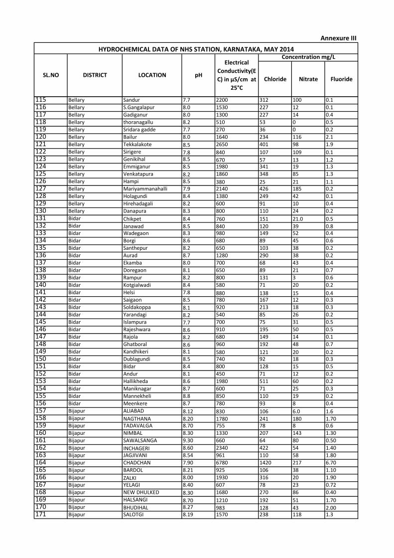
Chloride Nitrate Fluoride
Concentration mg/LHYDROCHEMICAL DATA OF NHS STATION, KARNATAKA, MAY 2014
SL.NO DISTRICT LOCATION pH
Electrical
Conductivity(E
C) in µS/cm at
25°C
Annexure III
115 Bellary Sandur 7.7 2200 312 100 0.1
116 Bellary S.Gangalapur 8.0 1530 227 12 0.1
117 Bellary Gadiganur 8.0 1300 227 14 0.4
118 Bellary thoranagallu 8.2 510 53 0 0.5
119 Bellary Sridara gadde 7.7 270 36 0 0.2
120 Bellary Bailur 8.0 1640 234 116 2.1
121 Bellary Tekkalakote 8.5 2650 401 98 1.9
122 Bellary Sirigere 7.8 840 107 109 0.1123 Bellary Genikihal 8.5 670 57 13 1.2124 Bellary Emmiganur 8.5 1980 341 19 1.3
125 Bellary Venkatapura 8.2 1860 348 85 1.3
126 Bellary Hampi 8.5 380 25 21 1.1127 Bellary Mariyammanahalli 7.9 2140 426 185 0.2
128 Bellary Holagundi 8.4 1380 249 42 0.1
129 Bellary Hirehadagali 8.2 600 91 10 0.4
130 Bellary Danapura 8.3 800 110 24 0.2
131 Bidar Chikpet 8.4 760 151 21.0 0.5132 Bidar Janawad 8.5 840 120 39 0.8133 Bidar Wadegaon 8.3 980 149 52 0.4
134 Bidar Borgi 8.6 680 89 45 0.6
135 Bidar Santhepur 8.2 650 103 38 0.2
136 Bidar Aurad 8.7 1280 290 38 0.2
137 Bidar Ekamba 8.0 700 68 43 0.4
138 Bidar Doregaon 8.1 650 89 21 0.7
139 Bidar Rampur 8.2 800 131 3 0.6
140 Bidar Kotgialwadi 8.4 580 71 20 0.2
141 Bidar Helsi 7.8 880 138 15 0.4142 Bidar Saigaon 8.5 780 167 12 0.3
143 Bidar Soldakoppa 8.1 920 213 18 0.3
144 Bidar Yarandagi 8.2 540 85 26 0.2
145 Bidar Islampura 7.7 700 75 31 0.5
146 Bidar Rajeshwara 8.6 910 195 50 0.5
147 Bidar Rajola 8.2 680 149 14 0.1
148 Bidar Ghatboral 8.6 960 192 48 0.7
149 Bidar Kandhikeri 8.1 580 121 20 0.2150 Bidar Dublagundi 8.5 740 92 18 0.3
151 Bidar Bidar 8.4 800 128 15 0.5
152 Bidar Andur 8.1 450 71 12 0.2
153 Bidar Hallikheda 8.6 1980 511 60 0.2
154 Bidar Maniknagar 8.7 600 71 25 0.3
155 Bidar Mannekheli 8.8 850 110 19 0.2
156 Bidar Meenkere 8.7 780 93 8 0.4
157 Bijapur ALIABAD 8.12 830 106 6.0 1.6158 Bijapur NAGTHANA 8.20 1780 241 180 1.70159 Bijapur TADAVALGA 8.70 755 78 8 0.6
160 Bijapur NIMBAL 8.30 1330 207 143 1.30
161 Bijapur SAWALSANGA 9.30 660 64 80 0.50
162 Bijapur INCHAGERI 8.60 2340 422 54 1.40
163 Bijapur JAGJIVANI 8.54 961 110 58 1.80
164 Bijapur CHADCHAN 7.90 6780 1420 217 6.70
165 Bijapur BARDOL 8.21 925 106 38 1.10
166 Bijapur ZALKI 8.00 1930 316 20 1.90
167 Bijapur YELAGI 8.40 607 78 23 0.72
168 Bijapur NEW DHULKED 8.30 1680 270 86 0.40
169 Bijapur HALSANGI 8.70 1210 192 51 1.70170 Bijapur BHUDIHAL 8.27 983 128 43 2.00171 Bijapur SALOTGI 8.19 1570 238 118 1.3
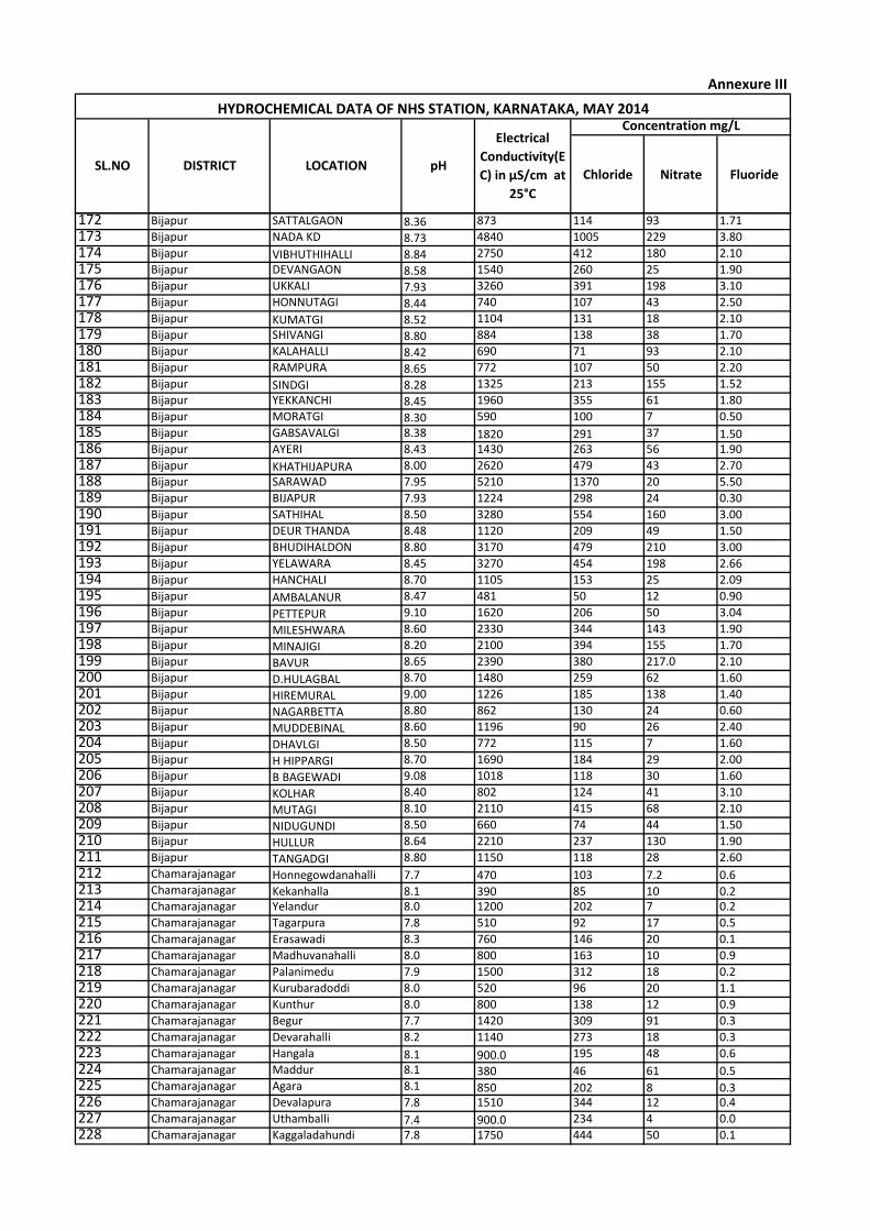
Chloride Nitrate Fluoride
Concentration mg/LHYDROCHEMICAL DATA OF NHS STATION, KARNATAKA, MAY 2014
SL.NO DISTRICT LOCATION pH
Electrical
Conductivity(E
C) in µS/cm at
25°C
Annexure III
172 Bijapur SATTALGAON 8.36 873 114 93 1.71
173 Bijapur NADA KD 8.73 4840 1005 229 3.80
174 Bijapur VIBHUTHIHALLI 8.84 2750 412 180 2.10
175 Bijapur DEVANGAON 8.58 1540 260 25 1.90
176 Bijapur UKKALI 7.93 3260 391 198 3.10
177 Bijapur HONNUTAGI 8.44 740 107 43 2.50
178 Bijapur KUMATGI 8.52 1104 131 18 2.10
179 Bijapur SHIVANGI 8.80 884 138 38 1.70
180 Bijapur KALAHALLI 8.42 690 71 93 2.10
181 Bijapur RAMPURA 8.65 772 107 50 2.20
182 Bijapur SINDGI 8.28 1325 213 155 1.52
183 Bijapur YEKKANCHI 8.45 1960 355 61 1.80
184 Bijapur MORATGI 8.30 590 100 7 0.50
185 Bijapur GABSAVALGI 8.38 1820 291 37 1.50186 Bijapur AYERI 8.43 1430 263 56 1.90
187 Bijapur KHATHIJAPURA 8.00 2620 479 43 2.70
188 Bijapur SARAWAD 7.95 5210 1370 20 5.50
189 Bijapur BIJAPUR 7.93 1224 298 24 0.30
190 Bijapur SATHIHAL 8.50 3280 554 160 3.00
191 Bijapur DEUR THANDA 8.48 1120 209 49 1.50
192 Bijapur BHUDIHALDON 8.80 3170 479 210 3.00
193 Bijapur YELAWARA 8.45 3270 454 198 2.66
194 Bijapur HANCHALI 8.70 1105 153 25 2.09
195 Bijapur AMBALANUR 8.47 481 50 12 0.90
196 Bijapur PETTEPUR 9.10 1620 206 50 3.04
197 Bijapur MILESHWARA 8.60 2330 344 143 1.90
198 Bijapur MINAJIGI 8.20 2100 394 155 1.70
199 Bijapur BAVUR 8.65 2390 380 217.0 2.10
200 Bijapur D.HULAGBAL 8.70 1480 259 62 1.60
201 Bijapur HIREMURAL 9.00 1226 185 138 1.40
202 Bijapur NAGARBETTA 8.80 862 130 24 0.60
203 Bijapur MUDDEBINAL 8.60 1196 90 26 2.40
204 Bijapur DHAVLGI 8.50 772 115 7 1.60
205 Bijapur H HIPPARGI 8.70 1690 184 29 2.00
206 Bijapur B BAGEWADI 9.08 1018 118 30 1.60
207 Bijapur KOLHAR 8.40 802 124 41 3.10
208 Bijapur MUTAGI 8.10 2110 415 68 2.10
209 Bijapur NIDUGUNDI 8.50 660 74 44 1.50
210 Bijapur HULLUR 8.64 2210 237 130 1.90
211 Bijapur TANGADGI 8.80 1150 118 28 2.60
212 Chamarajanagar Honnegowdanahalli 7.7 470 103 7.2 0.6213 Chamarajanagar Kekanhalla 8.1 390 85 10 0.2214 Chamarajanagar Yelandur 8.0 1200 202 7 0.2
215 Chamarajanagar Tagarpura 7.8 510 92 17 0.5
216 Chamarajanagar Erasawadi 8.3 760 146 20 0.1
217 Chamarajanagar Madhuvanahalli 8.0 800 163 10 0.9
218 Chamarajanagar Palanimedu 7.9 1500 312 18 0.2
219 Chamarajanagar Kurubaradoddi 8.0 520 96 20 1.1
220 Chamarajanagar Kunthur 8.0 800 138 12 0.9
221 Chamarajanagar Begur 7.7 1420 309 91 0.3
222 Chamarajanagar Devarahalli 8.2 1140 273 18 0.3
223 Chamarajanagar Hangala 8.1 900.0 195 48 0.6
224 Chamarajanagar Maddur 8.1 380 46 61 0.5225 Chamarajanagar Agara 8.1 850 202 8 0.3226 Chamarajanagar Devalapura 7.8 1510 344 12 0.4
227 Chamarajanagar Uthamballi 7.4 900.0 234 4 0.0
228 Chamarajanagar Kaggaladahundi 7.8 1750 444 50 0.1
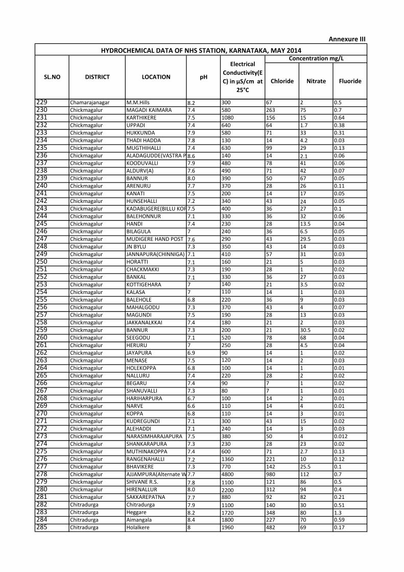
Chloride Nitrate Fluoride
Concentration mg/LHYDROCHEMICAL DATA OF NHS STATION, KARNATAKA, MAY 2014
SL.NO DISTRICT LOCATION pH
Electrical
Conductivity(E
C) in µS/cm at
25°C
Annexure III
229 Chamarajanagar M.M.Hills 8.2 300 67 2 0.5
230 Chickmagalur MAGADI KAIMARA 7.4 580 263 75 0.7
231 Chickmagalur KARTHIKERE 7.5 1080 156 15 0.64
232 Chickmagalur UPPADI 7.4 640 64 1.7 0.38
233 Chickmagalur HUKKUNDA 7.9 580 71 33 0.31
234 Chickmagalur THADI HADDA 7.8 130 14 4.2 0.03
235 Chickmagalur MUGTHIHALLI 7.4 630 99 29 0.13
236 Chickmagalur ALADAGUDDE(VASTRA POST)8.6 140 14 2.1 0.06
237 Chickmagalur KOODUVALLI 7.9 480 78 41 0.06
238 Chickmagalur ALDURV(A) 7.6 490 71 42 0.07
239 Chickmagalur BANNUR 8.0 390 50 67 0.05
240 Chickmagalur ARENURU 7.7 370 28 26 0.11
241 Chickmagalur KANATI 7.5 200 14 17 0.05
242 Chickmagalur HUNSEHALLI 7.2 340 43 24 0.05
243 Chickmagalur KADABUGERE(BILLU KOPPA)7.5 400 36 27 0.1
244 Chickmagalur BALEHONNUR 7.1 330 36 32 0.06
245 Chickmagalur HANDI 7.4 230 28 13.5 0.04
246 Chickmagalur BILAGULA 7 240 36 6.5 0.05
247 Chickmagalur MUDIGERE HAND POST 7.6 290 43 29.5 0.03
248 Chickmagalur JN BYLU 7.3 350 43 14 0.03
249 Chickmagalur JANNAPURA(CHINNIGA) 7.1 410 57 31 0.03
250 Chickmagalur HORATTI 7.1 160 21 5 0.03
251 Chickmagalur CHACKMAKKI 7.3 190 28 1 0.02
252 Chickmagalur BANKAL 7.1 330 36 27 0.03
253 Chickmagalur KOTTIGEHARA 7 140 21 3.5 0.02
254 Chickmagalur KALASA 7 110 14 1 0.03
255 Chickmagalur BALEHOLE 6.8 220 36 9 0.03
256 Chickmagalur MAHALGODU 7.3 370 43 4 0.07
257 Chickmagalur MAGUNDI 7.5 190 28 13 0.03
258 Chickmagalur JAKKANALKKAI 7.4 180 21 2 0.03
259 Chickmagalur BANNUR 7.3 200 21 30.5 0.02
260 Chickmagalur SEEGODU 7.1 520 78 68 0.04
261 Chickmagalur HERURU 7 250 28 4.5 0.04
262 Chickmagalur JAYAPURA 6.9 90 14 1 0.02
263 Chickmagalur MENASE 7.5 120 14 2 0.03
264 Chickmagalur HOLEKOPPA 6.8 100 14 1 0.01
265 Chickmagalur NALLURU 7.4 220 28 2 0.02
266 Chickmagalur BEGARU 7.4 90 7 1 0.02
267 Chickmagalur SHANUVALLI 7.3 80 7 1 0.01
268 Chickmagalur HARIHARPURA 6.7 100 14 2 0.01
269 Chickmagalur NARVE 6.6 110 14 4 0.01
270 Chickmagalur KOPPA 6.8 110 14 3 0.01
271 Chickmagalur KUDREGUNDI 7.1 300 43 15 0.02
272 Chickmagalur ALEHADDI 7.1 240 14 3 0.03
273 Chickmagalur NARASIMHARAJAPURA 7.5 380 50 4 0.012
274 Chickmagalur SHANKARAPURA 7.3 230 28 23 0.02
275 Chickmagalur MUTHINAKOPPA 7.4 600 71 2.7 0.13
276 Chickmagalur RANGENAHALLI 7.2 1360 221 10 0.12
277 Chickmagalur BHAVIKERE 7.3 770 142 25.5 0.1
278 Chickmagalur AJJAMPURA(Alternate Well)7.7 4800 980 112 0.7
279 Chickmagalur SHIVANE R.S. 7.8 1100 121 86 0.5
280 Chickmagalur HIRENALLUR 8.0 2200 312 94 0.4
281 Chickmagalur SAKKAREPATNA 7.7 880 92 82 0.21
282 Chitradurga Chitradurga 7.9 1100 140 30 0.51283 Chitradurga Heggare 8.2 1720 348 80 1.3284 Chitradurga Aimangala 8.4 1800 227 70 0.59
285 Chitradurga Holalkere 8 1960 482 69 0.17
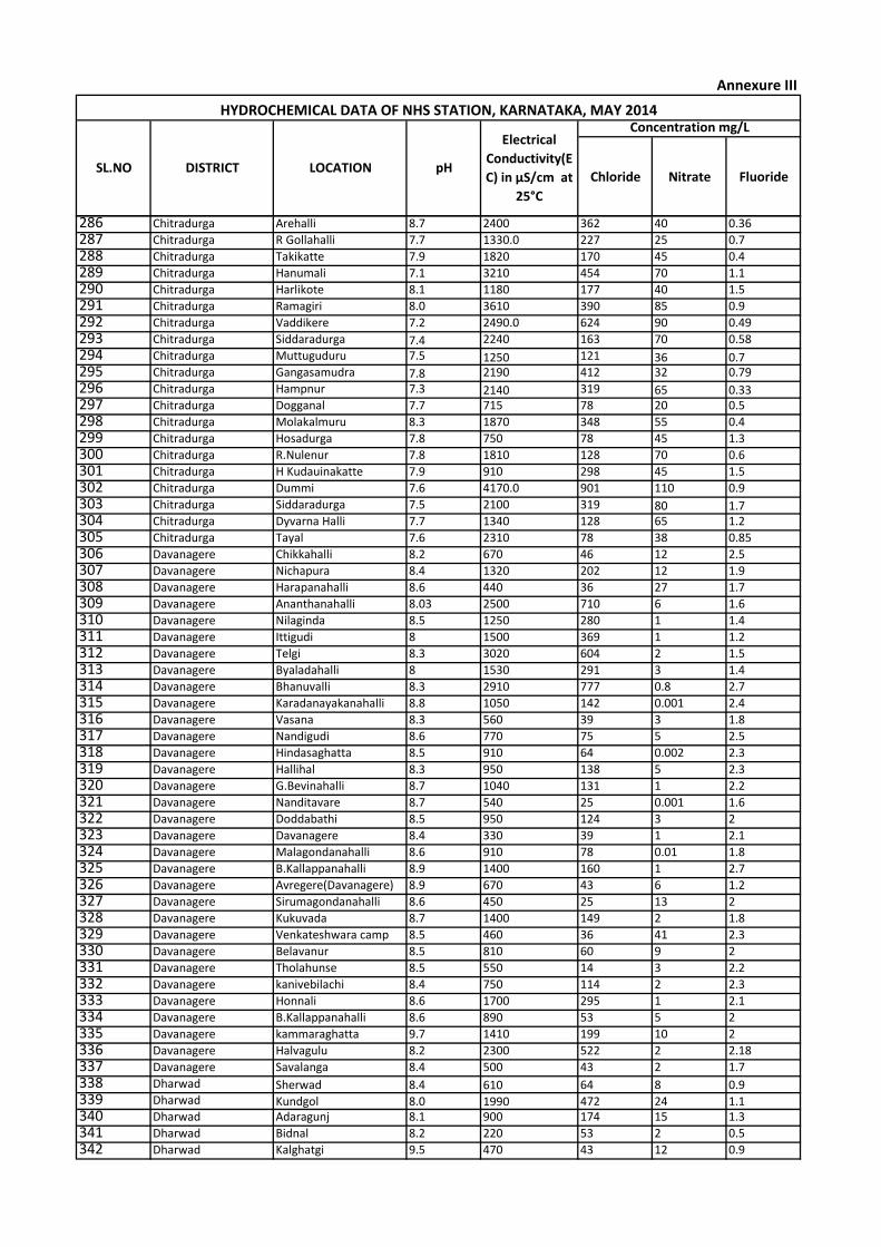
Chloride Nitrate Fluoride
Concentration mg/LHYDROCHEMICAL DATA OF NHS STATION, KARNATAKA, MAY 2014
SL.NO DISTRICT LOCATION pH
Electrical
Conductivity(E
C) in µS/cm at
25°C
Annexure III
286 Chitradurga Arehalli 8.7 2400 362 40 0.36
287 Chitradurga R Gollahalli 7.7 1330.0 227 25 0.7
288 Chitradurga Takikatte 7.9 1820 170 45 0.4
289 Chitradurga Hanumali 7.1 3210 454 70 1.1
290 Chitradurga Harlikote 8.1 1180 177 40 1.5
291 Chitradurga Ramagiri 8.0 3610 390 85 0.9
292 Chitradurga Vaddikere 7.2 2490.0 624 90 0.49
293 Chitradurga Siddaradurga 7.4 2240 163 70 0.58
294 Chitradurga Muttuguduru 7.5 1250 121 36 0.7295 Chitradurga Gangasamudra 7.8 2190 412 32 0.79
296 Chitradurga Hampnur 7.3 2140 319 65 0.33297 Chitradurga Dogganal 7.7 715 78 20 0.5
298 Chitradurga Molakalmuru 8.3 1870 348 55 0.4
299 Chitradurga Hosadurga 7.8 750 78 45 1.3
300 Chitradurga R.Nulenur 7.8 1810 128 70 0.6
301 Chitradurga H Kudauinakatte 7.9 910 298 45 1.5
302 Chitradurga Dummi 7.6 4170.0 901 110 0.9
303 Chitradurga Siddaradurga 7.5 2100 319 80 1.7304 Chitradurga Dyvarna Halli 7.7 1340 128 65 1.2
305 Chitradurga Tayal 7.6 2310 78 38 0.85
306 Davanagere Chikkahalli 8.2 670 46 12 2.5
307 Davanagere Nichapura 8.4 1320 202 12 1.9
308 Davanagere Harapanahalli 8.6 440 36 27 1.7
309 Davanagere Ananthanahalli 8.03 2500 710 6 1.6
310 Davanagere Nilaginda 8.5 1250 280 1 1.4
311 Davanagere Ittigudi 8 1500 369 1 1.2
312 Davanagere Telgi 8.3 3020 604 2 1.5
313 Davanagere Byaladahalli 8 1530 291 3 1.4
314 Davanagere Bhanuvalli 8.3 2910 777 0.8 2.7
315 Davanagere Karadanayakanahalli 8.8 1050 142 0.001 2.4
316 Davanagere Vasana 8.3 560 39 3 1.8
317 Davanagere Nandigudi 8.6 770 75 5 2.5
318 Davanagere Hindasaghatta 8.5 910 64 0.002 2.3
319 Davanagere Hallihal 8.3 950 138 5 2.3
320 Davanagere G.Bevinahalli 8.7 1040 131 1 2.2
321 Davanagere Nanditavare 8.7 540 25 0.001 1.6
322 Davanagere Doddabathi 8.5 950 124 3 2
323 Davanagere Davanagere 8.4 330 39 1 2.1
324 Davanagere Malagondanahalli 8.6 910 78 0.01 1.8
325 Davanagere B.Kallappanahalli 8.9 1400 160 1 2.7
326 Davanagere Avregere(Davanagere) 8.9 670 43 6 1.2
327 Davanagere Sirumagondanahalli 8.6 450 25 13 2
328 Davanagere Kukuvada 8.7 1400 149 2 1.8
329 Davanagere Venkateshwara camp 8.5 460 36 41 2.3
330 Davanagere Belavanur 8.5 810 60 9 2
331 Davanagere Tholahunse 8.5 550 14 3 2.2
332 Davanagere kanivebilachi 8.4 750 114 2 2.3
333 Davanagere Honnali 8.6 1700 295 1 2.1
334 Davanagere B.Kallappanahalli 8.6 890 53 5 2
335 Davanagere kammaraghatta 9.7 1410 199 10 2
336 Davanagere Halvagulu 8.2 2300 522 2 2.18
337 Davanagere Savalanga 8.4 500 43 2 1.7
338 Dharwad Sherwad 8.4 610 64 8 0.9339 Dharwad Kundgol 8.0 1990 472 24 1.1340 Dharwad Adaragunj 8.1 900 174 15 1.3
341 Dharwad Bidnal 8.2 220 53 2 0.5
342 Dharwad Kalghatgi 9.5 470 43 12 0.9
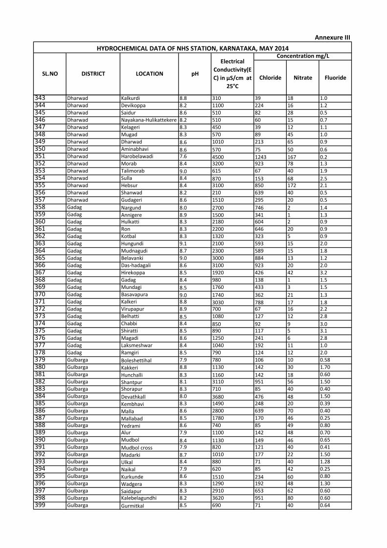
Chloride Nitrate Fluoride
Concentration mg/LHYDROCHEMICAL DATA OF NHS STATION, KARNATAKA, MAY 2014
SL.NO DISTRICT LOCATION pH
Electrical
Conductivity(E
C) in µS/cm at
25°C
Annexure III
343 Dharwad Kalkurdi 8.8 310 39 18 1.0
344 Dharwad Devikoppa 8.2 1100 224 16 1.2
345 Dharwad Saidur 8.6 510 82 28 0.5
346 Dharwad Nayakana-Hulikattekere 8.2 510 60 15 0.7
347 Dharwad Kelageri 8.3 450 39 12 1.1
348 Dharwad Mugad 8.3 570 89 45 1.0
349 Dharwad Dharwad 8.6 1010 213 65 0.9
350 Dharwad Aminabhavi 8.6 570 75 50 0.6351 Dharwad Harobelawadi 7.6 4500 1243 167 0.2352 Dharwad Morab 8.4 3200 923 78 1.3
353 Dharwad Talimorab 9.0 615 67 40 1.9
354 Dharwad Sulla 8.4 870 153 68 2.5355 Dharwad Hebsur 8.4 3100 850 172 2.1
356 Dharwad Shanwad 8.2 210 639 40 0.5
357 Dharwad Gudageri 8.6 1510 295 20 0.5
358 Gadag Nargund 8.0 2700 746 2 1.4359 Gadag Annigere 8.9 1500 341 1 1.3360 Gadag Hulkatti 8.3 2180 604 2 0.9
361 Gadag Ron 8.3 2200 646 20 0.9
362 Gadag Kotbal 8.3 1320 323 5 0.9
363 Gadag Hungundi 9.1 2100 593 15 2.0
364 Gadag Mudnagudi 8.7 2300 589 15 1.8
365 Gadag Belavanki 9.0 3000 884 13 1.2
366 Gadag Das-hadagali 8.6 3100 923 20 2.0
367 Gadag Hirekoppa 8.5 1920 426 42 3.2
368 Gadag Gadag 8.4 980 138 1 1.5
369 Gadag Mundagi 8.5 1760 433 3 1.5
370 Gadag Basavapura 9.0 1740 362 21 1.3371 Gadag Kalkeri 8.8 3030 788 17 1.8372 Gadag Virupapur 8.9 700 67 16 2.2
373 Gadag Belhatti 8.5 1080 127 12 2.8
374 Gadag Chabbi 8.4 850 92 9 3.0375 Gadag Shiratti 8.5 890 117 5 3.1
376 Gadag Magadi 8.6 1250 241 6 2.8
377 Gadag Laksmeshwar 8.4 1040 192 11 1.0
378 Gadag Ramgiri 8.5 790 124 12 2.0
379 Gulbarga Boleshettihal 7.9 780 106 10 0.58
380 Gulbarga Kakkeri 8.8 1130 142 30 1.70
381 Gulbarga Hunchalli 8.3 1160 142 18 0.60
382 Gulbarga Shantpur 8.1 3110 951 56 1.50
383 Gulbarga Shorapur 8.3 710 85 40 0.40
384 Gulbarga Devathkall 8.0 3680 476 48 1.50
385 Gulbarga Kembhavi 8.3 1490 248 20 0.39
386 Gulbarga Malla 8.6 2800 639 70 0.40
387 Gulbarga Mallabad 8.5 1780 170 46 0.25
388 Gulbarga Yedrami 8.6 740 85 49 0.80
389 Gulbarga Alur 7.9 1100 142 48 0.70
390 Gulbarga Mudbol 8.4 1130 149 46 0.65
391 Gulbarga Mudbol cross 7.9 820 121 40 0.41
392 Gulbarga Madarki 8.7 1010 177 22 1.50
393 Gulbarga Ulkal 8.4 880 71 40 1.28
394 Gulbarga Naikal 7.9 620 85 42 0.25
395 Gulbarga Kurkunde 8.6 1510 234 60 0.80
396 Gulbarga Wadgera 8.3 1290 192 48 1.30
397 Gulbarga Saidapur 8.3 2910 653 62 0.60
398 Gulbarga Kalebelagundhi 8.2 3620 951 80 0.60
399 Gulbarga Gurmitkal 8.5 690 71 40 0.64
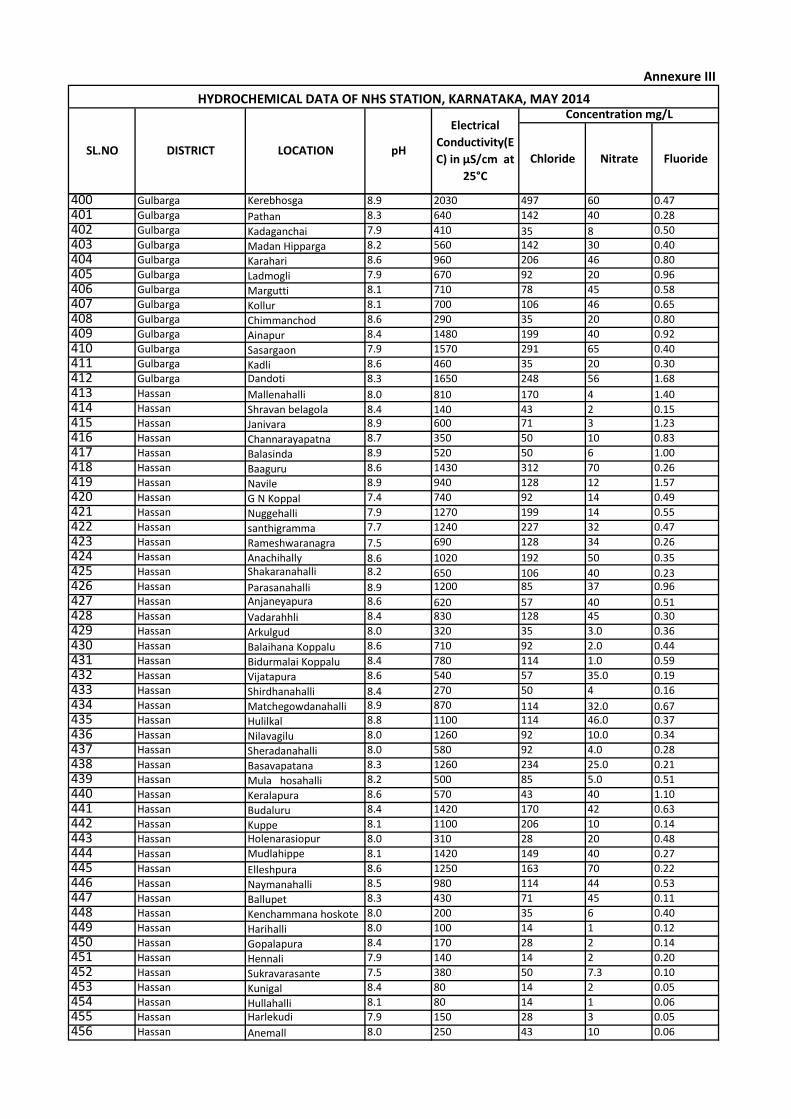
Chloride Nitrate Fluoride
Concentration mg/LHYDROCHEMICAL DATA OF NHS STATION, KARNATAKA, MAY 2014
SL.NO DISTRICT LOCATION pH
Electrical
Conductivity(E
C) in µS/cm at
25°C
Annexure III
400 Gulbarga Kerebhosga 8.9 2030 497 60 0.47
401 Gulbarga Pathan 8.3 640 142 40 0.28
402 Gulbarga Kadaganchai 7.9 410 35 8 0.50
403 Gulbarga Madan Hipparga 8.2 560 142 30 0.40
404 Gulbarga Karahari 8.6 960 206 46 0.80
405 Gulbarga Ladmogli 7.9 670 92 20 0.96
406 Gulbarga Margutti 8.1 710 78 45 0.58
407 Gulbarga Kollur 8.1 700 106 46 0.65
408 Gulbarga Chimmanchod 8.6 290 35 20 0.80
409 Gulbarga Ainapur 8.4 1480 199 40 0.92
410 Gulbarga Sasargaon 7.9 1570 291 65 0.40
411 Gulbarga Kadli 8.6 460 35 20 0.30
412 Gulbarga Dandoti 8.3 1650 248 56 1.68
413 Hassan Mallenahalli 8.0 810 170 4 1.40414 Hassan Shravan belagola 8.4 140 43 2 0.15415 Hassan Janivara 8.9 600 71 3 1.23
416 Hassan Channarayapatna 8.7 350 50 10 0.83
417 Hassan Balasinda 8.9 520 50 6 1.00
418 Hassan Baaguru 8.6 1430 312 70 0.26
419 Hassan Navile 8.9 940 128 12 1.57
420 Hassan G N Koppal 7.4 740 92 14 0.49
421 Hassan Nuggehalli 7.9 1270 199 14 0.55
422 Hassan santhigramma 7.7 1240 227 32 0.47
423 Hassan Rameshwaranagra 7.5 690 128 34 0.26
424 Hassan Anachihally 8.6 1020 192 50 0.35425 Hassan Shakaranahalli 8.2 650 106 40 0.23426 Hassan Parasanahalli 8.9 1200 85 37 0.96
427 Hassan Anjaneyapura 8.6 620 57 40 0.51428 Hassan Vadarahhli 8.4 830 128 45 0.30
429 Hassan Arkulgud 8.0 320 35 3.0 0.36
430 Hassan Balaihana Koppalu 8.6 710 92 2.0 0.44
431 Hassan Bidurmalai Koppalu 8.4 780 114 1.0 0.59
432 Hassan Vijatapura 8.6 540 57 35.0 0.19
433 Hassan Shirdhanahalli 8.4 270 50 4 0.16
434 Hassan Matchegowdanahalli 8.9 870 114 32.0 0.67435 Hassan Hulilkal 8.8 1100 114 46.0 0.37
436 Hassan Nilavagilu 8.0 1260 92 10.0 0.34
437 Hassan Sheradanahalli 8.0 580 92 4.0 0.28
438 Hassan Basavapatana 8.3 1260 234 25.0 0.21
439 Hassan Mula hosahalli 8.2 500 85 5.0 0.51
440 Hassan Keralapura 8.6 570 43 40 1.10
441 Hassan Budaluru 8.4 1420 170 42 0.63
442 Hassan Kuppe 8.1 1100 206 10 0.14
443 Hassan Holenarasiopur 8.0 310 28 20 0.48
444 Hassan Mudlahippe 8.1 1420 149 40 0.27
445 Hassan Elleshpura 8.6 1250 163 70 0.22
446 Hassan Naymanahalli 8.5 980 114 44 0.53
447 Hassan Ballupet 8.3 430 71 45 0.11
448 Hassan Kenchammana hoskote 8.0 200 35 6 0.40
449 Hassan Harihalli 8.0 100 14 1 0.12
450 Hassan Gopalapura 8.4 170 28 2 0.14
451 Hassan Hennali 7.9 140 14 2 0.20
452 Hassan Sukravarasante 7.5 380 50 7.3 0.10
453 Hassan Kunigal 8.4 80 14 2 0.05
454 Hassan Hullahalli 8.1 80 14 1 0.06
455 Hassan Harlekudi 7.9 150 28 3 0.05
456 Hassan Anemall 8.0 250 43 10 0.06

Chloride Nitrate Fluoride
Concentration mg/LHYDROCHEMICAL DATA OF NHS STATION, KARNATAKA, MAY 2014
SL.NO DISTRICT LOCATION pH
Electrical
Conductivity(E
C) in µS/cm at
25°C
Annexure III
457 Hassan Saklehspura 7.9 260 43 1.6 0.15
458 Hassan Kelagadale 7.8 100 21 4 0.14
459 Hassan Biccodu 8.0 490 56 10 0.15
460 Hassan Beluru 8.2 470 56 5 0.32
461 Hassan Singapurapet 7.6 980 106 10 0.54462 Hassan Hagare 7.5 1080 227 15 0.32463 Hassan Halebeedu 7.9 1480 177 3 0.66
464 Hassan Jayachamarajapura 8.7 1320 199 16 0.62
465 Haveri HANGAL(Allternate 7.6 2210 355 49 2.55
466 Haveri HANUMANKOPPA 7.5 1550 227 48 1.9
467 Haveri HIREKERUR (Allternate 8.1 1440 270 95 1.3
468 Haveri HULGUR 7.3 3860 383 360 0.6
469 Haveri KUPPELUR 7.5 1990 391 48 2
470 Haveri MASUR 7.7 4400 959 72 1.56
471 Haveri RANEBENNUR(A) 8.2 1490 277 69 1.57
472 Haveri SHIGGAON 7.5 1150 170 52 1.3
473 Haveri TADAS(A) 7.7 1030 135 27 1.34
474 Haveri TILAVALLI 7.6 1370 256 13.5 0.67
475 Haveri TUMARIKOPPA 7.5 1690 291 24 0.85
476 Haveri TUMMINKATTI 7.5 1140 199 17 0.96
477 Haveri VADARAYANAHALLI 7.3 530 99 19.5 0.53
478 Haveri KUNNUR 7.5 2230 376 47 0.83
479 Haveri SATENAHALLI 7.4 660 114 39 0.67
480 Haveri GUDDE MALLAPURA 7.5 960 156 35 0.57
481 Haveri MAKANUR 7.2 970 178 32 0.42
482 Haveri HALGERI 7.6 270 28 16 0.43
483 Haveri AKKI ALUR 7.7 770 92 13.5 0.66
484 Haveri KALKATTI 7.3 700 85 24 0.61
485 Haveri MALLANAYAKANAHALLI 7.1 1380 213 66 0.28
486 Haveri GIRIGAKOPPA 7.3 2300 398 210 0.71
487 Haveri SHADUKUPEE 7.4 870 85 43 1.13
488 Kodagu Chettimani 8.1 280 28 44 0.12489 Kodagu Katakeri 7.6 220 14 20 0.14490 Kodagu Cheyyandinne 8.2 160 21 18 0.09
491 Kodagu Haaturu 9.1 160 14 15 0.14
492 Kodagu Kakotu korumbu 9.2 180 21 13 0.11
493 Kodagu T.Shettikeri 8.3 140 14 19 0.10
494 Kodagu Karekaadu 9.2 230 28 15 0.18
495 Kodagu Ayyangiri 9.0 160 21 12 0.10
496 Kodagu Betari 7.9 150 14 16 0.12
497 Kodagu Bittanga 9.0 150 14 27 0.11
498 Kodagu Ammathi 9.0 420 50 45 0.10
499 Kodagu Hosur Betageri 9.2 180 21 26 0.08
500 Kodagu Kunda 8.8 140 14 18 0.08501 Kodagu Gowdahalli 8.2 170 21 15 0.09502 Kodagu Shivaralli 8.4 300 43 45 0.14
503 Kodagu Abbyathamangala 9.0 290 43 35 0.16504 Kodagu Jothinagara 9.2 490 64 49 0.15
505 Kodagu Marandodda 8.2 120 14 17 0.05
506 Kodagu Chettahalli 8.0 230 28 9 0.11
507 Kodagu Madikeri 8.1 250 21 32 0.10
508 Kodagu Devangiri 9.2 130 14 16 0.06
509 Kodagu Kadenur 8.5 190 28 12 0.11
510 Kodagu Kadanga 8.0 180 21 11 0.06511 Kodagu Hodduru 9.0 140 15 15 0.05
512 Kodagu Kakkabbe 8.6 130 14 21 0.04
513 Kodagu Ingligere 8.4 240 36 23 0.08

Chloride Nitrate Fluoride
Concentration mg/LHYDROCHEMICAL DATA OF NHS STATION, KARNATAKA, MAY 2014
SL.NO DISTRICT LOCATION pH
Electrical
Conductivity(E
C) in µS/cm at
25°C
Annexure III
514 Kodagu Begur 8.3 310 28 19 0.11
515 Kodagu Hudikeri 7.9 110 14 25 0.63
516 Kodagu B.Shettikere 8.0 160 21 18 0.60
517 Kodagu Kowdikatte 7.7 390 71 37 0.82
518 Kodagu Gopalapura 7.8 440 57 46 0.73
519 Kodagu Nilavagilu 8.4 400 64 40 0.18
520 Kodagu Basavanhalli 7.7 1010 142 55 0.29
521 Kodagu Nanjarayapatna 7.6 1070 177 25 0.19
522 Kodagu Peraje 7.9 170 21 18 0.07
523 Kodagu Cherambane 7.7 230 36 40 0.05
524 Kodagu Heravanadu 7.8 130 14 15 0.05
525 Kodagu Kathamudi 7.9 170 28 13 0.07
526 Kodagu Bellamavathuru 7.8 160 14 22 0.06
527 Kodagu Nelagi 8.6 170 21 13 0.08
528 Kodagu Napoklu 7.9 190 21 31 0.03
529 Kodagu Bagamandala 7.6 130 14 10 0.04
530 Kodagu Murnad 7.9 260 43 40 0.04
531 Kodagu Vantiangadi 7.6 190 21 22 0.09
532 Kodagu Siddapura 8.2 440 50 48 0.12
533 Kodagu Madlapura 7.7 260 21 17 0.24
534 Kodagu Belur 8.1 170 21 11 0.09
535 Kodagu Kodlipet 7.4 320 36 46 0.01
536 Kodagu Kushalnagara 8.1 650 50 60 0.22
537 Kodagu Devarakolli 7.9 200 28 20 0.07538 Kodagu Suntikoppa 8.0 400 50 13 0.1539 Kodagu Kodagarahalli 7.9 660 64 36 0.22
540 Kodagu Devalapura 7.7 860 92 61 0.19
541 Kodagu Gonikoppa 8 670 64 68 0.16
542 Kolar THONDEBHAVI 8.1 870 106 36 1.00543 Kolar PURA 9.0 1350 248 32 0.90544 Kolar SETTIGERE 8.2 850 85 10 1.40
545 Kolar GUDIBONDE-II 8.5 480 43 8 1.20
546 Kolar GUDIBANDA 8.0 1150 170 16 1.30
547 Kolar Hampasandra 8.1 1630 241 27 0.90
548 Kolar BILLURU 8.0 90 14 3 0.32
549 Kolar MOTEMEKALAHALLI 8.4 710 57 10 1.40
550 Kolar UPPARPET(KOLAR) 7.9 1060 135 16 1.60
551 Kolar Gajalahalli 8.1 1800 348 50 1.60
552 Kolar MURUGUMALE 8.2 1130 192 55 0.97
553 Kolar Arabikottanur 7.9 130 28 33 0.91
554 Kolar Kendatti 7.8 170 36 15 0.87555 Kolar Kurugal 8.0 1730 376 17 1.90556 Kolar DEVARAYASAMUDRA 8.4 1390 163 22 1.40
557 Kolar KEILOLLI 8.1 750 71 26 1.50558 Kolar AVANI 8.0 440 43 13 0.94
559 Kolar Vadgere 8.3 2510 433 85 0.95
560 Kolar Mittganahalli 7.8 2460 646 110 1.10
561 Kolar Budikote 8.0 1930 298 40 1.90
562 Kolar Gajorodahalli 8.3 1910 256 33 1.60
563 Kolar Angondahalli 8.9 1530 278 50 1.40
564 Kolar Gidipalli 8.4 1290 213 60 1.30565 Kolar Kurudumala 8.5 2050 327 110 1.20
566 Kolar Bevahalli 8.6 350 64 40 1.30
567 Koppal Hosahalli 8.7 750 121 28.0 1.5568 Koppal Hosabandi arlapur 7.4 1370 337 40 0.2569 Koppal Agalkere 8.3 1250 249 29 0.8
570 Koppal Basapur 8.5 1100 199 15 1.6
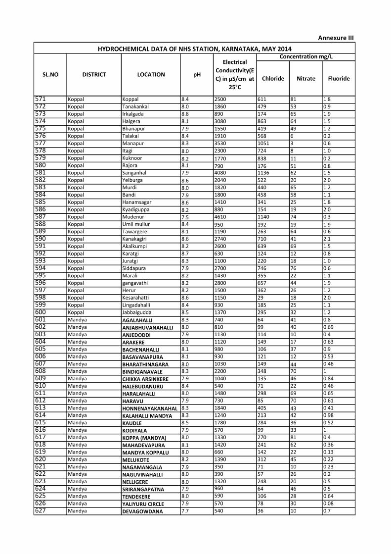
Chloride Nitrate Fluoride
Concentration mg/LHYDROCHEMICAL DATA OF NHS STATION, KARNATAKA, MAY 2014
SL.NO DISTRICT LOCATION pH
Electrical
Conductivity(E
C) in µS/cm at
25°C
Annexure III
571 Koppal Koppal 8.4 2500 611 81 1.8
572 Koppal Tanakankal 8.0 1860 479 53 0.9
573 Koppal Irkalgada 8.8 890 174 65 1.9
574 Koppal Halgera 8.1 3080 863 64 1.5
575 Koppal Bhanapur 7.9 1550 419 49 1.2
576 Koppal Talakal 8.4 1910 568 6 0.2
577 Koppal Manapur 8.3 3530 1051 3 0.6
578 Koppal Itagi 8.0 2300 724 8 1.0
579 Koppal Kuknoor 8.2 1770 838 11 0.2580 Koppal Rajora 8.1 790 176 51 0.8581 Koppal Sanganhal 7.9 4080 1136 62 1.5
582 Koppal Yelburga 8.6 2040 522 20 2.0
583 Koppal Murdi 8.0 1820 440 65 1.2
584 Koppal Bandi 7.9 1800 458 58 1.1
585 Koppal Hanamsagar 8.6 1410 341 25 1.8
586 Koppal Kyadiguppa 8.2 880 154 19 2.0
587 Koppal Mudenur 7.5 4610 1140 74 0.3
588 Koppal Umli mullur 8.4 950 192 19 1.9589 Koppal Tawargere 8.1 1190 263 64 0.6
590 Koppal Kanakagiri 8.6 2740 710 41 2.1
591 Koppal Akalkumpi 8.2 2600 639 69 1.5
592 Koppal Karatgi 8.7 630 124 12 0.8
593 Koppal Juratgi 8.3 1100 220 18 1.0
594 Koppal Siddapura 7.9 2700 746 76 0.6
595 Koppal Marali 8.2 1430 355 22 1.1
596 Koppal gangavathi 8.2 2800 657 44 1.9
597 Koppal Herur 8.2 1500 362 26 1.2
598 Koppal Kesarahatti 8.6 1150 29 18 2.0
599 Koppal Lingadahalli 8.4 930 185 25 1.1
600 Koppal Jabbalgudda 8.5 1370 295 32 1.2
601 Mandya AGALAHALLI 8.3 740 64 41 0.8
602 Mandya ANJABHUVANAHALLI 8.0 810 99 40 0.69
603 Mandya ANJEDODDI 7.9 1130 114 10 0.4
604 Mandya ARAKERE 8.0 1120 149 17 0.63
605 Mandya BACHENAHALLI 8.1 980 106 37 0.9
606 Mandya BASAVANAPURA 8.1 930 121 12 0.53
607 Mandya BHARATHINAGARA 8.0 1030 149 44 0.46
608 Mandya BINDIGANAVALE 8.3 2200 348 70 1
609 Mandya CHIKKA ARSINKERE 7.9 1040 135 46 0.84
610 Mandya HALEBUDANURU 8.4 540 71 22 0.46
611 Mandya HARALAHALLI 8.0 1480 298 69 0.65
612 Mandya HARAVU 7.9 730 85 70 0.61
613 Mandya HONNENAYAKANAHAL 8.3 1840 405 43 0.41
614 Mandya KALAHALLI MANDYA 8.3 1240 213 42 0.98
615 Mandya KAUDLE 8.5 1780 284 36 0.52
616 Mandya KODIYALA 7.9 570 99 33 1
617 Mandya KOPPA (MANDYA) 8.0 1330 270 81 0.4
618 Mandya MAHADEVAPURA 8.1 1420 241 62 0.36
619 Mandya MANDYA KOPPALU 8.0 660 142 22 0.13
620 Mandya MELUKOTE 8.2 1390 312 45 0.22
621 Mandya NAGAMANGALA 7.9 350 71 10 0.23
622 Mandya NAGUVINAHALLI 8.0 390 57 26 0.2
623 Mandya NELLIGERE 8.0 1320 248 20 0.5
624 Mandya SRIRANGAPATNA 7.9 960 64 46 0.5
625 Mandya TENDEKERE 8.0 590 106 28 0.64
626 Mandya YALIYURU CIRCLE 7.9 570 78 30 0.08
627 Mandya DEVAGOWDANA 7.7 540 36 10 0.7
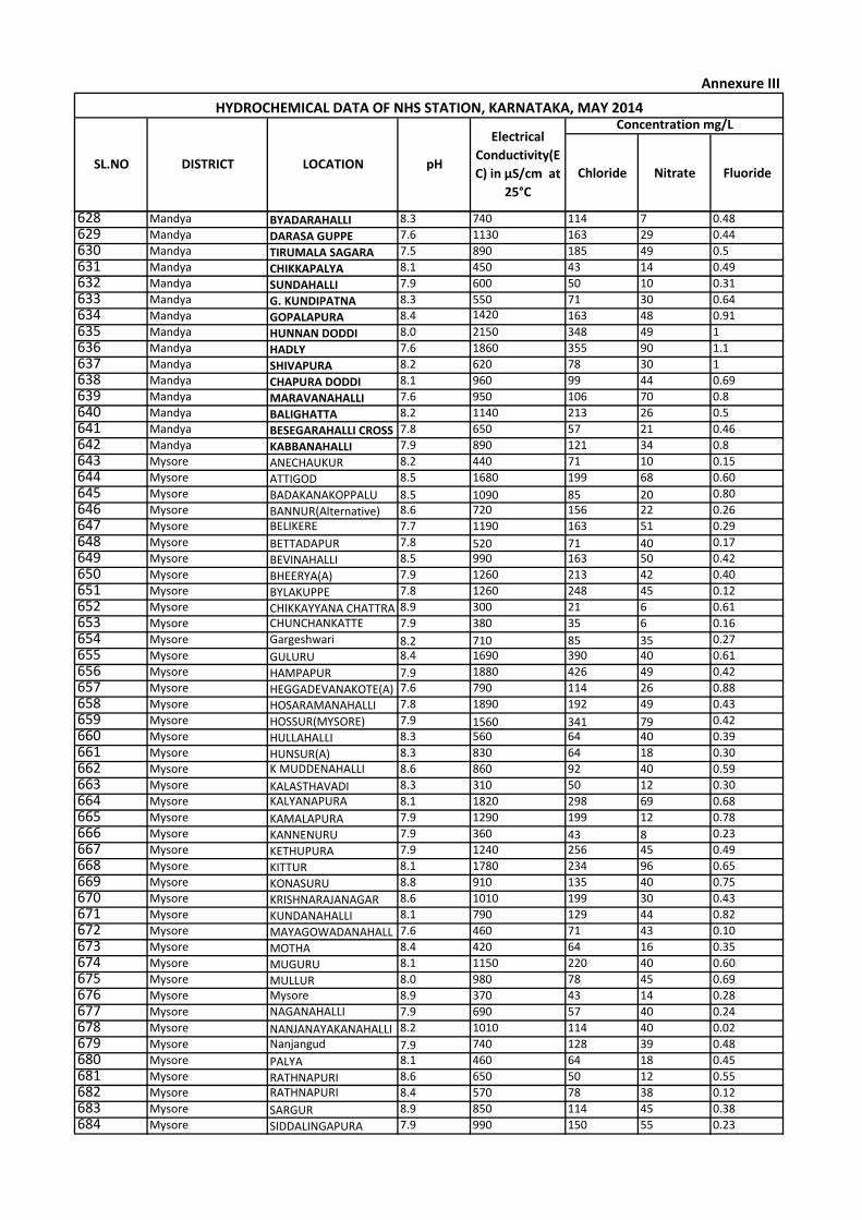
Chloride Nitrate Fluoride
Concentration mg/LHYDROCHEMICAL DATA OF NHS STATION, KARNATAKA, MAY 2014
SL.NO DISTRICT LOCATION pH
Electrical
Conductivity(E
C) in µS/cm at
25°C
Annexure III
628 Mandya BYADARAHALLI 8.3 740 114 7 0.48
629 Mandya DARASA GUPPE 7.6 1130 163 29 0.44
630 Mandya TIRUMALA SAGARA 7.5 890 185 49 0.5
631 Mandya CHIKKAPALYA 8.1 450 43 14 0.49
632 Mandya SUNDAHALLI 7.9 600 50 10 0.31
633 Mandya G. KUNDIPATNA 8.3 550 71 30 0.64
634 Mandya GOPALAPURA 8.4 1420 163 48 0.91
635 Mandya HUNNAN DODDI 8.0 2150 348 49 1
636 Mandya HADLY 7.6 1860 355 90 1.1
637 Mandya SHIVAPURA 8.2 620 78 30 1
638 Mandya CHAPURA DODDI 8.1 960 99 44 0.69
639 Mandya MARAVANAHALLI 7.6 950 106 70 0.8
640 Mandya BALIGHATTA 8.2 1140 213 26 0.5
641 Mandya BESEGARAHALLI CROSS 7.8 650 57 21 0.46
642 Mandya KABBANAHALLI 7.9 890 121 34 0.8
643 Mysore ANECHAUKUR 8.2 440 71 10 0.15
644 Mysore ATTIGOD 8.5 1680 199 68 0.60
645 Mysore BADAKANAKOPPALU 8.5 1090 85 20 0.80
646 Mysore BANNUR(Alternative) 8.6 720 156 22 0.26
647 Mysore BELIKERE 7.7 1190 163 51 0.29
648 Mysore BETTADAPUR 7.8 520 71 40 0.17
649 Mysore BEVINAHALLI 8.5 990 163 50 0.42
650 Mysore BHEERYA(A) 7.9 1260 213 42 0.40
651 Mysore BYLAKUPPE 7.8 1260 248 45 0.12
652 Mysore CHIKKAYYANA CHATTRA 8.9 300 21 6 0.61
653 Mysore CHUNCHANKATTE 7.9 380 35 6 0.16
654 Mysore Gargeshwari 8.2 710 85 35 0.27
655 Mysore GULURU 8.4 1690 390 40 0.61
656 Mysore HAMPAPUR 7.9 1880 426 49 0.42
657 Mysore HEGGADEVANAKOTE(A) 7.6 790 114 26 0.88
658 Mysore HOSARAMANAHALLI 7.8 1890 192 49 0.43
659 Mysore HOSSUR(MYSORE) 7.9 1560 341 79 0.42
660 Mysore HULLAHALLI 8.3 560 64 40 0.39
661 Mysore HUNSUR(A) 8.3 830 64 18 0.30
662 Mysore K MUDDENAHALLI 8.6 860 92 40 0.59
663 Mysore KALASTHAVADI 8.3 310 50 12 0.30
664 Mysore KALYANAPURA 8.1 1820 298 69 0.68
665 Mysore KAMALAPURA 7.9 1290 199 12 0.78
666 Mysore KANNENURU 7.9 360 43 8 0.23
667 Mysore KETHUPURA 7.9 1240 256 45 0.49
668 Mysore KITTUR 8.1 1780 234 96 0.65
669 Mysore KONASURU 8.8 910 135 40 0.75
670 Mysore KRISHNARAJANAGAR 8.6 1010 199 30 0.43
671 Mysore KUNDANAHALLI 8.1 790 129 44 0.82
672 Mysore MAYAGOWADANAHALL 7.6 460 71 43 0.10
673 Mysore MOTHA 8.4 420 64 16 0.35
674 Mysore MUGURU 8.1 1150 220 40 0.60
675 Mysore MULLUR 8.0 980 78 45 0.69
676 Mysore Mysore 8.9 370 43 14 0.28
677 Mysore NAGANAHALLI 7.9 690 57 40 0.24
678 Mysore NANJANAYAKANAHALLI 8.2 1010 114 40 0.02
679 Mysore Nanjangud 7.9 740 128 39 0.48
680 Mysore PALYA 8.1 460 64 18 0.45
681 Mysore RATHNAPURI 8.6 650 50 12 0.55
682 Mysore RATHNAPURI 8.4 570 78 38 0.12
683 Mysore SARGUR 8.9 850 114 45 0.38
684 Mysore SIDDALINGAPURA 7.9 990 150 55 0.23
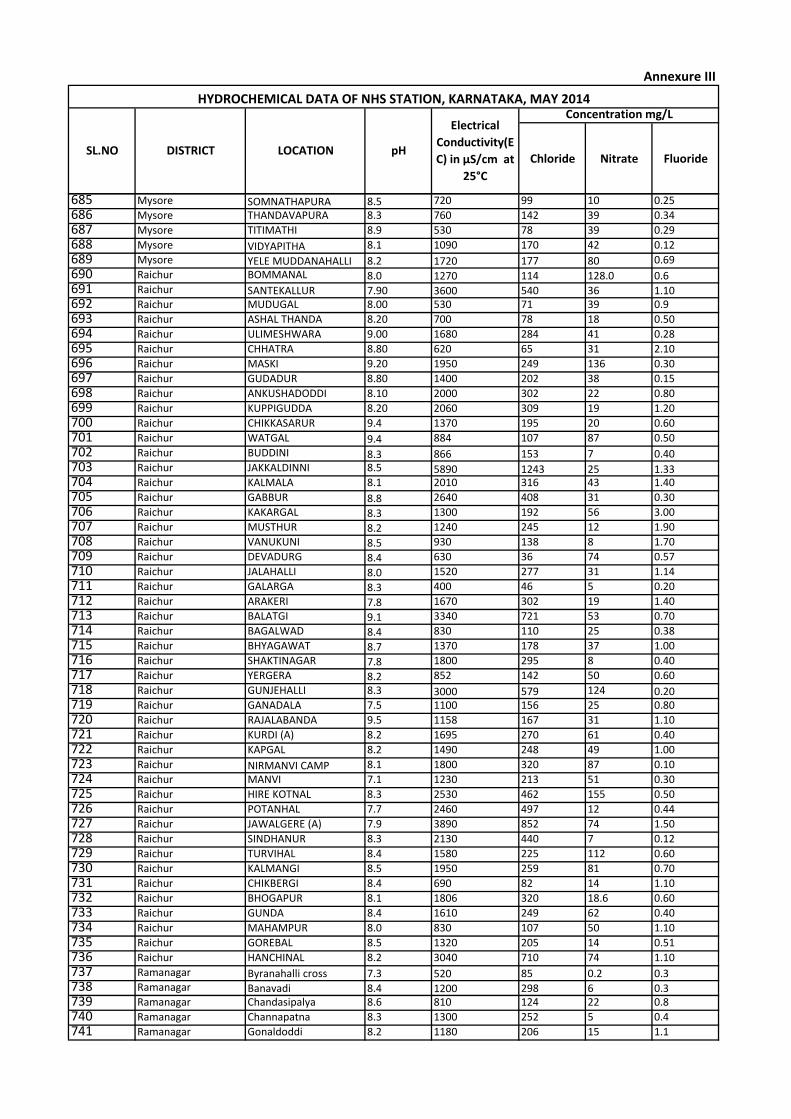
Chloride Nitrate Fluoride
Concentration mg/LHYDROCHEMICAL DATA OF NHS STATION, KARNATAKA, MAY 2014
SL.NO DISTRICT LOCATION pH
Electrical
Conductivity(E
C) in µS/cm at
25°C
Annexure III
685 Mysore SOMNATHAPURA 8.5 720 99 10 0.25
686 Mysore THANDAVAPURA 8.3 760 142 39 0.34
687 Mysore TITIMATHI 8.9 530 78 39 0.29
688 Mysore VIDYAPITHA 8.1 1090 170 42 0.12
689 Mysore YELE MUDDANAHALLI 8.2 1720 177 80 0.69
690 Raichur BOMMANAL 8.0 1270 114 128.0 0.6691 Raichur SANTEKALLUR 7.90 3600 540 36 1.10692 Raichur MUDUGAL 8.00 530 71 39 0.9
693 Raichur ASHAL THANDA 8.20 700 78 18 0.50
694 Raichur ULIMESHWARA 9.00 1680 284 41 0.28
695 Raichur CHHATRA 8.80 620 65 31 2.10
696 Raichur MASKI 9.20 1950 249 136 0.30
697 Raichur GUDADUR 8.80 1400 202 38 0.15
698 Raichur ANKUSHADODDI 8.10 2000 302 22 0.80
699 Raichur KUPPIGUDDA 8.20 2060 309 19 1.20
700 Raichur CHIKKASARUR 9.4 1370 195 20 0.60
701 Raichur WATGAL 9.4 884 107 87 0.50
702 Raichur BUDDINI 8.3 866 153 7 0.40703 Raichur JAKKALDINNI 8.5 5890 1243 25 1.33704 Raichur KALMALA 8.1 2010 316 43 1.40
705 Raichur GABBUR 8.8 2640 408 31 0.30
706 Raichur KAKARGAL 8.3 1300 192 56 3.00
707 Raichur MUSTHUR 8.2 1240 245 12 1.90
708 Raichur VANUKUNI 8.5 930 138 8 1.70
709 Raichur DEVADURG 8.4 630 36 74 0.57
710 Raichur JALAHALLI 8.0 1520 277 31 1.14
711 Raichur GALARGA 8.3 400 46 5 0.20
712 Raichur ARAKERI 7.8 1670 302 19 1.40
713 Raichur BALATGI 9.1 3340 721 53 0.70
714 Raichur BAGALWAD 8.4 830 110 25 0.38
715 Raichur BHYAGAWAT 8.7 1370 178 37 1.00
716 Raichur SHAKTINAGAR 7.8 1800 295 8 0.40
717 Raichur YERGERA 8.2 852 142 50 0.60
718 Raichur GUNJEHALLI 8.3 3000 579 124 0.20719 Raichur GANADALA 7.5 1100 156 25 0.80
720 Raichur RAJALABANDA 9.5 1158 167 31 1.10
721 Raichur KURDI (A) 8.2 1695 270 61 0.40
722 Raichur KAPGAL 8.2 1490 248 49 1.00
723 Raichur NIRMANVI CAMP 8.1 1800 320 87 0.10
724 Raichur MANVI 7.1 1230 213 51 0.30
725 Raichur HIRE KOTNAL 8.3 2530 462 155 0.50
726 Raichur POTANHAL 7.7 2460 497 12 0.44
727 Raichur JAWALGERE (A) 7.9 3890 852 74 1.50
728 Raichur SINDHANUR 8.3 2130 440 7 0.12
729 Raichur TURVIHAL 8.4 1580 225 112 0.60
730 Raichur KALMANGI 8.5 1950 259 81 0.70
731 Raichur CHIKBERGI 8.4 690 82 14 1.10
732 Raichur BHOGAPUR 8.1 1806 320 18.6 0.60
733 Raichur GUNDA 8.4 1610 249 62 0.40
734 Raichur MAHAMPUR 8.0 830 107 50 1.10
735 Raichur GOREBAL 8.5 1320 205 14 0.51
736 Raichur HANCHINAL 8.2 3040 710 74 1.10
737 Ramanagar Byranahalli cross 7.3 520 85 0.2 0.3738 Ramanagar Banavadi 8.4 1200 298 6 0.3739 Ramanagar Chandasipalya 8.6 810 124 22 0.8
740 Ramanagar Channapatna 8.3 1300 252 5 0.4
741 Ramanagar Gonaldoddi 8.2 1180 206 15 1.1
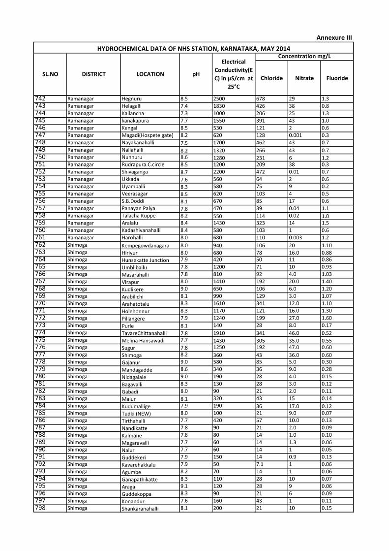
Chloride Nitrate Fluoride
Concentration mg/LHYDROCHEMICAL DATA OF NHS STATION, KARNATAKA, MAY 2014
SL.NO DISTRICT LOCATION pH
Electrical
Conductivity(E
C) in µS/cm at
25°C
Annexure III
742 Ramanagar Hegnuru 8.5 2500 678 29 1.3
743 Ramanagar Helagalli 7.4 1830 426 38 0.8
744 Ramanagar Kailancha 7.3 1000 206 25 1.3
745 Ramanagar kanakapura 7.7 1550 391 43 1.0
746 Ramanagar Kengal 8.5 530 121 2 0.6
747 Ramanagar Magadi(Hospete gate) 8.2 620 128 0.001 0.3
748 Ramanagar Nayakanahalli 7.5 1700 462 43 0.7
749 Ramanagar Nallahalli 8.2 1320 266 43 0.7750 Ramanagar Nunnuru 8.6 1280 231 6 1.2751 Ramanagar Rudrapura.C.circle 8.5 1200 209 38 0.3
752 Ramanagar Shivaganga 8.7 2200 472 0.01 0.7
753 Ramanagar Ukkada 7.6 560 64 2 0.6
754 Ramanagar Uyamballi 8.3 580 75 9 0.2
755 Ramanagar Veerasagar 8.5 620 103 4 0.5
756 Ramanagar S.B.Doddi 8.1 670 85 17 0.6
757 Ramanagar Panayan Palya 7.8 470 39 0.04 1.1
758 Ramanagar Talacha Kuppe 8.2 550 114 0.02 1.0759 Ramanagar Aralalu 8.4 1430 323 14 1.5
760 Ramanagar Kadashivanahalli 8.4 580 103 1 0.6
761 Ramanagar Harohalli 8.0 680 110 0.003 1.2
762 Shimoga Kempegowdanagara 8.0 940 106 20 1.10763 Shimoga Hiriyur 8.0 680 78 16.0 0.88764 Shimoga Hunsekatte Junction 7.9 420 50 11 0.86
765 Shimoga Umblibailu 7.8 1200 71 10 0.93
766 Shimoga Masarahalli 7.8 810 92 4.0 1.03
767 Shimoga Virapur 8.0 1410 192 20.0 1.40
768 Shimoga Kudlikere 9.0 650 106 6.0 1.20
769 Shimoga Arabilichi 8.1 990 129 3.0 1.07
770 Shimoga Arahatotalu 8.3 1610 341 12.0 1.10
771 Shimoga Holehonnur 8.3 1170 121 16.0 1.30
772 Shimoga Pillangere 7.9 1240 199 27.0 1.60
773 Shimoga Purle 8.1 140 28 8.0 0.17
774 Shimoga TavareChittanahalli 7.8 1910 341 46.0 0.52775 Shimoga Melina Hansawadi 7.7 1430 305 35.0 0.55776 Shimoga Sugur 7.8 1250 192 47.0 0.60
777 Shimoga Shimoga 8.2 360 43 36.0 0.60778 Shimoga Gajanur 9.0 580 85 5.0 0.30
779 Shimoga Mandagadde 8.6 340 36 9.0 0.28
780 Shimoga Nidagalale 9.0 190 28 4.0 0.15
781 Shimoga Bagavalli 8.3 130 28 3.0 0.12
782 Shimoga Gabadi 8.0 90 21 2.0 0.11
783 Shimoga Malur 8.1 320 43 15 0.14
784 Shimoga Kudumallige 7.9 190 36 17.0 0.12785 Shimoga Tudki (NEW) 8.0 100 21 9.0 0.07
786 Shimoga Tirthahalli 7.7 420 57 10.0 0.13
787 Shimoga Nandikatte 7.8 90 21 2.0 0.09
788 Shimoga Kalmane 7.8 80 14 1.0 0.10
789 Shimoga Megaravalli 7.7 60 14 1.3 0.06
790 Shimoga Nalur 7.7 60 14 1 0.05
791 Shimoga Guddekeri 7.9 150 14 0.9 0.13
792 Shimoga Kavarehakkalu 7.9 50 7.1 1 0.06
793 Shimoga Agumbe 8.2 70 14 1 0.06
794 Shimoga Ganapathikatte 8.3 110 28 10 0.07
795 Shimoga Araga 9.1 120 28 9 0.06
796 Shimoga Guddekoppa 8.3 90 21 6 0.09
797 Shimoga Konandur 7.6 160 43 1 0.11
798 Shimoga Shankaranahalli 8.1 200 21 10 0.15
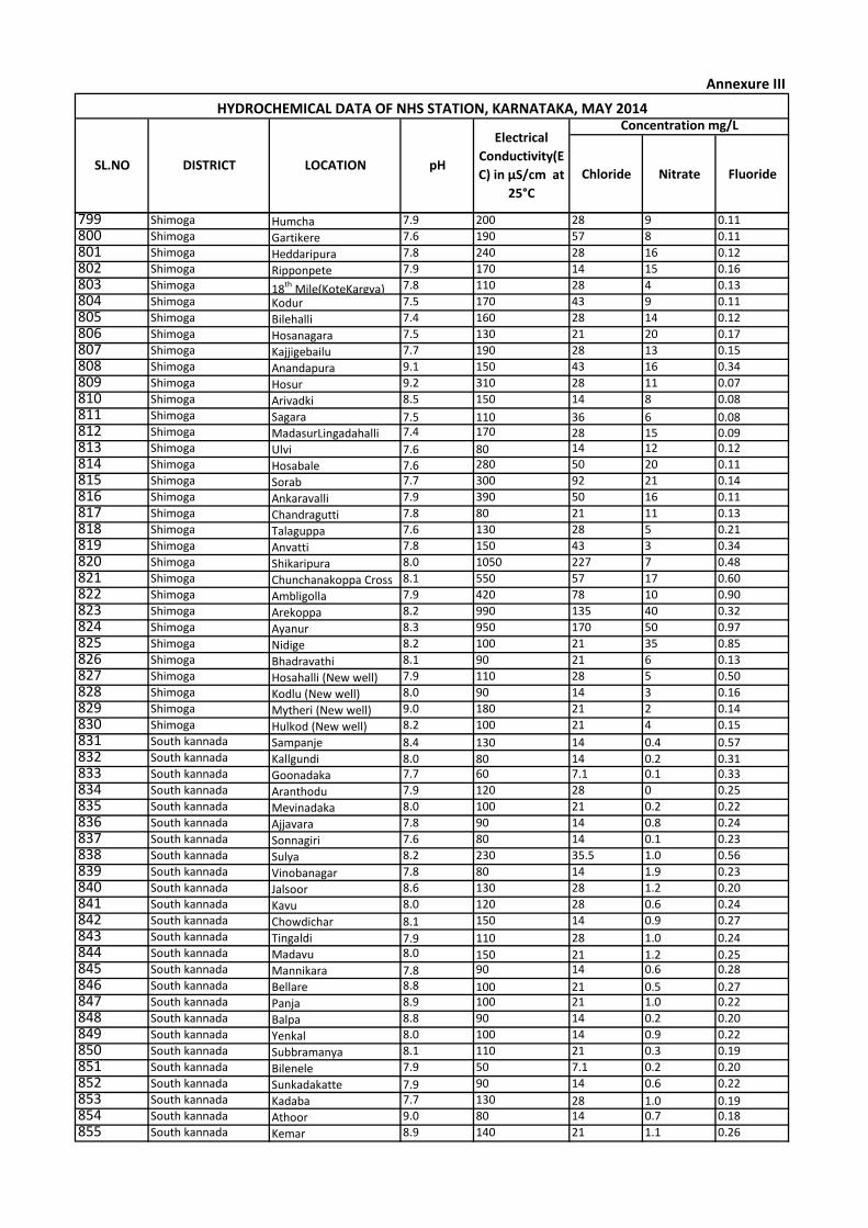
Chloride Nitrate Fluoride
Concentration mg/LHYDROCHEMICAL DATA OF NHS STATION, KARNATAKA, MAY 2014
SL.NO DISTRICT LOCATION pH
Electrical
Conductivity(E
C) in µS/cm at
25°C
Annexure III
799 Shimoga Humcha 7.9 200 28 9 0.11
800 Shimoga Gartikere 7.6 190 57 8 0.11
801 Shimoga Heddaripura 7.8 240 28 16 0.12
802 Shimoga Ripponpete 7.9 170 14 15 0.16
803 Shimoga 18th Mile(KoteKargya) 7.8 110 28 4 0.13
804 Shimoga Kodur 7.5 170 43 9 0.11
805 Shimoga Bilehalli 7.4 160 28 14 0.12
806 Shimoga Hosanagara 7.5 130 21 20 0.17
807 Shimoga Kajjigebailu 7.7 190 28 13 0.15
808 Shimoga Anandapura 9.1 150 43 16 0.34
809 Shimoga Hosur 9.2 310 28 11 0.07
810 Shimoga Arivadki 8.5 150 14 8 0.08
811 Shimoga Sagara 7.5 110 36 6 0.08812 Shimoga MadasurLingadahalli 7.4 170 28 15 0.09813 Shimoga Ulvi 7.6 80 14 12 0.12
814 Shimoga Hosabale 7.6 280 50 20 0.11
815 Shimoga Sorab 7.7 300 92 21 0.14
816 Shimoga Ankaravalli 7.9 390 50 16 0.11
817 Shimoga Chandragutti 7.8 80 21 11 0.13
818 Shimoga Talaguppa 7.6 130 28 5 0.21
819 Shimoga Anvatti 7.8 150 43 3 0.34
820 Shimoga Shikaripura 8.0 1050 227 7 0.48
821 Shimoga Chunchanakoppa Cross 8.1 550 57 17 0.60
822 Shimoga Ambligolla 7.9 420 78 10 0.90
823 Shimoga Arekoppa 8.2 990 135 40 0.32
824 Shimoga Ayanur 8.3 950 170 50 0.97
825 Shimoga Nidige 8.2 100 21 35 0.85
826 Shimoga Bhadravathi 8.1 90 21 6 0.13
827 Shimoga Hosahalli (New well) 7.9 110 28 5 0.50
828 Shimoga Kodlu (New well) 8.0 90 14 3 0.16
829 Shimoga Mytheri (New well) 9.0 180 21 2 0.14
830 Shimoga Hulkod (New well) 8.2 100 21 4 0.15
831 South kannada Sampanje 8.4 130 14 0.4 0.57832 South kannada Kallgundi 8.0 80 14 0.2 0.31833 South kannada Goonadaka 7.7 60 7.1 0.1 0.33
834 South kannada Aranthodu 7.9 120 28 0 0.25
835 South kannada Mevinadaka 8.0 100 21 0.2 0.22
836 South kannada Ajjavara 7.8 90 14 0.8 0.24
837 South kannada Sonnagiri 7.6 80 14 0.1 0.23
838 South kannada Sulya 8.2 230 35.5 1.0 0.56
839 South kannada Vinobanagar 7.8 80 14 1.9 0.23
840 South kannada Jalsoor 8.6 130 28 1.2 0.20
841 South kannada Kavu 8.0 120 28 0.6 0.24
842 South kannada Chowdichar 8.1 150 14 0.9 0.27
843 South kannada Tingaldi 7.9 110 28 1.0 0.24844 South kannada Madavu 8.0 150 21 1.2 0.25845 South kannada Mannikara 7.8 90 14 0.6 0.28
846 South kannada Bellare 8.8 100 21 0.5 0.27847 South kannada Panja 8.9 100 21 1.0 0.22
848 South kannada Balpa 8.8 90 14 0.2 0.20
849 South kannada Yenkal 8.0 100 14 0.9 0.22
850 South kannada Subbramanya 8.1 110 21 0.3 0.19
851 South kannada Bilenele 7.9 50 7.1 0.2 0.20
852 South kannada Sunkadakatte 7.9 90 14 0.6 0.22
853 South kannada Kadaba 7.7 130 28 1.0 0.19854 South kannada Athoor 9.0 80 14 0.7 0.18
855 South kannada Kemar 8.9 140 21 1.1 0.26

Chloride Nitrate Fluoride
Concentration mg/LHYDROCHEMICAL DATA OF NHS STATION, KARNATAKA, MAY 2014
SL.NO DISTRICT LOCATION pH
Electrical
Conductivity(E
C) in µS/cm at
25°C
Annexure III
856 South kannada Nellayadi 9.0 170 35 6 0.20
857 South kannada Nelliadka 8.2 90 14 0.2 0.16
858 South kannada Shiradi 7.8 100 21 0.3 0.15
859 South kannada Puttlo Addehole 7.7 80 14 0.2 0.15
860 South kannada Niddle 7.8 90 21 0.5 0.16
861 South kannada Ujjare 8.9 120 21 0.6 0.18
862 South kannada Badnaje Macharu 7.9 100 14 1 0.19
863 South kannada Ballalu 7.6 220 35.5 1.1 0.21
864 South kannada Nidigal 7.8 80 14 0.4 0.19
865 South kannada Usurya 8 110 21 1.4 0.31
866 South kannada Belthangdy 7.7 200 21 3 0.33
867 South kannada Gerukatte 7.9 180 35.5 8.0 0.32
868 South kannada Kalkeri 7.8 90 21 1.0 0.27
869 South kannada Adantadka 8.0 100 14 0.9 0.22
870 South kannada Uppinangadi 8.0 350 57 1.4 0.32
871 South kannada Mani 7.9 160 35.5 4.0 0.26
872 South kannada Mittur 8.2 110 21 0.2 0.16
873 South kannada Puttur 7.7 90 21 0.8 0.18
874 South kannada Kabaka Puttur 7.9 110 21 2.0 0.18
875 South kannada Ukkanda 8.5 80 14 0.2 0.14
876 South kannada Kudapadav 8.3 130 28 1.0 0.15
877 South kannada Kanayana 8.3 110 21 0.3 0.15
878 South kannada Vittala 8.7 160 43 5.0 0.14
879 South kannada Kudthamuger 8.6 80 14 0.2 0.16880 South kannada Boliangandi 8.7 210 28 7 0.31881 South kannada Subashnagar 8.0 230 50 7.7 0.34
882 South kannada Bantwal 8.1 250 28 5.6 0.27
883 South kannada Keliginaogga 7.9 120 21 1.2 0.26
884 South kannada KavalMadaur 8.0 130 28 1.6 0.27
885 South kannada Punjalkatte 7.9 100 21 0.6 0.14
886 South kannada Nayanadu 8.0 110 21 1.2 0.17
887 South kannada Kukkedi 7.8 80 14 0.4 0.19
888 South kannada Alangadi 8.1 150 28 0.5 0.24
889 South kannada Bore Gadde 8.1 180 21 6 0.16
890 South kannada Shirthadi 9.0 100 14 0.3 0.22
891 South kannada Kesargadde 8.9 110 14 1 0.21
892 South kannada Garadi 8.9 90 14 0.8 0.21
893 South kannada Kinnikambala 8.5 160 28 8 0.22
894 South kannada Perar 8.3 120 21 6 0.22
895 South kannada Bajpe 8.9 160 35.5 10 0.14
896 South kannada Kenjar 8.5 1080 312 20 0.27
897 South kannada Padil 8.3 220 35.5 6.7 0.22
898 South kannada Adiyar 7.8 170 21 0.41 0.36
899 South kannada Ullal 7.7 320 64 9.1 0.28
900 South kannada Kotekar 8.0 210 57 12 0.21
901 South kannada Thalpady 8.1 430 43 10 0.16
902 South kannada Ulla Beach 7.7 290 85 13 0.27
903 South kannada Mangalore I 7.6 160 35.5 3 0.18
904 South kannada Mangalore IV 8.7 130 21 1 0.19
905 South kannada Mangalore II 7.2 320 28 0.9 0.18
906 South kannada Mangalore III 9.0 310 57 4 0.15
907 South kannada Balla 8.6 440 50 28 0.25
908 South kannada Mukka 9.0 240 85 20 0.19
909 South kannada Haleyangandi 9.0 170 35.5 6 0.18
910 South kannada Kenchanakere 8.8 180 35.5 0.9 0.13
911 South kannada Pakshikere 7.9 200 43 7 0.14
912 South kannada Kingoli 7.7 100 28 1.4 0.13
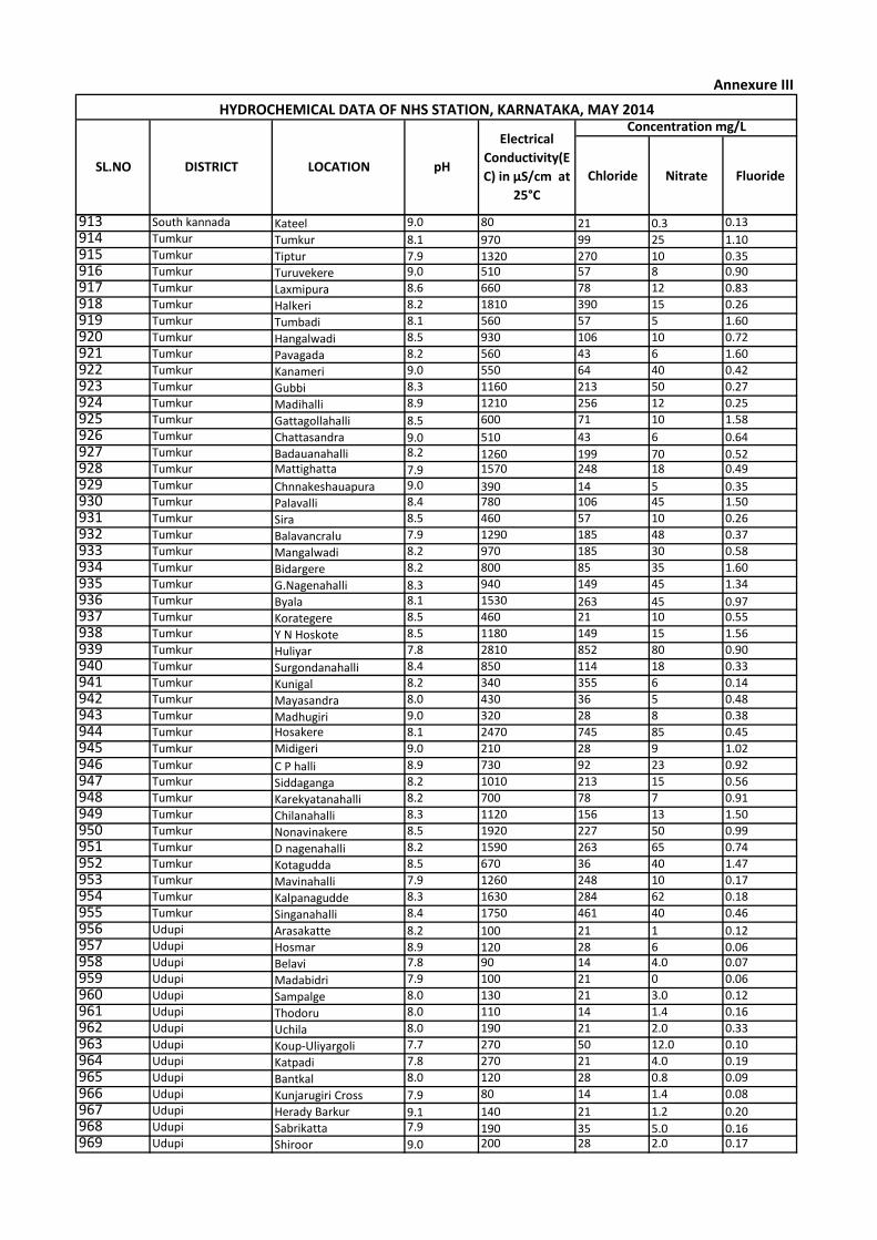
Chloride Nitrate Fluoride
Concentration mg/LHYDROCHEMICAL DATA OF NHS STATION, KARNATAKA, MAY 2014
SL.NO DISTRICT LOCATION pH
Electrical
Conductivity(E
C) in µS/cm at
25°C
Annexure III
913 South kannada Kateel 9.0 80 21 0.3 0.13
914 Tumkur Tumkur 8.1 970 99 25 1.10915 Tumkur Tiptur 7.9 1320 270 10 0.35916 Tumkur Turuvekere 9.0 510 57 8 0.90
917 Tumkur Laxmipura 8.6 660 78 12 0.83
918 Tumkur Halkeri 8.2 1810 390 15 0.26
919 Tumkur Tumbadi 8.1 560 57 5 1.60
920 Tumkur Hangalwadi 8.5 930 106 10 0.72
921 Tumkur Pavagada 8.2 560 43 6 1.60
922 Tumkur Kanameri 9.0 550 64 40 0.42
923 Tumkur Gubbi 8.3 1160 213 50 0.27
924 Tumkur Madihalli 8.9 1210 256 12 0.25
925 Tumkur Gattagollahalli 8.5 600 71 10 1.58
926 Tumkur Chattasandra 9.0 510 43 6 0.64927 Tumkur Badauanahalli 8.2 1260 199 70 0.52928 Tumkur Mattighatta 7.9 1570 248 18 0.49
929 Tumkur Chnnakeshauapura 9.0 390 14 5 0.35930 Tumkur Palavalli 8.4 780 106 45 1.50
931 Tumkur Sira 8.5 460 57 10 0.26
932 Tumkur Balavancralu 7.9 1290 185 48 0.37
933 Tumkur Mangalwadi 8.2 970 185 30 0.58
934 Tumkur Bidargere 8.2 800 85 35 1.60
935 Tumkur G.Nagenahalli 8.3 940 149 45 1.34
936 Tumkur Byala 8.1 1530 263 45 0.97937 Tumkur Korategere 8.5 460 21 10 0.55
938 Tumkur Y N Hoskote 8.5 1180 149 15 1.56
939 Tumkur Huliyar 7.8 2810 852 80 0.90
940 Tumkur Surgondanahalli 8.4 850 114 18 0.33
941 Tumkur Kunigal 8.2 340 355 6 0.14
942 Tumkur Mayasandra 8.0 430 36 5 0.48
943 Tumkur Madhugiri 9.0 320 28 8 0.38
944 Tumkur Hosakere 8.1 2470 745 85 0.45
945 Tumkur Midigeri 9.0 210 28 9 1.02
946 Tumkur C P halli 8.9 730 92 23 0.92
947 Tumkur Siddaganga 8.2 1010 213 15 0.56
948 Tumkur Karekyatanahalli 8.2 700 78 7 0.91
949 Tumkur Chilanahalli 8.3 1120 156 13 1.50
950 Tumkur Nonavinakere 8.5 1920 227 50 0.99
951 Tumkur D nagenahalli 8.2 1590 263 65 0.74
952 Tumkur Kotagudda 8.5 670 36 40 1.47
953 Tumkur Mavinahalli 7.9 1260 248 10 0.17
954 Tumkur Kalpanagudde 8.3 1630 284 62 0.18
955 Tumkur Singanahalli 8.4 1750 461 40 0.46
956 Udupi Arasakatte 8.2 100 21 1 0.12957 Udupi Hosmar 8.9 120 28 6 0.06958 Udupi Belavi 7.8 90 14 4.0 0.07
959 Udupi Madabidri 7.9 100 21 0 0.06
960 Udupi Sampalge 8.0 130 21 3.0 0.12
961 Udupi Thodoru 8.0 110 14 1.4 0.16
962 Udupi Uchila 8.0 190 21 2.0 0.33
963 Udupi Koup-Uliyargoli 7.7 270 50 12.0 0.10
964 Udupi Katpadi 7.8 270 21 4.0 0.19
965 Udupi Bantkal 8.0 120 28 0.8 0.09
966 Udupi Kunjarugiri Cross 7.9 80 14 1.4 0.08
967 Udupi Herady Barkur 9.1 140 21 1.2 0.20968 Udupi Sabrikatta 7.9 190 35 5.0 0.16969 Udupi Shiroor 9.0 200 28 2.0 0.17
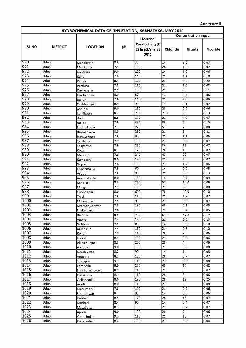
Chloride Nitrate Fluoride
Concentration mg/LHYDROCHEMICAL DATA OF NHS STATION, KARNATAKA, MAY 2014
SL.NO DISTRICT LOCATION pH
Electrical
Conductivity(E
C) in µS/cm at
25°C
Annexure III
970 Udupi Mandarathi 8.6 70 14 1.2 0.07971 Udupi Mairkome 7.9 130 28 1.5 0.07
972 Udupi Kokarani 9.0 100 14 1.0 0.06
973 Udupi Karje 7.9 140 21 1.1 0.10
974 Udupi Pethri 8.4 170 21 3.0 0.29
975 Udupi Perduru 7.8 110 21 1.0 0.08
976 Udupi Kukkehalla 7.7 150 21 3 0.11
977 Udupi Hirehadaka 8.0 80 14 0.4 0.06978 Udupi Bailur 7.9 140 21 2.0 0.06
979 Udupi Guddeangadi 8.9 90 14 0.1 0.07
980 Udupi parkala 9.0 110 28 0.9 0.06
981 Udupi kuniibetta 8.4 760 220 0 0.13
982 Udupi dupi 8.8 180 21 4.0 0.07
983 Udupi maipe 7.9 380 36 6 0.15
984 Udupi Santhekatte 7.7 270 57 7 0.08
985 Udupi Bramhavara 8.3 230 21 3 0.21
986 Udupi Hangarkatta 7.8 90 21 1.1 0.06
987 Udupi Sasthana 7.9 100 21 0.9 0.07
988 Udupi Saligarma 7.9 260 36 15 0.07
989 Udupi Kota 8 120 28 1 0.07
990 Udupi Mannur 7.9 240 43 20 0.07
991 Udupi Kumbashi 8.0 120 21 7 0.07
992 Udupi Gopadi 7.6 100 21 1.2 0.06
993 Udupi Hunsemakki 7.9 60 14 0.9 0.05
994 Udupi Asodu 7.8 90 21 0.3 0.13
995 Udupi Anandakatte 8.0 150 14 0.7 0.09
996 Udupi Kandlur 8.3 250 57 10.0 0.09
997 Udupi Margoli 7.9 100 21 0.6 0.08
998 Udupi Coondapur 8.0 600 78 40.0 0.10
999 Udupi Trasi 7.8 110 21 1.2 0.07
1000 Udupi Marvanthe 7.5 90 21 0.9 0.07
1001 Udupi Kiremanjeshwar 7.5 130 43 2.1 0.05
1002 Udupi Nadanvana 7.6 100 21 0.4 0.05
1003 Udupi Baindur 8.1 2030 625 42.0 0.121004 Udupi Vastre 7.4 120 21 0.9 0.101005 Udupi Golihole 7.5 80 14 0.6 0.10
1006 Udupi Areshirur 7.5 110 21 0.3 0.10
1007 Udupi Kollur 7.9 140 28 2 0.06
1008 Udupi Halkal 8.9 130 21 3.0 0.06
1009 Udupi Iduru Kunjadi 8.3 200 28 4 0.06
1010 Udupi Vandse 9.0 100 21 0.8 0.08
1011 Udupi Neralakatte 8.2 90 14 1 0.08
1012 Udupi Amparu 8.2 130 28 0.7 0.07
1013 Udupi Siddapur 9.1 110 21 0.6 0.08
1014 Udupi Kerebailu 9.0 220 43 10 0.08
1015 Udupi Shankarnarayana 8.9 140 21 8 0.07
1016 Udupi Halbadi Jn 8.1 110 28 3 0.06
1017 Udupi Goliangadi 8.0 190 28 12 0.25
1018 Udupi Aradi 8.0 110 21 8 0.08
1019 Udupi Madumakki 7.8 100 21 0.9 0.06
1020 Udupi Someshwar 8 90 14 0.5 0.06
1021 Udupi Hebbari 8.5 170 28 15 0.07
1022 Udupi Mudradi 8.4 90 14 0.4 0.07
1023 Udupi Matabattu 8.2 100 21 0.2 0.07
1024 Udupi Ajekar 9.0 120 28 7 0.06
1025 Udupi Yennehole 9.2 110 21 10 0.07
1026 Udupi Kunkundur 8.2 100 21 0.2 0.04
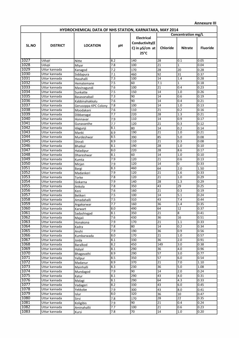
Chloride Nitrate Fluoride
Concentration mg/LHYDROCHEMICAL DATA OF NHS STATION, KARNATAKA, MAY 2014
SL.NO DISTRICT LOCATION pH
Electrical
Conductivity(E
C) in µS/cm at
25°C
Annexure III
1027 Udupi Nitte 8.2 140 28 0.1 0.05
1028 Udupi Miyar 7.8 100 21 1 0.04
1029 Uttar kannada Kanagod 7.2 170 28 20 0.281030 Uttar kannada Siddapura 7.1 460 92 31 0.371031 Uttar kannada Hasahalli 7.3 100 14 1.4 0.28
1032 Uttar kannada Hematemane 7.5 60 7.1 1 0.18
1033 Uttar kannada Mavinagundi 7.6 100 21 0.4 0.23
1034 Uttar kannada Sunkatte 7.5 150 14 1.0 0.26
1035 Uttar kannada Basavanabail 7.3 90 14 0.6 0.19
1036 Uttar kannada Kabbinahakkalu 7.6 90 14 0.4 0.21
1037 Uttar kannada Gerusoppa KPC Colony 7.8 100 14 1.0 0.13
1038 Uttar kannada Moodakani 7.6 110 21 0.2 0.16
1039 Uttar kannada Dibbanagai 7.7 220 28 1.3 0.21
1040 Uttar kannada Honnavar 7.9 110 14 0.9 0.17
1041 Uttar kannada Gunavanthe 7.7 120 21 0.3 0.121042 Uttar kannada Idagunji 8.1 80 14 0.2 0.141043 Uttar kannada Manki 8.9 190 21 1.0 0.21
1044 Uttar kannada Murdeshwar 8.5 390 85 5.0 0.081045 Uttar kannada Shirali 8.9 110 21 0.3 0.08
1046 Uttar kannada Bhatkal 8.1 190 28 1.0 0.10
1047 Uttar kannada Haladipur 8.0 220 28 8.6 0.17
1048 Uttar kannada Dhareshwar 8.1 60 14 1.0 0.10
1049 Uttar kannada Kumta 7.9 120 21 0.6 0.13
1050 Uttar kannada Mirjan 7.9 120 14 0 0.33
1051 Uttar kannada Bargi 8.3 460 64 2.0 1.501052 Uttar kannada Madankeri 7.9 120 21 1.6 0.33
1053 Uttar kannada Torke 7.8 120 21 1.0 0.29
1054 Uttar kannada Gokarna 7.9 140 28 1.3 0.29
1055 Uttar kannada Ankola 7.8 350 43 29 0.25
1056 Uttar kannada Keni 7.6 160 21 0.3 0.19
1057 Uttar kannada Belikeri 7.5 100 14 5.1 0.24
1058 Uttar kannada Amadahalli 7.5 310 43 7.4 0.44
1059 Uttar kannada Argakarwar 7.7 160 36 1.4 0.35
1060 Uttar kannada Karwart 8.0 490 64 12 0.37
1061 Uttar kannada Sadashivgad 8.1 350 21 8 0.41
1062 Uttar kannada Majaii 7.6 430 36 16 0.51
1063 Uttar kannada Honakona 7.9 170 21 1.1 0.33
1064 Uttar kannada Kadra 7.8 80 14 0.2 0.34
1065 Uttar kannada Anshi 7.9 190 36 0.9 0.56
1066 Uttar kannada Kumbarwada 8.0 170 21 1.0 0.57
1067 Uttar kannada Joida 8.1 330 36 2.0 0.91
1068 Uttar kannada Baralkod 8.2 450 149 3.0 0.38
1069 Uttar kannada Halyal 8.1 290 36 4.0 0.96
1070 Uttar kannada Bhagavathi 8.9 290 57 3.0 0.77
1071 Uttar kannada Yellpur 8.5 350 57 6.0 0.54
1072 Uttar kannada Madanur 8.9 370 21 7.0 1.10
1073 Uttar kannada Mainhalli 8.3 230 36 5.0 1.08
1074 Uttar kannada Mundagod 7.9 90 14 2.0 0.24
1075 Uttar kannada Katur 8.1 290 43 4.0 0.31
1076 Uttar kannada Malagi 8.1 290 64 4.3 0.33
1077 Uttar kannada Vadageri 8.2 330 43 6.0 0.45
1078 Uttar kannada Yekkobe 7.9 300 43 8.0 0.411079 Uttar kannada Islur 8.0 320 36 10 0.471080 Uttar kannada Sirsi 7.8 170 28 22 0.35
1081 Uttar kannada Koligibis 7.9 90 21 0.4 0.24
1082 Uttar kannada Aminahallii 7.7 100 21 0.6 0.23
1083 Uttar kannada Kursi 7.8 70 14 1.0 0.20
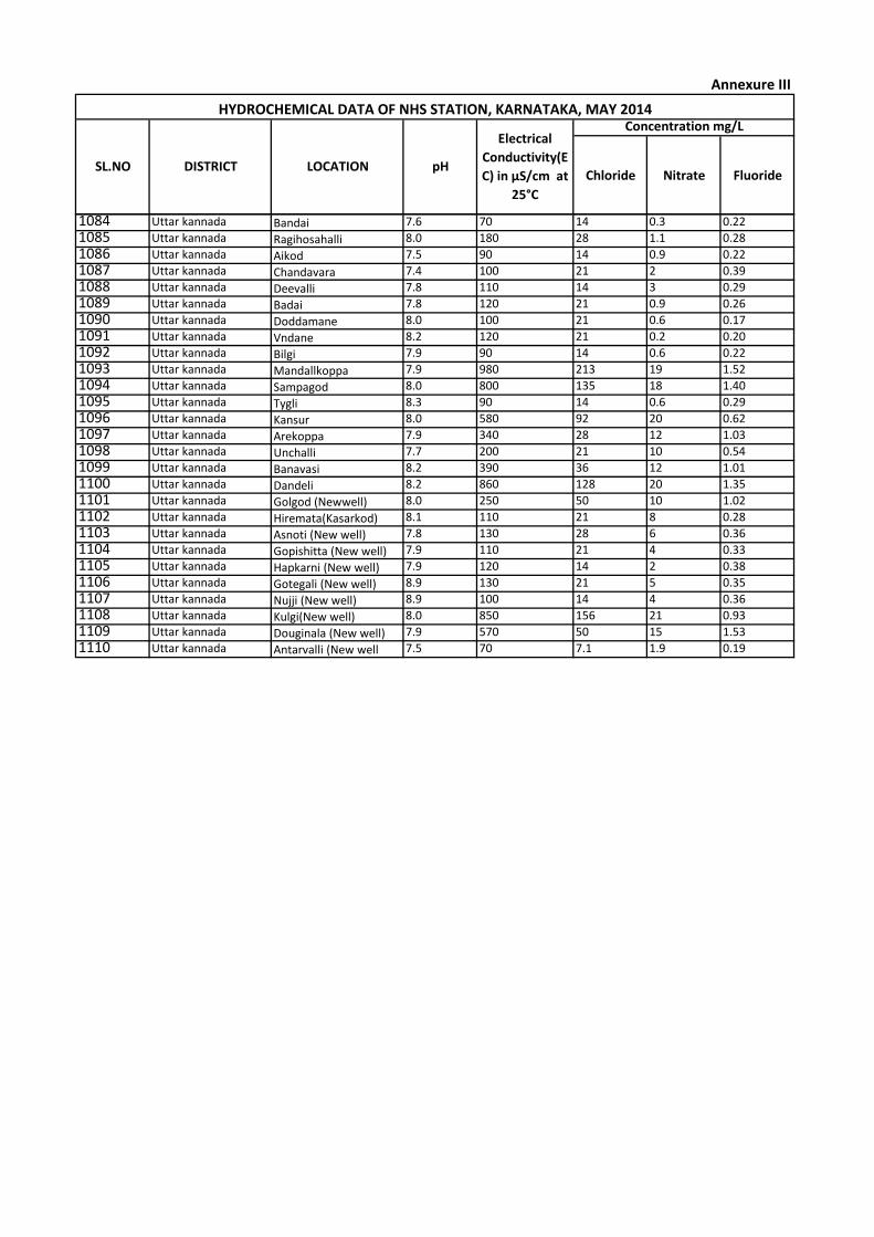
Chloride Nitrate Fluoride
Concentration mg/LHYDROCHEMICAL DATA OF NHS STATION, KARNATAKA, MAY 2014
SL.NO DISTRICT LOCATION pH
Electrical
Conductivity(E
C) in µS/cm at
25°C
Annexure III
1084 Uttar kannada Bandai 7.6 70 14 0.3 0.22
1085 Uttar kannada Ragihosahalli 8.0 180 28 1.1 0.28
1086 Uttar kannada Aikod 7.5 90 14 0.9 0.22
1087 Uttar kannada Chandavara 7.4 100 21 2 0.39
1088 Uttar kannada Deevalli 7.8 110 14 3 0.29
1089 Uttar kannada Badai 7.8 120 21 0.9 0.26
1090 Uttar kannada Doddamane 8.0 100 21 0.6 0.17
1091 Uttar kannada Vndane 8.2 120 21 0.2 0.20
1092 Uttar kannada Bilgi 7.9 90 14 0.6 0.22
1093 Uttar kannada Mandallkoppa 7.9 980 213 19 1.52
1094 Uttar kannada Sampagod 8.0 800 135 18 1.40
1095 Uttar kannada Tygli 8.3 90 14 0.6 0.29
1096 Uttar kannada Kansur 8.0 580 92 20 0.62
1097 Uttar kannada Arekoppa 7.9 340 28 12 1.03
1098 Uttar kannada Unchalli 7.7 200 21 10 0.54
1099 Uttar kannada Banavasi 8.2 390 36 12 1.01
1100 Uttar kannada Dandeli 8.2 860 128 20 1.35
1101 Uttar kannada Golgod (Newwell) 8.0 250 50 10 1.02
1102 Uttar kannada Hiremata(Kasarkod) 8.1 110 21 8 0.28
1103 Uttar kannada Asnoti (New well) 7.8 130 28 6 0.36
1104 Uttar kannada Gopishitta (New well) 7.9 110 21 4 0.33
1105 Uttar kannada Hapkarni (New well) 7.9 120 14 2 0.38
1106 Uttar kannada Gotegali (New well) 8.9 130 21 5 0.35
1107 Uttar kannada Nujji (New well) 8.9 100 14 4 0.36
1108 Uttar kannada Kulgi(New well) 8.0 850 156 21 0.93
1109 Uttar kannada Douginala (New well) 7.9 570 50 15 1.53
1110 Uttar kannada Antarvalli (New well 7.5 70 7.1 1.9 0.19
Related Documents