1 GOVERNMENT OF INDIA MINISTRY OF WATER RESOURCES CENTRAL GROUND WATER BOARD GROUND WATER INFORMATION BOOKLET BANGALORE URBAN DISTRICT, KARNATAKA SOUTH WESTERN REGION BANGALORE MARCH 2013

Welcome message from author
This document is posted to help you gain knowledge. Please leave a comment to let me know what you think about it! Share it to your friends and learn new things together.
Transcript

1
GOVERNMENT OF INDIA MINISTRY OF WATER RESOURCES
CENTRAL GROUND WATER BOARD
GROUND WATER INFORMATION BOOKLET BANGALORE URBAN DISTRICT, KARNATAKA
SOUTH WESTERN REGION BANGALORE MARCH 2013
2
Foreword Groundwater is an essential component of the environment and economy. It sustains the flow in
our rivers and plays an important role in maintaining the fragile ecosystems. The groundwater
dependence of agrarian states like Karnataka is high. Recent studies indicate that 26 percent of
the area of Karnataka State is under over exploited category and number of blocks is under
critical category. In view of the growing concerns of sustainability of ground water sources,
immediate attention is required to augment groundwater resources in stressed areas. Irrigated
agriculture in the state is putting additional stress on the groundwater system and needs proper
management of the resources.
Central Ground Water Board is providing all technical input for effective management of ground
water resources in the state. The groundwater scenario compiled on administrative divisions gives
a better perspective for planning various ground water management measures by local
administrative bodies. With this objective, Central Ground Water Board is publishing the revised
groundwater information booklet for all the districts of the state.
I do appreciate the efforts of Dr. K.Md.Najeeb, Regional Director and his fleet of dedicated
Scientists of South Western Region, Bangalore for bringing out this booklet. I am sure these
brochures will provide a portrait of the groundwater resources in each district for planning
effective management measures by the administrators, planners and the stake holders.
Sushil Gupta Chairman
3
PREFACE
Ground water contributes to about eighty percent of the drinking water
requirements in the rural areas, fifty percent of the urban water requirements and
more than fifty percent of the irrigation requirements of the nation. Central
Ground Water Board has decided to bring out district level ground water
information booklets highlighting the ground water scenario, its resource
potential, quality aspects, recharge – discharge relationship, etc., for all the
districts of the country. As part of this, Central Ground Water Board, South
Western Region, Bangalore, is preparing such booklets for all the 30 districts of
Karnataka state.
The Bangalore Urban district Ground Water Information Booklet has been
prepared based on the information available and data collected from various
state and central government organisations by scientists of Central Ground
Water Board with utmost care and dedication. This booklet has been prepared by
Dr. K.R. Sooryanarayana, Scientist D under the able guidance of Dr. K. Md.
Najeeb, Regional Director, Central Ground Water Board, South Western Region,
Bangalore. The figures were prepared by Sri.Sivaramakrishna, Assistant
Hydrogeologist and the hydrology data has been provided by Sri.
H.P.Jayaprakash, Scientist-C. The efforts of Report processing section in
finalising and bringing out the report are commendable.
I take this opportunity to congratulate them for the diligent and careful
compilation and observation in the form of this booklet, which will certainly serve
as a guiding document for further work and help the planners, administrators,
hydro geologists and other engineers to plan the water resources management in
a better way in the district.
(Dr. K. Md. Najeeb)
Regional Director
4
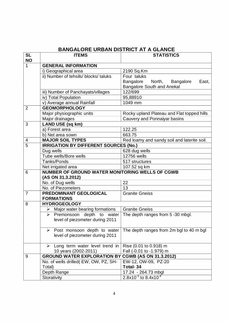
BANGALORE URBAN DISTRICT AT A GLANCE
SL NO
ITEMS STATISTICS
1 GENERAL INFORMATION i) Geographical area 2190 Sq.Km ii) Number of tehsils/ blocks/ taluks Four taluks
Bangalore North, Bangalore East, Bangalore South and Anekal
iii) Number of Panchayats/villages 122/699 iv) Total Population 95,88910 v) Average annual Rainfall 1049 mm
2 GEOMORPHOLOGY Major physiographic units Rocky upland Plateau and Flat topped hills Major drainages Cauvery and Ponnaiyar basins
3 LAND USE (sq km) a) Forest area 122.25 b) Net area sown 663.75
4 MAJOR SOIL TYPES Red loamy and sandy soil and laterite soil. 5 IRRIGATION BY DIFFERENT SOURCES (No.)
Dug wells 628 dug wells Tube wells/Bore wells 12756 wells Tanks/Ponds 517 structures
Net irrigated area 107.52 sq km 6 NUMBER OF GROUND WATER MONITORING WELLS OF CGWB
(AS ON 31.3.2012) No. of Dug wells 22 No. of Piezometers 13
7 PREDOMINANT GEOLOGICAL FORMATIONS
Granite Gneiss
8
HYDROGEOLOGY Major water bearing formations Granite Gneiss Premonsoon depth to water
level of piezometer during 2011
The depth ranges from 5 -30 mbgl.
Post monsoon depth to water level of piezometer during 2011
The depth ranges from 2m bgl to 40 m bgl
Long term water level trend in 10 years (2002-2011)
Rise (0.01 to 0.918) m Fall (-0.01 to -1.979) m
9 GROUND WATER EXPLORATION BY CGWB (AS ON 31.3.2012) No. of wells drilled( EW, OW, PZ, SH-Total)
EW-12, OW-09, PZ-20 Total- 34
Depth Range 17.24 - 264.73 mbgl Storativity 2.8x10⁻³ to 8.4x10⁻⁴
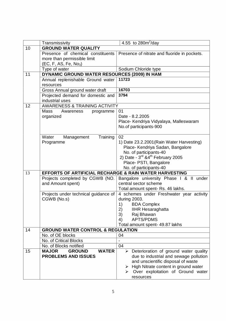
5
Transmissivity 4.55 to 280m2/day 10 GROUND WATER QUALITY
Presence of chemical constituents more than permissible limit (EC, F, AS, Fe, No3)
Presence of nitrate and fluoride in pockets.
Type of water Sodium Chloride type 11 DYNAMIC GROUND WATER RESOURCES (2009) IN HAM
Annual replenishable Ground water resources
11723
Gross Annual ground water draft 16703 Projected demand for domestic and industrial uses
3794
12 AWARENESS & TRAINING ACTIVITY Mass Awareness programme organized
01 Date - 8.2.2005 Place- Kendriya Vidyalaya, Malleswaram No.of participants-900
Water Management Training Programme
02 1) Date 23.2.2001(Rain Water Harvesting) Place- Kendriya Sadan, Bangalore No. of participants-40 2) Date - 3rd &4th February 2005 Place- PSTI, Bangalore No. of participants-40
13 EFFORTS OF ARTIFICIAL RECHARGE & RAIN WATER HARVESTING Projects completed by CGWB (NO. and Amount spent)
Bangalore university Phase I & II under central sector scheme Total amount spent- Rs. 46 lakhs.
Projects under technical guidance of CGWB (No.s)
4 schemes under Freshwater year activity during 2003. 1) BDA Complex 2) IIHR Hesaraghatta 3) Raj Bhawan 4) APTS/PDMS Total amount spent- 49.87 lakhs
14 GROUND WATER CONTROL & REGULATION No. of OE blocks 04 No. of Critical Blocks - No. of Blocks notified 04
15 MAJOR GROUND WATER PROBLEMS AND ISSUES
Deterioration of ground water quality due to industrial and sewage pollution and unscientific disposal of waste
High Nitrate content in ground water Over exploitation of Ground water
resources
6
BANGALORE URBAN DISTRICT 1.0 INTRODUCTION:
In the year 1986, Bangalore district was divided into Bangalore Urban and
Bangalore rural districts. The Bangalore urban district comprises of four taluks and within it lies the Bangalore city -the capital of Karnataka. It is the central point for running the state administration and is now known as Bruhat Bangalore Mahanagare Palike (BBMP). Bangalore is the sixth largest city of India and one of the fastest growing cities of Asia. It has acquired the name of ‘Silicon City”, due to its progressive trend in Information technology Now, after the IT boom, Bangalore city has suddenly overgrown its size and the district administration is facing a challenging task for providing necessary infrastructures to the related economic activities, trade, commerce and housing facilities. Especially, the enormous pressure on water particularly ground water in the district needs scientific planning and effective management of water resources. 1.1 Administrative divisions:
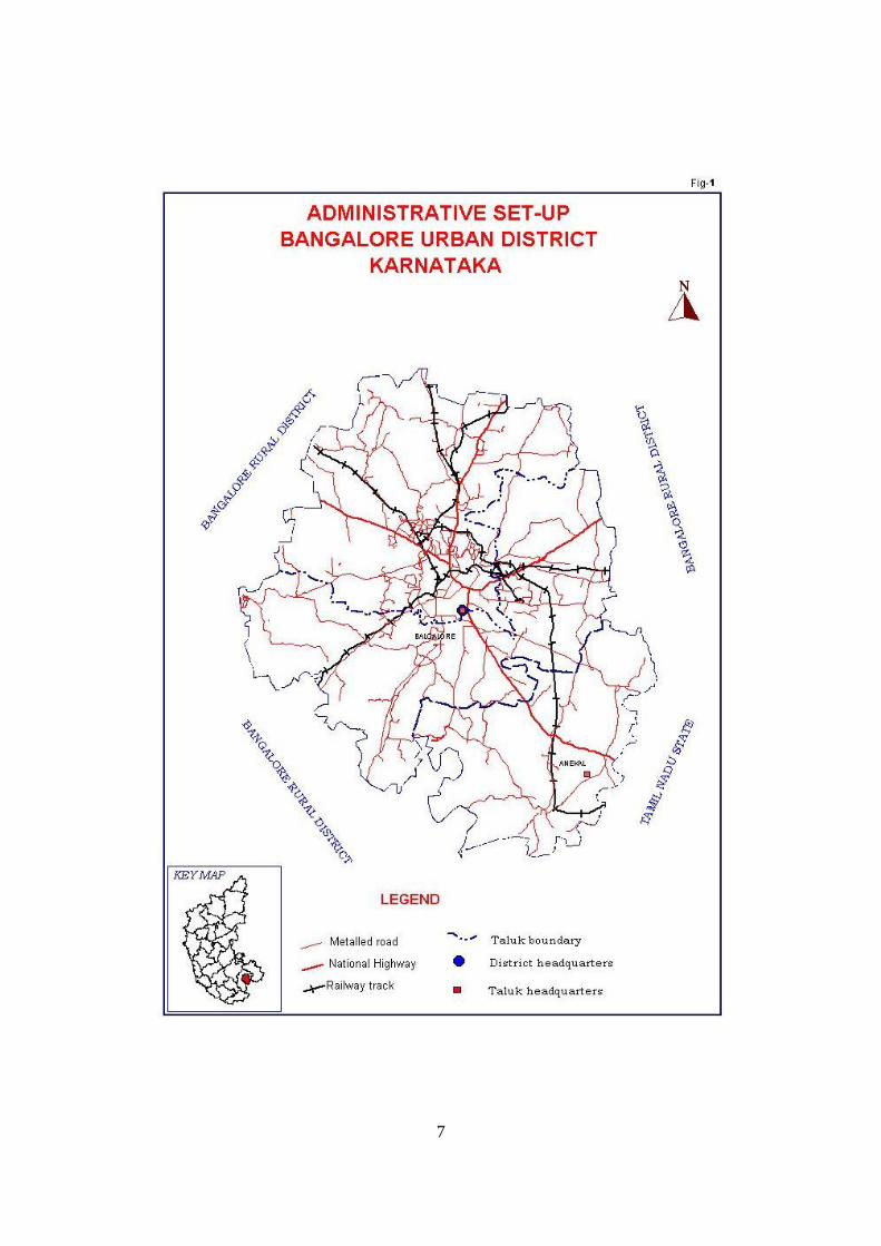
The district is located in the southeastern part of Karnataka. It is having an
areal extent of 2190 sq.km and is located between the North latitude 12˚39' 32’’: 13˚14' 13’’and East longitude 77˚19’44’’: 77˚50'13’’. The district is bounded by Bangalore rural district in the East, West and North except in southeast, where the district is bounded by Dharmapuri district of Tamil Nadu state (Fig-1). The district is divided into four taluks namely Anekal, Bangalore North, Bangalore South and Bangalore East taluks. There are 17 hoblies, 9 municipal corporation and 668 villages in the district. 1.2 Population:
As per the 2011 census, total population of the district is 9588910 with
population density of 4378 persons per sq.km compared to 2985 persons per sq.km in the year 2001. The sex ratio is 908 female among thousand males and the literacy rate of the district has increased from 83.91% on 2001 to 88.48 % in 2011. 1.3 Drainage:
The major rivers of the district are Shimsa, Kanva, Arkavathi, South
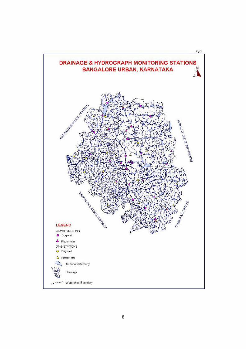
Pennar and Vrishabharathi. There are two major river basins in the district namely Cauvery and South Pennar. Shimsha and Kanva river of the Cauvery basin is draining majority of the district and Anekal taluk is drained by South Pennar river of Ponnaiyar basin, which takes its birth from Nandi hills and flows towards south. (Fig-2)
7
8
9
1.4 Agriculture and Crops:
Agriculture is the main occupation of the district. The major crops grown in the district are Paddy, Ragi, Jowar, Bajra, Maize and Wheat. Pulses like Gram, Tur are also cultivated along with oilseed like Groundnut, sunflower. Different varieties of fruits and vegetables are also produced. 1.5 Studies carried out by CGWB:
Central Ground Water Board is actively involved in carrying out multifaceted studies in the district such as
Water Supply Investigation comprising of Hydrogeological and geophysical
surveys Technical guidance and advice for rainwater harvesting and artificial
recharge scheme for various user agencies. Systematic hydrogeological surveys & Reappraisal hydrogeological
surveys (I &II Phase) and now referred as Groundwater Management studies.
Ground water exploration through hydrogeological, geophysical surveys and drilling of exploratory, observation bore wells and peizometer.
Monitoring of water levels and quality of ground water through a network of Ground water monitoring wells and purpose driven piezometers, established under Hydrology project I
Effects of Industrial pollution on ground water regime in Bangalore city. Artificial recharge scheme under central sector (Bangalore university-
Phase II & I) Artificial recharge & RWH schemes under Fresh water year in the year
2003 in Rajbhavan, BDA head office, IIHR- Hesaraghatta, PDMA & APTS campus.
Geophysical Studies carried out for recommending suitable area for municipal dumping (Solid waste) for NEERI in Kannahalli and Seegehalli area of Bangalore north taluk.
Urban Hydrogeology of Bangalore Ground Water Pollution Studies by distilleries and Breweries.
These studies have brought out enormous scientific data related to ground water regime in the district and all relevant data is published in the form of report and scientific papers.
10
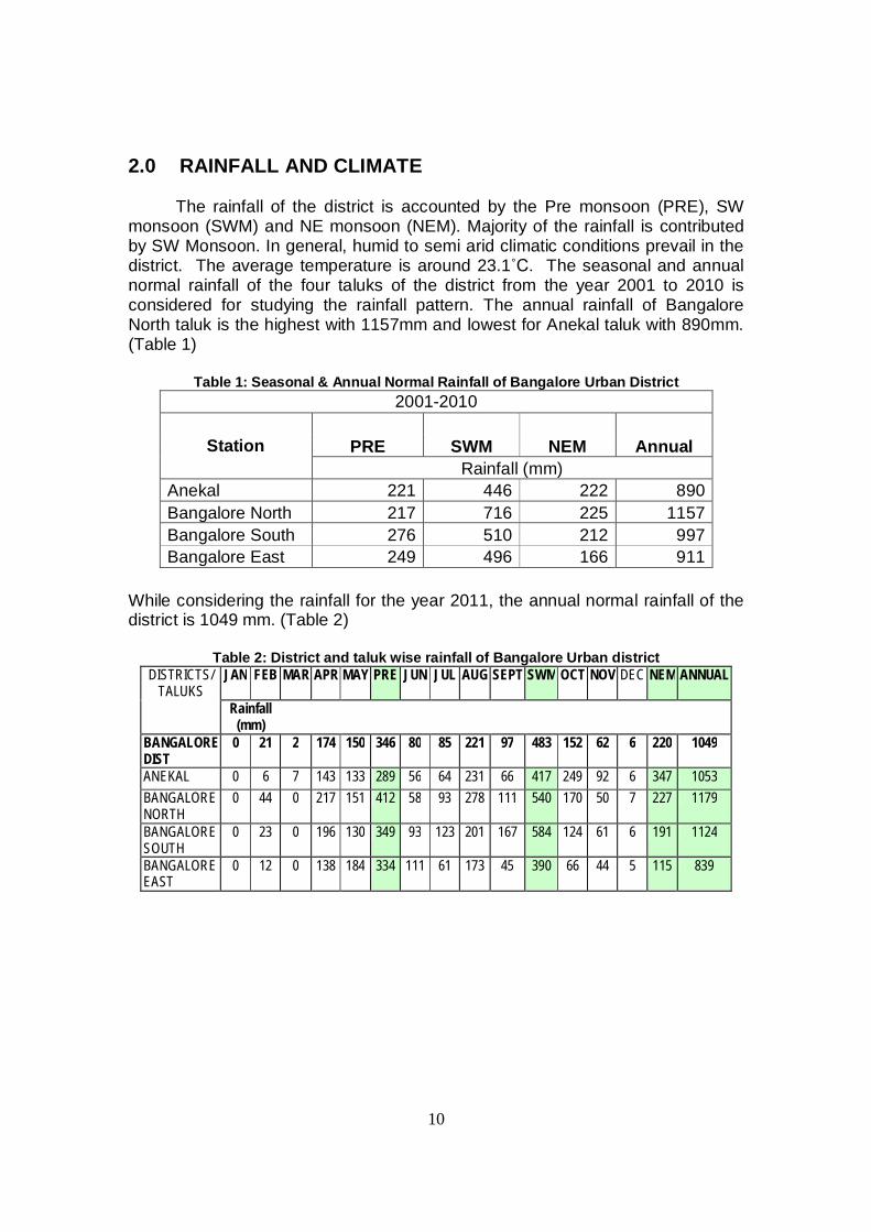
2.0 RAINFALL AND CLIMATE The rainfall of the district is accounted by the Pre monsoon (PRE), SW monsoon (SWM) and NE monsoon (NEM). Majority of the rainfall is contributed by SW Monsoon. In general, humid to semi arid climatic conditions prevail in the district. The average temperature is around 23.1˚C. The seasonal and annual normal rainfall of the four taluks of the district from the year 2001 to 2010 is considered for studying the rainfall pattern. The annual rainfall of Bangalore North taluk is the highest with 1157mm and lowest for Anekal taluk with 890mm. (Table 1)
Table 1: Seasonal & Annual Normal Rainfall of Bangalore Urban District 2001-2010
Station PRE SWM NEM Annual Rainfall (mm)
Anekal 221 446 222 890 Bangalore North 217 716 225 1157 Bangalore South 276 510 212 997 Bangalore East 249 496 166 911
While considering the rainfall for the year 2011, the annual normal rainfall of the district is 1049 mm. (Table 2)
Table 2: District and taluk wise rainfall of Bangalore Urban district DISTRICTS/
TALUKS JAN FEB MAR APR MAY PRE JUN JUL AUG SEPT SWM OCT NOV DEC NEM ANNUAL
Rainfall (mm)
BANGALORE DIST
0 21 2 174 150 346 80 85 221 97 483 152 62 6 220 1049
ANEKAL 0 6 7 143 133 289 56 64 231 66 417 249 92 6 347 1053 BANGALORE NORTH
0 44 0 217 151 412 58 93 278 111 540 170 50 7 227 1179
BANGALORE SOUTH
0 23 0 196 130 349 93 123 201 167 584 124 61 6 191 1124
BANGALORE EAST
0 12 0 138 184 334 111 61 173 45 390 66 44 5 115 839
11
3.0 GEOMORPHOLOGY AND SOIL TYPES
3.1 Geomorphology: Physiographically, the district can be divided into rocky upland, plateau &
flat topped hills at a general elevation of about 950amsl.The major part is sloping towards south and south east forming pediplains interspersed with hills all along the western part. The pediplains form the majority of the district underlain by granites and gneisses with the highest elevation of 850 to 950 m amsl. The pediplain constitute low relief area having matured dissected rolling topography with erosional land slope covered by a layer of red loamy soil of varied thickness. The pediplains is dissected by streamlets flowing in southern direction. 3.2 Soils:
The soils of the districts can be broadly grouped into red loamy soil and lateritic soil.
Red loamy and sandy soils generally occur on hilly to undulating land slope on granite and gneissic terrain. The soils are light textured and are highly leached in nature with good infiltration rate. It is mainly seen in the eastern and southern parts of Bangalore north and south taluks.
Laterite soils occur on undulating terrain forming plain to gently sloping topography of peninsular gneissic region. It is mainly covered in Anekal taluk and western parts of Bangalore North and south taluks. 4.0 GROUND WATER SCENARIO 4.1 Hydrogeology:
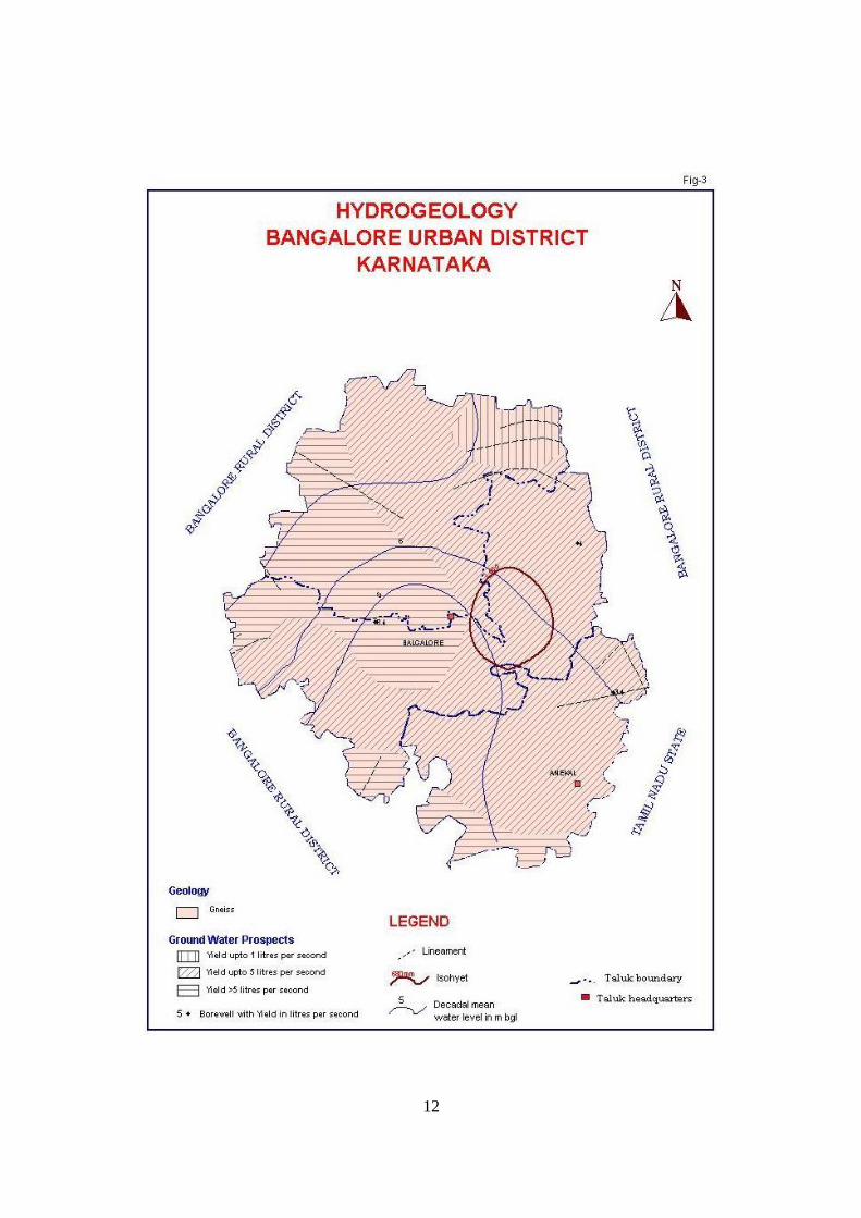
Ground water occurs in phreatic conditions or unconfined conditions in the weathered zone and under semi confined to confined conditions in fractured and jointed rock formations (Fig-3). The occurrence of Ground water movement and recharge to aquifers are controlled by various factors like fracture pattern, degree of weathering, geomorphological setup and amount of rainfall received.
Generally the depth of weathering varies, being more in the valley, and often extending up to 30 m in the dug wells. However the yield in the bore well is dependent upon factors like degree of weathering, presence of joints and fractures and its connectivity and the presence of intrusive bodies.
Granites and Gneisses of peninsular gneissic group constitute major
aquifers in the urban district of Bangalore. Laterites of Tertiary age occur as isolated patches capping crystalline rocks in Bangalore north taluk and ground water occur in phreatic condition. Alluvium of limited thickness and aerial extent of 20 to 25m thick occur along the river courses possessing substantial ground water potential.
12
13
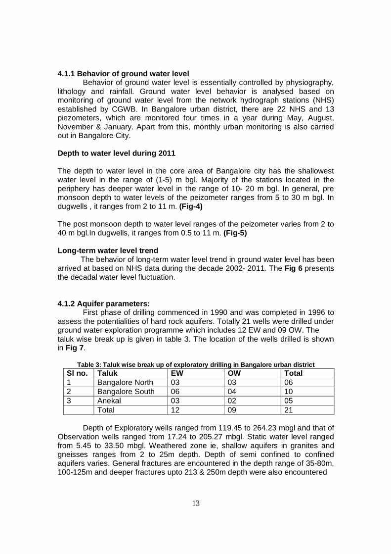
4.1.1 Behavior of ground water level Behavior of ground water level is essentially controlled by physiography,
lithology and rainfall. Ground water level behavior is analysed based on monitoring of ground water level from the network hydrograph stations (NHS) established by CGWB. In Bangalore urban district, there are 22 NHS and 13 piezometers, which are monitored four times in a year during May, August, November & January. Apart from this, monthly urban monitoring is also carried out in Bangalore City.
Depth to water level during 2011 The depth to water level in the core area of Bangalore city has the shallowest water level in the range of (1-5) m bgl. Majority of the stations located in the periphery has deeper water level in the range of 10- 20 m bgl. In general, pre monsoon depth to water levels of the peizometer ranges from 5 to 30 m bgl. In dugwells , it ranges from 2 to 11 m. (Fig-4)
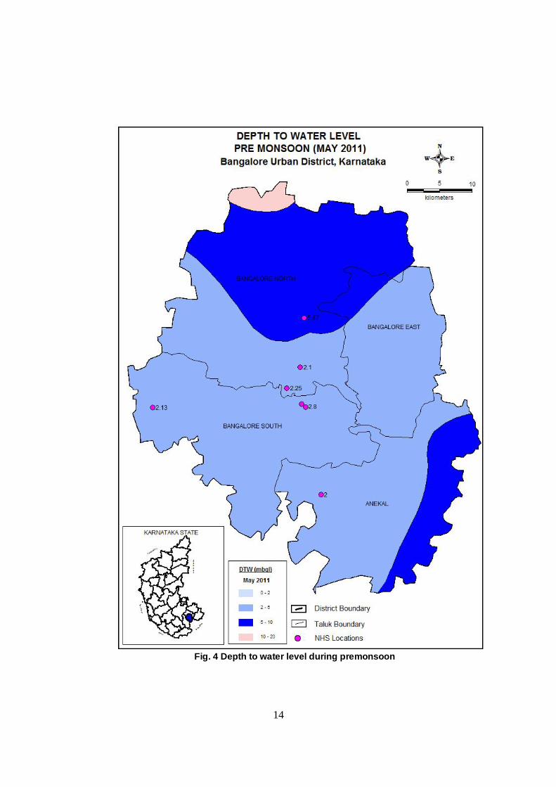
The post monsoon depth to water level ranges of the peizometer varies from 2 to 40 m bgl.In dugwells, it ranges from 0.5 to 11 m. (Fig-5)
Long-term water level trend
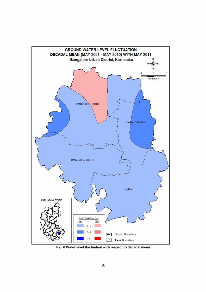
The behavior of long-term water level trend in ground water level has been arrived at based on NHS data during the decade 2002- 2011. The Fig 6 presents the decadal water level fluctuation. 4.1.2 Aquifer parameters:
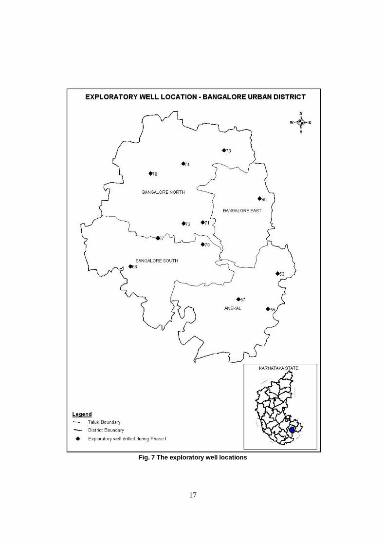
First phase of drilling commenced in 1990 and was completed in 1996 to assess the potentialities of hard rock aquifers. Totally 21 wells were drilled under ground water exploration programme which includes 12 EW and 09 OW. The taluk wise break up is given in table 3. The location of the wells drilled is shown in Fig 7.
Table 3: Taluk wise break up of exploratory drilling in Bangalore urban district Sl no. Taluk EW OW Total 1 Bangalore North 03 03 06 2 Bangalore South 06 04 10 3 Anekal 03 02 05 Total 12 09 21
Depth of Exploratory wells ranged from 119.45 to 264.23 mbgl and that of
Observation wells ranged from 17.24 to 205.27 mbgl. Static water level ranged from 5.45 to 33.50 mbgl. Weathered zone ie, shallow aquifers in granites and gneisses ranges from 2 to 25m depth. Depth of semi confined to confined aquifers varies. General fractures are encountered in the depth range of 35-80m, 100-125m and deeper fractures upto 213 & 250m depth were also encountered
14
Fig. 4 Depth to water level during premonsoon
15
Fig. 5 Depth to water level during post-monsoon
16
Fig. 6 Water level fluctuation with respect to decadal mean
17
Fig. 7 The exploratory well locations
18
in the district during ground water exploration programme. In general, discharge of the exploratory wells ranged from < 1.0 lps at Hesaraghatta to 8.4 lps at Bangalore university.
The aquifer in Bangalore urban district can be divided and generalized into
three zones namely shallow zone, moderately deep zone and deep zone. Shallow zone: Aquifer occurring within depth of 25m below ground level comprises of weathered and shallow fractured granites and gneisses and ground water occur in phreatic condition. Ground water development is mainly through dug wells, dug cum bore wells and shallow bore wells. Weathered thickness generally ranges from 5 to10m in 60% of the area in Bangalore south taluk and part of Bangalore north taluk. In Anekal taluk weathered zone thickness is deeper generally upto 25m depth. About 90% of ground water structures tapping shallow aquifers are yielding less than 1 lps and yield of more than 2 lps is recorded in Bangalore south taluk. Moderately deep zone: (Up to 60mbgl) Aquifer of this category consists of weathered and fractured granites and gneisses. Yield of the wells ranged from 2 to 6 lps. Transmissivity ranged from 10 to 65m2/day. In Deeper aquifers: (Beyond 60 m) Yield ranged from 2 to 8 lps in parts of Bangalore north and Anekal taluks. Transmissivity ranged from 15 to 280m2/day and storativity varies from 2.8*10-3 to 8.4*10-4.
During Hydrology Project-I, total of 22 piezometers were constructed in the district tapping mainly the phreatic aquifers of gneisses to a depth ranging from 30 to 90mbgl. The casing depth varied from 6.89 to 48.78m and discharge varied from 43.2 to 678m3/day. Depth to water level varied from 5.40 to 28.40m.bgl.
During the AAP of 2011-12, ground water exploration was carried out in
Bangalore urban district with the drilling of seven peizometers. The main aim of constructing the purpose built piezometers was for long term ground water monitoring purpose in terms of quantity and quality. The depth of the peizometer ranged from 100 to 162.5m bgl with discharge ranging from negligible to 4 lps. 4.2 Ground water resources:
Ground water resource of the district has been assessed keeping in view, the sustainable and optimum development of the resource. The estimation has been done based Ground Water Estimation methodology (GEM)-1997. Assessment is done taking into consideration of various hydrologic units viz. command, non command hilly area with more than 20 % slope and poor quality area.
19
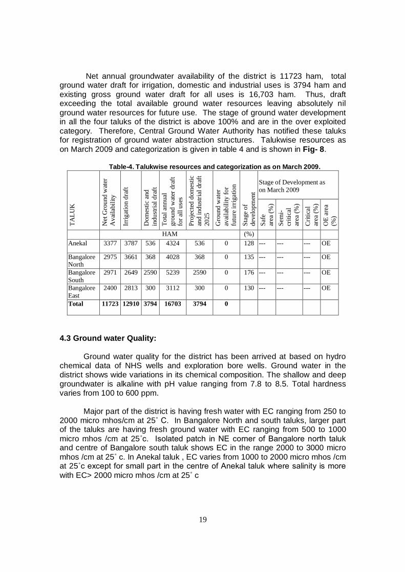
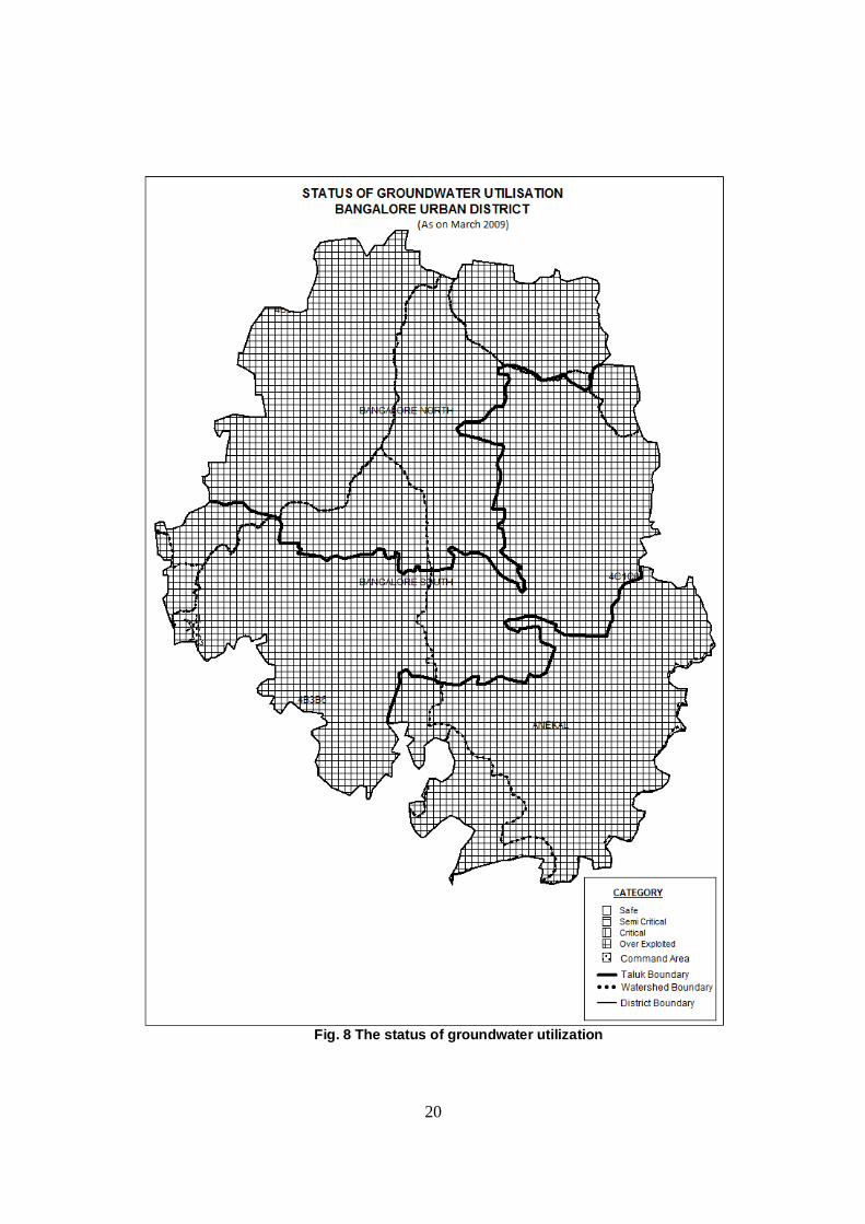
Net annual groundwater availability of the district is 11723 ham, total ground water draft for irrigation, domestic and industrial uses is 3794 ham and existing gross ground water draft for all uses is 16,703 ham. Thus, draft exceeding the total available ground water resources leaving absolutely nil ground water resources for future use. The stage of ground water development in all the four taluks of the district is above 100% and are in the over exploited category. Therefore, Central Ground Water Authority has notified these taluks for registration of ground water abstraction structures. Talukwise resources as on March 2009 and categorization is given in table 4 and is shown in Fig- 8.
Table-4. Talukwise resources and categorization as on March 2009.
TALU
K
Net
Gro
und
wat
er
Ava
ilabi
lity
Irrig
atio
n dr
aft
Dom
estic
and
in
dustr
ial d
raft
To
tal a
nnua
l gr
ound
wat
er d
raft
fo
r all
uses
Proj
ecte
d do
mes
tic
and
indu
stria
l dra
ft 20
25
Gro
und
wat
er
avai
labi
lity
for
futu
re ir
rigat
ion
Stag
e of
de
velo
pmen
t
Stage of Development as on March 2009
Safe
ar
ea (%
) Se
mi-
criti
cal
area
(%)
Crit
ical
ar
ea (%
) O
E ar
ea
(%)
HAM (%)
Anekal 3377 3787 536 4324 536 0 128 --- --- --- OE
Bangalore North
2975 3661 368 4028 368 0 135 --- --- --- OE
Bangalore South
2971 2649 2590 5239 2590 0 176 --- --- --- OE
Bangalore East
2400 2813 300 3112 300 0 130 --- --- --- OE
Total
11723 12910 3794 16703 3794 0
4.3 Ground water Quality:
Ground water quality for the district has been arrived at based on hydro chemical data of NHS wells and exploration bore wells. Ground water in the district shows wide variations in its chemical composition. The shallow and deep groundwater is alkaline with pH value ranging from 7.8 to 8.5. Total hardness varies from 100 to 600 ppm.
Major part of the district is having fresh water with EC ranging from 250 to 2000 micro mhos/cm at 25˚ C. In Bangalore North and south taluks, larger part of the taluks are having fresh ground water with EC ranging from 500 to 1000 micro mhos /cm at 25˚c. Isolated patch in NE corner of Bangalore north taluk and centre of Bangalore south taluk shows EC in the range 2000 to 3000 micro mhos /cm at 25˚ c. In Anekal taluk , EC varies from 1000 to 2000 micro mhos /cm at 25˚c except for small part in the centre of Anekal taluk where salinity is more with EC> 2000 micro mhos /cm at 25˚ c
20
Fig. 8 The status of groundwater utilization
21
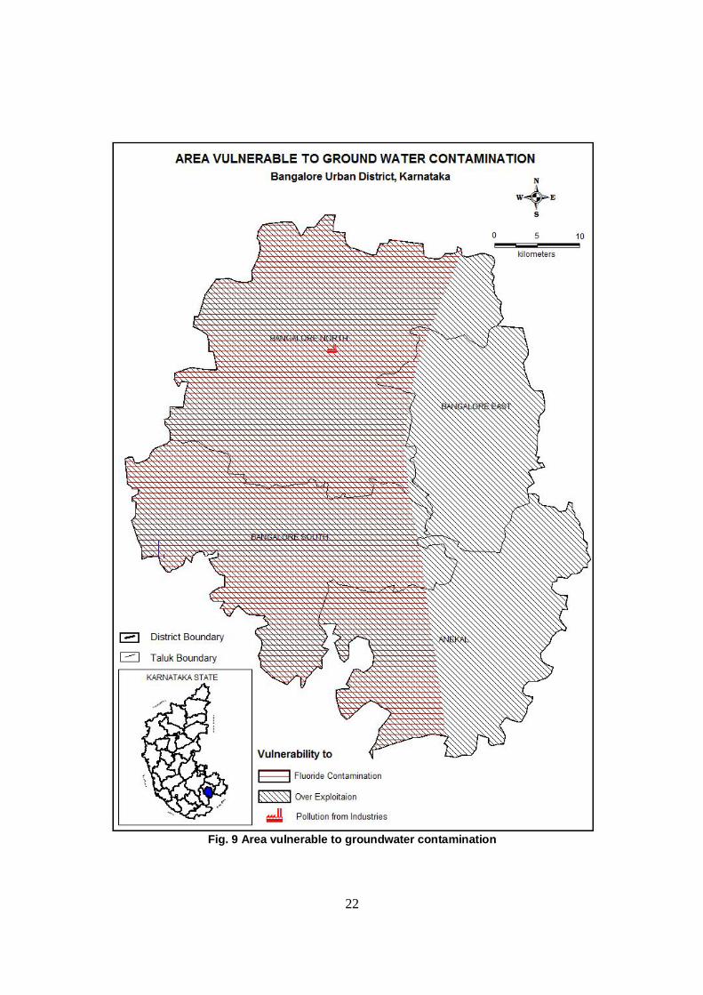
Larger part of Anekal taluk, isolated patches in the eastern part of
Bangalore north, southwest and eastern part of Bangalore south taluk is having Chloride in the range of 250 to 1000 mg/l.
Major part of the area of Anekal taluk and in Bangalore south taluk, is having nitrate content more than the permissible limit of > 45mg/l. In Bangalore north taluk only small portions in southwestern part and northeastern part, ground water is affected by high nitrate content. In general ground water in the district is of sodium Chloride type Flouride content in general is less than 1 ppm and in localized pockets of Bangalore south taluk, fluoride content above 1 mg/l is reported. The area vulnerable for groundwater contamination by fluoride is prepared by the department and the same is presented in Fig-9. 4.4 Status of ground water development: In Bangalore district, ground water is mainly developed through dug wells, dug cum borewells, borewells for irrigation, industrial and domestic purposes. In recent years, due to haphazard urbanization, exponential growth in population and industrial units, demand for water has resulted in indiscriminate drilling of bore wells by individual households, business establishments and industries. This has resulted in depletion of ground water levels & over exploitation of the ground water resources in the district.
Presently, water supply to the core area of about 220 sq km is mainly through surface water schemes of Cauvery river. This is done by state govt. dept like Bangalore water supply and Sewerage Board (BWSSB) with BBMP limits. However, in the outer sub urban area of 500 sq km within BBMP limit, there is no piped water supply from Cauvery river and the water requirement is mainly met from groundwater. As a result, the exploitation of ground water is more in the outer peripheral area than the core area. The same is reflected by the water level trend of the district as per CGWB data..
Out of the net irrigated area of 66375 ha in the district, a 10752 ha is irrigated as per Minor irrigation census of 2006-07. Ground water is the source for all types of irrigation. As per minor irrigation census of 2006-07, there are about 14992 minor irrigation schemes in the district. Of which there are total 43 dug wells schemes in the district and the highest being in Bangalore South taluk. Most of the schemes are private belonging to group of farmers or individual.
From the assessment of ground water resources, it is seen that all the taluks are categorized as over exploited with stage of development being more than (128-176) % and in principle there is no balance ground water resources left for future development in the dynamic zone , except some of the isolated patches.
22
Fig. 9 Area vulnerable to groundwater contamination
23
5.0 GROUND WATER MANAGEMENT STRATEGY 5.1 Ground water resource development:
In view of the over exploitation of ground water resources in all the four taluks, instead of recommending additional ground water abstraction structures, methods of augmenting the resources such as artificial recharge methods, rain water harvesting are recommended. Drip and micro irrigation are to be encouraged for water use efficiency. This will help to minimize ground water withdrawal and building up of ground water resource. Water use efficient fixtures and gadgets are to promoted in urban clusters. 5.2 Water conservation and Artificial recharge:
In view of the notification of all the four taluks as Over exploited as per GEC , 2009, methods of augmenting the resources such as artificial recharge methods, rain water harvesting and water shed management practice is to be made mandatory. Some of the artificial recharge studies taken up by CGWB are as below. 1) Bangalore University: The Central Ground Water Board (2002-2005) implemented a scheme of artificial recharge under the Central Sector Scheme in association with Bangalore University in 2 phases with financial support from Govt.of India. Under phase I, 2 check dams, one combination structure of check dam and subsurface dykes were constructed with 3 observation wells. Under phase-II, 2 check dams, one vertical shaft, 3 gully plugs and 4 observation wells were constructed. Also, Rooftop rainwater harvesting was facilitated in the civil engineering department in the university.
The natural surface water run-off has been harnessed to recharge the depleting aquifer system instead letting it into a drainage course (Vrishabahvathi). The observation wells in the catchment area were monitored to study water level behavior. The productivity of the bore well in the university and Sports Authority of India(SAI) campus has increased during the post project period. As per the observations, it is seen that there was no decline in water level trend after the implementation of the scheme in the observation wells. The possible intrusion of polluted Vrishbahavthi waters into aquifers is prevented and the chemical quality analysis of the ground water samples collected in the area reveals that there is no deterioration of ground water quality in the area. Apart from water conservation through artificial recharge, the complete catchment area of the micro watershed has been treated with contour trenches. Tree saplings have been planted all along the contour trenches to have a green canopy for the area. (2) Schemes completed under Fresh Water Year Activities during 2003.
Four schemes on Artificial Recharge and Rain water harvesting were implemented wherein CGWB provided technical and financial assistance and the beneficiary agency implemented the project as shown below
24
BDA head office, Bangalore Armed Police Training School and Police Driving Maintenance School, Raj
Bhawan, Yelahanka,Bangalore Indian institute of Horticulture Research, Bangalore IIHR, Hesaraghatta, BAngalore
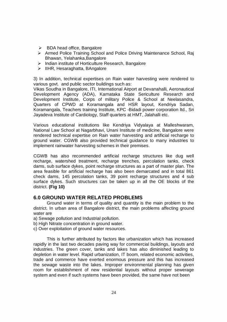
3) In addition, technical expertises on Rain water harvesting were rendered to various govt. and public sector buildings such as: Vikas Soudha in Bangalore, ITI, International Airport at Devanahalli, Aeronautical Development Agency (ADA), Karnataka State Sericulture Research and Development Institute, Corps of military Police & School at Neelasandra, Quarters of CPWD at Koramangala and HSR layout, Kendriya Sadan, Koramangala, Teachers training Institute, KPC -Bidadi power corporation ltd., Sri Jayadeva Institute of Cardiology, Staff quarters at HMT, Jalahalli etc. Various educational institutions like Kendriya Vidyalaya at Malleshwaram, National Law School at Nagarbhavi, Unani Institute of medicine, Bangalore were rendered technical expertise on Rain water harvesting and artificial recharge to ground water. CGWB also provided technical guidance to many industries to implement rainwater harvesting schemes in their premises. CGWB has also recommended artificial recharge structures like dug well recharge, watershed treatment, recharge trenches, percolation tanks, check dams, sub surface dykes, point recharge structures as a part of master plan. The area feasible for artificial recharge has also been demarcated and in total 861 check dams, 145 percolation tanks, 39 point recharge structures and 4 sub surface dykes. Such structures can be taken up in all the OE blocks of the district. (Fig 10) 6.0 GROUND WATER RELATED PROBLEMS
Ground water in terms of quality and quantity is the main problem to the district. In urban area of Bangalore district, the main problems affecting ground water are a) Sewage pollution and Industrial pollution. b) High Nitrate concentration in ground water. c) Over exploitation of ground water resources.
This is further attributed by factors like urbanization which has increased rapidly in the last two decades paving way for commercial buildings, layouts and industries. The green cover, tanks and lakes has also diminished leading to depletion in water level. Rapid urbanization, IT boom, related economic activities, trade and commerce have exerted enormous pressure and this has increased the sewage waste into the lakes. Improper environmental planning has given room for establishment of new residential layouts without proper sewerage system and even if such systems have been provided, the same have not been
25
Fig.10 Artificial recharge plan
26
connected to trunk sewers of BWSSB. The municipal effluents from such natural drains leading to tanks and lakes deteriorate the quality of the water. Sedimentation of the pollutants has not only reduced the surface area of the water which in turn has increased evaporation rate, but has also reduced ground water levels on account of poor permeability with more and more silt, clay deposits, trash and toxic waste accumulation in the lakes year after year. Ministry of Water resources Govt. of India has accorded approval vide order no. 7/1/2009-WB dated 02.03.2009 for the “Scheme of Repair, Renovation and Restoration of water bodies with Domestic support” along with Minor irrigation department. It is a state sector scheme where under the constitution of District level implementation and Monitoring committee, issues related to implementation, management, supervision and effectiveness of the project is monitored in some districts of Karnataka. Efforts are being also made by BBMP to conserve and rejuvenate major tanks in Bangalore city. Sewage pollution as obseved in the western part of the city where all the sewage is let into Vrishbahvathi river valley and most of the tanks are also polluted from sewage source due to haphazard urbanization. As per CGWB studies, most of the open wells/borewell situated in the vicinity of Vrishbhavathi river is polluted due to sewerage discharging into the river. However, impact assessment of artificial recharge structures in Bangalore university has shown that, there is improvement in the quality of ground water in and around Vrishabhavathi valley. Regarding industrial pollution, study of CGWB shows that, in Industrial belt of Peenya, Rajajinagar and Hoskote area, Ground water is slightly alkaline and indicated high concentration of chloride and magnesium in ground water and high nitrate in all the industrial belts of Peenya, Hoskeote, Rajajinagar and Kanakapura road. However water is free from bicarbonates. Nitrate concentration is the single major constraint for suitability of ground water for drinking is concerned. Major part of the shallow ground water ie., 45 % of the area is affected by high nitrate content which may be due to natural sewage and point source pollution whereas, deeper aquifer is not affected to that extent by high nitrate content.
Over exploitation of ground water Resources: Rapid and unplanned urbanization has taken its toll on water resources of the district, especially the ground water with increased exploitation by borewells dug up in all possible terrains. In view of the stage of the ground water development to the tune of 128-176% and over exploitation of ground water resources water level has gone deeper thereby leaving the only solution of building up of ground water resource through artificial recharge and rainwater harvesting.
7.0: AWARENESS, TRAINING ACTIVITY, ETC 7.1 Mass awareness, Water management, seminar and painting competition
27
organized by CGWA and IEC CGWB has conducted various Water Management training programme
and mass awareness programme in the district.
Water Management Training programme: Training programme on Roof top Rain water harvesting at Kendriya
Sadan, Bangalore on 23.2.2001, 40 trainees from different state departments, NGOs and individuals attended the two days training programme.
Water Management Training Programme was conducted at Bangalore during 3rd -4th of February 2005 (During RWH week-2005) wherein about 40 trainees from different state departments, NGOs and individuals had the benefit of technical talks and field visit.
Other training programme:
One week Orientation training course on “Ground Water Development and Management “from 20.12.2010 to 24.12.2010 at Bhujal Bhawan, Bangalore. Totally 23 trainees attended the training. A RGI training programme on “ Administrative and Financial matter” was
organized from 10.01.2011 to 15.01.2011 at Bhujal Bhawan, Bangalore. In total 20 trainees attended the training.
Mass awareness programme:
Awareness programme was organized at Kendriya Vidyalaya, Malleswaram, Bangalore during RWH week on 8.2.2005. Drawing competitions were held for school children on the theme of water conservation, models were exhibited. About 900 students and teaching staff participated in the programme.
Workshop:
One day workshop on “Ground water scenario, water quality, and enhancement of water use efficiency in Karnataka and Goa” was held during Feb, 2010 at Bhujal Bhawan, Bangalore. One day workshop on “Radon contamination in groundwater” was organized by the department during March, 2010 at Bhujal Bhawan, Bangalore. Brain storming session on “Knowledge economy at water sector” was organized by CGWB in association with WAPCOS during 2010-11. A national workshop on “Regulation and protection of Ground water resources” was organized by CGWB during January, 2012 at Bhujal Bhawan, Bangalore.
Painting Competition:
School and State level Painting Competition was organized by CGWB on
28
the theme” Save water-every drops counts”. Totally 2934 students participated.
7.2: Participating in Exhibitions, Mela, Fair etc: Participated as guest of honour and delivered talk on water conservation in
the mass awareness programmes organized by Department of Mines and Geology, Govt.of Karnataka at Anekal and Devanahalli during 2004 and 2006.
On account of World Water Day celebration by CWC during June 2006, CGWB put up a stall on Water conservation wherein; His Excellency President of India visited the stall.
Participated in Jaladhara caravan organized by NGO-Rashtrabandhu in Bangalore during April 2006.
Participated in "Save Water" campaign organized by NGO-Eco watch in Bangalore during April 2007.
Organized World water day independently and in coordination with CWC, Institute of Engg. and project Agasthya in Bangalore every year.
As a part of Rain Water Harvesting week celebrations, prepared working models on Artificial Recharge and Rainwater harvesting, hoardings, documentaries and posters on water conservation. Hoardings were displayed at vantage points in Bangalore city and posters were distributed to various state, central agencies and educational institutions and NGOs for campaign. Also, during first week of February 2005 exhibited working models and posters at Dr.Ambedkar Institute of Technology & St.Joesph,s college of Commerce Inauguration of first housing demonstrative project by Govt. of India at Laggere. At campaign by Indian society of environmental studies, Karnataka State Council of Science and technology and Bharat Education society. CGWB was associated with deliberation of state government agencies for prime minister’s relief package for farmer distress districts. During the year 2008, CGWB was associated with NGO Navachetana Trust in “Save Arkavathi” project. Associated with Minor Irrigation Department, Govt. of Karnataka on Flood control and River management. Review meeting of Dug well recharge scheme held with CGWB under the chairmanship of Additional Secretary and Development Commissioner on 05.06.2009. Meeting of working group of GEC for re-estimation of Groundwater Resource estimation regarding data dissemination and formation of resource estimation committee for resource evaluation. Regional Coordination Committee meeting on hard rock held at NIH, Belgaum where the Regional Director, CGWB, SWR, Bangalore is

29
one of the member. CGWB participated in Bharat Nirman Exhibition organized by Press Information Bureau at Mulbugal , Kolar, Pandavpura, Mandya district and at Hunsur, Mysore district. Working models, documentary and films of the department were exhibited at Mansa-2010 organized by Department of Geology and Earth Science, University of Mysore World Water day is celebrated every year.
7.3: Presentation & lectures delivered in public forum/Institution of repute and Academic institutions etc:
As resource personals, officers of CGWB delivered lectures on various themes of water conservation and water science in seminars/workshops, training programmes organized by State govt./central Govt organizations, NGOs, educational institutions such as-
State Govt. departments: Department of Mines and Geology, RDPR, State Educational Research and Training Directorate, Agro Industries, Karnataka Milk Federation, Regional Institute of Cooperative Management, Water Resource Department . Educational Institutions: Indian Institute of Science, Bangalore university, Geological society of India, National Institute of Advanced Studies - IISc, RV Engg college, Dayanand sagar college, SSMRV college, East West College, Univ. of Agriculture, Bangalore. NGOs and other institutions: INSTRUCT, Rashtra Bandhu, Eco watch, BIRD-K, Central Govt. departments: CPWD, Airforce campus, Central Silk Board, Geological Survey of India. 8.0: AREAS NOTIFIED BY CGWA
All the four taluks of the district has been regulated by CGWA for over
exploitation. This notification has brought out through various public notices published in the daily newspapers where registration of all the ground water abstraction structure is mandatory.
As per Directives of CGWA, all Industries seeking NOC for ground water abstraction are required to submit a referral letter from statutory organizations such as State Pollution Control Boards, Ministry of Environment and Forests, Bureau of Indian Standards, etc. In Critical/ Over-exploited areas, it is considered on case to case basis and in case of severely over-exploited areas which are devoid of any deeper potential aquifers, NOC for industrial use of ground water may be denied as per the policy. The permission for NOC for ground water withdrawal is accorded by CGWA, a mandatory clause for Rain Water Harvesting
30
and Artificial Recharge to ground water by the Industry/ Infrastructure projects is included. 9.0 RECOMMENDATIONS
In view of the Over exploited situation of ground water resources in the whole district following recommendations are made. Artificial recharge to ground water through structures like dug well
recharge, watershed treatment, recharge trenches, percolation tanks, check dams, sub surface dykes, point recharge structures should be implemented based on site specific scientific investigation. The area feasible for artificial recharge has been demarcated and in total 861 check dams, 145 percolation tanks, 39 point recharge structures and 4 sub surface dykes. Such structures can be taken up in all the OE blocks of the district.
Lakes were created basically for hydrological reasons for checking floods, recharging, and maintaining the ground water table. They also act as sediment traps, prevent clogging up of natural valleys and reduce erosion by regulating run off. Lakes and Tanks belong to wetland ecosystem and have a larger biological and ecological role. Due to urbanization most of the tanks/lakes in the districts have been erased form the map. Hence, measures for rejuvenation of tanks and lakes in the district will definitely build up ground water resources.
There are more than 200 parks in Bangalore City, which has also large
institutions, industries, public, and semi-public areas that can be utilized for rainwater harvesting. Additional water bodies in barren catchments of various campuses should be developed on a large scale to prevent wastage of run-off and to help augmenting ground water recharge. Multi approach method is ideal to have maximum benefits.
Central ground Water Authority has circulated the Model Bill to enact in the state in 1996 and 2005. Accordingly, the state has enacted Karnataka Ground water Act, 2011 (Regulation and Control of Development and management) and Rule 2012 to regulate the over exploitation of ground water in the state. The state Government has established the Karnataka Groundwater Authority to implement the act and rules in the state.
Waste water recycling for secondary uses like gardening, industrial cooling, flushing and other secondary purposes through municipal supply, which will definitely help to keep a check on over exploitation of ground
31
water sources and thus building up the ground water resources in the district.
In recent years many countries have implemented water recycling projects successfully. In addition to this, dual water supply systems in the upcoming areas for potable and non-potable water separately, are to be considered as a viable option to minimize the pressure on fresh water supply.
These recommendations can be implemented through public awareness and training through Central/ State administration, which will go in long way in realizing the civic responsibility towards very important element of life "water".
****************
Related Documents