GROUND-WATER-FLOW SYSTEMS IN THE POWDER RIVER STRUCTURAL BASIN, WYOMING AND MONTANA by James G. Rankl and Marl in E. Lowry U.S. GEOLOGICAL SURVEY Water-Resources Investigations Report 85-4229 Cheyenne, Wyoming 1990

Welcome message from author
This document is posted to help you gain knowledge. Please leave a comment to let me know what you think about it! Share it to your friends and learn new things together.
Transcript
GROUND-WATER-FLOW SYSTEMS IN THE POWDER
RIVER STRUCTURAL BASIN, WYOMING AND MONTANA
by James G. Rankl and Marl in E. Lowry
U.S. GEOLOGICAL SURVEY
Water-Resources Investigations Report 85-4229
Cheyenne, Wyoming
1990

U.S. DEPARTMENT OF THE INTERIOR
MANUEL J. LUJAN, JR., Secretary
U.S. GEOLOGICAL SURVEYi
Dallas L. Peck, Director
For additional information to:
District Chief U.S. Geological Survey 2617 E. Lincolnway, Suite B Cheyenne, Wyoming 82001
Copies of this report can be write purchased from:
U.S. Geological SurveyBooks and Open-File Reports SectionFederal Center, Building 810Box 25425Denver, Colorado 80225

CONTENTS
Page
Abstract................................................................ 1Introduction............................................................ 2
Purpose and scope.................................................. 2Precipitation...................................................... 4Geology............................................................ 4
Ground water............................................................ 6Aquifer data....................................................... 6Chemical quality of water.......................................... 7
Streamflow.............................................................. 8Regional ground-water-flow systems...................................... 15
Stratigraphic control.............................................. 15Discharge to streams............................................... 19
Basin streams................................................. 20Powder River.................................................. 20
Local ground-water-flow systems......................................... 20Alluvial systems................................................... 21
Losing streams................................................ 22Gaining streams............................................... 30
Clinker............................................................ 30Conclusions............................................................. 37References cited........................................................ 38
PLATE
Plate 1. Generalized geologic map showing location of streamflow- gaging stations, Powder River structural basin, Wyoming and Montana................................................. In
FIGURES
Figure 1. Map showing relation of the Powder River structural basin to nearby structural features and approximate areal extent of Fox Hills Sandstone.............................. 3
2. Graphs of normal monthly precipitation for selectedstations in the Powder River Basin, 1941-70................ 5
3. Graph showing differences in the chemical quality of waterwith depth in the Wasatch-Fox Hills sequence............... 9
4. Flow-duration curves for the Niobrara River at Wyoming- Nebraska State line (06454000), 1956-77 water years........ 11
5. Average-daily-discharge hydrograph for the Niobrara River at Wyoming-Nebraska State line (06454000), 1956-77 water years...................................................... 12
6. Flow-duration curves for Black Thunder Creek near Hampshire,Wyo. (06376300), 1972-77 water years....................... 13

FIGURES--Continued
Page
7. Average-daily-discharge hydrograph for Black Thunder Creeknear Hampshire, Wyo. (06376300), 1
8. Flow-duration curves for Dead HorseWyo. (06313700), 1971-77 water ye*
9. Average-daily-discharge hydrograph for Dead Horse Creeknear Buffalo, Wyo. (06313700), 1971-77 water years......... 17
10. Diagrammatic geohydrologic section
972-77 water years....... 14Creek near Buffalo,rs....................... 16
howing regionalground-water flow (arrows) controlled by stratigraphy...... 18
11. Diagrammatic geohydrologic section showing regionalground-water flow into major streams....................... 18
12. Graph showing percentages of wells less than 250 ft deepand springs that yield sodium bicarbonate type water....... 19
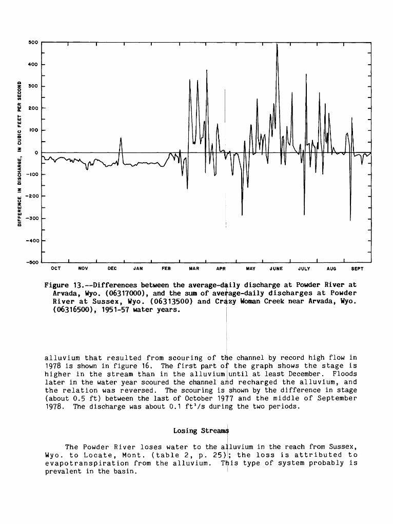
13-16. Hydrographs showing:13. Differences between the average-daily discharge at
Powder River at Arvada, Wyo. (06317000), and the sum of the average-daily discharges at Powder River at Sussex, Wyo. (06313500) and Crazy Woman Creek near Arvada, Wyo. (06316500), 1951-57 water years.......... 22
14. Differences between the average-daily discharge atPowder River at Moorhead, Mont. (06324500), and thesum of the average-daily discharges at Powder Riverat Arvada, Wyo. (06317000) and Clear Creek nearArvada, Wyo. (06324000), 1940-72 water years.......... 23
15. Differences between average-daily discharge at Powder River at Locate, Mont. (06326500) and Powder River at Moorhead, Mont. (06324500), 1940-72 water years.... 24
16. Relation of water levels in thel alluvium to the stage of the Cheyenne River near Du^l Center, Wyo. (06365900), 1978 water year.. 1......................... 26
17. Graph showing vegetation density along the Powder Rivervalley..................................................... 28
18. Hydrographs showing water levels in two wells completed in bedrock and two wells completed in the alluvium, Sheridan County, Wyo....................................... 29
19. Flow-duration curves for Little Missouri River at Camp Crook, S. Dak. (06334500), 1957-77
20. Map showing extent of the alluvium in the upper part ofthe Little Missouri River basin and nearby drainages....... 32
21. Flow-duration curves for Otter Creek 1 at Ashland, Mont. (06307740) and Pumpkin Creek near Miles City, Mont. (06308400), 1972-77 water years............................ 34
22. Average-daily-discharge hydrograph for Otter Creek atAshland, Mont. (06307740), 1972-77 water years............. 35
23. Average-daily-discharge hydrograph for Pumpkin Creek nearMiles City, Mont. (06308400), 1972-77 water years.......... 36
water years............. 31

TABLES
Table 1. Summary of ground-water and surface-water relations ofstreams originating in areas underlain by the Wasatch- Fox Hills sequence, from flow-duration curves and average- daily-discharge hydrographs...............................
2. Summary of change in low flow in the Powder River fromaverage-daily discharge during periods of minimal runoff.,
3. Runoff and factors affecting runoff, Otter Creek at Ashland Mont. (06307740), and Pumpkin Creek near Miles City, Mont, (06308400)................................................
Page
21
25
33
CONVERSION FACTORS
Multiply by
acre 0.4047foot (ft) 0.3048cubic foot per second (ftVs) 0.02832gallon per minute (gal/min) 0.06308inch (in.) 25.4mile (mi) 1.609square mile (mi 2 ) 2.590foot squared per day (ftVd) 0.0929
To obtain
hectaremetercubic meter per secondliter per secondmillimeterkilometersquare kilometermeter squared per day
Sea level: In this report, "sea level refers to the National Geodetic Vertical Datum of 1929 (NGVD of 1929) a geodetic datum derived from a general adjustment of the first-order level nets of both the United States and Canada, formerly called "Sea Level Datum of 1929."
GROUND-WATER-FLOW SYSTEMS IN THE POWDER RIVER STRUCTURAL BASIN,
WYOMING AND MONTANA
By James G. Rankl and Marlin E. Lowry
ABSTRACT
This study of regional ground-water flow in the Powder River structural basin was intended to describe the water resources of an area of coal develop ment and to determine the effects of the development on the water resources. The basin receives only about 12 to 16 inches of precipitation per year. The bedrock units described consist of the Fox Hills Sandstone and the Lance Formation of Late Cretaceous age, the Fort Union Formation of Paleocene age, and Wasatch Formation of Eocene age. These formations are heterogeneous, consisting predominantly of shale and sandstone.
Water wells in the area principally are for livestock and domestic supplies. Water for these supplies generally can be obtained from wells less than 500 feet deep. The water from the shallow wells generally is a calcium sulfate or calcium sodium sulfate type. Some industrial wells are drilled to depths greater than 5,000 feet to obtain larger quantities of water; these wells commonly tap several formations. Water from deep wells generally is a sodium bicarbonate type.
The types of streams in the area are perennial, ephemeral, and inter rupted. Some of the perennial streams in the basin originate in nearby mountains.
Northward regional ground-water flow that is stratigraphically controlled can be inferred from potentiometric data, but discharge areas in the northern part of the basin could not be identified on the basis of chemical quality of water from springs and shallow wells. The chemical quality of ground water from shallow depth in the northern part of the basin is affected more by local conditions than by regional flow.
Potentiometric data indicate that most streams in the Powder River structural basin should receive base flow from a regional ground-water system. However, such base flow is not evident in streamflow records. Streamflow data collected at fourteen stations on eight streams show that base flow occurs at six of the stations, but base flow during the nongrowing season occurred only in Otter Creek and the Little Powder River. The three largest streams included in the analysis were the Powder, Belle Fourche, and Cheyenne Rivers. Of the three, only the Belle Fourche had base flow, and it was present only during the period of largest precipitation, but not during the period of minimum evapotranspiration. The locations of the streams that do not have base flow and the period of base flow that occurs in most streams indicate that base flow, where present, is from local systems rather than a regional system.

The absence of base flow in streams derived from ground water moving through the regional system is the result of the nonhomogeneity of the formations. The nonhomogeneity of the formations precludes the use of simple water-level maps as a substitute for sets of stratigraphically based potenti- ometric maps.
Analysis of streamflow records indicates that alluvial and clinker aquifers have more measurable effect on flow at the stations analyzed than do bedrock aquifers. The alluvium contributes flow to some streams, but most streams probably lose water to the alluviufn to replace water discharged by evapotranspiration. !
The existence of those areas of natural ground-water discharge from a regional ground-water system consisting of the Wasatch-Fox Hills sequence in the Powder River structural basin that would be inferred from potentiometric data could not be substantiated. Therefore, it is concluded that the regional flow system may have a smaller flow than previously thought, and that measur able effects from surface mining and water development will affect mostlylocal flow systems. However, more data are subregional flow systems and their relation to
INTRODUCTION
necessary to describe local and the regional system.
The development of the coal resources that began in the Powder River structural basin (fig. 1) in the mid-1970's required additional water supplies and possibly could have a negative effect on existing supplies. The U.S. Geological Survey, under its coal-hydrology program, began extensive studies in the basin in both Montana and Wyoming in 1975.
Purpose and Scope
This report, which is one of several that resulted from the studies, summarizes the relative amounts of regional and local ground-water flow in the basin.
The initial concept of the ground-water-flow system was that the vertical component of ground-water flow was large enough for a regional flow system to measurably sustain the flow in the principal streams. If true, the characteristics of regional ground-water flow should be indicated by the seasonalcharacteristics of base flow in the the principal streams. Few streamflow data for studying the ground-water/surface-waUer relations would have been available, had a consistent period of record been used for the analysis; therefore, any continuous-record station with 5 or more years of record through water year 1977 was included. Some analyses of long-term records were done before the records for water year 1977 were available; analyses and illustrations using these data were not updated to include water year 1977. Analyses of flow data for streams or stream reaches in which the natural flows are substantially affected by releases of water from reservoirs are not included in this report.

108° 107° 106° I05e 104° 103°
Powder River
structurol boeln
P MILES
50 KILOMETERS
EXPLANATION
CONTACT OF UPPER CRETACEOUS FOX HILLS SANDSTONE--Dashed where inferred. Contacts
interpreted from Ksefer (1974), Ross and others(1955), and Lewis and Roberts (1978)
OUTLINE OF POWDER RIVER STRUCTURAL BASIN--
Approximately located
Figure 1. Relation of the Powder River structural basin to nearby structural features and approximate areal extent of Fox Hills Sandstone.
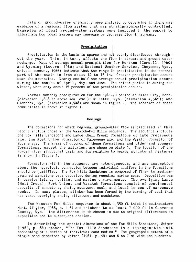
Data on ground-water chemistry were analyzed to determine if there was evidence of a regional flow system that was stratigraphically controlled. Examples of local ground-water systems were included in the report to illustrate how local systems may increase or decrease flow in streams.
Precipitation
Precipitation in the basin is sparse and not evenly distributed through out the year. This, in turn, affects the flow in streams and ground-water recharge. Maps of average annual precipitation for Montana (Cordell, 1960) and Wyoming (Lowers, 1960; and National Weatlher Service, Cheyenne, Wyo., written commun., 1966) indicate that the range in precipitation in the central part of the basin is from about 12 to 16 in. Greater precipitation occurs near the mountains. Nearly one half the average1 annual precipitation occurs during the months of April, May, and June. The driest period is during the winter, when only about 15 percent of the precipitation occurs.
Normal monthly precipitation for the 1941-70 period at Miles City, Mont, (elevation 2,628 ft above sea level); Gillette, Wyo. (elevation 4,565); and Glenrock, Wyo. (elevation 4,948) are shown in figure 2. The location of these communities is shown in figure 1.
Geology
The formations for which regional ground-water flow is discussed in this report include those in the Wasatch-Fox Hills sequence. The sequence includes the Fox Hills Sandstone and Lance (Hell Creek) Formations of Late Cretaceous age, the Fort Union Formation of Paleocene age, and the Wasatch Formation of Eocene age. The areas of outcrop of these formations and older and younger formations, except the alluvium, are shown on plate 1. The location of the Powder River structural basin and its relation to nearby structural features is shown in figure 1.
Formations within the sequence are heterogeneous, and any assumption about the hydrologic connection between individbal aquifers in the formations should be justified. The Fox Hills Sandstone is composed of fine- to medium- grained sandstone beds deposited during receding marine seas. Deposition was in barrier-island, neritic, and marine environments. The overlying Lance(Hell Creek), Fort Union, and Wasatch Format ions consist of continentaldeposits of sandstone, shale, mudstone, coal, ard local lenses of carbonate rocks. In many places, clinker has been formed by the burning of coal that has baked overlying shale, siltstone, and sandstone.
The Wasatch-Fox Hills sequence is about 1,350 ft thick in southeastern Mont. (Taylor, 1968, p. 4-6) and thickens to at least 7,000 ft in Converse County, Wyo. The difference in thickness is due to original differences in deposition and to subsequent erosion.
In describing the spatial dimensions of the Fox Hills Sandstone, Weimer(1961, p. 84) states, "The Fox Hills Sandstc ne is a lithogenetic unitconsisting of a series of individual sand bodies,." The geographic extent of a single sand described by Weimer (1961, p. 94) was 6 to 7 mi wide and hundreds

MILES CITY, MONTANA NORMAL ANNUAL PRECIPITATION = 13.93 INCHES
- 2z o
GILLETTE 2E, WYOMING NORMAL ANNUAL PRECIPITATION = 15.78 INCHES
GLENROCK 5ESE, WYOMING
NORMAL ANNUAL PRECIPITATION = 12.91 INCHES
JAN FEB MAR APR MAY JUNE JULY AUG SEPT OCT NOV DEC
Figure 2. Normal monthly precipitation for selected stations in thePowder River Basin, 19M1-70.

of miles long. Although this sand could be correlated over a long distance, the continuity of sand deposition is probably broken by inlets and deltaic deposits. The Fox Hills has been recognized in the northwestern part of the basin in Wyoming (Gill and Cobban, 1966, pi. 3)i, but is poorly developed and not mapped along much of the western side of the basin.
Flores (1979) and Flores and Canavello (1^79) have mapped the strati- graphic sequence of the Tongue River Member of the Fort Union Formation exposed along the Powder River in northern Wyoming and southern Montana. The maximum distance an individual sand was correlated was about 10 mi. This is similar to the extent of sands in the Wasatch E'ormation. Sharp and others (1964, p. 553), in a study of the Pumpkin Buttes area, state that most of thesandstone lenses are as much as 6 to 8 by 4 to 5 mi in areal extent, and thatthe largest single mappable sandstone is traceable for more than 12 mi across the area.
The mountains are the principal source of resistant rock, and the rocks are the source of most of the coarse-grained alluvium in the basin. Locally, the younger Tertiary rocks (Tertiary undivided on plate 1) and clinker are sources of coarse-grained alluvium in the basin. The difference incomposition of the alluvium in the Powder River drainage basin, whichoriginates in the Bighorn Mountains, and the Eielle Fourche River drainage basin, which originates in the area underlain by the Wasatch-Fox Hills sequence, is shown by descriptions of alluvial deposits by Leopold and Miller (1954). The oldest alluvial formations described in the Powder River drainage contain cobbles, sand, and gravel (Leopold and Miller, 1954, p. 8-11). Prevalence of silt in all the alluvium, however, was noted by Leopold and others (1964, p. 438).
They describe the valley along the Powder River as one that was alluvi- ated with a thick section of very uniform silt in late Pleistocene and post-Pleistocene time. Uniform silt is exposed in present channel and composes a major proportion
places along the walls of the f the valley fill.
The maximum known thickness of the alluviufn in the Powder River Basin in Wyoming is about 100 ft, but the thickness commonly is 30 ft or less (Wells, 1982). The thickness in Montana is similar.
GROUND WATER
Aquifer Data
Most of the data available to describe aquifers in the Wasatch-Fox Hills sequence are from stock and domestic wells; however, hydraulic-head data from these wells are not adequate to define potentiomtetric surfaces in the area. Large differences in hydraulic head occur with depth; therefore, a potenti- ometric map is meaningful only if it is for a specific horizon. Stock and domestic wells generally are completed in small intervals of single formations at depths of less than 500 ft. At these depths, yields of about 20 gal/min can be obtained with a chemical quality suitable for stock and domestic use. Because there is large topographic relief in the area and because these wells are completed in sandstone aquifers at differing depths, a specific horizon

within a geologic unit is difficult to correlate from well to well. There fore, the hydraulic-head data is not sufficient to define a potentiometric surface for a specific horizon.
Industrial and public-supply wells are of little more value for potenti ometric maps than are domestic or stock wells. Rarely is a well completed throughout the entire interval of a single formation or member. The authority granting permits to appropriate ground water may specify certain depth intervals from which water can be obtained, or may permit all sands in the interval of the well depth to be used. Therefore, the wells may be open only to a small interval within a formation, or may be open through an interval that includes several formations.
Water from the alluvium has not been developed extensively because better-quality water occurs in the underlying Wasatch-Fox Hills sequence, and because large yields generally are not possible as most of the alluvium is fine-grained. Measured transmissivities of the alluvium in areas where it is underlain by the Wasatch-Fox Hills sequence range from 449 to 1,337 ft 2 /d.
Chemical Quality of Water
The chemical quality of the water in the Wasatch-Fox Hills sequence can be used to determine recharge and discharge areas for ground water in the basin. The method has been described by Thorstenson and others (1979). Riffenberg (1925) described the quality of ground water in the northern Great Plains in Montana and North Dakota. His descriptions of the quality of water in the Fort Union and Lance Formations apply to the quality of water in the more inclusive Wasatch-Fox Hills sequence throughout the Powder River structural basin. His description of water in surficial deposits applies to the quality of water in the alluvium in the basin. The following is abstracted from that report:
Water from surficial deposits that contain less than 600 mg/L (milligrams per liter) dissolved solids may generally be divided into two chemical types, a calcium magnesium carbonate type and a calcium magnesium sulfate type. Dissolved-solids concentrations of more than 600 mg/L generally are due to the addition of sodium and sulfate.
Water from shallow wells completed in the Fort Union and Lance Formations is of similar quality to water from the surficial material. The water from deep wells is soft; that is, sodium plus potassium exceeds calcium plus magnesium. Many water samples contain carbonate as well as bicarbonate, and although some contain large concentrations of sulfate, others contain very little. The dominant reactions that control the chemical quality of water in the Fort Union and Lance Formations are cation-exchange softening and sulfate reduction. Sulfate reduction is not a reversible reaction (Thorstenson and others, 1979, p. 1493). Riffenburg (1925, p. 46) states that there is a definite relation between hardness and well depth; water from 100 to 125 ft deep generally is soft, and all water from below 125 ft is soft.

The change in chemical quality of water with depth in the basin is shown in figure 3. The data are from computer files of the U.S. Geological Survey. Samples without analysis for bicarbonate or where the depth of the well was unknown were deleted, and only the most recentt sample was used if there were multiple samples; springs were assumed to be 1 ft deep. The data were sorted by 100-ft depth intervals, from 0 to 1,000 ft, and the average concentrations of the principal cations and anions were determined. There is a decrease in calcium and magnesium and sulfate and an increase in bicarbonate down to a depth of about 500 ft. Deeper than 500 ft th|e concentration of dissolved constituents is relatively uniform. The decrease in total cations and anions to a depth of about 500 ft (fig. 3) has not been explained.
STREAMFLOW
Three types of streams are present in the Powder River structural basin: (1) perennial, (2) ephemeral, and (3) interrupted. The perennial streams in the Powder River Basin are of two types those that originate in the mountains and flow through the basin and those that originate in the basin.
The preceding terms, perennial, ephemeral;, and interrupted, have been defined by Meinzer (1923, p. 57-58): "A perennial stream, or stretch of astream, is one which flows continuously. * * * of a stream, is one that flows only in direct r
ftn ephemeral stream, or stretch Bsponse to precipitation. * x *
An interrupted stream is one which contains perennial stretches with inter vening intermittent or ephemeral stretches."
Records of streamflow in the Powder River Basin were analyzed using flow- duration curves, graphs of average-daily discharge, and average annual runoff to determine the type of stream and the relation between ground water and surface water. The flow-duration curve has been described by Searcy (1959, p. 1) as a: "* * ^cumulative frequency curve that shows the percent of time during which specified discharges were equaled or exceeded in a given period." Considerable information can be abstracted from a flow-duration curve when analyzed in conjunction with information on basin geology, vegetation, climate, and average-daily discharge. In this Report, the flow-duration curve is used to describe flow characteristics of streams and is not used for predictive purposes.
Interpretation of the shapes of the flow-duration curves are described by Searcy (1959, p. 22): "A curve with a steep slope throughout denotes a highly variable stream whose flow is largely from direct runoff, whereas a curve with a flat slope reveals the presence of surface- or ground-water storage which tends to equalize the flow." A change in slope of a flow-duration curve can provide as much or more information as the steepness or flatness of the slope. For example, a decrease in the slope in the lower part of the flow-duration curve can indicate small ground-water discharge. An increase in slope indi cates the depletion of either surface- or ground-water storage or both.

35
30 25
-
20
-
15
-
10 5 -
212-
r
-216 -
1-1
00
26
4--
29
0 * 11
01
-20
0
149--
151
ftX
iff:
' m
-
m
m I
II
II!
1 lii
isss
ss *
zx
lliflll
1|I H
I
20
1-3
00
6B lllllll
lilllllllf
SO
DIU
M A
ND
PO
TA
SS
IUM
-
CA
LC
IUM
A
ND
M
AG
NE
SIU
M-
37
-42
Igl^
gig
iijjij
iS
l:i:;i:S
;:iS
:|:|:
Ki:;:;
:;:;:;:;
:::;:;::
:;:;-::
;
32
--3
6
ill i||
23
-
149-
20
1-
-27
-151
11 1
11
-3
00
-
22
-
MIN
IMU
M
AN
D
MA
XIM
UM
N
UM
BE
R
OF
SA
MP
LES
U
SE
D
TO C
OM
PU
TE
A
VE
RA
GE
S
-SU
LF
AT
E
-CA
RB
ON
AT
E A
ND
BIC
AR
BO
NA
TE
RA
NG
E O
F W
EL
L
DE
PT
HS
IN
F
EE
T
FOR
"
WH
ICH
A
VE
RA
GE
W
AS
C
OM
PU
TE
D
(1-F
OO
T
DE
PT
H
US
ED
FO
R
SP
RIN
GS
)
14
-15
-23
Illlllll
30
1-4
00
4
01
-50
0
501-6
00
60
1-7
00
701-8
00
DE
PT
H,
IN
FE
ET
B
ELO
W
LA
ND
S
UR
FA
CE
:j:j:;:;
:;:j:::|
:j:j:j::
:j:j::::
:j ;:;:
;:;:j:;i
;:;ii:!:
;r;:;:S
;:;:
:::££
£:::£
::££¥
:
BO
1-9
00
II--
12 iSS
^iS
-Wft
S
£££S
£::;£
o£iS
iiilS
ilSS
SS
SS
::S
S::::
-:S::i
:SS;
:
9d
M,0
00
27
- 3
4
> 1
,000
Figu
re 3. Differences in
the
chem
ical
qu
alit
y of w
ater w
ith
dept
h in
the Wasatch-Fox
Hill
s sequence.

Flow-duration curves were drawn for two periods: October-March, which approximates the dormant period of vegetation; and April-September which approximates the growing period of vegetation. There is variation from year to year, but generally October through March is the period of least evapotran- spiration and April through September is the period of greatest evapotran- spiration.
Graphs of average-daily discharge, computed by averaging the streamflow for each calendar day of the water year, were prepared for all streamflow- gaging stations in the Powder River Basin with !> or more years of record. The averages of daily values are used because ainual and seasonal trends or changes in streamflow often are masked by flow Variability. The average-daily discharge can be used to determine long-term averages of base flow, changes in base flow due to evapotranspiration, and changes in flow in a reach between gaging stations. Hydrographs using averages of periods longer than one day obscure trends and changes in small flows because of runoff from precipita tion.
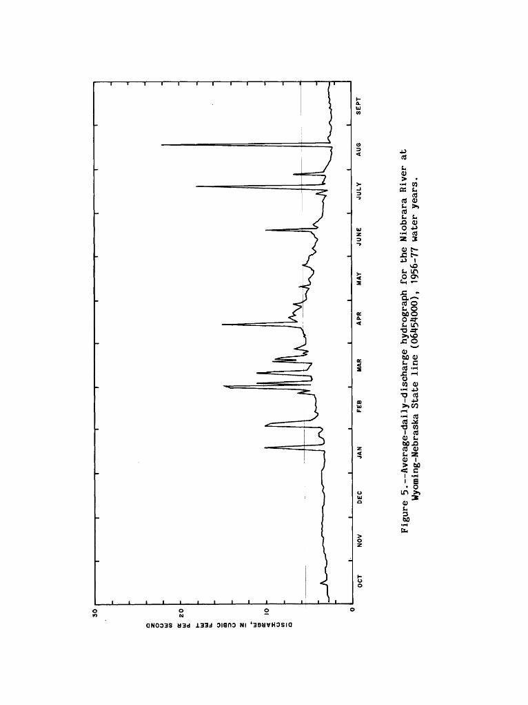
Three streamflow records the Niobrara River at the Wyoming-Nebraska State line (station number 0645^000); Black Thunder Creek near Hampshire, Wyo. (06376300); and Dead Horse Creek near Buffalo, Wyo. (06313700)--are used to show the flow in three different types of drainage basins. The surficial formations in the Niobrara basin have a high infiltration rate. Therefore, the river has small peak flows and uniform ground-water discharge. The seasonal flow-duration curves (fig. 4) for the hiobrara River have a very flat slope, indicating a uniform ground-water contribution. The two curves cross, indicating that during the growing season there are periods of larger flows because of direct runoff and also periods of smaller flows because of evapotranspiration. The average-daily-discharge hydrograph (fig. 5) shows a 0.8 ftVs difference between winter ground-water discharge and late-summer discharge. The flow increased because evapotranspiration decreased after the first freeze in the fall.
are
Black Thunder Creek basin is drained by an ground-water discharge but flows as a result of Seasonal flow-duration curves (fig. 6) for Bl slopes and are approximately parallel; these an ephemeral stream. The steep slopes are variability, while the parallelism indicates same for both periods, but that it occurs more season. The average-daily-discharge hydrograph ephemeral stream.
ephemeral stream that has no rainstorms or snowmelt runoff, ick Thunder Creek have steep
typically shaped curves for the result of streamflow
that the cause of runoff is the frequently during the growing
(fig. 7) is typical for an
Average annual runoff from the Black Thunder Creek basin is nearly identical to that of the Niobrara River basin. The Black Thunder Creek basin had 0.127 in. of runoff, all from direct runoff from rainfall or snowmelt, and the Niobrara River basin had 0.128 in., mostly from ground-water discharge. Average annual precipitation in the Niobrara River basin is about 2 in.greater than average annual precipitation in theThis additional precipitation is taken up by evapotranspiration.
Dead Horse Creek basin is drained by an streamflow-gaging station on Dead Horse Creek was a perennial reach of the stream; therefore, flow
Black Thunder Creek basin.
interrupted stream. Thelocated just downstream from
at the gage was intermittent.

100
10
1.0
O.I
OCTOBER-MARCH
APRIL-SEPT EMBER
I J_ I I
5 10 20 30 40 50 60 70 80 90 95
PERCENTAGE OF TIME THAT INDICATED DISCHARGE WAS EQUALED OR EXCEEDED
98
Figure 4. Flow-duration curves for the Niobrara River at Wyoming-Nebraska State line (06454000), 1956-77 water years.
DISCHARGE, IN CUBIC FEET PER SECOND
OQC
§ .H- I3 >
I 0>Z T
CTOQ
w a
ci- In> a ft H-o w
O OQ O * X
o cr <^«<Jr a O1 T 4r O OOQ
g^"5 CD ^ D
_» H,sO O
Ocr

100
10
1.0
O.I
OCTOBER-MARCH
APRIL-SEPTEMBER
10 30 40 50 60 70 80 90 95 98
PERCENTAGE OF TIME THAT INDICATED DISCHARGE WAS EQUALED OR EXCEEDED
Figure 6. Flow-duration curves for Black Thunder Creek near Hampshire, Wyo.(06376300), 1972-77 water years.

ISO
100
50
xAJL
,AJO
CT
NO
V
DE
CJA
NFEB
MAR
APR
MAY
JUNE
JULY
AU6
SEPT
Figu
re 7. Avera
ge-d
aily
-dis
char
ge h
ydro
grap
h for
Black
Thunder
Creek
near
Hampshire, Wy
o. (0
6376
300)
, 1972-77
wate
r ye
ars.

Intermittent flow is indicated by the change in the slope of the flow- duration curve (fig. 8) between 0.2 and 0.04 ft Vs. The intermittent flow is too small to show at the scale of the average-daily-discharge hydrograph (fig. 9). Average annual runoff was 0.170 in.
REGIONAL GROUND-WATER-FLOW SYSTEMS
Two systems of regional ground-water flow are possible: (1) Northward flow that is stratigraphically controlled (fig. 10), and (2) flow into the major streams (fig. 11). Some northward flow must occur because the potential for northward flow exists. The lowest static water level known is in a well in the southern part of the basin. The well is completed in the lower part of the Lance Formation and the Fox Hills Sandstone at a depth of 6,330 ft. The altitude of the water level in the well is about 500 ft lower than the alti tude of the outcrop along the North Platte River and about 1,800 ft higher than the land surface at the northern extent of the basin along the Yellowstone River. Flow into major streams, such as shown in figure 11, has been proposed, and the potential for the flow exists. The altitude of the bottom of most wells drilled in the interstream areas is higher than nearby streams levels, and flowing we]Is are common at stream level.
The concept of regional ground-water flow that is stratigraphically controlled was examined on the basis of water quality; the concept of flow into major streams was examined by analysis of streamflow.
Stratigraphic Control
If regional ground-water flow occurs, as shown in figure 10, it should be possible to identify discharge areas by an increase in the number of springs and shallow water wells that yield sodium bicarbonate type water. There is a northerly gradient, the formations thin because of differences in original deposition, and the Wasatch and part of the Fort Union and Lance Formations have been eroded from the northern part of the basin and all the formations have been eroded from the Ceder Creek anticline (fig. 1 and plate 1). Thus some discharge from the regional ground-water-flow system should take place in the northern part of the basin.
The percentage of wells and springs that contain large concentrations of sodium bicarbonate is shown in 0.3-degree intervals of latitude in figure 12. It was decided arbitrarily to use only samples in which: (1) The concentra tion of sodium plus potassium was at least twice that of the calcium and magnesium, to eliminate calcium bicarbonate water that sometimes occurs in recharge areas; and (2) the bicarbonate was at least twice that of the sulfate, to indicate water that had moved a sufficient distance through the aquifers to be affected by sulfate reduction. This method of distinguishing water in recharge and discharge areas is similar to that used by Thorstenson and others (1979) to describe ground-water flow in the Hell Creek and Fox Hills in North Dakota.

10 1 1 1
- \- \_ \
\\\\\
1 1 1 1 1 1 1 1
OCTOBER -MARCH
+ APRIL SEPTEMBER
-
-
0.0110 20 40 50 60 70 80 90 95 98
PERCENTAGE OF TIME THAT INDICATED DISCHARGE WAS EQUALED OR EXCEEDED
Figure 8. Flow-duration curves for Dead Horse Creek near Buffalo, Wyo,(06313700), 1971-77 water years.

DISCHARGE, IN CUBIC FEET PER SECOND

FEET 6,000 -|
SEA LEVEL
5,000
\WASATCH-FOX HILLS SEQUENCE
FORMATIONS OLDER THAN FOX HILLS SANDSTONE
VERTICAL SCALE GREATLY EXAGGERATED
0 50 100 MILES
Figure 10. Regional ground-water flow (arrows) controlled by stratigraphy, 0
Section is along 106 west longitude, from the Wyoming to the Yellowstone River in Montana.
North Platte River in
FEET 5,000
I06°MONTANA
25 MILES
VERTICAL EXAGGERATION X42 DATUM IS SEA LEVEL
EXPLANATION
SANDSTONE LENSE More permeable than surrounding rock
Campbell- ) Countyi£j i "»»"'» i
GROUND-WATER SURFACE
LINE OF EQUAL HYDRAULIC HEAD
DIRECTION OF FLOW
Figure 11. Regional ground-water flow into irerHagmaier, 1971, fig. 15
or streams. (Modified from

100
75
(9
»-
u 50 u a: u
25
WYOMING MONTANA
I
29
21
30
13 12
50
216
26
122
66206 iilii,,,,,,,.,,,,,,,..
liiilllii42.7 44.2 45.7
DEGREES NORTH LATITUDE47.2
Figure 12. Percentages of wells less than 250 ft deep and springs that yield sodium bicarbonate type water. Number of samples in 0.3-degree interval shown above bar.
The data (fig. 12) do not indicate that there is an increase in ground- water discharge in the northern part of the area. There is an increase in the percentage of shallow wells that yield bicarbonate type water in the area of the State line, but this is an area of intensive sampling of shallow wells that are completed in coal. Sulfate reduction requires organic carbon and, therefore, occurs more readily in coal than in sandstone aquifers.
Discharge to Streams
The ground-water discharge into streams that originate in the basin in areas underlain by the Wasatch-Fox Hills sequence was determined from the analysis of flow-duration curves and average-daily-discharge hydrographs. Ground-water discharge from the rocks in the Wasatch-Fox Hills sequence into the Powder River was determined from the analysis of the difference in discharge between streamf low-gag ing stations located in reaches underlain by the Wasatch-Fox Hills sequence.

BASIN STREAMS
Eight streamflow-gaging stations on seven streams that originate in the area underlain by the Wasatch-Fox Hills sequence have 5 or more years of record and were included in the analysis. The data (table 1) indicate that generally there is measurable ground-water contribution only to Otter Creek and to the Little Powder River during the non-growing season. Base flow where present in other streams, such as Pumpkin Cre^ek, occurs during the period of greatest precipitation, but not after the growing season when evapotranspira- tion is minimal. This indicates that base flon is from a local system that is dependent on precipitation for each year's discharge.
Powder River
Long-term discharge records indicate a decrease in flow in the Powder River from Sussex, Wyo., to Locate, Mont, (See figs. 13, 14, 15, and table 2.) The change in flow was determined by subtracting the average-daily discharges, at an upstream station, or stations, from the average-daily discharges at a downstream station. Changes in flow for the low flow period listed in table 2 were visually determined from graphs in figures 13, 14, and 15. Water in the reach between Sussex and Locate does not move from the stream into bedrock because the potentiometric surface in the bedrock is higher than the stream. No difference in streamflow is caused by underflow in the alluvium at the gaging stations, as there is exposed bedrock in the stream channel at the three streamflow-gaging stations downstream from Sussex. Water is not diverted for irrigation outside the valley.
The quantity lost during the winter months is too great to be stored as ice; therefore, the only plausible explanation is that water moves to the alluvium along the reach between gaging stations for an extended period to replace that which is evaporated and transpired during the growing season. That the hydraulic gradient is from the stream to the alluvium was confirmed for only one location in the reach, and then pnly for October 24, 1979. The stage graph for a different stream, Cheyenne Ri^er near Dull Center (fig. 16), shows that the hydraulic gradient at this location in the basin remains from the stream to the alluvium, at least until Dedember. The low permeability indicated by the slow response of the waten in the alluvium to that in the Cheyenne River is consistent with the silty character of the alluvium along the Powder River.
LOCAL GROUND-WATER-FLOW SYSTEMS
Flow in local ground-water systems appears to dominate over the flow in a regional system. Local systems that have been identified from analysis of streamflow in the basin are: (1) Bedrock, (2) alluvial, and (3) clinker. Areally the discharge of ground water from bedrock aquifers within the Wasatch-Fox Hills sequence is substantial. However, only intermittent and interrupted flow, such as described for Dead Horse Creek (p. 10), was identi fied in the analysis of streamflow. Much of uhe ground-water discharge from bedrock aquifers is above stream level because of the nonhomogeniety of the formations. This water is evaporated and transpired during the growing

Table 1.--Summary of ground-water and surface-water relations of streams originating 1nareas underlain by the Wasatch-Fox Hills sequence, from flow-duration curves and
average-da11y-discharge hydrographs
StationNo. Station name
Drainagearea
(squaremiles)
Ground-water
dischargeindicated
Base flow innongrowing
season(cubic ftper second)
Periodof
record(wateryears)
Figuresshowing
curves andhydrographs
06307740 Otter Creek at 707 Ashland, Mont.
06308400 Pumpkin Creek near 697 Miles City, Mont.
06313700 Dead Horse Creek 155 near Buffalo, Wyo.
06324970 Little Powder River 1,230 above Dry Creek near Weston, Wyo.
06325500 Little Powder River 1,974 near Broadus, Mont.
06376300 Black Thunder Creek 535 near Hampshire, Wyo.
06386500 Cheyenne River near 5,270 Riverview, Wyo.
06426500 Belle Fourche River 1,670 below Moorcroft, Wyo.
yes
yes
yes
yes
yes
no
no
yes
1972-77
1972-77
1948-74
1944-70
21, 22
1972-77 21, 23
1971-77 8, 9
1972-77
1957-72
6, 7
season and does not contribute to base flow. Some of the discharge is stored as ice during the winter months, and the quantity can not be separated from snowmelt runoff. Local ground-water systems in the alluvium and clinker have a more pronounced effect on streamflow than the regional flow system; examples of these systems are described in the following sections.
Alluvial Systems
Alluvial systems that deplete flow in the streams probably are the predominant type of alluvial system in the basin, but some streams may gain water from alluvial aquifers. Examples of these two conditions are given in the following pages. In some streams the difference between losing water to or gaining water from the alluvium is marginal. A reversal in the relation between water in the Cheyenne River near Dull Center, Wyo. (06365900) and the
500
-500OCT NOV DEC JAN FEB MAR APR MAY JUNE JULY AUG SEPT
Figure 13. Differences between the average-d Arvada, Wyo. (06317000), and the sum of average River at Sussex, Wyo. (06313500) and Crz (06316500), 1951-57 water years.
alluvium that resulted from scouring of the channel by record high flow in 1978 is shown in figure 16. The first part of the graph shows the stage ishigher in the stream than in the alluvium
ily discharge at Powder River at -daily discharges at Powder
zy Woman Creek near Arvada, Wyo.
until at least December. Floodslater in the water year scoured the channel and recharged the alluvium, and the relation was reversed. The scouring is shown by the difference in stage (about 0.5 ft) between the last of October 1977 and the middle of September 1978. The discharge was about 0.1 ftVs during the two periods.
Losing Stream:;
The Powder River loses water to the alluvium in the reach from Sussex, Wyo. to Locate, Mont, (table 2, p. 25); the loss is attributed to evapotranspiration from the alluvium. Ttyis type of system probably is prevalent in the basin.

500
-5001OCT NOV DEC JAN FEB MAR APR MAY JUNE JULY AU6 SEPT
Figure 14. Differences between the average-daily discharge at Powder River at Moorhead, Mont. (06324500), and the sum of the average daily discharges at Powder River at Arvada, Wyo. (06317000) and Clear Creek near Arvada, Wyo. (06324000), 1940-72 water years.
Remote-sensing methods were used to determine densities and distributions of vegetation in the valley of the Powder River between Sussex, Wyo. and Locate, Mont. These data were used as an indicator of transpiration by vegetation on the Powder River flood plain. No attempt was made to quantify the transpiration; however, the consumptive use of water from the system is directly related to vegetation density. The data were taken from two sequential Landsat scenes recorded September 17, 1974. The area in the two scenes extends from Sussex, Wyo. in the south to the mouth of the Powder River in Montana in the north.

1,000
-1,000OCT NOV DEC JAN FEB MAR APR MAY JUNE JULY AU6 SEPT
Figure 15. Differences between the average-daily at Locate, Mont. (06326500) and Powder River 1940-72 water years.
discharges at Powder River at Moorhead, Mont. (06324500),
Two spectral signatures for vegetationMoore (U.S. Geological Survey, oral commun., 1<579) were used to determine the number of acres of land per valley mile of the Powder River that have densevegetation. The reach studied was from Sussex,
that were established by G.K.
Wyo. to Locate, Mont., a reachof 199 valley mi. The reflected energy is measured in arbitrary units from 0 for black and 255 for white. The following table lists the spectral signatures used for this study:
Band
4567
Wavelength (micrometer)
0.5 to 0.60.6 to 0.70.7 to 0.80.8 to 1.1
FSignatur
40 to24 to
eflected energye I
5658
54 to 12860 to 1 52
Signature II
57 to 7046 to 6672 to 9472 to 100

Tab
le
2. S
umm
ary
of
chan
ge
In
low
flo
w I
n t
he P
owde
r R
iver
from
ave
rag
e-d
ally
dis
char
ged
urin
g
periods
of
min
imal
ru
noff
Downstream s
tati
onS
tatio
n
No.
Sta
tion
nam
e
Ups
tream
sta
tio
n(s
)Station
No.
Station
name
Area o
fsegment
(square
mile
s)
Chan
ge i
n discharge
(cubic f
eet
per
seco
nd)
Peri
odof record
(water y
ears)
063170
00Po
wder
Riv
er a
t Ar
vada
, Wyo.
0631
6500
0631
3500
Craz
y Wo
man
Cree
k ne
ar A
rvad
a, Wy
o,
Powd
er R
iver
at
Suss
ex,
Wyo.
2,00
4-68
1951-57
06324500
Powd
er R
iver
at
Moor
head
, Mont,
0632
4000
0631
7000
Cle
ar C
reek
ne
ar
Arv
ada,
W
yo.
Pow
der
Riv
er
at
Arv
ada,
W
yo.
928
-10
1940-72
06326500
Powd
er R
iver
near
Loca
te,
Mont
.06
3245
00Po
wder
Riv
er a
t Mo
orhe
ad,
Mont
.5,
016
-30
1940-72
Inflow f
rom
perennial
trib
utar
y streams
between
Moorhead a
nd L
ocate, Mont,
was
not
subtracted f
rom
the
aver
age-
da
ily
discharge.

100
s 0 10
u
o CD < O o
u. _ i.o
CO
O.I
Wel
l 270
feet
fr
om
rive
r
.No
d
oto
-I-
./
Wel
l 50
fee
t fr
om r
iver
OCT
NOV
DEC
JAN
FEB
MAR
APR
MAY
JUNE
JULY
AU6
SEPT
Figu
re 16
. Re
lati
ons
of water l
evels
in t
he a
lluvium
to t
he s
tage o
f the
Cheyenne R
iver
near
Dull Ce
nter
, Wy
o. (0
6365
900)
, 19
78 w
ater y
ear.
A field check was made to determine the vegetation type and to verify the changes in density. Vegetation types include alfalfa, native grasses, cotton- woods, and saltcedar. Some reaches of the valley had irrigated grain crops, which would be dormant at the time of year that the Landsat scenes were recorded. The density, in acres, is a function of the amount of irrigated cropland, the valley width, and the amount of irrigation. A graph showing the vegetation density measured at one-mile increments along the Powder River valley (fig. 17) indicates that the downstream reach has much more vegetation, hence greater transpiration.
Table 2 (p. 25) indicates that the loss of flow from the Powder River from Arvada, Wyo. to Moorhead, Mont, and from Moorhead, Mont, to Locate, Mont, is nearly the same when converted to common base. The average loss of flow per valley mile in the Powder River during late fall and early winter was 0.31 ftVs between Arvada, Wyo., and Moorehead, Mont., and 0.30 ftVs between Moorhead and Locate, Mont. There is perennial tributary inflow in the reach between Moorhead and Locate that could not be subtracted from the average- daily discharge because the tributary streams were not gaged during the period; whereas, all the perennial inflow (Clear Creek) in the reach from Arvada to Moorhead was subtracted. Water from Clear Creek is diverted for irrigation above the confluence of the Powder River. Therefore, some return flow to the Powder River is not accounted for and the source of the water for the irrigation that centers around valley mi 82 on figure 17 is not the Powder River.
Where there is a large area of sandstone in contact with alluvium, alluvium could collect water from the bedrock and convey it to the stream. However, the relation that probably prevails in much of the area is shown by water levels measured in wells in Sheridan County, Wyo., during 1960-61. This was the driest period in Sheridan from 1900 to 1980.
Water-level changes in four wells are shown in figure 18. Wells B1 and B2 are completed in bedrock and are in topographic locations such that the bottom of the wells are above the level of the nearest perennial stream. Wells A1 and A2 are completed in the alluvium near the stream channel and in reaches where the flow is ephemeral. Well A1 is in an area underlain by marine shale. Well A2 is in an area underlain by the Tongue River Member of the Fort Union Formation.
Water-level declines in the wells in bedrock show a relatively uniform decline. The flattening of the slope of the hydrograph of well B1 and rise in the hydrograph of well A2 in the spring of 1961 was probably recharge from snowmelt. Precipitation would be greater at these two wells because they are at higher elevations and snow would accumulate because the areas are more forested. The rise of water levels in well B2 in the fall of 1961 occurred after a period of rainfall that filled a stock pond on an ephemeral stream at the well site (Lowry and Cummings, 1966, p. 14).
In contrast to the trend of the water levels in wells completed in bedrock, the water levels in wells completed in the alluvium show that little or no recharge occurred during the period and that discharge is by evapotran- spiration. The reasoning used to attribute the discharge to evapotranspira- tion is: (1) If discharge was by underflow, the water-level decline should continue in winter, (2) a hypothesis that underflow in the alluvium is the

roo
60O
50
0
K
Ul
<L w
400
K u
30
0
2
200
100
2550
75
100
125
ISO
175
20
0
SU
SS
EX
(M
ILE
0)
AR
VA
DA
M
OO
RH
EA
D
BR
OA
DU
S(M
ILE
71
) (M
ILE
10
3)
(MIL
E
132)
MIL
ES
A
LON
G
RIV
ER
V
ALLE
Y
LO
CA
TE
(M
ILE
1
99
)
Figu
re 17
. Ve
geta
tion
density a
long the
Powd
er Ri
ver
valley.
Locations
of
gagi
ng st
atio
ns shown
on h
oriz
onta
l ax
is.

I960 1961
WELLS COMPLETED IN BEDROCK
I960 1961
WELLS COMPLETED IN ALLUVIUM
Figure 18. Water levels in two wells completed in bedrock and two wells completed in the alluvium, Sheridan County, Wyo.

same as recharge from bedrock in both wells is rejected because the bedrock in the area of well A1 is the relatively impermeable marine shale, and the bedrock in the area of well A2 is the Tongu^ River Member of the Fort Union Formation, and (3) the seasonal change in watejr-level decline corresponds to the seasonal periods of high and low evapotranspiration.
Gaining Streams
The Little Missouri River is used as an example of a gaining streamwithin the structural basin, although much of on rocks of the Wasatch-Fox Hills sequence.relatively impermeable shale that precludes measurable base flow from a sourceother than the alluvium for much of the
the course of the river is not Bedrock in most of the course is
reach shown on plate 1. Therelatively impervious nature of the shale is indicated by the large runoff, relative to that from streams underlain by the Wasatch-Fox Hills sequence.
The flow-duration curve (fig. 19) shows there is flow at Camp Crook morethan 95 percent of the time. On October 23, flow in the river to approximately the Wyoming
1979, there was only interrupted -Montana State line, but north
of the State line no points of zero flow were observed. Flow at Capitol, Mont., was 1.23 ftVs, and flow at the streamflow-gaging station at Camp Crook, S. Dak. (06334500) was 4.1 ft Vs.
The Hell Creek Formation crops out at the streamflow-gaging station; however, it is a recharge area, rather than a discharge area, for the formation (Thorstenson and others 1979, p. 1481). Therefore, all the baseflow at Camp Crook is attributed to ground-water discharge from the alluvium.
For the Little Missouri River to gain sufficient water from alluvium to maintain perennial flow at the streamflow-gaging station, the alluvium must be coarser or more extensive, or both, than normally found in valleys elsewhere in the basin. The area of alluvium is more extensive relative to nearby drainages (fig. 20). Whitcomb and Morris (1964, p. 42), in describing alluvium of the Little Missouri and Belle Fourche River drainages in Crook County, Wyo., state that the course of the Little Missouri River almost entirely is on soft shale and, consequently, little coarse material was deposited. However, the Belle Fourche River crosses resistant rocks and probably contains considerable quantities of sand and gravel. Before the Belle Fourche River was captured by a stream hfead-cutting westward, it flowed northward across Stoneville Flats into the| present drainage of the Little Missouri River. During that period it would have provided coarse-grained material to the alluvium of the present Little Missouri River in Montana. Another source of coarse-grained material are the formations mapped as Tertiary-undivided on plate 1.
Clinker
The hydrologic properties of clinker are different enough from other rocks in the Wasatch-Fox Hills sequence that clinker sometimes is consideredas a separate aquifer (U.S. Department of Runoff from two adjoining basins was compared
the Interior, 1977a, p. 143). with areas less than 3 mi 2 . One

100
10
1.0
O.I
OCTOBER-MARCH
APRIL-SEPTEMBER
5 10 20 30 40 SO 60 70 80 90
PERCENTAGE OF TIME INDICATED DISCHARGE WAS EQUALED OR EXCEEDED
95 98
Figure 19. Flow-duration curves for Little Missouri River at Camp Crook, S. Dak. (06334500), 1957-77 water years.

I05
°30
' 45
0l5
'r~
-'
44
°30
'
Pow
der
Riv
er J
^oun
ty
Cam
pbel
l C
ount
y
10 M
ILE
S
10 K
ILO
ME
TE
RS
Figure 20. Extent of
the
alluvium
in the
uppe
r part o
f th
e Li
ttle
Mis
sour
iRi
ver
basin
and
nearby dr
aina
ges.

was underlain by large areas of clinker, and most of the other was underlain by unaltered rocks of the Fort Union Formation. Runoff from the basin without large areas of clinker was five-to-eight times greater than the one underlain by large areas of clinker (U.S. Department of the Interior, 1977b, p. 81).
The affect that large areas of clinker has on the hydrology of a basin is shown by a comparison of Otter and Pumpkin Creek drainage basins. The Otter Creek drainage basin has a large area of clinker, which results in larger infiltration of precipitation and larger perennial base flow, but less total runoff than the adjoining basin. Although the alluvium in the two drainage basins is similar (S.E. Slagle, U.S. Geological Survey, oral commun., 1982) and the drainage basins are nearly identical in area, the streams have significantly different runoff characteristics, and their juxtaposition precludes that the difference in runoff is due to differences in ground-water inflow from a regional ground-water system or in precipitation.
The drainage area, runoff characteristics, area of clinker, and differences in the area of cropland in the two drainage basins are shown in table 3. The area of clinker was planimetered from maps in reports by Bryson and Bass (1973), Bryson (1952), Bass (1932), Warren (1959), Parker and Andrews (1939), and Pierce (1936). The area of cropland was computed as described previously for the Powder River valley (p. 24). The flow-duration curves for the stations on the two streams are shown in figure 21, and the average-daily- discharge hydrographs are shown in figures 22 and 23.
Table 3. Runoff and factors affecting runoff, Otter Creek at Ashland, Montana (06307740), and Pumpkin Creek near Miles City, Montana (06308400)
Station StationNo . name
Drainagearea
(squaremiles)
Area ofexposedclinker
(squaremiles)
Area ofvegetation
(squaremiles)
Averageannual
runoff(Inches)
Base flow innong rowing
season
(cubic ftper second)
06307740 Otter Creek at 707 Ashland, Mont.
06308400 Pumpkin Creek near 696 Miles City, Mont.
90
47
83
38
0.156
.275
Period of record 1s water years 1972-77.

100
5 10 20 30 40 50 60 70 80 90 95
PERCENTAGE OF TIME THAT INDICATED DISCHARGE WAS EQUALED OR EXCEEDED
98
Figure 21. Flow-duration curves for Otter and Pumpkin Creek near Miles City, Mont.
Crcsek at Ashland, Mont. (06307740) (06308400), 1972-77 water years.

DISCHARGE, IN CUBIC FEET PER SECOND
OQ
ro ro'i ia>oT (U
OQ
O ION O. CO H- O CO -*3 O
O v^- O
ro
cfo
Oci-
W O
M(-' P
a

4O
O
3OO
tu
200
u ii_ u CD o
u S
10
0
L
UO
CT
NO
V
DE
CJ
AN
F
EB
M
AR
A
PR
MA
Y
JU
NE
JU
LY
A
UG
SE
PT
Figu
re 2
3. Average-daily-discharge h
ydrograph
for
Pumpkin
Creek
near M
iles
City,
Mont.
(06308400),
1972-77
wate
r years.

CONCLUSIONS
Areas of natural ground-water discharge from a regional ground-water system that consists of the Wasatch-Fox Hills sequence in the Powder River structural basin that would be inferred from potentiometric data could not be substantiated. Therefore, it is concluded that the regional flow system may have a smaller flow than previously thought, and that measurable effects of surface mining and water development will affect mostly local flow systems. However, more data are necessary to describe local systems and their relation to the regional system.
Potentiometric data indicate that most streams in the Powder River structural basin should receive base flow from a regional ground-water system; however, such base flow is not evident in streamflow records. Streamflow data collected at 14 stations on 8 streams show that base flow occurs at 6 of the stations, but that base flow during the nongrowing season occurred only in Otter Creek and the Little Powder River. Of the three largest streams included in the analysis the Powder, Belle Fourche, and Cheyenne Rivers only the Belle Fourche had base flow, which was present only during the period of largest precipitation, but not during the period of minimum evapotranspira- tion. The locations of the streams that do not have base flow and the period during which base flow occurs in most streams indicate that base flow, where present, is from local systems rather than a regional system.
The absence of base flow in streams from ground water moving through the regional system is the result of the nonhomogeneity of the formations which produces a small regional effective transmissivity, and the combined effects of evaportranspiration from, and storage in, the stream alluvium. The nonhomogeneity of the formations precludes the use of simple water-level maps as a substitute for sets of stratigraphically based potentiometric maps.
Northward regional flow that is stratigraphically controlled, which would not necessarily contribute to base flow of streams, can be inferred from potentiometric data, but discharge areas in the northern part of the basin could not be identified on the basis of chemical quality of water from springs and shallow wells. The chemical quality of ground water from shallow depth in the northern part of the basin is affected more by local conditions than by regional flow. Taken together, these lines of evidence suggest that the regional flow, and therefore effective regional transmissivity is smaller than previous investigators have suggested.
REFERENCES CITED
Bass, N.W., 1932, The Ashland coal field, Rosebud, Powder River, and Custer Counties, Montana: U.S. Geological Survey Bulletin 831-B, p. 19-108.
Bryson, R.P., 1952, The Coalwood coal field, Powder River County, Montana: U.S. Geological Survey Bulletin 973-B, p. 23-106.
Bryson, R.P., and Bass, N. W., 1973, Geology of Moorhead coal field, Powder River and Rosebud Counties, Montana: U.S. Geological Survey Bulletin 1338, 116 p.
Cordell, G.V., Jr., 1960, Climate of the states, Montana: U.S. Department of Commerce, Weather Bureau, Cliraatography of the United States no. 60-24, 21 p.
Flores, R.M., 1979, Restored stratigraphic cross sections and coal correlations in the Tongue River Member of the Fort Union Formation, Powder River area, Montana: U.S. Geological Survey Miscellaneous Field Studies Map MF-1127, 2 sheets.
Flores, R.M., and Canavello, D.A., 1979, Res tored stratigraphic cross sectionsand coal correlations in the Tongue Ftiver Member of the Fort Union Formation, Powder River area, Wyoming: U.S. Geological SurveyMiscellaneous Field Studies Map MF-1126, 2 sheets.
Gill, J.R., and Cobban, W.A., 1966, The Red Bird section of the Upper Cretaceous Pierre Shale in Wyoming: U.S. Geological Survey Professional Paper 393-A, 73 p.
Hagmaier, J.L., 1971, Groundwater flow, hydrochemistry, and uranium deposition in the Powder River basin, Wyoming: University of North Dakota unpublished doctoral dissertation, 166 p,.
Reefer, W.R., 1974, Regional topography, physiography, and geology of the northern Great Plains: U.S. Geological Survey Open-File Report 74-50, 17 p.
Leopold, L.B., and Miller, J.P., 1954, A postglacial chronology for some alluvial valleys in Wyoming: U.S. Geological Survey Water-Supply Paper 1261, 90 p.
Leopold, L.B., Wolman, M.G., and Miller, J.P., 1964, Fluvial processes ingeomorphology: San Francisco, W.H. Freeman and Company, 522 p.
Lowry, M.E., and Cummings, T.R., 1966, Griound-water resources of Sheridan County, Wyoming: U.S. Geological Survey[Water-Supply Paper 1807, 77 p.
Lowers, A.R., 1960, Climate of the states, Wyoming: U.S. Department of Commerce, Weather Bureau, Climatography of the United States no. 60-48, 16 p.
Meinzer, O.E., 1923, Outline of ground-water hydrology: U.S. Geological Survey Wa^er-Supply Paper 494, 71 p.

Parker, F.S., and Andrews, D.A., 1939, The Mizpah coal field, Custer County, Montana: U.S. Geological Survey Bulletin 906-C, p. 85-133.
Pierce, W.G., 1936, The Rosebud coal field, Rosebud and Custer Counties, Montana: U.S. Geological Survey Bulletin 847-B, p. 43-120.
Riffenburg, H.B., 1925, Chemical character of ground water of the Northern Great Plains: U.S. Geological Survey Water-Supply Paper 560-B, p. 31-52.
Robinson, C.S., Mapel, W.J., and Bergendahl, M.H., 1964, Stratigraphy and structure of the northern and western flanks of the Black Hills uplift, Wyoming, Montana, and South Dakota: U.S. Geological Survey Professional Paper 404, 134 p.
Searcy, J.K., 1959, Flow-duration curves: U.S. Geological Survey Water-Supply Paper 1542-A, 33 p.
Sharp, W.M., McKay, E.J., McKeown, F.A., and White, A.M., 1964, Geology and uranium deposits of the Pumpkin Buttes ore of the Powder River basin, Wyoming: U.S. Geological Survey Bulletin 1107-H, p. 541-638, 8 pi.
Taylor, O.J., 1968, Ground-water resources of the northern Powder River valley, southeastern Montana: Montana Bureau of Mines and Geology Bulletin 66, 34 p.
Thorstenson, D.C., Fisher, W.D., and Croft, M.G. , 1979, The geochemistry of the Fox Hills-basal Hell Creek aquifer in southwestern North Dakota and northwestern South Dakota: Water Resources Research v. 15, no. 6, p. 1479-1498.
U.S. Department of the Interior, 1977a, Resource and potential reclamation evaluation, Bear Creek study area, West Moorhead Coalfield: U.S. Department of the Interior, EMRIA Report no. 8, 259 p.
___ 1977b, Resource and potential reclamation evaluation, White Tail Butte study area, Little Powder River Coal Field: U.S. Department of the Interior, EMRIA Report no. 13, 112 p.
Warren, W.C., 1959, Reconnaissance geology of the Birney-Broadus coal field, Rosebud and Powder River Counties, Montana: U.S. Geological Survey Bulletin 1072-J, p. 561-585.
Weimer, R.J., 1961, Spatial dimensions of Upper Cretaceous sandstones, Rocky Mountain area, in Geometry of sandstone bodies: American Association of Petroleum Geologists, 1961, p. 82-97.
Wells, D.K., 1982, Ground-water data from selected wells in alluvial aquifers Powder River basin and adjacent areas, northeastern Wyoming: U.S. Geological Survey Open-File Report 82-856, 35 p.
Whitcomb, H.A., and Morris, D.A., 1964, Ground-water resources and geology of northern and western Crook County, Wyoming: U.S. Geological Survey Water- Supply Paper 1698, 92 p.
Related Documents