Identification: 165.10.45 GEOTECHNICAL FINAL REPORT 165.10.45-030 I-710 CORRIDOR PROJECT Prepared for Los Angeles County Metropolitan Transportation Authority January 22, 2010 Prepared by: 2020 East First Street, Suite 400 Santa Ana, California 92705

Welcome message from author
This document is posted to help you gain knowledge. Please leave a comment to let me know what you think about it! Share it to your friends and learn new things together.
Transcript
Identification: 165.10.45
GEOTECHNICAL FINAL REPORT
165.10.45-030
I-710 CORRIDOR PROJECT
Prepared for
Los Angeles County Metropolitan Transportation Authority
January 22, 2010
Prepared by:
2020 East First Street, Suite 400Santa Ana, California 92705
I-710 Corridor ProjectGeotechnical Report
Page i January 22, 2010
TABLE OF CONTENTS
SECTION PAGE
1.0 INTRODUCTION..........................................................................................................1-1
1.1 Project Description..................................................................................1-1
1.2 Purpose and Scope of Report................................................................. 1-2
2.0 DATA GATHERING..................................................................................................... 2-3
2.1 Caltrans .................................................................................................. 2-3
2.2 County and City ...................................................................................... 2-4
2.3 California Division of Oil, Gas & Geothermal Resources ........................2-5
2.4 California Geological Survey (CGS) ....................................................... 2-5
2.5 United States Geological Survey (USGS)...............................................2-6
2.6 Natural Resources Conservation Service (NRCS)..................................2-6
2.7 Southern California Earthquake Data Center (SCEDC)..........................2-6
2.8 Port of Long Beach (POLB) ....................................................................2-6
2.9 Los Angeles Harbor Department (LAHD)................................................ 2-6
2.10 U.S. Army Corps of Engineers................................................................ 2-6
2.11 Other.......................................................................................................2-7
3.0 REGIONAL AND LOCAL GEOLOGIC CONDITIONS ...........................................................3-1
3.1 Regional Geologic Setting ......................................................................3-1
3.2 Local Geologic Conditions ......................................................................3-13.2.1 Surficial Soil Conditions........................................................................ 3-13.2.2 Subsurface Conditions ......................................................................... 3-2
3.3 Groundwater ...........................................................................................3-2
3.4 Faulting and Seismicity ........................................................................... 3-3
3.5 Oil and Gas Resources........................................................................... 3-5
4.0 GEOLOGIC AND SEISMIC HAZARDS ............................................................................. 4-1
4.1 Geologic Hazards ...................................................................................4-14.1.1 Subsidence .......................................................................................... 4-14.1.2 Expansive and Collapsible Soils........................................................... 4-1
4.2 Seismic Hazards.....................................................................................4-24.2.1 Surface Fault Rupture .......................................................................... 4-24.2.2 Ground Shaking ................................................................................... 4-24.2.3 Liquefaction.......................................................................................... 4-34.2.4 Earthquake-Induced Slope Instability ................................................... 4-34.2.5 Earthquake-Induced Flooding............................................................... 4-3
5.0 DISCUSSION AND RECOMMENDATIONS ........................................................................ 5-1
I-710 Corridor ProjectGeotechnical Report
Page ii January 22, 2010
5.1 Soil Types ...............................................................................................5-1
5.2 Groundwater ...........................................................................................5-1
5.3 Faulting and Seismicity ........................................................................... 5-1
5.4 Depth to Bedrock ....................................................................................5-2
5.5 Liquefaction ............................................................................................5-2
5.6 Oil and Gas Resources........................................................................... 5-2
5.7 Oil Extraction-Related Ground Subsidence ............................................ 5-2
5.8 Foundation Alternatives ..........................................................................5-35.8.1 Bridges................................................................................................. 5-35.8.2 Retaining Walls .................................................................................... 5-3
5.8.2.1 Concrete Cantilever Types 1 through 6.............................................................5-35.8.2.2 Non-gravity Cantilever and Anchored Walls......................................................5-35.8.2.3 Gravity Walls..........................................................................................................5-4
5.8.3 Soundwalls........................................................................................... 5-45.9 Slope Stability .........................................................................................5-4
5.10 Recommendations for Further Investigations .........................................5-4
6.0 LIMITATIONS............................................................................................................. 6-1
7.0 REFERENCES............................................................................................................ 7-1
I-710 Corridor ProjectGeotechnical Report
Page iii January 22, 2010
LIST OF TABLES
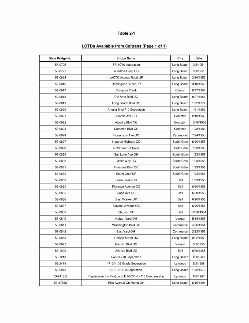
Table 2-1: LOTBs Available from Caltrans
Table 2-2: LOTBs Available from L.A. County
Table 3-1 Generalized Depth to Groundwater
Table 3-2: Summary of Most Significant Potential Seismic Sources
Table 4-1: Generalized Peak Ground Acceleration
LIST OF FIGURES
1. I-710 Corridor Project Location Map
2. Geologic Map
3. NRCS Soil Distribution Map
4. Groundwater Level Map
5. Liquefaction Potential Zone Map
APPENDIX A
Logs of Test Borings (LOTBs) for Bridges Along I-710 Corridor
APPENDIX B
Agency Review Comments and Responses
I-710 Corridor ProjectGeotechnical Report
Page 1-1 January 22, 2010
1.0 IN T R OD UC TI O N
1.1 PROJECT DESCRIPTION
Interstate 710 (I-710, also known as the Long Beach Freeway) is a major north-south interstate freeway within the Los Angeles basin. Within the I-710 Corridor Project study area, the freeway serves as the principal transportation connection for goods movement between the Ports of Los Angeles (POLA)/Long Beach (POLB), located at the southern terminus of the freeway, and the BNSF/UPRR railyards in the cities of Commerce and Vernon. The I-710 Major Corridor Study (MCS), undertaken to address the I-710 mobility and safety needs and to explore possible solutions for transportation improvements, was completed in March 2005 and identified a community-based Locally Preferred Strategy (LPS) consisting of ten general purpose lanes next to four separated freight movement lanes. The Los Angeles County Metropolitan Transportation Authority (Metro), the California Department of Transportation (Caltrans), the Gateway Cities Council of Governments (GCCOG), the Southern California Association of Governments (SCAG), POLA, POLB, and the Interstate 5 (I-5) Joint Powers Authority (JPA), are collectively known as the I-710 Corridor Project Funding Partners. These agencies are collectively funding the preparation of preliminary engineering and environmental documentation for the proposed I-710 Corridor Project to evaluate improvements along the I-710 Corridor.
The project proposes to improve Interstate 710 (I-710) from the City of Long Beach to the City of Commerce, a distance of approximately 18 miles, as shown on Figure 1.
The purpose of the proposed I-710 Corridor Project is to achieve the following within the I-710 corridor:
o Improve air quality and public health
o Improve traffic safety
o Address design deficiencies
o Address projected traffic volumes
o Address projected growth in population employment, and economic activities related to goods movement.
The area of study for this report for the I-710 corridor includes I-710 between Ocean Boulevard in the City of Long Beach and Noakes Street in the City of Commerce. At the freeway-to-freeway interchanges, the study area extends up to one mile east and west of I-710 for the I-405, SR-91 and I-105 interchanges. It also includes the major arterials such as E. Washington Boulevard, S. Atlantic Boulevard, Bandini Boulevard, Slauson Avenue, Gage Avenue, Florence Avenue, Firestone Boulevard, Imperial Highway, Rosecrans Avenue, Compton Boulevard, Alondra Boulevard, Artesia Boulevard, Long Beach Boulevard, Del Amo Boulevard, W. Wardlow
I-710 Corridor ProjectGeotechnical Report
Page 1-2 January 22, 2010
Road, W. Willow Street, W. Pacific Coast Highway, W. Anaheim Street, 7th Street and Ocean Boulevard.
1.2 PURPOSE AND SCOPE OF REPORT
The primary purpose of this report is to highlight the geotechnical constraints along the corridor alignment that impact design and construction of structural and roadway elements of the project.
The scope of work included:
o Obtaining and reviewing available geotechnical and materials information from various sources such as, but not limited to POLA, POLB, City of Los Angeles, City of Long Beach, County of Los Angeles and Caltrans.
o Prepare this Geotechnical Report. This report addresses geologic setting, major faultsthat control the seismic design of the project, seismicity, ground shaking and other seismic hazards, topography, groundwater levels, groundwater regime, soil conditions, depth to bedrock, foundations for structures, retaining wall types, sound walls, slope stability, and recommendations for additional field investigation.
The scope of work did not include any new field exploration or laboratory testing. This “Geotechnical Report” was prepared under Task 165.10.45.
URS submitted a Draft Interim Geotechnical Information Report dated September 30, 2008 (URS, 2008) to the Los Angeles County Metropolitan Transportation Authority (MTA). The MTA and Caltrans geotechnical engineering personnel reviewed the report and provided technical review comments dated October, 28, 2008 and February 27, 2009, respectively. URS responded to the review comments in writing on November 24, 2008 (MTA comments) and on November 18, 2009 (Caltrans comments) and indicated that we would comply with the review comments. This Final Report (dated December 11, 2009) incorporates changes that resulted from the final resolution of the review/response comment sheets. Copies of the review/response sheets are provided in Appendix B.
I-710 Corridor ProjectGeotechnical Report
Page 2-3 January 22, 2010
2.0 DATA GATH E RI NG
2.1 CALTRANS
Data was obtained through contacting pertinent Caltrans personnel in the following Caltrans offices:
Office of Earthquake Engineering:
o 2009 Caltrans Deterministic PGA Map and ARS Online Report
o 2007 Fault Database
o 2008 United States Geological Survey (USGS) National Seismic Hazard Map, 2008 National Seismic Hazard Map Gridded Data (static) and the 2009 USGS Interactive Deaggragation Tool ( Beta)
o Fault & Site Data Input Sheet
o Deterministic Response Spectrum Spreadsheet
o Probabilistic Response Spectrum Spreadsheet (based on the USGS data)
o Preliminary spectral acceleration and displacement curves(Caltrans SDC, Appendix B)
o Caltrans ARS Online
A complete list of these documents and tools with web links are listed in the Caltrans ARS Online website, http://dap3.dot.ca.gov/shake_stable/technical.php.
We also contacted a representative of the Office of Earthquake Engineering to obtain the most current information that may not be incorporated in the existing Seismic Hazard Map.
Office of Geotechnical Design – South 1:
o The assigned geotechnical engineer was contacted to discuss any Caltrans in-house information that may exist regarding known adverse geotechnical conditions which may present constraints to design or construction.
o Contacted assigned earthquake engineer to discuss any recent changes Caltrans may have made with respect to faulting and seismicity and their potential effect on future bridge or other structure design along the I-710 Corridor.
I-710 Corridor ProjectGeotechnical Report
Page 2-4 January 22, 2010
Division of Maintenance:
o Bridge Files containing Logs of Test Borings (LOTBs) for bridges along the project study area of the I-710 were obtained through the office of Structure Maintenance and Investigations - South. A list of LOTBs collected from Caltrans is presented in Table 2-1. As-built bridge files for a total of 35 bridges along the corridor from the years 1950 through 2004 are available for review. Copies of the as-built LOTBs contained in the bridge files are provided in Appendix A.
o A representative of Maintenance Engineering for the project area was contacted to discuss any problem areas that may be the result of adverse geotechnical conditions.
Structure Construction
A representative of Structure Construction was contacted to discuss any known geotechnical related structure construction issues that may have been encountered.
Division of Materials Investigation Unit:
A representative of Materials Investigation Unit for the Caltrans District 7 was contacted to obtain reports pertaining to the materials in the vicinity of the I-710 corridor. Various materials reports pertaining to the work performed by Caltrans along the I-710 corridor were found to exist in the archives and have been used as a reference in producing this report.
2.2 COUNTY AND CITY
The entire corridor area of study is located within the boundaries of Los Angeles County. Geotechnical related reference materials obtained from the County include:
o The safety element of the Los Angeles County Department of Regional Planning’s general plan (LACDRP, 1990).
o The revised safety element of the Los Angeles County Department of Regional Planning’s 2008 Draft General Plan (LACDRP, 2008).
o The Los Angeles County Department of Public Works maintains bridge files of most of the bridges that cross the Los Angeles River adjacent to the I-710. These records are available on the LACDPW website: http://dpwgis.co.la.ca.us/website/designMap%5Fnew/viewer.asp. Some of these files contain as-built LOTBs for the bridges. The as-built LOTBs from the years between 1951 and 2007 for a total of 8 bridges in the vicinity of the corridor study area were obtained and are listed in Table 2-2. The LOTBs are provided in Appendix A. The location of these bridges is shown on Figure 2.
I-710 Corridor ProjectGeotechnical Report
Page 2-5 January 22, 2010
Incorporated cities within the corridor study area alignment include, from south to north, Long Beach, Carson, Compton, Paramount, Lynwood, South Gate, Bell, Bell Gardens, Maywood, Commerce and Vernon. Attempts to obtain pertinent geotechnical related data from these various cities yielded little pertinent information other than safety elements of some of the cities’ general plans. Most of the cities contacted directed our search to Los Angeles County to obtain information.
Geotechnical information obtained through accessing city-maintained websites as well as through contact with pertinent city employees includes the following:
o The seismic safety element of the Long Beach City Department of Planning and Building’s general plan (Long Beach, 1988).
o The City of Compton’s “Natural Hazards Mitigation Plan” (Compton, 2004).
o The safety element of the City of Vernon’s general plan (Vernon, 2007).
o The safety element of the Los Angeles Department of City Planning’s general plan (LADCP, 1996).
2.3 CALIFORNIA DIVISION OF OIL, GAS & GEOTHERMAL RESOURCES
Data regarding locations and activity status of oil and gas wells in the vicinity of the project alignment were obtained from the California Division of Oil, Gas & Geothermal resources website: http://www.consrv.ca.gov/DOG/Pages/index.aspx.
2.4 CALIFORNIA GEOLOGICAL SURVEY (CGS)Reference materials and data concerning geology, faulting, seismic hazards and seismicity were obtained from the California Geological Survey (formerly the California Division of Mines and Geology). These references include:
o The Earthquake Fault Zone Map (Alquist-Priolo) for the Long Beach Quadrangle (CDMG, 1986).
o Seismic Hazard Zone Reports for the Long Beach, South Gate and Los Angeles Quadrangles (CDMG, 1998a-c).
o Seismic Hazard Zone Maps for the Long Beach, South Gate and Los Angeles Quadrangles (CDMG, 1999a-c).
o Fault evaluation reports prepared under the Alquist-Priolo Earthquake Fault Zoning Act for faulting relevant to the project area (CGS, 2002a).
o Fault parameters for faults that are most relevant to the project development (CGS, 2003a).
I-710 Corridor ProjectGeotechnical Report
Page 2-6 January 22, 2010
o Fault investigation reports for development sites within Alquist-Priolo earthquake fault zones in the vicinity of the project area (CGS, 2003b).
o The Uniform California Earthquake Rupture Forecast, Version 2 (Field, E.H., et al, 2008)
o Latest updates and updates being considered to California fault parameters (Wills, et al, 2008).
2.5 UNITED STATES GEOLOGICAL SURVEY (USGS)
o Obtained Quaternary fault data from USGS website: http//earthquake.usgs.gov/regional/qfaults/ (USGS, 2006).
2.6 NATURAL RESOURCES CONSERVATION SERVICE (NRCS)Data regarding soil conditions within the project study area obtained from the NRCS include the following:
o A soil distribution map and accompanying report covering the project study area were obtained from the Lancaster, California NRCS office (NRCS, 1967).
o Soil data from NRCS web soil survey website: http://websoilsurvey.nrcs.usda.gov/app/HomePage.htm (NRCS, 2009).
2.7 SOUTHERN CALIFORNIA EARTHQUAKE DATA CENTER (SCEDC)The Southern California Earthquake Center’s website was accessed to obtain pertinent fault and seismicity data:
http://www.data.scec.org/faults/faultmap.html
2.8 PORT OF LONG BEACH (POLB)Reports prepared for the POLB covering ground motions (Earth Mechanics, Inc., 2006 & 2008) were obtained.
2.9 LOS ANGELES HARBOR DEPARTMENT (LAHD)Geotechnical information was obtained from a report prepared by the LAHD for a proposed crude oil terminal project (LAHD, 2008).
2.10 U.S. ARMY CORPS OF ENGINEERS
An attempt to obtain pertinent and useful data such as Logs of Test Borings (LOTBs) for structures within and adjacent to the Los Angeles River was made with the U.S. Army Corps of

I-710 Corridor ProjectGeotechnical Report
Page 2-7 January 22, 2010
Engineers (USACE) in Los Angeles. USACE personnel weren’t available for research and/or retrieval of data.
2.11 OTHER
The other sources of information pertaining to the subsurface conditions in the vicinity of the I-710 in the Long Beach area were found in some URS in-house reports produced by former Dames and Moore. These reports provided data for the then existing soil conditions as well as liquefaction potential of the area on some projects done for the Port of Long Beach and Standard Oil Company of Ohio. These reports are listed in the reference section of this report.
I-710 Corridor ProjectGeotechnical Report
Page 3-1 January 22, 2010
3.0 RE GI ON A L AN D LO C A L GEO L OG IC CO NDI T I O NS
3.1 REGIONAL GEOLOGIC SETTING
I-710 corridor project study area is located at the north end of the Peninsular Ranges physiographic province in the central and south-central coastal plain area of the Los AngelesBasin.
The Los Angeles Basin is an alluviated coastal plain of low relief that slopes gradually seaward towards the south, southwest and west. The basin is bounded on the north by the Santa Monica Mountains and Elysian, Repetto, and Puente Hills and is bounded on the east and southeast by the Santa Ana Mountains and San Joaquin Hills. The basin has been subdivided into four structural blocks based on contrasting or partly contrasting rocks, separated by major zones of faulting or flexure in the basement rocks (Yerkes et al., 1965). These structural blocks are designated the southwestern, northwestern, central, and northeastern blocks. The project site traverses portions of the southwestern block and of the central block.
The relatively flat surface of the Los Angeles Basin is interrupted locally by a northwesterly trending alignment of low hills and mesas that extend from the Newport Beach area on the south to Beverly Hills on the north. This alignment of hills divides the basin into two major plains, the Downey-Tustin Plain northeast of the hills and the Torrance Plain on the southwest. The project alignment traverses the Torrance Plain from the coast northward through a low-lying break in the hills known as the Dominguez Gap and continues north across the Downey-Tustin Plain. With the exception of embankments associated with the existing freeways and the embankments and levees of the Los Angeles River, the topography along the project alignment is relatively flat with elevations ranging from about seven feet above mean sea level (msl) at the south end to about 165 feet msl at the north end.
3.2 LOCAL GEOLOGIC CONDITIONS
3.2.1 Surficial Soil Conditions
Agricultural soil types as mapped in the project area by the U.S. Department of Agriculture National Resource Conservation Service (NRCS, 1969) are shown on the NRCS Soil Distribution Map (Figure 3). The vast majority of the surficial soils in the immediate vicinity of the project alignment consist of Tujunga-Sobotoba Association sand. Local areas of surficial soils consisting of Hanford Association sandy and fine-sand loam, Yolo Association silty loam, Chino Association silt loam and Ramona-Placentia Association sand loam, clay loam and clayare also in the immediate vicinity of the project alignment.
I-710 Corridor ProjectGeotechnical Report
Page 3-2 January 22, 2010
3.2.2 Subsurface Conditions
The area in the vicinity of the project alignment is underlain by Holocene-age, sandy alluvial soils locally containing silts, clays, and gravels deposited by the Los Angeles, San Gabriel and Rio Hondo rivers (Figure 2). These deposits range in thickness from approximately 80 to 200 feet (Long Beach, 1986, Poland and Piper, 1956, Yerkes et al., 1965). Artificial fill consisting primarily of fine sand and silt overlies the Holocene deposits at the southerly end of the project alignment south of the Shoemaker Bridge in Long Beach (Long Beach, 1986).
In general, the Holocene deposits underlying the project alignment lie unconformably on lagoonal nonmarine and marine deposits of upper Pleistocene age which are exposed at the surface near the project site in the vicinity of the Newport-Inglewood fault zone (Figure 2). The upper Pleistocene deposits lie conformably on marine lower Pleistocene strata which, in turn, overlie Tertiary-age sedimentary rocks including the Pico, Repetto, Fernando, Puente, andMonterey formations. These Tertiary-age rocks overlie Mesozoic-age crystalline basement rocks at depths ranging from about 5,000 to 10,000 feet west of the Newport-Inglewood fault zone to over 30,000 feet in the deepest part of the central basin east of the Newport-Inglewood fault zone (Yerkes et al., 1965). The basement west of the Newport-Inglewood fault zone is primarily metamorphic rock (schist) whereas the basement to the east includes bothmetamorphic and igneous rocks.
3.3 GROUNDWATER
Groundwater was encountered in many test borings along the project alignment during previous investigations for bridge construction by Caltrans and Los Angeles County. The depths to groundwater below the ground surface (bgs) are shown at bridge locations within the project area of study on Figure 4. These groundwater depths are based on data presented on the bridge Logs of Test Borings (LOTBs). Tables 2-1 and 2-2 list the available bridge LOTBs from Caltrans and the Los Angeles County Department of Public Works, respectively.
Groundwater encountered in the bridge test borings within the project area of study was on the order of 5 to 15 feet below the ground surface (bgs) at the south end of the project alignment in the vicinity of Ocean Boulevard north to Pacific Coast Highway (SR-1). North of this area at Wardlow Road and the I-405 the depth to groundwater increased to about 45 feet (bgs). In the area north to the Miller Way undercrossing (approximately 1.8 miles north of the I-405), groundwater was encountered at all the bridge locations at depths ranging from 2.9 feet bgs at the Atlantic Avenue undercrossing to about 71 feet bgs at the Compton Boulevard overcrossing. In the area north of this location to the north end of the project alignment, groundwater depths ranged from 2.2 feet bgs at the Gage Avenue bridge to greater than the maximum depth explored of 113 feet bgs at the Cheli Depot overhead. It is likely that some of the depths to groundwater derived from the LOTBs shown on Figure 4 represent local perched water tables, especially some of the shallowest depths.
I-710 Corridor ProjectGeotechnical Report
Page 3-3 January 22, 2010
Based on the available depth to groundwater data from the LOTB’s a generalization can be made regarding the observed depth to groundwater table along the I-710 corridor as shown in Table 3-1.
The historical highest groundwater level contours as interpreted by the California Geological Survey are also shown on Figure 4 (CDMG, 1998a-c). The contours show that the historically highest groundwater levels range from approximately 8 feet to 30 feet bgs in the vicinity of the greater part of the project alignment, dropping steeply in the area north of Atlantic Boulevard to approximately 55 feet bgs at the north end of the alignment. However, it should be noted that the historical highest groundwater level contours shown on Figure 4 in the vicinity of SR-91 appear to be discontinuous where the Southgate Quad (CDMG 1998a) meets the Long Beach Quad (CDMG 1998c).
The primary source of groundwater in the project area is rain and snow melt from the San Gabriel Mountains that travels through washes and creeks into the San Gabriel and Rio Hondo Rivers where some of the water flow is diverted into infiltration (percolation) spreading grounds or basins along those rivers to the northeast of the project site. These spreading grounds are the Whittier Narrows, Rio Hondo and San Gabriel and are owned and operated by the Los Angeles County Department of Public Works (LACDPW, 2009). These spreading grounds provide the vast majority of the surface recharge into aquifers underlying the site and vicinity (MWD, 2009). There is only one spreading ground located in the immediate vicinity of the project site and that is the west basin of the Dominguez Gap spreading grounds. This 15-acre basin is located between the Los Angeles River and the I-710, immediately north of the existing north I-405/North I-710 connector. The basin is approximately ½-mile long. Water percolates into the subsurface from these spreading grounds and unlined portions of the river channels and into sandy and gravelly aquifers such as the Gaspur, Lakewood, Lynwood, etc. (Poland and Piper, 1956; MWD, 2009). The groundwater migrates southerly, southwesterly and westerly through the aquifers toward the coast. Shallow, perched aquifers recharged from local surface sources are also present in the project area.
Groundwater is drawn from wells for domestic use by municipal water departments of several cities along the project alignment. The cities of Long Beach and Compton obtain approximately half of their potable water supply from groundwater sources within their city limits (Long Beach Water Dept. 2009; Compton Municipal Water Dept., 2009). Groundwater for domestic use is also drawn from wells within the city limits of South Gate and Lynwood.
3.4 FAULTING AND SEISMICITY
As is most of southern California, the site is located within a seismically active region that will be subjected to future seismic shaking from earthquakes occurring along local or regional faults.The geoseismic characteristics of some of the faults considered by Caltrans, the California Geological Survey and others as potential seismic sources within the area surrounding the site are listed in Table 3-2. The seismic sources listed are known quaternary active potential seismic
I-710 Corridor ProjectGeotechnical Report
Page 3-4 January 22, 2010
sources within a site-to-fault rupture surface distance of about 12 kilometers or less. Other known potential seismic sources located at distances greater than 12 kilometers from the site are not listed since based on our evaluation; those sources will not control the seismic design of the project. The distances in Table 3-2 are the closest distance from the site to the surface trace of the fault or in the case of blind thrust faults, the closest distance from the site to the top of the rupture plane. Maximum earthquake magnitudes and other fault parameters shown in Table 3-2and discussed herein are those currently being considered for seismic design.
The geoseismic characteristics of the faults that represent the controlling seismic sources for the project are discussed in the following paragraphs.
The Newport-Inglewood fault zone extends from Newport Mesa on the south to the Baldwin Hills on the north for a total length of approximately 66 kilometers and consists of a series of northwest-trending faults and folds that form an alignment of hills in the western Los Angeles Basin. The Newport-Inglewood fault zone consists of several fault segments and branch faults. The fault segments in the vicinity of the project are the Cherry Hill, the Pickler, the Northeast Flank and the Reservoir Hill faults. The Cherry Hill fault crosses the project alignment near the I-710/I-405 intersection (Figure 2). The Caltrans interpretation of the fault trace location is plotted on Figure 2. The Newport-Inglewood is a right-lateral strike-slip fault. Caltrans has assigned a maximum moment magnitude earthquake of 7.5 to the Newport-Inglewood (CaltransARS Online Website).
The Puente Hills thrust is a northerly dipping blind thrust fault that trends along strike for more than 40 kilometers from downtown Los Angeles east to Brea in northern Orange County. Currently, the fault is believed to consist of three distinct segments named the Los Angeles, the Santa Fe Springs, and the Coyote Hills, from northwest to southeast (Shaw and Shearer, 1999). The upper tip line (the top of the sloping thrust ramp) of the Los Angeles segment trends beneath the project alignment approximately 6 kilometers north of the I-710/I-105 intersection (Figure 2). The westerly termination of the upper tip line of the Santa Fe Springs segment is located approximately 3 kilometers east of the I-710/I-105 intersection. The depth to the top of the Puente Hills thrust rupture plane of 2.6 kilometers as shown in Table 3-2 is an average of the depths to the tops of the three fault segments as shown in Wills et al. (2008). Caltrans assigns a maximum moment magnitude of 7.3 to the fault (Caltrans ARS Online Website).
The Compton blind thrust was identified by Shaw and Suppe (1996) as a northeasterly dipping blind thrust fault that extends northwest-southeast for approximately 40 kilometers along the western edge of the Los Angeles basin. As shown on Figure 2, the upper tip line of the thrust ramp is located approximately 1.2 kilometers southwest of the south end of the project alignment. The CGS once considered the Compton thrust as active but removed it as a seismic source in 2002 based on investigative work by Mueller (1997). However, more recent studies (Leon et al., 2007) suggest that the Compton may be active. The top of the Compton thrust rupture plane is considered by the CGS to be 5.2 kilometers below the ground surface (Wills et al., 2008). The maximum magnitude assigned to the Compton thrust by Caltrans is 6.8.
I-710 Corridor ProjectGeotechnical Report
Page 3-5 January 22, 2010
The Palos Verdes fault is a northwesterly trending, right-lateral strike-slip fault that extends from Santa Monica Bay southeasterly across the Palos Verdes Peninsula and then offshore along the coast for a total length of approximately 74 kilometers. At its closest point, the Palos Verdes is approximately 6.2 kilometers southwest of the south end of the project alignment. The Palos Verdes has been assigned a maximum moment magnitude of 7.3 by Caltrans (Caltrans ARS Online Website).
As shown on Figure 2, the trace of the upper tip line of the thrust ramp of the Lower Elysian Park blind thrust fault crosses the project alignment at the intersection of Firestone Boulevard and I-710 (Shawn and Suppe, 1996). However, the CGS has replaced this fault as a seismic source with the Puente Hills thrust (CGS, 2003a); therefore, this fault is not considered to have a significant influence on the project. As shown on Figure 2, Oskin mapped the upper tip line of the Upper Elysian Park Blind Thrust Fault at approximately 3 ¾ kilometers north of the north end of the project (Oskin, 2000) and Caltrans mapped the upper elysian park seismic source at approximately 2 kilometers to the north (Caltrans ARS Online Website). The Upper Elysian Park was assigned a maximum moment magnitude earthquake of 6.8.
3.5 OIL AND GAS RESOURCES
The project alignment traverses four oil fields. These are, from north to south, the Bandini in the vicinity of the city of Commerce and the Dominguez, Long Beach and Wilmington fields in the vicinity of the city of Long Beach. The Wilmington is the largest oil field in the Los Angeles basin and has been producing oil since 1932. The geologic structure of the oil field is a faulted, asymmetrical, anticlinal fold (the Wilmington anticline). Oil is extracted from reservoirs in semi- and unconsolidated Pliocene- and Miocene-age sandstone strata (Henderson, 1987; Blake, 1991).
There are numerous active, abandoned and plugged oil wells in the immediate vicinity of the southern part of the alignment where it crosses the Wilmington field (DOGGR, 2009). The majority of these wells are located on the west side of the Los Angeles River from the south end of the project north to the Shoemaker Bridge in Long Beach. There are only a few scattered wells in the general vicinity of the alignment where it crosses the other three oil fields.
In the 1940s, oil extraction began to cause land subsidence in the Wilmington-Long Beach Harbor area of the Wilmington oil field. The center of the subsidence area is located approximately one mile west of the south end of the project area. Before subsidence was arrested by a repressurization program of injection of water into the oil reservoirs that began in 1950s, the center of the subsidence bowl had sunk 29 feet (Long Beach Gas & Oil Department, 2008). The south end of the project area was also affected, where subsidence up to approximately 10 feet occurred (Long Beach, 1988). Ground subsidence was arrested in the Wilmington field by the late 1960s. Ground surface elevation monitoring and water injection continues today to counteract the effects of oil extraction.
I-710 Corridor ProjectGeotechnical Report
Page 4-1 January 22, 2010
4.0 GE O LO GI C A N D SE I SMI C HA Z AR D S
4.1 GEOLOGIC HAZARDS
4.1.1 Subsidence
The extraction of water or petroleum from sedimentary source rocks can cause the permanent collapse of the pore space previously occupied by the removed fluid. The compaction of subsurface sediments by fluid withdrawal will cause subsidence of the ground surface overlying a pumped reservoir. If the volume of water or petroleum removed is sufficiently great, the amount of resulting subsidence may be sufficient to damage nearby engineered structures.
Beginning in the 1940s, petroleum extraction began to cause land subsidence in the Wilmington-Long Beach Harbor area of the Wilmington oil field. Groundwater extraction also contributed to the subsidence but the majority resulted from petroleum extraction. The center of the subsidence area is located approximately one mile west of the southern end of the project area. Before subsidence was arrested by a repressurization program of injection of water into the oil reservoirs that began in 1950s, the center of the subsidence bowl had sunk 29 feet (Long Beach Gas & Oil Department, 2008). The south end of the project area was also affected, where subsidence up to approximately 10 feet occurred (Long Beach, 1988). Due to the water injection program, ground subsidence was successfully arrested by the late 1960s. Ground surface elevation monitoring and water injection continues today by the Long Beach Gas & Oil Department to counteract the effects of oil extraction. Since the continued water injection program has been successful, it doesn’t appear that oil extraction-related ground subsidence will pose a significant hazard to the project as long as the program continues.
4.1.2 Expansive and Collapsible Soils
Expansive soils are fine-grained soils (clay) that can undergo a significant increase in volume with an increase in water content and a significant decrease in volume with a decrease in water content. Changes in the water content of an expansive soil can result in severe distress to structures constructed upon the soil. No laboratory data is available regarding the expansion potential of site soils; however, based on review of the existing bridge LOTBs for sites within the project area, the soils consist generally of coarse-grained materials that are not highly expansive but some fine-grained soils susceptible to high degrees of expansion do exist.
Collapsible soils are characterized by having metastable soil structures that are susceptible to collapse upon saturation. Collapse typically occurs in relatively dry granular soils in arid climates or under dry conditions. Naturally occurring unsaturated sandy and silty alluvium and compacted granular fill materials with moisture contents below optimum are considered collapsible. Since no laboratory data is available regarding the collapsibility of soils in the area, it is not known if significantly collapsible soils are present. The area, however, is not known to have collapsible soils. Site specific laboratory testing should be performed for expansion potential and collapse potential during the subsurface investigation phase of the project.
I-710 Corridor ProjectGeotechnical Report
Page 4-2 January 22, 2010
4.2 SEISMIC HAZARDS
4.2.1 Surface Fault Rupture
Surface fault rupture is ground deformation that occurs along the surface trace of the causative fault during an earthquake. Of the most significant seismic sources within the project alignment discussed previously, only one is considered by the California Geological Survey as having the potential for surface fault rupture and that is the Newport-Inglewood fault zone. As defined by California’s Alquist-Priolo Earthquake Fault Zoning Act (Bryant and Hart, 2007), “Earthquake Fault Zone” boundaries are mapped around segments of faults considered sufficiently active and well defined and that have shown evidence of surface rupture within the last 11,000 years and have a relatively high potential for surface rupture. The earthquake fault zones in the vicinity of the project site as mapped by the CGS (CDMG, 1986) are shown on the Geologic Map, Figure 2. The extreme northwest end of the fault zone surrounding a portion of the Cherry Hill segment of the Newport Inglewood fault zone encroaches into a portion of the project alignment. The Cherry Hill segment of the Newport-Inglewood fault zone is known to cross the project alignment and continue to the northwest as mapped by Poland and Piper (1956) and shown on Figure 2. Some additional evidence of recent ground rupture in this area includes vague tonal lineaments in recent surface alluvium observed on historical aerial photographs (Bryant, 1985) in the vicinity of the intersection of the Cherry Hill segment of the fault zone and the project alignment (Figure 2). These lineaments suggest moisture or material changes across the fault that may indicate recent displacement at the surface. Considering the factors discussed above, this area of the project alignment should be considered as having potential for fault surface rupture. Several proposed structures in the vicinity may be potentially impacted. Based on the factors discussed above, it is recommended that the potential for surface fault rupture within the project alignment at this location be further evaluated.
The potential amount of average and maximum rupture displacement on the strike-slip style Newport-Inglewood can be estimated from log-linear regressions between earthquake magnitude and displacement (Wells and Coppersmith, 1994). The average displacement is the displacement averaged over the entire fault break while the maximum displacement is the greatest displacement at any point along the fault break. Per the deterministic methodology prescribed in Caltrans Memo to Designers 20-10 (Caltrans, 2007), utilizing a maximum credible earthquake moment magnitude of 7.5 for the Newport-Inglewood (see Table 3-2) and the mean-value regressions of Wells and Coppersmith, an average displacement of approximately 8 feet (2.4 meters) and a maximum displacement of about 16 feet (4.9 meters) are estimated due to the potential rupture along the Newport-Inglewood fault.
4.2.2 Ground Shaking
The site will continue to be subjected to periodic seismic shaking. The Peak Ground Acceleration was estimated at locations along the corridor using the Caltrans ARS online tool located at http://dap3.dot.ca.gov/shake_stable/index.php. These PGA values are categorized into zones to reflect the level of the ground shaking depending on the location of the site with
I-710 Corridor ProjectGeotechnical Report
Page 4-3 January 22, 2010
respect to the controlling faults. Based on the results, a generalization can be made regarding the anticipated PGA values along the I-710 corridor as shown in Table 4-1.
4.2.3 Liquefaction
As shown on Figure 5, with the exception of the northernmost approximately 0.8 miles of the project alignment and portions of some proposed on-ramp/off-ramp/transitions on the east side of the Los Angeles River between Ocean Boulevard and the I-405, the entire project alignment is located in an area identified by the CGS as having the potential for liquefaction (CDMG, 1999a-c). Based on subsurface soil conditions and groundwater elevations shown on the Caltrans and County of Los Angeles LOTBs for existing bridges, zones of the alignment have been preliminarily designated as having low, moderate or high potential for liquefaction (Figure5). Verification of the liquefaction potential of the various areas of the project should be performed based on final foundation investigations.
The potential effects of soil liquefaction include reduction in vertical and lateral capacity (due to strength loss), seismic settlement of soils and resulting downdrag loads on buried structures, additional lateral loads due to lateral spreading, instability and movement due to lateral spreading. The potential effects of liquefaction on the proposed structures and necessary mitigation measures should be evaluated during final design.
4.2.4 Earthquake-Induced Slope Instability
With the exception of the freeway embankments and embankments and levees of the Los Angeles River, the topography along the alignment is relatively flat with no natural slopes in the vicinity. Earthquake-induced slope instability is not a significant factor in the project designexcept in areas where there is a potential for liquefaction or lateral spreading.
Earthquake induced slope instability associated with liquefaction and lateral spreading is an issue in areas of moderate or high liquefaction potential (see Figure 5) and near slopes such as Los Angeles River. Detailed site specific data and analyses are required to address this and should be done during design.
4.2.5 Earthquake-Induced Flooding
Five major reservoirs (mostly for flood control) are located upstream of the project site from which flood waters could theoretically reach the site primarily via the Los Angeles and Rio Hondo River channels if one or more of the dams failed due to an earthquake when the reservoirs were full (Long Beach, 1988). These reservoirs are located at distances ranging from about 7 miles to about 26 miles northeast, north and northwest of the site and include the Los Angeles, Sepulveda, Hansen, Santa Fe and Whittier Narrows. With the exception of the Los Angeles Reservoir, these reservoirs impound water only during periods of infrequent high, seasonal precipitation and the probability of flooding due to coincident seismically induced failure of the dam structures is considered very low. Flood water from a seismically induced dam break of the Los Angeles Reservoir would probably reach the site via the Los Angeles
I-710 Corridor ProjectGeotechnical Report
Page 4-4 January 22, 2010
River channel but due to the distance from the site (about 26 miles), and since much of the intervening terrain is generally low and flat, the remaining runoff would probably be contained within the channel by the time it reaches the site.
I-710 Corridor ProjectGeotechnical Report
Page 5-1 January 22, 2010
5.0 DIS C US SI O N A ND RE CO MM E ND AT ION S
5.1 SOIL TYPES
The project alignment is underlain by alluvium (Figure 4). The alluvium generally consists of sands, silts, clays, and gravels deposited by the Los Angeles, San Gabriel and Rio Hondo rivers.
Based on NRCS mapping, the agricultural soil types in the vicinity of the project alignment are Tujunga-Sobotoba Association sand, Hanford Association sandy and fine-sand loam, Yolo Association silty loam, Chino Association silt loam and Ramona-Placentia Association sand loam, clay loam and clay (Figure 5)
5.2 GROUNDWATER
Based on data from LOTBs for bridges in the vicinity of the project alignment, depth to groundwater ranges from 2.2 feet below the ground surface (bgs) to greater than 113 feet bgs (Figure 2). Historically highest groundwater levels as determined by the CGS range from approximately 8 to 55 feet bgs. In general, the groundwater is shallow at the south end of the project and deepens to the north.
Groundwater levels in the project vicinity are influenced by seasonal fluctuations. Fluctuations in groundwater levels due to water district practices and long-term climatic conditions may lead to future changes in the water levels.
An element of the project traverses a portion of the west basin of the Dominguez Gap spreading grounds that is part of the Los Angeles County Department of Public Works groundwater recharge system. The potential impacts of the proposed construction on the spreading grounds should be evaluated.
A number of municipalities adjacent to the project alignment derive a portion of their municipal water supplies from wells within their respective city limits. The potential impacts of the proposed construction on local groundwater pumping activities should also be evaluated.
5.3 FAULTING AND SEISMICITY
There are four primary seismic sources that most significantly influence the project. These are the Newport-Inglewood and Palos Verdes faults and the Puente Hills and Compton blind thrust faults. The Compton thrust is currently not officially considered active but is currently being studied by the CGS and Caltrans to determine if it should be classified as active based on recent studies. If active, the Compton thrust would be a significant seismic source to the project.
I-710 Corridor ProjectGeotechnical Report
Page 5-2 January 22, 2010
Of the most significant seismic sources within or near the project alignment only one is considered by the CGS as having the potential for surface fault rupture and that is the Cherry Hill segment of the Newport-Inglewood fault zone.
5.4 DEPTH TO BEDROCK
The depth of recent (Holocene) alluvium beneath the project alignment ranges from approximately 80 feet to 200 feet. The recent deposits overlie older (Pleistocene) alluvium in some areas and overlie Pleistocene-age bedrock in other areas. Therefore, the depth to bedrock is at least 80 feet and ranges up to 200 feet or greater.
5.5 LIQUEFACTION
With the exception of the northernmost approximately 0.8 miles of the project alignment and portions of some proposed on-ramp/off-ramp/transitions on the east side of the Los Angeles River between Ocean Boulevard and the I-405, the entire project alignment is located in an area identified by the CGS as having the potential for liquefaction. Therefore, consequences of soil liquefaction that include reduction in vertical and lateral capacity (due to strength loss), seismic settlement of soils and resulting downdrag loads on piles and additional lateral loads due to lateral spreading are to be considered as needed. The potential effects of liquefaction on the proposed structures of the project alignment and the necessary mitigation measures should be evaluated during final design.
5.6 OIL AND GAS RESOURCES
There are numerous active, abandoned and plugged oil wells in the immediate vicinity of the southern part of the project alignment where it crosses the Wilmington oil field. A few scattered wells are also located in the general vicinity of the northern portion of the project. The potential impacts of the proposed construction on oil and gas extraction activities should be evaluated.
5.7 OIL EXTRACTION-RELATED GROUND SUBSIDENCE
Ground subsidence occurred in the vicinity of the south end of the project area from the 1940s through the late 1960s as a result of oil extraction from the Wilmington oil field. The subsidence was successfully halted by pumping water into the oil reservoirs. Ground surface elevation monitoring and water pumping continues today by the Long Beach Gas & Oil Department (Long Beach Gas & Oil Department, 2008). Since the continued water pumping program has been successful, it doesn’t appear that oil extraction-related ground subsidence will affect the project as long as the program continues.
I-710 Corridor ProjectGeotechnical Report
Page 5-3 January 22, 2010
5.8 FOUNDATION ALTERNATIVES
5.8.1 Bridges
Foundations for structures will depend on the loading conditions and tolerances for settlement. Bridge structures will typically use pile foundations. The selection of foundation and design will be done on the basis of a site specific geotechnical investigation. Piles will have to be designed for effects of soil liquefaction at sites with a potential for liquefaction.
5.8.2 Retaining Walls
The geotechnical subsurface conditions along the corridor generally consist of young alluvium, older alluvium or fill. The materials and groundwater conditions are highly variable; however the following generalizations can be made
o Groundwater level is generally higher in the southern part of the corridor than in the northern part of the corridor
o The density/consistency of the soils is generally looser/softer in the southern part of the corridor and denser/harder in the northern part of the corridor
The impacts of these are that issues of bearing capacity, stability and settlement will be greater in the south, than in the north. The impacts on feasible wall types are described below.
5.8.2.1 Concrete Cantilever Types 1 through 6The soils along the corridor are highly variable and contain loose/soft materials that may not always meet the requirements of the design soil parameters listed on the standard plans. In thiscase, consideration can be given to excavation of loose/soft soils and replacement with engineered fill or to putting the foundations on piles. Groundwater levels can influence both of these solutions. High groundwater may limit the depth of excavation and impact the choice of pile type. Precast prestressed concrete piles (Caltrans Standard Alternative X, Class 90 or Class 140 [2006 Standard Plan B2-5, Caltrans 2006]) may be used. Steel H-piles and/or CIDH piles may be an option. CIDH piles would require construction using the wet method in the southern end of the corridor because of the high groundwater. The minimum CIDH diameter required is 24 inches (Caltrans Standard 24 inch Cast-In–Drilled-Hole Concrete Pile, 200 kip design capacity [2006 Standard Plan B2-3, Caltrans 2006]). Consequences of soil liquefaction on piles include reduction in lateral capacity (due to strength loss), seismic settlement of soils and resulting downdrag loads on piles and additional lateral loads due to lateral spreading. These factors are to be considered for foundation design when there is a potential for liquefaction.
5.8.2.2 Non-gravity Cantilever and Anchored WallsThese types of walls include sheet pile, soldier pile with lagging, tangent/secant soldier pile, slurry diaphragm, soil-cement mix, and anchored walls. The heights of these walls may be limited in areas of loose/soft soils such as occur in the southern end of the project corridor.
I-710 Corridor ProjectGeotechnical Report
Page 5-4 January 22, 2010
High groundwater may also impact the selection of this wall type. Excavation below the groundwater would be very expensive. The depth of embedment of the wall below grade will be significantly increased in the loose/soft soil conditions in the southern end of the project. This would also limit the height of wall. Caving or difficult drilling will also be an issue for the southern end of the project.
5.8.2.3 Gravity WallsThese types of walls include Mechanically Stabilized Embankment (MSE) walls and Soil Nail walls. MSE walls can be used in fill situations and are useful in areas of poor soil conditions because of the bearing capacity and settlement tolerance of this wall type. MSE walls do require specialized and expensive backfill, and would not be appropriate for below groundwater table or in a channel such as the Los Angeles River. MSE walls also require room to install the reinforcement and backfill. While the foundation conditions can be poor, such as those that occur in the south, extremely soft soils may not provide enough support. In these cases global stability may be an issue and it may be necessary to lengthen the reinforcement or perform soil improvement. Such soft soil conditions may occur in the harbor area. Soil nail walls can be used in cut situations. These walls are not appropriate below the groundwater or in channels like the Los Angeles River. This wall type is also more sensitive to soil types. In general soil nail walls are better suited for granular soils than in clay soils, particularly soft clay soils. Based on this, the soil nail walls would be able to be used more in the northern end of the corridor than in the southern end. Corrosion potential of the soils is also a potentially significant issue. While there is very little corrosion data available, some data indicate that there are potentially corrosive soils along the corridor.
5.8.3 Soundwalls
Foundations for structures will depend on the loading conditions and tolerances for settlement. Soundwalls will typically use standard CIDH foundation or trench footing. CIDH piles would not be preferred in areas of shallow groundwater. The selection of foundation and design will be done on the basis of a site specific geotechnical investigation. Shallow foundation remediation (over excavation and replacement) maybe required.
5.9 SLOPE STABILITY
Embankment slopes of 4:1 (H: V) can be used for planning. The stability of embankments including static and seismic will be evaluated in the design phase. Lateral spreading will need to be evaluated, particularly near channels. Settlement of native soils due to placement of embankment fills will also be evaluated during the design phase.
5.10 RECOMMENDATIONS FOR FURTHER INVESTIGATIONS
There is a significant amount of existing geotechnical information along the corridor. While this data is sufficient to broadly characterize the subsurface conditions along the corridor and provide preliminary opinions about the geotechnical constraints for the project, it is insufficient to
I-710 Corridor ProjectGeotechnical Report
Page 5-5 January 22, 2010
provide specific recommendations at specific locations. A final foundation investigation should be performed for each proposed structure during the initial stages of the PS&E phase. The final foundation report should be prepared in accordance to Caltrans latest Guidelines for Foundation Investigation. In addition, a Geotechnical Design Report and Materials report should be prepared in accordance with Caltrans guidelines and standards. Also, appropriate city, county, Los Angeles Harbor Department, Port of Long Beach and U.S. Army Corps of Engineers standards should be considered, as needed.
I-710 Corridor ProjectGeotechnical Report
Page 6-1 January 22, 2010
6.0 L IMITAT IO N S
This report has been prepared for the I-710 Corridor Project and is to be used solely in the preliminary planning of the project described in this report. This report may not contain sufficient information for other uses or the purposes of other parties. The scope of work did not include any new exploration or testing, only the collection, review and synthesis of existing information. Additional exploration and testing will be required for future design phases.
The conclusions presented in this report are based upon the assumption that the subsurface conditions do not deviate appreciably from those described in the report. In view of the general geology of the area, the possibility of different conditions cannot be discounted.
Professional judgments presented in this report are based on an evaluation of the technical information gathered, the understanding of the proposed construction and general experience in the field of geotechnical engineering. URS does not guarantee the performance of the project in any respect, only that the engineering work and judgments rendered meet the standard of care in the profession at this time and location.
I-710 Corridor ProjectGeotechnical Report
Page 7-1 January 22, 2010
7.0 RE F ER E NC E S
Blake, G.H., 1991. “Review of Neogene Biostratigraphy and Stratigraphy of the Los Angeles Basin and Implications for Basin Evolution,” in Clark, D.D., Phillips, C.C., 2004. “Three-Dimensional Geologic Modeling and Horizontal Drilling Bring More Oil out of the Wilmington Oil Field of Southern California,” AAPG Methods in Exploration Series No. 14.
Bryant, W. A., 1985. “Fault Evaluation Report for the Northern Newport-Inglewood Fault Zone, Los Angeles County, California,” California Division of Mines and Geology Fault Evaluation Report FER-173.
Bryant, W. A., Hart, E. W., 2007. “Fault-Rupture Hazard Zones in California: Alquist-Priolo Earthquake Fault Zoning Act,” California Geological Survey Special Publication No. 42, interim revision 2007.
CDMG, 1986. California Division of Mines and Geology (now CGS). “Special Studies Zones, Long Beach Quadrangle, Revised Official Map, Effective July 1, 1986.”
CDMG, 1996. “Probabilistic Seismic Hazard Assessment for the State of California,” California Department of Mines and Geology Open File Report 96-08.
CDMG, 1998a. California Division of Mines and Geology (now CGS), “Seismic Hazard Zone Report for the Long Beach 7.5-Minute Quadrangle, Los Angeles County, California,” Seismic Hazard Zone Report 028.
CDMG, 1998b. California Division of Mines and Geology (now CGS), “Seismic Hazard Zone Report for the Los Angeles 7.5-Minute Quadrangle, Los Angeles County, California,” Seismic Hazard Zone Report 029.
CDMG, 1998c. California Division of Mines and Geology (now CGS), “Seismic Hazard Zone Report for the South Gate 7.5-Minute Quadrangle, Los Angeles County, California,” Seismic Hazard Zone Report 034.
CDMG, 1999a. California Division of Mines and Geology (now CGS), “Seismic Hazard Zone Map for the Long Beach Quadrangle,” Official Map, Released March 25, 1999.
CDMG, 1999b. California Division of Mines and Geology (now CGS), “Seismic Hazard Zone Map for the Los Angeles Quadrangle,” Official Map, Released March 25, 1999.
CDMG, 1999c. California Division of Mines and Geology (now CGS), “Seismic Hazard Zone Map for the South Gate Quadrangle,” Official Map, Released March 25, 1999.
Community Fault Model, 2007. “Community Fault Model (CFM) for Southern California,” contributing authors: Plesch, A., Shaw, J.H., Benson, C., Bryant, W.A., Carena, S., Cooke, M., Dolan, J., Fuis, G., Gath, E., Grant, L., Hauksson, E., Jordan, T., Kamerling, M., Legg, M., Lindvall, S., Magistrale, H., Nicholson, T., Niemi, N., Oskin, M., Perry, S., Planansky, G., Rockwell, T., Shearer, P., Sorlien, C., Suss, M.P., Suppe, J., Treiman, J., Yeats, R.: Bulletin of the Seismological Society of America, December 2007; 97: 1793-1802.
I-710 Corridor ProjectGeotechnical Report
Page 7-2 January 22, 2010
CGS, 2003a. California Geological Survey, 2003. “The Revised 2002 California Probabilistic Seismic Hazard Maps, June 2003.” http://www.consrv.ca.gov/cgs/rghm/psha/ fault_parameters/pdf/ Documents/2002_CA_Hazard_Maps.pdf.
Caltrans, 2006. “Standard Plans,” May 2006. http://caltrans-opac.ca.gov/publicat.htm.
Caltrans, 2007. “Surface Fault Rupture Displacement Hazard Investigations,” Memo to Designers 20-10, January 2007.
Caltrans, 2008a. Personal communication with Mohammed S. Islam of Caltrans Office of Geotechnical Design – South 1 on August 21, 2008.
Caltrans, 2008b. Email communication from Martha Merriam of Caltrans Office of Geotechnical Support, September 25, 2008.
Caltrans, 2009a. Personal communication with Mohammed S. Islam of Caltrans Office of Geotechnical Design – South 1 on March 9, 2009.
Caltrans, 2009b.ARS online website http://dap3.dot.ca.gov/shake_stable/technical.php
Compton Municipal Water Department, 2009. Website: http://www.comptoncity.org/water/ wSolWaste.html, accessed February 23, 2009.
Dames & Moore, 1943a, ”Report of Soil and Foundation Investigations, Los Angeles A.A.F. Specialized Storage Depot, Los Angeles, California.” March 08, 1943.
Dames & Moore, 1943b, ”Report of Foundation Investigation, Boiler Plant Chimney, East Yard, Los Angeles, California.” December 28, 1943.
Dames & Moore, 1944a, ”Report of Foundation Investigation, Additions to Los Angeles A.A.F. Supply Depot. Los Angeles, California.” February 09, 1944.
Dames & Moore, 1944b, ”Report of Foundation Investigation, Proposed Food Processing Plant Atlantic and Bandini Boulevards, Los Angeles County, California.” June 02, 1944.
Dames & Moore, 1946a, ”Report of Foundation Investigation, Proposed Metals Refining Plant, Los Angeles County, California.” August 22, 1946.
Dames & Moore, 1946b, ”Report of Geotechnical Investigation, Proposed Los Angeles River Crossing West Coast/Mid-Continent Pipeline Project, Los Angeles, California.” July 15, 1946.
Dames & Moore, 1948, ”Report of Soils Investigation, Proposed Land Purchase, South Gate, California.” May 18, 1948.
Dames & Moore, 1953a, ”Foundation Investigation Report Proposed Ocean Boulevard Bridge,Long Beach, California.” April 14, 1953.
Dames & Moore, 1953b, ”Review of Pile Lengths Report Proposed Ocean Boulevard Bridge,Long Beach, California.”, September 24, 1953.
Dames & Moore, 1957, ”Analysis of Proposed Fill Embankments for Ocean Boulevard Bridge, Long Beach, California.” February 04, 1957.
I-710 Corridor ProjectGeotechnical Report
Page 7-3 January 22, 2010
Dames & Moore, 1961, ”Report of Foundation Investigation, Site for Proposed Oxygen Bottle Stack, Vernon, California.” December 15, 1961.
Dames & Moore, 1962, ”Foundation Investigation Report, Proposed Tank Farm Northwest of Intersection of Seaside Boulevard and Mitchell Avenue Near Ocean Boulevard, Long Beach, California.” October 23, 1962.
Dames & Moore, 1969, ”Report of Foundation Investigation, Proposed Fractionating Columns, South Gate, California.” March 12, 1969.
Dames & Moore, 1976a, ”Dynamic Soil Response Consultation Report, Ocean Boulevard Bridge, Long Beach, California.” March 02, 1976.
Dames & Moore, 1976b, ”Geotechnical Consultation, Los Angeles County Bridge Retrofit Program Long Beach Boulevard over Los Angeles River, Los Angeles, California.” September 07, 1976.
Dames & Moore, 1976c, ”Report of Foundation Investigation, Supplement No. 1, Proposed Firewall Lunday - Thagard Refinery, South Gate, California.” December 29, 1976.
Dames & Moore, 1977a, ”Liquefaction Studies Report, Proposed 48-inch Pipeline Southern End of Pier J to Ocean Boulevard Bridge, Long Beach, California.” September 07, 1976.
Dames & Moore, 1977b, ”Liquefaction and Slope Stability Study Report, Proposed Crude Oil Pipeline Ocean Boulevard to Willow Street, Long Beach, California.” January 07, 1977.
Dames & Moore, 1983, ”Report of Foundation Investigation, Proposed Vacuum Tower and Asphalt Storage Tanks”, Lunday -Thagard Refinery, South Gate, California.” July 7, 1983.
Dames & Moore, 1992, ”Report of Geotechnical Investigation, Proposed Combustor Stack Arco Terminal – Vinvale Facility, South Gate, California.” March 18, 1992.
DOGGR, 2009. California Division of Oil, Gas & Geothermal Resources. Website: http://www.consrv.ca.gov/DOG/Pages/index.aspx, accessed February 19, 2009.
Henderson, C.P., 1987. “The Stratigraphy of the Wilmington Oil Field,” Geologic Field Guide to the Long Beach Area: Pacific Section AAPG,” in Clark, D.D., Phillips, C.C., 2004. “Three-Dimensional Geologic Modeling and Horizontal Drilling Bring More Oil out of the Wilmington Oil Field of Southern California,” AAPG Methods in Exploration Series No. 14.
LACDPW, 2009. Los Angeles County Department of Public Works website:http://dpw.lacounty.gov/wrd/SpreadingGround/information/,accessed February 19, 2009.
Leon, L., Shaw, J.H., Pratt, T., 2007. “Borehole and High-Resolution Seismic Reflection Evidence for Holocene Activity on the Compton Blind-Thrust Fault, Los Angeles Basin, California (abstract),” Association of Economic Geologists, Southern California Section meeting May 8, 2007.
Long Beach, 1988. Long Beach City Department of Planning and Building, “Seismic Safety Element of the City of Long Beach General Plan,” Revised 8/9/88, adopted October 1988.
I-710 Corridor ProjectGeotechnical Report
Page 7-4 January 22, 2010
Long Beach Gas & Oil Department, 2008. “"Elevation Changes in the City of Long Beach, November 2007 through April 2008, “September 9, 2008.
MWD, 2009. Metropolitan Water District of Southern California website: http://www.mwdh2o.com/mwdh2o/pages/yourwater/supply/groundwater/GWAS.html, accessed February 24, 2009.
Mualchin, L., 1996a. “California Seismic Hazard Map 1996, Revision 1,” revised 3/15/06, notes updated 5/16/06,” Caltrans, July 1996.
Mualchin, L., 1996b. “A Technical Report to Accompany the California Seismic Hazard Map,”Caltrans, July 1996.
Mueller, K.J., 1997, “Recency of folding along the Compton-Los Alamitos trend: Implications for seismic risk in the Los Angeles basin,” EOS Transactions of the American Geophysical Union, v. 78, p. F702.
NRCS, 1969. Natural Resources Conservation Service, “Report and General Soil Map,” Revised December 1969.
NRCS, 2009. “Natural Resources Conservation Service Website, updated 7/14/2009,” Website:http://websoilsurvey.nrcs.usda.gov/app/HomePage.htm (NRCS, 2008), accessed 10/27/2009.
Poland, J.F. and Piper, A.M., 1956. “Ground-water Geology of the Coastal Zone, Long Beach-Santa Ana Area, California,” U.S. Geological Survey Water-Supply Paper 1109.
SCEDC, 2008. Southern California Earthquake Data Center, “Faults of Southern California,” http://www.data.scec.org/faults/faultmap.html, website accessed September 23, 2008.
Shaw, J.H. and Shearer, P.M., 1999. “An Elusive Blind-Thrust Fault Beneath Metropolitan Los Angeles,” Science Magazine, Volume 283, March 5, 1999.
Yerkes, R.F., McCulloh, J.E., Schoellhamer, J.E. and Vedder, J.G., 1965. “Geology of the Los Angeles Basin, California-an Introduction,” U.S. Geological Survey Professional Paper 420-A.
Wells, D., and Coppersmith, K., 1994. “New Empirical Relationships Among Magnitude, Rupture Length, Rupture Width, Rupture Area, and Surface Displacement,” Bulletin of the Seismological Society of America, Vol. 84, pp 974-1002.
Wills, C.J., Weldon, R.J. II and Bryant, W.A., 2008. “Appendix A: California Fault Parameters for the National Seismic Hazard Maps and Working Group on California Earthquake Probabilities 2007,” California Geological Survey Special Report 203A.

TABLES
State Bridge No. Bridge Name City Date
53-0725 SR 1/710 separation Long Beach 3/5/1951
53-0727 Wardlow Road OC Long Beach 3/1/1951
53-0815 LACTC Access Road UP Long Beach 3/10/1952
53-0816 Dominguez Street UP Long Beach 3/10/1952
53-0817 Compton Creek Carson 8/27/1951
53-0818 Del Amo Blvd UC Long Beach 8/27/1951
53-0819 Long Beach Blvd OC Long Beach 10/2/1972
53-0820 Artesia Blvd/710 Separation Long Beach 1/21/1952
53-0821 Atlantic Ave UC Compton 2/10/1969
53-0822 Alondra Blvd OC Compton 10/10/1958
53-0823 Compton Blvd OC Compton 10/3/1983
53-0824 Rosecrans Ave OC Paramount 7/24/1956
53-0827 Imperial Highway OC South Gate 6/20/1955
53-0828 I-710 over LA River South Gate 7/23/1996
53-0829 Salt Lake Ave OH South Gate 1/23/1956
53-0830 Miller Way UC South Gate 1/23/1956
53-0831 Firestone Blvd OC South Gate 1/23/1956
53-0832 South Gate UP South Gate 1/23/1956
53-0833 Clara Street OC Bell 1/23/1956
53-0834 Florence Avenue OC Bell 6/20/1955
53-0835 Gage Ave OC Bell 6/20/1955
53-0836 East Walker UP Bell 6/20/1955
53-0837 Slauson Avenue OC Bell 6/20/1955
53-0838 Slauson UP Bell 12/20/1954
53-0840 Hobart Yard OH Vernon 5/18/1953
53-0841 Washington Blvd UC Commerce 4/26/1954
53-0842 East Yard OH Commerce 2/23/1953
53-0843 Carson Street UC Long Beach 9/22/1952
53-0877 Bandini Blvd UC Vernon 3/1/1955
53-1009 Atlantic Blvd UC Bell 9/20/1965
53-1210 I-405/I-710 Separation Long Beach 2/1/1960
53-2419 I-710/I-105 Grade Separation Lynwood 5/2/1988
53-2240 SR-91/I-710 Separation Long Beach 10/2/1972
53-2418G Replacement of Portion of E I-105/ N I-710 Overcrossing Lynwood 6/8/1987
53-2785S Pico Avenue On-Ramp OH Long Beach 6/10/1994
Table 2-1
LOTBs Available from Caltrans (Page 1 of 1)
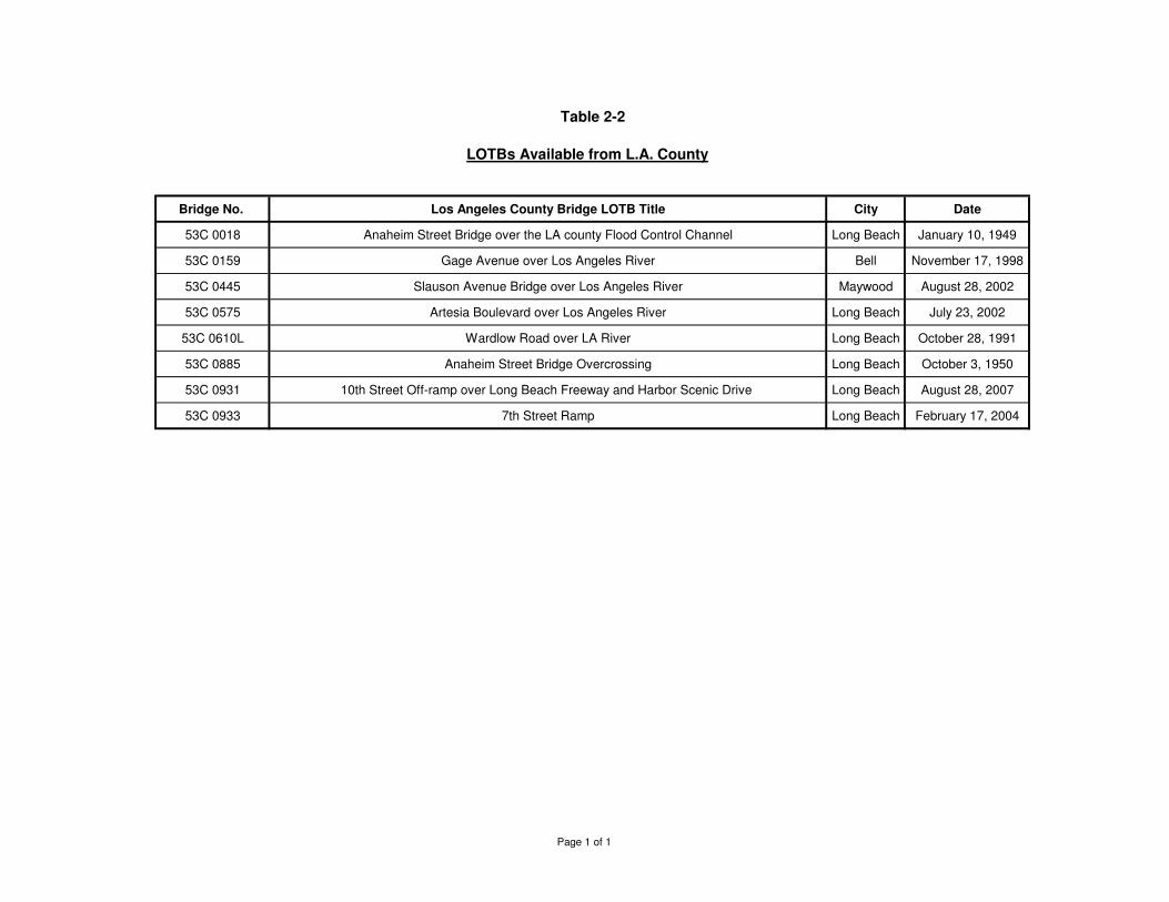
Table 2-2
Bridge No. Los Angeles County Bridge LOTB Title City Date
53C 0018 Anaheim Street Bridge over the LA county Flood Control Channel Long Beach January 10, 1949
53C 0159 Gage Avenue over Los Angeles River Bell November 17, 1998
53C 0445 Slauson Avenue Bridge over Los Angeles River Maywood August 28, 2002
53C 0575 Artesia Boulevard over Los Angeles River Long Beach July 23, 2002
53C 0610L Wardlow Road over LA River Long Beach October 28, 1991
53C 0885 Anaheim Street Bridge Overcrossing Long Beach October 3, 1950
53C 0931 10th Street Off-ramp over Long Beach Freeway and Harbor Scenic Drive Long Beach August 28, 2007
53C 0933 7th Street Ramp Long Beach February 17, 2004
LOTBs Available from L.A. County
Page 1 of 1
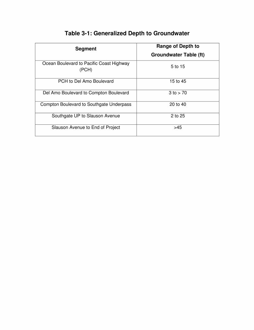
Table 3-1: Generalized Depth to Groundwater
Segment Range of Depth to
Groundwater Table (ft)
Ocean Boulevard to Pacific Coast Highway
(PCH) 5 to 15
PCH to Del Amo Boulevard 15 to 45
Del Amo Boulevard to Compton Boulevard 3 to > 70
Compton Boulevard to Southgate Underpass 20 to 40
Southgate UP to Slauson Avenue 2 to 25
Slauson Avenue to End of Project >45
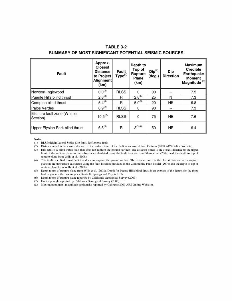
TABLE 3-2
SUMMARY OF MOST SIGNIFICANT POTENTIAL SEISMIC SOURCES
Fault
Approx. Closest Distance to Project Alignment
(km)
Fault Type
(1)
Depth to Top of
Rupture Plane (km)
Dip(7)
(deg.)
Dip Direction
Maximum Credible
Earthquake Moment
Magnitude (8)
Newport-Inglewood 0.0(2)
RLSS
0 90
-- 7.5
Puente Hills blind thrust 2.6(3)
R 2.6(5)
25 N 7.3
Compton blind thrust 5.4(4)
R 5.0(5)
20 NE 6.8
Palos Verdes 6.9(2)
RLSS 0 90 -- 7.3
Elsinore fault zone (Whittier Section)
10.5(2)
RLSS 0 75 NE 7.6
Upper Elysian Park blind thrust 6.5(3)
R 3(5)(6)
50 NE 6.4
Notes:
(1) RLSS=Right Lateral Strike-Slip fault, R=Reverse fault.
(2) Distance noted is the closest distance to the surface trace of the fault as measured from Caltrans (2009 ARS Online Website).
(3) This fault is a blind thrust fault that does not rupture the ground surface. The distance noted is the closest distance to the upper
limit of the rupture plane in the subsurface calculated using the fault location from Shaw et al. (2002) and the depth to top of
rupture plane from Wills et al. (2008).
(4) This fault is a blind thrust fault that does not rupture the ground surface. The distance noted is the closest distance to the rupture
plane in the subsurface calculated using the fault location provided in the Community Fault Model (2004) and the depth to top of
rupture plane from Wills et al. (2008).
(5) Depth to top of rupture plane from Wills et al. (2008). Depth for Puente Hills blind thrust is an average of the depths for the three
fault segments, the Los Angeles, Santa Fe Springs and Coyote Hills.
(6) Depth to top of rupture plane reported by California Geological Survey (2003).
(7) Fault dip angle reported by California Geological Survey (2003).
(8) Maximum moment magnitude earthquake reported by Caltrans (2009 ARS Online Website).
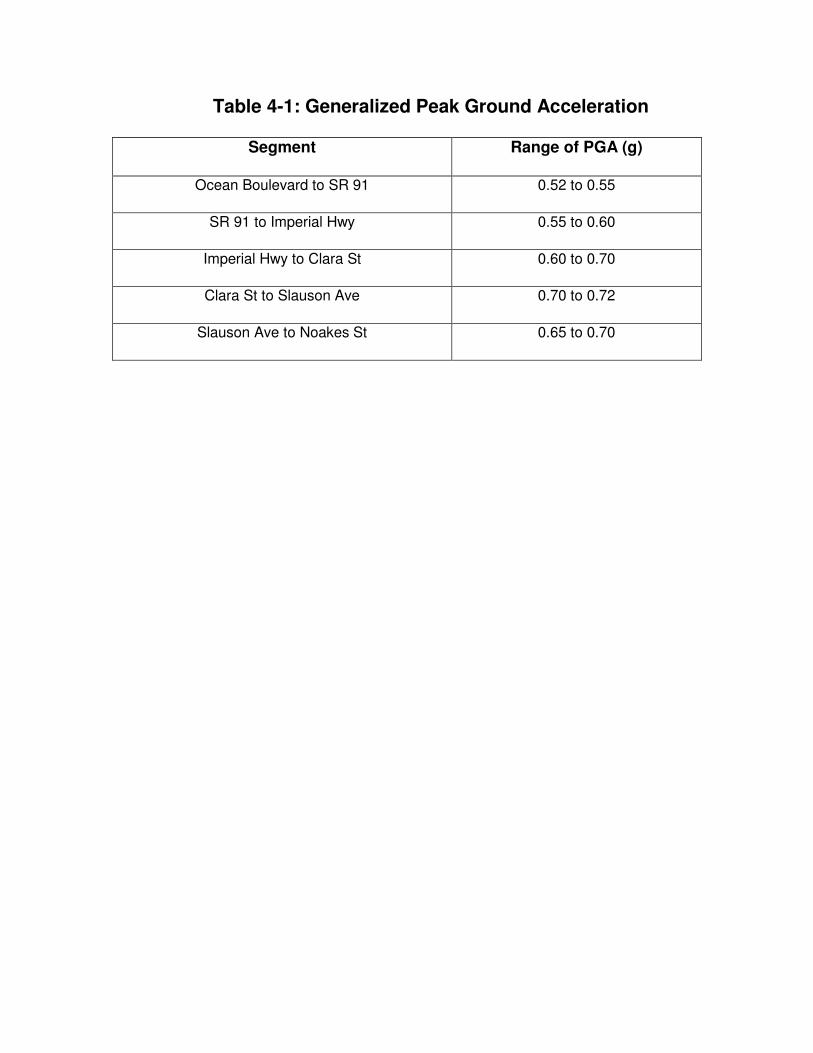
Table 4-1: Generalized Peak Ground Acceleration
Segment Range of PGA (g)
Ocean Boulevard to SR 91 0.52 to 0.55
SR 91 to Imperial Hwy 0.55 to 0.60
Imperial Hwy to Clara St 0.60 to 0.70
Clara St to Slauson Ave 0.70 to 0.72
Slauson Ave to Noakes St 0.65 to 0.70

FIGURES
APPENDIX A
LOGS OF TEST BORINGS (LOTBS ) FOR BRIDGES
ALONG I -710 CORRIDOR
APPENDIX B
AGENCY REV IEW COMMENTS AND RESPONSES
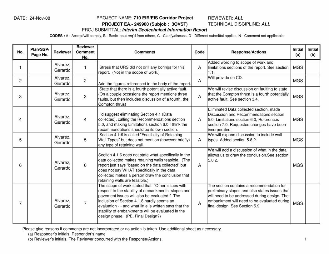
DATE: 24-Nov-08 PROJECT NAME: 710 EIR/EIS Corridor Project
PROJECT EA.- 249900 (Subjob : 3OVST)
PROJ SUBMITTAL: Interim Geotechnical Information Report
No.Plan/SSP/
Page No.Reviewer
Reviewer
Comment
No.
Comments Code Response/ActionsInitial
(a)
Initial
(b)
1Alvarez,
Gerardo1 Stress that URS did not drill any borings for this
report. (Not in the scope of work.)A
Added wording to scope of work and
limitations sections of the report. See section
1.1.
MGS
2Alvarez,
Gerardo2
Add the figures referenced in the body of the report.A
Will provide on CD.MGS
3Alvarez,
Gerardo3
State that there is a fourth potentially active fault.
(On a couple occasions the report mentions three
faults, but then includes discussion of a fourth, the
Compton thrust
A
We will revise discussion on faulting to state
that the Compton thrust is a fourth potentially
active fault. See section 3.4.MGS
4Alvarez,
Gerardo4
I'd suggest eliminating Section 4.1 (Data
collected), calling the Recommendations section
5.0, and making Limitations section 6.0 I think the
recommendations should be its own section.
A
Eliminated Data collected section, made
Discussion and Recommendations section
5.0, Limitations section 6.0, References
section 7.0. Requested changes have been
incorporated.
MGS
5Alvarez,
Gerardo5
Section 4.1.6 is called "Feasibility of Retaining
Wall Types" but does not mention (however briefly)
any type of retaining wall.
AWe will expand discussion to include wall
types. Added section 5.8.2. MGS
6Alvarez,
Gerardo6
Section 4.1.6 does not state what specifically in the
data collected makes retaining walls feasible. (The
report just says "based on the data collected" but
does not say WHAT specifically in the data
collected makes a person draw the conclusion that
retaining walls are feasible.)
A
We will add a discussion of what in the data
allows us to draw the conclusion.See section
5.8.2.
MGS
7Alvarez,
Gerardo7
The scope of work stated that "Other issues with
respect to the stability of embankments, slopes and
pavement issues will also be evaluated." The
inclusion of Section 4.1.8 hardly seems an
evaluation - - and what little is written says that the
stability of embankments will be evaluated in the
design phase. (PE, Final Design?)
A
The section contains a recommendation for
preliminary slopes and also states issues that
will need to be addressed during design. The
embankment will need to be evaluated during
final design. See Section 5.9.MGS
CODES : A - Accept/will comply, B - Basic input req'd from others, C - Clarify/discuss, D - Different submittal applies, N - Comment not applicable
REVIEWER: ALL
TECHNICAL DISCIPLINE: ALL
Please give reasons if comments are not incorporated or no action is taken. Use additional sheet as necessary.
(a) Responder’s initials. Responder’s name
(b) Reviewer’s initials. The Reviewer concurred with the Response/Actions. 1
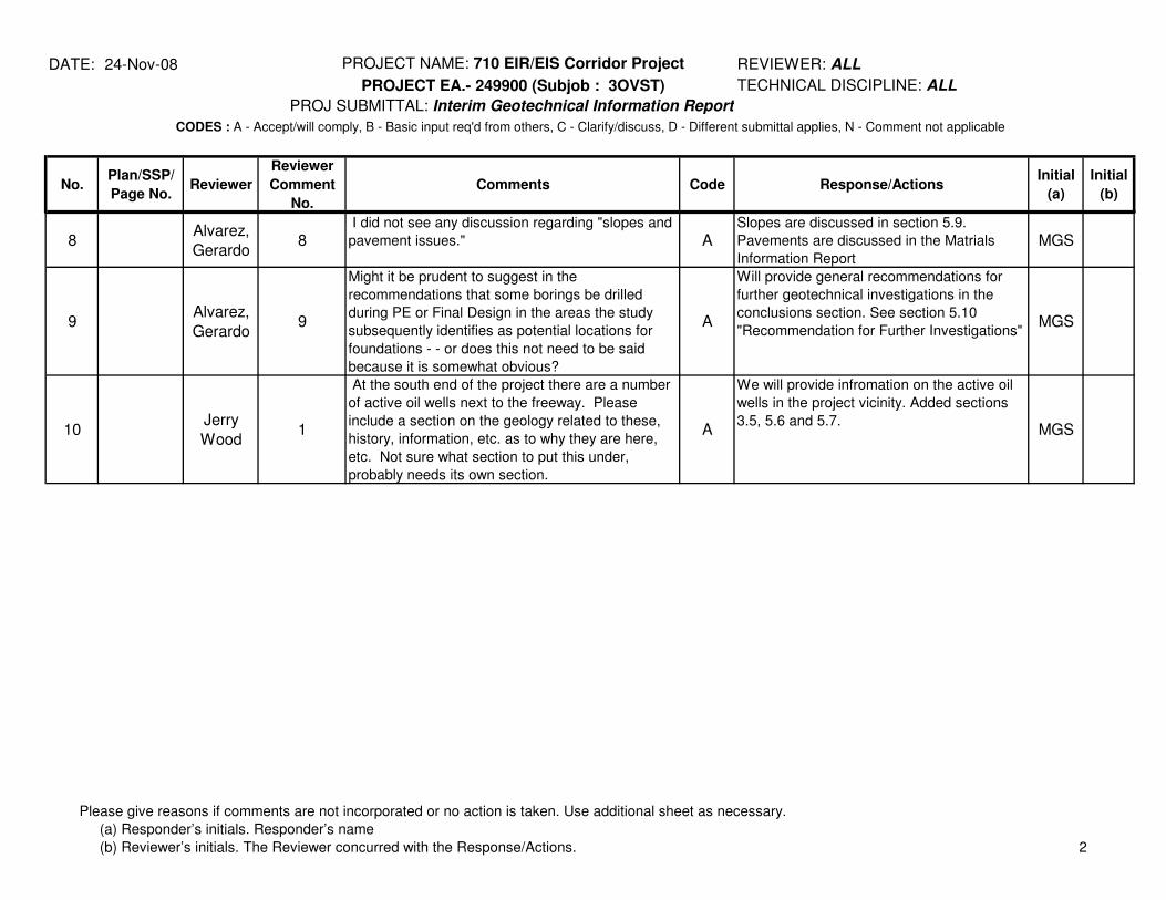
DATE: 24-Nov-08 PROJECT NAME: 710 EIR/EIS Corridor Project
PROJECT EA.- 249900 (Subjob : 3OVST)
PROJ SUBMITTAL: Interim Geotechnical Information Report
No.Plan/SSP/
Page No.Reviewer
Reviewer
Comment
No.
Comments Code Response/ActionsInitial
(a)
Initial
(b)
CODES : A - Accept/will comply, B - Basic input req'd from others, C - Clarify/discuss, D - Different submittal applies, N - Comment not applicable
REVIEWER: ALL
TECHNICAL DISCIPLINE: ALL
8Alvarez,
Gerardo8
I did not see any discussion regarding "slopes and
pavement issues." ASlopes are discussed in section 5.9.
Pavements are discussed in the Matrials
Information Report
MGS
9Alvarez,
Gerardo9
Might it be prudent to suggest in the
recommendations that some borings be drilled
during PE or Final Design in the areas the study
subsequently identifies as potential locations for
foundations - - or does this not need to be said
because it is somewhat obvious?
A
Will provide general recommendations for
further geotechnical investigations in the
conclusions section. See section 5.10
"Recommendation for Further Investigations"MGS
10Jerry
Wood1
At the south end of the project there are a number
of active oil wells next to the freeway. Please
include a section on the geology related to these,
history, information, etc. as to why they are here,
etc. Not sure what section to put this under,
probably needs its own section.
A
We will provide infromation on the active oil
wells in the project vicinity. Added sections
3.5, 5.6 and 5.7.MGS
Please give reasons if comments are not incorporated or no action is taken. Use additional sheet as necessary.
(a) Responder’s initials. Responder’s name
(b) Reviewer’s initials. The Reviewer concurred with the Response/Actions. 2
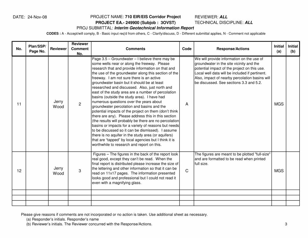
DATE: 24-Nov-08 PROJECT NAME: 710 EIR/EIS Corridor Project
PROJECT EA.- 249900 (Subjob : 3OVST)
PROJ SUBMITTAL: Interim Geotechnical Information Report
No.Plan/SSP/
Page No.Reviewer
Reviewer
Comment
No.
Comments Code Response/ActionsInitial
(a)
Initial
(b)
CODES : A - Accept/will comply, B - Basic input req'd from others, C - Clarify/discuss, D - Different submittal applies, N - Comment not applicable
REVIEWER: ALL
TECHNICAL DISCIPLINE: ALL
11Jerry
Wood2
Page 3.5 – Groundwater – I believe there may be
some wells near or along the freeway. Please
research that and provide information on that and
the use of the groundwater along this section of the
freeway. I am not sure there is an active
groundwater basin but it should be at least
researched and discussed. Also, just north and
east of the study area are a number of percolation
basins (outside the study area). I have had
numerous questions over the years about
groundwater percolation and basins and the
potential impacts of the project on them (don’t think
there are any). Please address this in this section
(the results will probably be there are no percolation
basins or impacts for a variety of reasons but needs
to be discussed so it can be dismissed). I assume
there is no aquifer in the study area (or aquifers)
that are “tapped” by local agencies but I think it is
worthwhile to research and report on this.
A
We will provide information on the use of
groundwater in the site vicinity and the
potential impact of the project on this use.
Local well data will be included if pertinent.
Also, impact of nearby percolation basins will
be discussed. See sections 3.3 and 5.2.
MGS
12Jerry
Wood3
Figures – The figures in the back of the report look
real good, except they can’t be read. When the
final report is distributed please increase the size of
the lettering and other information so that it can be
read on 11x17 pages. The information presented
looks good and professional but I could not read it
even with a magnifying glass.
C
The figures are meant to be plotted "full-size"
and are formatted to be read when printed
full size.
MGS
Please give reasons if comments are not incorporated or no action is taken. Use additional sheet as necessary.
(a) Responder’s initials. Responder’s name
(b) Reviewer’s initials. The Reviewer concurred with the Response/Actions. 3
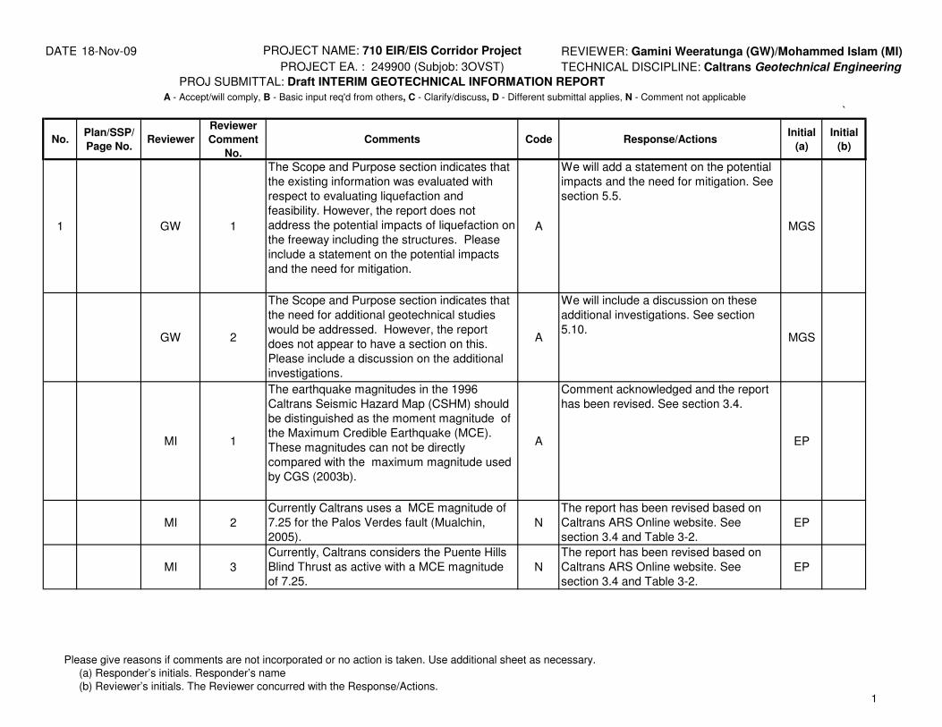
DATE: 18-Nov-09 PROJECT NAME: 710 EIR/EIS Corridor Project REVIEWER: Gamini Weeratunga (GW)/Mohammed Islam (MI)
PROJECT EA. : 249900 (Subjob: 3OVST) TECHNICAL DISCIPLINE: Caltrans Geotechnical Engineering
PROJ SUBMITTAL: Draft INTERIM GEOTECHNICAL INFORMATION REPORT
`
No.Plan/SSP/
Page No.Reviewer
Reviewer
Comment
No.
Comments Code Response/ActionsInitial
(a)
Initial
(b)
1 GW 1
The Scope and Purpose section indicates that
the existing information was evaluated with
respect to evaluating liquefaction and
feasibility. However, the report does not
address the potential impacts of liquefaction on
the freeway including the structures. Please
include a statement on the potential impacts
and the need for mitigation.
A
We will add a statement on the potential
impacts and the need for mitigation. See
section 5.5.
MGS
GW 2
The Scope and Purpose section indicates that
the need for additional geotechnical studies
would be addressed. However, the report
does not appear to have a section on this.
Please include a discussion on the additional
investigations.
A
We will include a discussion on these
additional investigations. See section
5.10.MGS
MI 1
The earthquake magnitudes in the 1996
Caltrans Seismic Hazard Map (CSHM) should
be distinguished as the moment magnitude of
the Maximum Credible Earthquake (MCE).
These magnitudes can not be directly
compared with the maximum magnitude used
by CGS (2003b).
A
Comment acknowledged and the report
has been revised. See section 3.4.
EP
MI 2
Currently Caltrans uses a MCE magnitude of
7.25 for the Palos Verdes fault (Mualchin,
2005).
N
The report has been revised based on
Caltrans ARS Online website. See
section 3.4 and Table 3-2.
EP
MI 3
Currently, Caltrans considers the Puente Hills
Blind Thrust as active with a MCE magnitude
of 7.25.
N
The report has been revised based on
Caltrans ARS Online website. See
section 3.4 and Table 3-2.
EP
A - Accept/will comply, B - Basic input req'd from others, C - Clarify/discuss, D - Different submittal applies, N - Comment not applicable
Please give reasons if comments are not incorporated or no action is taken. Use additional sheet as necessary.
(a) Responder’s initials. Responder’s name
(b) Reviewer’s initials. The Reviewer concurred with the Response/Actions. 1
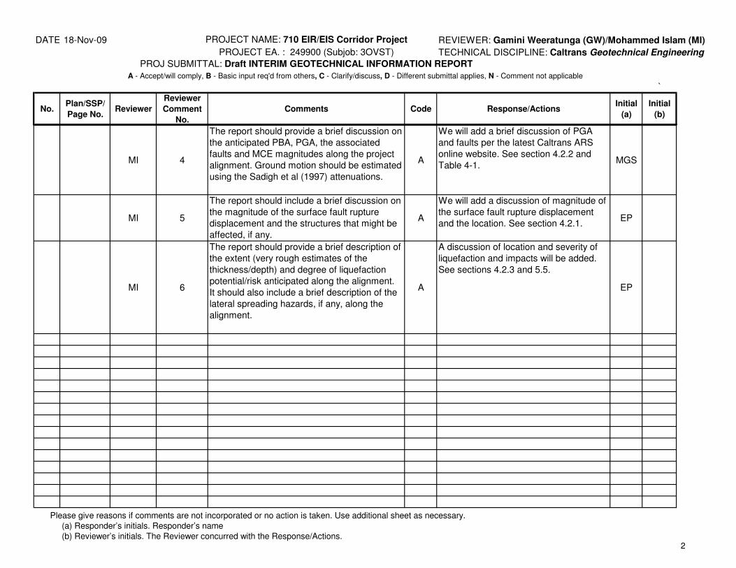
DATE: 18-Nov-09 PROJECT NAME: 710 EIR/EIS Corridor Project REVIEWER: Gamini Weeratunga (GW)/Mohammed Islam (MI)
PROJECT EA. : 249900 (Subjob: 3OVST) TECHNICAL DISCIPLINE: Caltrans Geotechnical Engineering
PROJ SUBMITTAL: Draft INTERIM GEOTECHNICAL INFORMATION REPORT
`
No.Plan/SSP/
Page No.Reviewer
Reviewer
Comment
No.
Comments Code Response/ActionsInitial
(a)
Initial
(b)
A - Accept/will comply, B - Basic input req'd from others, C - Clarify/discuss, D - Different submittal applies, N - Comment not applicable
MI 4
The report should provide a brief discussion on
the anticipated PBA, PGA, the associated
faults and MCE magnitudes along the project
alignment. Ground motion should be estimated
using the Sadigh et al (1997) attenuations.
A
We will add a brief discussion of PGA
and faults per the latest Caltrans ARS
online website. See section 4.2.2 and
Table 4-1.MGS
MI 5
The report should include a brief discussion on
the magnitude of the surface fault rupture
displacement and the structures that might be
affected, if any.
A
We will add a discussion of magnitude of
the surface fault rupture displacement
and the location. See section 4.2.1.EP
MI 6
The report should provide a brief description of
the extent (very rough estimates of the
thickness/depth) and degree of liquefaction
potential/risk anticipated along the alignment.
It should also include a brief description of the
lateral spreading hazards, if any, along the
alignment.
A
A discussion of location and severity of
liquefaction and impacts will be added.
See sections 4.2.3 and 5.5.
EP
Please give reasons if comments are not incorporated or no action is taken. Use additional sheet as necessary.
(a) Responder’s initials. Responder’s name
(b) Reviewer’s initials. The Reviewer concurred with the Response/Actions. 2
Related Documents