Geology of the North Bradfield River Iron Prospect Southeastern Alaska By E. M. MAcKEVETT, JR., and M. C. BLAKE, JR. MINERAL RESOURCES OF ALASKA EOLOGICAL SURVEY BULLETIN 1108-D Detailed and reconnaissance mapping of an area containing 11 known magnetite-rich ore bodies UNITED STATES GOVERNMENT PRINTING OFFICE. WASHINGTON ! 1963

Welcome message from author
This document is posted to help you gain knowledge. Please leave a comment to let me know what you think about it! Share it to your friends and learn new things together.
Transcript
Geology of the North Bradfield River Iron Prospect Southeastern AlaskaBy E. M. MAcKEVETT, JR., and M. C. BLAKE, JR.
MINERAL RESOURCES OF ALASKA
EOLOGICAL SURVEY BULLETIN 1108-D
Detailed and reconnaissance mapping of an area containing 11 known magnetite-rich ore bodies
UNITED STATES GOVERNMENT PRINTING OFFICE. WASHINGTON ! 1963
UNITED STATES DEPARTMENT OF THE INTERIOR
STEWART L. UDALL, Secretary
GEOLOGICAL SURVEY
Thomas B. Nolan, Director
For sale by the Superintendent of Documents, U.S. Government Printing Office Washington, D.C. 20402
CONTENTS
PageAbstract__-___-___--__________---___--__---_____-_--____.___.__ DlIntroduction. __-______.________._____________-_______.________ ____ 1Geology-_________________________________________________________ 4
Metamorphic rocks..______.__-_-___-_____.__..______._________ 4Lower gneiss unit__-____---___-_____-__.____-___________. 4Granulite and schist.______________________________________ 5Marble_..._._....__..-.._-._.__._.____..___.._.__._..__. 9Skarn.---.----__---_...-----_--------_---,_-------------_- 11Upper gneiss unit ..-_----__-------_-__--_-----__--_-____ 11Age and correlation._______________________________________ 12
Plutonic rocks__.__--__-_-----_-----_--_.____-_--_______ ____ 12Petrology and petrography.----------------------.-._______ 13Age____________________________________________________ 14
Hypabyssal rocks....-______-----_-__-__-_______-_-____________ 14Petrology and petrography.________________________________ 15
Surficial deposits._.__--__-----------_-___-_-__-__------__-_-__ 15Structure...__________________________________________________ 15Ore deposits-______________-_-_-___i_____-_______--._-______._ 16
Descriptions of the known ore bodies___------------------- 18Probable genesis_ ---------------------------------------- 20
Conclusions.-- - -_-_-_-----_-___----------__---_-_-_----_----_---__ 20References_ -____________________________________________________ 21
ILLUSTRATIONS
PLATE 1. Geology of the North Bradfield River iron prospect..--.. In pocketPage
FIGURE 1. Index map showing the location of the North Bradfield Riveriron prospect.______-_-___-___ __-___-_-__---__--_--.- D2
TABLES
Page TABLE 1. Mineralogy of the metamorphic rocks.____----_---_--_-_---- D6
2. Properties of garnets from the North Bradfield River iron pros pect- _--..__-__-____-_--__---___----_---------_--_----- 8
3. Semiquantitative spectrographic analyses of rocks and ore fromthe North Bradfield River iron prospect._____-_---_---_---- 9
4. Standard sensitivities for the 66 elements sought in the semi- quantitative spectrographic analyses__-___--.__-__--._----_ 10
in

MINERAL RESOURCES OF ALASKA
GEOLOGY OF THE NORTH BRADFIELD RIVER IRON PROSPECT, SOUTHEASTERN ALASKA
By E. M. MACKEVETT, JR., and M. C. BLAKE, JR.
ABSTRACT
The North Bradfleld River iron prospect is in southeastern Alaska in rugged terrain about 8 miles southwest of the Canadian boundary and about 15 miles northeast of the head of Bradfield Canah The prospect includes several magnet ite-rich ore bodies of pyrometasomatic origin that are localized in skarn. The skarn forms a small part of a northwestward-trending roof pendant that is enclosed in the composite Coast Range batholith. The dominant rocks of the roof pendant are gneiss, granulite, schist, and marble. The ore, which consists almost entirely of magnetite, contains subordinate amounts of hematite, hydrous iron sesquioxides, pyrrhotite, chalcopyrite, and malachite. The ore bodies are crudely stratiform and apparently discontinuous. The largest ore body exposed is traceable for about 350 feet along its strike and averages about 25 feet in thickness. An accurate appraisal of the economic potential of the prospect was precluded by poor outcrops, local snow cover, and inadequate subsurface data.
INTRODUCTION
The North Bradfield Kiver iron prospect is on the mainland of southeastern Alaska about 40 miles southeast of Wrangell, 8 miles southwest of the international boundary, and 72 miles north of Ketch- ikan (fig. 1). Access to the prospect is mainly by aircraft, most practically by helicopter. Skilled pilots can sometimes land small fixed-wing aircraft equipped with floats on suitable parts of the North Bradfield Eiver about 5 miles from the prospect, but such landings, which are governed by water conditions including the va garies of the shifting course of the river, are not always possible. The prospect can also be reached by hiking for a distance of about 15 miles over ill-defined trails from the limit of navigable water at the head of Bradfield Canal, but overland travel is slow and tedious.
The prospect is within highly dissected terrain west of the crest of the Coast Kange, a region characterized by steep topography, many swift streams, heavy precipitation, many alpine glaciers, and ia few
Dl

D2 MINERAL RESOURCES OF ALASKA
snowfields. The prospect area ranges in altitude from 400 to 4,000 feet above sea level. The region supports a dense forest below alti tudes of 2,500 feet, but at higher altitudes the vegetation consists of various grasses, shrubs, and lichens.
138° 134° 130°
60 60°
58
138
58°
130°
FIGURE 1. Index map of southeastern Alaska showing the location of the North BradfieldRiver iron prospect.
NORTH BRADFIELD RIVER IRON PROSPECT, ALASKA D3
Kenneth Eichner of Ketchikan (oral communication, 1960) noted the iron- and copper-stained outcrops that characterize some of the de posits from the air during the summer of 1955. Later in the summer of 1955, Eichner's prospecting partner, Paul Pieper of Ketchikan, investigated the stains and staked claims in the area. Several repre sentatives of mining companies have examined the prospect, and their investigations were supplemented by an aeromagnetic survey and by six diamond-drill holes totaling 186 feet in length. J. A. Williams of the Alaska Division of Mines and Minerals (written communications, 1960) briefly examined the prospect during 1957. Enlargements of natural exposures by local removal of overburden constitute the only workings.
The few previous geologic investigations in the general region con sisted of reconnaissance mapping. The general geology of the region, largely inferred from mapping done along the shores of Bradfield Canal, is shown on reconnaissance maps by Wright and Wright (1908, pis. 1 and 2). Nearby areas of British Columbia have been mapped by Kerr (1948) and by the Geological Survey of Canada during "Op- peration Stikine" (1957).
The present investigation comprised (1) detailed geologic mapping of an area of approximately 1% square miles that contains the best outcrops and the most promising known mineral deposits and (2) reconnaissance geologic mapping of a contiguous area of 2 square miles supplemented by interpretation of aerial photographs and re connaissance by helicopter (pi. 1). All the mapping was done at a scale of 1:20,000 on a topographic base enlarged from the Bradfield Canal (B-5) quadrangle (1955). Two weeks during June and July 1960 were spent in the field. A large part of the area that was mapped by reconnaissance methods is covered by dense vegetation, and many north-facing hillsides in the area were covered by snow during the period of the fieldwork. It is unlikely that detailed mapping of this part of the area would yield significant additional data. A recon naissance dip-needle survey (pi. 1) was made of the part of the area that was mapped in detail. The laboratory investigations included thin-section, polished-section, spectrographic, and X-ray studies of the rocks and minerals and mineral identifications using oil-immersion techniques.
The writers gratefully acknowledge the cooperation of Kenneth Eichner and Paul Pieper, the owners of the prospect, who assisted the investigation in many ways, of Ralph Pray of the Alaska Divi sion of Mines and Minerals, who freely shared his knowledge of the prospect, and of Joe Soloy of Temsco Copters, who provided reliable and dependable helicopter transportation.
D4 MINERAL RESOURCES OF ALASKA
GEOLOGY
The regional geology near the prospect is not well known. It is characterized by plutonic rocks of the Coast Kange batholith and by metamorphic rocks of diverse composition that form mainly north west-trending roof pendants. Reconnaissance maps by Wright and Wright (1908, pis. 1 and 3) show the region near the North Bradfield River to be underlain by plutonic rocks. Buddington and Chapin (1929, pi. 1) mapped much of the area contiguous to the eastern part of Bradfield Canal as gneiss during their reconnaissance mapping of southeastern Alaska. More recent work by Canadian geologists (Kerr, 1948, map 311A; Geological Survey of Canada, 1957, map 9-1957) indicates that the nearby parts of British Columbia, east and northeast of the prospect, are largely underlain by a variety of metamorphic rocks ranging in age from pre-Permian to Triassic and by Mesozoic granitic rocks.
Most rocks at the prospect are of metamorphic origin and form the northern part of a complexly folded roof pendant (pi. 1) that probably continues southeastward for many miles. The major structural fea ture in the northern part of the pendant is a syncline that plunges northwest and is overturned to the southwest. The pendant is en compassed by quartz monzonite, probably the dominant batholithic rock in the general area, and is intruded by dikes or dikelike bodies of quartz diorite, aplite, and alaskite. Along the North Bradfield River and some of its tributaries, the crystalline rocks are locally cov ered by glacial till and fluvioglacial deposits of Quaternary age. The potential ore at the prospect forms masses rich in magnetite of pyro- metasomatic origin that are associated with skarn within the meta- morphic sequence.
METAMORPHIC BOOKS
The metamorphic rocks were subdivided into five cartographic units (pi. 1) : a lower gneiss, granulite and schist, marble, skarn, and an upper gneiss that contains subordinate schist and skarn. These rocksare probably mainly in the sillimanite-almandine subf acies of the al-mandine amphibolite f acies as defined by Fyfe, Turner, and Verhoogen (1958, p. 230, 231).
XX>-WJB»
DISTRIBUTION AND RELATIONSHIP
Gneiss of the lower unit is distributed extensively in the southwest ern and southern parts of the prospect area (pi. 1) . It is well exposed on Hill 2405, where it locally forms craggy outcrops on steep south- facing hillsides in the southern part of the area> and along several canyons cut by tributaries of the North Bradfield River. In places,
NORTH BRADFIELD RIVER IRON PROSPECT, ALASKA D5
both east and west of the river, gneiss crops out forming bold, steep cliffs.
The lower gneiss forms the basal part of the syncline, and it is over lain by granulite-schist and locally covered by unconsolidated fluvio- glacial deposits. It is intruded by quartz monzonite and by a few thin alaskite dikes and sills. The gneiss contains numerous quartz veinlets as much as 3 inches thick that are parallel to the foliation. Contacts between the gneiss and the other metamorphic rocks are steep and gradational over several tens of feet and appear to be conformable, but the contacts between the gneiss and the quartz mon zonite are grossly discordant. The gneiss is the thickest metamorphic unit, and in the southern part of the map area its outcrop is as much as 5,300 feet wide.
PETROLOGY AND PETROGRAPHY
The gneiss is medium grained and has minor fine-grained facies. It ranges from light to dark gray when fresh and is brown when weathered. The gneissic texture is caused by alternating f elsic bands, 2 to 4 mm thick, and mafic bands, 1 mm thick. The mafic bands, which consist mostly of biotite, are locally streaky or lenticular and have well-defined foliation. The dominant minerals of the gneiss are plagioclase and quartz. Biotite and, less commonly, hornblende are the principal mafic minerals and constitute between 10 percent and 40 percent of the gneiss. The mineralogy of the gneiss is sum marized in table 1.
GRANUUTE AND SCHIST
DISTRIBUTION AND RELATIONSHIP
Rocks of the granulite-schist unit form the nose and large parts of the limbs of the syncline (pi. 1). They conformably overlie the lower gneiss and are overlain conformably by marble or skarn. The granulite-schist unit contains the lowermost of the two main marble horizons and a few small marble lenses. These calcareous rocks are describe^! under "Marble," page D9. Granulite and schist constitute the peripheral rocks of the roof pendant throughout the northern part of the prospect area, where they have been extensively intruded by quartz monzonite. The intrusive contacts are generally sharp and discordant overall, even though most of the observed contacts appear to be concordant. The granulite-schist unit is cut by a few dikes of alaskite and aplite and is locally overlain by till. Owing to structural complexity, the thickness of the granulite-schist unit cannot be accu rately determined. The maximum outcrop width of the granulite- schist unit is about 1,750 feet.
D6
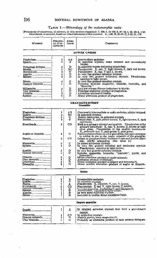
TABLE 1. Mineralogy of the metamorphic rocks[Frequency of occurrence, In percent, In thin sections examined: 1,100; 2, 75-100; 3,50 -76; 4, 25- 50; 5, <25.
Abundance, in percent, based on visual estimates of thin sections: A, >50; B, 25-50; C,5-25; D, <5]
MineralsFrequen cy of oc currence
Abun dance Comments
LOWER GNEISS
Potassium feldspar ......Biotite........ ..........
Opaque minerals _ _ ...
Slllimanita ______^ __ ___Clay minerals ...........Chlorite.. ..............Sericlte ____ . .......
1 1
5 1 2 4 3
4 1
5 1 55
AB B
D BC C D D
D D
D D D D
Intermediate andesine. In anhedral crystals, some strained and anomalously
biaxial. In anhedral masses embaying plagioclase. Pleochroism: X, tan; Y, light brown; Z, dark red brown. Pleochroism: X, tan; Y and Z, brown. In very fine grained euhedral crystals. In very fine grained subhedral crystals. Pleochroism:
colorless to light brown. In very fine grained euhedral crystals. Probably includes magnetite, ilmenite, hematite, and "limonite." As a few minute fibrous inclusions to biotite. Principal alteration product of plagioclase. Alteration product of biotite. Minor alteration product of plagioclase.
GRANULITE-SCHIST Granulite
Potassium feldspar ......Biotite..................
Hornblende .............
Augite or diopside.. ....
Garnet ..................
Muscovite -. .........
Apatite .................
Chlorite. ...............Clay minerals _ . .......Leucoxene. __ . ...Tremolite. ..............
1 2 5 3
3
4
5
54
5 1
3 4 5 6
AB BC C C
CD
C
CD
C D
D D
D D D D
Commonly Intermediate or sodic andesine; albite twinned. In anhedral crystals. Mainly microcline. in anhedral crystals. Pleochoism: X, pale yellow brown; Y, light brown; Z, dark
red brown. Both as a primary mineral and uralitic. Pleochroism of the
primary horblende: X, tan; Y, brown; Z, brown or dark olive green. Pleochroism of the uralitic hornblende: X, yellowish tan; Y, pale green; Z. pale green.
Forms porphyro blasts in a few granulites, but more common ly similar in size to the major minerals of the granulite.
Occurs as porphyroblasts between 2 mm and 2 cm in diam eter; chiefly almandine. (See table 2.)"
In alined subhedral crystals. In very fine grained euhedral and subhedral crystals.
Pleochroism: colorless to light brown. In very fine grained euhedral crystals. Includes magnetite, hematite, "limonite", pyrlte, and
ilmeniteC?). Minor alteration product of mafic minerals. Alteration product of feldspars. Minor alteration product of sphene and ilmenite(?). Minor uralitic alteration product of auglte or diopside.
Schist
Plagioclase ..........
iotite...... ............Hornblende ___ __
Apatite ____ . .......Zircon ..................
1
13i11
B
ACDr>
DD
PleOChrolSm: X, colorless; Y, tan; Z, brown.Pleochroism: X and Y, light brown; Z, brown.includes hematite. nmgnetite(?) and ilmenite(?).In very small euhedral crystals.Included in biotite; forms pleochroic halos.
Impure quartzite
Quartz........ ... .......Muscovite ............Opaque minerals ........Clay minerals ...........
1
l11
A
CDDD
In Strained anhedral crystals that form a granoblastlcmosaic.
Mainly pyrite, some magnetite (?).Probably an alteration product of once present feldspars.

NORTH BRADFIELD RIVER IRON PROSPECT, ALASKA
TABLE 1. Mineralogy of the metamorphic rocks Continued
MineralsFrequen cy of oc currence
Abun dance Comments
Amphibollte
Hornblende .............
Auglte or dlopslde. .....
1
1~ 1
A
CDD
Pleochrolsm: X, pale yellow brown; Y, olive green; Z,dark blue green.
Gneiss
Mineraloglcally similar to gneiss of the lower gneiss unit
MARBLE
Calc'lte.... _ .... _ ...
Dolomite.. .............Opaque minerals ........
Sphene ..............Serlclte _______ .
14414555
ADDDDDDD
Dominant mineral of marble; less common
Chiefly pyrite, hematite, and graphite.
Occurs In velnlets.
in veinlets.
SKARN
Garnet ..................
Potassium feldspar ......
Epidote.... .............Scapolite ................
Bcoleclte ................
Blotite.......... ........Chlorite.. ..............
11
13 31514444
55
AB
DD DDCDDDDC
DD
Composltionally andradite and grossularite. (See table 2.)Contains abundant poikilitic Inclusions, chiefly of opaque
minerals.
Microcline, in small anhedral crystals.
Pale yellow.In veinllke masses.Chiefly magnetite, hematite, and pyrite.In very small euhedral crystals; light brown.In fibrous bundles.In very fine grained euhedral crystals.In subhedral and euhedral crystals. Pleochroism: X,
yellowish brown; Y, greenish brown;. Z, dark green. In highly altered relicts.
UPPER GNEISS
Plagioclase... ...........Quartz ..................Potassium feldspar ...... Augite or diopslde.. .... Hornblende .............Biotite...... ............
Apatite .................Sphene... ___ ........Zircon. .................
124 4 131334
ABBC CC
CDDDDD
Intermediate to calcic andesine.In strained anhedral crystals.In anhedral masses that embay plagioclase. In subhedral crystals. Pleochroism: X, yellow brown; Y, brown; Z,Pleochrolsm: colorless to red brown.Magnetite, ilmenite(?) and pyrite.In very small euhedral crystals.
In very small euhedral crystals.
green brown.
The granulite-schist unit comprises fine-grained rocks that are litho- logically complex. It consists mainly of granulite accompanied by slightly lesser amounts of schist and subordinate gneiss, impure quartz-
D8 MINERAL RESOURCES OF ALASKA
ite, and amphibolite. Many of the rocks are closely related in com position and texture and are difficult to distinguish from each other in the field.
The granulite is a felsic rock that contains quartz and plagioclase and subordinate biotite and hornblende. Its less common variants contain augite, diopside, or garnet. The schists are mafic rocks that are rich in biotite. The minor amounts of gneiss in the granulite- schist unit consist mostly of quartz, plagioclase, and accessory horn blende and biotite. The impure quartzite consists largely of a mosaic of fine-grained quartz. The amphibolite is composed of hornblende and subordinate augite or diopside and plagioclase. Except for the amphibolite, which is dark brown to black, the rocks of the granulite- schist assemblage are mainly medium gray on fresh surfaces and brown on weathered surfaces.
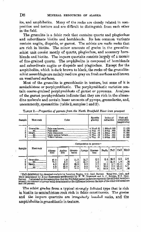
Most of the granulite is granoblastic in texture, but some of it is semischistose or porphyroblastic. The porphyroblastic varieties con tain coarse-grained porphyroblasts of garnet or pyroxene. Analyses of the garnet porphyroblasts indicate that they are rich in the alman^ dine molecule and contain lesser amounts of pyrope, grossularite, and, uncommonly, spessaritite (table 2, samples 1 and 2).
TABLE 2. Properties of garnets from the North Bradfield River iron prospect
Sample
12 3 4 5
Sample
l 2 34,
5
Host rock
.....do.......... Skarn..... ..........do..............do .......
Host rock
.....do........... Skarn __ . .........do...:::;;::
Color
Pale rose 1 Pale pink Pale clnn£ Light yell Yellow br
Specific gravity
4. 11±0. 01 4. 14± . 01 3. 74± . 01 3. 76± . 01 3.72± .01
Index of refraction
1. 800±0. 003 1. 810± . 003 1. 805± . 003 1. 810± . 003 1.810± .003
Unit cell dimension
(angstroms)
11. 570 11. 530 11. 932 11. 939 11.941
. . Composition In percent '
Alman- dine
67.0 73.4 6.2 4.0 5.8
Andra- dlte
1.33 O . &
42.6 52.5 4B. »
Grossu larite
11.0 1.5
48.3 37.048. 8
Pyrope
14.720.7 3.9 3.33.7
Spessar- tlne
6.0 1.2 2.0 o q4. O.8
FejOa
0.4 .1
13.416.5 13.8
FeO
29.0 31.82.72.1 2.5
CaO
4.5 1.6
31.031.2 31.6
MnO
2.6 .54.84
1.0 .36
1 FeO determined by chemical analysis by Leoniece Beatty. U.S. Qeol. Survey. Total Iron, CaO, and MnO determined by X-ray fluorescent spectroscopy by W. W. Brannock and A. c Bettiga, U.8.Qeol. Survey. Calculated on the assumption that the five listed garnet molecules represent the only end members present; the amount of pyrope being determined by the difference between the sum of the other end members and 100 percent.
The schist grades from a typical strongly foliated type that is rich in biotite to semischistose rock rich in felsic constituents. The gneiss and the impure quartzite are irregularly banded rocks, and the amphiobolite is granoblastic in texture.
NORTH BRADFIELD RIVER IRON PROSPECT, ALASKA D9
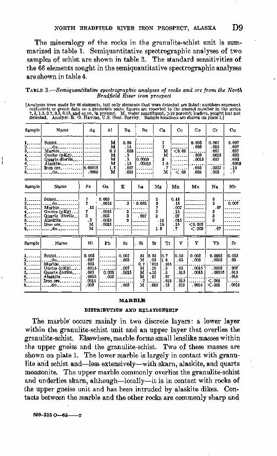
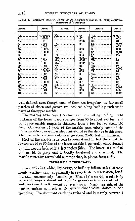
The mineralogy of the rocks in the granulite-schist unit is sum marized in table 1. Semiquantitative spectrographic analyses of two samples of schist are shown in table 3. The standard sensitivities of the 66 elements sought in the Semiquantitative spectrographic analyses are shown in table 4.
TABLE 3. Semiquantitative spectrographic analyses of rocks and ore from the North Bradfield River iron prospect
[Analyses were made for 66 elements, but only elements that were dfttected are listed; numbers represent midpoints or group data on a geometric scale; figures are reported to the nearest number In the series 7,3,1.5,0.7,0.3,0.15, and so on, In percent. M. major constituent, >10 percent; leaders, sought but not detected. Analyst: R. O. Havens, U.S. Qeol. Survey. Sample locations are shown on plate 1.]
Sample
j23.... 4_ 5.... ...6. 7.... ...8.
Sample
1.... ...2... 3_ 4. ...5. ...6. 7. 8.
Sample
2l 3. 4. 6. 6.... ...7. 8..
Name
Schist.. ..do..
Gneiss (pKg)_...
Alasklte
.... .do........ ....
Name
..do . .
Gneiss (pKg)... Quartz dlorlte..
. .do..... ...
Name
Schist.. .do.. . Marble.. Gneiss (pKg)..___ Quartzdiorlte.... Alasklte Iron ore.. .......
... ..do...... ......
Ag
. 0. 00015
. .0003
Fe
7 7 .15 .
7 3 .3M M .
Nl
0.003 .007 .003 .0015 .003 .0003 .0015 .003
Al
MM
0.3MMM
1.5M
da
0. 003 ..0015
.0015
.003
.0015
.0015 .
Pb
"o.'oos".003
Ba
0.03 .15 .003.3 .3 .15 .007 .003
K
3
3 .3 3 .
So
0.007 .003
""."667"
.0015
"."663"
Be Ca
0.0003 . 00015
La
0.003
.007
, 81
MM.
0.7 M M M .7 M
7 7 MM
3 1.5.7M
Ce
<0.05
<.05
Mg Mn
3 0.15 3 .16 7 .007 3 .15 3 .07
. 15 . 015
.15 .15 1.5 .7
Sr
0.03 .03:ois.15
-,15 .07
"bis'
Tl
0.7 1.5 .015 .3 .3 .07 .015 .15
Co
0.003 .003
.003
.0015
.003
.003
Mo
"<6."663"
<.003
V
0.03 .03
"."63"
.015
.015
.015
Y
0.003 .003
"Voois".0015
"W
Cr
0.007 .016 .007 .0015 .007
.0007
.003
Na
3 3.07
3 3 3
.07
Yb
0.0003 .0003
""."6663"
.00015
<.001 <.001
Cu
0.007 .007 .007 .003 .003 .0003 .15 .7
Nb
0.007
Zr
0.015 .03
" "."667"
.015 . .015
"."6615
MARBLE
DISTRIBUTION AND RELATIONSHIP
The marble' occurs mainly in two discrete layers: a lower layer within the granulite-schist unit and an upper layer that overlies the granulite-schist. Elsewhere, marble forms small lenslike masses within the upper gneiss and the granulite-schist. Two of these masses are shown on plate 1. The lower marble is largely in contact with granu- lite and schist and less extensively with skarn, alaskite, and quartz monzonite. The upper marble commonly overlies the granulite-schist and underlies skarn, although locally it is in contact with rocks of the upper gneiss unit and has been intruded by alaskite dikes. Con tacts between the marble and the other rocks are commonly sharp and
690-235 O 63 2
DIG MINERAL RESOURCES OF ALASKA
TABLE 4. Standard sensitivities for the 66 elements sought in the semiquantitativespectrographic analyses
Element
Ag Al. ......._..As._-- -----Au -----B. .Ba Be - Si-.--.-----Ca Cd -, . Ce.-- -----Co Cr. ....Cu ------Dy ..... ...Er. ----------Eu _ ___ _Fe Ga -----Gd ........Ge. Hf._. ..
Percent
0. 00001.0001.01.001.005.0005. 00005.005.01.005.03.001.0006. 00005.006.003.003.0008.001.006.001.007
Element
Hg Ho -----In__. _._.__..Ir __-_-_-K -----La____- -____Li... .--__-.. .Lu --Mg._ Mn. ..----.__Mo____ Na. --------Nb -------Nd_ ------Ni_. .........Os__ . ........P.. -.---..-_.Pb__ .---_... .Pd___--_-__Pr.-_ __ ___ .Pt... -------Re. __
Percent
0.08.001. 0004.03. 1.003.01.005. 00003.0007.0005.01.001.006.001. 1.07.001.003.01.003.04
Element
Rh... ........Ru _ _. --__-Sb. ..........Sc. ..........Si --------Sm- _____ _-Sn__ _...--. -.Sr ... ...Ta_-_ ---Tb -----Te_--_----Th____--_-Ti__ ._.-----.Tl_. -...-.. ..Tm__. -------U -------V. ........W__. .__---..Y_ ._Yb... .. ------Zn. ..........ZT. ..........
Percent
0.004.008.01.0005.005.008.0001.001. 1.01.08.05.0005.04.001.08.001.05.001.0001.008.0008
well defined, even though some of them are irregular. A few small patches of skarn and gossan are localized along bedding surfaces in parts of the upper marble.
The marbles have been thickened and thinned by folding. The thickness of the lower marble ranges from 50 to about 250 feet, and the upper marble ranges in thickness from a few feet to about 100 feet. Conversion of parts of the marble, particularly some of the upper marble, to skarn has also contributed to the change in thickness. The marble lenses commonly average about 20--30 feet in thickness.
Most of the marble is in beds between 4 and 10 feet thick, but the lowermost 40 or 50 feet of the lower marble is generally characterizedby thin marble beds only a few inches thick. The lowermost part ofthis marble is platy and is locally fractured and shattered. The marble generally forms bold outcrops that, in places, form cliffs.
PETROLOGY AND PETROGRAPHY
The marble is a white, light-gray, or buff crystalline rock that com monly weathers tan. It generally has poorly defined foliation, band ing, and uncommonly boudinage. Most of the marble is relativelypure and Consists almost entirely of a granoblastio mosaic of calcite
a*!<i lefee tka^ i av Q percent other minerals. Minor variants of the marble contain as much as 15 percent chondrodite, dolomite, and tremolite. The dominant calcite is twinned and is mainly between 1
NORTH BRADFIELD RIVER IRON PROSPECT, ALASKA Dll
and 3 mm in diameter, but it has size extremes of 0.1 and 5 mm. The mineralogy of the marble is summarized in table 1.
Quartz or calcite veinlets locally cut the marble. A semiquantitative spectrographic analysis of a sample from the lower marble horizon (table 3, sample 3) shows a high calcium content and a fairly high magnesium content.
SKARN
DISTRIBUTION AND RELATIONSHIP
The skarn is most extensive in the upper marble, particularly ad jacent to the upper gneiss unit, and less extensive in the upper gneiss and in the lower marble. The skarn is of economic interest, because locally it contains iron ore.
The skarn is commonly localized between marble and the rocks of the upper gneiss unit and less commonly between marble and rocks of the granulite-schist unit. Locally, the skarn has been intruded by apophyses of alaskite or quartz diorite. The contacts between skarn and the other rocks are sharp but, in places, irregular. The wide spread skarn that is associated with the upper marble has a maximum thickness of about 100 feet, but most of it is between 20 and 50 feet thick. The other skarn bodies are commonly 10 to 30 feet thick.
PETROLOGY AND PETROGRAPHY
The skarn is a dense rock that commonly is dark gray or dark green ish gray on fresh surfaces and dark brown on weathered surfaces. The skarn is composed mainly of garnet and diopside or augite, but it contains a variety of less abundant constituents. The mineralogy of the skarn is summarized in table 1. The minerals of the skarn range from 0.1 to 7.0 mm in diameter and average between 1 and 4 mm. Parts of the skarn consist almost entirely of magnetite and constitute high-grade iron ore.
The garnet forms mainly crystals that are euhedral or subhedral and commonly contain numerous minute poikilitic inclusions chiefly of augite. It consists of a mixture of the andradite and grossularite molecules; andradite is generally the more abundant. Properties of garnets from three of the skarns are given in table 2 (samples 3-5).
UPPER GNEISS UNIT
DISTRIBUTION AND RELATIONSHIP
Rocks of the upper gneiss unit form the core of the overturned syn- cline (pi. 1). The upper gneiss is in contact chiefly with skarn and, less commonly, with the upper marble. Locally the gneiss has been intruded by apophyses of alaskite and quartz diorite and covered by till. Contacts between the upper gneiss and other rocks are com-
D12 MINERAL RESOURCES OF ALASKA
monly sharp. An accurate determination of the thickness of this unit is precluded by many minor folds, but the apparent maximum thick ness is about 1,500 feet.
PETKOLOGY AND PETROGRAPHY
The upper gneiss unit consists of gneiss and minor amounts of skarn, schist, and marble. The gneiss is a gray medium- to fine-grained rock that weathers brown. It is similar to the gneiss of the lower gneiss unit except that it locally contains diopside or augite. The dominant minerals of the upper gneiss are plagioclase, quartz, and hornblende.
The mineralogy of the upper gneiss is summarized in table 1. A semiquantitative spectrographic analysis of a typical augite-horn- blende-andesine gneiss from this unit is shown in table 3 (sample 4).
The minor schist, skarn, and marble in the upper gneiss unit are similar to such rocks previously described.
AGE AND CORRELATION
The geologic age and correlation were not established for the meta- morphic rocks of the roof pendant at the prospect. No fossils were found in these rocks, and metamorphism probably obliterated any fossils that may once have been present in the rocks.
Buddington and Chapin (1929, pi. 1) believe that the gneiss near the east end of Bradfield Canal was derived from rocks ranging in age from Ordovician to Jurassic or later.
Perhaps a more definite correlation can be made between the meta- morphic rocks of the North Bradfield Eiver and similar rocks exposed in nearby parts of British Columbia, which are overlain by f ossilif er- ous Permian limestone and are considered by Kerr (1948, p. 22-26, map 311A) to be pre-Permian in age. More recent mapping by Canadian geologists (Geological Survey of Canada, 1957, map 9- 1957), however, suggests that most of these metamorphic rocks of British Columbia are Permian or earlier premiddle Permian in age.
PLUTONIC BOCKS
The plutonic rocks at the prospect are part of the composite CoastRange batholith and Consist of quartz monzonite and quartz diorite.
Quartz monzonite is the dominant rock in the plutonic mass adjacent to the roof pendant, and quartz diorite forms small satellitic dikelike bodies that cut the pendant. The quartz monzonite intrudes rocks of the lower gneiss and the granulite and schist, and locally it is over lain by till, The Contact relationships between qtiartz monzonite and and the metamorphic rocks have keen previously described. Locally, the quartz monzonite at and near contacts is fractured and shattered.
NORTH BRADFIELD RIVER IRON PROSPECT, ALASKA D13
Apophyses of quartz diorite, as much as 100 feet thick, have invaded rocks mainly of the upper gneiss unit and skarn.
PBTROLiOGY AND PETROGRAPHY
The quartz monzonite is a fine- or medium-grained leucocratic rock having hypidiomorphic granular and cataclastic textures. Quartz, K-feldspar, and plagioclase, which generally occur in nearly equal amounts, constitute between 90 and 95 percent of the rock. The quartz forms anhedral crystals less than 1 mm across and occurs also as late- stage quartz that occupies fractures that were produced during cata- clasis. The K-feldspar is in anhedral or subhedral microperthitic crystals between 1 and 5 mm long and, in places, is grid twinned. The K-feldspar surrounds and embays plagioclase, and less commonly it forms vermicular intergrowths with quartz. The plagioclase forms normally zoned subhedral crystals that are less than 2 mm long. It is mainly sodic andesine and calcic oligoclase.
Accessory minerals generally constitute between 5 and 10 percent of the quartz monzonite. They comprise hornblende, biotite, opaque minerals, sphene, apatite, zircon(?), and monazite(?). One sample of quartz monzonite that apparently has reacted with the wall rock also contains augite, scapolite, and zoisite. The pleochroism of the hornblende is either X, tan; Y, tan; and Z, brown; or X and Y, light green; Z, dark green. The pleochroism of the biotite is X and Y, tan; Z, red brown. The sparse opaque minerals consist mainly of magnetite and ilmenite. The secondary minerals are clay minerals that have altered from feldspars, hematite and limonite(?) that have altered from magnetite; and leucoxene, chlorite, and clinozoisite that have altered from ilmenite, biotite, and hornblende or augite, respectively.
The quartz diorite is a fine- or medium-grained rock of hypidiomor phic granular or porphyritic texture. It is flecked with mafic minerals and stained greenish brown on weathered surfaces.
The dominant mineral of the quartz diorite is plagioclase, which commonly forms normally zoned crystals of sodic andesine. Plagio clase constitutes the phenocrysts and is the chief groundmass consti tuent of the porphyritic quartz diorite. Quartz, which forms fine grained anhedral crystals, constitutes between 5 and 15 percent of the quartz diorite. The common mafic minerals of the quartz diorite are hornblende and biotite.. The hornblende is pleochroic with X, yellow or yellow green; Y, brown or green; and Z, brown or deep blue green. The pleochroism of the biotite is X and Y, tan; Z, reddish brown. The minor constituents of the quartz diorite are sphene, K-feldspar, mag netite, ilmenite(?), and allanite(?), and the secondary minerals are clay minerals and leucoxene. A semiquantitative spectrographic anal ysis of a quartz diorite is shown in table 3 (sample 5).
D14 MINERAL RESOURCES OF ALASKA
AGE
Field evidence for the age of the North Brafield River plutonic rocks is meager. These rocks intrude metamorphic rocks whose age could not be accurately ascertained, and they are locally overlain by till of Quaternary age.
Wright and Wright (1908, p. 75) consider the plutonic rocks of the Coast Range batholith in the Ketchikan and Wrangell mining dis tricts to be Mesozoic in age. Buddington and Chapin (1929, p. 252) cite evidence indicating that the rocks of the composite Coast Range batholith are late Jurassic or Early Cretaceous in age. Kerr (1948, p. 47), on the basis of his field work in British Columbia, believes that the composite Coast Range batholith ranges in age from Triassic to Early Cretaceous.
More recent attempts to date -parts of the Coast Range batholith by isotopic methods favor a Cretaceous age. Matzko, Jaffe, and Waring (1958, p. 532), using the lead-alpha method, determined a diorite from Tolstoi Point, on Prince of Wales Island about 53 miles S. 40° W. of the prospect (fig. 1), to be 103 million years old and a grano- diorite from Turner Lake, about 165 miles N. 31° W. of the prospect (fig. .1), to be 93 million years old. Both ages fall within the Cre taceous Period. The diorite was collected and described by C. L. Sainsbury (1961, p. 335-339), and the granodiorite was collected and reported on by George Plafker (1962, p. 145).
Baadsgaard, Folinsbee, and Lipson (1961, p. 694), on the basis of potassium-argon determinations on biotites from granitic rocks from British Columbia and the Yukon Territory, conclude that the mid-Cretaceous appears to have been the time of major intrusion in British Columbia, with the emplacement of the Coast Range intrusive mass, the Cassiar- Omineca batholith, early elements of the Nelson batholith, and outlying plutons such as the Itsi batholith of the Yukon.
BYFABYSSAL BOCKS
The hypabyssal rocks at the prospect consist of alaskite that forms dikes and irregular dikelike masses and of subordinate aplite dikes, The alaskite bodies are as much as 200 feet thick and 2,250 feet longand have invaded tKe gramilite-Schist, skarn, marble, and Uppergneiss. The aplite dikes, which include minor pegmatitic fades, are from 1/2 'to 3 feet thick, and intrude mainly granulite and schist. Both the alaskite and aplite dikes are localized in steep joints that are approximately perpendicular to fold axes and in fractures that are parallel or subparallel to the foliation Of the host rock. The hypa byssal rocks represent probably a late phase of the Coast Range batho lith and are probably Cretaceous in age.
NORTH BRADFIELD RIVER IRON PROSPECT, ALASKA D15
PETROLOGY AND PETROGRAPHY
The alaskite is a fine- to medium-grained leucocratic rock that is white or light gray. It is hypidiomorphic granular in texture and consists preponderantly of quartz, K-feldspar, and plagioclase. The plagiocl'ase is normally zoned throughout about 5 percent of the calcic-oligoclase range. The K-feldspar surrounds and embays plagi oclase and is mainly grid twinned. Minor myrmekitic intergrowths have formed between plagioclase and K-feldspar. The lesser primary constituents arebiotite (which is pleochroic from tan to dark brown), garnet, magnetite, and monazite(?), and the secondary minerals are hematite, clay minerals, and chlorite. A semiquantitative spectro- graphic analysis of an alaskite is shown in table 3 (sample 6).
The aplite is a white to light-gray rock that is fine grained and xenomorphic granular in texture. It consists of abundant quartz and K-feldspar and minor amounts of plagioclase and biotite. Its coarse-grained pegmatitic facies are composed mainly of quartz and perthitic K-feldspar.
SURFICIAL DEPOSITS
The surficial deposits were only cursorily examined during the pres ent investigation. They consist of till, which is exposed in a valley of a tributary of the North Bradfield River, and of fluvioglacial deposits along the North Bradfield River (pi. 1). The till consists mainly of large granitic boulders and probably is as much as about 60 feet thick. It was deposited by a receding alpine glacier whose terminus in 1960 was less than a mile east of the mapped area. The till is probably largely or entirely Recent in age.
The fluvioglacial deposits range in composition from fine sand to boulders, but they are composed mainly of gravel. They comprise fragments of many rock types, including diverse metamorphic and igneous rocks. These deposits probably are less than 25 or 30 feet thick in the mapped area. Like the till, they are probably mainly or entirely Recent in age.
STRUCTURE
The structure at the prospect is dominated by a roof pendant trend ing northwest within the plutonic rocks of the Coast Range batholith. The metamorphic rocks of the roof pendant are strongly folded. The major structural feature in the pendant appears to be a syncline that is overturned to the southwest, strikes about N. 40° W., and plunges about 20° NW. Many minor folds are superposed on the limbs of this syncline.
The few faults that were recognized have displacements of a few feet and could not be traced for more than 500 feet along strike
D16 MINERAL RESOURCES OF ALASKA
Some of the features that are shown as lineaments on plate 1 may represent faults, although most are probably joints. These features, which were plotted from aerial photographs, can be traced for several thousands of feet along strike and transect both metamorphic and plutonic rocks, but most of them do not seem to displace geologic contacts. Minor faulting is indicated by local fracturing, shattering, and similar cataclastic effects in both the metamorphic and the plu tonic rocks near the contacts of the pendant.
Joints are locally well formed in the metamorphic rocks. Theycommonly strike N. 40°-60° E. and dip diversely; less commonly,
-joints trend northwest, nearly parallel with the foliation. Most ofthe northeast-striking joints are probably A-C joints (joints that arevirtually perpendicular to the axes of folds).
The many minor folds general reflect the trend of the major struc ture of the pendant, but a few of them trend diversely from the major structure. The minor folds include many small anticlines and synclines, many which are overturned, and small drag folds. Only a few of the minor folds are shown on plate 1.
Foliation is well defined in most of the metamorphic rocks, par ticularly in the schist and gneiss, where it is best exemplified by the planar orientation of biotite. The foliation is probably parallel to the bedding in these rocks and commonly strikes northwest and dips northeast between 45° and 65°, approximately conformable to the major synclinal structure. Bedding is best defined in the marble, but locally it can be recognized in some of the other rocks.
Lineations are common in the schist and granulite and are less ex tensive in the gneiss. Most of the lineations reflect the alinement of minerals with an elongate habit, mainty hornblende. Some lineations are manifested by mullion structures that probably mark intersections between closely spaced fractures and minor folds. The lineations strike N. 20°-40° W. and plunge 15°-50° NW.
ORE DEPOSITS
The known ore at the prospect forms magnetite-rich bodies thatare almost entirely confined to the skarn in the upper marble. Mostof the known ore bodies occur in the southern part of the prospect area
(pi. 1), although two ore bodies are known to occur in the northern part of the area near the terminus of the pendant. The northernmost ore bodies are separated from the main group of ore bodies to the south by north-facing hillsides that support dense vegetation and are largelycovered by snow. The isolated outcrops on these hillsides suffice to establish the structural continuity of the syncline, and additional ore bodies are probably concealed in this part of the area.
NORTH BRADFIELD RIVER IRON PROSPECT, ALASKA D17
Nine ore bodies have been found in the southern part of the area. These are informally designated by the letters A to I- (pi. 1). The surface dimensions of several ore bodies could not be determined because of poor exposures, and some ore bodies may merge into others beneath covered areas. The two known ore bodies in the northern part of the area are informally designated by the letters J and K (pi. 1).
The ore bodies are crudely stratiform and roughly conformable to the folded metamorphic rocks, but some of them are disconformable locally. The ore bodies are mainly between 2 and 40 feet thick and between 50 and 350 feet in strike length. Knowledge of their downdip configuration is scant. Each of the six exploratory diamond-drill holes at the prospect penetrated between 3 and 36 feet of ore. Most of the ore bodies probably rake northward at angles between 15° and 45°, virtually parallel to the rake of the dominant lineation in the metamor phic rocks. A few of the ore bodies are localized on minor folds that are superposed on the main syncline.
In addition to ore bodies shown on the geologic map (pi. 1), the general distribution of near-surface ore throughout the part of the area that was mapped in detail can be inferred from the reconnaissance dip-needle survey that is also shown on plate 1. In this survey, the dip needle was oriented in a vertical east-west plane, and the vertical component of the magnetic intensity was recorded in degrees.
This survey shows local positive magnetic anomalies along the upper skarn, a strong anomaly over the skarn in the upper gneiss, and a similar anomaly over the skarn of the lower marble. The strong positive magnetic anomaly over the skarn of the lower marble in dicates the presence of a concealed ore body, as no ore-bearing outcrops were observed in the lower marble.
Most of the deposits probably contain between 50 and 65 percent iron and constitute high-grade iron ore. Their copper content is erratic, but probably most of the ore contains between 0.1 and 0.5 percent copper. No detailed sampling was done in connection with this investigation, and the grade estimates are based on analyses of hand specimens that are probably representative of the ore.
The ore is fine grained and consists almost entirely of magnetite; the magnetite forms a mosaic of irregular crystals that range from less than 0.1 to 1.0 mm in diameter but commonly are between 0.1 and 0.3 mm in diameter. The subordinate metallic minerals of the ore are pyrrhotite and chalcopyrite. The pyrrhotite generally occurs in irreg ular crystals between 0.1 and 0.3 mm in diameter that are interstitial to magnetite, and the minor chalcopyrite forms veinlets within the pyrrhotite.
D18 MINERAL RESOURCES OF ALASKA
Oxidized minerals are inconspicuous in most of the ore. A note worthy exception is ore body F, the site of the original discovery, whose outcrops are extensively stained reddish brown and green. The oxidized parts of the ore consist mainly of hematite and sub ordinate hydrous iron sesquioxides and malachite. Small surficial parts of some of the ore bodies are leached and porous and form gossan.
Some ore contains scattered relicts of minerals typical of the skarn. These relicts are chiefly a clinopyroxene, probably augite, which was more resistant to replacement than its associated minerals.
DESCRIPTIONS OF THE KNOWN ORE BODIES
The following paragraphs are brief descriptions of the known ore bodies that are shown on plate 1. Unless otherwise stated, all the ore bodies are in skarn that is associated with the upper marble.
Ore body A is in the southwest limb of the southern part of the main syncline. This ore body is bordered on the west by alaskite and on the east by the upper gneiss. Contacts between ore and alaskite are steep and irregular, and those between ore and gneiss are con formable and dip between 40° and 60° NE. The ore merges laterally into skarn that contains sparse magnetite. The outcrop of ore body A is between 20 and 40 feet thick and about 350 feet in strike length. The ore body rakes about 40° N. The ore consists almost entirely of magnetite. A semiquantitative spectrographic analysis of typical ore from ore body A is shown in table 3 (sample 7).
The B ore body is near the southernmost exposures of the skarn that is associated with the upper marble. It forms two outcrops, one on each limb of a minor syncline that is superposed on the main syncline. The largest outcrop is on the western limb and contains ore that is in termittently distributed over a length of about 100 feet and throughout widths as much as 50 feet. The ore body rakes about 40° N. The ore outcrop on the western limb is in contact with the upper gneiss to the east and with skarn to the north, west, and south. A few salients ofquartz diorite, each less than 6 inches thick, cut the skarn. The out crops of ore are locally stained by yellow-brown hydrous iron sesqui-oxides and by malachite. The ore on the east limb of the minor syn cline occurs in skarn adjacent to marble. It is between 3 and 5 feet thick and crops out for a length of about 100 feet. Its true lateral extent could not be determined because of overburden.
Ore body C is in a minor syncline that crops out on a small knoll near the southernmost limits of the upper marble. The ore-bearing skarnis conformable between marble and the upper gneiss. The or© bocly
is as much as 25 feet thick, and its arcuate outcrop is at least 200 feet long. The lateral extent of ore could not be ascertained, because snow
NORTH BRADFIELD RIVER IRON PROSPECT, ALASKA D19
bordered the ore outcrop to the east at the time of mapping. The C ore body plunges about 20° N. Besides the dominant magnetite, the ore locally contains fairly abundant pyrrhotite.
The D ore body forms two outcrops that are separated by a covered area. The ore body is on the southeast limb of the southern part of the main syncline. It averages about 12 feet in thickness, and each of its two outcrops is about 200 feet long. Ore probably persists beneath the covered areas along strike from the northernmost outcrop of the D ore body to the C ore body. If this is the case, the D ore body is the longest known ore deposit at the prospect. The D ore body lies mainly between the granulite-schist and the upper gneiss.
The E ore body occurs in a minor syncline that is exposed on a knoll. Because of topographic effects, the syncline has the outcrop configura tion of an anticline. The ore is associated with skarn and marble that form a lens in the upper gneiss. Possibly the lens represents a struc tural high in the main syncline that exposes the upper marble and its associated skarn. The ore body is between 5 and 10 feet thick and has an arcuate outcrop about 300 feet long. It plunges 25 ° N.
The F ore body is in the west limb of the main syncline near the northern part of the area that was mapped in detail. The ore is exposed mainly in the face of a cliff that is about 150 feet high, and neither the dimensions nor the geology of the ore body could be ac curately appraised. The rocks of the cliff are pervasively stained by iron oxides and malachite throughout a length of about 300 feet and a width of about 100 feet. The F ore body is in skarn, as much as 100 feet thick, overlying the upper marble. Locally, the skarn is in truded by alaskite dikes. Limited observation of the F ore body indicates that the ore is sporadically distributed and that it consists mainly of hematite. A semiquantitative spectrographic analysis of a sample of high-grade ore from the F ore body is shown in table 3, (sample 8). A few small irregular concentrations of magnetite occur in the skarn between the F and the A ore bodies.
The O ore body is in the northeast limb of the main syncline in an area that contains several minor folds. The ore forms two outcrops, each about 100 feet long and between 2 and 5 feet thick. The ore is in skarn that is associated with the upper marble and with alaskite and quartz diorite that are locally sheared.
The H ore body is in the northeast limb of the main syncline. The ore body is in skarn adj acent to rocks of the granulite-schist unit. The ore outcrop is about 100 feet long and a maximum of 15 feet wide.
The I ore body is in the northeast limb of the main syncline near the northern margin of the area that was mapped in detail. The ore body is exposed over a length of about 150 feet and a width of 10 feet and is in skarn between the upper gneiss and the upper marble.
D20 MINERAL RESOURCES OF ALASKA
The J and K ore bodies are in the northern part of the pendant. The J ore body is in skarn that intervenes between the granulite-schist and the upper gneiss, and the K ore body is localized near the contact between skarn and the upper marble. Alaskite crops out in the vi cinity of both ore bodies. The J ore body crops out over a strike length of about 100 feet and is 4 feet thick. The K ore body contains sporadically distributed magnetite throughout a length of about 75 feet and a width of 5 feet.
PROBABLE GENESIS
The ore deposits are probably of pyrometasomatic origin and have formed from hot iron-rich emanations that metasomatically replaced parts of the host rock. The emanations probably evolved from a late phase of the magma that produced the instrusive rocks. Earlier phases of the emanations reacted with parts of the marble wallrock to produce skarn, and later iron-rich phases replaced parts of the skarn with magnetite-rich ore.
Intrusive rocks crop out in the proximity of many of the deposits and are probably associated with most of the deposits, even though they may be concealed. Many of the intrusive bodies are localized near the upper marble. Contacts between the upper marble and adjacent metamorphic rocks may have formed zones of weakness .during folding that subsequently facilitated the emplacement of the intrusive rocks.
Several of the ore bodies are localized in minor folds, and the frac turing that commonly accompanied these folds probably provided access for the ore-forming fluids.
CONCLUSIONS
An adequate appraisal of the economic potential of the prospect necessitates additional geophysical and physical exploration, particu larly a detailed magnetic survey and diamond drilling. Paramount aims of any future exploration should be to determine the extents of the known ore bodies, to search for additional ore in the covered parts of the skarn that is associated with the upper marble, and to investi gate tho lower marble for skarn and ore.
Existing information favors interpreting the deposit as a smaii high-grade iron prospect. Whether or not it will be amenable to mining under current (1961) economic conditions is contingent on the results of additional exploration designed to provide a more ac curate knowledge of the extent of the ore bodies.
NORTH BRADFIELD RIVER IRON PROSPECT, ALASKA D21
REFERENCES
Baadsgaard, H., Folinsbee, R. E., and Lipson, J., 1961, Potassium-argon dates ofbiotites from Cordilleran granites: Geol. Soc. America Bull., v. 72, no. 5,p. 689-702.
Buddington, A. F., and Chapin, Theodore, 1929, Geology and mineral deposits ofsoutheastern Alaska: U.S. Geol. Survey Bull. 800, 398 p.
Fyfe, W. S., Turner, F. J., and Verhoogen, J., 1958, Metamorphic reactions andmetamorphic f acies: Geol. Soc. America Mem. 73, 259 p.
Geological Survey of Canada, 1957, Stikine River area, Cassiar district, BritishColumbia: Canada Geol. Survey map 9-1957.
Kerr, F. A., 1948, Lower Stikine and western Iskut River areas, British Co lumbia : Canada Geol. Survey Mem. 246, 94 p.
Matzko, J. J., Jaffee, H. W., and Waring, C. L., 1958, Lead-alpha age determina:tions of granitic rocks from Alaska: Am. Jour. Sci., v. 256, no. 8, p. 529-539.
Plafker, George, 1956, Geologic investigations of proposed power sites at SheepCreek, Carlson Creek, and Turner Lake, Alaska: U.S. Geol. Survey Bull.1031-F, p. 127-148.
Sainsbury, C. L., 1961, Geology of part of the Craig C-2 quadrangle and adjoiningareas Prince of Wales Island southeastern Alaska: U.S. Geol. Survey Bull.1058-H, p. 299-362.
Wright, F. E., and Wright, C. W., 1908, The Ketchikan and Wrangell miningdistricts, Alaska: U.S. Geol. Survey Bull. 347, 210 p.
U.S. GOVERNMENT PRINTING OFFICE : 1963 O 690-235
Related Documents