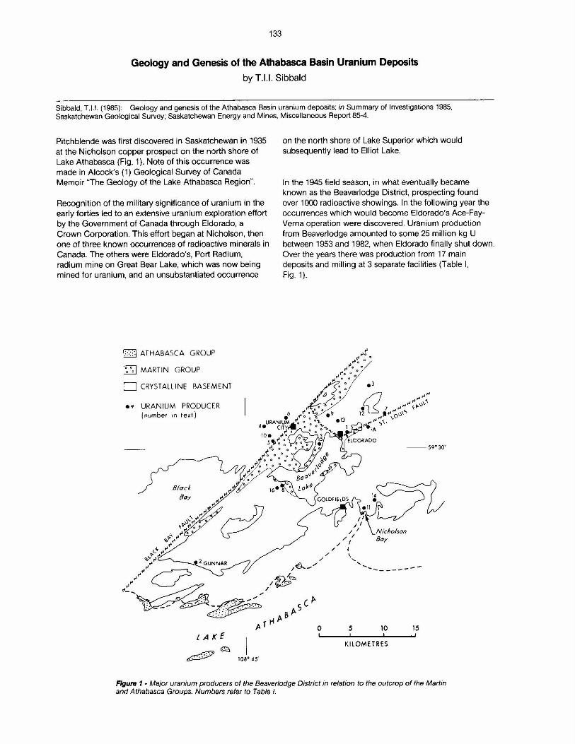
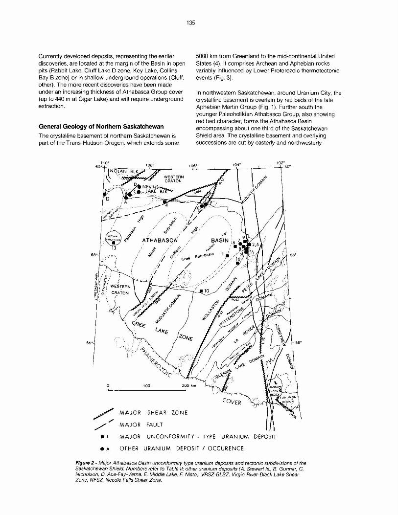
133 Geology and Genesis of the Athabasca Basin Uranium Deposits by T.1.1. Sibbald Sibbald. T.1.1. (1985): Geology and genesis of the Athabasca Basin uranium deposits; in Summary of Investigations 1985. Saskatchewan Geological Survey; Saskatchewan Energy and Mines, Miscellaneous Report 85-4. Pitchblende was first discovered in Saskatchewan in 1935 at the Nicholson copper prospect on the north shore of Lake Athabasca (Fig. 1). Note of this occurrence was made in Alcock's (1) Geological Survey of Canada Memoir "The Geology of the Lake Athabasca Region". Recognition of the military significance of uranium in the early forties led to an extensive uranium exploration effort by the Government of Canada through Eldorado, a Crown Corporation. This effort began at Nicholson, then one of three known occurrences of radioactive minerals in Canada. The others were Eldorado's, Port Radium, radium mine on Great Bear Lake, which was now being mined for uranium, and an unsubstantiated occurrence D ATHABASCA GROUP [ZJ MARTIN GROUP D CRYSTALLINE BASEMENT e9 URANIUM PRODUCER (number in text) 1oa• 45' on the north shore of Lake Superior which would subsequently lead to Elliot Lake. In the 1945 field season, in what eventually became known as the Beaverlodge District, prospecting found over 1000 radioactive showings. In the following year the occurrences which would become Eldorado's Ace-Fay- Verna operation were discovered. Uranium production from Beaverlodge amounted to some 25 million kg U between 1953 and 1982, when Eldorado finally shut down. Over the years there was production from 17 main deposits and milling at 3 separate facilities (Table I. Fig. 1). --59°30' 0 5 10 15 Kl LOMETRES Flgu1& f - Major uranium producers of the Beaverlodge District in relation to the outcrop of the Martin and Athabasca Groups. Numbers refer to Table I.

Welcome message from author
This document is posted to help you gain knowledge. Please leave a comment to let me know what you think about it! Share it to your friends and learn new things together.
Transcript
133
Geology and Genesis of the Athabasca Basin Uranium Deposits
by T.1.1. Sibbald
Sibbald. T.1.1. (1985): Geology and genesis of the Athabasca Basin uranium deposits; in Summary of Investigations 1985. Saskatchewan Geological Survey; Saskatchewan Energy and Mines, Miscellaneous Report 85-4.
Pitchblende was first discovered in Saskatchewan in 1935 at the Nicholson copper prospect on the north shore of Lake Athabasca (Fig. 1). Note of this occurrence was made in Alcock's (1) Geological Survey of Canada Memoir "The Geology of the Lake Athabasca Region".
Recognition of the military significance of uranium in the early forties led to an extensive uranium exploration effort by the Government of Canada through Eldorado, a Crown Corporation. This effort began at Nicholson, then one of three known occurrences of radioactive minerals in Canada. The others were Eldorado's, Port Radium, radium mine on Great Bear Lake, which was now being mined for uranium, and an unsubstantiated occurrence
D ATHABASCA GROUP
[ZJ MARTIN GROUP
D CRYSTALLINE BASEMENT
e9 URANIUM PRODUCER (number in text)
1oa• 45'
on the north shore of Lake Superior which would subsequently lead to Elliot Lake.
In the 1945 field season, in what eventually became known as the Beaverlodge District, prospecting found over 1000 radioactive showings. In the following year the occurrences which would become Eldorado's Ace-FayVerna operation were discovered. Uranium production from Beaverlodge amounted to some 25 million kg U between 1953 and 1982, when Eldorado finally shut down. Over the years there was production from 17 main deposits and milling at 3 separate facilities (Table I. Fig. 1).
--59°30'
0 5 10 15
Kl LOMETRES
Flgu1& f - Major uranium producers of the Beaverlodge District in relation to the outcrop of the Martin and Athabasca Groups. Numbers refer to Table I.
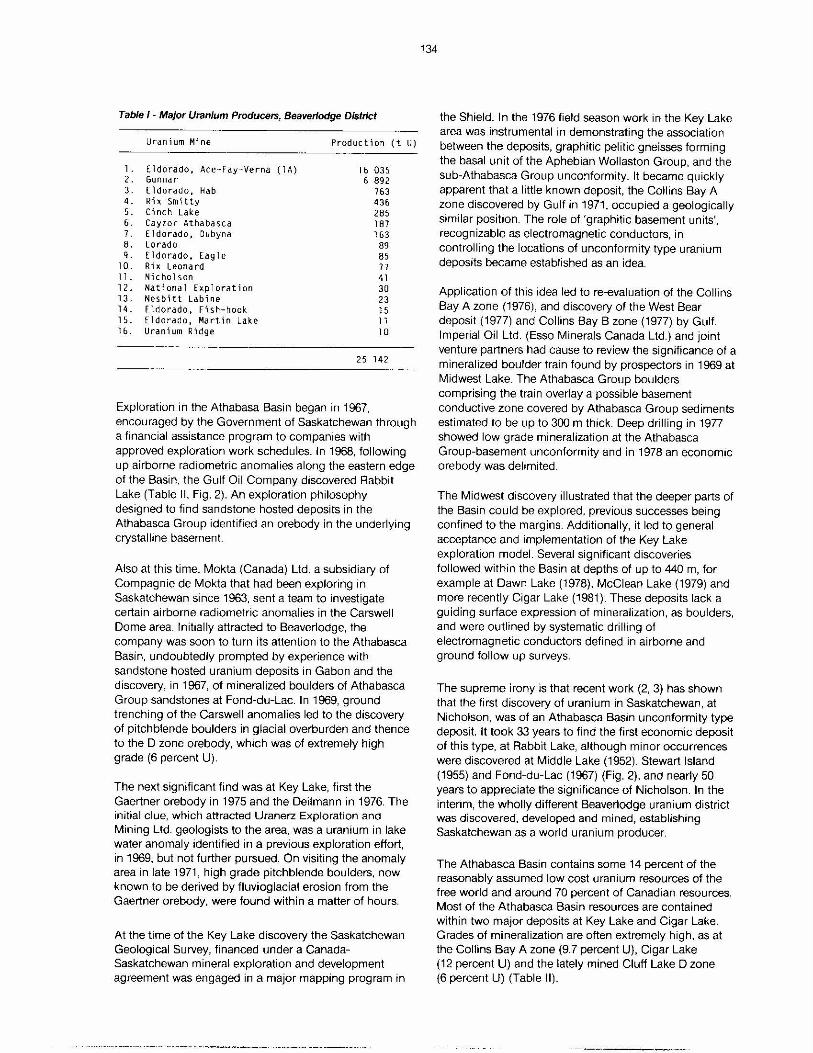
Table I - Major Uranium Producers, Beaverlodge District
Uranium Mine Production (t U)
l. Eldorado, Ace-Fay- Verna ( lA) 16 035 2. Gunnar 6 892 3. Eldorado, Hab 763 4. Rix Smitty 436 5. Cinch Lake 285 6. Cayzor Athabasca 187 7. Eldorado, Oubyna 163 8. Lorado 89 9. Eldorado, Eagle 85
10. Rix Leonard 71 11. Nicholson 41 12. National Exploration 30 13. Nesbitt Labine 23 14. Eldo rado, Fish-hook 15 15. Eldorado, Martin Lake 11 1&. Uranium Ridge l O
25 142
Exploration in the Athabasa Basin began in 1967, encouraged by the Government of Saskatchewan through a financial assistance program to companies with approved exploration work schedules. In 1968, following up airborne radiometric anomalies along the eastern edge of the Basin, the Gulf Oil Company discovered Rabbit Lake (Table II, Fig. 2). An exploration philosophy designed to find sandstone hosted deposits in the Athabasca Group identified an orebody in the underlying crystalline basement.
Also at this time, Mokta (Canada) Ltd. a subsidiary of Compagnie de Mokta that had been exploring in Saskatchewan since 1963, sent a team to investigate certain airborne radiometric anomalies in the Carswell Dome area. Initially attracted to Beaverlodge, the company was soon to turn its attention to the Athabasca Basin, undoubtedly prompted by experience with sandstone hosted uranium deposits in Gabon and the discovery, in 1967, of mineralized boulders of Athabasca Group sandstones at Fond-du-Lac. In 1969, ground trenching of the Carswell anomalies led to the discovery of pitchblende boulders in glacial overburden and thence to the D zone orebody, which was of extremely high grade (6 percent U).
The next significant find was at Key Lake, first the Gaertner orebody in 1975 and the Deilmann in 1976. The initial clue, which attracted Uranerz Exploration and Mining Ltd. geologists to the area, was a uranium in lake water anomaly identified in a previous exploration effort, in 1969, but not further pursued. On visiting the anomaly area in late 1971, high grade pitchblende boulders, now known to be derived by fluvioglacial erosion from the Gaertner orebody, were found within a matter of hours.
At the time of the Key Lake discovery the Saskatchewan Geological Survey, financed under a CanadaSaskatchewan mineral exploration and development agreement was engaged in a major mapping program in
134
the Shield. In the 1976 field season work in the Key Lake area was instrumental in demonstrating the association between the deposits, graphitic pelitic gneisses forming the basal unit of the Aphebian Wollaston Group, and the sub-Athabasca Group unco:iformity. It became quickly apparent that a little known deposit, the Collins Bay A zone discovered by Gulf in 1971, occupied a geologically similar position. The role of 'graphitic basement units', recognizable as electromagnetic conductors, in controlling the locations of unconformity type uranium deposits became established as an idea.
Application of this idea led to re-evaluation of the Collins Bay A zone (1976), and discovery of the West Bear deposit (1977) and Collins Bay B zone (1977) by Gulf. Imperial Oil Ltd. (Esso Minerals Canada Ltd.) and joint venture partners had cause to review the significance of a mineralized boulder train found by prospectors in 1969 at Midwest Lake. The Athabasca Group boulders comprising the train overlay a possible basement conductive zone covered by Athabasca Group sediments estimated to be up to 300 m thick. Deep drilling in 1977 showed low grade mineralization at the Athabasca Group-basement unconformity and in 1978 an economic orebody was delimited.
The Midwest discovery illustrated that the deeper parts of the Basin could be explored, previous successes being confined to the margins. Additionally, it led to general acceptance and implementation of the Key Lake exploration model. Several significant discoveries followed within the Basin at depths of up to 440 m, for example at Dawn Lake (1978), McClean Lake (1979) and more recently Cigar Lake (1981). These deposits lack a guiding surface expression of mineralization, as boulders, and were outlined by systematic drilling of electromagnetic conductors defined in airborne and ground follow up surveys.
The supreme irony is that recent work (2, 3) has shown that the first discovery of uranium in Saskatchewan, at Nicholson, was of an Athabasca Basin unconformity type deposit. It took 33 years to find the first economic deposit of this type, at Rabbit Lake, although minor occurrences were discovered at Middle Lake (1952), Stewart Island (1955) and Fond-du-Lac (1967) (Fig. 2), and nearly 50 years to appreciate the significance of Nicholson. In the intenm, the wholly different Beaverlodge uranium district was discovered, developed and mined, establishing Saskatchewan as a world uranium producer.
The Athabasca Basin contains some 14 percent of the reasonably assumed low cost uranium resources of the free world and around 70 percent of Canadian resources. Most of the Athabasca Basin resources are contained within two major deposits at Key Lake and Cigar Lake. Grades of mineralization are often extremely high, as at the Collins Bay A zone (9.7 percent U), Cigar Lake (12 percent U) and the lately mined Cluff Lake D zone (6 percent U) (Table II).
Currently developed deposits, representing the earlier discoveries. are located at the margin of the Basin in open pits (Rabbit Lake, Cluff Lake D zone, Key Lake, Collins Bay B zone) or in shallow underground operations (Cluff, other). The more recent discoveries have been made under an increasing thickness of Athabasca Group cover (up to 440 mat Cigar Lake) and will require underground extraction.
General Geology of Northern Saskatchewan The crystalline basement of northern Saskatchewan is part of the Trans-Hudson Orogen, which extends some
56°
135
~ MAJOR SHEAR ZONE
/ MAJOR FAULT
5000 km from Greenland to the mid-continental United States (4). It comprises Archean and Aphebian rocks variably influenced by Lower Proterozoic thermotectonic events (Fig. 3).
In northwestern Saskatchewan, around Uranium City, the crystalline basement is overlain by red beds of the late Aphebian Martin Group (Fig. 1). Further south the younger Paleohelikian Athabasca Group, also showing red bed character, forms the Athabasca Basin encompassing about one third of the Saskatchewan Shield area. The crystalline basement and overlying successions are cut by easterly and northwesterly
•l MAJOR UNCONFORMITY - TYPE URANIUM DEPOSIT
eA OTHER URANIUM DEPOSIT I OCCURENCE
Figure 2- Ma1or Athabasca Basin unconformity type uranium deposits and tectonic subd1vis1ons of the Saskatchewan Shield. Numbers refer to Table II; other uranium deposits (A. Stewart Is., B. Gunnar, C. Nicholson, D. Ace-Fay-Verna, E. Middle Lake, F. Nisto). VRSZ-BLSZ, Virgin River-Black Lake Shear Zone, NFSZ Needle Falls Shear Zone.
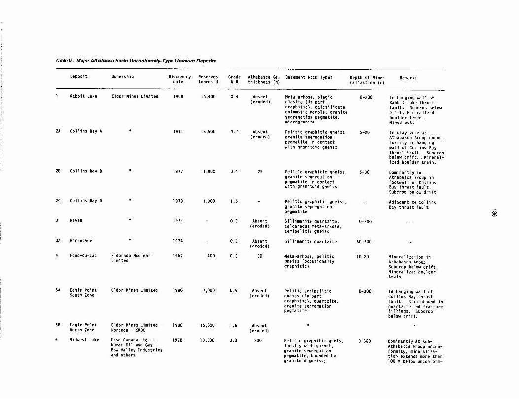
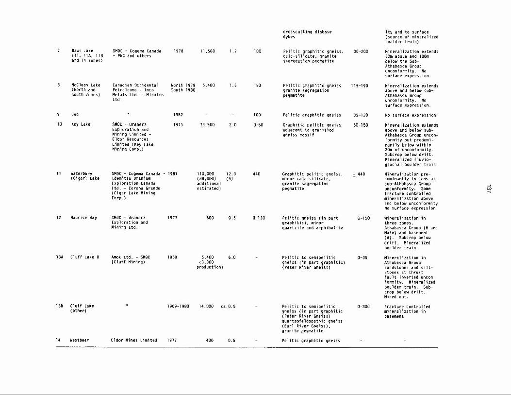
Table II • Major Athabasca Basin UnconfonnHy-Type Uranium Deposits
Deposit Ownership Discovery Reserves Grade Athabasca Gp. Basement Rock Types Depth of !'line- Remarks date tonnes U ' u thickness (m) ral1zation (m)
Rabbit Lake Eldor !'lines L1m1ted 1968 15,400 0.4 Absent Heta-arkose, plag1o- 0-200 In hanging wall of (eroded) clasite (in part Rabbit Lake thrust
graphitic), calcsilicate fault. Subcrop below dolomitic marble, granite drift. l'lineralized segregation pegmatite, boulder train. microgranite !'lined out.
2A Collins Bay A . l 971 6, 500 9.7 Absent Pel1tic graph1tlc gneiss, 5-20 In clay zone at (eroded) granite segregation Athabasca Group uncon-
pegmatite In contact formity in hanging with granitoid gneiss wall of Coollns Bay
thrust fault. Subcrop below drift .. Mineral-ized boulder train.
28 Collins Bay B 1977 11, 900 0.4 25 Pe11tlc graphitic gneiss, 5-30 Dominantly in granite segregation Athabasca Group in pegmatite in contact footwall of Collins with granitoid gneiss Bay thrust fault.
Subcrop below drift
2C Collins Bay D 1919 1 ,900 l .6 Pelitic graphitic gneiss, ~ Adjacent to Collins granite segregation Bay thrust fault ....... pegmatlte (;,.)
(j)
Raven . 1912 - 0.2 Absent S1111manite quartzite, 0-300 (eroded) calcareous meta-arkose,
semipelitic gneiss
3A Horseshoe . 1974 - 0.2 Absent Sillimanite quartzite 60-300 (eroded)
4 Fond-du-lac Eldorado Nuclear 1967 400 0.2 30 Heta-arkose, pelitic 10-30 Mineralization in Limited gneiss (occasionally Athabasca Group.
graphitic) Subcrop below drift. Mineralized boulder train
SA Eagle Point [ldor Mines Limited 1980 1,000 0. 5 Absent Pelitic-semipe11tic 0-300 In hanging wall of South Zone (eroded) gneiss (in part Collins Bay thrust
graphitic), quartzite, fault. Strata bound 1 n granite segregation quartzite and fracture pegmati te fillings. Subcrop
below drift.
58 Eagle Point Eldor Hines Limited - 1980 15,000 l.6 Absent Horth Zone Noranda - SMDC (eroded)
6 Midwest Lake Esso Canada Ltd. - 1978 13,500 3.0 200 Pelitic graphitic gneiss 0-300 Dominantly at sub-Numac 011 and Gas - locally with garnet, Athabasca Group uncon-Bow Valley Industries granite segregation form1ty, mineraliza-and others pegmattte, bounded by tion extends more than
granltoid gneiss; 100 m below unconform-
8
9
10
11
12
Dawn Lake 111, llA, 11 B and l4 zones)
Mcclean Lake ( North and South Zones)
Jeb
Key Lake
Waterbury (Cigar) Lake
Maurice Bay
13A Cluff Lake D
138 Cluff Lake ( other)
14 Westbear
SMOC - Cogema Canada - PNC and others
1978 11 , 500 1. 7
Canadian Occidental North 1979 5,400 1. 5 Petroleums - Inco South 1980 Metals Ltd. - Minatco Ltd.
SMDC - uranerz Exploration and Mi n i ng Limited -Eldor Resources Limited (Key Lake Mining Corp.)
1982
1975
SMOC - Cogema Canada - 1981 Idemitsu Uranium Exploration Canada Ltd. - Corona Grande (Cigar Lake Hining Corp.)
SHOC - Uranerz Exploration and Mining Ltd.
Amok ltd. - SMOC (Cluff Hining)
Cldor Mines Limited
1977
1%9
1%9-1980
1977
73, 900
110,000 (38,000) additional estimated)
600
2.0
12.0 (4)
0.5
5,400 6.0 (3,300
production)
14,000 ca.0.5
400 0. 5
100
150
100
0-60
440
0-130
crosscutting diabase dykes
Pe l itic graphitic gneis s , Cale-silicate, granite segregation pegmatite
Pelitic graphitic gneiss granite segregation pegmatite
Pelitic graphitic gneiss
Graphit1c pelitic gneiss adjacent to granitiod gneiss massif
Graphitic pelitic gneiss, minor calc-silicate, granite segregation pegmatite
Pe l itic gneiss (in part graphitic), minor quartzite and amphibo l ite
Pelitic to semipelitic gneiss (in part graphitic) (Peter River Gneiss)
Pelitic to semipelitic gneiss (in part graphitic (Peter River Gneiss) quartzofeldspathic gneiss (Carl River Gneiss), granite pegmatite
Pelitic graphitic gneiss
30-200
115-190
85 - 120
50-150
t 440
0-150
0-35
0-300
ity and to surface (source of mineralized boulder train)
Mineralization extends 50m above and 100m below the SubAthabasca Group unconformity. No surface express i on.
Mineralization extends above and below subAthabasca Group unconformity. No surface expression.
No surface expression
Mineralization extends above and below subAthabasca Group unconformity but predominantly below within 20m of unconformity. Subcrop below drift. Mineralized fluvioglacial boulder train
Mineralization predominantly in lens at sub- Athabasca Group unconformity. Some fracture controlled mineralization above and below unconformity No surface expression
Mineralization in three zones. Athabasca Group (Band Main) and basement (A). Subcrop below drift. Mineralized boulder train
Mineralization in Athabasca Group sandstones and silt~ stones at thrust fault-inverted unconformity. Mineralized boulder train. Subcrop below drift. Mined out.
Fracture controlled mineralization in basement
...,, w -..J
trending diabase dykes, probably emplaced in several generations.
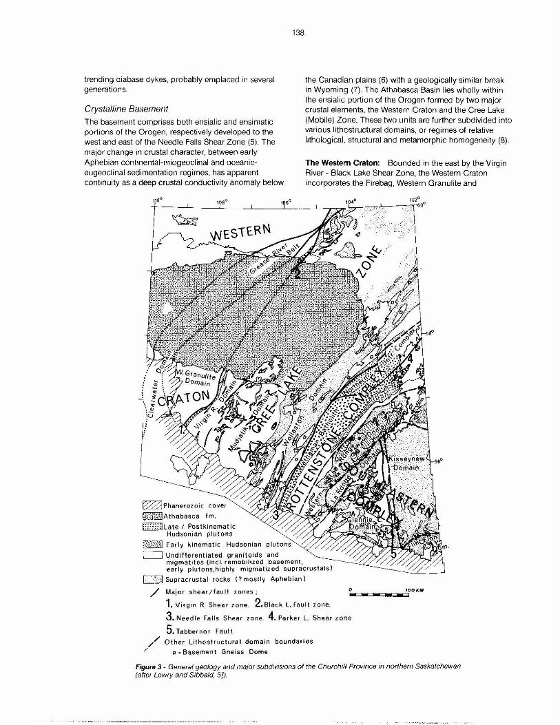
Crystalline Basement
The basement comprises both ensialic and ensimatic portions of the Orogen, respectively developed to the west and east of the Needle Falls Shear Zone (5). The major change in crustal character, between early Aphebian continental-miogeoclinal and oceaniceugeoclinal sedimentation regimes. has apparent continuity as a deep crustal conductivity anomaly below
108°
~ Phanerozoic cover
p ,:g·,.r-:..JAthabasca Fm.
t:i:::;:J Late I Post kinematic Hudsonian plutons
~,j:$;~1 Early kinematic Hudsonian
138
the Canadian plains (6) with a geologically similar break in Wyoming (7). The Athabasca Basin lies wholly within the ensialic portion of the Orogen formed by two major crustal elements, the Western Craton and the Cree Lake (Mobile) Zone. These two units are further subdivided into various lithostructural domains, or regimes of relative lithological, structural and metamorphic homogeneity (8).
The Western Craton: Bounded in the east by the Virgin River - Black Lake Shear Zone, the Western Craton incorporates the Firebag, Western Granulite and
[==i Undifferentiated granitoids and migmatites (incl. remobilized basement, early plutons,highly migmatized supracrustals)
L ')j Supracrustal rocks (? mostly Aphebian)
/ 0 100 ,u, ••11;;;;1iwa;;•wc:1w.-:c:awll::l1 Major shear /fau It zones ;
1. Virgin R. Shear zone. 2.Black L. Fault zone.
3. Needle Falls Shear zone. 4. Parker L. Shear zone
5. Tabbernor Fault
_.// Other Lithostructural domain boundaries
" = Basement Gneiss Dome
Figure 3 - General geology and major subdivisions of the Churchill Province in northern Saskatchewan (after Lewry and Sibbald, 5}).
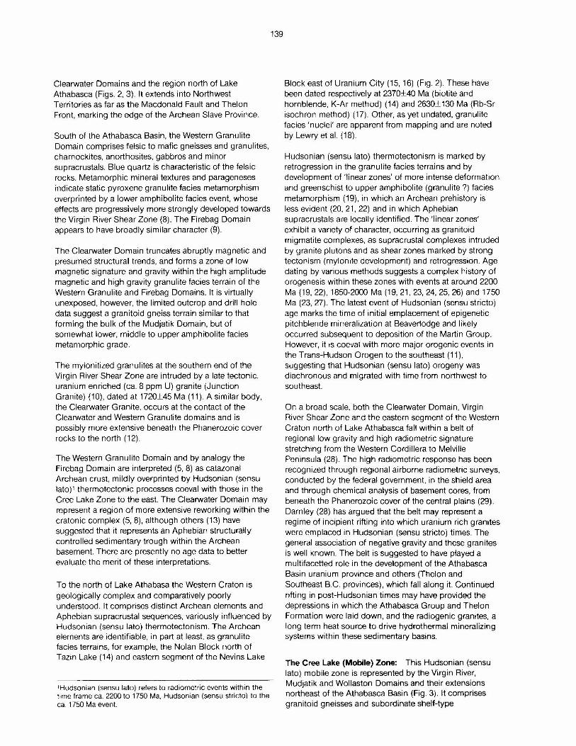
Clearwater Domains and the region north of Lake Athabasca (Figs. 2, 3). It extends into Northwest Territories as far as the Macdonald Fault and Thelon Front, marking the edge of the Archean Slave Province.
South of the Athabasca Basin, the Western Granulite Domain comprises felsic to mafic gneisses and granulites, charnockites. anorthosites, gabbros and minor supracrustals. Blue quartz is characteristic of the felsic rocks. Metamorphic mineral textures and parageneses indicate static pyroxene granulite facies metamorphism overprinted by a lower amphibolite facies event, whose effects are progressively more strongly developed towards the Virgin River Shear Zone (8). The Firebag Domain appears to have broadly similar character (9).
The Clearwater Domain truncates abruptly magnetic and presumed structural trends, and forms a zone of low magnetic signature and gravity within the high amplitude magnetic and high gravity granulite facies terrain of the Western Granulite and Firebag Domains. It is virtually unexposed, however, the limited outcrop and drill hole data suggest a granitoid gneiss terrain similar to that forming the bulk of the Mudjatik Domain, but of somewhat lower, middle to upper amphibolite facies metamorphic grade.
The mylonitized granulites at the southern end of the Virgin River Shear Zone are intruded by a late tectonic, uranium enriched (ca. 8 ppm U) granite (Junction Granite) (10), dated at 1720±45 Ma (11 ). A similar body, the Clearwater Granite, occurs at the contact of the Clearwater and Western Granulite domains and is possibly more extensive beneath the Phanerozoic cover rocks to the north (12).
The Western Granulite Domain and by analogy the Firebag Domain are interpreted (5, 8) as catazonal Archean crust, mildly overprinted by Hudsonian (sensu lato), thermotectonic processes coeval with those in the Cree Lake Zone to the east. The Clearwater Domain may represent a region of more extensive reworking withm the cratonic complex (5, 8), although others (13) have suggested that it represents an Aphebian structurally controlled sedimentary trough within the Archean basement. There are presently no age data to better evaluate the merit of these interpretations.
139
To the north of Lake Athabasa the Western Craton is geologically complex and comparatively poorly understood. It comprises distinct Archean elements and Aphebian supracrustal sequences, variously influenced by Hudsonian (sensu lato) thermotectonism. The Archean elements are identifiable, in part at least, as granulite facies terrains, for example, the Nolan Block north of Tazin Lake (14) and eastern segment of the Nevins Lake
1Hudsonian (sensu lato) refers to radiometric events within the time frame ca. 2200 to 1750 Ma. Hudsonian (sensu stricto) to the ca. 1750 Ma event.
Block east of Uranium City (15, 16) (Fig. 2). These have been dated respectively at 2370±40 Ma (biotite and hornblende, K-Ar method) (14) and 2630±130 Ma (Rb-Sr isochron method) (17). Other, as yet undated, granulite facies 'nuclei' are apparent from mapping and are noted by Lewry et al. (18)
Hudsonian (sensu lato) thermotectonism is marked by retrogression in the granulite facies terrains and by development of 'linear zones' of more intense deformation and greenschist to upper amphibolite (granulite ?) facies metamorphism (19), in which an Archean prehistory is less evident (20, 21, 22) and in which Aphebian supracrustals are locally identified. The 'linear zones' exhibit a variety of character, occurring as granitoid migmatite complexes. as supracrustal complexes intruded by granite plutons and as shear zones marked by strong tectonism (mylornte development) and retrogression. Age dating by various methods suggests a complex history of orogenesis within these zones with events at around 2200 Ma (19, 22). 1850-2000 Ma (19, 21, 23, 24, 25, 26) and 1750 Ma (23, 27). The latest event of Hudsonian (sensu stricto) age marks the time of initial emplacement of epigenetic pitchblende mineralization at Beaverlodge and likely occurred subsequent to deposition of the Martin Group. However, it is coeval with more major orogenic events in the Trans-Hudson Orogen to the southeast (11). suggesting that Hudsonian (sensu lato) orogeny was diachronous and migrated with time from northwest to southeast.
On a broad scale, both the Clearwater Domain, Virgin River Shear Zone and the eastern segment of the Western Craton north of Lake Athabasca fall within a belt of regional low gravity and high radiometric signature stretching from the Western Cordillera to Melville Peninsula (28). The high radiometric response has been recognized through regional airborne radiometric surveys, conducted by the federal government, in the shield area and through chemical analysis of basement cores, from beneath the Phanerozoic cover of the central plains (29). Darnley (28) has argued that the belt may represent a regime of incipient rifting into which uranium rich granites were em placed in Hudsonian (sensu stricto) times. The general association of negative gravity and these granites is well known. The belt is suggested to have played a multifacetted role in the development of the Athabasca Basin uranium province and others (Thelon and Southeast B.C. provinces), which fall along it. Continued rifting in post-Hudsonian times may have provided the depressions in which the Athabasca Group and Thelon Formation were laid down, and the radiogenic granites, a long term heat source to drive hydrothermal mineralizing systems within these sedimentary basins.
The Cree Lake (Mobile) Zone: This Hudsonian (sensu lato) mobile zone is represented by the Virgin River. Mudjatik and Wollaston Domains and their extensions northeast of the Athabasca Basin (Fig. 3). It comprises granitoid gneisses and subordinate shelf-type
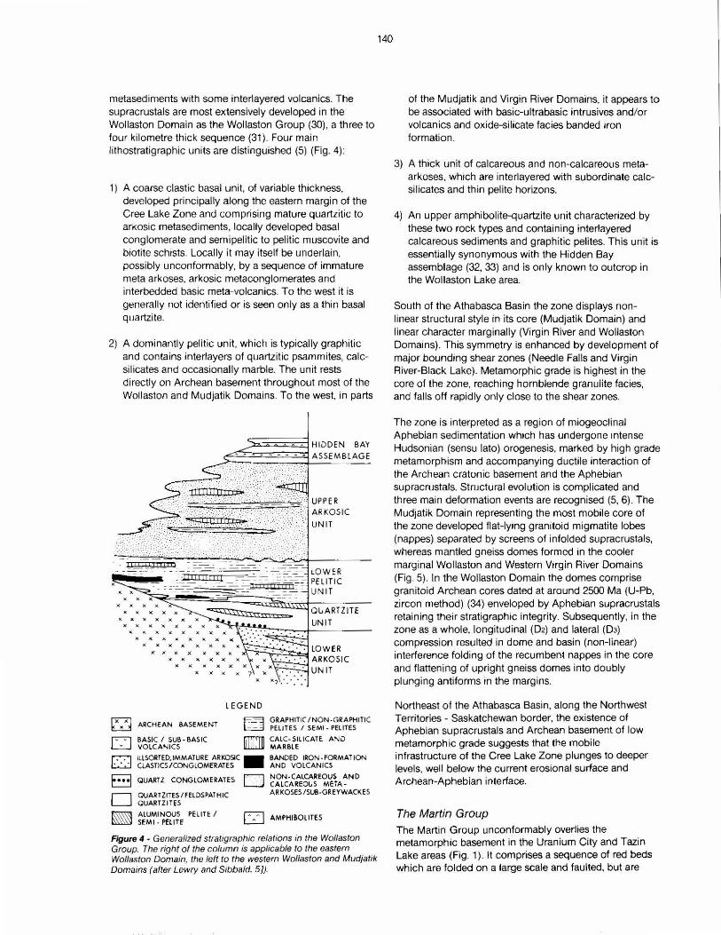
metasediments with some interlayered volcanics. The supracrustals are most extensively developed in the Wollaston Domain as the Wollaston Group (30), a three to four kilometre thick sequence (31). Four main lithostratigraphic units are distinguished (5) (Fig. 4):
1) A coarse elastic basal unit. of variable thickness. developed principally along the eastern margin of the Cree Lake Zone and comprising mature quartzitic to arkosic metasediments, locally developed basal conglomerate and semipelitic to pelitic muscovite and biotite schists. Locally it may itself be underlain, possibly unconformably, by a sequence of immature meta arkoses, arkosic metaconglomerates and interbedded basic meta-volcanics. To the west it is generally not identified or is seen only as a thin basal quartzite.
2) A dominantly pelitic unit, which is typically graphitic and contains interlayers of quartzitic psammites. calcsilicates and occasionally marble. The unit rests directly on Archean basement throughout most of the Wollaston and Mudjatik Domains. To the west, in parts
ARKOSIC
UNIT
QUARTZITE UNIT
LOW ER ~-.,:-.,.;=Clf=;:j ARKOSIC
UNIT
LE GEND
~ ARCHEAN BASEMENT
~ BASIC I SUB - BASIC L:'......J VO LCANICS
~ GRAPHITIC/N O N -GRAPHITIC l.=d PELITES I SEMI - PELITES
ITT"!Tl1 CALC- SILICATE AND 11.ill.J.U MARBLE
r,--:j ILLSORTED,IMMATURE ARKOSIC . BANDED IRON- FORMATION l:....:..j CLASTICS/CONGLOMERATES ANO VOLCANICS
El•• QUARTZ CONGLOMERATES r'.""'l NON-CALCAREOUS AND ~ CALCAREOUS META-
D QUARTZITES / FELDSPATHIC OUARTZITES
~ ALUMINOUS PELITE I ~ SEMI · PELITE
AR KOS ES /SUB-GREYWACKES
[;:] AMPHISOLITES
Figure 4 • Generalized stratigraphic relations in the Wollaston Group. The right of the column is app/icabfe to the eastern Wollaston Domain, the left to the western Wollaston and Mudjatik Domains (after Lewry and Sibbald. 5)).
140
of the Mudjatik and Virgin River Domains, it appears to be associated with basic-ultrabasic intrusives and/or volcanics and oxide-silicate facies banded iron formation .
3) A thick unit of calcareous and non-calcareous metaarkoses. which are interlayered with subordinate calcsilicates and thin pelite horizons.
4) An upper amphibolite-quartzite unit characterized by these two rock types and containing interlayered calcareous sediments and graphitic pelites. This unit is essentially synonymous with the Hidden Bay assemblage (32, 33) and is only known to outcrop in the Wollaston Lake area.
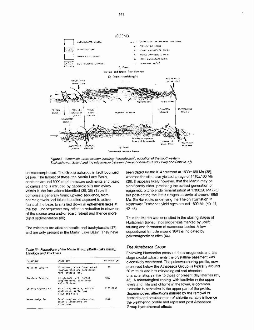
South of the Athabasca Basin the zone displays nonlinear structural style in its core (Mudjatik Domain) and linear character marginally (Virgin River and Wollaston Domains). This symmetry is enhanced by development of major bounding shear zones (Needle Falls and Virgin River-Black Lake). Metamorphic grade is highest in the core of the zone, reaching hornblende granulite facies. and falls off rapidly only close to the shear zones.
The zone is interpreted as a region of miogeoclinal Aphebian sedimentation which has undergone intense Hudsonian (sensu lato) orogenesis, marked by high grade metamorphism and accompanying ductile interaction of the Archean cratonic basement and the Aphebian supracrustals. Structural evolution is complicated and three main deformation events are recognised (5, 6). The Mudjatik Domain representing the most mobile core of the zone developed flat-lying granitoid migmatite lobes (nappes) separated by screens of infolded supracrustals, whereas mantled gneiss domes formed in the cooler marginal Wollaston and Western Virg in River Domains (Fig . 5). In the Wollaston Domain the domes comprise granitoid Archean cores dated at around 2500 Ma (U-Pb, zircon method) (34) enveloped by Aphebian supracrustals retaining their stratigraphic integrity. Subsequently, in the zone as a whole, longitudinal (0 2) and lateral (0 3) compression resulted in dome and basin (non-linear) interference folding of the recumbent nappes in the core and flattening of upright gneiss domes into doubly plunging antiforms in the margins.
Northeast of the Athabasca Basin, along the Northwest Territories - Saskatchewan border. the existence of Aphebian supracrustals and Archean basement of low metamorph ic grade suggests that the mobile infrastructure of the Cree Lake Zone plunges to deeper levels, well below the current erosional surface and Archean-Aphebian interface.
The Martin Group The Martin Group unconformably overlies the metamorphic basement in the Uranium City and Tazin Lake areas (Fig. 1 ). It comprises a sequence of red beds which are folded on a large scale and faulted, but are
141
LEGEND CJ UNlilE:MOSIUZfD CRATO N
~ INHlASTRUC TURE
D SU PRACRUSTAl COVER:
LAH TE CTON IC GRANITl:5
._,..-·- G ENERALI ZED METAMORflHIC ISO GRADS
A G R:Et:NSCHIS T f.A.CI H
D
LOWER: AMPH160ll TE FACI ES
MH)OL E .AMPH190LITE FACIES
UPP{ R: AM"HIBOU TE ~A(jfS
GR:ANUll TE fA(I ES ~ ~ D1 fyent
VerticoC and tateral flow domlr1ont
(D, Coeval crossfolding ?) NEE Dt.E FAHS
VIRGIN RI VER'
DOMAIN
MUDJATII( DOMAIN
WOL t ASTON
DOMAIN
R:0 1 TENS TONE DOMAI N
GRANIT E D, Event BAT HOU TH
Figure 5 - Schematic cross-section showing thermotectonic evolution of the southwestern Saskatchewan Shield and the relationship between different domains (after Lewry and Sibbald, 5]).
unmetamorphosed. The Group outcrops in fault bounded basins. The largest of these, the Martin Lake Basin, contains around 5000 m of immature sediments and baste volcanics and is intruded by gabbroic sills and dykes. Within it, the formations identified (35, 36) (Table Ill) comprise a generally fining upward sequence, from coarse gravels and talus deposited adjacent to active faults at the base, to silts laid down in ephemeral lakes at the top. The sequence may reflect a reduction in elevation of the source area and/or scarp retreat and thence more distal sedimentation (36).
The volcanics are alkaline basalts and trachybasalts (37) and are only present in the Martin Lake Basin. They have
Table Ill - Formations of lhe Marlin Group (Marlin Lake Basin), Lithology and Thickness
Fo rmat i or L 1thology Thi ckness (m )
'4elv 1 I l e Lake rm. S1ltstones, m1nor 1nterbedded 80 cong1omerates and sandstones rare strornatol ltes
Seaplane Base rm. lnterbedded , we 11 s.orted 1 BOO conglomerates, sandsto ne s. and s11ts tones
G111 i es Chaonel Fm. Basa.1 conglomerate, adrns.\c 2100-2900 s.ands tones, maf1c lava f lows and sills
Bea~er1odge Fm. Bas.al c ongl omerate/brecc1a, 1600 arkos1 c sandstones and s 11 ts t ones
been dated by the K-Ar method at 1630±180 Ma (38), whereas the sills have yielded an age of 1410±100 Ma (39). It appears likely however, that the Martin may be significantly older, predating the earliest generation of epigenetic pitchblende mineralization at 1780±20 Ma (23) but post-dating the latest orogenic events at around 1850 Ma. Similar rocks underlying the Thelon Formation in Northwest Territories yield ages around 1800 Ma (40, 41, 42, 43).
Thus the Martin was deposited in the closing stages of Hudsonian (sensu lato) orogenesis marked by uplift, faulting and formation of successor basins. A low depositional latitude around 16°N is indicated by paleomagnetic studies (44).
The Athabasca Group Following Hudsonian (sensu stricto) orogenesis and late stage crustal adjustments the crystalline basement was extensively weathered. The paleoweathering profile, now preserved below the Athabasca Group, is typically around 50 m thick and has mineralogical and chemical characteristics similar to those of present day laterites (31, 45). A mineralogical zoning, with kaolinite in the upper levels and illite and chlorite in the lower, is common. Hematite is pervasive in the upper part of the profile. Superimposed alterations marked by the removal of hematite and emplacement of chlorite variably influence the weathering profile and represent post Athabasca Group hydrothermal effects.
142
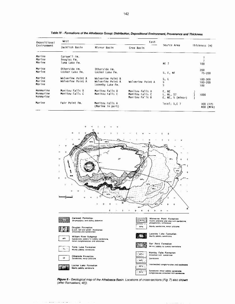
Table IV - Formations of the Athabasca Group: Distribution, Depositional Environment, Provenance and Thickness
Oepos it i ona l Environment
Marine Marine Marine
Marine Marine
Marine Marine Marine
Nonmari ne Nonmarine Nonmarine
Marine
West
Jack fish Basin Mirror Basin
Carswell Fm. Douglas Fm. Tuma Lake Fm.
Others i de Fm. Others ide Fm. Locker Lake Fm. Locker Lake Fm.
Wolverine Point B Wolverine Point Wolverine Point A Wolverine Point
Lazenby Lake Fm.
Manitou Falls 0 Manitou Fa 11 s D Manitou Falls c Manitou Fa 11 s c
Fair Point Fm. Manitou Fa 11 s A
+-
+
+
+
iEII -C::J [SJ
8 -
(Marine in part}
+ + +
Carswell Formation Strom1tohlic and oolitic dolomi1e
Douglas Format ion Bia ck. rad and green mudstonH, ,;:ilUHor,,es and sandstones
William Rivet Subgroup
+
Sandstone. o•bbry 10 cobbly sandstone, minor cong,omera1es and 3iUstonea
Tuma Lake Formation M11~nly P•bbty sandstone
Otherside Formation Sandslone. minor sillston•
Locker lake FormaHon M•Wlly P•bb•y aandslone
+
B A
East Source Area
Cree Basin
NE
s, E' NE
s, E Wolverine Point A s
Manitou Fal 1 s Manitou Falls Manitou Fa Tls
~ ~
s
D E. NE c E, NE, S? B E, NE, S (minor}
1 oca 1; S, E ?
Wolverine Point Formation Main,y siltstone and clay·ricti nndstone. pt,ospt,orilic , lurlaceous
Ma1rdy sandstone. minor sil1s1on•
Lazenby Lake Formation Mainly pebb1y sanCstor"le
Fair Point Format ion M ain!~ oebbly 10 cobbly sands1on•
Manitou Falls Formation Jrnraclas1-r,cn sandstone
Sand!IIIOf1fl
Sand11one. minor pebbly Hndtione. cong}om,rale. inlr.1clast·rich Hndlfo,..
Figure 6- Geological map of the Athabasca Basin. Locations of cross-sections (Fig. 7) also shown (after Ramaekers, 481).
Thickness (m)
100
200 75-200
l 00-300 100- 200 100
1000
300 ( F P) 400 (MFA)
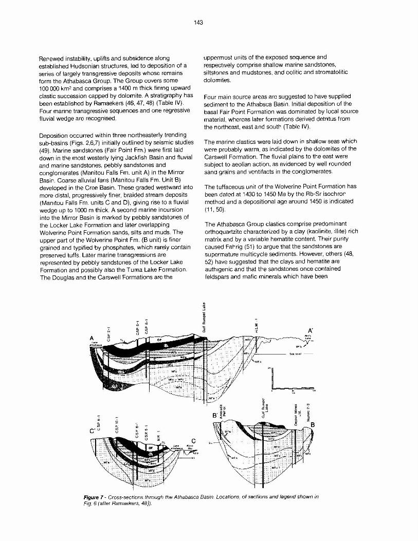
Renewed instability, uplifts and subsidence along established Hudsonian structures, led to deposition of a series of largely transgressive deposits whose remains form the Athabasca Group. The Group covers some 100 000 km2 and comprises a 1400 m thick fining upward elastic succession capped by dolomite. A stratigraphy has been established by Ramaekers (46, 47, 48) (Table IV). Four marine transgressive sequences and one regressive fluvial wedge are recognised.
Deposition occurred within three northeasterly trending sub-basins (Figs. 2,6,7) initially outlined by seismic studies (49). Marine sandstones (Fair Point Fm.) were first laid down in the most westerly lying Jackfish Basin and fluvial and marine sandstones, pebbly sandstones and conglomerates (Manitou Falls Fm. unit A) in the Mirror Basin. Coarse alluvial fans (Manitou Falls Fm. Unit B) developed in the Cree Basin. These graded westward into more distal, progressively finer, braided stream deposits (Manitou Falls Fm. units C and D), giving rise to a fluvial wedge up to 1000 m thick. A second marine incursion into the Mirror Basin is marked by pebbly sandstones of the Locker Lake Formation and later overlapping Wolverine Point Formation sands, silts and muds. The upper part of the Wolverine Point Fm. (B unit) is finer grained and typified by phosphates, which rarely contain preserved tufts. Later marine transgressions are represented by pebbly sandstones of the Locker Lake Formation and possibly also the Tuma Lake Formation. The Douglas and the Carswell Formations are the
A
"' :Ji c·o
143
uppermost units of the exposed sequence and respectively comprise shallow marine sandstones, siltstones and mudstones, and oolitic and stromatolitic dolomites.
Four main source areas are suggested to have supplied sediment to the Athabsca Basin. Initial deposition of the basal Fair Point Formation was dominated by local source material, whereas later formations derived detritus from the northeast, east and south (Table IV).
The marine elastics were laid down in shallow seas which were probably warm. as indicated by the dolomites of the Carswell Formation. The fluvial plains to the east were subject to aeolian action, as evidenced by well rounded sand grains and ventifacts in the conglomerates.
The tuffaceous unit of the Wolverine Point Formation has been dated at 1430 to 1450 Ma by the Rb-Sr isochron method and a depositional age around 1450 is indicated (11, 50).
The Athabasca Group elastics comprise predominant orthoquartzite characterized by a clay (kaolinite, ilhte) rich matrix and by a variable hematite content. Their purity caused Fahrig (51) to argue that the sandstones are supermature multicycle sediments. However, others (48, 52) have suggested that the clays and hematite are authigenic and that the sandstones once contained feldspars and mafic minerals which have been
Mfb /
Figure 7 - Cross-secrions through the Athabasca Basin. Locations, of sections and legend shown in Fig. 6 (after Ramaekers, 48)).
diagenetically altered. Rarely preserved relicts of the original detrital assemblage in early cemented zones, alterated mafic dykes and paleomagnetic data from hematized sandstone samples (53, 54, 55) have been argued to favour this contention.
Mafic dykes
The Athabasca Group is cut by a series of northwesterly trending mafic dykes. Although poorly exposed, they are often well defined as linear magnetic highs. The intrusives range in size from a metre or less to several hundred metres wide and comprise ophitic textured, plagioclaseaugite aggregates, with up to 15 percent magnetite and minor olivine, pigeonite apatite, orthoclase. quartz, biotite, chlorite and hornblende. Adjacent to dykes the sandstone is altered, by bleaching and silicification and locally exhibits columnar jointing (56). The most reliable ages for emplacement are provided by Rb-Sr mineral isochrons at 1310±70 Ma and 1160±40 Ma (50). K-Ar ages ranging between 1230 and 938 Ma (57, 58, 59, 60) have also been obtained.
Uranium Mineralization in Northern Saskatchewan The majority of uranium occurrences, and all yet proven to be economic. lie to the west of the Needle Falls Shear Zone. This distribution is not considered fortuitous, rather it reflects the major differences in crustal evolution of the areas on either side.
To the east of the shear zone uranium mineralization is confined within granites and granite pegmatites of presumed Hudsonian (sensu lato) age, whereas to the west, a diversity of deposits and deposit ages is apparent. For example, differing types of uranium mineralization of Lower Proterozoic age are present in the Western Craton and in the Cree Lake Zone. Yet another type, the most important economically, is seen in the younger Athabasca Basin uranium deposits which straddle the unconformity at the base of the Athabasca Group.
In the Western Craton uranium mineralization appears most commonly in 'linear zones' of Hudsonian (sensu lato) thermotectonic reworking. Following Beck (19). both syngenetic and epigenetic types are recognized, the latter occurring as veins and unusually as disseminations.
The syngenetic mineralization manifests itself as disseminations of radioactive minerals in granite pegmatites and, less commonly, in country rocks. Uraninite, the typical ore mineral, is usually associated with monazite and thorite. Rare earth minerals are locally present, but are only important in the pegmatites. U-Pb dating yields an age for the syngenetic deposits in the Beaverlodge area of 1930±40 Ma (23).
The epigenetic mineralization occurs as fracture controlled, pitchblende vein deposits. These provided the source for uranium production from the Beaverlodge area (Fig. 1, Table I). The epigenetic deposits can be divided into two groups showing simple and complex mineralogy respectively (19, 61).
144
In the former, which are the more common and exemplified by Eldorado's Ace-Fay-Verna orebodies. pitchblende is accompanied by coffinite, brannerite, nolanite, pyrite, chalcopyrite and galena, whereas in the latter, illustrated by the Nicholson ore zones, pitchblende occurs with coffinite, thucolite, sulphides, arsenides and selenides of nickel, cobalt, copper, lead and zinc, and native gold and silver. U-Pb dating has identified four pitchblende forming or reworking events in these deposits at 1780±20 Ma, 1110±50 Ma, 270±20 Ma and 0-100 Ma (23).
Hoeve and Sibbald (31) emphasized the geochemical similarity between deposits of complex mineralogy, in the Beaverlodge area, and those of unconformity type, in the Athabasca Basin, and proposed two main episodes of epigenetic uranium mineralization. The first. at 1780 Ma, gave rise to the Beaverlodge deposits of simple mineralogy, whereas the second at 1100 Ma resulted in reworking of these deposits and in formation of new ores of complex mineralogy both at Beaverlodge and in the Athabasca Basin.
Evidence to support this hypothesis is provided by the UPb age dates, obtained from deposits of both simple and complex type (23), and the recognition of a potential association between the Nicholson ore zones and the sub-Athabasca unconformity (2). Alteration chemistry and fluid inclusion characteristics are also indicative of unconformity origin (3) for at least some deposits of complex mineralogy in the Beaverlodge area.
The early generation of epigenetic pitchblende exhibits a strong structural control, occurring in the fractured wall rocks of ma;or faults, which themselves may cut rocks which have undergone earlier mylonitization during Hudsonian (sensu lato) orogenesis.
By contrast, the Cree Lake Zone is characterized by uranium mineralization which exhibits lithological and stratigraphic, rather than structural, controls. Some mineralization is present within granitic and pegmatitic anatectic fractions within the remobilized Archean basement, however, more commonly occurrences are located within the Aphebian, Wollaston Group, supracrustals (Fig. 4). On the basis of dominant host rock, Sibbald et al. (62) and Lewry and Sibbald (63) distinghish arkosic, pelite-pegmatite and calc-silicate types of deposits. Occurrences of the first two types are for the most part located near the base of the Aphebian succession, whereas those in calc-silicate rocks are encountered at several stratigraphic levels. These deposits are of sub-economic grade and are deemed to represent 'syngenetic' mineralizations which have been subjected to metamorphism and/or anatexis. Recent analogs might be sandstone type deposits and black shale and sabkha related uranium concentrations (64).
The absence of Hudsonian epigenetic vein type mineralization in the Cree Lake (Mobile) Zone is believed
to reflect its contrasting thermotectonic evolution relative to the Western Craton. The Zone was subiected to ductile, rather than plastic and brittle Hudsonian (sensu lato) deformation. The resultant absence of structural traps and the high grade metamorphic conditions precluded the development of Hudsonian fracture controlled vein type pitchblende deposits. The most easterly known occurrence of this type of mineralization is the Nisto showing (Fig. 2). located in the mylonites of the Black Lake Shear Zone, at the eastern margin of the Western Craton.
The important unconformity-type deposits are confined to the Athabasca Basin which covers portions of both the Cree Lake and the Western Craton. The Cluff Lake deposits are located within the Western Craton, the other main deposits within the Cree Lake Zone. Mineralization seems to have been controlled by the presence of the sub-Athabasca unconformity, rather than by factors related to Aphebian (Lower Proterozoic) sedimentation or Hudsonian (sensu lato) structural and metamorphic evolution, because outside the Athabasca Basin no such mineralization is encountered.
Athabasca Basin Unconformity-Type Deposits
145
The geological characteristics of these unconformity-type deposits are summarized in Table V and below and illustrated by cross-sections of Rabbit Lake, Collins Bay B zone and Midwest Lake (Figs. 8, 9, 10, 11 ). The deposits bear a clear cut relationship to the sub-Athabasca Group unconformity. The highest grade ore often straddles the unconformity, as at Midwest, McClean and Cigar Lakes, although mineralization may extend for hundreds of metres above (Midwest and Cigar Lakes) and below it (Rabbit Lake, Raven, Horseshoe and Eagle Point) (Table II). There is also an undeniable association with graphitic basement rocks which are characteristic of, though not restricted to, the basal and lower parts of the Aphebian (Wollaston Group) supracrustal succession throughout the Cree Lake Zone. At their intersection with the subAthabasca Group unconformity these rocks may host or
Table V - Geological Characteristics of Athabasca Basin Unconformity-Type Uranium Deposits
Proximity to the Sub-Athaba s.c a Group unco rifo rmity
Proximity to graphitlc rocks in the c rys.tal11ne basement
Structura 1 controls: a) Po'it-Athabasca Group thru-st fau1 ts bl Ba,;ement rel1ef ( 1 bumps') c} Solution collapse s.tructure'.i in ba,s.ement
( c.arbonates) and ln Athabasca GralJp I quartz-sandstones)
Higti grade: up to 12 percent u
Pr"itnary uran11,1m minerals: p1tchblende and coff1n1te
Comp1ex m1nerc11ogy and 9eochemi'iitry, Q!!1 var1ab1e concentrat1oni. of associated e1ements (U + N1, Co, As, Cu, Mo, Pb, Zn, Fe, V, Ag, Au, Pt, Se, S)
Glas'Sy hydrocarbons present 1 n the ore
(11:t ens\ve alteration envelopes.: Mg - chlorHhat\on, i'lg -tourmal1n1zation, ne111c1t1z.atlon. '111t1ut1on, s.il1C.HlC.atlon and dalomit I zat1on
Age of 1n1thl mlnerallllltlor. (@ 1300 ~a) pos.tdates. depoo;1t1 on of the Athabasca Group (@ 1450 Ma)
-----·-~- - -
underlie mineralization. As such there is an apparent basement stratigraphic control.
Graphite content within the basement gneisses, which are generally of pelitic composition. may vary from a few percent as at Rabbit Lake (31) to a few tens of percent as at Key Lake (64). Accordingly these units respond weakly, if at all, or strongly to electromagnetic survey methods. In detail, the spatial relationships between graphite and mineralization is less distinct, in that ore grade and graphite concentration are unrelated, (31, 64, 65) and the bulk of the mineralization is displaced and may occur in non-graphitic basement rocks or in the Athabasca Group.
In many deposits there are clear major structural controls. Mineralization can often be related to faults, which displace the sub-Athabasca Group unconformity by several tens of metres. At Rabbit Lake, Key Lake and the Collins Bay A and B zones reverse faults are characteristic (Figs. 8, 9, 10) (31, 64, 65), whereas at Midwest Lake normal faulting is inferred (Fig. 11) (66, 67). These structures may occur s+ngly, or in imbricate zones (66, 68), and strike northerly to east-northeasterly, dipping moderately to steeply in either direction. Contacts between maior units of graphitic pelitic and granitoid gneisses, which represent a major structural anisotropy, are preferred locations for these faults, as for example at Key Lake and the Collins Bay A and B zones (30, 33, 65). In several deposits (McClean and Dawn Lake), there is no obvious displacement of the unconformity, although the basement below mineralization appears structurally disturbed (69, 70)
A number of deposits occur on linear topographic basement highs showing a relief of a few metres (McClean, Midwest, Dawn and Cigar Lakes). These 'bumps' appear to have been features of the pre-Athabasca Group land surface, although there has been and continues to be debate as to their origin (69). Evidence for a pre-depositional origin is provided by the observation that basal conglomerate layers at Midwest and Dawn Lakes wedge out against the ridges (Fig. 11) (70) The development of pelitic ridges, while an irregularity to geologists familiar with temperate weathering environments, may be compatible with the tropical weathering lateritic conditions, which characterized the pre-Athabasca land surface. Under such conditions, relative to felsic rocks, those rich in phyllosilicates tend to weather resistently. A modern example is provided by the 'arena granites' of Uganda in which granite plutons form a depressed area rimmed by quartzites and argillaceous sediments (71).
Solution features have been recognized as adding to the structural complexity of deposits, both in the basement rocks and Athabasca Group. In the Rabbit Lake deposit secondary carbonate and quartz and alteration breccia occur within and around the ore zone. Repeated tectonic fracturing, solutioning of dolomitic marbles, collapse and mechanical infilling of open spaces have likely contributed to the lithologically and structurally chaotic alteration zone (Fig. 8) (31, 72, 73).
Rf.VAJ()N~ N WTlf<iA..,i..l ,,t'lS ••
375-
).S,.",-
,,, _
K .. L\
.. !'
\YM.JOL$
,,. _ .••. ··••··• ttlvtl c.u.)t \.O'i'f ~ :;)ltr 10,...f:
1.tf.l'O lNS Of ."{).1A"10f\l flA'H~(.) " l.Pf'fR GNLl55f5
, . ... -·· ~A.W:>NO O'! ll t HI.AL
146
ltG ENI)
~ AHM,BAS.CA. V ~Q IJP
r:"':l lffl~ <.;"'FMf~
;;-4;.1 N~'Vt META-~S
I ~ ·~l.,t,VOC:lA<.1 1t '
D (;AAIH:H ' l'LAGOC·. A~f l '
S;l M~:it·~, :lUlO,YJ"!
L ~ eioun .vJ~~rf
AITF!i: A~li~N~
~~-1 'REC.t)lllH '
- l<X.AlCHi.C'<IIIS.&110,,.
CJ P(-t'IA.S,o/f ( t,lf~IT~
!·:l.J ('.f!J.il'HlflC ~ Hl()l,'ITIC AlTFitAl, Dt, _
ir l lC\0,.',11~1:JN AN() (II LOlll~l'i.41,(JN
Figure 8 - Geological cross-section of the Rabbit Lake deposit illustrating primary and alteration lithologies (after Sibbald. 73]).
N
t A - - - · - - .. ·--·---- A
COLLINS 8AY X
8----------- -- 8 OVERBURDEN
x . /H=~==\: s :HG~~9~ :~ i ·'":i-.• _'ii,. •co, c-•c ·~ , ·---:-:Gt<fLS}:·
~- . • • - • • + .. ' + + ' ..\:,:·:- : -:-:-:- -+ 'ARCHEAN• GRANITE• + + +"\,·--. - . -
' . .. It - f G NE lSS + .. ...... .. .. . + I t + .. "'t,. "
(---- - - - ---- --- _:_ c
200 0 l S 50
MET US MH RE"5
PL AN SECTIONS
Figure 9 - Schematic plan and cross-sections of the Col/ms Bay B zone. Location of cross-section (Fig. 10) denoted XX (after Jones, 65)).
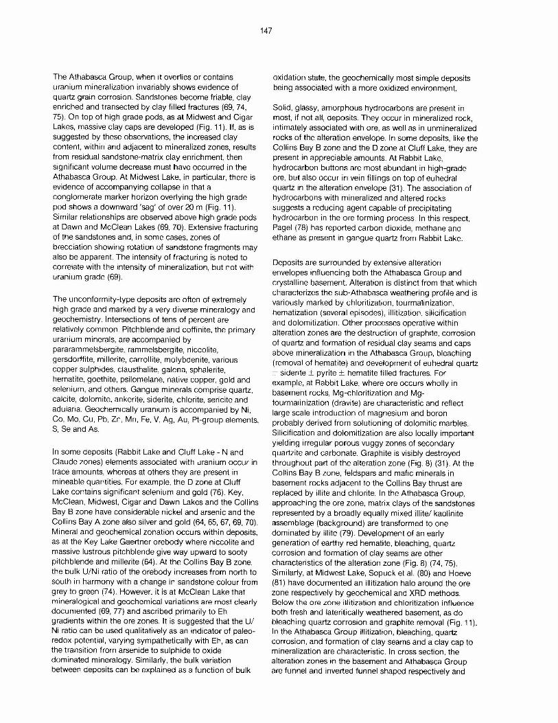
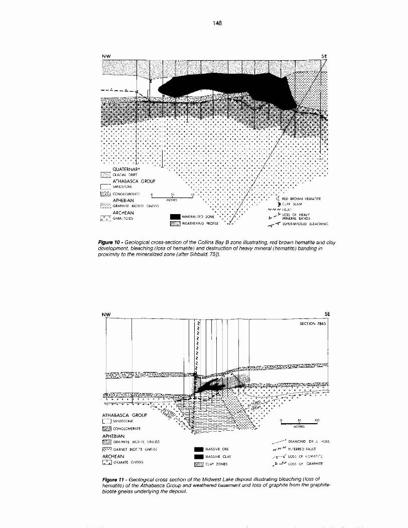
The Athabasca Group, when it overlies or contains uranium mineralization invariably shows evidence of quartz grain corrosion. Sandstones become friable, clay enriched and transected by clay filled fractures (69, 74, 75). On top of high grade pods, as at Midwest and Cigar Lakes, massive clay caps are developed (Fig. 11 ). If, as is suggested by these observations, the increased clay content, within and adjacent to mineralized zones, results from residual sandstone-matrix clay enrichment, then significant volume decrease must have occurred in the Athabasca Group. At Midwest Lake, in particular, there is evidence of accompanying collapse in that a conglomerate marker horizon overlying the high grade pod shows a downward 'sag' of over 20 m (Fig. 11 ). Similar relationships are observed above high grade pods at Dawn and McClean Lakes (69, 70). Extensive fracturing of the sandstones and, in some cases, zones of brecciation showing rotation of sandstone fragments may also be apparent. The intensity of fracturing is noted to correlate with the intensity of mineralization, but not with uranium grade (69).
The unconformity-type deposits are often of extremely high grade and marked by a very diverse mineralogy and geochemistry. Intersections of tens of percent are relatively common. Pitchblende and coffinite, the primary uranium minerals, are accompanied by pararammelsbergite, rammelsbergite, niccolite, gersdorffite, millerite, carrollite, molybdenite, various copper sulphides, clausthalite, galena, sphalerite, hematite, goethite, psilomelane, native copper, gold and selenium, and others. Gangue minerals comprise quartz, calcite, dolomite, ankerite, siderite, chlorite, sericite and adularia. Geochemically uranium is accompanied by Ni, Co, Mo, Cu, Pb, Zn, Mn, Fe, V, Ag, Au, Pl-group elements, S, Se and As.
In some deposits (Rabbit Lake and Cluff Lake - N and Claude zones) elements associated with uranium occur in trace amounts, whereas at others they are present in mineable quantities. For example, the D zone at Cluff Lake contains significant selenium and gold (76). Key, McClean, Midwest, Cigar and Dawn Lakes and the Collins Bay B zone have considerable nickel and arsenic and the Collins Bay A zone also silver and gold (64, 65, 67, 69, 70). Mineral and geochemical zonation occurs within deposits, as at the Key Lake Gaertner orebody where niccolite and massive lustrous pitchblende give way upward to sooty pitchblende and m1llerite (64). At the Collins Bay B zone, the bulk U/Ni ratio of the orebody increases from north to south in harmony with a change in sandstone colour from grey to green (74). However, it is at McClean Lake that mineralogical and geochemical variations are most clearly documented (69, 77) and ascribed primanly to Eh gradients within the ore zones. It is suggested that the U/ Ni ratio can be used qualitatively as an indicator of paleoredox potential, varying sympathetically with Eh, as can the transition from arsenide to sulphide to oxide dominated mineralogy. Similarly, the bulk variation between deposits can be explained as a function of bulk
147
oxidation state, the geochemically most simple deposits being associated with a more oxidized environment.
Solid, glassy, amorphous hydrocarbons are present in most, if not all, deposits. They occur in mineralized rock, intimately associated with ore, as well as in unmineralized rocks of the alteration envelope. In some deposits, like the Collins Bay B zone and the D zone at Cluff Lake, they are present in appreciable amounts. At Rabbit Lake, hydrocarbon buttons are most abundant in high-grade ore, but also occur in vein fillings on top of euhedral quartz in the alteration envelope (31 ). The association of hydrocarbons with mineralized and altered rocks suggests a reducing agent capable of precipitating hydrocarbon in the ore forming process. In this respect, Pagel (78) has reported carbon dioxide, methane and ethane as present in gangue quartz from Rabbit Lake.
Deposits are surrounded by extensive alteration envelopes influencing both the Athabasca Group and crystalline basement. Alterabon is distinct from that which characterizes the sub-Athabasca weathering profile and is variously marked by chloritization, tourmalinization, hematization (several episodes). illitizahon, silicification and dolomitization. Other processes operative within alteration zones are the destruction of graphite, corrosion of quartz and formation of residual clay seams and caps above mineralization in the Athabasca Group, bleaching (removal of hematite) and development of euhedral quartz + sidente ± pyrite ± hematite filled fractures. For example, at Rabbit Lake, where ore occurs wholly in basement rocks, Mg-chloritization and Mgtourmatinization (dravite) are characteristic and reflect large scale introduction of magnesium and boron probably derived from solutioning of dolomitic marbles. Silicification and dolomitization are also locally important yielding irregular porous vuggy zones of secondary quartzite and carbonate. Graphite is visibly destroyed throughout part of the alteration zone (Fig. 8) (31 ). At the Collins Bay B zone, feldspars and maftc minerals in basement rocks adjacent to the Collins Bay thrust are replaced by illite and chlorite. In the Athabasca Group, approaching the ore zone, matrix clays of the sandstones represented by a broadly equally mixed tllite/ kaolinite assemblage (background) are transformed to one dominated by illite (79). Development of an early generation of earthy red hematite, bleaching, quartz corrosion and formation of clay seams are other characteristics of the alteration zone (Fig. 8) (74, 75). Similarly, at Midwest Lake, Sopuck et al. (80) and Hoeve (81) have documented an illitizabon halo around the ore zone respectively by geochemical and XRD methods. Below the ore zone illitization and chloritization influence both fresh and lateritically weathered basement, as do bleaching quartz corrosion and graphite removal (Fig. 11 ). In the Athabasca Group illitization, bleaching, quartz corrosion, and formation of clay seams and a clay cap to mineralization are characteristic. In cross section, the alteration zones in the basement and Athabasca Group are funnel and inverted funnel shaped respectively and
NW
......... + ... + + + .. +
+ + + ..... + + .... -t +
+-t++++ ++ •+++ ++++ ++ + + + -1-i+
.... .... +++++++ +++ ++ + + ++ -1- ........... ...
+ + ++ + ++++ ++ • ++ .. + ....... ++ + •+ ++++ + + ... + +• + +
++ ............... ... ++ tt + + + .. • ++++ -1-t+
... + .. + .. + + + + ••• + + ++ + .. ...
QUATERNARY f> / ·J GLACIAL DRI FT
ATHABASCA GROUP L_J SANDSTONE
148
SE
+•+ + + + ++ + ++-++++ + :-:. -;,- ... +- ... -+ ... + + + + + + + + + + + ... w,
...... + + + + + + + + + +-+ ... + • +·· + + ... + + + + + + + + + + + + .. • + -+ • • + ... + +::
+ + ++. + + + + +++-+ ...... + •• ++ + + .... + .... + +. + + + + + + + + + •• + + + + + +. ... ~ , . .......... +++t++ ++ +•+++ • +•••+ + +++-++ + + .................... ... ....... . ... ... ..... ...- ...... ... ...... . ... ... ... ... ++++++t++ + +••+• + -++ + +++ ++ ++• ++ +++
++++-+- 1- + ++ t+ -+ + ++ ++-t- + • •• • ++ ++++-++ ++++-++-+-+-++++ ; + ii + + ... -+-+-+ ... ++ + •+• • • • •
+++ + +••••+••-+++ > + + +-+++ -+++-tt+-+-+ -+ + . . .... .......... -+++++++-+-+-+-+-t-++ + +-+-+++-+ +
+ + +• + •+++++• -+ -+++ + +-t-•++++++-+--+-+ + t• +
•••••••••••• ... ••• ..... •••• • ..... ••• .. • ... • • • • • ... • ... + ................... ... ... • • • ... ·.·.·.·.+ .... ... . .... ... .................. + +-+-++ +++ +++•t+
. ... ...... .......................... +++-+-++-++ + ••+• -t--1-+ + • • • + + ... ... ... + + +· + + + + + • + + + t + • + + + • + • • ... + + ·· · · ·--- •·•++ 1 +-t+++++ ........... .. ... . .. ...
"
++++++-1--1--1- t •++++++ .. ... +++++ + -1-+-1-+-t+ ++++-1-++-t-t+++ .. +++ + + -1- -t +• ++ ++++-t+
•-1- -1-t-t• + ++ .... + .. +++t•++ + ++++-1--1-t t t l ......... + ...... + ... + ... + + -+- • + + + + + ... -t +- + +
... ..- .. +++++++ -t -t-t+ ++++ -++ + + ... ... +t + + + ++++ -t -1--1-+ +++++++ -t -1-++ ......... ... + ... t ++ ++ ++++-t 1" + t t
++ .. ++++ + ++• + -+-+ + ++ ... ...... ...... -t + t + ............... + ... ...... -t -t t • +
.:s o + ... + + + .. + .... .... + .... + + -t ... ~t~ CONGLOMERATE
APHEBIAN ..... ~~~ ..... ~~--' + ... + + t t .... .... + + .... + ... + q RED BROWN HEMATITE
}I ( LAY SEAM f'.:'.3 GRAPHITE BIOTITE GN EI SS
ARCHEAN j ... + .... +1 GRANI Trnos
MET~fS + + +++++++ + + • -t-t -t-1-++++ + -t ~ I I I
+ +++++++t• + + + -t ... -t -t
+ ......... -t
- MINERALI ZED ZONE
-t ......... + + + +- + + ... + ...
.. +- + +
~ W EATHE~ING Pli10FltE
,v ,v N FAULT
_... ,- LOSS Of HEAVY :J.- MINERAL BANDS
-f' .-(" SUPERIMPOSED BLE ACHING
Figure 10 - Geological cross-section of the Collins Bay B zone illustrating, red brown hematite and clay development, bleaching (loss of hematite) and destruction of heavy mineral (hematite) banding in proximity to the mineralized zone (after Sibbald. 75]).
NW
ATHABASCA GROUP D SANDSTONE
~ CON GLOME RATE
APHEBIAN G GRAPHITE BIOTI TE GN EISS
&'§"3 GARN ET BIOT lff GNEiSS
ARCHEAN U G RA NITE GNe!SS
- M ASSI VE ORE
- MASSIVE (LAY
6 ClAY ZONES
SE
SECTION 7865
,...__.--' DIAMOND D RILL HOLE
r,1 r,J N INFERRED FAULT
.. ··c···f· LOSS Of H EMATIT E
,~ _11,,; LOSS O f' GRAPHI TE
Figure 11 - Geological cross-section of the Midwest Lake deposit illustrating bleaching (loss of hematite) of the Athabasca Group and weathered basement and loss of graphite from the graphitebiotite gneiss underlying the deposit.
show their widest extension at the unconformity. Of particular interest to explorationists is the fact that they extend both vertically and laterally well beyond mineralization, and thereby enlarge potential drilling targets by a factor of 10 to, 20 times (81).
Within the alteration zones, whose character is shaped by the introduction/removal of K, Mg, Fe and Si02, trace metals generally show only limited dispersion around mineralization. For example, uranium values may vary from a few percent to a few ppm over metres. However, at McClean Lake a 'chimney' of uranium values of 2-3 ppm U occurs in the Athabasca Group (background 1 ppm U) to the present erosion surface, 150 m above mineralization, as does the illitization halo (69). At Midwest Lake. uranium and boron and at Key Lake uranium and lead are enhanced around mineralization, but not as widely as the major element alterations (80).
Age dating studies have yielded a wide range of numbers of varying quahty for deposit formation. U-Pb, Pb-Pb and Sm-Nd data from pitchblende in several deposits serve to indicate that primary mineralization occurred around 1300 Ma. Samples identified as 'early' or 'first stage' pitchblendes commonly yield discordant ages defining various discordia intersecting concordia between 1250 and 1350 Ma (82, 83, 84 (Key Lake); 85, 86 (Rabbit Lake); 60, 87 (Midwest Lake); 88 (Collins Bay B zone)).
This age is recorded in illites from alteration zones adjacent to mineralization, using Ar-Ar (69); Rb-Sr (60) and K-Ar (25) dating methods.
The pitchblende data also indicate a second event, equated with initial mineralization in some deposits and remobilization of pitchblende in others. at around 1100 Ma (85, 86, 89 (Rabbit Lake); 60, 87 (Midwest Lake); 90 (Cluff Lake)). This event appears coeval with that identified by Koeppel (23), as a period of new pitchblende deposition or reworking (lead loss) in the Beaverlodge area (23). Koeppel also recognized younger periods of lead loss at around 300 Ma and between 100 Ma and the present day.
The more recent isotopic data from the Athabasca Basin deposits has confirmed these youngest events (84, 86, 87, 91). The former may represent a period of basin uplift. Ground waters gained access to mineralization causing redistribution of uranium in conjunction with kaolinitization, as. for example, at Key Lake (80, 86).
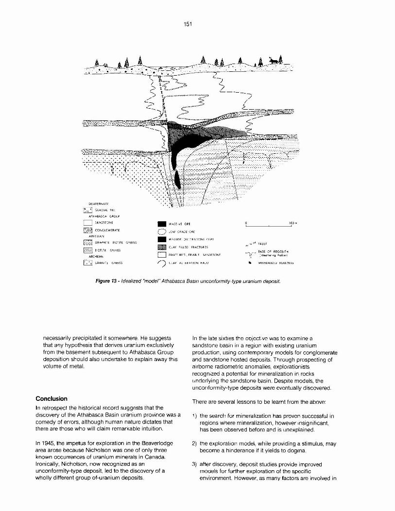
Deposit Model
Several genetic models have been proposed for the Athabasca Basin unconformity type uranium deposits. They fall into four categories, discussed by Hoeve et al. (52):
a) near surface supergene b) magmatic hydrothermal
149
c) diagenetic hydrothermal d) multicycle/process
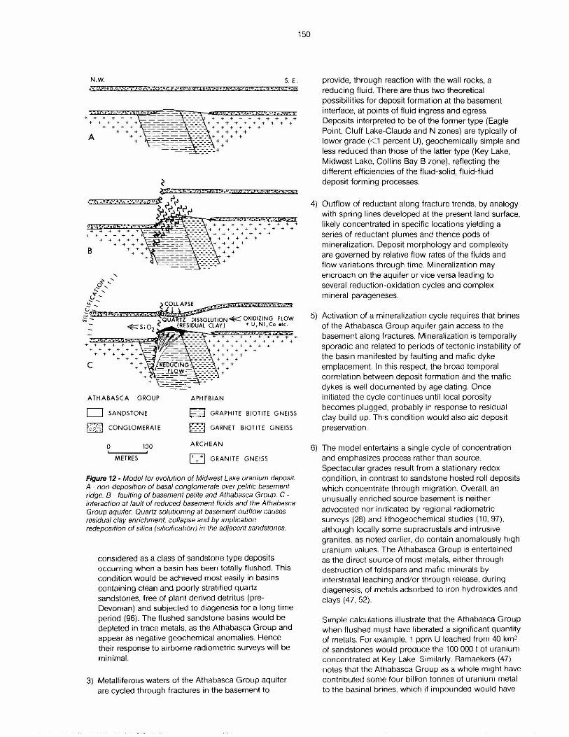
Over time the diagenetic-hydrothermal model (31) has found increasing acceptance among geologists as well as support from deposit studies. Recently it has been newly presented in a more elaborate form as the Reductant Plume Model (69).
The model (Figs. 12, 13) invokes the interaction of the crystalline basement and the Athabasca Group through the mixing of fluids of contrasting chemistry. Oxidizing brines of the Athabasca Group aquifer entered the basement along fractures, reacted with the wall rocks and re-emerged with reduced character. At, or in close proximity to the unconformity, they mixed with the aquifer creating a dynamic but essentially stationary redox front around a reductant plume displaced downstream by the flow of the aquifer (cf. Collins Bay B zone (Figs. 9, 10).
Conditions of deposit formation suggesed by fluid inclusion studies (92, 93, 94) are: T 150-2250c, P 0.7-1.5 kb salinity ca. 30 per cent NaCl, implying an elevated geothermal gradient in excess of 300C/km. The reducing fluids emanating from the basement were probably charged with C02, CH4, H2S, Fe, Kand Mg, whereas the aquifer contained U, Ni, Co, As, Cu, Zn etc. Debate continues as to the relative contributions to the deposit of the reducing and oxidizing fluids (52, 69).
Quartz solutioning of the Athabasca Group sandstones must have been caused by basement fluids undersaturated with respect to silica, and thence hotter or more alkaline than the aquifer. The former appears more probable. In this respect the steeply dipping graphitic units may have formed linear hot spots in the Basin floor transporting heat from greater depth by virtue of their superior thermal conductivity (95).
Discussion
The model has numerous implications from a mineral exploration viewpoint and on a broader scale for establishing parameters for recognition of a uranium province:
1) Deposit formation is dependent on the interaction of large volumes of fluids with dilute metal concentrations. Other factors aside, probability of mineralization increases with proximity to the fluid source, the formational brines of the Athabasca Group. To date, unconformity type mineralization has not been detected in excess of 1000 m vertically below the sub-Athabsca Group unconformity.
2) Deposits are formed by stripping of metals from the aquifer. For effective free circulation, and thence opportunity for basement interaction, the Athabasca Group must have been or become thoroughly oxidized. The unconformity deposits can be
N.W. S. E.
+ + ++++-++ +...-++++
c + +- + + + +
+ + +
ATHABASCA GROUP APHEBIAN
D SANDSTONE
f;,~o~ CONGLOMERATE
0 100
METRES
~ GRAPHITE BIOTITE GNEISS
D GARNET BIOTITE GNEISS
ARCHEAN
1+ + +1 GRANITE GNEISS
Figure 12 - Model for evolution of Midwest Lake uranium deposit. A - non-deposition of basal conglomerate over pelltic basement ndge. B - faulting of basement pelite and Athabasca Group. C -interaction at fault of reduced basement fluids and the Athabasca Group aquifer. Quartz solut1oning at basement outflow causes residual clay ennchment. collapse and by implication redeposition of silica (silicif1cation) in the adjacent sandstones.
considered as a class of sandstone type deposits occurring when a basin has been totally flushed. This condition would be achieved most easily in basins containing clean and poorly stratified quartz sandstones. free of plant derived detntus (preDevonian) and subjected to diagenesis for a long time period (96). The flushed sandstone basins would be depleted in trace metals, as the Athabasca Group and appear as negative geochem,cal anomalies. Hence their response to airborne radiometric surveys will be minimal.
3) Metalliferous waters of the Athabasca Group aquifer are cycled through fractures in the basement to
150
provide, through reaction with the wall rocks. a reducing fluid. There are thus two theoretical possibilities for deposit formation at the basement interface, at points of fluid ingress and egress. Deposits interpreted to be of the former type (Eagle Point, Cluff Lake-Claude and N zones) are typically of lower grade (< 1 percent U), geochemically simple and less reduced than those of the latter type (Key Lake, Midwest Lake, Collins Bay B zone), reflecting the different efficiencies of the fluid-solid, fluid-fluid deposit forming processes.
4) Outflow of reductant along fracture trends, by analogy with spring lines developed at the present land surface, likely concentrated in specific locations yielding a series of reductant plumes and thence pods of mineralization. Deposit morphology and complexity are governed by relative flow rates of the fluids and flow variations through time. Mineralization may encroach on the aquifer or vice versa leading to several reduction-oxidation cycles and complex mineral parageneses.
5) Activation of a mineralization cycle requires that brines of the Athabasca Group aquifer gain access to the basement along fractures. Mineralization is temporally sporadic and related to periods of tectonic instability of the basin manifested by faulting and mafic dyke emplacement. In this respect the broad temporal correlation between deposit formation and the mafic dykes is well documented by age dating. Once initiated the cycle continues until local porosity becomes plugged, probably in response to residual clay build up. This condition would also aid deposit preservation.
6) The model entertains a single cycle of concentration and emphasizes process rather than source. Spectacular grades result from a stationary redox condition, in contrast to sandstone hosted roll deposits which concentrate through migration. Overall, an unusually enriched source basement is neither advocated nor indicated by regional radiometric surveys (28) and lithogeochemical studies (10, 97). although locally some supracrustals and intrusive granites, as noted earlier, do contain anomalously high uranium values. The Athabasca Group 1s entertained as the direct source of most metals, either through destruction of feldspars and mafic minerals by interstratal leaching and/ or through release. during diagenesis. of metals adsorbed to iron hydroxides and clays (47, 52).
Simple calculations illustrate that the Athabasca Group when flushed must have liberated a significant quantity of metals. For example. 1 ppm U leached from 40 km3
of sandstones would produce the 100 000 t of urarnum concentrated at Key Lake Similarly. Ramaekers (47) notes that the Athabasca Group as a whole might have contributed some four billion tonnes of uranium metal to the basinal brines, which 1f impounded would have
151
OUA TE RN A R\I w G LACIAL Ti ll
ATH A BASCA G ROUf'
D SAND:5-TO NE
~ CO N GLOMERATE
APH ER IAN
• MAS SIVE O RE
:'.".".) ~O W G RA DE O ~E
10 0 111
till GRAPHITE B!OTltE GN EISS
D BIOTlTE GN EISS
• MASSIVE (A LTERATIONt CLAY
m CLAY FILL ED F'1ACTUJH- S rJ rJ rJ FAUl f
ARC HEAN
0 GR AN1i E' GNE ISS
D FR ACTURED ' FRIA BLE SANDSTONE
/) CL AY A LTERATIO N HAL O
_..., ,,..._. 8A5E. OF REGOUTH 1/ r w .a r~e-m,9 f',Qfil e f
'Ill MIN'ERAltlfD BOULDU :5
Figure 13 - Idealized "mode/" Athabasca Basin unconformity-type uranium deposit.
necessarily precipitated it somewhere. He suggests that any hypothesis that derives uranium exclusively from the basement subsequent to Athabasca Group deposition should also undertake to explain away this volume of metal.
Conclusion
In retrospect the historical record suggests that the discovery of the Athabasca Basin uranium province was a comedy of errors, although human nature dictates that there are those who will claim remarkable intuition.
In 1945, the impetus for exploration 1n the Beaverlodge area arose because Nicholson was one of only three known occurrences of uranium minerals in Canada. Ironically, Nicholson, now recognized as an unconformity-type deposit, led to the discovery of a wholly different group of-uranium deposits.
In the late sixties the objective was to examine a sandstone basin in a region with existing uranium production, using contemporary models for conglomerate and sandstone hosted deposits. Through prospecting of airborne radiometric anomalies, explorationists recognized a potential for mineralization 1n rocks underlying the sandstone basin. Despite models, the unconformity-type deposits were eventually discovered.
There are several lessons to be learnt f rom the above:
1) the search for mineralization has proven successful in regions where mineralization, however insignificant, has been observed before and is unexplained.
2) the exploration model, while providing a stimulus, may become a h1nderance if it yields to dogma.
3) after discovery, deposit studies provide improved models for further exploration of the specific environment. However, as many factors are involved in
deposit formation, an incorrect emphasis on any one of these may lead to misdirection of effort.
4) The relevant model is one which has been rigorously and successfully applied, not one that has led to discovery through balancing the wrong approach with a large measure of luck.
Acknowledgements The author acknowledges support of Saskatchewan Energy and Mines in preparation of this manuscript. The unending patience of Jagdish Bilkhu, in typing, and Phil Weir, in drafting, is greatly appreciated. Jan Hoeve, Bob Macdonald and Dave Thomas are thanked for valuable discussion and manuscript review.
References 1 ALCOCK, F.J.: Geology of the lake Athabasca
region, Saskatchewan; Geol. Surv. Can., Mem. 196 (1936) 41.
2 SIBBALD, T.1.1.: Uranium metallogenic studies: Nicholson Bay area; in Summary of Investigations 1982, Saskatchewan Geological Survey; Sask. Miner. Resour., Misc. Rep. 81-4 (1982) 43--45.
3 HOEVE, J.: unpublished data.
4 LEWRY, J.F.; SIBBALD, T.1.1., SCHLEDEWITZ, D.C.P.: Variation in character of Archean rocks in the Western Churchill Province and its significance; in Evolution of Archean Supracrustal Sequences (AYRES, L.D., THURSTON, P.C., CARD, K.C., WEBER, W., Eds.); Geol. Assoc. Can., Spec. Pap. 28 (1985) 239-261 .
5 LEWRY, J.F.: SIBBALD, T.1.1.: Thermotectonic evolution of the Churchill Province in northern Saskatchewan; Tectonophysics 68 (1980) 45-82.
6 CAMFIELD, P.A., GOUGH, 0.1.: A possible Proterozoic plate boundary in North America; Can. J. Earth Sci. 14 (1977) 1229-1238.
7 HILLS, F.A., ARMSTRONG, R.L.: Geochronology of Precambrian rocks in the Laramie Range and implications for the tectonic framework of Precambrian southern Wyoming; Precambrian Research 1 (1974) 213-225.
8 LEWRY, J.F., SIBBALD, T.1.1.: Variation in lithology and tectonometamorphic relationships in the Precambrian basement of northern Saskatchewan; Can. J. Earth Sci. 14 (1977) 1453-1467.
9 TREMBLAY, L.P.: Firebag River area, Alberta and Saskatchewan; Geol. Surv. Can .. Map 16 (1961).
152
10 PARSLOW, G.R., ADAMSON, D.: Preliminary data on U and Th values in the basement rocks of the W. Saskatchewan Shield; in Uranium Exploration Methods. Proceedings of Symposium: NENIAEA. Paris (1982) 219-234.
11 BELL, K., MACDONALD, R.: Geochronological calibration of the Precambrian Shield in Saskatchewan; in Summary of Investigations 1982, Saskatchewan Geological Survey; Sask. Miner. Resour., Misc. Rep. 82-4 (1982) 17-22.
12 WALLIS, RH: personal communication.
13 WALLIS, R.H.: A geological interpretation of gravity and magnetic data, northwest Saskatchewan; Can. J. Earth Sci. 7 (1970) 858-868.
14 KOSTER, F., BAADSGAARD, H.: On the geology and geochronology of northwestern Saskatchewan, I, Tazin Lake region; Can. J. Earth Sci. 7 (1970) 919-930.
15 BAER, A.J.: Precambrian geology of the Fond-duLac map area (74 0), Saskatchewan; Geol. Surv. Can .. Pap. 68-61 (1968) 17.
16 MACDONALD, R.: Geology and regional context of the Oldman Lake area; in Summary of Investigations 1983, Saskatchewan Geological Survey; Sask. Energy and Mines, Misc. Rep. 83-4 (1983) 19-23.
17 BELL, K., BLENKINSOP, J.: Saskatchewan Shield Rb-Sr geochronology: in Summary of Investigations 1984, Saskatchewan Geological Survey; Sask. Energy and Mines. Misc. Rep. 84-4 (1984) 80.
18 LEWRY, J.F., SIBBALD, T.1.1., REES, C.J.: Metamorphic patterns and their relation to tectonism and plutonism in the Churchill Province: in Metamorphism in the Canadian Shield; Geol. Surv. Can .. Pap. 78-10 (1978) 139-153.
19 BECK, L.S.: Uranium deposits of the Athabasca region. Saskatchewan; Sask. Dep. Miner. Resour., Rep. 126 (1969) 139
20 KRUPICKA, J., SASSANO. G.P. Multiple deformation of crystalline rocks in the Taz1n Group, Eldorado Fay Mine, NW Saskatchewan; Can. J. Earth Sci. 9 (1972) 422-433.
21 SASSANO, G.P., BAADSGAARD, H., MORTON, R.D.: Rb-Sr isotopic systematics of the Foot Bay Gneiss, Donaldson Lake Gneiss and pegmatite dykes from the Fay Mine, NW Saskatchewan: Can. J. Earth Sci. 9 (1972) 1368-1381.
22 TREMBLAY, L.P., LOVERIDGE, W.D., SULLIVAN, R.W.: U-Pb ages of zircons from the Foot Bay
Gneiss, Beaverlodge area, northern Saskatchewan; Geol. Surv. Can., Pap. 81-1C (1981) 123-126.
23 KOEPPEL, V.: Age and history of the uranium mineralization of the Beaverlodge area, Saskatchewan; Geol. Surv. Can., Pap. 67-31 (1968) 111.
24 BAADSGAARD, H., GODFREY, J.D.: Geochronology of the Canadian Shield in northeastern Alberta, I. Andrew Lake area; Can. J. Earth Sci. 4 (1967) 541-563.
25 STEVENS, R.D., DELABIO, R.N., LACHANCE, G.R.: Age determinations and geological studies: K-Ar isotopic ages, Report 15; Geol. Surv. Can., Pap. 81-2 (1982) 35.
26 BELL, K., BLENKINSOP, J.: Saskatchewan shield geochronology project (Rb-Sr method); in Summary of Investigations 1983, Saskatchewan Geological Survey; Sask. Energy and Mines, Misc. Rep. 83-4 (1983) 33.
27 SASSANO, G.P., BAADSGAARD, H., BURWASH, R.A.: Rb-Sr age of a late kinematic phase of the Hudsonian orogeny in the Beaverlodge area, Saskatchewan: Can. J. Earth Sci. 11 (1974) 643-649.
28 DARNLEY, A.G.: The relationship between uranium distribution and some major crustal features in Canada: Min. Mag., 44 (1981) 425-436.
29 BURWASH, R.A., CUMMING, G.L.: Uranium and thorium in the Precambrian basement of western Canada. I. abundance and distribution: Can. J. Earth Sci. 13 (1976) 284-293.
30 RAY, G.E.: The geology of the Highrock Lake - Key Lake vicinity, Saskatchewan; Sask. Dep. Miner. Resour., Rep. 197 (1977) 36p.
31 HOEVE, J., SIBBALD, T.1.1.: On the genesis of Rabbit Lake and other unconformity-type uranium deposits in northern Saskatchewan, Canada; Econ. Geol. 73 (1978) 1450-1473.
32 WALLIS, R.H.: The geology of the Hidden Bay area Saskatchewan: Sask. Dep. Miner. Resour., Rep. 137 (1971) 75p.
33 SIBBALD, T.1.1.: Geology of the crystalline basement, NEA/IAEA Athabasca Test Area; in Uranium Exploration in Athabasca Basin (CAMERON, E.M., Ed.): Geol. Surv. Can., Pap. 81-11 (1983) 11-14.
34 RAY, G.E., WANLESS, R.K.: The ages of the Wathaman Batholith, Johnson River Granite and Peter Lake Complex and their geological relationships to the Wollaston, Peter Lake and
153
Rottenstone Domains of northern Saskatchewan; Can. J. Earth Sc1. 17 (1980) 333-347.
35 LANGFORD, F.F.: The Martin Group in the greater Beaverlodge area: in Summary of Investigations 1981, Saskatchewan Geological Survey; Sask. Miner. Resour., Misc. Rep. 81-4 (1981) 38-43.
36 MAZlMHAKA, P.K., HENDRY, H.E.: The Martin Group, Beaverlodge area: in Summary of Investigations 1984, Saskatchewan Geological Survey; Sask. Energy and Mines, Misc. Rep. 84-4 (1984) 53-62.
37 THOMAS, D.J.: personal communication.
38 WANLESS, R.K., STEVENS, R.D., LACHANCE, G.R., RIMSAITE, R.Y.H.: Age determinations and geological studies: K-Ar isotopic ages, Report 6; Geol. Surv. Can., Pap. 65-17 (1966) 101.
39 WANLESS, R.K., STEVENS, R.D., LACHANCE, G.R., RIMSAITE, R.Y.H.: Age determinations and geological studies: isotopic ages, Report 5, Geol. Surv. Can., Pap. (1965) 64-17.
40 FRAZER, J.A., DONALDSON, J.A., FAHRIG, W.F., TREMBLAY, L.P.: Helikian basins and geosynclines of the northwestern Canadian shield; in Symposium on Basins and Geosynclines of the Canadian Shield (BAER, A.J., Ed.); Geol. Surv. Can., Pap. 70-40 (1970) 213-238.
41 WANLESS, R.K., LOVERIDGE, WO.: Rubidiumstrontium isochron age studies, Report 1: Geol. Surv. Can., Pap. 72-23 (1972) 25-31.
42 LECHEMINANT, A.N., LEATHERBARROW, R.W., MILLER.AR.: Thirty-Mile Lake map-area, District of Keewatin; in Current Research, Part B; Geol. Surv. Can., Pap. 79-1 B (1979) 319-327.
43 LECHEMINANT, AN.; IANNELLI, T.R., ZAITLIN, B.; MILLER, AR.: Geology of the Tebesjuak Lake maparea, District of Keewatin: a progress report: in Current Research, Part B; Geol. Surv. Can., Pap. 81-18 (1981) 113-128.
44 EVANS, M.E., BINGHAM, D.K: Paleomagnetism of the Precambrian Martin Formation, Saskatchewan; Can. J. Earth Sci. 10 (1973) 1485-1493.
45 HOEVE, J.: Uranium metallogenic studies: II. Rabbit Lake, mineralogy and geochemistry: in Summary of Investigations 1977, Saskatchewan Geological SuNey; Sask. Dep. Miner. Resour. (1977) 124-135.
46 RAMAEKERS, P.: Stratigraphy of the Athabasca Basin; in Summary of Investigations 1979, Saskatchewan Geological Survey; Sask. Miner.
Resour., Misc. Rep. 79-10 (1979) 254-160.
47 RAMAEKERS, P.: Stratigraphy and tectonic history of the Athabasca Group (Helikian) of northern Saskatchewan; in Summary of Investigations 1980, Saskatchewan Geological Survey; Sask. Miner. Resour .. Misc. Rep. 80-4 (1980) 99-106.
48 RAMAEKERS. P.: Hudsonian and Helikian Basins of the Athabasca region, northern Saskatchewan; in Proterozoic Basins of Canada (CAMBELL, F.H.A., Ed.); Geol. Surv. Can., Pap. 81-10 (1981) 219-233.
49 HOBSON, G.D., MACAULAY. H.A.: A seismic reconnaissance survey of the Athabasca Formation, Alberta and Saskatchewan (Part of 74); Geol. Surv. Can., Pap. 69-18 (1969) 23.
50 ARMSTRONG, R.L., RAMAEKERS, P.: Sr isotopic study of Helikian sediment and diabase dikes in the Athabasca Basin, northern Saskatchewan; Can. J. Earth Sci. 22 (1985) 399-407.
51 FAHRIG, W.F.: The geology of the Athabasca Formation; Geol. Surv. Can., Bull. 68 (1961) 41.
154
52 HOEVE, J., SIBBALD, T.1.1., Ramaekers, P., LEWRY, J.F.: Athabasca Basin unconformity-type uranium deposits: a special class of sandstone-type deposits?; m Uranium in the Pine Creek Geosyncline (FERGUSON, J., GOLEBY, A.8. Eds.); IAEA, Vienna (1980) 575-594.
53 FARIG, W.F., CHRISTIE, K.W., FREDA, G.: The paleolatitude and paleomagnetic age of the Athabasca Formation, northern Saskatchewan; Geol. Surv. Can., Pap. 78-1C (1978) 1-6.
54 RAMAEKERS, P : The paleolatitude and paleomagnetic age of the Athabasca Formation, northern Saskatchewan - discussion; Geol. Surv. Can., Pap. 79-10 (1979) 117-119.
55 RAMAEKERS, P.: The paleolatitude and paleomagnetic age of the Athabasca Formation. northern Saskatchewan - further discussion; Geol. Surv. Can., Pap. 80-18 (1980) 297-299.
56 RAMAEKERS, P., HARTLING, A.A.. Structural geology and intrusive events of the Athabasca Basin and their bearing on uranium mineralization; m Uranium Exploration Techniques (PARSLOW, G.R. Ed.); Saskatchewan Geological Society, Spec. Publ. 4 (1979) 221-234.
57 BURWASH. RA, BAADSGAARD, H .. PETERMAN, Z.E.: Precambrian K-Ar dates from the Western Canada Sedimentary Basin; J. Geophys. Res. 67 (1962) 1617-1625.
58 KNIPPING, H.D.: The concepts of supergene versus hypogene emplacement of uranium at Rabbit Lake, Saskatchewan, Canada; in Formation of Uranium Deposits; IAEA, Vienna (1974) 531-549.
59 TREMBLAY, L.P.: Geological setting of the Beaverlodge-type of vein urnium deposits and its comparison to that of the unconformity-type; in Uranium Deposits: their Mineralogy and Origin (KIMBERLY, M.M. Ed.); Short course; Mineralogical Association of Canada handbook (1978) 431-456.
60 WORDEN, J.M., CUMMING, G., BAADSGAARD, H.: Geochronology of host rocks and mineralization ages of the Midwest uranium deposit, northern Saskatchewan; in Proceedings of Uranium Symposium, Saskatoon, 1981; Can. Inst. Min, Spec. Vol. (in press).
61 Robinson, S.C.: Mineralogy of uranium deposits, Goldfields, Saskatchewan; Geol. Surv. Can., Bull. 21 (1955) 128.
62 SIBBALD, T.1.1., MUNDAY, R.J.C., LEWRY, J.F.: The geological setting of uranium mineralization in northern Saskatchewan; in Uranium in Saskatchewan (DUNN, C.E., Ed.); Saskatchewan Geological Society, Spec. Publ., 3 (1976) 51-98.
63 LEWRY, J.F., SIBBALD, T.1.1.: A review of the preAthabasca basement geology in northern Saskatchewan; in Uranium Exploration Techniques (PARSLOW, G.R., Ed.); Saskatchewan Geological Society, Spec. Publ. 4 (1979) 19-58.
64 DAHLKAMP, F.J.: Geological appraisa! of the Key Lake U-Ni deposits, northern Saskatchewan; Econ. Geol. 73 (1978) 1430-1449.
65 JONES, B.E.: The geology of the Collins Bay urarnum deposit; Can. Inst. Min., Bull. 73, 818 (1980) 84-90.
66 AYRES, D.E., WRAY, E.M., FARSTAD, J., IBRAHIM, H.: Geology of the Midwest uranium deposit; m Uranium Exploration in Athabasca Basin (CAMERON, E.M. Ed.); Geol. Surv. Can ., Pap. 82-11 (1983) 33-40.
67 WRAY, E.M., AYRES, D.E., IBRAHIM, H. Geology of the Midwest uranium deposit, northern Saskatchewan; in Proceedings of Uranium Symposium, Saskatoon, 1981; Can. Inst. Min .. Spec Vol. (in press).
68 STOETERAU, W.: Generalized geology - east Athabasca uranium area (map); in Can Inst. Min., Geology Division, Uranium Field Excursion Guidebook, 1981, Saskatchewan (1981) 32.
69 WALLIS, R.H., SARACOGLU, N., BRUMMER, J J , GOLIGHTLY. J.P.: The geology of the McClean Lake uranium deposits. northern Saskatchewan; in Uranium Exploration in Athabasca Basin (CAMERON, E.M., Ed.); Geo!. Surv. Can. Pap. 82-11 (1983) 71-110
70 CLARKE, P.J, FOGWILL, W.D. Geology of the Asamera Dawn Lake uranium deposits. northern Saskatchewan; in Proceedings of Uranium Symposium, Saskatoon, 1981; Can. Inst. Min. Spec. Vol. (in press).
71 COMBE, A.O.. The geology of southwest Ankole and adjacent territories with special reference to the tin deposits; Geol . Surv. Uganda, Mem. 2 (1932) 236.
72 HOEVE, J.: Uranium metallogenic studies: Rabbit Lake. mineralogy and geochemistry; in Summary of Investigations 1978, Saskatchewan Geological Survey; Sask. Miner. Resour. Misc. Rep. 78-10 (1978) 61-65
73 SIBBALD. Tl.I.: Uranium metallogenic studies: Rabbit Lake, geology; m Summary of Investigations 1978, Saskatchewan Geological Survey; Sask. Miner. Resour .. Misc. Rep. 78-10 (1978) 56-60
74 JONES, B.E.. Environmental impact statement, Collins Bay B-Zone development, first addendum: Gulf Minerals (Canada) Ltd., Appendix II.
75 SIBBALD, Tl.I.. Uranium metallogenic studies: Collins Bay B zone, I geology; m Summary of Investigations 1981, Saskatchewan Geological Survey; Sask. Miner. Resour, Misc Rep. 81-4 (1981) 69-72.
76 AMOK (Canada) Limited: The Carswell circular structure and Cluff Lake uranium ore-bodies; in Fuels a Geological Appraisal (PARSLOW. GR. Ed); Saskatchewan Geological Society, Spec Publ. 2 (1974) 47-61.
77 GOLIGHTLY, J P., GLEESON. CF., BRUMMER, J.J., SARACOGLU. N.: Geochemical zoning around the McClean uranium deposits, Saskatchewan. Canada; m Geochemical Exploration 1982 (PARSLOW, G.R Ed.); J Geochem. Explor 19 (1983) 101-102.
78 PAGEL, M.. Microthermometry and chemical analysis of fluid inclusions from the Rabbit Lake uranium deposit. Saskatchewan, Canada (Abstract): Inst. Min. Metall., Trans. Sect. B (1977) 86, 157.
79 HOEVE, J. RAWSTHORNE, K., QUIRT, 0.: Uranium metallogenic studies: Collins Bay B zone, II. clay mineralogy; m Summary of Investigations 1981, Saskatchewan Geological
155
Survey; Sask. Miner. Resour, Misc Rep. 81-4 (1981) 76-89.
80 SO PUCK, V.J., DE CARLE, A, WRAY. E.M., COOPER. B.. Application of lithogeochemistry to the search for unconformity-type uranium deposits in the Athabasca Basin; in Uranium Exploration in Athabasca Basin (CAMERON. EM . Ed.); Geo!. Surv Can., Pap. 82-11 (1983) 192-205.
81 HOEVE, J. Host rock alteration and its application as an ore guide at the Midwest Lake uranium deposit, northern Saskatchewan; Can. Inst. Min. Bull. 77. 868 (198) 63-72.
82 WENDT, I., HOHNDORF, A., LENZ, H . VOUL TSIDIS. V.. Radiometric age determinations on samples of the Key Lake uranium deposits; in short papers of the 4th Int. Cont., geochronology, cosmochronology and isotope geology, 1978; USGS Open File Rep 78-701 (1978) 448-449.
83 HOHN DORF. A .. LENZ, H . V. PECH MANN. E., VOUL TSIDIS, V., WENDT, I. Radiometric age determinations on samples of Key Lake uranium deposits; in Proceedings of Uranium Symposium, Saskatoon, 1981; Can. Inst. Min . Spec. Vol. (in press).
84 TROCKI, L.K., CURTIS, D.B., GANCARZ, J. BANAR, J.C. Ages of major uranium mineralization and lead loss in the Key Lake uranium deposit, northern Saskatchewan; Econ. Geol. 79 (1984) 1378-1386.
85 CUMMING, G.L .. RIMSAITE, J.: Isotopic studies of lead depleted pitchblende. secondary radioactive minerals and sulphide from the Rabbit Lake uranium deposit, Saskatchewan; Can. J Earth Sci 16 (1979) 1702-1715.
86 HOEVE, J, CUMMING, G.L., BAADSGAARD, H., MORTON, R.D.: Geochronology of uranium metallogenesis in Saskatchewan; Can. Inst. Min. Uranium Symposium, Saskatoon, 1981; Abstract. Volume (1981) 11-12
87 BAADSGAARD, H .. CUMMING, G.L., WORDEN, J.M.: U-Pb geochronology of minerals from the Midwest uranium deposit, northern Saskatchewan. Can. J. Earth Sci. 21 (1984) 642-648.
88 FRYER, B.J., TAYLOR, R.P., Sm-Nd direct dating of the Collins Bay hydrothermal uranium deposit, Saskatchewan; Geology 12 (1984) 479-482
89 LITTLE, H.W. Uranium in Canada; in Report of Activities, Part A: Geol. Surv. Can., Pap. 74-1A (1974) 137-139
90 GANCARTZ, A.J.: Chronology of the Cluff Lake uranium deposit, Saskatchewan, Canada; ,n
International Uranium Symposium on the Pine Creek Geosyncline, Australia; Abstract Volume (1979) 91-94.
91 CUMMING, G.L., KRSTIC, D., WORDEN, J.M., BAADSGAARD, H.: Isotopic composition of lead in galena and Ni-arsenides of the Midwest deposit, northern Saskatchewan; Can. J. Earth Sci. 21 (1984) 649-656.
92 PAGEL, M.: Cadre geologique des gisements d'uranium dans la structure Carswell (Saskatchewan - Canada) - Etude des phases flu ides; These de specialite, Universite Nancy 1 (1975) 157.
93 PAGEL, M., JAFFREZIC, H.: Analyses chimiques des samures des inclusions de quartz et de la dolomite du gisement d'uranium de Rabbit Lake (Canada). Aspect methodolog1que et importance genetique; C.R. Acad. Sc. Paris, Serie D, 284 (1977) 113-116.
156
94 PAGEL, M., POTY, B., SHEPPARD, M.F.: Contributions to some Saskatchewan uranium deposits mainly from fluid inclusion and isotopic data; in Uranium in the Pine Creek Geosyncline (FERGUSON, J., GOLEBY, A.B. Eds.); IAEA, Vienna (1980) 639-654.
95 TILSLEY, J.E.: Continental weathering and development of paleosurface-related uranium deposits: some genetic considerations: in Uranium in the Pine Creek Geosyncline (FERGUSON, J., GOLEBY, A.B., Eds.), IAEA, Vienna (1980) 721-732.
96 ROBERTSON, D.S., TILSLEY, J.E., HOGG, G.M.: The time bound character of uranium deposits; Econ. Geol. 73 (1978) 1409-1419.
97 DUNNING, N., PARSLOW, G.R.: Preliminary report on the geochemistry and geology of the Rabbit Lake area, northern Saskatchewan; in Uranium Exploration Techniques (PARSLOW, G.R., Ed.); Saskatchewan Geological Society, Spec. Publ. 4 (1979) 257-280.

Related Documents


![CSP: Commercials Service for Palm Zachi Sharvit, Elad Eldor PostPC [2003/2004]](https://static.cupdf.com/doc/110x72/56649d475503460f94a229d7/csp-commercials-service-for-palm-zachi-sharvit-elad-eldor-postpc-20032004.jpg)