GEOHYDROLOGY OF THE ISLAND OF OAHU, HAWAII Kauai HAWAII Niihau Molokai Oahu Maul Lanai Kahoolawe Hawaii ZUSGS science fora changing world PROFESSIONAL PAPER 1412-B

Welcome message from author
This document is posted to help you gain knowledge. Please leave a comment to let me know what you think about it! Share it to your friends and learn new things together.
Transcript
GEOHYDROLOGY OF THE ISLAND OF OAHU, HAWAII
KauaiHAWAII
NiihauMolokai
OahuMaul
Lanai Kahoolawe
Hawaii
ZUSGSscience fora changing world
PROFESSIONAL PAPER 1412-B

AVAILABILITY OF BOOKS AND MAPS OF THE US. GEOLOGICAL SURVEY
Instructions on ordering publications of the U.S. Geological Survey, along with prices of the last offerings, are given in the current- year issues of the monthly catalog "New Publications of the U.S. Geological Survey." Prices of available U.S. Geological Survey publica tions released prior to the current year are listed in the most recent annual "Price and Availability List." Publications that may be listed in various U.S. Geological Survey catalogs (see back inside cover) but not listed in the most recent annual "Price and Availability List" may be no longer available.
Order U.S. Geological Survey publications by mail or over the counter from the offices given below.
BY MAIL OVER THE COUNTER
Books
Professional Papers, Bulletins, Water-Supply Papers, Tech niques of Water-Resources Investigations, Circulars, publications of general interest (such as leaflets, pamphlets, booklets), single copies of Preliminary Determination of Epicenters, and some mis cellaneous reports, including some of the foregoing series that have gone out of print at the Superintendent of Documents, are obtain able by mail from
U.S. Geological Survey, Information Services Box 25286, Federal Center, Denver, CO 80225
Subscriptions to Preliminary Determination of Epicenters can be obtained ONLY from the
Superintendent of DocumentsGovernment Printing Office
Washington, DC 20402
(Check or money order must be payable to Superintendent of Documents.)
Maps
For maps, address mail orders to
U.S. Geological Survey, Information Services Box 25286, Federal Center, Denver, CO 80225
Books and Maps
Books and maps of the U.S. Geological Survey are available over the counter at the following U.S. Geological Survey Earth Sci ence Information Centers (ESIC's), all of which are authorized agents of the Superintendent of Documents:
ANCHORAGE, Alaska Rm. 101,4230 University Dr. LAKEWOOD, Colorado Federal Center, Bldg. 810 MENLO PARK, California Bldg. 3, Rm. 3128, 345
Middlefield Rd. RESTON, Virginia USGS National Center, Rm. 1C402,
12201 Sunrise Valley Dr. SALT LAKE CITY, Utah Federal Bldg., Rm. 8105, 125
South State St. SPOKANE, Washington U.S. Post Office Bldg., Rm. 135,
West 904 Riverside Ave. WASHINGTON, D.C. Main Interior Bldg., Rm. 2650, 18th
and C Sts., NW.
Maps Only
Maps may be purchased over the counter at the following U.S. Geological Survey office:
ROLL A, Missouri 1400 Independence Rd.

Geohydrology of the Island of Oahu, Hawaii
By CHARLES D. HUNT, JR.
REGIONAL AQUIFER-SYSTEM ANALYSIS OAHU, HAWAII
U.S. GEOLOGICAL SURVEY PROFESSIONAL PAPER 1412-B
U.S. DEPARTMENT OF THE INTERIOR
BRUCE BABBITT, Secretary
U.S. GEOLOGICAL SURVEY
Gordon P. Eaton, Director
Any use of trade, product, or firm names in this publication is fordescriptive purposes only and does not imply
endorsement by the U.S. Government
Library of Congress Cataloging in Publications Data
Hunt, Charles D., Geohydrology of the island of Oahu, Hawaii / by Charles D. Hunt, Jr.
p. cm. (Regional aquifer-system analysis Oahu, Hawaii) (U.S. Geological Survey professional paper ; 1412-B)
Includes bibliographical references. Supt. of Docs, no.: 119.16 :1412-B
1. Geohydrology Hawaii Oahu. I. Title. II. Series III. Series: U.S. Geological Survey professional paper ; 1412-B. GB1025.H3H86 1996 551.49'09969'3-dc20 96-24418
CIP ISBN 0-607-86102-9
For sale by the U.S. Geological Survey, Information Services, Box 25286, Federal Center, Denver, CO 80225

FOREWORD
THE REGIONAL AQUIFER-SYSTEM ANALYSIS PROGRAM
The Regional Aquifer-System Analysis (RASA) Program was started in 1978 following a congressional mandate to develop quantitative apprais als of the major ground-water systems of the United States. The RASA Program represents a systematic effort to study a number of the Nation's most important aquifer systems, which in aggregate underlie much of the country and which represent an important component of the Nation's total water supply. In general, the boundaries of these studies are identified by the hydrologic extent of each system and accordingly transcend the political subdivisions to which investigations have often arbitrarily been limited in the past. The broad objective for each study is to assemble geologic, hydro- logic, and geochemical information, to analyze and develop an understand ing of the system, and to develop predictive capabilities that will contribute to the effective management of the system. The use of computer simulation is an important element of the RASA studies, both to develop an understand ing of the natural, undisturbed hydrologic system and the changes brought about in it by human activities, and to provide a means of predicting the regional effects of future pumping or other stresses.
The final interpretive results of the RASA Program are presented in a series of U.S. Geological Survey Professional Papers that describe the geology, hydrology, and geochemistry of each regional aquifer system. Each study within the RASA Program is assigned a single Professional Paper number, and where the volume of interpretive material warrants, separate topical chapters that consider the principal elements of the investigation may be published. The series of RASA interpretive reports begins with Professional Paper 1400 and thereafter will continue in numerical sequence as the interpretive products of subsequent studies become available.
Gordon P. Eaton Director


CONTENTS
Foreword...........................................................................Abstract............................................................................Introduction......................................................................
Purpose and Scope......................................................Study Area..................................................................Physical Setting..........................................................Climate........................................................................Previous Studies.........................................................
Geologic Framework........................................................Regional Geologic Setting..........................................Shield-Building Volcanism.........................................Shield-Stage Volcanic Rocks......................................
Waianae Volcanics................................................Koolau Basalt........................................................
Modification of the Shields by Secondary Processes. Subsidence and Slope Failure ..............................Weathering and Erosion.......................................Sedimentation.......................................................
Rejuvenated-Stage Volcanism....................................Geohydrology of the Water-Bearing Deposits.................
Volcanic Rocks and Deposits......................................Lava Flows.............................................................Dikes......................................................................Pyroclastic Deposits..............................................Saprolite and Weathered Basalt..........................Hydraulic Properties of the Volcanic Rocks.........
Hydraulic Conductivity and Transmissivity.. Porosity.............................................................Specific Yield and Storage Coefficient............
Page III
Bl22224577899
10101010111111121214141416162424
Geohydrology of the Water-Bearing Deposits Continued Volcanic Rocks and Deposits Continued
Heterogeneity, Anisotropy, and Aquifer Structure... Sedimentary Rocks...........................................................
Modes of Ground-Water Occurrence.....................................Basal Ground Water.........................................................
Basal Water in the Volcanic Rocks............................Basal Water in the Sedimentary Rocks.....................
High-Level Ground Water................................................Dike-Impounded Water..............................................Perched Ground Water and Water in the Unsaturated Zone.......................................................High-Level Water in the Schofield Area....................
Saltwater..........................................................................Regional Aquifer System.......................................................
Principal Volcanic-Rock Aquifers andConfining Units ...............................................................Subordinate Aquifers.......................................................Geohydrologic Barriers and Ground-Water Areas .........Transient Hydraulic Behavior of theAquifer System.................................................................
Ground-Water Flow Systems ................................................Rift Zones and the Eastern and Western Ground-Water Systems....................................................Central Flow System........................................................Southeastern Flow System..............................................Deep Saltwater Flow System...........................................
Summary................................................................................References..............................................................................
2525262627303131
31313131
323232
3741
434446464951
ILLUSTRATIONS
Page FIGURES 1. Geologic map of Oahu showing rift zones and calderas of the Waianae and Koolau Volcanoes ................................... B3
2-6. Maps showing:2. Land use, island of Oahu........................................................................................................................................ 43. Topography, island of Oahu.................................................................................................................................... 54. Geomorphic provinces, island of Oahu .................................................................................................................. 65. Streams, island of Oahu......................................................................................................................................... 76. Mean annual precipitation, 1916-83, island of Oahu........................................................................................... 8
7. Diagrams showing relation of primary porosity features and occurrence of dikes to magnitude ofpermeability in lava flows................................................................................................................................................. 13
8. Map showing historic lava flows through 1953, island of Hawaii.................................................................................. 159. Histograms showing estimates of hydraulic conductivity from specific-capacity tests of volcanic
aquifers on the island of Oahu.......................................................................................................................................... 2310. Map showing structural contours on top of Koolau Basalt in the Pearl Harbor area, island of
Oahu, and section showing stratified coastal-plain sediments....................................................................................... 2811. Diagrammatic section showing modes of ground-water occurrence on the island of Oahu.......................................... 30

VI CONTENTS
ILLUSTRATIONS
Page
FIGURES 12-14. Maps showing:12. Ground-water areas and geohydrologic barriers, island of Oahu................................................................... 3313. Potentiometric surface in the principal volcanic aquifers of the island of Oahu........................................... 3514. Effects of valley-fill barriers on water level and chloride concentration in the Koolau aquifer,
Kahuku area, island of Oahu............................................................................................................................ 3815. Graph showing ground-water levels in central Oahu................................................................................................ 4016. Map showing ground-water flow systems and the major areas of the central flow system, island of Oahu .......... 42
17-18. Graphs showing:17. Relation between total measured discharge from the Pearl Harbor springs and freshwater head in the
Koolau aquifer, island of Oahu......................................................................................................................... 4718. Water levels in well 187 open to freshwater and well T133 open to saltwater in the Pearl Harbor area,
island of Oahu.................................................................................................................................................... 48
TABLES
Page
TABLE 1. Water-bearing properties of the rocks and occurrence of ground water on the island of Oahu........................................... 172. Hydraulic properties of the Waianae and Koolau aquifers, island of Oahu ......................................................................... 183. Ground-water areas and geohydrologic boundaries within the principal volcanic aquifers of the island of Oahu............ 41
CONVERSION FACTORS
Multiply By To obtain
foot (ft)foot per day (ft/d)
foot per mile (ft/mi)square foot per day (ft2/d)
gallon per minute per square foot (gal/min)/ft2inch (in.)
inch per year (in/yr) mile (mi)
mile per hour (mi/h) million gallons per day (Mgal/d)
pound per cubic foot (lb/ft3) square mile (mi2) square mile (mi2)
0.3048 meter0.3048 meter per day0.3048 meter per mile
0.09290 square meter per day630.9 liter per second per square meter
25.4 millimeter25.4 millimeter per year
1.609 kilometer1.609 kilometer per hour0.0438 million cubic meters per second
16.018 kilogram per cubic meter
259.0 hectare2.590 square kilometer
Temperature: is given in degrees Fahrenheit (°F), which can be converted to degrees Celsius (°C) by the following equation:
°C = (temp x °F-32) / 1.8
REGIONAL AQUIFER-SYSTEM ANALYSIS-OAHU, HAWAII
GEOHYDROLOGY OF THE ISLAND OF OAHU, HAWAII
By Charles D. Hunt, Jr.
ABSTRACT
The island of Oahu, Hawaii, is the eroded remnant of two coalesced shield volcanoes, the Waianae Volcano and the Koolau Volcano. Shield-building lavas emanated mainly from the rift zones of the volcanoes. Subaerial eruptions of the Waianae Volcano occurred between 3.9 and 2.5 million years ago, and eruptions of the Koolau Volcano occurred between 2.6 and 1.8 million years ago. The volcanoes have subsided more then 6,000 feet, and erosion has destroyed all but the western rim of the Koolau Volcano and the eastern part of the Waianae Volcano, represented by the Koolau and Waianae Ranges, respectively.
Hydraulic properties of the volcanic-rock aquifers are determined by the distinctive textures and geometry of individual lava flows. Individual lava flows are characterized by intergranular, fracture, and conduit-type porosity and commonly are highly per meable. The stratified nature of the lava flows imparts a layered heterogeneity. The flows are anisotropic in three dimensions, with the largest permeability in the longitudinal direction of the lava flow, an intermediate permeability in the direction transverse to the flow, and the smallest permeability normal to bedding. Averaged over several lava-flow thicknesses, lateral hydraulic conductivity of dike- free lava flows is about 500 to 5,000 feet per day, with smaller and larger values not uncommon. Systematic areal variations in lava- flow thickness or other properties may impart trends in the heterogeneity.
The aquifers of Oahu contain two flow regimes: shallow freshwater and deep saltwater. The freshwater floats on underlying saltwater in a condition of buoyant displacement, although the relation is not necessarily a simple hydrostatic balance everywhere. Natural driving mechanisms for freshwater and saltwater flow differ. Freshwater moves mainly by simple gravity flow; meteoric water flows from inland recharge areas at higher altitudes to discharge areas at lower altitudes near the coast. Remnant volcanic heat also may drive geothermal convection of freshwater in the rift zones. Saltwater flow is driven by changes in freshwater volume and sea level and by dispersive and geothermal convection. Freshwater flow is much more active velocity is higher and residence time is shorter than salt-water flow. Hydrodynamic dispersion produces a transition zone of mixed water between the freshwater and the underlying saltwater.
The Waianae aquifer in the Waianae Volcanics and the Koolau aquifer in the Koolau Basalt are the two principal volcanic-rock aquifers on Oahu. The sequences of coastal-plain and valley-fill deposits locally form aquifers, but these aquifers are of minor importance because of the small volume of water contained in them. The two principal volcanic-rock aquifers are composed mainly of thick sequences of permeable, thin-bedded lava flows. These aquifers combine to form a layered aquifer system throughout central Oahu where the Koolau aquifer overlies the Waianae aquifer. They are separated by a regional confining unit formed by weathering along the Waianae-Koolau unconformity, which marks the eroded and weathered surface of the Waianae Volcano buried by younger Koolau lava flows.
The areal hydraulic continuity of the aquifers of Oahu is interrupted in many places by steeply dipping, stratigraphically unconformable, geohydrologic barriers. These low-permeability features include eruptive feeder dikes, sedimentary valley fills, and former erosional surfaces now buried by younger lava flows or sediments. The barriers impede and divert lateral ground-water flow and impound ground water to greater heights than would occur in the absence of the barriers, causing abrupt stepped discontinuities in the potentiometric surface. The largest discontinuities are associated with dense concentrations of dikes in the eruptive rift zones of each volcano. The dikes in these zones originate from great depths and impede flow both in shallow-freshwater and in deep-saltwater flow systems. Valleys filled with sedimentary deposits are partly penetrating barriers that impede freshwater flow in shallow parts of the volcanic-rock aquifers. These barriers tend to cause smaller discontinuities in potentiometric surfaces than the rift-zone dikes.
Following earlier classification schemes, seven major ground- water areas are recognized within the Waianae and Koolau aquifers. These are the broad areas between prominent barriers in which hydraulic continuity is high and the potentiometric surface is smoothly continuous for the most part, except in the rift zones where dikes cause numerous stepped discontinuities. Several of the major ground-water areas are divided into subordinate ground-water areas by surficial geohydrologic barriers. A combination of large aquifer hydraulic conductivity, high pumping rates, and lateral geohydrologic barriers results in bounded-aquifer response within many of the ground-water areas.
Bl

B2 REGIONAL AQUIFER-SYSTEM ANALYSIS-OAHU, HAWAII
Four regional fresh ground-water flow systems the eastern, western, central, and southeastern Oahu are sustained by meteoric recharge. The central Oahu flow system can be further divided into a northern and a southern Oahu flow system. Ground-water divides within the Waianae and Koolau Ranges divert water into the interior flow system in central Oahu and exterior flow systems in western, eastern, and southeastern Oahu. Each flow system encompasses one or more of the major ground-water areas, with water flowing across geohydrologic barriers from areas of higher head to areas of lower head. The magnitude of flow across these barriers varies depending on head differences across the barrier and the hydraulic conductivity of the barrier. Total predevelopment recharge to the freshwater flow systems has been estimated at 792 million gallons per day, of which 543 million gallons per day was recharge to the central Oahu flow system, the most heavily developed flow system on Oahu.
INTRODUCTION
Many areas of the United States depend on ground water for a large part of their water needs or for a reserve supply during droughts. As part of the national response to the severe drought of 1976-77 in the conti nental United States, the 95th Congress provided funding to initiate a program to develop quantitative appraisals of the major aquifer systems of the United States (see Foreword). The U.S. Geological Survey was responsible for completing this program.
The Regional Aquifer-System Analysis (RASA) Pro gram encompasses studies of 25 ground-water systems nationwide, including the island of Oahu, Hawaii (fig. 1). The reports issuing from the Oahu RASA have two principal objectives: (1) develop a bet ter understanding of the complex hydrology and hydraulics of Oahu's ground-water flow system, and (2) provide a framework for future hydrologic studies and data-collection activities.
Demands for water have continued to increase on Oahu, and ground-water withdrawals have approached estimated sustainable yields in some areas. The quality of the ground water also is of con cern. Potential threats to water quality include salt water intrusion and contamination by various agricul tural and industrial chemical compounds. A better understanding of the ground-water hydrology of Oahu will aid in ensuring the availability and quality of its ground-water resources.
PURPOSE AND SCOPE
This report is one of a series on various aspects of Oahu's regional aquifer system. The purpose of this report is to provide an overview of the geohydrology of Oahu established by previous studies and recent efforts of the Oahu RASA program. The report describes the geologic features and processes that form the geohydrologic framework, the occurrence of ground water, the subdivision of Oahu into 15 ground-water areas, and the ground-water flow systems of Oahu.
STUDY AREA
The study area encompasses the entire island of Oahu (fig. 1), the third largest island in Hawaii, cover ing 593 mi2 of land area (University of Hawaii Depart ment of Geography, 1983). It is the most heavily populated of the islands; the population was 762,565 (State of Hawaii Department of Planning and Economic Development, 1981) in 1980. Oahu is the center of commerce, industry, and government in Hawaii and site of the State capital, Honolulu. Princi pal elements of the economy are tourism, agriculture, and Federal government expenditures, both civilian and military.
Although Oahu is the most populous island in Hawaii, much of its land area is forested or cultivated (fig. 2). Most of the population is concentrated in urban centers near the coast. Gently sloping upland areas are planted in sugarcane and pineapple, but urban devel opment has encroached progressively on these areas in recent decades. The rugged, mountainous terrain of Oahu is mostly forested conservation land, typically designated as watershed preserves. Intensive urban and agricultural development on Oahu creates high demand for water. Most of this demand is supplied by ground water.
PHYSICAL SETTING
The island of Oahu is formed by the eroded remnants of two elongated shield volcanoes with broad, low profiles (figs. 1 and 3). Weathering and erosion have modified the original domed surfaces of the volca noes, leaving the Koolau Range in eastern Oahu and the Waianae Range in western Oahu. Much of the sub- aerial mass of these volcanoes has been removed, leaving a landscape of deep valleys and steep inter- fluvial ridges in the interior highlands. In central Oahu, which forms the saddle between the Waianae and Koolau Ranges (figs. 3 and 4), erosion has been less severe and has modified the original volcanic domes only slightly.
A flat coastal plain underlain by sedimentary depos its surrounds much of Oahu (fig. 4). It varies in width from a narrow marine terrace to a broad plain several miles wide. Where it is extensive, as in southern Oahu, its surface is composed mainly of emerged Pleistocene reefs and associated sediments.
Streams on Oahu are short, with steep gradients and small drainage areas, the largest of which is 45.7 mi2 in area. Main courses of streams (fig. 5) generally follow the consequent drainage pattern established on the original domed surfaces of the shield volcanoes. Lower-order tributaries branch off from the main courses in a dendritic pattern. Steep terrain and
INTRODUCTION B3
158°160° 158° 156°
FISSURE
ZONES
Base modified from U.S. Geological Survey digital data, 1:24,000,1983, Alters equal area projection, standard parallels 21°15' and 2r45', central meridian 157°59'
.Diamond /
HeadEXPLANATION
| | SEDIMENTARY DEPOSITS (CAPROCK) (HOLOCENE AND PLEISTOCENE)
WAIANAE VOLCANO
^TE j KOLEKOLE VOLCANICS (PLEISTOCENE)
WAIANAE VOLCANICS (PLIOCENE)
|' j Palehua Member
[_' '-, ..-J Kamaileunu and Lualualei Members, undivided (Kamaileunu Member includes Mauna Kuwale Rhyodacite Flow)
KOOLAU VOLCANO
HONOLULU VOLCANICS (HOLOCENE (?) AND PLEISTOCENE)
h'\- I KOOLAU BASALT (PLEISTOCENE (?), AND PLIOCENE, INCLUDES KAILUA MEMBER)
GEOLOGIC CONTACT
~ IZ H GENERALIZED RIFT ZONE
CALDERA RING FAULT Approximately located
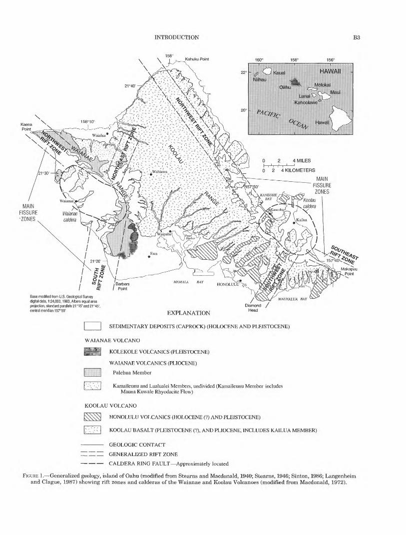
FIGURE 1. Generalized geology, island of Oahu (modified from Stearns and Macdonald, 1940; Stearns, 1946; Sinton, 1986; Langenheim and Clague, 1987) showing rift zones and calderas of the Waianae and Koolau Volcanoes (modified from Macdonald, 1972).

B4 REGIONAL AQUIFER-SYSTEM ANALYSIS-OAHU, HAWAII
steep stream gradients cause water to run off rapidly following precipitation, and permeable upland soils permit rapid infiltration of water to underlying aqui fers. As a result, streamflow is characteristically flashy, with high flood peaks and little baseflow. Few streams are perennial over their entire reach. Perennial streamflow occurs at high altitudes where precipita tion is persistent; in deeply incised valleys in rift zones, where streams intersect the water table; and near sea level where streams intercept shallow ground water. These conditions virtually preclude surface-water development on Oahu and lead to near-total reliance on ground water.
CLIMATE
The subtropical climate of Oahu is characterized by mild temperatures, moderate to high humidity that varies diurnally from about 60 to 90 percent at most
locations, prevailing northeasterly tradewinds that average about 9 mi/h in January and about 13 mi/h in June, and extreme variation in precipitation over short distances. Climate varies spatially with altitude and in relation to prevailing and local winds. Mean annual temperature is about 76°F in lowland Honolulu, decreasing to less than 70°F in the mountainous uplands (Blumenstock and Price, 1967). A pronounced orographic pattern of cloud cover and precipitation is established as moist oceanic air is forced up and over the mountainous terrain of Oahu by persistent tradewinds. Mean annual precipitation (fig. 6) has a steep orographic gradient and varies widely, ranging from about 60 in/yr on the windward (northeastern) coast of Oahu to about 275 in/yr near the crest of the Koolau Range to less than 25 in/yr over the leeward (southwestern) lowlands. The Waianae Range lies in the tradewind rainshadow of the Koolau Range and
158°Kahuku Point
EXPLANATION
LAND USE
Agriculture
Conservation (forested)
Urban
21°20'
Barbers Point
Base modified from U.S. Geological Survey digital data, 1:24,000,1983, Albers equal area projection, standard parallels 21°15' and 21°45', central meridian 157°59'
MAUNALUA BAYDiamond
Head024 KILOMETERS
FIGURE 2. Land use, island of Oahu (modified from State of Hawaii Department of Agriculture, 1980).

INTRODUCTION B5
receives much less precipitation, with a maximum of about 80 in/yr falling on the Waianae summit.
Precipitation on Oahu is markedly seasonal. In lowland and coastal areas, the winter months October through April receive about 70 percent of the total annual precipitation. Mountainous areas receive a fairly steady contribution of tradewind precipitation that is supplemented by intense, episodic rains from hurricanes, winter cold fronts, and convective distur bances associated with low pressure in the upper atmo sphere. Lowland areas receive a lesser proportion of total rainfall as tradewind rain and a greater propor tion of episodic winter rain. Mean annual precipitation over the open ocean near Oahu is about 25 in. (Blumenstock and Price, 1967).
PREVIOUS STUDIES
The geology and ground-water hydrology of Oahu have been studied in detail and are the subject of numerous reports. Many previous studies were not regional in scope and were concerned primarily with the geology and hydrology of local areas. The focus of the present report is island wide.
Stearns (1939) prepared a detailed geologic map of Oahu and published thorough descriptions of Oahu's geology and ground-water resources (Stearns and Vaksvik, 1935; Stearns, 1940). Other important studies of Oahu's geology include those of Hitchcock (1900), Palmer (1927, 1946), Wentworth (1926, 1951), Winchell (1947), Wentworth and Winchell (1947), Mac- donald and others (1983), and Stearns (1985). Sinton (1986) presented a revised geologic map and strati-
158°Kahuku Point
EXPLANATION
TOPOGRAPHIC DIVIDE Waianae Divide to the west and Koolau Divide to the east
Barbers Point
Base modified from U.S. Geological Survey digital data, 1:24,000,1983, Albers equal area projection, standard parallels 21°15' and 21°45', central meridian 157°59' Contours from U.S. Geological Survey digital elevation model data, 1:250,000,1986
024 MILES H ' 024 KILOMETERS
Contour interval 500 feet Datum is mean sea level
MAUNALUA BAYDiamond
Head
FIGURE 3. Topography, island of Oahu.

B6 REGIONAL AQUIFER-SYSTEM ANALYSIS-OAHU, HAWAII
graphic nomenclature for the Waianae Volcano, and the stratigraphic nomenclature for all of Oahu was reviewed and updated by Langenheim and Clague (1987). Walker (1986,1987) presented detailed descrip tions of the dike complex of the Koolau Volcano. Aspects of the geology of Oahu also are described in reports of the Hawaii Institute of Geophysics and in various doctoral dissertations and master's theses.
The hydrology of Oahu is described in various reports by the U.S. Geological Survey, the Honolulu Board of Water Supply, the State of Hawaii Depart ment of Land and Natural Resources, the University of Hawaii Water Resource Research Center, and in vari ous doctoral dissertations and master's theses. Early works of particular importance include those of Palmer (1927, 1946), Wentworth (1926, 1951), Stearns and Vaksvik (1935), and Stearns (1940). Visher and Mink (1964) discussed the ground-water resources of south
ern Oahu, which includes the Pearl Harbor area. Takasaki and others (1969) described the water resources and development of dike-impounded ground water of most of windward Oahu. (The location of wind ward Oahu and that of the other areas mentioned in the following discussion are shown in fig. 12A). Takasaki and Valenciano (1969) discussed the geo- hydrology and water resources of the Kahuku area. Rosenau and others (1971) described the water resources of north-central Oahu and estimated ground- water recharge to the area. Ground water in the Waianae area, which is the area west of the crest of the Waianae Range was described by Takasaki (1971). The effects of increased pumpage from the Schofield area was evaluated by Dale and Takasaki (1976). Finally, the water resources of southeastern Oahu were described by Takasaki and Mink (1982). Dike- impounded ground water and the effects of tunnels
158°Kahuku Point
4 MILES
21°30
21°20'
Barbers Point
Base modified from U.S. Geological Survey digital data, 1:24,000,1983, Albers equal area projection, standard parallels 21°15' and 21°45', central meridian 157°59'
FIGURE 4. Geomorphic provinces, island of Oahu (modified from Visher and Mink, 1964, fig. 1).

GEOLOGIC FRAMEWORK B7
used to develop this ground-water source in windward Oahu have been described and discussed by Hirashima (1971) and Takasaki and Mink (1985).
GEOLOGIC FRAMEWORK
The geology of Oahu (fig. 1) is the end result of varied geologic processes, including shield-building volcan- ism, subsidence, weathering, erosion, sedimentation, and rejuvenated volcanism. These processes have imposed on the aquifers their respective geometries and determined their textural and hydraulic proper ties. The processes have produced the rocks that consti tute the aquifers of Oahu, as well as the geohydrologic boundaries that subdivide the regional aquifer system into distinct ground-water areas. (The geohydrologic boundaries, topographic divides, and ground-water areas are shown on fig. 12). The principal aquifers of
Oahu are delineated mainly on the basis of stratigra phy
REGIONAL GEOLOGIC SETTING
Oahu and the other islands in Hawaii are the sub- aerial peaks of large volcanic mountain ranges, most of which lie beneath the sea, that comprise the Hawaiian Ridge. The Hawaiian Ridge is thought to have formed by the relative drift of the Pacific lithospheric plate over a convective plume, or hotspot, in the mantle (Wilson, 1963). Continuous volcanism at the hotspot and the northwestward relative motion of the Pacific plate produced a southeasterly succession of mountain building with progressively younger islands to the southeast. Present volcanic activity occurs at the extreme southeast end of the island chain on the island of Hawaii. The submarine parts of the Hawaiian Ridge rise about 15,000 ft above the adjacent sea floor before
158°Kahuku Point
21°30'
21°20'
Barbers Point
Base modified from U.S. Geological Survey digital data, 1:24,000,1983, Albers equal area projection, standard parallels 21°15' and 21°45', central meridian 157°59'
FIGURE 5. Streams, island of Oahu.

B8 REGIONAL AQUIFER-SYSTEM ANALYSIS-OAHU, HAWAII
protruding above sea level. The highest point on Oahu is 4,020 ft above sea level in the Waianae Range.
SHIELD-BUILDING VOLCANISM
The island of Oahu is formed by the remnants of two coalesced shield volcanoes, the Koolau Volcano to the east and the Waianae Volcano to the west (fig. 1). A shield volcano is formed by submarine eruptions of very fluid lava that build a dome-shaped structure resembling a shield on the ocean floor. Submarine vol canic deposits include pillow lavas, hyaloclastite, and flow-foot breccia; vitric ash deposits are formed when eruptions occur in shallow water. Eventually, the lavas build to sea level and above, and shield building contin ues with mostly quiescent subaerial eruptions of fluid lava. Building of the Waianae and Koolau Volcanoes occurred during the Pliocene and Pleistocene epochs.
The Waianae Volcano is older than the Koolau, in accordance with the southeasterly volcanic succession ascribed to the mechanism of plate motion over a hotspot in the mantle. However, both volcanoes likely erupted concurrently during at least part of their active life spans, as indicated by their large submarine masses. Shield-stage lava flows from the two volcanoes may interfinger at depth, although this has not been observed in surface outcrops or in boreholes. At the rel atively shallow depths of such observations, lava flows from the Koolau Volcano invariably overlie those from the Waianae Volcano unconformably, with soil and saprolite developed on the older Waianae surface and weathered alluvium separating the two formations in some places (Stearns and Vaksvik, 1935).
The shield-building lava flows emanated mainly from prominent rift zones of the Waianae and Koolau Volcanoes (fig. 1). These elongate zones form the topo graphic crests of the volcanoes and their submarine
158°Kahuku Point
EXPLANATION
LINE OF EQUAL MEAN ANNUAL PRECIPITATION Interval, in inches, is variable
21°30'
21°20
Barbers Point
Base modified from U.S. Geological Survey digital data, 1:24,000,1983, Albers equal area projection, standard parallels 21°15' and 21°45', central meridian 157°59'
Diamond Head
024 KILOMETERS
FIGURE 6. Mean annual precipitation, 1916-83, island of Oahu (modified from Giambelluca and others, 1986).
GEOLOGIC FRAMEWORK B9
extensions. Within each rift zone, a dike complex zone and a marginal dike zone have been delineated (Stearns and Vaksvik, 1935; Takasaki and Mink, 1985). Dikes are most heavily concentrated in the dike com plexes, where they commonly number several hundred per mile and constitute 10 percent or more of the total rock. In the marginal dike zones, dikes commonly num ber less than 100 per mile and account for less than 5 percent of the total rock (Wentworth, 1951; Takasaki and Mink, 1985). Most of the dikes dip steeply and are arranged in a subparallel pattern roughly aligned par allel to the trends of the major rift zones. Away from the rift zones, on the flanks of the volcanoes, dikes are sparse or absent.
The summits of both volcanoes collapsed and formed calderas, probably at numerous times during their growth. It was long thought that caldera collapse was a single event near the end of the shield-building stage of growth (Stearns, 1946), but the recent view is that caldera collapse occurs repeatedly during the growth of a shield volcano (Peterson and Moore, 1987). Late in the life of the Waianae Volcano, the chemical composi tion of its lava changed progressively from tholeiitic basalt to alkalic basalt, which is more viscous. Eruptions during this postshield period were more violent than the shield-building eruptions and produced greater proportions of ash and cinder. Lava flows also were thicker, more massive, and shorter than earlier flows, resulting in a steeper cap at the summit of the more gently sloping shield. The Koolau Volcano did not undergo this capping stage of growth. Finally after a period of volcanic quiescence, subsidence, and erosion a late stage of rejuvenated volcanism occurred from middle- to late-Pleistocene time (fig. 1). Numerous cinder cones and valley-filling lava flows were formed during this stage, but the total volume of these products represented only a small addition to the Oahu volcanic edifice.
SHIELD-STAGE VOLCANIC ROCKS
The shield-building rocks of the Waianae and Koolau Volcanoes are known respectively as the Waianae Vol- canics and the Koolau Basalt (Swanson and others, 1981; Langenheim and Clague, 1987). The Koolau Basalt is wholly of basaltic composition. The Waianae Volcanics encompass shield and postshield stages of activity (Langenheim and Clague, 1987) and are litho- logically diverse, therefore, the broader term "volca- nics" is applied. Waianae Volcanics and Koolau Basalt form the uplands and mountains of western and east ern Oahu, respectively, and extend to great depths beneath the island and offshore where they comprise the submarine mass of the island.
WAIANAE VOLCANICS
Waianae Volcanics are mainly lavas and feeder dikes of tholeiitic and alkalic basalt, with lesser amounts of talus breccia, explosion breccia, cinder, and spatter. Occasional thin soils and ash beds are intercalated with the lava flows. Lava flows of the Waianae Volca nics comprise the principal water-bearing rocks of western Oahu (fig. 1).
Stearns subdivided The Waianae Volcanic Series into informal lower, middle, and upper members (Stearns and Vaksvik, 1935), but did not differentiate them as separate units on the geologic map. He recog nized faulted and erosional unconformities that sepa rated the lower member from the middle and upper members and speculated that the faulting may have been related to caldera collapse. He also recognized a gradation from the primarily basaltic composition of the middle member to a more andesitic upper member (Stearns and Vaksvik, 1935, p. 76). Macdonald (1940) published a revised geologic map with the upper mem ber mapped separately from the still undifferentiated lower and middle members.
More recent field mapping, petrologic study, and radiometric dating led Sinton (1986) to revise the stratigraphic nomenclature and geologic map of the Waianae Volcano. He subdivided the Waianae Volcanics into three formal units, the Lualualei, Kamaileunu, and Palehua Members, that roughly are equivalent to the lower, middle, and upper members of Stearns. The Lualualei Member is composed largely of thin pahoehoe flows (ropy lava) and fewer aa flows (massive lava and clinker), dipping at angles of 4° to 14° away from the eruptive center of the volcano. The flows range in thickness from 5 to 75 ft and average about 25 ft (Macdonald, 1940). Lavas of the Kamaileunu Member are nearly horizontal and thicker than flows of the underlying Lualualei Member, presumably because they ponded within a caldera. The flows are predomi nantly pahoehoe with some aa, and the flows range in thickness from 10 to 120 ft and average about 40 ft (Macdonald, 1940). The Palehua Member consists mainly of aa flows, many of them 50 to 100 ft thick. Palehua flows are generally thicker than either Lualualei or Kamaileunu flows. The Palehua Member probably formed a broad, postshield cap of alkalic basalt over the earlier rocks; subsequent erosion has severely dissected it and obscured its original extent. Radiometric dating of basalt samples from subaerial sites yield ages of 2.5 to 3.9 Ma (million years) for Waianae Volcanics (Clague and Dalrymple, 1987; Lan genheim and Clague, 1987).
BIO REGIONAL AQUIFER-SYSTEM ANALYSIS-OAHU, HAWAII
KOOLAU BASALT
The Koolau Basalt consists of tholeiitic basalt lavas and feeder dikes of tholeiitic basalt, with lesser amounts of talus breccia, explosion breccia, cinder, and spatter. Occasional thin soils and ash beds are inter calated with the lavas, though more sparingly than in the Waianae Volcanics. Lava flows of Koolau Basalt comprise the principal water-bearing rocks of central and eastern Oahu (fig. 1).
Koolau lavas range in thickness from several feet to as much as 80 ft, and average 10 ft or less (Stearns and Vaksvik, 1935; Wentworth, 1951). The flows commonly dip 3° to 10° away from the eruptive axis of the volcano. Radiometric dates of samples from subaerial exposures range from 1.8 to 2.6 Ma (Clague and Dalrymple, 1987; Langenheim and Clague, 1987).
MODIFICATION OF THE SHIELDS BY SECONDARY PROCESSES
The shield volcanoes of Oahu have undergone sub stantial modification by secondary geologic processes. Gravitational loading of the lithospheric plate by the massive shields caused downwarping of the plate and subsidence of the volcanoes. Slope instability led to large-scale slumping and landslides. Chemical weath ering of easily decomposed basaltic rocks produced erodible soil and thick zones of clay-rich saprolite. Streams dissected the shields, eroding material and redepositing it in valleys or transporting it to the coastal estuaries or the sea. Marine processes reworked these terrigenous sediments and redeposited them on the submarine flanks of the volcanoes, together with calcareous sediments produced by marine organisms.
SUBSIDENCE AND SLOPE FAILURE
Subsidence was contemporaneous with shield devel opment and continued long after eruptions ceased. Moore and Campbell (1987), in a study of tilted, deeply submerged reefs in the Hawaiian islands, concluded that subsidence ended about 0.5 Ma after the end of shield-building volcanism. Direct evidence of the sub sidence of Oahu comes from wells that have penetrated alluvium or weathered basalt at depths of 1,100 to 1,200 ft below sea level (Stearns, 1935; Stearns and Chamberlain, 1967). Indirect evidence includes deep submarine canyons of probable subaerial origin, sub marine terraces thought to mark paleo-sea levels on the flanks of the volcanoes, and interpretations of crustal structure deduced from geophysical surveys. Moore (1987) provides a comprehensive summary of this evidence for the Hawaiian islands and, together
with new evidence and analysis, concluded that most of the volcanoes have subsided 6,500 to 13,000 ft.
Perhaps the most persuasive evidence of the magni tude of subsidence is the group of V-shaped sub-marine canyons on the eastern flank of Oahu (Hamilton, 1957; Shepard and Dill, 1966; Andrews and Bainbridge, 1972). These canyons are aligned with major stream valleys on land and can be traced to depths of more than 6,600 ft below sea level. Although submarine ero sion has been proposed as a possible cause of the can yons, most investigators have favored a subaerial origin. Therefore, subsidence of 6,500 ft or more after the shield-building stage of volcanism seems reason able for Oahu. Lavas that originally erupted subaeri- ally and have textural characteristics of subaerial lavas have since been carried to great depths by this subsidence.
In addition to subsidence, slope failure also modified the flanks of Oahu's volcanoes. Landslides of various sizes and rates of movement occurred during and after the volcanoes were built. Two extremely large subma rine landslides have been identified, one off the Waianae coast and one off the coast of windward Oahu (Moore, 1964; Moore and others, 1989).
WEATHERING AND EROSION
Weathering and fluvial and marine erosion pro ceeded contemporaneously with subsidence in Oahu's posteruptive period and continue to the present. These processes also were active to some degree during the waning phases of shield and postshield volcanism when progressively decreasing eruptive frequency would have left large areas of the volcanoes exposed for long periods of time.
Fluvial erosion has cut stream valleys several thou sand feet deep in the Waianae and Koolau shields. Much of the western part of the Waianae shield and much of the eastern side of the Koolau shield have been removed, leaving remnants of the shields as the Waianae and Koolau Ranges (the intensive erosion at these areas may have been aided or partly initiated by large-scale landsliding). Interstream divides on the western slopes of the Waianae Range and the eastern slopes of the Koolau Range have been eroded thor oughly, and numerous individual valleys have coa lesced into U-shaped composite valleys with broad amphitheater heads. In contrast, stream valleys in the Honolulu area also were cut to depths of several thou sand feet but did not coalesce to the same degree. These valleys are narrower, though still with amphitheater heads, and have broader, less dissected interfluves. Valleys elsewhere on Oahu are narrower still and gen erally V-shaped. In central Oahu, gentle slopes have inhibited stream incision and resulted in narrow,

GEOHYDROLOGY OF THE WATER-BEARING DEPOSITS Bll
shallow gulches separated by broad, little-dissected interfluves. Considerable fluvial erosion may have occurred very early after the shields were built, per haps within a few hundred thousand years and at least within one-half to one million years.
The chronology of early erosion in central Oahu has caused complex stratigraphic and hydrologic relations between Waianae and Koolau rocks. During or shortly after the final postshield eruptions of the Waianae vol cano, its eastern flank was modified by weathering and erosion. A composite amphitheater-headed valley was formed on the eastern flank, which subsequently was filled by late Koolau lavas and Waianae-derived allu vium (Stearns and Vaksvik, 1935). Stearns (1939; Stearns and Vaksvik, 1935), mainly on the basis of sur face outcrops, postulated that: (1) Waianae-derived soil, saprolite, and weathered alluvium separate Waianae Volcanics from Koolau Basalt throughout cen tral Oahu; and (2) that the alluvium is intercalated with lava flows of Koolau Basalt. Subsequent obser vations from drill holes and geophysical surveys sup port the first interpretation, but the second has not been verified.
SEDIMENTATION
Sedimentary deposition proceeded concurrently with subsidence and continued after submergence was complete. Shelves built by coral reefs and sediment were submerged and are now found at various depths around Oahu. Valleys cut very early in the erosional period were filled by marine, estuarine, and fluvial sediments as island subsidence raised the base level of streams and drowned their lower reaches. Eustatic fluctuations of sea level, coinciding with glacial and interglacial periods of the Pleistocene and ranging hun dreds of feet, were superimposed on these processes (Steams, 1935; 1978). Much of Oahu's coastal plain is underlain by ancient reefs and other marine sediments deposited during various Pleistocene sea stands.
REJUVENATED-STAGE VOLCANISM
After the long period of subsidence and erosion, eruptive activity resumed at scattered vents at the southern ends of the Koolau and Waianae Ranges (fig. 1). This stage of volcanism has been observed on other islands of Hawaii and has long been called the posterosional stage; more recently, it has come to be called the rejuvenated stage. The term "rejuvenated" connotes a resumption of eruption after a prolonged hiatus in volcanism. It typically implies different rock chemistry and magmatic origin than the earlier shield- building and postshield volcanism (Clague and Dal- rymple, 1987; Langenheim and Clague, 1987). The vol
ume of material erupted during the rejuvenated stages was small in comparison with the volume produced by earlier volcanism.
Rocks of the Waianae rejuvenated stage are called the Kolekole Volcanics and those of the Koolau rejuve nated stage are called the Honolulu Volcanics (Langen heim and Clague, 1987). Kolekole Volcanics are small in areal extent (fig. 1), comprising about six cinder cones and associated lava flows and ash, mostly at the southern end of the Waianae Range (Sinton, 1986). Radiometric ages for these deposits have yet to be pub lished, but recently completed radiometric and geochemical studies (T.K. Presley, J.M. Sinton, and Malcolm Pringle, Univ. of Hawaii, written commun., 1996) indicate that the Kolekole Volcanics are postero sional in the geomorphic sense of covering eroded topography, but are not rejuvenated in the sense of renewed magmatism of markedly different age and chemical composition. This would imply a need for slight revision of the stratigraphy used in this report, which is that of Langenheim and Clague (1987).
Honolulu Volcanics are limited in areal extent (fig. 1), occurring only near the southeastern end of the Koolau Range. The rocks are strongly alkalic and range in composition from alkalic basalt, basanite, and nephelite to melilitite (Clague and Dalrymple, 1987, p. 51). A large proportion of the rocks are pyroclastic products such as ash, cinder, spatter, and tuff. Erup tions inland from the coast left deposits of black ash and cinder and produced lavas that flowed down val leys and spread out over the coastal plain. Lava flows that ponded in valleys or other depressions in the pre existing erosional topography are commonly 40 to 100 ft thick and massive. Some units of the Honolulu Volcanics are water bearing and others, such as mas sive flows, overlie and confine ground water in valley alluvium or cause perched-water springs.
Potassium-argon ages for the Honolulu Volcanics range from 0.9 to 0.03 Ma (Clague and Dalrymple, 1987) and indicate that eruptions occurred sporadically over a period of about one million years. The major sub sidence of Oahu appears to have been completed prior to Koolau rejuvenated volcanism because Honolulu Volcanics lie on or are intercalated with only the upper most of the sedimentary units on the coastal plain.
GEOHYDROLOGY OF THE WATER-BEARING DEPOSITS
The rocks of Oahu vary widely in origin, chemical composition, and texture and in their ability to store and transmit water. This section outlines the physical and hydraulic properties of the rocks as a function of their origin and evolution.

B12 REGIONAL AQUIFER-SYSTEM ANALYSIS-OAHU, HAWAII
VOLCANIC ROCKS AND DEPOSITS
Although most volcanic rocks in the islands of Hawaii have similar basaltic composition, their modes of emplacement caused a variety of physical properties that govern their hydraulic properties. For purposes of discussion, the volcanic rocks have been divided into four groups: (1) lava flows, (2) dikes, (3) pyroclastic deposits, and (4) saprolite and weathered basalt. Each of these groups of rocks have markedly different phys ical and hydraulic properties. Much of the following discussion of rock textures and of the areal extent of lava flows is from Wentworth and Macdonald (1953) and Macdonald and others (1983).
LAVA FLOWS
Lava flows in Oahu, as well as the other islands of Hawaii, are mainly of two textural types: (1) pahoehoe (ropy lava), which has a smoothly undulating surface and contains numerous elongate voids; and (2) aa (clin- kery lava), which has a surface of coarse rubble and an interior of massive rock. Stratified sequences of thin- bedded lava flows form the most productive aquifers in Hawaii. At the local scale, the hydraulic properties of lava aquifers depend on the number, size, types, and distribution of openings or pores. The diverse rock tex tures encompassed by the two types of lava impart a complex porosity distribution to the lavas, one that dif fers in character from most sedimentary, metamorphic, and crystalline igneous rocks. Lava sequences also typ ically include cinders and ash transported by the wind from eruptive vents.
In a layered sequence of lava flows (fig. 7A), several types of primary porosity are present:
1. Vesicular small gas vesicles that form in molten lava;
2. Fracture joints, cracks, and bedding-plane separations;
3. Intergranular fragmental rock, including cinders, rubble, and clinkers that are analo gous to clean, coarse gravel; and
4. Conduit large openings such as lava tubes and interflow voids that take forms similar to solution conduits in limestones.
Vesicular porosity is a conspicuous element of bulk porosity, but the vesicles are poorly connected and con tribute little to effective porosity. Fracture and inter- granular porosity form a pervasive network of small openings that facilitates diffuse ground-water flow. Conduits provide avenues for highly channelized flow similar to solution cavities found in carbonate aquifers (White, 1969).
Pahoehoe flows are formed by basaltic lavas that are fluid, flow rapidly, and tend to spread out. Most pahoe hoe flows are thin, contain voids of various sizes, and are cracked and collapsed in places. Ponding of pahoe hoe lava in depressions or on gentle slopes can result in thick accumulations of massive pahoehoe. Interflow voids form where the irregular upper surface of a flow is not completely filled in by the viscous lava of a sub sequent flow. Lava tubes form when the flow surface cools and hardens into a crust and the molten lava beneath drains out. Most tubes are less than a few feet in diameter and are localized, but roofing over of lava rivers may result in tubes as large as several tens of feet in diameter that extend several miles. Some lava tubes covered by subsequent lava flows collapse upon burial and compaction. Wentworth (1945) gives a note worthy description of conduits encountered during a tunneling project in Honolulu:
Many small lava tubes and several large ones were encountered in the Red Hill-to-Halawa water-transmis sion tunnel. At one point a large tube, 15 to 30 ft wide and up to 8 or 10 ft high above the debris which partly filled it, crossed over the tunnel and was explored for two or three hundred feet inland.
The mixture of voids and fractures in pahoehoe flows imparts high intrinsic permeability similar to that of carbonate rocks. Vertical permeability elements in pahoehoe include cooling joints; collapse features; sky lights or holes in the roofs of large lava tubes; and large, open cracks where lava is pushed up into humps and pressure ridges. Lateral permeability elements in pahoehoe include drained lava tubes and interflow voids (small depressions in the irregular upper surface of a lava flow that are not filled in by the viscous lava of the subsequent flow). Where pahoehoe is massive, effective porosity and permeability are comparatively low and mainly of the fracture type.
Pahoehoe lava commonly grades into aa lava with increasing distance from the eruptive vent. Aa flows are typified by a central core of massive rock several feet to tens offset thick, with layers of coarse, fragmen tal rock above and below them. As the flowing aa lava cools, degases, and becomes more viscous, the hard ened crust on top of the flow breaks up into angular, scoriaceous rubble known as aa clinker, or flow-top breccia. Beneath the clinker a core of viscous, incandes cent lava continues to spread, carrying along the sheath of clinker like a tractor tread. As the flow advances, clinker and blocks of the massive core spall off and cascade down the front of the flow and are over ridden by it. Subsequent cooling and volumetric con traction of the core result in well-developed joints. Vertical joints are most conspicuous, although lateral and oblique joints resulting from shear stresses within the flowing core also are common. As with pahoehoe,

GEOHYDROLOGY OF THE WATER-BEARING DEPOSITS B13
Shrinkage joints and fractures
Clinker bridges
Solid phase of aa lava flow
Aa clinker beds
Interflow void between
pahoehoe lava flows
Lava tubein pahoehoe
lava flowEXPLANATION
Arrow length denotes relative magnitude of permeability in direction of arrows
e dir^on
FIGURE 7. Structural features associated with lava flows (modified from Takasaki and Valenciano, 1969, fig. 5). A, Dike-free lava flows. B, Dike-intruded lava flows.

B14 REGIONAL AQUIFER-SYSTEM ANALYSIS-OAHU, HAWAII
emplacement of aa on gentler slopes results in thicker, more massive flows.
The intergranular porosity of aa clinker is analogous to the intergranular porosity of coarse, well-sorted gravel. Widespread beds of clinker contribute high hor izontal permeability to a layered sequence of lava flows (fig. 7A). In contrast, the smaller effective porosity of massive aa cores suggests permeability several orders of magnitude less than aa clinker or thin-bedded pahoehoe. The principal permeability of an aa core is imparted by cooling joints. In flows thicker than a few feet, these fractures may be spaced several feet apart, intersecting in plan view to form crude polygons sev eral feet across. The intervening blocks of massive rock are virtually impermeable. Marginal clinker at the periphery of an aa flow may provide local avenues of high vertical permeability in lava sequences. Such flow-margin clinker bridges may be more prevalent in sequences of thinner flows than in thicker flows.
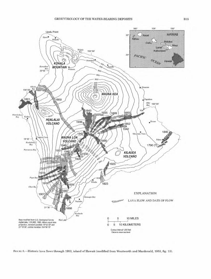
The areal extent of lava flows is much larger than their typical thickness of about 10 ft. Wentworth and Macdonald (1953, p. 31) listed measurements for 22 historical flows on Mauna Loa and Kilauea on the island of Hawaii (fig. 8), which presumably are typical of flows on Oahu as well. The flows on Hawaii average about 15 mi in length and about one-half mile in width. Individual flows can be traced and mapped on the sur face of young, unweathered volcanoes. Areal correla tion of flows in the subsurface requires careful drilling and collection of core samples or drill cuttings, detailed description and petrographic study of the samples, and borehole geophysical logging. These data are not collected routinely in Hawaii, and there are few instances when data are sufficient for lateral tracing of subsurface flows.
DIKES
Dikes are thin, near-vertical sheets of massive, intrusive rock that typically contain only fracture porosity and permeability. Most dikes are no more than several feet thick, but can extend vertically thousands of feet and laterally several miles. Where dikes intrude lava flows, they inhibit ground-water flow principally in the direction normal to the plane of the dike (fig. IB). Dike complexes are areas where dikes are more numer ous and intersect at various angles, forming small com partments and lowering overall rock porosity and permeability (Takasaki and Mink, 1985). Marginal dike zones are areas where dikes are subparallel and widely scattered. Dikes in these zones impound water within large compartments of more permeable lavas and tend to channel ground-water flow parallel to the general trend of the dikes (Hirashima, 1962; Takasaki, 1971).
PYROCLASTIC DEPOSITS
Pyroclastic deposits include ash, cinder, spatter, and larger blocks. These deposits are essentially granular; porosity and permeability are similar to that of granu lar sediments with similar grain size and degree of sorting. Ash, being fine-grained, is less permeable than coarse pyroclastic deposits such as cinder and spatter. The permeability of ash may be reduced further by weathering or by compaction to tuff. Weathered ash beds can act as thin confining units within lava sequences.
SAPROLITE AND WEATHERED BASALT
The humid, subtropical climate of Oahu fosters intense weathering of basaltic rocks, reducing the per meability of the parent rock by altering igneous miner als to clays and oxides. Weathered surficial materials mediate the infiltration of water and anthropogenic contaminants to deeper aquifers. Exposed weathering profiles on Oahu typically include inches to feet of soil underlain by several feet to several tens of feet of sapro- lite, a soft, clay-rich, thoroughly decomposed rock. The soils of Oahu, which have been classified and mapped by Foote and others (1972), differ in parent material, topography, and precipitation. Most of the soil types are well-drained, except for some soils that formed on allu vium in lowland areas. The soils generally have high proportions of iron and aluminum oxides and of clay (typically kaolinitic).
Saprolite is weathered material that has retained textural features of the parent rock. In basaltic sapro- lite, diverse parent textures and a variable degree of weathering impart a heterogeneous permeability structure with preferred avenues of water movement and retention. Miller (1987) measured saturated hydraulic conductivities of saprolite core samples and obtained values that ranged over five orders of magni tude, from 1x10 3 ft/d to Ixl02ft/d. Miller (1987, p. iv) further found that preferential flow occurs in channels between macropores and along joints. In outcrop, saprolite commonly has a friable texture, with exten sive networks of joints forming small, blocky aggre gates. It is not clear to what degree this is a general characteristic or simply reflects shrinkage from desic cation at the exposed outcrop.
Saprolitic weathering proceeds downward in flat areas and laterally inward from steep ridges and valley walls. Rocks with a high proportion of pore space and surface area, such as ash, cinder, and aa clinker, are weathered preferentially; weathering of massive rock proceeds more slowly. In the case of massive aa, whose principal permeability is vertical cooling joints,
GEOHYDROLOGY OF THE WATER-BEARING DEPOSITS B15
156°
Upolu Point
HonokohauBay { Kailua
^1942 MAUNALOA
VOLCANO 'i
1949
Base modified from U.S. Geological Survey Ka Lae digital data, 1:24,000,1983, Albers equal area projection, standard parallels 18°52'30" and 21°18'30", central meridian 154°56'15"
EXPLANATION
LAVA FLOW AND DATE OF FLOW
10 MILES
0 5 10 KILOMETERS
Contour interval 1 ,000 feet Datum is mean sea level
FIGURE 8. Historic lava flows through 1953, island of Hawaii (modified from Wentworth and Macdonald, 1953, fig. 13).

B16 REGIONAL AQUIFER-SYSTEM ANALYSIS-OAHU, HAWAII
slight weathering and swelling may seal the joints, resulting in a layer of low permeability.
Minerals leached from overlying material are rede- posited at greater depths in the saprolite to form clay- rich zones and sheets and concretions of iron oxides. These deposits reduce permeability and may contrib ute to perching or near-saturation in the unsaturated zone (Walker, 1964; Patterson, 1971). Perched water or near-saturated conditions have been encountered in saprolite at several sites in the Schofield Plateau of central Oahu (fig. 4) (Mink, 1981; State of Hawaii, Department of Agriculture, 1983) and elsewhere on Oahu (Walker, 1964; selected drillers' logs in files of the U.S. Geological Survey, Honolulu, Hawaii).
Observations of outcrops and drillers' logs suggest weathering intensity and saprolite thickness increase with precipitation. Saprolite typically is less than 100 ft thick in areas where precipitation is less than 50 in/yr and about 100 to 300 ft thick where precipita tion is between about 50 to 80 in/yr. Weathering may extend even deeper in mountainous areas where pre cipitation is from 80 to 275 in/yr. There also is some suggestion that bedrock weathering may be more intense beneath valleys than beneath adjacent inter- fluves. Weathered material extends to a depth of nearly 600 ft beneath a shallow gulch in the wet, eastern part of the Schofield area (drilling log for well 3-3059-02 in files of the U.S. Geological Survey, Honolulu, Hawaii). Although precipitation of about 80 in/yr at this site is somewhat greater than at most other sites in central Oahu, the depth of weathering is several hundred feet thicker than elsewhere and may be due to enhanced weathering associated with streambed infiltration.
HYDRAULIC PROPERTIES OF THE VOLCANIC ROCKS
The excellent water-yielding properties of the basal tic lavas of Oahu were known to early Hawaiian set tlers, but became especially apparent near the end of the 19th century when the first deep wells were drilled. Flowing artesian wells commonly produced several hundred to several thousand gallons per minute, and pumped wells and shafts provided similar yields with drawdowns of no more than several feet. Increasing exploitation of ground-water resources eventually brought about the need for quantitative resource appraisal, requiring knowledge of aquifer hydraulic properties.
Estimates of aquifer properties on Oahu have been made by several methods, including laboratory mea surements on rock samples, local aquifer tests in which drawdown is measured in a pumped well or in one or more observation wells at some distance from the pumped well, regional aquifer tests in which one or
more wells are pumped, and with regional numerical models of ground-water flow.
The most commonly estimated properties have been hydraulic conductivity and transmissivity; fewer esti mates are available for storage coefficient, specific yield, bulk porosity, and effective porosity. Specific storage and aquifer compressibility have been given in only a few reports. Generalized water-bearing proper ties of the volcanic rocks are given in table 1.
HYDRAULIC CONDUCTIVITY AND TRANSMISSIVITY
Most estimates of aquifer hydraulic properties on Oahu have been derived from aquifer tests at various field scales. Results from these tests, selected mainly from published reports, are presented in table 2. Val ues calculated from a given test are listed in table 2 rather than the average value or range of values. This allows a greater appreciation of the variability of the estimates, even for a single test, based on the choice of different analytical methods or from the analysis of data from multiple observation wells. Variability in results from well to well might be attributed to hetero geneity, anisotropy, or other conditions not adequately accounted for in the analysis. Where different analyti cal methods have been applied to the same test, it is not clear which method yields the most appropriate result; judgments have been made in these cases by the original investigators.
The thickness of the volcanic-rock aquifers of Oahu is not known, but probably is at least several thousand feet. This has important implications for estimates of hydraulic conductivity and transmissivity derived from aquifer tests because transmissivity is a function of hydraulic conductivity and aquifer thickness and is given by
T = Kb (1)
whereT is transmissivity, foot squared per day;K is hydraulic conductivity, foot per day;b is aquifer thickness, feet;
(the units above are one example; in fact, any consis tent set of length and time units can be substituted). Hydraulic conductivity likely decreases with depth because of compaction and may decrease sharply at depth where there is a transition from subaerially erupted lavas to submarine lavas.
Numerous estimates of hydraulic conductivity and transmissivity have been made for aquifers in Koolau Basalt and the Waianae Volcanics (table 2). However, the lack of a definable aquifer thickness and the partial penetration of wells introduce ambiguity to most of

GEOHYDROLOGY OF THE WATER-BEARING DEPOSITS B17
TABLE 1. Water-bearing properties of the rocks and occurrence of ground water on the island ofOahu
[Modified from Takasaki and Mink, 1982. Basal refers to the deepest or main water table near sea level, typically corresponding to a lens of freshwater floating onseawater. ft/d, foot per day; <, less than; , no data]
Rock type PermeabilityHydraulic
conductivity(ft/d)
Ground-water occurrence
Principal Secondary
Volcanic rocks
Waianae Volcanics
Lava flows
Dike complex.................... Low to moderate 1 - 500 Dike impounded Perched
Marginal dike zone ............... Moderate to high 100 -1,000 Dike impounded Basal
Dike free. ....................... Moderate to very high 500 - 5,000 Basal
Breccia............................ Low 1 - 100 Perched
Saprolite. .......................... Very low <1 Perched
Koolau Basalt
Lava flows
Dike complex.................... Low to moderate 1 - 500 Dike impounded Perched
Marginal dike zone ............... Moderate to high 100 -1,000 Dike impounded Basal
Dike free. ....................... Moderate to very high 500 - 5,000 Basal
Breccia............................ Low 1 -100 Perched
Saprolite. .......................... Very low <1 Perched
Honolulu Volcanics
Lava flows ......................... Low to moderate 1 - 500 Perched
Cinders. ........................... Low to moderate 1 - 500 Perched
Tuff. .............................. Low 1 - 100 Perched
Saprolite. .......................... Very low <1 Perched
Sedimentary rocks
Coral
In situ reef limestone ................ Moderate to very high 100 - 20,000 Basal Perched
Reworked coral rubble ............... Moderate to very high 100 -10,000 Basal Perched
Dunes
Consolidated ....................... Low 1 -100 Perched Basal
Unconsolidated ..................... Low to moderate 1 - 500 Basal Perched
Sand
Consolidated ....................... Low to moderate 1 - 500 Basal
Unconsolidated ..................... Moderate to high 100 -1,000 Basal
Lagoonal
Sand.............................. Low to moderate 1 - 500 Basal
Mud .............................. Very low <1 Basal Perched
Alluvium
Younger ........................... Low to moderate 1 - 500 Perched Perched
Older .............................
Consolidated .................... Very low <1 Perched
Unconsolidated .................. Low 1 - 100 Perched Basal

TAB
LE 2
. H
ydra
ulic
pro
pert
ies
of t
he W
aian
ae a
nd K
oola
u aq
uife
rs,
isla
nd o
fOahu
[Pub
lishe
d es
tim
ates
fro
m fi
eld-
scal
e aq
uife
r te
st v
alue
s sh
own
only
for
pro
pert
ies
repo
rted
by
the
orig
inal
aut
hors
; hyd
raul
ic c
ondu
ctiv
ity o
r tra
nsm
issi
vity
equ
ival
ents
hav
e no
t bee
n co
mpu
ted
for c
ases
in
whi
ch o
nly
one
or t
he o
ther
was
rep
orte
d. M
ultip
le v
alue
s fo
r th
e sa
me
aqui
fer
test
are
est
imat
es f
rom
mul
tipl
e ob
serv
atio
n w
ells
or
from
mul
tipl
e an
alyt
ical
met
hods
. St
orag
e co
effi
cien
t, va
lue
refe
rs to
spe
cifi
c yi
eld
whe
n th
e aq
uife
r is
unc
onfi
ned
and
refe
rs to
sto
rage
coe
ffic
ient
whe
n th
e aq
uife
r is
con
fine
d, f
t, fo
ot; f
t/d, f
oot p
er d
ay; f
t2/d
, foo
t squ
ared
per
day
; , n
o da
ta]
Sou
rce
ofin
form
atio
n
Aqu
ifer
;gr
ound
-wat
erar
ea
Aqu
ifer
cond
itio
nsdu
ring
test
Tra
nsm
issi
vity
,T
Met
hod
of a
naly
sis
(ft2
/d x
106
)
Hyd
raul
icco
nduc
tivi
ty,
K(f
t/d)
Sto
rage
coef
fici
ent,
S(x
10-
2)R
emar
ks
Dik
e-fr
ee l
ava
flow
s
Dal
e (1
978)
Koo
lau;
W
aial
uaU
ncon
fine
d;ba
sinw
ide
draw
dow
n
Thi
em (
1906
)1,
600
10B
ound
arie
s po
ssib
ly
sign
ific
ant,
but
not
trea
ted.
K d
eriv
ed a
s T
div
ided
by
pres
umed
le
ns
thic
knes
s (a
bout
45
0 ft
).
Pum
ped
wel
l w
as
600-
ft
hori
zont
al
wel
l as
sum
ed
equi
vale
nt
to
a ve
rtic
al
wel
l "t
hat
fu
lly
pen
etra
tes
the
fres
h-w
ater
fl
owfi
eld.
" U
ncon
fine
d st
orag
e co
effi
cien
t es
tim
ated
by
eq
uat
ing
vo
lum
e of
dr
awdo
wn
cone
to
cu
mul
ativ
e pu
mpa
ge.
Eyr
e (1
983)
Eyr
e an
d ot
hers
(19
86)
Koo
lau;
P
earl
H
arbo
r
Koo
lau;
W
aial
ae
Con
fine
d;
wea
ther
ed
Unc
onfi
ned,
sp
arse
di
kes;
ba
sinw
ide
draw
dow
n
Thi
em (
1906
),
Zan
gar
(195
3)
Hem
isph
eric
al f
low
eq
uati
on
50 68,
85,1
00,
120,
340
,40
0, 5
90,
930,
960
Spec
ific
ca
paci
ty
test
. W
eath
ered
ba
salt
. S
ubtr
acte
d
wel
l lo
sses
, ap
plie
d T
hiem
an
d Z
anga
r m
etho
ds.
Bou
ndar
ies
poss
ibly
si
gnif
ican
t,
but
not
trea
ted.
Ana
lyze
d sa
me
aqui
fer
test
as
W
entw
orth
(1
938)
, bu
t w
ith
hem
isph
eric
al
flow
eq
uati
on
inst
ead
of
cy
lind
rica
l T
hiem
eq
uati
on.
Min
k (1
980)
Koo
lau;
Pea
rlH
arbo
r
Unc
onfi
ned;
basi
nwid
ere
cove
ry
The
is (
1935
)
Coo
per-
Jaco
b (1
946)
0.93
,1.1
, 1.
2, 1
.3,
1.6,
2.7
1.4,
1.6,
2.
6,1.
5,
1.5,
1.6
1,60
0
1,60
0
5.9,
2.6
, 1.
4, 3
.6,
4.1,
2.8
8,2
, 3,3
, 8,1
4
Bou
ndar
ies
poss
ibly
si
gnif
ican
t,
but
not
trea
ted.
Rep
ort
stat
ed
that
im
age-
wel
l dr
awdo
wns
ar
e nea
rly
as
larg
e as
re
al
draw
dow
ns
for
sim
ilar
ra
te
of p
umpa
ge
of
long
er d
urat
ion.
K d
eriv
ed b
y av
erag
ing
all
valu
es o
f T
and
div
idin
g by
1,0
25-f
t "d
epth
of
flow
" (p
resu
med
len
s th
ickn
ess)
. A
naly
sis
of
reco
very
du
ring
4-
mon
th
peri
od
of
no
pum
ping
(19
58 s
ugar
str
ike)
.
Ros
enau
an
d K
oola
u;
othe
rs (
1971
) W
ailu
a,
Kaw
ailo
a
Not
spe
cifi
ed(p
roba
bly
The
is)
Not
spe
cifi
ed3.
6 to
8.4
Ran
ge f
rom
sev
eral
aqu
ifer
tes
ts.
Wai
anae
; M
okul
eia
2.0
to 3
.3R
ange
fro
m s
ever
al a
quif
er t
ests
.

TAB
LE 2
. H
ydra
ulic
pro
pert
ies
of t
he W
aian
ae a
nd K
oola
u aq
uife
rs,
isla
nd
of O
ahu
Conti
nued
Sou
rce
of
info
rmat
ion
Aqu
ifer
; gr
ound
-wat
er
area
Aqu
ifer
co
ndit
ions
duri
ng tes
tM
etho
d of
ana
lysi
s
Hyd
raul
ic
Tra
nsm
issi
vity
, co
nduc
tivi
ty,
T
K(f
t2/d
x 1
06)
(ft/
d)
Sto
rage
co
effi
cien
t,S
(x 1
0"2)
R
emar
ks
Dik
e-fr
ee l
ava
flow
s C
onti
nued
Sor
oos
(197
3)
Tak
asak
i an
d
othe
rs (
1969
)
Tod
d an
d M
eyer
(19
71)
Vis
her
and
Min
k (1
964)
Wen
twor
th
(193
8)
Wil
liam
s an
d S
oroo
s (1
973)
Wil
liam
s an
d S
oroo
s (1
973)
Var
ious
Koo
lau;
K
ahuk
u
Koo
lau;
P
earl
Har
bor
Koo
lau;
P
earl
Har
bor
Koo
lau;
W
aial
ae
Koo
lau;
P
earl
Har
bor
(Kao
nohi
site
)
Koo
lau;
K
ahuk
u (P
unal
uu
site
)
Var
ious
Con
fine
d;
basi
nwid
e dr
awdo
wn
Con
fine
d;
basi
nwid
e dr
awdo
wn
Unc
onfi
ned;
ba
sinw
ide
draw
dow
n
Unc
onfi
ned;
sp
arse
dik
es;
basi
nwid
e dr
awdo
wn
Unc
onfi
ned;
or
sem
i-
conf
ined
Con
fine
d;
basi
nwid
e dr
awdo
wn
Con
fine
d
Zan
gar
(195
3)
The
is (
1935
)
The
is (
1935
)
The
is (
1935
)
Thi
em (
1906
)
The
is (
1935
) W
alto
n (1
962)
H
antu
sh (
1961
)
The
is (
1935
)
The
is (
1935
) C
oope
r- Ja
cob
(194
6)
Han
tush
(19
61)
The
is (
1935
)
26 t
o 85
,000
84
0 (m
edia
n)
3,40
0 (m
ean)
0.19
, 0.
54,
0.54
0.55
1,
800
0.57
, 0.
59,
0.59
, 0.
61
1,80
0, 2
,100
, 2,
200,
2,7
00,
3,50
0
1.1,
4.7
2.
3, 5
.6
7.8,
16
1,10
0, 6
50
4.2
0.62
0.
87,
1.1
1.8.
0.9
9 32
0, 2
30
0.75
, 0.
65
0.65
, 0.
65
Spe
cifi
c ca
paci
ty t
ests
. S
ubtr
acte
d w
ell
loss
es,
appl
ied
Zan
gar
met
hod.
S
tati
stic
al
dist
ribu
tion
of
79 K
val
ues.
Bou
ndar
ies
poss
ibly
si
gnif
ican
t,
but
not
trea
ted
. V
alue
s fr
om t
hre
e te
sts.
Bou
ndar
ies
trea
ted w
ith
im
age-
wel
l th
eory
. K
de
rive
d by
div
idin
g T
by
300-
ft "
thic
knes
s of
fl
ow"
(wel
l ac
tive
len
gth)
.
4, 4
, B
ound
arie
s po
ssib
ly
sign
ific
ant
but
not
5, 6
tr
eate
d.
Ana
lysi
s of
dra
wdo
wn
afte
r 4-
mon
th
peri
od o
f no
pum
ping
(19
58 s
ugar
str
ike)
.
Bou
ndar
ies
poss
ibly
si
gnif
ican
t but
not
trea
ted.
K d
eriv
ed b
y di
vidi
ng T
hiem
T b
y an
as
sum
ed 2
00-f
t "z
one
of e
ffec
tive
inf
low
" (o
ne-
hal
f pr
esum
ed l
ens
thic
knes
s).
0.47
, 0.
034
Lea
ky
boun
dari
es
pres
ent.
W
alto
n m
etho
d 0.
25,
0.02
9 tr
eats
lea
kage
, ot
hers
do
not.
Bat
tery
of
nin
e 4.
3, 0
.30
wel
ls p
umpe
d.
0.04
2 A
naly
sis
by H
onol
ulu
Boa
rd o
f Wat
er S
uppl
y.
0.16
T
est
7-14
-65.
B
ound
arie
s si
gnif
ican
t;
earl
y-
0.17
, 0.
13
tim
e d
ata
used
. 0.
49,
0.49
0.06
4, 0
.14
Tes
t 2-
14-6
6. B
ound
arie
s no
t si
gnif
ican
t (d
urat
ion
of te
st w
as t
oo s
hort
).
§ 5 2 r*\ **-* o O
Gfi
Coo
per-
Jaco
b (1
946)
0.
65,
0.74
, 0.
730.
076,
0.0
99,
0.06
2

Sour
ce o
f in
form
atio
n
Aqu
ifer
; gr
ound
-wat
er
area
TABL
E 2.
Aqu
ifer
co
nditi
ons
duri
ng t
est
Hyd
rauli
c pr
oper
ties
of t
he W
aian
ae a
nd
Koo
lau
aqui
fers
, is
land
of O
ahu C
onti
nued
W o
Met
hod
of a
naly
sis
Tra
nsm
issi
vity
, T
(ft2
/d x
106
)
Hyd
raul
ic
cond
uctiv
ity,
K(f
t/d)
Sto
rage
co
effi
cien
t, S
(x 1
0'2)
R
emar
ks
Dik
e-fr
ee la
va f
low
s C
onti
nued
Will
iam
s an
d So
roos
(19
73)
Koo
lau;
K
ahuk
uC
onfi
ned
Han
tush
(19
61)
l.l,
0.8
6, 1
.3,
1.3
180,
200
, 420
, 47
00.
27,
0.35
, 0.
60, 0
.55
(Pun
aluu
si
te)
Zan
gar(
1953
)91
, 220
320
Spec
ific
ca
paci
ty
test
s (t
hree
te
sts)
. S
ubtr
acte
d w
ell
loss
es,
appl
ied
Zan
gar
met
hod.
H 2 o £
Will
iam
s an
d K
oola
u;So
roos
(19
73)
Ber
etan
ia
(Wild
er
Ave
. si
te)
Con
fine
dT
hiem
(19
06)
0.60
, 0.9
6,
0.27
, 0.3
7U
sed
pair
ed o
bser
vatio
n-w
ell
data
. D
ata
from
fo
ur te
sts.
H CO
Thi
em (
1906
)
The
is (
1935
)
Zan
gar(
1953
)
0.04
5, 0
.063
, 0.
068,
0.0
99,
0.10
, 0.0
95,
0.09
4, 0
.10,
0.
10, 0
.092
, 0.
16, 0
.16,
0.1
6
0.12
, 0.1
9, 0
.21
250,
900
, 930
,1,
500
Use
d pu
mpe
d-w
ell/
obse
rvat
ion
wel
l da
ta
pair
s.
Dat
a fr
om
four
te
sts,
m
ulti
ple
data
pa
irs
for
each
tes
t.
Use
d re
cove
ry d
ata
for
seco
nd t
est.
Spec
ific
cap
acit
y te
sts
(fou
r te
sts)
. S
ubtr
acte
d w
ell l
osse
s, a
ppli
ed Z
anga
r m
etho
d.
CO
I I
CO I O % c!
Sum
mar
y0.
272,
700
Aut
hors
judg
e th
is T
to b
e re
pres
enta
tive
and
di
vide
d by
"av
erag
e op
en-h
ole
leng
th"
of 1
00 f
t to
est
imat
e K
.
Will
iam
s an
d K
oola
u;So
roos
(19
73)
Pea
rl
Har
bor
(Kal
auao
si
te)
Unc
onfi
ned
The
is (
1935
)0.
25, 0
.28,
0.
28, 0
.35,
0.4
2,
0.45
, 0.4
7
2.2,
2.4
, 1.
1,
2.4,
2.8
, 1.
0,
0.78
Dat
a fr
om
aqui
fer
test
s on
th
ree
diff
eren
t da
tes,
alt
houg
h th
e sa
me
wel
l was
pum
ped.

TAB
LE 2
. H
ydra
uli
c pr
oper
ties
of t
he W
aian
ae a
nd
Koo
lau
aqui
fers
, is
land
of O
ahu
Conti
nued
Sour
ce o
fin
form
atio
n
Aqu
ifer
;gr
ound
-wat
erar
ea
Hyd
raul
icA
quif
er
Tra
nsm
issi
vity
, co
nduc
tivity
,co
nditi
ons
T
Kdu
ring
test
M
etho
d of
ana
lysi
s (f
t2/d
xl0
6)
(ft/d
)
Sto
rage
coef
fici
ent,
S(x
lO
'2)
Rem
arks
Dik
e-fr
ee l
ava
flo
ws
Conti
nued
Will
iam
s an
dSo
roos
(19
73)
Koo
lau;
Pea
rlH
arbo
r(K
alau
aosi
te)
Unc
onfi
ned
Coo
per-
Jaco
b (1
946)
0.
35,0
.26,
0.30
, 0.3
9,0.
49,
0.51
,0.
50
Han
tush
(19
61)
0.63
, 0.4
3,
820,
560
,0.
76,
0.83
, 36
0, 7
10,
0.64
, 0.9
0 24
0, 3
40
1.4,
1.7
, 0.9
6,2.
0,
2.0,
0.85
, 0.7
7
11,
17,
5.0,
19,
9.6,
4.7
...
Dik
e-in
truded
lav
a fl
ows
Tak
asak
i an
dot
hers
(19
69)
Will
iam
s an
dSo
roos
(19
73)
Koo
lau;
Koo
lau
rift
zone
Koo
lau;
Koo
lau
rift
zone
(Wai
hee
site
)
Con
fine
d an
d T
heis
(19
35)
0.00
27,
unco
nfin
ed
0.00
033,
0.00
040,
0.00
11,
0.00
17
Sem
icon
fine
d C
oope
r-Ja
cob
(194
6)
0.03
4,0.
034,
0.03
9, 0
.044
,0.
030,
0.0
48
Wal
ton
(196
2)
0.02
5, 0
.022
,0.
029,
0.0
43,
0.03
0, 0
.046
Han
tush
(19
61)
0.06
2, 0
.068
, 56
, 58
0.09
7, 0
.054
, 42
, 11
00.
076
44,
82
Zan
gar
(195
3)
27,
110,
37
12,
3.9,
0.08
4,
6.6,
0.19
, 2.2
16,
5.3,
0.2
8,7.
0, 0
.20,
2.4
42,
1.8,
5.0
,1.
3, 6
.1 ...
Dat
a fr
om
aqui
fer
test
s of
se
vera
l w
ells
.A
quif
er d
escr
ibed
as
"dik
e co
mpl
ex".
Lea
ky
boun
dari
es
pres
ent.
Wal
ton
met
hod
trea
ts l
eaka
ge,
othe
rs d
o no
t. D
ata
from
thr
eete
sts.
...
Spec
ific
cap
acit
y te
st (
thre
e te
sts)
. S
ubtr
acte
dw
ell l
osse
s, a
ppli
ed Z
anga
r m
etho
d.
§ tr1 O I !

B22 REGIONAL AQUIFER-SYSTEM ANALYSIS-OAHU, HAWAII
these estimates. Transmissivity commonly is deter mined using the non-leaky analyses of Thiem (1906) or Theis (1935). However, without correction for partial penetration, the reliability of the estimates is open to question. Further, given a transmissivity estimate, ambiguity remains as to the implicit aquifer thickness that corresponds to that transmissivity.
A number of investigators have equated aquifer thickness to the thickness of freshwater flow or to the length of a well open to the aquifer. Although one or more of these approximations may be meaningful, their validity generally has not been supported by analysis and, more importantly, they have not been applied consistently. Dividing a transmissivity esti mate by the length of the uncased or screened interval of a well, which in many cases is only 100 ft or so, would yield a hydraulic conductivity as much as an order of magnitude greater than if the same transmissivity were divided by the freshwater lens thickness (see sec tion on occurrence of ground water), which may be as much as 1,000 ft.
For steady horizontal flow in a freshwater lens, it can be reasoned that aquifer thickness theoretically corresponds to the thickness of the freshwater lens because freshwater head gradients induce only fresh water flow and not flow in the underlying saltwater. Therefore, an estimate of transmissivity using the Thiem, non-leaky, steady-state method is valid if: (1) a steady state has been sufficiently approximated, (2) the aquifer is isotropic, and (3) a correction has been made for partial penetration if the radial distance to the observation well is less than 1.5 times the aquifer thickness.
The validity of equating aquifer thickness to fresh water lens thickness is less certain under transient conditions where analysis by the Theis (1935) method is indicated. During the transient period, some salt water flow is induced by upconing of the freshwater- saltwater interface, and saltwater may be released from storage by decompression of deeper parts of the aquifer.
If the ratio of horizontal to vertical hydraulic con ductivity is large, a transmissivity estimate is likely to be more representative of the pumped interval than of the transmissivity that corresponds to lens thickness. Aquifer-test results also are more likely to reflect lat eral rather than vertical hydraulic conductivity, simply because the typical geometric arrangement is for obser vation wells to penetrate the same water-bearing zone as the pumping well. Many of the ambiguities described above can be circumvented by using methods that approximate the actual field conditions of partial penetration and anisotropy; for example, Hantush, 1961 (partial penetration), Hantush, 1966 (horizontal
anisotropy), Weeks, 1969 (vertical anisotropy), Neu- man, 1974 (vertical anisotropy, partial penetration in unconfined aquifers), Hsieh and Neuman, 1985 (3-dimensional anisotropy).
Estimates of hydraulic conductivity for dike-free lavas, based mostly on the solution of the Theis (1935) and Thiem (1906) equations, tend to fall within about one order of magnitude, from several hundred to sev eral thousand feet per day. Mink and Lau (1980) sug gest that a regional value for hydraulic conductivity of unweathered, flank lavas is in the range of 1,000 to 5,000 ft/d with the most probable values centering around 2,000 ft/d. Liu and others (1983) stated that hydraulic conductivity for basalt in the Pearl Harbor area is between 1,000 and 2,000 ft/d. Soroos (1973) esti mated hydraulic conductivity from 79 specific-capacity tests on Oahu and characterized the statistical distribution of his results (fig. 9) as follows:
The values range from 26 to 85,000 ft/d *** the mean is 3,413 ft/d and the median is 840 ft/d *** the mode of the grouped values is between 300 and 400 ft/d *** it is obviously a highly skewed distribution *** this distribu tion is probably more representative of the Pearl Harbor regional aquifer than Oahu aquifers in general because of the concentration of sites above Pearl Harbor from which data was taken.
The skew referred to by Soroos corresponds to find ings by other investigators that hydraulic conductivity commonly conforms to a log-normal distribution.
A small range of hydraulic conductivity has been applied to numerical models of ground-water flow on Oahu, most of which have been two-dimensional areal representations of horizontal freshwater flow. Areal models of southern and southeastern Oahu were cali brated using hydraulic conductivity values of 500 to 1,500 ft/d (Liu and others, 1983; Eyre and others, 1986; Eyre and Nichols, (in press). These values were deter mined by model calibration using repetitive, trial-and- error forward modeling. Souza and Voss (1987) simu lated miscible, density-dependent, freshwater- saltwater flow and solute transport in vertical cross sections in southern Oahu. They used values of 1,500 ft/d for horizontal hydraulic conductivity and 7.5 ft/d for vertical hydraulic conductivity as determined by model calibration.
Layered and channeled lavas indicate a hydraulic conductivity tensor that is anisotropic in three dimen sions, with its greatest principal axis in the longitudi nal lava-flow direction, intermediate principal axis in the transverse areal direction, and least principal axis normal to bedding, or essentially near-vertical (fig. 8). Anisotropy has not been measured directly in Hawai ian lavas. Wentworth (1938) suggested that the perme ability of Koolau lavas probably was greater in the horizontal dimension than in the vertical. Only a few

GEOHYDROLOGY OF THE WATER-BEARING DEPOSITS B23
60
50
40
30
20
10
CO
CO HI
HI 0
Z LLJ O DC LLJ Q_
111 II
14
12
10
10 "" -- -20--.___30 40 50 60 70 80
HYDRAULIC CONDUCTIVITY, IN FEET PER DAY x 103
90 100
2345678
HYDRAULIC CONDUCTIVITY, IN FEET PER DAY x 103
10
FIGURE 9. Estimates of hydraulic conductivity from specific-capacity tests of volcanic aquifers on the island of Oahu (modified from Soroos, 1973, fig. 10). Histogram frequency (y-axis) is expressed as a percentage of the total number of tests, N, where N=79. In the bottom graph, the x-axis is expanded by an order of magnitude to show additional detail in the lower part of the range. The histogram class width (bar width) is also expanded, being 100 feet per day in the lower graph and 1,000 feet per

B24 REGIONAL AQUIFER-SYSTEM ANALYSIS-OAHU, HAWAII
estimates of anisotropy have been made for Hawaiian lava aquifers. Eyre and Nichols (in press) used an anisotropic transmissivity ratio of 3:1 to reproduce the observed areal head distribution in a simulation of ground-water flow in southern Oahu. The maximum principal axis was aligned parallel to the longitudinal direction of lava flows. Burnham and others (1977, p. 17) presumed horizontal:vertical anisotropy ratios of 10:1 and 100:1 in a three-dimensional numerical simu lation of wastewater injection on the island of Maui, but suggested that a regional ratio may be closer to 5:1. Souza and Voss (1987) estimated a 200:1 horizontal to vertical anisotropy in a cross-sectional model used to simulate flow in the Pearl Harbor ground-water area.
POROSITY
Total porosity is the bulk volume of material occu pied by voids, whether isolated or connected. Estimates of the total porosity of various volcanic rocks on Oahu have been made by laboratory analysis of rock samples, borehole photographic logging, and gravity profiling in underground tunnels. Wentworth (1938) made labora tory determinations of total porosity in six hand speci mens and cores of Hawaiian basalt. For Koolau Basalt, he found porosities ranging from 5 to 51 percent, with a median value of about 43 percent. However, Went worth noted that "the greater part of the space in the vesicles of these flows is not interconnected, and only to a slight extent does it contribute to the effective storage and movement of water in the formation" (Wentworth, 1938, p. 175). Wentworth also reported porosities of 5 and 10 percent for two samples of massive Koolau dike rock, and that porosities of massive basalt of the Honolulu Volcanics were 16 percent or less, typically less than 10 percent. Ishizaki and others (1967) reported laboratory values of porosity of about 8 to 10 percent for massive aa core (Koolau Basalt) and about 50 percent for aa clinker.
Peterson and Sehgal (1974, p. 8), using borehole photographic logs, estimated intergranular and sec ondary porosity of basaltic lavas from less than 5 percent in dense flows to as much as 50 percent in some aa clinker zones, especially if unweathered. Huber and Adams (1971, p. 19) estimated from gravity surveys to a depth of 550 ft in Schofield Shaft (a water- development tunnel in the Schofield area of central Oahu, fig. 4), that total porosity decreased from 42 per cent at the surface to 18 percent at a depth of 340 ft and then remained constant at 18 percent throughout the extent of the shaft. The porosity-depth profile reflects the gradation from shallow, high-porosity, clayey saprolite to deeper, unweathered lavas.
All the estimates described above are of total poros ity, which includes the unconnected vesicular compo
nent of porosity. Values of effective porosity may be lower by as much as a factor of 10.
SPECIFIC YIELD AND STORAGE COEFFICIENT
Specific yield represents the volume of water an unconfined aquifer releases from storage per unit sur face area of aquifer per unit decline in the unconfined water level. It represents an actual dewatering of the pores of the aquifer material. The storage coefficient of a confined aquifer is the volume of water released from storage per unit surface area of the aquifer per unit decline in hydraulic head and is given by
S = (2)
whereS is the storage coefficient, dimensionless;Ss is specific storage, in I/feet; andb is aquifer thickness, in feet;
(the units above are an example; other length units could be substituted). Water released from storage in a confined aquifer represents water released by the expansion of water and the compaction of the aquifer when hydraulic head in the aquifer is reduced. Esti mating a storage coefficient for confined basalt aquifers is difficult, as is estimating hydraulic conductivity, because a value for aquifer thickness is required.
Estimates of specific yield range from about 1 to 20 percent with the exception of one value of 42 percent (table 2). Most of the values lie within a narrow range of about 5 to 10 percent. Estimates of confined storage coefficient given in table 2 range from about 3 x 10⁻⁴ to 1 x 10'3 . Investigators commonly interpreted the larger values to indicate leaky or semiconfined, conditions.
Eyre and others (1986) examined the effect of specific yield on transient ground-water flow using a vertically averaged, two-dimensional, areal model of ground-water flow in southeast Oahu. Values of 0.02 and 0.05 were found to reproduce observed transient water levels. However, it was recognized that transient simulation might violate the equilibrium assumptions inherent in the model formulation, and that some error could be associated with these values. A subsequent modeling study of the same problem was described by Essaid (1986) using a vertically averaged, two- dimensional model of coupled freshwater-saltwater flow. Essaid reproduced the observed transient water levels with specific yields of 0.05 and 0.10 and found that the model was not sensitive to specific yield in this range. Souza and Voss (1987) calibrated a vertical cross-sectional model of southern Oahu using a value of 0.04 for the specific yield of the Koolau aquifer.

GEOHYDROLOGY OF THE WATER-BEARING DEPOSITS B25
HETEROGENEITY, ANISOTROPY, AND AQUIFER STRUCTURE
Lavas in the islands of Hawaii differ markedly from continental flood basalts of the Columbia Plateau and Snake River Plain in Washington, Oregon, and Idaho. Lavas in Hawaii are much thinner and more vertically repetitious, resulting in a greater prevalence of highly permeable elements such as lava tubes, interflow voids, and flow-top breccia (clinker). The smaller areal extent of the lavas in the islands of Hawaii, especially the smaller transverse areal dimension, results in smaller lateral correlation scales and a lesser importance of discrete, regionally extensive permeable zones.
The hydraulic properties of the volcanic-rock aqui fers are determined by the distinctive textures and characteristic dimensions of lava flows. Most hydro- logic analyses of Hawaiian lava aquifers have been deterministic because of a lack of detailed spatial infor mation. For these analyses, the aquifer is represented as a homogeneous, porous medium. A homogeneous representation may be appropriate for the generalized predictive purposes of many analyses, but heterogene ity at various scales may introduce unforeseen short comings to the results. It is important, then, that the approach to parameter estimation be consistent with the scale and purpose of the analysis.
For regional analyses of ground-water flow, estima tion of representative or average values requires field experiments of sufficiently large scale or the averaging of many local-scale measurements. Rigorous analysis of some problems at the local scale may negate the presumption of homogeneity and require detailed drill ing, borehole logging, and geologic interpretation suffi cient to define important conductive or confining zones. This is especially true of solute transport problems in which the arrival and concentration of solutes, being determined by travel times along particular flowpaths, may depend more on the spatial distribution of conduc tive zones than on any average aquifer properties that may be assumed.
The spatial distribution of permeability within a vol canic-rock aquifer can be visualized at various scales. At the bedding scale encompassing dimensions of feet to tens of feet, permeability varies over many orders of magnitude, from very low within massive aa blocks to extremely high within lava tubes. Massive layers, even though jointed, possess mainly fracture porosity and are much less permeable than lavas in general. Aa clin ker probably has high intergranular hydraulic conduc tivity similar to coarse gravel, ranging from about 1,000 to as much as 100,000 ft/d (U.S. Bureau of Reclamation, 1977).
At the well-field scale encompassing hundreds to a few thousands of feet laterally, hydraulic behavior may
be influenced strongly by discrete layers. In a stratified sequence of lavas, the repetitive alternation of massive layers with highly porous clinker layers and void zones imparts a distinctly ordered heterogeneity similar to bedding, termed "layered heterogeneity" by Freeze and Cherry (1979, p. 30). Permeability contrast is large between massive layers and porous layers. Water- yielding zones in excavations and wells commonly are clinker layers or voids, with much less water entering from massive rock layers. Averaged over several lava- flow thicknesses, hydraulic conductivity at the well- field scale ranges from about 100 to 100,000 ft/d, with field aquifer tests yielding values most commonly between 500 and 5,000 ft/d for dike-free lava flows (see table 2).
At well-field and larger scales, the areal dimensions of the lava flows introduce a second type of ordered heterogeneity corresponding to the elongate tongue, or lobe, morphology described by Peterson and Moore (1987). Although stratification is pronounced and some conductive and confining zones may extend laterally for large distances, others may not because of lateral lava-flow termination or change in lava-flow morphology.
At the regional scale, which encompasses thousands of feet to miles laterally, systematic spatial variation in lava-flow thickness may impart trending heterogene ity, a systematic variation in locally averaged hydraulic conductivity (Freeze and Cherry, 1979, p. 30). Simi larly, variation in the areal dimensions of flows may cause trends in anisotropy ratios by varying the pro portional relations among bedding thickness, length, and width. Thicker massive flows tend to diminish overall permeability, but probably more so in the verti cal dimension, increasing the horizontal to vertical anisotropy. Wider flows would give greater transverse extent to permeable interflow zones and clinker and would diminish longitudinal to transverse areal anisotropy.
SEDIMENTARY ROCKS
Sedimentary rocks on Oahu are of both marine and terrestrial origin and have wide ranges in composition, grain size, and degree of induration. Marine sedimen tary rocks are mostly calcareous and include coral- algal reefs, coralline rubble and sands, and lagoonal sands and marls. Terrestrial sedimentary deposits include deposits of talus, colluvium, and alluvium ranging in size from estuarine muds to dune sands to boulders. Sedimentary deposits commonly are less per meable than the basaltic lavas and in some areas confine ground water in the volcanic-rock aquifers.
Marine sedimentary deposits are areally wide spread, occupying the coastal plain and the lower

B26 REGIONAL AQUIFER-SYSTEM ANALYSIS-OAHU, HAWAII
reaches of coastal valleys. The largest volume of sedi ment occurs in a stratified sequence beneath the coastal plain (fig. 10 is an example for southern Oahu). This wedge of calcareous and volcanogenic sediment is referred to locally as caprock because it overlies and confines ground water in the underlying volcanic-rock aquifers. The confining property of the coastal plain deposits stems mainly from the presence of fine grained muds and marls and from weathering of basalt-derived material. Despite the generally low per meability of the coastal plain deposits, shallow lime stone aquifers in the coastal plain contain water that is fresh to brackish; deeper coastal plain aquifers gener ally contain saline water.
Alluvial deposits, generally restricted to long, narrow valleys, are commonly a poorly sorted mixture of boulders, cobbles, gravel, and sand. Alluvium also forms deltas of silt and sand in estuaries at the mouths of streams. The alluvial deposits can be divided into younger alluvium, which is unconsolidated and unweathered, and older alluvium, which is wholly or partly consolidated and, in general, highly weathered (Stearns and Vaksvik, 1935; Wentworth, 1951). Younger alluvium is far less voluminous than older alluvium and occurs mainly as thin streambed deposits laid down during the Holocene. Older alluvium is more extensive and forms broad fans and the thick valley fills found in the lower reaches of most large valleys.
It is convenient to divide the sedimentary deposits into calcareous and noncalcareous deposits for a dis cussion of hydraulic properties. The permeability of calcareous rocks commonly is moderate to very high and results from primary depositional textures, as well as from development of secondary porosity by solution. The most important water-bearing calcareous rocks are the uppermost units of the coastal sediments con sisting of reef limestone, coralline rubble, and calcare ous sand. These units are productive aquifers, and they supply significant amounts of fresh and brackish water to wells. Cavernous limestone and coarse coralline rub ble are among the most permeable rocks on Oahu, com monly more permeable than the basaltic lavas. Hydraulic conductivities of several thousand feet per day are believed to be representative, and many esti mates from aquifer tests and tidal analyses exceed IxlO4 ft/d (Dale, 1974; Williams and Liu, 1975; Khan, 1981; Oberdorfer and Peterson, 1985). The high perme ability of many of the limestone and coralline rubble deposits is due in part to secondary solution permeabil ity. Sinkholes are common features of the coastal plain, and solution caverns and voids are seen in excavations and are encountered during drilling.
The noncalcareous deposits tend to be poorly perme able, mainly because their basaltic composition results
in rapid and thorough weathering that increases clay content. The most common noncalcareous sedimentary deposit on Oahu is alluvium, and its principal hydro- logic significance is its generally low permeability. Some water is developed from alluvial aquifers locally, particularly where alluvium is underlain by massive lava of the Honolulu Volcanic Series in valleys. Most younger alluvium is moderately permeable. Most older alluvium is poorly permeable except in the drier areas of Oahu where it is less-weathered and yields small quantities of water to wells and tunnels.
MODES OF GROUND-WATER OCCURRENCE
The occurrence of ground water on Oahu is deter mined by the type and character of the rocks and by the presence of geologic features such as dikes, valley fills, and caprock. The primary modes of freshwater occur rence in Oahu are as a basal lens of fresh ground water floating on saltwater, as dike-impounded freshwater, and as perched ground water (fig. 11). Saltwater occurs at depth throughout the island.
BASAL GROUND WATER
The most extensive bodies of freshwater on Oahu occur as basal ground water where the freshwater head in the aquifer is near sea level (fig. 11). This type of freshwater occurrence was recognized early in Hawaii by Lindgren (1903). The term "basal ground water" was defined by Meinzer (1930) during an early investiga tion of the island of Hawaii. Meinzer coined the term to describe water lying beneath "a general or main water table below which all the permeable rocks are satu rated" (Meinzer, 1930, p. 10) and to distinguish this type of occurrence "from the perched bodies of ground water" that were known to exist at the time (all ground water at high altitudes was thought to be perched; the concept of dike-impounded water was not yet known). The term is used locally in Hawaii and has been used in studies of other islands, but it is not in general use by ground-water hydrologists elsewhere. Synonymous terms for basal water include "freshwater lens," "basal lens," and "Ghyben-Herzberg lens," after the supposed lenticular shape of such bodies of water.
Basal ground water occurs in volcanic-rock aquifers and aquifers in the sedimentary deposits on Oahu under confined and unconfined conditions. The thick ness of the freshwater lens depends on recharge rates, aquifer permeability, and the presence or absence of confinement. Recharge to a given body of basal water may occur by direct infiltration of precipitation and by ground-water inflow from upgradient ground water. The direct infiltration component typically is more

MODES OF GKOUND-WATEK OCCUKKENCE B27
variable than the ground-water inflow component because of the episodic and seasonal distribution of precipitation.
The water table, or potentiometric surface, of a body of basal water in Hawaii typically is rather flat and only several feet to several tens of feet above sea level. However, the largest volume of freshwater lies below sea level in the same fashion that an iceberg floats in the sea with most of its mass submerged. This situation results from the buoyant displacement of the underly ing saltwater by freshwater and is governed by the dif ference in their specific gravities. The principle of hydrostatic balance between freshwater and salt water, often called the Ghyben-Herzberg principle, was put forth by Du Commun (1828), Badon Ghyben (1889), and Herzberg (1901). The principle can be summarized by the equation
z = '- z ,s (Ps -Pf) »' (3)
where
Zs is thickness of freshwater below sea level,in feet;
Zw is freshwater head above sea level, infeet;
Pf is density of freshwater, in pounds percubic foot; and
ps is density of saltwater, in pounds percubic foot;
(the units above are an example; other units could be substituted). Values of 62.4 and 63.96 lb/ft3 commonly are taken as the density of freshwater and saltwater, respectively, reducing the above equation to Zs = 4QZW; that is, the thickness of freshwater below sea level is 40 times the height of the freshwater head above sea level. Wentworth (1939) reported determinations of freshwater and saltwater density in and around Oahu and proposed that a ratio closer to 38:1 would be more appropriate.
Key assumptions of the Ghyben-Herzberg principle include the following:
1. A sharp interface separates freshwater from saltwater;
2. A hydrostatic pressure gradient exists in the freshwater, implying that freshwater is static or that the Dupuit assumption of horizontal flow is satisfied (Dupuit, 1863; most modern ground-water textbooks contain an explana tion of the Dupuit assumption, for example: Freeze and Cherry, 1979; Todd 1980); and
3. Saltwater is static, implying that saltwater head is zero with respect to sea level every where in the aquifer.
In most field situations, a sharp interface does not exist and freshwater grades into saltwater across a transition zone of mixed salinity. In a system that is tidally disturbed or episodically recharged, neither the freshwater nor saltwater is static; however, measure ments of freshwater head and thickness have shown the Ghyben-Herzberg principle to be a reasonable approximation. Cooper (1959) demonstrated the pres ence of circulatory saltwater flow in coastal aquifers driven by dispersion of saltwater in the freshwater flow field, which causes saltwater head to be somewhat less than zero. The magnitude of the negative saltwater head and the departure from the Ghyben-Herzberg hydrostatic balance depend on the permeability of the aquifer and any confining unit that restricts saltwater entry into the aquifer, as well as on the amount of dis persive mixing by lateral flow and short-term tidal fluc tuations. Hubbert (1940) demonstrated that vertical components of freshwater velocity will cause system atic departures from hydrostatic buoyancy in the coastal discharge zone. Similar departures will occur near pumping wells. Transient stresses such as pump- age from wells or recharge also will cause nonconfor- mance to hydrostatic buoyancy based on freshwater head alone.
BASAL WATER IN THE VOLCANIC ROCKS
Basal water in the thick volcanic-rock sequences of Oahu exists as free-floating lenses underlain by salt water. At the base of the lens, the transition zone of mixed freshwater and saltwater may range in thick ness from tens of feet to hundreds of feet. Basal water in the volcanic rocks of Oahu is mainly unconfined, except near the coast where the aquifer may be over lain and confined by sedimentary caprock (fig. 11). In the absence of a confining unit near the coast that impedes discharge of water to the sea, a comparatively thin basal-water body forms. The water table is a foot or so above sea level at the shore, rising inland at about 1 to 2 ft/mi to an altitude of about 10 ft above sea level several miles inland. A freshwater lens with this con figuration is no more than about 400 ft thick, and the freshwater discharges to the sea by diffuse sea-bottom seepage and from distinct submarine and shoreface springs. The diffuse discharge from these aquifers is virtually impossible to measure.
Where the volcanic-rock aquifer is overlain by caprock along the coast, ground water in the aquifer is confined and a thicker basal-water body forms. Although there is confinement along the coastal zone,

B28 REGIONAL AQUIFER-SYSTEM ANALYSIS-OAHU, HAWAII
21°25'158° 157°55'
21°20'
'""- '.V'V/,- ;/.!-V'v'i96v.y-~,'/^V-v.'/.'V'V/,' ,* '-' - ..- > ' - -- '-' '- 'i mrv 197 -' '."SJ--'- -' ' x -;-
Base modified from U.S. Geological Survey digital data, 1:24,000,1983, Alters equal area projection, standard parallels 21°15' and 21°45', central meridian 157°59'
2 MILES
2 KILOMETERS
EXPLANATION
Pacific Ocean
COASTAL-PLAIN DEPOSITS (CAPROCK)
KOOLAU BASALT
GEOLOGIC CONTACT
-250 STRUCTURE CONTOUR Shows altitude of top of Koolau basalt. Interval, in feet, is variable. Dashed where uncertain. Datum is mean sea level
A A' TRACE OF GEOLOGIC SECTION
165®748888
DRILLED WELL Top number is well number, middle number is casing depth, and bottom number is well depth. Long dash indicates no data. Depths are in feet below mean sea level
FIGURE 10. Structural contours on top of Koolau Basalt in the Pearl Harbor area, island of Oahu(modified from Wentworth, 1951, fig. 21) and section showing stratified coastal-plain sediments
(modified from Resig, 1969, fig. 6 and Stearns and Chamberlain, 1967, fig. 2).
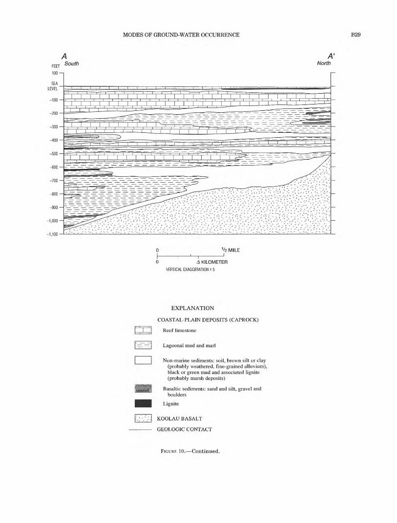
MODES OF GROUND-WATER OCCURRENCE B29
LEVEL
i i i i i i i i i i i
1/2 MILE
0 .5 KILOMETER
VERTICAL EXAGGERATION x 5
EXPLANATION
COASTAL-PLAIN DEPOSITS (CAPROCK)i i [
I | Reef limestone
:=. ^1 Lagoonal mud and marl
Non-marine sediments: soil, brown silt or clay (probably weathered, fine-grained alluvium), black or green mud and associated lignite (probably marsh deposits)
Basaltic sediments: sand and silt, gravel and boulders
Lignite
KOOLAU BASALT
GEOLOGIC CONTACT
FIGURE 10. Continued.

B30 REGIONAL AQUIFER-SYSTEM ANALYSIS-OAHU, HAWAII
Recharge (decreases down slope)
Springs, 1discharge ^^\- '- Knsaturatedzone
'
<"-'/,'V'_- '1^.','? iv Basal water-."'^ -\-V/V/i'>. IN-,Dike complex with dike- impounded freshwater
ground water ,\'/_'._>\
-1,500VERTICAL EXAGGERA1ION INCREASED X3 BELOW SEA LEVEL
EXPLANATION
COASTAL-PLAIN DEPOSITS (CAPROCK) Consists of saprolite and overlying coastal-plain sediments
KOOLAU BASALT _V_ WATER TABLE
< GENERALIZED DIRECTIONOF GROUND-WATER FLOW
FIGURE 11. Modes of ground-water occurrence on the island of Oahu.
the inland part of the aquifer is unconfined. The hydraulic head in the aquifer is higher than otherwise would be reached in the absence of the impounding effect of coastal confinement. Beneath the confining unit in the coastal zone, the freshwater would be prop erly referred to as confined basal water. In an impounded basal-water body, heads in the confined coastal zone are several feet to several tens of feet above sea level. In the unconfined part of the aquifer, the water table rises inland at about 1 to 2 ft/mi. Max imum inland freshwater heads in impounded basal lenses on Oahu typically are about 10 to 40 ft above sea level, with lens thicknesses about 41 times the head above sea level. The highest basal-water head measured on Oahu was 43.5 ft above sea level in the Honolulu area (Stearns and Vaksvik, 1938); this implies that the freshwater lens was nearly 1,800 ft thick. Coastal discharge from an impounded lens is by measurable flow from prominent lowland springs near the inland edge of the sedimentary confining unit and by diffuse, unmeasurable flow through the confining unit. Much of this unmeasurable discharge may leak
into overlying permeable layers of limestone and sedi ment near the inland edge of the sedimentary caprock.
BASAL WATER IN THE SEDIMENTARY ROCKS
Basal water in sedimentary rocks and deposits com monly is no more than 100 ft thick, with water levels not more than several feet above sea level. Most basal water in sedimentary rocks is unconfined and resides in the uppermost aquifers of the coastal-plain sedi ments. Confining beds of clay or soil are common at the base of these aquifers, and freshwater may occupy the entire thickness of the aquifer in some areas, although these areas are laterally contiguous with more shore ward areas of freely floating freshwater. This type of freshwater occurrence has been called "parabasal" by Mink (1976), with the connotation that the fully fresh areas could change to a free-floating lens given lateral intrusion of saltwater and consequent development of a free-floating lens. This occurrence of ground water is of minor significance on Oahu.

REGIONAL AQUIFER SYSTEM B31
HIGH-LEVEL GROUND WATER
Ground water occurs at high altitudes above sea level under two well-known conditions: dike impounded and perched. Dike-impounded, high-level ground water occurs dominantly in the rift zones of the Waianae and Koolau Volcanoes. Perched ground water occurs in the unsaturated zone. A large body of high- level water in the Schofield area of central Oahu differs in occurrence from either dike-impounded or perched ground water.
DIKE-IMPOUNDED WATER
Steeply dipping volcanic dikes impound freshwater to great heights within the rift zones of the Waianae and Koolau Volcanoes. The dikes impede lateral flow of ground water and impound water in compartments, or reservoirs, of permeable lavas (as in fig. 11). The term "dike-impounded water" seems to have evolved during the 1960's, replacing the earlier terms "dike-confined water" and "dike water." The term "dike-impounded water" is used to characterize any water that is enclosed or restrained laterally by dikes. Low-head, dike-impounded freshwater occurs in dry areas where recharge is small and in coastal discharge zones of dike-intruded aquifers. Wherever dikes provide appre ciable impoundment, even at low head, the head is higher than it otherwise would be in the absence of the dikes, and the aquifer will respond to stress differently than if the dikes were not present.
Freshwater in dike-impounded reservoirs reaches altitudes of nearly 2,000 ft above sea level in the rift zones of Oahu and commonly is higher than several hundred feet. Freshwater with such high hydraulic head probably is not supported strictly by hydrostatic balance with saltwater, and freshwater should not be expected to extend as deep as the Ghyben-Herzberg principle would predict because of vertical head loss associated with downward flow. The rocks beneath dike reservoirs probably are progressively less porous and permeable with depth because of increasing numbers of dikes (Takasaki and Mink, 1985). Dike-impounded water contributes to streamflow where valleys inter sect the impounded water table; the impounded water also moves downgradient into basal-water bodies. Flow from dike compartments is thought to be through frac tures and gaps in the dikes and by overflow where impounded water overtops dikes (as shown in fig. 11).
PERCHED GROUND WATER AND WATER IN THE UNSATURATED ZONE
The unsaturated zone is several hundred feet thick throughout much of Oahu and more than 1,000 ft thick in places. This zone includes the layers of soil, sapro-
lite, sediment, and rock that lie above the deepest water table. Within the unsaturated zone, perched water occurs where low-permeability material impedes downward percolation enough to cause localized satu ration. Perched ground water occurs in far less volume than basal or dike-impounded water on Oahu, and it responds more readily to extremes in climate such as droughts and episodic recharge events. It is found in valley-fill deposits, in saprolite, and to a lesser extent where ash beds and soils are intercalated with the lavas. Some of the largest bodies of perched water are associated with alluvium and rocks of the Honolulu Volcanics in valleys of the Honolulu area.
HIGH-LEVEL WATER IN THE SCHOFIELD AREA
A large body of high-level water occurs beneath the Schofield Plateau of central Oahu, and its occurrence and behavior do not resemble dike-impounded or perched types of high-level water. The Schofield high- level water is impounded to a height of about 280 ft above sea level by regional subsurface, geologic structures, probably dikes or weathered, buried volca nic ridges, or a combination of these. The water occurs mainly in permeable Koolau lavas that do not seem to be divided into small dike compartments, except perhaps within the impounding structures themselves. Based on ground-water levels in wells, the potentio- metric surface in the Koolau aquifer is continuous and very flat beneath much of the plateau.
SALTWATER
Rocks beneath the fresh ground water of Oahu are saturated with saltwater, which resides in permeable subaerial lavas to depths of 6,000 to 10,000 ft below sea level (the probable submergence of former subaerial lavas) and in less permeable submarine lavas at greater depths. The thickest known basal fresh-water on Oahu extends to about 1,700 ft below sea level. The maximum depth of dike-impounded fresh-water is not known; however, based on observed heads of a thou- sand feet or more in the rift zones, it is probably considerably more than the thickest basal water, even if Ghyben-Herzberg conditions of simple hydrostatic buoyancy do not strictly apply in the rift zones.
REGIONAL AQUIFER SYSTEM
Aquifer nomenclature for Oahu evolved historically without a consistent approach, resulting in a mixture of named and unnamed aquifer references. Examples of unnamed references are "the highly permeable volcanic-rock aquifer" and "the basal aquifers of the

B32 REGIONAL AQUIFER-SYSTEM ANALYSIS-OAHU, HAWAII
Honolulu area." References to named aquifers have implied correspondence to rock-stratigraphic units, such as the "Waianae aquifer" and "Koolau aquifer," or have invoked other locality names, such as "the Pearl Harbor aquifer." In addition to aquifers, other geo- hydrologic entities have been delineated on the basis of structural boundaries and modes of ground-water occurrence. Various workers have delineated "artesian areas," "isopiestic areas," and "ground-water bodies," for example the "Honolulu isopiestic areas" or the "Waialua basal-water body." Mink and Sumida (1984), noting the lack of an orderly procedure for naming aquifers in Hawaii, proposed a systematic aquifer clas sification for the major islands of Hawaii (later revised for Oahu by Mink and Lau (1990). Their classification is useful for many purposes, but some elements of it do not correspond to identifiable geohydrologic features.
This study defines a regional aquifer system for Oahu based on stratigraphy. Gently dipping lava flows and sedimentary rocks combine to form the regional aquifer system. Within this system rift-zone intrusives and weathered valley-fill sediments cut across bedded lavas at high angles, impeding lateral ground-water flow and causing abrupt lateral discontinuities in potentiometric surfaces. These steeply dipping geo hydrologic barriers (fig. 12C) delineate distinct ground- water areas underlain by the principal aquifers. The result is a regional aquifer system subdivided into dis tinct compartments or areas in plan view (fig. 12A and B). This classification provides a workable con ceptual framework for most hydrologic applications.
PRINCIPAL VOLCANIC-ROCK AQUIFERS AND CONFINING UNITS
The Waianae aquifer in the Waianae Volcanics and the Koolau aquifer in the Koolau Basalt are the two principal volcanic-rock aquifers on Oahu (fig. 1). The sequences of coastal-plain and valley-fill deposits locally form aquifers, but these are of minor importance because of the small volumes of water involved. The two principal volcanic-rock aquifers are composed mainly of thick sequences of permeable, thin-bedded lavas. These aquifers combine to form a layered aquifer system throughout central Oahu, where the Koolau aquifer overlies the Waianae aquifer. They are separated by a regional confining unit, the Waianae confining bed, formed along the Waianae- Koolau unconformity. The unconformity marks the eroded and weathered surface of the Waianae Volcano that was buried by younger Koolau lavas. This surface dips generally east at about 5° to 15° Figure 12C shows the approximate sea-level structure contour of the con fining bed.
Associated with the unconformity are Waianae- derived paleosols, saprolite, weathered volcanic ash, and weathered alluvium. These low-permeability materials form a leaky confining unit of regional extent between the Waianae and Koolau aquifers, causing dis continuities in freshwater heads of several feet between the aquifers. In this report, this confining unit is referred to as the Waianae confining bed, after the aquifer it overlies (following the guidelines in Laney and Davidson, 1986).
No other major confining units at depth are known, and permeable lavas in each aquifer are thought to extend several thousand feet below sea level. Minor confining units are intercalated within the permeable lavas, but have no more than local hydraulic influence. In most coastal areas, sediments overlie and confine the Waianae and Koolau aquifers, impeding freshwater discharge and impounding basal water to great thick nesses. The sediments are referred to as caprock because they confine, or cap, the underlying volcanic- rock aquifers. Coastal-plain sediments also fill the mouths of coastal valleys. The structure and composi tion of the coastal plain sediments near Pearl Harbor are shown in figure 10.
Beneath the caprock, the weathered surface of the volcanic formations also contributes to the confinement of water in the underlying volcanic-rock aquifers. Clay-rich saprolite was reported in many wells just above the depth where artesian heads exist in under lying unweathered or less weathered basalt. Some investigators (McCombs, 1927; Stearns and Vaksvik, 1935) have suggested the saprolite plays a key role in confining the principal volcanic-rock aquifers, but others (Wentworth, 1951) have thought its role to be less certain.
SUBORDINATE AQUIFERS
Numerous subordinate and local aquifers on Oahu are composed of marine deposits, alluvial sediments, and rocks of the Honolulu Volcanics (fig. 1). Although these materials confine water in the volcanic-rock aquifers in a larger sense, they also comprise a system of aquifers and confining units in and of themselves.
GEOHYDROLOGIC BARRIERS AND GROUND-WATER AREAS
The areal hydraulic continuity of the aquifers of Oahu is interrupted in many places by steeply dipping geohydrologic barriers (fig. 12C) that cut across the lay ered lavas at high angles. Two types of barriers are recognized: (1) barriers of structural and lithologic ori gin that are mainly intrusive rocks, but also include other types of massive rock such as ponded lavas; and
REGIONAL AQUIFER SYSTEM B33
EXPLANATION
MAJOR GEOHYDROLOGIC BOUNDARY
TOPOGRAPHIC DIVIDE
WAIALUA-WAHIAWA DISTRICT BOUNDARY
EXPLANATION
MAJOR GEOHYDROLOGIC BOUNDARY
SUBORDINATE GEOHYDROLOGICBOUNDARY Queried where uncertain
BBeretania
Kaimuki Waialae
/ Wailupe-Hawaii -~ KaT
Kaukonahua valley fill and Waianae confining bed i c-^r V^
f-^'b fiKalihi valley fill N
Nuuanu valley fill r Manoa valley fill
EXPLANATION
MAJOR GEOHYDROLOGIC BOUNDARY
SUBORDINATE GEOHYDROLOGICBOUNDARY Queried where uncertain
FIGURE 12. Ground-water areas and geohydrologic barriers, island of Oahu. A, Major ground-water areas. 6, Subordinate ground-water areas within the major areas. C, Geohydrologic barriers.

B34 REGIONAL AQUIFER-SYSTEM ANALYSIS-OAHU, HAWAII
(2) barriers of surficial origin, mainly valley fill depos its, but also including weathered geologic material. These barriers impede and divert ground-water flow and, in some instances, such as in the Schofield Pla teau and in the rift zones, impound ground water to much greater heights than would be reached in the absence of the barriers (figs. 12 and 13).
Structural barriers are deep-rooted features formed during the shield-building phases of the volcanoes. They include rift-zone intrusives, stray dikes that lie somewhat apart from well-defined rift zones, and two extensive impounding structures in the Schofield Pla teau of central Oahu. Structural barriers commonly cause large and abrupt head discontinuities ranging from tens offset to hundreds of feet. Regional contrasts in the principal mode of freshwater occurrence com monly coincide with their locations (for example, the transition from basal water to dike-impounded water). The largest head discontinuities on Oahu are associ ated with dense concentrations of dikes in the rift zones of the Waianae and Koolau Volcanoes (fig. 13).
Surficial barriers result from processes of erosion, sedimentation, and weathering at the surfaces of the volcanic formations. The surficial barriers appear to be more hydraulically conductive than the deep-seated barriers and cause smaller head discontinuities, typi cally no more than several feet. Hydraulic stresses are transmitted either through, beneath, or around these barriers. The most common surficial barriers are sedi mentary valley-fill deposits and underlying saprolite. The valley-fill barriers are superficial, or partially pen etrating, barriers that impede freshwater flow in shallow parts of the volcanic-rock aquifers.
The Schofield Plateau in central Oahu is bounded on the north and south by geohydrologic barriers of an undetermined type (fig.!2C), referred to as ground- water dams by Dale and Takasaki (1976). They may be zones of intrusive rock, but they also appear to be asso ciated with an erosional surface on Waianae Volcanics now buried by Koolau Basalt. These barriers may be a composite of dike-intruded rock, a buried erosional sur face, and massive lavas. They are discussed in more detail later in this section of this report.
The island of Oahu has been divided into seven major ground-water areas (fig. 12A) that are delin eated by deep-seated, structural, geohydrologic barri ers. These areas are southern Oahu, southeastern Oahu, the Koolau rift zone and the Kahuku area of windward Oahu, north-central Oahu, the Waianae rift zone, and the Schofield area. Hydraulic continuity within these seven areas generally is high and the potentiometric surface is smoothly continuous except in rift zones where dikes cause numerous local discon tinuities. Some of these areas, notably southern Oahu
and north-central Oahu, are further subdivided by sub ordinate surficial geohydrologic barriers. Delineation of the ground-water areas follows the convention of earlier investigators with modifications, and provides a useful context for discussions of regional flow and com parisons to earlier studies. The locality names assigned to the ground-water areas are ones that have been cited most frequently in previous reports.
The Koolau rift zone along the eastern or windward side of the island and the Waianae rift zone to the west constitute two of the major ground-water areas. Both of these areas contain dike-impounded ground water. The boundaries of the rift zones are slightly modified from those of Dale and Takasaki (1976) and Takasaki and Mink (1985). The absence of outcrop exposures or water-level measurements in the vicinity of these boundaries precludes an accurate delineation of the rift zones. The boundaries described for the two rift zones in this report are intended to include all areas likely to contain significant numbers of dikes.
The north-central Oahu ground-water area (fig. 12A), which contains basal lenses of freshwater with some confinement along the coast, is bounded on the east by the Koolau rift zone, on the south by the north Schofield ground-water barrier, on the west by the Waianae rift zone, and on the north by the sea. It is divided into three subordinate ground-water areas the Mokuleia, Waialua, and Kawailoa areas each of which contains a basal freshwater lens. The Waianae confining unit was considered by Dale (1978) to be the principal geohydrologic barrier separating the Mokuleia and Waialua areas, but valley-fill sediments in Kaukonahua Valley (fig. 12C) also may inhibit the lateral flow of ground water between the two areas. Valley-fill sediments in Anahulu Gulch (fig. 12C) form a barrier between the Waialua area and the Kawailoa area (Dale, 1978). The effect of this valley-fill barrier can be expected to diminish inland with increasing alti tude and decreasing aquifer penetration by the valley. At some distance inland from the coast, the potentio metric surfaces and freshwater lenses of the Waialua and Kawailoa areas probably are continuous.
The Schofield ground-water area (fig. 12A) encom passes much of the Schofield Plateau of central Oahu. It is bounded by the Koolau and Waianae rift zones on the east and west, and by the north and south Schofield ground-water barriers. Within the Schofield area, ground water is impounded to altitudes of about 280 ft above sea level (fig. 13). Ground water in this area is considered to be high level, but it does not appear to be divided into numerous small compartments like the dike impounded water in the rift zones.
Schofield high-level water was discovered in 1936 during construction of Schofield Shaft, a water-
REGIONAL AQUIFER SYSTEM B35
158°Kahuku Point
4 MILES
21°30'
21°20'
Barbers Point
Base modified from U.S. Geological Survey digital data, 1:24,000,1983, Albers equal area projection, standard parallels 21°15' and 21°45', central meridian 157°59'
EXPLANATION
Ewa SUBORDINATE GROUND-WATER AREA Annotated with mixed case
MAJOR GEOHYDROLOGIC BOUNDARY
- SUBORDINATE GEOHYDROLOGICBOUNDARY Queried where uncertain
24 WATER-LEVEL CONTOUR Shows altitude of water level. Contour interval in feet, is variable. Datum is mean sea level
(165) POINT OBSERVATION OF ALTITUDE OF WATER LEVEL, IN FEET ABOVE MEAN SEA LEVEL
(24) REPRESENTATIVE WATER LEVEL WHERE WATER TABLE IS TOO FLAT TO BE CONTOURED, IN FEET ABOVE MEAN SEA LEVEL
FIGURE 13. Ground-water areas and potentiometric surface in the principal volcanic aquifers of the island of Oahu (compiled from previous studies by the U.S. Geological Survey).

B36 REGIONAL AQUIFER-SYSTEM ANALYSIS-OAHU, HAWAII
development tunnel intended to tap thick basal water thought to lie beneath the site. The areal extent of the high-level water was inferred (Swartz, 1939, 1940) by mapping electrically conductive saltwater beneath freshwater and delineating the apparent absence of saltwater within the depth range of the soundings, over much of the Schofield Plateau. Swartz suggested two lines, or boundaries, that defined the northern and southern limits of high-level water. Later, wells con firmed the presence of high-level water throughout the Schofield area with a potentiometric level of about 280 ft above mean sea level and interannual fluctuations of about 15 ft.
Wells drilled in the area of the barriers have ground- water levels that are transitional between the typical Schofield level of about 280 ft above mean sea level and the basal-water levels of about 20 ft above sea level to the north and about 30 ft above sea level to the south. Several wells in the western Schofield area appear to have been drilled into the ground-water barriers. In the northern barrier, water levels in two wells have been measured at 130 and 165 ft above sea level (fig. 13), values that are transitional between Schofield high-level water and basal water to the north. The wells in the transitional area also have low unit specific capacities of 0.26 and 0.61 (gal/min)/ft, which are lower, by a factor of 2 to 10, than the specific capacities of the nearest wells that tap high-level water just south of the northern ground-water barrier. These specific capacities also are lower, by a factor of 10 to 20, than the minimum value cited as characteristic of dike free lavas by Takasaki and Mink (1982). Drillers' logs for these wells do not mention dikes or weathered material.
Transitional water levels also have been observed at the western end of the southern ground-water barrier (fig. 12C, fig. 13) in seven wells that span a distance of less than 0.4 mi normal to the trend of the barrier. The near-surface bedrock at the site has been mapped as Koolau Basalt, but a prominent ridge of dike-intruded Waianae Volcanics lies just to the west and plunges eastward in the subsurface. Water levels in the two northernmost wells are close to the Schofield high-level head of about 280 ft above sea level. However, water levels in the more southerly wells, about 1,000 ft away, are about 190 to 210 ft above sea level and appear to be stepped, suggesting separate compartments. Measure ments of the water level in one well showed a temporal change of 60 ft (Visher, no date), greater than is typical for wells that tap the Koolau aquifer in the Schofield area. Drillers' logs and descriptions of core samples and cuttings from these wells indicate weathered rock at various depths in several of the wells. On the basis of rock-sample examinations and by projecting the slope
of the nearby Waianae ridge in the subsurface, J.F. Mink (U.S. Geological Survey, written commun., 1959) concluded that several of the wells with transitional water levels had likely penetrated Waianae Volcanics at depth. Thus, weathered and dike-intruded Waianae Volcanics may be associated with at least the western part of the southern ground-water barrier.
These observations prompted Dale and Takasaki (1976) to revise the boundaries of the area, adding fur ther detail in delineating the two barriers in the areas of transitional water levels. Dale and Takasaki (1976) also suggested that the low-permeability rocks of the barriers consisted of either volcanic dikes or weathered bedrock, probably the latter.
Additional indirect information has been provided by surface geophysical surveys, primarily electrical resistivity soundings and profiles (Zohdy and Jackson, 1969; Kauahikaua and Shettigara, 1984; Shettigara, 1985; Shettigara and Peterson, 1985; Shettigara and Adams, 1989). The geophysical interpretations differ somewhat from the representation of Dale and Takasaki (1976), but probably do not warrant substan tial revision.
The southern Oahu ground-water area is bounded on the east by the Koolau and Kaau rift zones, on the north by the south Schofield ground-water barrier, on the west by the Waianae rift zone, and on the south by the sea. It has been subdivided into six subordinate ground-water areas (fig. 12B), mostly by valley-fill type barriers. Each of the areas contains a basal freshwater lens. The Ewa area on the west is underlain by the Waianae Volcanics and originally was identified as a separate major ground-water area based on differences in ground-water levels with the adjacent Pearl Harbor area. Stearns and Vaksvik (1935) recognized that this head difference was caused by the Waianae confining unit along the Waianae-Koolau unconformity. Without further explanation, Visher and Mink (1964) placed the boundary between the Ewa area (area 11 of Visher and Mink, 1964) and the Pearl Harbor area (area 6 of Visher and Mink, 1964) at the approximate location of the sea-level structure contour of the Waianae confin ing unit. The location of the boundary in the present study has been revised slightly following Eyre (PR. Eyre, U.S. Geological Survey, written commun., 1991) to better reflect the presumed constructional-dome shape of the now-buried Waianae Volcano.
The Pearl Harbor, Moanalua, Kalihi, Beretania, and Kaimuki ground-water areas of southern Oahu (fig. 12B) are separated by valley-fill geohydrologic bar riers (fig. 12C). As in north-central Oahu, the effective ness of the barriers may diminish inland from the coast with increasing altitude and decreasing penetration of the valleys into the underlying basalt. The boundary
REGIONAL AQUIFER SYSTEM B37
between the Pearl Harbor and Moanalua areas has been revised from South Halawa Valley to North Hal- awa Valley (fig. 5) following Eyre (P.R. Eyre, U.S. Geo logical Survey, written commun., 1991). Eyre reasoned that North Halawa Valley is deeper than South Halawa Valley and, therefore, is a more appropriate boundary between the two areas. This interpretation is consis tent with Wentworth (1951). The curved trend of this barrier reflects an assumed paleodrainage pattern in southern Oahu before island subsidence and sediment infilling of the valleys. The Kaimuki area is bounded on the east by the Kaau rift zone and, perhaps, by valley fill in Palolo Valley (fig. 5).
The southeastern Oahu ground-water area is divided into two subordinate ground-water areas, both of which contain a basal freshwater lens (fig. 12B). The major area is bounded on the north by the Koolau rift zone and on the west by the Kaau rift zone (fig. 12C). The subordinate Waialae and Wailupe-Hawaii Kai ground-water areas are separated by an ill-defined zone of northeast-trending dikes (Takasaki and Mink, 1982). Numerous dikes within the Kaau rift zone create an effective hydraulic separation between the Waialae area and the Kaimuki area of southern Oahu to the west (Takasaki and Mink, 1982), although the separation of these two areas previously was considered to be an intervening valley fill (Wentworth, 1951).
Along the northeast coast of windward Oahu is the Kahuku ground-water area. Ground water occurs here as a basal freshwater lens. Valleys in the Kahuku area are not as deep as those of the Honolulu area and are more comparable to the shallower gulches of the Pearl Harbor area and, perhaps, to Anahulu Gulch. The depth and width of valleys increases progressively from narrow V-shaped gulches to broader U-shaped valleys toward the south. The deeper, southernmost valleys likely compartmentalize the Koolau aquifer consider ably. However, there are too few wells to allow separate ground-water areas to be distinguished as they have elsewhere on Oahu. The shallower and more northern valleys (fig. 14) cause only slight reentrants in mapped water-level contours. This suggests that the northern valley fills penetrate the freshwater zone of the Koolau aquifer only partially, causing only slight interruption of freshwater continuity and flow. The more pro nounced reentrants in the lines of chloride concentra tion (fig. 14) probably are more a result of heavy pumping at particular wells than they are a function of the depth of valley incision.
There is generally a high degree of hydraulic conti nuity and a smoothly continuous potentiometric surface in the volcanic-rock aquifers in each ground- water area. In the rift zones, however, dikes divide the
volcanic-rock aquifers into numerous compartments and cause stepped discontinuities in the potentiometric surface. The degree of hydraulic continuity among con tiguous areas depends on the nature of the geohydro- logic barrier that separates them. The structural barriers separating major ground-water areas are highly effective impediments to flow; steep hydraulic gradients are required to transmit water through the barriers, and hydraulic stresses in a given ground- water area are not transmitted readily to adjacent areas. For example, in the Koolau rift zone, water is impounded by dikes, and ground water levels are as much as 1,000 ft higher than in adjacent central Oahu and Kahuku areas. Movement of water from the rift zones to adjacent ground-water areas occurs as flow through fractures in the dikes and overflow at the top of dike compartments.
A greater degree of hydraulic connection exists among the subordinate ground-water areas delineated on the basis of surficial barriers than exists among those areas delineated by dikes. Valley-fill deposits and saprolitic zones have low permeability compared to the volcanic rocks. Where the valleys are sufficiently shal low, considerable amounts of freshwater may flow beneath or inland of the valley-fill barriers from one area to another. The Waianae confining bed also appears to be a comparatively leaky barrier, based on freshwater head differences of only several feet between the Waianae and Koolau aquifers. If the small head difference is a true indication of hydraulic conduc tivity, then conditions in either aquifer are highly dependent on conditions in the other, and their hydraulic behavior is best analyzed jointly.
TRANSIENT HYDRAULIC BEHAVIOR OF THE AQUIFER SYSTEM
Hydraulic responses within the Waianae and Koolau aquifers depend on the nature and magnitude of hydraulic stresses and on characteristics of the aqui fers, including aquifer thickness and areal extent, aquifer hydraulic conductivity and specific yield, and the geometries and hydraulic conductivities of confin ing units and lateral barriers. In most parts of the aqui fer system of Oahu, the combination of large hydraulic stresses, high permeability, and limited aquifer extent result in bounded-aquifer behavior rather than infinite-aquifer behavior. High rates of freshwater withdrawal result in declines in freshwater head that extend rapidly to lateral aquifer boundaries. Declines in freshwater head are accompanied by lens thinning, reduced freshwater discharge from head-dependent discharge boundaries along the coast, and possibly additional induced inflow across barriers from upgradi- ent areas of higher head. Changes in freshwater head

B38
158° 21°45'
REGIONAL AQUIFER-SYSTEM ANALYSIS-OAHU, HAWAII
158° 157°55'
T
21°40'
Base modified from U.S. Geological Survey digital data, 1:24,000,1983, Albers equal area projection, standard parallels 21°15' and 21°45', central meridian 157°59'
2 MILESJ
2 KILOMETERS
Pacific Ocean
12
--50--
EXPLANATION
COSTAL-PLAIN DEPOSITS (CAPROCK)
KOOLAU BASALT
GEOLOGIC CONTACT
WATER-LEVEL CONTOUR Shows altitude of water level in 1963. Contour interval, 1 foot. Datum is mean sea level
LINE OF EQUAL CHLORIDE CONCENTRA TION Interval, in milligrams per liter is variable
HEAVILY PUMPED WELL
LIGHTLY PUMPED WELL
FIGURE 14. Effects of valley-fill barriers on water level and chloride concentration in the Koolau aquifer, Kahuku area, island of Oahu (modified from Takasaki and Valenciano, 1969, fig. 27).
REGIONAL AQUIFER SYSTEM B39
and lens volume establish saltwater head gradients that induce inflow or outflow of saltwater. Saltwater flow impeded by low-permeability materials at aquifer boundaries contributes to bounded-aquifer response.
Mink (1980) provided an example of bounded- aquifer response in the Koolau aquifer by analyzing transient drawdowns that accompany seasonal pump ing in the Pearl Harbor area of southern Oahu. Mink used image-well superposition to compute departures from infinite-aquifer transient response. Using assumed boundaries on four sides of the aquifer, he found that, after a pumping season of about 200 days, drawdowns attributable to boundaries were roughly equal to drawdowns caused by the pumping wells themselves. Bounded responses may be even more pro nounced in smaller ground-water areas such as the Kalihi, Beretania, and Kaimuki areas of southern Oahu (fig. 12B) because of their intervening valley-fill barriers. Fluctuations in freshwater head also influ ence flow at head-dependent boundaries, such as spring discharge and seepage through coastal confining units.
Transient water-level fluctuations are strikingly similar in both character and magnitude in some of Oahu's ground-water areas (fig. 15), but are dissimilar in others. Similarity in fluctuations may indicate good hydraulic connection between contiguous areas or could arise by coincidence if the areas have similar recharge or pumping stresses. On the other hand, dis similarities in water-level fluctuations likely indicate that an effective hydraulic barrier separates the two areas and that hydraulic stresses or boundary condi tions are dissimilar. Long-term water-level variations are similar in each of the ground-water areas (fig. 15), although the amplitude of the variations is subdued in the Waialua area of north-central Oahu, the Ewa area of southern Oahu, and the Waialae area of southeast ern Oahu, and is more pronounced in the Schofield area and the Beretania and Pearl Harbor areas of southern Oahu. The subdued seasonal fluctuations of water lev els in the Schofield area are presumed to indicate the seasonal occurrence of recharge because these water levels are influenced mainly by natural recharge and discharge and are influenced little by pumping. Water- level changes observed in the Schofield area are evident in the other areas, although the amplitude is smaller elsewhere.
Seasonal water-level fluctuations also occur in most of the areas. Seasonal fluctuations in the Beretania, Pearl Harbor, and Ewa areas of southern Oahu are large in amplitude and about 6 months out of phase from water-level fluctuations in the Schofield area; the variations in these areas primarily reflect the magnitude and timing of large, seasonal, domestic and
agricultural pumping (Stearns and Vaksvik, 1935). Pumping-induced drawdown in these areas recovers rapidly when pumping is curtailed. In heavily pumped areas, the immediate recovery response precedes and obscures the water-level rise caused by seasonal recharge, which, in turn, probably lags precipitation by several months. Rapid drawdown and recovery responses to pumping have been reproduced in numer ical simulations of the Pearl Harbor area by Souza and Voss (1987).
In a given ground-water area, the magnitude of sea sonal and annual water-level fluctuations reflects the magnitude of transient variations in recharge and dis charge from average values and, perhaps, the degree of hydraulic isolation by lateral barriers and coastal con fining units. For example, water-level fluctuations in the Ewa area of southern Oahu and the Waialae area of southeastern Oahu are much smaller than those in the adjacent Pearl Harbor and Beretania areas of southern Oahu. This demonstrates the hydraulic effectiveness of the intervening geohydrologic barriers that separate these areas. The Waianae confining bed apparently is sufficiently low in hydraulic conductivity that pronounced water-level fluctuations in the Koolau aquifer in the Pearl Harbor area are not fully transmit ted to the underlying Waianae aquifer in the Ewa area. The smaller seasonal fluctuations in the Waianae aqui fer could represent a damped response to the Koolau fluctuations, a response to local pumping in the Ewa area, or more probably a combination of both. The recharge area of the Waianae aquifer in the Ewa area also is much drier than the recharge area of the Koolau aquifer, likely limiting the magnitude of recharge- induced seasonal and interannual fluctuations. The lack of similarity of fluctuations of water levels in the Waialae area of southeastern Oahu to those in south ern Oahu demonstrates the hydraulic effectiveness of the Kaau rift-zone barrier.
The water-level record (fig. 15) of the Waialua area in north-central Oahu (fig. 125) also shows a much smaller range of seasonal and interannual variation than the Schofield area or the Pearl Harbor and Beretania areas of southern Oahu (fig. 12B). The smaller seasonal variation may reflect a smaller ratio of pumpage to ground-water recharge, although agri cultural pumpage in the Waialua area is large and as strongly seasonal as in the Pearl Harbor area. The smaller variation may reflect less variability in recharge and, perhaps, less effective hydraulic bound aries in the Koolau aquifer in the Waialua area than in southern Oahu. Lesser confinement by coastal sedi ments in north-central Oahu may impart a leakier coastal boundary condition than occurs in southern Oahu, requiring smaller head differentials to effect
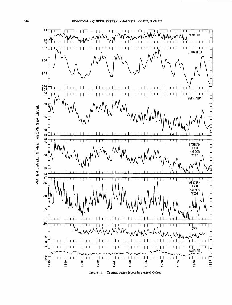
B40 REGIONAL AQUIFER-SYSTEM ANALYSIS-OAHU, HAWAII
14
10
285
I | | I I I | | I I I U WAIALUA
I i i I I I i i i
I I ' ' ' I I i i i I I i i i I SCHOFIELD
280
275
270269
34
LU>LU
LU CO
LU >oDO
LU LU LL
LU >LU
DC LU
30
25
20
18
i i i i i i i i i i i i i i i i i i i i i i i i i i i i i i i i i i i i i iEASTERN
PEARLHARBOR
FIGURE 15. Ground-water levels in central Oahu.

GROUND-WATER FLOW SYSTEMS B41
transient adjustments in recharge and discharge of ground water.
GROUND-WATER FLOW SYSTEMS
The aquifers of Oahu contain two fundamental ground-water systems: shallow freshwater and deep saltwater. Fresh ground water floats on underlying saltwater in a condition of buoyant displacement. The natural driving mechanisms for freshwater and salt water flow differ. Most freshwater flow is driven by gravity from inland recharge areas at higher altitudes to discharge areas at lower altitudes near the coast. Remnant volcanic heat may drive geothermal con vection of freshwater at great depths in the rift zones. Saltwater flow is driven by changes in freshwater vol ume and in sea level, and by dispersive and geothermal convection.
Four separate fresh ground-water flow systems are defined and described by this study: (1) the eastern Oahu flow system, (2) the central Oahu flow system, (3)
the western Oahu flow system, and (4) the south eastern Oahu flow system (fig. 16). The central Oahu ground-water flow system is further divided into northern and southern parts. The northern part of the central Oahu flow system encompasses the north- central Oahu ground-water area and the northern part of the Schofield area. The southern part of the central Oahu flow system encompasses the southern part of the Schofield area and the southern Oahu ground- water area (fig. 12A and B, table 3). Meteoric fresh water flow diverges from ground-water divides that lie somewhere within the Waianae and Koolau rift zones, forming an interior flow system in central Oahu, exte rior flow systems in western (Waianae area) and eastern (windward) Oahu, and a small flow system in southeastern Oahu. The exact location of the ground- water divides is not known but, following a common arbitrary convention, they are shown as coinciding with topographic divides for diagrammatic purposes. Despite this convention, ground-water divides need not coincide with the topographic divides, and their
TABLE 3. Ground-water areas and geohydrologic boundaries within the principal volcanic aquifers of the island of Oahu
dikes and valleys cause numerous interruptions). Principal aquifer: Aquifer (Waianae or Koolau) having greatest areal extent within depths of freshwater occurrence. Principal freshwater occurrence: Basal, dike impounded, or high level.Geohydrologic boundary: Marks a major contrast in mode of freshwater occurrence, or a barrier that impedes flow and causes an abrupt potentiometric discon tinuity.
Ground-water area
Principal aquifer
Principal fresh water occurrence Geohydrologic boundaries
Eastern Oahu ground-water flow systemKoolau rift zone
Kahuku area
Koolau
Koolau
Dike impounded Rift zone boundaries. The southern part or the area is deeply dissected, leaving isolated volcanic interfluves
Basal Valley fills probably impede flow
Western Oahu ground-water flow systemWaianae rift zone
Schofield area
Southern Ewa area Pearl Harbor area Moanalua area Kalihi area1 Beretania area1 Kaimuki area1
Waianae Dike impounded Kilt zone boundaries. The western part of the area is deeply dissected, leaving isolated volcanic interfluves
Central Oahu ground-water flow systemNorth-central
Mokuleia area Waialua area Kawailoa area
Waianae Koolau Koolau
Basal Basal Basal
Kaukonahua valley fill and Waianae confining unit Anahulu valley fill Northern Schofield ground- water dam
Koolau
Waianae Koolau Koolau Koolau Koolau Koolau
High level Southern Schofield ground-water dam
Basal Waianae confining unitBasal North Halawa valley fillBasal Kalihi valleyBasal Nuuanu valley fillBasal Manoa valley fillBasal Kaau rift zone, Palolo valley fill (?)
Southeastern Oahu ground-water flow systemWaialae area Wailupe-Hawaii Kai area
Koolau Basal Northeast-trending dikesKoolau Basal Valley fills likely subdivide the area further, though water-
level measurements are too sparse to define subdivisions xThe Kalihi, Beretania, and Kaimuki areas also are known collectively as the Honolulu area.

B42 REGIONAL AQUIFER-SYSTEM ANALYSIS-OAHU, HAWAII
158°Kahuku Point
024 MILES I , 024 KILOMETERS
21°30'
WESTERN OAHU
Waianae> GROUND-WATER
21°20'
/ ^ - __ ~> Makapuu yOUTHEASTERNOAHU} Point
Barbers Point
Base modified from U.S. Geological Survey digital data, 1:24,000,1983, Albers equal area projection, standard parallels 21°15' and 21°45', central meridian 157°59' Contours from U.S. Geological Survey digital elevation model data, 1:250,000,1986
EXPLANATION
CENTRAL OAHU GROUND-WATER FLOW SYSTEM
MAJOR GEOHYDROLOGIC BOUNDARY
SUBORDINATE GEOHYDROLOGIC BOUNDARY Queried where uncertain
DISTRICT BOUNDARY
ARROW INDICATES GENERALIZED DIRECTION OF GROUND-WATER FLOW
FIGURE 16. Ground-water flow systems and the major areas of the central flow system, island of Oahu.The locations of ground-water divides are not actually known but are here as coinciding with topographic
divides and other surficial boundaries for diagrammatic purposes.

GROUND-WATER FLOW SYSTEMS B43
location may shift in response to transient hydraulic stresses.
Each flow system encompasses one or more ground- water areas within the principal volcanic-rock aquifers, as well as flow through sediments on the coastal plain. Water flows across geohydrologic barriers from areas of higher head to areas of lower head in the volcanic-rock aquifers (fig. 16) then into overlying sediments, where present, and ultimately to the sea. The magnitude of the cross-boundary flow varies around average values of recharge and discharge in response to associated changes in head gradients.
Ground-water recharge for all of Oahu has been esti mated by Shade and Nichols (1996). For the flow sys tems shown in figure 16, predevelopment ground-water recharge, in million gallons per day, is estimated as fol lows:
Flow systemRecharge,(Mgal/d)
Western Oahu flow system,Central Oahu flow system, which includes the
northern Oahu flow system, andthe southern Oahu flow system,
Eastern Oahu flow system, Southeastern Oahu flow system,
Total predevelopment ground-water recharge
32
18435919819
792
These estimates represent all ground-water recharge, including 22 Mgal/d to caprock areas, which does not enter the underlying volcanic-rock aquifers. The significance of the central Oahu flow system is clearly indicated by its estimated ground-water recharge of more than 540 Mgal/d, about 68 percent of the total recharge to Oahu.
RIFT ZONES AND THE EASTERN AND WESTERN GROUND- WATER FLOW SYSTEMS
Dike-impounded ground water in the high-rainfall areas of the mountains in the Koolau and Waianae rift zones is the origin of the regional freshwater flow systems of Oahu. The topographic divide in the Koolau rift zone is shown as the boundary between the eastern Oahu flow system, which includes all of windward Oahu, and the flow systems of central and southeast ern Oahu. Similarly, the topographic divide along the crest of the Waianae Range in the Waianae rift zone is shown as the boundary between the western Oahu ground-water flow system, which encompasses the Waianae area, and the central Oahu flow system. As stated before, the actual locations of the ground-water divides are not truly known.
The orographic effect of the mountainous terrain causes high rates of precipitation, and hence recharge, in the rift zones. Ground water is impounded by dikes
to altitudes as high as 1,600 ft above sea level in the Waianae rift zone and to nearly 1,000 ft in the Koolau rift zone. Both rift zones are deeply dissected by erosion, and much of their area is occupied by broad, U-shaped, amphitheater-headed valleys filled with alluvium and marine sediments. Ground-water flows from the high, dike-impounded reservoirs of the rift zones to downgradient parts of the volcanic-rock aquifers (fig. 13).
Ground water in the eastern Oahu flow system, on the windward side of the Koolau Range, moves down- gradient in the rift zone from near the crest of the range to the sea. The land surface of the entire breadth of the northern part of the rift zone is above the poten- tiometric surface resulting in a recharge area. In the central and southern parts of the flow system where the rift zone is more dissected by erosion (fig. 3), the potentiometric surface is at or near land surface (except near the crest of the range), causing ground- water discharge, high evapotranspiration, and rejec tion of recharge. Dike-impounded ground-water levels in the mountains range from 600 to 1,000 ft above sea level (fig. 13; Takasaki and Mink, 1985). As valleys erode deeper into the rift zone, successive dikes are breached and ground water flows parallel to the dikes, toward the breaching valley. A valley that penetrates deeply into the mountains cuts more dikes and diverts more ground water from behind the dikes not yet cut by less deeply penetrating valleys (Takasaki and Mink, 1985).
In the northern part of the eastern Oahu flow sys tem, ground water from the rift zone flows into the freshwater lens of the Kahuku area. A narrow band of caprock along the northeast Oahu coast confines the lens, and freshwater heads rise inland to about 22 ft above sea level in the southern part of the Kahuku area and about 10 ft above sea level in the northern part of the area (fig. 13). If flow is normal to the head contours, water flows generally toward the coast at a somewhat oblique angle, having an alongshore directional compo nent. This suggests a component of alongshore ground- water flow to the north, where coastal sediments may be particularly thin or permeable. However, there prob ably is considerable discharge of freshwater all along this coast and not just at the northern end of the area.
Shade and Nichols (1996) estimated the mean annual recharge rate to the eastern Oahu ground- water flow system of windward Oahu to be about 198 Mgal/d. Of this, nearly 4 Mgal/d is recharge directly to the Kahuku area; the remaining 98 Mgal/d (P.J. Shade, U.S. Geological Survey, written commun., 1991) is to the eastern part of the rift zone inland from the Kahuku area (from the eastern rift-zone boundary to the topographic divide). Some of the recharge flows

B44 REGIONAL AQUIFER-SYSTEM ANALYSIS-OAHU, HAWAII
parallel to the rift zone and discharges to the sea on the north, some flows south toward deeper valleys that breached the impounding dikes, but much of it is pre sumed to flow downgradient to the freshwater lens of the Kahuku area.
The western Oahu ground-water flow system is in the Waianae rift zone, west of the crest of the Waianae Range, and is coincident with the Waianae area of pre vious investigations (Zones, 1963; Takasaki, 1971). Ground water in this system flows generally west from near the crest of the Waianae Range to the sea. The west slope of the Waianae Range is deeply dissected; within the shallow depths penetrated by wells, the Waianae aquifer is present only as narrow interfluvial ridges separated by valley-fill sediments in intervening valleys, which may be incised to at least 1,200 ft below sea level. The combination of dikes in the rift zone and thick valley fills results in a flow system in which the volcanic-rock aquifer has little regional hydraulic con tinuity. Ground-water recharge to the western Oahu flow system (Waianae area) is estimated to be about 32 Mgal/d of which about 6 Mgal/d is transpired by phreatophytes in lowland areas and about 26 Mgal/d discharges to the sea (Shade and Nichols, 1996).
CENTRAL FLOW SYSTEM
Because the determination of ground-water flow and availability in central Oahu is of considerable hydro- logic and economic significance, the present under standing of the movement of ground water through this area is discussed in some detail. The northern and southern parts of the central Oahu ground-water flow system (fig. 16) contain large quantities of basal fresh water in the Waianae and Koolau aquifers. Early ground-water development in both areas was primarily from free-flowing artesian wells open to confined parts of the aquifers near the coast, and from springs near the surficial basalt-caprock contact. Pumpage histori cally has been large in southern Oahu (fig. 12A) and in the Waialua area of north-central Oahu (fig. 12S), with agricultural pumpage constituting a large part of total pumpage and imparting strong seasonality to the draft. Pumpage in the Mokuleia and Kawailoa areas of north-central Oahu (fig. 12.B) has been small in com parison to that in southern Oahu and Waialua. South ern Oahu is the most heavily developed area of Oahu and serves as the island's principal source of freshwa ter. It is the most intensely studied area of the Hawai ian islands, with the Honolulu and Pearl Harbor areas (fig. 12.B) receiving particularly detailed attention since the early 1900's. Much of the present knowledge of ground-water hydrology in Hawaii has come from the study of southern Oahu.
The central Oahu flow system encompasses the greatest extent of the island. Flow originates in the high-rainfall areas of the Waianae and Koolau rift zones and continues downgradient to the ground-water areas of the central Oahu plateau, diverging to the north and south somewhere within the Schofield area. Predevelopment ground-water recharge to the central Oahu flow system was estimated to be about 543 Mgal/d; recharge to noncaprock areas of the flow system was estimated to be about 521 Mgal/d, about 68 percent of the total predevelopment recharge to non caprock areas of the island of Oahu (Shade and Nichols, 1996). Of this amount, about 199 Mgal/d, or 38 percent, was recharge as infiltration of precipitation and ground-water underflow from the rift zones to the Schofield area (fig. 12A).
Much of the inland part of the central Oahu ground- water flow system is dominated by the high-level ground water of the Schofield area (figs. 12A, 16). The Schofield area is bounded on the east and west by the Koolau and Waianae rift zones, where dike-impounded water stands several hundred feet higher than Schofield high-level water. Ground-water flow is pre sumably as underflow from the rift zones into the Schofield area and then out of the Schofield area to the north and south, with flow diverging from a poorly defined ground-water divide somewhere within the Schofield area (although the location of the divide is not known, it is shown for diagrammatic purposes in figure 16 as coinciding with the Waialua-Wahiawa district boundary which is near the northern boundary of the Schofield plateau). Underflow out of the Schofield area is controlled by the north and south Schofield ground- water barriers.
Precipitation and recharge are high in the Schofield area, and even higher in the upgradient Koolau rift zone. Dale and Takasaki (1976) estimated a total inflow of 126 Mgal/d to the Schofield area, of which 74 Mgal/d was direct infiltration from precipitation, and 52 Mgal/d was ground-water underflow from the adja cent Koolau rift zone. They assumed that the part of the rift zone west of the Koolau topographic divide was tributary to the Schofield area. These estimates are based on a water budget approach where recharge is the residual of precipitation minus runoff minus evapo- transpiration. Runoff was estimated as a linear func tion of precipitation based on a study by Hirashima (1971), and evapotranspiration was estimated as a function of precipitation using an equation developed by Takasaki and others (1969) for windward Oahu. Applying the same tributary assumption to the areal distribution of recharge computed by Shade and Nichols (1996), total recharge to the Schofield area is estimated to be about 199 Mgal/d, considerably more

GROUND-WATER FLOW SYSTEMS B45
than previous estimates. About 79 Mgal/d of the recharge is from direct infiltration of precipitation and about 120 Mgal/d is underflow from the Koolau and Waianae rift zones.
Estimates of north-south ground-water underflow from Schofield have varied. Dale and Takasaki (1976), by comparing estimated discharge from the down- gradient areas to their estimate of water surplus for Schofield, inferred that 115 Mgal/d of Schofield high- level water flows south to the Pearl Harbor area and 18 Mgal/d flows north to the Waialua area. The under flow out of the Schofield area estimated by Dale and Takasaki (1976) exceeded their estimate of recharge by 7 Mgal/d. This difference was attributed to data errors or faulty assumptions (Dale and Takasaki, 1976). Using a lumped-parameter model to estimate ground- water levels of southern Oahu, Mink and others (1988) estimated underflow of 76 Mgal/d from the Schofield area to the southern Oahu area. A numerical simula tion of ground-water flow in the southern Oahu area (Eyre and Nichols, 1996), which included the southern part of the Schofield area, estimated underflow from the Schofield area to be about 88 Mgal/d for predevel- opment conditions and about 92 Mgal/d for 1950's land- use conditions. The areally distributed recharge esti mate of Shade and Nichols (1996) suggests about 103 Mgal/d of underflow from the Schofield area to south ern Oahu for predevelopment conditions. Their esti mates also suggest about 96 Mgal/d as underflow northward from the Schofield area to the north-central Oahu area. This is a significantly higher rate than esti mated by previous studies.
Southern and north-central Oahu also are recharged by direct infiltration of precipitation, as well as the underflow from the adjacent rift zones. For the nonca- prock areas of the northern and southern Oahu flow systems, the following recharge rates were estimated for predevelopment conditions (Shade and Nichols, 1996):
Recharge
Recharge Component Total(Mgal/d) (Mgal/d)
Northern Oahu Flow System
Direct infiltration to
North-central Oahu
Northern part of Schofield area
North Schofield barrier
Underflow from
Koolau Rift Zone
Waianae Rift Zone
39
16
108
9
63
117
Recharge
Recharge Component Total (Mgal/d) (Mgal/d)
Southern Oahu Flow System
Direct infiltration to
Pearl Harbor and Ewa areas 142Moanalua, Kalihi, Beretania, and 71
Kaimuki areas ' *
Southern part of Schofield area 45
South Schofield barrier 10
Underflow from
Koolau Rift Zone 62
Waianae Rift Zone H
Total to noncaprock area of central Oahu ground-water flow system
268
73
521
Extensive caprock along the coast of both southern and north-central Oahu strongly affects ground-water flow. By confining water in the Waianae and Koolau aquifers, the caprock impounds basal freshwater to thicknesses of 1,000 ft or more in southern Oahu and the Mokuleia area of north-central Oahu. As a result, the ground-water resource potential is greater in com parison to areas with thinner caprock or no caprock and, thus, thinner freshwater lenses. Throughout southern Oahu, the coastal confining unit reaches thicknesses of 1,000 ft near the coast and just offshore (Gregory, 1980). In comparison, the caprock in north- central Oahu is thinner, less extensive, and probably contains a greater proportion of permeable sediments. It reaches thicknesses of 500 ft or more in the Mokuleia area, 200 ft or more in the Waialua area, and is thin or absent throughout most of the Kawailoa area (Dale, 1978). Natural ground-water discharge from the cen tral Oahu system is by springflow and diffuse seepage at the coast where caprock is absent, by diffuse seepage through the caprock, and by springflow near the inland margin of the caprock where it is thinnest. Much of the spring discharge at the caprock margin may be, in effect, overflow at the top of the caprock. The Pearl Harbor springs (fig. 17) appear to be largely of this nature (Visher and Mink, 1964).
Discharge from the central Oahu flow system is dif ficult to quantify because much of it is by diffuse seep age and minor springflow, both subaerial and submarine. In southern Oahu, much of the freshwater flow in the Koolau aquifer converges to large subaerial springs around Pearl Harbor, which can be measured. Measurements of flow at these springs have enabled a relation to be established between springflow and
B46 REGIONAL AQUIFER-SYSTEM ANALYSIS-OAHU, HAWAII
freshwater head in nearby wells (Stearns and Vaksvik, 1935; Visher and Mink, 1964). Soroos and Ewart (1979) developed a head-discharge relation for total discharge from the Pearl Harbor springs and estimated historical springflow as a function of historical head, for which more continuous measurements are available. A revised version of their graph for several prominent springs is presented (fig. 17); containing about twice the number of measurements as their original. In addi tion to measurable springflow, however, there are also large amounts of diffuse, unmeasurable seepage through the southern Oahu caprock.
Discharge also is difficult to quantify in north-cen tral Oahu. The coastal confining unit diverts ground- water flow nearly parallel to the shoreline, thus water discharges at the east and west ends of the confining unit where coastal sediments are thin or absent. Along the flowpaths that parallel the coast, freshwater prob ably leaks into the sediments and then to the sea. However, available water-level observations are not sufficient to quantify this leakage.
SOUTHEASTERN FLOW SYSTEM
The smallest regional freshwater flow system on Oahu lies at the southeastern end of the Koolau Range where basal water occurs in the Koolau aquifer (fig. 16). Inflow to the Waialae and Wailupe-Hawaii Kai areas of southeastern Oahu is by direct infiltration of precipitation and by underflow of dike-impounded water from the upgradient Koolau rift zone. Infiltra tion of precipitation to the Koolau aquifer was esti mated to be about 19 Mgal/d (Shade and Nichols, 1996), of which about 8 Mgal/d was in the Waialae area and about 11 Mgal/d was in the Wailupe-Hawaii Kai area.
Coastal sediments overlie and confine the Koolau aquifer along the coast and extend inland into the valleys. In the Waialae area, the combination of rift- zone dikes and the thick caprock causes moderate impoundment of freshwater, with inland freshwater heads ranging from 8 to 15 ft above sea level (Eyre and others, 1986). Ground water discharges along the coast predominantly by subaerial and submarine springflow and diffuse seepage; it is unmeasurable for practical purposes, except at a few distinct subaerial springs.
The Koolau aquifer in southeastern Oahu is intruded sparsely by dikes. Few wells have been drilled in the area; therefore, water levels are poorly defined. Other than along the Kaau rift zone, only one disconti nuity in the potentiometric surface resulting from dike impoundment has been recognized. However, scattered dikes appear to impede flow, based on the relatively low regional hydraulic conductivity of 400 ft/d estimated by Eyre and others (1986). This estimate was based on
data from an aquifer test of regional extent in the Waialae area by Wentworth (1938) and is lower than most estimates from tests of dike-free lavas.
DEEP SALTWATER FLOW SYSTEM
Little is known about the saltwater flow system that lies beneath the freshwater flow systems of Oahu. Sev eral mechanisms of saltwater flow, however, can be pos tulated from basic principles or from examples known elsewhere as follows:
1. Saltwater inflow or outflow may be induced by volumetric changes in the floating freshwater lens that depressurize or pressurize under lying saltwater.
2. Saltwater inflow or outflow may be induced by sea-level variations.
3. Circulatory flow may occur when saltwater is entrained and discharged by freshwater flow, thereby inducing a compensating inflow of sea- water (Cooper, 1959).
4. Circulatory flow may occur when thermal gra dients induce density-driven, buoyant convec tion. Geothermal gradients may arise within the island mass from remnant geothermal heat associated with former magma reservoirs or from pervasive conduction from deep within the lithosphere. Thermal gradients also will be established by the temperature-depth profile in surrounding seawater and the contrast between seawater and terrestrial temperatures.
Each of these mechanisms involves exchange of water between the aquifer and sea.
Few measurements of saltwater head have been made on Oahu. Water-level records for well T133, which is open to saltwater at a depth of 1,100 ft, and well 187, which is open only to freshwater, are shown in figure 18. The casing of well T133 apparently has one or more breaks that have allowed brackish water from sediments higher in the stratigraphic section to enter the well and dilute the saltwater; this lowers the fluid density of the saltwater and raises the head correspondingly. Alternatively, the well bottom may be open to the lower part of the transition zone in the Koolau aquifer and thereby not tap 100-percent saltwa ter. The water-level record for the saltwater well has not been corrected for this dilution, which may vary over time; correction for dilution would shift the record downward slightly Regardless of these shortcomings, the well is open in or near the deep saltwater zone of the volcanic-rock aquifer, and it is presumed here that the water-level fluctuations closely reflect fluctuations in saltwater head.
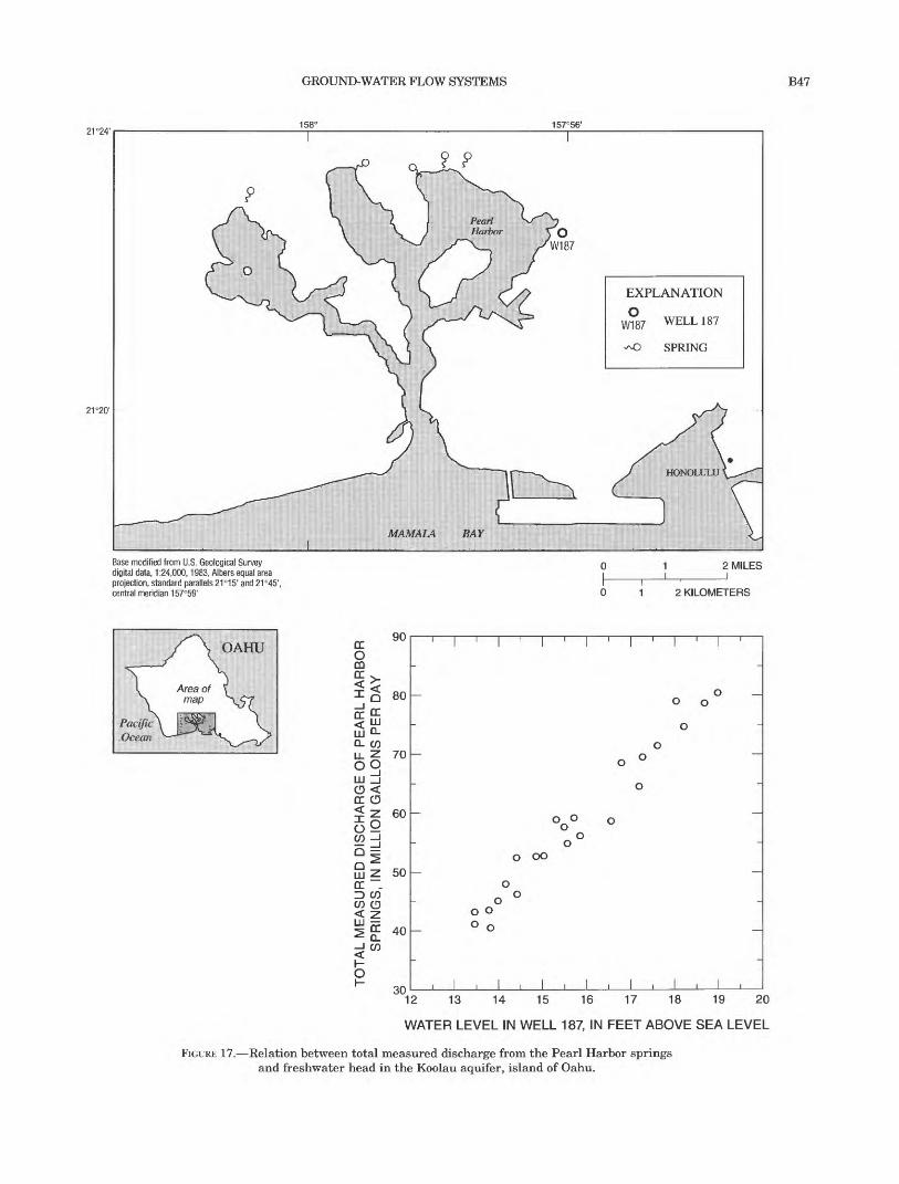
GROUND-WATER FLOW SYSTEMS B47
21=24'158° 157°56'
21°20'
MAMALA BAY
EXPLANATION
0W187
v^O
WELL 187
SPRING
Base modified from U.S. Geological Survey digital data, 1:24,000,1983, Albers equal area projection, standard parallels 21°15' and 21°45', central meridian 157°59'
2 MILES
2 KILOMETERS
OAHU
Pacific Ocean
cc0COCC >.
1 Q 80 ' ~-CC "-
UJ 0-0. COU_ Z 70
2§CD <CC CD$ Z 60o° _iQ ^^~\
Qj Z 50CC .ID COCO CD < Z
«^ CC Af\^ o_ 4U
1-o "an
, | , | , | , | , | , | , | ,
_
_ o _ o o
oo
0 °
o
ooo oo
o
^ o- o o o
_ ° 0
-
, 1,1,1,1,1,1,1, \2 13 14 15 16 17 18 19 2
WATER LEVEL IN WELL 187, IN FEET ABOVE SEA LEVE
FIGURE 17. Relation between total measured discharge from the Pearl Harbor springs and freshwater head in the Koolau aquifer, island of Oahu.

B48 REGIONAL AQUIFER-SYSTEM ANALYSIS-OAHU, HAWAII
Water-level fluctuations in the freshwater well, 187, reflect transient pumping and recharge stresses and are similar to fluctuations observed elsewhere in southern Oahu. It can be seen in figure 18 that the water-level fluctuations in the saltwater well are virtu ally the same as those in the freshwater well, except for a slightly smaller range of variation. The similarity in water-level fluctuations indicates that the volumetric addition and withdrawal of freshwater causes fluctua tions in freshwater and saltwater head of almost equal magnitude and with little discernible lag. Hydraulic stresses wholly within the freshwater zone appear to be transmitted to the underlying saltwater zone with little apparent attenuation, at least in the vicinity of these two wells. In the freshwater zone, freshwater head fluctuates about an average value that is positive with respect to sea level. In the saltwater zone, head should fluctuate about some average saltwater head that is not zero, but in theory must be slightly negative in order to maintain dispersion-driven saltwater circulation (Cooper, 1959).
The saltwater circulation is not steady, but is perturbed by transient fluctuations. Recharge deficit or discharge of freshwater by pumping will tend to lower freshwater heads from their average values; more strongly negative saltwater heads will induce salt-water inflow to the aquifer and allow upward and landward displacement of the freshwater-saltwater interface. Episodically, the addition of recharge will increase heads and expand the freshwater lens; posi tive saltwater heads will force saltwater to flow through the confining unit and out of the aquifer, allow
ing downward and seaward interface displacement. These effects are also mediated by adjustment of other system boundary conditions, for example the head- dependent discharge of freshwater at springs and dif fuse leakage through the confining unit. Visher and Mink (1964) discussed these aspects of transient hydraulics, though without consideration of the effects of the confining unit.
A temperature profile in an uncased test well (Visher and Mink, 1964; in the confined Koolau aquifer in southern Oahu, revealed an isothermal freshwater lens underlain by saltwater at 1,300 ft below sea level that is almost 27°F warmer than ocean water. They attrib uted the higher temperature to slight geothermal heat ing of the relatively immobile saltwater within the aquifer. They further speculated that the isothermal part of the profile was the result of a high rate of fresh water flow that prohibited a geothermal temperature gradient from becoming established in the freshwater lens. These concepts are supported by Souza and Voss (1987), who simulated the regional freshwater-saltwa ter flow system in the same area with a numerical model that incorporated density-dependent flow and solute transport.
The saltwater flow system responded distinctly to the early development of Oahu aquifers after about 1880. This development caused a rapid lowering of freshwater heads and a corresponding shrinkage of basal freshwater bodies, particularly in southern Oahu. Records of salinity for these early wells (Stearns, 1938) indicate a clear pattern of progressive saltwater encroachment, both lateral and vertical, in response to
25
LU 20
<s15
:-s 10LU O> -ILU LU_l CD 5
DC DC LU
* O
i i i i i i i i i i i i i iNOTE: Well locations are shown on figure 10
FRESHWATER WELL 187
1968 1969 1970 1971 1972 1973 1974 1975 1976 1977 1978 1979 1980 1981 1982 1983 1984 1985
FIGURE 18. Water levels in well 187 open to freshwater and well T133 open to saltwater in the Pearl Harbor area, island of Oahu.

SUMMARY B49
hydraulic stress. Visher and Mink (1964) presented a map of chloride concentrations for the Pearl Harbor area that showed progressive inland movement of lines of 200- and 1,000-mg/L (milligrams per liter) chloride concentration between 1910 and 1950. The 1,000-mg/L line shifted about 1.5 mi inland over this time.
SUMMARY
The island of Oahu is formed by the eroded rem nants of the Koolau and Waianae Volcanoes; two elon gated shield volcanoes with broad, low profiles. Weathering and erosion have modified the original domed surfaces of the volcanoes leaving the Koolau Range in eastern Oahu and the Waianae Range in western Oahu. Much of the original mass of these vol canoes has been removed, leaving a landscape of deep valleys and steep interfluvial ridges in the interior highlands. A flat coastal plain underlain by sedimen tary deposits surrounds much of Oahu. The coastal plain varies in width from a narrow marine terrace to a broad plain several miles wide. Where it is extensive, such as in southern Oahu, its surface is composed mainly of emerged Pleistocene reefs and associated sediments.
The shield-building rocks of the Waianae and Koolau Volcanoes are known respectively as the Waianae Vol canics and the Koolau Basalt. The Waianae Volcanics encompass both shield and postshield stages of activity and a chemically diverse lithology. The Koolau Basalt is wholly of basaltic composition. Waianae Volcanics and Koolau Basalt form the uplands and mountains of western and eastern Oahu, respectively, and extend to great depths beneath the island and offshore where they constitute the submarine mass of the island. Sub sidence of the volcanoes was contemporaneous with shield development and continued long after eruptions ceased. Lavas that originally erupted subaerially and have textural characteristics of subaerial lavas have since been carried to depths of 6,000 ft or more below sea level by this subsidence. Lava flows of the Waianae Volcanics comprise the principal water-bearing rocks of western Oahu. Radiometric dating of basalt samples from subaerial sites yield ages of 2.5 to 3.9 Ma for Waianae Volcanics. Lava flows of Koolau Basalt com prise the principal water-bearing rocks of central and eastern Oahu. Radiometric dates of samples from sub- aerial exposures of the Koolau Basalt range from 1.8 to 2.6 Ma. After a long period of subsidence and erosion, a rejuvenated stage of volcanic activity resumed at scattered vents at the southern ends of the Koolau and Waianae Ranges (recent results that have yet to be published, however, suggest that these Waianae vents
erupted late in the postshield stage and do not repre sent a rejuvenated stage of volcanism).
The rocks of Oahu vary widely in origin, chemical composition, texture, and in their ability to store and transmit water. Although most volcanic rocks of the islands of Hawaii, including those of Oahu, have similar basaltic chemical and mineralogical composi tion, their modes of emplacement resulted in a variety of physical properties that govern their hydraulic prop erties. These rocks can be divided into four groups: (1) lava flows, (2) dikes, (3) pyroclastic deposits, and (4) saprolite and weathered basalt. Each of these groups of rocks has markedly different physical and hydraulic properties. Lava flows are mainly of two tex tural types: (1) pahoehoe, which has a smoothly undulating surface and contains numerous elongate voids; and (2) aa, which has a surface of coarse rubble and an interior of massive rock. The diverse rock tex tures encompassed by the two types of lava impart a complex porosity distribution to the lavas, one that differs in character from most sedimentary, meta- morphic, and crystalline igneous rocks. Stratified sequences of such lava flows form the most productive aquifers in Hawaii. Dikes are thin, near-vertical sheets of massive intrusive rock that typically contain only fracture permeability. Where dikes intrude lava flows, they impede ground-water flow principally in the direc tion normal to the plane of the dike. Dike complexes are areas where dikes are more numerous and intersect at various angles, forming small compartments and lowering overall rock porosity and permeability. Pyro clastic deposits are essentially granular, with porosity and permeability similar to that of granular sediments of similar grain size and degree of sorting. Saprolite is formed by intense weathering of basaltic rocks, which alters silicate minerals to clay and reduces the permeability of the parent rock.
Sedimentary rocks on Oahu are of both marine and terrestrial origin and have wide ranges in composition, grain size, and degree of induration. Marine sedimen tary rocks are mostly calcareous and include coral- algal reefs, coralline rubble and sands, and lagoonal sands and marls. Terrigenous sedimentary deposits include deposits of talus, colluvium, and alluvium. The largest volume of sediments occurs in stratified sequences beneath the coastal plain. This wedge of calcareous and volcanogenic sediments is known locally as caprock because it overlies and confines ground water in the underlying volcanic-rock aquifers.
Estimates of aquifer properties on Oahu have been made by several methods, including laboratory mea surements on rock samples, local aquifer tests in which drawdown is measured in a pumped well or in one or more observation wells at some distance from the

B50 REGIONAL AQUIFER-SYSTEM ANALYSIS-OAHU, HAWAII
pumped well, regional aquifer tests in which one or more wells are pumped, and regional numerical models of ground-water flow. The most commonly estimated properties have been hydraulic conductivity and trans- missivity; fewer estimates are available for storage coefficient, specific yield, bulk porosity, or effective porosity. The thickness of the volcanic-rock aquifers of Oahu is not known, but probably is at least several thousand feet. Aquifer thickness has important implications for estimates of hydraulic conductivity and transmissivity derived from aquifer tests because transmissivity is a function of hydraulic conductivity and aquifer thickness. Numerous estimates of hydrau lic conductivity and transmissivity have been made for the Waianae Volcanics and Koolau Basalt, but the lack of a definable aquifer thickness and the partial penetration of wells introduce ambiguity to these estimates. Most estimates of hydraulic conductivity for unweathered dike-free lava flows range from 500 to 5,000 ft/d with an average of from 1,500 to 2,000 ft/d. Estimates of the ratio of horizontal to vertical hydrau lic conductivity (anisotropy ratio) range from 5:1 to 200:1. Estimates of the total porosity of various volcanic rocks on Oahu range from 5 to 51 percent, with a median value of about 43 percent. Values of effective porosity may be lower by as much as a factor of 10. Estimates of specific yield range from 1 to 20 per cent; most of the values lie within a narrow range of about 5 to 10 percent. Estimates of confined storage coefficient range from about 3 x 10'4 to 1 x 10⁻² suggest ing semiconfined conditions for the larger values.
The occurrence of ground water in Oahu is determined by the character of the rocks and by the presence of geohydrologic barriers. The primary modes of freshwater occurrence are as a basal lens of fresh ground water floating on saltwater, as dike-impounded ground water, and as perched ground water. Saltwater occurs at depth throughout the island. The most exten sive bodies of freshwater on Oahu occur as basal ground water. Basal ground water occurs in volcanic- rock aquifers and aquifers in the sedimentary deposits on Oahu under confined and unconfined conditions. The thickness of the freshwater lens depends on recharge, aquifer permeability, and the presence or absence of confinement. The water table, or potentio- metric surface, of a Hawaiian basal-water body is typi cally rather flat and commonly is only several feet to several tens of feet above sea level. However, the larg est volume of freshwater lies below sea level; the thick ness of freshwater below sea level is about 40 times the height of the freshwater head above sea level. A sharp interface does not exist between the fresh-water in the aquifer and the underlying salt-water; freshwater
grades into the saltwater across a transition zone of mixed salinity.
Basal water occurs in the thick volcanic-rock sequences of Oahu as free-floating lenses underlain everywhere by saltwater. At the base of the lens, the transition zone of mixed freshwater and saltwater may range in thickness from tens of feet to hundreds of feet. Basal water in the volcanic rocks is mostly unconfined, except near the coast where the aquifer may be over lain and confined by sedimentary caprock. In the absence of a confining unit near the coast, which impedes discharge of water to the sea, a comparatively thin basal-water body, no more than about 400 ft thick, exists.Where the volcanic-rock aquifer is overlain by caprock along the coast, ground water in the aquifer is confined and there is a thicker, impounded basal-water body. In the unconfined part of the aquifer, the water table rises inland at about 1 to 2 ft/mi. Maximum inland freshwater heads in impounded basal lenses on Oahu typically are about 10 to 40 ft above sea level, with lens thicknesses about 41 times the head above sea level. The highest basal-water head measured on Oahu was 43.5 ft above sea level in the Honolulu area; this implies that the freshwater lens was nearly 1,800 ft thick.
Ground water occurs under two well-understood conditions at high altitudes above sea level, dike- impounded and perched. Dike-impounded ground water occurs dominantly in the rift zones of the Waianae and Koolau Volcanoes. Perched ground water may occur in the unsaturated zone. A large body of high-level water occurs in the Schofield area of central Oahu that is different from either dike-impounded or perched ground water.
Nearly flat-lying lava flows and sedimentary rocks combine to form the regional aquifer system. Rift-zone intrusives and weathered valley-fill sediments cut across bedded lavas at high angles, impeding lateral ground-water flow and causing abrupt lateral disconti nuities in potentiometric surfaces. Steeply dipping geo hydrologic barriers delineate distinct ground-water areas underlain by the principal volcanic-rock aquifers. The result is a regional aquifer system subdivided into distinct compartments or areas. This classification pro vides a workable conceptual framework for most hydro- logic applications. The Waianae aquifer in the Waianae Volcanics and the Koolau aquifer in the Koolau Basalt are the two principal volcanic-rock aquifers on Oahu. The two volcanic-rock aquifers combine to form a lay ered aquifer system throughout central Oahu, where the Koolau aquifer overlies the Waianae aquifer. They are separated by a regional confining unit, formed along the Waianae-Koolau unconformity, that consists of Waianae-derived paleosols, saprolite, weathered
REFERENCES B51
volcanic ash, and weathered alluvium. In most coastal areas, sediments overlie and confine the Waianae and Koolau aquifers, impeding freshwater discharge and impounding basal freshwater to great thicknesses. Beneath the caprock, the weathered surface of the vol canic formations also contributes to the confinement of water in the underlying volcanic-rock aquifers. The sequences of coastal-plain and valley-fill deposits locally form aquifers, but are of minor importance because of the small quantities of water involved.
The areal hydraulic continuity of the aquifers of Oahu is interrupted in many places by steeply dipping, stratigraphically unconformable, geohydrologic barri ers that cut across the layered lavas at high angles. Two types of barriers are recognized: those of struc tural and lithologic origin, mainly intrusive rocks, but also other types of massive rock such as ponded lavas; and those of surficial origin, mainly valley-fill deposits, but also weathered geologic material. These barriers impede and divert ground-water flow and, in some instances such as in the Schofield Plateau and in the rift zones, impound ground water to much greater heights than would be reached in the absence of the barriers. Structural barriers are deep-rooted features formed during the shield-building phases of volcanoes and include rift-zone intrusives, stray dikes that lie somewhat apart from well-defined rift zones, and two extensive impounding structures in the Schofield Plateau of central Oahu. Surficial barriers result from processes of erosion, sedimentation, and weathering at the surface of the volcanoes. The most numerous barriers of this type are sedimentary valley-fill deposits and underlying saprolite.
The island of Oahu has been divided into seven major ground-water areas that are delineated by deep- seated structural geohydrologic barriers. These areas are southern Oahu, southeastern Oahu, the Koolau Rift Zone, the Kahuku area, north-central Oahu, the Waianae Rift Zone, and the Schofield area. Hydraulic continuity within these seven areas generally is high, and the potentiometric surface is for the most part smoothly continuous, except in rift zones where dikes cause numerous local discontinuities. Some of these areas, notably southern Oahu and north-central Oahu, are further subdivided by subordinate surficial geohy drologic barriers.
Four separate fresh ground-water flow systems western, central, eastern and southeastern are defined and described by this study The central Oahu ground-water flow system is further divided into northern and southern parts. The northern Oahu flow system encompasses the north-central Oahu ground- water area and the northern part of the Schofield area. The southern Oahu flow system encompasses the
southern part of the Schofield area and the southern Oahu ground-water area. Meteoric freshwater flow diverges from ground-water divides that lie somewhere within the Waianae and Koolau rift zones, forming an interior flow system in central Oahu, exterior flow sys tems in western (Waianae area) and eastern (wind ward) Oahu, and a small flow system in southeastern Oahu. Predevelopment ground-water recharge, in million gallons per day, for each of the flow systems of Oahu has been estimated as follows:
Flow systemRecharge (Mgal/d)1
Western Oahu flow system ..................................... 32
Central Oahu flow system....................................... 543
Eastern Oahu flow system...................................... 198
Southeastern Oahu flow system............................. 19
Total predevelopment ground-water recharge....... 792
1These estimates include all ground-water recharge, including 22 Mgal/d to caprock areas, which does not enter the underlying volcanic-rock aquifers.
REFERENCES
Andrews, J.E., and Bainbridge, Charles, 1972, Submarine canyons off eastern Oahu: Pacific Science, v. 26, no. 1, p. 108-113.
Badon Ghyben, W., 1889, Notes on the probable results of the pro posed well drilling near Amsterdam: Tijdschrift van het Konirklijk Instituut van Ingenieurs, 1888-89, The Hague, p. 21.
Blumenstock, D.I., and Price, S., 1967, Climates of the States- Hawaii: U.S. Department of Commerce, Climatography of the United States, no. 60-51, 27 p.
Burnham, W.L., Larson, S.P., and Cooper, H.H., Jr., 1977, Distribu tion of injected wastewater in the saline lava aquifer, Wailuku- Kahului wastewater treatment facility, Kahului, Maui, Hawaii: U.S. Geological Survey Open-File Report 77-469, p. 58.
Clague, D.A., and Dalrymple, G.B., 1987, The Hawaiian-Emperor volcanic chain, part I, geologic evolution, in Decker, R.W., and others, eds, Volcanism in Hawaii: U.S. Geological Survey Professional Paper 1350, v. 1, p. 5-54.
Cooper, H.H., Jr., 1959, A hypothesis concerning the dynamic balance of fresh water and salt water in a coastal aquifer: Journal of Geo physical Research, v. 64, no. 4, p. 461-467.
Cooper, H.H., Jr., and Jacob, C.E., 1946, A generalized graphical method for evaluating formation constants and summarizing well-field history: Transactions of the American Geophysical Union, v. 27, no. 4, p. 526-534.
Dale, R.H., 1974, Relationship of ground-water tides to ocean tides: A digital simulation model: Honolulu, University of Hawaii, Ph.D dissertation, 150 p.
1978, A ground-water inventory of the Waialua basal-water body, island of Oahu, Hawaii: U.S. Geological Survey Open-File Report 78-24, 71 p.
Dale, R.H., and Takasaki, K.J., 1976, Probable effects of increasing pumpage from the Schofield ground-water body, island of Oahu, Hawaii: U.S. Geological Survey Water-Resources Investigations 76-47, 45 p.

B52 REGIONAL AQUIFER-SYSTEM ANALYSIS-OAHU, HAWAII
Du Commun, Joseph, 1828, On the cause of fresh water springs, fountains, and etc.: American Journal of Science (1st ser.), v. 14, p. 174-176.
Dupuit, J., 1863, Etudes theoriques et pratiques sur la movement des eaux dans le canaux decouverts et a travers les terrrains permeables, 2nd ed., Dunod, Paris, 304 p.
Essaid, H.I., 1986, A comparison of the coupled freshwater-saltwater flow and the Ghyben-Herzberg sharp interface approaches to modeling of transient behavior in coastal aquifer systems: Journal of Hydrology, v. 86, p. 169-193.
Eyre, P.R., 1983, The effects of pumpage, irrigation return, and regional ground-water flow on the water quality at Waiawa water tunnel, Oahu, Hawaii: U.S. Geological Survey Water- Resources Investigations Report 83-4097, 44 p.
Eyre, P.R., Ewart, C., and Shade, P.J., 1986, Hydrology of the Lee ward aquifers, southeast Oahu, Hawaii: U.S. Geological Survey Water-Resources Investigations Report 85-4270, 67 p.
Eyre, P.R., and Nichols, W.D., in press, Regional analysis of the Southern Oahu ground-water flow system, Hawaii: U.S. Geological Survey Open-File report 94-513.
Foote, D.E., Hill, E.L., Nakamura, S., and Stephens, F., 1972, Soil survey of islands of Kauai, Oahu, Maui, Molokai and Lanai, State of Hawaii: U.S. Department of Agriculture, Soil Conservation Service, 232 p.
Freeze, R.A., and Cherry, J.A., 1979, Groundwater: Englewood Cliffs, New Jersey, Prentice-Hall, Inc., 604 p.
Giambelluca, T.W, Nullet, M.A., and Schroeder, T.A., 1986, Rainfall atlas of Hawaii: State of Hawaii, Department of Land and Natural Resources Report R76, 267 p.
Gregory, A.E. III, 1980, Reflection profiling studies of the 500-meter shelf south of Oahu: Reef development on a mid-oceanic island: University of Hawaii, Masters thesis, 68 p.
Hamilton, E.L., 1957, Marine geology of the southern Hawaiian ridge: Geological Society of America Bulletin, v. 68, p. 1011-1026.
Hantush, M.S., 1961, Aquifer tests on partially penetrating wells: Journal of Hydraulic Division, Proceedings of the American Society of Civil Engineers, v. HY5, p. 171-195.
1966, Wells in homogeneous anisotropic aquifers: WaterResources Research, v. 2, no. 2, p. 273-279.
Herzberg, Alexander, 1901, The water supply on parts of theNorth Sea coast: Munich, Journal Gasbeleuchtung undWasserversorgung, v. 44, p. 815-819, 842-844.
Hirashima, G.T., 1962, Effect of the Haiku tunnel on KahaluuStream, Oahu, Hawaii: U.S. Geological Survey ProfessionalPaper 450-C, p. C118-C120.
1971, Tunnels and dikes of the Koolau Range, Oahu, Hawaii, and their effect on storage depletion and movement of ground water: U.S. Geological Survey Water-Supply Paper 1999-M, 21 p.
Hitchcock, C.H., 1900, The geology of Oahu: Geological Society of America Bulletin, v. 11, no. 23, p. 15-57.
Hsieh, P.A., and Neuman, S.P., 1985, Field determination of the three-dimensional hydraulic conductivity tensor of anisotropic media, part 1, Theory: Water Resources Research, v. 21, no. 11, p. 1655-1665.
Hubbert, M.K., 1940, The theory of ground-water motion: Journal of Geology, v. 48, no. 8, p. 785-944.
Huber, R.D., and Adams, W.M., 1971, Density logs from underground gravity surveys in Hawaii: University of Hawaii, Water Resources Research Center Technical Report 45, 39 p.
Ishizaki, K., Burbank, N.C., Jr., and Lau, L.S., 1967, Effects of soluble organics on flow through thin cracks of basaltic lava: University of Hawaii, Water Resources Research Center Technical Report 16, 56 p.
Kauahikaua, James, and Shettigara, K.V., 1984, Electrical- resistivity investigation of the Schofield high-level water body, Oahu, Hawaii: U.S. Geological Survey Open-File Report 84-646, 83 p.
Khan, LA., 1981, Waste water disposal through a coastal aquifer: Water Resources Bulletin, v. 16, no. 4, p. 608-614.
Laney, R.L., and Davidson, C.B., 1986, Aquifer-nomenclature guidelines: U.S. Geological Survey Open-File Report 86-534, 46 p.
Langenheim, V.A.M., and Clague, D.A., 1987, The Hawaiian- Emperor volcanic chain, part II, Stratigraphic framework of volcanic rocks of the Hawaiian islands, in Decker, R.W, and oth ers, eds., Volcanism in Hawaii: U.S. Geological Survey Professional Paper 1350, v. 1, p. 55-84.
Lao, Chester, Peterson, F.L., and Cox, D.C., 1969, Application of elec tric well logging and other well logging methods in Hawaii: University of Hawaii, Water Resources Research Center Technical Report 21,108 p.
Lindgren, Waldemar, 1903, The water resources of Molokai, Hawai ian islands: U.S. Geological Survey Water-Supply Paper 77, 62 p.
Liu, C.C.K., Lau, L.S., and Mink, J.F., 1983, Ground-water model for a thick fresh-water lens: Groundwater, v. 21, no. 3, p. 293-300.
Macdonald, G.A., 1940, Petrography of the Waianae Range, Oahu, in Stearns, H.T., ed., Supplement to the geology and ground-water resources of the island of Oahu, Hawaii: State of Hawaii, Division of Hydrography Bulletin 5, p. 61-91.
1972, Volcanoes: Englewood Cliffs, New Jersey, Prentice-Hall,Inc., 510 p.
Macdonald, G.A., Abbott, A.T., and Peterson, F.L., 1983, Volcanoes inthe sea: The geology of Hawaii (2d ed.): Honolulu, University ofHawaii Press, 517 p.
McCombs, J., 1927, Methods of exploring and repairing leakyartesian wells on the island of Oahu, Hawaii: U.S. GeologicalSurvey Water-Supply Paper 596-A, p. 4-24.
Meinzer, O.E., 1930, Ground water in the Hawaiian islands, inStearns, H.T., and Clark, W.O., eds., Geology and waterresources of the Kau District, Hawaii: U.S. Geological SurveyWater-Supply Paper 616, p. 1-28.
Miller, M.E., 1987, Hydrogeologic characteristics of central Oahusubsoil and saprolite: Implications for solute transport:Honolulu, University of Hawaii master's thesis, 231 p.
Mink, J.F., 1976, Ground-water resources of Guam occurrence anddevelopment: University of Guam, Water Resources TechnicalReport 1, 276 p.
1980, State of the groundwater resources of southern Oahu: Board of Water Supply, City and County of Honolulu, 83 p.
--1981, DBCP and EDB in soil and water at Kunia, Oahu, Hawaii: Honolulu, Del Monte Corporation, 90 p.
Mink, J.F., and Lau, L.S., 1980, Hawaiian groundwater geology and hydrology, and early mathematical models: University of Hawaii, Water Resources Research Center Technical Memoran dum Report 62, 74 p.
1990, Aquifer identification and classification for Oahu groundwater protection strategy for Hawaii: University of Hawaii, Water Resources Research Center Technical Memorandum Report 179, 28 p.
Mink, J.F., and Sumida, S.T., 1984, Aquifer classification, State of Hawaii: University of Hawaii, Water Resources Research Center Technical Memorandum Report 75, 34 p.
Mink, J.F., Yuen, G.A.L., and Chang, J.Y.C., 1988, Review and eval uation of groundwater conditions in the Pearl Harbor Ground- water Control Area, Oahu, Hawaii: Consultants report prepared for and in the files of the State of Hawaii, Department of Land and Natural Resources, 95 p. plus appendices.

REFERENCES B53
Moore, J.G., 1964, Giant submarine landslides on the Hawaiian Ridge: U.S. Geological Survey Professional Paper 501-D, p. D95-D98.
1987, Subsidence of the Hawaiian Ridge, in Decker, R.W., and others, eds., Volcanism in Hawaii: U.S. Geological Survey Professional Paper 1350, v. 1, p. 85-100.
Moore, J.G., and Campbell, J.F., 1987, Age of tilted reefs, Hawaii: Journal of Geophysical Research, v. 92, no. B3, p. 2641-2646.
Moore, J.G., Clague, D.A., Holcomb, R.T., Lipman, P.W., Normark, W.R., and Torresan, M.E., 1989. Prodigious submarine land slides on the Hawaiian Ridge: Journal of Geophysical Research, v. 94, no. B12, p. 17, 465-17, 484.
Neuman, S.P., 1974, Effect of partial penetration on flow in uncon- fined aquifers considering delayed gravity response: Water Resources Research, v. 10, no. 2, p. 303-312.
Oberdorfer, J.A., and Peterson, F.L., 1985, Waste-water injection: Geochemical and biogeochemical clogging processes: Ground Water, v. 23, no. 6, p. 753-761.
Palmer, H.S., 1927, The geology of the Honolulu artesian system, supplement to the report of the Honolulu Sewer and Water Commission: Honolulu, Mercantile Press, 68 p.
1946, The geology of the Honolulu ground-water supply: Honolulu, Board of Water Supply, City and County of Honolulu, 55 p.
Patterson, S.H., 1971, Investigations of ferruginous bauxite and other mineral resources on Kauai and a reconnaissance of ferruginous bauxite deposits on Maui, Hawaii: U.S. Geological Survey Professional Paper 656, 74 p.
Peterson, D.W., and Moore, R.B., 1987, Geologic history and evolution of geologic concepts, island of Hawaii, in Decker, R.W, and others, eds., Volcanism in Hawaii: U.S. Geological Survey Professional Paper 1350, v. 1, p. 149-189.
Peterson, F.L., and Sehgal, M.M., 1974, Determining porosity with neutron logs from Hawaiian basaltic aquifers: University of Hawaii, Water Resource Research Center Technical Report 80, 37 p.
Resig, J.M., 1969, Paleontological investigations of deep borings on the Ewa Plain, Oahu, Hawaii: University of Hawaii, Hawaii Institute of Geophysics Report HIG-69-2, 98 p.
Rosenau, J.C., Lubke, E.R., and Nakahara, R.H., 1971, Water resources of north-central Oahu, Hawaii: U.S. Geological Survey Water-Supply Paper 1899-D, 40 p.
Shade, P.J. and Nichols, W.D., 1996, Water budget and the effects of land-use changes on ground-water recharge, Oahu, Hawaii: U.S.Geological Survey Professional Paper 1412-C.
Shepard, F.P., and Dill, R.F., 1966, Submarine canyons and other sea valleys: Chicago, Rand MacNally, 343 p.
Shettigara, K.V., 1985, Electrical resistivity investigation of Schofield high-level water body, Oahu, Hawaii: Honolulu, University of Hawaii, Ph.D dissertation, 238 p.
Shettigara, K.V., and Adams, W.M., 1989, Detection of lateral varia tions in geological structures using electrical resistivity gradient profiling: Geophysical Prospecting, v. 37, p. 293-310.
Shettigara, K.V., and Peterson, F.L., 1985, Electrical resistivity investigation of Schofield high-level water body, Oahu, Hawaii: University of Hawaii, Water Resources Research Center Technical Report 169, 136 p.
Sinton, J.M., 1986, Revision of stratigraphic nomenclature of Waianae Volcano, Oahu, Hawaii: U.S. Geologic Survey Bulletin 1775-A, p. A9-A15.
Soroos, R.L., 1973, Determination of hydraulic conductivity of some Oahu aquifers with step-drawdown data: Honolulu, University of Hawaii master's thesis, 47 p.
Soroos, R.L., and Ewart, C.J., 1979, Ground-water status report, Pearl Harbor area, 1978: U.S. Geological Survey Open-File Report 79-1542, 3 sheets.
Souza, W.R., and Voss, C.I., 1987, Analysis of an anisotropic coastal aquifer system using variable-density flow and solute transport simulation: Journal of Hydrology, v. 92, p. 17-41.
State of Hawaii, Department of Agriculture, 1980, State agriculture plan, a state functional plan prepared in accordance with Chapter 226, Hawaii Revised Statutes: Honolulu, 153 p.
1983, Preliminary report on soil sampling for EDB on Oahu:Honolulu, Division of Plant Industry, Pesticides Branch, 19 p.
State of Hawaii, Department of Planning and EconomicDevelopment, 1981, State of Hawaii data book: A statisticalabstract: Honolulu, 603 p.
Stearns, H.T., 1935, Pleistocene shore lines on the islands of Oahuand Maui, Hawaii: Geological Society of America Bulletin, v. 46,p. 1927-1956.
1938, Records of the drilled wells on the island of Oahu, Hawaii: State of Hawaii, Division of Hydrography Bulletin 4, 213 p.
1939, Geologic map and guide of island of Oahu, Hawaii: State of Hawaii, Division of Hydrography Bulletin 2, 75 p.
1940, Supplement to the geology and ground-water resources of the island of Oahu, Hawaii: State of Hawaii, Division of Hydrography Bulletin 5, 164 p.
1946, Geology of the Hawaiian islands: State of Hawaii, Division of Hydrography Bulletin 8, 112 p.
1978, Quaternary shorelines in the Hawaiian islands: Honolulu, Bishop Museum Press, Bulletin 237, 57 p.
1985, Geology of the State of Hawaii (2d ed): Palo Alto,California, Pacific Books, 335 p.
Stearns, H.T., and Chamberlain, T.K., 1967, Deep cores of Oahu,Hawaii, and their bearing on the geologic history of the centralPacific basin: Pacific Science, v. 21, p. 153-165.
Stearns, H.T., and Macdonald, G.A., 1940, Geologic map of theWaianae Range, in Stearns, H.T., ed., Supplement to the geologyand ground-water resources of the island of Oahu, Hawaii: Stateof Hawaii, Division of Hydrography Bulletin 5, 164 p.
Stearns, H.T., and Vaksvik, K.N., 1935, Geology and ground-waterresources of the island of Oahu, Hawaii: State of Hawaii, HawaiiDivision of Hydrography Bulletin 1, 479 p.
1938, Records of the drilled wells on Oahu, Hawaii: State ofHawaii, Division of Hydrography Bulletin 4, 213 p.
Swanson, R.W, Hubert, M.L., Luttrell, G.W, and Jussen, V.M., 1981,Geologic names of the United States through 1975: U.S.Geological Survey Bulletin 1535, 643 p.
Swartz, J.H., 1939, Geophysical investigations in the Hawaiianislands, part II: Transactions of the American GeophysicalUnion, v. 20, p. 292-298.
1940, Resistivity survey of Schofield Plateau, in Stearns, H.T., ed., Supplement to the geology and ground-water resources of the island of Oahu, Hawaii: State of Hawaii, Division of Hydrography Bulletin 5, p. 56-59.
Takasaki, K.J., 1971, Ground water in the Waianae District, Oahu, Hawaii: U.S. Geological Survey Hydrologic Investigations Atlas HA-358, 2 sheets.
Takasaki, K.J., Hirashima, G.T., and Lubke, E.R., 1969, Water resources of windward Oahu, Hawaii: U.S. Geological Survey Water-Supply Paper 1894, 119 p.
Takasaki, K.J., and Mink, J.F., 1982, Water resources of southeast ern Oahu, Hawaii: U.S. Geological Survey Water-Resources Investigations Report 82-628, 82 p.
1985, Evaluation of major dike-impounded ground-water res ervoirs, island of Oahu: U.S. Geological Survey Water-Supply Paper 2217, 77 p.

B54 REGIONAL AQUIFER-SYSTEM ANALYSIS-OAHU, HAWAII
Takasaki, K.J., and Valenciano, Santos, 1969, Water in the Kahuku area, Oahu, Hawaii: U.S. Geological Survey Water-Supply Paper 1874, 59 p.
Theis, C.V., 1935, The relation between the lowering of the piezomet- ric surface and the rate and duration of discharge of a well using ground-water storage: Transactions of the American Geophysi cal Union, v. 16, p. 519-524.
Thiem, Gunther, 1906, Hydrologische methoden: Leipzig, J.M. Beghart, 56 P.
Todd, O.K., 1980, Groundwater Hydrology: New York, John Wiley & Sons, 535 p.
Todd, O.K., and Meyer, C.F., 1971, Hydrology and geology of the Honolulu aquifer: Proceedings of the American Society of Civil Engineers, Journal of the Hydraulics Division, v. 97, no. HY2, p. 233-256.
University of Hawaii, Department of Geography, 1983, Atlas of Hawaii (2d ed.): Honolulu, University of Hawaii Press, 238 p.
U.S. Bureau of Reclamation, 1977, Ground water manual, a water resources technical publication (1st ed.): U.S. Department of Interior, 480 p.
Visher, F.N., [n.d.], Wells in compartmented aquifers: Unpublished manuscript in files of the U.S. Geological Survey, Honolulu, Hawaii.
Visher, F.N., and Mink, J.F., 1964, Ground-water resources in south ern Oahu, Hawaii: U.S. Geological Survey Water-Supply Paper 1778,133 p.
Walton, W.C., 1962, Selected analytical methods for well and aquifer evaluation: Urbana, Illinois State Water Survey Bulletin 49, 81 p.
Walker, G.P.L., 1986, Koolau dike complex, Oahu: Intensity and origin of a sheeted-dike complex high in a Hawaiian volcanic edifice: Geology, v. 14, p. 310-313.
1987, The dike complex of Koolau Volcano, Oahu: internal structure of a Hawaiian rift zone, in Decker, R.W, and others, eds., Volcanism in Hawaii: U.S. Geological Survey Professional Paper 1350, v. 2, p. 961-993.
Walker, J.L., 1964, Pedogenesis of some highly ferruginous formations in Hawaii: Honolulu, University of Hawaii, Hawaii Institute of Geophysics HIG-64-10, 406 p.
Weeks, E.P., 1969, Determining the ratio of horizontal to vertical per meability by aquifer-test analysis: Water Resources Research, v. 5, no. 1, p. 196-214.
Wentworth, C.K., 1926, Pyroclastic geology of Oahu: B.P. Bishop Museum Bulletin 30, 121 p.
1938, Geology and ground water resources of the Palolo- Waialae District: Unpublished manuscript in files of the Board of Water Supply, City and County of Honolulu, 274 p.
1939, The specific gravity of sea water and the Ghyben- Herzberg ratio at Honolulu: University of Hawaii Bulletin, v. 18, no. 8, 24 p.
1945, Geology and ground-water resources of the Pearl Harbor District: Unpublished manuscript in files of the Board of Water Supply, City and County of Honolulu, 156 p. plus appendices.
1951, Geology and ground-water resources of Honolulu-Pearl Harbor area, Oahu, Hawaii: Board of Water Supply, City and County of Honolulu, 111 p.
Wentworth, C.K., and Macdonald, G.A., 1953, Structures and forms of basaltic rocks in Hawaii: U.S. Geological Survey Bulletin 994, 98 p.
Wentworth, C.K., and Winchell, Horace, 1947, Koolau basalt series, Oahu, Hawaii: Geological Society of America Bulletin, v. 58, p. 49-78.
White, W.B., 1969, Conceptual models for carbonate aquifers: Ground Water, v. 7, no 3, p. 15-21.
Williams, J.A., and Liu, T.C., 1975, Response to tides of coastal aquifers: Analog simulation vs. field observation: University of Hawaii, Water Resources Research Center Technical Report 86, 67 p.
Williams, J.A., and Soroos, R.L., 1973, Evaluation of methods of pumping test analyses for application to Hawaiian aquifers: University of Hawaii, Water Resources Research Center Technical Report 70,159 p.
Winchell, Horace, 1947, Honolulu series, Oahu, Hawaii: Geological Society of America Bulletin, v. 58, p. 1-48.
Wilson, J.T., 1963, A possible origin of the Hawaiian islands: Canadian Journal of Physics, v. 41, p. 863-870.
Zangar, C.N., 1953, Theory and problems of water percolation: U.S. Bureau of Reclamation Engineering Monograph 8, 76 p.
Zohdy, A.A.R., and Jackson, D.B., 1969, Application of deep electrical soundings for groundwater exploration in Hawaii: Geophysics, v. 40, p. 584-600.
Zones, C.P, 1963, Preliminary report on the ground-water resources of the Waianae area, Oahu, Hawaii: State of Hawaii, Depart ment of Land and Natural Resources Circular C16.

SELECTED SERIES OF US. GEOLOGICAL SURVEY PUBLICATIONSPeriodical
Preliminary Determination of Epicenters (issued monthly).
Technical Books and ReportsProfessional Papers are mainly comprehensive scientific
reports of wide and lasting interest and importance to professional scientists and engineers. Included are reports on the results of resource studies and of topographic, hydrologic, and geologic investigations. They also include collections of related papers addressing different aspects of a single scientific topic.
Bulletins contain significant data and interpretations that are of lasting scientific interest but are generally more limited in scope or geographic coverage than Professional Papers. They include the results of resource studies and of geologic and topographic investi gations, as well as collections of short papers related to a specific topic.
Water-Supply Papers are comprehensive reports that present significant interpretive results of hydrologic investigations of wide interest to professional geologists, hydrologists, and engineers. The series covers investigations in all phases of hydrology, includ ing hydrogeology, availability of water, quality of water, and use of water.
Circulars present administrative information or important scientific information of wide popular interest in a format designed for distribution at no cost to the public. Information is usually of short-term interest.
Water-Resources Investigations Reports are papers of an interpretive nature made available to the public outside the formal USGS publications series. Copies are reproduced on request unlike formal USGS publications, and they are also available for public inspection at depositories indicated in USGS catalogs.
Open-File Reports include unpublished manuscript reports, maps, and other material that are made available for public consul tation at depositories. They are a nonpermanent form of publica tion that may be cited in other publications as sources of information.
MapsGeologic Quadrangle Maps are multicolor geologic maps
on topographic bases in 7.5- or 15-minute quadrangle formats (scales mainly 1:24,000 or 1:62,500) showing bedrock, surficial, or engineering geology. Maps generally include brief texts; some maps include structure and columnar sections only.
Geophysical Investigations Maps are on topographic or planimetric bases at various scales; they show results of surveys using geophysical techniques, such as gravity, magnetic, seismic, or radioactivity, which reflect subsurface structures that are of eco nomic or geologic significance. Many maps include correlations with the geology.
Miscellaneous Investigations Series Maps are on planimet ric or topographic bases of regular and irregular areas at various scales; they present a wide variety of format and subject matter. The series also includes 7.5-minute quadrangle photogeologic maps on planimetric bases that show geology as interpreted from aerial photographs. Series also includes maps of Mars and the Moon.
Coal Investigations Maps are geologic maps on topographic or planimetric bases at various scales showing bedrock or surficial geology, stratigraphy, and structural relations in certain coal- resource areas.
Oil and Gas Investigations Charts show stratigraphic infor mation for certain oil and gas fields and other areas having petro leum potential.
Miscellaneous Field Studies Maps are multicolor or black- and-white maps on topographic or planimetric bases for quadran gle or irregular areas at various scales. Pre-1971 maps show bed rock geology in relation to specific mining or mineral-deposit problems; post-1971 maps are primarily black-and-white maps on various subjects such as environmental studies or wilderness min eral investigations.
Hydrologic Investigations Atlases are multicolored or black- and-white maps on topographic or planimetric bases presenting a wide range of geohydrologic data of both regular and irregular areas; principal scale is 1:24,000, and regional studies are at 1:250,000 scale or smaller.
CatalogsPermanent catalogs, as well as some others, giving compre
hensive listings of U.S. Geological Survey publications are avail able under the conditions indicated below from the U.S. Geological Survey, Information Services, Box 25286, Federal Center, Denver, CO 80225. (See latest Price and Availability List.)
"Publications of the Geological Survey, 1879-1961" may be purchased by mail and over the counter in paperback book form and as a set of microfiche.
"Publications of the Geological Survey, 1962-1970" may be purchased by mail and over the counter in paperback book form and as a set of microfiche.
"Publications of the U.S. Geological Survey, 1971-1981" may be purchased by mail and over the counter in paperback book form (two volumes, publications listing and index) and as a set of microfiche.
Supplements for 1982, 1983, 1984, 1985, 1986, and for sub sequent years since the last permanent catalog may be purchased by mail and over the counter in paperback book form.
State catalogs, "List of U.S. Geological Survey Geologic and Water-Supply Reports and Maps For (State)," may be pur chased by mail and over the counter in paperback booklet form only.
"Price and Availability List of U.S. Geological Survey Publications," issued annually, is available free of charge in paperback booklet form only.
Selected copies of a monthly catalog "New Publications of the U.S. Geological Survey" are available free of charge by mail or may be obtained over the counter in paperback booklet form only. Those wishing a free subscription to the monthly catalog "New Publications of the U.S. Geological Survey" should write to the U.S. Geological Survey, 582 National Center, Reston, VA 20192.
Note Prices of Government publications listed in older cata logs, announcements, and publications may be incorrect. There fore, the prices charged may differ from the prices in catalogs, announcements, and publications.
Related Documents