Basin Plan Amendment and Action Plan for Erosion/Sedimentation* Problem Statement Accelerated erosion from man's disturbance of soil resources (construction, agri- cultural operations, highway construction, etc.) contributes to turbidity and sedimentation in basin streams. For example, the US Army Corps of Engineers removes over 10 million cubic yards of sediment yearly from the Sacramento River. There exists a tremendous push by the urban population for construction of primary residences and second-homes (with support activities) in the rural lands of the Central Valley. Exposure of soil during construction of house pads and access roads, and the subsequent earth disturbing cuts and fills can accelerate erosion many times above that which occurs in undeveloped watershed lands. Agricultural activities can cause a long-term persistent erosion/sedimentation problem. Conversion of steeper sloping lands for agricultural production is occurring as new water sources become available and flatter land becomes more scarce. The conversion of these lands involves the removal of natural vegetation and alteration of natural drainage patterns, which can increase erosion from irrigation and rainfall runoff. Highway construction, management of forest lands and federal grazing lands are also sources of accelerated erosion; however, these are dealt with in other 208 issues. Sediment from erosion can have both short and long-term effects on water quali- ty/beneficial uses. The immediate effect is increased turbidity in adjacent water ways, resulting in adverse impacts on fish and wildlife habitat, reduced water pump life due to abrasion, increased municipal/industrial water treatment costs for :turbidity removal, and impaired recreation and aesthetic value. Some of the long- term effects are reduced reservoirs capacity, increased flooding hazard from reduced channel capacities, increased irrigation system maintenance and increased dredging costs. Sediment is also a carrier of other pollutants such as pesticides, heavy metals, and nutrients. Action Plan The State and Regional Boards contracted with several agencies to collect existing data and make recommendations for developing a statewide policy and a regional action plan for the control of erosion/sedimentation. These studies have been completed and used as supportive studies (Attachment 1) for this Regional Board action plan. Objective are: 1. Beneficial uses of receiving waters that are presently significantly impacted by sediment should be restored to a water quality level consistent with state and federal water quality standards. * As adopted in Resolution No. 79-180 17/1./5

Welcome message from author
This document is posted to help you gain knowledge. Please leave a comment to let me know what you think about it! Share it to your friends and learn new things together.
Transcript
Basin Plan Amendment and Action Plan
for Erosion/Sedimentation*
Problem Statement
Accelerated erosion from man's disturbance of soil resources (construction, agri-cultural operations, highway construction, etc.) contributes to turbidity andsedimentation in basin streams. For example, the US Army Corps of Engineersremoves over 10 million cubic yards of sediment yearly from the Sacramento River.
There exists a tremendous push by the urban population for construction of primaryresidences and second-homes (with support activities) in the rural lands of theCentral Valley. Exposure of soil during construction of house pads and accessroads, and the subsequent earth disturbing cuts and fills can accelerate erosionmany times above that which occurs in undeveloped watershed lands.
Agricultural activities can cause a long-term persistent erosion/sedimentationproblem. Conversion of steeper sloping lands for agricultural production isoccurring as new water sources become available and flatter land becomes morescarce. The conversion of these lands involves the removal of natural vegetationand alteration of natural drainage patterns, which can increase erosion fromirrigation and rainfall runoff.
Highway construction, management of forest lands and federal grazing lands are alsosources of accelerated erosion; however, these are dealt with in other 208 issues.
Sediment from erosion can have both short and long-term effects on water quali-ty/beneficial uses. The immediate effect is increased turbidity in adjacent waterways, resulting in adverse impacts on fish and wildlife habitat, reduced water pumplife due to abrasion, increased municipal/industrial water treatment costs for:turbidity removal, and impaired recreation and aesthetic value. Some of the long-term effects are reduced reservoirs capacity, increased flooding hazard fromreduced channel capacities, increased irrigation system maintenance and increaseddredging costs. Sediment is also a carrier of other pollutants such as pesticides,heavy metals, and nutrients.
Action Plan
The State and Regional Boards contracted with several agencies to collect existingdata and make recommendations for developing a statewide policy and a regionalaction plan for the control of erosion/sedimentation. These studies have beencompleted and used as supportive studies (Attachment 1) for this Regional Boardaction plan.
Objective are:1. Beneficial uses of receiving waters that are presently significantly impacted
by sediment should be restored to a water quality level consistent with stateand federal water quality standards.
* As adopted in Resolution No. 79-180
17/1./5
Erosion/Sedimentation
Beneficial, uses of receiving waters presently unimpaired out threatened by
impacts of sediment should be protected,
Sediment control standards and program performance evaluation criteria, should
be-bas-ed7upon-Best Management-Practices_and_upderstanding of the impacts of
sediment on beneficial uses.
A. Local units of government. should have the lead role, with the Regional Board
involving and assisting them, in the assessment'Of sediment problems,'the
determination of problem areas, and the estimate of sediment control Priori-
ties within their jurisdiction.
5. Land use activities that produce significant sediment impacts upon beneficial
uses .should' be addrested by local volUntary prOgraMS that provide for inclu-
sion of Best Management Practices.applied in the context of management plans
acceptable to the affected land'users..
6. Minimum county-wide erosion control and surface runoff management criteria
should be enacted to address impacts of sediment produced by construction.
activities.
7. Regional Board participation in sediment control programs shall include
assistance in the establishment of local control programs, participation :in
the determination of water quality problem areas and a cooperative progran
evaluation with local units of government. Upon failure of local programs to
address impacts, waste discharge permits shall be issued for sediment control
purposes.
8. In critical water quality problem areas, counties and cities in the Central
Valley should submit action plans to the Regional .Board within a reasonable
time frame that sets forth local sediment control programs consistent with
basin plan objectives and criteria. The control features of such action plans
shall be incorporated into subsequent water quality management plans.
Guidelines for Existing Erosion/Sedimentation Probelms
1. The resource management subsystem approach developed by the USDA-Soil Conser-
vation Service and reported in their "Recommended Plan.for Best Management
Practices" shall be considered as Best. Management Practices to control, or
reduce erosion/sedimentation.
2. The Regional Board recognizes the sediment problem area maps developed by the
USDA-Soil Conservation Service as the most comprehensive regional assessment
of erosion problems for private lands presently available. These maps will be
refined to assess significantly impacted water with the. ehlp of SCSLRCD,
county, and interested agencies.
17/2/5 .
Erosion/Sedimentation -3-
3. Regional Board will cooperate with counties to establish county erosioncontrol.committees, composed of interest groups including those representingthe public interest, and local, state, and federal agencies with resourcemanagement skills, Committee_duties _are:
a. Provide local input and assistance to develop a control plan for theproblem area.
b. Define with the Regional Board, seasonal water quality and soil lossstandards for their area.
o. Seek technical assistance from agencies in planning, review, and tnplemen-tation of Best Management Practices..
d. Seek funding for implementation of Best Management Practices.
e. Provide leadership In working with land users-An the problem area.
f. Encourage development and/or implementation of local erosion/sedimentationcontrol ordinance.
Guidelines for Potential Erosion/Sediment Problems
A. Agriculture
Potential problems stem from conversion of one type of agricultural: land useto another (i.e., range to Oultivated'agriculture) which result in soildisturbing activities and removal of vegetative cover.
1. Local units of government should identify areas where such conversions arelikely. to occur and erosion/sedimentation will have adverse impaCts onwater duality.
2. The county erosion control committees should work with the County todevelop a Control plan for identified areas.
3. Local USDA-Soil Conservation Service/RCD and DC Cooperative ExtensionOffices should establish education and information. programs to assistagricultural land users in planning and applying Best 4apagement.PracticeSto mitigate erosion during. And after conversion.
B. Construction
1. Plans .for erosion/sedimentation control should be a requirement for'issuance.Of a county or city grading and/or building_ permit for construc-tion activities that will disturb greater. than 10,000 square feet ofsurface area and/or more than 100 cubic yards of excavated material.
17/3/5.
Erosion/Sedimentation
2. Plans for erosion/sedimentation control should meet the following minimum
criteria:
a. During development and/or construction, adequate measures to protectagainst erosion/sedimentation shall be provided.
b. Land shall be developed in increments of workable size that can be
completed during a single construction season. Emsion and sedimentcontrol measures shall be coordinated with the sequence of grading,
development and construction operations.
c. Vegetation shall be removed only when absolutely necessary.
d. Every effort shall be made to conserve top soil for reuse in revegeta-
tion of disturbed areas.
e. All disturbed soil surfaces shall be stabilized and revegetated before
the rainy season.
In addition, plans should address the need for the following criteria:
a. Sediment basins and traps shall be installed in conjunction with theinitial grading operation.
b. The drainage, and storm water runoff control system and its componentfacilities shall be designed to fit the hydrology of the area underfull, development and have adequate capacity to transport the flow from
all upstream areas.
c. The drainage and storm water runoff control system and its componentfacilities shall be nonerosive in design, shall conduct runoff to astable outlet, and be installed prior to the rainy season.
3. Those counties and cities that have adopted and are implementing ordinancesand programs compatible with these guidelines shall transmit tentative mapsfOr land develpments containing 100 lots or more with sufficient informa-tion that the proposed development will meet these guidelines or theapproved county/city erosion control ordinances.
4. Construction activities in counties and cities having no erosion controlprograms or one which is not in compliance with the Regional Board guide-
lines may be required to file a report of waste discharge.
17/4/5
.--Erdsion/Sedimentation
Supportive Studies
The following studiestional information on
1. Recommended Plan1979.
2. 208 Institutional
were performed to provide much of the technical and institu-which the recommendations of this plan are based:
of Best Management Practices, Soil Conservation Service,
Study, John Muir Institute, 1979.
Nevada COuntY Sediment1979.
4. Placer County Sediment1979.
Control Plan, Nevada County RCD and Nevada County,
Control Plan, Placer County RCD and 'Placer County,'
5. A Water Quality Study for Spanish Grant Drainage District and Crow. CreekWatershed, G.L. Gustafson and Orestimba RCU, 1978-.
6. A Gully Control Demonstration Project, Cottonwood RCU, 1979.
7. Erosion and Sediment Control Handbook, Department of Conservation ResourcesAgency, State of California, 1978.
CALIFORNIA REGIONAL WATER QUALITY CONTROL BOARDCENTRAL VALLEY REGION
RESOLUTION NO. 83-135
AMENDING. THE WATER QUALITY CONTROL PLANFOR.
'Oimms-,FoR PROTECTION OF WATER QUALITYDURING CONSTRUCTION AND OPERATION OF
SMALL.HYDRO PROJECTS-
WHEREAS, the California Regional Water Quality Control Board, Central ValleyRegion, (hereafter Board) adopted a Water Quality Control Plan'On.:25'aly 1975;and
WHEREAS, high energy costs and attractive economic benefits have resulted ina recent boom in the development, of small hydropower projects in Central Valleywatersheds; and
WHEREAS: these projects can adversely affect water quality,.aquatic andriparcan'habitat. and recreational/aesthetic uses of streams; and
WHEREAS, guidelines. have been developed which set forth. Regional Beardon small hydro development, project standards for water quality protection, andprocedures for project .approval;.and-
-WHEREAS, the Regional Btard has conducted an environmental .assessment pur-suant to Title 14, California Administrative Code, and has determined that theproposed action will not have,a significant effect on the environmsnt; and
WHEREAS, the Regional Board, on 23 September 1963 in 'Sacramento. and *on'28 October 1983 in Redding, held public hearings and. considered all evidence con-cerning this matter: Therefore be it
:RESOLVED, Thatthe Board hereby adopts the Guidelines. for Protection of WaterQuality Durina Construction and Operation of Small Hydro Projects as an a;:iendmet!:to the Water Quality Control Plan;. and be it further
RESOLVED, That the Executive Officer is instructed to transmit the WaterQuality Control Plan amendments to the State Water Resources Control. Board.forits consideration and approval.
1, WILLIAM H. CROOKS, Executive Officer, do hereby certify the foregoing is afull, true, and correct copy of a Resolution adopted by the California RegionalWater Quality Control Board, Central Valley Region, on 28 October 1983.
JçcL d\t'.1 JLtyILLIAm H. CROOKS, Executive Office,
18/1/5
GUIDELINES' FOR PROTECTION OF WATER QUALITYDURING CONSTRUCTION AND OPERATION. OF
SMALL HYDRO PROJECTS
J-___POLICIES_AND-PRINCIPLES-
All benefiCial instream uses, including water quality, aquatic and riparianhabitat, recreational and aesthetic uses, should be protected.
The Regional Board will be responsible for addressing water quality-relatedimpacts of small hydro projects. Nonwater quality-related impacts will beaddressed by other authorities; i.e., Department of Fish and Game; StateWater Resources Control Board, Division of Water Rights; federal landmanagement agencies; and local governments.
Construction and operation of small hydro projects shall not result.in aviolation of'adooted water quality objectives as contained in the Board's.Water Quality Control Plan. The following objectives are considered of'particular importance in protecting beneficial uses from adverse impacts of.small hydro projects.
A. TEMPERATURE
Water temperature shall not be altered unless it 'can be demonstrated tothe satisfaction of the Regional Board that such alteration does notadversely affect beneficial uses. At no time shall temperature beincreased by more than 5F above background levels. Where temperatureincreases would threaten fisheries or other beneficial uses, the appli-cant may be required to establish baseline temperature conditions.
B. TURBIDITY
Waters shall be free of changes in turbidity that cause nuisance oradversely affect beneficial uses.
Increases in turbidity attributable to controllable water qualityfactors shall not exceed the following limits:
Where natural turbidity is between 0 and 50 Jackson Turbidity Units(JTU), increases shall not exceed 20%.
Where natural turbidity is between 50 and 100 JTU, increases shallnot exceed 10 JTU.
Where natural turbidity is greater than 100 jTU, increases shallnot exceed 10%.
The above turbidity limits will be eased during any. working periOd whencOnstruction work must occur in flowing water, to allow a turbidityincrease of 15 JTU as measured 30 feet below the discharge.
18/2/5
GUIDELINES FOR PROTECTION OF WATER QUALITYDURING CONSTRUCTION AND OPERATION OF
SMALL HYDRO PROJECTS
. SEDIMENT
The suspended sediment load and concentration shall not be altered in
such a manner as to cause nuisance or adversely affect beneficial uses.
Where suspended or settleable sediment would threateh fisheries or other
beneficial uses, the applicant may be required to establish baseline
sediment conditions.
D. SETTLEABLE MATERIAL
Waters shall not contain substances in concentrations that result in
deposition of material that causes nuisance or adversely affects benefi-
. cial uses.
E. DISSOLVED. OXYGEN
Dissolved oxygen shall not be depressed below levels specified in the
Board's Water Quality Control Plan.
II. PROJECT STANDARDS AND REQUIREMENTS
A. CONSTRUCTION
The project applicant shall submit to the Regional 'Board an Erosion
Control Plan specifying those measures which will be used to preventerosion/sedimentation problems during project construction. . The plan
shall include a map of the project site delineating where erosion
control measures will be applied. The erosion control plan shall
include the following minimum criteria.
I. Construction equipment shall not be operated in flowing:water except
as may be necessary to construct crossings or barriers.
2. Where. working, areas are adjacent to or encroach on live streams,
barriers shall be constructed which are adequate to preveht the
discharge of turbid water in excess Of those limits specified above.
3. Material from construction work. shall not be deposited where it
could be eroded and carried to the stream by surface runoff or high
stream flows.
4. All permanent roads shall be surfaced.with material sufficient to
maintain a stable road surface.
S. All disturbed soil and fill slopes shall be stabilized in an appro-
priate manner.
18/3/5
..-
avlDELINES FOR PROTECTION OF WATER QUALITY)URING CONSTRUCTION AND OPERATION OFitALL HYDRO PROJECTS
-3-
-----6,--Surface-dratnage-facilfties shall be design ed. to transport runoff in -7-a nofterosive manner.
7. Riparian vegetation shall-be removed only when absolutely necessary.
8. .There shall be no discharge of petroleum products, cement washingsor other construction materials.
9. Erosion control measures shall be in place by October 15 of eachyear.
10. Stream diversion structures should be designed to preclude accumula-tion of sediment. If this is not feasible, the applicant mustdevelop an operation plan that will prevent adverse downstreameffects from sediment discharges.
11. The project shall be designed to avoid erosion and degradation. ofwater quality in the event of. .a failure in the water transportsystem. An automatic, immediate shutoff mechanism is an acceptablemethod (in many cases, the only feasible method).
_ .
:II. PROJECT REVIEW AND REGULATION
A. Applicants should seek early consultation with the Regional Board todetermine water quality concerns and to arrange a site inspection ifneeded.
B. Where appropriate, the Regional Board will participate with the appli-cant and other reviewing agencies to determine the scope of the pro-ject's environmental assessment.
C. The Regional Board will review the FERC application which should includethe following water quality-related information:
1. All environmental assessment information.'
2. A copy of the Erosion Control Plan.
3. A description of all project mitigations for water qualityprotection.
"D. The Regional Board 'will issue a letter addressing the need for Water .
Quality Certification and waste discharge requirements.'
18/4/5
GUIDELINES'FORTROTECTION OF WATER QUALITYDURING CONSTRUCTION AND OPERATION OFSMALL HYDRO PROJECTS
Waste Discharge Requirements
1. The Regional Board believes the standard specifications contained inSection II of these guidelines will provide water quality protectionfrom small hydro construction and operation. In most instances, theRegional Board will waive the need for Reports of Waste Dischargeand waste discharge reqmirements for projects which comply withthese standard specifications.
2. Waste discharge requirements may be required for projects havinghigh potential for water quality impairment 'or for major projectswhere construction work will be continued beyond one year.
Water Quality Certification
1. Regulations under Section 401 of the Clean Water, Act require appli-cants for federal licenses or permits (such as FERC licenses or U.S.Corps Dredge and Fill Permits) to obtain state certification ofconformance with water quality standards.
2. In most instances, the Regional Board will waive water qualitycertification provided the project includes the standards specifiedin Section II of these guidelines and it is determined that projectoperation will not violate adopted water quality objectives.
IV. ENFORCEMENT
When investigations by staff reveal that a prOject is impairing, or threat-ens to impair, beneficial uses of water, the project owner/operator is
. required to take corrective action as follows:
. The responsible party shall be promptly notified and asked to submit adescription 'of actions and. a time schedule to be taken to bring theproject into compliance.with these guidelines.
B. A Cleanup and Abatement Order may be issued where the discharge of wasteto surface waters is imminent and normal administrative procedures willnot afford timely water quality protection. Upon failure to comply withsuch Cleanup and Abatement Order, the matter shall be referred to theAttorney General for, appropriate action.
C. The,Regional Board may expend available.monies to perform any cleanupand abatement Work Which, 'in i'ts judgment;, is 'required to prevent'substantial adverse impacts' on water quality and beneficial uses. Thedischarger shall be liable for all costs incurred in taking the cleanupand abatement action.
18/5/5
October 1983
Guidelines for Waste Disposal from Land Developments
In its June 1971 Interim Water Quality Control Plan the Board included Guidelinesfor Land DevelopMent Planning. .These Guidelines were substantially modified OM15 December 1972 and retitled Guidelines for Waste Disposal From Land Develop=ments:-The-Guidel-ines-that follow-are substantially-the Same as those adopted in-1972 but contain changes based upon experience gained from working closely withlocal governmental agencies in the development of individual waste disposalordinances.
Section 13260 of the Porter-Cologne Water Quality Control Act requires any persondischarging_ waste or proposing to discharge waste to file a report of the dis-charge containing such information as may be required by the. Board. In the early1950's, the Board waived the filing of reports for discharges from individualsewage disposal systems An those counties having satisfactory ordinances orregulations. Traditionally, these individual discharges have been treated byseptic tank - leaching systems.
The Water Quality Control Act requires local governmental agencies to notify theBoard of the filing of tentative subdivision maps or applioations for buildingpermits'involving six or more family units except where the waste isdisCharged toa community sewer system.
The Board believes that control of individual waste treatment and disposal systemscan best be accomplished by local county environmental health departments if thes edepartments are strictly enforcing an ordinance that is designed to providecomplete protection to ground and surface waters and to the public health:
The following principles and policies will be applied by the Bcard in review ofwater quality factors related to land developments and waste disposal from septictank - leaching systems:
There are great differences in the geology, hydrology, geography, andmeteo-tology of the 40 counties which lie partially or wholly within the CentralValley. The criteria contained herein are considered to be,applicable to theCentral Valley and pertain to: (a) all tentative maps filed after 15 December1972, (b) all divisions of land made after 15 December 1972, and '(c) allfinal' maps for which tentative maps were filed prior to 15 December 1971.Local agencies and the Board may adopt and enforce more stringent regulationswhich recognize .particular local conditions that may be limiting to waste-water treatment and disposal.
The Board does not intend to preempt local authority and will support localauthority to the fullest extent possible. Where local authority demonstratesthe inability or unwillingness to. adopt an ordinance compatible with theseguidelines, the Board intends to:withdraw its waiver concerning waste dis-posal. from individual systems and will require each and every party proposingto discharge waste within that county to submit a report of waste dischargeas required by Section 13260 of the Porter-Cologne Water Quality Act.
19/1/6
Guidelines for Waste Disposal from land Developments -2-
Evaluation of the cpability of.individual waste treatment systems to achieve
continuous safe disposal of wastes requires detailed local knowledge of the
area involved. The experience and recommendations of local agencies will,
therefore, be an important input to the information upon which the Board will
base its decision.
There are many areas within the Central Valley that are not conducive to
individual waste treatment and disposal systems. In these areas, connection
to an adequate community sewerage:system is the most satisfactory method of
disposing of sewage... 'The Board believet that individual.disposal systems
should hot:be used where community systems are available..and that every
effort should be made to secure public sewer extensions', particularly in
urban areas. Where connection to a public sewer is not feasible and a number
of residences are. to be served, .dueconsideration should be given to, con-
struction of a community sewage treatment and disposal system.'
The installation of individual disposal systems, especially in large numbers,
creates discrete discharges which must be considered on an individual basis.
The life of such disposal systems may be quite limited. Failures; once they
.begin in an area, generally will occur on. an areawid.e basis. Further,
regular maintenance is important to successful operation of individual
disposal' systems. To assure continued protection of Water quality, 'toprevent water pollution and to avoid: the creation of public health hazards
and nuisance conditions, 'a public entity* shall be formed with power's and
responsibilities defined herein for all subdivisions having 100 lots or more
Subdivisions with less than 100 lots which threaten to cause water quality or
public.health problems will also be required to form a public entity.
Criteria for Septic Tank Leaching Systems
The following criteria will be applied to assure continued preservation and
enhancement of state waters .for all present and anticipated beneficial uses,
prevention of water pollution; health hazards, and nuisance conditions. These
* Public Entity - A local agency, as defined in the' State of California. Government
Code Section 53090 et seq., which is empowered to plan, design, finance, con-
struct, operate, maintain, and to abandon, if necessary, any sewerage system or
the expansion of any-sewerage system and sewage treatment facilitieS serving a
land development. In addition, the entity shall be empowered to provide permits
and to have supervision: over the location, design, construction, operation,
maintenance, and abandonment of individual sewage disposal systems within a land
development, and shall be empowered to design, finance, tonstruct,opeate, and
maintain any facilities necessary for the disposal of wastes. pumped from indiv,
idual sewage disposal systems and to conduct any monitoring, or surveillance.
programs required for water quality control purposes. (Unless there is an
existing puolic entity performing these tasks.)
19/2/6
Guidelines for Waste Disposal from Land Developments -3
criteria prescribe conditions for waste disposal from septic tank-leaching systemsfor single family residential units or the equivalent and do not preclude the_establishment-of-more-stringent-criteria by-Tocalagencies-or-the Board. Boardmay prohibit the discharge from septic tank-leaching systems which' do not conformto these criteria. Systems which cannot meet the following criteria may be allowedin selected areas if they are individually designed. The criteria may not beapplicable in all cases to commercial or industrial developments.
The septic tank, absorption systems, and disposal area requirements for other thansingle family residential units shall be based upon the current edition of the"Manual of Septic Tank Practice" or in accordance with methods approved by theExecutive Officer. An adequate replacement area equivalent to at least the initialdisposal area shall be required at the time of design of the initial installationand incompatible uses of the replacement area shall be prohibited.
Minimum Distances
The Board has determined the following minimum distances (in feet) should befollowed in order to provide protection to water quality and/or public health:
DrainageCourse of Cut or
Domestic Public Flowing Ephemeral Fill. Property Lake orFacility. Well Well Stream(1) Stream(2) Bank(3) Line(4) Reservoir(S)
Septic Tank or 50 100 50 25 10 25 50Sewer Line
Leaching 100 100 100 50 4h 50 200Field
Seepage Pit 150 150 150 50 4h 75 200
(1) M measured from the line which defines the limit of a 10-year frequency flood.
(2) As measured from the edge of the drainne course or stream.
(3) Distance in feet equals four times the vertical height of the cut or fill bank. Distance ismeasure-4 from the top .edge of the bank.
(4) This distance shall be maintained When individual wells are to be installed and theminimum distance between waste &pose and wells cannot be assured.
(5) As measured from the high water line.
19/3/5
Guidelines for Waste Disposal from Land Developments -4-
Minimum Criteria
The percolation. rate* in the disposal area shall not be slower than. 60 mtn-
utes:per inch, or not slower than 30 minutes per inch if seepage pits are
Proposed__The percolation rate shall not be faster than five minutes Per
inch unless it can be shown that a suffitielit di-state-of soil is avail-able :-
to assure proper filtration.
Soil depth below the bottom of a leaching trench shall not be less than five
feet, nor less than 10 feet below bottom of a seepage pit.
Depth to anticipated highest level of ground water below the bottom of a
leaching trench shall not be less than five feet, nor less than 10 feet below
bottom of seepage pit. Greater depths are required if soils do not provide
adequate filtration.
Ground slope in the diposal area shall not be greater than 30 percent.
The minimum disposal area shall conform to the following:
Percolation Rate Minimum Usable Disposal
(minutes /inch) Area (sq ft)
41-60 12,000
21-40 10,000
11-20 8,000
Less than 10 6,000
Areas that are within the minimum distances which are necessary to provide
protection to water quality and/or public health shall not be used for waste
disposal. The following areas are also considered unsuitable for the loca-
tion of disposal systems or replacement area:,
- Areas within any easement which is dedicated for surface or subsurface
improvement.
- Paved areas.
- Areas not owned or controlled by property owners unless said' area is
dedicated for waste dispoSal purposes.
- Areas occupied occu structures.
. .
* Determined in accordance with procedures contained in current US Department
of Health, Education, and Welfare "Manual. of Septic Tank Practice" or a
method approved by the Executive Officer.
19/4/6
Guidelines for Waste Disposal from Land Developments -5-
Implementation
-.--The- Bo -ard--will -review-local -ordinances for the control of individual wastedi sposal systems and will request local agencies to adopt criteria which arecompatible with or more stringent than these guidelines.
In those counties which have adopted an ordinance compatible with theseguidelines, the Board will pursue the following course of action for discharges from individual septic tank-leaching systems.
- Land developments consisting of less than 100 lots will be processedentirely by the county.' Tentative maps for subdivisions involving six ormore family units shall be transmitted to the Board along with sufficientinformation* to clearly determine that the proposed development will meetthe approved county ordinance. The Board or the appropriate localauthority may require a public entity if potential water quality orpublic health problems are anticipated.
- Tentative maps for land developments containing 100 lots .or more snail betransmitted to the Board. The map shall be accompanied by a report ofwaste discharge and sufficient information to clearly demonstrate thatthe proposed development will meet these guidelines or the approvedcounty ordinance. A public entity is required prior to any discharge ofwaste.
The Board will prohibit the discharge of wastes from land developments whichthreaten to cause water pollution, quality degradation, or the creation ofhealth hazards or nuisance conditions. These guidelines will be used toevaluate potential water .quality or health problems. In certain locationsand under special circumstances the Board's Executive Officer may waiveindividual criteria or he may waive the formation of a public entity. Landdevelopers are to be aware that a. waiver by the Executive Officer is notbinding on any location entity.
Examples of these special circumstances would be:
-. Short time, interim use of individual septic tank-leaching systems may beacceptable in areas which do not meet these guidelines if sufficient,dependable funding of community collection, treatment and disposal isdemonstrated and a plan and time schedule for iMplementation is beingf011Owed.
* The Board's staff has developed a doctament entitled *Information Needs forWaste Disposal from_ Land Developments". This document discusses the neces-sary reports, maps, etc., that must be submitted in order to 'evalute proposedland developments.
19/5/6
Guidelines for Waste Disposal from Land Developments
- A failure to meet the minimum criteria could be negated by other favor-
able conditions. for example, the installation of individual septic
tank-leaching systems may be allowed in areas which cannot meet the
minimum criteria in these guidelines if the disposal area is increased
sufficiently to allowfor special design systems* that have-beenshown to
be effective in similar areas.
Severe impact on water quality has resulted from improper storm drainage and
erosion control. Land dtvelopet,s most provide plans. for the control of such
runoff from initialtonstrUctiOn up to complete build-out of the deieloOment..
The disposal of solid waste can 'haveenimpact on water quality and public
health. Land developers must submit a plan which conforms to the regional or
county master plan and contains adequate provisions for solid waste disposal
for complete build-out of the development.
The disposal of septic tank sludge is an important part of any areawide
master plan for waste disposal. Land,developers must submit a, plan which
or'con- forms to the regional o county master plan. and.Contains.adequate.
provisions for septic tank sludge disposal for complete build-out of the
development.
The responsibility for the timely submittal of information necessary for the
Board or the appropriate local authority to determine compliance:with these
guioelines rests with persons submitting proposals for development or. dis-
charge. For those developments which are to be submitted to the Board, the
Porter-Cologne Water Quality Control, Act provides that no person shall
initiate any new discharges of wastes prior to filing a report of waste
discharge and prior to (1) issuance of waste discharge requrements, (2) the
expiration of 120 days after submittal of an adequate report of waste dis.-
charge, or (3) the issuance of a waiver by the Regional Board.
A report& waste discharge which does not proVide the information.required
by these guidelines' is an inadequatereport. The 120-day time:period.Aoes
not begin until an adequate report has been sUbmitted. .Thus, to avoid
extensive delay, every effort. should be made to comply with these, gUldelines
at the earliest possible date during formulation of proposalt.
* Special design systems will be accepted for review.from registered engineers,
geologists, or sanitarians who are knowledgeable and experiencedin the field
of septic tank-leaching system design and installation. These, systems will
include at leaSt a 100 percent replacement disposal area. these systems
shall be installed under the supervision of the designer, the public entity
responsiole, and the local health department.
19/6/6
Amendment to Water Quality Control Plan and Action Plan
for Mining*
Problem Statement
Although water quality problems from active mines are effectively controlledthrough traditional avenues of waste discharge requirements, permits, and enforce-ment, acid mine drainage and heavy metals from inactive mines have created sterilestream conditions in isolated locations throughout central and northern California.Most of those mines known to be causing water quality problems are in the CentralValley Region.
Action Plan and Development
In planning to correct water quality problems caused by past mining activity, theBoard undertook several related studies, the summaries and general recommendationsof which are given below.
Tables 1 and 2 show, respectively, an inventory and ranking of problem mines in theCentral Valley Region. A report was prepared describing the method used to rankthe mines.
A study of enforcement and funding options was also completed.
Technical feasibility studies were conducted or are underway. These site-specificstudies at Walker Mine in Plumas County; Malakoff Diggins in Nevada County; andLeviathan Mine in Alpine County will be used to promote cleanup at those sites andserve as examples of the application of BMPs for tunnel, open pit spoils, andsediment problems, respectively, with transfer value to other mines. The abatementproject a Penn Mine, Calaveras County, begun as a 208 project, will also aid inidentifying controls and techniques for other mines. A summary of acid minedrainage control technology has been prepared. Control methods (BMPs) that appearmost promising for application in California are suggested in Figure 1. A Memor-andum of Understanding among the State Water Resources Control Board, the US Bureauof Reclamation, and the Department of Fish and Game was prepared which outlines aprogram of correction for the Spring Creek watershed, Iron Mountain Mine, ShastaCounty.
The Board will take the following approach in applying, the results of the-studiesdescribed above:
1. The Board finds there are serious water quality problems related to inactivemines and will take necessary actions to control those problems using 'thepriorities shown in Table 2 as a guide.
2. In implementing necessary controls, the Board will take appropriate actionsidentified in the legal, institutional, and funding studies conducted duringthe 208 planning program.
* As adopted in Resolution No. 79-149
20/1/5
Mining, continued-2-
3. As an important initial step in implementation and enforcement, feasibility
studies should be developed for all high priority problem mines. Owners and
operators will be required to prepared such plans, or in sOMe-Oases, as.
apprOpriate, the-Board-will -seek funds-from_the_identified .sources to, conduct
the studies. BMPs shown in Figure 1 Should be considered in develOking those
plans.
4. The State Board and EPA should assist the Region in pursuing promising funding
sources and other appropriate measures as recommended in the legal, institu-
tional, and funding studies.
5. To prevent future problems, the Board will require owners and operators of
active mines to prepare plans for closure and reclaination. Closure and
reclanation plans for all operations will meet the minimum requirements of
regulations in the Surface Minign and Reclamation Act of 1975 and will be
coordinated with the State Board of Mining and Geology.
Public Participation
Work plans and products re reviewed by a Mining Technical Advisory Group (MTAG)
and individuals and groups on the Regional and State Board agenda lists. A Penn
Mine subcommittee toured the mine site and reviewed proposed abatement plans. One
meeting with the MTAG was held to review the draft inventory and assessment
report, discuss the legal study, and evaluate staff proposals for the site-
specific feasibility studies.
Negative Declaration
A Negative Declaration wasprepared for this project.
20/2/5
FIGURE].
BEST MANAGEMENT PRACTICES AVAILABLE FOR
CONTROL OF AND FROM ABANDONED MINES
ACID M INE DRAINAGEYOLLUTION CONTROL
ADAIMONEDMINES
SURFACEMIR
CONTROL
SURF CEREGRAOING FORINFILTRATION
CONTROL
*REVEGEtATICNFCR
IHFILTFATIfHCORI RCA
NYGRAUL1C!WS FnR
IIIFILTP.ATIONcorRN.
SURFACEMINES
I REGRADING
0 TERRACE4k REGRADING
3 REGRADING
4LIMON
5 sREDUCTION
ALKALINE1° REGRADING
SURFACE MIMESUNDERGROUND
MINE TAIL itns
TOPS IL
REPLACEMENT
SURFACE4a. PREPARATION
3 SOILNT S
4 UNITIne. .PLANTING
a-0 TE CHI I DUES
6 ARID AREAS
SURFACE MINES.
UNDERGROUNDMINES .
,DIVERS IONOF WATER
9 RUNOFF. CONTROL
nr SURFACEJ SEALING
SEAL HOLES"FL FRACTURES
INTERCEPT-4 AQUIFERS
SURFACE MI NER EGRAD I fir.
I77SLURRN TRENCH
CHANNEL PROT4 SETTING POND
MINEDRAINAGE
CONTRO-
MINE DRAINAGEHANDLING
DUK1-ALE .11NESDURFACED DRAIN-AGE FROM UNDER-GROUND MINES
1
REUSE OFDISCHARGE
9 EVAPORATION,rw PONDS
:t SPRAY
a-a IRRIGATION
.4 SUBSURFACE"r INJECTION
RDEIGIscti-LTGEt
6 REROUTING.
P7, MINERALRECOVERY
20/3/5
1
I
WITHINUNDERGRDUND
MINES
I SEALING1 OF MINES.DOUBLE SEALS
b.GUNITE SEALS`c.SiNtl.E SEALSd GROUTCURTA I /
e .CL AY SEALSP FRmE ABLE S.
g.GROUT BAGSh . RE GULA ID FLi.AIP SEALSJ . SHAFT SEALS
2 REPACK VO 1ES
DRAINAGETUNNELS
MIRE DRAINAGETREATMENT
SURFACE ANDUNDERGROUND
MINES
LIMESTONE-a-NEUTRAL IZATA.
9 LIME NFUTRAL IZAT I CR
3 EVAPOP.AT
REVERSE"1" OSMOSIS
EL ECTRO-zDIALYSIS
cs OTHER DEM 14.
U PROCESSES
P7 I RON4 tgir.AnCli
adapted from unpublished literaturereview by the Sanitary EngineeringResearch Lab, U.C. Berkeley
TABLE 1. INVENTORY OF PROBLEMMINES
Watershed
Mine Name
County
.011110
Map Bo.
USGS Hap .Latitue
Longitude
Comnoity
Mined
Type of
Operation
Rcceiting Strenm
marican River, Si
Alhambra Shumway
El Dorado
5A-733
Georgetown38 49.54" 120 47.37'
Gold
Undergrnd
Mosquito Trail Glch--+Rock Crk ---Si
A7.7.er4ces R
Bear River
Dairy Tarn
Placer
5A -633
Cep For W
39
1.81' 121 17.25'
Copper
Undergrnd
Camp For West Reservoir
.i
Lava Cap-Banner
Nevado
5A-571
Chicago Pk
39 13.64' 120 58.19'
Gold
Undergrnd
L.Clipper Ork--Creenh1)rn Crk- Bolline Res--henr 1-
butte 1Creek
Cherokee
Butte
5A-278
Cherokee
39 38.21' 121 37.7('
Gold
Hyd PlicrSawmill ReVine -Dry Creek -Butte Crk
Mineral Slide.
Butte
(none)
Paradise
39 47.14'.121 37.63'
Gold.
Undergrnd
L.Butte Crk -. -Butte Ok
Dube Greek
Abbott
Lake
5A-645
Wilbur.Spg
39
1.23' 122 26:63'
Mercury
Undergrnd
Harley Glch-7--Cache Cit.
Mantanita
Colusa
5A-644
Wilbur Spg
39
2.30' 122 25.82'
Mercury
UndergrndSulfur Crk--Beer Crk
- -Cache Crk
Reid
Yolo
5A-656
Knoxville
38 51.88' 122 22.20'.Hercury
Undergrnd
Davis Crk-,--Cache Crk;
Sulfur Bank
Lake
5A-653
Clr Lk Hi
38 59.90'.122 40.35'
Herc,Sul
Open Fit-
Clear Lake-Cache Crk
Cornmeal! River
Copper Hill.
Amador
58-044
Latrobe
38 33.13' 120 58.00'
Copper
Undergrnd
Costumes River_
.,
.....
._
.Feather River
Chins Gulch
Pluiaa
(none)
Greenvlle
40 12.74' 120 45.17'
Copper
Undergrnd
Lights Crk---Nolf Cric4.--i' Feather 11
'Engel
Plumes
5A-076A
Greenvlle
40 12.20' 120 46.41'
Cop,Silv
UndergrndLights Crk---Wolf Crk -HRF Feather R.
Iron Dyke
Plumes
5A-080
Greenvlle
40
3.90' 120 50.60'
Cu,Ag,Au
UndergrndTaylor Crk.7.-Indien Crk --Wolf.Crk--NF Feather 14
Walker
Plumes
5A-159
Mt Inglis'
39 58.70' 120 39.80'
Copper
Undergrnd
L.Grizzly Crk--Indian 06(--Walf Crk--NF Feather h
Fresno Slodgh
New Idris
Sen Benito
5D-045
Idris
36 24.85' 120 40.39'
flercury
OPit&Undg
Sen Carlos Crk--Silve
Crk,-Panoche Crk
Mokelumne River
Argonaut
Amador
5B-105
Jackson
38 2117?! 120 47.10'
Gold
Undergrnd
Jackson Crk--Dry Crk--Mokeltume B
.
Newton
Amador
5B -089
Zone
38 20.45' 120 53.20' Copper
Undergrnd
Copper Crk --Sutter Grk7--Dry Crk--Mokelumne R
.
.Penn.
Calaveras
5B-223
Vlly Spg
38 13.97' 120 52.50' Copper
OPit&Undg
!
Mokelumne River (Comanche Res)
Putah Creek
Aetna
.Napa
5A-785
Aetna Spg
38 39.43' 122 29.51' Mercury
Surf&Undg
Swartz Crk -Pope Crk -Fatah Crk--Lake Berryessa
Anderson
Lake
5A-652
Whisp Pne
38 46.35' 122 42.40' Mercury
Undergrnd
Anderson Crk--Bear Canyon Crk--7Putoh Crk--L4. 13,r
Big Iniun
Lake
5A-650A
Whisp Pne
38 45.85' 122 42.40' Mercury
SurfUlPit
Bear Canyon Crk-7-PutehiCrk--Lase.berryessa
Corona
Nape
5A-790
Betert Spg
3e 40.21' 122 32.47' Mercury
Undergrnd
James Crk --Pope Crk-Patah Urk--Lake Berryesso
Great Western
Lake
5A-795
Mt St Hel
38 42.87' 122 38.44' Mercury
OPit&Undg
Hoodoo Crk -Dry Crk--.7PUtah Crk-7-Lose Berryesse
Knoxville
.Napa
5A-659
Knoxville
38 49.61' 122 20.34' Mercury
OPit&Undg
Knoxville Crk--Eticueris Crk--Lake Berryessa
Oat Hill
Reps
5A-789
Detert Spg
38 40.50'122 21:65
Mercury
Surface
James Crk - --Pope Crk--.Ftitelh Crk-- .Lake Berryeehe
Sacramento River
Afterthought
Shasta
5A-019
Millville
40 44.10' 122
4.10' Cu,Ag,AuUndergrod
L.Cow. Crk--Secramento B
Buleklele
Shasta
5A-033
Shasta Dims40 45.59' 122 29.79' qu,Zn,Ag
UndergrndWest Squaw Crk---Sheste Lake
Bully Hill
Shasta
5A-017
Bllbkka Mt
'+0.47.80' 122 12.20' Cu,Zn,Pb
Undg&SurfFirst. Crk,Town Crk---Shecte Luke
Golinaky
Shasta
511-014
Lamoine
40 45.84' 122 27.40' Cu,Zn,Au
UndergrndL.Backbone Crk--Shasta Lake
Greenhorn
Shasta.
5A-055
Frnch Glob
40 39-75' 122 41.65' Cu,Au,Ag
Undergrnd
Willow Ork-,Clear -Ork-tWhiskeytown Lake
iron fountain
Shasta
5A-041
Frneh Clch
40 40.39' 122 31.47' Cu,Zn,Au
Undg&Surf
Spring Crk - Keswick Res (Sacramento R )
Keystone
Sheets
. 5A-037
Prink Glch
40 43-10' 122 30.32' Cuitiu,AgUndergrnd
Went Squaw Crk--7-Shosta Lake
--.-
Mammoth.
Shasta'
5A-013
Latmine
40 45.84' 122 27.40' Cu,Zn,Au
Undergrnd
L.Backbone Crk---Sheste Lake
Shoats. King
Shasta
5A-035
Shasta Dew40 43.80' 122 29.80 Cu,Au,AgUndergrnd
West Squaw Crk---Shasta :Lake
San Joaquin Delta.
Mount Diablo
Contra Coate
(none)
Antioch So
37 53.87' 121 52.54' Mercury
Undergrnd
Marsh Crk---Marsh Crk Res---Sen Jon4u111 Belts
Stanislaw' River
Empire
Calaveras
5C-072
Copporople
37 58.60' 120 38.30' Copper
OPit&UndgCopper Cricif-Rleek Crk-7Tulloch Ree (Btenisleus 11)
Keystone
Calaveras
50-073
Copperepla
37 59.20' 120 38.90' Copper
Undergrnd
Penny Crk - -Sawmill Crk' -Black Crk--Telloch Res
Yube River
Kenton
Sierra
5A-357
Allegheny
39 27.31' 120 51.52' Gold
.Undergrnd
Kaneka Crk---41 Tuba B
Malakoff Digginge
Nevada
5A-345
Pike,NBlmf
39 22.20' 120 55.00' Gold
Surf Hydr
Humbug Crk---SF rube R 1
Plunbago
Sierra.
5A-384
Alle
ghen
y39 27.17'
120
48.7
4' G
old
Und
ergr
ndBuckeye Ravine--
]1 T
uba
BSixteen to One
Sierra
- 6
Allegheny.
39 27.92' 120 50.53' Gold
UndergrndKenaka Crk---H Yuba R
20/4/5
IAELE 2 HIVE RANKING
tine Name
.._..in
%;reaic118
..
! !Date So'irce
CPollution Problem
lron Mountain
a30
5-70
ecid,Cu,Zn,Fe from tailings end edits to creeks
USGS WRI78-32, CDFG, CMG repOrta, and evitwrycn inspections
Nammotb,
11
30
3acid,cti,En,Fe from edits to creek
USGS WR178-32
,
a26
680
acid,Cu,Znae from tailings and shartu to river
CDFG and CVRVWB reports o.d inspectionu
e:Anklelo
H26
5ecid,Cd,Cu,En from edits and dump to creek.
USGS WRI78-32 end DUB repoi-t
10
4cystene
a26
5acid;Cd,Cu,Zn from edits end dump to creek
USGS WRI78-32 and DWR repot
Arterthoueht
II
24
68.
scid,Cd,Cu,Zn from main portal to creek
CDFG report
r.nant Diablo
II
23
.6-1
ecid,Hg;Fe from:tsilings end overburden to creek
CVRWSCB end DNA inepections and reports
.
holly Hill
a21
1-8wcid,Cd,Cu,En from:mine to creek
USG
S.W5I78-32
Walker
a-
17
11
Cu,Zn from tailings and portal to creek
cm/qui; CONOCO, end MAX inspections and sempling
SolCur Bunk
a15
.5
fig from open pit to lake
USGS end DWR reports
Neuton
M30
.3
licid,Cu',Fe from tailings to creek
CVRWQCB inspections
Greenhorn
H19
.6-5
Cu,Zii,Fe fro' tailings to creek
CDFG inspection
lies Idris
H19
.6-5
Hg,Fe.from mine to creek
GFRW'4CS inspection
Corona
M17.
1.2
acid,iig,Fe from edits to creek
cipaNci inspection.
Menzenite
815
3.5
Hg from mine area to creek
CVRAOli inspection
,
.
Cherokee
n15
.6-5
Jig from mine area to creek
cinpiwp inspection
;.
Copper Hill
M5
474
du,tn from mins aria to river-
STO
RE
?and 0806-DUI data
1
Empire
.
L20
.3
Cu from tailings to °reek
CVIIWQCB inspection
Abbott
L15
.1
Hg from tailings to snook
ClilanCli inspections
,
Knoxville
L10
2Mg from Mine arms to *reek
cins413 inspection
Keystone
L4
2none -observed -but Cu inspected; perhaps Fe
.CVMMICB inspection
Leis Cap-Banner
L3
1.3none detected in crook butAs,Acits are possible
0110108 inspection
.
Great Western
L3
1none detected but *g suspected
,,
OVOKOR-inapection
Alhambra 8bumUey
L2
1none detected and sidimentation
euspicted
COWCIOR-inspietion
Andoreon
.L
013'.none detected but Hp suspected
OSWQCS inspection
[
big In Jim
L0
8-
none detected Wit Hg suspected
OVOUQCO inspection
itenLon
L0
5none detected but Lu possible
-.
STOUT data and-0V1M05 inspections of creek
16 to
lL
05
pODO detected but As possible
STORE? dati sad MIRO inOp4ctions of creak
Engel
[L
03
none detected but Cu Suspected
STORE? dote
China Gulch
L0
3non. detected but Cu suspected
-STOW dote
Oat Hill
L0
3none detected in creek but-sinerunoff high in Ng"
cvsmcips inspections
Aetna
_L
0.5
none detected but Mg Suspected
qTRAPB,100peCtiOn
Shoats Meg
L0
.1
none detected in Crook but mine ester high
in aoid,Ou
USGS 110175-32 end WE report
Golincky
L0
0none observed (no flOW-.from mine) but Cu,Zn ars
pOssible
USGS 110178-32
Iron D7ke.
L0'
0non. observed (so flew from mine) but Cuis possible
.CVIWOC8 inspections
Argonaut'
L0.
0none observed (no flow from mine) but acid is
possible
CTROWB inspection
Dairy lens
L0
0none observed but sota,Cu are possible
,-.
cvmsmice commnnication witb 8. Sutter Water Sistriot.
Plua
bago
UMK0011i1
..v.
no inspectiod-low to pant.
location, As euspeete0
,_.,---7
.
Reid
0116001,11
no inspootiogfas.ta.lagiccessibility,..old,Rg
suspected
..
.
Ilelakoff Diggings
8..ritOIAL
bigb.sidimentimd teirbi4ity from nine area to aroolt
crpollo inspection
Mineral Slide
SPECIAL
sediment and turbidity from sine area to creek
MIMI observation
-----
20/5/5
WATER QUALITY LIMITED SEGMENTS(Basins 5A, 5B, and SC)
NAME OF SEGMENT WASTE BENEFICIAL USE IMPAIRMENTS) APPROXIMATE EXTENT
W. Squaw Cr. Acid mine drainage COLD; Reduced aquatic life 2 mi.
Lt. Backbone Cr. Acid mine drainage COLD; Reduced aquatic life 1 mi.
Town Cr. Acid mine drainage COLD; Reduced aquatic life 1J2 mi.
Horse Cr. Acid mine drainage COLD; Reduced aquatic life 1/2 mi.
Spring Cr. Acid mine drainage COLD; Reduced aquatic life 3 mi.
Keswick Res. Acid mine drainage COLD; Reduced aquatic life 5 mi.
Upper Sacra-mento River
Acid mine drainagetemperature &turbidity
COLD; Reduced aquatic life 30 mi. (KeswickDam to Red Bluff)
Little Cow Cr.
Little Grizzly Cr.
Clear Lake
Lake Berryessa
James Cr.
Sulphur Cr.
Davis Cr. R
Lower Sacra-mento River
Delta R.
Mokelumne R.
San Joaquin
Marsh Cr. Res.
Marsh Cr.
Heavy metals
Acid mine Drainage
Hg
Hg
Acid mine drainage
Hg
Hg
Ordram, Bolero
Hg
pH, heavy metals
Salt, DO
COLD; Reduced aquatic life%exceeds water quality objective
COLD; Reduced aquatic life;existing WQ limited segment
REC 1; REC 2;_DHS HealthAdvisory in effert
REC 1; DHS Health. Advisoryin effect
REC 1; WARM; COLD;Reduced aquatic life
REC 1; WARM; MUN; Exceedsdrinking water standard
REC 2; Fish tissues exceedFDA levels
MUN; WARM; COLD; Exceedswater quality objectivefor pesticides
REC 1; DHS Health. Advisoryin effect
REC 1; REC 2; COLD; WARM;WILD; Reduced aquatic life;Existing WQ limited, segment
Existing WQ limited segment
REC 1, 2; Closed to public access
REC 1,2; Reduced aquatic life;exceeds drinking water standard
21/111
2
10 mi. (from DollyCreek confluence toN. Fork Feather R.)
All
30 mi. (1 St. Bridgeto Chipps Lshind
All
20 mi. (Penn Mumto State Hwy. 99)
35mi.(Confluencewith Old Riverconfluence withCalaveras R.)
All
10 mi.
2
3
4
.5
6
7
8
9 teMEREAS, THE UNITED STATES INTENDS TO CONSTRUCT A DAM AND RESERVOIR IN
UNITED. STATES
DEPARTMENT CF. THE INTEiflor
BUEAU OF RF.CLAMATIONNEW KLCNES UNIT
CENTRAL VALLEY PROJECT, CALIFORNtA
MEMORANDUM CF ACREEVENT FOR THE PRMICTION AND ENHANCEIJOIT .
OF THE WATER QUALITY OF THE STANISLAUS AMD'SAN'JOgILIIN RIVERS
AS. AFFECTED BY THE NEW MELONES PROJECTLS:7ER dAT:P. RIGHT A7=PLIC!TI.:':.
OF THE UNITED STATES CF A'ERIC.AND BY mUNICIPAL AND INDUSTRIAL 'ASTES
.19 AND ACROSS THE sT4N1sLAus RIVER AT A Po/NT UPSTREAR'PROM OAKDALE, STANI.SLAUS
11 .
CouNrr,. CALIFORNIA, AND WILL UTILIZE SAID DAM AND RESERVOIR AND THEIR RELATED
12 WORMS rot:: THE D1ERSloN AND STORAGE OF WATER OF THE STANISLAUS RIVER PRIMARILY.
13 FOR FLooD CONTROL, DOMESTIC, IRRIGATION, RECREATION, MUNICIPAL AND !NOUSTRIAL,
14 FISH CULTURE, AND WATER QUALITY CONTROL PURPOSES AND FOR THE GENERATION OF
15 HYDROELECTRIC ENERGY SAID DAM TO BE KNOWN AS NEW MELONES DAM AND THE RESERVOIR
16 CREATED THEREBY TO SE KNOWN AS NEW MELONES RESERVOIR; AND
17 WHEREAS, THE UNITED STATES HAS FILED AN'ARPLICATIoN AND, IS SEEKING TO
18 OBTAIN A PERHIT AND LICENSE TO APPROPRIATE AND APPLY TO BENEFICIAL USE WATERS
19 OF THE STANISLAUS RIVER AND ITs.TRIBuTARIES IN CONNECTION WITH THE OPERATION
20 OF THE NEWMELoNEs DAM Aso-REsERvOIR, SUCH APPLICATION BEING O.ESICNATED IN THE
21 FILES OF THE CALIFORNIA. STATE WATER RESOURCES CONTROL, BOARD AS NURSER 19304;
22 AND
23 WHEREAS, THE. CENTRAL VALLEY REGIONAL WATER CUALITY CONTROL BOAND WITH RE-
24 SPECT TO ITS REGION HAS THE DUTY TO OBTAIN COORDINATED ACTION IN WATER QUALITY
25 CONTROL ANC IN THE ABATEMENT, PREVENTION AND CONTROL OF WATER POLLUTION AND
26 uulsA!,cE; AND
27 1IIE BENEFICIAL USES OF THE STANISLAUS AND SAN JOAQUIN RIVERS
23 ARE CPCNt NT LP..1 WATER QUALITY CONI.:ITIONS, AND THE PARTIES RECOGNIZE THAT
29 vArrn QUALITY CONOIT,ONS FAAY BE PROTECTED AND ENHANCED BY FACILITIES CoN.
30 As.. cr,.=ATEO uNGER. A per,m1T.ANc.LicrNst Issu7D ON AP.PLIcATioN /9304;
33
22/1 / 4
1 WHEREAS, AUTHORITY TO INVESTIGATE THE NEED FOR WATER QUALITY'CONYNOL IS
2 CONTAINED IN THE FEDERAL WATER POLLUTION CONTROL. ACT AMENDMENTS of 1961. (PUBLIC
3 LAW 87.).11.S, APPROVED JULY 20, 1961) WHICH PROVIDES IN PART
4
5
S
...IN THE SURVEY OR PLANNINO' Op ANY RESERVOIRS OF THE CORPSOF ENGINEERS, BUREAU OF RECLAMATION OR OTHER FEDERAL AGENCY,'CONSIDERATION sHALL.et GIVEN TO INtLusioft:or STORAGE FORREGULATION OF STREAMFLOW FOR THE PURPOSE OF WATER QUALITY
. CONTROL...
7 AND, IN &COITION, THE 1962 FLOOD CONTROL ACT AUTHORIZING THE Nrw MELONES
8 PROJECT (PUBLIC LAW 87-e,74) PROVIDES
9n..-.THAT THE SECRETARY OF THE ARMY GIVE CONSIDERATION DURING
THE PRECQNSTRuCTION PLANNING FOR 7Ht-Ntld MELONES PROJECT TO10 THE 'ADVISABILITY OF INCLUDING STORAGE FOR THE REGULATION OF
STREAMFLOW FOR THE PURPOSE OF.DOWNSTREAN WATERQUALITY CON11 TROL04.;"
12 AND
13 WHEREAS, COOPERATIVE STUDIES BY THE PuaLtt HEALTH SERVICE; BUREAU OF
14 RECLAMATION, AND CORPS Or ENGINEERB 'OF WATER QUALITY REQUIREMENTS IN STANJSLAUS
15 ROVER AND LOWER SAN JOAQUI.N RIVER FOR IRRIGATION, FISH, ANODTHER PURPOSES WERE
18 MADE DEMONSTRATING THE FEASIBILITY or ADDING WATER QUALITY CONTROL AS A roNET I oN
17 OF THE NEW MELONES PROJECT; AND
18 WHEREAS, THE CONSTRUCTION OF .THE-NEW MELONCS DAM BY THE UNITED STATES.
19 AND OPERATION, -AS PROvIDED.IN THIS AGREEMENT,'WTLL &SS1ST IN PROVIDING .PRO -
20 .TEtTION AND ENHANCEMENT OF THE QUALITY OF THE wAyERS OF THE STANISLAUS ASO
21 SAN JOAQUIN RIVERS- AND IT IS MUTUALLY .19EHEriC:41 AND DESIRABLE THAT THE PARTIES.
22 FORMALIZE THEIR UNDERSTANDING BY THIS MEMORANDUN OF .OPERAT1NG AGREEMENT:
23. NOW, THEREFORE, THE UNITED. STATES ACTING By AND THROUGH THE BUREAU OF
24 RECLAMATION, HEREINAFTER CALLED THE BUREAU, ITS SUCCESSORS AND ASSIGNS, AND
25 THE STATE or CALIFORNIA, ACTING BY AND THROUGH ITS CENTRAL VALLEY REGIONAL.
26 WA.TER QUALITY CoNTRDL BOARD, HEREINAFTER CALLE!. TgE REGIONAL . BOARD, 175 SUCCES-
27 SORB ANC.) Asslms, AND IN CONSIDERATION OF THE PAExISES CONTAINED AGREE AS
28 FOLLOWS'
29 1. THE BUREAU SHALL, IN ADDITION TO FISHE2f REQUIREMENTS, RELEASE FROM
30 MEL0NES DLN, F.-JR 'ATER QUALITY CONTROL PURPOSES IN THE DOWNSTREAM
31 REACHES OF THE STAN1:,LAVS RIVER AND IN ENE SAN 20A0NJN RIVER BELOW THE
22/2/4
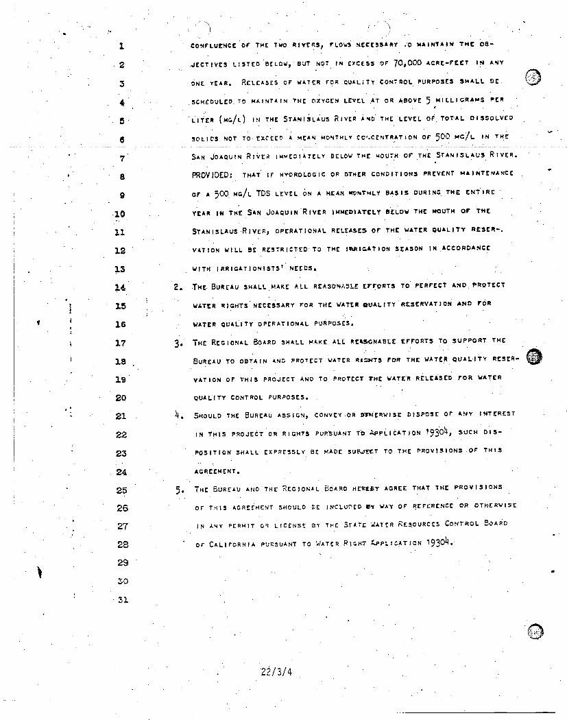
1 CONFLUENCE OF THE Two RIVERS, FLOI.SNECESSARY .0 MAINTAIN INC OB-
2 4ECTIVES LISTED BELOW, BUT NOT IN ErCESS OF 70,000 ACRE-FEET IN ANY
3 ONE YEAR. RELEASES or WATER FOR QUALITY CONTROL PURPOSES SHALL DE
4
5
S
7
SCHEDULED. TO MAINTAIN THE OXYGEN LEVEL AT OR ABOVE 5 MILLIGRAMS PER
LITER (MG/I.) IN THE STANISLUS.RIvER AND THE LEVEL OF TOTAL DISSOLVED
soLics. NOT To EXCEED A MEAN MONTHLY CcP.CENTRAT ION OF 500 MC/L IN THE
SAN JOAQUIN RfirEA IMMEDIATELY BELOW THE MOUTH or THE STANISLAUS RIVER.
8 PROVIDED: THAT If HY,OROLOGIC OR OTHER CONDITIONS PREVENT MAINTENANCE
9
10
11
12
13
14
15
16
17
18
19
20
21
22
23
24
25
26
27
26
29
50
31
Or A 500. moh. TOS LEVEL ON A MEAN wONTHLY BASIS DURING THE ENTIRE
YEAR IN THE SAN JoADuIN RIVER IMMEDIATELY BELOW THE MOUTH or THE
STANISLAUS RIVER, OPERATIONAL RELEASES OF THE WATER QUALITY RESCR-.
.VATION WILL BE RESTRICTED TO .THE.IRAIGATION SEASON IN ACCORDANCE
WITH IRRIGATIONISTS1 NEEDS.
2. THE. BUREAU SHALL HAKE ALL REASON/LULE crrora; TO PERFECT AND PROTECT
WATER RIGHTS NECESSARY FOR THE WATER QUALITY RESERVATION AND FOR
WATER QUALITY OPERATIONAL. PURPOSES.
3. THE REGIONAL BOARD SHALL HAKE ALL REASONABLE EFFORTS TO SUPPORT THE
BUREAU TO OBTAIN AND PROTECT WATER RIGHTS FOR THE WATER QUALITY RESER-
VATION OF THIS PROJECT AND TO PROTECT THE WATER RELEASED FOR WATER
QUALITY CONTROL PURPOSES.
4. SHOULD THE BUREAU ASSIGN, CONVEYOR ITMERwISE DISPOSE OF AY INTEREST
IN THIS PROJECT OR RIGHTS PURSUANT To APPLICATIoN 1930, 4 SUCH DIS-
POSITION SHALL EXPRESSLY BE MADE SUBJECT TO THE PROVISIONS or THIS
AGREEMENT.
5. THE BUREAU AND THE REGIONAL O.I.R0 HEREBY AGREE THAT THE PROVISIONS
OF THIS AGREEMENT SHOULD SE INCLUI.1E0 EN WAY OF REFERENCE OR OTHERWISE
IN ANY PERMIT OR LICENSE BY THE STATE idATER RESOURCES CONTROL BOARD
OF CALIFORNIA PURSUANT TO WATER RIGHT 4.PPLICATION 1930. 4
22/3/4
OAY Of3. DATED r. T1415
2
3
4
5 . UNATED STATSS BLREW OF RECLAMATION
a
7
8
9
10
11
12
13
14
15
le17
16
19
20
21
22
23
24
25
26
27
28
29
30
31
CENTRAL VALLEY REC.' I ON AL WATER QUALITY CONTROL BOARD
BY
:1
de-1.14, 14:11 (2-'1-'4(41tRwAN, CENIT*AL VALLEY kEGIOKAL BOARD
The Federal Antidegradatton Policy(40 CFR 131.12)
(a) The State shall develop and adopt a statewide antidegradation policy and identify the methodsfor implementing such policy pursuant to this. subpart. The antidegradation policy andimplementation methods shall, at a minimum, be consistent with the following:
(1) Existing instream water uses and the level of water quality necessary to protect theexisting-uses shall_be_maintained and protected.
(2) Where the quality of the waters exceed levels necessary to support propagation of fish,shellfisll, and wildlife and recreation in and on the water, that quality shall bemaintained and protected unless the State finds, after full satisfaction of theintergovernmental- coordination and public participation provisions of the State'scontinuing planning process, that allowing lower, water quality is necessary toaccommodate important economic or social development in the area in which thewaters are located. In allowing such degradation or lower water quality, the State shall
assure water quality adequate to protect existing uses fully. Further, the State shallassure that there shall be achieved the highest statutory and regulatory requirementsfor all new and existing point sources and all cost-effective and reasonable best
management practices for nonpoint source control.
(3) Where high quality waters constitute an outstanding National resource, such as watersof National and State parks andlyildlife refuges and waters of exceptional recreationalor ecological significance, that water quality shall be maintained and protected.
(4) In those cases where potential water quality impairment associated with a thermaldischarge is involved, the antidegradation policy and implementing method shall beconsistent with, section 316 of the (Clean Water) Act.
23/1 /1
STAFF REPORTAMENDMENT OF THE WATER QUALITY CONTROL PLAN FORSACRAMENTO RIVER BASIN, SACRAMENTO - SAN JOAQUIN DELTA BASIN,AND THE SAN JOAQUIN RIVER BASIN
INTRODUCTION
The Water Quality Control Plan (Basin Plan) for the Sacramento River Basin (Basin5A),' Sacramento - San Joaquin Delta (Basin 5B), and the San Joaquin River Basin(Basin 5C) .was first adopted in 1975. Triennial reviews were, completed in 1984 and1988. The Basin Plan was revised and updated in 1989. This Basin Plan Amendmentfulfills various federal and state requirements, including Federal Clean Water ActSection 303(c)(1) and California Water Code Section 13240.
The Regional Water Board must comply with the requirements of the CaliforniaEnvironmental Quality Act ( "CEQA," Public Resources Code Section 21000 et seq.)when amending the Basin Plan. CEQA provides that a program of a state regulatoryagency is exempt from the requirements for preparing Environmental Impact Reports(EIRs), Negative Declarations, and Initial Studies if certified as functionally equivalentby the Secretary of the Resources Agency. Public Resources Code Section 21080.5. Theprocess the Regional Water Board is using to amend the Basin Plan has receivedcertification from the Resources Agency to be "functionally equivalent" to the CEQAprocess. Title 14, California Code of Regulations (CCR), Section 15251(g). This staffreport is a Functional Equivalent Document (FED) which fulfills the requirements ofCEQA.
The purpose of this staff report is to present alternatives and staff recommendations foramending the Basin Plan and to provide a summary of 'the necessity for the proposedregulatory provisions. The potential for environmental impacts which would occur as aresult of the proposed amendments is addressed in the Environmental Checklist(Appendix.. 1) and in the discussion of the rationale for why an individual, alternative wasselected over others. Where applicable, an attainability analysis is presented. All'potential environmental impacts are being mitigated to a less than significant level.A workshop was held on 30 November 1993 to receive public input regarding potentialrevisions to the Basin Plan. A public hearing is scheduled for December 1994 to receivepublic comments on this draft FED and proposed amendment of the Basin Plan. Thepublic hearing notice is included as Appendix 2.
The major purposes of the proposed revisions are to update the Basin Plan and to revisethe format to make the Basin Plan more useful. The amendments to the Basin Planinclude revisions to beneficial uses, water quality objectives and implementationprograms.
-1- 11 October 1994
EXHIBIT 6
STAFF REPORT BackgroundCENTRAL VALLEY REGIONAL WATER BOARD
BACKGROUND
The Basin Plan includes a forward- and -five tha-pters; The - forward explains-the- federaland state requirements of the Basin Plan. Chapter I is the introduction and includes adescription of the watershed basins and ground waters that are covered under the BasinPlan. Chapter II provides a listing of present and potential beneficial uses of theprinciple waters in the basins. Chapter III contains water quality objectives that need tobe achieved to protect those uses identified in the previous chapter. Chapter IV containsdescriptions of programs of implementation for achieving compliance with the waterquality objectives. This chapter summarizes and or references State and Regional WaterBoard policies, plans, guidelines, and programs that influence how compliance with waterquality objectives is achieved. Chapter V describes monitoring programs that areimplemented to measure compliance with water quality objectives.
The Porter-Cologne Water Quality. Control Act ("Porter-Cologne," Water Code Section13000 et seq.) defines 'water quality objectives as "...thelimits or levels of water qualityconstituents or characteristics which, are established for the reasonable protection ofbeneficial uses of water or the prevention of nuisance within a specific area." It alsorequires the Regional Water Board to establish water quality objectives, whileacknowledging that it is possible for water, quality to be changed to some degree withoutunreasonably affecting beneficial uses. Water Code Section 13241. In establishing waterquality objectives, the Regional Water Board must consider the following factors:
1. Past, present, and probable future beneficial uses;2. Environmental characteristics of the hydrographic unit under consideration, including
the quality of water available thereto;3. Water, quality conditions that could reasonably be achieved through the coordinated
control of all factors which affect water quality in the area;
4. Economic considerations;5. The need for developing housing within the region; and6. The need to develop and use recycled water. Water Code Section 13241.
The first four factors are considered in this document. This amendment would notimpact the ability to develop housing within the region or to develop and use recycledwater.
Water Code. Section 13000 mandates that activities and.factors which may affect waterquality "shall be regulated to attain the highest water quality which is reasonable,considering all demands being made and to be made on those waters and the totalvalues involved, beneficial and detrimental, economic and social, tangible andintangible.". Consequently, the Regional Water Board may adopt water quality objectiveseven thoudh adoption may result in significant' economic consequences to the regulatedcommunity.
-2- 11 October 1994
STAFF REPORTBackgroundCENTRAL VALLEY REGIONAL WATER BOARD
As stated in the existing Basin Plan, the Federal Clean Water Act requires a state tosubmit for approval of the Administrator of the United States Environmental ProtectionAgency (USEPA)- all -new -or-revised water quality standards which are established forsurface and ocean waters. California water quality standards consist of both beneficialuses (identified in Chapter II) and the water quality objectives based on those uses. It isimportant to note that the Porter-Cologne Act and federal Clean Water Act havediffering requirements for how and when economics are to be considered. Under PorterCologne, economics must be considered when adopting water quality objectives.However, under the Clean Water Act, once beneficial uses have been designated for awater body, criteria to protect those uses (water quality objectives) must at a minimumfully protect those uses, regardless of economic considerations. Above this minimumthreshold of protectiveness, economics may be considered in adoption of more restrictiveClean Water Act criteria.
The Porter-Cologne Act also, states that Basin Plans must contain a program ofimplementation for achieving water quality objectives. Water Code Section 13050(j).The implementation program must include at least the following:
1. A description of the nature of actions which are necessary to achieve the objectives,including recommendations for appropriate action by any entity, public or private;.
2. A time schedule for the actions to be taken; and1 A description of surveillance to be undertaken to determine compliance with the
objectives. Water Code Section 13242.
EXECUTIVE SUMMARY
Following is a chapter by chapter summary of the proposed changes to the existing BasinPlan. All of the chapters also include editing changes that do not constitute substantivechanges, and are therefore not discussed in this staff report. All significant changes willbe discussed in more detail under the section titled "Issue Analyses."
Forward
The Forward has been changed to reflect how this amended Basin Plan fits in withprevious Basin Plan actions. It also includes a new section 'that explains that this BasinPlan complements the various statewide plans, such as the Water Quality Control Plansfor Bays and Estuaries and Ocean Waters.
Chapter I - Introduction
The Basin Plan covers the area drained by the Sacramento and San Joaquin Rivers. Forplanning purposes, it was divided into three basins: Sacramento River Basin,
-3- 1.1 October 1994
STAFF REPORT Executive SzarimaryCENTRAL VALLEY REGIONAL WATER BOARD
Sacramento - San Joaquin Delta, and San Joaquin River Basin. The revised Basin Plandivides the same area into two basins: Sacramento River Basin and San Joaquin River
_Basin.___This_change was_made to make the Basin Plan consistent with other agencies'
planning boundaries. There is a note describing the existing planning boundary betweenthe San Joaquin River 'Basin and the Tulare Lake Basin. There is also a briefdescription of the surface and ground water resources in the two basins. This chapterhas been expanded to include more discussion on ground water. Reference is made toDepartment of Water Resources (DWR) Bulletin 118-80, which is a partial
representation of the region's ground water basins. However, in order to be consistentwith the State Water Board's interpretation of Water Code Section 13050(e), theproposed Basin Plan defines ground water to include all subsurface waters that occur infully saturated zones and fractures within soils and other geologic formations, whether ornot these waters meet the classic definition of an aquifer or occur within DWR identifiedground water basins.
Chapter II - Present and Potential Beneficial Uses
The beneficial uses chapter has been revised to incorporate beneficial use definitions forsurface waters that are consistent with other Regional Water Boards, with some minoradditions. The revised definitions do not significantly change the meaning of any 7- the
beneficial use designations that exist in the present Basin Plan. (See "Issue Analysis." for
more detail.) The water bodies are grouped by hydrologic unit and new maps areprovided to make finding water bodies easier.
As discussed above, the proposed third edition of the Basin Plan is divided into twobasins, instead of three. Table II-1 has been modified slightly to correspond to the newmaps. Hydrologic unit numbers have been added to the table to help the reader locatewater bodies on the maps. In. addition to the general table modifications, an "existing"municipal and domestic supply (MUN) designation has been added for Cache Creek(Clear Lake to Yolo Bypass). These changes will be explained in more detail laterunder "Issue Analysis." Potential beneficial uses for "Auburn Reservoir (UnderConstruction)" were removed from the table because the reservoir is not under
construction.
The existing Basin _Plan indicates that streams not listed on the surface water beneficialuse table (Table II-1) have the same beneficial uses as the listed streams, lakes andreservoirs to which they are tributary. This statement (footnote to Table II-1) has beendeleted. New language has been added that indicates that beneficial uses of anyspecifically identified water body generally apply to its tributary streams, but that in caseswhere this does not make sense the Regional Water Board will make site-specificdeterminations. This is discussed in more detail under "Issue Analysis."
Provisions of State. Water Board Resolution No. 88-63, "Sources of Drinking WaterPolicy" have been specifically listed. The ground water beneficial uses table has been
11 October 1994
STAFF REPORT Executive SummaryCENTRAL VALLEY REGIONAL WATER BOARD
replaced by a narrative description which says that all ground waters in the Sacramentoand San Joaquin River Basins (with specific stated exception criteria) are consideredsuitable or potentially suitable, at a minimum, for MUN, agricultural supply (AGR),industrial service supply (IND), and industrial process supply (PRO). This revisionexpands the AGR, IND and PRO beneficial uses to more ground water areas. Nobeneficial uses have been deleted. These changes will be discussed in more detail under"Issue Analysis." The existing ground water map has been deleted, since it is out-of-date.
Chapter III - Water Quality Objectives
This chapter has been revised to incorporate objectives contained in the Statewide WaterQuality Control Plan for Salinity in the Delta.
Under the "Chemical Constituents" and "Radioactivity" sections for both surface andground water, the existing Basin Plan references drinking water standards contained inthe California Code of Regulations, Title 22, Division 4, Chapter 15. Reference todrinking water standards contained in Title 40, Code of Federal Regulations, Parts 141and 143, has been added. This merely adds clarifying language to describe existingrequirements under Section 4023.1 (a)(3) of the Health and Safety Code and the FederalSafe Drinking Water Act. (See "Issue Analysis" for more detail.)
Table III-1 has been reorganized for clarity. The table has been organized byconstituent. rather than by geographical location. Most of the objectives have not beenchanged. However, the critical year, monthly mean, selenium objective for the SanJoaquin River, mouth of the Merced River to Vernalis [0.008 mg/1 (maximumconcentration)], and the selenium objectives for Salt Slough, Mud Slough (north), andthe San Joaquin River from Sack. Dam to the mouth of the Merced River [0.026 mg/I(maximum concentration) and 0.010 mg/1 (monthly mean)) were disapproved by USEPA.The new selenium objectives that appear in Table III-1 were promulgated by USEPA on22 December 1.992 following USEPA's disapproval of the Regional. Water Board'sselenium concentrations. (See 57 Fed. Reg. 60848, 60920.) The new seleniumconcentrations in Table III-1 are provided solely for reference. The new footnote at theend of the table notes this and makes it clear that these objectives were not adopted bythe Regional Water Board.
The "Dissolved Oxygen" section has been reorganized for clarity. The 6.0 mg/I objectivefor the. San Joaquin River (between Turner Cut and Stockton, I. September- through30 November) was added for the readers' convenience. The objective is in the StateWater Board's Water Quality Control Plan for Salinity, May 1991. The objective is morestringent than what is in the Regional Water Board's existing Basin Plan. Pursuant toWater Code Section 13170, the objective contained in the State Water Board plansupersedes the objective contained in the Regional Water Board's Basin Plan.
11 Octob4
STAFF REPORT .
Executive Summary
CENTRAL VALLEY REGIONAL WATER BOARD
A sentence has been added to the "pH","Temperature", and "Turbidity" sections for
surface waters. The sentence clarifies how the current objectives in these three sections
are_implemented, It states that in determining compliance with the water qualityobjectives, appropriate averaging periods may be applied provided that beneficial uses
will be fully protected.
Table 111-2, "Specific Dissolved Oxygen Water Quality Objectives", has been revised to
remove redundancies and inconsistencies. The revisions do not change any of the
objectives.
The existing section on toxicity in surface waters contains a narrative statement and
indicates how compliance will be measured. New language has been added that explains
how the Regional. Water Board considers, on a case-by-case basis, all material andrelevant information submitted by the discharger and other interested parties, and-relevant numerical criteria and guidelines developed and/or published by other agencies
and organizations to determine compliance with the objective. This is' discussed in more
detail later in this document under "Issue Analysis." A new paragraph has also been
added stating that in the absence of scientifically valid data to the contrary, theoretical
risks from toxic substances will be considered additive across all media of exposure and
will be considered additive for all chemicals having similar toxicological effects or having
carcinogenic effects. (See "Issue Analysis" for more detail.)
The turbidity objective for surface, waters having a natural turbidity less than 5 NTUs has
been changed from " ...increases shall not exceed 20 percent" to " increases shall not
exceed 1 NTU." This change is discussed in more detail under "Issue Analysis".
The 'Chemical Constituents" section for ground. waters in the existing basin plan contains
the sentence, "Ground waters designated for use as agricultural supply (AGR) shall notcontain concentrations of chemical constituents in amounts that adversely affect suchbeneficial use." The sentence, has been deleted in the proposed Basin Plan since it is
redundant. The first sentence under the "Chemical Constituents" heading says 'the same
thing for all beneficial uses, which includes agricultural supply.
In the existing Basin Plan, under the ground water section, there are narrative objectives
that simply say ground water shall not contain chemicals in concentrations that adversely
affect beneficial uses. A new subsection has been added on toxicity in ground water.The new subsection takes the same approach as the existing Basin Plan contains for
toxicity in surface waters. In other words, ground waters must be maintained free of
toxicants in amounts that cause detrimental physiological responses in: human, animal, or
aquatic life associated with the use of the ground water. Compliance with this objective
will be measured in the same manner as for surface waters (i.e., reference to available
criteria, direct evidence- of toxicity, and information submitted by.the discharger' and
other interested persons). There is also a statement, like the one for surface waters,
-6- 11 October 1994
STAFF REPORTExecutive SummaryCENTRAL VALLEY. REGIONAL WATER BOARD
accounting for additive toxicity of pollutants in ground water. (See "Issue Analysis" formore detail.)
Figure III-2-and Table III-5 have been updated. The figure and table in the existing.Basin Plan were from the State Water Board's Delta Plan and Decision 1485 and wereprovided for the reader's convenience. The Delta Plan has been superseded by the StateWater 'Board's Water Quality Control Plan for Salinity, May 199.1. Therefore, the tableand figure need to be replaced.
Chapter 1V - Implementation
This chapter is divided into five sections. Revisions are discussed section by section.
WATER QUALITY CONCERNS
The introduction to this section has been amended to include a general description ofsurface and ground water concerns and problems. Subsections haVe either been addedor expanded to discuss, urban runoff, mining waste management, hazardous and non-hazardous waste disposal, and contaminated sites.
Under the subsection "Water Bodies with Special Water Quality Problems", language hasbeen added that refers to the policy for establishment of a water quality limited zone forground water that is analogous to the water quality limited segment concept for surfacewater. The ground water policy, is described under "Control Action Considerations of theCentral Valley Regional Water Quality Control Board", "Policies and Plans" section(page IV-22, item 10).
NATURE OF CONTROL ACTIONS IMPLEMENTED BY THE REGIONALWATER BOARD
This section has been revised to incorporate recently adopted state policies, plans, andprograms. New and/or updated summary paragraphs are provided for the following:
1. State Water Board Resolution No. 88-63, Sources of Drinking Water2. State Water Board Resolution No. 90-67, Pollutant Policy Document3. State Water Board Resolution No. 92-49, Policies and Procedures for Investigationand Cleanup and Abatement of Discharges Under Water Code Section 133044. State Water Board Resolution No. 93-62, Policy for Regulation of Discharges ofMunicipal Solid Waste5. Exception to The Thermal Plan6. Delta Plan, Water Rights Decision 1485, and the Water Quality Control Plan forSalinity7. Nonpoint Source Management Plan
11 October 1994
STAFF REPORT Executive Summ.ary
CENTRAL VALLEY REGIONAL WATER BOARD
8. Discharges of Waste to Land, California Code of Regulations Title 23, DivisionChapter 15
9. Solid Waste_ Assessment Test10. Toxic. Pits Cleanup Act11. Underground Storage Tank Program12. Aboveground Petroleum Storage Act13. Storm Water Regulations14. U.S: Department of Defense "Program15. Memorandum of Agieement between State Water Board and Department of Health
Services regarding the implementation of the hazardous waste program16. Memorandum of Agreement between State Water Board and Department of Health
Services regarding the use of reclaimed water.17. Memorandum of Understanding between State Water Boaid and Department.. of
Health Services/Department of Toxic Substances Control regarding the roles of each,agency for cleanups of hazardous waste sites.
18. Memorandum of Understanding between State Water Board and U.S. Departmentof Agriculture, Soil Conservation Service regarding implementation of bestmanagement practices and other nonpoint source' pollution prevention measures-
19. Memorandum of Understanding between State Water Board and Air ResourcesBoard and Integrated Waste Management Board to enhance program coordinationand reduce duplication of effort
20. Memorandum of Understanding between State Water Board and Department ofPesticide Regulation to ensure that pesticides registered in California are used in amanner that protects water quality and the beneficial uses of water while recognizingthe need for pest control
21. Memorandum of Understanding between State Water Board and numerous agencieson Implementation of the San Joaquin Valley Drainage Program (agencies agree touse the management plan described in the September 1990 final report of the SanJoaquin Valley Drainage Program as a guide for remedying subsurface drainage andrelated problems)
22. Memorandum of Understanding between State Water Board and Integrated WasteManagement Board to address the Regional Water Board's review of SWAT reports
23. Memorandum of Agreement between the State Water Board and Bureau of LandManagement to address nonpoint source water quality issues on public landsmanaged by the Bureau
24. Regional Water Board Resolution No 70-118, Delegation of Duties and. Powers tothe Regional Water Board's Executive Officer
25. Regional Water Board Policy on Reuse of Wastewaters26. Regional Water Board Policy on Implementation of Antidegradation Policy27. Regional Water Board Policy on Application of Water Quality Objectives28. Regional Water Board Policy on Investigation and Cleanup of Contaminated Sites29. Rezional Water Board Policy. on Ground Watt'. Water Quality Limited Zone30. Memorandum of Understanding between the Regional Water Board, California
Department of Fish and Game, and Vector Control Districts of the South San
11 October 1994
STAFF REPORTExecutive SummaryCENTRAL VALLEY REGIONAL WATER BOARD
Joaquin Valley which designates the Districts as lead agencies in determining theadequacy of vegetation management operations in abating mosquito breedingsources
The. Regional Water Board policies (25-29) are new and are discussed in more detaillater under "Issue Analysis." The other twenty-five are paragraphs that describe theprovisions of the plans and policies that were previously adopted or approved by theState Water Board or Regional Water Board.
ACTIONS RECOMMENDED FOR IMPLEMENTATION BY OTHER ENTITIES
No substantive revisions have been made to this section.
CONTINUOUS PLANNING FOR IMPLEMENTATION OF' WATER QUALITYCONTROL
No substantive changes have been made to this section.
ACTIONS AND SCHEDULE TO ACHIEVE. WATER QUALITY OBJECTIVES
Porter-Cologne states that Basin Plans must contain a program of implementation forachieving water quality objectives.. Specifically required is a description of the nature ofactions which are necessary to achieve water quality objectives, a time schedule foractions to be taken and a description of surveillance to be undertaken to determinecompliance with the objectives. Much of the Implementation Chapter (Chapter IV)contains general implementation provisions. The implementation plan is greatlystrengthened by including more detail, especially for those situations where water qualityobjectives are threatened or not being met and where the attainment of those objectivesmay be difficult or complex. Recognizing this need, in 1987, the Regional Water Boardconducted a Triennial Basin Plan Review. As part of that review, the Regional WaterBoard developed a list of major water quality problems that needed to be addressed.The Regional Water Board prioritized the list and developed workplans to address theproblems. The implementation actions, time schedules, and monitoring portions of theworkplans were incorporated into the Basin Plan (Chapter IV, Actions and Schedule toAchieve Water Quality Objectives). As pointed out in the existing Basin Plan,implementation of the workplans was dependent on resource availability.
These workplans have been updated to reflect existing conditions, progress onimplementation of past proposed actions, and future proposed actions. The updatedworkplans include the implementation status of the work proposed in 1987 and revisedworkplan elements and time schedules (where appropriate). These updated workplanswill be approved concurrently with the adoption of the updated Basin Plan and will meetthe requirements for completing a triennial review. Applicable portions of the workplans
11 October 1994
STAFF REPORT Executive Summary
CENTRAL VALLEY REGIONAL WATER BOARD
are incorporated into the Basin Plan. There are no new regulatory provisions in theseworkplans. Some of the workplans call for development of new or revised regulatory
-approaches- and- these -will-be fully_evaluated when they are developed._ _New workplanwere developed and summarized for "Dairies" and "Nutrient and Pesticide Discharges
from Nurseries."
Following is brief description of the workplans:
Agricultural Drainage Discharges in the San Joaquin River Basin
All the major workplan elements were implemented or are still in the process of being
implemented in accordance with time frames contained in the workplan. One elementwas not implemented, Due to reductions in resources, the Regional Water Board didnot prepare a study plan by 1 March 1989 that identified the information needed -to
reconsider selenium and boron objectives in 1992. The updated workplan indicates thatthe Regional Water Board will do this in the next three years.
Assessment of Biotoxicity of Major Point and Nonpoint Source Discharges In theSacramento and San Joaquin River Basins
All the primary actions identified in the 1987 workplan were completed. Reports werewritten summarizing monitoring results. The Regional Water Board's updated workplanincludes continued work in the lower portions of both Rivers and in the Delta.
Acid Mine Drainage from Abandoned Mines in the Sacramento River Basin
All the primary actions identified in the 1987 workplan were completed. Inadequate
resources were available for implementation of the augmented actions. The Regional
Water Board's updated workplan includes a broadened focus, to address other sources ofmetals, in addition to the mines. The title of this workplan element is changed to "HeavyMetals from Point and Nonpoint Sources" to reflect the broadened scope. At current andprojected funding levels, the Regional Water Board plans to continue to monitor in theDelta, develop a mass emission strategy, work to resolve' liability issues, and coordinatecopper reduction programs with the San Francisco Bay Regional Water Board. With
augmented resources, the Regional Water Board would establish a monitoring programto track metals into and across the Delta, update the Abandoned Mine Inventory, and
initiate studies to define agricultural sources of copper.
Mercury Discharges in the Sacramento River and San Joaquin River Basins
All the primary actions identified in the workplan were completed. None of the
augmented actions were completed because of inadequate resources. The Regional
Water Board's updated workplan includes continued monitoring for mercury in the Delta
-10- 11 October 1994
STAFF REPORTExecutive SummaryCENTRAL VALLEY REGIONAL WATER BOARD
and at upstream reservoirs. The augmented actions identified in 1987 are stillappropriate.
Pesticide Discharges-from Nonpoint- Sources
In 1987, the focus of this element was rice field discharges. The scope was broadenedand the title changed in the 1990 Basin Plan update to reflect this broadened. scope. Allthe primary actions identified in 1987 (in the workplan titled Rice Field Discharges' inthe Sacramento River Basin) were implemented. The actions identified in the 1990Basin Plan amendment have been partially implemented. This amendment is now beingreevaluated, in response to litigation. Some monitoring is planned in the Delta anddownstream. portions of the Sacramento and San Joaquin Rivers to determine pesticidelevels. With augmented resources, the Regional Water Board proposes to developstudies to more closely link toxicity with observed pesticide levels. In addition, studieswould be undertaken to get more information that links elevated pesticide levels with in-stream impairments.
Dredging in the Sacramento River and San Joaquin River Basins
In 1987, the Regional Water Board proposed to produce a set of guidelines forregulation of dredging and riverbank protection projects. This was not done becausestaff participated in a cooperative effort to develop a long term management strategy fordredging (LTMS). The development of this strategy is still underway. This strategy willaccomplish the same results as the guidelines the Regional Water Board was going todevelop.. The Regional Water Board's updated workplan includes continued work on theLTMS and review of all significant dredging projects that are planned in the Region.Auzmented actions would include development of guidelines for assessing thecompatibility of dredged material with proposed uses.
Nitrate Pollution of Ground Water in the Sacramento River and San Joaquin River BasinsDue to limited resources available in 1987, no primary actions were proposed. Withaugmented funding, staff proposed to design and conduct a systematic assessment ofnitrate problem areas in the Basins through a contract with the University of California.Inadequate resources were available to implement the augmented actions. Some, workwas initiated on defining ground water problems in Merced County and in developmentof guidelines for protecting ground and surface water from dairy discharges. At currentand projected levels of funding for the next three years, the Regional Water Boardexpects to complete the development of dairy waste management guidelines. Augmentedresources are needed .to assure that adequate support is available' for this program.
-11- 11 October. 1994
STAFF REPORT Executive Summary
CENTRAL VALLEY REGIONAL WATER BOARD
Temperature and Turbidity Increases Below Large Water Storage and Diversion Projects in
the Sacramento Basin
The primary action identified in the 1987 workplan was implemented. Conditions were
placed on the discharge from Shasta Dam.. No specific actions are proposed for the next
triennial review period other than coordinating with other agencies.
Beneficial Use Impairments from Logging, Construction, and Associated Activities
The primary action identified in the 1987 workplan was not implemented. The Regional
Water Board did not consider adoption of a Basin Plan prohibition on the discharge
from logging of soil, silt, debris, and other material in quantities deleterious to beneficial
uses. Instead, staff will continue to participate in weekly interagency review team
meetings (in Redding and Fresno) and pre-harvest as well as post-harvest inspections.
During the 1994 calendar year, staff expects to review approximately 800 timber harvest
plans and attend about 80 pre-harvest inspections and some post-harvest inspections. In
addition, watersheds with the potential to be designated special watersheds need to be
monitored and assessed. Staff will pursue additional funding in an attempt to meet theincreased staffing needs for this task.
Dairies
This is a new workplan element. Future work builds on the results of a recent project
that evaluates alternative approaches to obtaining improved water quality at dairy sites.
Nutrient and Pesticide Dischargesfrom Nurseries
This is a new workplan element. Future work builds on the results of a recent project
that evaluated discharges from representative nurseries.
ESTIMATED COSTS OF AGRICULTURAL WATER QUALITY CONTROL
PROGRAMS AND POTENTIAL SOURCES OF FINANCING
No substantive revisions were made to this section.
Chapter V - Surveillance and Monitoring
No substantive revisions were made to this chapter.
Appendix
The appendix has been updated,
-12- 11 October 1994
.STAFF REPORTExecutive SummaryCENTRAL VALLEY REGIONAL WATER BOARD
Note to the Basin Plan reviewer regarding 1990 Amendments to the Basin Planaddressing Pesticides
In 1990 the Regional Water Board adopted Resolution No- which amendedportions of the Basin Plan. This amendment included water quality objectives andimplementation programs for pesticides. None of the provisions included in the 1990amendment have been changed or revised as part of the current update activity becausethey' are the subject of litigation. The Regional Water Board is not soliciting commentson those portions of the Basin Plan at this time.
-13- 11 October 1994

STAFF REPORTCENTRAL VALLEY REGIONAL WATER BOARD
Issue Analysis
ISSUE ANALYSIS
The following .sections contain analyses of the issues related to the proposed amendment
to the existing Basin Plan with emphasis -on--proposed regulatory-_revisions_Proposed
revisions which staff considers to be regulatory have been highlighted with vertical lines
in the margin on the (WRY stiikeeet- version of the proposed Basin Plan. The staff
analysis presents the present policy, a. description of the issue, a description of
alternatives considered, a staff recommendation, and analyseS of attainability, economics,
and environmental impacts (where applicable).
The -specific purpose of each proposed regulatory provision (references are provided in
parentheses) is to directly address the significant issue described in the following. analysis.
The: information which summarized the necessity for each of these provisions is provided
as part of the recommendation.
Issue 1 - Definition of Ground Water (Chapter I, page I-1)
Present Policy
The term "ground water" is not defined in the existing Basin Plan. However, as defined
in the Porter Cologne Act "'waters of the state' means any water, surface or
underground, including saline waters, within the boundaries of the state." Water Code
Section I3050(e). The term "ground water" is used by the. State and Regional Water
Boards to refer to the underground (subsurface) "waters of the state." See, e.g., State
Water Board Order No. WQ 86-13 (BKK Corporation).
Issue. Description
The Regional Water Board's use of the term "ground water" for basin planning purpose.:
is not clear because the Basin Description (Chapter. I) in .the existing Basin. Plan does not
specifically define the term. As a result, the existing Basin Plan's application to ground
waters of the Region may be misunderstood. It is possible to incorrectly interpret the
existing Basin Plan to apply only to the ground water bodies that are listed in Chapter II.
However. the existing Basin Plan applies to all ground waters of the Region.
Alternatives
I. No ACTION . No action would continue the undefined .use of the term "ground
water" as specified in the existing Basin Plan; therefore, the scope of coverage of the
Basin Plan with respect to ground waters of the Region would continue to be
unclear.
-14- 11 October 1994
STAFF REPORTCENTRAL VALLEY REGIONAL WATER BOARD
Issue Analysis
AMEND CHAPTER I OF THE BASIN PLAN TO INCLUDE A DISCUSSION ANDDEFINITION OF "GROUND WATER ". Including a specific discussion of ground waters,and using a definition to explain the term "ground water" in Chapter I, wouldprovide -a:--clear and consistent basis for understanding the Regional Water Board'sexisting approach to protecting the quality of ground waters of the Region.
Staff Recommendation
Adopt Alternative 2. Staff recommends this alternative as the most effective, reasonable,and necessary method to eliminate potential ambiguity regarding applicability of groundwater provisions in the existing Basin Plan. This ambiguity could result in incorrectapplication or interpretation of Basin Plan requirements. The following language isproposed:
"Therefore, for basin planning and regulatory purposes, the term "ground water"includes all subsurface waters that occur in fully saturated zones and fractures withinsoils and other geologic formations, whether or not these waters meet the definitionof an aquifer or occur within identified .ground water basins."
A. definition of the term "ground water" which is consistent with the definition of the"waters of the state" set forth in Division 7 of the California Water Code is necessary toadequately protect ground water outside ground water basins identified in Chapter II ofthe. existing Basin Plan. The revised language will allow the regulated community tomore easily understand how the Basin Plan is consistent with the existing ground waterprograms and regulations which are designed to protect the underground (subsurface)"waters of the state".
This amendment would provide clarification and does not include any new requirements;therefore, it would have no environmental or economic consequences.
Issue 2: Beneficial Use Definitions (pages II-1, 11-2, and II-3)
The beneficial use definitions have been re-worded to be consistent with the definitionsused by the other Regional Water Boards. The revised definitions do not significantlychange the meaning of any of the beneficial use definitions in the existing Basin Plan.The following new definitions are added to the proposed Basin Plan, in addition to thebeneficial use definitions in the existing Basin Plan: Commercial and Sport Fishing(COMM), Aquaculture (AQUA), Estuarine Habitat (EST), Preservation of BiologicalHabitats of Special Significance (BIOL), and Shellfish Harvesting (SHELL). However,no water bodies have been assigned these new beneficial uses. There are no knownadverse .environmental or economic impacts that would result from these new andrevised definitions.
-15- 11 October 1994
STAFF REPORT .
Issue Analysis
CENTRAL VALLEY. REGIONAL WATER BOARD
Issue 3: New Surface Water Maps and Format of Table II-1 (pages 11-3, Table 11-1)
_The existing_Basin_Plan_coyers_an area which is divided into three sub-basins: the.Sacramento River Basin (5A), the Sacramento-San Joaquin Delta Basin (5B), and The
San Joaquin River Basin (5C). New maps are provided in the proposed Basin Plan that
divide the area into hydrologic basins to be consistent with other agencies' planning.
boundaries. By separating the maps into hydrologic basins, the area is divided into twobasins instead of three, dividing the Delta. The two new basins are called theSacramento River Basin and San Joaquin River Basin.
Table II-1 was also changed to reflect changes in the new maps. The Table in theexisting Basin Plan lists beneficial uses for "Other Lakes and Reservoirs in Basin 5B" .
Because of the new dividing line, lakes and reservoirs in 5B will now be in either the
Sacramento River Basin (which encompasses all of Basin 5A and a portion of Basin 5B)
or the San Joaquin River Basin (which encompasses all of Basin 5C and a portion of
Basin 5B). In the existing Basin Plan, Basins 5A and 5B have the same beneficial uses
for "Other Lakes and Reservoirs" so there is no change. Basin 5C, however, differs from
Basin 5B in the existing Basin Plan for agriculture (AGR) and industrial process (PRO)
for "Other Lakes and Reservoirs". The simplest way to list the remaining "Other Lakes
and. Reservoirs in Basin 5B" that don't have the same beneficial uses as those in the San
Joaquin River Basin is to list them by hydrologic unit, rather than by basin. This does
not result in any changes in beneficial uses of the water bodies in question. There are
no known adverse environmental or economic impacts that would result from these
changes.
Issue 4: MUN Beneficial Use Designation for Cache Creek (page 11-3, Table II-1)
Present Policy
On Table II-I of the existing Basin Plan, Cache Creek (from Clear Lake to Yolo Bypass)
is not designated as an "existing" source of, drinking water.
Issue Description
Interested parties have requested that Cache Creek be designated as an "existing" source
of drinking water. Although the Regional Water Board is not aware of any direct use of
Cache Creek water for municipal use, there are some shallow supply wells in close
proximity to the Creek that are used for municipal purposes. It is reasonable to assume
. that, because of recharge, the water quality in the shallow wells is essentially the same as
Cache Creek water: In any case, under the "Sources of Drinking Water Policy" (State.
Water Board Resolution No. 88-63, described on Page IV-10 of the Draft Basin Plan),
Cache Creek is considered to be suitable, or potentially suitable, for municipal .or
domestic water supply.
-16- 11 October 1994
STAFF REPORTIssue AnalysisCENTRAL VALLEY REGIONAL WATER BOARD
Since it is a source of drinking water, the Regional. Water Board provides the same levelof protection for Cache Creek as it does for other water bodies named in Table II-1 thatare listed as having the "existing" MUN beneficial use. However, public perception ishat_greater_protection-Vould be provided for water biddies specifically listed in the tableas having an "exiSting"use.
Alternatives
1. NO ACTION This would leave no indication in Table II-1 that Cache Creek isdesignated as an "existing" source of drinking water. At this time, the RegionalWater Board provides the same level of protection for water bodies listed as havingthe "existing" beneficial use for MUN as those water bodies covered under the"Sources of Drinking Water Policy", so there would be no difference. However,public perception is that greater protection would be provided for a water bodylisted in the table as having an "existing" use.
2. ADD THE "EXISTING " MUN BENEFICIAL USE DESIGNATION TO TABLE II-1 FORCACHE CREEK (FROM CLEAR LAKE TO YOLO BYPASS). At the present, this wouldnot have any significance, since the Regional Water 'Board provides the same levelof protection for water bodies listed in Table II-1 as having, the "existing" beneficialuse for MUN as those water bodies covered under the "Sources of Drinking WaterPolicy". However, this distinction could be significant if the Regional Water Board,at some future date, determined that "existing" uses warranted greater protection.The close association of the existing shallow wells with Cache Creek makes it seemreasonable to treat the Creek as an "existing" source of drinking water. There is noharm in making this change and it would appear to provide some measure ofassurance to the public that their municipal water supply will be. protected.
Staff Recommendation.
Staff recommends the second alternative. There are no significant consequences and itprovides the public with a sense that their water supplies will be protected. Because theRegional Water Board currently provides, the same level of protection for water bodieslisted in Table II-1 as having the "existing" beneficial use for MUN as those water bodiescovered under the "Sources of Drinking Water Policy", there are no known adverseenvironmental or economic impacts that would result from this change.
Issue 5: Revise the Tributary Statement (page 11-3, Table II-1)
Present Policy
Table II-I of the existing Basin Plan, titled Surface Water Bodies and Beneficial Uses,names 96 of the most important surface waters in the Sacramento River Basin, San
-17- 11 October 1994
STAFF REPORT Issue 5: Tributary Statement
CENTRAL, VALLEY REGIONAL WATER BOARD
Joaquin River Basin and the Delta. For each of these named waters, the table identifiestheir existing beneficial water uses and their potential beneficial water uses. These uses,taken together, are termed the "designated" beneficial uses in reference to the fact thattheRelional Water Board has_ explicitly-recognized-these- waters- by-name,-and -associated
with each an array of appropriate beneficial uses pursuant to state and federal law.
At the bottom of Table II-I is a footnote that reads "(1) Those streams not listed have
the same beneficial uses as the streams, lakes, or reservoirs to which they are tributary.
This footnote is often referred to as "the tributary rule" or "the tributary footnote".
Because the existing tributary footnote has proven to be inflexible and unworkable,Regional Water Board staff now proposes to remove or modify it. The following historyprovides the background of the present policy.
The Regional Water Board adopted the first edition of its Basin Plan on 25 July 1975.That Basin Plan contained Figure 2-1, titled Surface Water. Bodies and Beneficial Uses,which is essentially the same as Table II-I in the Second Edition, the only difference
being a few minor corrections in the latter edition. The first edition also contained the
tributary footnote.
At the time of its adoption, the Regional Water Board knew Figure 2-1 was incomplete,its 96 named water bodies being only a tiny fraction of the region's estimated 10,000waters. But the Basin Plan at least included the major rivers, lakes and reservoirs, andthe larger creeks, that together contain most of the region's 'surface water. The Regional.Water Board envisioned that, in the ensuing years; there would be a continuing planningprocess in which tributaries of the major water bodies would be investigated in somepriority fashion, and the beneficial uses of these tributaries would be identified anddesignated in periodic amendments to the Basin Plan. In the interim, the RegionalWater Board knew it would need to make decisions involving waters not named inFigure 2-1 and for which little detailed information was available. The tributary footnote
was thus conceived to bridge the information gap and provide guidance until factual
information was available.
Due to resource limitations, the continuing planning process did not evolve asanticipated, and the staff-intensive effort needed to identify the beneficial uses of the9,900 lesser water bodies was never funded nor undertaken. Years after adoption of thefirst edition, the Basin Plan's beneficial use designations remain uncompleted.
In April 1991, the State Water Board adopted its Water Quality Control Plan for InlandSurface Waters (ISWP). That plan put in place statewide numerical and narrative waterquality objectives for toxic materials designed to protect human health and freshwateraquatic life. These water quality objectives apply in water bodies whose identities andbeneficial use designations are listed in regional Basin Plans.
-18- 11 October 1994
STAFF REPORTIssue 5: Tributary StatementCENTRAL VALLEY REGIONAL WATER BOARD
An equally important feature of the ISWP was a procedure for identifying anddesignating the beneficial uses of three distinct classes of waters: ephemeral streams,effluent dominated waters, and constructed agricultural drains. The ISWP provided a sixyear time schedule to-allow Regional Water Boards to complete that work and adoptappropriate site specific objectives.
In September 1992, the Regional Water Board adopted and transmitted to the StateWater. Board a list of 6,535 water bodies considered candidates for beneficial useinvestigations and designations in those three classes. That work was subsequently haltedand the funding withdrawn by the State Water Board following USEPA's rejection ofportions of the ISWP pertaining to beneficial uses designations.
USEPA staff have invoked the tributary footnote as the appropriate principle governingthe selection of beneficial uses, even in the face of conflicting facts. The ISWP Is thecase alluded to. In the ISWP, the State Water Board proposes to make scientificfindings as to what the beneficial uses are and then designate them. USEPA says thereis- no need for fact findings, the Tributary Footnote tells us all we need to know.In an earlier action, the State Water Board rejected a portion of a Basin Planamendment that designated beneficial uses for Mud Slough (North) and Salt. Slough,tributaries to the San Joaquin River, because the Regional Water Board's findings of factwere at odds with the tributary footnote (See State Water Board ResolutionNo. WQ 89-88).
Issue Description
The tributary footnote. intended as a temporary palliative for the lack of beneficial useinformation when formulating tentative waste discharge requirements and enforcementdocuments, is being misunderstood and misused by various parties. The Regional WaterBoard never intended that the footnote serve as the foundation for establishing waterquality objectives. And, the Regional Water 'Board certainly never intended that thefootnote should prevail over findings of scientific fact, as occurred in the two cases citedearlier. If consequences of such misuse were trivial, it could easily be ignored. But, itwill profoundly affect staff activities and Regional Water Board decisions in the decadeahead, as statewide objectives are implemented. The economic consequences todischargers will likewise be considerable.
The tributary footnote says, in effect, that all tributaries to the water bodies listed in theBasin Plan have precisely the same beneficial uses as the water bodies to which they aretributary, without exception, exemption, or qualification. The truth of the tributaryfootnote can be proven only by examining every case (i.e., every tributary/listed waterbody pair) and demonstrating its truth in all cases. On the other hand, the tributaryfootnote can be disproved by finding a single counter-example (i.e., a tributary/listedwater body pair in which one or more of their beneficial uses differ).
-19- 11 October 1994
STAFF REPORTIssue 5: Tributary Statement
CENTRAL VALLEY REGIONAL WATER BOARD
In the real world of the Central Valley's watersheds, exceptions to the tributary footnote
abound. A suitable example is Spring Creek, in Shasta County. Spring Creek conveys
acid_ mine drainage impounded behind Spring Creek Debris Dam to the Sacramento
River, where it becomes diluted -in -the-water-released from Shasta-Reservoir. Spring
Creek's water is strongly acidic and contains lethal concentrations of a number of heavy
metals, including copper, zinc, and cadmium. Massive fish kills occur in the Sacramento
River whenever Spring Creek's flow cannot he regulated in suitable ratio to the Shasta
Reservoir release.
Under a literal application of the Tributary footnote, Spring Creek's beneficial uses
include:
Municipal, and Domestic SupplyAgriculture (irrigation and stock watering)Recreation (contact, canoeing and rafting)Freshwater Habitat (cold and warm)
Migration (cold and warm)Wildlife HabitatNavigation
In fact, Spring Creek's water is at all times unsuitable for supporting any of these uses,
and none of them are being realized. Thus, the fundamental premise of the tributary
footnote is false.
Although the important beneficial uses of most water bodies and their tributaries are
often the same, the tributary footnote, if applied to all tributaries, is inaccurate.
Alternatives
The Regional Water Board has three choices with respect to the tributary footnote:
1. NO. ACTION . Under this alternative, the tributary footnote would remain unchanged
in Table II-1. A false statement makes a shaky foundation for a regulatory program,
so this choice should not be seriously considered. Further, as long as the footnote
continues to be misused, it will continue to interfere with the Regional Water
Board's conduct of its business. Examples of inappropriate uses of the tributary rule
are described above, under Present Policy.
2. CHANGE THE FOOTNOTE . This could be done in two ways: rewrite it so that it is
accurate, or condition its applicability to cause the same effect. If the footnote were
restated to say Some of those streams not listed have some of the same beneficial
uses as the streams, lakes, or reservoirs to which they are tributary". it would be
accurate, but it would be of no apparent usefulness. Or, it could be conditioned to
say its use is limited to preparing waste discharge requirements and enforcement
-20- 11 October 1994
STAFF REPORTCENTRAL VALLEY REGIONAL WATER BOARD
Issue 5: Tributary Statement
orders in the absence of factual information, and it will be corrected as the factsbecome known. This reflects the way the footnote is currently being used by theRegional Water Board.
DELETE THE FOOTNOTE AND ADD NEW CLARIFYING LANGUAGE . New clarifyinglanguage could be added to the Basin Plan text to more explicitly describe how theRegional Water Board applies beneficial uses, in the absence of scientific fact, towaters tributary to the water bodies listed in Table II-1. The footnote to Tablewould then be deleted. This alternative would eliminate much of the confusioncaused by the' wording of the tributary footnote, without changing its intendedmeaning.
Staff Recommendation
Adopt alternative 3. Clarifying language is necessary to eliminate the ambiguity causedby the tributary footnote. The following language is proposed:
The beneficial uses of any specifically identified water body (identified inTable II-I) generally apply to its tributary streams. In some cases a beneficial usemay not, be applicable to the entire body of water. In these cases the RegionalWater Board's judgement will be applied.
It should be noted that it is impractical to list every surface water body in theRegion. For unidentified water bodies, the beneficial uses will be evaluated on acase-by-case basis."
The proposed new language clarifies the intended meaning of the tributary footnotewhen it was originally adopted by the. Regional Water Board in 1975. Beneficial uses ofany water body specifically identified in Table II-1 will generally apply to its tributarystreams, except in cases where the Regional Water Board determines that a beneficialuse is not applicable. It also notes the need to evaluate beneficial uses for unidentifiedwater bodies (i.e. water bodies not listed in Table II-1) on a case-by-case basis. since it isimpractical to list every surface water body in the region. This is due to the fact thatbeneficial uses have yet to be identified for roughly 9900 water bodies in the region and,currently, there is insufficient staff and funding available to identify the beneficial uses ofthose water bodies.
The proposed language eliminates present and future problems of,misinterpretation andmisuse, and removes a known falsehood from the Basin Plan. This approach allows forcollection of information to better determine what beneficial uses need to be protected.It avoids the problems created by applying inaccurate beneficial uses to some waterbodies. The proposed language clarifies how the Regional Water. Board alreadyinterprets the tributary statement in the existing. Basin Plan. Therefore, there are no
-21- 11 Octdber 1994
STAFF REPORT Issue 5: Tributary Statement
CENTRAL VALLEY REGIONAL WATER BOARD
known adverse environmental or economic impacts that would result from the proposed
new language.
TO the extent the tributary statement has been misapplied by other agencies in-the
manner described above, the proposed language may result in economic savings for
dischargers to tributaries with less restrictive beneficial uses than the downstream water
bodies. Any corresponding environmental impacts will be insignificant because allappropriate beneficial uses (and the water quality objectives that protect those beneficial
uses) will still apply.
Issue 6: Update ground water beneficial use designations (Chapter II, pages 11-3 to 11-4)
Present Policy
Beneficial uses which currently apply to the major ground water bodies of the. Region
are presented in Table 11-2 of the existing Basin. Plan. Municipal and domestic supply,
irrigation, stock watering, industrial process supply, and industrial service supply are thebeneficial use designations listed in the Table. Ground waters of the Region that arenot listed, in Table 11-2 are assigned municipal and domestic water supply (MUN)designations in accordance with the provisions of State Water Resources Control BoardResolution No. 88-63 (Sources of Drinking Water Policy) which is incorporated, byreference, as part of the existing Basin Plan. Pursuant to the Sources of Drinking WaterPolicy, all surface and ground waters of the State are considered suitable, or potentiallysuitable, for MUN and should be so designated by the Regional Water Boards with theexception of waters that meet criteria' specified in the Policy.
Issue Description
State and Regional water resources haVe become increasingly important in response to
the needs of a steadily growing state population. In particular, 'demands for usableground water are more extensive than in past years and are expected to continue togrow. In many parts of the Region, discharges associated with the use and disposal of
both hazardous and non-hazardous chemicals and wastes have resulted in long term
impacts to ground water quality. These impacts have the potential to significantly reduce
the amount of ground water available for beneficial use. Recurring drought conditions
in the Region in recent years have placed additional emphasis on the importance ofground water resources for both existing and potential uses. Droughts, increasingpopulation, and the realization that reduced diversion of surface waters is needed toprotect aquatic species has resulted in more extensive development of ground water
supplies throughout the region. As a result, the beneficial use designations for groundwater in the existing Basin Plan no longer adequately correspond to how ground water in
many areas of the Region is being, or is likely to be, beneficially used.
-22- '.11 October 1994
STAFF REPORTIssue 6: Ground Water BeneficialCENTRAL VALLEY REGIONAL WATER BOARD Use Designations
The beneficial uses designated for the major ground water bodies listed in Table 11-2 ofthe existing Basin Plan were established based on the known existing uses of these watersin 1975, when the Basin Plan was first adopted. These ground water bodies areillustrated on FigureII-2 of the -existing Basin Plan. Table 11-2 and Figure 11-2 were notupdated in 1989 when the existing edition of the Basin Plan was published. According toCalifornia Department of Water Resources records, Figure 11-2 no longer provides 'anaccurate identification or delineation of the boundaries of the major ground water bodiesof the Region. See, e.g., Department of Water Resources Bulletin 118-80.The beneficial use designations for these bodies are no longer representative of theactual beneficial uses of the waters, or the areal extent of such uses. Beneficial uses ofground waters not specifically named in the Basin Plan have been recognized by theRegional Water Board. Whenever the Regional Water Board takes an action whichcould affect ground water quality (whether or not the ground water basin is named in theBasin Plan) the Regional Water Board evaluates present and potential beneficial uses ofthe affected ground water. Under the existing Basin Plan, ground waters in areas outsidethe major ground water bodies are mainly designated pursuant to the Sources ofDrinking Water Policy. Beneficial uses of irrigation, stock watering, and industrial arealso specifically identified for ground waters' bodies where these uses were known to existin 1975.
Since 1975, it has become apparent to the Regional Water Board that there is morewidespread agricultural and industrial use, in addition to municipal and domestic use, ofground waters in many areas of the Region. For example, in the Sierra foothills andCoast Ranges, existing uses of ground water include stock watering, irrigation of grapesand orchard crops, and mining and ore processing.. Ground water wells also supply theindustrial processes of electronic equipment manufacturers, lumber mills, and otherindustries throughout the Region. While it has always been the Regional Water Board'sintention and duty to protect all beneficial uses. wherever they occur (see Water CodeSection 13000), the existing Basin Plan language is not clear on this point.
In most cases, the designation of municipal and domestic water supply requiresmaintaining the highest water quality; however, 'for some ground water parameters andconstituents, standards necessary to' protect existing or potential agricultural andindustrial uses may be more stringent. For example, specific conductivity and chloridelevels should not exceed 700 micromhos/centimeter and 106 milligrams/liter,respectively, for unrestricted agricultural use. Ayers & Westcot, Water Quality forAgriculture, Food & Agriculture Organization of the United Nations, 1985. By contrast,the limiting concentrations for municipal and domestic use are 900micromhos/centimeter and '.250 milligrams/liter, respectively. 22 California Code ofRegulations, Division 4, Chapter 15. Because beneficial uses of ground waters outsidethe major ground water bodies are currently inappropriately designated, neither existingnor probable future beneficial uses of these waters are adequately being protected.
-23- 11 October 1994
STAFF REPORT Issue 6: Ground Water BeneficialCENTRAL VALLEY REGIONAL WATER BOARD Use Designations
The ongoing demands on regional ground water resources emphasize the need to protectthe availability of these resources for a variety of future beneficial uses. Water CodeSection 13000 states, in part, that "the quality of all the waters of the state shall beprotected for use and enjoyment by the people of the state." The Regional Water-Boarduses the term "potential beneficial use" to protect water bodies where the existing waterquality is suitable for future beneficial use, but it may not have the use at the present.
time.
However, the existing Basin Plan specifically protects potential beneficial uses of groundwater only pursuant to the Sources of Drinking Water Policy. Potential uses of groundwater for agricultural supply and industrial activities represent important opportunitiesfor growth and prosperity in the Region. As such, protection of these uses has becomecritical to adequate regional water quality management. Because water quality criteriaassociated with these uses are, in several cases, more stringent than needed for MUN thecurrent policy allows the quality of ground waters to be degraded to a degree thatunreasonably affects these beneficial uses.
Alternatives
1. NO ACTION . No action would continue' application of the beneficial usedesignations as identified in the existing Basin Plan. Beneficial use designations arekey elements of the Basin Plan which are used to protect against water pollution.The current designations do not correspond to the widespread existing and probablefuture beneficial uses of ground waters of the Region. These designations do notprovide for effective long-range regional ground water resource planning, quality
control, and management.
2. REVISE GROUND WATER BODIES AND BENEFICIAL USE DESIGNATIONS USING
DWR BULLETIN 118-80 MAPS. Since 1975, the time that the current map (Figure11-2) was published, the Department of Water Resources (DWR) has publishedupdated maps (Bulletin 118-80) that provide more detailed and accuraterepresentations of the areal extent of the major ground water bodies of the Region.Under this alternative, DWR Bulletin 118-80 maps would be referenced to replacethe current Figure 11-2 map. The revised Basin Plan would include major groundwater body names and boundaries to correspond to DWR Bulletin 118-80.
This approach would result in changes from the current beneficial uses designatedin Table 11-2 in cases where new bodies or different body boundaries are identified.The potential be ficial uses of major ground water bodies would continue to be
identified pursuant to the Sources of Drinking Water Policy. However, thisapproach would not modify current or potential future beneficial use designationsof ground waters outside the major ground water bodies that are identified in DWRBulletin 118-80. Thus, the beneficial use designations would remain limited and
-24- 11. October 1994
STAFF REPORTIssue 6: Ground Water BeneficialCENTRAL VALLEY REGIONAL WATER BOARD Use Designations
inappropriate with respect to current and future demands on ground waterresources.
3. REVISE GROUND WATER BODIES AND BENEFICIAL USE. DESIGNATIONS USINGDWR BULLETIN MAPS AND ACTUAL WATER USE INFORMATION . Under thisalternative, updated DWR Bulletin 118-80 maps would be referenced to replace thecurrent Figure II-2 map and actual water use information would be compiled forthe ground waters of the Region. This information, along with an evaluation ofpotential beneficial uses of these ground waters, would be used to identifyappropriate beneficial use designations.
Collecting existing and potential beneficial use information regarding major groundwater bodies; and addressing ground waters in the Region outside the major groundwater bodies would require the expenditure of staff resources far beyond currentand projected funding levels. Although several sources of geographical data andwater supply quality and use information are available, this information is notsufficient for a complete and accurate data base. Water bearing zones must bedelineated both horizontally and vertically, because vertical stratification of waterbearing zones could result in differences in existing and potential beneficial uses ofshallow versus deep ground water. Detailed site-specific geologic informationwould be required to delineate these differences. An extensive effort to fill datagaps, and to address inaccuracies and insufficiencies would be necessary.
Limiting this effort to the major ground water bodies would result in continuedapplication of only municipal and domestic water supply designations, assigned inaccordance with the provisions of the Sources of Drinking Water Policy, for watersoutside of the major around water bodies. The inadequacies of these currentdesignations are discussed above.
While this alternative could eliminate the inadequacies of the current ground waterbeneficial use designations, an inordinate amount of staff resources and time would .be required to compile the necessary information and to tabulate specific beneficialuse designations for the ground waters of the Region.
DELETE FIGURE 11-2 AND TABLE 11-2 AND ADD A NARRATIVE STATEMENT THATDESIGNATES BENEFICIAL USES FOR 'ALL THE GROUND WATERS OF THE REGION .Beneficial use designations for all ground waters of the Region would be identifiedin accordance with a narrative description.
In addition to municipal and domestic supply, the narrative description woulddesignate agricultural supply, industrial service supply; and industrial process supplyas suitable, or potentially suitable beneficial uses for all ground waters in theRegion. Exceptions to these designations would be permitted on a case-by-casebasis using site-specific factors..
-25- 11 October 19
STAFF REPORT Issue 6: Ground Water BeneficialCENTRAL VALLEY REGIONAL WATER BOARD Use Designations
The provisions of the Sources of Drinking Water Policy, currently incorporated byreference, would be directly specified in the Basin Plan, including the criteria forconsideration_by_the_Regional Water Board in making exceptions to the beneficial
use designation of municipal and domestic supply. Eceptions to agricultural andindustrial supply beneficial use designations would be made using relevant subsetsof the specific criteria set forth in the Sourc4s, of Drinking Water Policy. Based onthe current knowledge of extensive uses of grpund waters in the Reg' for
agricultural supply and industrial activities, and, on the probable inct....,e of theseuses in the future, this alternative would appropriately eliminate the inadequaCies of
the existing beneficial usa..desigpations, while_ allowing .exceptions, t4a, 'these beneficial
use designations to be acknowledged b_y_tb.e Regional Water Board on case -by-
case basis.
Staff Recommendation
Adopt Alternative 4. Staff recommends this alternative as the most effective,appropriate, and reasonable method to ensure proper management and control ofground water quality in the Region. As discussed in the issue description, stiff hasidentified inadequacies and a lack of clarity in the existing Basin Plan which haveresulted in a need to modify beneficial use designations at this time.
'With the dramatic rise in California 's population (nearly 31 million people in 1992, a26% increase since 1980; even with the recession, expected to reach 63 million by 2040)
comes a rapidly increasing demand for high quality water supplies. With the ,,:rowing
demands on the surface waters of the Central Valley Region (the Region 's majorsurface water systems furnish roughly 51% of all of the state 's water supply) and therecent decision of USEPA to reduce withdrawals of surface water from the Delta,in-basin users are increasingly relying on ground water supplies. This increasing demand
for both surface and ground waters in California, and specifically those of ti:;: CentralValley Region, points to a reality that whatever water is suitable for beneficial uses willbe used for these purposes in the foreseeable future.
The significantly increasing demands being made on ground water resources in theRegion and the lack of Regional Water Board resources that would be needed, to
delineate specifically where ground waters are unsuitable for each beneficia use at thistime have resulted in the need to designate beneficial uses in addition to municipal anddomestic supply for all ground water, including ground water outside the major groundwater bodies identifici I in DWR Bulletin 118-80. Widespread agricultural and industrialground water uses, bL th existing and potential, have resulted in a need to acknowledgethese as beneficial uses in the Basin Plan in order to ensure their protection. Examples
of such uses include the vineyards in Amador, Lake, and El Dorado Counties; the apple
and pear orchards in El Dorado County; equipment manufacturers, such as Tavis Inc. inMariposa County; and mining companies, such as Sonora Mining Company JamestownProject in Tuolumne County.
-26- 11 October 1994
STAFF REPORTIssue 6: Ground Water BeneficialCENTRAL VALLEY REGIONAL WATER BOARD Use Designations.
Section 13000 of the Water Code states, in, part, that "the quality of all waters of thestate shall be protected for use and enjoyment by the people of the state." The peopleof the state have the right to use ground water other than as a source of drinking water.This right must be preservedthrough -the-protection of the quality of ground water forsuch use. Ground water considered to be suitable, or potentially suitable, for municipaland domestic supply can, in many cases, be considered as suitable for agricultural supply,industrial service supply, or industrial process supply. However, certain water qualitycriteria associated with these uses can be more restrictive than the correspondingdrinking water criteria. Some agricultural uses are more sensitive to certain parameters,such as total dissolved solids, copper, and zinc. Metals, such as manganese and iron, canbe present in concentrations which would limit use for manufacturing processes.Industrial processes can have a low tolerance to hard water ions, such as calcium andmagnesium resulting in a need for lower concentrations than are required for drinkingwater. Therefore, the use of ground water for agriculture and industry can only -beadequately 'protected by identifying agricultural supply, industrial service supply, andindustrial process supply as beneficial use designations in the Basin Plan for all groundwaters of the Region.
All ground water bodies identified in the existing. Basin Plan (in Figure II-1 and TableII-1) are currently designated for municipal and domestic supply and for agriculturalsupply. Water of sufficient quality to be suitable for these uses is also potentiallysuitable for at least certain industrial process and service uses, even though 'the existingBasin Plan designates only a few ground water bodies for these industrial supply uses.This situation is the result of 1.975 beneficial use designations for ground water beingbased largely on uses existing at that time. In addition, industrial uses of ground watercurrently exist within ground water basins that are not designated for industrial uses inthe existing Basin Plan. Therefore, it is reasonable that all ground waters for whichbeneficial uses are specifically designated in the existing Basin Plan (in Figure II-1 andTable II-1) are potentially suitable for industrial process and service uses and should,therefore, be so designated.
This alternative would set forth the agricultural supply, industrial service supply, andindustrial process supply beneficial use designations in a manner consistent with theSources of Drinking Water Policy for applying municipal and domestic supply beneficialuses. To ensure that beneficial use designations are applied in a reasonable manner,exceptions must be provided for ground waters that are not of a quality or quantityreasonably suitable for a designated use. Criteria for making such exceptions should beconsistent with the criteria that were already adopted by the State Water Board as partof the Sources of Drinking Water Policy.
The exception criterion for water sources that "[do] not provide sufficient water to supplya single well capable of producing an average, sustained yield. of 200 gallons per day" inthe Sources of Drinking Water Policy is designed to be protective of single familydwelling domestic users. The proposed exception criteria for agricultural and industrial
-27- 11 October 1994
STAFF REPORTIssue 6: Ground Water Beneficial
CENTRAL VALLEY REGIONAL WATER BOARD Use Designations
supply include the same provision, because of the likelihood that industrial and
agricultural uses will require equal or larger quantities of water than single family
-dwelling _domestic uses,
Ground water that is not considered suitable, or potentially suitable, for municipal and
domestic supply can, in some cases, be considered suitable for agricultural supply,
industrial service supply, or industrial process supply use. For example, water with high
levels of total dissolved solids (in excess of 3,000 mg/I) is known to be used for
agricultural supply, industrial service supply and industrial process supply. Geothermal
energy producing waters are also known to have industrial uses.. As a result, the
proposed Basin Plan adopts only those exception criteria from the Sources of Drinking
Water Policy that are appropriate for these beneficial uses.
It is necessary to ensure that beneficial use designations are consistent with existing and
potential uses in order to adequately protect the quality of water resources in the
Region. This alternative is the only practicable method available to adequately, and
reasonably, address all ground waters of the Region.
There are costs associated with the extension of agricultural and industrial beneficial use
designations to ground waters that are currently not designated for these uses. Where
background water quality is suitable for these beneficial uses, the Regional Water Board
will require that degradation not occur so as to unreasonably affect these uses. This may
place additional limitations on permitted waste discharges that have the potential to
affect ground water quality where the constituents of concern have more stringent
beneficial use protective limits for agricultural or industrial supply than for municipal
and domestic supply. Similarly, additional cleanup and abatement under Water Code
Section 13304 may also be required for discharges that have impaired these newly
designated beneficial uses. Where a discharger chooses to seek exemption from one or
more beneficial use designation based on the exception 'criteria, development of the case
for consideration by the Regional Water Board will involve the expenditure of both
private and state resources.'
There may be both positive and negative environmental impacts from the added
beneficial use designations. Potential environmental impacts are discussed following the
CEQA checklist (see Appendix 1).
Issue 7: Update maximum contaminant level (MCL) criteria in water quality objectives
for both surface and ground waters and clarify that more stringent limits may be
applied. (Chapter III, pages 111-3, 111-7, III-11)
Present Policy
The water quality objectives for Chemical Constituents and Radioactivity in the existing
basin plan include a reference to Maximum Contaminant Levels (MCLs) from Title 22.
-28- 11 October 1994
STAFF REPORTIssue 7: MCL CriteriaCENTRAL VALLEY REGIONAL WATER BOARD
of the California Code of Regulations (CCR), Division 4, Chapter 15, as water qualitylimits. The MCLs from Title 40 of the Code of Federal Regulations (CFR), Parts 141and 143 are not referenced as water quality limits in the existing narrative _objectives.
The Regional Water Board reviews the water quality objectives, and the limits described,on a case-by-case basis and applies limits to assure protection of all beneficial uses. Thismay result in the need to apply limits more stringent than MCLs.
The existing Basin Plan (p.III-2) indicates that in response to the antidegradationdirectives of State Water Board Resolution No. 68-16 (Antidegradation Policy), themaintenance of the existing high quality of water (i.e., "background") is the RegionalWater Board's initial goal. "Background" means the concentrations or measures ofconstituents or parameters in water or soil that have not been affected by the dischargein question. This goal of "background" defines the most stringent limits that the-Regional Water Board may require for water quality protection. The water qualityobjectives specified in the Basin Plan and in other applicable Water Quality ControlPlans represent the least stringent limits required for water quality protection.
Issue Description
The current water quality objectives have not been updated since 1989 when the existingBasin Plan was published. As presented, the existing water quality objectives forChemical Constituents and Radioactivity lack comprehensiveness and clarity with respectto water quality limits. Specifically, the federal MCL criteria are not included asreferences in these objectives; therefore, the existing Basin Plan is not consistent withprovisions of the federal Safe Drinking Water Act (42 U.S.C. Section 300f et seq.).In addition, the existing objectives do not explicitly state that the. Board may apply limitsthat are more stringent than MCLs.
Alternatives
1. No ACTION . No action would continue use of the existing Chemical Constituentsand Radioactivity objectives as currently set forth. As previously indicated, theMCL criteria are not up-to-date, and the application of water quality limits morestringent than MCLs is not clear.
2. UPDATE THE WATER QUALITY OBJECTIVES FOR CHEMICAL CONSTITUENTS ANDRADIOACTIVITY USING FEDERAL MCL CRITERIA AND CLARIFY THAT MORESTRINGENT LIMITS MAY BE APPLIED . This alternative would update the ChemicalConstituents and Radioactivity water quality objectives in the existing Basin Plan toinclude federal Primary MCL criteria and an additional statement to clarify that theRegional Water Board may apply limits more stringent than MCLs in order toprotect all beneficial uses.
-29- 11 October .1994
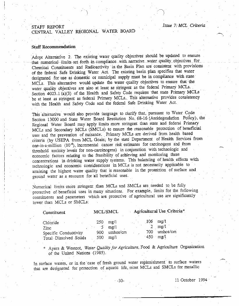
STAFF REPORT Issue 7: MCL CriteriaCENTRAL VALLEY REGIONAL WATER BOARD
Staff Reconunendation
Adopt Alternative 2. The existing water quality objectives should be updated to ensurethat numerical limitsset forth-in compliance _with narrative water quality objectives_ forChemical Constituents and Radioactivity in the Basin Plan are consistent with provisionsof the federal Safe Drinking Water Act. The existing basin plan specifies that waterdesignated for use as domestic or municipal supply must be in compliance with stateMCLs. This alternative would update the water quality objectives to ensure that thewater quality objectives are also at least as stringent as the federal Primary MCLs.Section 4023.1 (a)(3) of the Health and Safety Code requires that state Primary MCLsbe at least as stringent as federal Primary MCLs. This alternative provides consistencywith the Health and Safety Code and the federal Safe Drinking Water Act.
This alternative would also provide language to clarify that, pursuant to Water CodeSection 13000 and State Water Board Resolution No. 68-16 (Antidegradation Policy), theRegional Water Board may apply limits more stringent than state and federal PrimaryMCLs and Secondary MCLs (SMCLs) to ensure the reasonable protection of beneficialuses and the prevention of nuisance. Primary MCLs are derived from health basedcriteria (by USEPA from .MCL Goals; by the state Department of Health Services fromone-in-a-million (10-6), incremental cancer risk estimates for carcinogens and fromthreshold toxicity levels for non-carcinogens) in conjunction with technologic andeconomic factors relating to the feasibility of achieving and monitoring theseconcentrations in drinking water supply systems. This balancing of health effects withtechnologic and economic considerations in MCLs is not necessarily applicable toattaining the highest water quality that is reasonable in the protection of surface andground water as a resource for all beneficial uses.
Numerical limits more stringent than MCLs and SMCLs are needed to be fullyprotective of beneficial uses in many situations. For example, limits for the followingconstituents and parameters which are protective of agricultural use are significantlylower than IvICLs or SMCLs:
Constituent MCL/SMCL Agricultural Use Criteria*
Chloride 250 mg/1 106 mg/1
Zinc 5 mg/1 2 mg /I
Specific Conductivity 900 umhos/cm 700 umhos/cm
Total Dissolved Solids 500 mg/1 450 mg/1
* Ayers & Westcot, Water Quality for Agriculture, Food & Agriculture Organizationof the United Nations (1985).
In surface waters, or in the 'case of fresh ground water replenishment to surface watersthat are designated for protection of aquatic life, most MCLs and SMCLs for metallic
-30- 11 October 1994
STAFF REPORTIssue 7 MCL CriteriaCENTRAL VALLEY REGIONAL WATER BOARD
constituents will not be sufficiently protective, of beneficial uses. Aquatic life-protectivenumerical limits are often below MCLs and SMCLs for metallic constituents.
Even -for protection of drinking water supplies, MCLs and SMCLs are not alwaysprotective of this beneficial use of a water resource. MCLs are designed to apply towater within a drinking water distribution system and at the tap. As previously discussed,MCLs are derived from health based criteria in conjunction with technologic andeconomic factors relating to the feasibility of achieving and monitoring theseconcentrations in drinking water supply systems. This balancing of health effects withtechnologic and economic considerations in the derivation of MCLs is not necessarilyapplicable to the protection of sources of drinking water (a raw surface or ground waterresource).
A common example of incorrect MCL application is the use of the total trihalomethane(THM) MCL for the protection of ground water from chloroform. Chloroform is one ofthe four chemicals covered by the term "trihalomethanes ". These probable humancarcinogens are formed in drinking water by the action of chlorine, used for disinfection,on organic matter present in the raw source water. The total THM Primary MCL of 100micrograms/liter is 17 to 230 times higher than the published one-in-a-millionincremental cancer risk estimates for chloroform. USEPA has stated that the MCL fortotal THMs was based mainly on technologic and economic considerations. The MCLfor total THMs was derived by balancing the benefit provided by the chlorinationprocess (elimination of pathogens in drinking water) with the health threat posed by thetrihalomethane by-products of this process and the cost associated with conversion toother disinfection methods. Since ground water has not yet been chlorinated and maynot require chlorination before use, this type of cost/benefit balancing (accepting somecancer risk from chloroform and other THMs in order to eliminate pathogens and avoidconversion costs) is not germane to ground water protection. Therefore, the total THMMCL is not sufficiently protective of the ambient quality of domestic water supplysources. 'The published one-in-a-million incremental cancer risk estimates (ranging from0.43 to 6 micrograms/liter) are more accurate measures of potential impairment bychloroform of the beneficial use of ground water for domestic supply. Staff of USEPA,Region 9 (San Francisco), Water Management Division has supported the application ofa one-in-a-million cancer risk estimate, instead of the total THM Primary MCL, as anumerical water quality limit for chloroform in ground water as consistent with the intentof the federal Clean Water and Safe Drinking Water Acts. In conclusion, the total THMMCL is not appropriate for protection of the quality of a water resource from pollutionby chloroform.
The existing. Basin Plan contains a narrative water quality objective for tastes and odorsin both surface and ground waters. Taste and odor thresholds for the petroleum-basedfuel constituents toluene, xylene, and ethylbenzene are significantly lower (20 to 100times more restrictive) than the primary MCLs for those substances. To comply with thewater quality objective for tastes and odors, limits must be established at the taste and
-31- 11 October 1994
STAFF REPORT Issue 7: MCL CriteriaCENTRAL VALLEY REGIONAL WATER BOARD
odor threshold, not the primary MCLs, for these substances in cases where the water hasthe designated beneficial use of municipal and domestic supply. Where taste and odor
_ thresholds _ have_ not_been_ promulgated as SMCLs, the Regional Water Board usesavailable technical literature and other sources of information for determining theappropriate numeric standard that complies with the taste and odor objective. (See
Issue 14, Application of water quality objectives.,)
In an August 20, 1991 memorandum to all Department of Toxic Substances Control(DTSC) toxicologists regarding Health Risk Criteriafor Use in Risk Assessments Preparedfor or by DTSC , Mr. Jeffrey J. Wong, Ph.D., Chief, Toxicology and Risk AssessmentSection, DTSC, acknowledges that MCLs are, only part of the hierarchy of health riskcriteria that should be used to estimate health risks.
This alternative would provide consistency with existing federal standards andclarification with respect to the existing water quality objectives; therefore, attainability is
not in question and no environmental or economic consequences are anticipated.
Issue 8: Clarify the Surface Water Quality Objective for Toxicity - Additional Sources ofInformation (page III-I0)
The existing Basin Plan (Chapter III) contains the narrative toxicity objective "All watershall be maintained free of toxic substances in concentrations that produce detrimentalphysiological responses in human, plant, or aquatic life". The Basin Plan goes on to say,"Compliance with this objective will be determined by analyses of indicator organisms,species diversity, population density, growth anomalies, and biotoxicity tests ofappropriate duration or other methods as specified by the Regional [Water] Board". TheBasin Plan also cites various organizations that develop criteria that the Regional WaterBoard refers to when determining compliance with this narrative objective, including theState Water Board, the U.S. Food and Drug Administration the National Academy ofSciences, the USEPA, and "other organizations".
The list of references in this section of the proposed Basin Plan has been updated toinclude, "all material and relevant information submitted by the discharger and otherinterested parties", the California Office of Environmental Health. Hazard Assessment(which publishes Proposition 65 regulatory criteria for carcinogens and reproductivetoxins), and the California Department of Health Services (which publishes drinkingwater standards and action levels). This updated list gives a more complete descriptionof the references most commonly used by the Regional. Water Board when evaluatingcompliance with the toxicity objective and clarifies what is meant by "otherorganizations".
In addition, some agencies call their numerical limits "criteria", while others refer tothem as "guidelines". Therefore, the term "guidelines" is included in the proposed Basin
-32- 11 October 1994
STAFF REPORTIssue 8: Toxicity - AdditionalCENTRAL VALLEY REGIONAL WATER BOARD Sources of Information
Plan, along with the existing word "criteria". The terms are virtually synonymous, as theyrefer to non-regulatory indicators of toxicity.
The changes in the Basin Plan-language that are described above clarify existingregulation. Therefore, there are no known adverse environmental or economic impactsthat would result from the proposed new language. The proposed new language isconsistent with the proposed "Policy for Application of Water Quality Objectives" (seeIssue 14).
Issue 9: Clarify the Surface Water Quality Objective for Toxicity - ToxicologicInteraction (page III-10)
Present Policy
The existing Basin Plan contains the following narrative toxicity objective: "All watershall be maintained free of toxic substances in concentrations that produce detrimentalphysiological responses in human, plant, or aquatic life. Compliance with this objectivewill be determined by analyses of indicator organisms, species diversity, populationdensity, growth anomalies, and biotoxicity tests of appropriate duration or other methodsas specified by the Regional [Water] Board." The Basin Plan also cites variousreferences that are referred to in determining compliance with this narrative objective.Issue Description
As stated above, the existing Basin Plan includes the objective that "all waters shall bemaintained free of toxic substances in concentrations that produce detrimentalphysiolo6cal responses in human, plant, animal or aquatic life". Toxicity is prohibited,regardless of whether one chemical or a group of chemicals is responsible for thetoxicity. However, there has been some confusion over how the Regional Water Boardmakes toxicity determinations when combinations of toxic chemicals are present in water.The term "toxicologic interaction " refers to the toxicologic effect of the exposure of anorganism to two or' more toxic chemicals. Possible toxicologic interactions may begrouped into three types synergism, additivity, and antagonism. Usually, the effect oftwo toxic chemicals is the summation of the individual responses to each chemical. Thissituation is known as "additivity," since the toxic effects of each chemical are simplyadded to determine the overall, toxic effect. Synergism is where the combined effect isgreater than the summation of the individual responses to each chemical. An example ofsynergism is the cancer risk from the combination of asbestos exposure and smoking.Antagonism is where the combined effect is less than the summation of the individualresponses to each chemical. Unfortunately, . sufficient information is. often not availableon toxicologic interaction to be able to predict whether the result of the exposure tomultiple toxic chemicals will be synergistic or antagonistic.
-33-: 11 October 1994
STAFF REPORT .Issue 9: Surface Water Toxicity -
CENTRAL VALLEY REGIONAL WATER BOARD Toxicologic Interaction
The existing Basin Plan necessarily considerS toxicologic interactions through direct
measurement of toxicity to organisms, but is silent on how criteria and guidelines may be,
used to predict those toxicologic interactions.
Alternatives
Two types of options were evaluated: 1) no change and 2) adding language to clarify how.
the Regional Water Board makes determinations when combinations of toxic chemicals
are present in water. In addition to the "No Action" alternative, two alternative choices
are presented for clarifying language.
1. No ACTION . Under this alternative, the narrative objective for toxicity would
continue to be used' with no clear interpretation of how to protect beneficial usesfrom combinations of chemicals in the absence of direct measurements on..testorganisms, aquatic life. wildlife, plants or humans. This would result in
inconsistent interpretation and application of the objective. This could lead to
inadequate protection, or delay in protection until toxicity is actually manifested in
populations of organisms that beneficially use water.
CLARIFY How INTERACTIVE TOXICOLOGICAL EFFECTS ARE EVALUATED BY
ASSUMING ADDITIVITY FOR ALL POLLUTANTS . Under this alternative, theRegional Water Board would assume additivity for all pollutants. This would be
protective of beneficial uses and would clearly tell the regulated community andpublic how the Regional Water Board will address multiple toxicants in water.
However, this alternative would probably be over protective in many cases, since
it is unlikely that all constituents are strictly additive. Implementation of this
alternative could result in excessive expenditures by dischargers to meet receiving
water limits that are unnecessarily stringent.
CLARIFY HOW INTERACTIVE TOXICOLOGICAL' EFFECTS ARE EVALUATED BY
A SSUMING ADDITIVITY FOR SPECIFIC POLLUTANTS . Under this alternative, theRegional Water Board would, in the 'absence of scientifically valid evidence to the
contrary, assume additivity, for pollutants which are carcinogens or which manifest
their toxic effect through similar mechanisms (e.g., they affect the same organ
system).
This alternative would eliminate the existing ambiguity regarding how the
Regional Water Board interprets and implements the surface water quality
objective for toxicity. It would provide for more consistent implementation and
eliminate the potential for strict consideration of all chemical effects to be
additive.
-34- 11. October .1994
STAFF REPORTIssue 9: Swface Water Toxicity -CENTRAL VALLEY REGIONAL WATER BOARD Toxicologic Interaction
Staff Recommendation
Adopt alternative 3. Under this alternative, the Regional Water Board would, in theabsence of scientifically valid evidence to the contrary, assume additivity for pollutantswhich are carcinogens or which manifest their toxic effect through similar mechanisms.This alternative provides reasonable protection of beneficial uses and is a reasonableapplication of the narrative toxicity objective that has existed in the Basin Plan since1975. This alternative allows for clear action by the Regional Water Board based onchemical concentration data without the need to wait for toxicity to manifest itself inorganism populations. A standard toxicologic additivity equation to determine theadditive risk of multiple toxic substances is also proposed to be added to theImplementation section of the Basin Plan (see Issue 14).
Alternative 3 is consistent with the way the narrative objective has been historicallyinterpreted and it clarifies the existing objective. The existing Basin Plan includes theobjective that "all waters shall be maintained free of toxic substances in concentrationsthat produce detrimental physiological responses in human, plant, animal or aquatic life".Thus, the Basin Plan already requires that surface waters be nontoxic, regardless ofwhether one or a group of constituents are responsible for the toxicity. The proposedBasin Plan language about additivity merely clarifies the' existing requirement. It allowsthe Regional Water Board to make judgments about which constituents are additive(based on existing sources of information) whenever the Regional Water Board makes adecision that could affect surface water (e.g., adopt waste discharge requirements). Italso allows dischargers and other interested parties the opportunity to presentinformation regarding the toxicologic interaction of constituents.
The proposed Basin Plan language is consistent with regulations in Title 23, CaliforniaCode of Regulations (CCR), Section 2550.4(g) and Title 22, CCR, Section 66264.94(f)for determining cleanup levels' greater than background, and with guidance materialsprovided both by USEPA under the CERCLA Program [Risk Assessment & Guidance forSupeifund (RAGS) , Volume I, Human Health Evaluation Manual, Part A-1989 and PartB-1991} and by the Department of Toxic Substances Control for hazardous site riskassessment [Cal TOX: A Multimedia Total Exposure Model For Hazardous Waste Sites,December 1993 and Preliminary Endangerment Assessment Guidance Manual , January1994]. It is also consistent with the existing additivity provisions contained in theimplementation program for pesticides, described in Chapter 4 of the existing Basin Plan(Page IV-36).
The existing Basin Plan already requires waters to be free of pollutants or chemicals inamounts that are toxic. The proposed language on additivity does not impose anyadditional regulatory requirement. In considering economics, it should be noted thatthere may be costs associated with this objective. Since the objective has broad andgeneral applicability, it is not feasible to perform a meaningful economic analysis of itsimpacts at this time. To implement this Basin Plan language, the Regional Water Board
-35- 11 October 1994
STAFF REPORT Issue 9: Surface. Water Toxicity -CENTRAL VALLEY REGIONAL WATER BOARD Toxicologic Interaction
will weigh economic considerations along with other factors in adopting enforcementorders and waste discharge requirements for individual discharges. One potential_expense_ to a discharger might be_if they choose to prepare information to submit to theRegional Water Board regarding the toxicologic interactive properties of chemicals. Thiswould be a factor only if the discharger does not agree with the Regional Water Board'sdeterminations on what is additive. The cost of preparing this information is unknownsince it is up to the discharger to determine what level of response is appropriate, if any.However, there will be no additional costs in the event that the discharger can prove notoxicity exists. If the discharger is unable to prove to the Regional Water Board thatadditive toxicity does not exist, there will also be costs associated with treatmentprocesses, etc., that must be performed to reduce the levels of constituents to a pointwhere they are no longer toxic. The economic benefits of avoiding the costs of failing torecognize and compensate for toxicological interaction are also unknown, but may bequite substantial in some instances (e.g., fish kills, loss of biodiversity, loss ofeconomically important aquatic life, and loss of drinking water supplies).
In summary, the proposed language on additivity clarifies existing Basin Plan language,and does not add an additional regulatory or significant economic burden to dischargers.There are no adverse environmental impacts that would result from this action.
Issue 10: Add turbidity objective for surface waters with natural turbidity less than5 NTUs (Chapter III, page III-10)
Present Policy
. The existing Basin Plan contains the following general turbidity objectives, in addition toobjectives for specific water bodies: "Waters shall be free of changes. in 'turbidity thatcause nuisance or adversely affect beneficial uses. Increases in turbidity attributable to
controllable water quality factors shall not exceed the following limits:
Where natural turbidity is between 0 and 50 Nephelometric Turbidity Units(NTUs), increases shall not exceed 20 percent.
Where natural turbidity is between 5.0 and 100 NTUs, increases shall not exceed
10 NTUs.
Where natural turbidity is greater than 100 NTUs, increases shall not exceed 10percent."
Issue Description
Turbidity is caused by suspended materials which interfere with the passage of lightthrough water. Because of the wide variety of materials which cause turbidity, an
-36- 11 October 1994
STAFF REPORTCENTRAL VALLEY REGIONAL WATER BOARD
Issue 10: Turbidity Objectivefor Swface Waters
arbitrary standard of 1 milligram of silicate clay per liter of water is defined as one unitof turbidity.
Staff is not aware of-any significant water quality problems associated with an increase of1 NTU in surface, waters in the lower turbidity range (natural turbidities between 0 and 5NTUs). However, the difference between allowing an increase of 1 NTU and anincrease of 20 percent over background may be significant in terms of cost when treatingwastewater. Retaining the stringent limit when there is no known water quality benefitcould result in reduction of discharges of good quality wastewaters into natural channels.Because of the climate in the Region and the control of natural stream flows, increasingflows in the natural channels would be a benefit to aquatic resources and, thus, to thepeople of the state. In cases of effluent dominated streams, aquatic resources maydepend on the effluent flow for survival.
Alternatives
No, ACTION . Under this alternative the existing objective would' apply: wherenatural turbidity is between 0 and 50 NTUs, increases shall not exceed 20 percent.Staff is not aware of any adverse impact on beneficial uses of water in the lowerranges. (0 to 5 NTUs) with small changes in turbidity. However, when the wastedischarge is of good quality, it may be used to increase the flow of waters in naturalchannels and thus increase the water quality benefits for aquatic life. Retaining thecurrent objective, which limits increases to 20 percent, would prohibit almost alldischarges to these surface waters because of excessive treatment costs.
ALLOW TURBIDITY TO INCREASE BY 1 NTU IN WATERS WITH NATURALTURBIDITIES LESS THAN 5 NTUs. Under this alternative the objective for turbidityincreases in waters where natural turbidity is between 0 and 5 NTUs would beI NTU. The objective for turbidity increases in waters where natural turbidity isbetween 5 and 50 NTUs would be 20 percent. Staff is not aware of any adverseimpact on beneficial uses of water with small changes in turbidity in the lowerranges (0 to 5 NTUs). Waste discharges that increase natural turbidity by just 1NTU are of good quality. It would be beneficial in this case to allow the dischargeto increase the flows in the natural channel. This would benefit the aquaticresources of the channel and thus benefit the people of the state.
Staff Recommendation
Adopt Alternative 2. Alternative 1 was rejected because it is unnecessarily stringent. Itcan be cost prohibitive to treat effluent to a level where it will only increase the turbidityof the receiving water a fraction of an NTU, which is the case for receiving ,waters in thelower turbidity range (0 to 5 NTUs). In those cases, a valuable resource is needlesslygoing to waste, since discharges that increase natural turbidity by just 1 NTU are still ofgood quality. Alternative 2 allows a more reasonable approach in terms of treatment
-37- 11 October 1994
STAFF REPORT Issue 10: Turbidity ObjectiveCENTRAL VALLEY REGIONAL WATER BOARD for Swface Waters
costs. Staff does not have any information to show that a change of 1 NTU in the 0 to 5NTU turbidity range has any significant adverse impact on beneficial uses or theenvironment. It would be a benefit to the people of the state and the environment to beable-td Maintain flows in natural ch-attriels;7e-specially -effluent -dominated streams thatwould otherwise go dry during certain times of the year.
Staff proposes the following Basin Plan language:
"Waters shall be free of changes in turbidity that cause nuisance or adversely affectbeneficial uses. Increases in turbidity attributable to controllable water qualityfactors shall not exceed the following limits:
o Where natural turbidity is between 0 and 5 Nephelometric Turbidity Units(NTUs), increases shall not exceed 1 NTU.
Where natural turbidity is between 5 and 50 Nephelometric Turbidity Units(NTUs), increases shall not exceed 20 percent.
Where natural turbidity is between 50 and 100 NTUs, increases shall not exceed
10 NTUs.
o Where natural turbidity is greater than 100 NTUs, increases shall not exceed 10
percent.
In determining compliance with the above limits, appropriate averaging periods maybe applied provided that beneficial uses will be fully protected."
The statement regarding and appropriate averaging periods was added for clarity.Averaging periods are currently allowed under the existing Basin Plan.
Potential environmental impacts are discussed following the CEQA checklist (seeAppendix 1). In considering economics, it should be noted that the new language wouldresult in cost savings, because it would eliminate unnecessary treatment costs, todischargers proposing to discharge into streams with a natural turbidity between 0 and 5NTUs.
Issue 11: Clarify the ground water quality objective for chemical constituents withrespect to toxic constituents (Chapter III, page III-11)
Present Policy
The water quality objectives specified in the existing Basin Plan that apply to all groundwaters of the Sacramento and San Joaquin River Basins are set forth under the
-38- 11 October 1994
STAFF REPORTIssue 11: Ground Water Quality Obj.CENTRAL VALLEY REGIONAL WATER BOARD for Chemical Constituents
categories of bacteria, chemical constituents, radioactivity, and tastes and odors. Anumerical objective is specified for bacteria, and the narrative objectives for chemicalconstituents and Radioactivity include a reference to MCLs from Title 22 of theCalifornia Code of Regulations- (C-CR)-,- Division 4, Chapter 15, as water quality limits.General narrative objectives prohibit chemical constituents and radionuclides inconcentrations that can adversely affect any designated beneficial use, and prohibit tasteor odor-producing substances that cause nuisance or could adversely affect beneficialuses. These objectives describe limits to protect designated beneficial uses of groundwater.
Issue Description
As indicated previously in discussing the need to expand ground water beneficial usedesignations (see Issue 6), ground water resources in the Region have recently comeunder increasing demands and impacts. The importance of ensuring adequate waterquality, as well as quantity, in protecting the sources of usable ground water throughoutthe Region is now being greatly emphasized.
The Regional Water Board has identified over 7000 sites throughout the Region withconfirmed releases of toxic and other deleterious substances which have adverselyimpacted or threaten to impact the quality of ground water resources. Sources ofpollution at these sites include, but are not limited to: leaking underground storagetanks and sumps; leaking above ground tanks; leaking pipelines; leaking wastemanagement units, such as landfills, disposal pits, trenches and ponds; surface spills fromchemical handling, transfer or storage; poor housekeeping; and illegal disposal. Thesesources of pollution can represent both existing and potential toxic and carcinogenicthreats to humans, plants, animals, or aquatic life. Some of the important toxicpollutants from these sources include benzene, TCE, PCE, pesticides such as DBCP, andheavy metals, such as arsenic and chromium.
The current water quality objectives for ground' water were set forth as part of the BasinPlan when it was first adopted in 1975. These objectives were not updated in 1989, whenthe existing Basin Plan was published: Since 1975, it has become imperative that thesewater quality objectives be more adequately designed to ensure that ground waterremain of a_ quality suitable for its existing and potential beneficial uses. As presented,the existing ground water objectives lack clarity and comprehensiveness with respect totoxicity.
The beneficial uses of ground waters threatened and impacted by toxic substances arealready protected in the existing Basin Plan pursuant to the water quality objective forChemical Constituents, which states, in part, that "{g}round waters shall not containchemical constituents in concentrations that adversely affect beneficial uses." However,the Basin Plan language should be more specific to ensure adequate protection againsttoxic effects. The existing Basin Plan does not include a ground water quality objective
-39- 11 October 1994
STAFF REPORT Issue II: Ground Water Quality Obj.CENTRAL VALLEY. REGIONAL WATER BOARD for Chemical Constituents
for toxicity and it provides no specific interpretation of how beneficial uses are protectedfrom combinations of toxic chemicals present in water. Without a toxicity objective thataccounts for combined toxicity, adequate protection from toxic substances andcarcinogens is not clearly provided.
Alternatives
1. NO ACTION. No action would continue use of the existing approach to protectingground water from toxicity which is not clear. As previously indicated, adequateprotection of usable ground water resources from the effects of toxic substances
may not be clearly provided by the existing' water quality objective for Chemical
Constituents.
CLARIFY THE GROUND WATER QUALITY OBJECTIVE FOR CHEMICAL
CONSTITUENTS BY ADDING A SPECIFIC OBJECTIVE FOR TOXICITY AND ASSUMING
ADDITIVITY FOR ALL POLLUTANTS . Under this alternative, the ChemicalConstituent objective for ground water would be clarified by adding a ground waterquality objective for toxicity, including language to address toxicologic interactiveeffects. The Regional Water Board would assume additivity for all pollutants. This
would be protective of beneficial uses and would clearly tell the regulatedcommunity and public how the Regional Water Board will address multipletoxicants in water. However, this alternative would probably be over protective inmany cases, since it is unlikely that all constituents are strictly additive.Implementation of this alternative could result in excessive expenditures bydischargers to meet receiving water limits that are unreasonably stringent.
CLARIFY THE GROUND WATER QUALITY OBJECTIVE FOR CHEMICAL
CONSTITUENTS BY ADDING A SPECIFIC OBJECTIVE FOR TOXICITY AND ASSUMING
ADDITIVITY FOR SPECIFIC POLLUTANTS . Under this alternative, the ChemicalConstituent objective for ground water would be clarified by a.ddi,:g a ground water
quality objective for toxicity, including language to address toxicologic interactiveeffects. The Regional Water Board would, in the absence of scientifically validevidence to the contrary, assume additivity for pollutants which are carcinogens orwhich manifest their toxic effect through similar mechanisms (e.g., they affect the
same organ system).
This approach would address the ambiguities associated with the ChemicalConstituent objective by identifying that information regarding toxicity andinteractive toxicologic effects may be considered by the. Regional 'Water Board inprotecting the beneficial uses of ground water. It would eliminate the potential forstrict consideration of all chemical effects to be additive.
-40- 11 October 1994
STAFF REPORTIssue 11: Ground Water Quality Obj.CENTRAL VALLEY REGIONAL WATER BOARD for Chemical Constituents
Staff Recommendation
Adopt Alternative 3. This Region is significantly limited by the availability and qualityof its ground water resources. Improper wastemanagement practices and contaminatedsites pose significant threats to the quality of the usable ground water resources. Inorder to adequately protect the beneficial uses of ground water and prevent conditions ofnuisance associated with these resources, the existing water quality objectives must beupdated and made more clear, comprehensive, and effective with respect to toxicity.
A water quality objective for toxicity is needed to more clearly provide adequateprotection of beneficial uses of ground waters from toxic substances, includingcarcinogens. This objective essentially clarifies the current approach to applying theexisting narrative ground water objective for Chemical Constituents in cases where eitherno MCL is available or the MCL is not sufficiently limiting to protect beneficial -uses(see Issue 7). Toxicity in ground water is a concern when beneficial uses involveexposure of organisms to ground water, including exposure of humans for M,UN waters,exposure of crops and livestock for agricultural supply waters, and exposure of aquaticlife and wildlife for ground waters that replenish surface waters. This objective moreclearly indicates that protection must be provided in cases where organisms are involvedin he beneficial use. For example, in cases where Agricultural Supply has beendesignated as a beneficial use, the consideration of toxicity criteria for plant lifeprotection, which are more stringent than MCLs for certain constituents and parameters,is required in order to protect the beneficial use. Toxicity criteria for certainconstituents and parameters are also more stringent than MCLs for aquatic lifeprotection. Consideration of these 'criteria are necessary to protect the beneficial usedesignated for surface waters in cases where ground waters are hydraulically connectedto surface waters that support habitats suitable for aquatic organisms and wildlife.
Where multiple toxic pollutants exist together in water, toxic effects can only beprevented by acknowledgment of toxicologic interactions. In the absence of scientificallyvalid evidence to the contrary, pollutants which are carcinogens or which manifest theirtoxic effects through similar mechanisms must be considered by, the Board to haveadditive toxicity in order to provide adequate protection from detrimental affectsassociated with beneficial uses (see Issue 9). These additive considerations are alsocurrently provided for pursuant to the existing Chemical Constituent water qualityobjective for ground water.
The toxicity objective for ground water clarifies existing requirements and- is set forth ina manner similar to the existing and proposed additions to the toxicity objective forsurface waters of the Region. As such, this objective provides for protecting beneficialuses of ground water in a manner consistent with existing Basin Plan requirements forboth surface and ground waters. As a result, attainability is not in question and thisalternative has no new environmental or economic consequences.
-41- 11 October 1994
STAFF REPORT Issue 11: Ground Water Quality Obj.
CENTRAL VALLEY REGIONAL WATER BOARD for Chemical Constituents
The existing Basin Plan already requires waters to be free of pollutants or chemicals inamounts that are toxic. The proposed language on additivity does not impose any
additional regulatory requirement. In considering economics, it should be noted thatthere may be costs associated with this objective. Since the objective has broad andgeneral applicability, it is not feasible to perform a meaningful economic analysis of itsimpacts at this time. To implement this Basin Plan language, the Regional Water Boardwill weigh economic considerations along with other factors in adopting enforcementorders and waste discharge requirements for individual discharges. One potentialexpense to a discharger might be if they choose to prepare information to submit to the
Regional Water Board regarding the toxicologic interactive properties of chemicals. This
would be a factor only if the discharger does not agree with the. Regional Water Board'sdeterminations on what is additive. The cost of preparing this information is unknownsince it is up to the discharger to determine what level of response is appropriate, if any.However, there will be no additional costs in the event that the discharger can prove notoxicity exists. If the discharger is unable to prove to the Regional Water Board thattoxicity does not exist, there will also be costs associated with treatment processes, etc.,reduce the levels of constituents to a point where they' are no longer toxic.
Issue 12: Expand the Disposal of Wastewater on Land Policy and further clarifyimplementation of Water Reclamation Policy (Chapter IV Policy #2 WastewaterReuse Policy, page IV-17.)
Present Policy
The existing Basin Plan incorporates State Water Board Resolution No. 77-1, Statement
of Policy with respect to Water Reclamation in California, by reference. It is Appendix
Item 5 and is discussed as part of the section entitled "Nature of Control ActionsImplemented by the Regional Board". As discussed in the existing Basin Plan,Resolution No. 77-1 requires the Regional Water Board to conduct water reclamationsurveys and specifies rechrnation actions to be implemented by the Regional Board.This resolution directs the Regional Water Board to encourage the reclamation andreuse of water in the region. In implementing Resolution No. 77-1, The Regional Water
Board adopted a policy entitled "Disposal of Wastewater on Land Policy" as part of theexisting Basin Plan. Pursuant to this policy, the Regional Water Board encourages thedisposal of wastewaters on land where practicable, and requires applicants for wastedischarge requirements and discharge permits to evaluate land disposal as an alternative.
Issue Description
The existing Basin Plan does not address how the Regional Water Board implementsResolution No. 77-1 to encourage the reuse of wastewater other than for land disposal.As stated in Resolution 77-1, "The California Legislature has declared that the Stateshall undertake all possible steps to encourage the development of water reclamation
-42- II October 1994
STAFF REPORTIssue 12: WastewaterCENTRAL VALLEY REGIONAL WATER BOARD Reuse Policy
facilities so that reclaimed water may be made available to help meet the growing waterrequirements of the State." A document entitled "Policy and Action Plan for WaterReclamation in California," dated December 1976, is also referred to in Resolution No.77-1. This document recommends a variety of actions to encourage the development ofwater reclamation facilities and the use of reclaimed- water. However, it is not clear howthe Regional Water Board applies these water reclamation principles when issuing apermit, or in an equivalent process, other than to authorize the disposal of wastewaterson land where practicable. As a result, the existing Basin Plan lacks the specificitynecessary to ensure proper and consistent implementation of the principles of Resolution77-1. In addition, this lack of clarity can result in unnecessary delay in permittingprocesses because information necessary to be consistent with the requirements ofResolution 77-1 may not be provided to the Regional Water Board.
Alternatives
1. NO ACTION. The policy entitled "Disposal of Wastewater on Land Policy" wouldcontinue to present a limited approach to implementing Resolution No. 77-1 in theBasin Plan. As previously indicated, the Regional Water Board's approach to waterreclamation and reuse in this policy, as currently set forth in the Basin Plan, is notadequate.
EXPAND THE POLICY ENTITLED "DISPOSAL OF WASTEWATER ON LAND POLICY ."This alternative would modify the "Disposal of. Wastewater. on Land Policy" byadopting a new title and language to further clarify the principles of Resolution No.77-1 as part of the Basin Plan. The policy would be entitled "Wastewater ReusePolicy." The policy would be expanded to require applicants for waste dischargerequirements and discharge permits to evaluate wastewater reuse options inaddition to land disposal, as appropriate. Dischargers would also be required toevaluate how options for wastewater reuse can be optimized. This expanded policywould provide a more comprehensive basis for understanding and implementing theRegional Water Board's existing approach to encouraging water reuse pursuant tothe mandate of Resolution No. 77-1.
Staff Recommendation
Adopt Alternative 2. Staff recommends this alternative as necessary to ensure properinterpretation and application of Resolution No. 77-1. Basin Plan requirements must bemore consistent with, and clarify, the principles described in Resolution No. 77-1 toeffectively encourage water reclamation in the Region.
This alternative would clarify procedures and requirements used and implemented by theRegional Board pursuant to the existing basin plan; therefore, attainability is not inquestion and this alternative would not result in any new environmental or economicconsequences. Potential environmental impacts are discussed following the CEQAchecklist (see Appendix 1).
-43- 11 October 1994
STAFF REPORTIssue 12: Wastewater
CENTRAL VALLEY REGIONAL WATER BOARD Reuse Policy
Issue 13: Clarify implementation of antidegradation policy (Chapter IV - Policy #6.
Antidegradation Implementation Policy, page IV-18)
Present Policy
The existing Basin Plan incorporates State Water Board Resolution No. 68-16,
"Statement of Policy with Respect to Maintaining High Quality of Waters of California"
(Antidegradation Policy) by reference. It is Appendix Item 1 and is discussed as part of
the section entitled "Nature of Control Actions Implemented by the Regional Board." In
1968, the State Water Board adopted Resolution No. 68-16 under the Dickey Water
Pollution Control Act (Dickey Act) and intended it to be part of the state's water quality
standards submittal under the Water Quality Act of 1965, Pub. L. No. 89-234, 79 Stat.
903. See generally Environmental Law Institute, Federal Environmental Law 715-19
(1974); 47 Ops.Cal.Atty.Gen. 135 (1966). The State Water Board at that time -
established water quality standards by setting objectives in state policy for water quality
control. 44 Ops.Cal.Atty.Gen. 126 (1964). As discussed in the existing Basin Plan,
Resolution No. 68-16 generally restricts the Regional Water Board and dischargers from
reducing the water quality of surface and ground waters even though such a reduction in
water quality might still allow the protection of the beneficial uses associated with the
water prior to the quality reduction. Pursuant to Resolution 68-16, in regulating
discharges to waters of the state, Regional Boards should not allow degradation of water,
quality unless such degradation would be consistent with the maximum benefit to the
people of the state, protects all beneficial uses, and applies best practicable treatment or
control. This policy to maintain existing high quality water was reaffirmed by the State,
Board in 1987 and has not been superseded by any other policies of the State Water
Board.
Issue Description
The existing Basin Plan does not directly address how the Regional Water Board
implements Resolution No. 68-16. In particular, it is not clear how the Regional Water
Board applies the mandate to maintain high quality waters when issuing a permit, or in
an equivalent process, to authorize a discharge which may affect the quality of waters
within the region. As a result, the existing Basin Plan lacks the specificity necessary to
ensure compliance with, and consistent application of, Resolution 68-16. The lack of
clarity can also result in unnecessary delay in permitting processes because insufficient
information may be provided to the Regional Water Board.
Alternatives
1. No ACTION . Resolution No. 68-16 would continue to be incorporated, by the
existing references in the Basin Plan. As previously indicated, the Regional Water
Board's approach to implementing this policy, as currently set forth in the Basin
Plan, is not clear. This alternative would continue the existing potential for
11 October 1994
STAFF REPORTIssue 13: Implementation ofCENTRAL VALLEY REGIONAL WATER BOARD
Antidegrodotion Policy
inconsistent interpretation and application of Resolution 68-16. This could result inoverregulation in some cases and inadequate protection of water quality in others,pursuant to this policy. The potential for unnecessary delay as part of permitting-processes would also-remain high.
ADOPT A NEW POLICY TO CLARIFY HOW RESOLUTION No. 68-16 IS IMPLEMENTEDBY THE REGIONAL WATER BOARD IN ISSUING A PERMIT , OR AN EQUIVALENTPROCESS , REGARDING. ANY DISCHARGE OF WASTE WHICH MAY AFFECT THEQUALITY OF SURFACE OR GROUND WATER IN THE REGION . This alternativewould set forth a new policy entitled "Antidegraciation Implementation Policy" aspart of the Basin Plan. The policy would include a discussion of the informationnecessary, including factors which must be considered, in making a determinationregarding a discharge, or a potential discharge, which may degrade the quality ofwaters of the Region. This policy would provide a clear and consistent basis forunderstanding the Regional Water Board's existing approach to protecting thesewaters pursuant to the mandate of Resolution No. 68-16.
Staff Recommendation
Adopt Alternative 2. Staff recommends this alternative as the most effective, reasonable,and necessary method to eliminate ambiguity, and to ensure proper protection of waterquality, regarding the implementation of Resolution No. 68-16. This ambiguity couldresult in incorrect application or interpretation of Basin Plan requirements. Pursuant toResolution No. 68-16, the Regional Water Board should make specific findings inauthorizing any discharge which may affect water quality in the region. Therefore, it isthe responsibility of the Regional Board to make decisions regarding the nature of adischarge, or potential discharge, which may have an adverse affect on water quality.
Both regional and site-specific conditions must be considered in any decision affectingresources that are locally important. The State Water Board has interpreted ResolutionNo. 68-16 to incorporate the federal antidegradation policy in order to ensureconsistency with federal Clean Water Act requirements. See State Water Board OrderNo. 86-17 (Fay) at 17-18.. USEPA concurred with the State Water Board'sinterpretation. See memorandum from William R. Attwater to All Regional BoardExecutive Officers, 7 October 1987, p.2, "Anti-degradation Policy". Application ofResolution No. 68-16 and the federal antidegradation policy hinge on the specific facts ofthe situation. It, is not possible to provide a definitive answer as to what numericstandard is appropriate regarding a discharge without site-specific information.Nonetheless, the Regional Board must strive for consistency in procedures for authorizingdischarges to waters of the region in order to avoid inequitable results.
Resolution No. 68-16 requires, in part, that any activity that results in discharges to highquality water must be required to meet "waste discharge requirements which will resultin the best practicable treatment or control of the discharge necessary to assure that (a)
-45- 11 October 1994
STAFF REPORT Issue 13: Implementation ofCENTRAL VALLEY REGIONAL WATER BOARD Antidegradation Policy
pollution or nuisance will not occur and (b) the highest water quality consistent with themaximum benefit to the people of the State will be maintained." However, ResolutionNo. 68-16 does, not define "best practicable treatment or control." To comply with thisstandard, the Regional Board sets waste discharge requirements at levels thatcan beachieved using "best efforts" and "reasonable control methods." See, e.g., State WaterBoard Order No. 82-5 (Chino Basin Municipal Water District). Discharge requirements
may be set at more stringent levels than the water quality control plan objectives if they
can be met using "best efforts." The "best efforts" approach involves "(a) making ashowing that the constituent is in need of control; and (b) establishing limitations whichthe discharger can be expected to achieve using reasonable control measures." StateWater Board Order No.. WQ 81-5 (City of Lompoc) at p.6. To determine what are"reasonable control methods" for discharges to ground water, reference to Clean WaterAct technology-based standards for discharges to surface water is appropriate. Underthe Clean Water Act, point source discharges to surface waters must be treated usingbest available technology economically achievable (BAT). Point source discharges toground water must meet the same requirements.
The policy set forth under this alternative would clarify procedures and requirementsused and implemented by the Regional Board pursuant to the existing Basin Plan;
therefore, attainability is not in question and this alternative' would not result in any newenvironmental or economic consequences. Costs of providing information will continueto vary based on the potential impacts of the discharge to receiving waters. There areno adverse environmental impacts that would result from the proposed clarifications.
Issue 14: Clarify application of water quality objectives (Chapter IV - Policy 7. Policyfor Application of Water Quality Objectives, pages IV-18 to IV-20)
Present Policy
The Porter-Cologne Act requires the Regional Water Boards to establish water quality'objectives in Basin Plans. Water Code Section 13241. "Water quality objectives" aredefined as "the limits or levels of water quality constituents or characteristics which areestablished for the reasonable protection of beneficial uses of water or the prevention ofnuisance within a specific area." Water Code Section 13050(h).
The water quality objectives specified in the existing 'Basin Plan that apply to surfacewaters of the Sacramento and San Joaquin River Basins are set forth under thecategories of bacteria, biostimulatory substances, chemical constituents, color, dissolvedoxygen, floating material, oil and grease, pH, pesticides, radioactivity, salinity, sediment,
settleable material, suspended material, tastes and odors, temperature, toxicity, and
turbidity. These objectives (numerical, narrative, or both) describe limits to protectdesignated beneficial uses of surface water. The narrative objectives for Chemical
-46- 11 October 1994
STAFF REPORT Issue 14: Application of Water.CENTRAL VALLEY REGIONAL WATER BOARD Quality Objectives
Constituents and Radioactivity include a reference to MCLs from Title 22 of theCalifornia Code of Regulations (CCR), Division 4, Chapter 15, as water quality limits.
The water quality objectives specified in the existing Basin Plan that apply to ground_waters of-theSacramentoand-San-Joaquin River Basins, are set forth under thecategories of Bacteria, Chemical Constituents, Radioactivity, and Tastes and Odors. Anumerical objective is specified for Bacteria, and the narrative objectives for ChemicalConstituents and Radioactivity include a reference to MCLs from Title 22 of theCalifornia Code of Regulations (CCR), Division 4, Chapter 15, as water quality limits.General narrative objectives prohibit chemical constituents in concentrations thatadversely affect agricultural and other beneficial uses, and prohibit taste orodor-producing substances that cause nuisance or could adversely affect beneficial uses.These objectives describe limits to protect designated beneficial uses of ground water.
As previously discussed (see Issue 7), the maintenance of the existing high quality ofwater (i.e., "background") is the. Regional Water Board's initial goal in implementing theamidegradation directives of Section 13000 of the Water Code and State Water BoardResolution No. 68-16 (Antidegradation Policy). "Background" means the concentrationsor measures of constituents or parameters in water or soil that has not been affected bythe discharge(s) in question. This goal of "background" defines the most stringent limitsthat the Regional Water Board may require for water quality protection. The waterquality objectives specified in the Basin Plan and in other applicable Water. QualityControl Plans represent the least stringent limits required for water quality protection.
Issue Description
As presented in the existing Basin Plan, the water quality objectives lack clarity andcomprehensiveness. A better understanding of the complete process of applying thewater quality objectives is needed. It is not clear in the existing Basin Plan howconsistency with existing statutes, policies and procedures is maintained when waterquality objectives are applied.
In addition, water quality objectives may be stated in either numerical or narrative form.Where numerical objectives are listed in the existing Basin Plan, their values become thenumerical water quality limits for the indicated constituent(s) or parameter(s) to protectbeneficial uses of the specified body of water. Thus, the application of numericalobjectives is direct and easy to understand. However, some of the important waterquality objectives for surface water and most of the current water quality objectives forground waters are stated in narrative form, including only limited references tonumerical criteria. As a result, it is unclear how these objectives are applied by theRegional Water Board.
The lack of clarity associated with the existing water quality objectives is particularlyevident in cases where State or Federal agencies other than the Regional Water Boardare involved in interpreting and applying the objectives. For example, in establishing
-47- 11 October 1994
STAFF REPORT Issue 14: Application of WaterCENTRAL VALLEY REGIONAL WATER BOARD Quality Objectives
cleanup. levels for ground water contaminated by hazardous chemicals and waste atDepartment of Defense (DoD) sites throughout the region, the USEPA and DoDinterpret the state standards that will be implemented. As the agencies responsible forimplementing the provisions of the Comprehensive Environmental Response,Compensation, and Liability Act (CERCLA), and because CERCLA takes precedencethese DoD sites, the USEPA and DoD ultimately determine whether water qualityobjectives and other state requirements are applicable, or relevant and appropriate
requirements (ARARs).
Once this determination is made, the USEPA or DoD will implement a state waterquality objective or other state requirement only to the extent that the objective is, orresults in, more stringent limits than included in any federal ARAR criteria.Negotiations with the USEPA and DoD regarding the applicability and stringency of thewater quality objectives for ground water have been complicated and difficult as a resultof the lack of explicit identification of the initial "background" goal and the ambiguitiesassociated with implementing the current narrative form of the water quality objectivesin the existing basin plan. This process has, and will continue to have, great potential to
result in applications of water quality objectives at DoD and CERCLA facilities that areinconsistent with those applied by the Regional Water Board at other sites in the region.
In addition, as discussed in Issue 9, the existing Basin Plan explicitly considers toxicologicinteraction through direct measurement of toxicity to organisms, but is silent on howcriteria and guidelines may be used to measure or predict toxicologic interactions.Therefore, it is unclear how the Regional Water Board makes determinations whencombinations of toxic chemicals are present in water.
Alternatives
1. No ACTION . No action would continue use of the existing numerical and narrativeobjectives. As previously indicated, the application of these objectives, as currentlyset forth, is not clear. This alternative would continue the existing potential forinconsistent interpretation and application of the water quality objectives. Thiscould result in overregulation in some cases and inadequate protection in others.
CLARIFY THAT "BACKGROUND " REPRESENTS AN INITIAL GOAL AND ADOPT
NUMERICAL WATER QUALITY OBJECTIVES . This alternative would expand thewater quality objectives to include lannage that would describe how the RegionalWater Board applies State Water Board Resolution No. 68-16 to maintain"background" water quality conditions, unless some change in water quality ispermissible under that policy. This alternative would also replace the narrativewater quality objectives with numerical water quality objectives for all constituentsand parameters of concern in protecting water quality and all designated beneficialuses.
-48- 11 October 1994
STAFF REPORTIssue 14: Application of WaterCENTRAL VALLEY REGIONAL WATER BOARD Quality Objectives
This alternative would require physical tests (e.g. toxicity, taste and odor) to beconducted on all waters of the Region in order to measure the effects ofconstituents and parameters on all waters with designated beneficial uses. An effortsuch as this would not be practical nor practicable to perform. There would be aneed to develop numerical objectives for a "vast number of constituents andparameters and it may not be feasible to simulate all cases representative ofpotential actual effects or make accurate predictions of actual effects. Even if allsuch effects could be adequately simulated or accurately predicted, there areinsufficient staff resources available to cover all of the chemicals and parametersthat could affect beneficial uses of the waters of the region.
In addition, fixed numerical objectives would leave no flexibility to account forchanges in our knowledge of the effects of pollutants or the ability to react to newlydiscovered pollutants without a formal Basin Plan amendment. Fixed numericalobjectives for chemical constituents would also remove the flexibility to account forthe combined risks resulting from the presence of multiple chemicals together in awater resource. This would not provide for adequate protection of water qualityand designated beneficial uses.
3. ADOPT A POLICY WHICH CLARIFIES THAT "BACKGROUND " REPRESENTS AN INITIALGOAL AND DESCRIBES HOW THE NUMERICAL LIMITS ARE ESTABLISHED. INIMPLEMENTING THE NARRATIVE WATER QUALITY OBJECTIVES . Under thisalternative, a policy entitled "Policy for Application of. Water Quality Objectives"would be adopted as part of the Basin Plan to clarify how water quality objectivesare implemented and applied. The policy would include language to clarify thatwater quality objectives apply to all waters within a surface water or ground waterresource for which beneficial uses have been designated, rather than at an intake,vvellhead or other point of consumption. The policy would also describe how theRegional Water Board applies State Water Board Resolution No. 68-16 to promotethe maintenance of "background" water quality conditions, unless some adversechange in water quality is permissible under that resolution. References tonumerical criteria and other information would be added to make the process bywhich numerical limits are determined by the Regional Water Board when applyingand evaluating compliance with narrative standards easier to understand. Finally,specific language and a standard additive toxicity formula would be presented toclarify how the Regional Water Board determines appropriate numerical limits incases where toxic pollutants exist together in water.
This approach would clarify the implementation of Section 13000 of the WaterCode, the Antidegradation Policy, and the Chemical Constituent water qualityobjectives. Further clarification would be provided in evaluating compliance withthe current narrative 'objectives by identifying information that may be consideredby the Regional Water Board, including toxicity and interactive toxicologic effects;and numerical criteria developed and/or published by other agencies andorganizations (e.g., State Water Board, USEPA, California Department of Health
-49- 11 October 1994
STAFF REPORT Issue 14: Application of WaterCENTRAL VALLEY ,REGIONAL WATER BOARD Quality Objectives
Services, Cal/EPA's Office of Environmental Health Hazard Assessment, CaliforniaDepartment of Toxic Substances Control), and by describing how this information is
to be considered.
Because it is impracticable to predict and evaluate benefiCial use impacts ofconstituents and parameters that can cause pollution but lack numerical waterquality objectives, this alternative represents the most effective, inclusive, andreasonable method for clarifying how the narrative objectives are applied usingadequate and appropriate criteria. This approach clarifies bow the Regional WaterBoard utilizes readily available and up-to-date information to interpret narrativeobjectives on a case-by-case basis to protect beneficial uses.
Staff Recommendation
Adopt Alternative 3. Staff recommends this alternative as necessary to ensure a -betterunderstanding of how the Regional Water Board promotes the maintenance of existinghigh quality waters and applies water quality objectives to protect the beneficial uses andprevent conditions of nuisance associated with the water resources in the Region. Thisalternative presents the most practicable and reasonable approach to clarifying the
application of water quality objectives.
Adoption of the proposed policy would provide for more consistent application of waterquality objectives within the region and would present the application process in a formatthat is readily understandable by those affected by it. The policy would describe howconsistency with existing statutes, policies and procedures is maintained when waterquality objectiNes are applied.
A statement is included in the policy to clarify that water quality objectives apply to allwaters within a surface water :'r ground water resource for which beneficial uses havebeen designated, rather than at an intake, wellhead or other point of consumption. This
statement is necessary to clarify the existing procedures that are used by the Board inimplementing the requirement that "the quality of all waters of the state shall beprotected for use and enjoyment by the people of the state:. Water Code Section 13000.The term "waters of the state" is defined to mean "any water, surface or underground,including saline waters, within the boundaries of the state." Water Code Section
13050(e). Beneficial uses of surface water take place throughout water bodies.. Ground
water with existing or potential beneficial uses is also not limited to ground water locatedin immediate areas of current intake or consumption.
The policy would also describe how the Regional Water Board applies "background" asan initial goal pursuant to State Water Board Resolution No. 68-16. Resolution No.68-16 requires the maintenance of the existing high quality of water (i.e., "background"),unless a change in water quality "will be consistent with maximum benefit to the people
of the State."
-50- 11 October 1994
STAFF REPORT Issue 14: Application of WaterCENTRAL VALLEY REGIONAL WATER BOARD Quality Objectives
In some areas within the Central Valley Region, natural background levels of arsenic,selenium, or boron in ground water exceed MCLs or other numerical water quality limitsused by the Board to gauge compliance with applicable water quality objectives. Thepolicy would clarify that in cases where natural background levels of parameters orconstituents exceed applicable water quality objectives, the natural backgroundrevdls areconsidered to comply with the objectives. In other words, the water quality objectives donot mandate improvement in water quality over natural background conditions.
Ideally, the Regional Water Board would establish numerical water quality objectives forall constituents and parameters of concern. However, the Regional Water Board islimited in its ability and resources to independently establish numerical objectives for, allconstituents and parameters that have the potential to impact water quality.Furthermore, an effort to measure the effects of all constituents and parameters ofconcern on beneficial uses would not be practical nor practicable to perform. All casesrepresentative of potential or actual effects cannot necessarily be simulated or predicted.For these reasons, the Regional Water Board must rely on narrative water qualityobjectives implemented by the application of appropriate numerical limits developedand/or published by other agencies and organizations (e.g., State Water Board, USEPA,California Department of Health Services, Cal/EPA's Office of Environmental HealthHazard Assessment, California Department of Toxic Substances Control) and otherrelevant information submitted to the Regional Water Board.
Under this alternative, references to numerical criteria and other information would beadded to make the process by which numerical limitS are determined by the RegionalWater Board when evaluating compliance with narrative standards easier to understand.This clarifies the information that is considered by the Regional Water Board whenestablishing enforceable numerical limits for constituents and parameters which lacknumerical water quality objectives. This approach provides for consideration of the mostrecent and relevant water quality criteria and guidelines to protect a particular beneficialuse. Appropriate criteria are updated frequently, some on a regular basis. For example,USEPA health-based water quality limits are updated approximately twice per year.Therefore, compiling the necessary information, and adopting and updating numericalwater quality objectives would be both difficult and impractical. As a result, it isnecessary to retain narrative objectives to set forth water quality objectives in an optimaland reasonable manner.
For further clarification, and to assist the regulated community and any interested partiesin locating numerical criteria used in applying narrative objectives, the policy would alsorefer to the Regional Water Board's staff report, "A Compilation of Water QualityGoals," as a convenient source of numerical water quality limits from other appropriateagencies and organizations.
This alternative would also provide a specific interpretation of how the Regional WaterBoard protects water quality and beneficial uses from combinations of toxic chemicalspresent in water. Without a toxicity objective that explicitly accounts for combined
-51- 11 October 1994
STAFF REPORT Issue 14: Application of WaterCENTRAL VALLEY REGIONAL WATER BOARD Quality Objectives
toxicity, adequate protection from toxic substances and carcinogens is not clearlyprovided. The proposed language is necessary to clarify that where additive toxicity isdetermined to be present, concentrations of individual toxic pollutants must be reducedsuch that additive toxicity is no longer present. The proposed policy presents specificlanguage and a standard additive toxicity formula that is consistent with regulations inTitle 23, CCR, Section 2550.4(g), Title 22, CCR, Section 66264.94(f) for determiningcleanup levels greater than background, and with guidance materials provided both byUSEPA under the CERCLA Program [Risk Assessment Guidance for Superfund (RAGS),Volume I Human Health Evaluation Manual, Part A-1989 and Part B-1991] and by theDepartment of Toxic Substances Control for hazardous site risk assessments [Cal TOX: AMultimedia Total Exposure Model For Hazardous Waste Sites, December 1993 and.Preliminary Endangerment Assessment Guidance Manual , January 1994], and which isalready implemented pursuant to the Chemical Constituent water quality objectives andsurface water toxicity objective specified in the existing basin plan.
The policy set forth under this alternative would clarify procedures and requirementsused and implemented by the Regional Water Board pursuant to the existing Basin Plan;therefore, attainability is not in question and this alternative would not result in any newenvironmental or economic consequences. There are no adverse environmental impactsthat would result from these clarifications.
In considering economics, is should be noted that there are costs associated with therequirements of this policy. For instance, a discharger may not agree with the RegionalWater Board's determination that specific pollutants in their discharge have additivetoxicity. In that case, dischargers may wish to submit evidence to the Regional WaterBoard that shows that additive toxicity does not exist. There would then be costsassociated with testing, preparation of reports, etc.. In addition, where additive toxicity is
determined to be present, there will be costs associated with necessary treatment,possible changes in management practices, etc. that must be performed in order toreduce the concentrations of individual toxic pollutants to a level where additive toxicityis no longer demonstrated.
Issue 15: Clarify the existing strategy designed to ensure adequate investigation andestablishment of cleanup levels for ground waters, and for soils which threaten thequality of these waters, at contaminated sites in the Region (Chapter IV - Policy 8,Policy for Investigation and Cleanup of Contaminated Sites, pages IV-20 to IV-23)
Present Policy
The existing Basin Plan does not directly address how the Regional Water Boardimplements ground water quality objectives when overseeing investigations ofcontaminated sites in the Region, and establishing cleanup levels for ground waters, andfor soils which threaten the quality of these waters. The Regional Water Board overseesinvestigations and cleanup and abatement actions under the authority of Sections. 13000,
-52- 11 October 1994
STAFF REPORT Issue 15: Policy for Investigation andCENTRAL VALLEY REGIONAL WATER BOARD Cleanup of Contaminated Sites
13304, and 13267 of the Water Code. It is the responsibility of the Regional WaterBoard to make decisions regarding cleanup and abatement goals and objectives for theprotection of water quality and the beneficial uses of waters of the state within theregion. The basis for these decisions include: (1) site-specific characteristics; (2)applicable state and federal statutes and regulations; (3) applicable water quality controlplans adopted by the State Water Board and the Regional Water Boards, includingbeneficial uses, water quality objectives, and implementation plans; (4) State WaterBoard policies for water quality control, including Resolution No. 68-16, Resolution No.88-63 and Resolution No. 92-49; (5) relevant standards, criteria, and advisories adoptedby other state and federal agencies and organizations.
In 1968, the State Water Board adopted Resolution No. 68-16 ("Statement of Policy withRespect to Maintaining High Quality of Waters in California"). Resolution No.. 68-16provides that Regional Water Boards should not allow degradation of water qualityunless such degradation would be consistent with the maximum benefit to the people ofthe state. This policy to maintain existing high quality water has not been superseded byany other policies of the State Water Board.
The State Water Board adopted Title 23, California Code of Regulations, Section 2510and following (hereafter referred to as 'Chapter 15") pursuant to its broad authority toregulate "[a]ny person discharging waste or proposing to discharge waste within anyregion that could affect the quality of waters of the state," to require cleanup andabatement of any discharge of waste that threatens water quality, and to adoptregulations that classify Wastes and disposal sites in order to "ensure adequate protectionof water quality and statewide uniformity in the siting, operation, and closure of wastedisposal sites." See Water Code. Sections 13260(a)(1), 13304, 13172. Chapter 15, whichis entitled "Discharges of Waste to Land," regulates all discharges of waste to land thatmay affect water quality, unless specifically exempted. Chapter 15 establishes waste andsiting classification systems and minimum waste management standards for discharges ofwaste to land for treatment, storage, and disposal. It also contains corrective actionprovisions for responding to leaks and other unauthorized' discharges, which are intendedto maintain background water quality as the goal for corrective action. Title 23, CCR,Section 2550.4(c).
The State Water Board adopted an amended version of Resolution No. 92-49, "Policiesand Procedures for Investigation and Cleanup and Abatement of Discharges UnderWater Code Section 13304" (Resolution No. 92-49) on April 21, 1994. This policy forwater quality control requires that actions for cleanup and abatement ff[c]onform to theprovisions of Resolution No. 68-16 of the State Water Board and the Water QualityControl Plans of the State and Regional Water Boards", and "[i]mplement the provisionsof Chapter 15 that are applicable to cleanup and abatement. This policy containsspecific lanauage to "[e]nsure that dischargers are required to clean up and abate theeffects of discharges in a manner that promotes attainment of either background waterquality, or the best water quality which is reasonable if background levels of water
-53- 11 October 1994
STAFF REPORT Issue 15: Policy for Investigation andCENTRAL VALLEY REGIONAL WATER BOARD Cleanup of Contaminated Sites
quality cannot be restored, considering all demands being made and to be made on thosewaters and the total values involved, beneficial and detrimental, 'economic and social,tangible and intangible". Any cleanup levels less stringent than background must (1) beestablished according to the method prescribed in Section 2550.4 of Chapter 15, (2) be"consistent with maximum benefit to the people of the state," (3) "[n]ot unreasonablyaffect present and anticipated beneficial uses," and (4) "[n]ot result in water quality lessthan that prescribed in the Water. Quality Control Plans and Policies adopted by theState and Regional Water. Boards."
Thus, background pollutant concentrations are the initial goal in establishing cleanuplevels for water and for contaminated soils which threaten water quality, in accordancewith the Water Code, Resolution No. 68-16, Resolution No. 92-49, and applicableprovisions of Chapter 15. If attainment of background concentrations is technologicallyor economically infeasible, cleanup levels must be set as close to background astechnologically and economically achievable and must, at a minimum, restore and protectall applicable beneficial uses of waters of the state (as measured by the water qualityobjectives) and must not pose a substantial present or potential hazard to human healthor the environment.
Issue Description
Much of the existing Basin Plan sections regarding ground water policy and procedurewere developed in 1975. Minor revisions to these policies were included in the BasinPlan as part of the second edition published in 1989. Since that time, policies,procedures, regulations, and programs for protecting ground water quality have becomemore extensive and specific in response to findings of extensive pollution of ground waterand in response to increasing demands being made and to be made on ground waters inthe Region. As a result, the Basin Plan lacks specificity necessary to ensure consistentapplication and is out-of-date with respect to current Regional Water .Board emphasisand policy regarding ground waters.
Within the past decade, the need to restore degraded and polluted ground waterresources to provide sufficient availability and adequate quality for existing and potentialbeneficial uses has become increasingly important. The Regional Water Board hasidentified over 7000 sites with confirmed releases of constituents of concern which haveadversely impacted or threaten to impact ground waters in the Region. Many of thesesites contain high concentrations of contaminants in soils which continue to be sources ofground water degradation and pollution. The process of adequately investigatingcontaminated sites and establishing ground water and soil cleanup levels at these sites isof great importance to the economics and environmental concerns, including waterquality control, of the Region.
The existing basin plan is not up-to-date with current practices, nor,with policies andregulations set forth by the State and Regional Water Boards, and does not specify any
-54- 11 October 1994
STAFF REPORTIssue 15: Policy for Investigation andCENTRAL VALLEY REGIONAL WATER BOARD Cleanup of Contaminated Sites
minimum requirements for overseeing investigations and establishing cleanup levels atcontaminated sites in the Region. A cleanup level for ground water must implement allapplicable water quality objectives and existing policies for water quality controlestablished-- by-the-State Water Board. The lack of clarity in the existing basin plan withrespect to the strategy implemented by the Regional Water Board to ensure adequateinvestigation and establishment of cleanup levels for ground waters, and for soils whichthreaten the quality of these waters, can result in inconsistent approaches and results atcontaminated sites in the Region.
Alternatives
I. NO ACTION . The existing Basin Plan would continue to be out-of-date with existingpractices, policies, and regulations set forth by the State and Regional WaterBoards for overseeing investigations and establishing cleanup levels for groundwaters and soils which threaten the quality of waters of the Region. The lack ofconsistency and specificity with respect to implementing water quality objectives inaccordance with these practices, policies, and regulations would remain. Theexisting Basin Plan would continue to be unclear regarding the strategyimplemented by the Regional Water Board to ensure adequate investigation andestablishment of cleanup levels for ground waters, and for soils which threaten thequality of these waters, and the potential for inconsistent approaches and results atcontaminated sites in the Region would remain. This alternative could result inlower short-term cleanup costs at some sites. However, water quality would not beadequately protected and the Basin Plan would not conform to State Water Boardpolicies, in violation of Water Code Section 13240.
UPDATE REFERENCES TO POLICIES AND REGULATIONS FOR INVESTIGATION ANDCLEANUP AND ABATEMENT OF DISCHARGES AND ADOPT ALL GROUND WATERAND SOIL CLEANUP LEVELS AS THE MOST STRINGENT LEVELS . This alternativewould include updating the references to policies and regulations adopted by theState and Regional Water Boards for overseeing investigations and establishingcleanup levels for ground waters and soils which threaten the quality of waters ofthe Region. This alternative would also set forth, in narrative form, a requirementthat cleanup levels for all ground waters and soils which threaten the quality ofwaters of the Region be established at background levels or highest water quality.For the purposes of this alternative, "background" would mean the concentrations ormeasures of constituents or parameters in the water or soil that has not beenaffected by the discharge in question.
The narrative requirement to establish cleanup levels at "background" set forthunder this alternative would not be completely consistent with current practice,policies, and regulations, because reasonable flexibility to account for technologicand economic factors in establishing cleanup levels would not be provided. While
-55- 11 October 1.994
STAFF REPORT Issue 15: Policy for Investigation andCENTRAL VALLEY REGIONAL WATER BOARD Cleanup of Contaminated Sites
this approach may require a less extensive investigation of the nature and extent ofcontamination problems because cleanup levels would be fixed, such cleanup levelsmay not be practicable. In many cases, compliance with background levels is notachievable,- while-compliance- with-applicable water quality objectives-or-soil-concentrations protective of beneficial uses of ground waters may be possible. Inestablishing water quality objectives, Water Code Section 13241 acknowledges thatit may be possible for the quality of water to be changed to some degree withoutunreasonably affecting beneficial uses, but technical and economic feasibility, andother factors, must be considered. In addition, the procedures for establishingcleanup levels set forth in the Chapter 15 regulations provide for establishingcleanup levels above background concentrations only after technological andeconomic achievability, is considered. Title 23, CCR, Section 2550.4(c). Thismethod of establishing cleanup levels above background is an explicit and necessarypart of the procedures set forth in Resolution No. 92-49.
As a practical matter, cleanup levels should be established on a case-by-case basisbecause technologic and economic capabilities, and background levels, vary withsite- and pollutant-specific factors.. These factors are. highly variable according tohydrogeologic site conditions and can also often depend on investigative methodsand interim remedial measures, such as source removal actions, being conducted
properly. Information regarding these factors and other necessary information isderived as a result of comprehensive remedial investigation activities; therefore,cleanup levels would be best established as part of the development' and selectionof an appropriate corrective action program.
3. UPDATE REFERENCES TO POLICIES AND REGULATIONS FOR INVESTIGATION ANDCLEANUP AND ABATEMENT OF DISCHARGES AND ADOPT NUMERICAL CLEANUP
LEVELS FOR GROUND WATER AND SOILS THAT ARE APPLICABLE THROUGHOUT
THE REGION . This alternative would include updating the references to policiesand regulations adopted by the State and Regional Water Boards for overseeinginvestigations and establishing cleanup levels for ground waters and soils whichthreaten the quality of waters of the Region. This alternative would also set forthnumerical cleanup levels for all ground waters and for.. soils which threaten thequality of waters of the Region.
This alternative would require that numerical levels be established for a vastnumber of constituents and parameters. This approach would not be practical norpracticable. There are insufficient staff resources available to be able to cover allchemicals and parameters that could affect water quality and beneficial uses and itwould be difficult, if not impossible, to determine appropriate worst casehydrogeologic conditions.
Standardized numerical cleanup levels would not account for site-specific variability.Such cleanup levels would need to be protective of water quality at the most
-56- 11 October 1994
STAFF REPORTissue 15: Policyfor Investigation andCENTRAL VALLEY REGIONAL WATER BOARD Cleanup of Contaminated Sites
sensitive of sites (e.g., sites with extremely shallow ground water that is designatedfor beneficial uses) resulting in levels more stringent than would be necessary toprotect and restore water quality at other sites if site-specific conditions wereconsidered. This- would result in- unnecessary economic bur-dens.
As discussed under Alternative 2, reasonable flexibility to account for site-specificfeasibility of achieving cleanup levels would not be provided. Hydrogeologicconditions vary greatly throughout the Region. The contaminants and chemicalmixtures discharged to these environments also vary widely, and the physical andchemical characteristics of contaminants 'can vary with hydrogeologic conditions. Asa result, the environmental fate and transport characteristics of contaminants areunique at each site. Data regarding these characteristics are essential to design acleanup program that will be appropriate and effective for a site because thesecharacteristics greatly influence: (1) the impacts, and potential impacts of soilcontamination, to ground water; and (2) the feasibility of achieving various soil andground water cleanup levels within a range that is protective of water quality andbeneficial uses of waters of the State. As a practical matter, it is this site-specificinformation that the Regional Water Board must use in determining the finalcleanup level.
As previously discussed, the procedures for establishing cleanup levels set forth inChapter 15. and Resolution No. 92-49 require consideration of technologic andeconomic achievability in setting cleanup levels; therefore, this approach would notbe consistent with State Water Board policies or regulations already established forcleanup and abatement of waste discharges.
UPDATE REFERENCES TO POLICIES AND REGULATIONS FOR INVESTIGATION ANDCLEANUP AND ABATEMENT OF DISCHARGES AND ADOPT A NEW POLICY TOCLARIFY THE EXISTING STRATEGY DESIGNED TO ENSURE ADEQUATEINVESTIGATION AND ESTABLISHMENT OF CLEANUP LEVELS , WHICH INCLUDESESTABLISHING CLEANUP LEVELS FOR ALL GROUND WATER , AND SOILS WHICHTHREATEN THE QUALITY OF THESE WATERS , ON A CASE-BY-CASE BASIS IN THEREGION . This alternative would include updating the references to policies andregulations adopted by the State and Regional Water Boards for overseeinginvestigations and establishing cleanup levels for ground waters and soils whichthreaten the quality of waters of the Region. This alternative would also set forth anew policy entitled "Policy for Investigation and Cleanup of Contaminated Sites" toprovide a written procedure, including specific factors to be considered and criteriathat must be satisfied, which would clarify the Regional Water Board's existingstrategy designed to ensure adequate investigation and establishment of cleanuplevels for ground waters, and for soils which threaten the quality of these waters, atcontaminated sites in the Region. The existing strategy includes implementingground water quality objectives for' the purpose of establishing these cleanup levelson a case-by-case basis.
-57- 11 October 1994
STAFF REPORT Issue 15: Policy for Investigation and
CENTRAL VALLEY REGIONAL WATER BOARD Cleanup of Contaminated Sites
The factors and criteria included in the new policy would be consistent with
provisions of present statutes, regulations and policies for water quality control.
The policy would include specific language which provides a clear and
comprehensive description- of-existing-practicer The policy-is_consistent _with,_and
refers to, provisions of the Water Code and the policies and procedures already
established by the State Water Board in Resolution No. 68-16, Resolution No. 92-
49, and the Chapter 15 regulations. As such, this method of establishing cleanup
levels would provide consistency between the various Regional Water Board
programs that address site cleanup.
Staff Recommendation
Adopt. alternative 4. Staff recommends this alternative as the most effective, appropriate,
and reasonable method to ensure proper protection of water quality and beneficial uses
when establishing all ground water and soil cleanup levels in the Region.
Paragraph (a), State Water Board Policy & Regulation
Water Code Section 13240 requires the Regional Water Board to formulate and adopt a
water quality control plan for all areas within the Region. It further requires that this
plan (the Basin Plan) conform to the policies set forth. in Chapter 1 of the Porter-
Cologne Act (commencing with Section 13000) and any state policy for water quality
control. Therefore, the existing Basin Plan must include up-to-date references to the
policies, procedures, and regulations adopted by the State Water Board for investigation
and cleanup and abatement of discharges under Water Code Section 13304.
Furthermore,; the Regional Water Board is required to establish water quality objectives
and a program of implementation in the Basin Plan to ensure reasonable protection of
beneficial uses and the prevention of nuisance. Water Code Sections 13241,
13242(a),(b). Therefore, clear, comprehensive, and up-to-date information regarding the
implementation of water quality objectives for cleanup of contaminated sites must be
provided in the Basin Plan.
The procedures and requirements presented in the new policy are necessary to reflect
existing Regional Water Board practices and to ensure consistency with existing
authorities, policies, and procedures that the -Regional. Water Board uses to oversee
investigations and cleanup and abatement actions under Water Code Section 13304. The
specific language is also intended to make the existing policies and procedures for
establishing both ground water and soil cleanup levels easier to understand by Regional
Water Board staff, other agencies, and the public. This will provide for more consistent
implementation .of these policies and procedures in all cleanup and abatement actions.
As explained under Alternative 3, it is not practical or practicable to establish standard
numerical cleanup levels for all constituents and parameters of concern in the Basin Plan
-58- 11 October 1994
STAFF REPORTIssue 15: Policy for Investigation andCENTRAL VALLEY REGIONAL WATER BOARD Cleanup of Contaminated Sites
for use throughout the region. Despite the conceptual appeal of this approach, cleanuplevels must, be established on a case-by-case basis using site-specific data in order toensure protection of beneficial uses at all sites without being overly restrictive at somelesssensitive_sites,-utilize-sufficient-teclmical information, provide adequate flexibility,and provide consistency with applicable statutes, regulations and policies. Even forparticular categories of discharges, different cleanup levels which are fully protective ofbeneficial uses will be appropriate in different site-specific situations.
Both regional and site-specific conditions must be considered in any decision affectingresources that are locally important. The State Water Board has interpreted ResolutionNo. 68-16 to incorporate the federal antidegradation policy in order to ensureconsistency with federal Clean Water Act requirements. See State Water Board OrderNo. WQ 86-17 (Fay) at 17-18. .USEPA concurred with the State Water Board'sinterpretation. See memorandum from William R. Attwater to All Regional BoardExecutive Officers. 7 October 1987, p.2, "Anti-degradation Policy". Application ofResolution No. 68-16 and the federal antidegradation policy hinge on the specific facts ofthe situation. Thus, it is not possible to provide a definitive answer as to what numericstandard is appropriate without site-specific information. Nonetheless, the RegionalWater Board must strive for consistency in procedures for setting cleanup levels in orderto avoid inequitable results.
The Basin Plan identifies the beneficial uses of waters within the Region and containsthe water quality objectives that establish the minimum water quality standards necessaryfor the protection of the designated uses. Accordingly, at a minimum, the RegionalWater Board must ensure that any cleanup and abatement action will promote cleanuplevels that will restore, or not allow impairment of, beneficial uses to the extentpracticable, as measured by compliance with the water quality objectives.
The Porter-Cologne Act mandates that "activities and factors which may affect thequality of waters of the state shall be regulated to attain the highest water quality whichis reasonable... ." Water Code Section 13000. The legislative history of the Porter-Cologne Act indicates that "jc)onservatism in the direction of high quality should guidethe establishment of objectives both in water quality control plans and in waste dischargerequirements." Recommended Changes in Water Quality Control, Final Report of theStudy Panel to the California State Water Resources Control Board, Study Project--Water Quality Control Program (1969) ("Final Report"), p.15. "It is expected thatobjectives will be tailored, on the high quality side of needs of the present and futurebeneficial uses." Final Report, p.12.
The Regional Water Board is authorized to require the person responsible for adischarge to "clean up the waste or abate the effects thereof... ." Water Code. Section13304. Cleanup of waste contemplates more than abatement of the effects of dischargedwaste. Cleanup means to remove what was disposed or discharged, Therefore, the
-59- 11 October 1994
STAFF REPORT Issue 15: Policy for Investigation andCENTRAL VALLEY REGIONAL WATER BOARD Cleanup of Contaminated Sites
Regional Water Board is authorized to require complete cleanup of all of the dischargedwaste (i.e., restoration of affected water to conditions that existed before the discharge).
Resolution No. 6846 is of general applicability to all discharges --of- waste to waters -of the
state. In most cleanup cases, some discharge of waste caused the degradation and/orpollution, and Resolution No. 68 -16' would apply in relation to that discharge if itoccurred after 1968. Actions of the Regional Water Board to establish cleanup levels forcontaminated sites are also actions to determine the appropriateness of the dischargethat unreasonably degraded water in the first place. In setting ground water cleanuplevels, the Regional Water Board considers whether to grant the discharger 's request to
allow a certain degree of degradation caused by the discharge to remain. In setting ,cleanup levels for soils where ground water has not yet been impacted, the RegionalWater Board may establish cleanup levels that will prevent degradation of water quality
from occurring. In addition, many cleanup actions involve new discharges of treatedwater into surface waters, onto land where ground waters may be affected, or directlyinto ground waters. Resolution No. 68-16 also applies 'to establishment of effluent limitsfor such new discharges. See Memorandum from William R. Attwater, Chief Counsel ofthe State Water. Board, to Harry M. Schueller, "Application of State Water BoardResolution No. 68 -1.6 . . . to. Cleanup of Contaminated Ground Water," February 17,
1994.
As discussed above, the primary corrective action provision of the Chapter 15 regulationswas adopted pursuant to not only the State Water Board's specific authority to regulateauthorized waste management units, but also to the State Water Board's broad authorityunder Water Code Section 13304 to require cleanup of any discharge of waste thatthreatens water quality. The definition of waste management unit in Chapter 15 is verybroad, including "an area of land... at which waste is discharged." Title 23, CCR, Section2601. Therefore, unless specifically exempted, all discharges of waste to land that mayaffect water quality are regulated by Chapter 15. Section 2511(d) of Chapter 1'5, whichaddresses releases of waste to the environment, provides further evidence that Chapter15 is not limited to discharges of waste to authorized waste management units. SeeMemorandum from Craig M. Wilson, Assistant Chief Counsel, State Water Board, toJames Cornelius, "Applicability of [Chapter 15] to Remedial Actions at National PriorityList Sites," February 2, 1994.
Chapter 15 prescribes a methodology for establishing cleanup standards which is set forthto maintain background water quality as the goal for corrective action. Title 23, CCR,Section 2550.4. The Regional Water Board may establish a cleanup level that is greater(less stringent) than the background value of a constituent only if the Board finds that itis technologically or economically infeasible to achieve the background value for thatconstituent and that the constituent will not pose a substantial present or potentialhazard to human health and the environment. Title 23, CCR, Section 2550.4(c).Chapter 15 cleanup requirements do not differentiate between pre- and post-1968degraded water quality.
-60- 11 October 1994
STAFF REPORTIssue 15: Policy for Investigation andCENTRAL VALLEY REGIONAL WATER BOARD Cleanup of Contaminated Sites
Moreover, the State Water Board adopted Resolution No. 92-49, which sets forthprocedures for investigation and cleanup and abatement of discharges subject to WaterCode Section 13304.. This policy for water quality control requires that actions forcleanup__ancLabatement-- conform to the provisions of Resolution No. 68-16 andimplement the provisions of Chapter 15 that are applicable to cleanup and abatement.This policy specifically requires the Regional Water Boards to require dischargers "toclean up and abate the effects of discharges in a manner that promotes attainment ofeither background water quality, or the best water quality which is reasonable ifbackground levels of water quality cannot be restored... ." Any levels greater thanbackground must be established according to the method prescribed in Chapter 15,Section 2550.4, and other specific factors.
Attainment of the minimum water quality objectives necessary to protect beneficial useswould not be consistent with Water Code Sections 13000 and 13304, Resolution No. 68-16, Resolution No. 92-49, or Chapter 15 if better water quality could be restored by acleanup and abatement program' that is technically and economically feasible. Therefore,the new policy requires dischargers to clean up and abate the effect of discharges in amanner that promotes attainment of background water quality, or the highest waterquality which is reasonable if background levels of water quality cannot be restored, notto exceed applicable water quality objectives or concentrations which would pose asignificant risk to human health 'or the environment. For the purposes of the new policy,"backgroUnd" means the concentrations or measures of constituents or parameters inwater or soil that would have existed if the discharge in question had not occurred. Thisis consistent with the definition contained in Chapter 15. See Title 23, CCR, Section2601. Application of Resolution No.. 68-16, Resolution No. 92-49, and applicable orrelevant provisions of the Chapter 15 regulations is explicitly required by Paragraph (a),State Water Board Policy & Regulation, of the new policy.
Paragraph (h). Site. Investigation
In order to be effective, cleanup and remedial activities must be founded on adequatesoil and ground water investigations. Each site is unique and the majority ofhydrogeologic setting's in the Region are complex. The adequacy of a corrective actionprogram hinges, in large part, on the quality and quantity of hydrogeologic data used indesigning the program. Therefore, accurate information regarding the nature, magnitudeand extent of pollution in a hydrogeologic setting is essential in estimating correctiveaction design parameters. This information, along with other site-specific andcontaminant chemical data, is vitally important in estimating the potential forcontaminant migration, which must be factored into the development of an appropriateand effective corrective action system.
If the design of a corrective action system, or remedial activity, is based on incomplete orinaccurate data regarding the impacts, or potential impacts, upon water quality thatresult from a discharge, the system cannot fulfill its intended purpose, i.e., the system will
-61- 11 October 1994
STAFF REPORT Issue 15: Policy for Investigation and
CENTRAL VALLEY REGIONAL WATER BOARD Cleanup of Contaminated Sites
likely not be capable of meeting the final goal of cleanup. Such systems may meetacceptable cleanup levels only in the short term or may only serve as a control against
further contaminant migration. Thus, the lack of adequate contarr.rant data can result
in a need for additional investigation, modification of existing-corr:.!ctive- actionsystems,
or development of new corrective action measures capable of eliminating the impact or
threat posed by the discharge. The Regional Water Board has observed that cleanup
and abatement actions taken without a prior comprehensive investigation often result in .
the need for additional work that would not have been required if these actions had
been based on an initial sound understanding of site Conditions and the nature and
extent of the pollution caused by the discharge.
The requirement presented in Paragraph (b) of the new policy is also necessary to beconsistent with Resolution No. 9249 which sets forth specific language that requires the
Regional Water Boards to require dischargers to conduct soil and water investigations todetermine the source, nature, and horizontal and vertical extent of a discharge, including
a preliminary site assessment which must identify affected or threatened waters of the
state and their beneficial uses.
Paragraph (b) also provides consistency with the Evaluation Monitoring Programrequired by Chapter 15, Section 2550.9. This section requires the expeditious delineation
of the nature and extent of releases. The discharger is required to collect and analyze
all data necessary to assess the nature and extent of the release. The assessment must
include a determination of the spacial distribution and concentration of each constituent
of concern throughout the zone affected by the release. This information is to be used
in the development of adequate and appropriate corrective action measures. In
addition, consistency with State Water Board regulations governing underground storage
of hazardous substances, which include provisions governing site investigation and
corrective action for releases of hazardous substances from underground storage tanks, is
provided. See Title 23, CCR, Section 2610 et seq., "Underground Storage Tank
Regulations."
As previously discussed, Water Code Section 13304 authorizes the Regional Water Board
to require dischargers to clean up waste and abate the effects thereof. If soil or watercontamination extends off-site, the discharger must pursue the investigation into these
areas so that the effects or threats to water may be fully evaluated and abated.
Dischargers may not use the "property line defense" to avoid further investigation of
discharges for' which they are responsible. This requirement also provides consistency
with Resolution No. 92-49, which requires the discharger to extend the investigation, and
cleanup and abatement, to any location affected by the discharge or threatened
discharge.
-62- 11 October 1994
STAFF REPORTIssue 15.- Policy for Investigation andCENTRAL VALLEY REGIONAL WATER BOARD Cleanup of Contaminated Site
Paragraph (c), Source Removal/Containment
Removal or containment of the source of contamination is required in order to ensurethat water quality is adequately -protected from the potential adverse affects of thedischarged wastes. Timely implementation of an appropriate source removal orcontainment action can protect water quality from unnecessary degradation and canprevent or lessen the loss of beneficial uses of affected waters by arresting the release.This approach to protecting water quality is consistent with Chapter 15, Section2550.10(c), which requires the discharger to take source control action as part ofcorrective action measures.
In nearly all, cases, it is much more cost-effective to prevent pollution than to clean uppollution after it has occurred. If ground water pollution cannot be, prevented, takingearly source control action can prevent extensive cleanup costs by significantly reducingthe levels necessary and/or the time required for ground water cleanup. It is essentiallyimpossible to control contaminant migration and ensure the long-term effectiveness ofcorrective action programs without significant source control or removal. Furthermore,successful ground water cleanup may never be achieved if these actions are not taken.Contaminants that are discharged to surface soil typically move into the unsaturated zoneand may move directly to the water table or they may be partially or fully retained withinthe unsaturated zone to act as continual sources of ground water degradation and/orpollution. Without removal or containment, chemical constituents remaining in thesubsurface will continue to leach. Ongoing leachate resulting from the presence of soilcontamination, 'or other uncontrolled sources, can counteract the effectiveness of groundwater treatment systems, exacerbating cleanup efforts.
Paragraph (d), Cleanup Level Approval
The Regional. Water Board is the principal state agency with primary responsibility forthe coordination and control of water quality within its region. Water Code Sections13001, 13225. Cleanup, abatement, and remedial work is necessary to prevent, or correctconditions of pollution, nuisance, or degradation of waters of the state. Therefore,procedures for establishing soil and ground water cleanup levels within the region areconsidered by the Regional Water Board to be a strategic part of its program for waterquality control: Because cleanup levels are key elements in these processes, they mustbe. approved by the Regional Water Board. However, the Regional Water Board maydelegate this effort to its executive officer. Water Code Section 13223.
Paragraph (e), Site Specificity
See discussion under Alternatives 2 and 3, above.
-63- 11 October 1994
STAFF REPORT Issue 15: Policy for Investigation andCENTRAL VALLEY REGIONAL WATER BOARD Cleanup of Contaminated Sites
Paragraph (f), Discharger Submittals
The discharger must provide sufficient technical information to support sound cleanuplevel selection decisions. See Water Code Section 13267. Paragraph- (f)--of-the-new---
policy describes the information necessary for consideration by the Regional WaterBoard in making these decisions. These decisions require professional judgmentsregarding the nature and extent of the environmental problem in relation to the kinds ofcleanup technologies which can be considered environmentally protective and effective.Therefore, this information must be focused on plausible concerns and likely remediespresented in the context of cleanup goals.
As required by Resolution No. 92-49, the requested information is consistent with dataneeded to satisfy regulatory considerations prescribed in Chapter 15, Sections 2550.4 (c)through (g). The level of cleanup that can technologically and economically be achievedwill be dictated to a. large extent by the impacts, and potential impacts, of thecontaminants discharged to the hydrogeologic environment. Therefore, the discharger isrequired to assess these impacts, and provide the resulting data to the Regional WaterBoard for review. To form a basis for making resource-protective cleanup level
determinations, the information .rovided must include analyses of all changes, andpotential changes, to water quality. All parameters and constituents discharged that arecapable of causing adverse impacts on water quality or beneficial uses must be includedin these analyses. An assessment of impacts and potential impacts to human health is
also necessary to .determine health risk based cleanup levels, and to evaluate the needfor any immediate actions necessary to protect humans. The complexity of this type ofhydrogeologic data presumes a need for written reporting which includes discussions ofthe analyses that were conducted and the conclusions that were reached. This approach
will serve to expedite cleanup decisions and will also provide an evidentiary basis forthese decisions, i.e., a record of facts and rationale used in making cleanup decisions.
As discussed above, the Regional Water Board must "reinsure that dischargers arerequired to clean up and abate the effects of discharges in a manner that promotesattainment of either background water quality, or the best water quality which is
reasonable if background levels of water quality cannot be restored, considering alldemands being made and to be made on those waters and the total values involved,beneficial and detrimental, economic and social, tangible and intangible." Resolution
No. 92-49. Any levels greater than background must be established to ensure reasonableprotection of beneficial uses and the prevention of nuisance, to the extent practicable, asmeasured by the water quality objectives. See Water Code Sections 13241 and 13263,and Resolution No. 92-49. To ensure that water quality is not compromised, theRegional Water Board must become familiar with the applicability and relative efficacyof the range of cleanup and abatement strategies available in relation to these cleanupgoals. Review of this information will also enable the Regional Water Board to ensurethat the dischargers' resources are not wasted on ineffective measures. Chapter 15requires dischargers to submit an engineering feasibility study that contains a detailed
-64- 1,1 October 1994
STAFF REPORTIssue 15: Policy for Investigation andCENTRAL VALLEY REGIONAL WATER BOARD Cleanup of Contaminated Sites
description of the corrective action measures that could be taken to achieve backgroundconcentrations. Title 23, CCR, Section 2550.8(k)(6). This required information is usedto determine cleanup levels that are achievable pursuant to Chapter 15, Section2550,4(e). The proposed -requirement specified in-Subparagraph. -(0(iii) of the new policyis consistent with these regulations.
Paragraphs (g) and (j), Ground Water and Soil Cleanup Levels
The provisions in Paragraph (g) of the new policy are set forth to clarify the four basicelements used by the Regional Water Board in establishing cleanup levels for groundwater. Additional provisions are set forth to describe how the Board will evaluate theappropriateness of establishing a ground water cleanup level above backgroundconcentrations and how the Board will determine such cleanup levels. The provisions inParagraph (j) of the new policy are set forth to clarify how the Regional Water Boardestablishes cleanup levels for soils which threaten the quality of water resources in theRegion. As previously discussed, these provisions must maintain background waterquality, or the best water quality that is reasonable, as the cleanup goal in order toensure consistency with existing statutes, regulations and policies. See Water CodeSections 13000 and 13304, Title 23, CCR, Section 2550.4, Resolution No. 68-16, andResolution No. 92 -49.
Therefore, the Regional Water Board will establish a cleanup level above a backgroundconcentration only if the Regional Water Board determines that it is technologically oreconomically infeasible to achieve the background concentration. If the Regional WaterBoard makes such a determination, the Board will then select a cleanup level that isbased on the lowest levels which are technically or economically achievable and that willnot unreasonably affect present and anticipated beneficial uses of waters of the Region.Decisions involving the issuance of waste discharge requirements and cleanup andabatement orders are subject to public comment, including the public's input on what isreasonable. The proposed provisions of paragraph (g) and (j) are necessary to ensureconsistency with the existing statutes, regulations and policies which require technical andeconomic considerations as pan of "reasonable" protection of water quality andbeneficial uses, See Water Code Section 13000, Title 23, CCR, Section 2550.4(e),Resolution No. 68-16, and Resolution No. 92-49.
Determinations of technical achievability require a detailed analysis of site-specificconditions in relation to potential cleanup alternatives. In addition to the investigativeand water quality assessment data submitted by the discharger, these determinations willgenerally require the Regional Water Board to review information regardingtechnologies which are currently being used and are effective, or have been shown to beeffective, in reducing concentrations of the constituents of concern under similarconditions. Both design specifications and performance evaluations provide valuableinformation that should be used to predict how well a technology can accomplish itsintended purpose. Therefore, the Regional Water Board will consider performance as
-65- 11 October 1994
STAFF REPORT Issue 15: Policy for Investigation and
CENTRAL VALLEY REGIONAL WATER BOARD Cleanup of Contaminated Sites
demonstrated by past success or failure of a cleanup technology in evaluating thepotential effectiveness of the technology. Where a discharger, through implementationof a particular technology, has been shown to attain a specific discharge limit, theRe-gibrial- Water-Board -will determine that the- limit is- technically -achievable.- -"Bydefinition, current performance is achievable." State Water Board Order No. WQ 90-5
(Citizens for a Better. Environment) at p..79.
Resolution No. 68-16 requires, in part, that any activity that results in discharges to highquality water must be required to meet "waste discharge requirements which will result
in the best practicable treatment or control of the discharge necessary to assure that (a)
pollution or nuisance will not occur and (b) the highest water quality consistent with themaximum benefit to the people of the State will be maintained." The State Water Board
has interpreted this to mean that discharge requirements may be set at more stringent
levels than the water quality objectives if they can be met using "best efforts." The "best
efforts" approach involves "(a) making a showing that the constituent is in need ofcontrol; and (b) establishing limitations which the discharger can be expected to achieve
using reasonable control measures." State Water Board Order No. WQ 81-5 (City ofLompoc) at p.6. To determine what are "reasonable control methods" for discharges to
ground water, reference to Clean Water Act technology-based standards for discharges to
surface water is often appropriate. Under the Clean Water Act, point source discharges
to surface waters must be treated using best available technology economically
achievable (BAT). Clean Water Act Section 301(b), 33 U.S.C. Section 1311(b). BecauseResolution 68-16 applies equally to discharges to ground waters and surface waters, BAT
requirements may also be considered appropriate for discharges to ground water.
In addition to reviewing information regarding demonstrated and proven cleanup
technologies it can be necessary to test these or other potential innovative technologies
on the constituents of concern in the hydrogeologic setting, or in a simulated
environment. As previously discussed, the efficacy of a cleanup method hinges, in large
part, on site-specific conditions. For example, the efficacy of soil vapor extraction
systems for removal o- volatile organic contaminants from soils depends largely on the
moisture content, grail, size, and effective porosity of the contaminated soils. Therefore,
depending on the complexity of the site and the magnitude of the discharge, it may be
necessary for the discharger to conduct small scale demonstrations which simulate or
involve on-site conditions (i.e., bench-scale and/or pilot scale studies) in order to provide
the data necessary to estimate the degree of success which may be anticipated using
particular technologies.
Additional provisions in Paragraph (g) are necessary to clarify how the Regional Water
Board will determine economic feasibility. The Regional Water Board must balance the
incremental costs of the cleanup with the economic and social costs to the people of the
State and to the environment of not achieving the incremental level of cleanup. In
determining appropriate cleanup levels, economic feasibility does not refer to the
subjective measurement of the ability of the discharger to pay the costs of cleanup, but
-66- 11 October 1994
STAFF REPORTIssue 15: Policy for Investigation andCENTRAL VALLEY REGIONAL WATER BOARD Cleanup of Contaminated Sites
rather to the objective measurement of the incremental level of cleanup relative to thecost. The discharger's ability to pay is one factor to be considered in determiningwhether the cleanup level is reasonable. "Cost savings to the discharger, standing alone,absent a demonstration of how thesesavings--are necessary to accommodate 'importantsocial and economic development' are not adequate justification" for allowingdegradation. State Water Board Order No. WQ 86-17 (Fay), pg. 22, n.10 (applying thefederal antidegradation policy). With reference to social costs, consideration must begiven to whether a lower water quality can be mitigated through reasonable means. Inother words, the lower water quality should not result from inadequate treatmentfacilities or less-than-optimal operation of treatment facilities. Financial and technicalresources are primarily considered in establishing schedules for cleanup. Resolution 92-49, State Water Board Order No. WQ 92-09 (Environmental Health Coalition), p.13,n.12. The Regional Water Board has the greatest opportunity to make accommodationsfor a discharger's financial constraints in its determination of cleanup and abatementschedules because 'such accommodations need not compromise cleanup goals andobjectives.
Paragraph (g) further clarifies that procedures to establish ground water cleanup levelsmust include considerations of potential additive effects of individual constituents. Aspreviously discussed in Issues 9, 11 and 14, the water quality objectives in the existingBasin Plan require waters to be free of toxic or chemical constituents that adverselyaffect beneficial uses. Pursuant to these objectives, the Regional Water Board protectswater quality and beneficial uses from combinations ,of toxic chemicals, includingcarcinogenic constituents, present in water. The proposed provisions in Paragraph (g)are necessary to clarify that the Regional Water Board must consider interactivetoxicological effects in a manner consistent with these objectives when establishing'ground water cleanup levels. The proposed language is also consistent with Title 23,CCR, Section 2550.4, Tide 22, CCR. Section 66264.94(f) for determining cleanup levelsgreater than background, and with guidance materials provided both by USEPA underthe CERCLA. Program [Risk Assessment Guidance for Superfund (RAGS), Volume IHuman Health Evaluation Manual, Part A-1989 and Part B -1991] and by theDepartment of Toxic Substances Control for hazardous site risk assessments [Cal TOX: AMultimedia Total Exposure Model For Hazardous Waste Sites, December 1993 andPreliminary Endangerment Assessment Guidance Manual , January 1994]. The proposedprovisions also clarify that procedures to evaluate interactive toxicological effects mustconform to the toxicological procedures used by appropriately designated agencies toreview and evaluate risks to human health and the environment. As a practical matter,the Regional Water Board should avoid duplication of effort with these other agencieswhen evaluating these types of risk assessments.
Paragraph (h), Compliance with Ground Water Cleanup Levels
As specified in the new policy, the requirement proposed in Paragraph (h) is necessaryto implement Water Code Sections 13000 and 13241 to ensure protection of potential as
-67- 11 October 1994
STAFF REPORT Issue 15: Policy for Investigation and
CENTRAL VALLEY REGIONAL WATER BOARD Cleanup of Contaminated Sites
well as existing beneficial uses. This requirement also provides consistency with
Resolution No. 92-49, which extends cleanup and abatement to any location affected by
the discharge in question, and Section 2550.5(a) of Chapter 15, which specifies that
cleanup levels apply immediately from-an-authorized -waste management
unit. Due to its relatively slow movement, lack of mixing or turbulent flow, and
generally low biological activity as compared with surface waters, ground water has little
or no assimilative capacity. Therefore, the Regional Water Board considers this
requirement as necessary to adequately, protect ground water quality in the region. In
addition, Water Code Section 13263 specifies that the Regional Water Boards, in
prescribing requirements, need not authorize the utilization of the full waste assimilation
capacities of the receiving waters.
Paragraph (i), Modification of Ground Water Cleanup Levels
Paragraph (i) of the new policy is proposed to allow the Regional Water Board to
consider modifying ground water cleanup levels that are more stringent than applicable
water quality objectives under certain conditions. This approach provides for evaluating
compliance with these cleanup levels in a reasonable manner by addressing cases where
the appropriate performance of a cleanup program demonstrates that it is not reasonably
possible to comply with the levels. The conditions specified in. Paragraph (i) are
necessary to be consistent with maintaining "background" or the "highest" water quality as
a goal in accordance with the procedures and policies implemented in establishing the
initial cleanup levels. These conditions also provide the specificity necessary to ensure
consistent application of this provision.
Paragraph (k), Verification of Soil Cleanup
The provisions proposed in Paragraph (k) of the new policy are necessary to make
existing procedures and policies for determining compliance with soil cleanup levels
easier to understand. Depending on how compliance with soil cleanup levels is
determined, existing or potential future beneficial uses could be lost and ground water
resources may not be adequately protected. In many cases, releases to the environment
are not visible and so visual inspection will not provide reliable assurance that soil
cleanup levels have been met, Compliance often must be evaluated based on accurate
measurements of the concentrations of constituents of concern in soil samples taken
from the cleanup area. This approach utilizes direct measurements of samples
considered to be "representative" of soils in the cleanup area to reasonably estimate
concentrations of constituents of concern remaining in soils in the area. In addition,
ground water monitoring provides the only means to, ensure whether or not ground water
quality is being affected by soil contaminants. Therefore, the provisions in Paragraph (k)
also clarify that ground water monitoring may be required to evaluate the success of soil
cleanup activities.
-68- 11 October 1994
STAFF REPORTIssue 15: Policy for Investigation andCENTRAL VALLEY REGIONAL WATER BOARD Cleanup of Contaminated Sites
Paragraph (1), Remaining Constituents
The provisions proposed in Paragraph (1) are necessary to be consistent with theregulations set forth in Chapter. 15.. If the cleanup- action- is-intended to contain waste atthe place of release, Section 2511(d) of Chapter 15 provides that Chapter 15 isapplicable to the extent feasible. In general, the provisions that apply to a cleanup areportions of Article 2 (Waste Classification), Article 3 (Waste Management UnitClassification), Article 4 (Construction Standards), Article 5 (Monitoring and CorrectiveAction), and Article 8 (Closure and Post-closure Maintenance). See Memorandum fromCraig M. Wilson, Assistant Chief Counsel, State Water Board, to James Cornelius,"Applicability .of [Chapter 15] to Remedial Actions at National Priority List Sites,"February 2, 1994.
Spills and leaks from unauthorized waste management units and other discharges to theenvironment typically occur at sites that have not been properly selected with regard toChapter 15 siting and construction standards. Therefore, in order to meet Chapter 15'sperformance goals and provide equivalent protection against water quality impairment,the waste must generally be removed from the place of release. However, if the sitecomplies with the construction and prescriptive standards of Chapter 15, or if it is notfeasible to remove the waste from the place of release, then in order to comply with theperformance goals of Chapter 15, the waste must be contained such that it does notmigrate. See Title 23, CCR, Sections 2522, 2540.
Therefore, any action which is not designed to remove the waste must be designed toadequately contain the waste. In this context, to "contain" is to prevent furtherdissemination of the waste by any means other than the removal of all contaminatedmaterials. Examples of actions which may contain waste include, but are not limited to,in-situ stabilization through chemical fixation, in-situ bioremediation, hydraulic capture ofa ground water plume through a pump and treat action, placement of a final cover,placement of slurry walls, and utilization of natural hydraulic conditions or man-madebarriers. Furthermore, waste which remains at the place of release at the close ofcorrective actions (including excavation and removal) must be adequately contained bynatural hydrogeologic conditions, man-made barriers, etc., so as to prevent migration.
Potential environmental impacts are discussed following the CEQA checklist (seeAppendix 1). In considering economics, it should be noted that there are costsassociated with the provisions of this policy. For instance, there are associated costs withthe following activities which are required under this policy: investigation of the verticaland horizontal extent of the pollution; removal or containment of the source as well asremediation actions; submission of reports, studies, plans, etc.; verification sampling andground water monitoring.
-69- 11 October 1994
STAFF REPORT.Issue 16: Designating Ground WQLZs
CENTRAL VALLEY REGIONAL WATER BOARD
Issue 16: Specify process for responding to cleanup cases where water quality objectives
may not be technically or economically achievable within a reasonable period of time
(Chapter IV - Policy 9, Policy for Designating Ground Water Quality Limited Zones
-(W-QLZs), (pages IV-23 to, IV-24)
Present Policy
The existing Basin Plan does not address how the Regional Water Board may respond in
cases of anthropogenic (caused by human activities) pollution of ground water where
cleanup to levels which comply with all applicable water quality objectives can be
adequately demonstrated as not technologically or economically achievable.
Issue Description
In recent years, the Regional Water Board has become increasingly aware that, in
limited circumstances, compliance with water quality objectives for ground water as part
of cleanup actions cannot reasonably be achieved. There are cases of anthropogenic
pollution of ground water, where cleanup to levels which comply with all applicable
water quality objectives may not be technologically or economically achievable, even if
an aggressive cleanup program, which is adequate to understand both the hydrogeology
of the site and pollutant dynamics, has been fully implemented and operated for a
reasonable periOd of time. The existing basin plan, and current policy, do not address
these cases.
Alternatives
1. No ACTION . No procedure would be provided to address cases where it is not
reasonably possible to comply with water quality objectives. This may result in
dischargers needlessly expending resources in an attempt to achieve the impossible.
ALLOW ESTABLISHMENT OF "ALTERNATE POINTS OF COMPLIANCE " IN GROUND
WATER . This alternative would set forth a new policy to allow alternate points of
compliance in cases where the Regional Water Board determines that compliance
with ground water quality objectives is not achievable throughout the body of
ground water.
This alternative would set forth a procedure to address cases where compliance
with water quality objectives can be demonstrated as not being achievable
throughout the body of ground water. However, this alternative may not adequately
address all of these cases. Because the Board would be making an exception to the
appropriate location for applying water quality objectives, it would be necessary for
the discharger to demonstrate, to the satisfaction of the Board, that restoration of
all beneficial uses will not be achievable at any time in the future after the
-70- 11 October 1994
STAFF REPORTIssue 16: Designating Ground WQLZsCENTRAL VALLEY REGIONAL WATER BOARD
determination is made. This demonstration could only be based on a high degreeof confidence with respect to the lack of future achievability; however, it may beimpracticable to make such a demonstration because of potential future technologicadvances or alteration of hydrogeologic conditions.
The establishment of alternate points of compliance would, in effect, deletebeneficial use designations. This approach would informally de-designate theimpacted beneficial uses of waters upgradient of the alternate points of compliance.Therefore, this provision would be inconsistent with the Porter-Cologne Act whichrequires that beneficial uses be designated in the Basin Plan and protected by theRegional Water Board. See Water Code Sections 13000, 13241. Such an approachwould probably be unworkable because an amendment to the Basin Plan'sbeneficial use designations would be required each time alternate points ofcompliance were established.
There is also concern that such demonstrations would be inappropriately focused onthe "alternate points of compliance" instead of the inability to achieve ground waterquality objectives. Providing alternate points of compliance also conveys theimpression that objectives have been met when, in fact, the objectives are incapableof being met. Moving the point of compliance outward to the edge of a plume thatis resistant to cleanup methods would also incorrectly give the impression thatcompliance with cleanup requirements based on Regional Water Board regulations,plans, policies has been achieved.
Establishing alternate points of compliance is inconsistent with Resolution No.92-49, which requires all cleanup and abatement actions to be in conformance withapplicable provisions of Chapter 15 to the extent feasible. Article 5 of Chapter 15includes provisions which describe specific locations for "points of compliance"established to evaluate compliance and corrective actions. Title 23, CCR, Section2550.5. These points of compliance cannot be moved during cleanup actions atwaste management facilities. This alternative would result in inter-programinconsistency.
Because essentially "new" compliance points are established pursuant to thisalternative, there is no provision for future attainment of ground water qualityobjectives upgradient of the new points of compliance. Therefore, this approachappears inconsistent with current policies by,creating the impression that restorationof the beneficial uses of the affected ground water resource is no longer a goal.3. ALLOW ESTABLISHMENT OF WATER QUALITY LIMITED ZONES. IN GROUND.WATER . This alternative would set forth a new policy to allow the Regional WaterBoard to respond in cases of anthropogenic (caused by human activities) pollutionof ground water where cleanup fo levels which comply with all applicable waterquality objectives can be adequately demonstrated as not achievable within a
-71- 11 October 1994
STAFF REPORT Issue 16: Designating Ground WQLZs
CENTRAL VALLEY REGIONAL WATER BOARD
reasonable period of time. The new policy would allow the Regional Water Board
to consider designating the portion of the aquifer that is not able to be brought into
compliance with objectives as a Water Quality Limited Zone (WQLZ). Conditions
which must-be -met-prior- to the Regional Water Board designating a WQLZ are set
forth in order to ensure adequate protection of remaining unpolluted ground water
resources in the Region.
Under this alternative, in cases where the Regional Water Board determines that
compliance with ground water quality objectives is not technologically or
economically achievable either after a reasonable attempt has been made or after
applicable remedial technologies have been fully evaluated, an additional
determination could be made by the Board to designate the boundaries of the
Water Quality Limited Zone (WQLZ). In most cases, this determination would be
based on available data. The boundaries of the WQLZ would be delineated_ by the
portion of the aquifer that is not able to be brought into compliance with applicable
water quality objectives. The nature, and vertical and horizontal extent of the
plume is required to be defined by the discharger as part of the remedial
investigation and remedy evaluation phases, which would already have been
completed. Therefore, it is not likely that the discharger would need to gather
additional information to define the proposed boundaries of the WQLZ.
If the Board determines that restoration of beneficial uses is not achievable in the
foreseeable future, then a formal delisting of one or more beneficial uses, through a
Basin Plan amendment, would be an option.
Staff Recommendation
Adopt alternative 3. This alternative is necessary to set forth a reasonable and
adequately protective procedure to address cases where either the appropriate
performance of an approved cleanup program or the thorough evaluation of applicable
remediation technologies demo. strates that it is not reasonably possible to comply with
applicable water quality objectives. In both cases, the designation of non-compliant
waters as a Water Quality Limited Zone (WQLZ) would be appropriate only if best.
available and economically achievable treatment technology has been properly
implemented or are infeasible to implement. As previously discussed under Issue 15, the
requirement to use best available and economically achievable treatment technology is
set forth as part of the corrective action requirements of Chapter 15, Article 5. Pursuant
to Resolution No. 92-49, these requirements are equally applicable to corrective actions
in the context of all discharges to land which are subject to Water Code Section 13304.
The proposed policy accounts for two circumstances under which compliance with water
quality objectives may be demonstrated to be unachievable. In the first situation,
through the proper implementation of best available and economically achievable
-72- 11 October 1994
STAFF REPORTIssue 16: Designating Ground WQLZsCENTRAL VALLEY REGIONAL WATER BOARD
treatment technology approved pursuant to the proposed "Policy for Investigation andCleanup of Contaminated Sites, ground water pollutant concentrations have beendemonstrated to reach asymptotic levels which are higher than the most limiting ofapplicable water, quality objectives. Under_this alternative; -restoration of all beneficialuses must be demonstrated by the discharger, to the satisfaction of the Board, not to beachievable at the present time, i.e., at the time the determination is made. Suchdemonstrations would be made using data normally developed during implementation ofremedial action methods and may not require that additional information be developed.Since such data are necessary to the demonstration, in this case, full implementation ofthe approved treatment technology is necessary before a WQLZ can be designated.
The Regional Water Board is expressly prohibited under Water Code Section 13360from specifying methods to be used to attain compliance with Water Board requirementsat a particular site. It is therefore the discharger's responsibility to propose and conductmethods that are effective. The Regional Water Board is responsible for establishing theperformance standards in the form of cleanup levels. If the cleanup method fails toachieve these standards, the method must be modified accordingly. The conditionsspecified in the new policy are necessary to ensure that the discharger has made suchmodifications to "fully"implement the prescribed remediation technology in a good faitheffort to comply with applicable water quality objectives.
However, it is reasonable to assume that in some cases it could be demonstrated, to thesatisfaction of the Regional Water Board, that it is either technologically or economicallyinfeasible to implement any technology that will achieve compliance with all applicablewater quality objectives. In such cases, the proposed policy would also permit the.Regional Water Board to designate a WQLZ. Even though it may be infeasible toimplement technologies that will achieve compliance with objectives, it may betechnologically and economically feasible to implement remediation technologies thatwill Achieve reductions in pollutant levels. The policy would require implementation ofsuch technologies in accordance with existing policies and procedures set forth to achieve"background" or the "highest" water quality as a goal. See Issue 15 above.
In both situations, the new policy further requires the Regional Water Board to ensurethat the discharger has implemented adequate source removal and/or isolation toeliminate or significantly reduce the source of ground water pollutants. As previouslydiscussed under Issue 15, removal or containment of the source of contamination isrequired in order to ensure that water quality is adequately protected from the potentialadverse affects of the wastes discharged. This approach to protecting water quality isconsistent .with Section 2550.10(c) of Chapter 15, which requires the discharger to takesource control action as part of corrective action measures. It is essentially impossible tocontrol contaminant migration and ensure the long-term effectiveness of corrective actionprograms without significant source control or removal.
-73- 11 October 1.994
STAFF REPORT Issue 16: Designating Ground WQLZs
CENTRAL VALLEY REGIONAL WATER BOARD
To promote future attainment of compliance with water quality objectives where
possible, periodic evaluation of achievability of further cleanup will be required and the
Board will critically limit further discharges of waste to ground water and discharges of
was to land Which have the potential to affe ground- water quality-within WQLZs.
These requirements are necessary to be consistent with existing policies and procedures
set forth to maintain "background" or the "highest" water quality as a goal.
Additional conditions set forth in the new policy in order to ensure that water quality is
adequately protected from the potential adverse affects of the discharged wastes includemanagement of any residual ground water pollution to prevent pollutants from spreading
to adjacent unpolluted waters (i.e., maintaining hydraulic control of ground water within
the WQLZ), and verification of such control through continued monitoring. Such
requirements would be enforced through the adoption, by the Board, of waste discharge
requirements or and enforcement order for the WQLZ.
In order to compensate users for present loss of beneficial uses of waters within the
WQLZ, the discharger will be required to provide alternative water supply to affected
users. This is consistent with Water Code Section 13304 which requires the discharger to"mitigate the effects" of the discharge.
While this alternative acknowledges the impracticability of achieving ground waterquality objectives in cases in which it has been demonstrated, it also includes a provision
to account for future attainment of these water quality objectives. In the majority of
cases it should be assumed that the waters within a WQLZ would be able to meet water
quality objectives at some future date, either using newly-developed technology orthrough the progress of natural attenuative mechanisms. It is necessary to recognize andaddress these possibilities as part of antidegradation and potential beneficial use
protection. This alternative is necessary to be consistent with current policies because
the restoration of the affected ground water resource remains a goal.
Potential environmental impacts are discussed following the CEQA checklist (see
Appendix 1). In considering economics. it should be noted that there are costsassociated with this policy. A discharger responsible for a WQLZ will be required toprov.ide an alternative, water supply to affected users, maintain hydraulic control of
ground water within 'the WQLZ, verify such control through continued monitoring, and
periodically evaluate the achievability of further cleanup. There may be institutional
controls, such as deed restrictions which could affect property values.
-74- 11 October 1994
2
3
4
5
6
7
8
9
10
11
12
1'3
14
15
16.
17
18
19
20
21
22
23
24
25
26
27
28
PROOF OF SERVICE
I am employed in the County of Sacramento; my business address is 500 Capitol Mall,Suite 1000, Sacramento, California; I am over the age of 18 years and not a party to the foregoingaction.
On July 11,2011, I served a true and correct copy of:
CITY OF LIVE OAK'S REQUEST FOR STAY ANDMEMORANDUM OF POINTS AND AUTHORITIES IN SUPPORT THEREOF
XXX (by mail) on all parties in said action, in accordance with Code of Civil Procedure§1013a(3), by placing a true copy thereof enclosed in a sealed envelope, with postage fully paidthereon, in the designated area for outgoing mail, addressed as set forth below.
Pamela Creedon, Executive OfficerCentral Valley Regional Water Quality
Control Board11020 Sun Center Drive, Suite 200Rancho Cordova, CA 95670-6114
Brant Bordsen, EsquireLive Oak City Attorney .
Rich, Fuidge, Morris & IversonP.O. Box "A"Marysville, CA 95901
David P. Coupe, Staff CounselSan Francisco Bay Regional Water Quality
Control Board1515 Clay Street, Suite 1400Oakland, CA 94612
I declare under penalty of perjury that the foregoing is true and correct. Executed onJuly 11,2011; at Sacramento, California.
Crystal Ri era
LIVE OAK'S REQUEST FOR STAY AND P&As -20-
CITY OF LIVE OAKBRANT BORDSEN, ESQ. (SBN 101590)City AttorneyRich, Fuidge, Morris & Iverson1129 D StreetP.O. Box "A"Marysville, CA 9590-1Telephone: (530) 742-7371Facsimile: (530) 742-5982
SOMACH SIMMONS & DUNNA Professional CorporationTHERESA A. DUNHAM, ESQ. (SBN 187644)ROBERTA L. LARSON, ESQ. (SBN 191705)500 Capitol Mall, Suite 1000Sacramento, CA 95814Telephone: (916) 446-7979Facsimile: (916) 446-8199
Attorneys for Petitioner CITY OF LIVE OAK
BEFORE THE
CALIFORNIA STATE WATER RESOURCES CONTROL BOARD
In the Matter of the Petition of City of Live Oakfor Review of Action and Failure to Act byCentral Valley Regional Water Quality ControlBoard.
SWRCB/OCC File No.
DECLARATION OF WILLIAM P. LEWISIN SUPPORT OF CITY OF LIVE OAK'SREQUEST FOR STAY
I, William P. Lewis, declare as follows:
1. I am the Public Works Director for the City of Live Oak (Live Oak). I have held
this position since May of 2010. Prior to joining the City of Live Oak, I was the Utilities Director
for the City of Yuba City from April of 1997 until May of 2010. I am a registered civil engineer
with over 35 years of professional experience in the design, construction, and operation of water
and wastewater treatment facilities.
2. I am responsible for and have direct oversight of all activities at Live Oak's
Wastewater Treatment Facility (WWTF).
LEWIS DECL. IN SUPPORT OF LIVE OAK'S REQUEST FOR STAY -1-
3. As the Utilities Director for the City of Yuba City, I was responsible for and had
direct oversight of all activities at Yuba City's Wastewater Treatment Facility.
4. I was personally involved in reviewing and preparing comments on the Waste
Discharge Requirements and Cease and Desist Order for the Live Oak WWTP contained in Order
Nos. R5-2011-0034 and R5-2011-0035, submitted by Live Oak to the Regional Water Quality
Control Board, Central Valley Region (Regional Water Board), on August 26, 2010.
5. I have direct oversight of expenditures that occur at, and in relation to, Live Oak's
WWTP and permit compliance.
6. I direct and oversee work conducted by consultants and Live Oak staff for work
directly and indirectly related to permit compliance.
7. Order No. R5-2011-0034 requires Live Oak to comply with water quality-based
effluent limits for arsenic by June 10, 2016, an effluent limit for total trihalomethanes by June 10,
2014, and requires Live Oak to comply with effluent limitations for nitrate (as N),
dibromochloromethane, dichlorobromomethane, iron, and manganese immediately. Order
No. R5-2011-0035 provides Live Oak with a time schedule for complying with nitrate (as N),
iron, and manganese by June 10, 2016, and dibromochloromethane and dichlorobromomethane
by June 10, 2014.
8. Live Oak currently estimates the projected cost of full compliance with Order
Nos. R5-2011-0034 and R5-2011-0035 to be at least $24 million.
9. The estimated cost of compliance in paragraph 8 includes modification of the
current secondary treatment system to provide for compliance with requirements associated with
tertiary treatment, ultra violet disinfection (UV) for compliance with effluent limitations for
dichlorobromomethane, dibromochloromethane, and total trihalomethanes, and effluent
limitations for nitrate (as N).
10. Live Oak has already committed to modifying the current secondary treatment
system to provide for compliance with requirements associated with tertiary treatment. The
estimated costs associated with this modification, which includes UV for other reasons, are over
$20 million.
LEWIS DECL. IN SUPPORT OF LIVE OAK'S REQUEST FOR STAY -2-
1
2
3
4
5
6
7
8
9
10
11
12
13
14
15
16
17
18
19
20
21
22
23
24
25
26
27
28
11. The estimated costs of compliance for meeting effluent limitations for nitrate
(as N), is over $4 million for the planning, design, and construction of upgraded facilities.
12. The estimated costs for annual operation and maintenance for upgraded facilities
to comply with effluent- limitations for nitrate (as N) are $40,000.
13. Live Oak has not yet estimated additional costs for complying with effluent
limitations for arsenic, iron, and manganese.
14. In order to comply with the water quality-based effluent limitations for nitrate
(as N), iron, manganese, and arsenic, and associated compliance schedule provisions, Live Oak
must begin work immediately. Such work will entail preparing pollution prevention plans,
collecting data, conducting special studies, and facilities planning and preliminary design,
including complying with the California Environmental Quality Act (CEQA).
15. Live Oak currently has an annual operating budget of $1,529,000.
16. Any and all costs related to collecting data, special studies, facilities planning,
preliminary design, and CEQA compliance will place a hardship on Live Oak and its residents.
17. Live Oak meets the state's definition of a distressed community. The
unemployment rate exceeds 36%, and median household income is $31,663 per year.
18. Sewer rates in Live Oak will rise to $69 per month in 2012 to pay for the costs
identified in paragraph 10.
19. The estimated sewer rate for the cost of compliance identified in paragraph 9 is
$80 per month inclusive of rates identified in paragraph 18.
20. The U.S. EPA affordability index recommends that sewer rates not exceed 2% of
the median household income. The estimated sewer rate for the cost of compliance identified in
paragraph 9 is 3.1% of median household income.
21. Once expended, costs invested in the Live Oak WWTP are irretrievable.
I declare under penalty of perjury under the laws of the State of California that the
foregoing is true and correct. Executed this 6 day of July 2011 at Live Oak, California.
William P. Lewis
LEWIS DECL. IN SUPPORT OF LIVE OAK'S REQUEST FOR STAY -3-
1
2
3
4
5
6
7
8
9
10
11
12
1'3
14
15
16
17
18
19
20
21
22
23
24
25
26
27
28
PROOF OF SERVICE
I am employed in the County of Sacramento; my business address is 500 Capitol Mall,Suite 1000, Sacramento, California; I am over the age of 18 years and not a party to the foregoingaction.
On July 11,2011, I served a true and correct copy of:
DECLARATION OF WILLIAM P. LEWIS IN SUPPORT OF CITY OF LIVE OAK'SREQUEST FOR STAY
XXX (by mail) on all parties in said action, in accordance with Code of Civil Procedure§1013a(3), by placing a true copy thereof enclosed in a sealed envelope, with postage fully paidthereon, in the designated area for outgoing mail, addressed as set forth below.
Pamela Creedon, Executive OfficerCentral Valley Regional Water Quality
Control Board11020 Sun Center Drive, Suite 200Rancho Cordova, CA 95670-6114
Brant Bordsen, EsquireLive Oak City AttorneyRich, Fuidge, Morris & IversonP.O. Box "A"Marysville, CA 95901
David P. Coupe, Staff CounselSan Francisco Bay Regional Water Quality
Control Board1515 Clay Street, Suite 1400Oakland, CA 94612
I declare under penalty of perjury that the foregoing is true and correct. Executed onJuly 11,2011, at Sacraniento, California.
Crystal Ri ra
CITY OF LIVE OAKBRANT BORDSEN, ESQ. (SBN 101590)City AttorneyRich, Fuidge, Morris & Iverson1129 D StreetP.O. Box "A"Marysville, CA 95901Telephone: (530) 742-7371Facsimile: (530) 742-5982
SOMACH SIMMONS & DUNNA Professional CorporationTHERESA A. DUNHAM, ESQ. (SBN 187644)ROBERTA L. LARSON, ESQ. (SBN 191705)500 Capitol Mall, Suite 1000Sacramento, CA 95814Telephone: (916) 446-7979Facsimile: (916) 446-8199
Attorneys for Petitioner CITY OF LIVE OAK
BEFORE THE
"c(It :45
"re E\6,,..2\
Le/co, El.s,
CALIFORNIA STATE WATER RESOURCES CONTROL BOARD
In the Matter of the Petition of City of Live Oakfor Review of Action and Failure to Act byCentral Valley Regional Water Quality ControlBoard.
I, Michael J. Harrison, declare as follows:
1.
SWRCB/OCC File No.
DECLARATION OF MICHAEL J.HARRISON IN SUPPORT OF CITY OFLIVE OAK'S REQUEST FOR STAY OFORDER NOS. R5-2011-0034 ANDR5-2011-0035
I am a registered civil engineer with Stantec, a global professional services
organization, and have over 12 years of experience in designing wastewater treatment facilities. I
am a consultant to the City of Live Oak (Live Oak) and have worked as a consultant to Live Oak
since 2002.
2. I currently serve as Project Manager for the modification of Live Oak's
Wastewater Treatment Facility (WWTF) from equivalent secondary treatment to tertiary
treatment.
HARRISON DECL. IN SUPPORT OF LIVE OAK'S REQUEST FOR STAY
1
2
3
4
5
6
7
8
9
10
11
12
13
14
15
16
17
18
19
20
21
22
23
24
25
26
27
28
3. I have direct oversight of all current design work being conducted for the Live Oak
WWTF.
4. To comply with the effluent limitation for nitrate (as N), Live Oak will need to
upgrade the WWTF after the tertiary treatment modification is complete.
5. The estimated cost of upgrading the WWTF to comply with the effluent limitation
for nitrate (as N) is $4.1 million.
6. Before designing and constructing upgrades to the Live Oak WWTF, Live Oak
will need to obtain data from the modified WWTF, comply with the California Environmental
Quality Act (CEQA), conduct preliminary design, obtain financing, and go through the public
process of raising rates.
7. Complying with a five-year time schedule for completing all of these activities is
challenging.
8. Live Oak will need to expend resources immediately to comply with the effluent
limitation for nitrate (as N) by June 10, 2016.
I declare under penalty of perjury under the laws of the State of California that the
foregoing is true and correct. Executed this 70, day of July 2011 at Rocklin C. 'fornia.
Michael J. Harrison
HARRISON DECL. IN SUPPORT OF LIVE OAK'S REQUEST FOR STAY -2-
1
2
4
5
6
7
8
9
10
11
12
13
14
15
16
17
18
19
20
21
22
23
24
25
26
27.
28
PROOF OF SERVICE
I am employed in the County of Sacramento; my business address is 500 Capitol Mall,Suite 1000, Sacramento, California; I am over the age of 18 years and not a party to the foregoingaction.
On July 11,2011, I served a true and correct copy of:
DECLARATION OF MICHAEL J. HARRISON IN SUPPORT OF CITY OF LIVEOAK'S REQUEST FOR STAY OF ORDER NOS. R5-2011-0034 AND R5-2011-0035
XXX (by mail) on all parties in said action, in accordance with Code of Civil Procedure§1013a(3), by placing a true copy thereof enclosed in a sealed envelope, with postage fully paidthereon, in the designated area for outgoing mail, addressed as set forth below.
Pamela Creedon, Executive Officer.Central Valley Regional Water Quality
Control Board11020 Sun Center Drive, Suite 200Rancho Cordova, CA 95670-6114
Brant Bordsen, EsquireLive Oak City AttorneyRich, Fuidge, Morris & IversonP.O. Box "A"Marysville, CA 95901
David P. Coupe, Staff CounselSan Francisco Bay Regional Water Quality
Control Board1515 Clay Street, Suite 1400Oakland, CA 94612
I declare under penalty of perjury that the foregoing is true and correct. Executed onJuly 11,2011, at Sacramento, California.
Crystal Rivera
Related Documents