FLUVIAL FLUVIAL PROCESSES PROCESSES HOW FLOWING WATER CHANGES HOW FLOWING WATER CHANGES THE EARTH’S SURFACE THE EARTH’S SURFACE

FLUVIAL PROCESSES HOW FLOWING WATER CHANGES THE EARTH’S SURFACE.
Dec 14, 2015
Welcome message from author
This document is posted to help you gain knowledge. Please leave a comment to let me know what you think about it! Share it to your friends and learn new things together.
Transcript

FLUVIAL FLUVIAL PROCESSESPROCESSESHOW FLOWING WATER HOW FLOWING WATER CHANGES THE EARTH’S CHANGES THE EARTH’S
SURFACESURFACE
2(c) Vicki Drake

3(c) Vicki Drake
FLUVIAL PROCESSESFLUVIAL PROCESSES FLUVIAL: from the Latin FLUVIAL: from the Latin fluvinsfluvins
for ‘running water’ or streamflowfor ‘running water’ or streamflow Streams alter the Earth’s Streams alter the Earth’s
surface and landscapessurface and landscapes: : As As erosional agentserosional agents through through
water movement in a channelwater movement in a channel As As depositional agentsdepositional agents through through
sediment transport from sediment transport from headwaters to base levelheadwaters to base level

4(c) Vicki Drake
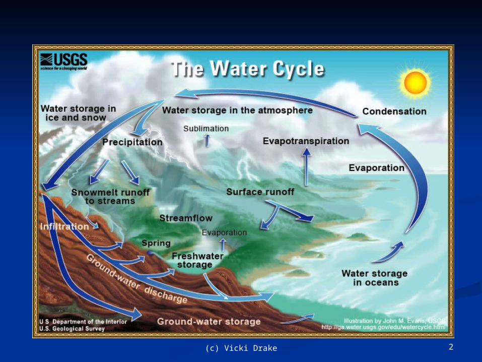
EARTH’S WATER EARTH’S WATER SUPPLYSUPPLY
SourceSource % of Supply % of Supply OceansOceans 97.2 97.2 Ice Sheets and GlaciersIce Sheets and Glaciers 2.15 2.15 Ground WaterGround Water 0.62 0.62 Lakes (Fresh)Lakes (Fresh) 0.009 0.009 Inland Seas / Salt Water LakesInland Seas / Salt Water Lakes 0.008 0.008 Soil MoistureSoil Moisture
0.005 0.005 AtmosphereAtmosphere 0.001 0.001 Rivers*Rivers*
0.0001 0.0001
* * Running water is the most significant agent sculpting Running water is the most significant agent sculpting the Earth’s land surfacethe Earth’s land surface

5(c) Vicki Drake
Major Rivers in USAMajor Rivers in USA

6(c) Vicki Drake
SOURCE OF RIVER’S WATERSOURCE OF RIVER’S WATER
Between 25% - 40% of total Between 25% - 40% of total precipitation runs off as precipitation runs off as streamflowstreamflow
Streamflow divided into two Streamflow divided into two types of flow:types of flow: BaseflowBaseflow: streamflow in : streamflow in
low flow periods fed by low flow periods fed by groundwatergroundwater
StormflowStormflow: streamflow : streamflow that occurs quickly in that occurs quickly in response to precipitationresponse to precipitation events.events.
7(c) Vicki Drake
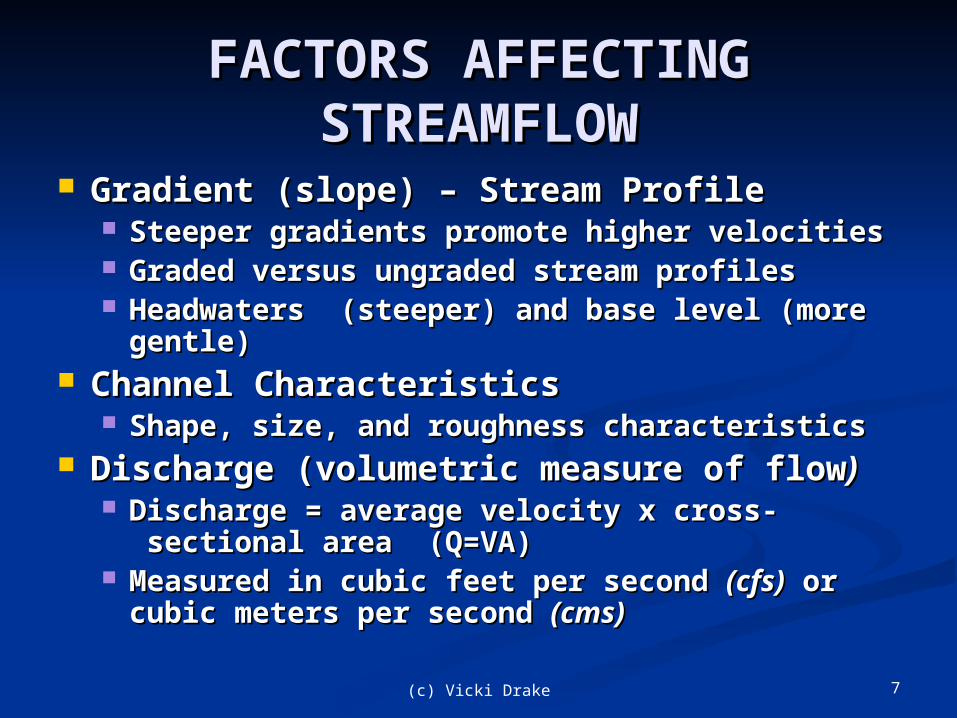
FACTORS AFFECTING FACTORS AFFECTING STREAMFLOWSTREAMFLOW
Gradient (slope) – Stream ProfileGradient (slope) – Stream Profile Steeper gradients promote higher velocitiesSteeper gradients promote higher velocities Graded versus ungraded stream profilesGraded versus ungraded stream profiles Headwaters (steeper) and base level (more Headwaters (steeper) and base level (more
gentle)gentle) Channel CharacteristicsChannel Characteristics
Shape, size, and roughness characteristicsShape, size, and roughness characteristics Discharge (volumetric measure of flowDischarge (volumetric measure of flow))
Discharge = average velocity x cross-Discharge = average velocity x cross- sectional area (Q=VA) sectional area (Q=VA)
Measured in cubic feet per second Measured in cubic feet per second (cfs)(cfs) or or cubic meters per second cubic meters per second (cms)(cms)
8(c) Vicki Drake
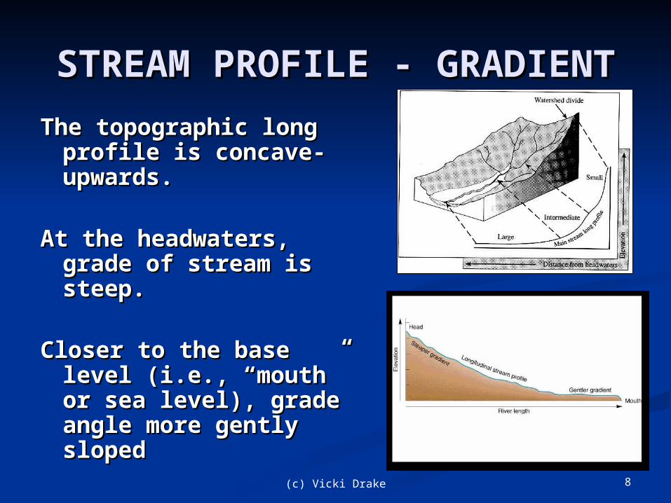
STREAM PROFILE - STREAM PROFILE - GRADIENTGRADIENT
The topographic long The topographic long profile is concave-profile is concave-upwards.upwards.
At the headwaters, At the headwaters, grade of stream is grade of stream is steep.steep.
Closer to the base Closer to the base level (i.e., “mouth” level (i.e., “mouth” or sea level), grade or sea level), grade angle more gently angle more gently slopedsloped

9(c) Vicki Drake
Streamflow: Ungraded vs. Graded Streamflow: Ungraded vs. Graded StreamsStreams
Graded stream: Balance between transport capacity and sediment load.Maintained by altering the shape of the channel and stream profile.
Typical ungraded stream
Hypothetical graded stream
Graded profile smoothes channel out; no more waterfalls or rapids
10(c) Vicki Drake
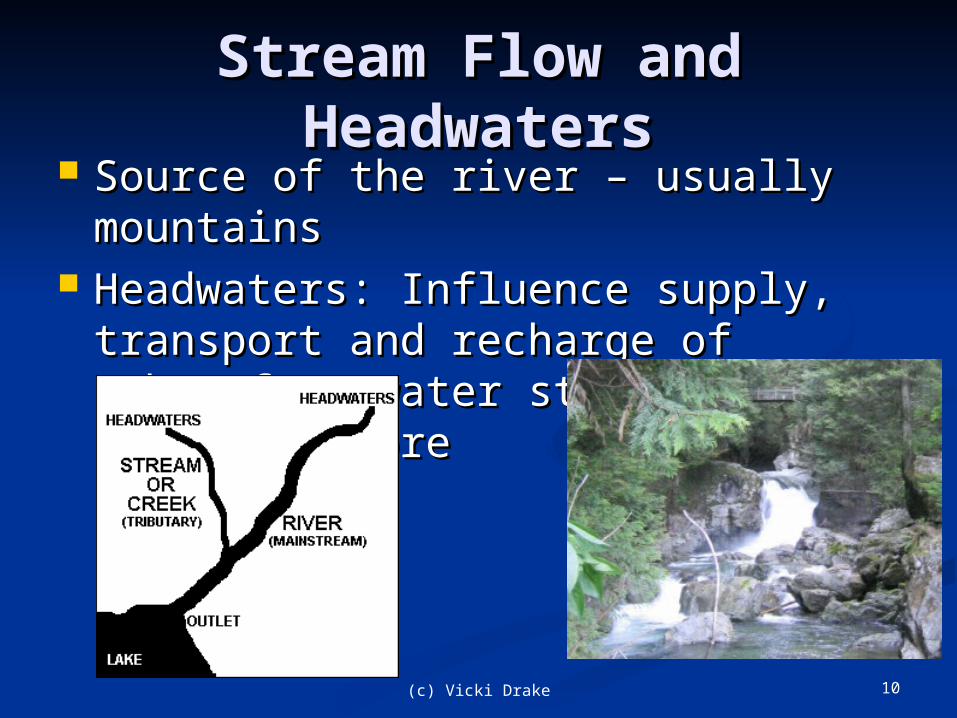
Stream Flow and Stream Flow and HeadwatersHeadwaters
Source of the river – usually Source of the river – usually mountainsmountains
Headwaters: Influence supply, Headwaters: Influence supply, transport and recharge of transport and recharge of subsurface water stores, flows paths subsurface water stores, flows paths and moreand more
11(c) Vicki Drake
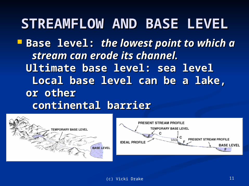
STREAMFLOW AND BASE STREAMFLOW AND BASE LEVELLEVEL
Base level: Base level: the lowest point to which the lowest point to which aa stream can erode its channel.stream can erode its channel.Ultimate base level: sea levelUltimate base level: sea level Local base level can be a lake, or Local base level can be a lake, or otherother continental barrier continental barrier
12(c) Vicki Drake
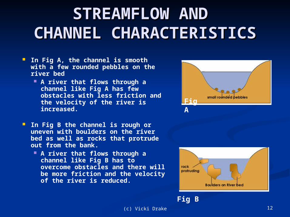
STREAMFLOW AND STREAMFLOW AND CHANNEL CHANNEL
CHARACTERISTICSCHARACTERISTICS In Fig A, the channel is smooth
with a few rounded pebbles on the river bed A river that flows through a
channel like Fig A has few obstacles with less friction and the velocity of the river is increased.
In Fig B the channel is rough or uneven with boulders on the river bed as well as rocks that protrude out from the bank. A river that flows through a
channel like Fig B has to overcome obstacles and there will be more friction and the velocity of the river is reduced.
Fig A
Fig B
13(c) Vicki Drake
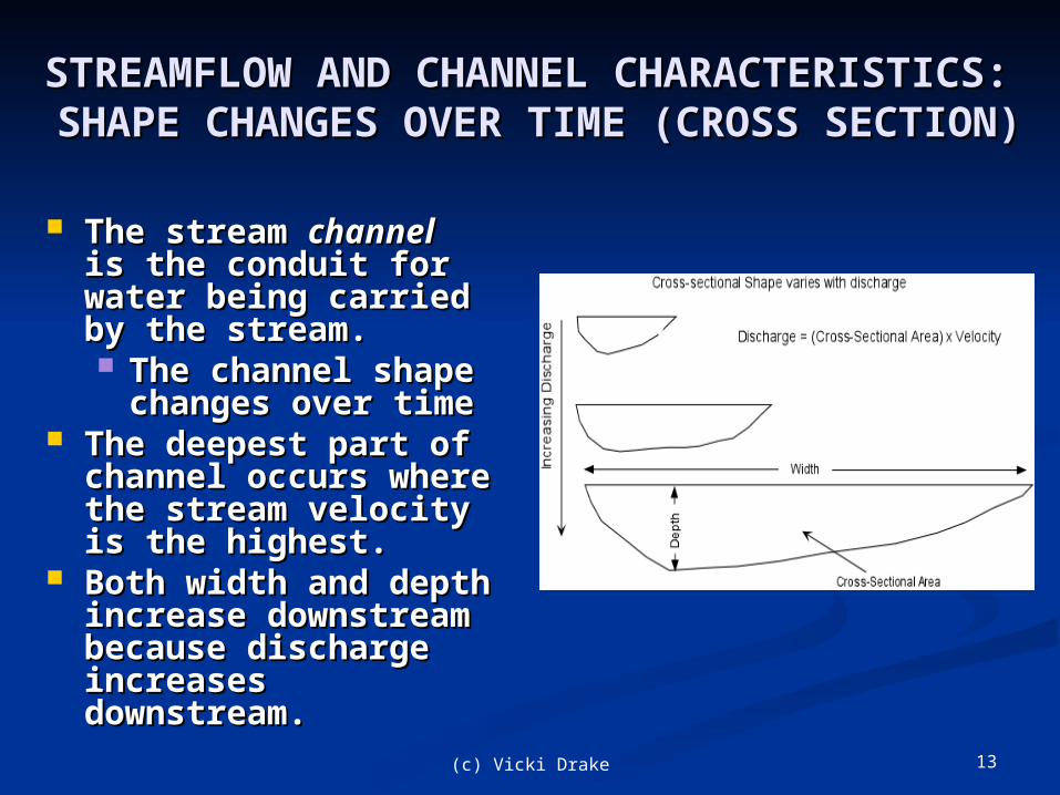
STREAMFLOW AND CHANNEL STREAMFLOW AND CHANNEL CHARACTERISTICS: CHARACTERISTICS:
SHAPE CHANGES OVER TIME (CROSS SHAPE CHANGES OVER TIME (CROSS SECTION)SECTION)
The stream The stream channelchannel is the conduit for is the conduit for water being carried water being carried by the stream. by the stream. The channel shape The channel shape
changes over time changes over time The deepest part of The deepest part of
channel occurs channel occurs where the stream where the stream velocity is the velocity is the highest. highest.
Both width and Both width and depth increase depth increase downstream because downstream because discharge increases discharge increases downstream. downstream.

14(c) Vicki Drake
STREAMFLOW AND STREAMFLOW AND DISCHARGE (Q)DISCHARGE (Q)
Stream discharge (Q): Stream discharge (Q): A measure of the volume A measure of the volume
of water passing through of water passing through a given cross-section per a given cross-section per unit timeunit time
Q = ‘Area’ x ‘Velocity’ and is Q = ‘Area’ x ‘Velocity’ and is represented in cubic meters represented in cubic meters per second (cms) or cubic per second (cms) or cubic feet per second (cfs)feet per second (cfs) AreaArea
The average width and The average width and depth of flow in a depth of flow in a stream channelstream channel
VelocityVelocity Stream velocity Stream velocity
measured as the measured as the distance water in a distance water in a stream travels over an stream travels over an interval of time (m/s interval of time (m/s or f/s) or f/s)

15(c) Vicki Drake
The Work of Streams: The Work of Streams: Erosion, Transportation, and Erosion, Transportation, and
DepositionDeposition Rivers Rivers erode erode materials materials
at the headwaters, at the headwaters, and and deposit deposit transported materials transported materials near their base level.near their base level.
Rivers are natural Rivers are natural ‘sorters’ – as velocity ‘sorters’ – as velocity decreases in a river, decreases in a river, larger cobbles and larger cobbles and boulders dropped out boulders dropped out first, then pebbles, first, then pebbles, gravels and sands, gravels and sands, and finally silts and and finally silts and clays carried the clays carried the farthest before farthest before depositiondeposition
16(c) Vicki Drake
EROSIONEROSION Flowing water creates and erodes a channel Flowing water creates and erodes a channel
in three ways: in three ways: (1) Dissolving material entering the (1) Dissolving material entering the
flowing water channelflowing water channel (2) Hydraulic action as force of flowing (2) Hydraulic action as force of flowing
water on the sides and bed of the channel water on the sides and bed of the channel dislodges materials and makes them dislodges materials and makes them available for transport as stream load. available for transport as stream load.
(3) Abrasion (scouring) as materials too (3) Abrasion (scouring) as materials too heavy to suspend, are pushed or rolled heavy to suspend, are pushed or rolled across the stream bed eroding the channel. across the stream bed eroding the channel.

17(c) Vicki Drake
Erosion of Stream BanksErosion of Stream Banks
Headward erosion – backward (or ‘up river’) erosion near head of stream
channel erosion
Cutbank erosion – wearing awayalong stream banks

18(c) Vicki Drake
Erosion: Rills and GulliesErosion: Rills and Gullies
Rills – Small channels flowing Rills – Small channels flowing down a slope after an intense rain. down a slope after an intense rain. Start a few inches deep and wideStart a few inches deep and wide Rills join to become a stream channelRills join to become a stream channel
Gullies - An advanced form of Gullies - An advanced form of channel erosion.channel erosion. The channels carry water after rains The channels carry water after rains
and can become permanent and can become permanent landscape features. landscape features.

19(c) Vicki Drake
Erosion: Rills and GulliesErosion: Rills and Gullies
Rills developing on slope
Gullies developing from rills

20(c) Vicki Drake
RILLS AND GULLIES TO STREAM RILLS AND GULLIES TO STREAM CHANNELS AND VALLEYSCHANNELS AND VALLEYS
Small rills and gullies become stream Small rills and gullies become stream channels and develop valleys through: channels and develop valleys through: DowncuttingDowncutting - downward erosion of the - downward erosion of the
stream channel. stream channel. Stream energy exceeds the stream's loadStream energy exceeds the stream's load Creates narrow and steep-sided V-Creates narrow and steep-sided V-
shaped canyons and gorges. shaped canyons and gorges. Lateral erosionLateral erosion - undermines part of the - undermines part of the
bank or valley wall, leading to mass bank or valley wall, leading to mass wasting and widening of the valley. wasting and widening of the valley.
Headward erosionHeadward erosion - lengthens valley - lengthens valley upstream by erosion of headwater divide upstream by erosion of headwater divide areas. areas.

21(c) Vicki Drake
Evolution of a Stream and Evolution of a Stream and its Valleyits Valley

22(c) Vicki Drake
LIFECYCLE OF A STREAM - LIFECYCLE OF A STREAM - “YOUTH” HEADWATERS EROSION“YOUTH” HEADWATERS EROSION
YOUTHYOUTH At the headwaters, At the headwaters,
the stream the stream gradient and gradient and topography are topography are steep. steep.
Stream velocity at Stream velocity at maximum cuts a maximum cuts a deep channeldeep channel V-shaped ValleyV-shaped Valley
Minimal floodplain Minimal floodplain developmentdevelopment
Yellowstone River
cutting down
through ‘young’ volcanic
rocks

23(c) Vicki Drake
Stream Channel: “Maturity” Stream Channel: “Maturity”
Mid Profile Braided Stream Mid Profile Braided Stream MATURITYMATURITY Stream leaves Stream leaves
mountainous terrain, mountainous terrain, more gently sloping more gently sloping landscapelandscape
Reduction in stream Reduction in stream velocity begins velocity begins development of flood development of flood plainplain Deposition of Deposition of
coarser cobbles, coarser cobbles, pebbles and sandspebbles and sands
Braided streamsBraided streams

24(c) Vicki Drake
Stream Channel: “Old Age” Stream Channel: “Old Age”
Mouth of Stream - Base Mouth of Stream - Base LevelLevel OLD AGEOLD AGE
Extensive floodplain Extensive floodplain from meandering from meandering streamstream Lower slope gradientLower slope gradient
Channel is large as Channel is large as stream moves stream moves across floodplainacross floodplain
Maximum discharge Maximum discharge (Q) carrying fine-(Q) carrying fine-grained materialsgrained materials

25(c) Vicki Drake
Rejuvenation – Incised Rejuvenation – Incised MeandersMeanders
““Old Age” streams Old Age” streams develop meanders develop meanders at base levelat base level
Tectonic uplift of Tectonic uplift of drainage basin drainage basin results in results in meanders that are meanders that are incised and fixedincised and fixed
Floodplain Floodplain development development slows as slows as downcutting downcutting begins againbegins again
26(c) Vicki Drake
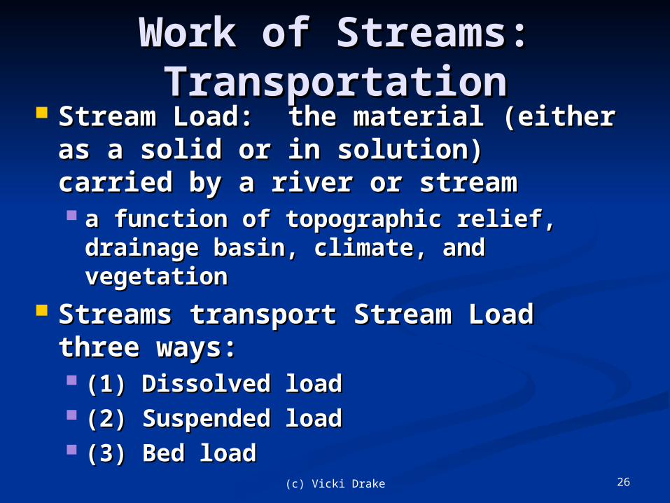
Work of Streams: Work of Streams: TransportationTransportation
Stream Load: the material (either Stream Load: the material (either as a solid or in solution) carried as a solid or in solution) carried by a river or streamby a river or stream a function of topographic relief, a function of topographic relief,
drainage basin, climate, and drainage basin, climate, and vegetationvegetation
Streams transport Stream Load Streams transport Stream Load three ways:three ways: (1) Dissolved load(1) Dissolved load (2) Suspended load(2) Suspended load (3) Bed load (3) Bed load

27(c) Vicki Drake
Stream Load and Stream Load and TransportationTransportation
Dissolved loadDissolved load comes from groundwater comes from groundwater seepage into the stream as well as the seepage into the stream as well as the dissolution of solids in the flowing water. dissolution of solids in the flowing water.
Suspended loadSuspended load is comprised of sediment is comprised of sediment suspended and transported through the suspended and transported through the stream.stream. Comes from material eroded from the Comes from material eroded from the
surface bordering the channel and surface bordering the channel and deposited in the stream, as well as erosion deposited in the stream, as well as erosion of the channel itself. of the channel itself.
Bed loadBed load is moved along the bed of the is moved along the bed of the channel in two ways:channel in two ways: (1) Traction: a pushing or rolling of (1) Traction: a pushing or rolling of
particles along the bed. particles along the bed. (2) Saltation: a bouncing-like movement (2) Saltation: a bouncing-like movement
of lighter particles moving downstreamof lighter particles moving downstream

28(c) Vicki Drake
Transporting Stream Transporting Stream LoadLoad

29(c) Vicki Drake
http://www.youtube.com/watch?v=7Z0XwYkqXy4&feature=related

30(c) Vicki Drake
MEASURING STREAM MEASURING STREAM TRANSPORTTRANSPORT Stream capacityStream capacity is the total is the total
suspended load and bed load that suspended load and bed load that a stream can transport a stream can transport ““How much”How much”
Stream competenceStream competence is the ability is the ability of a stream to transport a of a stream to transport a particular size of particle (e.g., particular size of particle (e.g., boulder, cobble, pebble, gravel, boulder, cobble, pebble, gravel, sand, etc.) sand, etc.) ““How big”How big”
31(c) Vicki Drake
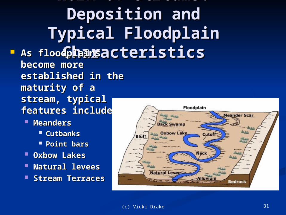
Work of Streams: Work of Streams: Deposition andDeposition and
Typical Floodplain Typical Floodplain CharacteristicsCharacteristics As floodplains As floodplains
become more become more established in the established in the maturity of a maturity of a stream, typical stream, typical features include:features include: MeandersMeanders
CutbanksCutbanks Point barsPoint bars
Oxbow LakesOxbow Lakes Natural leveesNatural levees Stream TerracesStream Terraces

32(c) Vicki Drake
CREATING A CREATING A FLOODPLAINFLOODPLAIN
Floodplains are the relatively flat Floodplains are the relatively flat regions near a stream channel.regions near a stream channel.
Floodplains develop over long Floodplains develop over long periods of time through river periods of time through river meanders and occasional river meanders and occasional river flooding.flooding.
Distinctive floodplain characteristics Distinctive floodplain characteristics develop with age of stream develop with age of stream
33(c) Vicki Drake
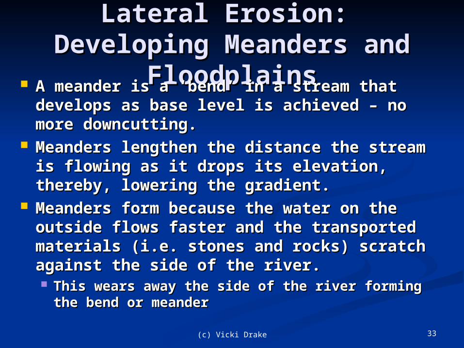
Lateral Erosion: Developing Lateral Erosion: Developing Meanders and FloodplainsMeanders and Floodplains
A meander is a ‘bend’ in a stream that A meander is a ‘bend’ in a stream that develops as base level is achieved – no develops as base level is achieved – no more downcutting.more downcutting.
Meanders lengthen the distance the Meanders lengthen the distance the stream is flowing as it drops its stream is flowing as it drops its elevation, thereby, lowering the gradient.elevation, thereby, lowering the gradient.
Meanders form because the water on the Meanders form because the water on the outside flows faster and the transported outside flows faster and the transported materials (i.e. stones and rocks) scratch materials (i.e. stones and rocks) scratch against the side of the river. against the side of the river. This wears away the side of the river forming This wears away the side of the river forming
the bend or meander the bend or meander

34(c) Vicki Drake
Deposition and Erosion in a Deposition and Erosion in a MeanderMeander
Cut bank
Point bar

35(c) Vicki Drake
Floodplain Characteristics: Floodplain Characteristics: Meander Cut Banks and Meander Cut Banks and
Point BarsPoint Bars Cut BanksCut Banks: The maximum velocity on the : The maximum velocity on the
outside of a meander cuts into the bank. outside of a meander cuts into the bank. Point BarsPoint Bars: The minimum velocity on : The minimum velocity on
the inside of a meander allows for the inside of a meander allows for deposition of sands and gravels.deposition of sands and gravels.
Meanders slowly migrate back and forth Meanders slowly migrate back and forth across valley floor with the cycle of across valley floor with the cycle of erosion and deposition.erosion and deposition. This process builds the floodplain over This process builds the floodplain over
many yearsmany years

36(c) Vicki Drake
Floodplains: Cut Banks and Floodplains: Cut Banks and Point BarsPoint Bars

37(c) Vicki Drake
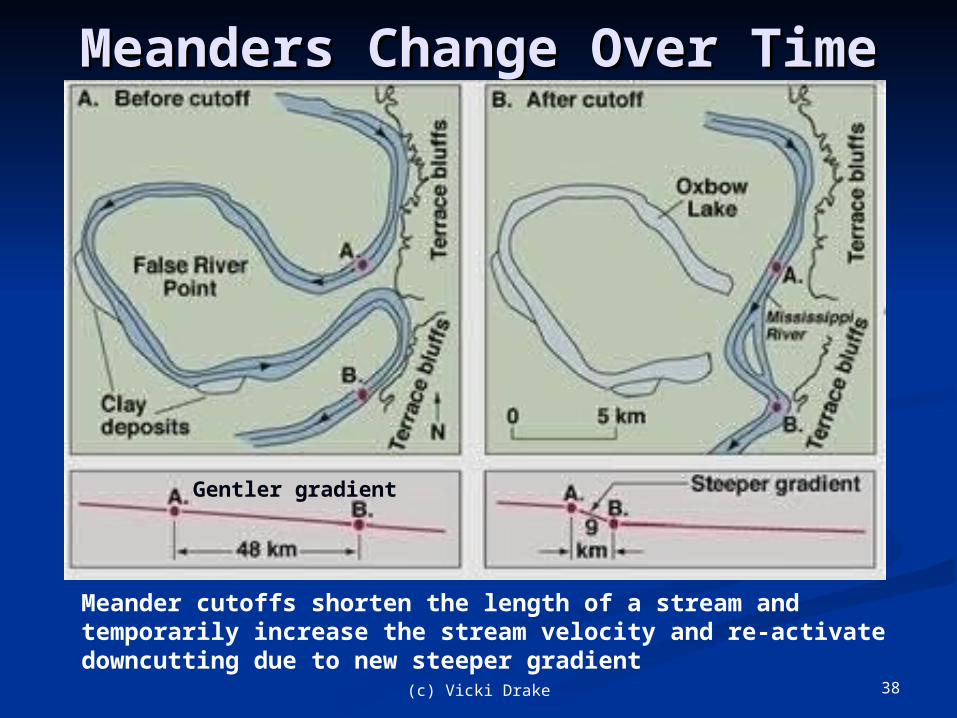
MEANDER CUTOFFS AND MEANDER CUTOFFS AND OXBOW LAKESOXBOW LAKES
Shortens length of river, increases slope gradient, renewed downcutting with higher velocity. In areas with high water table, Oxbow lakes can become permanent features. Meander scars (“dry” lakes) form in areas with less available water.
38(c) Vicki Drake
Meanders Change Over Meanders Change Over TimeTime
Meander cutoffs shorten the length of a stream and temporarily increase the stream velocity and re-activate downcutting due to new steeper gradient
Gentler gradient

39(c) Vicki Drake
Floodplain Characteristics: Floodplain Characteristics: Natural LeveesNatural Levees
Natural levees are Natural levees are formed after many formed after many floodsfloods
Larger, coarser Larger, coarser material deposited material deposited immediately after immediately after water leaves its water leaves its channelchannel
Finer material Finer material carried further carried further away and deposited away and deposited on the floodplainon the floodplain

40(c) Vicki Drake
MISSISSIPPI LEVEESMISSISSIPPI LEVEES

41(c) Vicki Drake
Drainage Basins - Drainage Basins - WatershedsWatersheds A drainage basin is A drainage basin is
the topographic the topographic region from which a region from which a stream receives stream receives runoff, groundwater runoff, groundwater and surface flowand surface flow
A watershed is an A watershed is an area of land over and area of land over and through which water through which water flows to the lowest flows to the lowest point - a stream, point - a stream, river, wetland, or lake river, wetland, or lake Drainage divides are Drainage divides are
the high topographic the high topographic points within a points within a watershed that watershed that determine the direction determine the direction of flow of water of flow of water
Highest elevation
Lowest elevation

42(c) Vicki Drake
Watershed of Mississippi Watershed of Mississippi River, USARiver, USA

43(c) Vicki Drake
SOUTHERN CALIFORNIA SOUTHERN CALIFORNIA RIVER WATERSHEDSRIVER WATERSHEDS
44(c) Vicki Drake
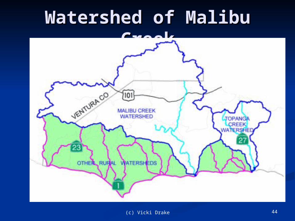
Watershed of Malibu Watershed of Malibu CreekCreek

45(c) Vicki Drake
BALLONA CREEK BALLONA CREEK WATERSHEDWATERSHED
46(c) Vicki Drake
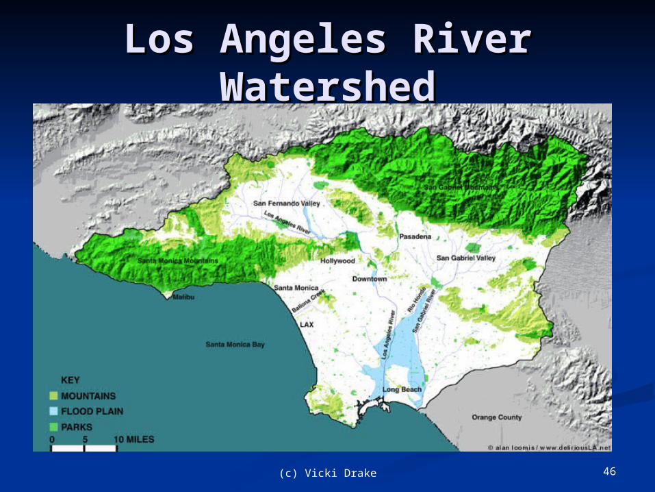
Los Angeles River Los Angeles River WatershedWatershed

47(c) Vicki Drake
Streams and Base level: Streams and Base level: DeltasDeltas
Deltas form by the deposition of sediment Deltas form by the deposition of sediment at the mouth of stream when water flows at the mouth of stream when water flows into a lake or the ocean into a lake or the ocean
Stream velocity decreases upon reaching Stream velocity decreases upon reaching base level (either a lake, reservoir, or the base level (either a lake, reservoir, or the ocean): the stream deposits its load. ocean): the stream deposits its load.
A delta’s surface is marked by A delta’s surface is marked by distributariesdistributaries Small shifting channels that carry water Small shifting channels that carry water
away from main river channelaway from main river channel Sediment deposited at mouth of Sediment deposited at mouth of
eventually block flow causing shift of eventually block flow causing shift of depositiondeposition

48(c) Vicki Drake
MISSISSIPPI DELTAMISSISSIPPI DELTA
49(c) Vicki Drake
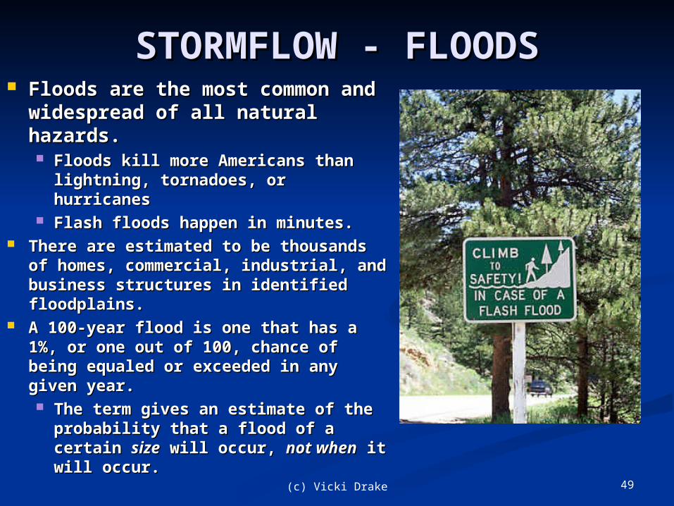
STORMFLOW - FLOODSSTORMFLOW - FLOODS Floods are the most common Floods are the most common
and widespread of all natural and widespread of all natural hazards. hazards. Floods kill more Americans than Floods kill more Americans than
lightning, tornadoes, or lightning, tornadoes, or hurricanes hurricanes
Flash floods happen in minutes. Flash floods happen in minutes. There are estimated to be thousands There are estimated to be thousands
of homes, commercial, industrial, of homes, commercial, industrial, and business structures in identified and business structures in identified floodplains. floodplains.
A 100-year flood is one that has a 1%, A 100-year flood is one that has a 1%, or one out of 100, chance of being or one out of 100, chance of being equaled or exceeded in any given equaled or exceeded in any given year. year. The term gives an estimate of the The term gives an estimate of the
probability that a flood of a probability that a flood of a certain certain sizesize will occur, will occur, not whennot when it it will occur. will occur.
50(c) Vicki Drake
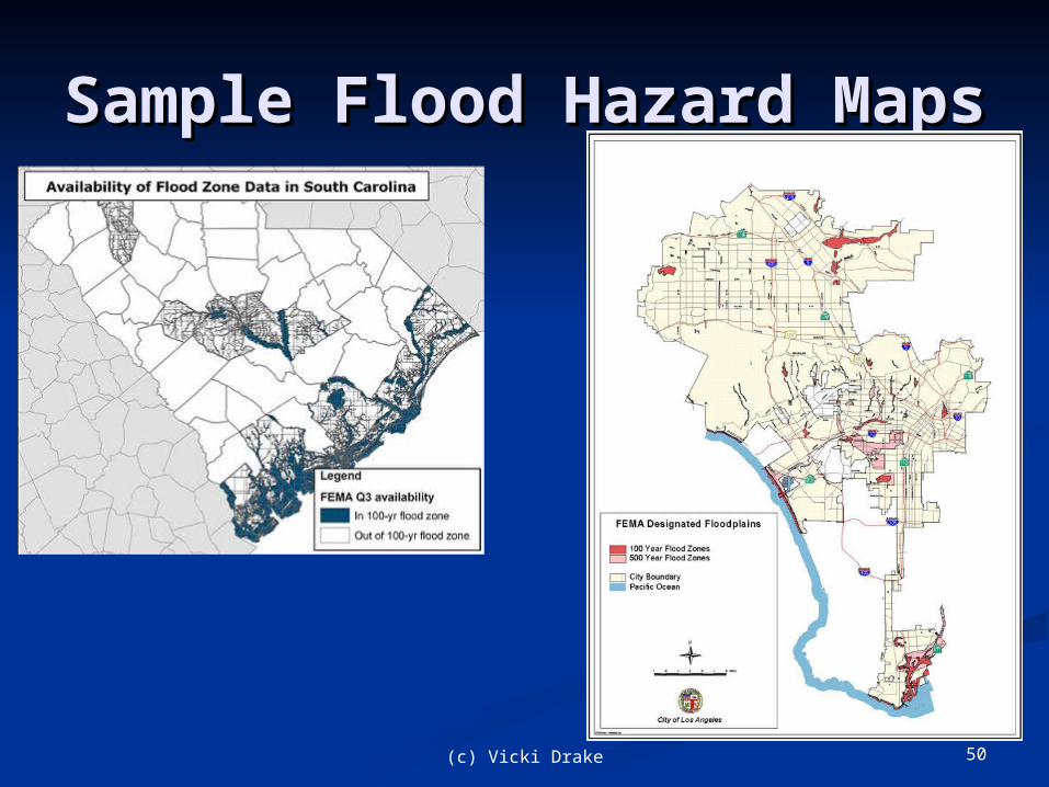
Sample Flood Hazard Sample Flood Hazard MapsMaps

51(c) Vicki Drake
Flash FloodsFlash Floods Flash floods: short-term inundations of Flash floods: short-term inundations of
small areas such as a town or parts of a small areas such as a town or parts of a city, usually by creeks and other smaller city, usually by creeks and other smaller tributaries that flow into larger rivers. tributaries that flow into larger rivers.
Heavy rain produces flash flooding in a Heavy rain produces flash flooding in a few hours even in places where little few hours even in places where little rain has fallen for weeks or months. rain has fallen for weeks or months.
In arid or semiarid regions, flash In arid or semiarid regions, flash flooding can send a wall of water flooding can send a wall of water downstream, turning a completely dry downstream, turning a completely dry valley or canyon into a raging torrent in valley or canyon into a raging torrent in mere secondsmere seconds..

52(c) Vicki Drake
Flash Floods - DesertsFlash Floods - Deserts

53(c) Vicki Drake
Mainstem FloodingMainstem Flooding
If heavy rainfall occurs If heavy rainfall occurs repeatedly over a wide area, then repeatedly over a wide area, then river or mainstem flooding river or mainstem flooding becomes more likelybecomes more likely Main rivers of a region swell Main rivers of a region swell
and inundate large areas, and inundate large areas, sometimes well after rainfall sometimes well after rainfall has ended. has ended.

54(c) Vicki Drake
Mainstem FloodingMainstem Flooding
55(c) Vicki Drake
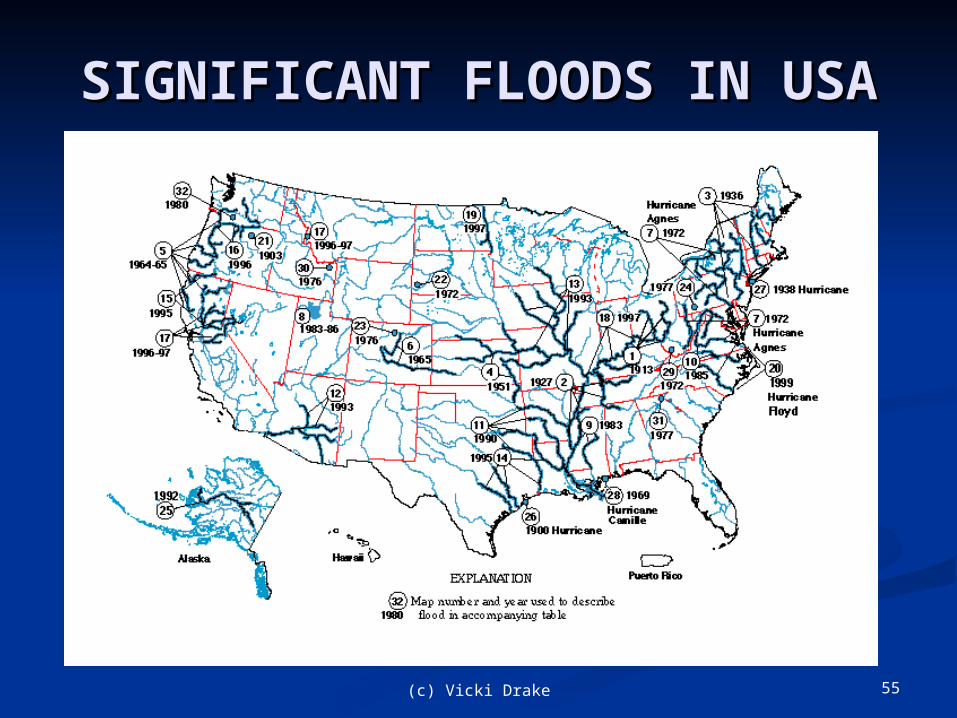
SIGNIFICANT FLOODS IN SIGNIFICANT FLOODS IN USAUSA

56(c) Vicki Drake
LOS ANGELES RIVER LOS ANGELES RIVER

LOS ANGELES RIVER LOS ANGELES RIVER FLOODSFLOODSBridge over L.A. River
at Dark Canon washed away, 1927
1938 Flood Colfax Ave at Ventura Blvd
2005
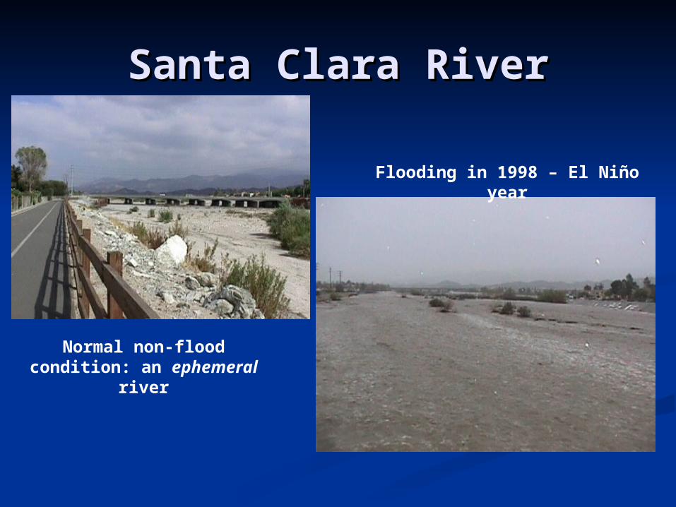
Santa Clara RiverSanta Clara River
Normal non-flood condition: an
ephemeral river
Flooding in 1998 – El Niño year

Northern California Northern California Major River WatershedsMajor River Watersheds
Sacramento River
Watershed
San Joaquin River Watershed
Klamath River Watershed

Northern California Northern California River FloodsRiver Floods
Sacramento River floods
Feather River floods
Related Documents