Oregon Department of Fish and Wildlife Fish Screening and Passage Program Fish Passage Priority List February 1, 2013 Prepared By: Ken Loffink

Welcome message from author
This document is posted to help you gain knowledge. Please leave a comment to let me know what you think about it! Share it to your friends and learn new things together.
Transcript
Oregon Department of Fish and Wildlife
Fish Screening and Passage Program
Fish Passage Priority List
February 1, 2013
Prepared By: Ken Loffink

2
Table of Contents
Acknowledgements 3
(1) Introduction 4
(1.1) Requirements of Rules and Statutes 4
(2) Past Prioritization Efforts 5
(2.1) 2007 Priority List 5
(2.2) Lessons Learned from 2007 6
(3) Development and Methodology of 2012 Priority List 7
(3.1) Data Inventory and Standardization 7
(3.2) Role of ODFW District Staff 8
(3.3) Role of Fish Passage Task Force 9
(3.4) Data Limitations 10
(4) The Prioritization Model 11
(4.1) The Equation 11
(4.2) Definitions and Data Sources 12
(4.3) Assumptions Made in the Model 17
(5) Results of the 2012 Prioritization 19
(6) Recommendations for Future Prioritization Efforts 19
(6.1) Data Source Refinements 20
(6.2) Model Refinements 20
(7) Conclusions/Discussion and Potential Use of the Priority List 21
Appendices
Appendix A: 2007 Priority List
Appendix B: 2007 Priority List Highlighting Removed or Fixed Project
Appendix C: 2013 Priority List
3
Acknowledgements
ODFW Staff: Todd Alsbury, Greg Apke, Tim Bailey, Pete Baki, David Banks, Jon Bowers, Robert Bradley, Jason Brandt, Bob Buckman, Jean Castillo, Chris Claire, Todd Confer, Charlie Corrarino, Nadine Craft, Jay Doino, Bill Duke, Mark English, Matt Falcy, Alex Farrand, Danette Faucera, Rod French, Chuck Fustish, Michael Gray, David Haight, Karen Hans, Rick Hargrave, Mike Harrington, Ray Hartlerode, Ron Hendrickson, Brett Hodgson, Tabatha Hoge, Holly Huchko, Shannon Hurn, Laura Jackson, Lisa Kingsley, Chris Knutsen, Michael Lambert, Steve Mamoyac, Steve Mazur, Ryan McCormick, Bruce McIntosh, Tom Murtagh, Jeff Neal, Ray Perkins, Dave Plawman, Tim Porter, Kelly Reis, Alan Ritchey, Pete Samarin, Ruth Schellbach, Jason Seals, Brent Smith, Marty Smith, Roger Smith, Lance Solis, John Spangler, Tom Stahl, Bill Tinniswood, Dan VanDyke, Gary Vonderohe, Joel Watts, Derek Wilson, Jeff Yanke, Jeff Ziller
Fish Passage Task Force: Doug Dehart, David Heller, Kim Kambak, Stuart Myers, Dawn Nilson, David Newton, Harry Rectenwald, Vera Simonton, Willie Tiffany,
4
1. Introduction: Purpose and Need
Fish passage is a key component to many facets of fisheries resource management. Connectivity between aquatic habitats is an important part of garnering successful and healthy fish populations. Without habitat connectivity, resident or fluvial fish species such as native trout, suckers, and whitefish become isolated, leading to reduced levels of genetic diversity and fitness. For anadromous populations, fish passage can allow access to new habitats or fertile spawning grounds that are pivotal for success of the species. In addition to providing access to vital spawning habitats for adults, fish passage also provides access to essential rearing habitats for juvenile species. Population isolation due to fish passage barriers also heightens migratory fish exposure to disturbances, thus increasing the potential magnitude of the disturbance at a population of individual level.
Fish passage barriers are prevalent throughout the Oregon landscape. Over time, despite fish passage rules and regulations, access to native fish habitats has been blocked or impaired by the construction of impassable culverts, dams, tide gates, dikes, bridges, and other anthropogenic infrastructure. Providing passage at these artificial obstructions is vital to recovering Oregon’s native migratory fish populations. The Oregon Department of Fish and Wildlife’s (ODFW) latest inventory shows over 27,800 artificial obstructions to fish passage in the State of Oregon. Of those, only 17% are documented as providing adequate fish passage for native migratory fish1. With so many barriers spread across the landscape, and funding becoming scarce, it is paramount that we thoroughly prioritize fish passage, with inclusion of multiple parameters. This will allow for a focused effort to improving passage conditions and meeting a critical need of Oregon’s native migratory fish.
1.1 Required by Statute and Rule
Fish passage prioritization and inventory is a requirement of the ODFW’s Fish Passage Program (FPP) through Oregon Revised Statute (ORS) 509.585 (3). This statute states that ODFW shall “complete and maintain a statewide inventory in order to prioritize enforcement actions based on the needs of native migratory fish.” Furthermore the statute states that the Department shall update the priority list every 5 years. The last fish passage priority list was approved by the Oregon Fish and Wildlife Commission in 2007.
As noted, the priority list shall be based on the needs of native migratory fish. More specifically, the base requirements of the priority list are identified in Oregon Administrative Rule (OAR) 635-412-0015 (2). This rule states the following:
The priority list shall be based on the needs of native migratory fish. (a) The prioritization shall consider the following factors relative to each artificial obstruction for all native migratory fish currently or historically present at the artificial obstruction:
(A) the quantity of native migratory fish habitat which is inaccessible, (B) the quality of native migratory fish habitat which is inaccessible,
1 Note: During fish passage barrier data compilation efforts, emphasis was placed on the identification of features with known passage issues.
5
(C) unique or limited native migratory fish habitat which is inaccessible, or should remain inaccessible for fish management purposes, (D) the biological status of the native migratory fish, (E) the level of fish passage currently provided at the artificial obstruction, (F) the presence of other artificial obstructions upstream and downstream and the timeframe native migratory fish will be able to utilize restored passage, and (G) existing agreements with the Department regarding fish passage.
(b) The prioritization may utilize existing Department information or professional judgment in the absence of information specific to a given site. (c) The priority list shall contain one artificial obstruction per Oregon sub-basin, which shall be ranked across the state.
The 2013 fish passage priority list was developed in accordance with these requirements and guidelines. 2. Past Prioritization Efforts
Artificial obstruction inventory and prioritization was identified as a key component of managing fish passage in Oregon during the formation of Oregon’s fish passage laws. The Fish Passage Task Force (FPTF), a volunteer advisory group created when fish passage laws were accepted in 2001, further defined the need for inventory and prioritization. Criteria and guidelines for fish passage prioritization were defined in 2004, and even though some level of prioritization of projects has always occurred, the first formal fish passage priority list was approved in 2007.
2.1 2007 Priority List Methodology
In 2007 ODFW developed a priority list of artificial obstructions consistent with the guidelines listed in the rule and met the statutory needs presented in section 1.1. During the 2007 prioritization effort, ODFW FPP staff asked each of the 18 ODFW fish districts to provide the top 5 fish passage priorities in their district. District Biologists and staff were not expected to do extensive on-the-ground data gathering, as these top passage priority sites should have been readily evident based on their knowledge district. In addition, District Biologists were asked to exclude sites where fish passage restoration was imminent (i.e., a totally funded project is in place or clear trigger has or will happen) and sites where mitigation (per an agreement) was provided (e.g., waiver sites, Corps of Engineers' dams with hatcheries, hydropower dams with Settlement Agreements). The District Biologists were also asked to rank the priority barriers within their District, without limitations on number per sub-basin and based on professional judgment (i.e., taking into account factors that are not otherwise quantified). Finally, the District Biologists were asked to provide the following information for their priority barrier sites, which was used to rank them collectively across the state:
• number and listing status of native migratory fish species present currently and historically,
• distance of habitat blocked by the artificial obstruction,
• subjective quality of habitat blocked by the artificial obstruction,
6
• other complete (total blocking barriers) upstream and downstream artificial obstructions,
• the current level of passage at the artificial obstruction (i.e., is it a complete or partial barrier), and
• importance of upstream habitat for unique or isolated native migratory fish populations.
The information, provided by the District Biologists, was then used to rank sites across the State to come up with the statewide priority list. The primary factors used for the statewide ranking were: the number of state and federally-listed threatened and endangered migratory fish species; the distance which would be made accessible, upstream of the site, to the next complete barrier; the number of complete downstream barriers; the level of fish passage currently provided at the site; the presence of unique populations or habitat; and the relative ranking made by the District Biologist. The influence of each of these factors on a site's ranking are summarized below:
Factor Impact on Ranking
T&E Species .................. higher number increases priority
Distance ......................... higher distance increases priority
Downstream Barriers .... higher number decreases priority
Passage Level ................ higher level of obstruction increases priority
Unique Site .................... higher degree of uniqueness increases priority
District Biologist Rank* higher rank increases priority
* takes into account habitat quality
The final approved 2007 fish passage priority list is attached (Attachment A). The final 2007 list did not include a numeric ranking, rather the list categorized projects into low, medium, and high categories based on their priority scores. By grouping barriers into low, medium, and high priority categories, variability surrounding the data used for ranking as well as the variability in the ranking methodology (prioritization model) has less impact on the priority list.
2.2 Lessons Learned from the 2007 Priority List
The 2007 priority list provided the framework for the 2013prioritization effort. During the 2007 effort, the expertise of District Biologists and their staff was vital to the development of the priority list. The institutional knowledge harbored within the districts was and continues to be invaluable to this prioritization effort and other fish management actions. However, the need for more data was clear. The final 2007 Priority List tabulated data and ranked a total of 67 barriers, each of which was located within a different Oregon sub-basin. This number fell a little short of the requirement for a barrier in each of the 90 sub-basins that are totally or partially within Oregon. Several sub-basins did not receive a priority barrier, because either no priority barriers were identified in those sub-basins, or barrier information was limited within those sub-basins.
7
The 2007 Priority List identified 67 priority fish passage barriers. However, hundreds of other priority barriers were not identified by this Priority List. As such, there was some public perception that if a barrier was not on the list, then it was not a high priority. Due to this perception, the 2013 prioritization effort focused on obtaining a more complete inventory and using a more comprehensive prioritization to establish a more robust list that better reflected the scope of the fish passage issue in Oregon.
Despite data limitations, the 2007 Priority List was a very useful tool for fishery managers. Of the 67 barriers on this list, 17 have been addressed either through removal of the artificial obstruction, or through construction of an approved fish passage facility (Appendix B). Addressing passage at 17 high priority fish passage locations in five years is a significant accomplishment.
3. Development of the 2013 Priority List
By reviewing the 2007 prioritization efforts and the lessons learned from that effort, the 2013 prioritization focused on two primary goals: 1) a more comprehensive inventory of fish passage artificial obstructions in Oregon; and 2) a more robust prioritization structure list and methodology. The 2013 prioritization effort utilized a comprehensive approach that was both data driven and based on professional knowledge. This new approach includes components that incorporated data standardization, barrier inventory, professional knowledge, and biological data.
3.1 Geographic Information Systems (GIS) Data Inventory, Standardization, and Prioritization Metrics
The need for a more comprehensive single artificial obstruction database in Oregon has been longstanding. Beginning in 2007, the ODFW Natural Resource Information Management Program (NRIMP) began the inventory data management process by creating the Oregon Fish Passage Barrier Data Standard (OFPBDS). This data standard established the type of information (data content), and the format of that data (data structure), needed at every artificial obstruction site to accurately inventory and prioritize fish passage obstructions.
After the creation of the OFPBDS, NRIMP began compiling barrier inventory data from multiple sources throughout the state. Data was obtained from local, state, and federal agencies, watershed councils, tribes, counties, and other entities that possessed fish passage barrier data. These data were compiled, standardized to match the requirements of the OFPBDS, and were loaded into a GIS database. This database represents the most thorough statewide inventory of artificial obstructions to date, and includes information on the number and type of artificial obstructions in the state, as well as the level of fish passage at each barrier, and the physical characteristics of each obstruction.
The database is dynamic, but the most up to date information shows that approximately 27,800 fish passage artificial obstructions (those structures, such as culverts, dams, tide gates, levees, etc., placed in fish bearing streams that hinder, or have the potential to hinder fish passage) exist in Oregon. This number continues to grow as our knowledge of structures across the state increases. Of this total, approximately 17% are documented as providing adequate fish passage, 21% are complete barriers to fish passage (block all life stages, species, etc.), 19% are partial barriers, and approximately 43% have a “status unknown passage condition.” Of the 27,800
8
artificial obstructions in the database, culverts make up the vast majority with over 23,000 (83%) inventoried, while dams are the next most common barrier type with over 2,500 inventoried (9%).
After standardizing the barrier data and compiling a statewide inventory, a series of maps and spreadsheets containing barrier data was distributed to ODFW fish District Biologists for review, refinement, and to support the fish passage prioritization effort. Maps were created at the 5th Hydrologic Unit Code (HUC) watershed level (approximately 1:24,000 scale), showing the location of each barrier in the database, the barrier’s fish passage status, and its location relative to current fish distribution and other artificial obstructions. These maps were tools for district staff to review and make decisions regarding the highest priority barriers in each respective district. They also, provided staff an opportunity to comment and provide input on data gaps. During this process, ODFW District Biologists and staff were asked to identify the top 25 priority barriers in each of their respective watershed districts.
Once all “top 25” barriers and other data inputs or corrections were compiled, NRIMP analyzed each of the priority barriers and applied the applicable data needed for prioritization. Specifically, at each priority barrier, the quantity of available upstream habitat (by species), species presence, the biological status of species present, and the number of upstream artificial obstructions were tabulated. The priority barrier metrics were then provided to the FPP for input into the prioritization formula.
3.2 Role of ODFW District Staff
In December 2011, 18 ODFW Fish Districts were contacted to provide additional information and review of the fish passage prioritization process. The request contained instructions for each district to perform the following:
- Identify the district’s 25 highest fish passage priority barriers o Based on the biologist’s knowledge of their district, fish use, habitat, etc.
- Review, edit, or confirm data listed on the maps and spreadsheets for each barrier included on the district’s top 25 list, including level of passage, habitat quantity upstream (current and historical), native migratory fish presence, and biological status of those fish (listed as threatened or endangered under the Endangered Species Act (ESA)).
- Review, edit, or confirm information for other priority barriers not in the district’s top 25.
- Provide additional barrier information where data gaps exist within the database
By the end of January 2012, each district had submitted the requested information on their “top 25” priority barriers. The focus of this initial step was to create a comprehensive list of priorities based primarily on the biological benefits that would occur, if passage were provided at the artificial obstruction.
As discussed in section 2.1, maps and spreadsheets were provided to district staff to assist in the prioritization process. Regardless this process was a cumbersome exercise for district staff to complete. Some districts have in excess of 1,000 barriers, with varying amounts of associated information and data. Selecting a “Top 25” from each district was a challenge. In doing so,
9
district staff was also able to provide valuable input NRIMP regarding fish species, habitat data, and distribution. Selecting only a “Top 25” was difficult for some districts due to the magnitude of known artificial obstructions. Many districts included more barriers than the minimum 25 that were initially requested. All artificial obstructions that district staff included as their top priority barriers, regardless if more than 25 were submitted, were included in the final fish passage priority list.
After the initial request for top priority barriers, and the subsequent addition of the applicable biological information by NRIMP, the FPP requested final input from District Biologists in August 2012. This final step involving district staff was used to gather qualitative information, based on best professional knowledge or judgment, or other data sources when applicable that would increase or decrease the priority ranking of a given barrier. During this process District Biologists also confirmed the native migratory fish species present at each priority barrier, and made final comments. All of the final comments and information was received by the FPP from September through November 2012.
3.3 Role of Fish Passage Task Force
The Fish Passage Task Force (FPTF) is comprised of nine volunteers, appointed by the ODFW Director, whom represent interests subject to the installation of fish passage facilities (also referred to “water users” as a generic term), Fishing Conservation, and Public-at-Large constituencies. The FPTF makes recommendations to the Oregon Fish and Wildlife Commission, reports to the Oregon Legislature, and advises ODFW on rulemaking, funding, waivers, exemptions, and prioritization. The FPTF has been vital in developing the 2013 fish passage priority list.
The FPTF has reviewed and made recommendations on various aspects of the prioritization steps throughout 2011 and 2012. In November of 2011, the FPTF was provided a copy of the 2007 priority list (Attachment A), and a copy of the 2007 priority list that highlighted priority barriers that had been removed or corrected (passage provided at) on the list (Attachment B). During this meeting, staff notified FPTF members that a new prioritization effort in 2012 was forthcoming. At this time FPTF members brainstormed potential goals and uses of the new Priority List and provided suggestions to FPP staff.
In February of 2012, the FPTF identified “prioritization and inventory” as a top FPTF priority and a key component of the FPP. During discussions, the FPTF recommended that the FPP consider application of the best available science, biological effectiveness, and program efficiency during the fish passage prioritization process. At this time the FPTF recommended that staff document each step and the process for developing the list and ranking criteria, in order to provide context for the list, build a basis for continued refinement of the prioritization process, and create transparency for the list and process.
During June of 2012, the FPTF provided recommendations to FPP staff regarding the equation to be used to calculate the priority ranking of each barrier. The FPTF reminded staff to try and keep the prioritization process as simple as possible, especially given the large number of barriers and the variable nature of the data provided, but keep it biologically sound. The FPTF discussed the “weighting” of specific factors, and recommended that staff test different approaches and weighting of criteria in the model development. It also recommended sensitivity testing to
10
determine how different variables and weighting factors affected individual rankings. FPTF members also discussed the factors to be used in the prioritization list, and recommended that the list follow the requirements listed in OAR, that each specific factor used in the prioritization should be well defined, and have appropriate data sources cited. The FPTF discussed several potential uses for the prioritization list including:
• Enforcement (as required by ORS) • Solicitation of funding • Allocation of limited funds for restoration actions.
Based on these recommendations from the FPTF, FPP staff continued the development of the priority list. Specifically, FPP staff ensured that the process was well defined and documented, and that the list would be robust and defensible. It was hoped that the list would be useful for not only enforcement purposes, but also serve as a tool for funding agencies (OWEB, Amercian Rivers, other grantors) and fish passage project implementers statewide (Watershed Councils, SWCD’s, tribes, local ODFW offices, etc.).
In August of 2012, FPP staff presented a draft prioritization methodology for ranking passage barriers to the FPTF. The draft equation, used to generate rating scores, incorporated many factors, including level of passage, species present, habitat quantity, and habitat quality. The FPTF noted the complexity associated with creating a universal equation to calculate priority and discussed the difficulties associated with this process given the wide array of habitat types, fisheries needs, and varied information availability in each basin, eco-region, and demographic area. Due to these difficulties, the FPTF and FPP agreed that the equation and methodology for the priority list be developed with a flexible approach and narrower ranking system. The FPTF also stressed the need for the equation to be simple, and explainable, and recommended that more weight be given to fish species diversity, and to somehow include historically accessible habitat into the priority equation. In November of 2012, the FPTF was presented a draft copy of the 2012 Fish Passage Priority list, as well as a draft copy of the equation used to calculate the scores for each site used to assign a priority ranking. Based on previous FPTF recommendations, the equation was modified from earlier drafts and each factor used was better defined. The FPTF recommended FPP staff to move forward in creating the final priority list and to be able to f present the list to the Oregon Fish and Wildlife Commission, for approval, in early 2013. At this time the FPTF also recommended that a process paper be developed. This document would clearly explain the prioritization process, define the factors used in the equation, cite the sources of the data used in the prioritization, disclose the limitations and assumptions made in the list, and explain the intended use of the priority list.
After review of the final priority list and the prioritization process paper in December 2012, the FPTF provided their final comments on the priority list, edits on the draft process paper, recommended approval of the priority list by the Oregon Fish and Wildlife Commission.
11
3.4 Data Limitations
There is variability in the completeness of the data used in the model. The data used in the 2013 fish passage priority list is the best available data, and the result of years of collaboration between department staff and other agencies. Despite this, additional data gaps and needs exist, including passage status, habitat distribution, and location of other artificial obstructions. The primary data used for quantifying the inaccessible habitat, upstream of the priority barriers, is “salmon centric.” Habitat data for anadromous species such as chinook, coho, and steelhead is fairly well documented, while habitat data for other salmonid species, such as redband trout are lacking but still relatively comprehensive. Other native migratory fish species, such as suckers and whitefish, have little or no published habitat or distribution data. Historical data for all species is also not as widely documented as current distribution. Therefore, as this prioritization process and other projects evolve, there remains a great need for more timely and complete data, and improved procedures for data storage and management.
4. The Prioritization Model
A total of 598 priority barriers were included on the updated 2013 statewide priority list. These barriers were evaluated with the requirements of OAR in mind, with each barrier containing information on species present, biological status of species, quality of habitat upstream, quantity of habitat upstream, level of passage currently provided at the obstruction, unique or limited habitat located upstream, presence of artificial obstructions in proximity to the priority barrier, and other information relative to the priority (socio-economic concerns, historic habitat, likelihood of passage, etc.).
4.1 The Equation
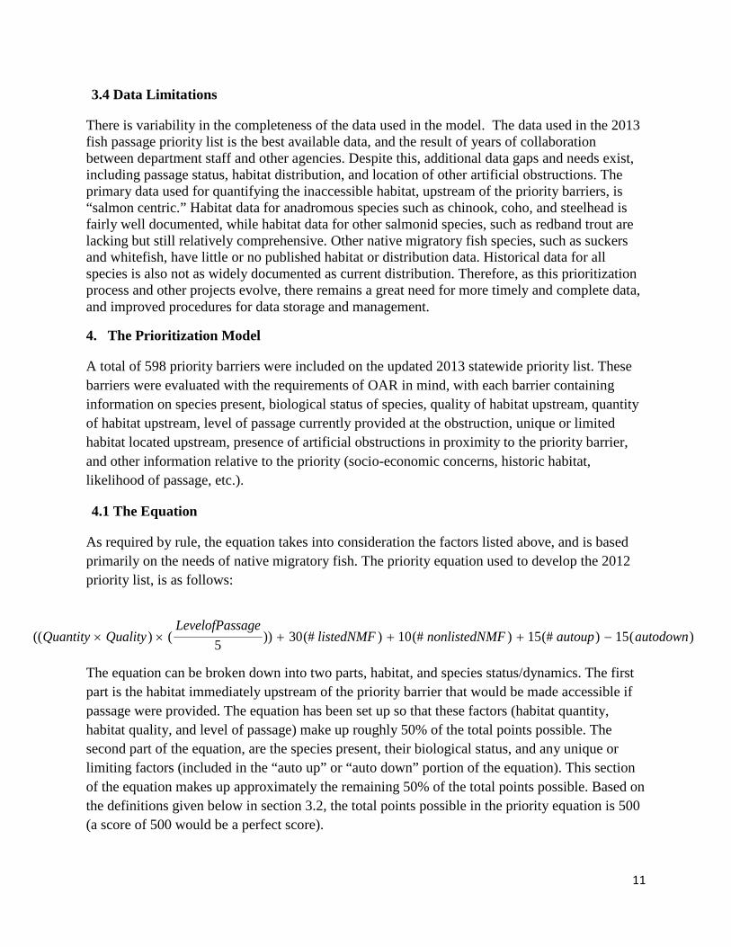
As required by rule, the equation takes into consideration the factors listed above, and is based primarily on the needs of native migratory fish. The priority equation used to develop the 2012 priority list, is as follows:
The equation can be broken down into two parts, habitat, and species status/dynamics. The first part is the habitat immediately upstream of the priority barrier that would be made accessible if passage were provided. The equation has been set up so that these factors (habitat quantity, habitat quality, and level of passage) make up roughly 50% of the total points possible. The second part of the equation, are the species present, their biological status, and any unique or limiting factors (included in the “auto up” or “auto down” portion of the equation). This section of the equation makes up approximately the remaining 50% of the total points possible. Based on the definitions given below in section 3.2, the total points possible in the priority equation is 500 (a score of 500 would be a perfect score).
)(15)(#15)(#10)(#30))5()(( autodownautoupMFnonlistedNlistedNMFsageLevelofPas
QualityQuantity −+++××
12
4.2 Definition and Data Source For Each Parameter
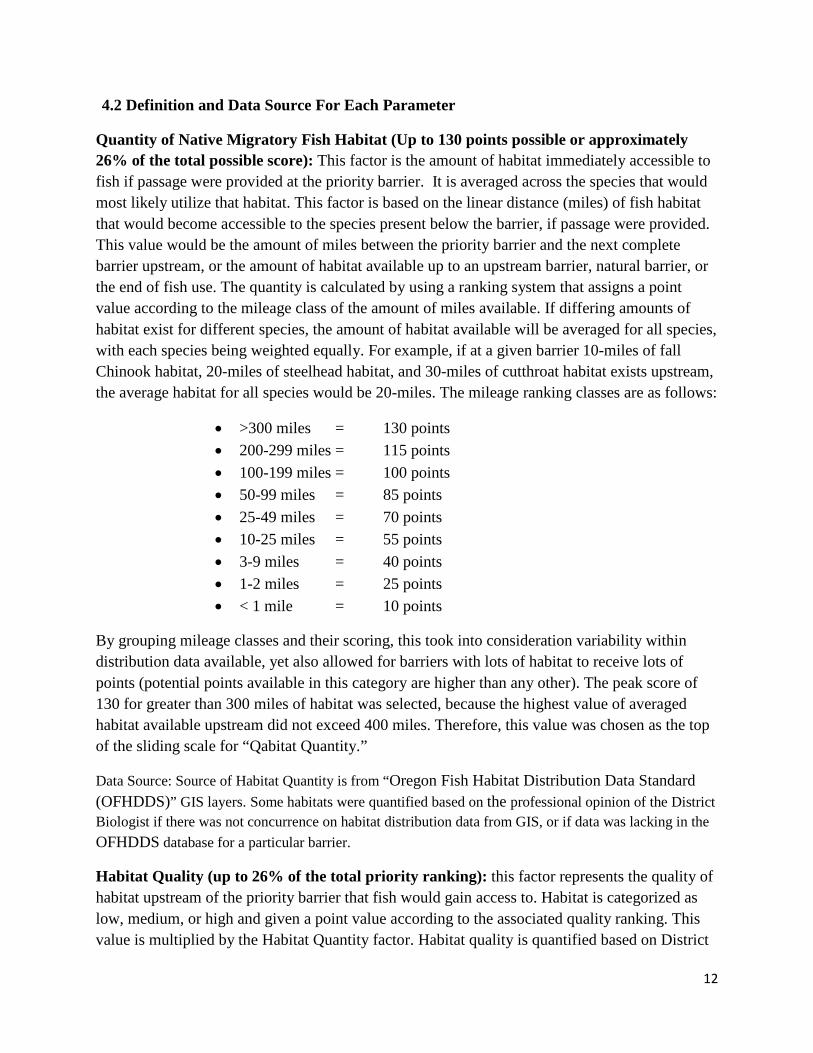
Quantity of Native Migratory Fish Habitat (Up to 130 points possible or approximately 26% of the total possible score): This factor is the amount of habitat immediately accessible to fish if passage were provided at the priority barrier. It is averaged across the species that would most likely utilize that habitat. This factor is based on the linear distance (miles) of fish habitat that would become accessible to the species present below the barrier, if passage were provided. This value would be the amount of miles between the priority barrier and the next complete barrier upstream, or the amount of habitat available up to an upstream barrier, natural barrier, or the end of fish use. The quantity is calculated by using a ranking system that assigns a point value according to the mileage class of the amount of miles available. If differing amounts of habitat exist for different species, the amount of habitat available will be averaged for all species, with each species being weighted equally. For example, if at a given barrier 10-miles of fall Chinook habitat, 20-miles of steelhead habitat, and 30-miles of cutthroat habitat exists upstream, the average habitat for all species would be 20-miles. The mileage ranking classes are as follows:
• >300 miles = 130 points • 200-299 miles = 115 points • 100-199 miles = 100 points • 50-99 miles = 85 points • 25-49 miles = 70 points • 10-25 miles = 55 points • 3-9 miles = 40 points • 1-2 miles = 25 points • < 1 mile = 10 points
By grouping mileage classes and their scoring, this took into consideration variability within distribution data available, yet also allowed for barriers with lots of habitat to receive lots of points (potential points available in this category are higher than any other). The peak score of 130 for greater than 300 miles of habitat was selected, because the highest value of averaged habitat available upstream did not exceed 400 miles. Therefore, this value was chosen as the top of the sliding scale for “Qabitat Quantity.”
Data Source: Source of Habitat Quantity is from “Oregon Fish Habitat Distribution Data Standard (OFHDDS)” GIS layers. Some habitats were quantified based on the professional opinion of the District Biologist if there was not concurrence on habitat distribution data from GIS, or if data was lacking in the OFHDDS database for a particular barrier.
Habitat Quality (up to 26% of the total priority ranking): this factor represents the quality of habitat upstream of the priority barrier that fish would gain access to. Habitat is categorized as low, medium, or high and given a point value according to the associated quality ranking. This value is multiplied by the Habitat Quantity factor. Habitat quality is quantified based on District
13
Biologists’ professional knowledge of the habitat upstream of the priority barrier. In the absence of professional knowledge for a given site, habitat quality is based on any available habitat data, such as surveys, literature, or other data. By categorizing habitat quality into low, medium, and high categories, this allowed District Biologists to base the ranking off the fisheries needs and habitat characteristics specific to their geographic region. Scoring for Habitat Quality is based on the characteristics listed below.
High (2 points): Habitat upstream can be fully utilized by downstream fish populations with little or no restoration activities needed. Cover, substrate, stream features (pools, riffles, glides), stream temperature, and water quality are all optimal for production of native fish that would use them. Access to this habitat is expected to lead to noticeably higher fish productivity in the basin, and would significantly benefit the native migratory fish accessing the habitat. In order to be ranked as “good” the accessed upstream habitat, with these characteristics, must represent greater than 50% of the total available habitat.
Medium (1 point): Habitat upstream will likely be utilized by native migratory fish found below the obstruction. However, some restoration actions are likely needed to improve the quality/quantity of habitat, or the habitat naturally lacks some of the primary requirements for production of native migratory fish. Cover, pools, and substrate are generally suitable for fisheries production; however, quantity/quality of these habitats may be limited or unusable during certain periods of the year. Water quality and temperature may be limiting factors at times, or in certain locations. Overall, fish populations would likely see a benefit from access to this habitat.
Low (.5 points): Habitat upstream may be utilized by native migratory fish in need of passage; however, restoration activities are needed to restore native habitats, or the habitat inherently has limited value to native migratory fish. Conditions are characterized by very limited cover and pools available for rearing, and channel substrate is either silty or bedrock. Spawning habitat is limited or non-existent. Water quality and temperature are less than optimal for fish that are present presence for much of the year. Habitat in this class are often found in areas that are highly urbanized, affected by agriculture or grazing, have a degraded or limited riparian habitat, and/or have other conditions that are not beneficial for fish. Improved access to this habitat would likely have only marginal benefits to native fish or would require extensive restoration activities.
Scoring Habitat Quality based on this ranking system allows for a linear increase or decrease in the overall habitat value. By scoring high quality habitat as 2 points, low quality habitat as .5 points, and by multiplying those factors by Habitat Quantity in the priority equation, the assumption is made that high quality habitat is twice as valuable as medium habitat, while low quality habitat is half as valuable.
14
Data Source: All habitat quality data was obtained from District Biologists and their staff. Data was primarily based on professional opinion/knowledge of the habitats located upstream of the priority barriers. In some cases, where habitats were less well known by district staff, quality was determined from reports, habitat surveys, historical documents, maps, other data sources, or any combination thereof. District staff provided the data source they obtained the habitat quality determination from during the data collection process.
Level of Passage Currently Provided: This factor addresses the level of fish passage that is currently provided at a given obstruction. The scale, values, and descriptions are provided below:
• 5 - barrier to all native migratory fish, • 4 - barrier to some native migratory fish adults and/or species, • 3 - barrier to some native migratory fish adults and/or species for only part of migration period, • 2 - barrier to all native migratory fish juveniles, • 1 - barrier to some native migratory fish juveniles and/or for only part of migration period. • 0 - Full volitional passage for all native migratory fish species, adults and juveniles.
Anything ranked less than a 5 (complete barrier) will reduce the overall priority (cannot receive full credit for habitat being blocked if not a complete barrier). The “level of passage” rating will reduce the priority score based on the relative degree (percentage) of complete blockage at the barrier. The level of passage is applied to the upstream habitat value (Quantity and Quality), because anything less than a complete barrier indicates that fish are already accessing the habitat upstream at varying degrees depending on the severity of the blockage. Therefore, any score less than 5 for the “Level of Passage” ranking will reduce the overall score for habitat upstream by the following percentages:
• Level of passage rating: 4 = 20% • Level of passage rating: 3 = 40% • Level of passage rating: 2 = 60% • Level of passage rating: 1 = 80% • Level of passage rating: 0 = 100%
Data source: Level of passage data was obtained from the barrier data gathered on GIS. This barrier data is from a variety of sources, but was translated and collaborated into one data source to be consistent with the OFPBDS (as described in section 2.1 of this document). In many cases, ODFW district staff provided their recommended fish passage status based on knowledge of the barrier and history of fish passage at the site. Most of this data is professional judgment and is not based on comprehensive field sampling during various seasons and flow conditions.
Listed Native Migratory Fish (Can add up to 120 points or approximately 24% of the total possible priority score): This factor addresses fish in need of passage at the barrier that are listed as “threatened” or “endangered” under the federal Endangered Species Act (ESA). The presence of federally listed fish increases the priority ranking of a barrier. For each “listed” fish species present at the barrier, 30 points will be added to the priority ranking. There is no
15
maximum score possible for this factor; however, the highest number of ESA listed fish at any given site was four. Therefore, the highest score received for this factor is 120 points.
Data Source: Biological status data was obtained by a combination of GIS habitat distribution data and professional knowledge of District Biologists.
Species Diversity – (Can add up to 60 additional points or approximately 12% of the total possible priority score) This factor addresses the number of non ESA listed native migratory fish species or stocks in need of passage at the priority barrier (# of species or stocks that would utilize the habitat upstream of the barrier). For each, non-listed, native migratory fish species or stock present, 10 points will be given. There is a maximum of 60 total points available for this category. Native migratory fish species, according to OAR 635-412-0005 are as follows:
Acipenser medirostris ….. Green Sturgeon Acipenser transmontanus ….. White Sturgeon Amphistichus rhodoterus ….. Redtail surfperch Catostomus columbianus ….. Bridgelip sucker Catostomus luxatus/Deltistes luxatus ….. Lost River sucker Catostomus macrocheilus ….. Largescale sucker Catostomus microps ….. Modoc sucker Catostomus occidentalis ….. Goose Lake sucker Catostomus platyrhynchus ….. Mountain sucker Catostomus rimiculus ….. Klamath smallscale sucker Catostomus snyderi ….. Klamath largescale sucker Catostomus tahoensis ….. Tahoe sucker Catostomus warnerensis ….. Warner sucker Chasmistes brevirostris ….. Shortnose sucker Hypomesus pretiosus ….. Surf smelt Lampetra ayresi ….. River lamprey Lampetra lethophaga ….. Pit-Klamath lamprey Lampetra minima ….. Miller Lake lamprey Lampetra similes ….. Klamath River lamprey Lampetra tridentate ….. Pacific lamprey Oncorhynchus clarki ….. Coastal, Lahontan and West Slope cutthroat trout Oncorhynchus keta ….. Chum salmon Oncorhynchus kisutch ….. Coho salmon Oncorhynchus mykiss ….. Steelhead, Rainbow and Redband trout Oncorhynchus nerka ….. Sockeye/Kokanee salmon Oncorhynchus tshawytscha ….. Chinook salmon Prosopium williamsoni ….. Mountain whitefish Ptychocheilus oregonensis ….. Northern pikeminnow Ptychocheilus umpquae ….. Umpqua pikeminnow Salvelinus confluentus ….. Bull trout Spirinchus thaleichthys ….. Longfin smelt Thaleichthys pacificus ….. Eulachon
16
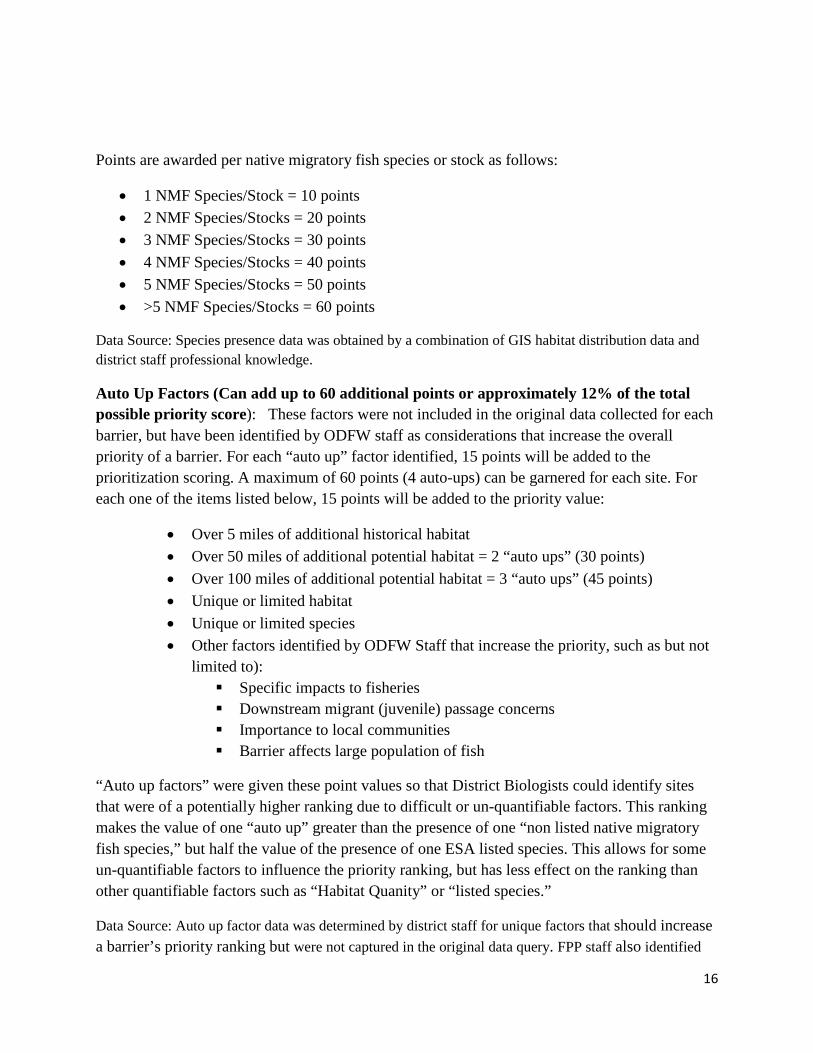
Points are awarded per native migratory fish species or stock as follows:
• 1 NMF Species/Stock = 10 points • 2 NMF Species/Stocks = 20 points • 3 NMF Species/Stocks = 30 points • 4 NMF Species/Stocks = 40 points • 5 NMF Species/Stocks = 50 points • >5 NMF Species/Stocks = 60 points
Data Source: Species presence data was obtained by a combination of GIS habitat distribution data and district staff professional knowledge.
Auto Up Factors (Can add up to 60 additional points or approximately 12% of the total possible priority score): These factors were not included in the original data collected for each barrier, but have been identified by ODFW staff as considerations that increase the overall priority of a barrier. For each “auto up” factor identified, 15 points will be added to the prioritization scoring. A maximum of 60 points (4 auto-ups) can be garnered for each site. For each one of the items listed below, 15 points will be added to the priority value:
• Over 5 miles of additional historical habitat • Over 50 miles of additional potential habitat = 2 “auto ups” (30 points) • Over 100 miles of additional potential habitat = 3 “auto ups” (45 points) • Unique or limited habitat • Unique or limited species • Other factors identified by ODFW Staff that increase the priority, such as but not
limited to): Specific impacts to fisheries Downstream migrant (juvenile) passage concerns Importance to local communities Barrier affects large population of fish
“Auto up factors” were given these point values so that District Biologists could identify sites that were of a potentially higher ranking due to difficult or un-quantifiable factors. This ranking makes the value of one “auto up” greater than the presence of one “non listed native migratory fish species,” but half the value of the presence of one ESA listed species. This allows for some un-quantifiable factors to influence the priority ranking, but has less effect on the ranking than other quantifiable factors such as “Habitat Quanity” or “listed species.”
Data Source: Auto up factor data was determined by district staff for unique factors that should increase a barrier’s priority ranking but were not captured in the original data query. FPP staff also identified

17
“auto up factors” by analyzing the data available on the priority list spreadsheet (such as additional potential habitat).
Auto Down Factors (subtract up to 60 points or approximately 12% of the total possible score): These are factors not included in the original data collected for each barrier, but have been identified by ODFW staff as factors that should be considered to decrease the overall priority of a barrier. For each “auto down” factor identified, 15 points will be subtracted from the prioritization ranking. A maximum of 60 points (4 auto-downs) can be garnered for each site. For each one of the items listed below, 15 points will be subtracted from the priority value:
- Complete barriers downstream - 3 or more complete barriers upstream - 10 or more complete barriers upstream = 2 auto downs (-30 points) - Imminent Trigger (high likelihood of passage in the near future) - Existing ODFW Agreements (waivers) - Fish Management Concerns (Non-native fish, or other concerns) - Other factors identified by ODFW staff that decrease the priority
“Auto down factors” were given these point values so that District Biologists could identify sites that were of a potentially lower ranking due to difficult or un-quantifiable factors. This ranking makes the value of one “auto down” greater than the reduction of one “non listed native migratory fish species” at a given site, but half the value of the reduction of one ESA listed species. This allows for some un-quantifiable factors to influence the priority ranking, but have less effect on the ranking than other quantifiable factors such as “Habitat Quanity” or “listed species.”
Data Source: Auto down factor data was determined by district staff for unique factors that were not captured in the original data query that should be considered to decrease barrier’s priority scoring. FPP staff also identified “auto down factors” by analyzing the data available on the priority list spreadsheet (data such as complete barriers upstream).
Other Definitions:
Complete Artificial Obstruction (up or downstream): An artificial obstruction up or downstream of the priority artificial obstruction that completely blocks all native migratory fish migration. For complete artificial obstructions upstream, fish habitat available ends at these obstructions.
Additional Potential Habitat: Habitats that exist above other complete artificial obstructions located upstream of a priority barrier. These habitats would be potentially available in the future, if passage were provided at the blocking barrier(s).
4.3 Assumptions Made in the Model
18
A number of assumptions were made in the development of this priority model and the priority list. First, are assumptions made related to habitat distribution data. As noted in the data limitations section (section 2.4), the majority of the available data were “salmon centric.” It is common knowledge that individual salmon species and life stages have different habitat requirements/preferences. The same holds true for other species such as suckers, bull trout, and whitefish. Since the majority of habitat distribution data characterized salmon habitat, the decision was made to quantify available habitat, upstream of the priority barrier, by averaging the habitat quantities of the species with documented data. By averaging habitat, a balance is created between those fish species that may travel far upstream, and those species that typically do not. This assumption keeps the data from skewing towards quantities that are unrealistic for individual species. An example would be having Chinook, steelhead, and suckers listed as species present, habitat data shows 10 miles of habitat available for steelhead, 5 miles available for Chinook, and habitat is not mapped for suckers. The habitat quantity value for this example would be 7.5 miles (the average between Chinook and steelhead habitat), as this number more closely represents the stream miles that all species present could potentially occupy.
The habitat distribution data used for the Habitat Quantity factor is from the best and most up to date data available; however, within the data there is some variability. ODFW recognizes that the science and information regarding fish distribution (both current and historical) is ever evolving. Knowing that some variability exists in the data was a key in developing the model for two reasons. First, the habitat quantity factor was given points based on classes that described a range of miles available instead of giving points per mile of habitat. By using these classes, which are defined by a range of miles, to assign scores, a given amount of points (50-99 miles = 85 points) we acknowledge that some variability exists in the data. Second, the model and the priority list were created in a way that make them easy to access and update as new information becomes available. The priority list is a tool that can be updated and changed as passage is provided at barriers or new data is obtained.
Historical habitat for fish species is another piece of the data set with substantial variability. ODFW feels that it is important to include this information in the prioritization process, but also realizes that some geographic regions have better historic, habitat distribution data than others. For example, historical fish habitat for Chinook and steelhead is not well mapped in the drainages above the Snake River dams (Hells Canyon, Oxbow, Brownlee), but it is well documented in the Klamath basin. Due to these variations, historic habitat was not included as a “stand alone” factor. Rather, if well-documented, or professionally agreed upon historical habitat existed, it is quantified in the “auto up” factor. Likewise, complete barriers, located upstream of the priority barriers, were quantified in the “auto down” factor.
Habitat quality is a term used to determine the relative suitability of habitats for fish and other species. In this model, habitat quality was determined by the district biologists and their staff who are knowledgeable about local fish habitats. It is assumed that habitats, upstream of these high priority barriers, are well known by district staff. In cases where professional knowledge
19
was lacking, district staff consulted habitat surveys, reports, map data, literature, or any other means available to help ascertain or support their habitat quality determination.
The overall priority ranking and the prioritization model is primarily based on biology. This assumption is supported by OAR, which states that “the priority list shall be based on the needs of the native migratory fish.” ODFW also recognizes that other factors also come into play when prioritizing sites for fish passage restoration. Whether they are socio-economic in nature, or common sense driven, they help to provide a more complete picture of important considerations for a given site. The “auto up” and “auto down” factors are a way for district staff, or FPP staff to consider a number of other factors that may increase or decrease the priority of barriers. These factors included, but were not limited to, likelihood of passage, ODFW agreements, management decisions, historic habitat, presence of artificial obstructions, and others.
It is felt that the methodology selected for development of the priority list utilizes the best available information and the best professional judgment. There is a range of other ways that one could use to calculate priority. These could include many different factors, but ODFW believes this method best characterizes priorities based on biology and the guidelines set forth in OAR. Based on this, the variability within the data, and the variability within the prioritization model, ODFW categorized the priority barriers into distinct groups based on their raw scores. In doing this, it is assumed that all barriers within each succinct group have roughly the same overall priority within the state, and will provide close to an equal amount of benefit to native fish when improved passage is provided at these artificial obstructions. Despite this categorization system, it is assumed that all barriers on the priority list are high priorities in the state.
5. Results of the 2012 Fish Passage Prioritization List
The final priority list contains 534 high priority fish passage barriers (Attachment C), with an additional 55 barriers characterized as “other significant barriers in need of more data.” Out of the 27,800 artificial obstructions documented in Oregon, the 534 priority obstructions comprise less than 2% of the total. Of the 534 priority obstructions 289 (59%) are dams, 207 (39%) are culverts, and the remaining 38 (7%) are include tide gates, fords, bridges, and other artificial obstructions. Dams make up the majority of the “top” priorities. This is largely, due to the fact that they generally block large segments of habitat on larger river systems. The priorities have been organized into classes, with each class representing barriers of similar priority ranking. It is important to note, that all barriers on the list are high priorities for ODFW.
6. Recommendations For Future Improvements
As is the case for all large-scale projects, there is always room for improvement. In this case, discrepancies, shortfalls, and potential data gaps were noted along the way to help identify process improvements that could be made for future priority lists. That being said, this list was developed to be dynamic that will be adaptively managed when new information is identified. It
20
is ODFW’s goal to ensure that this priority list of artificial obstructions represents the best available science and reflects data that is accurate and up to date.
6.1 Data Source Refinements
The data utilized in this priority list is the result of years of hard work by many individuals. It represents the best data available science; however, it is clear that there are still data gaps. Several priority barriers, listed by district biologists, could not be ranked on the list, because not enough data existed to support a prioritization ranking. These barriers were highlighted as “other significant barriers,” ODFW hopes to fill in the data gaps as new information becomes available, and to update the priority list as this occurs.
It is also clear that more emphasis needs to be invested into developing distribution data for non-salmonids, particularly those listed species native to Oregon, such as Lost River suckers, small-scale suckers, and Warner suckers of the Klamath and Warner basins. These species are important native migratory fish, with habitat requirements that differ significantly from salmonids, and limited date exists regarding their status and distribution.
6.2 Model Refinements
The prioritization model serves to answer the question “Where will the greatest biological benefits be realized if passage is provided?” The model does a good job of utilizing biological factors and professional judgment to answer this question. However, models are currently being developed that look at habitat factors such as watershed area, wetted channel width, miles of habitat, gradient, and other important habitat features to provide a more comprehensive estimate of potential fish use. Most notably, this has been completed for coho on the coast. Broader application of this approach, for other species, would be a great tool in improving the statewide priority list.
Similarly, in future fish passage prioritization efforts, another look at habitat quality could warrant less subjective results. Habitat types and their individual extent and quality, rather than habitat quality of entire stream reaches, could be applied to the habitat metric. Values would be given to certain types of habitat for different species, such as miles of rearing habitat for Chinook, or miles of spawning habitat for suckers. Each habitat type, for each species, could be weighted to help determine a more accurate estimate of the habitat upstream for native migratory fish in need of passage. Currently, the data simply does not exist to be able to quantify all habitats, by species, across the state. Extensive surveys have been done over the years, by ODFW and others, but additional data collection is warranted, including a standardization of how data is collected and universal stratification of habitat quality levels. As new habitat data and surveys are completed, this system of quantifying the quantity and quality of habitat
21
upstream of an artificial obstruction, by individual fish species, could be a valuable and more accurate way to calculate priority.
7 Conclusions and Use of the Document
The priority list represents the highest priority barriers for fish passage in the state. These sites will provide the large benefits to native migratory fish, by providing access to high quantity and quality habitats, if passage is provided. Fish passage restoration efforts should be focused on these priority barriers, specifically the highest priorities on the list.
This list is a viable tool for several uses. These include:
1. Enforcement by the Oregon Fish and Wildlife Commission (OFWC). As directed by OAR 635-412-0015 and by ORS 509.585, the OFWC may enforce that fish passage be provided if the barrier is one of ODFW’s top ten priority barriers, and ODFW secures 60% of non owner/operator funding for fish passage at the barrier. As passage is enforced at top barriers, provided after a “trigger event,” or provided voluntarily, the list will be updated so that a current “top ten” exists for the state.
2. Prioritization for funding by ODFW and other Funding Agencies. Funding agencies and grantors take many aspects of a project into consideration prior to either funding or denying funding to a project. This list can serve as a primary filter for these agencies. The list can be used to get a sense of a given site’s relative priority as compared to another priority barrier. This list should not solely be used as the basis of funding decisions, but can serve as a foundation for these types of decisions.
3. Mitigation Opportunities for Fish Passage Waivers. This list is a prime source for obtaining mitigation locations for fish passage waivers or to offset other impacts that may qualify. A barrier’s presence on the priority list does not automatically mean that it qualifies as a valid mitigation site to offset impacts; however, the list should be a starting point for locating potential fish passage mitigation sites.
4. A database of high priority projects. The list is comprised of barriers in each of the 18 fish districts across the state. The list will not only categorize fish passage priorities at the statewide level, but will also categorize fish passage priorities at the district level. Local entities, such as ODFW Fish Districts, Watershed Councils, Soil and Water Conservation Districts, and other interested parties can use the list of priorities in their respective geographic locations to help make decisions on restoration of fish passage. This list will give those agencies and groups a better idea of where high priority locations are, and the conditions present at each.

22
The priority list can be utilized in many ways; however, one way it should not be utilized is as a sole source of data. As noted in this document, a number of assumptions were made in the development of this list. Because of those assumptions, habitats were averaged based on the available data at each barrier, and actual habitat located above a barrier may vary for each species as compared to the average amount of habitat that is listed on the priority list. Also, as noted previously, determination and understanding of historic fish distribution, and current fish distribution for some species, continues to be a work in progress.
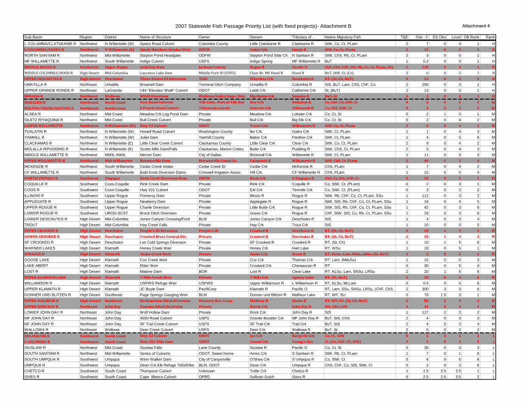
2007 Statewide Fish Passage Priority List- Attachment A Attachment 3
Sub-Basin Region District Name of Structure Owner Stream Tributary of… Native Migratory Fish T&E Dist - C DS Obs Level DB Rank RankL COLUMBIA/CLATSKANIE R Northwest N Willamette (W) Apiary Road Culvert Columbia County Little Clatskanie R Clatskanie R StW, Co, Ct, PLam 2 7 0 4 1 HL COLUMBIA/SANDY R Northwest N Willamette (E) Sandy Hatchery Intake/Weir ODFW Cedar Crk Sandy R StW, Co, Ct, PLam 2 12 0 5 1 HNORTH SANTIAM R Northwest Mid-Willamette Stayton Pond Headgate ODFW Stayton Pond Side Ch. N Santiam R StW, ChS, Rb, Ct, PLam 2 3 0 5 1 HMF WILLAMETTE R Northwest South Willamette Indigo Culvert USFS Indigo Spring MF Willamette R BuT 1 0.2 0 5 1 HMIDDLE ROGUE R Southwest Upper Rogue Gold Ray Dam Jackson County Rogue R Pacific O ChF, ChS, StW, StS, Rb, Co, Ct, PLam, SSu 1 110 0 4 1 HMIDDLE COLUMBIA/HOOD R High Desert Mid-Columbia Laurance Lake Dam Middle Fork ID (USFS) Clear Br. MF Hood R Hood R BuT, StW, Ct, (Co) 3 6 0 5 1 HUPPER DESCHUTES R High Desert Deschutes Three Sisters ID Diversion TSID Whychus Crk Deschutes R RT, (St, Ch, BuT) 2 15 0 5 1 HUMATILLA R Northeast Umatilla Brownell Dam Terminal Ditch Company Umatilla R Columbia R StS, BuT, Lam, ChS, ChF, Co 2 200 0 3 1 HUPPER GRANDE RONDE R Northeast LaGrande I-84 "Elevator Shaft" Culvert ODOT Ladd Crk Catherine Crk St, (BuT) 2 13 0 5 1 HIMNAHA R Northeast Wallowa WVID Diversion Wallowa Valley Impr. Dist. Big Sheep Crk Imnaha R BuT, St 2 3 0 4 1 HNEHALEM R Northwest North Coast Foss Road Culverts Till. Cnty., Port of Till. Bay Roy Crk Nehalem R Co, ChF, CS, StW, Ct 0 2 0 3 1 MWILSON/TRASK/NESTUCCA Northwest North Coast S Prairie Road Culvert Tillamook County Fawcett Crk Tillamook R Co, ChF, StW, Ct 0 4 0 3 2 MALSEA R Northwest Mid-Coast Meadow Crk Log Pond Dam Private Meadow Crk Lobster Crk Co, Ct, St 0 2 1 5 1 MSILETZ R/YAQUINA R Northwest Mid-Coast Bull Creek Culvert Private Bull Crk Big Elk Crk Co, Ct, St 0 2 0 4 2 MLOWER WILLAMETTE Northwest N Willamette (W) Hwy 43 Culvert ODOT Tryon Crk Willamette R StW, Co, Ct, PLam 2 4 0 4 2 MTUALATIN R Northwest N Willamette (W) Howell Road Culvert Washington County Iler Crk Gales Crk StW, Ct, PLam 1 1 0 4 3 MYAMHILL R Northwest N Willamette (W) Juliet Dam Yamhill County Baker Crk Panther Crk StW, Ct, PLam 1 4 0 5 6 MCLACKAMAS R Northwest N Willamette (E) Little Clear Creek Culvert Clackamas County Little Clear Crk Clear Crk StW, Co, Ct, PLam 2 9 0 4 2 MMOLALLA R/PUDDING R Northwest N Willamette (E) Scotts Mills Dam/Falls Clackamas, Marion Cnties. Butte Crk Pudding R StW, ChS, Ct, PLam 2 5 0 4 3 MMIDDLE WILLAMETTE R Northwest MWIL-NWIL Mercer Dam City of Dallas Rickreall Crk Willamette R StW, Ct, PLam 1 11 0 5 3 MUPPER WILLAMETTE R Northwest Mid-Willamette Brownsville Dam Brownsville Canal Co. Calapooia R Willamette R StW, ChS, Ct, PLam 2 40 1 3 4 MMCKENZIE R Northwest South Willamette Cedar Creek Intake Cedar Creek ID Cedar Crk McKenzie R ChS, PLam 1 7 0 4 2 MCF WILLAMETTE R Northwest South Willamette Bald Knob Diversion Dams Creswell Irrigation Assoc. Hill Crk CF Willamette R ChS, PLam 1 15 0 5 4 MNORTH UMPQUA R Southwest Umpqua Rock Creek Diversion Dam ODFW Rock Crk N Umpqua R ChS, Co, StS, StW, Ct 0 45 0 3 1 MCOQUILLE R Southwest Coos-Coquille Rink Creek Dam Private Rink Crk Coquille R Co, StW, Ct, (PLam) 0 2 0 3 1 MCOOS R Southwest Coos-Coquille Hwy 101 Culvert ODOT Eel Crk Tenmile Crk Co, StW, Ct, (PLam) 0 3 0 3 2 MILLINOIS R Southwest Upper Rogue Pomeroy Dam Private Illinois R Rogue R StW, Rb, ChF, Co, Ct, PLam, SSu 1 112 0 3 2 MAPPLEGATE R Southwest Upper Rogue Newberry Dam Private Applegate R Rogue R StW, StS, Rb, ChF, Co, Ct, PLam, SSu 1 16 0 4 5 MUPPER ROGUE R Southwest Upper Rogue Charlie Diversion Private Little Butte Crk Rogue R StW, StS, Rb, ChF, Co, Ct, PLam, SSu 1 42 0 3 6 MLOWER ROGUE R Southwest UROG-SCST Brock Ditch Diversion Private Grave Crk Rogue R ChF, StW, StS, Co, Rb, Ct, PLam, SSu 1 29 0 3 6 MLOWER DESCHUTES R High Desert Mid-Columbia Jones Canyon Crossing/Ford BLM Jones Canyon Crk Deschutes R StS 1 4 0 3 4 MTROUT High Desert Mid-Columbia Hay Creek Falls Private Hay Crk Trout Crk StS 1 10 0 5 5 MUPPER CROOKED R High Desert Deschutes People's ID Diversion People's ID Crooked R Deschutes R RT, (St, Ch, BuT) 2 20 2 5 2 MLOWER CROOKED R High Desert Deschutes Crooked River Central Div. Private Crooked R Deschutes R RT, (St, Ch, BuT) 2 45 1 4 3 MSF CROOKED R High Desert Deschutes Lwr Cold Springs Diversion Private SF Crooked R Crooked R RT, (St, Ch) 1 10 1 5 6 MWARNER LAKES High Desert Klamath Honey Creek Weir Private Honey Crk Hart Lake RT, WSu 1 19 0 5 1 MSPRAGUE R High Desert Klamath Snake Creek Weir Private Snake Crk Sycan R RT, KLSu, Lam, SNSu, LRSu, (St, BuT) 2 2 0 5 2 MGOOSE LAKE High Desert Klamath Cox Creek Weir Private Cox Crk Thomas Crk RT, Lam, (MdcSu) 1 15 0 5 3 MLAKE ABERT High Desert Klamath Elder Weir Private Crooked Crk Chewaucan R RT 0 30 0 5 4 MLOST R High Desert Klamath Malone Dam BOR Lost R Clear Lake RT, KLSu, Lam, SNSu, LRSu 2 20 1 5 6 MUPPER KLAMATH LAKE High Desert Klamath 7-Mile Creek Weir Private 7-Mile Crk Agency Lake RT, (St, BuT) 1 10 0 3 6 MWILLIAMSON R High Desert Klamath USFWS Refuge Weir USFWS Upper Williamson R L Williamson R RT, KLSu, MLLam 0 0.5 0 5 6 MUPPER KLAMATH R High Desert Klamath JC Boyle Dam PacifiCorp Klamath R Pacific O RT, Lam, SSu, SNSu, LRSu, (ChF, ChS, St, Co, 2 300 3 3 6 MDONNER UND BLITZEN R High Desert Southeast Page Springs Gauging Weir BLM Donner und Blitzen R Malheur Lake RT, WF, SU 0 70 1.5 3 1 MUPPER MALHEUR R High Desert Southeast Reclamation Ditch Diversion Drewsey Rec. Coop. Malheur R Snake R RT, WF, SU, (St, Ch, BuT) 2 80 2 4 2 MUPPER JOHN DAY R Northeast John Day Panama Ditch Diversion Private Beech Crk John Day R StS, ChS, CtW 1 42 0 3 1 MLOWER JOHN DAY R Northeast John Day Wolf Hollow Dam Private Rock Crk John Day R StS 1 127 2 3 2 MMF JOHN DAY R Northeast John Day 4550 Road Culvert USFS Granite Boulder Crk MF John Day R BuT, StS, ChS 2 4 0 3 3 MNF JOHN DAY R Northeast John Day SF Trail Creek Culvert USFS SF Trail Crk Trail Crk BuT, StS 2 4 0 3 4 MWALLOWA R Northeast Wallowa Deer Creek Culvert USFS Deer Crk Wallowa R BuT, St 2 5 0 2 2 MNECANICUM R Northwest North Coast Hwy 53 Culvert ODOT Joe Crk Bergsvik Crk Co, Ct, StW 0 2 0 2 3 LL COLUMBIA R Northwest North Coast Hwy 202 Tide Gate ODOT Crosel Crk Young's Bay Ct, (Co, ChF, CS, StW) 3 1 0 3 5 LSIUSLAW R Northwest Mid-Coast Siuslaw Falls Lane County Siuslaw R Pacific O Co, Ct, St 0 30 0 3 3 LSOUTH SANTIAM R Northwest Mid-Willamette Series of Culverts ODOT, Sweet Home Ames Crk S Santiam R StW, Rb, Ct, PLam 1 7 0 1 6 LSOUTH UMPQUA R Southwest Umpqua Winn Walker Dam City of Canyonville O'Shea Crk S Umpqua R Co, StW, Ct 0 6 0 5 6 LUMPQUA R Southwest Umpqua Dean Crk Elk Refuge TdGt/Dike BLM, ODOT Dean Crk Umpqua R ChS, ChF, Co, StS, StW, Ct 0 2 0 2 6 LCHETCO R Southwest South Coast Thompson Culvert Unknown Tuttle Crk Chetco R 1 2.5 2.5 3.5 1 LSIXES R Southwest South Coast Cape Blanco Culvert OPRD Sullivan Gulch Sixes R 0 2.5 2.5 3.5 2 L
2007 Statewide Fish Passage Priority List- Attachment A Attachment 3
SILVER CRK High Desert Southeast Silver Creek Dam Private Silver Crk Harney Lake RT, SU 0 95 5 4 4 LGUANO SLOUGH High Desert Southeast Hwy 205 Culvert Harney County Threemile Crk NA RT 0 4 1 3 3 LSILVIES R High Desert Southeast 5 Mile Dam Private Silvies R Malheur Lake RT, SU 0 150 5 4 5 LLOWER MALHEUR R High Desert Southeast Nevada Dam Private Malheur R Snake R SU, (Ch, St, BuT, RT) 1 85 1 3.5 6 LWALLA WALLA R Northeast Umatilla City Water Intake Dam City of Walla Walla Mill Crk Walla Walla R StS, BuT, RT, WF 2 20 4.5 3 2 LWILLOW CRK Northeast Umatilla Willow Farms Dam #2 Private Willow Crk Columbia R StS, RT 1 150 0.5 5 6 LPOWDER R Northeast LaGrande Series of 4 Culverts Baker County Fruit Crk Silver Crk RT, (BuT) 1 3 2.5 3 3 LBURNT R Northeast LaGrande County Road 1121 Culvert Baker County Clarks Crk Burnt R RT 0 10 2.5 4 4 LLOWER GRANDE RONDE R Northeast Wallowa Doe Creek Culvert USFS Doe Crk Chesnimnus Crk St 1 2 0 3 6 LSILTCOOS Northwest Mid-Coast None Known NASMITH R Southwest South Coast None Known (small) NABUTTE High Desert Klamath None Known (v.small) NASUMMER LAKE High Desert Klamath None Known NALOWER KLAMATH R High Desert KLAM-UROG None Known (v.small) NAALVORD LAKE High Desert Southeast None NABULLY CRK High Desert Southeast None Known NACROOKED/RATTLESNAKE High Desert Southeast None NAEAST LITTLE OWYHEE R High Desert Southeast None (small) NAHARNEY/MALHEUR LAKES High Desert Southeast None NAJORDAN CRK High Desert Southeast None NALOWER OWYHEE R High Desert Southeast None NAMIDDLE OWYHEE R High Desert Southeast None NAMIDDLE SNAKE/PAYETTE High Desert Southeast None (small) NAMIDDLE SNAKE/SUCCOR High Desert Southeast None Known (small) NASOUTH FORK OWYHEE R High Desert Southeast None (v.small) NATHOUSAND/VIRGIN High Desert Southeast None Known (small) NAUPPER QUINN High Desert Southeast None Known (small) NAWILLOW CRK (Snake) High Desert Southeast None Known NAM COL/LAKE WALLULA Northeast Umatilla None Known NABROWNLEE RESERVOIR Northeast LAGR-SE NA NAHELLS CANYON Northeast Wallowa None Known (small) NALOWER SNAKE/ASOTIN Northeast Wallowa None Known (small) NA
Column DescriptionsT&E The number of federal- or state-listed Threatened or Endangered native migratory fish species. State "Sensitive" species and federal "Species of Concern" are not included.
Dist - C The current distance (miles) affected by the site (i.e., the distance that would be made accessible, including tributaries, if passage were provided at the site taking into account other artificial complete barriers).DS Obs The number of artificial obstructions downstream which are complete barriers.
Level The current level of fish passage at the site (i.e., "passability"), using the following ranking criteria:5 - barrier to all native migratory fish4 - barrier to some native migratory fish adults and/or species3 - barrier to some native migratory fish adults and/or species for only part of migration period2 - barrier to all native migratory fish juveniles1 - barrier to some native migratory fish juveniles and/or for only part of migration period
DB Rank The rank of the structure within a District Fish Biologist's District, without limitations on number per sub-basin and based on professional judgment and factors that are not otherwise quantified.
Native Migratory Fish - Species Codes
BuT Bull Trout PLam Pacific LampreyCh Chinook Salmon Rb Rainbow Trout
ChF Fall Chinook RT Redband TroutChS Spring Chinook SNSu Shortnose Sucker
Co Coho Salmon SSu Klamath Smallscale SuckerCS Chum Salmon St Steelhead TroutCt Cutthroat Trout StS Summer Steelhead
KLSu Klamath Largescale Sucker StW Winter SteelheadLam Lamprey (unidentified) SU Sucker (unidentified)
LRSu Lost River Sucker (Mullet) WF Mountain WhitefishMdcSu Modoc Sucker WSu Warner Sucker
MLLam Miller Lake Lamprey
2007 Statewide Fish Passage Priority List (with fixed projects)- Attachment B Attachment 4
Sub-Basin Region District Name of Structure Owner Stream Tributary of… Native Migratory Fish T&E Dist - C DS Obs Level DB Rank Rank
L COLUMBIA/CLATSKANIE R Northwest N Willamette (W) Apiary Road Culvert Columbia County Little Clatskanie R Clatskanie R StW, Co, Ct, PLam 2 7 0 4 1 HL COLUMBIA/SANDY R Northwest N Willamette (E) Sandy Hatchery Intake/Weir ODFW Cedar Crk Sandy R StW, Co, Ct, PLam 2 12 0 5 1 H
NORTH SANTIAM R Northwest Mid-Willamette Stayton Pond Headgate ODFW Stayton Pond Side Ch. N Santiam R StW, ChS, Rb, Ct, PLam 2 3 0 5 1 HMF WILLAMETTE R Northwest South Willamette Indigo Culvert USFS Indigo Spring MF Willamette R BuT 1 0.2 0 5 1 HMIDDLE ROGUE R Southwest Upper Rogue Gold Ray Dam Jackson County Rogue R Pacific O ChF, ChS, StW, StS, Rb, Co, Ct, PLam, SSu 1 110 0 4 1 H
MIDDLE COLUMBIA/HOOD R High Desert Mid-Columbia Laurance Lake Dam Middle Fork ID (USFS) Clear Br. MF Hood R Hood R BuT, StW, Ct, (Co) 3 6 0 5 1 HUPPER DESCHUTES R High Desert Deschutes Three Sisters ID Diversion TSID Whychus Crk Deschutes R RT, (St, Ch, BuT) 2 15 0 5 1 H
UMATILLA R Northeast Umatilla Brownell Dam Terminal Ditch Company Umatilla R Columbia R StS, BuT, Lam, ChS, ChF, Co 2 200 0 3 1 HUPPER GRANDE RONDE R Northeast LaGrande I-84 "Elevator Shaft" Culvert ODOT Ladd Crk Catherine Crk St, (BuT) 2 13 0 5 1 HIMNAHA R Northeast Wallowa WVID Diversion Wallowa Valley Impr. Dist. Big Sheep Crk Imnaha R BuT, St 2 3 0 4 1 H
NEHALEM R Northwest North Coast Foss Road Culverts Till. Cnty., Port of Till. Bay Roy Crk Nehalem R Co, ChF, CS, StW, Ct 0 2 0 3 1 M
WILSON/TRASK/NESTUCCA Northwest North Coast S Prairie Road Culvert Tillamook County Fawcett Crk Tillamook R Co, ChF, StW, Ct 0 4 0 3 2 M
ALSEA R Northwest Mid-Coast Meadow Crk Log Pond Dam Private Meadow Crk Lobster Crk Co, Ct, St 0 2 1 5 1 MSILETZ R/YAQUINA R Northwest Mid-Coast Bull Creek Culvert Private Bull Crk Big Elk Crk Co, Ct, St 0 2 0 4 2 MLOWER WILLAMETTE Northwest N Willamette (W) Hwy 43 Culvert ODOT Tryon Crk Willamette R StW, Co, Ct, PLam 2 4 0 4 2 M
TUALATIN R Northwest N Willamette (W) Howell Road Culvert Washington County Iler Crk Gales Crk StW, Ct, PLam 1 1 0 4 3 MYAMHILL R Northwest N Willamette (W) Juliet Dam Yamhill County Baker Crk Panther Crk StW, Ct, PLam 1 4 0 5 6 MCLACKAMAS R Northwest N Willamette (E) Little Clear Creek Culvert Clackamas County Little Clear Crk Clear Crk StW, Co, Ct, PLam 2 9 0 4 2 MMOLALLA R/PUDDING R Northwest N Willamette (E) Scotts Mills Dam/Falls Clackamas, Marion Cnties. Butte Crk Pudding R StW, ChS, Ct, PLam 2 5 0 4 3 MMIDDLE WILLAMETTE R Northwest MWIL-NWIL Mercer Dam City of Dallas Rickreall Crk Willamette R StW, Ct, PLam 1 11 0 5 3 MUPPER WILLAMETTE R Northwest Mid-Willamette Brownsville Dam Brownsville Canal Co. Calapooia R Willamette R StW, ChS, Ct, PLam 2 40 1 3 4 M
MCKENZIE R Northwest South Willamette Cedar Creek Intake Cedar Creek ID Cedar Crk McKenzie R ChS, PLam 1 7 0 4 2 MCF WILLAMETTE R Northwest South Willamette Bald Knob Diversion Dams Creswell Irrigation Assoc. Hill Crk CF Willamette R ChS, PLam 1 15 0 5 4 MNORTH UMPQUA R Southwest Umpqua Rock Creek Diversion Dam ODFW Rock Crk N Umpqua R ChS, Co, StS, StW, Ct 0 45 0 3 1 M
COQUILLE R Southwest Coos-Coquille Rink Creek Dam Private Rink Crk Coquille R Co, StW, Ct, (PLam) 0 2 0 3 1 MCOOS R Southwest Coos-Coquille Hwy 101 Culvert ODOT Eel Crk Tenmile Crk Co, StW, Ct, (PLam) 0 3 0 3 2 MILLINOIS R Southwest Upper Rogue Pomeroy Dam Private Illinois R Rogue R StW, Rb, ChF, Co, Ct, PLam, SSu 1 112 0 3 2 MAPPLEGATE R Southwest Upper Rogue Newberry Dam Private Applegate R Rogue R StW, StS, Rb, ChF, Co, Ct, PLam, SSu 1 16 0 4 5 MUPPER ROGUE R Southwest Upper Rogue Charlie Diversion Private Little Butte Crk Rogue R StW, StS, Rb, ChF, Co, Ct, PLam, SSu 1 42 0 3 6 MLOWER ROGUE R Southwest UROG-SCST Brock Ditch Diversion Private Grave Crk Rogue R ChF, StW, StS, Co, Rb, Ct, PLam, SSu 1 29 0 3 6 MLOWER DESCHUTES R High Desert Mid-Columbia Jones Canyon Crossing/Ford BLM Jones Canyon Crk Deschutes R StS 1 4 0 3 4 MTROUT High Desert Mid-Columbia Hay Creek Falls Private Hay Crk Trout Crk StS 1 10 0 5 5 MUPPER CROOKED R High Desert Deschutes People's ID Diversion People's ID Crooked R Deschutes R RT, (St, Ch, BuT) 2 20 2 5 2 M
LOWER CROOKED R High Desert Deschutes Crooked River Central Div. Private Crooked R Deschutes R RT, (St, Ch, BuT) 2 45 1 4 3 M
SF CROOKED R High Desert Deschutes Lwr Cold Springs Diversion Private SF Crooked R Crooked R RT, (St, Ch) 1 10 1 5 6 MWARNER LAKES High Desert Klamath Honey Creek Weir Private Honey Crk Hart Lake RT, WSu 1 19 0 5 1 MSPRAGUE R High Desert Klamath Snake Creek Weir Private Snake Crk Sycan R RT, KLSu, Lam, SNSu, LRSu, (St, BuT) 2 2 0 5 2 M
GOOSE LAKE High Desert Klamath Cox Creek Weir Private Cox Crk Thomas Crk RT, Lam, (MdcSu) 1 15 0 5 3 MLAKE ABERT High Desert Klamath Elder Weir Private Crooked Crk Chewaucan R RT 0 30 0 5 4 MLOST R High Desert Klamath Malone Dam BOR Lost R Clear Lake RT, KLSu, Lam, SNSu, LRSu 2 20 1 5 6 MUPPER KLAMATH LAKE High Desert Klamath 7-Mile Creek Weir Private 7-Mile Crk Agency Lake RT, (St, BuT) 1 10 0 3 6 M
WILLIAMSON R High Desert Klamath USFWS Refuge Weir USFWS Upper Williamson R L Williamson R RT, KLSu, MLLam 0 0.5 0 5 6 MUPPER KLAMATH R High Desert Klamath JC Boyle Dam PacifiCorp Klamath R Pacific O RT, Lam, SSu, SNSu, LRSu, (ChF, ChS, S 2 300 3 3 6 MDONNER UND BLITZEN R High Desert Southeast Page Springs Gauging Weir BLM Donner und Blitzen R Malheur Lake RT, WF, SU 0 70 1.5 3 1 MUPPER MALHEUR R High Desert Southeast Reclamation Ditch Diversion Drewsey Rec. Coop. Malheur R Snake R RT, WF, SU, (St, Ch, BuT) 2 80 2 4 2 M
UPPER JOHN DAY R Northeast John Day Panama Ditch Diversion Private Beech Crk John Day R StS, ChS, CtW 1 42 0 3 1 M
LOWER JOHN DAY R Northeast John Day Wolf Hollow Dam Private Rock Crk John Day R StS 1 127 2 3 2 MMF JOHN DAY R Northeast John Day 4550 Road Culvert USFS Granite Boulder Crk MF John Day R BuT, StS, ChS 2 4 0 3 3 MNF JOHN DAY R Northeast John Day SF Trail Creek Culvert USFS SF Trail Crk Trail Crk BuT, StS 2 4 0 3 4 MWALLOWA R Northeast Wallowa Deer Creek Culvert USFS Deer Crk Wallowa R BuT, St 2 5 0 2 2 MNECANICUM R Northwest North Coast Hwy 53 Culvert ODOT Joe Crk Bergsvik Crk Co, Ct, StW 0 2 0 2 3 L
L COLUMBIA R Northwest North Coast Hwy 202 Tide Gate ODOT Crosel Crk Young's Bay Ct, (Co, ChF, CS, StW) 3 1 0 3 5 L
SIUSLAW R Northwest Mid-Coast Siuslaw Falls Lane County Siuslaw R Pacific O Co, Ct, St 0 30 0 3 3 LSOUTH SANTIAM R Northwest Mid-Willamette Series of Culverts ODOT, Sweet Home Ames Crk S Santiam R StW, Rb, Ct, PLam 1 7 0 1 6 LSOUTH UMPQUA R Southwest Umpqua Winn Walker Dam City of Canyonville O'Shea Crk S Umpqua R Co, StW, Ct 0 6 0 5 6 LUMPQUA R Southwest Umpqua Dean Crk Elk Refuge TdGt/Dike BLM, ODOT Dean Crk Umpqua R ChS, ChF, Co, StS, StW, Ct 0 2 0 2 6 LCHETCO R Southwest South Coast Thompson Culvert Unknown Tuttle Crk Chetco R 1 2.5 2.5 3.5 1 LSIXES R Southwest South Coast Cape Blanco Culvert OPRD Sullivan Gulch Sixes R 0 2.5 2.5 3.5 2 L
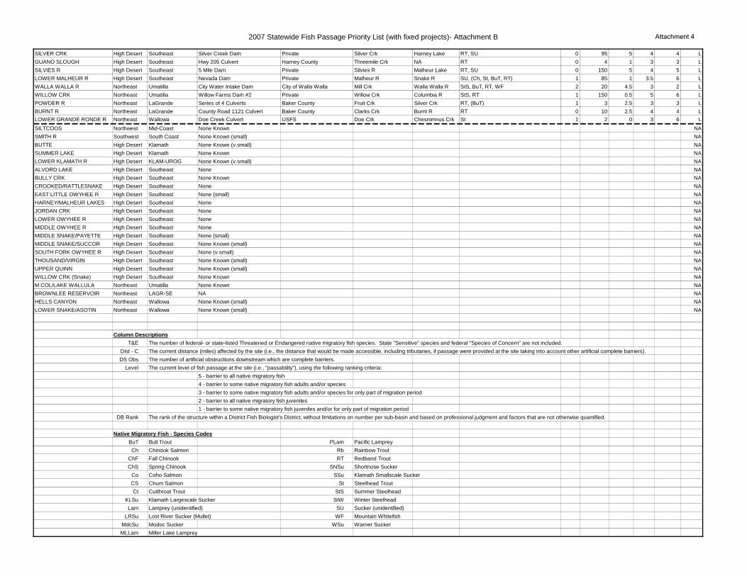
2007 Statewide Fish Passage Priority List (with fixed projects)- Attachment B Attachment 4
SILVER CRK High Desert Southeast Silver Creek Dam Private Silver Crk Harney Lake RT, SU 0 95 5 4 4 LGUANO SLOUGH High Desert Southeast Hwy 205 Culvert Harney County Threemile Crk NA RT 0 4 1 3 3 LSILVIES R High Desert Southeast 5 Mile Dam Private Silvies R Malheur Lake RT, SU 0 150 5 4 5 LLOWER MALHEUR R High Desert Southeast Nevada Dam Private Malheur R Snake R SU, (Ch, St, BuT, RT) 1 85 1 3.5 6 LWALLA WALLA R Northeast Umatilla City Water Intake Dam City of Walla Walla Mill Crk Walla Walla R StS, BuT, RT, WF 2 20 4.5 3 2 LWILLOW CRK Northeast Umatilla Willow Farms Dam #2 Private Willow Crk Columbia R StS, RT 1 150 0.5 5 6 LPOWDER R Northeast LaGrande Series of 4 Culverts Baker County Fruit Crk Silver Crk RT, (BuT) 1 3 2.5 3 3 LBURNT R Northeast LaGrande County Road 1121 Culvert Baker County Clarks Crk Burnt R RT 0 10 2.5 4 4 LLOWER GRANDE RONDE R Northeast Wallowa Doe Creek Culvert USFS Doe Crk Chesnimnus Crk St 1 2 0 3 6 LSILTCOOS Northwest Mid-Coast None Known NASMITH R Southwest South Coast None Known (small) NABUTTE High Desert Klamath None Known (v.small) NASUMMER LAKE High Desert Klamath None Known NALOWER KLAMATH R High Desert KLAM-UROG None Known (v.small) NAALVORD LAKE High Desert Southeast None NABULLY CRK High Desert Southeast None Known NACROOKED/RATTLESNAKE High Desert Southeast None NAEAST LITTLE OWYHEE R High Desert Southeast None (small) NAHARNEY/MALHEUR LAKES High Desert Southeast None NAJORDAN CRK High Desert Southeast None NALOWER OWYHEE R High Desert Southeast None NAMIDDLE OWYHEE R High Desert Southeast None NAMIDDLE SNAKE/PAYETTE High Desert Southeast None (small) NAMIDDLE SNAKE/SUCCOR High Desert Southeast None Known (small) NASOUTH FORK OWYHEE R High Desert Southeast None (v.small) NATHOUSAND/VIRGIN High Desert Southeast None Known (small) NAUPPER QUINN High Desert Southeast None Known (small) NAWILLOW CRK (Snake) High Desert Southeast None Known NAM COL/LAKE WALLULA Northeast Umatilla None Known NABROWNLEE RESERVOIR Northeast LAGR-SE NA NAHELLS CANYON Northeast Wallowa None Known (small) NALOWER SNAKE/ASOTIN Northeast Wallowa None Known (small) NA
Column DescriptionsT&E The number of federal- or state-listed Threatened or Endangered native migratory fish species. State "Sensitive" species and federal "Species of Concern" are not included.
Dist - C The current distance (miles) affected by the site (i.e., the distance that would be made accessible, including tributaries, if passage were provided at the site taking into account other artificial complete barriers).DS Obs The number of artificial obstructions downstream which are complete barriers.
Level The current level of fish passage at the site (i.e., "passability"), using the following ranking criteria:5 - barrier to all native migratory fish4 - barrier to some native migratory fish adults and/or species3 - barrier to some native migratory fish adults and/or species for only part of migration period2 - barrier to all native migratory fish juveniles1 - barrier to some native migratory fish juveniles and/or for only part of migration period
DB Rank The rank of the structure within a District Fish Biologist's District, without limitations on number per sub-basin and based on professional judgment and factors that are not otherwise quantified.
Native Migratory Fish - Species CodesBuT Bull Trout PLam Pacific LampreyCh Chinook Salmon Rb Rainbow Trout
ChF Fall Chinook RT Redband TroutChS Spring Chinook SNSu Shortnose Sucker
Co Coho Salmon SSu Klamath Smallscale SuckerCS Chum Salmon St Steelhead TroutCt Cutthroat Trout StS Summer Steelhead
KLSu Klamath Largescale Sucker StW Winter SteelheadLam Lamprey (unidentified) SU Sucker (unidentified)
LRSu Lost River Sucker (Mullet) WF Mountain WhitefishMdcSu Modoc Sucker WSu Warner SuckerMLLam Miller Lake Lamprey

Attachment C
Sub-BasinODFW Fish
District Owner Barrier Name Type Stream
NameSpecies In need of passage at barrier and biological status
# T&E (ESA)
Avg. Habitat
Quantity
Avg. Potential hab.
(historical)
Habitat Quality
# Comp. barriers
up stream
Auto Up
Auto Down
Psg. Level Group Rank
Hells Canyon La GrandeIdaho Power
CompanyHells Canyon
DamDam Snake River
Pacific lamprey, Summer Steelhead (fT), Redband trout, fall Chinook (fT), spring Chinook (fT), bull trout (fT), largescale sucker, northern pikeminnow, white
sturgeon
4.0 75.0 100+ Medium 10+ 4.0 2.0 5.0Group 1 (Top
Ten)
Lower Crooked
DeschutesDeschutes Valley
Water DistrictOpal Springs
Diversion DamDam
Crooked River
Bulltrout (fT), Spring Chinook, Redband trout, Summer Steelhead (ft)
2.0 356.9 94.238 med-high 7.0 3.0 2.0 5.0Group 1 (Top
Ten)
Middle Fork Willamette
Upper Willamette
District
U.S. Army Corps of Engineers
Lookout Point Dam
DamMiddle Fork Willamette
River
Bulltrout (fT historical), Spring Chinook (fT), Rainbow trout, CT, WF, PL, NPM, LSS
1.0 54.8 41.831 High 1.0 2.0 1.0 5.0Group 1 (Top
Ten)
Middle Rogue Upper Rogue Steven Keeton Fielder Dam Dam Evans CreekFall Chinook, Coho (fT), Pacific lamprey, Summer and Winter Steelhead, suckers,
cutthroat1.0 54.8 5.93 High 4.0 3.0 1.0 4.0
Group 1 (Top Ten)
Coast Fork Willamette
Upper Willamette
District
U.S. Army Corps of Engineers
Cottage Grove DamCoast Fork Willamette
River
Spring Chinook (fT), Rainbow trout, CT, WF, PL, LSS
1.0 73.1 9.703 High 6.0 1.0 1.0 5.0Group 1 (Top
Ten)
North SantiamMid
Willamette District
U.S. Army Corps of Engineers
Detroit Reservoir
DamNorth
Santiam River
Bulltrout (fT historical), Spring Chinook (fT), Cutthroat trout, Winter Steelhead,
Pacific Lamprey, Mountain Whitefish1.0 33.7 0.000 High 0.0 4.0 2.0 5.0
Group 1 (Top Ten)
Middle Columbia-
Hood
Mid-Columbia
District
Middle Fork Irrigation District
Clear Branch Creek Dam
DamPinnacle
Creek, Clear Branch Creek
Bulltrout (fT), Spring Chinook (fT), Coastal cutthroat, Coho (fT/sE), Redband
trout, Winter Steelhead (fT)4.0 4.8 1.971 High 1.0 1.0 0.0 5.0
Group 1 (Top Ten)
Middle Rogue Upper Rogue Private Wimer Dam Dam Evans CreekFall Chinook, Coho (fT), Pacific lamprey, Summer and Winter Steelhead, suckers,
cutthroat
1.0 37.7 5.93 High 3.0 3.0 1.0 4.0Group 1 (Top
Ten)
Burnt La GrandeU.S. Bureau of Reclamation
Unity Reservoir
Dam Burnt RiverRedband trout, largescale sucker,
northern pikeminnow, bridgelip sucker0.0 88.4 54.065 High 3.0 2.0 1.0 5.0
Group 1 (Top Ten)
South SantiamMid
Willamette District
U.S. Army Corps of Engineers
Foster Reservoir
DamSouth
Santiam River
Bulltrout (fT historical), Spring Chinook (fT), Winter Steelhead (fT), Pacific lamprey, Mountain Whitefish, CT
2.0 31.4 29.865 med-high 1.0 3.0 1.0 5.0Group 1 (Top
Ten)
UmatillaUmatilla District
U.S. Bureau of Reclamation
McKay Reservoir
(USBR)
Dam McKay CreekSummer Steelhead (fT), Redband trout
(historical)1.0 84.1 11.450 High 0.0 1.0 0.0 5.0
Group 1 (Top Ten)
Coast Fork Willamette
Upper Willamette
District
U.S. Army Corps of Engineers
Dorena Dam Dam Row RiverSpring Chinook (fT), Rainbow trout, CT,
WF, PL, LSS1.0 33.0 0.201 High 1.0 0.0 0.0 5.0 Group 2
ODFW 2013 Statewide Fish Passage Priority List
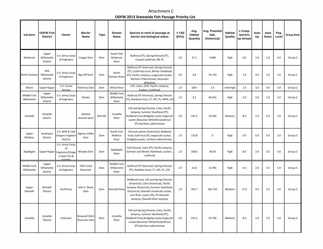
Attachment C
Sub-BasinODFW Fish
District Owner Barrier Name Type Stream
NameSpecies In need of passage at barrier and biological status
# T&E (ESA)
Avg. Habitat
Quantity
Avg. Potential hab.
(historical)
Habitat Quality
# Comp. barriers
up stream
Auto Up
Auto Down
Psg. Level Group Rank
ODFW 2013 Statewide Fish Passage Priority List
McKenzieUpper
Willamette District
U.S. Army Corps of Engineers
Cougar Dam DamSouth Fork McKenzie
River
Bulltrout (fT), Spring Chinook (fT), Coastal cutthroat, RB, PL
2.0 37.1 0.000 High 0.0 2.0 1.0 4.0 Group 2
North SantiamMid
Willamette District
U.S. Army Corps of Engineers
Big Cliff Dam DamNorth
Santiam River
Bulltrout (fT historical), Spring Chinook (fT), Cutthroat trout, Winter Steelhead
(fT), Pacific Lamprey, Largescale Sucker, Northern Pikeminnow, Mountain
Whitefish
2.0 2.8 35.133 High 1.0 4.0 1.0 5.0 Group 2
Illinois Upper Rogue U.S. Forest Service
Pomeroy Dam Dam Illinois River CHF, Coho, STW, Pacific Lamprey, Suckers, Cutthroat
1.0 100+ 1.5 med-high 1.0 3.0 0.0 3.0 Group 2
Middle Fork Willamette
Upper Willamette
District
U.S. Army Corps of Engineers
Dexter DamMiddle Fork Willamette
River
Bulltrout (fT historical), Spring Chinook (fT), Rainbow trout, CT, WF, PL, NPM, LSS
1.0 3.2 96.452 High 2.0 4.0 1.0 5.0 Group 2
UmatillaUmatilla District
Blasted channel weirs
WeirSillUmatilla
River
Fall and Spring Chinook, Coho, Pacific lamprey, Summer Steelhead (fT),
Redband trout,Bridgelip sucker,largecale sucker,Mountian Whitefish,Bulltrout
(fT),Northern pikeminnow
2.0 225.5 53.394 Medium 8.0 2.0 2.0 4.0 Group 2
Upper Malheur
Southeast District
U.S. BOR & Vale Oregon Irrigation
District
Agency Valley Dam
DamNorth Fork
Malheur River
Chinook salmon (historical), Redband trout, bull trout (ft), largescale sucker,
bridgelip sucker, northern pikeminnow, 1.0 133.8 0 High 0.0 0.0 4.0 5.0 Group 2
Applegate Upper Rogue
U.S. Army Corps of
Engineers/Oregon Dept Fish &
Wildlife
Murphy Dam DamApplegate
River
Fall Chinook, Coho (fT), Pacific lamprey, Summer and Winter Steelhead, suckers ,
cutthroat1.0 100.0 30.63 High 8.0 2.0 2.0 3.0 Group 2
Middle Fork Willamette
Upper Willamette
District
U.S. Army Corps of Engineers
Hills Creek Reservoir
DamMiddle Fork Willamette
River
Bulltrout (fT historical), Spring Chinook (fT), Rainbow trout, CT, WF, PL, CSS
1.0 21.6 13.785 High 0.0 2.0 1.0 5.0 Group 3
Upper Klamath
Klamath District
PacifiCorpJohn C. Boyle
DamDam Klamath River
Redband trout, Fall and Spring Chinook (historical), Coho (historical), Pacific
lamprey (historical), Summer Steelhead (historical), Klamath smallscale sucker,
Lost River sucker (fE), Pit-Klamath lamprey, Klamath River lamprey
1.0 342.7 301.792 Medium 17.0 4.0 2.0 4.0 Group 3
UmatillaUmatilla District
UnknownBrownell Ditch Diversion Dam
DamUmatilla
River
Fall and Spring Chinook, Coho, Pacific lamprey, Summer Steelhead (fT),
Redband trout,Bridgelip sucker,largecale sucker,Mountian Whitefish,Bulltrout
(fT),Northern pikeminnow
2.0 225.2 53.746 Medium 8.0 2.0 1.0 3.0 Group 3
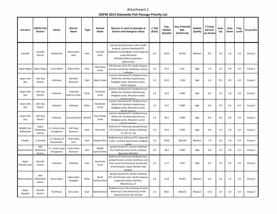
Attachment C
Sub-BasinODFW Fish
District Owner Barrier Name Type Stream
NameSpecies In need of passage at barrier and biological status
# T&E (ESA)
Avg. Habitat
Quantity
Avg. Potential hab.
(historical)
Habitat Quality
# Comp. barriers
up stream
Auto Up
Auto Down
Psg. Level Group Rank
ODFW 2013 Statewide Fish Passage Priority List
UmatillaUmatilla District
PacificCorpBoyd Hydro
DamDam
Umatilla River
Fall and Spring Chinook, Coho, Pacific lamprey, Summer Steelhead (fT),
Redband trout,Bridgelip sucker,largecale sucker,Mountian
Whitefish,Bulltrout,Northern pikeminnow
2.0 218.4 44.456 Medium 8.0 2.0 1.0 3.0 Group 3
Upper Rogue Upper Rogue Loren Walch Walcot Dam DamLittle Butte
Creek
Fall Chinook, Coho (fT), Pacific lamprey, Summer and Winter Steelhead, suckers,
cutthroat
1.0 25.4 0.20 High 1.0 2.0 0.0 3.0 Group 3
Upper John Day
John Day District
UnknownMeridith Diversion
Dam Beech Creek
Summer Steelhead (fT), Redband trout, White Fish, Northern pikeminnow, Bridgelip sucker, Mountain sucker,
Pacific lamprey
1.0 45.4 1.330 high 1.0 0.0 0.0 4.0 Group 3
Upper John Day
John Day District
UnknownUnnamed
bedrock chuteChute
Thirtymile Creek
Summer Steelhead (fT), Redband trout, White Fish, Northern pikeminnow, Bridgelip sucker, Mountain sucker,
Pacific lamprey
1.0 32.6 0.000 high 0.0 1.0 1.0 4.0 Group 3
Lower John Day
John Day District
Unknown Unknown OtherMurderers
Creek
Summer Steelhead (fT), Redband trout, White Fish, Northern pikeminnow, Bridgelip sucker, Mountain sucker,
Pacific lamprey
1.0 32.6 0.000 high 0.0 0.0 0.0 4.0 Group 3
Lower John Day
John Day District
Unknown Unnamed weir WeirSillPine Hollow
Creek
Summer Steelhead (fT), Redband trout, White Fish, Northern pikeminnow, Bridgelip sucker, Mountain sucker,
Pacific lamprey
1.0 36.5 0.000 high 0.0 0.0 0.0 4.0 Group 3
Middle Fork Willamette
Upper Willamette
District
U.S. Army Corps of Engineers
Fall Creek Reservoir
Dam Fall CreekBulltrout (fT historical), Spring Chinook (fT), Rainbow trout, Winter Steelhead,
CT, WF, PL, CSS1.0 43.9 2.384 High 0.0 1.0 1.0 4.0 Group 3
Powder La GrandeU.S. Bureau of Reclamation
Thief Valley Dam
Dam Powder RiverRedband trout, bull trout (fT), largescale sucker, northern pikeminnow, bridgelip
sucker
1.0 156.0 106.569 Medium 7.0 3.0 1.0 5.0 Group 3
South SantiamMid
Willamette District
U.S. Army Corps of Engineers
Green Peter Reservoir
DamMiddle
Santiam River
Spring Chinook (fT), Winter Steelhead (fT), Cutthroat trout, Pacific Lamprey,
Mountain Whitefish2.0 38.4 0.000 High 0.0 1.0 3.0 5.0 Group 3
Upper Klamath Lake
Klamath District
Unknown Unknown DamSevenmile
Canal
Bulltrout (fT historical), Redband trout, spring chinook, summer steelhead, Lost River sucker (fe historical), pit klamath
brook lamprey, Upper Klamath Lake lamprey
2.0 11.2 7.821 High 0.0 1.0 0.0 4.0 Group 4
North SantiamMid
Willamette District
City of SalemSalem Ditch
headgateOther
North Santiam River
Spring Chinook (fT), Winter Steelhead (fT), Fall Chinook, Coho, Pacific lamprey,
Largescale Sucker, Northern Pikeminnow, CT
2.0 31.8 29.907 Medium 4.0 1.0 1.0 5.0 Group 4
Upper Klamath
Klamath District
PacifiCorp Keno Dam Dam Klamath River
Redband trout, Fall and Spring Chinook (historical), Coho (historical), Pacific
lamprey (historical), Summer
1.0 348.1 305.615 Medium 17.0 3.0 2.0 4.0 Group 4
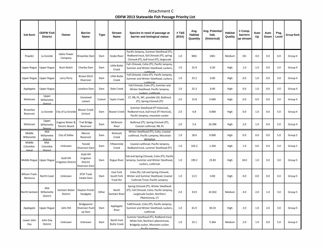
Attachment C
Sub-BasinODFW Fish
District Owner Barrier Name Type Stream
NameSpecies In need of passage at barrier and biological status
# T&E (ESA)
Avg. Habitat
Quantity
Avg. Potential hab.
(historical)
Habitat Quality
# Comp. barriers
up stream
Auto Up
Auto Down
Psg. Level Group Rank
ODFW 2013 Statewide Fish Passage Priority List
Powder La GrandeIdaho Power
CompanyBrownlee Dam Dam Snake River
Pacific lamprey, Summer Steelhead (fT), Redband trout, fall Chinook (fT), spring Chinook (fT), bull trout (fT), largescale
1.0 300+ 100+ Medium 10+ 4.0 3.0 4.0 Group 4
Upper Rogue Upper Rogue Buck Walch Charley Dam DamLittle Butte
Creek
Fall Chinook, Coho (fT), Pacific lamprey, Summer and Winter Steelhead, suckers,
cutthroat
1.0 25.9 0.20 High 1.0 1.0 0.0 3.0 Group 4
Upper Rogue Upper Rogue Larry PerryBrown Ditch
DiversionDam
Little Butte Creek
Fall Chinook, Coho (fT), Pacific lamprey, Summer and Winter Steelhead, suckers,
cutthroat
1.0 25.2 0.00 High 0.0 1.0 0.0 3.0 Group 4
Applegate Upper Rogue Lovelace Dam Dam Slate CreekFall Chinook, Coho (fT), Summer and Winter Steelhead, Pacific lamprey,
suckers, cutthroat
1.0 25.3 0.00 High 0.0 1.0 0.0 3.0 Group 4
McKenzieUpper
Willamette District
Unnamed culvert
Culvert Taylor CreekCT, RB, PL, WF, possible LSS, Bulltrout
(fT), Spring Chinook (fT)2.0 15.8 0.000 High 0.0 0.0 0.0 3.0 Group 4
Brownlee Reservoir
La Grande City of La GrandeBeaver Creek
(Union)Dam Beaver Creek
Summer Steelhead (fT historical), Redband trout, bull trout (fT hitorical),
Pacific lamprey, mountain sucker2.0 6.8 0.000 High 0.0 1.0 0.0 5.0 Group 4
McKenzieUpper
Willamette District
Eugene Water & Electric Board
Trail Bridge Reservoir
DamMcKenzie
RiverBulltrout (fT), Spring Chinook (fT),
Coastal cutthroat, RB, PL2.0 5.4 16.396 High 2.0 1.0 0.0 5.0 Group 4
Middle Willamette
Mid Willamette
District
City of DallasMercer
ReservoirDam
Rickreall Creek
Winter Steelhead (fT), Coho, Coastal cutthroat, Pacific Lamprey, Mountain
Whitefish
1.0 18.6 0.000 High 0.0 0.0 0.0 5.0 Group 5
Middle Columbia-
Hood
Mid-Columbia
District
UnknownTenold
Diversion DamDam
Fifteenmile Creek
Coastal cutthroat, Pacific lamprey, Redband trout, summer Steelhead (fT)
1.0 102.2 1.204 High 1.0 0.0 0.0 3.0 Group 5
Middle Rogue Upper RogueGold Hill
Irrigation District
Gold Hill Irrigation District
Diversion Dam
Dam Rogue RiverFall and Spring Chinook, Coho (fT), Pacific lamprey, Summer and Winter Steelhead,
suckers, cutthroat1.0 199.2 25.83 High 18.0 1.0 3.0 3.0 Group 5
Wilson-Trask-Nestucca
North Coast UnknownEFSF Trask Intake Dam
DamEast Fork
South Fork Trask Rvr
Coho (ft), Fall and Spring Chinook, Winter and Summer Steelhead, Coastal
Cuthroat Trout, Pacific Lamprey1.0 12.5 0.00 High 0.0 0.0 0.0 4.0 Group 5
North SantiamMid
Willamette District
Santiam Water District
Stayton Ponds headgate
OtherNorth
Santiam River
Spring Chinook (fT), Winter Steelhead (fT), Fall Chinook, Coho, Pacific lamprey,
Largescale Sucker, Northern Pikeminnow, CT
2.0 33.9 24.922 Medium 4.0 2.0 1.0 3.0 Group 5
Applegate Upper Rogue John HillBridgepoint
Diversion Push-up Dam
DamApplegate
River
FallChinook, Coho (fT), Pacific lamprey, Summer and Winter Steelhead, suckers,
cutthroat 1.0 61.9 30.33 High 2.0 1.0 2.0 3.0 Group 5
Lower John Day
John Day District
Unknown Unknown DamNorth Fork Butte Creek
Summer Steelhead (fT), Redband trout, White Fish, Northern pikeminnow, Bridgelip sucker, Mountain sucker,
Pacific lamprey
1.0 25.1 5.364 Medium 2.0 1.0 0.0 5.0 Group 5
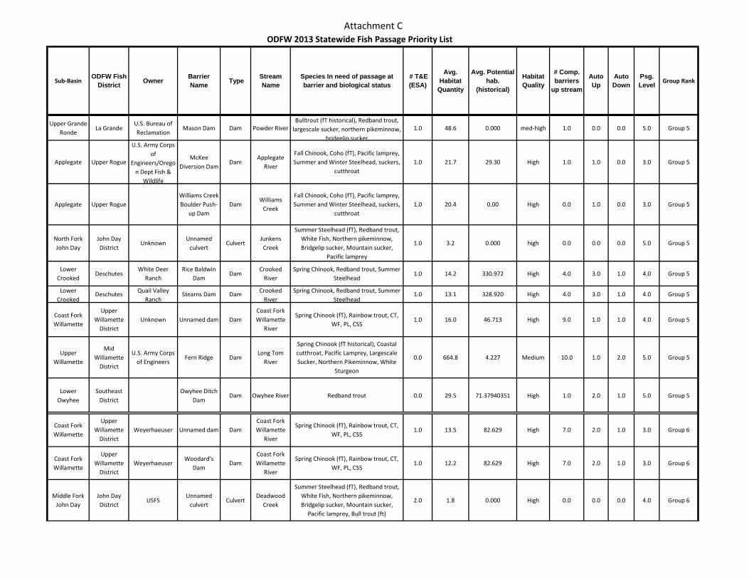
Attachment C
Sub-BasinODFW Fish
District Owner Barrier Name Type Stream
NameSpecies In need of passage at barrier and biological status
# T&E (ESA)
Avg. Habitat
Quantity
Avg. Potential hab.
(historical)
Habitat Quality
# Comp. barriers
up stream
Auto Up
Auto Down
Psg. Level Group Rank
ODFW 2013 Statewide Fish Passage Priority List
Upper Grande Ronde
La GrandeU.S. Bureau of Reclamation
Mason Dam Dam Powder RiverBulltrout (fT historical), Redband trout,
largescale sucker, northern pikeminnow, bridgelip sucker
1.0 48.6 0.000 med-high 1.0 0.0 0.0 5.0 Group 5
Applegate Upper Rogue
U.S. Army Corps of
Engineers/Oregon Dept Fish &
Wildlife
McKee Diversion Dam
DamApplegate
River
Fall Chinook, Coho (fT), Pacific lamprey, Summer and Winter Steelhead, suckers,
cutthroat1.0 21.7 29.30 High 1.0 1.0 0.0 3.0 Group 5
Applegate Upper RogueWilliams Creek Boulder Push-
up DamDam
Williams Creek
Fall Chinook, Coho (fT), Pacific lamprey, Summer and Winter Steelhead, suckers,
cutthroat1.0 20.4 0.00 High 0.0 1.0 0.0 3.0 Group 5
North Fork John Day
John Day District
UnknownUnnamed
culvertCulvert
Junkens Creek
Summer Steelhead (fT), Redband trout, White Fish, Northern pikeminnow, Bridgelip sucker, Mountain sucker,
Pacific lamprey
1.0 3.2 0.000 high 0.0 0.0 0.0 5.0 Group 5
Lower Crooked
DeschutesWhite Deer
RanchRice Baldwin
DamDam
Crooked River
Spring Chinook, Redband trout, Summer Steelhead
1.0 14.2 330.972 High 4.0 3.0 1.0 4.0 Group 5
Lower Crooked
Deschutes Quail Valley Ranch
Stearns Dam Dam Crooked River
Spring Chinook, Redband trout, Summer Steelhead
1.0 13.1 328.920 High 4.0 3.0 1.0 4.0 Group 5
Coast Fork Willamette
Upper Willamette
DistrictUnknown Unnamed dam Dam
Coast Fork Willamette
River
Spring Chinook (fT), Rainbow trout, CT, WF, PL, CSS
1.0 16.0 46.713 High 9.0 1.0 1.0 4.0 Group 5
Upper Willamette
Mid Willamette
District
U.S. Army Corps of Engineers
Fern Ridge DamLong Tom
River
Spring Chinook (fT historical), Coastal cutthroat, Pacific Lamprey, Largescale Sucker, Northern Pikeminnow, White
Sturgeon
0.0 664.8 4.227 Medium 10.0 1.0 2.0 5.0 Group 5
Lower Owyhee
Southeast District
Owyhee Ditch Dam
Dam Owyhee River Redband trout 0.0 29.5 71.37940351 High 1.0 2.0 1.0 5.0 Group 5
Coast Fork Willamette
Upper Willamette
DistrictWeyerhaeuser Unnamed dam Dam
Coast Fork Willamette
River
Spring Chinook (fT), Rainbow trout, CT, WF, PL, CSS
1.0 13.5 82.629 High 7.0 2.0 1.0 3.0 Group 6
Coast Fork Willamette
Upper Willamette
DistrictWeyerhaeuser
Woodard's Dam
DamCoast Fork Willamette
River
Spring Chinook (fT), Rainbow trout, CT, WF, PL, CSS
1.0 12.2 82.629 High 7.0 2.0 1.0 3.0 Group 6
Middle Fork John Day
John Day District
USFSUnnamed
culvertCulvert
Deadwood Creek
Summer Steelhead (fT), Redband trout, White Fish, Northern pikeminnow, Bridgelip sucker, Mountain sucker,
Pacific lamprey, Bull trout (ft)
2.0 1.8 0.000 High 0.0 0.0 0.0 4.0 Group 6
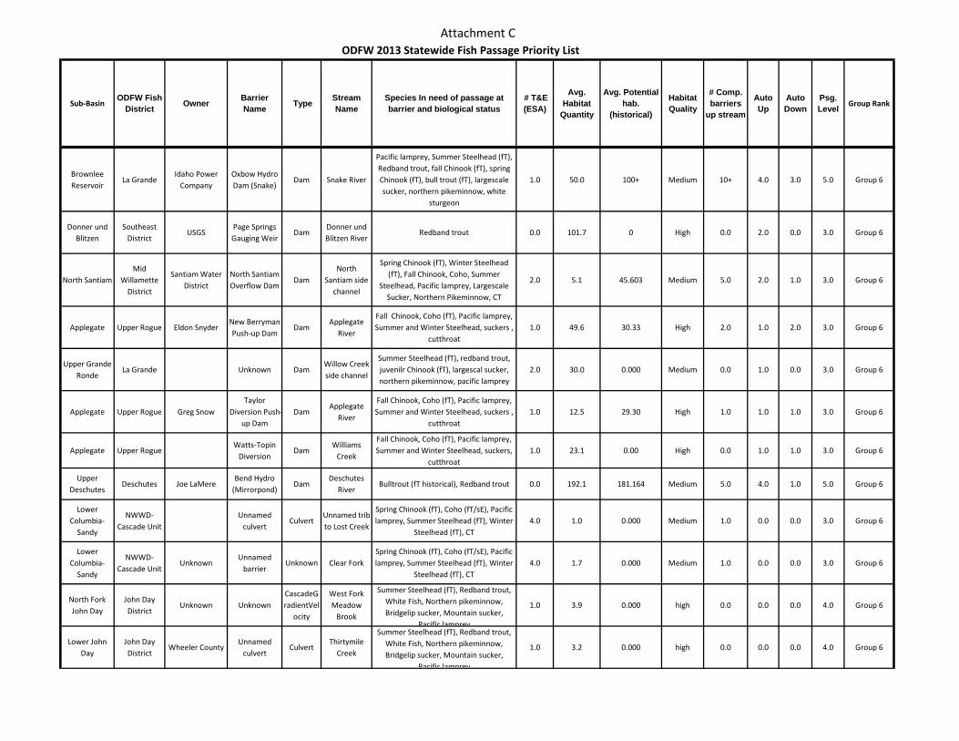
Attachment C
Sub-BasinODFW Fish
District Owner Barrier Name Type Stream
NameSpecies In need of passage at barrier and biological status
# T&E (ESA)
Avg. Habitat
Quantity
Avg. Potential hab.
(historical)
Habitat Quality
# Comp. barriers
up stream
Auto Up
Auto Down
Psg. Level Group Rank
ODFW 2013 Statewide Fish Passage Priority List
Brownlee Reservoir
La GrandeIdaho Power
CompanyOxbow Hydro Dam (Snake)
Dam Snake River
Pacific lamprey, Summer Steelhead (fT), Redband trout, fall Chinook (fT), spring Chinook (fT), bull trout (fT), largescale sucker, northern pikeminnow, white
sturgeon
1.0 50.0 100+ Medium 10+ 4.0 3.0 5.0 Group 6
Donner und Blitzen
Southeast District
USGSPage Springs Gauging Weir
DamDonner und Blitzen River
Redband trout 0.0 101.7 0 High 0.0 2.0 0.0 3.0 Group 6
North SantiamMid
Willamette District
Santiam Water District
North Santiam Overflow Dam
DamNorth
Santiam side channel
Spring Chinook (fT), Winter Steelhead (fT), Fall Chinook, Coho, Summer
Steelhead, Pacific lamprey, Largescale Sucker, Northern Pikeminnow, CT
2.0 5.1 45.603 Medium 5.0 2.0 1.0 3.0 Group 6
Applegate Upper Rogue Eldon SnyderNew Berryman Push-up Dam
DamApplegate
River
Fall Chinook, Coho (fT), Pacific lamprey, Summer and Winter Steelhead, suckers ,
cutthroat1.0 49.6 30.33 High 2.0 1.0 2.0 3.0 Group 6
Upper Grande Ronde
La Grande Unknown DamWillow Creek side channel
Summer Steelhead (fT), redband trout, juvenilr Chinook (fT), largescal sucker, northern pikeminnow, pacific lamprey
2.0 30.0 0.000 Medium 0.0 1.0 0.0 3.0 Group 6
Applegate Upper Rogue Greg SnowTaylor
Diversion Push-up Dam
DamApplegate
River
Fall Chinook, Coho (fT), Pacific lamprey, Summer and Winter Steelhead, suckers ,
cutthroat1.0 12.5 29.30 High 1.0 1.0 1.0 3.0 Group 6
Applegate Upper RogueWatts-Topin
DiversionDam
Williams Creek
Fall Chinook, Coho (fT), Pacific lamprey, Summer and Winter Steelhead, suckers,
cutthroat1.0 23.1 0.00 High 0.0 1.0 1.0 3.0 Group 6
Upper Deschutes
Deschutes Joe LaMereBend Hydro
(Mirrorpond)Dam
Deschutes River
Bulltrout (fT historical), Redband trout 0.0 192.1 181.164 Medium 5.0 4.0 1.0 5.0 Group 6
Lower Columbia-
Sandy
NWWD-Cascade Unit
Unnamed culvert
CulvertUnnamed trib to Lost Creek
Spring Chinook (fT), Coho (fT/sE), Pacific lamprey, Summer Steelhead (fT), Winter
Steelhead (fT), CT4.0 1.0 0.000 Medium 1.0 0.0 0.0 3.0 Group 6
Lower Columbia-
Sandy
NWWD-Cascade Unit
UnknownUnnamed
barrierUnknown Clear Fork
Spring Chinook (fT), Coho (fT/sE), Pacific lamprey, Summer Steelhead (fT), Winter
Steelhead (fT), CT4.0 1.7 0.000 Medium 1.0 0.0 0.0 3.0 Group 6
North Fork John Day
John Day District
Unknown UnknownCascadeGradientVel
ocity
West Fork Meadow
Brook
Summer Steelhead (fT), Redband trout, White Fish, Northern pikeminnow, Bridgelip sucker, Mountain sucker,
Pacific lamprey
1.0 3.9 0.000 high 0.0 0.0 0.0 4.0 Group 6
Lower John Day
John Day District
Wheeler CountyUnnamed
culvertCulvert
Thirtymile Creek
Summer Steelhead (fT), Redband trout, White Fish, Northern pikeminnow, Bridgelip sucker, Mountain sucker,
Pacific lamprey
1.0 3.2 0.000 high 0.0 0.0 0.0 4.0 Group 6
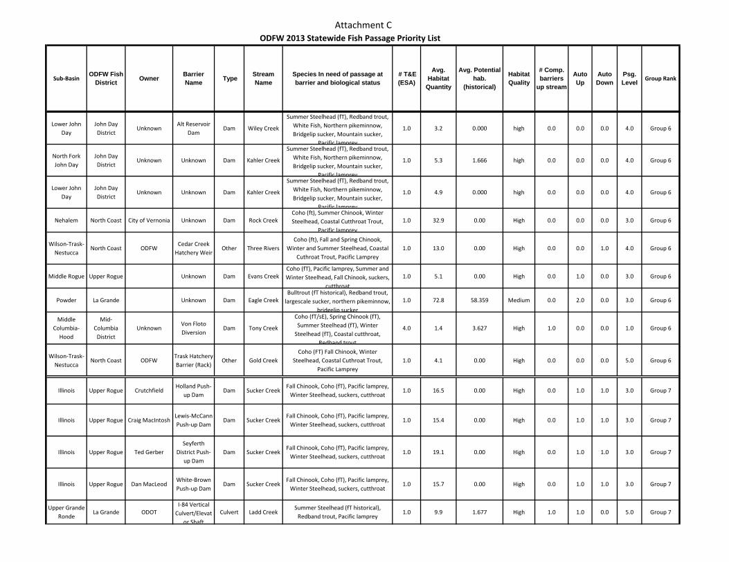
Attachment C
Sub-BasinODFW Fish
District Owner Barrier Name Type Stream
NameSpecies In need of passage at barrier and biological status
# T&E (ESA)
Avg. Habitat
Quantity
Avg. Potential hab.
(historical)
Habitat Quality
# Comp. barriers
up stream
Auto Up
Auto Down
Psg. Level Group Rank
ODFW 2013 Statewide Fish Passage Priority List
Lower John Day
John Day District
UnknownAlt Reservoir
DamDam Wiley Creek
Summer Steelhead (fT), Redband trout, White Fish, Northern pikeminnow, Bridgelip sucker, Mountain sucker,
Pacific lamprey
1.0 3.2 0.000 high 0.0 0.0 0.0 4.0 Group 6
North Fork John Day
John Day District
Unknown Unknown Dam Kahler Creek
Summer Steelhead (fT), Redband trout, White Fish, Northern pikeminnow, Bridgelip sucker, Mountain sucker,
Pacific lamprey
1.0 5.3 1.666 high 0.0 0.0 0.0 4.0 Group 6
Lower John Day
John Day District
Unknown Unknown Dam Kahler Creek
Summer Steelhead (fT), Redband trout, White Fish, Northern pikeminnow, Bridgelip sucker, Mountain sucker,
Pacific lamprey
1.0 4.9 0.000 high 0.0 0.0 0.0 4.0 Group 6
Nehalem North Coast City of Vernonia Unknown Dam Rock CreekCoho (ft), Summer Chinook, Winter Steelhead, Coastal Cutthroat Trout,
Pacific lamprey
1.0 32.9 0.00 High 0.0 0.0 0.0 3.0 Group 6
Wilson-Trask-Nestucca
North Coast ODFWCedar Creek
Hatchery WeirOther Three Rivers
Coho (ft), Fall and Spring Chinook, Winter and Summer Steelhead, Coastal
Cuthroat Trout, Pacific Lamprey1.0 13.0 0.00 High 0.0 0.0 1.0 4.0 Group 6
Middle Rogue Upper Rogue Unknown Dam Evans CreekCoho (fT), Pacific lamprey, Summer and Winter Steelhead, Fall Chinook, suckers,
cutthroat
1.0 5.1 0.00 High 0.0 1.0 0.0 3.0 Group 6
Powder La Grande Unknown Dam Eagle CreekBulltrout (fT historical), Redband trout,
largescale sucker, northern pikeminnow, bridgelip sucker
1.0 72.8 58.359 Medium 0.0 2.0 0.0 3.0 Group 6
Middle Columbia-
Hood
Mid-Columbia
DistrictUnknown
Von Floto Diversion
Dam Tony Creek
Coho (fT/sE), Spring Chinook (fT), Summer Steelhead (fT), Winter
Steelhead (fT), Coastal cutthroat, Redband trout
4.0 1.4 3.627 High 1.0 0.0 0.0 1.0 Group 6
Wilson-Trask-Nestucca
North Coast ODFWTrask Hatchery Barrier (Rack)
Other Gold CreekCoho (FT) Fall Chinook, Winter
Steelhead, Coastal Cuthroat Trout, Pacific Lamprey
1.0 4.1 0.00 High 0.0 0.0 0.0 5.0 Group 6
Illinois Upper Rogue CrutchfieldHolland Push-
up DamDam Sucker Creek
Fall Chinook, Coho (fT), Pacific lamprey, Winter Steelhead, suckers, cutthroat
1.0 16.5 0.00 High 0.0 1.0 1.0 3.0 Group 7
Illinois Upper Rogue Craig MacIntoshLewis-McCann Push-up Dam
Dam Sucker CreekFall Chinook, Coho (fT), Pacific lamprey,
Winter Steelhead, suckers, cutthroat1.0 15.4 0.00 High 0.0 1.0 1.0 3.0 Group 7
Illinois Upper Rogue Ted GerberSeyferth
District Push-up Dam
Dam Sucker CreekFall Chinook, Coho (fT), Pacific lamprey,
Winter Steelhead, suckers, cutthroat1.0 19.1 0.00 High 0.0 1.0 1.0 3.0 Group 7
Illinois Upper Rogue Dan MacLeodWhite-Brown Push-up Dam
Dam Sucker CreekFall Chinook, Coho (fT), Pacific lamprey,
Winter Steelhead, suckers, cutthroat1.0 15.7 0.00 High 0.0 1.0 1.0 3.0 Group 7
Upper Grande Ronde
La Grande ODOTI-84 Vertical
Culvert/Elevator Shaft
Culvert Ladd CreekSummer Steelhead (fT historical),
Redband trout, Pacific lamprey1.0 9.9 1.677 High 1.0 1.0 0.0 5.0 Group 7
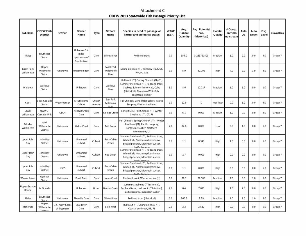
Attachment C
Sub-BasinODFW Fish
District Owner Barrier Name Type Stream
NameSpecies In need of passage at barrier and biological status
# T&E (ESA)
Avg. Habitat
Quantity
Avg. Potential hab.
(historical)
Habitat Quality
# Comp. barriers
up stream
Auto Up
Auto Down
Psg. Level Group Rank
ODFW 2013 Statewide Fish Passage Priority List
SilviesSoutheast
District
Unknown 1.4 miles
upstreaam of 5-mile dam
Dam Silvies River Redband trout 0.0 359.0 3.289761503 Medium 1.0 2.0 0.0 4.0 Group 7
Coast Fork Willamette
Upper Willamette
DistrictUnknown Unnamed dam Dam
Coast Fork Willamette
River
Spring Chinook (fT), Rainbow trout, CT, WF, PL, CSS
1.0 5.9 82.792 High 7.0 2.0 1.0 3.0 Group 7
WallowaWallowa District
Unknown DamWallowa
River
Bulltrout (fT ), Spring Chinook (fT/sT), Summer Steelhead (fT), Redband trout,
Sockeye Salmon (historical), Coho (historical), Mountain Whitefish,
Largescale Sucker
3.0 8.6 10.717 Medium 1.0 1.0 0.0 1.0 Group 7
CoosCoos-Coquille
DistrictWeyerhauser
EF Millicoma Oxbow
Chute/ velocity
East Fork Millicoma
River
Fall Chinook, Coho (fT); Suckers; Pacific lamprey, Winter Steelhead
1.0 12.6 0 med-high 0.0 1.0 0.0 4.0 Group 7
Lower Willamette
NWWD-Cascade Unit
ODOTKellogg Creek
DamDam Kellogg Creek
Coho (fT/sE), Fall Chinook (fT), Winter Steelhead (fT), CT, PL
3.0 6.1 0.000 Medium 1.0 0.0 0.0 4.0 Group 7
Middle Willamette
Mid Willamette
DistrictUnknown Waller Pond Dam Mill Creek
Fall Chinook, Spring Chinook (fT), Winter Steelhead (fT), Pacific Lamprey,
Largescale Sucker, Northern Pikeminnow, CT
2.0 22.6 0.000 Low 0.0 1.0 0.0 1.0 Group 7
Upper John Day
John Day District
UnknownUnnamed
culvertCulvert
Buck Cabin Creek
Summer Steelhead (fT), Redband trout, White Fish, Northern pikeminnow, Bridgelip sucker, Mountain sucker,
Pacific lamprey
1.0 1.1 0.949 High 1.0 0.0 0.0 5.0 Group 7
Upper John Day
John Day District
UnknownUnnamed
culvertCulvert Hog Creek
Summer Steelhead (fT), Redband trout, White Fish, Northern pikeminnow, Bridgelip sucker, Mountain sucker,
Pacific lamprey
1.0 2.7 0.000 High 0.0 0.0 0.0 5.0 Group 7
Upper John Day
John Day District
USFSUnnamed
culvertCulvert
Buck Cabin Creek
Summer Steelhead (fT), Redband trout, White Fish, Northern pikeminnow, Bridgelip sucker, Mountain sucker,
Pacific lamprey
1.0 1.1 0.000 High 0.0 0.0 0.0 5.0 Group 7
Warner Lakes Klamath District
Unknown Plush Dam Dam Honey Creek Redband trout, Warner sucker (ft) 1.0 28.3 27.500 Medium 2.0 3.0 1.0 5.0 Group 7
Upper Grande Ronde
La Grande Unknown Other Beaver CreekSummer Steelhead (fT historical),
Redband trout, bull trout (fT hitorical), Pacific lamprey, mountain sucker
2.0 0.4 7.025 High 1.0 2.0 0.0 5.0 Group 7
Silvies Southeast District
Unknown Fivemile Dam Dam Silvies River Redband trout (historical) 0.0 360.6 3.29 Medium 1.0 1.0 1.0 5.0 Group 7
McKenzieUpper
Willamette District
U.S. Army Corps of Engineers
Blue River Dam
Dam Blue RiverBulltrout (fT), Spring Chinook (fT),
Coastal cutthroat, RB, PL2.0 2.2 2.512 High 0.0 0.0 0.0 5.0 Group 7
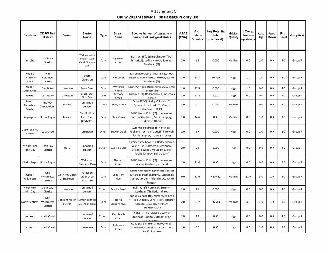
Attachment C
Sub-BasinODFW Fish
District Owner Barrier Name Type Stream
NameSpecies In need of passage at barrier and biological status
# T&E (ESA)
Avg. Habitat
Quantity
Avg. Potential hab.
(historical)
Habitat Quality
# Comp. barriers
up stream
Auto Up
Auto Down
Psg. Level Group Rank
ODFW 2013 Statewide Fish Passage Priority List
ImnahaWallowa District
Wallowa Valley Improvement
Canal Diversion Dam
DamBig Sheep
Creek
Bulltrout (fT), Spring Chinook (fT/sT historical), Redband trout, Summer
Steelhead (fT)3.0 1.4 0.000 Medium 0.0 1.0 0.0 5.0 Group 7
Middle Columbia-
Hood
Mid-Columbia
District
Byers Diversion
Dam Mill CreekFall Chinook, Coho, Coastal cutthroat,
Pacific lamprey, Redband trout, Winter Steelhead (fT)
1.0 15.7 20.329 High 1.0 1.0 0.0 2.0 Group 7
Upper Deschutes
Deschutes Unknown Sokol Dam Dam Whychus Creek
Spring Chinook, Redband trout, Summer Steelhead
1.0 17.5 0.000 High 1.0 0.0 0.0 4.0 Group 7
Powder La Grande UnknownCoughanour Ditch Dam
Dam Anthony Creek
Bulltrout (fT), Redband trout, mountain sucker
1.0 13.4 1.320 High 0.0 0.0 0.0 4.0 Group 7
Lower Columbia-
Sandy
NWWD-Cascade Unit
PrivateUnnamed
culvertCulvert Henry Creek
Coho (fT/sE), Spring Chinook (fT), Summer Steelhead (fT), Winter
Steelhead (fT), CT
4.0 0.9 0.000 Medium 1.0 0.0 0.0 4.0 Group 7
Applegate Upper Rogue PrivateSantilla Fish Farm Dam (Harboldt)
Dam Slate CreekFall Chinook, Coho (fT), Summer and Winter Steelhead, Pacific lamprey,
suckers, cutthroat1.0 14.6 0.00 Medium 0.0 1.0 0.0 3.0 Group 7
Upper Grande Ronde
La Grande Unknown Other Beaver CreekSummer Steelhead (fT historical),
Redband trout, bull trout (fT hitorical), Pacific lamprey, mountain sucker
2.0 5.7 0.000 High 0.0 1.0 0.0 2.0 Group 7
Middle Fork John Day
John Day District
USFSUnnamed
culvertCulvert Swamp Gulch
Summer Steelhead (fT), Redband trout, White Fish, Northern pikeminnow, Bridgelip sucker, Mountain sucker,
Pacific lamprey, Bull trout (ft)
2.0 0.2 0.000 High 0.0 0.0 0.0 4.0 Group 7
Middle Rogue Upper RogueWakeman
Diversion DamDam
Pleasant Creek
Fall Chinook, Coho (fT), Summer and Winter Steelhead,cutthroat
1.0 12.6 0.00 High 0.0 0.0 0.0 3.0 Group 7
Upper Willamette
Mid Willamette
District
U.S. Army Corps of Engineers
Ferguson Creek Drop Structure
DamLong Tom
River
Spring Chinook (fT historical), Coastal cutthroat, Pacific Lamprey, Largescale Sucker, Northern Pikeminnow, White
Sturgeon
0.0 32.6 630.432 Medium 11.0 3.0 2.0 5.0 Group 7
North Fork John Day
John Day District
Unknown Unnamed culvert
Culvert Granite Creek Bulltrout (fT historical), Summer Steelhead (fT), Redband trout
2.0 3.1 0.000 High 0.0 0.0 0.0 4.0 Group 7
North SantiamMid
Willamette District
Santiam Water District
Lower Bennett Diversion Dam
DamNorth
Santiam River
Spring Chinook (fT), Winter Steelhead (fT), Fall Chinook, Coho, Pacific lamprey,
Largescale Sucker, Northern Pikeminnow, CT
2.0 31.7 36.613 Medium 4.0 1.0 1.0 1.0 Group 7
Nehalem North Coast Unnamed
culvertCulvert
Oak Ranch Creek
Coho (FT) Fall Chinook, Winter Steelhead, Coastal Cuthroat Trout,
Pacific Lamprey
1.0 3.7 0.00 High 0.0 0.0 0.0 4.0 Group 7
Nehalem North Coast Unknown DamFishhawk
Creek
Coho (ft), Summer Chinook, Winter Steelhead, Coastal Cutthroat Trout,
Pacific lamprey
1.0 6.8 0.00 High 0.0 1.0 0.0 3.0 Group 7
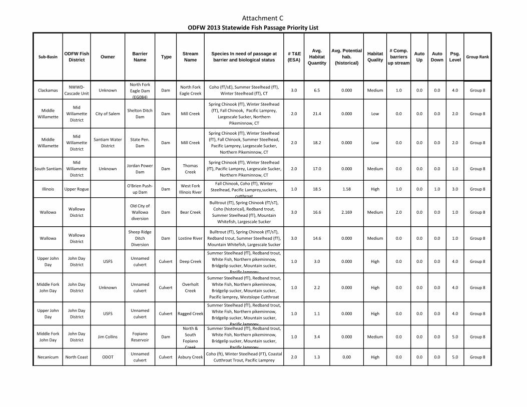
Attachment C
Sub-BasinODFW Fish
District Owner Barrier Name Type Stream
NameSpecies In need of passage at barrier and biological status
# T&E (ESA)
Avg. Habitat
Quantity
Avg. Potential hab.
(historical)
Habitat Quality
# Comp. barriers
up stream
Auto Up
Auto Down
Psg. Level Group Rank
ODFW 2013 Statewide Fish Passage Priority List
ClackamasNWWD-
Cascade UnitUnknown
North Fork Eagle Dam
(EG084)
DamNorth Fork Eagle Creek
Coho (fT/sE), Summer Steelhead (fT), Winter Steelhead (fT), CT
3.0 6.5 0.000 Medium 1.0 0.0 0.0 4.0 Group 8
Middle Willamette
Mid Willamette
DistrictCity of Salem
Shelton Ditch Dam
Dam Mill Creek
Spring Chinook (fT), Winter Steelhead (fT), Fall Chinook, Pacific Lamprey,
Largescale Sucker, Northern Pikeminnow, CT
2.0 21.4 0.000 Low 0.0 0.0 0.0 2.0 Group 8
Middle Willamette
Mid Willamette
District
Santiam Water District
State Pen. Dam
Dam Mill Creek
Spring Chinook (fT), Winter Steelhead (fT), Fall Chinook, Summer Steelhead,
Pacific Lamprey, Largescale Sucker, Northern Pikeminnow, CT
2.0 18.2 0.000 Low 0.0 0.0 0.0 2.0 Group 8
South SantiamMid
Willamette District
UnknownJordan Power
DamDam
Thomas Creek
Spring Chinook (fT), Winter Steelhead (fT), Pacific Lamprey, Largescale Sucker,
Northern Pikeminnow, CT2.0 17.0 0.000 Medium 0.0 0.0 0.0 1.0 Group 8
Illinois Upper RogueO'Brien Push-
up DamDam
West Fork Illinois River
Fall Chinook, Coho (fT), Winter Steelhead, Pacific Lamprey,suckers,
cutthroat
1.0 18.5 1.58 High 1.0 0.0 1.0 3.0 Group 8
WallowaWallowa District
Old City of Wallowa diversion
Dam Bear Creek
Bulltrout (fT), Spring Chinook (fT/sT), Coho (historical), Redband trout,
Summer Steelhead (fT), Mountain Whitefish, Largescale Sucker
3.0 16.6 2.169 Medium 2.0 0.0 0.0 1.0 Group 8
WallowaWallowa District
Sheep Ridge Ditch
DiversionDam Lostine River
Bulltrout (fT), Spring Chinook (fT/sT), Redband trout, Summer Steelhead (fT), Mountain Whitefish, Largescale Sucker
3.0 14.6 0.000 Medium 0.0 0.0 0.0 1.0 Group 8
Upper John Day
John Day District
USFSUnnamed
culvertCulvert Deep Creek
Summer Steelhead (fT), Redband trout, White Fish, Northern pikeminnow, Bridgelip sucker, Mountain sucker,
Pacific lamprey
1.0 3.0 0.000 High 0.0 0.0 0.0 4.0 Group 8
Middle Fork John Day
John Day District
UnknownUnnamed
culvertCulvert
Overholt Creek
Summer Steelhead (fT), Redband trout, White Fish, Northern pikeminnow, Bridgelip sucker, Mountain sucker,
Pacific lamprey, Westslope Cutthroat
1.0 2.2 0.000 High 0.0 0.0 0.0 4.0 Group 8
Upper John Day
John Day District
USFSUnnamed
culvertCulvert Ragged Creek
Summer Steelhead (fT), Redband trout, White Fish, Northern pikeminnow, Bridgelip sucker, Mountain sucker,
Pacific lamprey
1.0 1.1 0.000 High 0.0 0.0 0.0 4.0 Group 8
Middle Fork John Day
John Day District
Jim CollinsFopiano
ReservoirDam
North & South
Fopiano Creek
Summer Steelhead (fT), Redband trout, White Fish, Northern pikeminnow, Bridgelip sucker, Mountain sucker,
Pacific lamprey
1.0 3.4 0.000 Medium 0.0 0.0 0.0 5.0 Group 8
Necanicum North Coast ODOTUnnamed
culvertCulvert Asbury Creek
Coho (ft), Winter Steelhead (FT), Coastal Cutthroat Trout, Pacific Lamprey
2.0 1.3 0.00 High 0.0 0.0 0.0 5.0 Group 8
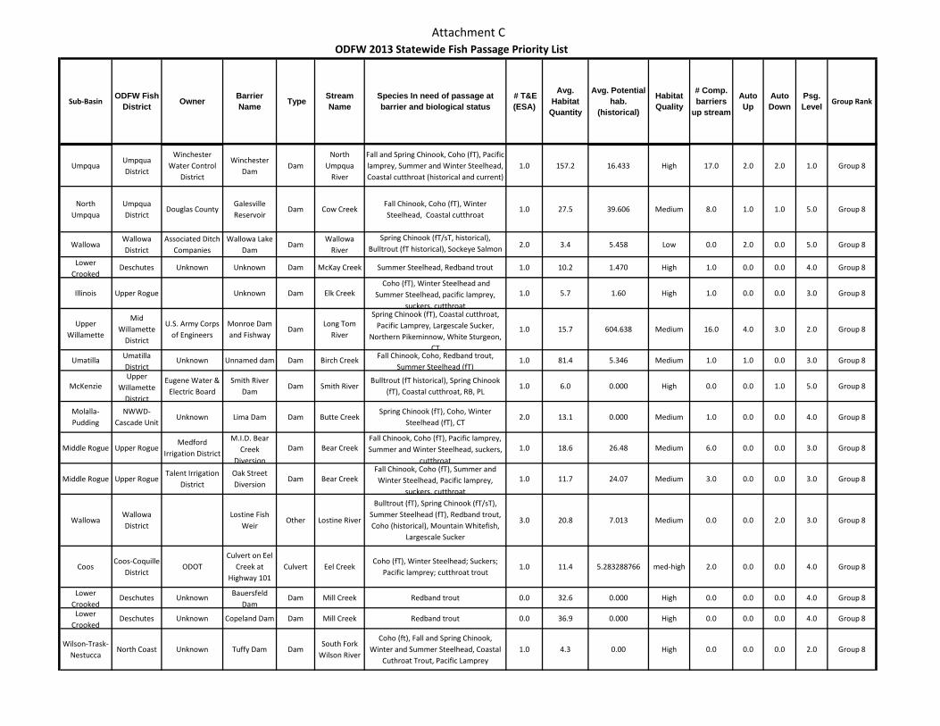
Attachment C
Sub-BasinODFW Fish
District Owner Barrier Name Type Stream
NameSpecies In need of passage at barrier and biological status
# T&E (ESA)
Avg. Habitat
Quantity
Avg. Potential hab.
(historical)
Habitat Quality
# Comp. barriers
up stream
Auto Up
Auto Down
Psg. Level Group Rank
ODFW 2013 Statewide Fish Passage Priority List
UmpquaUmpqua District
Winchester Water Control
District
Winchester Dam
DamNorth
Umpqua River
Fall and Spring Chinook, Coho (fT), Pacific lamprey, Summer and Winter Steelhead, Coastal cutthroat (historical and current)
1.0 157.2 16.433 High 17.0 2.0 2.0 1.0 Group 8
North Umpqua
Umpqua District
Douglas County Galesville Reservoir
Dam Cow CreekFall Chinook, Coho (fT), Winter Steelhead, Coastal cutthroat
1.0 27.5 39.606 Medium 8.0 1.0 1.0 5.0 Group 8
WallowaWallowa District
Associated Ditch Companies
Wallowa Lake Dam
DamWallowa
River
Spring Chinook (fT/sT, historical), Bulltrout (fT historical), Sockeye Salmon
2.0 3.4 5.458 Low 0.0 2.0 0.0 5.0 Group 8
Lower Crooked
Deschutes Unknown Unknown Dam McKay Creek Summer Steelhead, Redband trout 1.0 10.2 1.470 High 1.0 0.0 0.0 4.0 Group 8
Illinois Upper Rogue Unknown Dam Elk Creek Coho (fT), Winter Steelhead and
Summer Steelhead, pacific lamprey, suckers, cutthroat
1.0 5.7 1.60 High 1.0 0.0 0.0 3.0 Group 8
Upper Willamette
Mid Willamette
District
U.S. Army Corps of Engineers
Monroe Dam and Fishway
DamLong Tom
River
Spring Chinook (fT), Coastal cutthroat, Pacific Lamprey, Largescale Sucker,
Northern Pikeminnow, White Sturgeon, CT
1.0 15.7 604.638 Medium 16.0 4.0 3.0 2.0 Group 8
Umatilla Umatilla District
Unknown Unnamed dam Dam Birch Creek Fall Chinook, Coho, Redband trout, Summer Steelhead (fT)
1.0 81.4 5.346 Medium 1.0 1.0 0.0 3.0 Group 8
McKenzieUpper
Willamette District
Eugene Water & Electric Board
Smith River Dam
Dam Smith RiverBulltrout (fT historical), Spring Chinook
(fT), Coastal cutthroat, RB, PL1.0 6.0 0.000 High 0.0 0.0 1.0 5.0 Group 8
Molalla-Pudding
NWWD-Cascade Unit
Unknown Lima Dam Dam Butte CreekSpring Chinook (fT), Coho, Winter
Steelhead (fT), CT2.0 13.1 0.000 Medium 1.0 0.0 0.0 4.0 Group 8
Middle Rogue Upper RogueMedford
Irrigation District
M.I.D. Bear Creek
Diversion
Dam Bear CreekFall Chinook, Coho (fT), Pacific lamprey, Summer and Winter Steelhead, suckers,
cutthroat
1.0 18.6 26.48 Medium 6.0 0.0 0.0 3.0 Group 8
Middle Rogue Upper RogueTalent Irrigation
DistrictOak Street Diversion
Dam Bear CreekFall Chinook, Coho (fT), Summer and Winter Steelhead, Pacific lamprey,
suckers, cutthroat
1.0 11.7 24.07 Medium 3.0 0.0 0.0 3.0 Group 8
WallowaWallowa District
Lostine Fish Weir
Other Lostine River
Bulltrout (fT), Spring Chinook (fT/sT), Summer Steelhead (fT), Redband trout, Coho (historical), Mountain Whitefish,
Largescale Sucker
3.0 20.8 7.013 Medium 0.0 0.0 2.0 3.0 Group 8
CoosCoos-Coquille
DistrictODOT
Culvert on Eel Creek at
Highway 101 Culvert Eel Creek
Coho (fT), Winter Steelhead; Suckers; Pacific lamprey; cutthroat trout
1.0 11.4 5.283288766 med-high 2.0 0.0 0.0 4.0 Group 8
Lower Crooked
Deschutes Unknown Bauersfeld Dam
Dam Mill Creek Redband trout 0.0 32.6 0.000 High 0.0 0.0 0.0 4.0 Group 8
Lower Crooked
Deschutes Unknown Copeland Dam Dam Mill Creek Redband trout 0.0 36.9 0.000 High 0.0 0.0 0.0 4.0 Group 8
Wilson-Trask-Nestucca
North Coast Unknown Tuffy Dam DamSouth Fork
Wilson River
Coho (ft), Fall and Spring Chinook, Winter and Summer Steelhead, Coastal
Cuthroat Trout, Pacific Lamprey1.0 4.3 0.00 High 0.0 0.0 0.0 2.0 Group 8
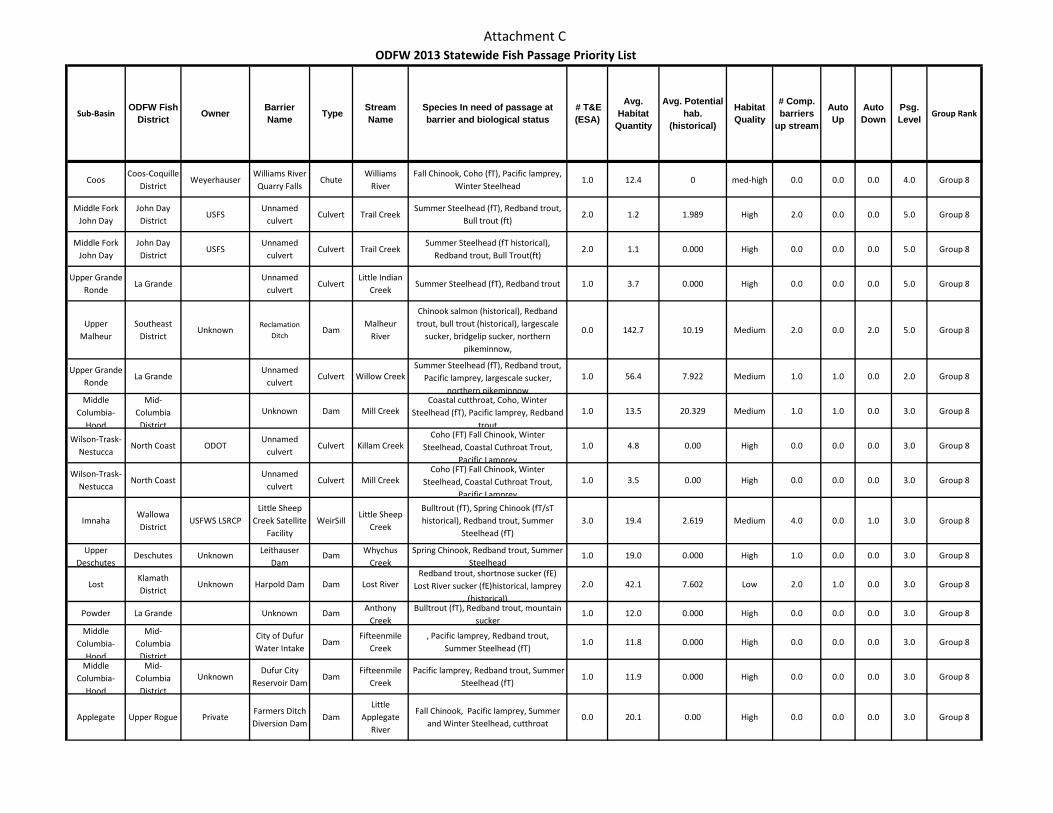
Attachment C
Sub-BasinODFW Fish
District Owner Barrier Name Type Stream
NameSpecies In need of passage at barrier and biological status
# T&E (ESA)
Avg. Habitat
Quantity
Avg. Potential hab.
(historical)
Habitat Quality
# Comp. barriers
up stream
Auto Up
Auto Down
Psg. Level Group Rank
ODFW 2013 Statewide Fish Passage Priority List
CoosCoos-Coquille
DistrictWeyerhauser
Williams River Quarry Falls
ChuteWilliams
RiverFall Chinook, Coho (fT), Pacific lamprey,
Winter Steelhead1.0 12.4 0 med-high 0.0 0.0 0.0 4.0 Group 8
Middle Fork John Day
John Day District
USFSUnnamed
culvertCulvert Trail Creek
Summer Steelhead (fT), Redband trout, Bull trout (ft)
2.0 1.2 1.989 High 2.0 0.0 0.0 5.0 Group 8
Middle Fork John Day
John Day District
USFSUnnamed
culvertCulvert Trail Creek
Summer Steelhead (fT historical), Redband trout, Bull Trout(ft)
2.0 1.1 0.000 High 0.0 0.0 0.0 5.0 Group 8
Upper Grande Ronde
La GrandeUnnamed
culvertCulvert
Little Indian Creek
Summer Steelhead (fT), Redband trout 1.0 3.7 0.000 High 0.0 0.0 0.0 5.0 Group 8
Upper Malheur
Southeast District
UnknownReclamation
DitchDam
Malheur River
Chinook salmon (historical), Redband trout, bull trout (historical), largescale
sucker, bridgelip sucker, northern pikeminnow,
0.0 142.7 10.19 Medium 2.0 0.0 2.0 5.0 Group 8
Upper Grande Ronde
La GrandeUnnamed
culvertCulvert Willow Creek
Summer Steelhead (fT), Redband trout, Pacific lamprey, largescale sucker,
northern pikeminnow
1.0 56.4 7.922 Medium 1.0 1.0 0.0 2.0 Group 8
Middle Columbia-
Hood
Mid-Columbia
District
Unknown Dam Mill CreekCoastal cutthroat, Coho, Winter
Steelhead (fT), Pacific lamprey, Redband trout
1.0 13.5 20.329 Medium 1.0 1.0 0.0 3.0 Group 8
Wilson-Trask-Nestucca
North Coast ODOTUnnamed
culvertCulvert Killam Creek
Coho (FT) Fall Chinook, Winter Steelhead, Coastal Cuthroat Trout,
Pacific Lamprey
1.0 4.8 0.00 High 0.0 0.0 0.0 3.0 Group 8
Wilson-Trask-Nestucca
North Coast Unnamed
culvertCulvert Mill Creek
Coho (FT) Fall Chinook, Winter Steelhead, Coastal Cuthroat Trout,
Pacific Lamprey
1.0 3.5 0.00 High 0.0 0.0 0.0 3.0 Group 8
ImnahaWallowa District
USFWS LSRCPLittle Sheep
Creek Satellite Facility
WeirSillLittle Sheep
Creek
Bulltrout (fT), Spring Chinook (fT/sT historical), Redband trout, Summer
Steelhead (fT)3.0 19.4 2.619 Medium 4.0 0.0 1.0 3.0 Group 8
Upper Deschutes
Deschutes Unknown Leithauser Dam
Dam Whychus Creek
Spring Chinook, Redband trout, Summer Steelhead
1.0 19.0 0.000 High 1.0 0.0 0.0 3.0 Group 8
LostKlamath District
Unknown Harpold Dam Dam Lost RiverRedband trout, shortnose sucker (fE)
Lost River sucker (fE)historical, lamprey (historical)
2.0 42.1 7.602 Low 2.0 1.0 0.0 3.0 Group 8
Powder La Grande Unknown Dam Anthony Creek
Bulltrout (fT), Redband trout, mountain sucker
1.0 12.0 0.000 High 0.0 0.0 0.0 3.0 Group 8
Middle Columbia-
Hood
Mid-Columbia
District
City of Dufur Water Intake
DamFifteenmile
Creek, Pacific lamprey, Redband trout,
Summer Steelhead (fT)1.0 11.8 0.000 High 0.0 0.0 0.0 3.0 Group 8
Middle Columbia-
Hood
Mid-Columbia
District
UnknownDufur City
Reservoir DamDam
Fifteenmile Creek
Pacific lamprey, Redband trout, Summer Steelhead (fT)
1.0 11.9 0.000 High 0.0 0.0 0.0 3.0 Group 8
Applegate Upper Rogue PrivateFarmers Ditch Diversion Dam
DamLittle
Applegate River
Fall Chinook, Pacific lamprey, Summer and Winter Steelhead, cutthroat
0.0 20.1 0.00 High 0.0 0.0 0.0 3.0 Group 8
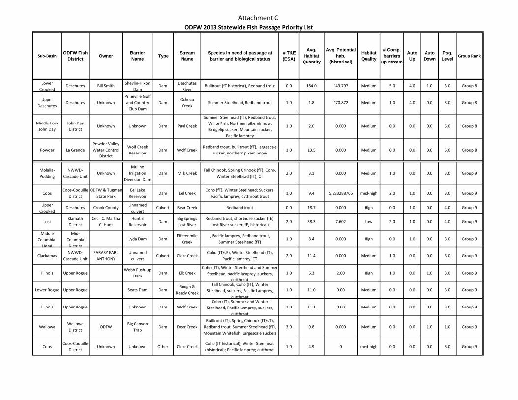
Attachment C
Sub-BasinODFW Fish
District Owner Barrier Name Type Stream
NameSpecies In need of passage at barrier and biological status
# T&E (ESA)
Avg. Habitat
Quantity
Avg. Potential hab.
(historical)
Habitat Quality
# Comp. barriers
up stream
Auto Up
Auto Down
Psg. Level Group Rank
ODFW 2013 Statewide Fish Passage Priority List
Lower Crooked
Deschutes Bill Smith Shevlin-Hixon Dam
Dam Deschutes River
Bulltrout (fT historical), Redband trout 0.0 184.0 149.797 Medium 5.0 4.0 1.0 3.0 Group 8
Upper Deschutes
Deschutes UnknownPrineville Golf and Country
Club DamDam
Ochoco Creek
Summer Steelhead, Redband trout 1.0 1.8 170.872 Medium 1.0 4.0 0.0 3.0 Group 8
Middle Fork John Day
John Day District
Unknown Unknown Dam Paul Creek
Summer Steelhead (fT), Redband trout, White Fish, Northern pikeminnow, Bridgelip sucker, Mountain sucker,
Pacific lamprey
1.0 2.0 0.000 Medium 0.0 0.0 0.0 5.0 Group 8
Powder La GrandePowder Valley Water Control
District
Wolf Creek Reservoir
Dam Wolf CreekRedband trout, bull trout (fT), largescale
sucker, northern pikeminnow1.0 13.5 0.000 Medium 0.0 0.0 0.0 5.0 Group 8
Molalla-Pudding
NWWD-Cascade Unit
UnknownMulino
Irrigation Diversion Dam
Dam Milk CreekFall Chinook, Spring Chinook (fT), Coho,
Winter Steelhead (fT), CT2.0 3.1 0.000 Medium 1.0 0.0 0.0 3.0 Group 9
CoosCoos-Coquille
DistrictODFW & Tugman
State ParkEel Lake
ReservoirDam Eel Creek
Coho (fT), Winter Steelhead; Suckers; Pacific lamprey; cutthroat trout
1.0 9.4 5.283288766 med-high 2.0 1.0 0.0 3.0 Group 9
Upper Crooked
Deschutes Crook County Unnamed culvert
Culvert Bear Creek Redband trout 0.0 18.7 0.000 High 0.0 1.0 0.0 4.0 Group 9
LostKlamath District
Cecil C. Martha C. Hunt
Hunt S Reservoir
DamBig Springs Lost River
Redband trout, shortnose sucker (fE). Lost River sucker (fE, historical)
2.0 38.3 7.602 Low 2.0 1.0 0.0 4.0 Group 9
Middle Columbia-
Hood
Mid-Columbia
District
Lyda Dam DamFifteenmile
Creek, Pacific lamprey, Redband trout,
Summer Steelhead (fT)1.0 8.4 0.000 High 0.0 1.0 0.0 3.0 Group 9
ClackamasNWWD-
Cascade UnitFARASY EARL
ANTHONYUnnamed
culvertCulvert Clear Creek
Coho (fT/sE), Winter Steelhead (fT), Pacific lamprey, CT
2.0 11.4 0.000 Medium 1.0 0.0 0.0 3.0 Group 9
Illinois Upper RogueWebb Push-up
DamDam Elk Creek
Coho (fT), Winter Steelhead and Summer Steelhead, pacific lamprey, suckers,
cutthroat
1.0 6.3 2.60 High 1.0 0.0 1.0 3.0 Group 9
Lower Rogue Upper Rogue Seats Dam DamRough &
Ready Creek
Fall Chinook, Coho (fT), Winter Steelhead, suckers, Pacific Lamprey,
cutthroat
1.0 11.0 0.00 Medium 0.0 0.0 0.0 3.0 Group 9
Illinois Upper Rogue Unknown Dam Wolf CreekCoho (fT), Summer and Winter
Steelhead, Pacific Lamprey, suckers, cutthroat
1.0 11.1 0.00 Medium 0.0 0.0 0.0 3.0 Group 9
WallowaWallowa District
ODFWBig Canyon
TrapDam Deer Creek
Bulltrout (fT), Spring Chinook (fT/sT), Redband trout, Summer Steelhead (fT), Mountain Whitefish, Largescale suckers
3.0 9.8 0.000 Medium 0.0 0.0 1.0 1.0 Group 9
CoosCoos-Coquille
DistrictUnknown Unknown Other Clear Creek
Coho (fT historical), Winter Steelhead (historical); Pacific lamprey; cutthroat
1.0 4.9 0 med-high 0.0 0.0 0.0 5.0 Group 9
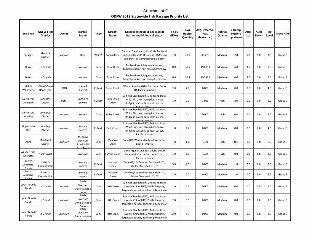
Attachment C
Sub-BasinODFW Fish
District Owner Barrier Name Type Stream
NameSpecies In need of passage at barrier and biological status
# T&E (ESA)
Avg. Habitat
Quantity
Avg. Potential hab.
(historical)
Habitat Quality
# Comp. barriers
up stream
Auto Up
Auto Down
Psg. Level Group Rank
ODFW 2013 Statewide Fish Passage Priority List
SpragueKlamath District
Unknown Dam Weir 2 Sycan RiverSummer Steelhead (historical), Redband trout, bull trout (fT Historical), Miller lake
lamprey, Pit-Klamath brook lamprey1.0 47.7 40.276 Medium 2.0 1.0 1.0 3.0 Group 9
Burnt La Grande Unknown Dam Burnt RiverRedband trout, largescale sucker,
bridgelip sucker, northern pikeminnow0.0 37.7 190.993 Medium 6.0 3.0 1.0 3.0 Group 9
Burnt La Grande Unknown Dam Burnt RiverRedband trout, largescale sucker,
bridgelip sucker, northern pikeminnow0.0 38.1 190.993 Medium 6.0 3.0 1.0 3.0 Group 9
Middle Willamette
NWWD-Coast Range Unit
ODOTHwy 43 Culvert
Culvert Tryon CreekWinter Steelhead (ft), Cutthroat, Coho
(ft), Pacific Lamprey2.0 4.0 0.000 Medium 0.0 0.0 0.0 4.0 Group 9
North Fork John Day
John Day District
USFSUnnamed
culvertCulvert
Buck Cabin Creek
Summer Steelhead (fT), Redband trout, White Fish, Northern pikeminnow, Bridgelip sucker, Mountain sucker,
Pacific lamprey
1.0 0.1 1.929 High 2.0 0.0 0.0 5.0 Group 9
North Fork John Day
John Day District
Unknown Unknown Dam Wiley Creek
Summer Steelhead (fT), Redband trout, White Fish, Northern pikeminnow, Bridgelip sucker, Mountain sucker,
Pacific lamprey
1.0 0.4 0.000 High 0.0 0.0 0.0 5.0 Group 9
Upper John Day
John Day District
UnknownUnnamed
culvertCulvert Park Creek
Summer Steelhead (fT), Redband trout, White Fish, Northern pikeminnow, Bridgelip sucker, Mountain sucker,
Pacific lamprey
1.0 1.2 0.000 Medium 0.0 0.0 0.0 4.0 Group 9
AlseaMid-Coast
DistrictUnknown
Meadow Creek Log Pond (Mill Pond Dam)
DamMeadow
CreekCoho (fT), Winter Steelhead, cutthroat,
pacific lamprey1.0 1.6 0.00 High 0.0 0.0 0.0 5.0 Group 9
Wilson-Trask-Nestucca
North Coast Unknown Dam Farmer CreekCoho (ft), Fall Chinook, Chum, winter Steelhead, Coastal Cutthroat Trout,
Pacific lamprey
1.0 1.8 0.00 High 0.0 0.0 0.0 3.0 Group 9
Lower Columbia-
Sandy
NWWD-Cascade Unit
Unnamed culvert
CulvertHackett Creek
Coho (fT/sE), Summer Steelhead (fT), Winter Steelhead (fT), CT
3.0 2.1 0.000 Medium 1.0 0.0 0.0 2.0 Group 9
Lower Columbia-
Sandy
NWWD-Cascade Unit
Unnamed culvert
CulvertHackett Creek
Coho (fT/sE), Summer Steelhead (fT), Winter Steelhead (fT), CT
3.0 2.0 0.000 Medium 1.0 0.0 0.0 2.0 Group 9
Upper Grande Ronde
La Grande Unknown
Ditch Diversion
Dams on Little Creek
Dam Little CreekSummer Steelhead (fT), Redband trout, juvenile Chinook(fT), Pacific lamprey,
largescale sucker, northern pikeminnow2.0 7.6 0.000 Medium 0.0 0.0 0.0 1.0 Group 9
Upper Grande Ronde
La Grande Unknown
Ditch Diversion
Dams on Little Creek
Dam Little CreekSummer Steelhead (fT), Redband trout, juvenile Chinook(fT), Pacific lamprey,
largescale sucker, northern pikeminnow2.0 6.9 0.000 Medium 0.0 0.0 0.0 1.0 Group 9
Upper Grande Ronde
La Grande Unknown
Ditch Diversion
Dams on Little Creek
Dam Little CreekSummer Steelhead (fT), Redband trout, juvenile Chinook(fT), Pacific lamprey,
largescale sucker, northern pikeminnow2.0 6.3 0.000 Medium 0.0 0.0 0.0 1.0 Group 9
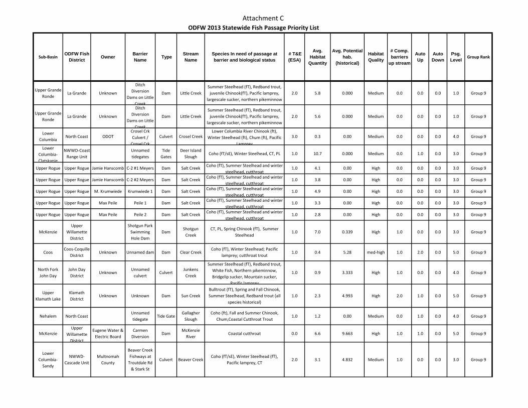
Attachment C
Sub-BasinODFW Fish
District Owner Barrier Name Type Stream
NameSpecies In need of passage at barrier and biological status
# T&E (ESA)
Avg. Habitat
Quantity
Avg. Potential hab.
(historical)
Habitat Quality
# Comp. barriers
up stream
Auto Up
Auto Down
Psg. Level Group Rank
ODFW 2013 Statewide Fish Passage Priority List
Upper Grande Ronde
La Grande Unknown
Ditch Diversion
Dams on Little Creek
Dam Little CreekSummer Steelhead (fT), Redband trout, juvenile Chinook(fT), Pacific lamprey,
largescale sucker, northern pikeminnow2.0 5.8 0.000 Medium 0.0 0.0 0.0 1.0 Group 9
Upper Grande Ronde
La Grande Unknown
Ditch Diversion
Dams on Little Creek
Dam Little CreekSummer Steelhead (fT), Redband trout, juvenile Chinook(fT), Pacific lamprey,
largescale sucker, northern pikeminnow2.0 5.6 0.000 Medium 0.0 0.0 0.0 1.0 Group 9
Lower Columbia
North Coast ODOTCrosel Crk Culvert /
Crosel Crk
Culvert Crosel CreekLower Columbia River Chinook (ft),
Winter Steelhead (ft), Chum (ft), Pacific Lamprey
3.0 0.3 0.00 Medium 0.0 0.0 0.0 4.0 Group 9
Lower Columbia-Clatskanie
NWWD-Coast Range Unit
Unnamed tidegates
Tide Gates
Deer Island Slough
Coho (fT/sE), Winter Steelhead, CT, PL 1.0 10.7 0.000 Medium 0.0 1.0 0.0 3.0 Group 9
Upper Rogue Upper Rogue Jamie Hanscomb C-2 #1 Meyers Dam Salt Creek Coho (fT), Summer Steelhead and winter steelhead, cutthroat
1.0 4.1 0.00 High 0.0 0.0 0.0 3.0 Group 9
Upper Rogue Upper Rogue Jamie Hanscomb C-2 #2 Meyers Dam Salt Creek Coho (fT), Summer Steelhead and winter steelhead, cutthroat
1.0 3.8 0.00 High 0.0 0.0 0.0 3.0 Group 9
Upper Rogue Upper Rogue M. Krumwiede Krumwiede 1 Dam Salt Creek Coho (fT), Summer Steelhead and winter steelhead, cutthroat
1.0 4.9 0.00 High 0.0 0.0 0.0 3.0 Group 9
Upper Rogue Upper Rogue Max Peile Peile 1 Dam Salt Creek Coho (fT), Summer Steelhead and winter steelhead, cutthroat
1.0 3.3 0.00 High 0.0 0.0 0.0 3.0 Group 9
Upper Rogue Upper Rogue Max Peile Peile 2 Dam Salt Creek Coho (fT), Summer Steelhead and winter steelhead, cutthroat
1.0 2.8 0.00 High 0.0 0.0 0.0 3.0 Group 9
McKenzieUpper
Willamette District
Shotgun Park Swimming Hole Dam
DamShotgun
CreekCT, PL, Spring Chinook (fT), Summer
Steelhead1.0 7.0 0.339 High 1.0 0.0 0.0 3.0 Group 9
CoosCoos-Coquille
DistrictUnknown Unnamed dam Dam Clear Creek
Coho (fT), Winter Steelhead; Pacific lamprey; cutthroat trout
1.0 0.4 5.28 med-high 1.0 2.0 0.0 5.0 Group 9
North Fork John Day
John Day District
UnknownUnnamed
culvertCulvert
Junkens Creek
Summer Steelhead (fT), Redband trout, White Fish, Northern pikeminnow, Bridgelip sucker, Mountain sucker,
Pacific lamprey
1.0 0.9 3.333 High 1.0 0.0 0.0 4.0 Group 9
Upper Klamath Lake
Klamath District
Unknown Unknown Dam Sun CreekBulltrout (fT), Spring and Fall Chinook, Summer Steelhead, Redband trout (all
species historical)1.0 2.3 4.993 High 2.0 1.0 0.0 5.0 Group 9
Nehalem North Coast Unnamed tidegate
Tide GateGallagher
SloughCoho (ft), Fall and Summer Chinook,
Chum,Coastal Cutthroat Trout1.0 1.2 0.00 Medium 0.0 1.0 0.0 4.0 Group 9
McKenzieUpper
Willamette District
Eugene Water & Electric Board
Carmen Diversion
DamMcKenzie
RiverCoastal cutthroat 0.0 6.6 9.663 High 1.0 1.0 0.0 5.0 Group 9
Lower Columbia-
Sandy
NWWD-Cascade Unit
Multnomah County
Beaver Creek Fishways at
Troutdale Rd & Stark St
Culvert Beaver CreekCoho (fT/sE), Winter Steelhead (fT),
Pacific lamprey, CT2.0 3.1 4.832 Medium 1.0 0.0 0.0 3.0 Group 9
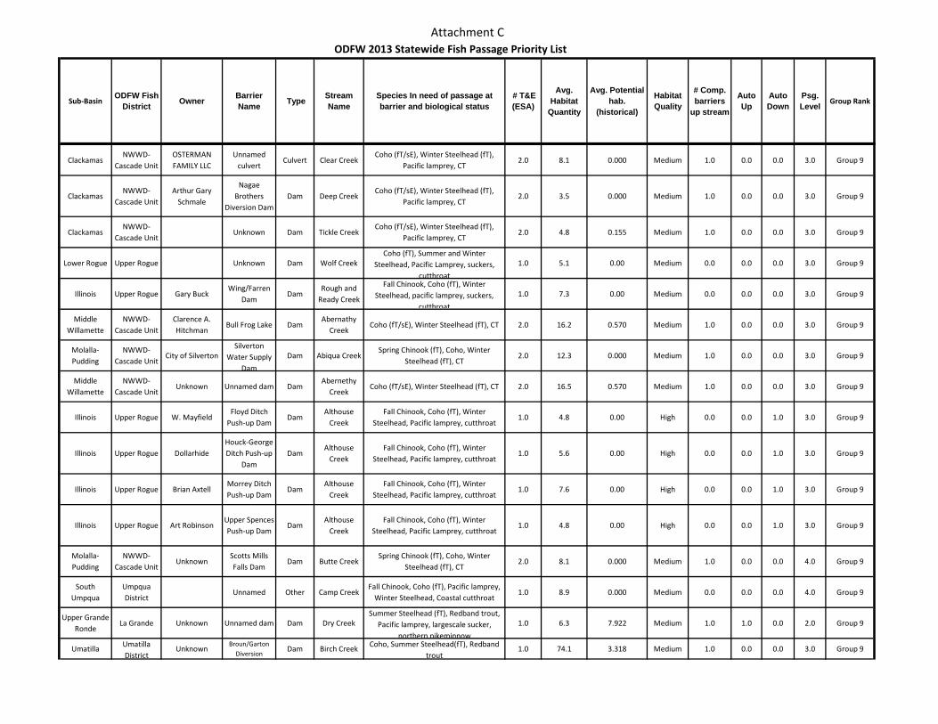
Attachment C
Sub-BasinODFW Fish
District Owner Barrier Name Type Stream
NameSpecies In need of passage at barrier and biological status
# T&E (ESA)
Avg. Habitat
Quantity
Avg. Potential hab.
(historical)
Habitat Quality
# Comp. barriers
up stream
Auto Up
Auto Down
Psg. Level Group Rank
ODFW 2013 Statewide Fish Passage Priority List
ClackamasNWWD-
Cascade UnitOSTERMAN FAMILY LLC
Unnamed culvert
Culvert Clear CreekCoho (fT/sE), Winter Steelhead (fT),
Pacific lamprey, CT2.0 8.1 0.000 Medium 1.0 0.0 0.0 3.0 Group 9
ClackamasNWWD-
Cascade UnitArthur Gary
Schmale
Nagae Brothers
Diversion DamDam Deep Creek
Coho (fT/sE), Winter Steelhead (fT), Pacific lamprey, CT
2.0 3.5 0.000 Medium 1.0 0.0 0.0 3.0 Group 9
ClackamasNWWD-
Cascade UnitUnknown Dam Tickle Creek
Coho (fT/sE), Winter Steelhead (fT), Pacific lamprey, CT
2.0 4.8 0.155 Medium 1.0 0.0 0.0 3.0 Group 9
Lower Rogue Upper Rogue Unknown Dam Wolf CreekCoho (fT), Summer and Winter
Steelhead, Pacific Lamprey, suckers, cutthroat
1.0 5.1 0.00 Medium 0.0 0.0 0.0 3.0 Group 9
Illinois Upper Rogue Gary BuckWing/Farren
DamDam
Rough and Ready Creek
Fall Chinook, Coho (fT), Winter Steelhead, pacific lamprey, suckers,
cutthroat
1.0 7.3 0.00 Medium 0.0 0.0 0.0 3.0 Group 9
Middle Willamette
NWWD-Cascade Unit
Clarence A. Hitchman
Bull Frog Lake DamAbernathy
CreekCoho (fT/sE), Winter Steelhead (fT), CT 2.0 16.2 0.570 Medium 1.0 0.0 0.0 3.0 Group 9
Molalla-Pudding
NWWD-Cascade Unit
City of SilvertonSilverton
Water Supply Dam
Dam Abiqua CreekSpring Chinook (fT), Coho, Winter
Steelhead (fT), CT2.0 12.3 0.000 Medium 1.0 0.0 0.0 3.0 Group 9
Middle Willamette
NWWD-Cascade Unit
Unknown Unnamed dam DamAbernethy
CreekCoho (fT/sE), Winter Steelhead (fT), CT 2.0 16.5 0.570 Medium 1.0 0.0 0.0 3.0 Group 9
Illinois Upper Rogue W. MayfieldFloyd Ditch
Push-up DamDam
Althouse Creek
Fall Chinook, Coho (fT), Winter Steelhead, Pacific lamprey, cutthroat
1.0 4.8 0.00 High 0.0 0.0 1.0 3.0 Group 9
Illinois Upper Rogue DollarhideHouck-George Ditch Push-up
DamDam
Althouse Creek
Fall Chinook, Coho (fT), Winter Steelhead, Pacific lamprey, cutthroat
1.0 5.6 0.00 High 0.0 0.0 1.0 3.0 Group 9
Illinois Upper Rogue Brian AxtellMorrey Ditch Push-up Dam
DamAlthouse
CreekFall Chinook, Coho (fT), Winter
Steelhead, Pacific lamprey, cutthroat1.0 7.6 0.00 High 0.0 0.0 1.0 3.0 Group 9
Illinois Upper Rogue Art RobinsonUpper Spences Push-up Dam
DamAlthouse
CreekFall Chinook, Coho (fT), Winter
Steelhead, Pacific Lamprey, cutthroat1.0 4.8 0.00 High 0.0 0.0 1.0 3.0 Group 9
Molalla-Pudding
NWWD-Cascade Unit
UnknownScotts Mills Falls Dam
Dam Butte CreekSpring Chinook (fT), Coho, Winter
Steelhead (fT), CT2.0 8.1 0.000 Medium 1.0 0.0 0.0 4.0 Group 9
South Umpqua
Umpqua District
Unnamed Other Camp CreekFall Chinook, Coho (fT), Pacific lamprey,
Winter Steelhead, Coastal cutthroat 1.0 8.9 0.000 Medium 0.0 0.0 0.0 4.0 Group 9
Upper Grande Ronde
La Grande Unknown Unnamed dam Dam Dry CreekSummer Steelhead (fT), Redband trout,
Pacific lamprey, largescale sucker, northern pikeminnow
1.0 6.3 7.922 Medium 1.0 1.0 0.0 2.0 Group 9
Umatilla Umatilla District
UnknownBroun/Garton
DiversionDam Birch Creek Coho, Summer Steelhead(fT), Redband
trout1.0 74.1 3.318 Medium 1.0 0.0 0.0 3.0 Group 9
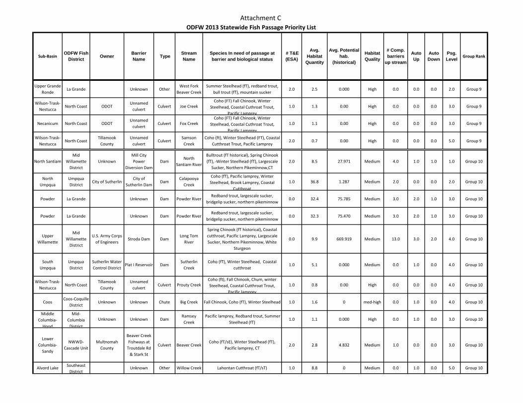
Attachment C
Sub-BasinODFW Fish
District Owner Barrier Name Type Stream
NameSpecies In need of passage at barrier and biological status
# T&E (ESA)
Avg. Habitat
Quantity
Avg. Potential hab.
(historical)
Habitat Quality
# Comp. barriers
up stream
Auto Up
Auto Down
Psg. Level Group Rank
ODFW 2013 Statewide Fish Passage Priority List
Upper Grande Ronde
La Grande Unknown OtherWest Fork
Beaver CreekSummer Steelhead (fT), redband trout,
bull trout (fT), mountain sucker2.0 2.5 0.000 High 0.0 0.0 0.0 2.0 Group 9
Wilson-Trask-Nestucca
North Coast ODOTUnnamed
culvertCulvert Joe Creek
Coho (FT) Fall Chinook, Winter Steelhead, Coastal Cuthroat Trout,
Pacific Lamprey
1.0 1.3 0.00 High 0.0 0.0 0.0 3.0 Group 9
Necanicum North Coast ODOTUnnamed
culvertCulvert Fox Creek
Coho (FT) Fall Chinook, Winter Steelhead, Coastal Cuthroat Trout,
Pacific Lamprey
1.0 1.1 0.00 High 0.0 0.0 0.0 3.0 Group 9
Wilson-Trask-Nestucca
North Coast Tillamook
CountyUnnamed
culvertCulvert
Samson Creek
Coho (ft), Winter Steelhead (FT), Coastal Cutthroat Trout, Pacific Lamprey
2.0 0.7 0.00 High 0.0 0.0 0.0 5.0 Group 9
North SantiamMid
Willamette District
UnknownMill City Power
Diversion DamDam
North Santiam River
Bulltrout (fT historical), Spring Chinook (fT), Winter Steelhead (fT), Largescale
Sucker, Northern Pikeminnow,CT2.0 8.5 27.971 Medium 4.0 1.0 1.0 1.0 Group 10
North Umpqua
Umpqua District
City of SutherlinCity of
Sutherlin DamDam
Calapooya Creek
Coho (fT), Pacific lamprey, Winter Steelhead, Brook Lamprey, Coastal
Cutthroat
1.0 36.8 1.287 Medium 2.0 0.0 0.0 2.0 Group 10
Powder La Grande Unknown Dam Powder RiverRedband trout, largescale sucker,
bridgelip sucker, northern pikeminnow0.0 32.4 75.785 Medium 3.0 2.0 1.0 3.0 Group 10
Powder La Grande Unknown Dam Powder RiverRedband trout, largescale sucker,
bridgelip sucker, northern pikeminnow0.0 32.3 75.470 Medium 3.0 2.0 1.0 3.0 Group 10
Upper Willamette
Mid Willamette
District
U.S. Army Corps of Engineers
Stroda Dam DamLong Tom
River
Spring Chinook (fT historical), Coastal cutthroat, Pacific Lamprey, Largescale Sucker, Northern Pikeminnow, White
Sturgeon
0.0 9.9 669.919 Medium 13.0 3.0 2.0 4.0 Group 10
South Umpqua
Umpqua District
Sutherlin Water Control District
Plat I Reservoir DamSutherlin
CreekCoho (fT), Winter Steelhead, Coastal
cutthroat 1.0 5.1 0.000 Medium 0.0 1.0 0.0 4.0 Group 10
Wilson-Trask-Nestucca
North Coast Tillamook
CountyUnnamed
culvertCulvert Prouty Creek
Coho (ft), Fall Chinook, Chum, winter Steelhead, Coastal Cutthroat Trout,
Pacific lamprey
1.0 0.8 0.00 High 0.0 0.0 0.0 4.0 Group 10
CoosCoos-Coquille
DistrictUnknown Unknown Chute Big Creek Fall Chinook, Coho (fT), Winter Steelhead 1.0 1.6 0 med-high 0.0 1.0 0.0 4.0 Group 10
Middle Columbia-
Hood
Mid-Columbia
District
Unknown Unknown DamRamsey Creek
Pacific lamprey, Redband trout, Summer Steelhead (fT)
1.0 1.1 0.000 High 0.0 1.0 0.0 3.0 Group 10
Lower Columbia-
Sandy
NWWD-Cascade Unit
Multnomah County
Beaver Creek Fishways at
Troutdale Rd & Stark St
Culvert Beaver CreekCoho (fT/sE), Winter Steelhead (fT),
Pacific lamprey, CT2.0 2.8 4.832 Medium 1.0 0.0 0.0 3.0 Group 10
Alvord Lake Southeast District
Unknown Other Willow Creek Lahontan Cutthroat (fT/sT) 1.0 8.8 0 Medium 0.0 1.0 0.0 5.0 Group 10
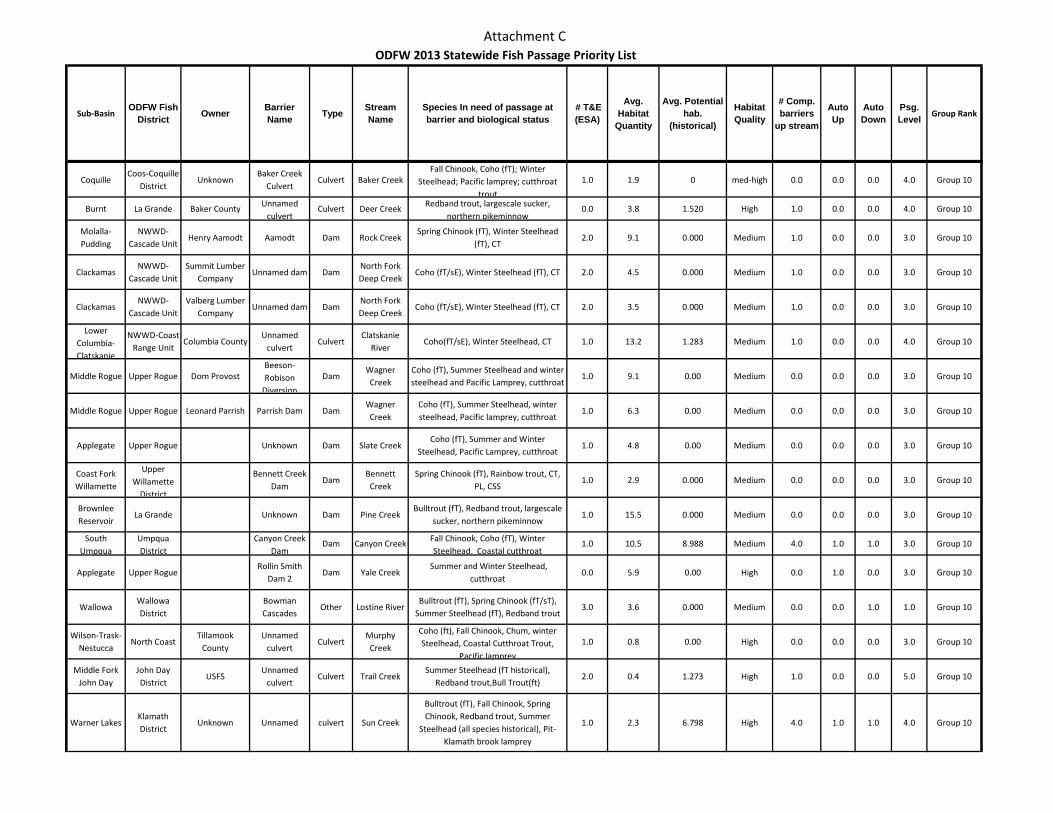
Attachment C
Sub-BasinODFW Fish
District Owner Barrier Name Type Stream
NameSpecies In need of passage at barrier and biological status
# T&E (ESA)
Avg. Habitat
Quantity
Avg. Potential hab.
(historical)
Habitat Quality
# Comp. barriers
up stream
Auto Up
Auto Down
Psg. Level Group Rank
ODFW 2013 Statewide Fish Passage Priority List
CoquilleCoos-Coquille
DistrictUnknown
Baker Creek Culvert
Culvert Baker CreekFall Chinook, Coho (fT); Winter
Steelhead; Pacific lamprey; cutthroat trout
1.0 1.9 0 med-high 0.0 0.0 0.0 4.0 Group 10
Burnt La Grande Baker County Unnamed culvert
Culvert Deer Creek Redband trout, largescale sucker, northern pikeminnow
0.0 3.8 1.520 High 1.0 0.0 0.0 4.0 Group 10
Molalla-Pudding
NWWD-Cascade Unit
Henry Aamodt Aamodt Dam Rock CreekSpring Chinook (fT), Winter Steelhead
(fT), CT2.0 9.1 0.000 Medium 1.0 0.0 0.0 3.0 Group 10
ClackamasNWWD-
Cascade UnitSummit Lumber
CompanyUnnamed dam Dam
North Fork Deep Creek
Coho (fT/sE), Winter Steelhead (fT), CT 2.0 4.5 0.000 Medium 1.0 0.0 0.0 3.0 Group 10
ClackamasNWWD-
Cascade UnitValberg Lumber
CompanyUnnamed dam Dam
North Fork Deep Creek
Coho (fT/sE), Winter Steelhead (fT), CT 2.0 3.5 0.000 Medium 1.0 0.0 0.0 3.0 Group 10
Lower Columbia-Clatskanie
NWWD-Coast Range Unit
Columbia CountyUnnamed
culvertCulvert
Clatskanie River
Coho(fT/sE), Winter Steelhead, CT 1.0 13.2 1.283 Medium 1.0 0.0 0.0 4.0 Group 10
Middle Rogue Upper Rogue Dom ProvostBeeson-Robison
Diversion
DamWagner Creek
Coho (fT), Summer Steelhead and winter steelhead and Pacific Lamprey, cutthroat
1.0 9.1 0.00 Medium 0.0 0.0 0.0 3.0 Group 10
Middle Rogue Upper Rogue Leonard Parrish Parrish Dam DamWagner Creek
Coho (fT), Summer Steelhead, winter steelhead, Pacific lamprey, cutthroat
1.0 6.3 0.00 Medium 0.0 0.0 0.0 3.0 Group 10
Applegate Upper Rogue Unknown Dam Slate CreekCoho (fT), Summer and Winter
Steelhead, Pacific Lamprey, cutthroat1.0 4.8 0.00 Medium 0.0 0.0 0.0 3.0 Group 10
Coast Fork Willamette
Upper Willamette
District
Bennett Creek Dam
DamBennett
CreekSpring Chinook (fT), Rainbow trout, CT,
PL, CSS1.0 2.9 0.000 Medium 0.0 0.0 0.0 3.0 Group 10
Brownlee Reservoir
La Grande Unknown Dam Pine CreekBulltrout (fT), Redband trout, largescale
sucker, northern pikeminnow1.0 15.5 0.000 Medium 0.0 0.0 0.0 3.0 Group 10
South Umpqua
Umpqua District
Canyon Creek Dam
Dam Canyon Creek Fall Chinook, Coho (fT), Winter Steelhead, Coastal cutthroat
1.0 10.5 8.988 Medium 4.0 1.0 1.0 3.0 Group 10
Applegate Upper RogueRollin Smith
Dam 2Dam Yale Creek
Summer and Winter Steelhead, cutthroat
0.0 5.9 0.00 High 0.0 1.0 0.0 3.0 Group 10
WallowaWallowa District
Bowman Cascades
Other Lostine RiverBulltrout (fT), Spring Chinook (fT/sT),
Summer Steelhead (fT), Redband trout3.0 3.6 0.000 Medium 0.0 0.0 1.0 1.0 Group 10
Wilson-Trask-Nestucca
North Coast Tillamook
CountyUnnamed
culvertCulvert
Murphy Creek
Coho (ft), Fall Chinook, Chum, winter Steelhead, Coastal Cutthroat Trout,
Pacific lamprey
1.0 0.8 0.00 High 0.0 0.0 0.0 3.0 Group 10
Middle Fork John Day
John Day District
USFSUnnamed
culvertCulvert Trail Creek
Summer Steelhead (fT historical), Redband trout,Bull Trout(ft)
2.0 0.4 1.273 High 1.0 0.0 0.0 5.0 Group 10
Warner LakesKlamath District
Unknown Unnamed culvert Sun Creek
Bulltrout (fT), Fall Chinook, Spring Chinook, Redband trout, Summer
Steelhead (all species historical), Pit-Klamath brook lamprey
1.0 2.3 6.798 High 4.0 1.0 1.0 4.0 Group 10
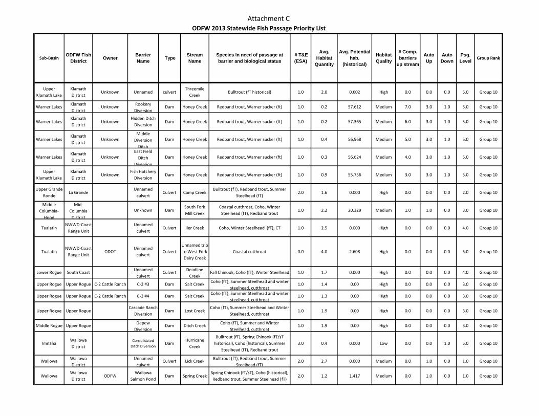
Attachment C
Sub-BasinODFW Fish
District Owner Barrier Name Type Stream
NameSpecies In need of passage at barrier and biological status
# T&E (ESA)
Avg. Habitat
Quantity
Avg. Potential hab.
(historical)
Habitat Quality
# Comp. barriers
up stream
Auto Up
Auto Down
Psg. Level Group Rank
ODFW 2013 Statewide Fish Passage Priority List
Upper Klamath Lake
Klamath District
Unknown Unnamed culvertThreemile
CreekBulltrout (fT historical) 1.0 2.0 0.602 High 0.0 0.0 0.0 5.0 Group 10
Warner Lakes Klamath District
Unknown Rookery Diversion
Dam Honey Creek Redband trout, Warner sucker (ft) 1.0 0.2 57.612 Medium 7.0 3.0 1.0 5.0 Group 10
Warner LakesKlamath District
UnknownHidden Ditch
DiversionDam Honey Creek Redband trout, Warner sucker (ft) 1.0 0.2 57.365 Medium 6.0 3.0 1.0 5.0 Group 10
Warner LakesKlamath District
UnknownMiddle
Diversion Ditch
Dam Honey Creek Redband trout, Warner sucker (ft) 1.0 0.4 56.968 Medium 5.0 3.0 1.0 5.0 Group 10
Warner LakesKlamath District
UnknownEast Field
Ditch Diversion
Dam Honey Creek Redband trout, Warner sucker (ft) 1.0 0.3 56.624 Medium 4.0 3.0 1.0 5.0 Group 10
Upper Klamath Lake
Klamath District
UnknownFish Hatchery
DiversionDam Honey Creek Redband trout, Warner sucker (ft) 1.0 0.9 55.756 Medium 3.0 3.0 1.0 5.0 Group 10
Upper Grande Ronde
La GrandeUnnamed
culvertCulvert Camp Creek
Bulltrout (fT), Redband trout, Summer Steelhead (fT)
2.0 1.6 0.000 High 0.0 0.0 0.0 2.0 Group 10
Middle Columbia-
Hood
Mid-Columbia
District
Unknown DamSouth Fork Mill Creek
Coastal cutthroat, Coho, Winter Steelhead (fT), Redband trout
1.0 2.2 20.329 Medium 1.0 1.0 0.0 3.0 Group 10
TualatinNWWD-Coast
Range UnitUnnamed
culvertCulvert Iler Creek Coho, Winter Steelhead (fT), CT 1.0 2.5 0.000 High 0.0 0.0 0.0 4.0 Group 10
TualatinNWWD-Coast
Range UnitODOT
Unnamed culvert
CulvertUnnamed trib to West Fork Dairy Creek
Coastal cutthroat 0.0 4.0 2.608 High 0.0 0.0 0.0 5.0 Group 10
Lower Rogue South Coast Unnamed culvert
Culvert Deadline Creek
Fall Chinook, Coho (fT), Winter Steelhead 1.0 1.7 0.000 High 0.0 0.0 0.0 4.0 Group 10
Upper Rogue Upper Rogue C-2 Cattle Ranch C-2 #3 Dam Salt Creek Coho (fT), Summer Steelhead and winter steelhead, cutthroat
1.0 1.4 0.00 High 0.0 0.0 0.0 3.0 Group 10
Upper Rogue Upper Rogue C-2 Cattle Ranch C-2 #4 Dam Salt Creek Coho (fT), Summer Steelhead and winter steelhead, cutthroat
1.0 1.3 0.00 High 0.0 0.0 0.0 3.0 Group 10
Upper Rogue Upper RogueCascade Ranch
DiversionDam Lost Creek
Coho (fT), Summer Steelhead and Winter Steelhead, cutthroat
1.0 1.9 0.00 High 0.0 0.0 0.0 3.0 Group 10
Middle Rogue Upper Rogue Depew Diversion
Dam Ditch Creek Coho (fT), Summer and Winter Steelhead, cutthroat
1.0 1.9 0.00 High 0.0 0.0 0.0 3.0 Group 10
ImnahaWallowa District
Consolidated Ditch Diversion
DamHurricane
Creek
Bulltrout (fT), Spring Chinook (fT/sT historical), Coho (historical), Summer
Steelhead (fT), Redband trout3.0 0.4 0.000 Low 0.0 0.0 1.0 5.0 Group 10
Wallowa Wallowa District
Unnamed culvert
Culvert Lick Creek Bulltrout (fT), Redband trout, Summer Steelhead (fT)
2.0 2.7 0.000 Medium 0.0 1.0 0.0 1.0 Group 10
WallowaWallowa District
ODFWWallowa
Salmon Pond Dam Spring Creek
Spring Chinook (fT/sT), Coho (historical), Redband trout, Summer Steelhead (fT)
2.0 1.2 1.417 Medium 0.0 1.0 0.0 1.0 Group 10
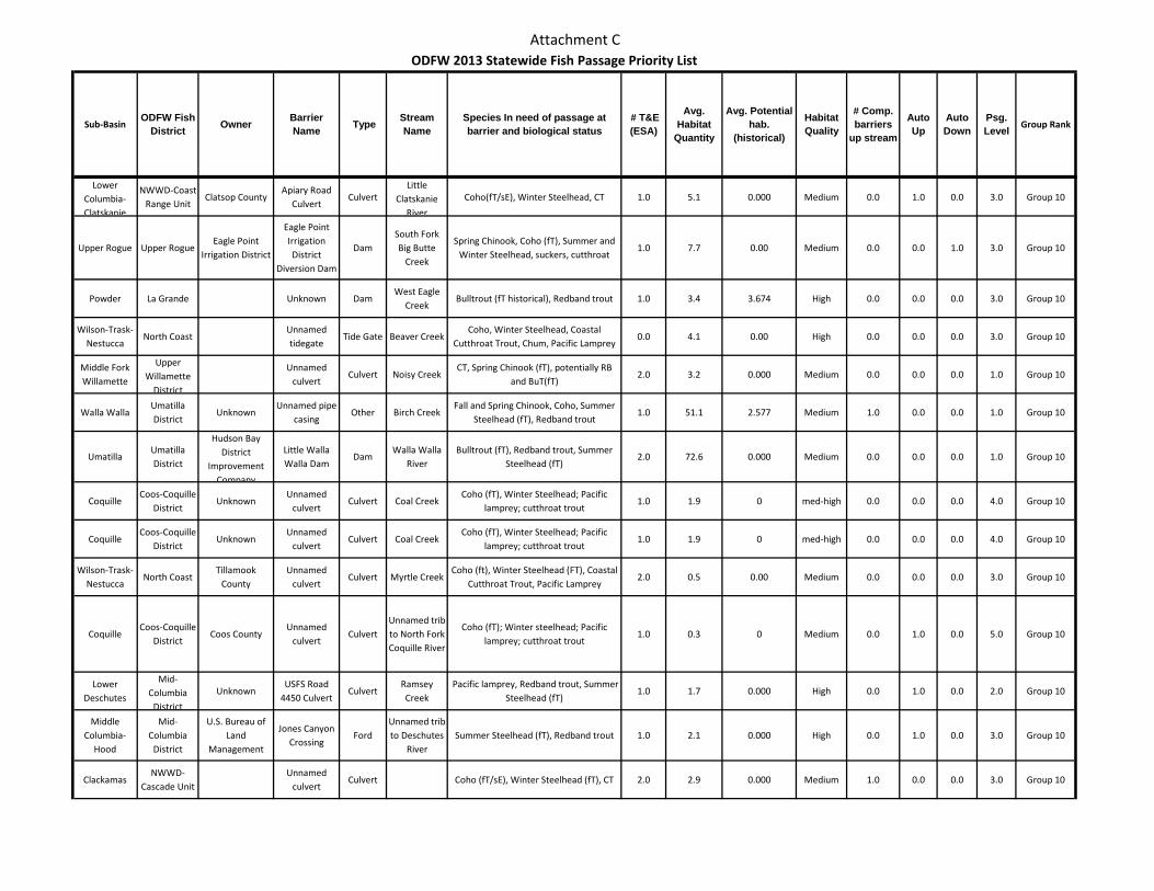
Attachment C
Sub-BasinODFW Fish
District Owner Barrier Name Type Stream
NameSpecies In need of passage at barrier and biological status
# T&E (ESA)
Avg. Habitat
Quantity
Avg. Potential hab.
(historical)
Habitat Quality
# Comp. barriers
up stream
Auto Up
Auto Down
Psg. Level Group Rank
ODFW 2013 Statewide Fish Passage Priority List
Lower Columbia-Clatskanie
NWWD-Coast Range Unit
Clatsop CountyApiary Road
CulvertCulvert
Little Clatskanie
River
Coho(fT/sE), Winter Steelhead, CT 1.0 5.1 0.000 Medium 0.0 1.0 0.0 3.0 Group 10
Upper Rogue Upper RogueEagle Point
Irrigation District
Eagle Point Irrigation District
Diversion Dam
DamSouth Fork Big Butte
Creek
Spring Chinook, Coho (fT), Summer and Winter Steelhead, suckers, cutthroat
1.0 7.7 0.00 Medium 0.0 0.0 1.0 3.0 Group 10
Powder La Grande Unknown DamWest Eagle
CreekBulltrout (fT historical), Redband trout 1.0 3.4 3.674 High 0.0 0.0 0.0 3.0 Group 10
Wilson-Trask-Nestucca
North Coast Unnamed tidegate
Tide Gate Beaver CreekCoho, Winter Steelhead, Coastal
Cutthroat Trout, Chum, Pacific Lamprey0.0 4.1 0.00 High 0.0 0.0 0.0 3.0 Group 10
Middle Fork Willamette
Upper Willamette
District
Unnamed culvert
Culvert Noisy CreekCT, Spring Chinook (fT), potentially RB
and BuT(fT)2.0 3.2 0.000 Medium 0.0 0.0 0.0 1.0 Group 10
Walla WallaUmatilla District
UnknownUnnamed pipe
casingOther Birch Creek
Fall and Spring Chinook, Coho, Summer Steelhead (fT), Redband trout
1.0 51.1 2.577 Medium 1.0 0.0 0.0 1.0 Group 10
UmatillaUmatilla District
Hudson Bay District
Improvement Company
Little Walla Walla Dam
DamWalla Walla
RiverBulltrout (fT), Redband trout, Summer
Steelhead (fT)2.0 72.6 0.000 Medium 0.0 0.0 0.0 1.0 Group 10
CoquilleCoos-Coquille
DistrictUnknown
Unnamed culvert
Culvert Coal CreekCoho (fT), Winter Steelhead; Pacific
lamprey; cutthroat trout1.0 1.9 0 med-high 0.0 0.0 0.0 4.0 Group 10
CoquilleCoos-Coquille
DistrictUnknown
Unnamed culvert
Culvert Coal CreekCoho (fT), Winter Steelhead; Pacific
lamprey; cutthroat trout1.0 1.9 0 med-high 0.0 0.0 0.0 4.0 Group 10
Wilson-Trask-Nestucca
North Coast Tillamook
CountyUnnamed
culvertCulvert Myrtle Creek
Coho (ft), Winter Steelhead (FT), Coastal Cutthroat Trout, Pacific Lamprey
2.0 0.5 0.00 Medium 0.0 0.0 0.0 3.0 Group 10
CoquilleCoos-Coquille
DistrictCoos County
Unnamed culvert
CulvertUnnamed trib to North Fork Coquille River
Coho (fT); Winter steelhead; Pacific lamprey; cutthroat trout
1.0 0.3 0 Medium 0.0 1.0 0.0 5.0 Group 10
Lower Deschutes
Mid-Columbia
District
UnknownUSFS Road
4450 CulvertCulvert
Ramsey Creek
Pacific lamprey, Redband trout, Summer Steelhead (fT)
1.0 1.7 0.000 High 0.0 1.0 0.0 2.0 Group 10
Middle Columbia-
Hood
Mid-Columbia
District
U.S. Bureau of Land
Management
Jones Canyon Crossing
FordUnnamed trib to Deschutes
RiverSummer Steelhead (fT), Redband trout 1.0 2.1 0.000 High 0.0 1.0 0.0 3.0 Group 10
ClackamasNWWD-
Cascade UnitUnnamed
culvertCulvert Coho (fT/sE), Winter Steelhead (fT), CT 2.0 2.9 0.000 Medium 1.0 0.0 0.0 3.0 Group 10
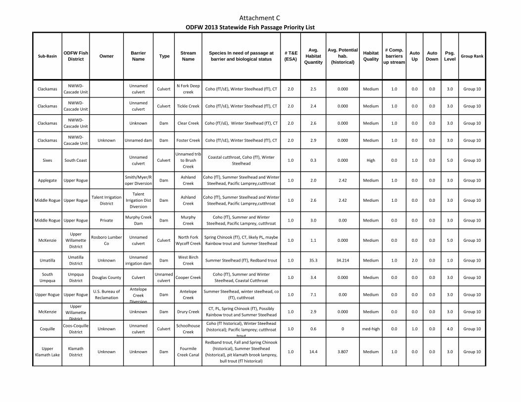
Attachment C
Sub-BasinODFW Fish
District Owner Barrier Name Type Stream
NameSpecies In need of passage at barrier and biological status
# T&E (ESA)
Avg. Habitat
Quantity
Avg. Potential hab.
(historical)
Habitat Quality
# Comp. barriers
up stream
Auto Up
Auto Down
Psg. Level Group Rank
ODFW 2013 Statewide Fish Passage Priority List
ClackamasNWWD-
Cascade UnitUnnamed
culvertCulvert
N Fork Deep creek
Coho (fT/sE), Winter Steelhead (fT), CT 2.0 2.5 0.000 Medium 1.0 0.0 0.0 3.0 Group 10
ClackamasNWWD-
Cascade UnitUnnamed
culvertCulvert Tickle Creek Coho (fT/sE), Winter Steelhead (fT), CT 2.0 2.4 0.000 Medium 1.0 0.0 0.0 3.0 Group 10
ClackamasNWWD-
Cascade UnitUnknown Dam Clear Creek Coho (fT/sE), Winter Steelhead (fT), CT 2.0 2.6 0.000 Medium 1.0 0.0 0.0 3.0 Group 10
ClackamasNWWD-
Cascade UnitUnknown Unnamed dam Dam Foster Creek Coho (fT/sE), Winter Steelhead (fT), CT 2.0 2.9 0.000 Medium 1.0 0.0 0.0 3.0 Group 10
Sixes South CoastUnnamed
culvertCulvert
Unnamed trib to Brush
Creek
Coastal cutthroat, Coho (fT), Winter Steelhead
1.0 0.3 0.000 High 0.0 1.0 0.0 5.0 Group 10
Applegate Upper RogueSmith/Myer/Roper Diversion
DamAshland
CreekCoho (fT), Summer Steelhead and Winter
Steelhead, Pacific Lamprey,cutthroat1.0 2.0 2.42 Medium 1.0 0.0 0.0 3.0 Group 10
Middle Rogue Upper RogueTalent Irrigation
District
Talent Irrigation Dist
DiversionDam
Ashland Creek
Coho (fT), Summer Steelhead and Winter Steelhead, Pacific Lamprey,cutthroat
1.0 2.6 2.42 Medium 1.0 0.0 0.0 3.0 Group 10
Middle Rogue Upper Rogue PrivateMurphy Creek
DamDam
Murphy Creek
Coho (fT), Summer and Winter Steelhead, Pacific Lamprey, cutthroat
1.0 3.0 0.00 Medium 0.0 0.0 0.0 3.0 Group 10
McKenzieUpper
Willamette District
Rosboro Lumber Co
Unnamed culvert
CulvertNorth Fork
Wycoff CreekSpring Chinook (fT), CT, likely PL, maybe Rainbow trout and Summer Steelhead
1.0 1.1 0.000 Medium 0.0 0.0 0.0 5.0 Group 10
UmatillaUmatilla District
UnknownUnnamed
irrigation damDam
West Birch Creek
Summer Steelhead (fT), Redband trout 1.0 35.3 34.214 Medium 1.0 2.0 0.0 1.0 Group 10
South Umpqua
Umpqua District
Douglas County CulvertUnnamed
culvertCooper Creek
Coho (fT), Summer and Winter Steelhead, Coastal Cutthroat
1.0 3.4 0.000 Medium 0.0 0.0 0.0 3.0 Group 10
Upper Rogue Upper RogueU.S. Bureau of Reclamation
Antelope Creek
Diversion
DamAntelope
CreekSummer Steelhead, winter steelhead, co
(fT), cutthroat1.0 7.1 0.00 Medium 0.0 0.0 0.0 3.0 Group 10
McKenzieUpper
Willamette District
Unknown Dam Drury CreekCT, PL, Spring Chinook (fT), Possibly
Rainbow trout and Summer Steelhead1.0 2.9 0.000 Medium 0.0 0.0 0.0 3.0 Group 10
CoquilleCoos-Coquille
DistrictUnknown
Unnamed culvert
CulvertSchoolhouse
Creek
Coho (fT historical), Winter Steelhead (historical); Pacific lamprey; cutthroat
trout
1.0 0.6 0 med-high 0.0 1.0 0.0 4.0 Group 10
Upper Klamath Lake
Klamath District
Unknown Unknown DamFourmile
Creek Canal
Redband trout, Fall and Spring Chinook (historical), Summer Steelhead
(historical), pit klamath brook lamprey, bull trout (fT historical)
1.0 14.4 3.807 Medium 1.0 0.0 0.0 3.0 Group 10
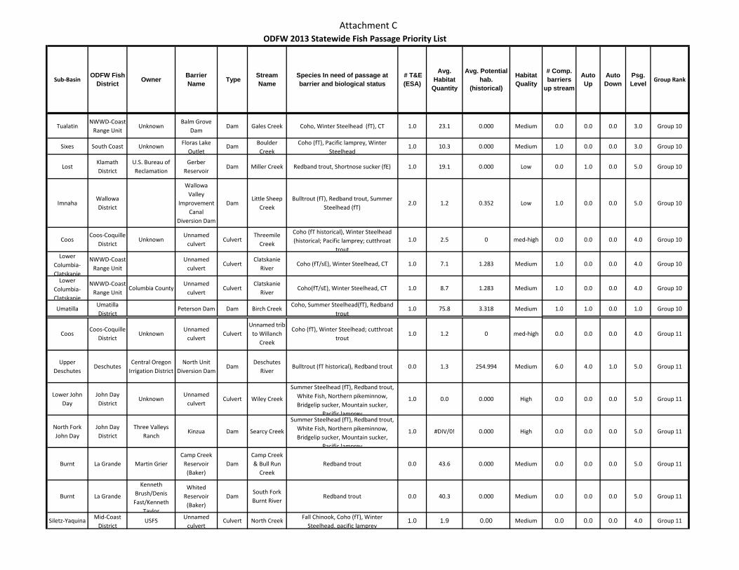
Attachment C
Sub-BasinODFW Fish
District Owner Barrier Name Type Stream
NameSpecies In need of passage at barrier and biological status
# T&E (ESA)
Avg. Habitat
Quantity
Avg. Potential hab.
(historical)
Habitat Quality
# Comp. barriers
up stream
Auto Up
Auto Down
Psg. Level Group Rank
ODFW 2013 Statewide Fish Passage Priority List
TualatinNWWD-Coast
Range UnitUnknown
Balm Grove Dam
Dam Gales Creek Coho, Winter Steelhead (fT), CT 1.0 23.1 0.000 Medium 0.0 0.0 0.0 3.0 Group 10
Sixes South Coast Unknown Floras Lake Outlet
Dam Boulder Creek
Coho (fT), Pacific lamprey, Winter Steelhead
1.0 10.3 0.000 Medium 1.0 0.0 0.0 3.0 Group 10
LostKlamath District
U.S. Bureau of Reclamation
Gerber Reservoir
Dam Miller Creek Redband trout, Shortnose sucker (fE) 1.0 19.1 0.000 Low 0.0 1.0 0.0 5.0 Group 10
ImnahaWallowa District
Wallowa Valley
Improvement Canal
Diversion Dam
DamLittle Sheep
CreekBulltrout (fT), Redband trout, Summer
Steelhead (fT)2.0 1.2 0.352 Low 1.0 0.0 0.0 5.0 Group 10
CoosCoos-Coquille
DistrictUnknown
Unnamed culvert
CulvertThreemile
Creek
Coho (fT historical), Winter Steelhead (historical; Pacific lamprey; cutthroat
trout
1.0 2.5 0 med-high 0.0 0.0 0.0 4.0 Group 10
Lower Columbia-Clatskanie
NWWD-Coast Range Unit
Unnamed culvert
CulvertClatskanie
RiverCoho (fT/sE), Winter Steelhead, CT 1.0 7.1 1.283 Medium 1.0 0.0 0.0 4.0 Group 10
Lower Columbia-Clatskanie
NWWD-Coast Range Unit
Columbia CountyUnnamed
culvertCulvert
Clatskanie River
Coho(fT/sE), Winter Steelhead, CT 1.0 8.7 1.283 Medium 1.0 0.0 0.0 4.0 Group 10
UmatillaUmatilla District
Peterson Dam Dam Birch CreekCoho, Summer Steelhead(fT), Redband
trout1.0 75.8 3.318 Medium 1.0 1.0 0.0 1.0 Group 10
CoosCoos-Coquille
DistrictUnknown
Unnamed culvert
CulvertUnnamed trib
to Willanch Creek
Coho (fT), Winter Steelhead; cutthroat trout
1.0 1.2 0 med-high 0.0 0.0 0.0 4.0 Group 11
Upper Deschutes
DeschutesCentral Oregon
Irrigation DistrictNorth Unit
Diversion DamDam
Deschutes River
Bulltrout (fT historical), Redband trout 0.0 1.3 254.994 Medium 6.0 4.0 1.0 5.0 Group 11
Lower John Day
John Day District
UnknownUnnamed
culvertCulvert Wiley Creek
Summer Steelhead (fT), Redband trout, White Fish, Northern pikeminnow, Bridgelip sucker, Mountain sucker,
Pacific lamprey
1.0 0.0 0.000 High 0.0 0.0 0.0 5.0 Group 11
North Fork John Day
John Day District
Three Valleys Ranch
Kinzua Dam Searcy Creek
Summer Steelhead (fT), Redband trout, White Fish, Northern pikeminnow, Bridgelip sucker, Mountain sucker,
Pacific lamprey
1.0 #DIV/0! 0.000 High 0.0 0.0 0.0 5.0 Group 11
Burnt La Grande Martin GrierCamp Creek
Reservoir (Baker)
DamCamp Creek & Bull Run
CreekRedband trout 0.0 43.6 0.000 Medium 0.0 0.0 0.0 5.0 Group 11
Burnt La Grande
Kenneth Brush/Denis
Fast/Kenneth Taylor
Whited Reservoir (Baker)
DamSouth Fork Burnt River
Redband trout 0.0 40.3 0.000 Medium 0.0 0.0 0.0 5.0 Group 11
Siletz-Yaquina Mid-Coast District
USFS Unnamed culvert
Culvert North Creek Fall Chinook, Coho (fT), Winter Steelhead, pacific lamprey
1.0 1.9 0.00 Medium 0.0 0.0 0.0 4.0 Group 11
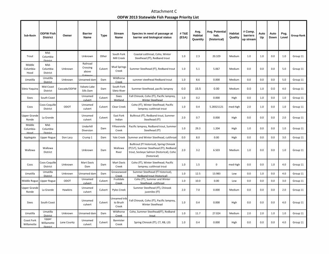
Attachment C
Sub-BasinODFW Fish
District Owner Barrier Name Type Stream
NameSpecies In need of passage at barrier and biological status
# T&E (ESA)
Avg. Habitat
Quantity
Avg. Potential hab.
(historical)
Habitat Quality
# Comp. barriers
up stream
Auto Up
Auto Down
Psg. Level Group Rank
ODFW 2013 Statewide Fish Passage Priority List
TroutMid-
Columbia District
Unknown OtherSouth Fork Mill Creek
Coastal cutthroat, Coho, Winter Steelhead (fT), Redband trout
1.0 2.3 20.329 Medium 1.0 1.0 0.0 1.0 Group 11
Middle Columbia-
Hood
Mid-Columbia
DistrictUnknown
Railroad Crossing
above Gateway
CulvertMud Springs
CreekSummer Steelhead (fT), Redband trout 1.0 5.1 5.067 Medium 0.0 0.0 0.0 5.0 Group 11
Umatilla Umatilla District
Unknown Unnamed dam Dam Wildhorse Creek
summer steelhead Redband trout 1.0 8.6 0.000 Medium 0.0 0.0 0.0 5.0 Group 11
Siletz-YaquinaMid-Coast
DistrictCascade/ODFW
Valsetz Lake Sills Dam
DamSouth Fork Siletz River
Summer Steelhead, pacific lamprey 0.0 15.5 0.00 Medium 0.0 1.0 0.0 4.0 Group 11
Sixes South Coast Unnamed culvert
Culvert Sixes Wetland
Fall Chinook, Coho (fT), Pacific lamprey, Winter Steelhead
1.0 0.2 0.000 High 0.0 1.0 0.0 1.0 Group 11
CoosCoos-Coquille
DistrictODOT
Unnamed culvert
Culvert Clear CreekCoho (fT), Winter Steelhead; Pacific
lamprey; cutthroat trout1.0 0.4 5.28321121 med-high 2.0 1.0 0.0 1.0 Group 11
Upper Grande Ronde
La GrandeUnnamed
culvertCulvert
East Fork Indian
Bulltrout (fT), Redband trout, Summer Steelhead (fT)
2.0 0.7 0.000 High 0.0 0.0 0.0 2.0 Group 11
Middle Columbia-
Hood
Mid-Columbia
District
Underhill Diversion
DamFifteenmile
Creek Pacific lamprey, Redband trout, Summer
Steelhead (fT)1.0 29.3 1.204 High 1.0 0.0 0.0 1.0 Group 11
Applegate Upper Rogue Don Lacy Crump 1 Dam Yale Creek Summer and Winter Steelhead, cutthroat 0.0 8.0 0.00 High 0.0 0.0 0.0 3.0 Group 11
WallowaWallowa District
Unknown DamWallowa
River
Bulltrout (fT historical), Spring Chinook (fT/sT), Summer Steelhead (fT), Redband trout, Sockeye Salmon (historical), Coho
(historical)
2.0 3.2 6.503 Medium 1.0 0.0 0.0 1.0 Group 11
CoosCoos-Coquille
DistrictUnknown
Mart Davis Dam
DamMart Davis
CreekCoho (fT), Winter Steelhead; Pacific
lamprey; cutthroat trout1.0 1.5 0 med-high 0.0 0.0 1.0 4.0 Group 11
Umatilla Umatilla District
Unknown Unnamed dam Dam Greasewood Creek
Summer Steelhead (fT historical), Redband trout (historical)
1.0 12.5 13.983 Low 0.0 1.0 0.0 4.0 Group 11
Middle Rogue Upper Rogue ODOT Unnamed culvert
Culvert Fruitdale Creek
Coho (fT), Summer and Winter Steelhead, cutthroat
1.0 10.0 0.00 Low 0.0 0.0 0.0 3.0 Group 11
Upper Grande Ronde
La Grande HawkinsUnnamed
culvertCulvert Pyles Creek
Summer Steelhead (fT), Chinook juveniles (fT)
2.0 7.0 0.000 Medium 0.0 0.0 0.0 2.0 Group 11
Sixes South CoastUnnamed
culvertCulvert
Unnamed trib to Brush
Creek
Fall Chinook, Coho (fT), Pacific lamprey, Winter Steelhead
1.0 0.4 0.000 High 0.0 0.0 0.0 4.0 Group 11
Umatilla Umatilla District
Unknown Unnamed dam Dam Wildhorse Creek
Coho, Summer Steelhead(fT), Redband trout
1.0 11.7 27.024 Medium 2.0 2.0 1.0 1.0 Group 11
Coast Fork Willamette
Upper Willamette
District
Lane CountyUnnamed
culvertCulvert
Bannister Creek
Spring Chinook (fT), CT, RB, LSS 1.0 0.4 0.000 High 0.0 0.0 0.0 4.0 Group 11
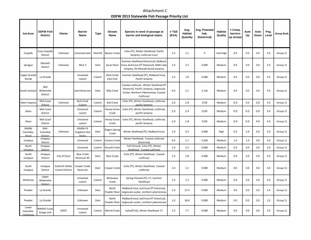
Attachment C
Sub-BasinODFW Fish
District Owner Barrier Name Type Stream
NameSpecies In need of passage at barrier and biological status
# T&E (ESA)
Avg. Habitat
Quantity
Avg. Potential hab.
(historical)
Habitat Quality
# Comp. barriers
up stream
Auto Up
Auto Down
Psg. Level Group Rank
ODFW 2013 Statewide Fish Passage Priority List
CoquilleCoos-Coquille
DistrictUnknown Unnamed weir WeirSill Beaver Creek
Coho (fT), Winter Steelhead; Pacific lamprey; cutthroat trout
1.0 1.2 0 med-high 0.0 0.0 0.0 3.0 Group 11
SpragueKlamath District
Unknown Weir 3 Dam Sycan RiverSummer Steelhead (historical), Redband trout, bull trout (fT Historical), Miller lake
lamprey, Pit-Klamath brook lamprey1.0 2.2 0.000 Medium 0.0 0.0 0.0 3.0 Group 11
Upper Grande Ronde
La GrandeUnnamed
culvertCulvert
Rock Creek East Fork
Summer Steelhead (fT), Redband trout, Pacific lamprey
1.0 1.8 0.000 Medium 0.0 0.0 0.0 5.0 Group 11
South SantiamMid
Willamette District
Jazel Reservoir Dam Billy Creek
Coastal cutthroat, Winter Steelhead (fT historical), Pacific Lamprey, Largescale Sucker, Northern Pikeminnow, Coastal
Cutthroat
0.0 2.1 2.142 Medium 0.0 0.0 0.0 5.0 Group 11
Siletz-Yaquina Mid-Coast District
Unknown Bull Creek Culvert
Culvert Bull Creek Coho (fT), Winter Steelhead, cutthroat, pacific lamprey
1.0 1.9 0.00 Medium 0.0 0.0 0.0 3.0 Group 11
AlseaMid-Coast
DistrictUnnamed
culvertCulvert
Honey Grove Creek
Coho (fT), Winter Steelhead, cutthroat, pacific lamprey
1.0 2.4 0.00 Medium 0.0 0.0 0.0 3.0 Group 11
AlseaMid-Coast
DistrictUnnamed
culvertCulvert
Honey Grove Creek
Coho (fT), Winter Steelhead, cutthroat, pacific lamprey
1.0 1.9 0.00 Medium 0.0 0.0 0.0 3.0 Group 11
Middle Columbia-
Hood
Mid-Columbia
District
UnknownMiddle Fk
Irrigation Dist Hydro
DamRogers Spring
CreekWinter Steelhead (fT), Redband trout 1.0 0.3 0.000 High 0.0 1.0 0.0 5.0 Group 11
UmpquaUmpqua District
Unnamed Culvert Canyon CreekWinter Steelhead, Coastal cutthroat
(historical)0.0 5.1 5.636 Medium 1.0 1.0 0.0 5.0 Group 11
North Umpqua
Umpqua District
Unnamed Culvert Russell Creek Fall Chinook, Coho (fT), Winter Steelhead, Coastal cutthroat
1.0 2.5 0.000 Medium 0.0 0.0 0.0 3.0 Group 11
South Umpqua
Umpqua District
City of DrainBear Creek
Reservoir #3Dam Bear Creek
Coho (fT), Winter Steelhead, Coastal cutthroat
1.0 2.8 0.000 Medium 0.0 0.0 0.0 5.0 Group 11
South Umpqua
Umpqua District
Sutherlin Water Control District
Cooper Creek Reservoir
Dam Cooper CreekCoho (fT), Winter Steelhead, Coastal
cutthroat 1.0 1.2 0.000 Medium 0.0 0.0 0.0 5.0 Group 11
McKenzieUpper
Willamette District
Unnamed culvert
CulvertMcGowan
CreekSpring Chinook (fT), CT, Summer
Steelhead1.0 1.2 0.000 Medium 0.0 0.0 0.0 5.0 Group 11
Powder La Grande Unknown DamNorth
Powder RiverRedband trout, bull trout (fT historical), largescale sucker, northern pikeminnow
1.0 27.4 0.000 Medium 0.0 0.0 0.0 1.0 Group 11
Powder La Grande Unknown DamNorth
Powder RiverRedband trout, bull trout (fT historical), largescale sucker, northern pikeminnow
1.0 26.8 0.000 Medium 0.0 0.0 0.0 1.0 Group 11
Lower Columbia-Clatskanie
NWWD-Coast Range Unit
ODOTUnnamed
culvertCulvert Merrill Creek Coho(fT/sE), Winter Steelhead, CT 1.0 7.7 0.000 Medium 0.0 0.0 0.0 3.0 Group 11
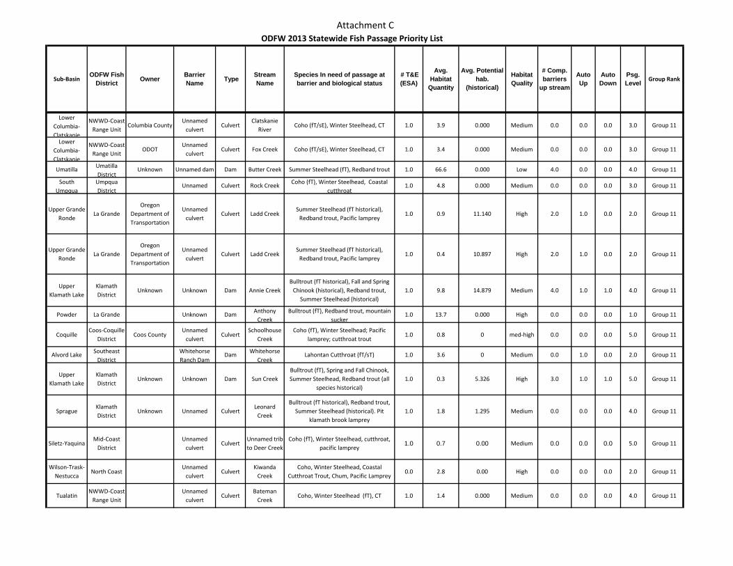
Attachment C
Sub-BasinODFW Fish
District Owner Barrier Name Type Stream
NameSpecies In need of passage at barrier and biological status
# T&E (ESA)
Avg. Habitat
Quantity
Avg. Potential hab.
(historical)
Habitat Quality
# Comp. barriers
up stream
Auto Up
Auto Down
Psg. Level Group Rank
ODFW 2013 Statewide Fish Passage Priority List
Lower Columbia-Clatskanie
NWWD-Coast Range Unit
Columbia CountyUnnamed
culvertCulvert
Clatskanie River
Coho (fT/sE), Winter Steelhead, CT 1.0 3.9 0.000 Medium 0.0 0.0 0.0 3.0 Group 11
Lower Columbia-Clatskanie
NWWD-Coast Range Unit
ODOTUnnamed
culvertCulvert Fox Creek Coho (fT/sE), Winter Steelhead, CT 1.0 3.4 0.000 Medium 0.0 0.0 0.0 3.0 Group 11
Umatilla Umatilla District
Unknown Unnamed dam Dam Butter Creek Summer Steelhead (fT), Redband trout 1.0 66.6 0.000 Low 4.0 0.0 0.0 4.0 Group 11
South Umpqua
Umpqua District
Unnamed Culvert Rock Creek Coho (fT), Winter Steelhead, Coastal cutthroat
1.0 4.8 0.000 Medium 0.0 0.0 0.0 3.0 Group 11
Upper Grande Ronde
La GrandeOregon
Department of Transportation
Unnamed culvert
Culvert Ladd CreekSummer Steelhead (fT historical),
Redband trout, Pacific lamprey1.0 0.9 11.140 High 2.0 1.0 0.0 2.0 Group 11
Upper Grande Ronde
La GrandeOregon
Department of Transportation
Unnamed culvert
Culvert Ladd CreekSummer Steelhead (fT historical),
Redband trout, Pacific lamprey1.0 0.4 10.897 High 2.0 1.0 0.0 2.0 Group 11
Upper Klamath Lake
Klamath District
Unknown Unknown Dam Annie CreekBulltrout (fT historical), Fall and Spring
Chinook (historical), Redband trout, Summer Steelhead (historical)
1.0 9.8 14.879 Medium 4.0 1.0 1.0 4.0 Group 11
Powder La Grande Unknown Dam Anthony Creek
Bulltrout (fT), Redband trout, mountain sucker
1.0 13.7 0.000 High 0.0 0.0 0.0 1.0 Group 11
CoquilleCoos-Coquille
DistrictCoos County
Unnamed culvert
CulvertSchoolhouse
CreekCoho (fT), Winter Steelhead; Pacific
lamprey; cutthroat trout1.0 0.8 0 med-high 0.0 0.0 0.0 5.0 Group 11
Alvord Lake Southeast District
Whitehorse Ranch Dam
Dam Whitehorse Creek
Lahontan Cutthroat (fT/sT) 1.0 3.6 0 Medium 0.0 1.0 0.0 2.0 Group 11
Upper Klamath Lake
Klamath District
Unknown Unknown Dam Sun CreekBulltrout (fT), Spring and Fall Chinook, Summer Steelhead, Redband trout (all
species historical)1.0 0.3 5.326 High 3.0 1.0 1.0 5.0 Group 11
SpragueKlamath District
Unknown Unnamed CulvertLeonard
Creek
Bulltrout (fT historical), Redband trout, Summer Steelhead (historical). Pit
klamath brook lamprey1.0 1.8 1.295 Medium 0.0 0.0 0.0 4.0 Group 11
Siletz-YaquinaMid-Coast
DistrictUnnamed
culvertCulvert
Unnamed trib to Deer Creek
Coho (fT), Winter Steelhead, cutthroat, pacific lamprey
1.0 0.7 0.00 Medium 0.0 0.0 0.0 5.0 Group 11
Wilson-Trask-Nestucca
North Coast Unnamed
culvertCulvert
Kiwanda Creek
Coho, Winter Steelhead, Coastal Cutthroat Trout, Chum, Pacific Lamprey
0.0 2.8 0.00 High 0.0 0.0 0.0 2.0 Group 11
TualatinNWWD-Coast
Range UnitUnnamed
culvertCulvert
Bateman Creek
Coho, Winter Steelhead (fT), CT 1.0 1.4 0.000 Medium 0.0 0.0 0.0 4.0 Group 11
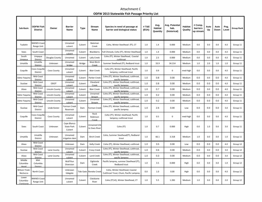
Attachment C
Sub-BasinODFW Fish
District Owner Barrier Name Type Stream
NameSpecies In need of passage at barrier and biological status
# T&E (ESA)
Avg. Habitat
Quantity
Avg. Potential hab.
(historical)
Habitat Quality
# Comp. barriers
up stream
Auto Up
Auto Down
Psg. Level Group Rank
ODFW 2013 Statewide Fish Passage Priority List
TualatinNWWD-Coast
Range UnitUnnamed
culvertCulvert
Bateman Creek
Coho, Winter Steelhead (fT), CT 1.0 1.4 0.000 Medium 0.0 0.0 0.0 4.0 Group 11
Sixes South Coast Unnamed culvert
Culvert Blackberry Fall Chinook, Coho (fT), Winter Steelhead 1.0 1.4 0.000 Medium 0.0 0.0 0.0 4.0 Group 11
South Umpqua
Umpqua District
Douglas County Unnamed Culvert Lally Creek Coho (fT), Winter Steelhead, Coastal cutthroat
1.0 2.5 0.000 Medium 0.0 0.0 0.0 4.0 Group 11
Umatilla Umatilla District
Unknown Unnamed bridge
Bridge West Birch Creek
Summer Steelhead (fT), Redband trout 1.0 33.9 34.214 Medium 1.0 2.0 1.0 1.0 Group 11
CoquilleCoos-Coquille
DistrictCoos County
Unnamed culvert
Culvert Blair CreekCoho (fT), Winter Steelhead; Pacific
lamprey; cutthroat trout1.0 0.9 0 med-high 0.0 0.0 0.0 4.0 Group 11
Siletz-Yaquina Mid-Coast District
Unnamed culvert
Culvert Parker Creek Coho (fT), Winter Steelhead, cutthroat, pacific lamprey
1.0 0.8 0.00 Medium 0.0 0.0 0.0 4.0 Group 11
Siuslaw Mid-Coast District
ODOT Unnamed culvert
Culvert Cleveland Creek
Coho (fT), Winter Steelhead, cutthroat, pacific lamprey
1.0 0.8 0.00 Medium 0.0 0.0 0.0 4.0 Group 11
Alsea Mid-Coast District
Lincoln County Unnamed culvert
Culvert Blair Creek Coho (fT), Winter Steelhead, cutthroat, pacific lamprey
1.0 0.7 0.00 Medium 0.0 0.0 0.0 4.0 Group 11
Siletz-Yaquina Mid-Coast District
Lincoln County Unnamed culvert
Culvert Unnamed Stream
Coho (fT), Winter Steelhead, cutthroat, pacific lamprey
1.0 0.2 0.00 Medium 0.0 0.0 0.0 4.0 Group 11
Siletz-Yaquina Mid-Coast District
Lincoln County Unnamed culvert
Culvert Unnamed Stream
Coho (fT), Winter Steelhead, cutthroat, pacific lamprey
1.0 0.2 0.00 Medium 0.0 0.0 0.0 4.0 Group 11
SiuslawMid-Coast
DistrictLinde Kester
Farman Creek Reservoir
Dam Farman CreekCoho (fT), Winter Steelhead, cutthroat,
pacific lamprey1.0 2.6 0.00 Low 0.0 0.0 0.0 3.0 Group 11
CoquilleCoos-Coquille
DistrictCoos County
Unnamed culvert
CulvertRock
Robinson Creek
Coho (fT); Winter steelhead; Pacific lamprey; cutthroat trout
1.0 0.5 0 med-high 0.0 0.0 0.0 4.0 Group 11
Sixes South Coast UnknownCape Blanco State Park
CulvertCulvert
Unnamed trib to Sixes River
Coho (fT) 1.0 0.7 0.000 High 0.0 1.0 0.0 3.0 Group 11
UmatillaUmatilla District
UnknownUnnamed
irrigation damDam Birch Creek
Coho, Summer Steelhead(fT), Redband trout
1.0 66.1 3.318 Medium 1.0 0.0 0.0 1.0 Group 11
AlseaMid-Coast
DistrictUnknown Dam Kelly Creek Coho (fT), Winter Steelhead, cutthroat 1.0 3.5 0.00 Low 0.0 0.0 0.0 4.0 Group 12
Siuslaw Mid-Coast District
Lane County Unnamed culvert
Culvert Crazy Creek Coho (fT), Winter Steelhead, cutthroat, pacific lamprey
1.0 0.6 0.00 Medium 0.0 0.0 0.0 3.0 Group 12
Alsea Mid-Coast District
Lane County Unnamed culvert
Culvert Lord Creek Coho (fT), Winter Steelhead, cutthroat, pacific lamprey
1.0 0.3 0.00 Medium 0.0 0.0 0.0 3.0 Group 12
Middle Columbia-
Hood
Mid-Columbia
District
Wolf Run Diversion
DamEightmile
CreekPacific lamprey, summer Steelhead (fT),
Redband trout1.0 3.5 0.000 High 0.0 0.0 0.0 1.0 Group 12
Wilson-Trask-Nestucca
North Coast Unknown tidegate
Tide Gate Reneke CreekCoho, Winter Steelhead, Coastal
Cutthroat Trout, Chum, Pacific Lamprey0.0 1.0 0.00 High 0.0 0.0 0.0 4.0 Group 12
Lower Columbia-Clatskanie
NWWD-Coast Range Unit
Unnamed culvert
CulvertClatskanie
RiverCoho (fT/sE), Winter Steelhead, CT 1.0 5.5 1.283 Medium 1.0 0.0 0.0 2.0 Group 12
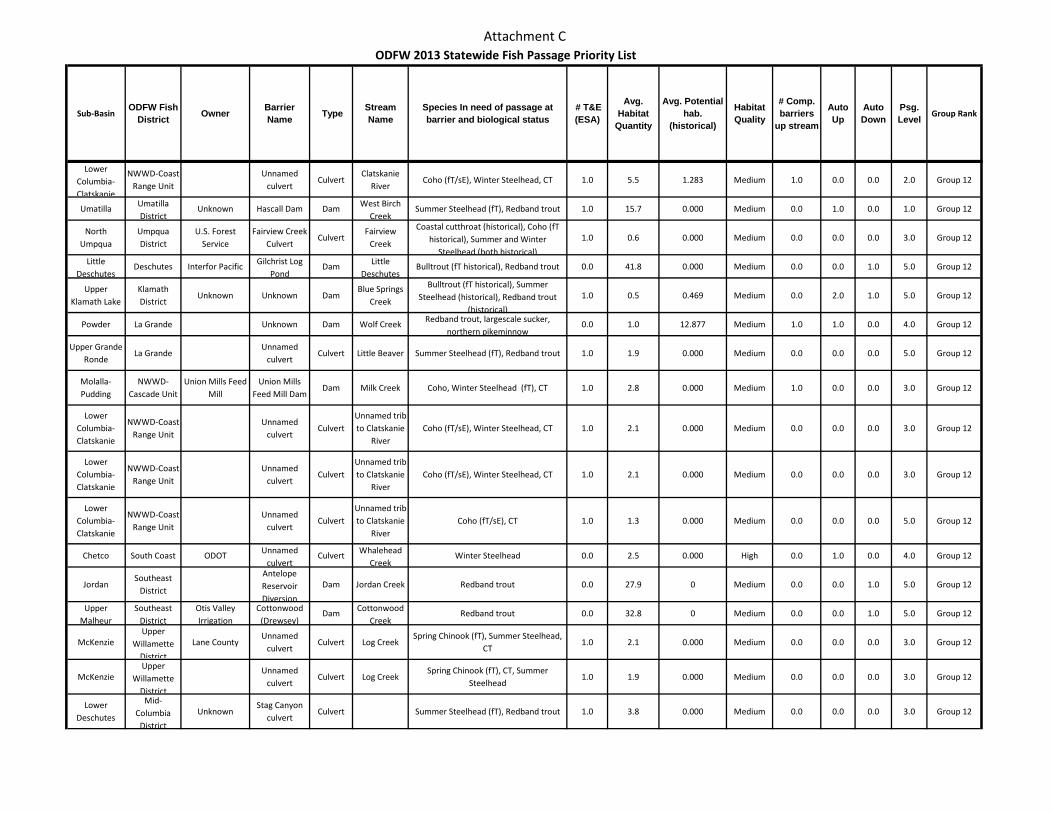
Attachment C
Sub-BasinODFW Fish
District Owner Barrier Name Type Stream
NameSpecies In need of passage at barrier and biological status
# T&E (ESA)
Avg. Habitat
Quantity
Avg. Potential hab.
(historical)
Habitat Quality
# Comp. barriers
up stream
Auto Up
Auto Down
Psg. Level Group Rank
ODFW 2013 Statewide Fish Passage Priority List
Lower Columbia-Clatskanie
NWWD-Coast Range Unit
Unnamed culvert
CulvertClatskanie
RiverCoho (fT/sE), Winter Steelhead, CT 1.0 5.5 1.283 Medium 1.0 0.0 0.0 2.0 Group 12
Umatilla Umatilla District
Unknown Hascall Dam Dam West Birch Creek
Summer Steelhead (fT), Redband trout 1.0 15.7 0.000 Medium 0.0 1.0 0.0 1.0 Group 12
North Umpqua
Umpqua District
U.S. Forest Service
Fairview Creek Culvert
CulvertFairview
Creek
Coastal cutthroat (historical), Coho (fT historical), Summer and Winter
Steelhead (both historical)
1.0 0.6 0.000 Medium 0.0 0.0 0.0 3.0 Group 12
Little Deschutes
Deschutes Interfor Pacific Gilchrist Log Pond
Dam Little Deschutes
Bulltrout (fT historical), Redband trout 0.0 41.8 0.000 Medium 0.0 0.0 1.0 5.0 Group 12
Upper Klamath Lake
Klamath District
Unknown Unknown DamBlue Springs
Creek
Bulltrout (fT historical), Summer Steelhead (historical), Redband trout
(historical)
1.0 0.5 0.469 Medium 0.0 2.0 1.0 5.0 Group 12
Powder La Grande Unknown Dam Wolf Creek Redband trout, largescale sucker, northern pikeminnow
0.0 1.0 12.877 Medium 1.0 1.0 0.0 4.0 Group 12
Upper Grande Ronde
La GrandeUnnamed
culvertCulvert Little Beaver Summer Steelhead (fT), Redband trout 1.0 1.9 0.000 Medium 0.0 0.0 0.0 5.0 Group 12
Molalla-Pudding
NWWD-Cascade Unit
Union Mills Feed Mill
Union Mills Feed Mill Dam
Dam Milk Creek Coho, Winter Steelhead (fT), CT 1.0 2.8 0.000 Medium 1.0 0.0 0.0 3.0 Group 12
Lower Columbia-Clatskanie
NWWD-Coast Range Unit
Unnamed culvert
CulvertUnnamed trib to Clatskanie
RiverCoho (fT/sE), Winter Steelhead, CT 1.0 2.1 0.000 Medium 0.0 0.0 0.0 3.0 Group 12
Lower Columbia-Clatskanie
NWWD-Coast Range Unit
Unnamed culvert
CulvertUnnamed trib to Clatskanie
RiverCoho (fT/sE), Winter Steelhead, CT 1.0 2.1 0.000 Medium 0.0 0.0 0.0 3.0 Group 12
Lower Columbia-Clatskanie
NWWD-Coast Range Unit
Unnamed culvert
CulvertUnnamed trib to Clatskanie
RiverCoho (fT/sE), CT 1.0 1.3 0.000 Medium 0.0 0.0 0.0 5.0 Group 12
Chetco South Coast ODOT Unnamed culvert
Culvert Whalehead Creek
Winter Steelhead 0.0 2.5 0.000 High 0.0 1.0 0.0 4.0 Group 12
JordanSoutheast
District
Antelope Reservoir Diversion
Dam Jordan Creek Redband trout 0.0 27.9 0 Medium 0.0 0.0 1.0 5.0 Group 12
Upper Malheur
Southeast District
Otis Valley Irrigation
Cottonwood (Drewsey)
Dam Cottonwood Creek
Redband trout 0.0 32.8 0 Medium 0.0 0.0 1.0 5.0 Group 12
McKenzieUpper
Willamette District
Lane CountyUnnamed
culvertCulvert Log Creek
Spring Chinook (fT), Summer Steelhead, CT
1.0 2.1 0.000 Medium 0.0 0.0 0.0 3.0 Group 12
McKenzieUpper
Willamette District
Unnamed culvert
Culvert Log CreekSpring Chinook (fT), CT, Summer
Steelhead1.0 1.9 0.000 Medium 0.0 0.0 0.0 3.0 Group 12
Lower Deschutes
Mid-Columbia
District
UnknownStag Canyon
culvertCulvert Summer Steelhead (fT), Redband trout 1.0 3.8 0.000 Medium 0.0 0.0 0.0 3.0 Group 12
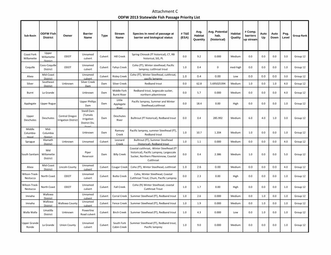
Attachment C
Sub-BasinODFW Fish
District Owner Barrier Name Type Stream
NameSpecies In need of passage at barrier and biological status
# T&E (ESA)
Avg. Habitat
Quantity
Avg. Potential hab.
(historical)
Habitat Quality
# Comp. barriers
up stream
Auto Up
Auto Down
Psg. Level Group Rank
ODFW 2013 Statewide Fish Passage Priority List
Coast Fork Willamette
Upper Willamette
District
ODOTUnnamed
culvertCulvert Hill Creek
Spring Chinook (fT historical), CT, RB historical, StS, PL
0.0 9.2 0.000 Medium 0.0 0.0 0.0 3.0 Group 12
CoquilleCoos-Coquille
DistrictODOT
Unnamed culvert
Culvert Fahys CreekCoho (fT); Winter steelhead; Pacific
lamprey; cutthroat trout1.0 0.4 0 med-high 0.0 0.0 0.0 1.0 Group 12
Alsea Mid-Coast District
Unnamed culvert
Culvert Risley Creek Coho (fT), Winter Steelhead, cutthroat, pacific lamprey
1.0 0.4 0.00 Low 0.0 0.0 0.0 3.0 Group 12
Silver Southeast District
Unknown Silver Creek Dam
Dam Silver Creek Redband trout 0.0 62.8 5.695025394 Medium 1.0 0.0 1.0 4.0 Group 12
Burnt La Grande Unknown DamMiddle Fork Burnt River
Redband trout, largescale sucker, northern pikeminnow
0.0 5.7 0.000 Medium 0.0 0.0 0.0 4.0 Group 12
Applegate Upper RogueUpper Phillips
DamDam
Little Applegate
River
Pacific lamprey, Summer and Winter Steelhead,cutthroat
0.0 18.4 0.00 High 0.0 0.0 0.0 1.0 Group 12
Upper Deschutes
DeschutesCentral Oregon
Irrigation District
Steidl Dam (Tumalo Irrigation
District Div. Dam)
DamDeschutes
RiverBulltrout (fT historical), Redband trout 0.0 0.4 285.992 Medium 6.0 4.0 1.0 3.0 Group 12
Middle Columbia-
Hood
Mid-Columbia
District
Unknown DamRamsey Creek
Pacific lamprey, summer Steelhead (fT), Redband trout
1.0 10.7 1.204 Medium 1.0 0.0 0.0 1.0 Group 12
Sprague Klamath District
Unknown Unnamed Culvert Leonard Creek
Bulltrout (fT), Summer Steelhead (historical), Redband trout
1.0 1.1 0.000 Medium 0.0 0.0 0.0 4.0 Group 12
South SantiamMid
Willamette District
Piper Reservoir
Dam Billy Creek
Coastal cutthroat, Winter Steelhead (fT historical), Pacific Lamprey, Largescale Sucker, Northern Pikeminnow, Coastal
Cutthroat
0.0 0.4 2.386 Medium 1.0 0.0 0.0 5.0 Group 12
Alsea Mid-Coast District
Lincoln County Unnamed culvert
Culvert Cougar Creek Coho (fT), Winter Steelhead, cutthroat 1.0 2.6 0.00 Medium 0.0 0.0 0.0 4.0 Group 12
Wilson-Trask-Nestucca
North Coast ODOTUnnamed
culvertCulvert Butte Creek
Coho, Winter Steelhead, Coastal Cutthroat Trout, Chum, Pacific Lamprey
0.0 2.3 0.00 High 0.0 0.0 0.0 1.0 Group 12
Wilson-Trask-Nestucca
North Coast ODOTUnnamed
culvertCulvert Fall Creek
Coho (ft) Winter Steelhead, coastal Cutthroat Trout
1.0 1.7 0.00 High 0.0 0.0 0.0 1.0 Group 12
Imnaha Wallowa District
Unnamed culvert
Culvert Corral Creek Summer Steelhead (fT), Redband trout 1.0 2.6 0.000 Medium 0.0 1.0 0.0 1.0 Group 12
Imnaha Wallowa District
Wallowa County Unnamed culvert
Culvert Fence Creek Summer Steelhead (fT), Redband trout 1.0 1.9 0.000 Medium 0.0 1.0 0.0 1.0 Group 12
Walla WallaUmatilla District
UnknownPowerline
Road culvertCulvert Birch Creek Summer Steelhead (fT), Redband trout 1.0 4.3 0.000 Low 0.0 1.0 0.0 1.0 Group 12
Upper Grande Ronde
La Grande Union CountyUnnamed
culvertCulvert
South Fork Cabin Creek
Summer Steelhead (fT), Redband trout, Pacific lamprey
1.0 9.0 0.000 Medium 0.0 0.0 0.0 1.0 Group 12
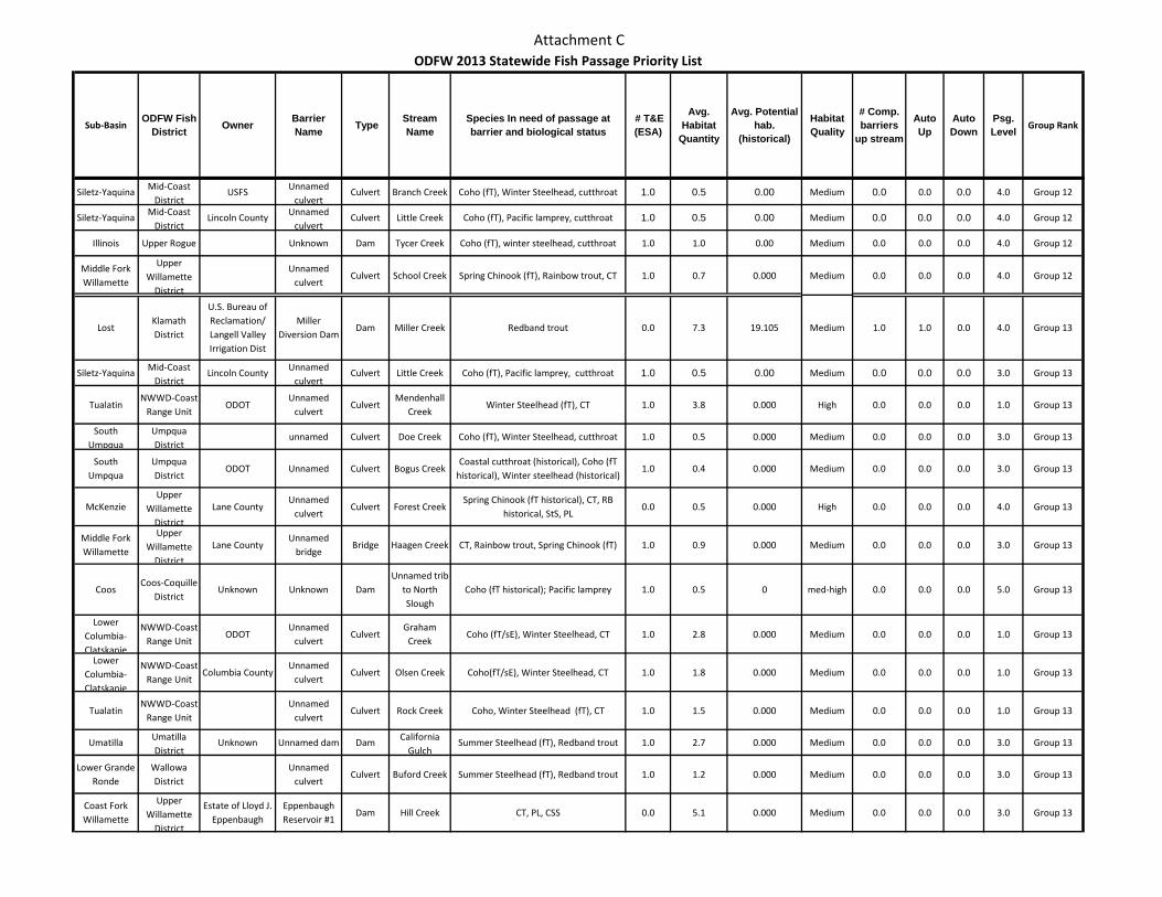
Attachment C
Sub-BasinODFW Fish
District Owner Barrier Name Type Stream
NameSpecies In need of passage at barrier and biological status
# T&E (ESA)
Avg. Habitat
Quantity
Avg. Potential hab.
(historical)
Habitat Quality
# Comp. barriers
up stream
Auto Up
Auto Down
Psg. Level Group Rank
ODFW 2013 Statewide Fish Passage Priority List
Siletz-Yaquina Mid-Coast District
USFS Unnamed culvert
Culvert Branch Creek Coho (fT), Winter Steelhead, cutthroat 1.0 0.5 0.00 Medium 0.0 0.0 0.0 4.0 Group 12
Siletz-Yaquina Mid-Coast District
Lincoln County Unnamed culvert
Culvert Little Creek Coho (fT), Pacific lamprey, cutthroat 1.0 0.5 0.00 Medium 0.0 0.0 0.0 4.0 Group 12
Illinois Upper Rogue Unknown Dam Tycer Creek Coho (fT), winter steelhead, cutthroat 1.0 1.0 0.00 Medium 0.0 0.0 0.0 4.0 Group 12
Middle Fork Willamette
Upper Willamette
District
Unnamed culvert
Culvert School Creek Spring Chinook (fT), Rainbow trout, CT 1.0 0.7 0.000 Medium 0.0 0.0 0.0 4.0 Group 12
LostKlamath District
U.S. Bureau of Reclamation/ Langell Valley Irrigation Dist
Miller Diversion Dam
Dam Miller Creek Redband trout 0.0 7.3 19.105 Medium 1.0 1.0 0.0 4.0 Group 13
Siletz-Yaquina Mid-Coast District
Lincoln County Unnamed culvert
Culvert Little Creek Coho (fT), Pacific lamprey, cutthroat 1.0 0.5 0.00 Medium 0.0 0.0 0.0 3.0 Group 13
TualatinNWWD-Coast
Range UnitODOT
Unnamed culvert
CulvertMendenhall
CreekWinter Steelhead (fT), CT 1.0 3.8 0.000 High 0.0 0.0 0.0 1.0 Group 13
South Umpqua
Umpqua District
unnamed Culvert Doe Creek Coho (fT), Winter Steelhead, cutthroat 1.0 0.5 0.000 Medium 0.0 0.0 0.0 3.0 Group 13
South Umpqua
Umpqua District
ODOT Unnamed Culvert Bogus CreekCoastal cutthroat (historical), Coho (fT
historical), Winter steelhead (historical)1.0 0.4 0.000 Medium 0.0 0.0 0.0 3.0 Group 13
McKenzieUpper
Willamette District
Lane CountyUnnamed
culvertCulvert Forest Creek
Spring Chinook (fT historical), CT, RB historical, StS, PL
0.0 0.5 0.000 High 0.0 0.0 0.0 4.0 Group 13
Middle Fork Willamette
Upper Willamette
District
Lane CountyUnnamed
bridgeBridge Haagen Creek CT, Rainbow trout, Spring Chinook (fT) 1.0 0.9 0.000 Medium 0.0 0.0 0.0 3.0 Group 13
CoosCoos-Coquille
DistrictUnknown Unknown Dam
Unnamed trib to North Slough
Coho (fT historical); Pacific lamprey 1.0 0.5 0 med-high 0.0 0.0 0.0 5.0 Group 13
Lower Columbia-Clatskanie
NWWD-Coast Range Unit
ODOTUnnamed
culvertCulvert
Graham Creek
Coho (fT/sE), Winter Steelhead, CT 1.0 2.8 0.000 Medium 0.0 0.0 0.0 1.0 Group 13
Lower Columbia-Clatskanie
NWWD-Coast Range Unit
Columbia CountyUnnamed
culvertCulvert Olsen Creek Coho(fT/sE), Winter Steelhead, CT 1.0 1.8 0.000 Medium 0.0 0.0 0.0 1.0 Group 13
TualatinNWWD-Coast
Range UnitUnnamed
culvertCulvert Rock Creek Coho, Winter Steelhead (fT), CT 1.0 1.5 0.000 Medium 0.0 0.0 0.0 1.0 Group 13
Umatilla Umatilla District
Unknown Unnamed dam Dam California Gulch
Summer Steelhead (fT), Redband trout 1.0 2.7 0.000 Medium 0.0 0.0 0.0 3.0 Group 13
Lower Grande Ronde
Wallowa District
Unnamed culvert
Culvert Buford Creek Summer Steelhead (fT), Redband trout 1.0 1.2 0.000 Medium 0.0 0.0 0.0 3.0 Group 13
Coast Fork Willamette
Upper Willamette
District
Estate of Lloyd J. Eppenbaugh
Eppenbaugh Reservoir #1
Dam Hill Creek CT, PL, CSS 0.0 5.1 0.000 Medium 0.0 0.0 0.0 3.0 Group 13

Attachment C
Sub-BasinODFW Fish
District Owner Barrier Name Type Stream
NameSpecies In need of passage at barrier and biological status
# T&E (ESA)
Avg. Habitat
Quantity
Avg. Potential hab.
(historical)
Habitat Quality
# Comp. barriers
up stream
Auto Up
Auto Down
Psg. Level Group Rank
ODFW 2013 Statewide Fish Passage Priority List
CoquilleCoos-Coquille
DistrictUnknown
Unnamed culvert
Culvert Blair CreekCoho (fT), Winter Steelhead; Pacific
lamprey; cutthroat trout1.0 0.6 0 med-high 0.0 0.0 1.0 4.0 Group 13
Powder La Grande Unknown Dam Wolf Creek Redband trout, largescale sucker, northern pikeminnow
0.0 3.0 25.755 Medium 1.0 1.0 0.0 1.0 Group 13
Upper Willamette
Mid Willamette
District
Waverly Lake Dam
Dam Cox Creek
Spring Chinook (fT historical), Winter Steelhead (fT historical), Pacific Lamprey,
Coastal Cutthroat, Largescale Sucker, Northern Pikeminnow
0.0 1.7 0.000 Low 0.0 0.0 0.0 5.0 Group 13
Powder La Grande Unknown DamNorth
Powder RiverRedband trout, largescale sucker,
northern pikeminnow0.0 11.4 0.000 Medium 0.0 0.0 0.0 2.0 Group 13
North Umpqua
Umpqua District
ODOT Unnamed Culvert Canyon Creek Winter Steelhead (historical), Cutthroat(historical)
0.0 4.0 4.537 Medium 1.0 0.0 0.0 4.0 Group 13
South Umpqua
Umpqua District
Unnamed CulvertNewton Creek
Coho (fT historical), Winter Steelhead (historical), Coastal cutthroat
1.0 4.5 0.000 Medium 0.0 0.0 1.0 2.0 Group 13
Wallowa Wallowa District
Wallowa County Unnamed culvert
Culvert Whisky Creek Summer Steelhead (fT), Redband trout 1.0 10.8 0.000 Medium 0.0 0.0 0.0 1.0 Group 13
Lake AbertKlamath District
UnknownCrooked Creek
HeadcutsOther
Crooked Creek
Redband trout 0.0 3.1 30.712 Medium 2.0 1.0 1.0 5.0 Group 13
Upper Klamath Lake
Klamath District
Unknown Unknown Dam Agency Creek Bulltrout (fT historical), Redband trout 1.0 0.1 0.000 Medium 0.0 0.0 0.0 5.0 Group 13
Burnt La Grande Unknown Dam Trout Creek Redband trout 0.0 6.4 0.000 Medium 0.0 0.0 0.0 5.0 Group 13
AlseaMid-Coast
DistrictGygi & Engel
Gygi & Engel Reservoir
Dam Banton Creek Coastal cutthroat (historical), Coho (fT) 1.0 0.6 0.00 Medium 0.0 0.0 0.0 5.0 Group 13
Lower Columbia-
Sandy
NWWD-Cascade Unit
UnknownUnnamed
barrierOther
Minikahda Creek
Coho (fT/sE), Pacific lamprey, CT 1.0 0.0 0.000 Medium 1.0 0.0 0.0 3.0 Group 13
Sixes South Coast ODOT Unnamed culvert
Culvert Jim Creek Coho (fT), Winter Steelhead 1.0 0.2 0.000 Medium 0.0 0.0 0.0 5.0 Group 13
Silver Southeast District
Unknown Dam Dairy Creek Redband trout 0.0 5.7 0 Medium 0.0 0.0 0.0 5.0 Group 13
Umatilla Umatilla District
Umatilla County Unnamed culvert
Culvert Bridge Creek Summer Steelhead (fT), Redband trout 1.0 2.7 0.000 Medium 0.0 0.0 1.0 5.0 Group 13
North Umpqua
Umpqua District
unnamed Culvert Bilger Creek Coho (fT), Winter Steelhead, Coastal cutthroat
1.0 1.7 0.000 Medium 0.0 0.0 1.0 3.0 Group 13
ImnahaWallowa District
Camp Creek Ditch Push-up
damDam Camp Creek Redband trout, Summer Steelhead (fT) 1.0 8.1 0.000 Medium 0.0 0.0 1.0 3.0 Group 13
Siltcoos Mid-Coast District
USFS Unnamed culvert
Culvert Carter Creek Coho (fT), cutthrout 1.0 0.3 0.00 Medium 0.0 0.0 0.0 4.0 Group 13
Lower Columbia-Clatskanie
NWWD-Coast Range Unit
Columbia CountyUnnamed
culvertCulvert
Keystone Creek
Coho (fT/sE), CT 1.0 0.9 0.000 Medium 0.0 0.0 0.0 4.0 Group 13
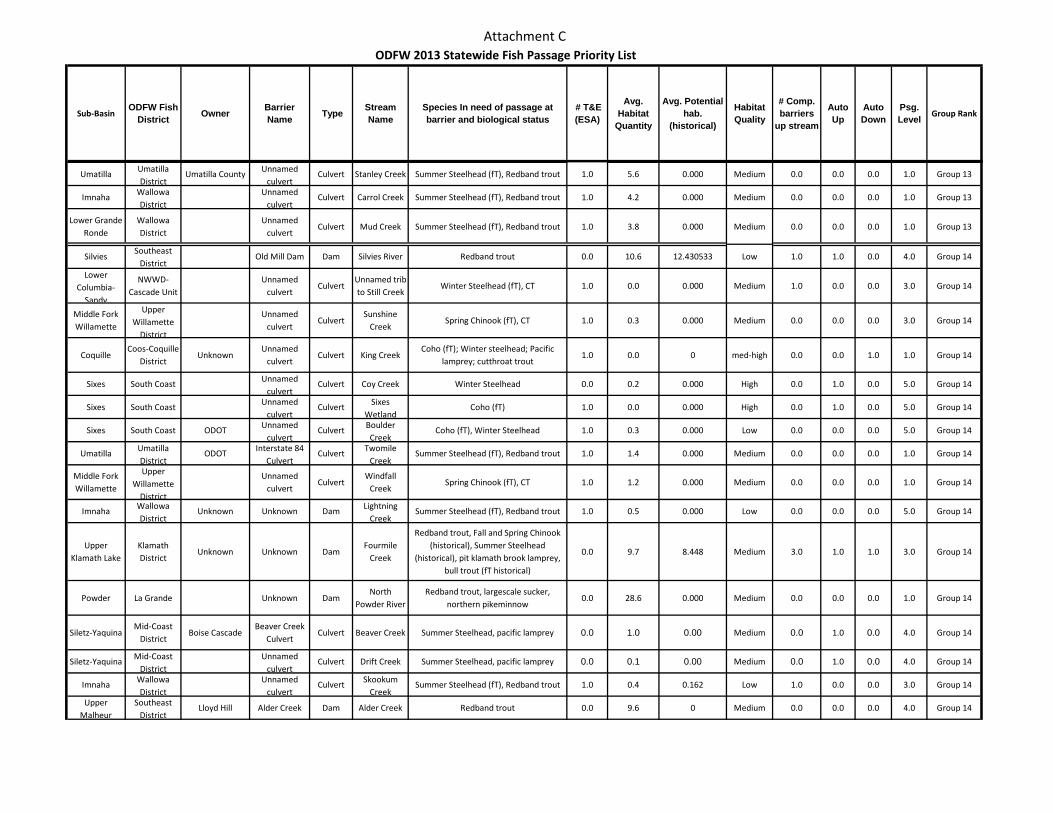
Attachment C
Sub-BasinODFW Fish
District Owner Barrier Name Type Stream
NameSpecies In need of passage at barrier and biological status
# T&E (ESA)
Avg. Habitat
Quantity
Avg. Potential hab.
(historical)
Habitat Quality
# Comp. barriers
up stream
Auto Up
Auto Down
Psg. Level Group Rank
ODFW 2013 Statewide Fish Passage Priority List
Umatilla Umatilla District
Umatilla County Unnamed culvert
Culvert Stanley Creek Summer Steelhead (fT), Redband trout 1.0 5.6 0.000 Medium 0.0 0.0 0.0 1.0 Group 13
Imnaha Wallowa District
Unnamed culvert
Culvert Carrol Creek Summer Steelhead (fT), Redband trout 1.0 4.2 0.000 Medium 0.0 0.0 0.0 1.0 Group 13
Lower Grande Ronde
Wallowa District
Unnamed culvert
Culvert Mud Creek Summer Steelhead (fT), Redband trout 1.0 3.8 0.000 Medium 0.0 0.0 0.0 1.0 Group 13
SilviesSoutheast
DistrictOld Mill Dam Dam Silvies River Redband trout 0.0 10.6 12.430533 Low 1.0 1.0 0.0 4.0 Group 14
Lower Columbia-
Sandy
NWWD-Cascade Unit
Unnamed culvert
CulvertUnnamed trib to Still Creek
Winter Steelhead (fT), CT 1.0 0.0 0.000 Medium 1.0 0.0 0.0 3.0 Group 14
Middle Fork Willamette
Upper Willamette
District
Unnamed culvert
CulvertSunshine
CreekSpring Chinook (fT), CT 1.0 0.3 0.000 Medium 0.0 0.0 0.0 3.0 Group 14
CoquilleCoos-Coquille
DistrictUnknown
Unnamed culvert
Culvert King CreekCoho (fT); Winter steelhead; Pacific
lamprey; cutthroat trout1.0 0.0 0 med-high 0.0 0.0 1.0 1.0 Group 14
Sixes South Coast Unnamed culvert
Culvert Coy Creek Winter Steelhead 0.0 0.2 0.000 High 0.0 1.0 0.0 5.0 Group 14
Sixes South Coast Unnamed culvert
Culvert Sixes Wetland
Coho (fT) 1.0 0.0 0.000 High 0.0 1.0 0.0 5.0 Group 14
Sixes South Coast ODOT Unnamed culvert
Culvert Boulder Creek
Coho (fT), Winter Steelhead 1.0 0.3 0.000 Low 0.0 0.0 0.0 5.0 Group 14
Umatilla Umatilla District
ODOT Interstate 84 Culvert
Culvert Twomile Creek
Summer Steelhead (fT), Redband trout 1.0 1.4 0.000 Medium 0.0 0.0 0.0 1.0 Group 14
Middle Fork Willamette
Upper Willamette
District
Unnamed culvert
CulvertWindfall
CreekSpring Chinook (fT), CT 1.0 1.2 0.000 Medium 0.0 0.0 0.0 1.0 Group 14
Imnaha Wallowa District
Unknown Unknown Dam Lightning Creek
Summer Steelhead (fT), Redband trout 1.0 0.5 0.000 Low 0.0 0.0 0.0 5.0 Group 14
Upper Klamath Lake
Klamath District
Unknown Unknown DamFourmile
Creek
Redband trout, Fall and Spring Chinook (historical), Summer Steelhead
(historical), pit klamath brook lamprey, bull trout (fT historical)
0.0 9.7 8.448 Medium 3.0 1.0 1.0 3.0 Group 14
Powder La Grande Unknown DamNorth
Powder RiverRedband trout, largescale sucker,
northern pikeminnow0.0 28.6 0.000 Medium 0.0 0.0 0.0 1.0 Group 14
Siletz-YaquinaMid-Coast
DistrictBoise Cascade
Beaver Creek Culvert
Culvert Beaver Creek Summer Steelhead, pacific lamprey 0.0 1.0 0.00 Medium 0.0 1.0 0.0 4.0 Group 14
Siletz-Yaquina Mid-Coast District
Unnamed culvert
Culvert Drift Creek Summer Steelhead, pacific lamprey 0.0 0.1 0.00 Medium 0.0 1.0 0.0 4.0 Group 14
Imnaha Wallowa District
Unnamed culvert
Culvert Skookum Creek
Summer Steelhead (fT), Redband trout 1.0 0.4 0.162 Low 1.0 0.0 0.0 3.0 Group 14
Upper Malheur
Southeast District
Lloyd Hill Alder Creek Dam Alder Creek Redband trout 0.0 9.6 0 Medium 0.0 0.0 0.0 4.0 Group 14
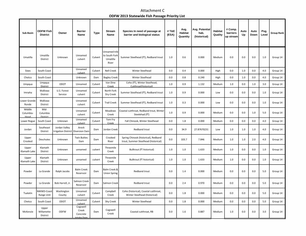
Attachment C
Sub-BasinODFW Fish
District Owner Barrier Name Type Stream
NameSpecies In need of passage at barrier and biological status
# T&E (ESA)
Avg. Habitat
Quantity
Avg. Potential hab.
(historical)
Habitat Quality
# Comp. barriers
up stream
Auto Up
Auto Down
Psg. Level Group Rank
ODFW 2013 Statewide Fish Passage Priority List
UmatillaUmatilla District
UnknownUnnamed
culvertCulvert
Unnamed trib to South Fork
Umatilla River
Summer Steelhead (fT), Redband trout 1.0 0.6 0.000 Medium 0.0 0.0 0.0 1.0 Group 14
Sixes South Coast Unnamed culvert
Culvert Nell Creek Winter Steelhead 0.0 0.4 0.000 High 0.0 1.0 0.0 4.0 Group 14
Chetco South Coast Unknown Dam Bagley Creek Winter Steelhead 0.0 0.8 0.240 High 0.0 1.0 0.0 4.0 Group 14
Umpqua Umpqua District
ODOT Unnamed Culvert Van Dine Creek
Coho (fT), Winter Steelhead, Cutthroat(historical)
1.0 0.9 1.132 Medium 1.0 0.0 1.0 3.0 Group 14
ImnahaWallowa District
U.S. Forest Service
Unnamed culvert
CulvertNorth Fork Dry Creek
Summer Steelhead (fT), Redband trout 1.0 0.9 0.000 Low 0.0 0.0 0.0 1.0 Group 14
Lower Grande Ronde
Wallowa District
Unnamed culvert
Culvert Trail Creek Summer Steelhead (fT), Redband trout 1.0 0.3 0.000 Low 0.0 0.0 0.0 1.0 Group 14
Middle Columbia-
Hood
Mid-Columbia
District
Unnamed culvert
CulvertMeadows
CreekCoastal cutthroat, Redband trout, Winter
Steelehad (fT)1.0 0.9 0.000 Medium 0.0 0.0 1.0 5.0 Group 14
Lower Rogue South Coast Unknown Unnamed culvert
Culvert Tom Fry Creek
Fall Chinook, Winter Steelhead 0.0 1.8 0.000 Medium 0.0 0.0 0.0 4.0 Group 14
JordanSoutheast
DistrictJordan Valley
Irrigation DistrictArock
Diversion DamDam Jordan Creek Redband trout 0.0 34.9 27.87670231 Low 1.0 1.0 1.0 4.0 Group 14
Upper Crooked
Deschutes UnknownTwin Buttes
DamDam
Crooked River
Spring Chinook (historical), Redband trout, Summer Steelhead (historical)
0.0 103.7 7.846 Medium 1.0 1.0 2.0 4.0 Group 14
Upper Klamath Lake
Klamath District
Unknown unnamed culvertThreemile
CreekBulltrout (fT historical) 1.0 1.0 1.633 Medium 1.0 0.0 0.0 1.0 Group 14
Upper Klamath Lake
Klamath District
Unknown unnamed culvertThreemile
CreekBulltrout (fT historical) 1.0 1.0 1.633 Medium 1.0 0.0 0.0 1.0 Group 14
Powder La Grande Ralph JacobsBalm Creek Reservoir
DamBalm Creek & Union Spring
Redband trout 0.0 1.4 0.000 Medium 0.0 0.0 0.0 5.0 Group 14
Powder La Grande Bob Harrell, Jr.Salmon Creek
ReservoirDam Salmon Creek Redband trout 0.0 2.4 0.970 Medium 0.0 0.0 0.0 5.0 Group 14
TualatinNWWD-Coast
Range UnitWashington
CountyUnnamed
culvertCulvert
Campbell Creek
Coho (historical), Coastal cutthroat, Winter Steelhead (historical)
0.0 1.8 0.000 Medium 0.0 0.0 0.0 5.0 Group 14
Chetco South Coast ODOT Unnamed culvert
Culvert Shy Creek Winter Steelhead 0.0 1.8 0.000 Medium 0.0 0.0 0.0 5.0 Group 14
McKenzieUpper
Willamette District
ODFW
Cogswell Creek
Concrete Intake Dam
DamCogswell
CreekCoastal cutthroat, RB 0.0 1.6 0.887 Medium 1.0 0.0 0.0 3.0 Group 14
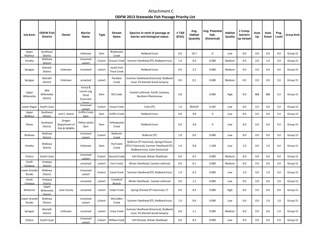
Attachment C
Sub-BasinODFW Fish
District Owner Barrier Name Type Stream
NameSpecies In need of passage at barrier and biological status
# T&E (ESA)
Avg. Habitat
Quantity
Avg. Potential hab.
(historical)
Habitat Quality
# Comp. barriers
up stream
Auto Up
Auto Down
Psg. Level Group Rank
ODFW 2013 Statewide Fish Passage Priority List
Upper Malheur
Southeast District
Unknown DamBluebucket
CreekRedband trout 0.0 10.7 0 Low 0.0 0.0 0.0 4.0 Group 15
Imnaha Wallowa District
Unnamed culvert
Culvert Grouse Creek Summer Steelhead (fT), Redband trout 1.0 0.9 0.000 Medium 0.0 0.0 1.0 3.0 Group 15
SpragueKlamath District
Unknown Unnamed culvertSouth Fork Trout Creek
Redband trout 0.0 2.3 0.000 Medium 0.0 0.0 0.0 4.0 Group 15
SpragueKlamath District
Unknown unnamed culvertParadise
CreekSummer Steelhead (historical), Redband
trout. Pit klamath brook lamprey0.0 0.2 0.000 Medium 0.0 0.0 0.0 5.0 Group 15
Upper Willamette
Mid Willamette
District
Forcia & Larsen Log
Pond (Concrete
Dam)
Dam Elk CreekCoastal cutthroat, Pacific Lamprey,
Northern Pikeminnow0.0 0.000 High 0.0 0.0 0.0 5.0 Group 15
Lower Rogue South Coast Unnamed culvert
Culvert Snout Creek Coho (fT) 1.0 #DIV/0! 0.342 Low 0.0 0.0 0.0 5.0 Group 15
Upper Malheur
Southeast District
Joel C. Sword Griffin Creek Dam
Dam Griffin Creek Redband trout 0.0 9.8 0 Low 0.0 0.0 0.0 5.0 Group 15
SilviesSoutheast
District
Oregon Department of Fish & Wildlife
Yellow Jacket Dam
DamYellowjacket
CreekRedband trout 0.0 3.8 0 Low 0.0 0.0 0.0 5.0 Group 15
Wallowa Wallowa District
Unnamed culvert
Culvert Redmont Creek
Bulltrout (fT) 1.0 0.0 0.000 Low 0.0 0.0 0.0 3.0 Group 15
ImnahaWallowa District
Unknown DamHurricane
Creek
Bulltrout (fT historical), Spring Chinook (fT/sT historical), Summer Steelhead (fT),
Redband trout, Coho (historical)1.0 0.8 1.358 Low 1.0 0.0 1.0 4.0 Group 15
Chetco South Coast Unnamed culvert
Culvert Second Creek Fall Chinook, Winter Steelhead 0.0 0.5 0.000 Medium 0.0 0.0 0.0 4.0 Group 15
South Umpqua
Umpqua District
unnamed culvert Corn Creek Winter Steelhead, Coastal cutthroat 0.0 0.1 0.000 Medium 0.0 0.0 0.0 4.0 Group 15
Lower Grande Ronde
Wallowa District
Unnamed culvert
Culvert Canal Creek Summer Steelhead (fT), Redband trout 1.0 0.3 0.000 Low 1.0 0.0 1.0 3.0 Group 15
South Umpqua
Umpqua District
unnamed culvert Crawford Branch
Winter Steelhead, Coastal cutthroat 0.0 1.2 0.000 Low 0.0 0.0 0.0 3.0 Group 15
McKenzieUpper
Willamette District
Lane County unnamed culvert Cedar Creek Spring Chinook (fT historical), CT 0.0 0.4 0.000 High 0.0 0.0 0.0 4.0 Group 15
Lower Grande Ronde
Wallowa District
Unnamed culvert
CulvertMcCubbin
CreekSummer Steelhead (fT), Redband trout 1.0 0.6 0.000 Low 0.0 0.0 1.0 1.0 Group 15
SpragueKlamath District
Unknown unnamed culvert Crazy CreekSummer Steelhead (historical), Redband
trout. Pit klamath brook lamprey0.0 1.1 0.000 Medium 0.0 0.0 0.0 1.0 Group 15
Chetco South Coast Unnamed culvert
Culvert Willow Creek Fall Chinook, Winter Steelhead 0.0 0.4 0.000 Low 0.0 0.0 0.0 4.0 Group 15
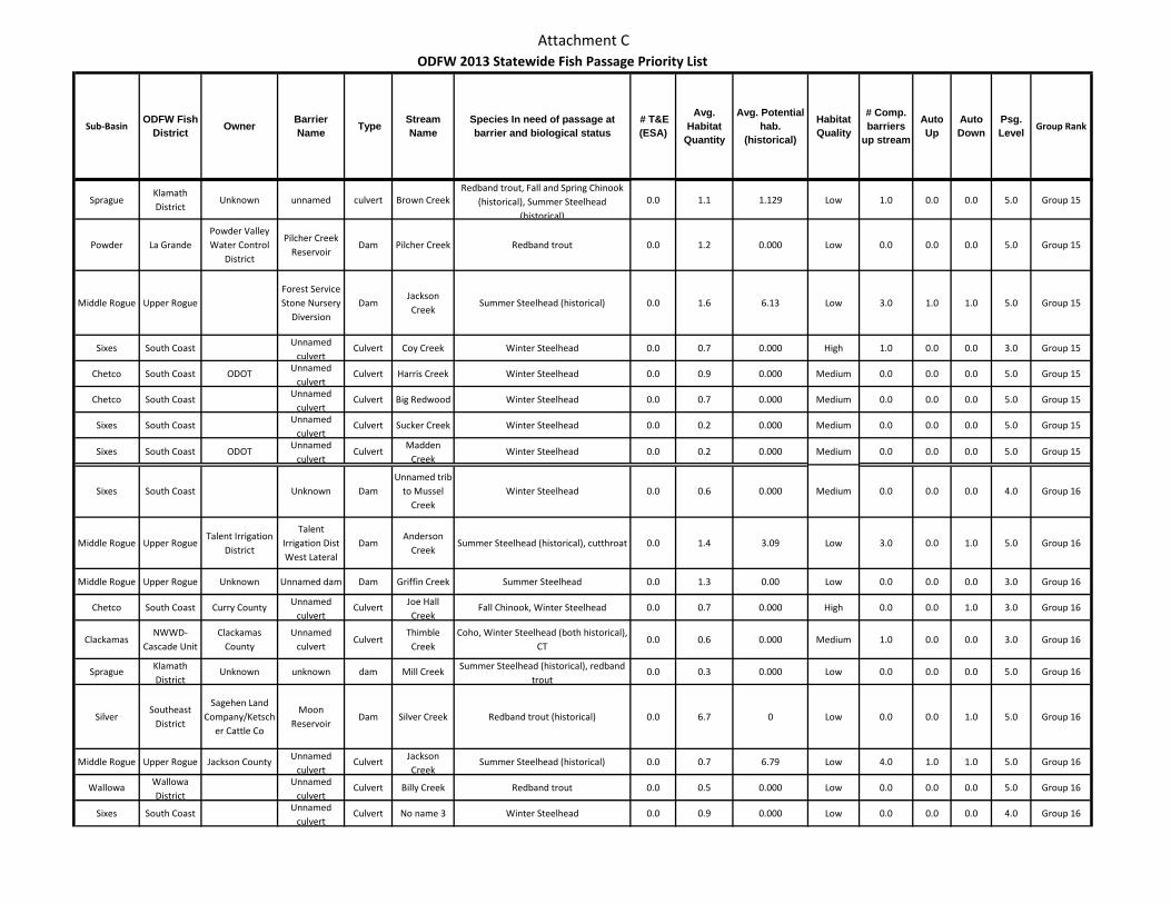
Attachment C
Sub-BasinODFW Fish
District Owner Barrier Name Type Stream
NameSpecies In need of passage at barrier and biological status
# T&E (ESA)
Avg. Habitat
Quantity
Avg. Potential hab.
(historical)
Habitat Quality
# Comp. barriers
up stream
Auto Up
Auto Down
Psg. Level Group Rank
ODFW 2013 Statewide Fish Passage Priority List
SpragueKlamath District
Unknown unnamed culvert Brown CreekRedband trout, Fall and Spring Chinook
(historical), Summer Steelhead (historical)
0.0 1.1 1.129 Low 1.0 0.0 0.0 5.0 Group 15
Powder La GrandePowder Valley Water Control
District
Pilcher Creek Reservoir
Dam Pilcher Creek Redband trout 0.0 1.2 0.000 Low 0.0 0.0 0.0 5.0 Group 15
Middle Rogue Upper RogueForest Service Stone Nursery
DiversionDam
Jackson Creek
Summer Steelhead (historical) 0.0 1.6 6.13 Low 3.0 1.0 1.0 5.0 Group 15
Sixes South Coast Unnamed culvert
Culvert Coy Creek Winter Steelhead 0.0 0.7 0.000 High 1.0 0.0 0.0 3.0 Group 15
Chetco South Coast ODOT Unnamed culvert
Culvert Harris Creek Winter Steelhead 0.0 0.9 0.000 Medium 0.0 0.0 0.0 5.0 Group 15
Chetco South Coast Unnamed culvert
Culvert Big Redwood Winter Steelhead 0.0 0.7 0.000 Medium 0.0 0.0 0.0 5.0 Group 15
Sixes South Coast Unnamed culvert
Culvert Sucker Creek Winter Steelhead 0.0 0.2 0.000 Medium 0.0 0.0 0.0 5.0 Group 15
Sixes South Coast ODOTUnnamed
culvertCulvert
Madden Creek
Winter Steelhead 0.0 0.2 0.000 Medium 0.0 0.0 0.0 5.0 Group 15
Sixes South Coast Unknown DamUnnamed trib
to Mussel Creek
Winter Steelhead 0.0 0.6 0.000 Medium 0.0 0.0 0.0 4.0 Group 16
Middle Rogue Upper RogueTalent Irrigation
District
Talent Irrigation Dist West Lateral
DamAnderson
CreekSummer Steelhead (historical), cutthroat 0.0 1.4 3.09 Low 3.0 0.0 1.0 5.0 Group 16
Middle Rogue Upper Rogue Unknown Unnamed dam Dam Griffin Creek Summer Steelhead 0.0 1.3 0.00 Low 0.0 0.0 0.0 3.0 Group 16
Chetco South Coast Curry County Unnamed culvert
Culvert Joe Hall Creek
Fall Chinook, Winter Steelhead 0.0 0.7 0.000 High 0.0 0.0 1.0 3.0 Group 16
ClackamasNWWD-
Cascade UnitClackamas
CountyUnnamed
culvertCulvert
Thimble Creek
Coho, Winter Steelhead (both historical), CT
0.0 0.6 0.000 Medium 1.0 0.0 0.0 3.0 Group 16
Sprague Klamath District
Unknown unknown dam Mill Creek Summer Steelhead (historical), redband trout
0.0 0.3 0.000 Low 0.0 0.0 0.0 5.0 Group 16
SilverSoutheast
District
Sagehen Land Company/Ketsch
er Cattle Co
Moon Reservoir
Dam Silver Creek Redband trout (historical) 0.0 6.7 0 Low 0.0 0.0 1.0 5.0 Group 16
Middle Rogue Upper Rogue Jackson County Unnamed culvert
Culvert Jackson Creek
Summer Steelhead (historical) 0.0 0.7 6.79 Low 4.0 1.0 1.0 5.0 Group 16
Wallowa Wallowa District
Unnamed culvert
Culvert Billy Creek Redband trout 0.0 0.5 0.000 Low 0.0 0.0 0.0 5.0 Group 16
Sixes South Coast Unnamed culvert
Culvert No name 3 Winter Steelhead 0.0 0.9 0.000 Low 0.0 0.0 0.0 4.0 Group 16
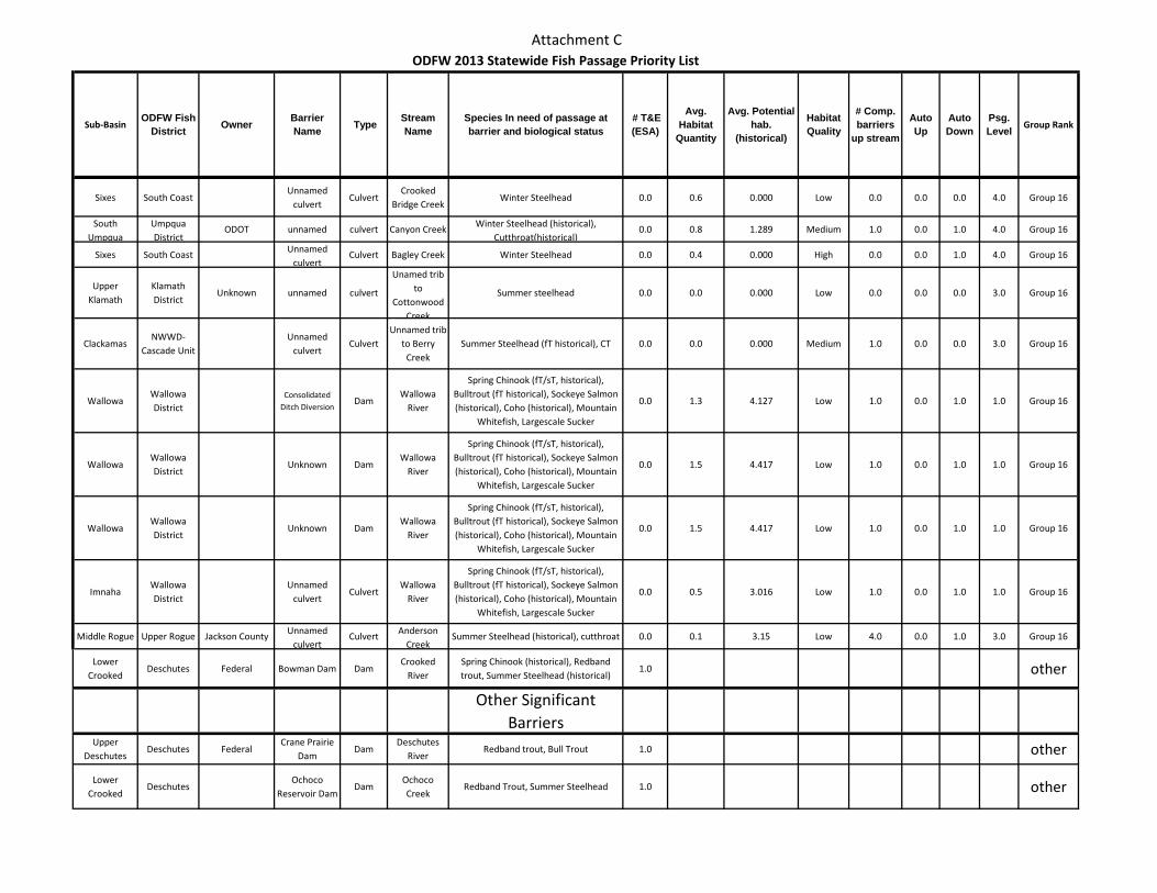
Attachment C
Sub-BasinODFW Fish
District Owner Barrier Name Type Stream
NameSpecies In need of passage at barrier and biological status
# T&E (ESA)
Avg. Habitat
Quantity
Avg. Potential hab.
(historical)
Habitat Quality
# Comp. barriers
up stream
Auto Up
Auto Down
Psg. Level Group Rank
ODFW 2013 Statewide Fish Passage Priority List
Sixes South CoastUnnamed
culvertCulvert
Crooked Bridge Creek
Winter Steelhead 0.0 0.6 0.000 Low 0.0 0.0 0.0 4.0 Group 16
South Umpqua
Umpqua District
ODOT unnamed culvert Canyon Creek Winter Steelhead (historical), Cutthroat(historical)
0.0 0.8 1.289 Medium 1.0 0.0 1.0 4.0 Group 16
Sixes South Coast Unnamed culvert
Culvert Bagley Creek Winter Steelhead 0.0 0.4 0.000 High 0.0 0.0 1.0 4.0 Group 16
Upper Klamath
Klamath District
Unknown unnamed culvert
Unamed trib to
Cottonwood Creek
Summer steelhead 0.0 0.0 0.000 Low 0.0 0.0 0.0 3.0 Group 16
ClackamasNWWD-
Cascade UnitUnnamed
culvertCulvert
Unnamed trib to Berry
CreekSummer Steelhead (fT historical), CT 0.0 0.0 0.000 Medium 1.0 0.0 0.0 3.0 Group 16
WallowaWallowa District
Consolidated Ditch Diversion
DamWallowa
River
Spring Chinook (fT/sT, historical), Bulltrout (fT historical), Sockeye Salmon (historical), Coho (historical), Mountain
Whitefish, Largescale Sucker
0.0 1.3 4.127 Low 1.0 0.0 1.0 1.0 Group 16
WallowaWallowa District
Unknown DamWallowa
River
Spring Chinook (fT/sT, historical), Bulltrout (fT historical), Sockeye Salmon (historical), Coho (historical), Mountain
Whitefish, Largescale Sucker
0.0 1.5 4.417 Low 1.0 0.0 1.0 1.0 Group 16
WallowaWallowa District
Unknown DamWallowa
River
Spring Chinook (fT/sT, historical), Bulltrout (fT historical), Sockeye Salmon (historical), Coho (historical), Mountain
Whitefish, Largescale Sucker
0.0 1.5 4.417 Low 1.0 0.0 1.0 1.0 Group 16
ImnahaWallowa District
Unnamed culvert
CulvertWallowa
River
Spring Chinook (fT/sT, historical), Bulltrout (fT historical), Sockeye Salmon (historical), Coho (historical), Mountain
Whitefish, Largescale Sucker
0.0 0.5 3.016 Low 1.0 0.0 1.0 1.0 Group 16
Middle Rogue Upper Rogue Jackson County Unnamed culvert
Culvert Anderson Creek
Summer Steelhead (historical), cutthroat 0.0 0.1 3.15 Low 4.0 0.0 1.0 3.0 Group 16
Lower Crooked
Deschutes Federal Bowman Dam DamCrooked
RiverSpring Chinook (historical), Redband trout, Summer Steelhead (historical)
1.0 other
Other Significant Barriers
Upper Deschutes
Deschutes FederalCrane Prairie
DamDam
Deschutes River
Redband trout, Bull Trout 1.0 other
Lower Crooked
DeschutesOchoco
Reservoir DamDam
Ochoco Creek
Redband Trout, Summer Steelhead 1.0 other
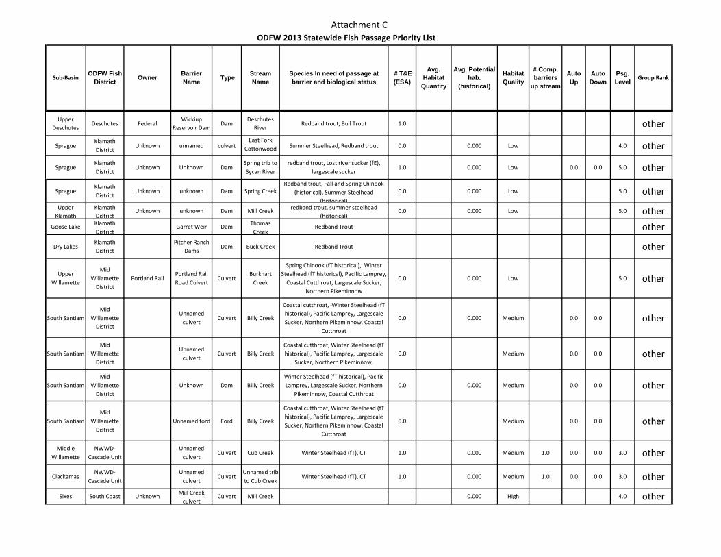
Attachment C
Sub-BasinODFW Fish
District Owner Barrier Name Type Stream
NameSpecies In need of passage at barrier and biological status
# T&E (ESA)
Avg. Habitat
Quantity
Avg. Potential hab.
(historical)
Habitat Quality
# Comp. barriers
up stream
Auto Up
Auto Down
Psg. Level Group Rank
ODFW 2013 Statewide Fish Passage Priority List
Upper Deschutes
Deschutes FederalWickiup
Reservoir DamDam
Deschutes River
Redband trout, Bull Trout 1.0 other
SpragueKlamath District
Unknown unnamed culvertEast Fork
Cottonwood Summer Steelhead, Redband trout 0.0 0.000 Low 4.0 other
SpragueKlamath District
Unknown Unknown DamSpring trib to Sycan River
redband trout, Lost river sucker (fE), largescale sucker
1.0 0.000 Low 0.0 0.0 5.0 other
SpragueKlamath District
Unknown unknown Dam Spring CreekRedband trout, Fall and Spring Chinook
(historical), Summer Steelhead (historical)
0.0 0.000 Low 5.0 other
Upper Klamath
Klamath District
Unknown unknown Dam Mill Creek redband trout, summer steelhead (historical)
0.0 0.000 Low 5.0 other
Goose Lake Klamath District
Garret Weir Dam Thomas Creek
Redband Trout other
Dry LakesKlamath District
Pitcher Ranch Dams
Dam Buck Creek Redband Trout other
Upper Willamette
Mid Willamette
DistrictPortland Rail
Portland Rail Road Culvert
CulvertBurkhart
Creek
Spring Chinook (fT historical), Winter Steelhead (fT historical), Pacific Lamprey,
Coastal Cutthroat, Largescale Sucker, Northern Pikeminnow
0.0 0.000 Low 5.0 other
South SantiamMid
Willamette District
Unnamed culvert
Culvert Billy Creek
Coastal cutthroat, Winter Steelhead (fT historical), Pacific Lamprey, Largescale Sucker, Northern Pikeminnow, Coastal
Cutthroat
0.0 0.000 Medium 0.0 0.0 other
South SantiamMid
Willamette District
Unnamed culvert
Culvert Billy CreekCoastal cutthroat, Winter Steelhead (fT historical), Pacific Lamprey, Largescale
Sucker, Northern Pikeminnow, 0.0 Medium 0.0 0.0 other
South SantiamMid
Willamette District
Unknown Dam Billy CreekWinter Steelhead (fT historical), Pacific Lamprey, Largescale Sucker, Northern
Pikeminnow, Coastal Cutthroat0.0 0.000 Medium 0.0 0.0 other
South SantiamMid
Willamette District
Unnamed ford Ford Billy Creek
Coastal cutthroat, Winter Steelhead (fT historical), Pacific Lamprey, Largescale Sucker, Northern Pikeminnow, Coastal
Cutthroat
0.0 Medium 0.0 0.0 other
Middle Willamette
NWWD-Cascade Unit
Unnamed culvert
Culvert Cub Creek Winter Steelhead (fT), CT 1.0 0.000 Medium 1.0 0.0 0.0 3.0 other
ClackamasNWWD-
Cascade UnitUnnamed
culvertCulvert
Unnamed trib to Cub Creek
Winter Steelhead (fT), CT 1.0 0.000 Medium 1.0 0.0 0.0 3.0 other
Sixes South Coast Unknown Mill Creek culvert
Culvert Mill Creek 0.000 High 4.0 other
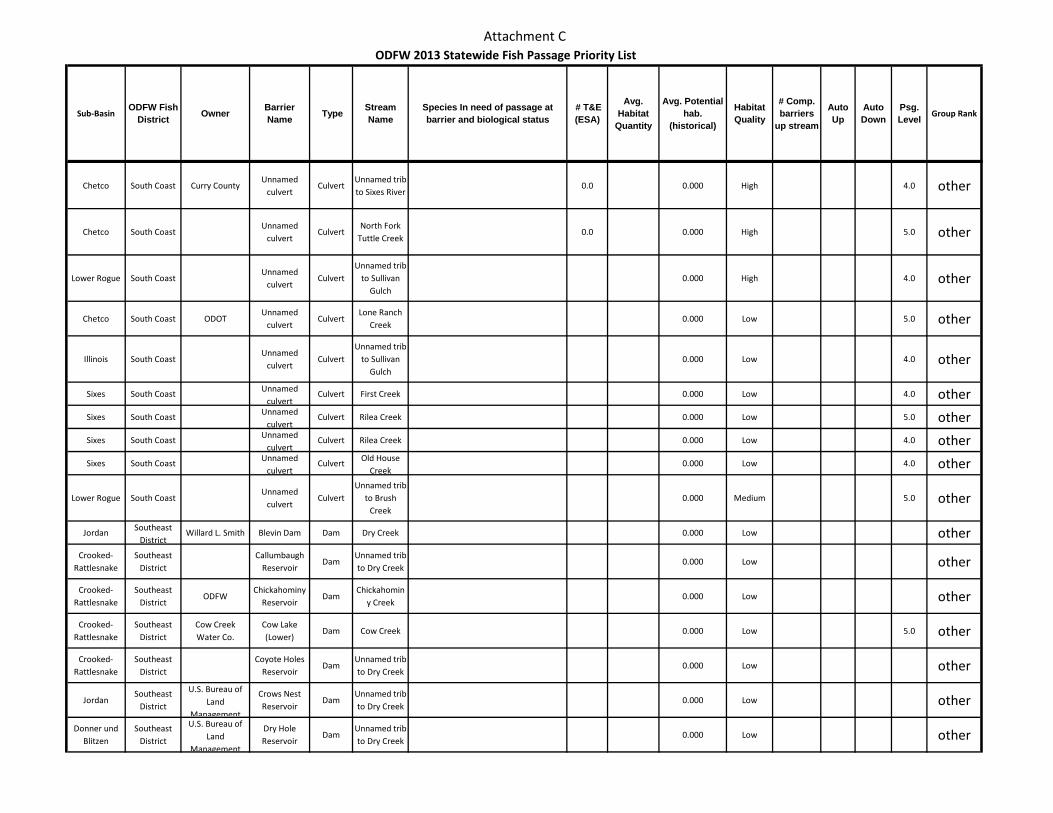
Attachment C
Sub-BasinODFW Fish
District Owner Barrier Name Type Stream
NameSpecies In need of passage at barrier and biological status
# T&E (ESA)
Avg. Habitat
Quantity
Avg. Potential hab.
(historical)
Habitat Quality
# Comp. barriers
up stream
Auto Up
Auto Down
Psg. Level Group Rank
ODFW 2013 Statewide Fish Passage Priority List
Chetco South Coast Curry CountyUnnamed
culvertCulvert
Unnamed trib to Sixes River
0.0 0.000 High 4.0 other
Chetco South CoastUnnamed
culvertCulvert
North Fork Tuttle Creek
0.0 0.000 High 5.0 other
Lower Rogue South CoastUnnamed
culvertCulvert
Unnamed trib to Sullivan
Gulch0.000 High 4.0 other
Chetco South Coast ODOTUnnamed
culvertCulvert
Lone Ranch Creek
0.000 Low 5.0 other
Illinois South CoastUnnamed
culvertCulvert
Unnamed trib to Sullivan
Gulch0.000 Low 4.0 other
Sixes South Coast Unnamed culvert
Culvert First Creek 0.000 Low 4.0 other
Sixes South Coast Unnamed culvert
Culvert Rilea Creek 0.000 Low 5.0 other
Sixes South Coast Unnamed culvert
Culvert Rilea Creek 0.000 Low 4.0 other
Sixes South Coast Unnamed culvert
Culvert Old House Creek
0.000 Low 4.0 other
Lower Rogue South CoastUnnamed
culvertCulvert
Unnamed trib to Brush
Creek0.000 Medium 5.0 other
Jordan Southeast District
Willard L. Smith Blevin Dam Dam Dry Creek 0.000 Low otherCrooked-
RattlesnakeSoutheast
DistrictCallumbaugh
ReservoirDam
Unnamed trib to Dry Creek
0.000 Low other
Crooked-Rattlesnake
Southeast District
ODFWChickahominy
ReservoirDam
Chickahominy Creek
0.000 Low other
Crooked-Rattlesnake
Southeast District
Cow Creek Water Co.
Cow Lake (Lower)
Dam Cow Creek 0.000 Low 5.0 other
Crooked-Rattlesnake
Southeast District
Coyote Holes Reservoir
DamUnnamed trib to Dry Creek
0.000 Low other
JordanSoutheast
District
U.S. Bureau of Land
Management
Crows Nest Reservoir
DamUnnamed trib to Dry Creek
0.000 Low other
Donner und Blitzen
Southeast District
U.S. Bureau of Land
Management
Dry Hole Reservoir
DamUnnamed trib to Dry Creek
0.000 Low other
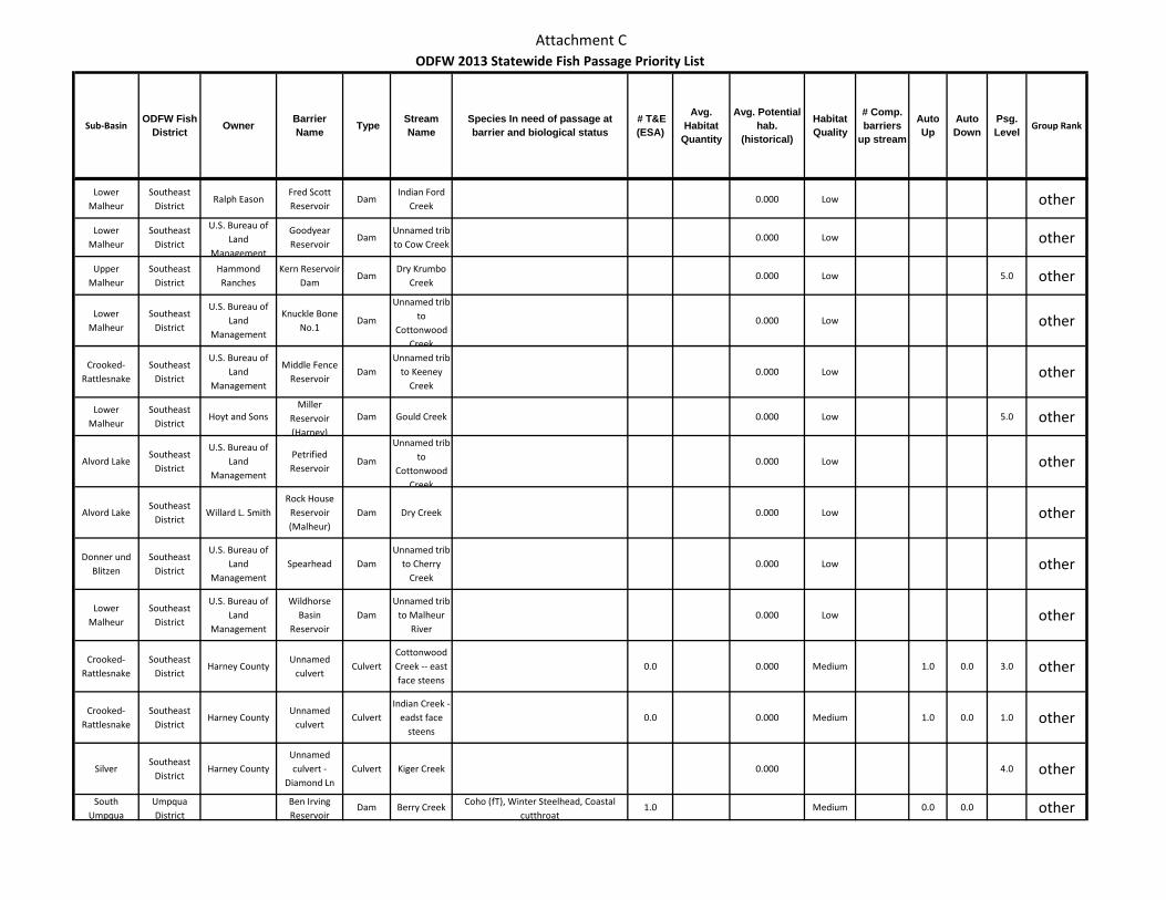
Attachment C
Sub-BasinODFW Fish
District Owner Barrier Name Type Stream
NameSpecies In need of passage at barrier and biological status
# T&E (ESA)
Avg. Habitat
Quantity
Avg. Potential hab.
(historical)
Habitat Quality
# Comp. barriers
up stream
Auto Up
Auto Down
Psg. Level Group Rank
ODFW 2013 Statewide Fish Passage Priority List
Lower Malheur
Southeast District
Ralph EasonFred Scott Reservoir
DamIndian Ford
Creek0.000 Low other
Lower Malheur
Southeast District
U.S. Bureau of Land
Management
Goodyear Reservoir
DamUnnamed trib to Cow Creek
0.000 Low other
Upper Malheur
Southeast District
Hammond Ranches
Kern Reservoir Dam
DamDry Krumbo
Creek0.000 Low 5.0 other
Lower Malheur
Southeast District
U.S. Bureau of Land
Management
Knuckle Bone No.1
Dam
Unnamed trib to
Cottonwood Creek
0.000 Low other
Crooked-Rattlesnake
Southeast District
U.S. Bureau of Land
Management
Middle Fence Reservoir
DamUnnamed trib
to Keeney Creek
0.000 Low other
Lower Malheur
Southeast District
Hoyt and SonsMiller
Reservoir (Harney)
Dam Gould Creek 0.000 Low 5.0 other
Alvord LakeSoutheast
District
U.S. Bureau of Land
Management
Petrified Reservoir
Dam
Unnamed trib to
Cottonwood Creek
0.000 Low other
Alvord LakeSoutheast
DistrictWillard L. Smith
Rock House Reservoir (Malheur)
Dam Dry Creek 0.000 Low other
Donner und Blitzen
Southeast District
U.S. Bureau of Land
ManagementSpearhead Dam
Unnamed trib to Cherry
Creek0.000 Low other
Lower Malheur
Southeast District
U.S. Bureau of Land
Management
Wildhorse Basin
ReservoirDam
Unnamed trib to Malheur
River0.000 Low other
Crooked-Rattlesnake
Southeast District
Harney CountyUnnamed
culvertCulvert
Cottonwood Creek -- east face steens
0.0 0.000 Medium 1.0 0.0 3.0 other
Crooked-Rattlesnake
Southeast District
Harney CountyUnnamed
culvertCulvert
Indian Creek -- eadst face
steens0.0 0.000 Medium 1.0 0.0 1.0 other
SilverSoutheast
DistrictHarney County
Unnamed culvert -
Diamond Ln Culvert Kiger Creek 0.000 4.0 other
South Umpqua
Umpqua District
Ben Irving Reservoir
Dam Berry Creek Coho (fT), Winter Steelhead, Coastal cutthroat
1.0 Medium 0.0 0.0 other
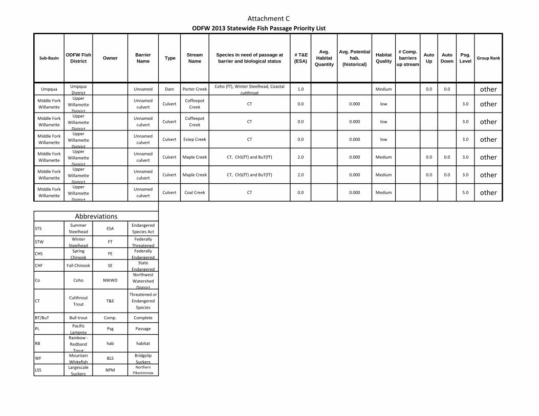
Attachment C
Sub-BasinODFW Fish
District Owner Barrier Name Type Stream
NameSpecies In need of passage at barrier and biological status
# T&E (ESA)
Avg. Habitat
Quantity
Avg. Potential hab.
(historical)
Habitat Quality
# Comp. barriers
up stream
Auto Up
Auto Down
Psg. Level Group Rank
ODFW 2013 Statewide Fish Passage Priority List
Umpqua Umpqua District
Unnamed Dam Porter Creek Coho (fT), Winter Steelhead, Coastal cutthroat
1.0 Medium 0.0 0.0 otherMiddle Fork Willamette
Upper Willamette
District
Unnamed culvert
CulvertCoffeepot
CreekCT 0.0 0.000 low 3.0 other
Middle Fork Willamette
Upper Willamette
District
Unnamed culvert
CulvertCoffeepot
CreekCT 0.0 0.000 low 3.0 other
Middle Fork Willamette
Upper Willamette
District
Unnamed culvert
Culvert Estep Creek CT 0.0 0.000 low 3.0 other
Middle Fork Willamette
Upper Willamette
District
Unnamed culvert
Culvert Maple Creek CT, ChS(fT) and BuT(fT) 2.0 0.000 Medium 0.0 0.0 3.0 other
Middle Fork Willamette
Upper Willamette
District
Unnamed culvert
Culvert Maple Creek CT, ChS(fT) and BuT(fT) 2.0 0.000 Medium 0.0 0.0 3.0 other
Middle Fork Willamette
Upper Willamette
District
Unnamed culvert
Culvert Coal Creek CT 0.0 0.000 Medium 5.0 other
STSSummer
SteelheadESA
Endangered Species Act
STW Winter Steelhead
FT Federally Threatened
CHS Spring Chinook
FE Federally Endangered
CHF Fall Chinook SE State Endangered
Co Coho NWWDNorthwest Watershed
District
CTCutthrout
TroutT&E
Threatened or Endangered
Species
BT/BuT Bull trout Comp. Complete
PL Pacific Lamprey
Psg Passage
RBRainbow - Redband
Trout
hab habitat
WF Mountain Whitefish
BLS Bridgelip Suckers
LSS Largescale Suckers
NPMNorthern
Pikeminnow
Abbreviations
Related Documents