EUROSION Case Study 1 RHONE DELTA (FRANCE) Contact : Mireille PROVANSAL Centre Européen de Recherche et d’Enseignement des Géosciences de l’Environnent Europole de l’Arbois BP80 13545 Aix-en-Provence (Cedex04) France Tel : +33 (0)4-42-97-15-63 Fax : +33 (0)4-42-97-15-59 e-mail: [email protected] 14

Welcome message from author
This document is posted to help you gain knowledge. Please leave a comment to let me know what you think about it! Share it to your friends and learn new things together.
Transcript
EUROSION Case Study
1
RHONE DELTA (FRANCE)
Contact :
Mireille PROVANSAL
Centre Européen de Recherche et d’Enseignement des Géosciences de
l’Environnent
Europole de l’Arbois BP80 13545
Aix-en-Provence (Cedex04) France
Tel : +33 (0)4-42-97-15-63 Fax : +33 (0)4-42-97-15-59
e-mail: [email protected]
14
EUROSION Case Study
2
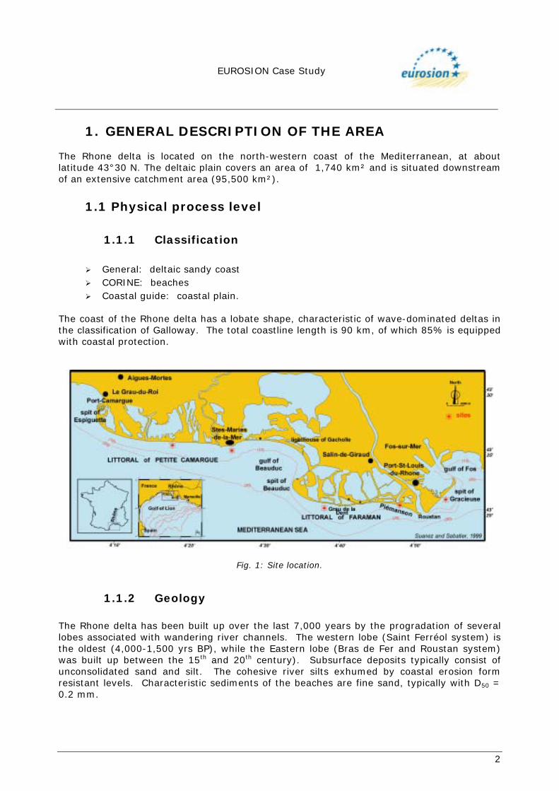
1. GENERAL DESCRIPTION OF THE AREA The Rhone delta is located on the north-western coast of the Mediterranean, at about latitude 43°30 N. The deltaic plain covers an area of 1,740 km² and is situated downstream of an extensive catchment area (95,500 km²).
1.1 Physical process level
1.1.1 Classification
! General: deltaic sandy coast ! CORINE: beaches ! Coastal guide: coastal plain.
The coast of the Rhone delta has a lobate shape, characteristic of wave-dominated deltas in the classification of Galloway. The total coastline length is 90 km, of which 85% is equipped with coastal protection.
Fig. 1: Site location.
1.1.2 Geology The Rhone delta has been built up over the last 7,000 years by the progradation of several lobes associated with wandering river channels. The western lobe (Saint Ferréol system) is the oldest (4,000-1,500 yrs BP), while the Eastern lobe (Bras de Fer and Roustan system) was built up between the 15th and 20th century). Subsurface deposits typically consist of unconsolidated sand and silt. The cohesive river silts exhumed by coastal erosion form resistant levels. Characteristic sediments of the beaches are fine sand, typically with D50 = 0.2 mm.
EUROSION Case Study
3
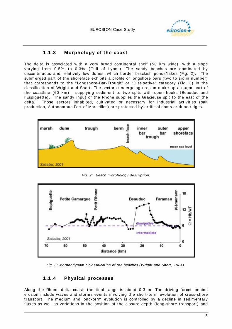
1.1.3 Morphology of the coast The delta is associated with a very broad continental shelf (50 km wide), with a slope varying from 0.5% to 0.3% (Gulf of Lyons). The sandy beaches are dominated by discontinuous and relatively low dunes, which border brackish ponds/lakes (Fig. 2). The submerged part of the shoreface exhibits a profile of longshore bars (two to six in number) that corresponds to the “Longshore-Bar-Trough” or “Dissipative” category (Fig. 3) in the classification of Wright and Short. The sectors undergoing erosion make up a major part of the coastline (60 km), supplying sediment to two spits with open hooks (Beauduc and l’Espiguette). The sandy input of the Rhone supplies the Gracieuse spit to the east of the delta. Those sectors inhabited, cultivated or necessary for industrial activities (salt production, Autonomous Port of Marseilles) are protected by artificial dams or dune ridges.
Fig. 2: Beach morphology description.
Fig. 3: Morphodynamic classification of the beaches (Wright and Short, 1984).
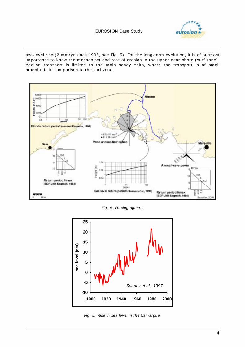
1.1.4 Physical processes Along the Rhone delta coast, the tidal range is about 0.3 m. The driving forces behind erosion include waves and storms events involving the short-term evolution of cross-shore transport. The medium and long-term evolution is controlled by a decline in sedimentary fluxes as well as variations in the position of the closure depth (long-shore transport) and
EUROSION Case Study
4
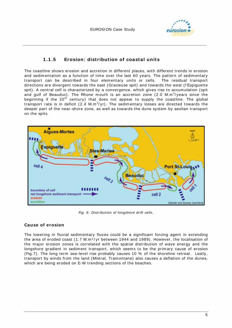
sea-level rise (2 mm/yr since 1905, see Fig. 5). For the long-term evolution, it is of outmost importance to know the mechanism and rate of erosion in the upper near-shore (surf zone). Aeolian transport is limited to the main sandy spits, where the transport is of small magnitude in comparison to the surf zone.
Fig. 4: Forcing agents.
-10
-5
0
5
10
15
20
25
1900 1920 1940 1960 1980 2000
sea
leve
l (cm
)
Suanez et al., 1997
Fig. 5: Rise in sea level in the Camargue.
EUROSION Case Study
5
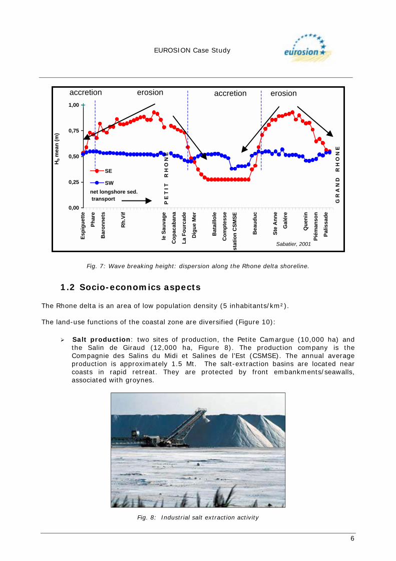
1.1.5 Erosion: distribution of coastal units The coastline shows erosion and accretion in different places, with different trends in erosion and sedimentation as a function of time over the last 60 years. The pattern of sedimentary transport can be described in four elementary units or cells. The residual transport directions are divergent towards the east (Gracieuse spit) and towards the west (l’Espiguette spit). A central cell is characterized by a convergence, which gives rise to accumulation (spit and gulf of Beauduc). The Rhone mouth is an accretion zone (2.0 M.m3/years since the beginning if the 20th century) that does not appear to supply the coastline. The global transport rate is in deficit (2.4 M.m3/yr). The sedimentary losses are directed towards the deeper part of the near-shore zone, as well as towards the dune system by aeolian transport on the spits.
Fig. 6: Distribution of longshore drift cells.
Cause of erosion The lowering in fluvial sedimentary fluxes could be a significant forcing agent in extending the area of eroded coast (1.7 M.m²/yr between 1944 and 1989). However, the localisation of the major erosion zones is correlated with the spatial distribution of wave energy and the longshore gradient in sediment transport, which seems to be the primary cause of erosion (Fig.7). The long term sea-level rise probably causes 10 % of the shoreline retreat. Lastly, transport by winds from the land (Mistral, Tramontane) also causes a deflation of the dunes, which are being eroded on E-W trending sections of the beaches.
EUROSION Case Study
6
0,00
0,25
0,50
0,75
1,00
Esp
igue
tte
Phar
e
Bar
onne
ts
Rh.
Vif
le S
auva
ge
Cop
acab
ana
La F
ourc
ade
Dig
ue M
er
Bat
aillo
le
Com
ptes
se
stat
ion
CSM
SE
Bea
uduc
Ste
Ann
e
Gal
ére
Que
nin
Piém
anso
n
Palis
sade
Hb m
ean
(m)
SE
SW
erosion
P E
T I T
R
H O
N E
G R
A N
D
R H
O N
E
accretion erosionaccretion
net longshore sed. transport
Sabatier, 2001
Fig. 7: Wave breaking height: dispersion along the Rhone delta shoreline.
1.2 Socio-economics aspects The Rhone delta is an area of low population density (5 inhabitants/km²). The land-use functions of the coastal zone are diversified (Figure 10):
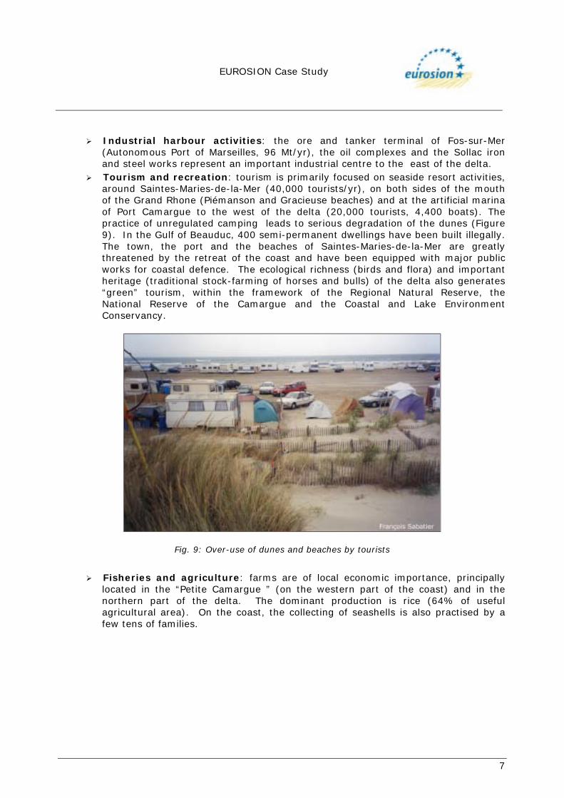
! Salt production: two sites of production, the Petite Camargue (10,000 ha) and the Salin de Giraud (12,000 ha, Figure 8). The production company is the Compagnie des Salins du Midi et Salines de l’Est (CSMSE). The annual average production is approximately 1.5 Mt. The salt-extraction basins are located near coasts in rapid retreat. They are protected by front embankments/seawalls, associated with groynes.
Fig. 8: Industrial salt extraction activity
EUROSION Case Study
7
! Industrial harbour activities: the ore and tanker terminal of Fos-sur-Mer
(Autonomous Port of Marseilles, 96 Mt/yr), the oil complexes and the Sollac iron and steel works represent an important industrial centre to the east of the delta.
! Tourism and recreation: tourism is primarily focused on seaside resort activities, around Saintes-Maries-de-la-Mer (40,000 tourists/yr), on both sides of the mouth of the Grand Rhone (Piémanson and Gracieuse beaches) and at the artificial marina of Port Camargue to the west of the delta (20,000 tourists, 4,400 boats). The practice of unregulated camping leads to serious degradation of the dunes (Figure 9). In the Gulf of Beauduc, 400 semi-permanent dwellings have been built illegally. The town, the port and the beaches of Saintes-Maries-de-la-Mer are greatly threatened by the retreat of the coast and have been equipped with major public works for coastal defence. The ecological richness (birds and flora) and important heritage (traditional stock-farming of horses and bulls) of the delta also generates “green” tourism, within the framework of the Regional Natural Reserve, the National Reserve of the Camargue and the Coastal and Lake Environment Conservancy.
Fig. 9: Over-use of dunes and beaches by tourists
! Fisheries and agriculture: farms are of local economic importance, principally
located in the “Petite Camargue ” (on the western part of the coast) and in the northern part of the delta. The dominant production is rice (64% of useful agricultural area). On the coast, the collecting of seashells is also practised by a few tens of families.

EUROSION Case Study
8
Fig. 10: Spatial distribution of activities on the Rhone delta.
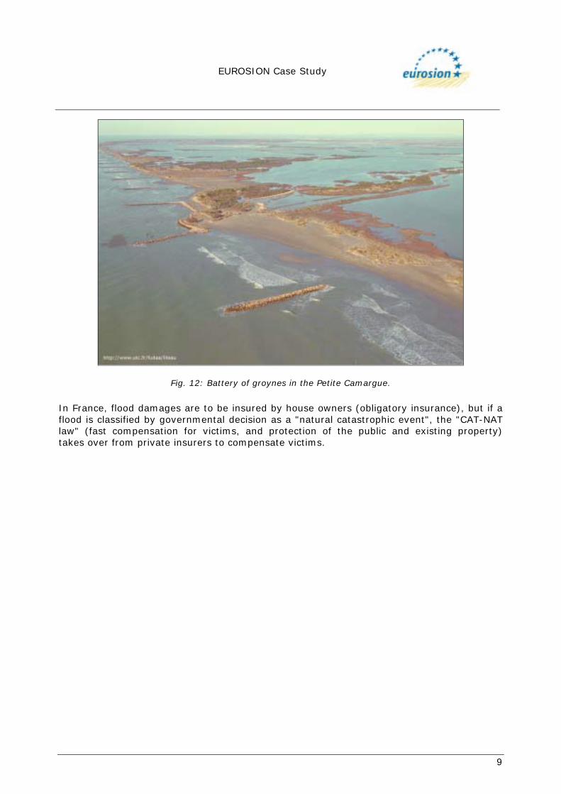
1.2.1 Coastal risk Along the Rhone delta coast, erosion leads to a higher risk of coastal retreat and flooding. Generally, erosion reduces the beach width and poses a threat for the dunes (Figure 11). It is threatening the industrial salt pans at Faraman and in the Petite Camargue: during the winter of 1997, a breach in the dykes produced extensive flooding in the Faraman basins. On the Petite Camargue, erosion has separated the groynes from the beach (Figure 12) and is threatening the farms and salt pans. In the medium term (30 years), coastal retreat combined with flooding and the predicted rise in sea level could cut off the town of Saintes-Maries from areas farther inland (Fig.19).
Fig. 11: Erosion of dunes by storms.
EUROSION Case Study
9
Fig. 12: Battery of groynes in the Petite Camargue.
In France, flood damages are to be insured by house owners (obligatory insurance), but if a flood is classified by governmental decision as a "natural catastrophic event", the "CAT-NAT law" (fast compensation for victims, and protection of the public and existing property) takes over from private insurers to compensate victims.

EUROSION Case Study
10
2. PROBLEM DESCRIPTION Five sites illustrating the different techniques of protection are selected in order to describe the erosion and its impact (Fig. 1). Site of the Gracieuse sand spit (Fig.13) The formation of the Gracieuse sand spit is due to the retreat of an old mouth of the Rhone (the “Pégoulier” Rhone) and the erosion of its fossil prodelta. Sands derived from this erosion were taken up again by SW-NE longshore drift, and have led naturally to the construction of the spit. The elongation of this spit towards the north has provided protection against storm swell for the Port of Marseilles, which is especially occupied with the transit of hydrocarbons. From the 1970s onwards, the continuous retreat of the central part of the spit and the occurrence of many breaches has endangered the permanence/sustainability of this structure.
Fig. 13: La Gracieuse spit evolution.
Piémanson beach The beach of Piémanson is partially protected from storm swell and is practically stable, being located near the mouth of the Rhone and supplied by longshore drift from the west. This sector is particularly subject to the pressure of summer tourists, which results in the destructive trampling of small dunes on the lower foreshore and a considerable traffic of vehicles on the beach.
EUROSION Case Study
11
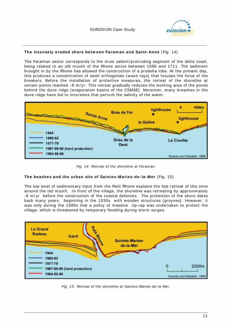
The intensely eroded shore between Faraman and Saint-Anne (Fig. 14) The Faraman sector corresponds to the most salient/protruding segment of the delta coast, being related to an old mouth of the Rhone active between 1586 and 1711. The sediment brought in by the Rhone has allowed the construction of a prodelta lobe. At the present day, this produces a concentration of swell orthogonals (wave rays) that focuses the force of the breakers. Before the installation of protective measures, the retreat of the shoreline at certain points reached –8 m/yr. This retreat gradually reduces the working area of the ponds behind the dune ridge (evaporation basins of the CSMSE). Moreover, many breaches in the dune ridge have led to incursions that perturb the salinity of the water.
Fig. 14: Retreat of the shoreline at Faraman.
The beaches and the urban site of Saintes-Maries-de-la-Mer (Fig. 15) The low level of sedimentary input from the Petit Rhone explains the fast retreat of this zone around the old mouth. In front of the village, the shoreline was retreating by approximately -8 m/yr before the construction of the coastal defences. The protection of the shore dates back many years, beginning in the 1930s with wooden structures (groynes). However, it was only during the 1980s that a policy of massive rip-rap was undertaken to protect the village, which is threatened by temporary flooding during storm surges.
Fig. 15: Retreat of the shoreline at Saintes-Maries-de-la-Mer.
EUROSION Case Study
12
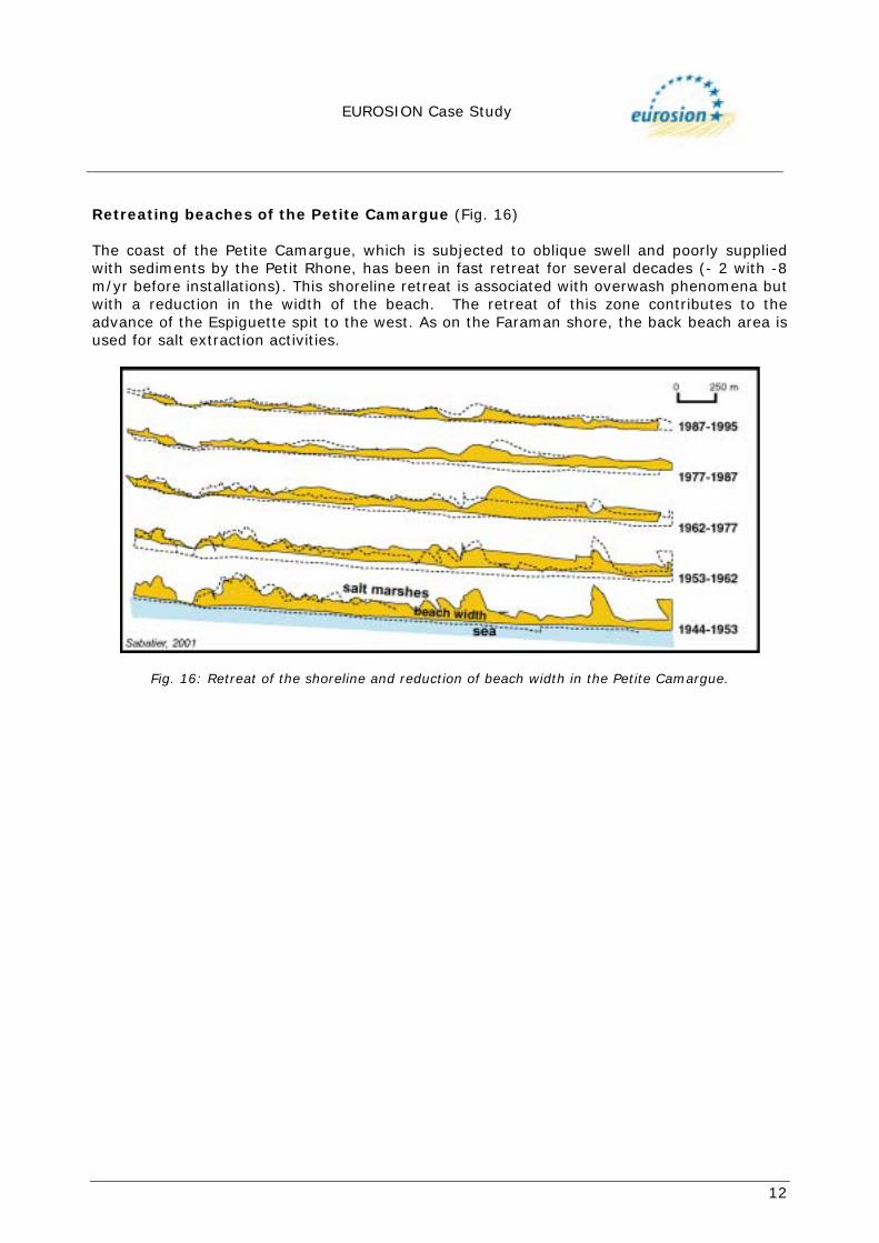
Retreating beaches of the Petite Camargue (Fig. 16) The coast of the Petite Camargue, which is subjected to oblique swell and poorly supplied with sediments by the Petit Rhone, has been in fast retreat for several decades (- 2 with -8 m/yr before installations). This shoreline retreat is associated with overwash phenomena but with a reduction in the width of the beach. The retreat of this zone contributes to the advance of the Espiguette spit to the west. As on the Faraman shore, the back beach area is used for salt extraction activities.
Fig. 16: Retreat of the shoreline and reduction of beach width in the Petite Camargue.
EUROSION Case Study
13
3. SOLUTIONS/MEASURES
3.1 Policy options Along the inhabited sectors (Saintes-Maries-de-la-Mer) or in areas intended for salt production, the adopted policy option is to “Hold the Line”, with the help of public financing. In the sectors belonging to the regional Natural Reserve and the National Reserve, the policy option is to “Do Nothing” on the stable beaches, or carry out limited operations (“ganivelles”) on the slow retreating coasts.
3.2 Strategy
3.2.1 Approach in relation to the problem The engineering actions are diverse. On inhabited or industrial coastlines, hard (robust) solutions are applied to prevent local erosion (front embankments, groynes and break-waters). This choice is necessary because of the economic value of the property to be protected and the risks incurred by inhabitants in sectors that have lost their natural capacity of shore defence (due to sedimentary deficit or highly destructive swell). On the windward coast, east of Saintes-Maries and along the Gracieuse spit, dunes are protected by a wind-break (“ganivelle”). This choice depends on the existence of a system still being fed by sand, allowing cross-shore sedimentary exchanges. However, near Saintes-Maries, the retreat of the beach threatens the dunes equipped with ganivelles: future rebuilding-up operations are considered here. In the 1970s, a dyke with geotextile revetment was built on the almost-stable Piemanson beach, which is threatened by over-use by tourists. Recently, ganivelles were built on the beach itself, to limit the traffic of vehicles.
3.3 Measures
3.3.1 Historical measures Locally, some technical measures were taken during the period from 1930 to 1950: wood groynes were built around Saintes-Maries-de-la-Mer and Faraman. These structures are nowadays destroyed.
3.3.2 Type Artificial structures to stop or reduce erosion are listed here in relation to the major eroded sites, along with the period in which they were built and/or maintained Reinforcement of the Gracieuse dune ridge by ganivelles. The Autonomous Port of Marseilles decided to consolidate the Gracieuse spit (rebuilding of the dune ridge on a network of ganivelles) and to control the advance of its tip (19 m/yr), which threatened the navigation channel at the entry of the port (immersion of barges on the sand bank). Work proceeded from 1988 to 1993. The rebuilding of the ridge involved
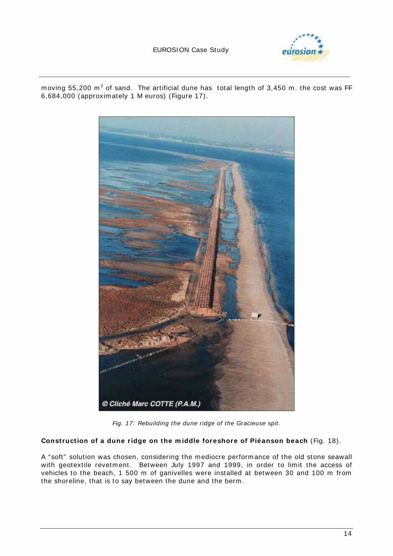
EUROSION Case Study
14
moving 55,200 m3 of sand. The artificial dune has total length of 3,450 m. the cost was FF 6,684,000 (approximately 1 M euros) (Figure 17).
Fig. 17: Rebuilding the dune ridge of the Gracieuse spit.
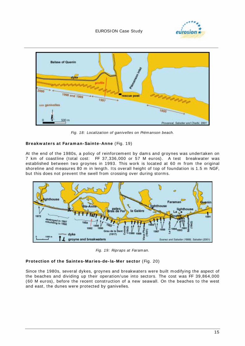
Construction of a dune ridge on the middle foreshore of Piéanson beach (Fig. 18). A “soft” solution was chosen, considering the mediocre performance of the old stone seawall with geotextile revetment. Between July 1997 and 1999, in order to limit the access of vehicles to the beach, 1 500 m of ganivelles were installed at between 30 and 100 m from the shoreline, that is to say between the dune and the berm.
EUROSION Case Study
15
Fig. 18: Localization of ganivelles on Piémanson beach.
Breakwaters at Faraman-Sainte-Anne (Fig. 19) At the end of the 1980s, a policy of reinforcement by dams and groynes was undertaken on 7 km of coastline (total cost: FF 37,336,000 or 57 M euros). A test breakwater was established between two groynes in 1993. This work is located at 60 m from the original shoreline and measures 80 m in length. Its overall height of top of foundation is 1.5 m NGF, but this does not prevent the swell from crossing over during storms.
Fig. 19: Ripraps at Faraman.
Protection of the Saintes-Maries-de-la-Mer sector (Fig. 20) Since the 1980s, several dykes, groynes and breakwaters were built modifying the aspect of the beaches and dividing up their operation/use into sectors. The cost was FF 39,864,000 (60 M euros), before the recent construction of a new seawall. On the beaches to the west and east, the dunes were protected by ganivelles.
EUROSION Case Study
16
Fig. 20: Ripraps at Saintes-Maries-de-la-Mer.
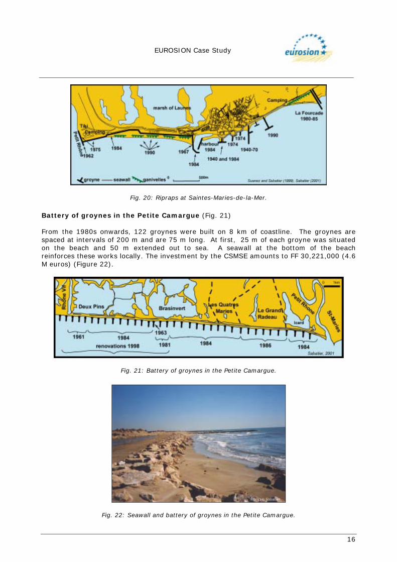
Battery of groynes in the Petite Camargue (Fig. 21) From the 1980s onwards, 122 groynes were built on 8 km of coastline. The groynes are spaced at intervals of 200 m and are 75 m long. At first, 25 m of each groyne was situated on the beach and 50 m extended out to sea. A seawall at the bottom of the beach reinforces these works locally. The investment by the CSMSE amounts to FF 30,221,000 (4.6 M euros) (Figure 22).
Fig. 21: Battery of groynes in the Petite Camargue.
Fig. 22: Seawall and battery of groynes in the Petite Camargue.

EUROSION Case Study
17
4. EFFECTS AND LESSONS LEARNT
4.1 Effects related to erosion Structural erosion is apparently halted by the “hard” type of equipment, but the surf zone and the upper shoreface continues to evolve in a negative manner. Soft solutions are only locally effective. Gracieuse spit (Fig. 23) The coastline has been stabilized at the same position since 1995. Storm-breaches were closed. For many years, dune maintenance has been carried out. A spontaneous vegetation is now covering the inward face of the dune.
Fig. 23: Reconstructing the dune ridge using ganivelles.
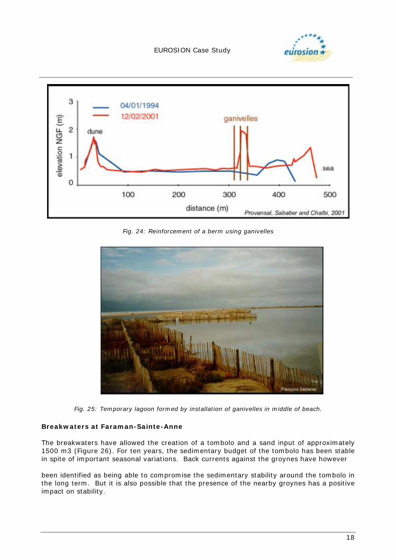
Ganivelles in the middle of Piemanson beach (Fig. 24) The ganivelles established on the middle part of the beach have led to the build-up of a small dune ridge and a sedimentary gain of between 10 and 20 m3/m. It seems that the shoreline has also advanced, but it is however too early to determine if this accumulation could have destabilized the sedimentary budget of the beach. Moreover, tourist activities are nowadays concentrated in the area between the ganivelles and the dune ridge (camp-sites, caravanning). This zone corresponds to a relative depression where overflow storm waters remain during the winter months, thus modifying the environment by creating a temporary lagoon (Figure 25).
EUROSION Case Study
18
Fig. 24: Reinforcement of a berm using ganivelles
Fig. 25: Temporary lagoon formed by installation of ganivelles in middle of beach.
Breakwaters at Faraman-Sainte-Anne The breakwaters have allowed the creation of a tombolo and a sand input of approximately 1500 m3 (Figure 26). For ten years, the sedimentary budget of the tombolo has been stable in spite of important seasonal variations. Back currents against the groynes have however been identified as being able to compromise the sedimentary stability around the tombolo in the long term. But it is also possible that the presence of the nearby groynes has a positive impact on stability.

EUROSION Case Study
19
Fig. 26: Breakwaters at St-Anne (1996)
Sector of Saintes-Maries-de-la-Mer (Fig. 27) Overall, the works have made it possible to stop the retreat of the shoreline, even leading to a certain amount of advance related to the creation of a tombolo due to a breakwater. Without these works, the town of Saintes-Maries-de-la-Mer would now be submerged by the sea. Nevertheless, despite these structures, underwater erosion has continued and no measurements are available allowing an estimation of its importance. The effect of the works is thus limited in time. By blocking a large part of the sedimentary transport, the works deprive the eastern beaches of sedimentary input related to the eastward longshore drift.
Fig. 27: Prediction (2000 and 2030) of the position of the shoreline at Saintes-Maries-de-la-Mer
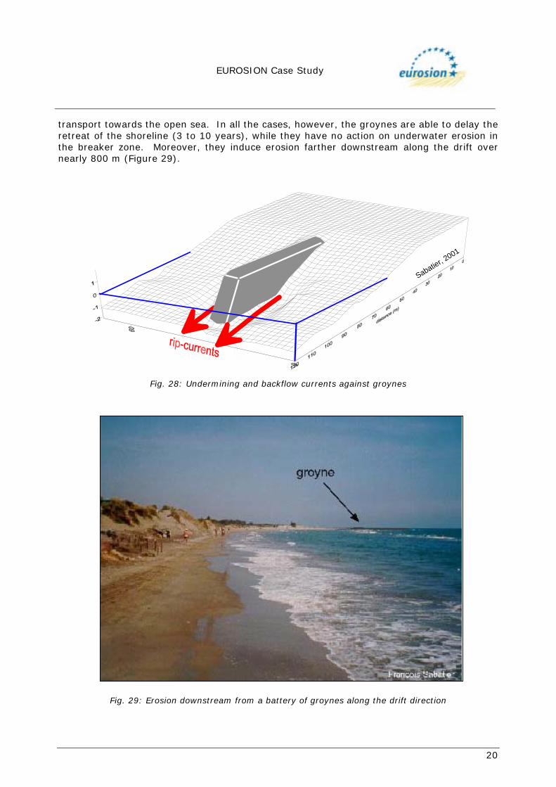
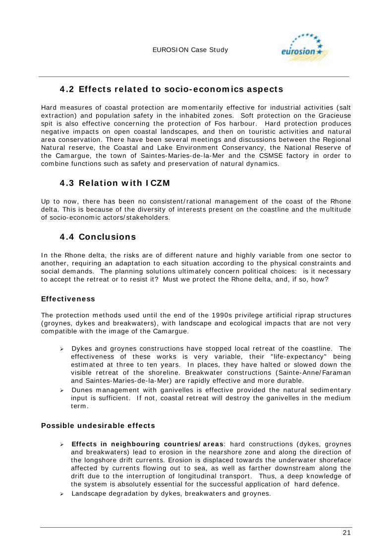
Beaches of the Petite Camargue (Fig. 28) The effectiveness of the coastal protection works is limited because of geotechnical deficiencies (groynes are too short and too widely spaced) and the generally weak sedimentary inputs. The skirting of groynes is now inducing a resumption of erosion, after a relative stabilization in the 1990s. In 1998, most of the groynes were lengthened with the aim of obtaining a certain degree of effectiveness. The length/spacing ratio of the groynes was unfavourable during their construction, but this was improved by the recent extension work. However, there is still great uncertainty on the long-term effectiveness of groynes. Indeed, we can observe backflow currents against the works that could favour sediment
EUROSION Case Study
20
transport towards the open sea. In all the cases, however, the groynes are able to delay the retreat of the shoreline (3 to 10 years), while they have no action on underwater erosion in the breaker zone. Moreover, they induce erosion farther downstream along the drift over nearly 800 m (Figure 29).
Sabatier, 2001
Fig. 28: Undermining and backflow currents against groynes
Fig. 29: Erosion downstream from a battery of groynes along the drift direction
EUROSION Case Study
21
4.2 Effects related to socio-economics aspects Hard measures of coastal protection are momentarily effective for industrial activities (salt extraction) and population safety in the inhabited zones. Soft protection on the Gracieuse spit is also effective concerning the protection of Fos harbour. Hard protection produces negative impacts on open coastal landscapes, and then on touristic activities and natural area conservation. There have been several meetings and discussions between the Regional Natural reserve, the Coastal and Lake Environment Conservancy, the National Reserve of the Camargue, the town of Saintes-Maries-de-la-Mer and the CSMSE factory in order to combine functions such as safety and preservation of natural dynamics.
4.3 Relation with ICZM Up to now, there has been no consistent/rational management of the coast of the Rhone delta. This is because of the diversity of interests present on the coastline and the multitude of socio-economic actors/stakeholders.
4.4 Conclusions In the Rhone delta, the risks are of different nature and highly variable from one sector to another, requiring an adaptation to each situation according to the physical constraints and social demands. The planning solutions ultimately concern political choices: is it necessary to accept the retreat or to resist it? Must we protect the Rhone delta, and, if so, how?
Effectiveness The protection methods used until the end of the 1990s privilege artificial riprap structures (groynes, dykes and breakwaters), with landscape and ecological impacts that are not very compatible with the image of the Camargue.
! Dykes and groynes constructions have stopped local retreat of the coastline. The effectiveness of these works is very variable, their "life-expectancy" being estimated at three to ten years. In places, they have halted or slowed down the visible retreat of the shoreline. Breakwater constructions (Sainte-Anne/Faraman and Saintes-Maries-de-la-Mer) are rapidly effective and more durable.
! Dunes management with ganivelles is effective provided the natural sedimentary input is sufficient. If not, coastal retreat will destroy the ganivelles in the medium term.
Possible undesirable effects
! Effects in neighbouring countries/areas: hard constructions (dykes, groynes and breakwaters) lead to erosion in the nearshore zone and along the direction of the longshore drift currents. Erosion is displaced towards the underwater shoreface affected by currents flowing out to sea, as well as farther downstream along the drift due to the interruption of longitudinal transport. Thus, a deep knowledge of the system is absolutely essential for the successful application of hard defence.
! Landscape degradation by dykes, breakwaters and groynes.
EUROSION Case Study
22
Gaps in information:
! Sedimentary balance, with regard to precise river input in the delta. ! Economic balance between the estimated value of endangered property and
activities (tourism, salt extraction) and the cost of coastal defences.
Perspectives and discussion The functioning of the delta coast system must be analysed as a whole, by taking account of the interactions between present-day dynamics and long-term tendencies. However, the risk management is necessarily local and immediate, being a function of the required level of protection of people and property. Major works are effective on some sectors with high economic value, where their use is necessary to block coastal erosion. On several sectors, however, the choice of less expensive techniques (ganivelles) can also be effective (if sedimentary input is sufficient) or lead to a temporary slowing down in the retreat. Nevertheless, it is necessary to test innovative techniques: artificial nourishment and sedimentary by-passing via the river course. Lastly, some of the flood waters loaded with sediment may be released onto the deltaic plain in order to combat the rise in water level. Locally, a fallback/regression of the shoreline may prove indispensable in the medium term (a few years) if structural erosion becomes too important. But this fallback solution cannot be applied without evaluating its natural and economic consequences, i.e.: threats on maintaining salt extraction, agricultural activities and the urban site of Saintes-Maries-de-la-Mer.
EUROSION Case Study
23
5. REFERENCES Blanc, J.J. (1977). Recherche en sédimentologie appliquée au littoral du delta du Rhône, de Fos au Grau du Roi. Centre National pour l'Exploitation des Océans, 75(1193): 69. Blanc, J.J. (1985). Ruptures d'équilibre au littoral de Provence Occidentale: l'action des tempêtes, relations avec les aménagements. Téthys, 11(3-4): 350-359. Blanc, J.J.; Froget, C.H. (1981). Mesure et méthode d'étude quantitative de l'érosion des littoraux meubles, exemple de Camargue. Bull. de l'Association Française pour l'étude du Quaternaire, (18)-5: 47-52. Blanc, J.J. ; Jeudy de Grissac, A. (1982). Dangers d'érosion littorale en Petite Camargue (aire occidentale du Delta du Rhône, France). Téthys, 10(4): 349-354. Blanc, J.J.; Poydenot, F. (1993). Le rivage de Faraman en Camargue (SE France) : un géosystème côtier en déséquilibre; méthodes d'étude-conséquences pratiques. Géologie Méditerranéenne, XX(2): 75-87. Bruzzi, C. (1998). Les tempêtes et l'évolution morphosédimentaire des plages orientales du delta du Rhône, Thèse Université de Provence, UFR des Sciences Géographiques et de l'Aménagement, Aix-en-Provence, 325 pp. Clairefond, P. (1977). Le golfe des Saintes-Maries-de-la-Mer (Camargue). Etude sédimentologique aménagement et protection, Université de Luminy, Marseille, 139 pp. EDF-LNH-SOGREAH (1984). Catalogue sédimentologique des côtes françaises. Côtes de la Méditerranée. EDF-LNH (1990). Mesure de houle en différents sites du Littoral Français. 6e edition. Fleury, M.C. (1992). Le littoral camarguais, inventaire des aménagements, évolution géographique, économique et juridique entre 1970 et 1992, Université de Montpellier I II et III et Réserve Nationale de Camargue. François, L. (1937). Etude sur l'évolution actuelle des côtes de Camargue. Revue de Géographie Régionale: 71-126. Jiménez, J. ; Capobianco, M. ; Suanez, S. ; Piero, R. ; Fraunié, P. ; Stive, M.J.F. (1995). Coastal processes along the Ebro, Po and Rhone deltas, MEDCOAST 95, October 24-27, Tarragona, Spain E. Özhan (Editor), 827-840. L'Homer, A.; Bazile, F.; Thommeret, J.; Thommeret, Y. (1981). Principales étapes de l'édification du delta du Rhône de 7,000 BP à nos jours; variations du niveau marin. Oceanis, 7(4): 389-408. Miossec, A. (1998). Le littoral de la Camargue, état des lieux et propositions d'action en matière de lutte contre l'érosion marine, Parc Naturel Régional de Camargue, Arles. Paskoff, R. (1991). La défense de la côte de la Camargue contre la mer, Parc Naturel Régional de Camargue, Arles.
EUROSION Case Study
24
Paskoff, R. (1998). Le littoral du Parc Naturel Regional de la Camargue après la grande tempête de décembre 1997, Parc Naturel Régional de Camargue, Arles. Pons, F.; Sabatier, F.; Tanguy, J.M.; Lambert , A. (2002). Morphodynamique des dunes sous l’effet du vent: mesures expérimentales et modélisation, Génie Civil Génie Côtier, 220-228. Provansal, M.; Sabatier, F. (2002). Evolution du trait de côte et conservation du littoral sableux Plage Est des Saintes-Maries-de-la-Mer, pour le Parc Naturel Régional de Camargue, 32 p. Provansal, M.; Sabatier, F.; Chaibi, M. (2001). Schéma d’aménagement concerté de la plage de Piémenson, pour le Parc Naturel Régional de Camargue, 34 p. Sabatier F.; Suanez S. (subm.) Cinématique du littoral du delta du Rhône depuis le début du siècle, Géomorphologie: Relief. Processus. Environnement. Sabatier, F.; Lambert, A.; Provansal, M. (in press). Déformation des barres d’avant côte des plages du delta du Rhône. Résultats préliminaires, Journal de Recherche Océanographique. Sabatier, F.; Raivard, G. (in press). Evolution bathymétrique de la pointe de l’Espiguette, Commission Nationale de Géographie de la Mer, Dunkerque, 3-5 Juin 2000. Sabatier, F.; Chaibi, M.; Pons. F. (2002). Validation of aeolian sediment transport formulae, in E. Özhan eds., International MEDCOAST Workshop on Beaches of the Mediterranean and the Black Sea: Dynamics, Regeneration, Ecology & Management, Turkey. Sabatier, F.; Lambert, A.; Chaibi, M.; Samat, O.; Vella, C.; Provansal, M. (2002). Experimental and numerical approach of beach profile change on sandy microtidal environment, European Geophysical Society, april 2002, Nice, France. Sabatier, F.; Lambert, A.; Chaibi, M.; Samat, O.; Provansal, M. (2002). Morphodynamique du profil de plage en milieu microtidal : du relevé de terrain au modèle mathématique et numérique, « Geomorphology : from expert opinion to modelling», 26-27 avril 2002, 204-208. Sabatier, F.; Provansal, M. (2002). La Camargue sera-t-elle submergée ?, La Recherche, juillet-aout 2002, 72-73 Sabatier, F. (2001). Fonctionnement et dynamiques morpho-sédimentaires du littoral du delta du Rhone, Ph.D thesis, Aix-Marseille III University, 272p. Sabatier, F. (2001). Morphogénèse d’une plage sableuse en contexte aménagé. Le cas des Saintes-Maries-de-la-Mer Delta du Rhône. Journée des Jeunes Géomorphologues, St Etienne. Sabatier, F.; Chaibi, M.; Lambert, A.; Provansal, M. (2001). Longshore sediment transport on sandy beaches. A field modelling approach, European Geophysical Society, 29 march, Nice, France. Sabatier, F.; Provansal, M. (2000). Sandbars morphology of Espiguette spit, Mediterranean Sea, France, International Workshop Sandwaves Dynamics, Lille, 23-25 march 2000, 179-187.

EUROSION Case Study
25
Sabatier, F.; Provansal, M. (2000). Bilans morphologiques, répartition granulométriques et direction du transport sédimentaire autour du brise-lames de Ste Anne, delta du Rhône, Génie Civil Génie Côtier, 207-216. Sabatier, F.; Arnaud-Fassetta, G. (1999). Premières données sur la contribution des apports sableux du Petit Rhône aux plages du golfe de Beauduc (delta du Rhône), Méditerranée, 4, 11-18. SNPN (1994). Compte rendu scientifique 1994. Arles, Réserve Nationale de Camargue: 97. Sogreah (1995). Etude de l'évolution du littoral sableux de la Camargue, Grenoble. Suanez, S.; Durand, P.; Sabatier, F. (2001). Evolution du trait de côte du littoral sableux méditerranéen, Atlas permanent de la Mer et du Littoral, N°5, CNRS-Géolittomer-LETG Suanez, S.; Bruzzi, C. (1999). Shoreline managements and its implications for the coastal processes in the eastern part of the Rhone delta, Journal of Coastal Conservation, 5, 1-12. Suanez, S.; Bruzzi, C. (1999). Aménagements de défense littorale et dynamique côtière : exemple de la partie orientale du delta du Rhône (France Méridionale), Actes du Colloque de Caen (MRSH, mai 1997), Les Documents de la MRSH, n°10, décembre 1999, 101-112. Suanez, S.; Sabatier, F. (1999). Eléments de réflexion pour la gestion plus cohérente d’un système anthropisé: exemple du delta du Rhône, Revue de Géographie de Lyon, 74(1), 7-25. Suanez, S.; Provansal, M. (1998). Large scale evolution of the littoral of the Rhone delta (Southeast France), Journal of Coastal Research, 14(2), 493-501. Suanez, S.; Bruzzi, C.; Arnoux-Chiavassa, S. (1998). Données récentes sur l'évolution des fonds marins dans le secteur oriental du delta du Rhône (plage Napoléon et flèche de la Gracieuse), Géomorphologie : Relief. Processus. Environnement, 4, 291-312. Suanez, S.; Prosper-Laget, V.; Provansal, M. (1997). Variation relative du niveau marin dans le delta du Rhône. Implication climatique et/ou tectonique, C.R. Acad. Sci. Paris., t.234. Série IIa, 639-646. Suanez, S.; Simon, B. (1997). Utilisation de l'analyse diachronique dans l'étude de l'évolution du littoral du delta du Rhône (France, Sud-Est), Photo-Interprétation, 35, 3-4, 147-158. Suanez, S.; Provansal, M. (1996). Morphosedimentary behaviour of the deltaïc fringe in comparison to the relative sea-level rise on the Rhone delta, Quaternary Science Reviews, 15, 811-818. Suanez, S. (1995). Quelques données nouvelles sur l'évolution mi-séculaire du littoral camarguais à l'embouchure du Rhône (France, Sud-Est), B.A.G.F., 5, 440-454. Suanez, S.; Provansal, M. (1993). Etude des modifications morphosédimentaires du littoral à l'embouchure du Rhône: plages de Piémanson et Napoléon, Méditerrannée, 3-4, 43-56.
EUROSION Case Study
26
Vella, C. (2000). Relative sea-level rise and neotectonic events during the last 6500 yr on the southern eastern Rhône delta, France, Marine Geology. Vernier, E. (1972). Recherches sur la dynamique sédimentaire du Golfe de Fos. Thèse de 3ème cycle d'Océanographie, Université d'Aix-Marseille, 68pp. Wright, L.D.; Short, A.D. (1984). Morphodynamics variability of surf zones and beaches: A Synthesis. Marine Geology, 56, 93-118.
Related Documents