Blueprint for Iskandar Malaysia TM Drainage and Stormwater Management ISBN 978-967-5626-26-5

Welcome message from author
This document is posted to help you gain knowledge. Please leave a comment to let me know what you think about it! Share it to your friends and learn new things together.
Transcript
Blueprint for Iskandar Malaysia
TM
Drainage andStormwater Management
ISBN 978-967-5626-26-5

Drainage and StormwaterManagement Blueprint forIskandar Malaysia
ACKNOWLEDGEMENT
List of agencies/ departments involved in developing DSWM blueprint
Federal
Department of Drainage and Irrigation (JPS)Ministry of Housing and Local Government (KPKT)Department of Works (JKR)Department of Town and Country Planning (JPBD)Department of Environmental (JAS)Suruhanjaya Perkhidmatan Air Negara (SPAN)Department of National Landscape (JLN)
State
Chief Minister Office (Pejabat Menteri Besar)State Economic Planning Unit (UPEN Johor)Johor Bahru Land OfficeKulaijaya Land OfficePontian Land OfficeBadan Kawal Selia Air Johor (BAKAJ)Johor Bahru City Council (MBJB)Central JB Municipal Council (MPJBT)Kulai Municipal Council (MPKu)Pasir Gudang Municipal Council (MPPG)Pontian District Council (MDP)Jabatan Landskap NegeriLocal community
Others
Syarikat Air Johor Indah Water Consortium
Foreword
Iskandar Malaysia is a National Project to develop a vibrant new region at the southern gateway of Peninsular Malaysia. A regional authority body Iskandar Regional Development Authority (IRDA) was formed with specific roles to plan, promote and facilitate in which to coordinate the economic,environmental and social planning, development and management of Iskandar Malaysia. IRDA refers to The Comprehensive Development Plan (CDP) as the guiding document in developing IskandarMalaysia, and subsequent to that, blueprints are prepared as a subset and supplementary document to CDP, which outlines detail findings, strategies, implementation and action plans.
The Drainage and Stormwater Management (DSWM) blueprint for Iskandar Malaysia has been prepared to assist the public and private sector and the community to work together in managing drainage and storm water concerns within the Iskandar Malaysia region so that all can benefit in making the region a place to invest, work, live and play.
Floods and flash floods can cause a significant impact to the performance and economy of Iskandar Malaysia. With this Blueprint, Iskandar Malaysia shall have a reliable, efficient and sustainable drainage system and stormwater management that can prevent floods or associated problems which may hinder the development. The objectives of the Blueprint, are as follow: to support and improve the implementation of Government’s policy on Drainage and Stormwater Management i.e. MSMAGuidelines; to improve performance of drainage and storm water infrastructure with the aim ofcreating a system that is of international standards; and to develop a practical and effective master plan to mitigate prevailing flood in Iskandar Malaysia.
This blueprint has incorporated a set of Forty-four initiatives for Drainage and Stormwatermanagement that is critically address and tackle the region’s drainage, and flooding issues as Iskandar Malaysia develops.
To facilitate the implementation, the blueprint outlines a set of new coordinating structure to manage new partnerships expected to come from public agencies and private organisations working together on practical implementation to improve drainage system, on how to collect storm water for daily usage, and to prevent the flooding in Iskandar Malaysia. Consequently, we look forward to a metropolis that is safe and secure from flooding toward becoming a place to invest, live, work and play within a Metropolis environment of an International Standard.
CONTENT
1 INTRODUCTION 1.1 Background of Project 1 1.2 Objectives of the Blueprint 1 1.3 Scope of Work 1
2 DATA COLLECTION 2.1 Collection of Data 2 2.2 Topographical Data and Engineering Survey 2 2.3 Landuse Information 2 2.4 Hydrological Data 3
3 IDENTIFICATION OF KEY ISSUES 3.1 Drainage and Stormwater Management 4 3.2 Legislation, Policies and Guidelines 4 3.3 Focus Group Discussion 4
4 ANALYSIS AND FINDINGS 4.1 Review of Existing Legislation, Policies and Guidelines 5 4.2 Review of Key Institutions Related to DSWM 5 4.3 Review of Key Legislations Related to DSWM 8 4.4 Review of Landuse Planning Guidelines 10 4.5 Review of Drainage Pattern And Distribution 10 4.6 Gap Analysis 11 4.7 Implementation Framework and Institutional Arrangement 11
5 HYDROLOGICAL AND HYDRAULIC ANALYSIS 5.1 Hydrological Study 13 5.2 Hydraulic Analysis 14 5.3 Drainage System 15
6 BENCHMARKING & EVALUATION 6.1 Introduction 16 6.2 Benefits of Benchmarking 16 6.3 Benchmarking and Performance Assessment 16 6.4 Objectives of Benchmarking 16 6.5 Examples of Benchmarking in Other Countries 17 6.6 Benchmarking for Rivers in Iskandar Malaysia 17 6.7 Non-Structural Best Management Practices 17
7 GEOGRAPHICAL INFORMATION SYSTEM 7.1 Introduction 19 7.2 Objective 19 7.3 Methodology and Approach 19 7.4 Metadata And GIS Database Structure 21 7.5 Work Progress 21
8 ENFORCEMENT PLAN AND DSWM INITIATIVES 8.1 Enforcement Plan 21 8.2 Drainage and Stormwater Management Initiatives 22 8.3 Conclusion 23
ix
1 INTRODUCTION
1.1 Background of Project
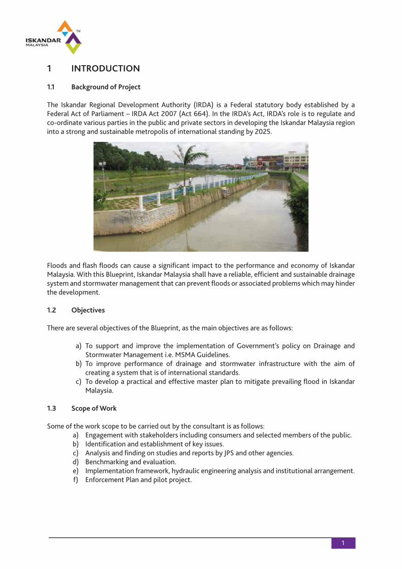
The Iskandar Regional Development Authority (IRDA) is a Federal statutory body established by a Federal Act of Parliament – IRDA Act 2007 (Act 664). In the IRDA’s Act, IRDA’s role is to regulate and co-ordinate various parties in the public and private sectors in developing the Iskandar Malaysia region into a strong and sustainable metropolis of international standing by 2025.
Floods and flash floods can cause a significant impact to the performance and economy of Iskandar Malaysia. With this Blueprint, Iskandar Malaysia shall have a reliable, efficient and sustainable drainage system and stormwater management that can prevent floods or associated problems which may hinder the development.
1.2 Objectives
There are several objectives of the Blueprint, as the main objectives are as follows:
a) To support and improve the implementation of Government’s policy on Drainage and Stormwater Management i.e. MSMA Guidelines. b) To improve performance of drainage and stormwater infrastructure with the aim of creating a system that is of international standards. c) To develop a practical and effective master plan to mitigate prevailing flood in Iskandar Malaysia. 1.3 Scope of Work
Some of the work scope to be carried out by the consultant is as follows: a) Engagement with stakeholders including consumers and selected members of the public. b) Identification and establishment of key issues. c) Analysis and finding on studies and reports by JPS and other agencies. d) Benchmarking and evaluation. e) Implementation framework, hydraulic engineering analysis and institutional arrangement. f) Enforcement Plan and pilot project.
2 DATA COLLECTION
2.1 Collection of Data
Data collection forms an important process in this study. In fulfilling the requirements of the Terms of Reference (TOR), a review of all relevant information/institutions/laws pertaining to flood, drainage and stormwater management including issues related to water in general and land and environment needed to be done.
There are some relevant data and information required stated in blueprint. Requests have been made to the relevant agencies i.e., Jabatan Pengairan dan Saliran (JPS) Johor, the 5 Local Councils and IRDA for the relevant data and information. Requests were also made during the Focus Group Discussion and the also during the report presentation. In addition, team members have made visits to the study area and have obtained some information from the relevant authorities. Some pertinent publications have also been obtained.
2.2 Topographical Data and Engineering Survey
Topographical and engineering survey information’s are required at the areas that are prone to flooding and areas commonly hit by flash floods in Iskandar Malaysia to enable these areas to be identified for remedial works. Survey information of these areas has been requested from JPS Johor and the relevant authorities.
As of this stage, the Consultant has received 17 sheets of 1:25,000 scale topographical maps from the Jabatan Ukur dan Pemetaan Malaysia (JUPEM). However, these 17 sheets only form a partial of the total 39 sheets required for the river catchments within the Iskandar Malaysia.
The engineering survey information/data have been obtained from the JPS Johor, MBJB, MPJBT and IRDA.
2.3 Landuse Information
Land use planning for the Iskandar Malaysia is guided by the “Integrated Land Use Blueprint”, adocument that provides the framework for managing urban growth, change of land use anddevelopment for the region. To accommodate the needs of a 3-million population by 2025, theBlueprint has advocated certain planning and land use management strategies. The area bounded by the Urban Growth Boundary is at least 106,900 hectares or 51% of the total land area of the Iskandar region.
The Land Use Blueprint estimates that this land area would be sufficient to accommodate the social, economic and physical infrastructure requirements of a growing population by 2025. These areas encompass three categories. One of the issues posed at the Focus Group Discussion held on 12th May 2010 is the level of integration and coordination (or its inadequacy) in the planning and development of land use strategies amongst the various Local Authorities. By 2025, the Land Use Blueprintrecognizes the need to urbanize at least 50% of the Iskandar region to cater to the social, economic and infrastructure requirements of the region’s population of 3 million.
2.4 Hydrological Data
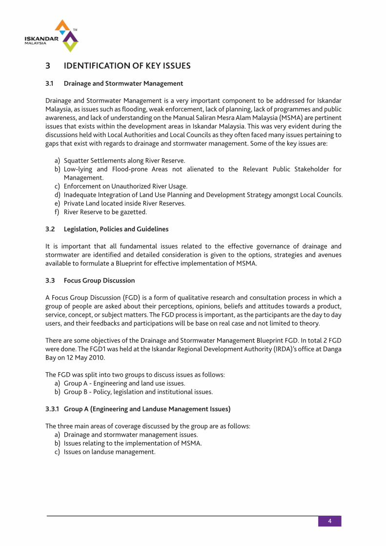
The study area covers the whole of Iskandar Malaysia development and encompasses a land size of 2,217 km2 located at the south of Johor. However, the river catchment boundary exceeds the study area boundary of Iskandar Malaysia (approximately 2.5 times the size) as the main water courses within Iskandar Malaysia is shown in Figure 2.4.
Figure 2.4: Main Water Courses within Iskandar Malaysia(Source: Kajian Rancangan Tempatan Daerah Johor Bahru and Kajian Tempatan Daerah Pontian)
There are 18 hydrological stations available in the Iskandar Malaysia. These are mainly rainfall stations. Due to the nature and short duration of the study, the flood runoff estimations will be based on the Rational Formula as defined in JPS’s Manual Saliran Mesra Alam (MASMA) for urban areas. For the rural areas, estimations shall be done using the Hydrological Procedure No. 11 by JPS.
3 IDENTIFICATION OF KEY ISSUES
3.1 Drainage and Stormwater Management
Drainage and Stormwater Management is a very important component to be addressed for Iskandar Malaysia, as issues such as flooding, weak enforcement, lack of planning, lack of programmes and public awareness, and lack of understanding on the Manual Saliran Mesra Alam Malaysia (MSMA) are pertinent issues that exists within the development areas in Iskandar Malaysia. This was very evident during the discussions held with Local Authorities and Local Councils as they often faced many issues pertaining to gaps that exist with regards to drainage and stormwater management. Some of the key issues are:
a) Squatter Settlements along River Reserve. b) Low-lying and Flood-prone Areas not alienated to the Relevant Public Stakeholder for Management. c) Enforcement on Unauthorized River Usage. d) Inadequate Integration of Land Use Planning and Development Strategy amongst Local Councils. e) Private Land located inside River Reserves. f) River Reserve to be gazetted.
3.2 Legislation, Policies and Guidelines
It is important that all fundamental issues related to the effective governance of drainage andstormwater are identified and detailed consideration is given to the options, strategies and avenues available to formulate a Blueprint for effective implementation of MSMA.
3.3 Focus Group Discussion
A Focus Group Discussion (FGD) is a form of qualitative research and consultation process in which a group of people are asked about their perceptions, opinions, beliefs and attitudes towards a product, service, concept, or subject matters. The FGD process is important, as the participants are the day to day users, and their feedbacks and participations will be base on real case and not limited to theory.
There are some objectives of the Drainage and Stormwater Management Blueprint FGD. In total 2 FGD were done. The FGD1 was held at the Iskandar Regional Development Authority (IRDA)’s office at Danga Bay on 12 May 2010.
The FGD was split into two groups to discuss issues as follows: a) Group A - Engineering and land use issues. b) Group B - Policy, legislation and institutional issues.
3.3.1 Group A (Engineering and Landuse Management Issues)
The three main areas of coverage discussed by the group are as follows: a) Drainage and stormwater management issues. b) Issues relating to the implementation of MSMA. c) Issues on landuse management.
3.3.2 Group B (Policy, Legislation and Institutional Issues)
The main areas of coverage discussed by the group are as follows: a) Policies. b) Lead Agency. c) Supporting Agencies. d) Coordinating Mechanisms. e) Enforcement. f) Stakeholder participation
3.3.3 Questionnaire
A Questionnaire was sent together with the invitation to attend the FGD by IRDA. This Questionnaire was meant to prepare the participants, as well as to gain an understanding on the subject matter from the participants. The Questionnaire comprises of 22 questions, which were in objective and subjective forms. From the Questionnaire, an analysis was done to derive the understanding and responsibility of the respondent.
4 ANALYSIS AND FINDINGS
4.1 Review of Existing Legislation, Policies and Guidelines
Issues of governance are required to be addressed in relation to the institutional and legislativeframework. Institutions are the administrative machinery through which policies, plans and programs (PPP’s) and related formal and informal instruments such as laws and guidelines are implemented and enforced. Legislation is a key element and a vital tool in the implementation and enforcement ofmandatory requirements to ensure that the PPP’s are achieved by all sectors. This Chapter contains a review of all major legislation pertaining to drainage and stormwater management (DSWM) in Malaysia.
4.2 Review of Key Institutions Related to DSWM
4.2.1 Iskandar Regional Development Authority (IRDA)
The Iskandar Regional Development Authority (IRDA) is a statutory body established by the Federal Government under the Iskandar Regional Development Authority Act 2007 (IRDA Act 2007). Its primary objective, as stipulated under the IRDA Act 2007 is to make the Iskandar Malaysia a strong andsustainable metropolis of international standing. Iskandar Malaysia comprises of Kulai Jaya Municipal Council, Pasir Gudang Municipal Council, Johor Bahru Tengah Municipal Council, Johor Bahru CityCouncil and Pontian District. Its core functions are to plan, facilitate and promote the desireddevelopment and investment in the region and include as follows: a) Integrate and recommend planning policies and strategies at the Federal and Johor State and Local Authority levels. b) To develop strategies to enhance infrastructure, skills, science and technology research for the development in Iskandar Malaysia.
4.2.2 Fisheries Department
The Department of Fisheries (DOF) is responsible for the development and management of the fishing industry in a sustainable, dynamic and competitive manner. This Department seeks to increaseproduction and balance the national commercial fishing. The Fisheries Department issues licenses, permits and guidelines relating to the activities within the fishing industry.
There are several divisions within the DOF, which may be significant for biodiversity conservation. The FRI consists of Fishery Resources Research Section, Biotechnology and Fisheries Products Research Section, Aquaculture Research Section and Aquatic Ecosystem Research Section. Their significances are as follows: a) Fishery Resources Research Section. b) Biotechnology and Fisheries Products Research Section. c) Aquaculture Research Section. d) Aquatic Ecosystem Conservation Section.
4.2.3 Department Of Irrigation and Drainage
The Department of Irrigation and Drainage (JPS) is functional to include drainage, irrigation, river and coastal engineering and hydrology. The Flood Mitigation Division functions to reduce and prevent flooding, flood damage and create a better environment for economic and social development.
The Prime Minister’s Department aim to ensure proper planning and sustainable development of the coastal zone. Section 3 of the Guidelines has identified the following categories of development which calls for its application and requires EIAs to be carried out: a) Shore front development. b) Back shore development. c) Land reclamation. d) Sand mining and river mouth dredging (state and federal level).
The Hydrology and Water Resources Division in JPS collects processes and provides hydrological data necessary for the development and management of water resources as well as provide hydrological services at major river basins in Malaysia.
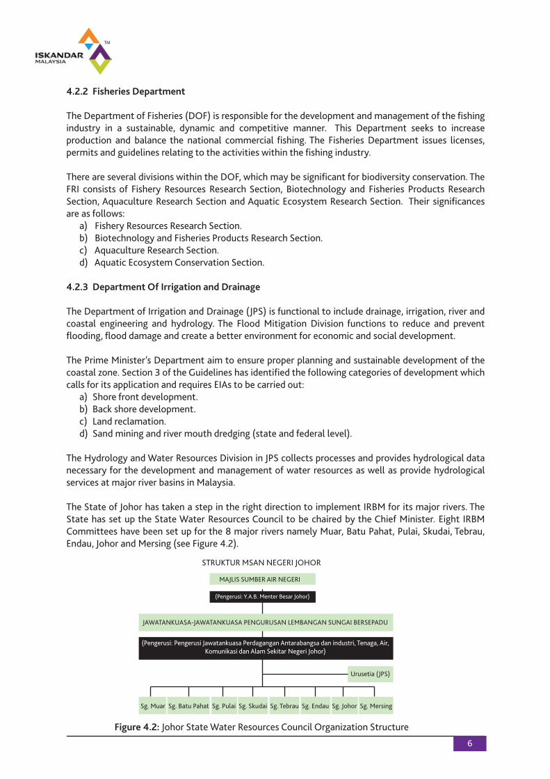
The State of Johor has taken a step in the right direction to implement IRBM for its major rivers. The State has set up the State Water Resources Council to be chaired by the Chief Minister. Eight IRBM Committees have been set up for the 8 major rivers namely Muar, Batu Pahat, Pulai, Skudai, Tebrau, Endau, Johor and Mersing (see Figure 4.2).
Figure 4.2: Johor State Water Resources Council Organization Structure
MAJLIS SUMBER AIR NEGERI
(Pengerusi: Y.A.B. Menter Besar Johor)
JAWATANKUASA-JAWATANKUASA PENGURUSAN LEMBANGAN SUNGAI BERSEPADU
(Pengerusi: Pengerusi Jawatankuasa Perdagangan Antarabangsa dan industri, Tenaga, Air,Komunikasi dan Alam Sekitar Negeri Johor)
Sg. Muar Sg. Batu Pahat Sg. Pulai Sg. Skudai Sg. Tebrau Sg. Endau Sg. Johor Sg. Mersing
STRUKTUR MSAN NEGERI JOHOR
Urusetia (JPS)
4.2.4 Department of Forestry
The Forestry Department of Peninsular Malaysia (FDPM) is principally responsible to ensure sustainable management and development of the nation's forest resources. Some objectives of the FDPM are as follows: a) To manage the forest resources sustainably for the continuous production of forest goods and services and their optimum utilization, compatible with environmental requirements. b) To increase the supply of forest goods and services through appropriate forestry activities that enhances the quality, productivity and utilization of the forest resources. Some strategies adopted by this Department to manage the forest resources are in line with the forest management policy and objectives stated above and include as follows: a) Forested land scheduled for conversion to agriculture will be released for clearance in a properly planned and controlled manner to ensure a regulated and reliable flow of logs, together with themaximum possible utilization of the available wood supply. b) Forested land not destined for conversion to agriculture will be designated as permanent forest and will be managed as a renewable resource in a manner designed to maximize commercial returns compatible with the maintenance of environmental quality.
4.2.5 Department of Agriculture
The Department of Agriculture (DOA) is the principal agency in rural and agricultural development responsible for the management and development of the nation’s agriculture. The DOA offersprofessional services in various areas of agriculture to smallholders, entrepreneurs and the private sector in its effort to promote the use of modern and efficient technologies.
The DOA responsible is to develop trained and skilled human resource in the agricultural sector. Functions of the DOA which are relevant for IRBM include the following: a) Develop a National Source of Agricultural Information for purposes of planning and development of agricultural projects. b) To enforce the Pesticides Act 1974 to ensure that all pesticides imported, manufactured and sold in the country are of high quality and do not have adverse effects on humans, animals, food crops and the environment.
4.2.6 Jabatan Perancang Bandar dan Desa
The planning process in Peninsular Malaysia at the Federal level falls within the jurisdiction of the Jabatan Perancang Bandar dan Desa (JPBD). The JPBD falls under the purview of the Ministry of Housing and Local Government and is headed by a Director General. The JPBD objectives are to establish and implement comprehensive and uniform nationwide rural and urban planning to strengthen and promote physical, social, economic and environmental development. Its functions look towards achieving primary national development goals through its policies.
The planning process takes place at 3 stages namely the federal, state and district/ municipal levels. The JPBD is moving towards implementing Strategic Environmental Assessment to be included in thepreparation of Statutory Plans and Development Proposal Plan.
4.2.7 Department of Environment
The Department of Environment (DOE) is tasked to prevent, control and abate pollution through the administration and enforcement of the Environmental Quality Act 1974 (EQA 1974) and othersubsidiary legislation. Some strategies adopted and carried out by DOE in executing its duties andfunctions are as follows: 1. Pollution Control and Prevention. 2. Sustainable Development through Conservation of Resources. 4.2.8 Local Councils
The various Local Councils which fall under the area of Iskandar Regional Development include the Johor Bahru Tengah Municipal Council, Johor Bahru City Council, Pasir Gudang Municipal Council, Kulai Municipal Council and Pontian District Council.
There are various Departments and Divisions within the Local Councils that are designated to and assigned to carry out various functions. The roles and functions of the Planning, Building andEngineering Department would be relevant and important pertaining to drainage and storm watermanagement.
Local Councils are in charge of the construction and maintenance of all drains within their areas. They are equipped with the powers under the Local Government Act to ensure that the rules and regulations required in building and construction matters, including drainage and sewerage. Despite there being various divisions which are responsible for matters related to drainage and stormwater management, there are numerous challenges faced by Local Authorities. Some of the issues that have been brought to light include lack of specific designated entity to manage drainage and storm water on an integrated manner and lack of understanding of the MSMA Guidelines.
4.3 Review of Key Legislations Related to DSWM
There are list of the Key Legislations which are related to Drainage and Stormwater Management.
4.3.1 Geological Survey Act 1974
The Geological Survey Act contains provisions to regulate and control geological matters and includes geological surveys and the setting up of geological archives. Licenses mining activities are also subjected to conditions under this Act. 4.3.2 Street, Drainage and Building Act 1984 (Amended 2007)
The Street Drainage and Building Act (SDBA) regulate all matters pertaining to construction andmaintenance of streets, drainage, water courses and buildings in Peninsular Malaysia. The penalty for offences under this provision is a jail term not exceeding 5 years or/and a fine not exceeding RM50,000 and additional fine not exceeding RM500 per day for each day the offence iscommitted.
4.3.3 Uniform Building By-Laws 1984
This By-Law has been made pursuant to Section 133 of the Street Drainage and Building Act.
4.3.4 National Forestry Act 1984
The National Forestry Act 1984 permits the State Authority to declare forests as protected forest reserves. For the purpose of this Act, State gazetted forests include peatland, wetland and mangrove forests. The National Forest Policy has resulted in the creation of Permanent Reserved Forest that deals with sustainable forest management.
4.3.5 National Land Code 1965
All matters pertaining to land fall within the jurisdiction and control of State Governments under the State List of the Federal Constitution. The National Land Code, 1965 contains provisions on land tenure, registration of titles relating to land, transfer of land, leases and charges in respect of land, and ease-ments and other rights and interests in land.
4.3.6 Environmental Quality Act 1974
The Environmental Quality Act (EQA) defines “environment” to mean physical factors of the surround-ings of the human beings including certain elements. This Federal law establishes the position of the Director General (DG) of the Department of Environment (DOE) federal agency and confers the power to the DG to prevent and control pollution over all states in Malaysia.
4.3.7 Land Conservation Act 1960
The Land Conservation Act, 1960 (Act 385) places emphasis on the conservation of hill land and the protection of soil from erosion and the inroad of silt. Activities of clearing and cultivation of hill land is restricted under Section 6. The Land Administrator may issue notice to show cause against a prohibitory order if any earth, mud, silt, gravel or stone has interfered with any watercourse or cultivation of any other land or that by reason of the steepness of the slope of such land damage is likely to be caused or silt and erosion are going to take place (Section 11). The Land Administrator can act under the power conferred by Section 14 which prohibits the removal of trees, plants, undergrowth, weeds or grass and/or making drains, watercourses, dams and retaining walls specific in strength to the issue or adopt any course of action to control the problem.
4.3.8 Town and Country Planning Act 1976
The Act contains the legal framework for the establishment of the National Physical Plan, development plans (comprising structure and local plans) and development planning control in the country.
4.3.9 Local Government Act 1976
The Act provides for the establishment of local authorities to manage and regulate their respective juris-dictional areas. The local authorities may generally be directed by the State Authority from time to time on policy with regards to the local authority’s powers and duties under this Act. Matters of land and water are within the jurisdiction of States which are managed through local authorities.
4.3.10 Waters Act 1920
This Act empowers the State Authority to regulate and manage their respective river. However, this Act only applies in the several states in Malaysia. Section 2 of the Act defines “river” to include: a) A tributary of a river and any other stream or natural water course. b) Any canal declared by the State Authority of the State in which such canal is situated by notification in the Gazette.
State land under this Act and the National Land Code bears the same meaning which includes the bed of any river. The felling of trees or construction of structures near a river is prohibited unless licensed.
4.3.11 National Water Services Commission Act 2006
The Act which came into effect on 1 February 2007 provides for the establishment of the National Water Services Commission (Suruhanjaya Perkhidmatan Air Negara - SPAN) to supervise and regulate water supply services and sewerage services and enforce the related laws.
For the purposes of this Act the following definitions shall apply “water supply services”, “sewerage services”, and “water supply and any sewerage services laws”. The National Water Services Commission or SPAN comprises of 10 members appointed by the Minister and shall hold office for 2 years.
4.3.12 Water Services Industry Act 2006
The Water Services Industry Act 2006 (WSIA) came into force on 1 January 2008 and regulates the water services industry. The Act is applicable in Peninsular Malaysia and Federal Territory of Labuan. The coming into effect of this Act does not affect or overrule the general application of existingenvironmental quality laws. Pursuant to this Act, the Federal Government shall have the executive authority over matters relating to water supply systems and water supply services but the rights of the States over land and water resource remain unaffected. 4.3.13 Solid Waste and Public Cleansing Management Act 2007
Solid waste management falls under the jurisdiction of the Ministry of Housing and Local Government which has the Department of National Solid Waste Management as the responsible managing agency.
4.4 Review of Landuse Planning Guidelines
Generally, land use management is one of the non-structural measures adopted in tandem withstructural measures to address flood risk in the drainage catchment. With respect to land usemanagement in the Iskandar Malaysia, there are following elements being examined:
4.4.1 Planning Guidelines for Residential Development
The “Planning Guidelines for Residential Development” addresses the planning and design objectives and principles of the various components inherent in different types of residential development in the Iskandar Malaysia.
4.4.2 Planning Guidelines for Mixed Use Development
The “Integrated Land Use Blueprint for Iskandar Malaysia” outlines the regional land use framework and identifies short, medium and long-term limits within which urban developments will be promoted and contained in Iskandar Malaysia.
4.5 Review of Drainage Pattern and Distribution
Covering a land area of close to 221,700 hectares, the Iskandar region is drained by 4 major river systems – Sg. Tebrau, Sg. Skudai, Sg. Plentong and Sg. Pulai with catchment areas that include heavily built-up urban areas along the middle and lower stretches of the rivers and areas that are still agricultural, rural and forested along their upper reaches. For the purpose of reviewing existing land use pattern with the
aim of recommending appropriate land use management guidelines for the Drainage and Storm water Blueprint, these 26 catchments are grouped into three general groups.
4.6 Gap Analysis
Gap analysis is required to summarize the deficiencies of the findings from the review studies done on the previous reports and the existing legislations, policies and guidelines pertaining to drainage and storm water management in Iskandar Malaysia.
It is important that all fundamental issues related to the effective governance of drainage andstormwater are identified and detailed consideration is given to the options, strategies and avenues available to formulate a Blueprint for effective implementation of MSMA.
4.7 Implementation Framework and Institutional Arrangement
4.7.1 Introduction
Within Iskandar Malaysia, there is also IRDA, which has a key role in the overall planning, development and use of land and its resources. JPS, viewed by the State as the primary agency entrusted with the management of rivers in the State, can also play a key role in the implementation of the DSWMBlueprint. It is necessary that due cognizance of the roles of these key and myriad other agencies is taken into account in any framework for the implementation of the Blueprint. There are several Principles should be adhered to in the implementation of these recommendations.
4.7.2 State Policy on Water Resources
It is necessary that a statewide integrated approach is adopted in the management of water resources including DSWM (which is part and parcel of the latter resources).
4.7.3 Institutional Set Up
4.7.3.1 Inter Agency Partnership
In the context of the State of Johor, with particular reference to the Iskandar Malaysia, there are relevant organizations (other than IRDA) included.
4.7.3.2 Johor State Sub-Committee on DSWM
Johor State has established the IRBM Coordination Committee Chaired by the Chief Minister. This Committee deals with issues related to IRBM. To bring better focus on DSWM issues it is recommended that a Sub-Committee on DSWM is also established under the IRBM Committee. This Sub-Committee can then undertake coordination of implementation of DSWM and the MSMA Manual on a state wide basis. 4.7.3.3 IRDA Regional Committee
It is also recommended that in the interim (until the State Sub Committee is sanctioned), IRDA could form a Regional Committee for better coordination and implementation of policies, plans and programs related to DSWM within the Iskandar Malaysia.
4.7.3.4 Lead Agency JPS
JPS, being the lead agency in the implementation of DSWM in Johor State should, in close cooperation with IRDA, proactively undertake some of the following: a) Initiate PPP’s through the State and Regional Committees for the implementation of IWRM/IRBM in general, and DSWM in particular. b) Collect, compile and disseminate data on DSWM from and to all participating agencies. c) Promote programs and assist in the implementation of the DSWM Blueprint.
4.7.3.5 IRDA’s Role
As observed in an earlier section in the Report, IRDA has a different procedural approach to the consideration, approval and implementation of development projects within its ambit. Such an approach must however be also consistent with overall state DSWM PPP’s. In general, IRDA should assist, cooperate and adopt inclusive transparent development and implementation of the DSWM Blueprint. It should include all relevant agencies and stakeholders to in this process.
4.7.4 Operational Approach – Legislative
4.7.4.1 Implementation of MSMA
Johor (unlike some states such as Kedah, Pahang, Selangor and Sabah) does not have a dedicated law on the control and regulation of water resources nor for the implementation of IWRM/IRBM. The operational approach to enforcement of DSWM requirements including the MSMA therefore, relies heavily on indirect provisions in legislation such as Street Drainage and Building Act and Local Government Act. It will also have to rely on other related legislation such as the Environmental Quality Act, National Land Code, Land Conservation Act, Earthworks By-Laws and other similar legislation.
4.7.4.2 Development Planning Control and Approval
Several parties are involved in Planning Control and design of DSWM infrastructure within such plans. Whilst the JPBD is the key player in this aspect, Local Authorities and District and Land Office are also vital players.
4.7.4.3 Prevention of Pollution
The prevention mechanism is largely through the Environmental Impact Assessment (EIA) Order for projects with prescribed limits of size and location. It is worth noting the steps taken by new township of Putrajaya to control pollution of its DSWM system and ultimately its priced lake. There is therefore, a change of mindset in this Local Authority from considering DSWM as drainage of waste water to drainage as part of water resources and an economic asset. Within the Iskandar Malaysia, it is proposed that Local authorities pay more attention to pollution from non-point sources so as to supplement the efforts of DOE. It is laudable that Johor Baru City Council.

4.7.4.4 Stakeholder Participation
One of the means of enhancing implementation of programs and achieving better compliance to laws is through effective stakeholder participation. Important stakeholders will include the community within the catchment, developers, project proponents and NGO’s (to be identified by each Local Authority from within the Iskandar Malaysia).
4.7.4.5 Establish and Continuously Update Basic Data
Priority should be accorded for data gathering and management as this information can be used for planning purposes, fostering better cooperation between relevant agencies and inculcating public interest on the implementation of the DSWM Blueprint. The information/data may be obtained from some steps.
The data must be collected, collated and disseminated. The data must also be continuously updated. JPS/IRDA must consider the setting up of a MIS framework for effective use of the data.
5 HYDROLOGICAL AND HYDRAULIC ANALYSIS
5.1 Hydrological Study
The study area covers the whole of Iskandar Malaysia development and encompasses a land size of 2,217 km2 located south of Johor. However, the river catchment boundary exceeds the study area boundary of Iskandar Malaysia (approximately 2.5 times the size).
The design flood runoff estimation adopted for this study is based on the catchment characteristics. The Iskandar Development covering such a large area. For ease of analysis, the cathments are largely grouped into urban and rural categories.
The peak runoff was estimated for the flood events of various degree of severity. The drainage systems are generally designed to convey a return period of 5-years average recurrence interval (ARI) with appropriate freeboard and checked against the 100-year ARI.
The runoff is estimated for various flood events of various degree of severity. The Average Recurrence Intervals (ARI) is considered.
5.1.1 Rational Method from MSMA
The Rational Formula is one of the most frequently used urban hydrology methods in Malaysia. It gives satisfactory results for small catchments only. The formula is:
360)( AICQ t
y
y =
5/110/1
)(SALFt c
c =
(Equation 5.1)
(Equation 5.2)
14
Rainfall intensities for the respective time of concentration were obtained from rainfallIntensity-Duration-Frequency (IDF) curve developed for Johor Bahru region. The runoff coefficient, C, in Equation 5.1 is a function of the permeability of the catchment surface area. The Rational Method has certain limitations and is not recommended for catchments characteristics.
Thus for catchment’s areas limited by the above, the Modified Rational Method will be applied. Assumptions made in calculating the catchment runoff for urbanized catchments are as certain factor.
5.1.2 Hydrological Procedure No 11 (HP 11)
HP 11 is the most conventional method to derive the design flood hydrograph for rural catchments. This procedure presents the deterministic approach to estimate flood hydrographs for ungauged ruralcatchments.
The design baseflow component of the hydrograph reflects the antecedent rainfall activity over the catchment. It is recommended that 5 cusec per square mile is satisfactory figure for design baseflow on catchments less than 200 square miles in area.
5.2 Hydraulic Analysis
The hydraulic study is basically computed from the resulting peak flow derived from the hydrological analysis. For the catchment areas within the MBJB area, drain sizes were derived based on the Manning’s formula.
5.2.1 Manning’s Method
The Manning’s formula is the common empirical method used to calculate the capacity of drainage sections. The capacity is calculated based on the wetted perimeter and proposed gradient. 5.2.2 HEC-RAS River Analysis System
The HEC-RAS (River Analysis System) is a program that performs one-dimensional steady state water surface profile calculation. The program is currently capable of performing one-dimensional water surface profile calculations for steady gradually varied flow in natural or constructed channels. Acontinuity and energy equation for solving the water surface profile in open channels. The momentum equation is used for determining the flood level in special cases where there is a large energy loss at hydraulic jumps and sometimes at bridges and junctions.
5.2.2.1 Equation for Basic Profile Calculations
Water surface profiles are computed from one cross section to the next by solving the energy equation with an iterative procedure called standard step method.
5.2.2.2 Cross Section Subdivision for Conveyance Calculations
The determination of total conveyance and the velocity coefficient for a cross section requires that flow be subdivided into units for which the velocity is uniformly distributed. The approach used in the HEC-RAS is to subdivide flow in the overbank areas using the input cross section n-value break points (locations where n-values change) as the basis for subdivision.
15
5.2.2.3 Evaluation of the Mean Kinetic Energy Head
As the HEC-RAS is a one-dimensional water surface profiles program, only a single water surface and therefore a single mean energy are computed at each cross section.
5.2.2.4 Friction Loss Evaluation
Friction loss is evaluated in the HEC-RAS as the product of Sf, and L, where Sf is the representative friction slope for a reach.
5.2.2.5 Contraction and Expansion Loss Evaluation
The program assumes that a contraction is occurring whenever the velocity head downstream is greater than the velocity head upstream.
5.3 Drainage System
5.3.1 Existing Drainage System
The existing drainage system for rivers within the MBJB area are mostly lined sections consisting of L-units with a dry weather flow component or composite sections. They can be further grouped asmonsoon drain networks in the upper reaches followed by improved river sections in the downstream reach.
5.3.2 Proposed Drain Section
The analysis of the proposed drainage system for 5-year ARI and 100-year ARI was carried out todetermine suitable drain size, gradient and capacity. Basically, due to the intense urbanization that have contributed to the large peak flows, the proposed minor system are all improved concrete sections followed by composite sections made of protected slope for major system. The proposed drain section consists of three main types of drain section as indicated below:
a) Concrete L-Section. b) Composite drain. c) Trapezoidal Drain.
16
6 BENCHMARKING & EVALUATION
6.1 Introduction
Benchmarking can be defined as a systematic process for securing continual improvement through comparison with relevant and achievable internal or external norms and standards. The overall aim of benchmarking is to improve the performance of an organization as measured against its mission and objectives. Benchmarking is about change, moving from one position to a better position
6.2 Benefits of Benchmarking
The benefits of benchmarking to an organization, if the process is followed correctly, are an improve-ment in its level of performance. It also can provide valuable insight on how well the organization is performing in all areas of service delivery. In the wider context of stormwater drainage management the benefits are in more productive and efficient use of resources.
In this wider context of stormwater drainage there are a range of beneficiaries to the benchmarking process: a) Water users. b) Service providers. c) Government regulatory bodies. d) Donors and funding agencies.
6.3 Benchmarking and Performance Assessment
Benchmarking is essentially an externally focused activity. In benchmarking the specific aim is toidentify key competitors/comparable organizations and find best management practices for thatorganization.
Central to the benchmarking process is that the organization:
• wants to understand how it is performing relative to other organizations or to established standards and norms and crucially; and • is willing and able to implement change within the organization to effect change and bring about improvement in performance
Performance assessment across an organization covers a wider range of performance indicators that are require for day-to-day management.
6.4 Objectives of Benchmarking
Rapid urbanization puts intense pressure on cities and their infrastructure network and the natural environment. Water and sewerage utilities around the world commonly use benchmarking to gauge the effectiveness of service levels to their consumers. Benchmarking is beginning to be used to gauge the status of service level and review the effectiveness of implementation of infrastructure improvement programmes.
Benchmarking as used in the context of a utility provider is used for performance and service levelmeasurement and management for utility operational units. It is used to compare performance between various internal operational units or to compare performance against external operational units.
17
6.5 Examples of Benchmarking in Other Countries
For storm water drainage and management there usually is a wide variation of parameters used for performance measurement and benchmarking from organization to organization.
India
In India, the Ministry of Urban Development has developed a benchmarking system which has 2parameters monitored for stormwater drainage as follows: 1. Coverage of stormwater drainage network 2. Incidence of water logging and flooding
Singapore
A classic example where significant improvement in river water quality has been achieved is the clean up of the Singapore River. Urbanization and industrial expansion had turned the waterways into open sewers and rubbish dumps. The clean up project was conceived in 1977 and major improvements were achieved within a span of 10 years. It is to be noted that at the commencement of the river improvement project conditions contributing to pollution in the river were very similar to the problems faced by rivers in Malaysia. These were:
1. Pig and duck farms. 2. Unsewered premises. 3. Street hawkers. 4. Riverine activities. 5. Vegetable wholesale activities.
6.6 Benchmarking for Rivers in Iskandar Malaysia
Benchmarking for the rivers in Iskandar Malaysia is necessary to ensure that best management practices from other “successful” river improvement projects around the region can be adopted and imposed on the river systems within the Iskandar Malaysia and improve its conditions.
For the purpose of this Study, we have selected Sungai (Sg.) Tebrau for benchmarking against theSingapore River. There are 12 parameters listed used in benchmarking Sg. Tebrau against the Singapore River.
6.7 Non-Structural Best Management Practices
Non-structural stormwater quality best management practices (non-structural BMPs) are institutional and pollution-prevention practices designed to prevent or minimise pollutants from enteringstormwater runoff and/or reduce the volume of stormwater requiring management (US EPA, 1999). 6.7.1 Types of Non-Structural Best Management Practices
There are numerous types of non-structural BMPs for stormwater quality improvement, but common examples include town planning controls, education programs and enforcement programs.
Although classification systems vary, five core categories of non-structural BMPs feature strongly and have been used to group nonstructural BMPs:
18
1. Town planning controls. 2. Strategic planning and institutional controls. 3. Pollution prevention procedures. 4. Education and participation programs. 5. Regulatory controls.
6.7.2 Need for Non-Structural Best Management Practices
In the past 20 years, stormwater management agencies worldwide have become increasingly aware of the importance of urban stormwater runoff as a cause of environmental harm in waterways through pollutant discharge, altered hydrologic regime, and direct habitat destruction.
A major cause for concern is the economic impact of urban stormwater runoff. For example, in 1997 the US EPA conservatively estimated the total cost to the American economy from illness and loss of economic output due to urban stormwater pollution to be millions of dollars each year (US EPA, 1998). Impacts on estuaries are of particular concern, as they are vulnerable to stormwater pollution and are highly valued for the environmental services they provide, such as nutrient cycling, provision of habitat for fisheries, food production, cultural values and recreation.
During the 1990s, most government expenditure on urban stormwater management in Australia was on large, regional, structural BMPs (e.g. gross pollutant traps, ponds and wetlands). Since the late 1990s, the funding has increasingly shifted toward source controls for managing urban stormwater quality and achieving a more balanced mix of structural and non-structural urban stormwaterstrategies. Such controls include WSUD elements in new developments (e.g. the use of stormwater recycling and infiltration at the allotment or street-scape scale) and non-structural BMPs that can be applied on a city-wide scale (e.g. town planning controls, education and participation programs, and enforcement programs).
6.7.3 Potential Benefits of Using Non-Structural Best Management Practices
Potential benefits from using non-structural BMPs for city-wide urban stormwater qualitymanagement include
1. Cost. 2. Coverage. 3. Can be used in a retro-fit context. 4. Can target specific pollutants of concern. 5. The polluter pays principle and economic incentives/disincentives. 6. The high potential effectiveness of some measures. 7. Community participation. 8. Flexibility. 9. Secondary benefits.
19
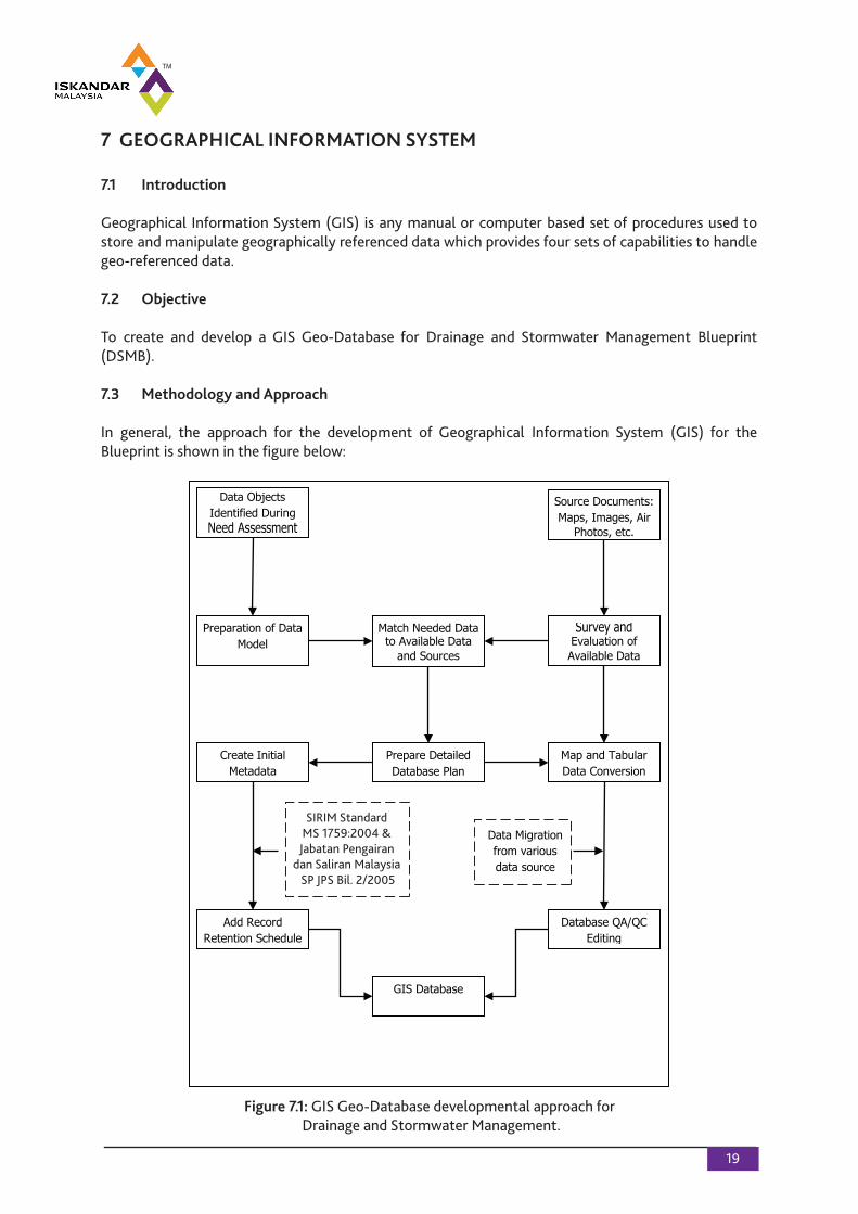
7 GEOGRAPHICAL INFORMATION SYSTEM
7.1 Introduction
Geographical Information System (GIS) is any manual or computer based set of procedures used to store and manipulate geographically referenced data which provides four sets of capabilities to handle geo-referenced data.
7.2 Objective
To create and develop a GIS Geo-Database for Drainage and Stormwater Management Blueprint (DSMB).
7.3 Methodology and Approach
In general, the approach for the development of Geographical Information System (GIS) for theBlueprint is shown in the figure below:
Data Objects Identified During Need Assessment
Source Documents: Maps, Images, Air
Photos, etc.
Preparation of Data Model
Survey and Evaluation of Available Data
Match Needed Data to Available Data
and Sources
Prepare Detailed Database Plan
Create Initial Metadata
Map and Tabular Data Conversion
Add Record Retention Schedule
Database QA/QC Editing
GIS Database
(Geodatabase)
Data Migration from various data source
SIRIM Standard MS 1759:2004 &
Jabatan Pengairan dan Saliran Malaysia SP JPS Bil. 2/2005
Figure 7.1: GIS Geo-Database developmental approach for Drainage and Stormwater Management.
20
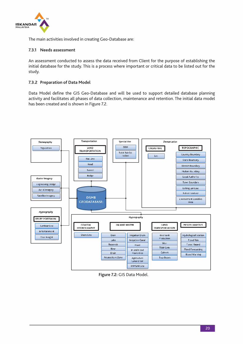
The main activities involved in creating Geo-Database are:
7.3.1 Needs assessment
An assessment conducted to assess the data received from Client for the purpose of establishing the initial database for the study. This is a process where important or critical data to be listed out for the study.
7.3.2 Preparation of Data Model
Data Model define the GIS Geo-Database and will be used to support detailed database planningactivity and facilitates all phases of data collection, maintenance and retention. The initial data modelhas been created and is shown in Figure 7.2.
Figure 7.2: GIS Data Model.
21
7.3.3 Data Acquisition and Sources of Data
Once the needs assessment is executed, the collection and acquisition of the data which to be acquired would cover the Iskandar Malaysia region. Most of the data will be obtained from several sources.
7.3.4 Database Design and Planning
Once the data matching between needed data and available data is completed, the process of database design and planning will commence and includes the followings stages:
• Developing a logical or physical database design based on the data model prepared earlier; • Evaluating the potential data sources; and • Data conversion plan.
7.3.5 Metadata, Thematic Mapping and Geo-Database
Once the data conversion completed, information acquired and created during the study will becompiled in a data.
7.4 Metadata and GIS Database Structure
7.4.1 GIS Geo-Database Component
It describes data layer within each feature categories. There are seven feature categories captured into GIS Geo-database: 1. Demarcation; 2. Hydrography; 3. Hypsography; 4. Transportation; 5. Special Use; 6. Demography; and 7. Satellite Imagery.
7.5 Work Progress
The progress of works for the Database Management team are mainly focus on data formatting and the execution of data conversion plan. See details in the complete Blueprint.
8 ENFORCEMENT PLAN AND DSWM INITIATIVES
8.1 Enforcement Plan
Drainage and Stormwater Management (DSWM) is an integral part of a national and state widestrategy for integrated water resources management and also part of the efforts to promotesustainable development within an urban environment.
Implementation of the DSWM Blueprint requires due consideration be given to its impact not only within the IRDA Region but also coordinated with similar programs elsewhere within the State and ultimately at the national level. Before reaching for punitive impeachment of offenders it is suggested that priority be accorded to capacity building including implementation of the Communication,Education and Public Awareness (CEPA) programs for all stakeholders. Better compliance with themandatory requirements could well be achieved through such capacity building, education andawareness programs rather than through aggressive implementation of the laws. Over time tougher enforcement methods may be adopted for those who refuse to comply with the conditions imposed under the MSMA.
In general, most Government agencies and many municipalities lack resources and capacity to enforce their laws. Enforcement often requires persistent application of the law in a manner that is consistent, transparent and objective. Without such enforcement laws are meaningless.
It is recommended six steps considered to strengthen enforcement within Government agencies.
8.2 Drainage and Stormwater Management Initiatives
There is a need for continuous research, development and application on the DSWM, so that suitable adaptation to local conditions are designed and applied. Climate change and developing urbanlandscapes will continue to challenge and require innovation by agencies.
The Consultant has prepared a list of initiatives that can be carried out in this blueprint. The proposed initiatives were further refined via consultation with other stakeholders during the Focus GroupDiscussion 2 (FGD2), which was held on 13 October 2010 at M-Suites Hotel, Johor Bahru.
The initiatives are proposed to be implemented based on time-frame and priority. The time frame proposed is short-term (2010-2012), medium-term (2010-2015) and long-term (2010-2020). The priority is based on low, moderate and high depending on its urgency for implementation. There are several proposed initiatives endorsed by the FGD2 participants and the DSWM Blueprint Technical Committee members for an efficient implementation of the Drainage and StormwaterManagement Blueprint.
22
23
8.3 Conclusion
The following deliverables has been completed with the submission of this Report:
a) Review and Evaluation of existing institutional framework for the management of drainage and stormwater; b) Review and Evaluation of existing legal framework for the control and regulation of activities which would have an effect or impact on drainage and stormwater; c) Review and Evaluation of existing State/Federal Government Policies, if any, on drainage and stormwater in general – currently there are none; d) Review and evaluation of the governance aspects of MSMA and assist in the preparation of the Blueprint for effective structure of governance for the implementation of the Blueprint – completed; e) Review of the previous studies and blueprints to incorporate or formulate best management practices for drainage and stormwater – elements have been incorporated into key issues and findings; f) Review and evaluate best practices in other jurisdictions on drainage and stormwater management and propose suitability for adaptation to local conditions - completed; g) Summarize the main issues and problems related to the existing institutional and legal framework - completed; h) Together with other members of the Consultant team derive and make recommendations for a new/improved State level structure of governance and proposals for the implementation of MSMA in the IM – completed; i) Have consultation with various stakeholders and obtain feedback to the proposed institutional/legislative framework for the implementation of the Blueprint; and j) Finalize the Institutional and Legal framework for the better governance of DSWM within the Iskandar Malaysia.
Related Documents