AHRC ICT Methods Network www.methodsnetwork.ac.uk AHRC ICT Methods Network, Centre for Computing in the Humanities, Kay House, 7 Arundel Street, London, WC2R 3DX. Digital Tools for Archaeology A Methods Network Working Paper Introduction The use of computers in archaeology has a lengthy history and practitioners within the discipline can claim, with some justification, that both the technology they use and the methods that they’ve adopted have more of a relationship to scientific practice (including computer science) than those adopted by colleagues in many other arts and humanities disciplines. Ultimately, this has no pejorative meaning in the context of what the various disciplines may have a remit to accomplish, but it nonetheless begins to explain the basis of a common perception that archaeology is ‘ahead’ of some of its neighbours in certain areas that relate to the use of ICT, notably perhaps: the development of standard approaches to electronic documentation; the use of collaborative frameworks for technological research; and the broad integration of globally established digital spatial reference systems. Taking into account the longevity of the relationship between archaeologists and computing, it is difficult to effectively summarise the range of digital tools that are available to researchers. Additionally, providing some context for the use of these tools is similarly problematic, given that there is so much activity and so many projects to choose from. The objective of this working paper is, therefore, to block out some broad categories of tools usage and to provide some examples of methods and approaches that relate to those tools. Whilst this approach may not reveal very much to researchers who are experienced in using specific or multiple technologies at an advanced level, it may nonetheless provide a useful foundation document, onto which more nuanced and technically complex additional material might be appended. The Methods Network, in collaboration with other organisations, is currently developing an online community platform which it hopes will become a widely used forum across a range of disciplines and for a number of complementary organizations (http://www.arts-humanities.net ). One of the useful functions of this site is that it will provide a place to record and preserve commentary relating to this working paper and it is anticipated that such commentary will add significant value to what is, necessarily, an initially basic overview. More immediately, this paper may be of interest to those researchers who are not broadly familiar with digital tools for archaeology or who have experience in other disciplines and are seeking to form cross-disciplinary working partnerships with archaeologists. It is perhaps also worth noting that, in common with other working papers in this series, the use of the word ‘tool’ is used throughout this paper in the broadest possible sense. Databases The use of structured information lends itself extremely well to database techniques and this has been an enduring methodology for archaeological projects ever since the days of mainframe computing. At a recent Methods Network Expert Seminar 1 which focused on virtual representations in historical and archaeological research, Vince Gaffney proposed the view that archaeologists had in fact been using computational-type methods even before computers became widely available and that this formal approach to data recording, a legacy of the work of figures such as Pitt Rivers and Petrie, 2 was easily transposed onto database systems when they started to become more widely available in the 1980’s. The successful integration of the sites and monuments record (SMR) 3 databases and the more recent OASIS 4 initiative that enables 1 Virtual History and Archaeology, a Methods Network Expert Seminar on History and Archaeology, April 19-21, 2006, Humanities Research Institute, University of Sheffield 2 Augustus Pitt Rivers (1827-1900) and Sir Flinders Petrie (1853 – 1942) 3 Past Perfect, http://www.pastperfect.info/archaeology/smr.html , (accessed 9 March 2007) 4 Online Access to the Index of Archaeological Investigations, http://www.rslp.ac.uk/projects/research/51.htm , (accessed 9 March 2007)

Welcome message from author
This document is posted to help you gain knowledge. Please leave a comment to let me know what you think about it! Share it to your friends and learn new things together.
Transcript
AHRC ICT Methods Network www.methodsnetwork.ac.uk
AHRC ICT Methods Network, Centre for Computing in the Humanities, Kay House, 7 Arundel Street, London, WC2R 3DX.
Digital Tools for Archaeology A Methods Network Working Paper Introduction The use of computers in archaeology has a lengthy history and practitioners within the discipline can claim, with some justification, that both the technology they use and the methods that they’ve adopted have more of a relationship to scientific practice (including computer science) than those adopted by colleagues in many other arts and humanities disciplines. Ultimately, this has no pejorative meaning in the context of what the various disciplines may have a remit to accomplish, but it nonetheless begins to explain the basis of a common perception that archaeology is ‘ahead’ of some of its neighbours in certain areas that relate to the use of ICT, notably perhaps: the development of standard approaches to electronic documentation; the use of collaborative frameworks for technological research; and the broad integration of globally established digital spatial reference systems. Taking into account the longevity of the relationship between archaeologists and computing, it is difficult to effectively summarise the range of digital tools that are available to researchers. Additionally, providing some context for the use of these tools is similarly problematic, given that there is so much activity and so many projects to choose from. The objective of this working paper is, therefore, to block out some broad categories of tools usage and to provide some examples of methods and approaches that relate to those tools. Whilst this approach may not reveal very much to researchers who are experienced in using specific or multiple technologies at an advanced level, it may nonetheless provide a useful foundation document, onto which more nuanced and technically complex additional material might be appended. The Methods Network, in collaboration with other organisations, is currently developing an online community platform which it hopes will become a widely used forum across a range of disciplines and for a number of complementary organizations (http://www.arts-humanities.net). One of the useful functions of this site is that it will provide a place to record and preserve commentary relating to this working paper and it is anticipated that such commentary will add significant value to what is, necessarily, an initially basic overview. More immediately, this paper may be of interest to those researchers who are not broadly familiar with digital tools for archaeology or who have experience in other disciplines and are seeking to form cross-disciplinary working partnerships with archaeologists. It is perhaps also worth noting that, in common with other working papers in this series, the use of the word ‘tool’ is used throughout this paper in the broadest possible sense. Databases The use of structured information lends itself extremely well to database techniques and this has been an enduring methodology for archaeological projects ever since the days of mainframe computing. At a recent Methods Network Expert Seminar1 which focused on virtual representations in historical and archaeological research, Vince Gaffney proposed the view that archaeologists had in fact been using computational-type methods even before computers became widely available and that this formal approach to data recording, a legacy of the work of figures such as Pitt Rivers and Petrie,2 was easily transposed onto database systems when they started to become more widely available in the 1980’s. The successful integration of the sites and monuments record (SMR)3 databases and the more recent OASIS4 initiative that enables 1 Virtual History and Archaeology, a Methods Network Expert Seminar on History and Archaeology, April 19-21, 2006, Humanities Research Institute, University of Sheffield 2 Augustus Pitt Rivers (1827-1900) and Sir Flinders Petrie (1853 – 1942) 3 Past Perfect, http://www.pastperfect.info/archaeology/smr.html, (accessed 9 March 2007) 4 Online Access to the Index of Archaeological Investigations, http://www.rslp.ac.uk/projects/research/51.htm, (accessed 9 March 2007)
AHRC ICT Methods Network www.methodsnetwork.ac.uk
AHRC ICT Methods Network, Centre for Computing in the Humanities, Kay House, 7 Arundel Street, London, WC2R 3DX.
searching across considerable quantities of ‘grey’ literature (unpublished routine documentation) relating to archaeological fieldwork, was cited as proof of the strength of the methodologies at work within the discipline. A quick review of fifteen recent and ongoing projects listed in the ICT Guides database5 (that relate to archaeology) reveal that at least eleven of them explicitly list the use of database software as being integral to the project methodology. The packages listed in order of popularity are:
• Microsoft Access (6) • AdLib (2) • MySQL (2) • Filemaker (1)
The use of database software in itself is unremarkable but a closer look at a specific project that has recently undertaken a rationalisation of its approach to data management might usefully illustrate how significant productivity gains can be achieved by mapping data systems more accurately onto the actual working practices of a project team. The IT report from the Catalhoyuk excavation in 20056 gives a very clear overview of how demanding it can be to accommodate the varied needs of different sections working on a large excavation, many of which had developed discreet databases to suit their own requirements, e.g. human remains, faunal remains, archaeobotany, and so forth. The approach of the Catalhoyuk IT team was to consolidate the data (much of which was in Microsoft Access format) onto a back-end Microsoft SQL server whilst enabling users to continue to use the forms and queries they had formulated for their own specific purposes over the duration of the project. By redefining the data model and dividing information into ‘core’ and ‘specialist’ categories, it was possible to create a multi-level database structure that in some cases rescued undocumented specialist information from previously stand-alone databases. The database consolidation process allows specialist teams access to the entire range of core records for the first time (in some cases enabling the identification of duplicate records) whilst the core/extension model also means that fields for specialist data can still be created when data models are found to be inadequate to accommodate newly defined material. Extension tables in one database may appear as core tables in another which increases the potential for specialization across areas of expertise. Perhaps more significantly, the cessation of the requirement to assign an object to a particular type of database had a significant impact on the neutrality of the approach used to initially record items. As Mia Ridge states in her report,
Previously, artefacts were assigned to specialists and were subtly but implicitly labelled by the specialism and specialist application within which they were recorded. [..] The use of isolated specialist databases may bind the artefact to an implicit interpretation limited by the method or location used to record its materiality.7
XML and Related Methods Recent convergence between relational database systems and XML related methods has led to increasing interest in using XML to publish data from database systems and for databases to be used to store and query XML data, often by handling queries issued over the Internet. Distributed databases increasingly need to talk to each other over the web and XML can be used as a standard exchange format for distributed query processing. The aggregation of data can lend economies of scale to information projects 5 AHDS, http://ahds.ac.uk/ictguides/, (accessed 9 March 2007) 6 Catalhoyuk Excavations of a Neolithic Anatolian Hoyuk, http://www.catalhoyuk.com/archive_reports/2005/ar05_37.html, (accessed 9 March 2007) 7 Ridge, M., http://www.catalhoyuk.com/archive_reports/2005/ar05_37.html, (accessed 9 March 2007)
AHRC ICT Methods Network www.methodsnetwork.ac.uk
AHRC ICT Methods Network, Centre for Computing in the Humanities, Kay House, 7 Arundel Street, London, WC2R 3DX.
and could certainly diminish possibilities of projects duplicating effort. Developed by David Schloen at the University of Chicago, the Archaeological Markup Language (ArchaeoML) is a component part of a larger initiative called OCHRE (Online Cultural Heritage Research Environment) which intends to be ‘an Internet Database System for research on cultural heritage in all its forms’, 8 accommodating anthropological, linguistic and other inter-disciplinary textual data as well as archaeological documentation. The ArchaeoML component of the system is based on twenty XML Schema9 definitions which define the formal specification of the data structure. The principle is to allow projects with diverse types of data to setup hierarchies with as many levels as necessary (using recursive nesting) to adequately represent that information, whilst keeping the number of element types to a minimum. This system is still in development at the time of writing and takes its place amongst a number of other XML related initiatives that are beginning to inform data management issues within the discipline. Kilbride has argued fairly recently (CSA newsletter, Winter 2005)10 that archaeologists appear to have demonstrated a reluctance to adopt XML related tools in relation to certain other disciplines and sets out the case for a more widespread uptake of this methodology to assist with the drive towards data integration and sustainability. Other research relating to the use of XML in archaeology has focused on the use of the Text Encoding Initiative11 (TEI) document type definitions (DTD’s) which have been the focus of a collaborative worldwide effort to provide all researchers dealing with digital text with a standardised way of describing material. Developing work from her MSc dissertation in 2001, Meckseper investigates the use of TEI for archaeological fieldwork in an article for the Archaeology and XML newsletter (2004),12 in which she cites various other relevant initiatives and resources that she considered using, including the Geography Markup Language (GML)13, the Historical Event Markup and Linking (HEML) Project14, and the MDA SPECTRUM documentation standard DTD15. In an article in Internet Archaeology, Falkingham also looks at the use of the TEI guidelines for archaeological ‘grey’ literature16, the same primary source material that, as mentioned previously, is the focus of the OASIS project17. OASIS is a major collaboration between academic and governmental agencies that provides a standard data capture form that is designed to allow local and national data managers who are responsible for site documentation to easily deposit data. This enables the OASIS system to provide an online index to a mass of previously inaccessible data and is delivered by means of the ARCHSearch18 system, an impressive tool which allows graphical browsing by clicking on general and detailed maps of the UK, as well as providing advanced textual search options. The use of XML and its related methods underpins these activities and would seem to support the theory that the use of XML can be an effective enabling strategy to support the management of large volumes of data. Image Capture The capture and analysis of image data is an integral part of the archaeological process and digital applications and techniques have revolutionised methods of data gathering, no more so than with aerial
8 David Schloen, http://ochre.lib.uchicago.edu/index.htm, (accessed 9 March 2007) 9 For an introduction to XML and related systems see: Cover Pages hosted by OASIS, http://xml.coverpages.org/xml.html#overview, (accessed 9 March 2007) 10 William Kilbride, http://www.csanet.org/newsletter/winter05/nlw0502.html, (accessed 9 March 2007) 11 Text Encoding initiative, http://www.tei-c.org/, (accessed 9 March 2007) 12 Archweb, http://archweb.co.uk/archaeology_and_xml_newsletter_2, (accessed 9 March 2007) 13 Open Geospatial Consortium Inc., http://www.opengis.org/techno/specs/00-029/GML.html, (accessed 9 March 2007) 14 The Historical Event Markup and Linking Project, http://heml.mta.ca/heml-cocoon/, (accessed 9 March 2007) 15 Museums Documentation Association, http://www.mda.org.uk/spectrum.htm, (accessed 9 March 2007) 16 Falkingham, G., http://intarch.ac.uk/journal/issue17/falkingham_index.html, (accessed 9 March 2007) 17 Archaeology Data Service, http://ads.ahds.ac.uk/project/oasis/, (accessed 9 March 2007) 18 Archaeology Data Service, http://ads.ahds.ac.uk/catalogue/, (accessed 9 March 2007)
AHRC ICT Methods Network www.methodsnetwork.ac.uk
AHRC ICT Methods Network, Centre for Computing in the Humanities, Kay House, 7 Arundel Street, London, WC2R 3DX.
and satellite photography. Software applications have enabled new processing and analysis techniques for these types of images and problems such as the abutting of oblique angled photographs of undulating terrain can be carried out using, for example, the rectification component of the Bonn Archaeological Software Package (BASP), a collaboratively developed suite of tools in development since 1973 which also includes functions for seriation, clustering, correspondence analysis, and mapping. Airphoto19 is a low cost orthophoto programme which allows the user to correct a distorted aerial view and represent terrain as a relief model, combining the geometric accuracy of a map with the detail of a photograph. The use of multiple photographs to determine accurate measurements and to produce digital terrain models (DTM’s) is a highly technical process known as photogrammetry, for which a range of software is available.20 English Heritage are responsible for the National Library of Air Photographs21 which consists of 2 million vertical, and 680,000 oblique photographs providing near-complete coverage for the whole of England (similar holdings are available for Scotland22 and Wales23). This largely black and white collection is an enormously valuable resource and represents, for many thousands of archaeological sites, the sole evidence of their existence, ranging from isolated simple ring-ditches to very complex multi-featured landscapes showing human interventions onto the landscape from a range of historical periods. Image manipulation packages such as Adobe Photoshop24 or Gimp25 can be used on digitized versions of these images to enhance areas that are obscure and bring out features in the landscape that might indicate the presence of sub-surface archaeology. Google Earth Scott Madry from the University of North Carolina, Chapel Hill, presented a paper at CAA200626 (Computer Applications and Quantitative Methods for Archaeology) which summarised some of his very successful work with Google Earth27 to find potential excavation sites in the Burgundy region of France, a method which he is quoted as saying provided him with more meaningful results in a matter of hours than he had gathered in years of carrying out aerial photography and land-based surveys.28 References to Google Earth’s interoperability with GIS data29 assume the use of Google Earth Pro version, which requires licensing after a 7 day trial period. The benefits of using this system are however enticing and begin to offer the user some quite sophisticated geospatial referencing functionality. In conventional GIS (Geographical Information Systems), the overlaying of one map onto another, or one layer of information over a related image, is carried out by a process of georeferencing where point data on both source files are matched up sequentially, ultimately allowing the images to be accurately superimposed. Google Earth provides a ‘rubbersheeting’ function which involves specifying corner markers and stretching one terrain over another to provide a similar degree of synchronisation between two representations. In 19 The Bonn Archaeological Software Package, http://www.uni-koeln.de/%7Eal001/airphoto.html, (accessed 9 March 2007) 20 For a review, see: GISVision, http://www.gisvisionmag.com/vision.php?article=200202%2Freview.html, (accessed 9 March 2007) 21 English Heritage, http://www.english-heritage.org.uk/server/show/ConWebDoc.4510, (accessed 9 March 2007) 22 The Royal Commission on the Ancient and Historical Monuments of Scotland, http://www.rcahms.gov.uk/aerialphotography.html, (accessed 9 March 2007) 23 The Royal Commission on the Ancient and Historical Monuments of Wales, http://www.rcahmw.gov.uk/aerial/collections.shtml, (accessed 9 March 2007) 24 Adobe, http://www.adobe.com/products/photoshop/family.html, (accessed 9 March 2007) 25 GIMP, http://www.gimp.org/, (accessed 9 March 2007) 26 Computer Applications and Quantitative Methods, http://www.caa2006.org/schedule/viewabstract.php?id=125, (accessed 9 March 2007) 27 Google, http://earth.google.com/, (accessed 9 March 2007) 28 National Geographic, http://news.nationalgeographic.com/news/2006/11/061107-archaeology_2.html, (accessed 9 March 2007) 29 Ullmann, L., Gorokhovich, Y., http://www.csanet.org/newsletter/winter06/nlw0604.html, (accessed 9 March 2007)
AHRC ICT Methods Network www.methodsnetwork.ac.uk
AHRC ICT Methods Network, Centre for Computing in the Humanities, Kay House, 7 Arundel Street, London, WC2R 3DX.
conjunction with a GIS data import function, distance measurement tools, and the ability to find, mark, map and export data to other applications, Google Earth has the potential to provide serious benefits to archaeologists, not least in terms of the time that it takes to achieve certain tasks in comparison with using standard GIS packages and dedicated aerial or satellite imagery.
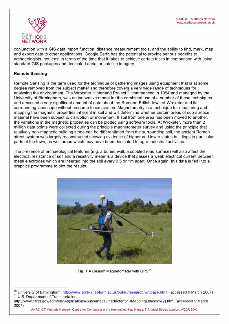
Remote Sensing Remote Sensing is the term used for the technique of gathering images using equipment that is at some degree removed from the subject matter and therefore covers a very wide range of techniques for analysing the environment. The Wroxeter Hinterland Project30, commenced in 1994 and managed by the University of Birmingham, was an innovative model for the combined use of a number of these techniques and amassed a very significant amount of data about the Romano-British town of Wroxeter and its surrounding landscape without recourse to excavation. Magnetometry is a technique for measuring and mapping the magnetic properties inherent in soil and will determine whether certain areas of sub-surface material have been subject to disruption or movement. If soil from one area has been moved to another, the variations in the magnetic properties can be plotted using software tools. At Wroxeter, more than 2 million data points were collected during the principle magnetometer survey and using the principle that relatively non-magnetic building stone can be differentiated from the surrounding soil, the ancient Roman street system was largely reconstructed showing evidence of higher and lower status buildings in particular parts of the town, as well areas which may have been dedicated to agro-industrial activities. The presence of archaeological features (e.g. a buried wall, a cobbled road surface) will also affect the electrical resistance of soil and a resistivity meter is a device that passes a weak electrical current between metal electrodes which are inserted into the soil every 0.5 or 1m apart. Once again, this data is fed into a graphics programme to plot the results.
Fig. 1 A Cesium Magnetometer with GPS31
30 University of Birmingham, http://www.arch-ant.bham.ac.uk/bufau/research/wh/base.html, (accessed 9 March 2007) 31 U.S. Department of Transportation, http://www.cflhd.gov/agm/engApplications/SubsurfaceChartacter/613MappingLithology(2).htm, (accessed 9 March 2007)
AHRC ICT Methods Network www.methodsnetwork.ac.uk
AHRC ICT Methods Network, Centre for Computing in the Humanities, Kay House, 7 Arundel Street, London, WC2R 3DX.
Ground Penetrating Radar (GPR) was also used at Wroxeter32 over an area of 2.25 hectares and involves the use of equipment that can measure the nanosecond delay times of microwaves that ‘bounce’ back off buried archaeological features. In combination with seismic surveys, where the reflection of soundwaves are measured to identify sub-surface features (also applicable to maritime archaeology in the form of sonar), and a range of airborne techniques such as multi-spectral photography and airborne thematic mapping, the amassed data has enabled researchers at Wroxeter to put together compelling evidence to explain the changing fortunes of this historically important provincial Roman city. Additional more current initiatives relating to remote sensing, such as the use of LIDAR (Light Detection and Ranging; or Laser Imaging Detection and Ranging), are referenced on the Methods Network website in the form of case studies.33 Information is also available about the Access Grid Support Network for Visualization and Remote Sensing,34 organised by the Institute for Archaeology and Antiquity at the University of Birmingham, which has been established to provide a virtual forum for the discussion of methodologies and solutions in this burgeoning area of research. GIS (Geographic Information System) It has been proposed that rather than being classified as a ‘tool’, GIS might more accurately be labelled a sub-discipline in its own right, complete with its own competing methodologies and camps endorsing one approach over another in relation to the vast amount of functionality that GIS encompasses. Conolly and Lake35 list five categories of activity that GIS systems can address and it is apparent that the aggregation of all of these activities represents a significant proportion all of the ICT related activities that archaeology is likely to provoke.
• Data acquisition • Spatial data management • Database management • Spatial data visualization • Spatial data analysis
Bearing in mind the very broad functionality that GIS brings to archaeological practice, it may be useful to concentrate on the signature function that demarcates these systems from, for example, CAD and visualization packages. GIS is designed to allows users to describe some form of entity (situated in a landscape) in terms of its geospatial coordinates and to then make connections between that very explicit instance of data and any other information that might be pertinent to the description or analysis of that entity. This related information can take the form of text, images, statistics, graphs, multi-media; in fact anything that can be stored or referenced by a database. This enables GIS to act as both a visualization tool (displaying the database information spatially) and an analysis tool (displaying the spatial information quantitatively). Whilst it could be argued that some CAD packages can also be used to anchor displayed objects to real-world geospatial co-ordinates, their principle function is to enable users to produce very sophisticated graphical representations and the analysis of geospatial data is beyond the remit and functionality of such systems. In the past, GIS systems came in two mutually exclusive ‘flavours’ and the different types, raster and vector-based systems, meant that users had to determine which approach more closely suited their requirements. Current GIS systems can deal with both types of data but even so, it is still of practical use to know when the use of raster images (also known as bitmaps) might be more appropriate than their 32 University of Birmingham, http://www.arch-ant.bham.ac.uk/bufau/research/wh/tours/gpr.html, (accessed 9 March 2007) 33 See the North Sea Palaeolandscapes project and the Analysis of the Effectiveness of Airborne LIDAR,: Methods Network, http://www.methodsnetwork.ac.uk/resources/casestudies.html, (accessed 9 March 2007) 34 Methods Network, http://www.methodsnetwork.ac.uk/activities/act10.html, (accessed 9 March 2007) 35 Conolly and Lake (2006)
AHRC ICT Methods Network www.methodsnetwork.ac.uk
AHRC ICT Methods Network, Centre for Computing in the Humanities, Kay House, 7 Arundel Street, London, WC2R 3DX.
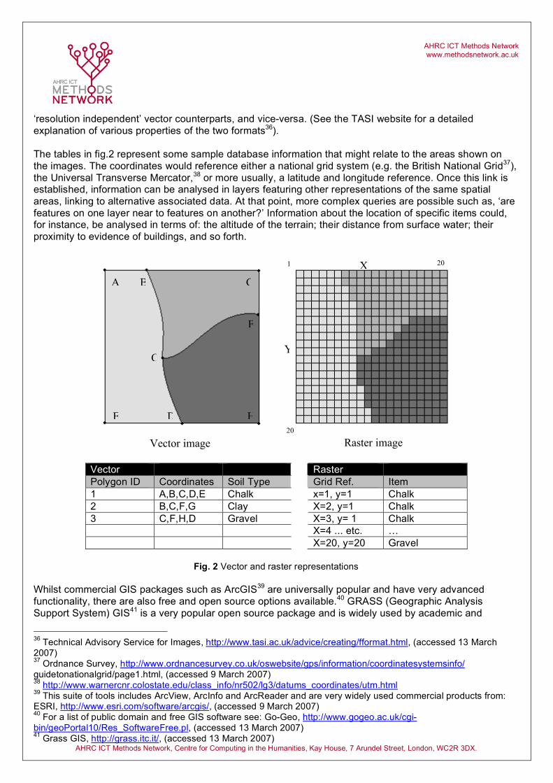
‘resolution independent’ vector counterparts, and vice-versa. (See the TASI website for a detailed explanation of various properties of the two formats36).
The tables in fig.2 represent some sample database information that might relate to the areas shown on the images. The coordinates would reference either a national grid system (e.g. the British National Grid37), the Universal Transverse Mercator,38 or more usually, a latitude and longitude reference. Once this link is established, information can be analysed in layers featuring other representations of the same spatial areas, linking to alternative associated data. At that point, more complex queries are possible such as, ‘are features on one layer near to features on another?’ Information about the location of specific items could, for instance, be analysed in terms of: the altitude of the terrain; their distance from surface water; their proximity to evidence of buildings, and so forth.
Vector Raster Polygon ID Coordinates Soil Type Grid Ref. Item 1 A,B,C,D,E Chalk x=1, y=1 Chalk 2 B,C,F,G Clay X=2, y=1 Chalk 3 C,F,H,D Gravel X=3, y= 1 Chalk X=4 ... etc. … X=20, y=20 Gravel
Fig. 2 Vector and raster representations
Whilst commercial GIS packages such as ArcGIS39 are universally popular and have very advanced functionality, there are also free and open source options available.40 GRASS (Geographic Analysis Support System) GIS41 is a very popular open source package and is widely used by academic and
36 Technical Advisory Service for Images, http://www.tasi.ac.uk/advice/creating/fformat.html, (accessed 13 March 2007) 37 Ordnance Survey, http://www.ordnancesurvey.co.uk/oswebsite/gps/information/coordinatesystemsinfo/ guidetonationalgrid/page1.html, (accessed 9 March 2007) 38 http://www.warnercnr.colostate.edu/class_info/nr502/lg3/datums_coordinates/utm.html 39 This suite of tools includes ArcView, ArcInfo and ArcReader and are very widely used commercial products from: ESRI, http://www.esri.com/software/arcgis/, (accessed 9 March 2007) 40 For a list of public domain and free GIS software see: Go-Geo, http://www.gogeo.ac.uk/cgi-bin/geoPortal10/Res_SoftwareFree.pl, (accessed 13 March 2007) 41 Grass GIS, http://grass.itc.it/, (accessed 13 March 2007)
Raster image
A B
C
D E
F
H
G
Vector image
X
Y
1 20
20
AHRC ICT Methods Network www.methodsnetwork.ac.uk
AHRC ICT Methods Network, Centre for Computing in the Humanities, Kay House, 7 Arundel Street, London, WC2R 3DX.
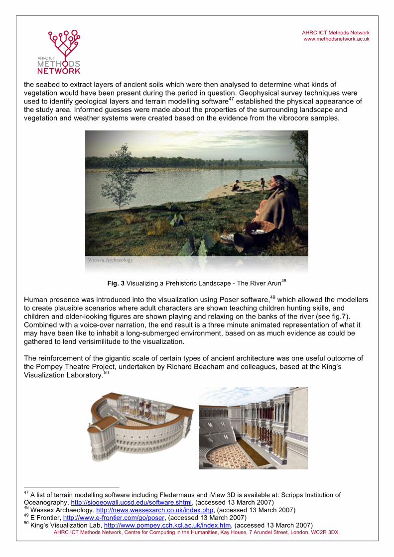
commercial organisations. It is a fully functional package featuring tools for geospatial data management and analysis, image processing, graphics/maps production, spatial modelling and visualization and is supported by a community of users who contribute information to the GRASS wiki.42 CAD Originally developed for architectural and engineering purposes, CAD (Computer-Aided Design) software is now used in a multitude of disciplines and integrates seamlessly with the archaeological point data that may be acquired from a variety of sources including Total Station surveys and GPS (Global Positioning System) readings. CAD packages enable the user to create 2D and 3D vector-based drawings and work with a coordinate referencing system, x and y for position and z for height. The coordinates can refer simply to the drawing itself or can reference either an excavation site plan or, perhaps in the case of a regional survey, might reference National Grid coordinates or the UTM (Universal Transverse Mercator). Drawings can consist of layers of information which can be edited and manipulated either separately or together adding functionality to the pre-digital technique of pin-bar drafting (using transparencies to overlay a base sheet using registration pins to ensure accuracy). An extensive range of functionality allows entities within the drawing to be scaled, rotated, distorted, skewed, re-aligned etc., and line types and the rendition of objects as wire frames or solid models can be selected. Raster images can also be imported to be used either as background or as textural elements within the vector-based environment. Where CAD and GIS packages start to overlap is the ability not only to store CAD objects in libraries for reuse in other contexts, but also to store attribute information about the objects separately, in a database if needs be. Some CAD packages also include their own programming and control language allowing application-specific front end menus to be built. Commercial systems like AutoCAD43 and SolidWorks44 give the user enormous expressive power to visualize 2D and 3D models but for those with more modest requirements and limited budgets, QCAD45 may suffice for 2D modelling whilst the freely downloadable Google Sketchup46 is very user-friendly and enables 3D models to be developed very rapidly. Visualization Though difficult to refer to as a discreet area of activity, visualization might best be understood as the method by which archaeological ideas can be effectively communicated to their target audience, which entails obvious overlaps with the functionality of many of the tools mentioned already. It may be useful to think about the growing interest in complex visualization techniques in the context of the post-processual view of archaeology, an approach which gives the human element a central place in the research process and deals with concepts of human defined boundaries and territories. This trend developed in reaction to the deterministic and functional (processual) views prevalent in the discipline prior to the 1980’s, which inclined researchers towards scientific methods (archaeometry). By placing human activity and intervention more at the centre of the research process, there are greater incentives to realise past scenarios using proximal representations of realistic environments, using human scales of reference and, in some cases, indications of human behaviour to enhance interpretations and comprehension of otherwise rather sterile-looking landscapes. One highly developed example of this approach was demonstrated at CAA UK 2007 by Tom Goskar (Wessex Archaeology), who showed the visualization of the now-submerged landscape that would, in prehistoric times, have formed the mouth of the River Arun (see fig. 3). Vibrocore tubes were pushed into
42 Grass Wiki, http://grass.gdf-hannover.de/wiki/Main_Page, (accessed 13 March 2007) 43 Autodesk, http://www.autodesk.com/autocad, (accessed 13 March 2007) 44 SolidWorks, http://www.solidworks.com/, (accessed 13 March 2007) 45 RibbonSoft, http://www.ribbonsoft.com/qcad.html, (accessed 13 March 2007) 46 Google, http://sketchup.google.com/, (accessed 13 March 2007)
AHRC ICT Methods Network www.methodsnetwork.ac.uk
AHRC ICT Methods Network, Centre for Computing in the Humanities, Kay House, 7 Arundel Street, London, WC2R 3DX.
the seabed to extract layers of ancient soils which were then analysed to determine what kinds of vegetation would have been present during the period in question. Geophysical survey techniques were used to identify geological layers and terrain modelling software47 established the physical appearance of the study area. Informed guesses were made about the properties of the surrounding landscape and vegetation and weather systems were created based on the evidence from the vibrocore samples.
Fig. 3 Visualizing a Prehistoric Landscape - The River Arun48
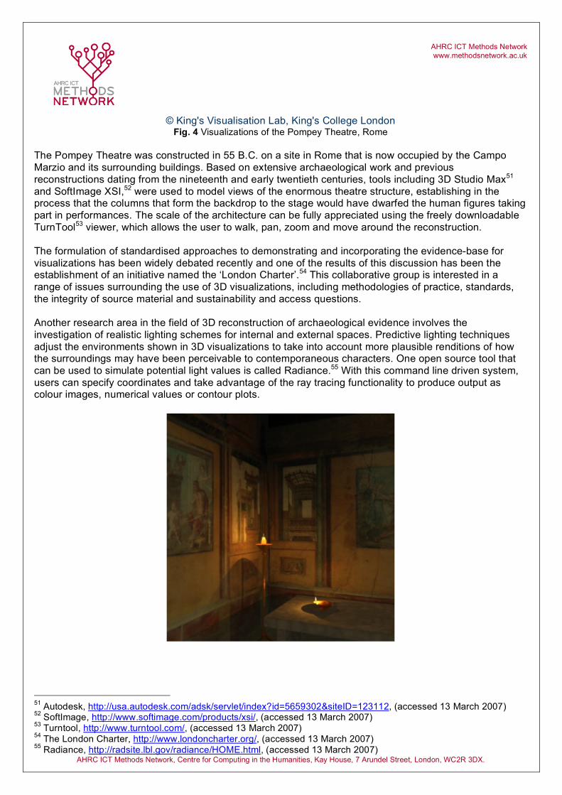
Human presence was introduced into the visualization using Poser software,49 which allowed the modellers to create plausible scenarios where adult characters are shown teaching children hunting skills, and children and older-looking figures are shown playing and relaxing on the banks of the river (see fig.7). Combined with a voice-over narration, the end result is a three minute animated representation of what it may have been like to inhabit a long-submerged environment, based on as much evidence as could be gathered to lend verisimilitude to the visualization. The reinforcement of the gigantic scale of certain types of ancient architecture was one useful outcome of the Pompey Theatre Project, undertaken by Richard Beacham and colleagues, based at the King’s Visualization Laboratory.50
47 A list of terrain modelling software including Fledermaus and iView 3D is available at: Scripps Institution of Oceanography, http://siogeowall.ucsd.edu/software.shtml, (accessed 13 March 2007) 48 Wessex Archaeology, http://news.wessexarch.co.uk/index.php, (accessed 13 March 2007) 49 E Frontier, http://www.e-frontier.com/go/poser, (accessed 13 March 2007) 50 King’s Visualization Lab, http://www.pompey.cch.kcl.ac.uk/index.htm, (accessed 13 March 2007)
Wessex Archaeology
AHRC ICT Methods Network www.methodsnetwork.ac.uk
AHRC ICT Methods Network, Centre for Computing in the Humanities, Kay House, 7 Arundel Street, London, WC2R 3DX.
© King's Visualisation Lab, King's College London Fig. 4 Visualizations of the Pompey Theatre, Rome
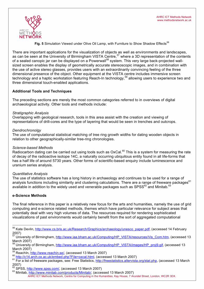
The Pompey Theatre was constructed in 55 B.C. on a site in Rome that is now occupied by the Campo Marzio and its surrounding buildings. Based on extensive archaeological work and previous reconstructions dating from the nineteenth and early twentieth centuries, tools including 3D Studio Max51 and SoftImage XSI,52 were used to model views of the enormous theatre structure, establishing in the process that the columns that form the backdrop to the stage would have dwarfed the human figures taking part in performances. The scale of the architecture can be fully appreciated using the freely downloadable TurnTool53 viewer, which allows the user to walk, pan, zoom and move around the reconstruction. The formulation of standardised approaches to demonstrating and incorporating the evidence-base for visualizations has been widely debated recently and one of the results of this discussion has been the establishment of an initiative named the ‘London Charter’.54 This collaborative group is interested in a range of issues surrounding the use of 3D visualizations, including methodologies of practice, standards, the integrity of source material and sustainability and access questions. Another research area in the field of 3D reconstruction of archaeological evidence involves the investigation of realistic lighting schemes for internal and external spaces. Predictive lighting techniques adjust the environments shown in 3D visualizations to take into account more plausible renditions of how the surroundings may have been perceivable to contemporaneous characters. One open source tool that can be used to simulate potential light values is called Radiance.55 With this command line driven system, users can specify coordinates and take advantage of the ray tracing functionality to produce output as colour images, numerical values or contour plots.
51 Autodesk, http://usa.autodesk.com/adsk/servlet/index?id=5659302&siteID=123112, (accessed 13 March 2007) 52 SoftImage, http://www.softimage.com/products/xsi/, (accessed 13 March 2007) 53 Turntool, http://www.turntool.com/, (accessed 13 March 2007) 54 The London Charter, http://www.londoncharter.org/, (accessed 13 March 2007) 55 Radiance, http://radsite.lbl.gov/radiance/HOME.html, (accessed 13 March 2007)
AHRC ICT Methods Network www.methodsnetwork.ac.uk
AHRC ICT Methods Network, Centre for Computing in the Humanities, Kay House, 7 Arundel Street, London, WC2R 3DX.
Fig. 5 Simulation Viewed under Olive Oil Lamp, with Furniture to Show Shadow Effects56
There are important applications for the visualization of objects as well as environments and landscapes, as can be seen at the University of Birmingham VISTA Centre,57 where a 3D representation of the contents of a sealed canopic jar can be displayed on a Powerwall58 system. This very large back-projected wall-sized screen enables the display of geometrically accurate stereoscopic images, and in combination with the use of active stereo glasses, provides users with an extraordinarily convincing feeling of the three dimensional presence of the object. Other equipment at the VISTA centre includes immersive screen technology and a haptic workstation featuring Reach-In technology,59 allowing users to experience two and three dimensional touch-enabled applications. Additional Tools and Techniques The preceding sections are merely the most common categories referred to in overviews of digital archaeological activity. Other tools and methods include: Stratigraphic Analysis Overlapping with geological research, tools in this area assist with the creation and viewing of representations of drill-cores and the type of layering that would be seen in trenches and outcrops. Dendrochronolgy The use of computational statistical matching of tree ring growth widths for dating wooden objects in relation to other geographically-similar tree-ring chronologies. Science-based Methods Radiocarbon dating can be carried out using tools such as OxCal.60 This is a system for measuring the rate of decay of the radioactive isotope 14C, a naturally occurring ubiquitous entity found in all life-forms that has a half life of around 5730 years. Other forms of scientific-based enquiry include luminescence and uranium series analysis. Quantitative Analysis The use of statistics software has a long history in archaeology and continues to be used for a range of analysis functions including similarity and clustering calculations. There are a range of freeware packages61 available in addition to the widely used and venerable packages such as SPSS62 and Minitab.63 e-Science Methods The final reference in this paper is a relatively new focus for the arts and humanities, namely the use of grid computing and e-science related methods, themes which have particular relevance for subject areas that potentially deal with very high volumes of data. The resources required for rendering sophisticated visualizations of past environments would certainly benefit from the sort of aggregated computational
56 Kate Devlin, http://www.cs.bris.ac.uk/Research/Graphics/archaeology/unesco_paper.pdf, (accessed 14 February 2007) 57 University of Birmingham, http://www.iaa.bham.ac.uk/Computing/HP_VISTA/resources/Vis_Com.htm, (accessed 13 March 2007) 58 University of Birmingham, http://www.iaa.bham.ac.uk/Computing/HP_VISTA/images/HP_proj9.gif, (accessed 13 March 2007) 59 ReachIn, http://www.reachin.se/, (accessed 13 March 2007) 60 http://c14.arch.ox.ac.uk/embed.php?File=oxcal.html, (accessed 13 March 2007) 61 For a list of freeware packages, see: Free Statistics, http://freestatistics.altervista.org/stat.php, (accessed 13 March 2007) 62 SPSS, http://www.spss.com/, (accessed 13 March 2007) 63 Minitab, http://www.minitab.com/products/Minitab/, (accessed 13 March 2007)
AHRC ICT Methods Network www.methodsnetwork.ac.uk
AHRC ICT Methods Network, Centre for Computing in the Humanities, Kay House, 7 Arundel Street, London, WC2R 3DX.
power that the grid computing model is designed to deliver, particularly in association with the types of dedicated high speed bandwidth that this methodology aims to employ. The nature of archaeological fieldwork and the problems inherent with linking researchers on the ground with centralised data repositories represent interesting challenges that might be tackled in the context of the development of virtual research environments (VRE).64 The Silchester Roman Town excavation,65 and the Integrated Archaeological Database (IADB) that was developed in the course of this project, was an attempt to look into problems of exactly this nature and will provide extremely useful reference material for further research into the problems of data accessibility and exchange. Information about this project and other e-science initiatives relating both to archaeology and the arts and humanities more generally can be found on the website of the Arts and Humanities e-Science Support Centre.66 Neil Grindley Methods Network Senior Project Officer Original draft - February 2007 Version control – 4 July 2007
64 Joint Information Systems Committee, http://www.jisc.ac.uk/whatwedo/programmes/programme_vre.aspx, (accessed 14 March 2007) 65 Joint Information Systems Committee, http://www.jisc.ac.uk/whatwedo/programmes/programme_vre/vre_silchester.aspx, (accessed 13 March 2007) 66 AHeSSC, http://www.ahessc.ac.uk/, (accessed 3 July 2007)
AHRC ICT Methods Network www.methodsnetwork.ac.uk
AHRC ICT Methods Network, Centre for Computing in the Humanities, Kay House, 7 Arundel Street, London, WC2R 3DX.
REFERENCES Books Consulted Conolly,J., Lake, M. (2006), Geographical Information Systems in Archaeology, Cambridge University Press Eiteljorg, H., ‘Computing for Archaeologists’, in Schreibman, S., Siemens, R., Unsworth, J., (eds), A companion to Digital Humanities, (pp. 20 - 30) Lock, G. (2003), Using Computers in Archaeology: Towards Virtual Pasts, Routledge, London Websites The following url’s represent a selection of the websites consulted during the preparation of this paper, some of which duplicate the references made in the footnotes. It should be regarded as illustrative of the references used rather than an attempt to provide a comprehensive summary of archaeology links and resources. The section headings are ordered alphabetically but the items within those sections are in no particular order. Articles and Reports CSA Newsletter http://csanet.org/newsletter/ The use of computers and digital technologies in the practice of archaeology and architectural history. Various articles on CAD, XML, Google Earth etc .. CSA article about XML http://www.csanet.org/newsletter/winter05/nlw0502.html William Kilbride writing about the use of XML in archaeology Çatalhöyük IT support team report 2005 http://www.catalhoyuk.com/archive_reports/2005/ar05_37.html Mia Ridge et al and the database integration project Internet Archaeology http://intarch.ac.uk/ Leading online archaeology journal – by subscription
Contents Articles and Reports Organizations Preservation Projects Resources and Listings Standards Tools Visualization Web 2.0
AHRC ICT Methods Network www.methodsnetwork.ac.uk
AHRC ICT Methods Network, Centre for Computing in the Humanities, Kay House, 7 Arundel Street, London, WC2R 3DX.
Networks in the Aegean http://155.198.210.128/~time/networks/arch/XTAG06.pdf Evans and Knappett study of trade routes in the Aegean Society of exploration Geophysicists http://www.segdl.org/ Digital library of articles Time Space Uncertainty http://echo.gmu.edu/toolcenter-wiki/index.php?title=Time%2C_Space%2C_Uncertainty George Madison University response to Digital Tools Summit Archaeological Computing Newsletter http://www.gla.ac.uk/Acad/Archaeology/acn/index.html Subscription-based newsletter since 1985 Ancient Monuments Laboratory Reports http://www.eng-h.gov.uk/AMLRepSums/ reports of investigations in archaeological science and conservation Field Survey at Poggio Colla and the Podere Funghi http://www.smu.edu/poggio/surveys.html topographic mapping of the south side of Poggio Colla Organizations CAST http://www.cast.uark.edu/index_main.html Center for Advanced Spatial Technologies at the University of Arkansas ADS (AHDS Archaeology) http://ads.ahds.ac.uk/ Arts and Humanities Data Service – Archaeology ICOMOS http://www.international.icomos.org/home.htm International Council on Monuments and Sites Scripps Institution for Oceanography http://siovizcenter.ucsd.edu/ Uses a lot of technology for research Wessex Archaeology http://www.wessexarch.co.uk/index.php Large non-profit archaeological practice Oxford Archaeology http://thehumanjourney.net// Largest independent archaeology practice in the UK Alexandria Library http://www.alexandria.ucsb.edu/
AHRC ICT Methods Network www.methodsnetwork.ac.uk
AHRC ICT Methods Network, Centre for Computing in the Humanities, Kay House, 7 Arundel Street, London, WC2R 3DX.
Digital Library at UCSB GSB Prospection http://www.gsbprospection.com/aboutgsb.htm Commerical remote sensing company Digital Archaeology http://www.online-archaeology.com/ Digital Archaeology Group devoted to implementing high-end methodologies in Archaeological fieldwork and Digital Data Management (DDM) Digital Archaeology http://www.digital-archaeology.com/Start.htm German commercial organisation Recreating the Past http://www.cs.bris.ac.uk/Research/Graphics/archaeology/recon.html Computer Graphics Group at Bristol University Southampton Research Projects http://www.arch.soton.ac.uk/Projects/default.asp List of current research at Southampton University HEIRNET http://www.britarch.ac.uk/HEIRNET/index.html Historic Environment Information Resources Network Preservation Rescuing Neglected and Damaged Data Resources http://www.hatii.arts.gla.ac.uk/research/BrLibrary/ JISC NPO study Digital Curation Centre http://www.dcc.ac.uk/tools/digital-curation-tools/ List of Digital Curation Tools Projects The Archaeological Settlements of Turkey http://tayproject.org Large-scale constructed dataset Çatalhöyük, Turkey http://www.catalhoyuk.com/ Excavations at the neolithic site at Çatalhöyük Teotihuacan http://archaeology.la.asu.edu/teo/ Archaeology of Teotihuacan, Mexico Wroxeter Project http://www.arch-ant.bham.ac.uk/bufau/research/wh/base.html
AHRC ICT Methods Network www.methodsnetwork.ac.uk
AHRC ICT Methods Network, Centre for Computing in the Humanities, Kay House, 7 Arundel Street, London, WC2R 3DX.
Important for showing advances in the use of new landscape analysis techniques Using GeoScan equipment http://www.bsa.gla.ac.uk/fitch/index.htm?research/geo/geo_pk Geophysical survey scanning project, British School in Athens Troodos Archaeological and Environmental Survey Project http://www.taesp.arts.gla.ac.uk/Method/Method.htm A broad range of archaeological, environmental, ethnographic and historical research relating to the Troodos Mountains on Cyprus Vindolanda Tablets http://vindolanda.csad.ox.ac.uk/ The Vindolanda writing tablets, excavated from the Roman fort at Vindolanda in northern England
Framework Archaeology http://www.framearch.co.uk/ Collaboration by Oxford Archaeology and Wessex Archaeology to excavate Terminal 5 at Heathrow Resources and Listings National Archeological Database of US public archaeological sites http://www.cast.uark.edu/other/nps/nadb/ GIS mapping and US spread of archaeological sites Archaeological Guide to Europe http://odur.let.rug.nl/arge/ EU funded portal site with numerous links – seems to be no longer maintained OASIS http://ads.ahds.ac.uk/project/oasis/ Collaborative online index to archaeological ‘grey literature’ NASA Visible Earth http://visibleearth.nasa.gov/ NASA images and animations Association for Environmental Archaeology http://www.envarch.net/links/software.html List of software web resources National Library Air Photographs http://www.english-heritage.org.uk/server/show/ConWebDoc.4510 2.7 million photographs of the UK ADS Guides to Good Practice http://ahds.ac.uk/archaeology/creating/guides/ Guides on Remote Sensing, AP, CAD, GIS, GeoPhyical Data, VR Standards FISH http://www.fish-forum.info/
AHRC ICT Methods Network www.methodsnetwork.ac.uk
AHRC ICT Methods Network, Centre for Computing in the Humanities, Kay House, 7 Arundel Street, London, WC2R 3DX.
Forum for Information Standards in Heritage Archimuse paper about open standards http://archimuse.com/publishing/ichim05/Kelly.pdf Dunning et al on open standards and the problems CIDOC http://cidoc.ics.forth.gr/, The International Committee for Documentation of the International Council of Museums Open Archives Initiative Protocol for Metadata Harvesting http://www.openarchives.org/OAI/openarchivesprotocol.html Method for extracting metadata from archived information Tools OCHRE system (formerly XSTAR) http://ochre.lib.uchicago.edu/ Online Cultural Heritage Research Environment Total Station http://en.wikipedia.org/wiki/Total_station Explanation of the use and function of Total Stations Ground Penetrating Radar http://www.findarticles.com/p/articles/mi_m1200/is_5_168/ai_n14895414/print Description of the use of GPR techniques SIO GeoWall system http://siogeowall.ucsd.edu/about.shtml lower cost system for 3D display of terrain models Software for terrain modelling http://siogeowall.ucsd.edu/software.shtml as listed by the GeoWall site at SIO including Fledermaus Go-Geo http://www.gogeo.ac.uk/cgi-bin/geoPortal10/Res_SoftwareFree.pl Public domain and freeware GIS and related software Magnetometers http://en.wikipedia.org/wiki/Magnetometer List of different types of magnetometer The Bonn Archaeological Software Package (BASP) http://www.uni-koeln.de/%7Eal001/basp.html includes more than 70 functions for seriation, clustering, correspondance analysis, and mapping tools for archaeologists GRASS GIS http://grass.itc.it/ Freeware GIS programme
AHRC ICT Methods Network www.methodsnetwork.ac.uk
AHRC ICT Methods Network, Centre for Computing in the Humanities, Kay House, 7 Arundel Street, London, WC2R 3DX.
Historical Event Markup and Linking Project http://www.heml.org/heml-cocoon/ a means of coordinating and navigating disparate historical materials on the internet. Archaeology Software List http://www.online-archaeology.co.uk/Software/tabid/75/Default.aspx Computers in Archaeology – Jeremy Huggett http://www.gla.ac.uk/archaeology/resources/computing/compsw.html Archaeology Software Resources Part of lager site with other categories – last update 2004 Tools for Quantitative Archaeology http://tfqa.com/ Commercial package of 40 tools for archaeological analysis Software for quantitative software and other things http://www.envarch.net/links/software.html SPSS, and free stats stuff Archaeopack Pro http://www.online-archaeology.com/ArchaeoPackProNew.htm All in one archaeology system Site Recorder 4 http://archaeology.about.com/gi/dynamic/offsite.htm?zi=1/XJ/Ya&sdn=archaeology&cdn=education&tm=46&gps=59_6_1006_569&f=00&tt=14&bt=0&bts=0&zu=http%3A//www.3hconsulting.com/ProductsRecorderMain.htm versatile, Geographic Information System ( GIS ) designed for use in maritime, freshwater and intertidal archaeology List of archaeology software http://archaeology.about.com/od/programsforarchaeology/index_r.htm quick list of arch..y software CSA CAD guide http://www.csanet.org/inftech/cadgd/cadgdtoc.html 2002 guide written by Eiteljorg Scott Madry and Google Earth http://www.gearthblog.com/blog/archives/2006/10/armchair_archeology.html Using Google Earth to identify excavation sites in France British Archaeological Jobs Resource http://www.bajr.org/BAJRResources/Software.asp List of software and technology for heritage sector eSkeletons http://www.eskeletons.org/ with java measurement function SolidWorks CAD package http://www.gizmag.co.uk/go/5319/ Drawing with 3D modeller
AHRC ICT Methods Network www.methodsnetwork.ac.uk
AHRC ICT Methods Network, Centre for Computing in the Humanities, Kay House, 7 Arundel Street, London, WC2R 3DX.
Sketchup case sudy http://www.sketchup.com/?id=21&csid=142 google alternative to CAD Presentation of Open Source Software Choices http://www.public.asu.edu/~cmbarton/files/OSSarchaeology.pdf With screenshots of various programmes, particularly GRASS Open Source GIS software http://opensourcegis.org/ Listing of software STREAM http://terrain.cs.duke.edu/ Duke University project funded by U.S. military to investigate advanced terrain modelling maps Toolkit for archaeology http://www.dignubia.org/toolkit/detail.php?cat=laboratory digNubia – various hand and ICT tool definitions Visualization and 3D Modelling ARCO http://www.arco-web.org/TextVersion/Description/Description9.html Augmented representation of cultural objects – EU project to look at the representation using X-VRML Humanoid Working Group http://www.hanim.org/ Specification of standard way of schematically representing human forms VRML and 3DX description http://xml.coverpages.org/vrml-X3D.html Technology report on 3D systems Pompeii Frescoes and Use of Radiance http://www.cs.bris.ac.uk/~devlin/pompeii/pompeii.html Computer representation of the House of the Vettii and lighting scenarios Computer-Aided Visualisation of Archaeological Caves http://www.capra.group.shef.ac.uk/3/sellers.html Sellers, Orton and Chamberlin King’s Visualization Lab http://www.kvl.cch.kcl.ac.uk/ Range of archaeological, heritage and theatre based visualization work Web 2.0 Steve.Museum http://www.rawsugar.com/www2006/4.pdf Report on tagging in the museum community
AHRC ICT Methods Network www.methodsnetwork.ac.uk
AHRC ICT Methods Network, Centre for Computing in the Humanities, Kay House, 7 Arundel Street, London, WC2R 3DX.
Open Objects http://openobjects.blogspot.com/ Mia Ridge’s blog about IT issues in museums and archaeology
Related Documents