DELAWARE RIVER BASIN LAKE LADORE DAM NDI NO. PA-00091 DER NO. 64-5 WAYNE COUNTY, PENNSYLVANIA PHASElI INSPECTION REPORT NATIONAL DAM INSPECTION PROGRAM, ) G,'~ I ~ r 1 y' OLOR PLAT!7S: ALL D130 REPCiC0"r"o:4 VvlL BEI S LACK AND WHITE DTIC SEL ECTE MAR 1 11980 PREPARED FOR DEPARTMENT OF THE ARMY Baltimore District, C o rps of Engineers Baltimore ,Maryland 21203 DiS-hIBUTIQN STATEMEN'1A Approved for public relooso; B Y Distribution Ufnlimited Berger As so c ia tes,' Inc. Harrisburg , Pennsylvania ____JANUARY__1980 VCV 'IPIJ; X 'ZT t!'y PRACMIAJBJ I3 i rd~ OFpAG WUI OH TDO ffw

Welcome message from author
This document is posted to help you gain knowledge. Please leave a comment to let me know what you think about it! Share it to your friends and learn new things together.
Transcript
DELAWARE RIVER BASIN
LAKE LADORE DAM
NDI NO. PA-00091DER NO. 64-5
WAYNE COUNTY, PENNSYLVANIA
PHASElI INSPECTION REPORTNATIONAL DAM INSPECTION PROGRAM, )
G,'~ I ~ r1 y' OLOR PLAT!7S: ALL D130REPCiC0"r"o:4 VvlL BEI S LACK AND WHITE
DTICSEL ECTEMAR 1 11980
PREPARED FOR
DEPARTMENT OF THE ARMY
Baltimore District, C o rps of EngineersBaltimore ,Maryland 21203
DiS-hIBUTIQN STATEMEN'1A
Approved for public relooso;B Y Distribution Ufnlimited
Berger As so c ia tes,' Inc.Harrisburg , Pennsylvania
____JANUARY__1980
VCV 'IPIJ; X 'ZT t!'y PRACMIAJBJ I3 ird~ OFpAG WUI OH TDO ffw
DISCLAIMER NOTICE
THIS DOCUMENT IS BEST QUALITYPRACTICABLE. THE COPY FURNISHEDTO DDC CONTAINED A SIGNIFICANTNUMBER OF PAGES WHICH DO NOT
REPRODUCE LEGIBLY.
Lck~e - 7 --- PA-
2 19 1 Y 0 0 Y P- nV- _q v -C- PV) a -.se -
This report has been prepared under guidance contained in theRecommended Guidelines for Safety Inspection of Dams, for Phase I
7 Investigations. Copies of these guidelines may be obtained from the
of a Phase I investigation is to identify expeditiously those damswhich may pose hazards to human life or property. The assessment of
the general condition of the dam is based upon available data andvisual inspections. Detailed investigation, and analyses involvingtopographic mapping, subsurface investigations, testing, and detailed
computational evaluations are beyond the scope of a Phase I investi-"gation; however, the ti ation is intendedt dtif any needfor such studies.
df a yIn reviewing thiis report, it should l a e reportedcondition of the dam is based on observations of field conditions atthe time of inspection along with data available to the inspectionteam. In cases where the reservoir was lowered or drained prior toinspection, such action, while improving the stability and safety ofthe dam, removes the normal load on the structure and may obscurecertain conditions which might otherwise be detectable if inspectedunder the normal operating ea e neJ u~tur 1
L It is important to note that a am eensnnumeroUand constantly changing internal and external conditions, and isevolutionary in nature. It would be incorrect to assume that thepresent condition of the dam will continue to represent the conditionof the dam at some point in the future. Only through frequent inspec-tions can unsafe conditions be detected and only through continuedcare and maintenance can these conditions be prevented or corrected.
Phase I inspections are not intended to provide detailed hydro-logic and hydraulic analyses. In accordance with the establishedGuidelines, the spillway design flood is based on the estimated"probable Maximum Flood" for the region (greatest reasonably possiblestorm runoff), or fractions thereof. The spillway design floodprovides a measure of relative spillway capacity and serves as an aidin determining the need for more detailed hydrologic and hydraulicstudies, considering the size of the dam, its general condition andthe downstream damage potential.
-- ;,',t .C COLOR PLATES: ALL DDC! !.E tN 13LACK 1,,'D W04HITE
_
I'ig Approved for public releasel tV___ '. ution Unlimia~ted/
It ~~~~ ~C (3-*~--AJi 0
- ~ - t ),*=-- -- * -- -- ---- --- *-A- - -

U - - - = - n= " -- - - - _ ° - - _
PHASE I REPORT
NATIONAL DAM INSPECTION PROGRAM -- Z
DDC 71,B
BRIEF ASSESSMENT OF GENERAL CONDITIONS, ldn-cinced
AND RECOMMENDATIONS Justl Pcation,
Name of Dam: LAKE LADORE DAM Distribution/
State & State No.: PENNSYLVANIA, 64-5 .. Codesi AIa-, id /o r
County: WAYNE DLst j special
Stream: VAN AUKEN CREEK
Date of Inspection: October 23, 1979
Based on the visual inspection, past performance and the available
engineering data, the dam and its appurtenant structures appear to be in
fair condition.
--X-% _In accordance with the Corps of Engineers' evaluation guidelines,
the size classification of this dam is intermediate and the hazard
classification is high. The spillway capacity is inadequate to pass the
PMF (Probable Maximum Flood) peak inflow without overtopping the dam.
The project is capable of passing 57 percent of the PMF and is con-
sidered to be inadequate, but not seriously inadequate.
The following recommendations are presented for immediate action by
the owner:
(i) That a detailed study be made to determine the cause and
origin of leakage and to evaluate the structural stability of
the dam. This study to be made by a professional engineer,
4 experienced in the design and construction of dams, should
also determine the phritic line and the condition of the
wetwell,
(2) That the spillway en.. ce be cleared of all obstructions
C3) That the boards in the downstream valve be removed)
C4) That the concrete of the right buttress be repaired)
- 1 (51 That all brush be removed from the embankment,
: ii
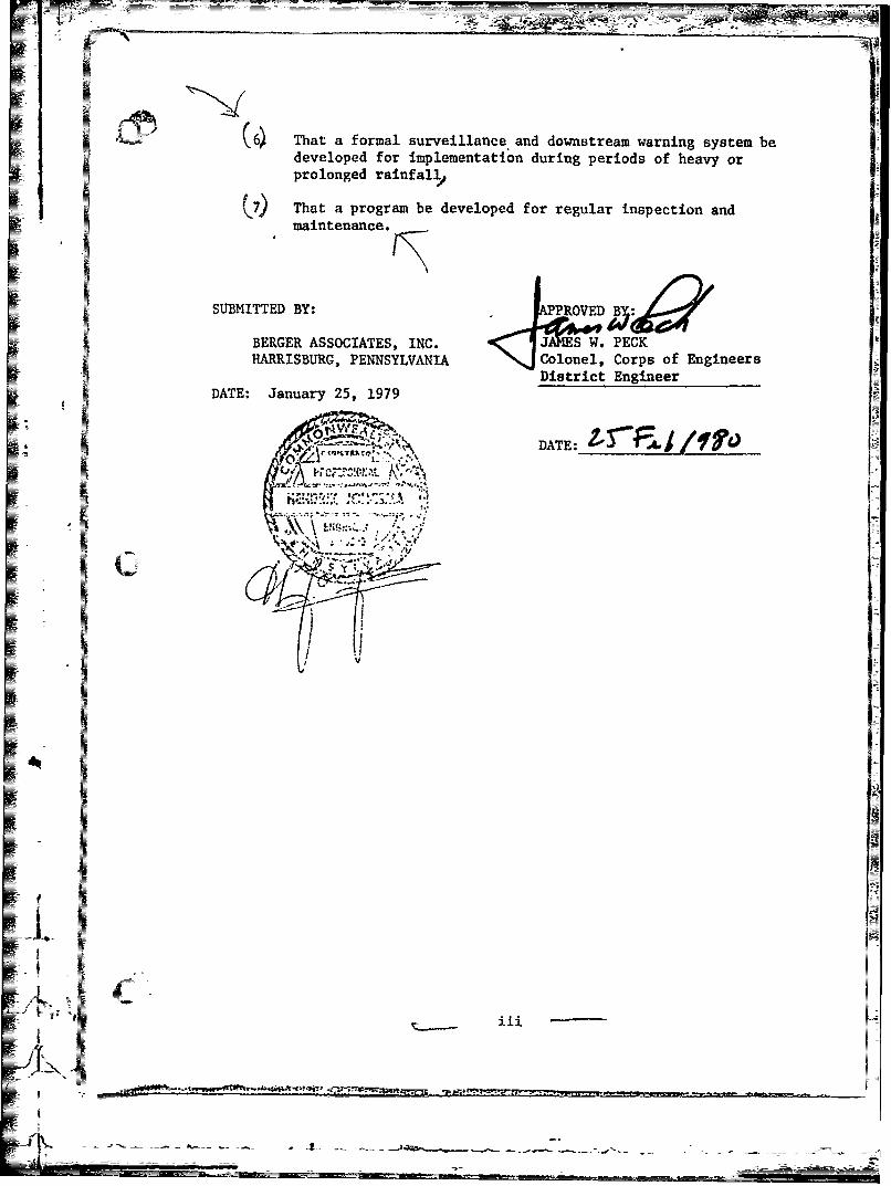
A- 6, That a formal surveillance and downstream warning system bedeveloped for implementation during periods of heavy orprolonged rainfall,
7) That a program be developed for regular inspection andI' maintenance.7
SUBMITTED BY: POE
BERGER ASSOCIATES, INC. J S W. PECKHARRISBURG, PENNSYLVANIA Coonel, Corps of Engineers
District Engineer
DATE: January 25, 1979
~~~ ~DATE:___________
(*Li
7-
w I
I~ I
ivi
TABLE OF CONTENTS
Page
SECTION 1 - PROJECT INFORMATION
1.1 GENERAL 11.2 DESCRIPTION OF PROJECT 11.3 PERTINENT DATA 3
SECTION 2 - ENGINEERING DATA
2.1 DESIGN 62.2 CONSTRUCTION 62.3 OPERATION 72.4 EVALUATION 7
SECTION 3 - VISUAL INSPECTION
3.1 FINDINGS 93.2 EVALUATION 11
SECTION 4 - OPERATIONAL PROCEDURES
4.1 PROCEDURES 124.2 MAINTENANCE OF DAM 124.3 MAINTENANCE OF OPERATING FACILITIES 124.4 WARNING SYSTEM 124.5 EVALUATION 12
SECTION 5 - HYDROLOGY/HYDRAULICS
5.1 EVALUATION OF FEATURES 13
SECTION 6 - STRUCTURAL STABILITY
6.1 EVALUATION OF STRUCTURAL STABILITY 15
SECTION 7 - ASSESSMENT AND RECOMMENDAIONS
7.1 DAM ASSESSMENT 177.2 RECO,1ENDATIONS 17
fAPPENDIX A - CHECK LIST OF VISUAL INSPECTION REPORT
APPENDIX B - CHECK LIST OF ENGINEERING DATA
--1APPENDIX C -PHOTOGRAPHSAPPENDIX D -HYDROLOGY AND HYDRAULIC CALCULATIONSAPPENDIX E- PLATESAPPENDIX F - GEOLOGIC REPORT
l_
I i -
PHASE I INSPECTION REPORTNATIONAL DAM INSPECTION PROGRAM
LAKE IADORE DAMI
I NDI-ID NO. PA-00091
DER-ID NO. 64-5
I_ SECTION 1 - PROJECT INFORMATION
1.1 GENERAL
A. Authority
The Dam Inspection Act, Public Law 92-367, authorized theSecretary of the Army, through the Corps of Engineers, to initiate aprogram of inspections of dams throughout the United States.
B. Purpose
The purpose of this inspection is to determine if the damconstitutes a hazard to human life and property.
1.2 DESCRIPTION OF PROJECT
A. Description of Dam and Appurtenances
Note: Project weir elevation was Elev. 94.6 which wasraised to 95.5 during construction in 1922. This
report is based on information from U.S.G.S. quad-rangle sheet and spillway elevation was set at
-1367.0.
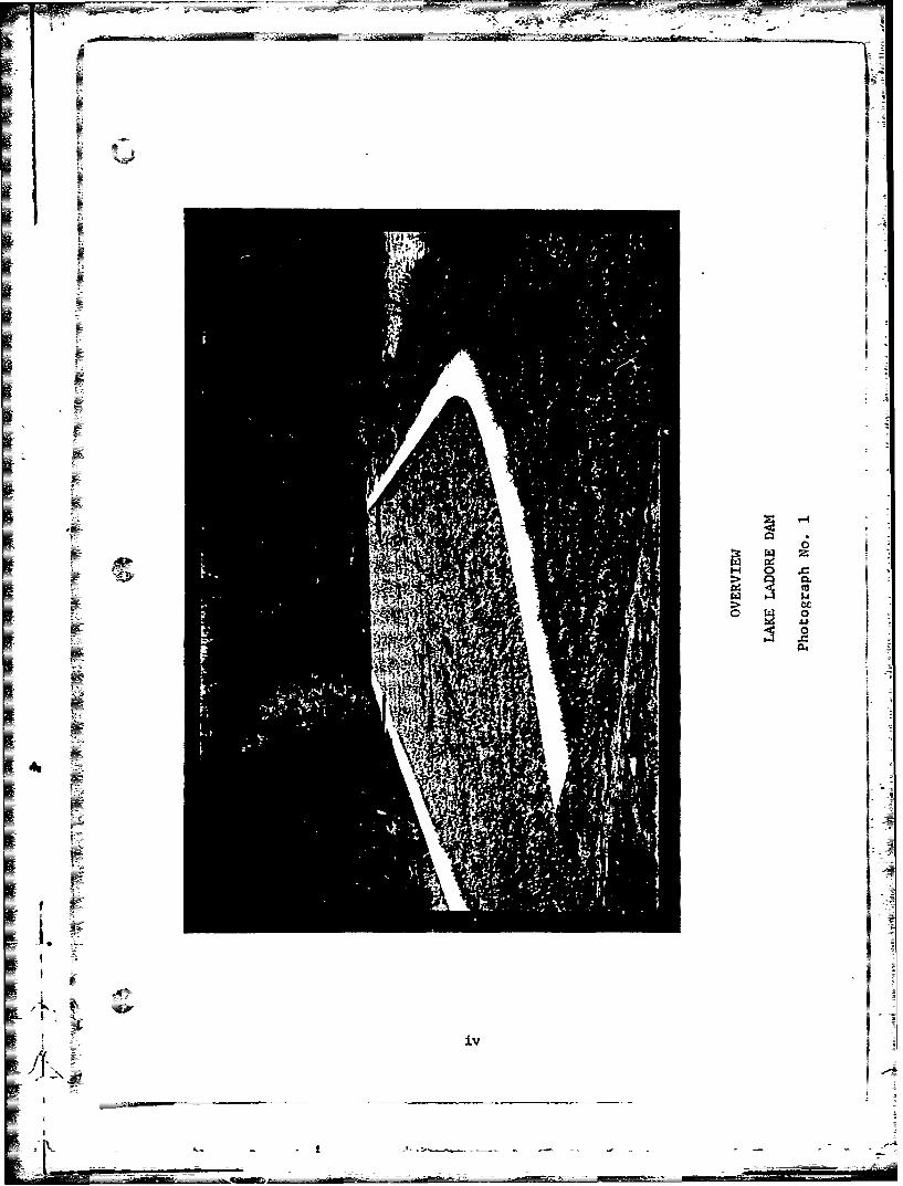
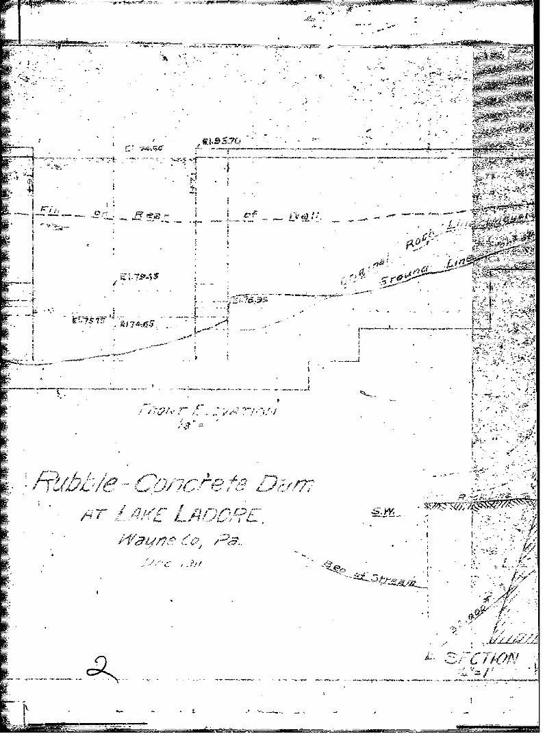
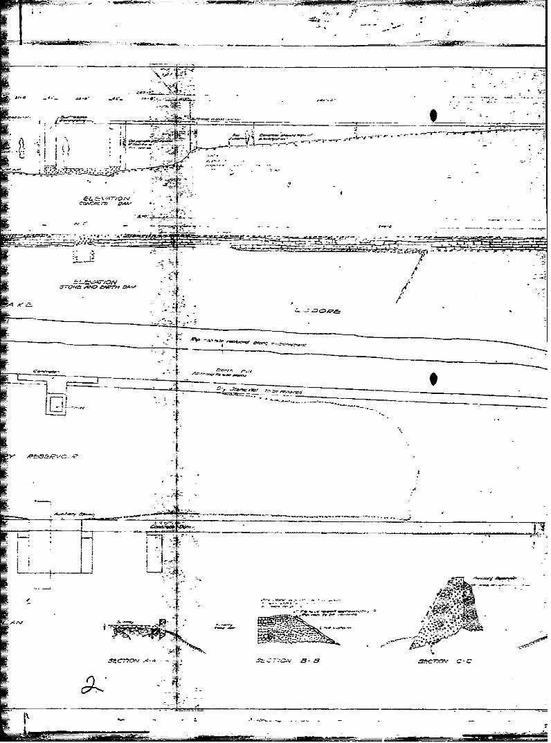
- The present dam was constructed as two separate structures.The first dam was an upstream embankment with a downstream verticalstone wall and was constructed in 1860. In 1906-07 a new concrete
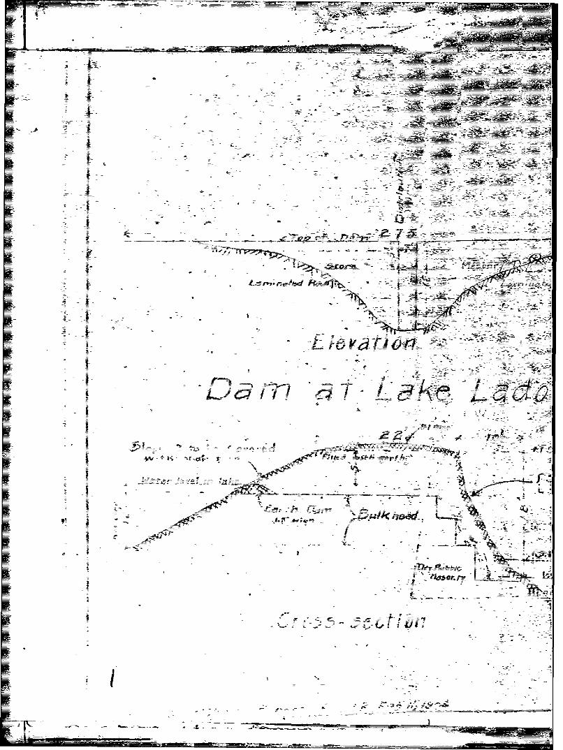
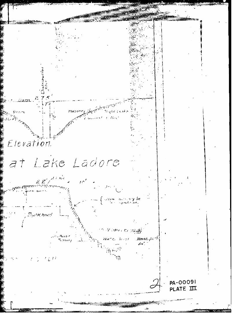
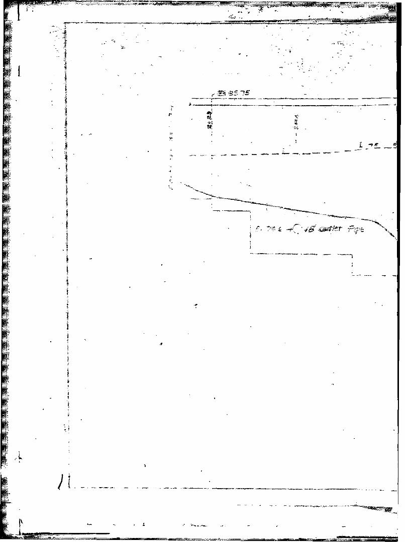
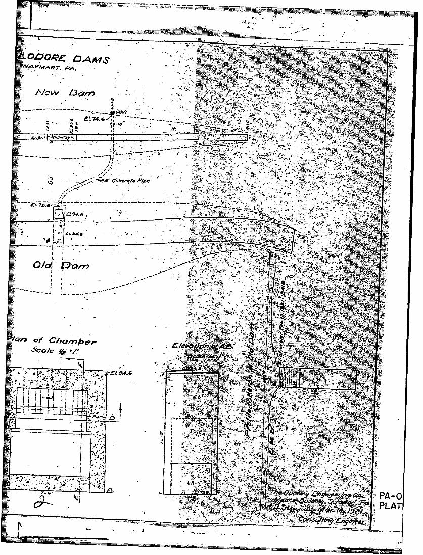
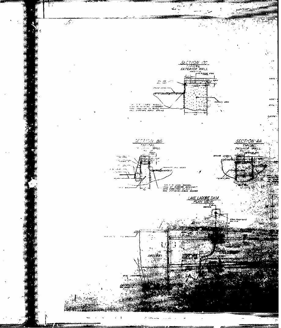
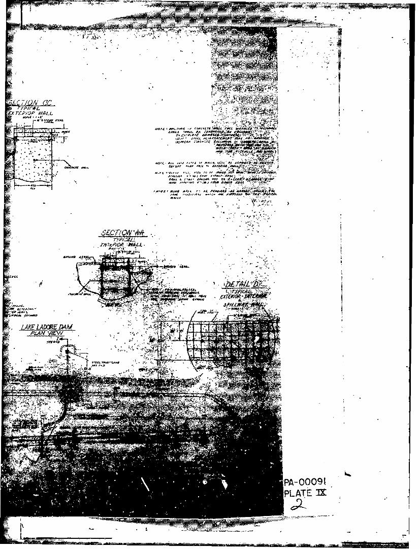
-gravity dam was constructed 50 feet downstream of the first dam. Inlater years, the space between these two dams was filled with soilmaterial and many repairs and improvements have been added. The presentdam is about 330 feet long and has a maximum height of 28 feet abovestreambed. A wetwell has been constructed at the location of the sluicewayi . in the firsf dam, with a sluice gate on an 18-inch concrete outlet pipe.
The outlet pipe discharges into a junction box" located between the twoawalls and an 18-inch cast iron pipe leads from this junction box through
= the downstream concrete gravity section (Refer to Plate IX, Appenuix E).
711
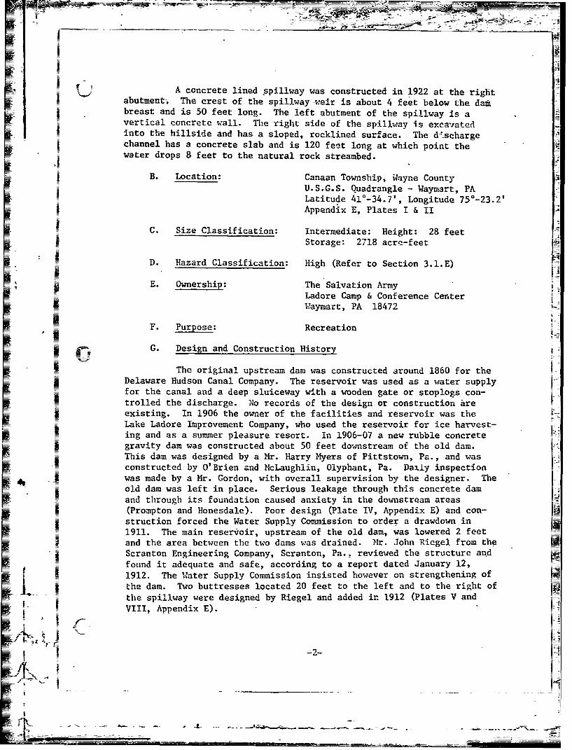
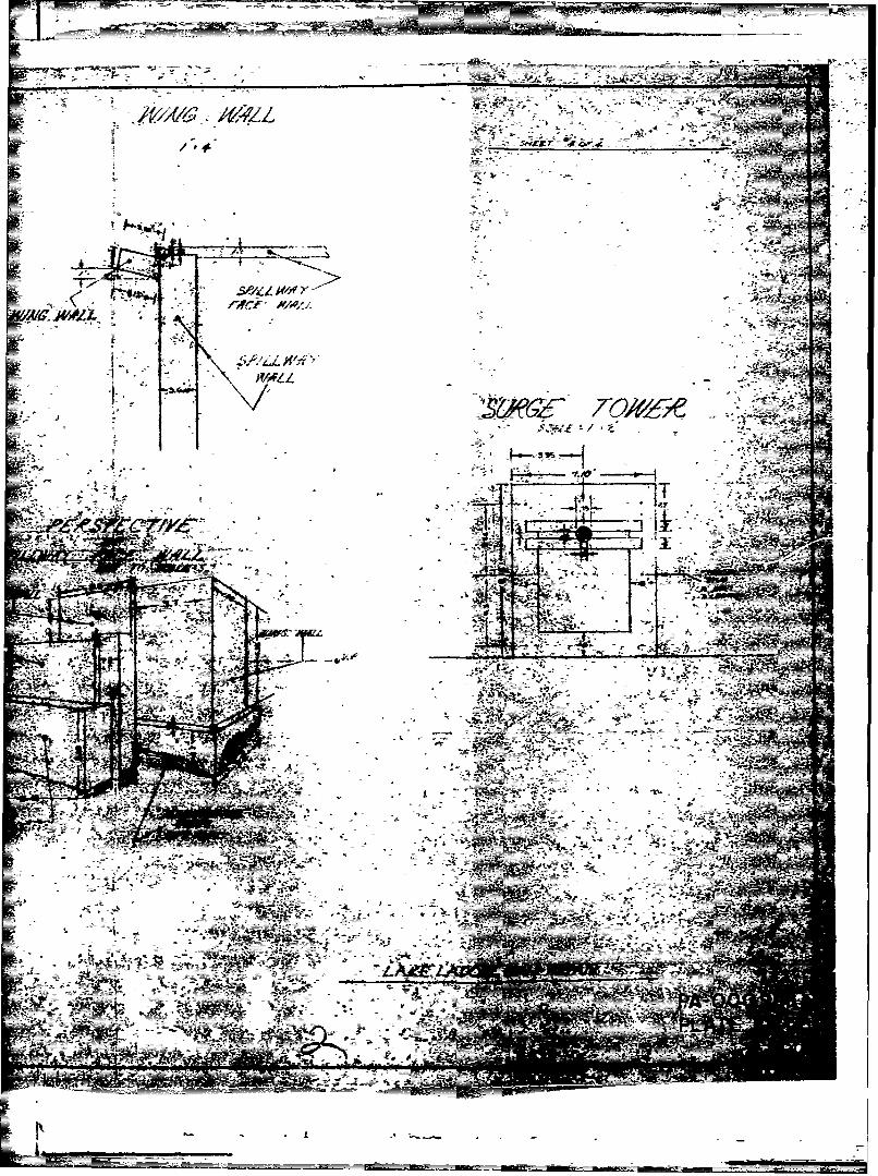
A concrete lined 'spillway was constructed in 1922 at the right
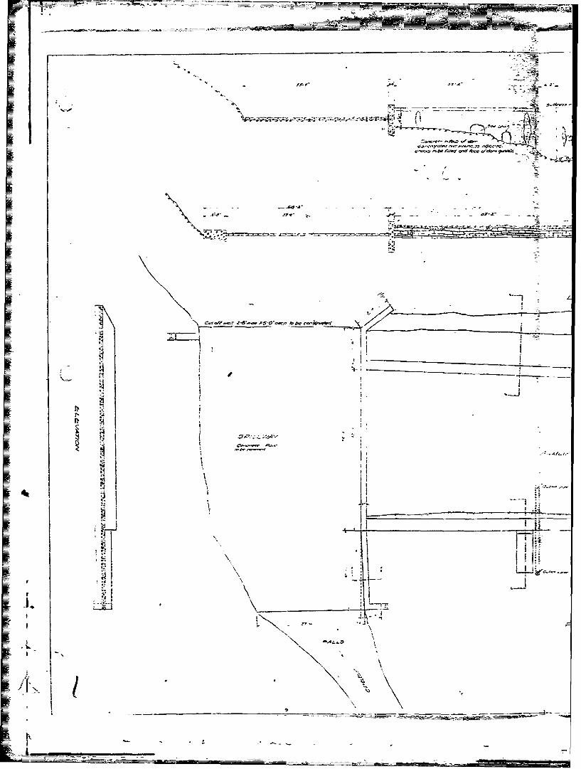
abutment- The crest of the spiliway -weir is about 4 feet below the damibreast and is 50 feet long. The left abutment of the spillway is a
_ vertical concrete wall. The riglt side of the spillway is excavatedinto the hillside and has a sloped, rocklined surface. The d-schargechannel has a concrete slab and is 120 feet long at which point thewater drops 8 feet to the natural rock streambed. -P
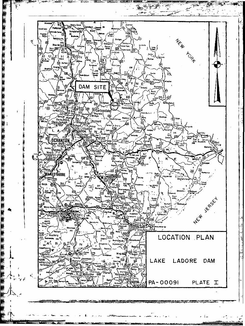
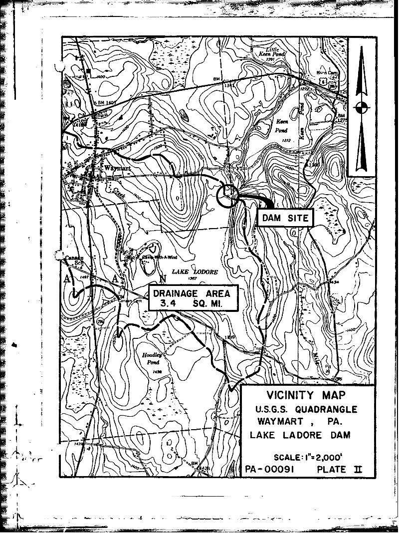
B. Location: Canaan Township, Wayne CountyU.S.G.S. Qadrangle Wayart, PALatitude 41°-34.7 ', Longitude 75-23.2'
Appendix E, Plates I & II
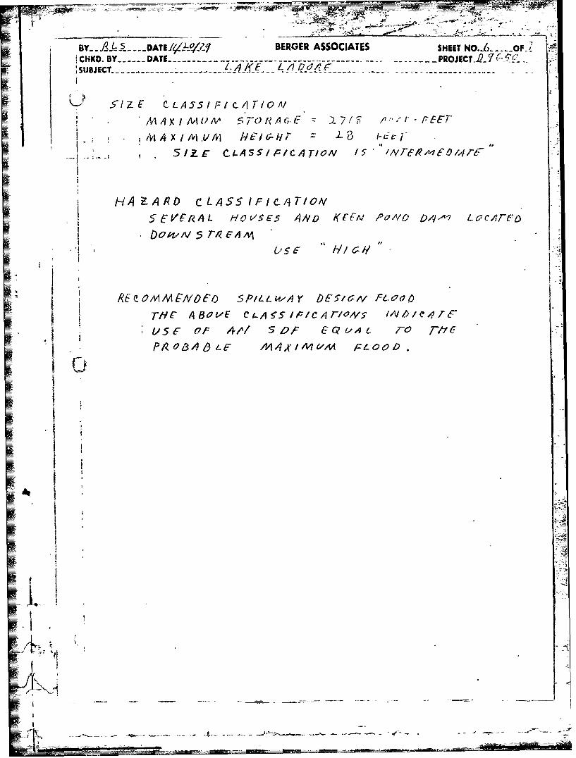
C. Size Classification: Intermediate: Height: 28 feetStorage: 2718 acre-feet
D. Hazard Classification: High (Refer to Section 3.1.E)
E. Ownership: The Salvation ArmySLadore Camp & Conference Center
Waymart, PA 18472
F. Purpose: Recreation
G. Design and Construction History
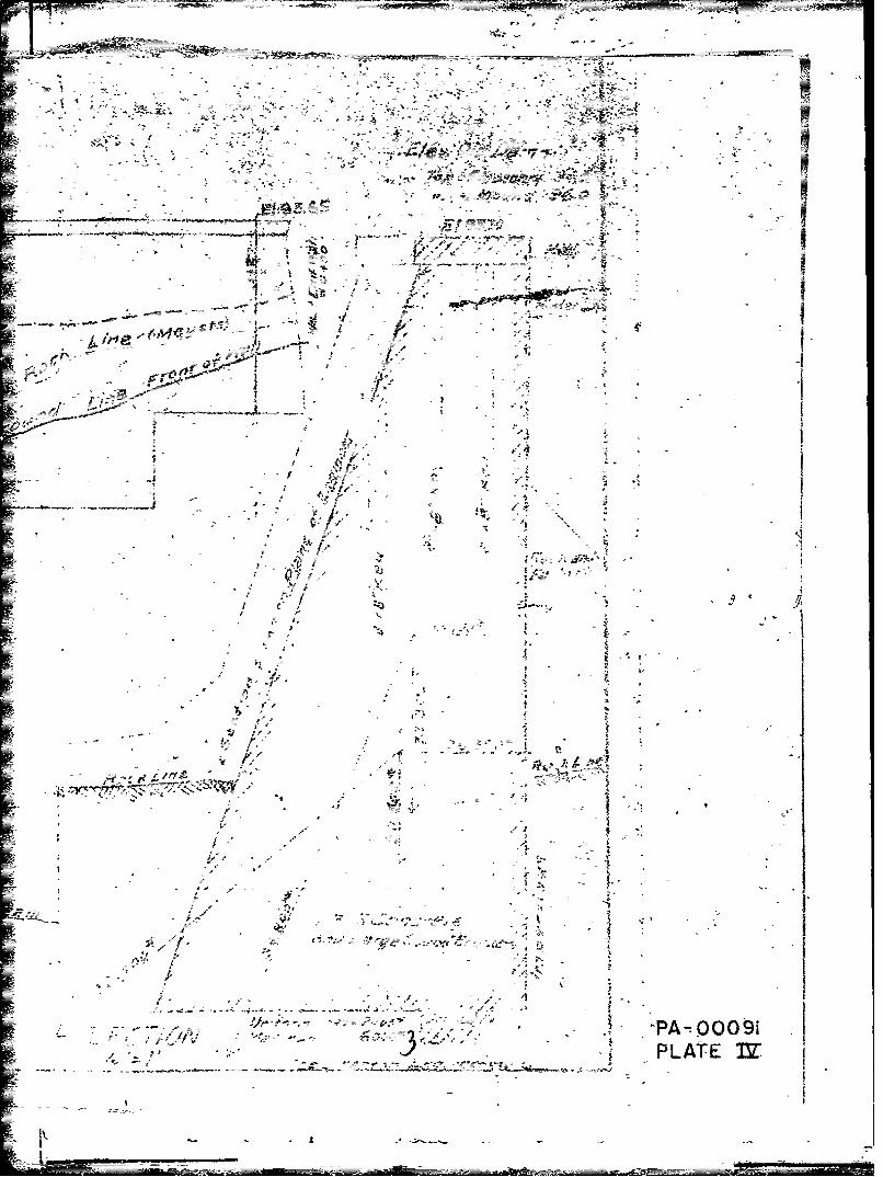
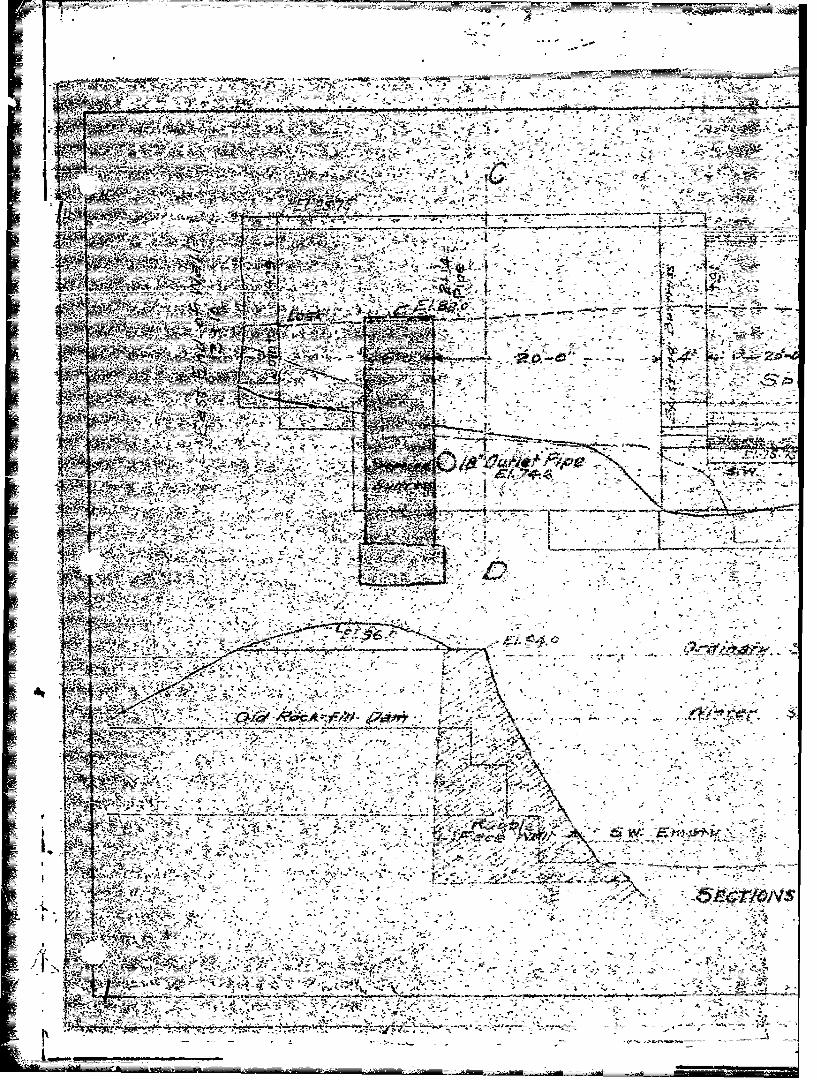
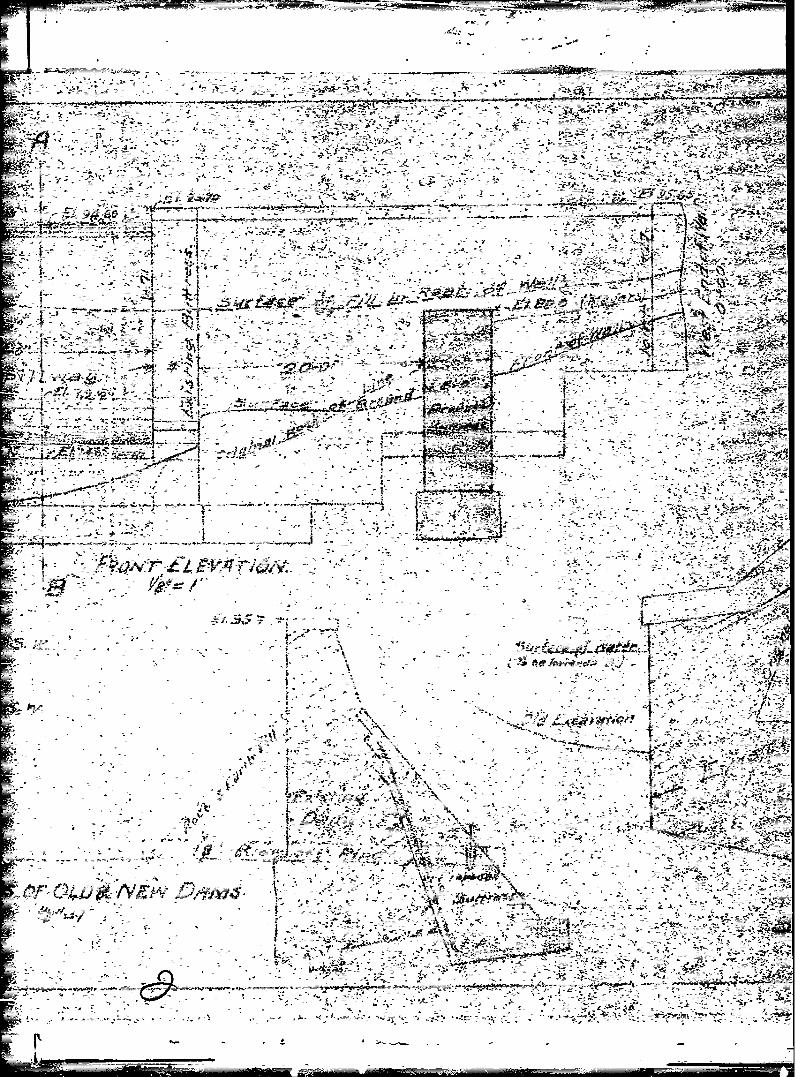
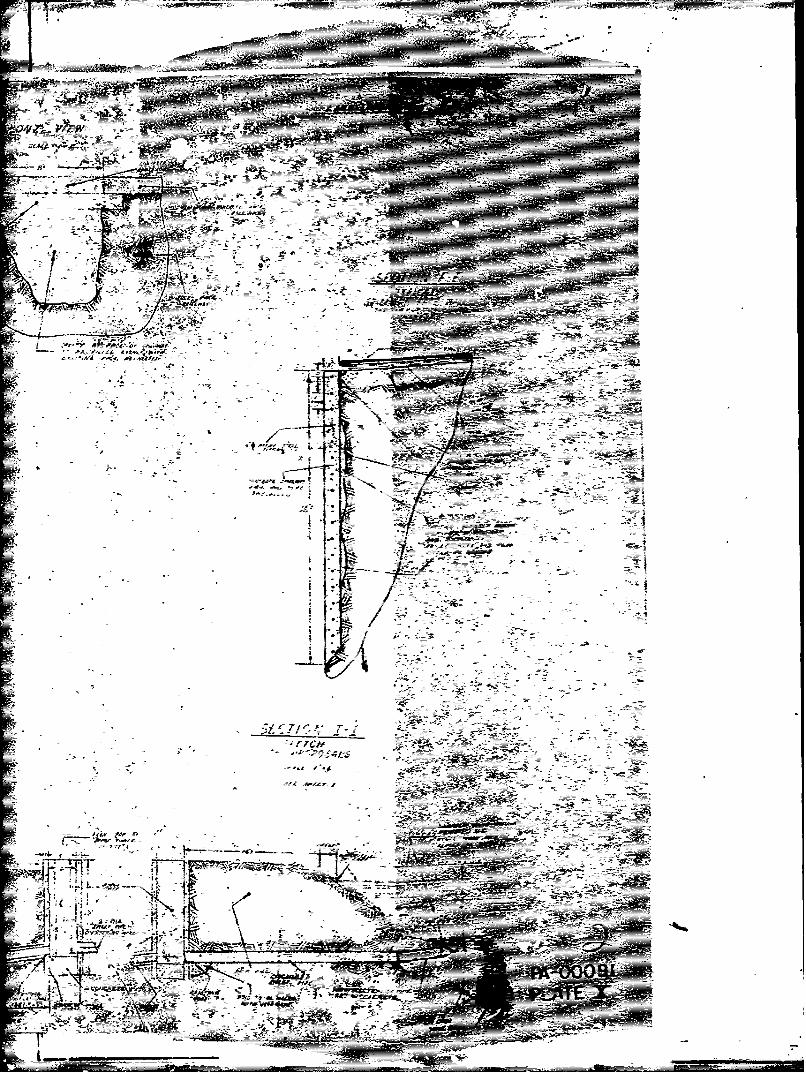
The original upstream dam was constructed around 1860 for theDelaware Hudson Canal Company. The reservoir was used as a water supplyfor the canal and a deep sluiceway with a wooden gate or stoplogs con-trolled the discharge. No records of the design or construction areexisting. In 1906 the owner of the facilities and reservoir was theLake Ladore Improvement Company, who used the reservoir for ice harvest-ing and as a summer pleasure resort. In 1906-07 a new rubble concretegravity dam was constructed about 50 feet downstream of the old dam.This dam was designed by a Mr. Harry Myers of Pittstown, Pa., and wasconstructed by O'Brien and McLaughlin, Olyphant, Pa. Daily inspectionwas made by a Mr. Gordon, with overall supervision by the designer. Theold dam was left in place. Serious leakage through this concrete damand through its foundation caused anxiety in the downstream areas(Prompton and Honesdale). Poor design (Plate IV, Appendix E) and con-struction forced the Water Supply Commission to order a drawdown in1911. The main reservoir, upstream of the old dam, was lowered 2 feetand the area between the two dams was drained. Mr. John Riegel from the
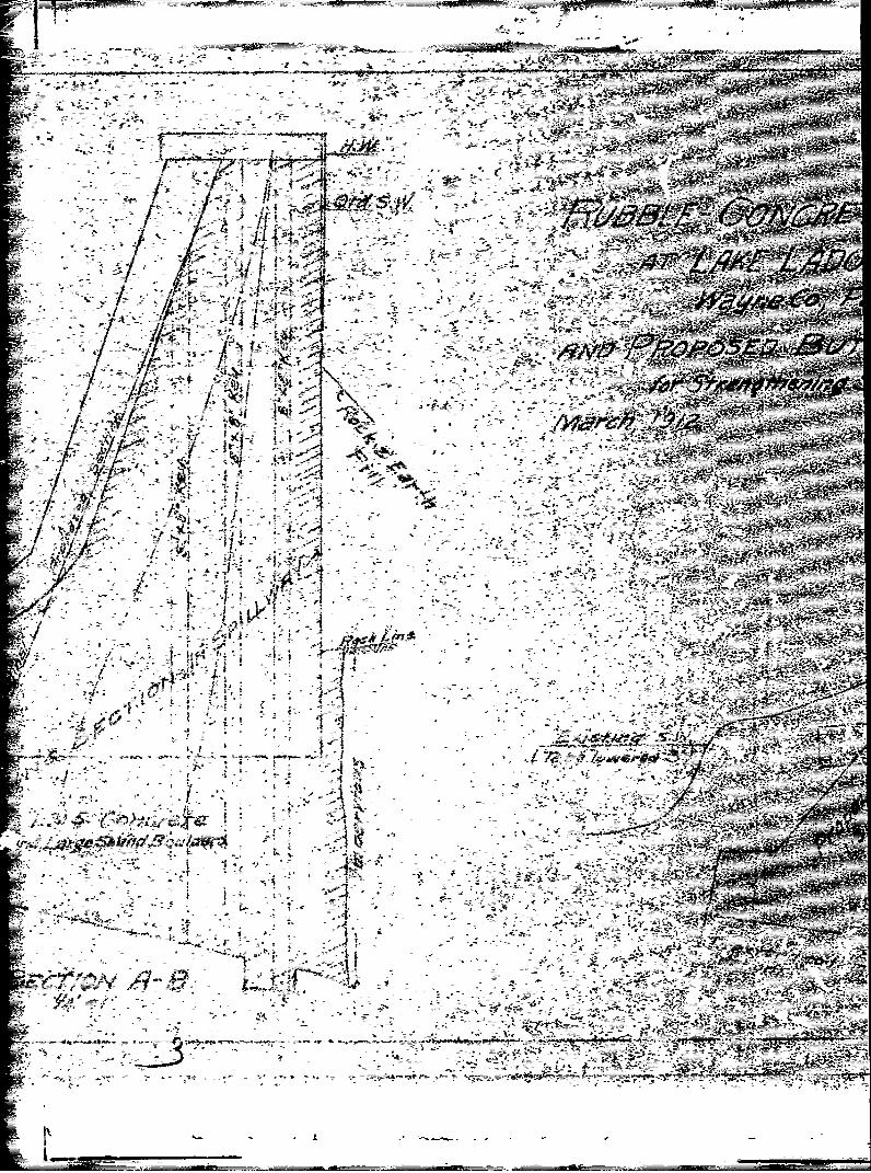
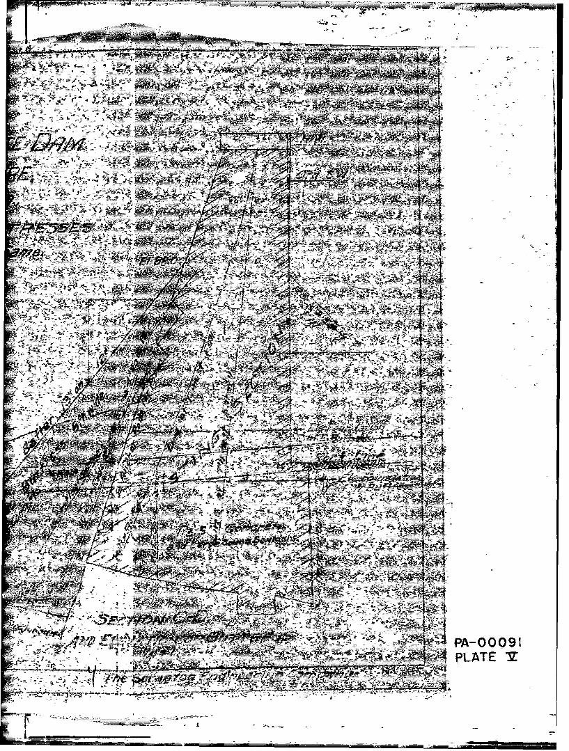
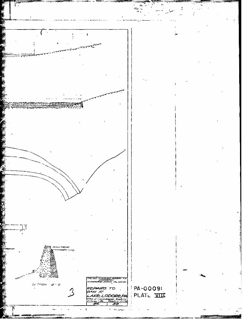
Scranton Engineering Company, Scranton, Pa., reviewed the structure an dfound it adequate and safe, according to a report dated January 12,1912. The Water Supply Commission insisted however on strengthening ofthe dam. Two buttresses located 20 feet to the left and to the right ofthe spillway were designed by Riegel and added in 1912 (Plates V andVIII, Appendix E).
r i -2-
iI
Due to considerable leakage through the concrete, the deterio-ration of the concrete and the questiona-'e stability of the gravitysection, the reservoir was ordered to be lowered again in 1917. InSeptember 1919 plans were made by Mr. Riegel to place fill between thetwo dams and to construct a valve p t at the sluiceway of the upstreamdam.
Plans were not submitted to the Water Supply Commission andvery little progress was made. The o .ers engaged a new engineer, Mr.Dunning, Scranton, Pa., in December 1920.
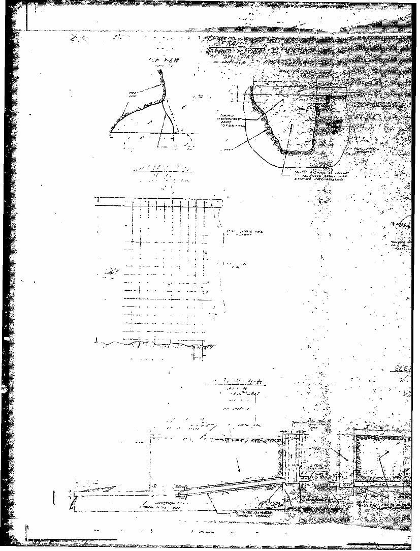
Plans were approved in March 1921 which included fill betweenthe two dams, topped with loose stone, wingwalls at end of embankmentand using the whole dam section as an overflow section, with a maximumdepth of 1 foot. New plans (Plate VI, Appendix E) were submitted at theend of 1921 which included a new spillway in the right abutment and theraising of the drywall of the upstream dam. This work was completed in1924.
Ownership was transferred in 1933 to the Delaware and HudsonRailroad Company. Serious leakage through the concrete was stilloccurring at this time. Plans were prepared by the new owner andapproved in March 1937. These plans included the raising 'of thestone wall by another foot, placing additional fill in the upstreamslope and the guniting of the upstream and downstream side of thedownstream concrete wall. Drainpipes were placed through the wall torelieve hydrostatic pressure. This work was completed in July 1938.
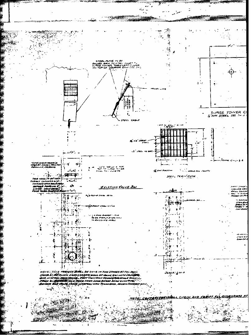
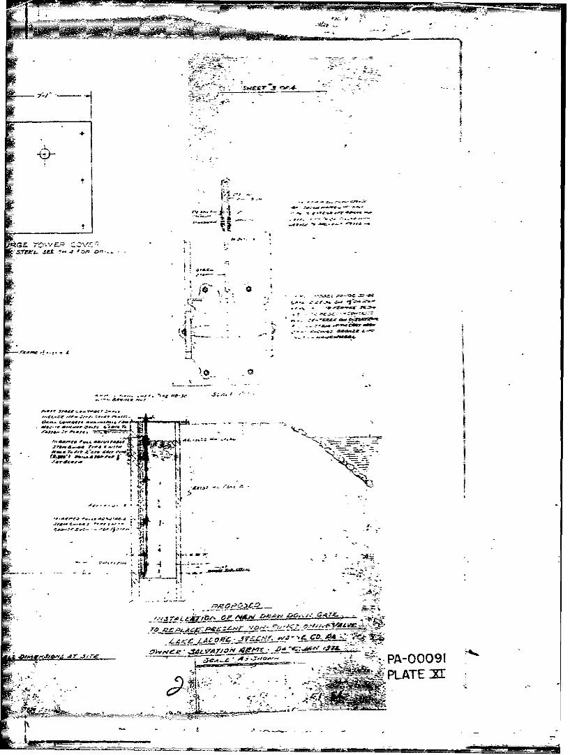
The Salvation Army obtained ownership of the dam in 1960.They engaged Mr. Zimmer, Surveyor, "--esdale, Pa., to study the leakageproblem and to improve the spillwn Ie valve chamber was repaired anda new gate was installed. Both conL :e and masonry walls were recapped4(Plates IX through XII, Appendix E).
H. Normal Operating Procedures
The reservoir is used for recreation and a pool. level at weircrest elevation is desirable. All inflow above this level is dischargedover the uncontrolled spillway. The gate in the wetwell, as reported bythe owner's representative, is partially opened on an annual basis.
1.3 PERTINENT DATA
A. Drainage Area (square miles)
From files: 2.4
Computed for this report: 3.4
iUse: 3.4
-3-
B. Discharge at Dam Site (cubic feet per second)i
j See Appendix D for hydraulic calculations
i! Maximum known flood (date unknown) 81
Outlet works low-pool outlet at pool Elev. 1356 12 [
Outlet works at pool level Elev. 1367.0 !
(spillway crest) 30
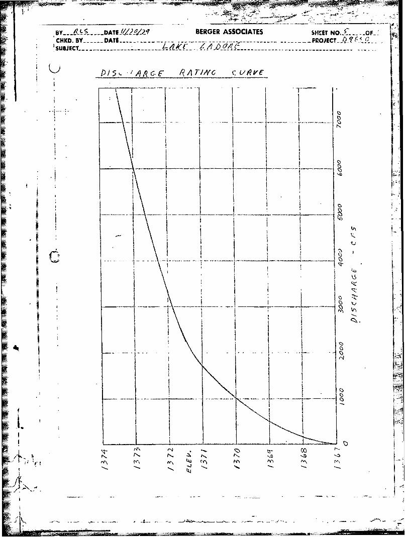
Spillway capacity at pool Elev. 1371.0(top of dam) 1694
C. Elevation (feet above mean sea level)
~Top of dam (low point) 1371.0 b
Spillway crest 1367.0
Upstream centerline intake pipe (estimated) 1354.0 !
Downstream outlet pipe invert 1345
Streambed at centerline of dam -estimate 1343.0
SD. Reservoir (miles);
Length of normal pool 1.3
I iLength of maximum pool 1.4-- E. Storage (acre-feet)
~Spillway crest (Elev. 1367.0) 1605
Top of dam (Elev. 1371.0) 2718
F. Reservoir Surface (acres)
Top of dam (Elev. 1371.0) 301 wn
i¢Spillway crest (Elev. 1367.0) 261
0 . Dam
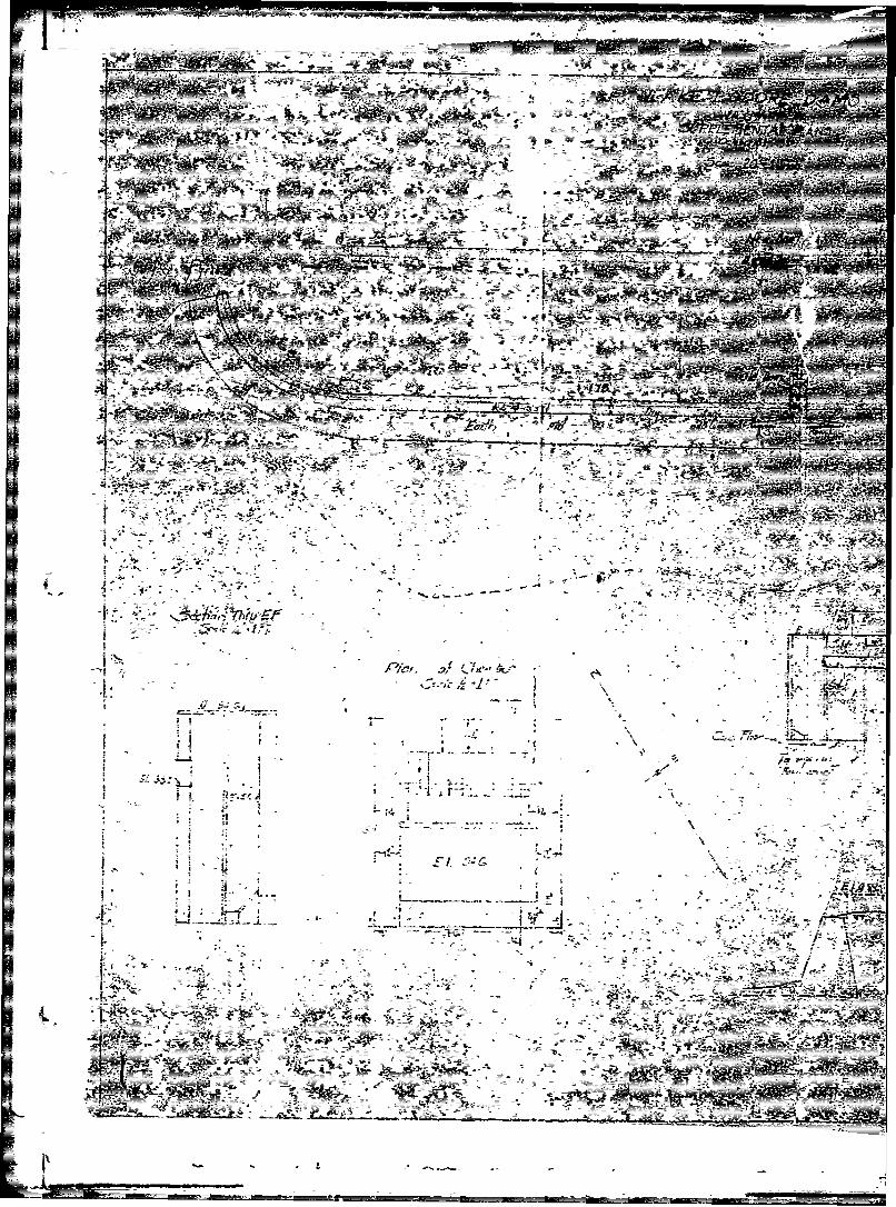
i Refer to Plate VIII in Appendix E for plan and section.
i Type: Upstream dam: Upstream Embankment with downstream
i masonry wall, capped with concrete.
B sh Do stream dam: Rubble concrete gravity section.
Mxm4owfilo (tw e tko 81ms
-4-
OultwrslwpA ule tpo lv-361
Length: 330 feet.
Height: 28 feet above streambed.
Top Width: 73 feet.
Side Slopes: Upstream - Unknown, steep above flowline.
I Downstream - Vertical with 4 buttresses.
= Zoning: None.
- Cutoff: Gravity section ?laced on rock.
IGrouting: None.
H. Outlet Facilities
An 18-inch outlet pipe discharges into a wetwell and valvechamber located on upstream side of centerline of embankment. A sluice
-- gate is on discharge side of wetwell for drawdown. Downstream-of thewetwell is an 18-inch outlet pipe. The alignment of this pipe iscurved.
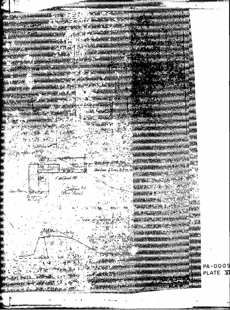
I. Spillway
Type: Uncontrolled broad crested weir with sloping crest,concrete paved.j
Length: 47 feet.
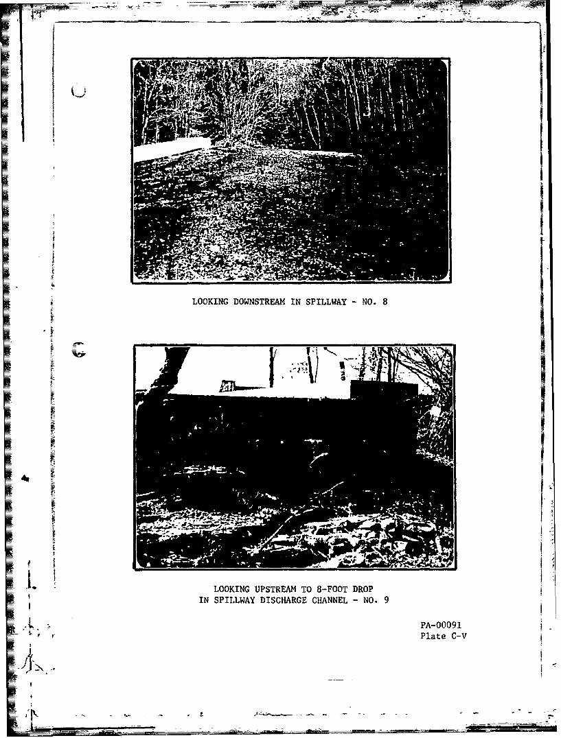
Channel: Spillway widens to about 60 feet immediately down-stream of the upstream edge of the crest, forming a concretechannel. The total length of the channel is 127 feet. Atthe downstream end is an 8 'Loot drop to a natural channel. Awooden footbridge crosses the channel.
J. Regulating Outlet
B See Section 1. 3.1H above.
-5-
-- ~ -A _
UP
IL 'SECTION 2 -ENGINEERING DATA
2.1 DESIGN
A. Hydrology and Hydraulics
i Engineering data on the hydrology and hydraulic design for1 these facilities were limited to statements in Reports on Applications
for repairs by the Pennsylvania Department on Environmental Resources
(PennDER) or its predecessor, the Water Supply Commission.
These reports indicate that the drainage area was assumed to
-, be 2.4 sqLare miles. The concrete gravity dam had a 20 feet long spill-
way with a one foot depth. The maximum outflow without overtopping was
67 cfs, storage was 255 acre-feet and maximum inflow was assumed to be
800 cfs. The blow-off facility discharge capacity (18-inch pipe) was 40
cfs. The spillway constructed in the right abutment was supposed to be
I rectangular (60 ft. x 4 ft. deep) and had a discharge rating of 1250
cfs.
I B. Embankment and Gravity Section
I Information on the design of the upstream dam was not avail-
able. Design data and analysis for the downstream dam was not found.
After the construction was completed and the stability was questioned, a
review of the stability was made by the Scranton Engineering Company
(Plate V, Appendix E) and the Water Supply Comnission. Reports indi-
cate that the resultant would only fall within the middle third for an
18 ft. height, assuming no uplift. The maximum height was, however, 2
28 feet. The influence of the buttresses on the stability was neglected. -Z
I C. Appurtenant Structures
a The available engineering data is limited to the design draw-
ings reproduced in Appendix E.
2.2 CONSTRUCTION
Construction data on the upstream dam is limited to inspection
reports by PennDER and some letters from enginpcrs reviewing the
I stability-and safety of the gravity dam.
Si These reports indicate that blasting was used to excavate the
foundation for the gravity dam and the later addition of the buttresses.
I The foundation material was described as tough green sandstone. The
l excavation for the buttresses in 1912 showed considerable leakage
underneath the dam. The Water Supply Commission reported the foundation
as seamy, with considerable leakage through a vertical seam and through
the concrete of the dam. Blasting caused additional fissures.
r -6-10
IN. ____ _ _ ____ ___ ____ ___ _ __ _7!
-~-w~ -~3
IIIn 1919 some fill was placed between the two dams. The material
was obtained from the hillside near the right abutment. Reports indi-care that the material was placed looscly and contained many stones andsome good sized rock. Because the area between the two dams was drained,the downstream side of the old dam could be inspected. The reportindicated that the dry stone wall was in gool condition and that someleakage was occurring near the left abutment. I
In the early twenties, a concrete cut-off for the sluiceway was
constructed (Appendix E, Plate VI). The foundation of this wall wasinspected by PennDER and was placed below the timber cribbing formingthe sluiceway bottom.
In 1938, fill was excavated on the upstream and downstream side ofthe gravity wall. A report indicates that the upstream side was infairly good condition but That the footing appeared to be a dry stonewall rather than concrete. Both faces of the wall were gunited anddrainpipes were installed in the wall to relieve hydrostatic pressurebehind the wall. It appears also that a drainpip, along the upstreamtoe was installed, outletting in the old 18-inch blow-off pipe.
Additional construction was performed in 1973 which consisted ofrepaving of spillway channel, recapping of masonry and gravity wall and
repairs to the valve pit.
2.3 OPERATION
There are no formal records of operation maintained. Records ofmaximum discharges were not found with the owner or in the files ofPennDER.
2.4 EVALUATION
A. Availability
The only engineering data available for examination were
contained in the .iles of PennDER, Bureau of Dam Safety. The data was
limited to drawings and reports.
B. Adequacy
The available information contained in the files are suffi-
C. Operating Records
Formal operating records are not maintained for this dam.
Reports could not be obtained to evaluate maximum flows discharged over
i - the spillway.
-7- +j'.7 +-
N---~---C - -- -
| D. Post Construction Changes
Many modifications have been made to these facilities,including the construction of a new dam downstream, Lhe filling of learea between the two dams, the raising of the dam, and the constructionof a new valve pit and spillway. For detdiled discussion of thesechanges reference is made to Sections 1.2.G and 2.2.
1 -8-N,
- L
SECTION 3 - VISUAL INSPECTION
3.1 FINDINGS
A. General
The general appearance of the Lake Ladore Dam is fair. Thedam has a long history of changes and additions and is a mixture ofseveral different types of construction. Although the upstream portion
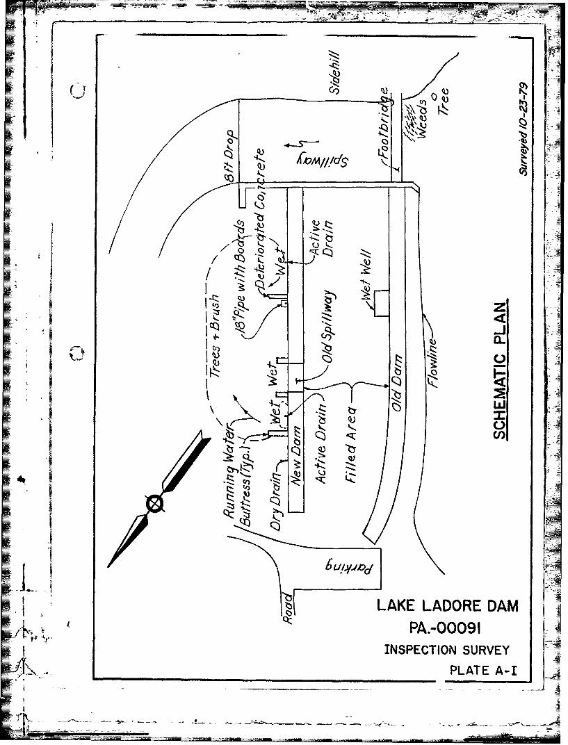
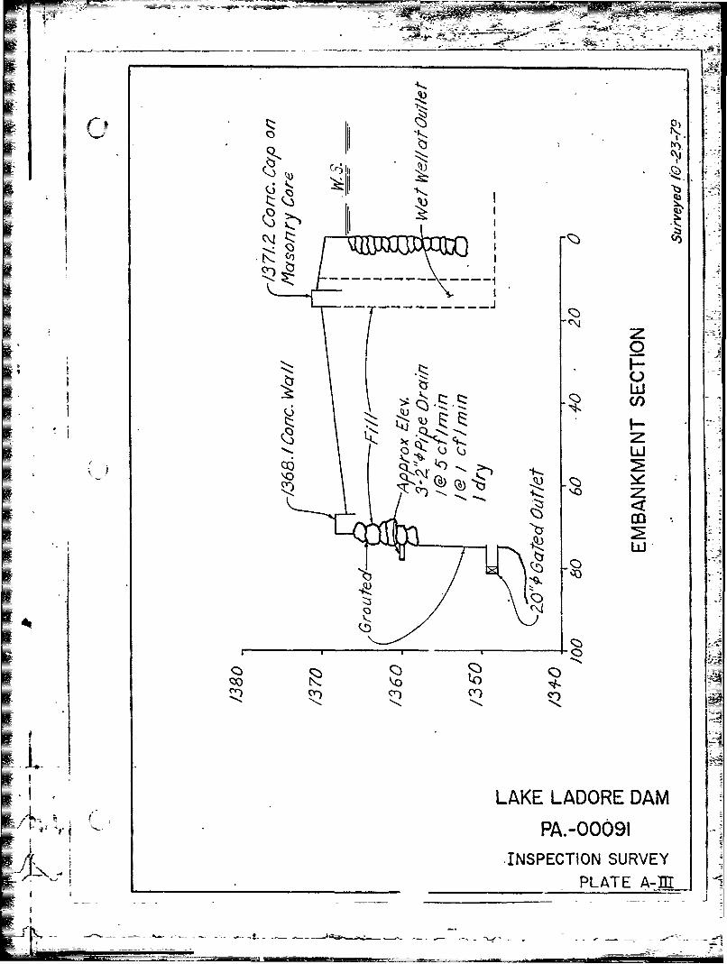
of the embankment and the top of the dam has a good appearance, thedownstream side of the dam, formed by a concrete wall, shows a poorquality of concrete surface and some deterioration. Several weepholesextending through the wall are active, indicating a high phreatic line.The toe below the wall is wet and a steady flow of water was apparent attwo locations (Appendix A, Plate A-I).
fr The reservoir and dam are owned by the Salvation Army, whichhas a large conference center located close by. The reservoir is usedfor recreation including fishing, boating and swimming. Mr. Paul Buntingof the Salvation Army accompanied the inspectors during the inspection.The visual inspection check list is in Appendix A of this report.Sketches of a general plan, profile and typical section of the dam,based on the field inspection survey, are also in Appendix A. Photo-
graphs of the facilities taken during the inspection are reproduced inAppendix C.
B. Embankment
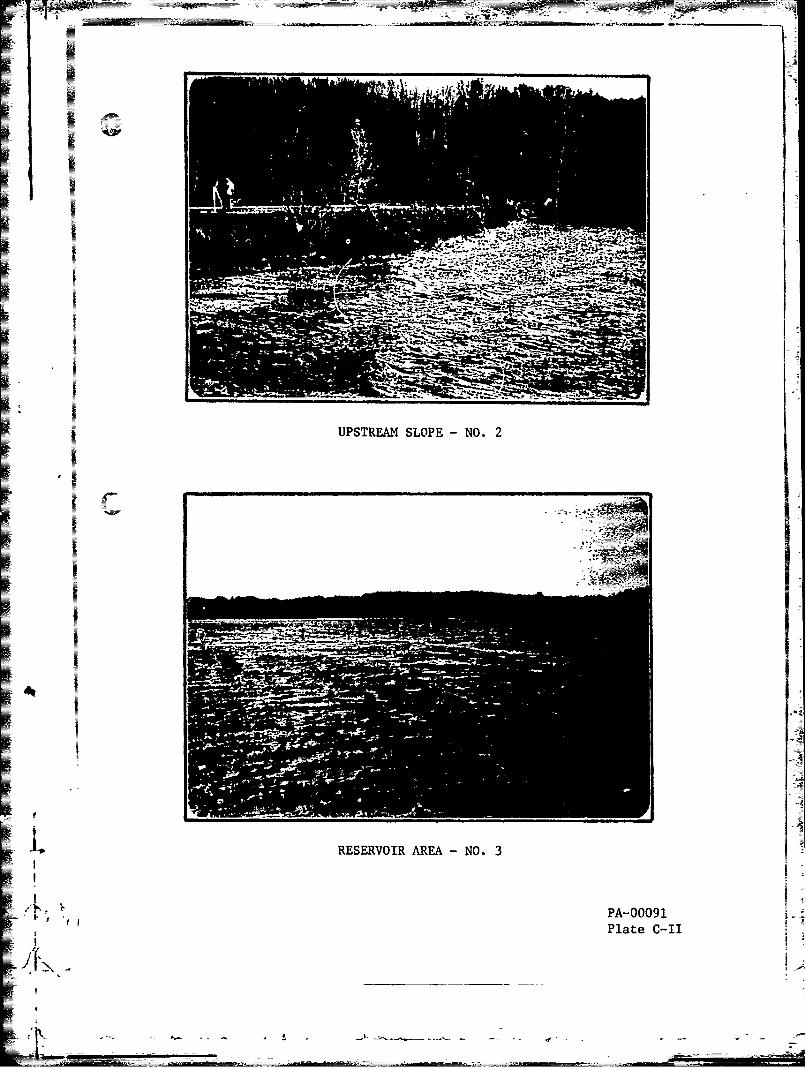
The upstream section of the embankment is the original struc-ture which was an earthfill dam with a downstream masonry wall. Theembankment was raised and the masonry wall was extended by a concretewall which presently projects above the earthfill. The top of this wallwas surveyed as the top profile of the dam. A 14 feet wide earthfill islocated upstream of the wall. The upstream slope is very steep to theflow line and is protected against wave action by heaqy rock. Someweed and brush growth is present on this slope.
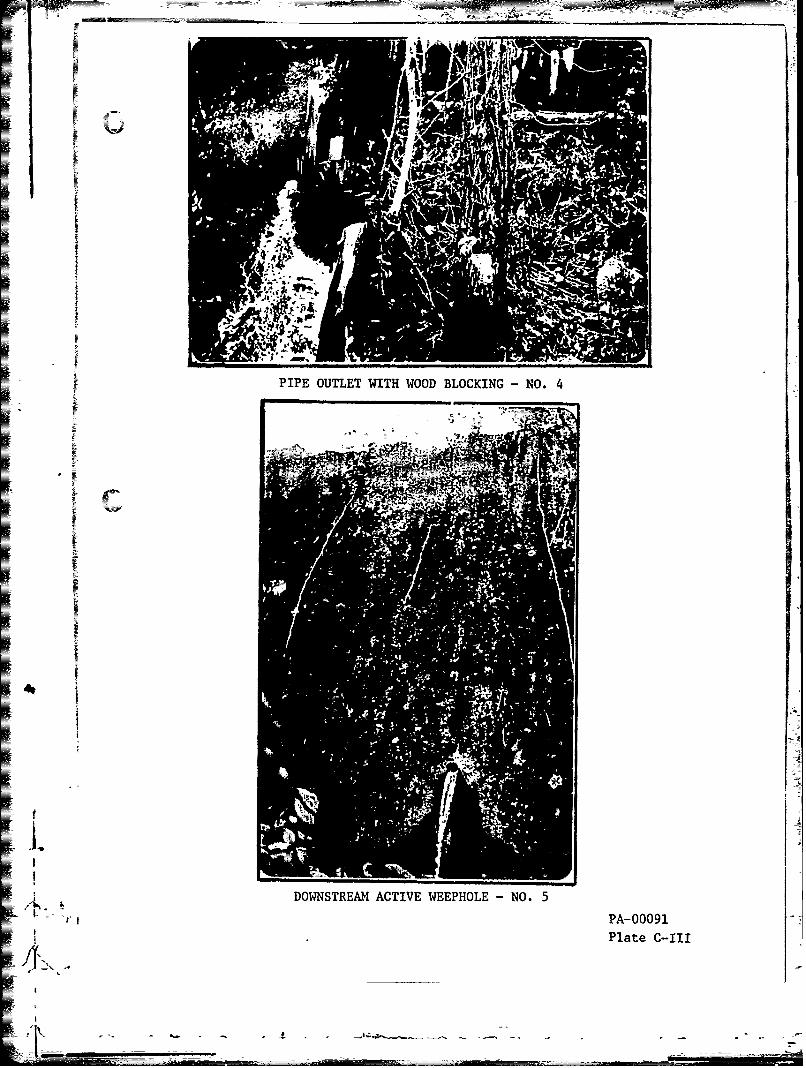
A fifty foot wide earthfill, with the surface sloping about 3feet to the downstream side, is located downstream of the -initial wall.This area has a well maintained grass mat. The downstream side of thedam is formed by a concrete wall, about 3 feet lower than the upstreamwall. Originally, this concrete wall had a small spillway with twosmall buttresses. Two addizional buttresses were subsequently added tosupport the wall. This wall was gunited at a later date. Four drain-pipes extend through the wall to the downstream side. Two of thesei idrainpipes are active. one discharges about 5 gallons per minute andthe other about 1 gallon per minute. Both drains are approximately 9
. feet below the top of the wall. This indicates a high phreatic line atthese two pipes. One of the other pipes was crushed. The top of thewall has been recapped and is in good condition. The gunite surface onthe downstream side shows many cracks and is deteriorated at many locations.
-9-
The ground surface at the toe of the wall is saturated betweenthe added buttress ard the old spillway buttress (See Plate A-I, Appendix
=A) and two streams of steady flow were apparent at the corners of thebuttresses. The concrete of one buttress has spalled exposing thereinforcing steel.
C. Appurtenant Structures
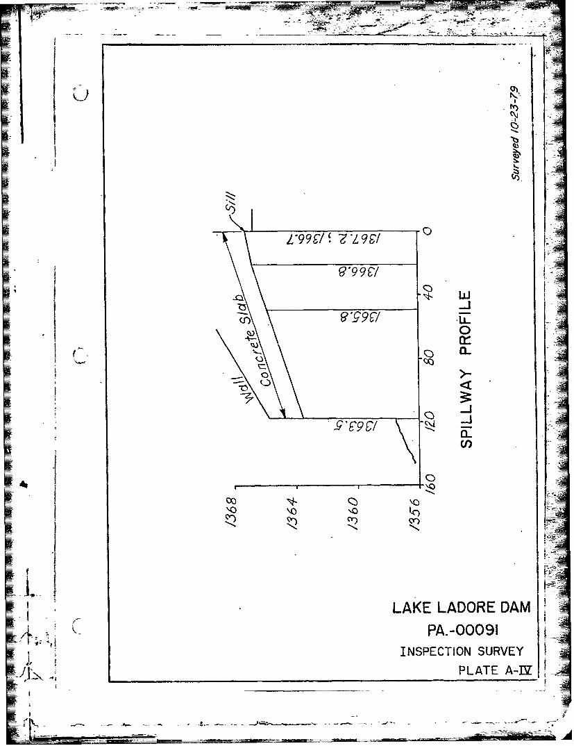
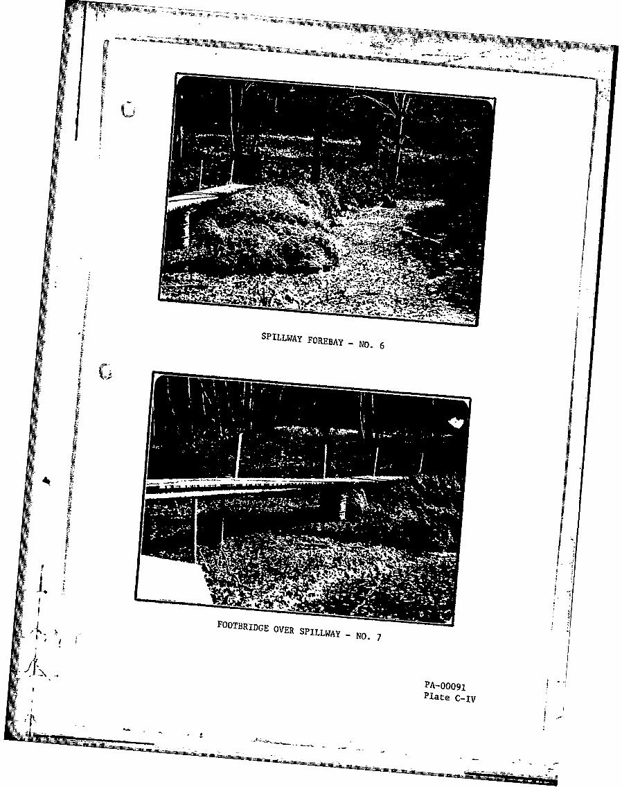
The spillway, which was added to this facility in 1922 is
located in the right abutment. The approach to the spillway is directlyfrom the reservoir. The entrance to the right side is partiallyobstructed by high weeds. The spillway weir is a broad crested type andnot very level. There is about a 2-inch drop from right to left (SeePlate A-If, Appendix A). The spillway has a concrete abutment wall onthe left side and a sloped natural rock surface on the right side. Thedischarge channel is 118 feet long and drops at a 4 percent grade. Theslab is showing some deterioration, but is in fairly good condition.The left side and the end of the discharge channel are protected with
concrete walls.
A temporary footbridge has been constructed over the spillway.This narrow wooden structure is supported on several 4' x 4's and abarrel (See Appendix C, Plate C-IV). The structure would probably wash
away if a heavy discharge would occur.
A wetwell is located between the two masonry walls just down-
stream from the original wall. The wetwell is covered with a heavysteel plate and contains a sluice gate, which is operated annually. Theoutlet conduit from the wetwell is an 18-inch pipe. The pipe dischargesto the right of the old spillway adjacent to a buttress. A 20-inch gate
at the downstream end of this pipe is not in working coudition. Thisgate is blocked by some boards. Water is continually discharging throughthe pipe to maintain minimum flow. According to Mr. Bunting, the control
gate in the wetwell is never completely closed.
D. Reservoir Area
The reservoir is surrounded by woodlands on moderate slopes.
The banks appear to be stable and sedimentation has not been reported to
be a problem in the reservoir.
E. Downstream Channel
The spillway discharges at the end of the chute over an 8 foot
vertical drop into a rock lined channel in a wooded area. The stream-I , slopes about 80 feet in 1,500 feet at which point the stream enters a
camping ground are located around this lake. About 6 houses are located
below Keen Lake Dam in an area which would be flooded if Keen Lake Dam
-10-
S -
should fail due to failure of the Lake Ladore Dam. The hazard categoryof Lake Ladore Dam is considered "High."
3.2 EVALUATION
The visual evaluation of the facilities at Lake Ladore Dam is fair.An accurate assessment of the stability of the dam cannot be made due tothe many changes and additions. The main concern is the seepage at thetoe of the downstream wall and the active discharge through 2 weepholes.These conditions indicate a high phreatic line in the earthfill, andthat a pervious or semi-pervious material was used for the fill betweenthe two walls. Another possibility is that the downstream concrete wall
prevents the normal seepage to pass out of the fill and that this generatesIa hydrostatic pressure behind the wall.
The top of the dam is well maintained. Although the upstream slopeappears to be steep, good rock protection is present and no failureswere detected.
The spillway, while not entirely level, is in good condition. Theentrance should be kept free of weeds and brush. The footbridge wasprobably placed without a permit. It appears that this bridge would bewashed away during high flow and would not seriously impede the capacityof the spillway.
iiK
10. IF_ _ __N_1_ _P7_= .1eM.-..I
SECTION 4 - OPERATIONAL PROCEDURES
4.1 PROCEDURES
The operational. procedures at Lake Ladore Dam are limited. Thereservoir is used for recreation and the pool level is maintained at theelevation of the spillway weir. Any additional inflow is dischargedover the uncontrolled broadcrested weir.
4.2 MAINTENANCE OF EMBANKMENT
The recently restored top of the concrete walls is in good con-dition. The top of the embankment has a well maintained grass mat.There is some brush growing on the upstream slope, which needs removal.
- 4.3 MAINTENANCE OF OPERATING FACILITIES
The entrance to the spillway should be cleared to provide forunobstructed discharge. The annual opening of the gate in the wetwell shouldbe continued.
4.4 WAPNING SYSTEM
Although the top of the dam is observed daily by maintenancepersonnel, this observation is limited to a policing function. A formalsurveillance plan and downstream warning system does not exist at present.
4.5 EVALUATION
The operational and maintenance procedures for these facilitiesshould be expanded to include brush removal on the upstream slope and inthe spillway area. Regular observance of the upstream slope should beincluded in the maintenance program to ascertain that no failures in thesteep rock slope has occurred. The weepholes on the downstream wallshould be observed to evaluate if higher pool levels would cause finesto be washed out. A formal surveillance plan and downstream warning
1system should be developed for implementation during periods of high orprolonged precipitation.
'-12-
ZN i. .. ..
_______ --=--- I ____ -, ___________
SECTION 5 - HYDROLOGY/HYDRAULICS
5.1 EVALUATION OF FEATURES
A. Design Data
The hydrologic and hydraulic analyses available from PennDERfor Lake Ladore Dam were not extersive. No frequency curve, unit hydro-graph, nor flood routings were submitted by the designer to PennDEt..
B. Experience Data
The maximum recently known flood at Lake Ladore Dam caused thepool level to rise to 8 inches above the spillway crest. The storm waspassed without difficulty.
C. Visual Observations
On the date of the inspection no conditions were observed thatwould indicate that the appurtenant structures of the dam could notoperate satisfactorily during a flood event, until the dam is overtopped.
D. Overtopping Potential
Lake Ladore Dam has a cotal storage capacity of 2,718 acre-feet and the overall height is 28 feet above the streambed. Thesedimensions indicate a size classification of "Intermediate". The hazardclassification for this dam is "High" (See Section 3.1.E).
The recommended Spillway Design Flood (SDF) for a dam havingthe above classifications is the PMF (Probable Maximum Flood). For thisdam the PMF peak inflow is 6,030 cfs (See Appendix D for hydrauliccalculations).
Comparison of the estimated PMF peak inflow of 6,030 cfs with4che estimated discharge capacity of 1,694 cfs indicates that a potential
for overtopping of the Lake Ladore Dam exists. This discharge is basedon the present low point in the crest at Elev. 1,371.
An estimate of the storage effect of the reservoir and routingof the computed inflow hydrograph through the reservoir shows that this
- dam does not have the necessary storage available to pass the PMF with-out overtopping. The spillway-reservoir system can pass a flood event
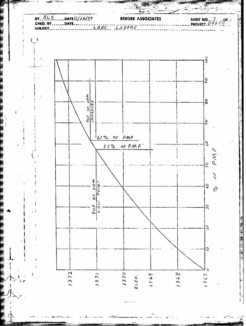
equal to 57% of a PMF, based on the present low point in the crestprofile.
-13-
_U
E. Spillway Adequacy
The intermediate size and high hazard categories, in accor-dance with the Corps of Engineers criteria and guidelines, indicatesthat the Spillway Design Flood (SDF) for this dam should be the ProbableMaximum Flood.
Calculations show that the spillway discharge capacity andreservoir storage capacity combine to handle 57% of the PMF (Refer to
Appendix D). If the low point in the embankment would be raised toElev. 1371.2, making the crest elevation uniform, the spillway dischargecapacity and reservoir storage capacity would handle approximately 61% ofthe PMF.
Since the spillway discharge and reservoir storage capacitycannot pass the full PMF without overtopping, but can pass more thanone-half the PMF without overtopping, the spillway is considered to beinadequate but not seriously inadequate.
The hydrologic analysis for this investigation was based uponexisting conditions of the watershed. The effects of future developmentwere not considered.
o
I|L
i 'r
N-14-
_________________________ -
II
SECTION 6 - STRUCTURAL STABILITY
6.1 EVALUATION OF STRUCTURAL STABILITY
A. Visual Observations
1. Embankment
The visual observation of this structure indicates a very
high phreatic line behind the downstream concrete wall (active drain-pipes) and possible seepage through the foundation (soggy toe). The topof the structure is quite wide and well maintained, with a good grassmat. There were no indications that any movement has occurred in thedownstream wall, and it appears that the embankment with its two wallsare stable. Although the upstream slope was steep, the riprap protec-tion is apparently stable. Reference is made to the Geologic Report,Appendix F, for discussion of the foundation.
2.- Appurtenant Structures
A small amount of deterioration has occurred in thespillway slab, but the overall condition of the spillway appears to beadequate at the present time. The left wall is solid and the rocksurface on the right side appears sufficient to withstand expecteddischarges.
The wetwell could not be inspected and the operationalcondition of the sluice gate was not ascertained during the inspection.Although the downstream valve is not usable, its function is not impor-tant from a structural point of view. It is recommended to remove theboards in this valve, because this cannot be done when full hydrostaticpressure is present in the outlet pipe. The existing condition wouldprevent full use of the discharge capacity in case of an emergency.
B. Design and Construction Data
1. Embankment
Detailed information is not available about the struc-tural stability of this structure as it exists today. Reports indicatethat some leakage at the left abutment occurred in the upstream dam.The dry stone wall was reported to be in good condition during a dewater-ing period in the twenties. The structural stability of the downstreamconcrete gravity wall was questioned and reevaluated. Reports and forcediagrams indicate that the resultant falls outside the middle third forthe maximum section. Although two buttresses were added, the design of i4the wall would not be acceptable if this wall was the only retainingfeature. There is, however, a large amount of fill in front of thiswall including the old masonry wall. If the downstream wall should
_ _ _fail, progressive recession could occur. The present available informa-tion is not adequate to evaluate the stability and structural integrityof the embankment.
_-5-
{ 2. Appurtenant Structures
The available design and construction data is limited tothe design drawings. Design assumptiQns and calculations could not befound. A point of concern is the presence of the wetwell in the filland the many times the outlet pipe was reconstructed and attached tothe cast iron pipe through the downstream wall. Leakage through the wet-well walls and pipe could exist.
C. Operating Records
There are no operating records for this dam. Inspectionreports indicate that leakage has been a problem since 1906.
D. Post Construction Changes
The construction of many of the changes to this dam since 1906have been made haphazardly without good engineering design and supervision.Construction was often over long periods of time without trying torectify the actual stability and leakage problems. The quality ofconcrete in the gravity dam was poor and the fill between the dams wasconstructed of poor material and without good compaction methods.
E. Seismic Stability
This dam is located in Seismic Zone I and it is consideredthat the static stability is sufficient to withstand minor earthquake-induced dynamic forces. No studies or calculations have been made toconfirm this assumption.
I!16
SECTION 7 - ASSESSMENT AND RECOMMENDATIONS
7.1 DAMI ASSESSMENT
A. Safety
The visual inspection and the review of available infor.it.>nindicate that che dam and its appurtenant structures are in fair condition.The inspection did not detect any signs of present instability of tl-edam, but the suspected high phreatic line in the fill and the soggy
condition along the toe are points of concern. The design reviews made-by PennDER indicate that the downstream dam was not designed in accordance
with accepted engineering practice. Although the dam does not showsigns of instability, further studies are recommended to evaluate the
safety of the structure.
In accordance with the Corps of Engineers evaluation guide-
lines, the spillway is inadequate for passing the full PMF peak inflowI without overtopping the dam. The combination of storage and spillwaycapacity is sufficient for passing 57 percent of the PMF and althoughthe spillway is inadequate, it is not considp-ed to be seriouslyinadequate. If the low areas were raised to the design crest eleva-tion, the project would pass approximately 61 percent of the PMF without
overtopping the dam.
B. Adequacy of Information
Although the available engineering data are not sufficient to
make a detailed analysis of the stability of the dam and its appurtenantstructures, the available drawings, reports and the observed physical
conditions are judged sufficient for making a reasonable assessment of~~the overall condition of the dam.
C. Urgency
The recommendations presented below should be implemented
without delay.
D. Necessity for Additional Studies
Additional studies will be required to ascertain the stability
of dam, and to evaluate the cause and consequences of the apparent high
phreatic line in the fill.
7.2 RECOMMENDATIONS
In order to assure the safe operation of this dam, the following
j recommendations are presented for implementation by the owner:
.. -17-
I-1
1. That a detailed study be made to determine the cause andorigin of leakage and to evaluate the structural stability ofthe dam. This study shall include, but not be limited to thedetermination of the phreatic line, the condition of the wet-well and outlet and the possible results if the downstreamwall of this dam would fail due to overturning. The study isto be made by a Professional Engineer with experience in the
design and construction of dams.
2. That the spillway entrance be cleared of grass, weeds andother obstructions.
3. That the boards in the downstream valve be removed.
4. That the concrete of the right buttress be repaired andprotected from further deterioration.
5. That the brush on the upstream slope be removed.
6. That a formal surveillance and downstream warning system beI developed for implementation during periods of heavy or pro-longed rainfall.
7. That a program be developed for regular inspection andmaintenance of Lne dam and its appurtenant structures.
- - -
- I-
t.-18-
"I . ... ...... ..-~-~ -__
- - _____ -~ - -~---~-~ --
5-
Li
I
I
APPENDIX A
CHECKLIST OF VISUAl INSPECTION REPORT
II IIII
f
~i~j -
APPENDIX A
K
- ~- - - - .~-~----~------ --- ~,,- -
IMA
CHECK L I ST
PHASE I VISUAL INSPECTION REPORT
PA DER # 64-5 NDI NO. PA-O0 091
NAME OF DAM LAKE LADORE DAM HAZARD CATEGORY High
TYPE OF DAM Earthfilled concrete masonry cell
LOCATION Canaan TOWNSHIP Wayne.* COUNTY, PENNSYLVANIA
INSPECTION DATE 10/23/79 WEATHER sunny, windy TEMPERATBRE 60's
INSPECTORS: R.V. Houseal (Recorder) OWNER'S REPRESENTATIVE(s):
H. Jongsma, Paul Bunting
R. Shireman
A.L. Bartlett
, NORMAL POOL ELEVATION: 1367.0 AT TIME OF INSPECTION:
BREAST ELEVATION: 1371.2 POOL ELEVATION:_1367
SPILLWAY ELEVATION: 1367.0 U.S.G.S. TAILWATER ELEVATION:
MAXIMUi RECORDED POOL ELEVATION: Unknown (Estimated 1367.67)
GENERAL COMMENTS:
Owner's representative (3 years here) indicated about 8" max. o:-rspillway. Usually 1"± on embankment side of spillway. Dry in somemonths of summer.
This dam is concrete and masonry cell with earthfill in thi center.Tops of concrete cell recently capped and appear in good condition.Earth embankment is limited to upstream of wall 14' then almostvertically to water surf ice. Water going over left side of spillwayj due to wave action.
I. A-] -
JfK
T-±
VISUAL II'SPECTION Ni NO. PA-OO 091
EMBANKMENT
OBSERVATIONS AND REMARKSA. SURFACE CRA'C'KS There 'is no earth embankment as such. Earthf il.
is contained within concrete and concretemasonry walls. Upstream portion is earth.
B. UNUSUAL MOVEMENT None observed.BEYOND TOE
C. SLOUGHING OR EROSION None observed.OF EMBANKMENT ORABUTMENT SLOPES
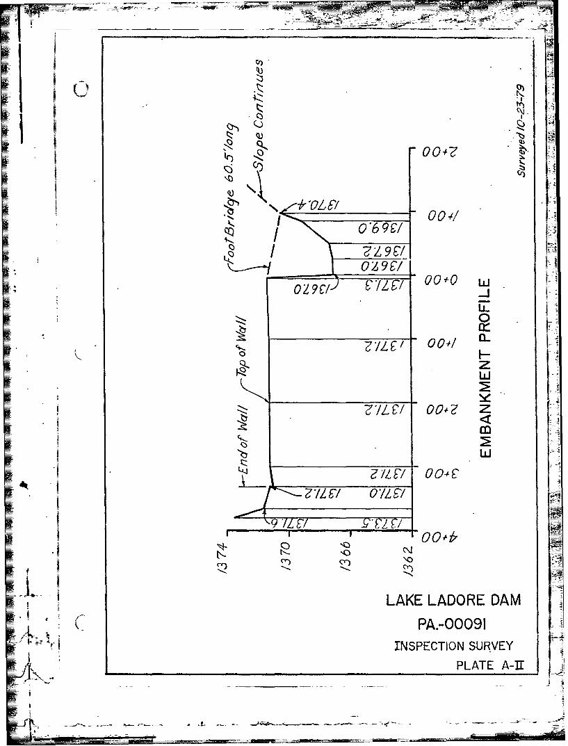
D. ALIGNMENT OF CREST: Horizontal alignment is good. VerticalHORIZONTAL: See Profile Plate A-II, Appendix A.VERTICAL:
E. RIPRAP FAILURES Large rocks & boulders along upstream face ofdam embankment. Covered with weed and brushgrowth.
F. JUNCT'ON EMBANKMENT Left side abutment is with natural ground.& ABUTMENT OR Right side abuts with concrete spillway andSPILLWAY channel walls.
G. SEEPAGE Pipes extending through the downstream face of
AI,' wall are discharging water. Blow-off pipe isdischarging also. Some seepage beneath wallSee sketch, Plate A-I.
H. DRAINS Several 2" dia. pipes exiend through the
downstream concrete wall..-Ia
J. GAGES & RECORDER Noe
K. COVER (GROWTH) Top surface is closely cropped grass.E. Upstream riprap to flow line.
Downstream concrete wall with buttresses.
A-2
r2 M
NDI NO. PA-O0 091
VISUAL INSPECTIONOUTLET WORKS
OBSERVATIONS AND REMiARKSI A INAK STUCTREConcrete wetwell with gate valve.
B. OUTLET STRUCTURE Control for blow off is located on the down-
stream side of the upstream wall of the concretcell. Valve is always slightly open. It isoperated about one time each year.
C. OUTLET CHANNEL 20-inch valve on an 18-inch pipe.
D. GATES In wetwell and downstream.
E. EMERGENCY GATE Same.
4
F. OPERATION &CONTROL Gate opened about once a year.
G. BRIDGE (ACESS)None.
NA-3
NDI NO. PA-O0 091
VISUAL INSPECTIONS SPILLWAY
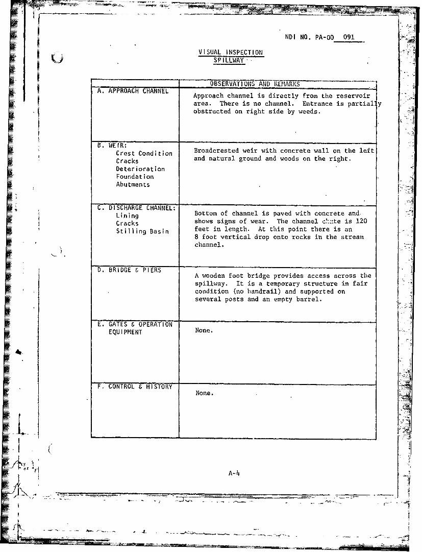
__OBSERVATIONS AND REMARKSA. APPROACH CHANNEL chane iyr
area. There is no channel. Entrance is partiallyobstructed on right side by weeds.
B. WEIR:Crest Condition Broadcrested weir with concrete wall on the leftCracks and natural ground and woods on the right.
Deter iorat ionFoundationAbutments
C. DISCHARGE CHANNEL:Lining Bottom of channel is paved with concrete and,
Cracks shows signs of wear. The channel c!*:Lte is 120
Stilling Basin feet in length. At this point there is an8 foot vertical drop onto rocks in the streamchannel.
D. BRIDGE & PIERSA wooden foot bridge provides access across thespillway. It is a temporary structure in faircondition (no handrail) and supported onseveral posts and an empty barrel. 4
E. GATES & OPERATIONEQUIPMENT None.
1F. CONTROL & HISTORY .None.
A-4
= it
VISUAL INSPECTION
NDI NO. PA-00 091
VISUAL INSPECTION
OBSERVATIONS AND REMARKS
I NSTRUMENTAT I ON
Monumentation None.
Observation Wells None.
Weirs None.
Piezometers None.
Staff Gauge None.
Other None.
RESERVOIR The reservoir is surrounded with woodlands. TheSlopesslopes are moderate - 8% to 10% toward lakeSlopes area and stable.
Sedimentation None reported.
Watershed Woodlands and forests - minimum developed lands.Description
DOWNSTREAM CHANNEL Wooded in the overbank areas - rock bottom inP the channel. Another reservoir downstream.
S4 iCondition
Slopes Wooded moderate 8' - 100.
Approximate 20 plus campers.Population
No. Homes Keen Lake camp ground and then 6 homes in floodplain.
- i -.- A-5 F- - --- . 4 - . i- - -{
qJz
cf)j
LAELAOE A
/ '.-00091
INPETIN URE1 ~PLAT -A 4
- -_= _ . -' - _ - - -- Z -
__ -
001V
, ". I 0'6 9 Cl
0~~~ ZZ 9 /-/10~0
o 1
-- ~ m e/ 00,4/, 4,o P--
0 0
F zV
E/L'/ 000 z
|m
I t4
PLAKE LADORE DAM
, :_-" -iINSPECTION SURVEY jkI ,. PLATE A-lI
- - - - - - - - - - --- -
00
f I
Z4.-
Q)(I
cz) Q
Qoo
LAE ADREDAPA.-0009
-ISPCTONSUVEPLAT A-M
-Ir
0
IiL
<z
F9 e,/II _____
LAK _ _ _ _ _ _ _ _ _M
-009
LAKELATE DAMI
4 PA.000A
r7 I
I APPENDIX B
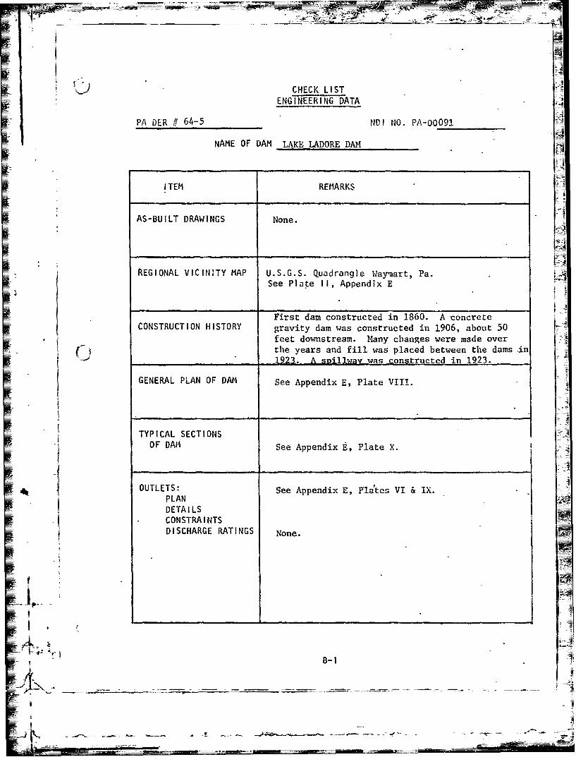
CHECK LISTENGINEERING DATA
PA DER if64- ND I NO. PA -
NAME OF DAM LAKE LADORE DAM4
ITEM REMARKSIAS-BUILT DRAWINGS None.
REGIONAL VICINITY MAP U.S.G.S. Quadrangle Way'uart, Pa.
See Plate 11, AppendixE
First dam constructed in 1860. A -concreteCONSTRUCTION HISTORY gravity dam was constructed in 1906, about 50
feet downstream. Many changes were made overthe years and fill was placed between the dams in1923. A suiliwaX w~as-constructed in 1923.
GENERAL PLAN OF DAM See Appendix E, Plate VIII.
TYPICAL SECTIONSOF DAM See Appendix EPlate X.
OUTLETS:See Appendix E, Plaltes VI & IX.PLANDETAILSCONSTRAINTSDISCHARGE RATINGS None.
B-
- t == = -: T =
- -_ - - =
NDI NO. PA-00091
ENGINEERING DATA
ITEM REMARKS
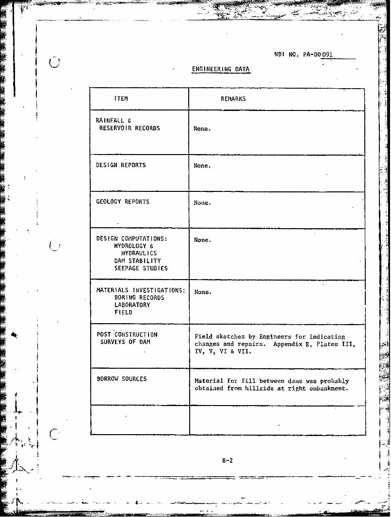
RAINFALL &RESERVOIR RECORDS None.
DESIGN REPORTS None.
GEOLOGY REPORTS None.
DESIGN COMPUTATIONS: None.HYDROLOGY &
HYDRAULICS
DAM STABILITYSEEPAGE STUDIES
MATERIALS INVESTIGATIONS: None.BORING RECORDSLABORATORYFIELD
4 POST CONSTRUCTION Field sketches by Engineers for indicatingSURVEYS OF DAM changes and repairs. Appendix E, Plates III,
IV, V, VI & VII.
BORROW SOURCES Material for fill between dams was probably
obtaiaed from hillside at right embankment.
i -
- -- =
NDI NO- PA-00 091
ENGINEERING DATA[
ITEM REMARKS
MONITORING SYSTEMS None.
1906 - Downstream dam.MODIFICATIONS 1912 - Buttresses added to downstream dam.
1922-- Valve pit and fill between dams. Spill-way added. Stone wall raised.
i938 -Stone wall raised. Downstream dam gunited1973 -Spillway repaired, valve pit changed. wall
capped.HIGH POOL RECORDS
No records.
POST CONSTRUCTION Many inspection reports and reports uponENGINEERING STUDIES application for repairs by PennDER.&REPORTS
PRIOR ACCIDENTS OR No failures reported.FAILURE OF DAM
Description:
Reports:
___________________________
MAINTENANCE & No records by owner.OPERATION RECORDS
SPILLWAY PLAN, SECTIONS See Appendix E, Plates VI &VIII.AND DETAILS
I B-3
-NDI NO. PA-00 091
ENGINEERING DATA
I TEll REMARKS
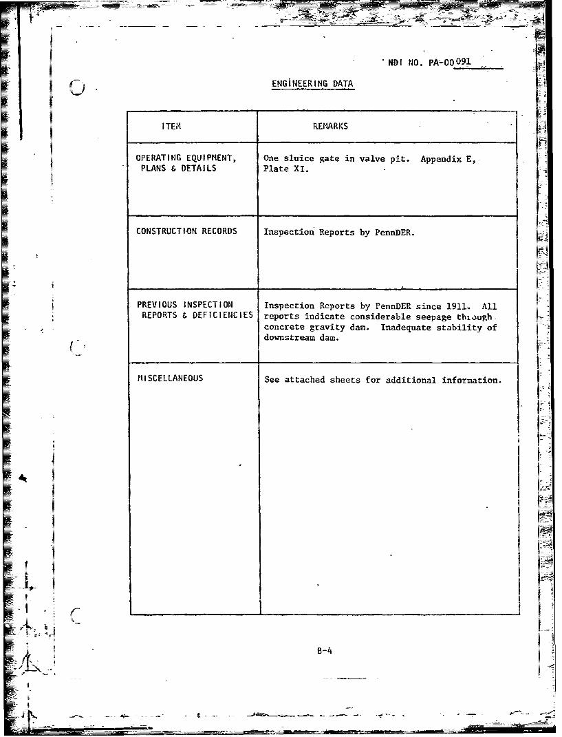
OPERATING EQUIPMENT, One sluice gate in valve pit. Appendix E, -- PLANS &DETAILS Plate XI. 1
-7CONSTRUCT ION RECORDS Inspection Reports by PennDER.
PREVIOUS INSPECTION Inspection Reports by PennDER since 1911. All
REPORTS £DEFICIENCIES reports indicate considerable seepage thiough-
MISCELLANEOUS See attached sheets for additional information.I
8-4ITI
I~ V-,
- ~ ~ ~ -- - -b _ _
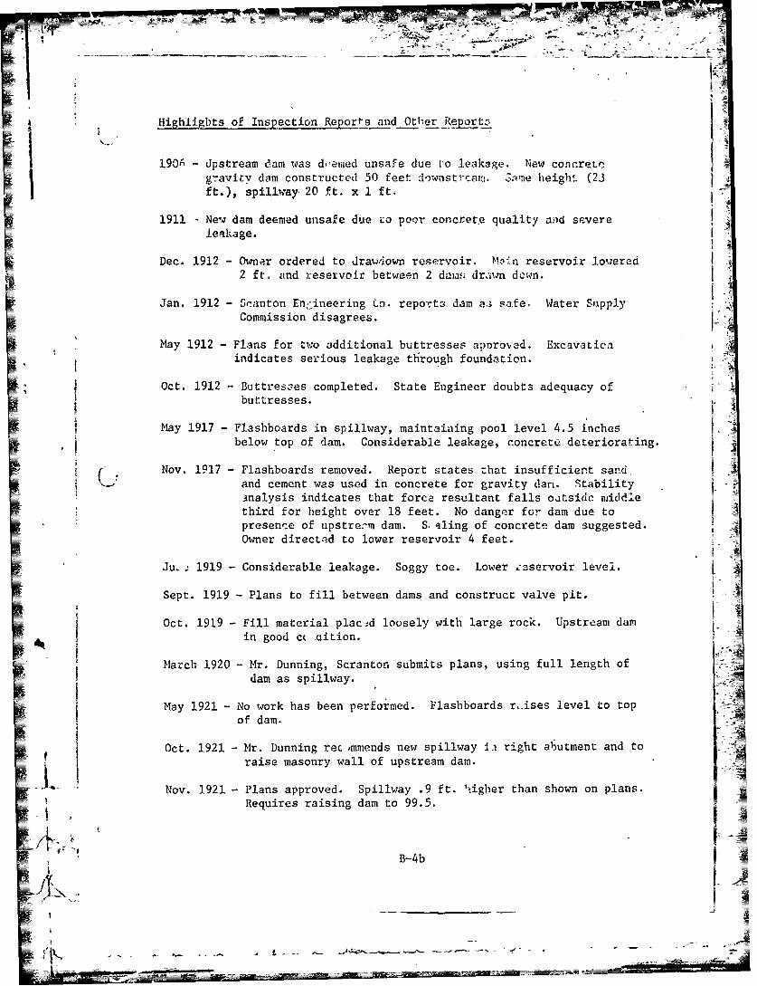
- AHighligbts of Inspection Reports and 0tlier iept
190A - tOpstream dam was d"orned unsaFe due to leakage. New conrfu',gravity dam constructed 50 feet bwsra. a eigh. (23
j ft.), spillway 20 ft. x 1 ft.
1911 - New dam deemed unsafe due to poor concrere quality and severeleakage.
Dec. 1912 - Ownar ordered to drawdown reservoir. Mz-2r reservoir lowered, ff-2 ft. end reservoir between 2 dnas dravn dozwn.
Jan. 1912 - Scanton Eni-ineering 0,. repo-rtc dam a,; safe. Water SlapplyCommission disagrees. I
May 1912 -Plans for 'Iwo additional buttresses aporoved. Excav3LicIindicates serLious leakage through foundation.
Oct. 1912 -Buttresses completed. State Engineer doubts adequacy ofbuttresses.
May 1917 -Flashboards in spillway, maintaining pool level 4.5 inchesbelow top of dam. Considerable leakage, concrete deteriorating.
UNov. 1917 -Flashboards removed. Report states chat insufficient sand.and cement was used in concrete for gravity dari. Stabilityinalysis indicates that force resultant falls outside m~iddl-ethird for height over 18 feet. No danger for dam due topresen2e of upstrerm dam. S ~aling of concrete dam suggested.Owner direCUid to lower reservoir 4 feet.
Ju. ., 1919 -Considerable leakage. Soggy toe. Lower czservoir level.
Sept. 1919 -Plans to fill between dams and construct valve pit.
Oct. 1919 -Fill material plac:ed loosely with large rock. Upstream damnin good cc .ition.
March 1920 - Mr. Dunning, Scranton submits plans, using full length ofdam as spillway.
May 1921 -No work has been performed. Plashboards r-ises level to topIof dam.
* 1Oct. 1921 -Mr. Dunning rec .mmends new spillway LA~ right abutment and toraise masonry wall of upstream dam.
Nov. 1921 -Plans approved. Spillway .9 ft. '-igher than shown on plans.
Requires raising dam to 99.5.
B-4b
tC -=--
LA -T
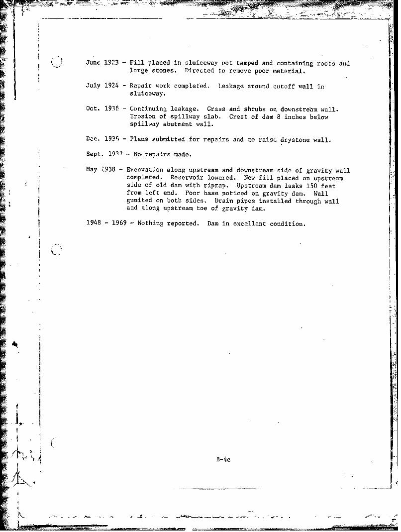
June 1923 - Fill placed in sluiceway Pot tamped and containing roots andlarge stones. Directed to remove poor material,
July 1924 - Repair work complet'ed. Leakage around cutoff wall insluiceway.
Oct. 1936 - Continuing leakage. Grass and shrubs on downstream wall.Erosion of spillway slab. Crest of dam 8 inches belowspillway abutment wall.
Dee. 1936 - Plans submitted for repairs and to raise drystone wall.
Sept. 1917 - No repairs made.
May .938 -Excavation along upstream and downstream side of gravity wallcompleted. Reservoir loweied. New fill placed on upstream
side of old dam with riprap. Upstream dam leaks 150 feetfrom left end. Poor base noticed on gravity dam. Wallgunited on both sides. Drain pipes installed through walland along upstream toe of gravity dam.
1948 - 1969 - Nothing reported. Dam in excellent condition.
f B-4c
~1
k- - - = --
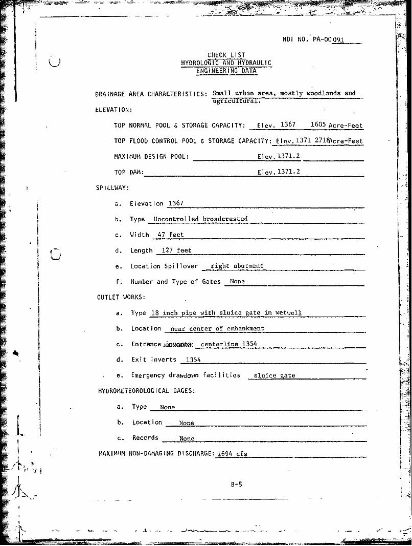
NDI NO. PA-O0091
CHECK LISTHYDROLOGIC AND HYDRAULIC
ENGINEERING DATA
DRAINAGE AREA CHARACTERISTICS: Small urban area, mostly woodlands and
agricultural.
LLEVATION:
TOP NORMAL POOL & STORAGE CAPACITY: Elev. 1367 1605 Acre-Feet
TOP FLOOD CONTROL POOL & STORAGE CAPACITY: Elev. 1371 2718cre-Feet
MAXIMUM DESIGN POOL: Elev. 1371.2
TOP DAM: Elev. 1371.2
SPILLWAY:
Elevation 1367
b. Type Uncontrolled broadcrested
c. Width 47 feet
-d. Length 127 feet
e. Location Spillover right abutment
f. Number and Type of Gates None
OUTLET WORKS:
a. Type 18 inch pipe with sluice gate in wetwell
b. Location near center of embankment
c. Entrance A & centerline 1354
d. Exit inverts 1354
e. Emergency drawdown facilities sluice gate
HYDROMETEOROLOGICAL GAGES:
Sa. Type None
1 b. Location None
c. Records None
MAXIM$IM NON-DAMAGING DISCHARGE: 1694 cfs
B-5
-i- _i i
C_ APPENDIX C
P1 OTOGRAPHS
- I
7.
4134
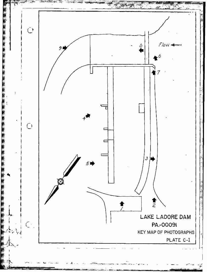
LAKE LADORE DAMPA.-00091 I
KEY MAP OF PHOTOGRAPHS
PLATE C-1
UPSTREAM SLOPE -NO. 2
iRESERVOIR AREA - NO. 3
PA-00091I~5 Plate C-II
I d
PIPE OUTLET WITH WOOD BLOCKING -NO. 4
- E
A DOWNSTREAM ACTIVE WEEPHOLE -NO. 5
PA-00091Plate C-Ill
SPILLWJAY FOREBAy NO. 6
IOTRIG OVRSILAIOPA-0009Plate C-I
- I-
LOOKNG OWNSREA IN PILWAY O.
LOOKNG PSTRAM O 8-OOTDRO
IN SILLAY DSCHRGECHANEL O.
PA-0009
if I
- -~---~--~ -~
II
I
IC
C APPENDIX D
HYDROLOGY AND HYDRAULIC CALCULATIONS
-4
I
LI
I -I APPENDIX DC
1K
_itI -- _______
-~ ____________

SUM1MARY DESCRIPTIONOF
FLOOD HYDROGPPII PACFPCGE (IIEC-I)DAM SAFETY VERSION
The hydrologic and hydraulic evaluation for this inspection reporthas employed computer techniques using the Corps of Engineers computerprogram identified as the Flood Hydrograph Package (HEC-I) Dam SafetyVersion.
The program has been designed to enable the user to perform twobasic types of hydrologic analyses: (1) the evaluation of the over-topping potential of the dam, and (2) the capability to estimate thedownstream hydrologic-hydraulic consequences resulting from assumedstructural failures of the dam. A brief summary of the computationprocedures typically used in the dam overtopping analysis is shown
below.
Development of an inflow hydrograph to the reservoir.
Routing of the inflow hydrograph(s) through the reservoirto determine if the event(s) analyzed would overtop thedam.
- Routing of the outflow hydrograph(s) of the reservoir to
desired downstream locations. The results provide the
peak discharge and maximum stage of each routed hydrograph
at the outlet of the reach.
The output data provided by this program permits the comparison ofdownstream conditions just prior to a breach failure with that after abreach failure and the determination as to whether or not there is asignificant increase in the hazard to loss of life as a result of such a
failure.
The results of the studies conducted for this report are presented
in Section 5.
For detailed information regarding this program refer to the UsersManual for the Flood Hydrograph Package (HEC-l) Dam Safety Version
prepared by the Hydrologic Engineering Center, U.S. Army Corps of
Engineers, Davis, California.
Z.JKM
~yIL-----.DATEI/Z? RERGER ASSOCIATES SHEET NO.~ O
~U~JE~-----DAT LAKE Ln/'(___-PROJECT L1 q
SPILL WAr PrA6
5PILLWAY C/AE57 .0X
71 ^4 A
,~~~-i7Ws~ INLC~ A5
%I
2. 4'4 .
+2 r j-
ay~ ~A~oTEL~LV~zBERGER ASSOCIATES SHEET NCHKD. 1Y - -- DATE-----CT '
SUBJECT ~ ~ ~ - - - - - - - - - --- -- - - -- - -- - - -- - -- - - -- --------- - ------
1371
M~ A Xg1 M____fL____0A_)4A- L-POP :
ivI s I6 DrO
LI 4 2.1
_____ __ _ _ _
BY---ATE/./-9 BERGER ASSOCIATES SHEET NO._ . OF-i .. ..... CHKO.. BY .. ---- ATE--- ..................... . ~ J:.Z /: .. ISUBJECT - --I-- -- --------- L 0Ifx------------------------------------- C -SU Df5ECT H - LAKE - c i L f"
I0
L/~ 1 L CNV~ j r- ~ ~ t or '9 4 ,I / e ' L V 3 3
! / APP1-oy ¢, / uP;;,# A Cg,,'/,Z L,,tvc ,CL(V. / !3
g ____ :0.6V,~ LIf 3 5
T 14' -21,It Pool - ES'| - v
I/' 135 - 3.2_4.
- C a
7-
-, ~ 1-" /*-/
8Y....AE/2?9BERGER ASSOCIATES SHE N..L CHKD. BY ---- DATE------------------ _pltJECYI q -SUBJECT --------------------- ----------------
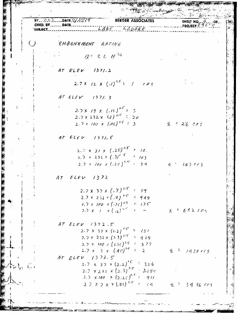
Fm941v(i?~v R 4 //1V 4
4T71- El 137(1)-
47ELCV /37/
2;,' I o x
2 ' X0 2. 3 o(.
311, Z32. (.) , /0,=
2.~I 3';*. .
2.7 r"~ (2)3~ 4
B]
2,?X 3 X 7--
7 5-
47 E tc- 32
.2. ' 1 y< (e) j .
A?-t ELCV ,3 3, j
- ,-7 ' -y-- .' 4- , . t. . "- -13!
B_- .DATEAOzq BERGER ASSOCIATES SIUT NO._ _ 0F.
CHKD. BY -- DATE - --------------- ------ ----- 7--.... PROJECT- '_-O
SUBJECT -------------------- -_ -- - ----------------- -- --
P1%:,,*~~/?A TINV 6-Cu've
' " ii I , .I
I I____ I ----.--- i- .*.-
Si I I.I .. . . .I .
' I I I
- , I !-
q - --- I 0
-__ _____iij i ii- I I-. I
I III " :-- - - - - - - - - - - - - - - - -- -
I .I -
- ,NJ -- * ,. . ..- c., -_j, -".
.x ,
_____________ -M-8
BY- .DATE // . , BERGER ASSOCIATES SHEET NO.-6--. .OF- L!CHKD. BY ---- DATE----------.. . - - - - - - - - - - .PROJEC TA7( ' . 7.SUBJECT.--------------------- A lf 1--------- ------------
CIz CLA55lF Ic /IT/0Al
*AA 4X I M 7sr? A G, IF/ r7/ 17
Ai.4X AivI~'~.uVil ii9HIc l I V.~i.~
1ZARD CALA5S IPI C/4T/O
5 E 11RAL HO3V565 ANDV K(CCI Pe0AIVO p/j--loeWvTHE- ABO4lM V E- il-4-'I r1C r10T =/ b' C.4, C
- t
e7A A_.A LA1 S 0FIC.. cQ./tT4 70OFyVif
PA 19B LF M 4 A"(I FLOOD.
IT-~I
I,I
-c
-1.----I' -------- -- !. ~
BYA L (Ws DATEI/_& Z BERGER ASSOCIATES SHEET NO_. -OF-
Ct4KD.B - DATE----------- ----------- 1) -0RJC 1?( '--- --J-- - -- --- -- - ---- - --- --- --
i or 1
547% oF PM F LL
_ _ _ _ _ _ _ _ _ -.- _J4
57% O.4M
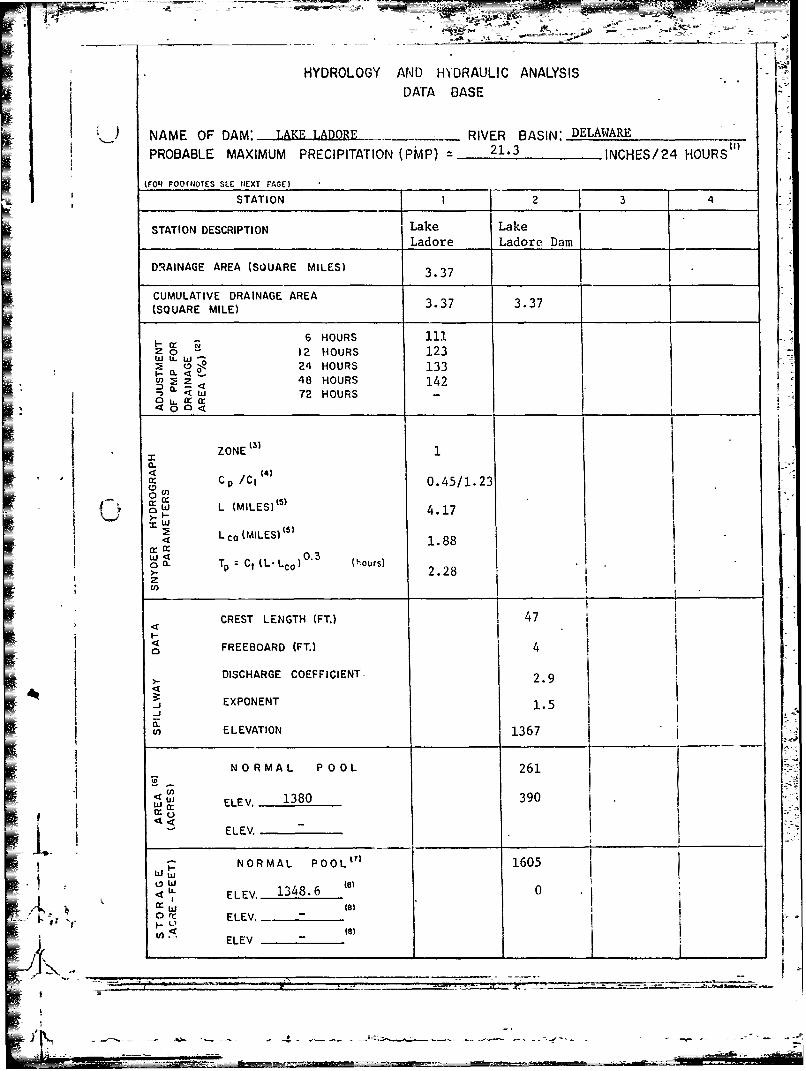
HYDROLOGY AND HYDRAULIC ANALYSISDATA BASE
'-9 NAME OF DAM: LAKE LADORE . RIVER BASIN: DELAWARE
PROBABLE MAXIMUM PRECIPITATION (PMP) 21.3 INCHES/24 HOURS u"
(FOR FOO0OTES SEE NEXT FAGE)
STATION -1STATION DESCRIPTION Lake Lake I
Ladore Ladore Dam_
DRAINAGE AREA (SQUARE MILES) 337
CUMULATIVE DRAINAGE AREA(SQUARE MILE)
-. 6 HOURS11" 0 12 HOURS 123
24 HOURS 133cn z 48 HOURS 142 I
w 72 HOURS -0
LL c a0.
ZONE (3)
-(4)• ,,"Cp /Ct 0.45/1.23
IS- w L (MILES) 1 4.17
L co (MILES) s 1i <1. 88
-0L Tp C, (LLco) (hours)• ->-2.28z
CREST LENGTH (FT.) 47
DIFREEBOARD (FT.) 4
i >-DISCHARGE COEFFICIENT- 2.9
EXPONENT 1.5-J
u) ELEVATION 1367 , _
NORMAL POOL 261w u ELE V. 1380 390
m
ELEV.
FNORMAL POOL tTI 1605
ELEV. 1348.6 0
0 ro ELEV. -
ELEV -
-- , . ."..-J -
.. .- .........
M~tigineeer 1956. Report33- (11 ig i jro 1), U.S. Army, Corps of
I ~ )Hydrometeorological Report 33L (Figure 2), U.S. Army, Corps ofEngineers, 1956.
(3) Hydrological zone defined by Corps of Engineers,.lBaltimore District,for determining Snyder's Coefficients (C and CO).
(4)
~~Snyder' s Coefficients.
L= Length of longest water course from outlet to husin divide.L ca = Length of water course from outlet to point opposite the
centroid of drainage area.
- ~( 6)Planimetered area ancompased by contour upstream of dam.
I ~ ~~PennDER files.
(8)Computed by conic method.
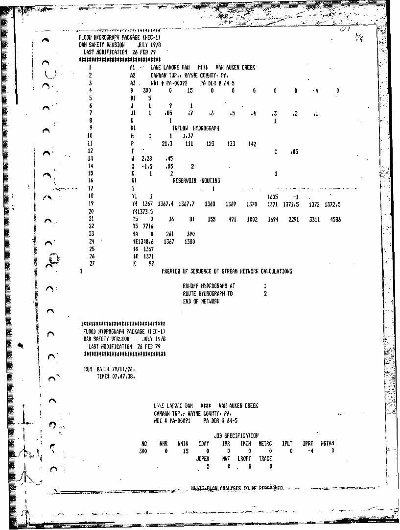
FLOOD HYDROGRAPH PACKAGE fHEC-1)DAN SAFETY VERSION JULY 1978
LAST MODIFICATION 26 FEB 79
I Al LANE LADORE PAN 014 VAN AUKEN CREEK2 A2 CANAAN TUP,, RAYNE COUHTY, PAs3 A3 NDI # PA-.00091 PA DER f 64-54 B 300 0 15 0 0 0 0 0 -4 05 BI 5
6 J 1 9 17 Ji 1 185 7 .6 .5 64 .3 .2 ,18 K I I9 KI INFLOW HYDROGRAPH10 H 1 1 3,3711 P 21.3 111 123 133 14212 T # .0513 W 2.28 ,4514 X -1.5 ,05 215 K 1 2 116 KI RESERVOIR -ROUTING17 Y "18 YI 1 1605 -119 Y4 1367 1367,4 1367,7 1368 1369 1370 1371 1371.5 1372 1372,520 Y41373.521 Y5 0 36 81 155 491 1002 1694 2291 3311 458622 Y5 771623 $A 0 261 39024 $E1348,6 1367 138025 1$ 136726 SD 137127 K 99
PREVIEW OF SEGUENCE OF STREAM NETWORK CALCULATIONS
RUNOFF HYDROGRAPH AT IROUTE HYDROGRAPH TOEND OF NETWORK
FLOOD HYDROGRAPH P4CKAGE (IlEC-I)DAN SAFETY VERSION - JULY 1978
- ~LAST MODIFICATION 26FEDB79
RUN DAIEt 79/11/26,r"%~ TIME$ 07,47,38.
.L.A\E LAPNRE DAN rU0 VAN AUKEN CREEKCANAAN TUP.y WAYNE COUNlYr PA.NDI f PA-00071 PA DER 1 64-5
JOB SPECIFICATIONNO NHR IIN IDAY IRR ININ hETRC IPLT IPRT NSTAN
300 0 15 0 0 0 0 0 -4 0JOPER NWT LROPT TRACE
5 0 ~ 0 0
i -"

Jut 9ECIIICOTlO""NO NHR NiMIN IIDAY I!1R 1111H 14TRC IPLT IPRT lISTAII
300 0 15 0 0 0 0 0 -4 0.IOFER NV I LROFT TRACE
- 1 J 5 0 (' 9
HIILTI-PL611 ANALYSES TO IE FEI; RII IDFWIq= I .RIIU= 9 LRTIO: I
RTIOS= 1,00 ,85 .70 .60 .50 .40 .30 .20 .10
#0100te 1*0t.tit littittt 111ttiit U041t~ti
SU-AREA RUIIOFF COMPUTATION
I1FLOJU HYIIROGRAPll
ISIAO ICOMP IECON IIAPE JPLT JPRT IHMEt ISTAGE IAUTO1 0 0 0 0 0 1 0 0
IJYPROGRAPI; D.I'lJIIYPG IU!!G TAREA SNAP TRSDA TRSPC RAJ 10 ISNOV ISAME LOCAL
1 1 3.37 0.00 3.37 0.00 0.000 0 0 0
FLECIP PAIA
SFFE PhS R6 R12 R24 R43 R72 R?6
0,00 21,30 111.00 123,00 133,00 142.00 0.00 0,00TRSPC COMPUTED PY TlE FROGRA1 IS .800
LOSS lATLROPT SWitR PLTR RTIOL ERAIN STRIS RTiOK SIRTL CNSTL ALSHX RTiIIP
0 0.00 0.00 bo00 0 .00 00 1.00 .05 0 .00 0.00
~~UNIT A "RgGR:A'PAATP= 2.28 CP-" .45 liT',= 1
RECESSIG1 DA[A
STRTO= -1.50 ORCS(= .05 RTIOR= 2.00
UNIT HYDROGRAPI 81 EID-OF-PERIOD ORPINATESr LAG- 2.30 IIO'JRSI CP= .45 VOL= 1.0014, 52, 1O,. 170, 240. 310. 368. 410. 436, 437,
416. 389- 361. 337, -723, 273. 255. 238. " 1.207- 193. 180. 167. 156. 146. 136, 127, 118. lO.
103, 96, 89. 93, 70. 72. 67, 63. s?, ..- 51. 49. 44. 41. 3. 34, 31. 2?. 27.
,4, 22, 21. 19, 1c, 17, 16. 14. 14.
13, 12, I1, i : 0, 9. 8. 8. 7, 7.6. 6, 5. 5. 5, 4, 4, 4. 44 3.
3.
0 END-OF-fERIOD FLUoiO.PA IIRIN PERIOD RAIN EXCS LOSS COP 0 IIO.DA HR.KN PERIOD RAIN EXCS LOSS LWiP 0
SUN 24.20 21.S1 2.39 1,8763( 615)( 554,)( 61.)( 5745.17 }
N ,I-
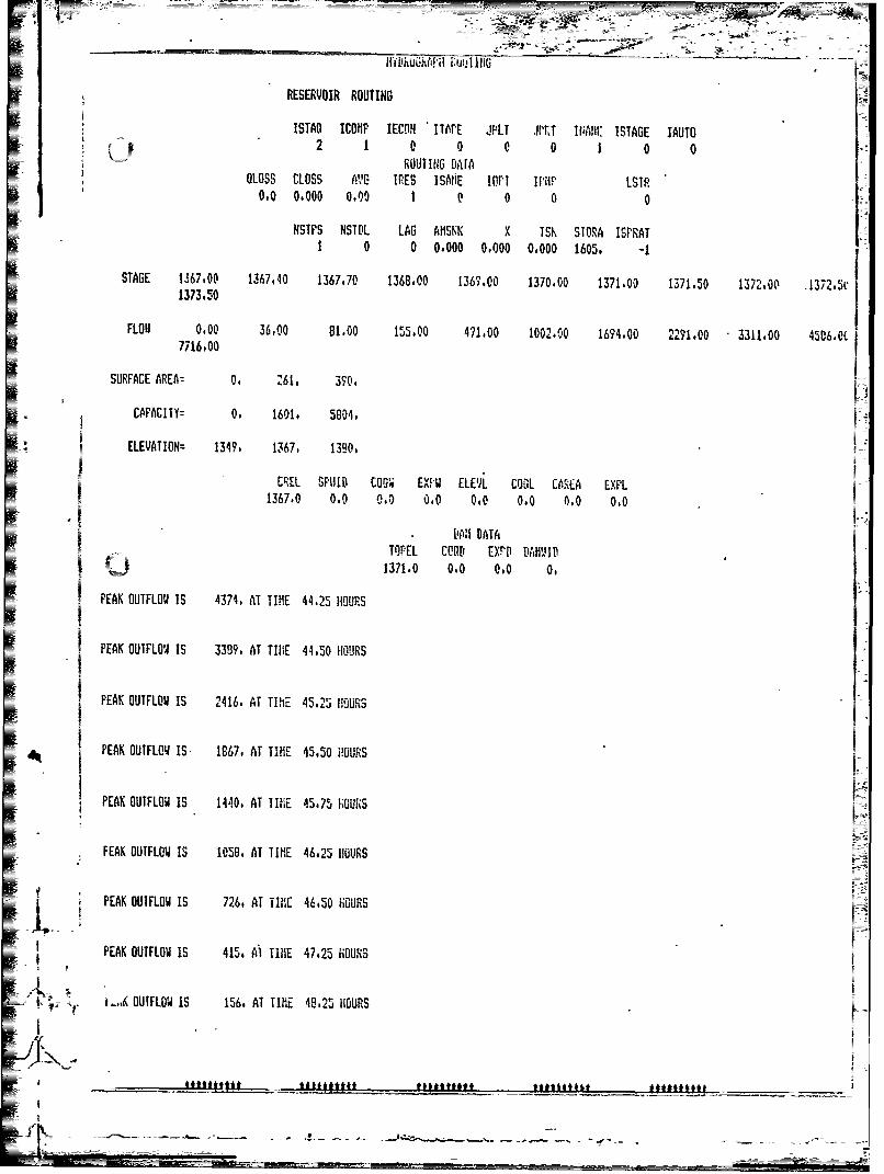
RESERVOIR ROUTINO
ISTAG ICOMP IECON 1IArE JILT 1T I 1HL' ISTAGE AUTO2 1 0 0 0 0 1 0 0
ROUT I1(0 DATAGLOSS CLSS AVG IRES ISAVE IO'I ll'iP LSTF:
0,0 0,000 0,00 1 0 0 ]0
NSTPS NSTDL LAG AtSKK X 1Sk SIDRA ISPRAT1 0 0 0.000 0,000 0000 I605. -1
STAGE 1367,00 1367,40 1367,70 1368.00 1370.00 1371.00 1371.50 1372,00 .1372.5v1373.50
FLOU 0.00 36,00 81.00 155.00 421,00 1002.00 164.00 2291.00 3311.00 450.07716,00
SURFACE AREA= 0. 2.61 30,
CAPACITPY= 0, 1601, 5804.
ELEVATION= 1349, 1367, 130,
CREL SPUID C0O1 EXU ELEVL COOL (AWEA EXPL1367.0 0.0 0.0 0.0 0.0 0.0 0 ,0.0
L, All DATA(
TOPEL COGi EXPD D'IIVIP1371.0 0.0 0.0 0'
PEAK OUTFLOW IS 4374, Al TitlE 44.25 HOURS T
PEAK OUTFLO9 IS 3389 AT TIIIE 44,50 HOURS
PEAK OUTFLOW 15 2416. AT TlhE 45.25 IOURS
4 I PEAK OUTFLOW IS- 1867. AT TItE 45.50 HOURS
PEAK OUTFLOW IS 1440, AT TiME 45.75 HOURS
FEAK OUTFLOW IS 1058, AT TIlME 46.25 HOURS
) PEAK OUIFLDl IS 726, AT TIME 46,50 HOURS
PEAK OUTFLOW IS 415. A) TitlE 47.25 HOURS
r-..,, OUIFLOU IS 156, AT TItlE 4825 HOURS
p ._ _ _ _ _ _ _ _ _ _ _ _ _ _ _ _ _ _ _ _ _
[ _ 2 § i ~ t~lt .9tt l _ ~ ~ l|t _ _l~l~lk - -_ _ _}
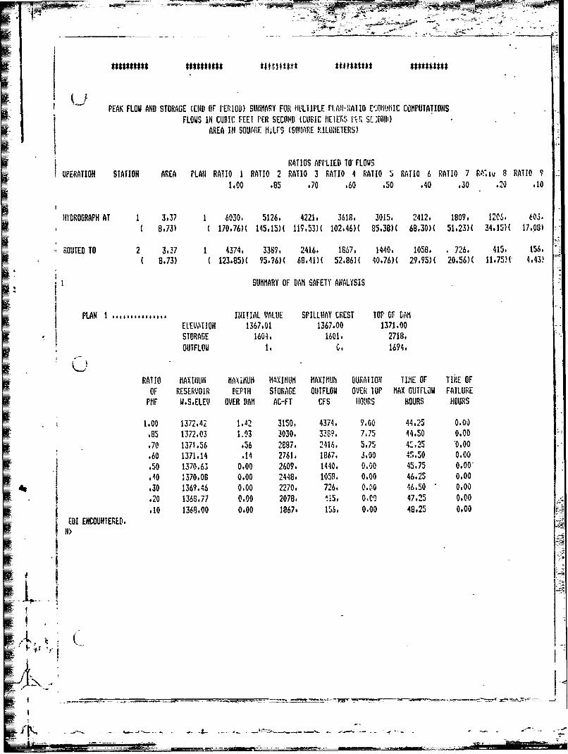
PEAK FLOW AND STORAGE (EOW OF PERIOD) SUHMARY FUR PUL!IPLE FLAt-IRAhIO E.1OllIIC COMPUTATIONSFLOWS IN CUBIC FEET PER SECOND (CUBIC IPiElri Ilr, SIO~l)
- 1AREA IN SOUARE HiLF (SOUARE "ILOHETERS)
RATIOS APPLIED TO'FLOWSOPERATION STATION AREA PLAN RATIO 1 RATIO 2 RATIO 3 RATIO 4 RATIO S RATIO 6 RATIO 7 RA iv 8 RATIO 9
1*00 .85 .70 .60 .50 ,40 .30 .20 .10
HYDROGRAPH AT 1 3.37 1 6030. 5126, 4221. 3618, 3015. 2412. 1809. 1206. 3. I8.73) ( 170.76)( 145,15)( 119,53)( 102.46)( 8543B)( 68.30)( 51.23)( 34.15)( 17.09)
ROUTED TO 2 3,37 1 4374, 3387. 2416. 1867, 1440, 1058. . 726. 415. 15s.8.73) C 123.85)( 95.?6)( 6B.41)( 52,86)( 40.76)( 29,95)( 20,56)( 11.75)( 4.43'
- SUMMARY OF DAM SAFETY ANALYSIS
PLAN I ........ o..... INITIAL VALUE SPILLVAY CREST TOP OF DANELEVATION 1367.01 1367.00 1371.00STORAGE 1604, 1601. 2718.OUTFLOW 1. £, 1694.
RATIO MAXIIIUH MAXiMUH MAXIHUM MAXIgUh DURATION TIME OF TIflE OFOF RESERVOIR DEPTH STORAGE OUTFLOW OVER TOP MAX OUTFLOW FAILURE
PMW W.S.ELEV OVER DAM AC-FT CFS HOURS HOURS HOURS
1.00 1372.42 1,42 3150, 4374. 9.00 44,25 0.00.85 1372,03 1.03 3030, 3389, 7,75 44.50 0.00.70 1371.56 .56 2897. 2416, 5.75 4:,25 0,00.60 1371,14 .14 2761, 1867. 3,00 45.50 0.00.50 1370.63 0.00 2609, 1440, 0,00 45.75 0.00.40 :370,08 0,00 2448. 1050. 0.00 46.25 0,00
4 .30 1369.46 0.00 2270, 726, 0.!0 46.50 0.00.20 1368.77 0.00 2078. 1i. 0.00 47.25 0.00
.10 1369.00 0,00 1867- 156, 0.00 48,25 0,001 EDI ENCOUNTERED.
-I: =-_: -.. -= - .---- ---- -- __ , . . . . . .. . -- _ , --- -'.- __ . - =
7= - - - -777-
I APPENDIX E
- C'.', nm
~vaa
44 /22(R,'
jiIi
s.*i~ 1Gti24c&-.--
-,e.' VAN~ ~e2/
SITE Mh 9
4s~e' 'W.-
r.." : WA imso PLATEc.4BJh~KA TON,.PA009
_ _ _
Go Cubon _____ ___
II
0_
I 17 ' LAKKLADOREODASCALE I"2,OO
RAIAG PAAREAPAT3. N i
Pon p t
PIE-
-M
-fili
-~~~~~1 -------~-~C
-77-
.rh y
C.5N
II
44e
-. , 1
2> ; ~ Ar, I
'i
- " " - - 1!
/i
Cf 0 t PAfr00 9
-.- -- _--
-4 -T-4
J- t l-
=] . -- : - -- . =---.-- .. ...
A -
o - = - .. .
-L -v--
- -t' " -- -.
IVI
Ito
- Et- - -- o-_- -
-=3..• -. " : -:
-JJ
V ~- - - I - - - - - ~ =_----- /
Aff
- ...
-e 4 I-I- I
"I / ~ SI
A
- - r. ___
rC 1
- ~v L-t i'r~~r '
I f~, ~-'~
it
it?
4'
A-'0'
434
-V ''
I ~'
it '4
I
it-' I 4j, r I r
-t -w ~,e 7..'.*t ~4 ,,,
if 'II
/I
I IA' I
A
-~ 9r-'-.- ~ - '-I - PA-0009i...-. 3 PLATEfl
I A-'- -
- ' - - ~ - - - . - -- - - - A w
Tr'
-9 t d5?
-- 4-- -z
a'4 J 4n9
---- z v----- --4fY.~#~"~t =~rr~*r~7&74"-9
=fl ~ ~ ~ ~ ~ ~ ~ 45 94.4 -. -
_________- 44 "'-n4Z=~= f~ 44 9 4 4u
'7 4rr
4'-7i~~Fk2~~j-77;i IAL 2 14 24 L92%
L7= ~ Z,~=- PCr. - c s- ?" -
'. -- c4.f ~ ~ . 9 4 4 - -~~~ -;, . - & - 9 4
J44& Wt
*4'
ZIA4-44.=.= --- r . ~ ~.4 --
4-9I~~~4~'7 7I4- ~ ,,= - -
I Z-qv - - -
-,~Q -z,--
-~xt -- jp .----.. -tI --
-t A&.ol.- Tsrc
t' d7-I7A.
I -~r
1; r, wx OZ
-47- -t
Ole~ -'a-i-
v Ak
7F
tIAt
T'' V
- -' -- Sn -
4j
tils
AIa -- "Y-
ft~
~~Mr
g -~-=- PF 4~
-- ~ - = ~-Mv
I~ p '= - V .--
Z ~~ ~ ~ - -5-- _ W =
4-- 1-q
ME= - =.-c = ~~--;
~ ~ -W 6.
-kg.
- al
SW ml= __t
~gw
~~ -
7 ~7 TFC
*IC=~ -4 - - .
~ ~Of
Lzf-35I _________
.M ~ -~-~=-- ~Rip==
g- WWI -
__ -mmi PT
aft.
-av
J ~ r
9D - -A t --_ --- 4
ORO--
tnAtrF
Al
J.--.
Ar
I- * -fI-
- 7., 7
- I I u. , si
-- i5-
M_ F217~ - >r' -<
W4-
jil 5tuAi At.k RI j
A _ _ _ _ _ _ _ _ _ _ _ _ _ _ _ _ _ __4
4_ _ _
N'Q -- '.Zz r -§F
7iX ~ ~ ~ ~ -.... ...
---
F CA .~ .- ....
-- p-
A~ ~ -7 -.- r i N _ -~t
-~ ~ ~ ~ ~ z -~ 72-4 ~ ~ ~ __
" --7
PA-00Q0S__ PVLATE
-4V
J p -F !i
-- -- - - - - - - -
- A
44~O,,~l- /IO
= ~~ -7 71 r~rM= E
IVevv DamnN
II 4 a--'.
-- A-- 5
-- 4 - -- -- --- --- - -- - - i-. 4!_4
W -~ 4- ---
I -a a'- - s, tX
- Ix
-,;Z Alf--
~~F-
N -
" -- ''a M_____A-~~~~~0 ls* A* '" 4t:-~---
A4
4 r -. xx
>4 - 4-I -
* ~ __ -
_______ -~=-
- eat.
4-I ,- A..dfl
I -
-~ r>"-' {~h "t~
Iflee '~ o',d ~- War. ~ ~
____ __
- - n-c- .p.t.... - - cA-CI
A
C.,'C.T,.II zet. Aeoo.~o bbe co,4,atn \ ______________________________________________________
'ii* I
I :9 _____________
I.
- I= 4 I - -
9' I I . I
I Co-t--rc e,.r I.I ctr n-ct
I Ij
I I *1Ii
I IiI I i I
L I'
H____________'I
I I II I II
-9 lb I -Al -i.r -
N
II-
- -I* A
.~' '.~~ I I
9 _ - - ----- A---
K-= - * ~ - -
A__ - - __
-~ ____ - ~ - - _____
x
jt*~ ~ a-.- ~ ~ -
- ~ g - - - -
I -
I -
I -
j I - -.
'I
t~Ar/oA'cC~r~ C,4A'
-. 4
A
S flCA'~fr
I-'
- r Ar=~.----- 4
T~i ~ - C) - _________________________________________________________
~
I-FwIF.
I--* Co,~ntOcm
'I;
I
<AJV I ~~~.'-----r /CC
4 *1~=
-fl-c'U
9NiK - -~ = -
SIC
i2 PLATL VI
Alt
II
W5
/XrKQEL4XQiL
RI-AAI VIE
I.Arrc
'9' ' ',',, bt#L Opt-
i'9A '54, /24 4'PVRi
................
T 4 4 4
~t'fCkzOk 7,;L
fortS 4M'C rOr.*fl I wj4 ,gtADa; tAf4bL "*/.v fl 'AAC
4t A lrr
- r~~ ~A A""- flC40 C S t 11siA'Mtc4All t~ f~?4CL~ l*f
.*-..C tae~n AE As Pt K
'roi' a, jttn iS 4 *4'& f.ltAW- tA 4t&wflrt4X
* c~~iacrt inn. (44&'4f~-k l t4 SL4 "lt4s&~
'4'.~~~~~LI Ab a C i ~ 444 Wt~ a.w'tc~f$i
. -. ~fl~~'4 c.YVA.W f ttttttt4#t 4
rVe'C AL-
T%7
I 'Wee ifTPffIk-W0f4'-Aft.~PAT IXit/Jtfk
- -. - , i * •= - #' - -
- 3 . . . .- i - ' -- ; : - 1.--
-. - -. _;N -•
4 / fl
--t"t--* SiL 4L_
- , . .).t . . , ;,. ,i-
% "i 1-I _|',
-_ . . flT .. ~ , ,'..A.<
"- - L . :1_
I __ :_ = = _ _ _ __- .. . . _-
- -ag
-45
==TV
-4V-
41'-
2t"r----.- -
7 -4-
-- AF
S"J rea $rr ic
i
-L.~~~~ -LM-ID --- aA~L- r~CtrrfS.
AC'
'971
' sr' A seu_ _ _ _Vv
4' 4 WA. J ~fvi', j
44
4o
tii
- B - I'.-
'"-c
14t'i
=.--/ L. ,' =. ' ' --
__"'-- ' - . ... ..... -
-~~~~~ ~~ .. N. . ., -. - z .. ^ .a _.- -
: , .- -... . _
Ir! 74!
A 7
- a e
117- IPJ_14 0) C l/
I F~ 11__
-tm
~jtijJIM;rrc _4 =- SvfT 4oC
I~~~~~U. /<A_________
1'IT
-Q
irczi
-AW.~k
se-I
Z-. a:-, a
SAPPENDIX FI
SGEOLOGIC REPORTI
'S
ml I
- I-* -€
-i I
MA - - -- ~-
GEOLOGIC REPORT
Bedrock - Dam and Reservoir
Formation Name: Packerton and Poplar Gap Members of the Catskill
Formation.
Lithology: The contact between the Packerton-Poplar Gap Members
and the undifferentiated Catskill Formation is defified by a con-
glomerate layer up to 20 feet thick, composed of quartz pebbles in
a coarse sand matrix; generally gray in color. Beds are two tofour feet thick. It is overlain by gray to graying red sandstone
in beds one to four feet thick. The quartz sand grains are in a
silt and clay matrix. Some thin siltstone interbeds are present.
Structure
The dam site lies within the Pocono Plateau and the beds are
essentially horizontal. There is a small regional dip to the west,toward the Lackawanna Syncline. The N55*E5Ni strike and dip
mentioned in the 1917 inspection report is probably cross bedding.The same report mentions vertical joints. A distinct pattern of
joints in the bedrock, striking about NlO*W on the hill just east
c the dam, can be seen on the air photos. Other fracture traces
trend N2O0 E.
Overburden
This dam is really two dams, the original earth and masonry dam
built in the eighteen hundreds And a concrete gravity dam built in1937 No detailed description, borings, or other foundation
information is availahle for either dam. Although the aro:, iswithin the limits of Pleistocene glaciation, overburden is appar-
ently thin. Outcrops are plainly visible on the air photos,especially on the hill east of the dam. The concrete dam founda-
tion was excavated by blast.ng "at least four feet into tough green
sandstone, more where necesfary to eliminate fissures and voids".
Aquifer Characteristics
The conglomerates and sandstones of the Packerton Member are gener-
ally of low permeability and ground water moves generally along
bedding planes and fractures. The intersection of two sets of
fractures, N10°W and N20*E at the dam site provide a potential zone
of permeability of some magnitude.
.
- '- . -- --
Discussion
There is considerable evidence that there are a number of openvertical joints making a high angle to the dam -axis which allowleakage under the dam. Somre of these joints are visible on the airphotos. Various construction reports mention "fissures", "voids","joints", etc. Various efforts were made to close these openings,but there is no evidence that pressure grouting was ever attempted.
The bedrock is, for the most part, hard, sound rock and -is notlikely to be significantly eroded by even large leaks under the
dam. The joints do provide, however, a pathway for 4ater to enterthe earth embankment, and the fill between the two dams from below.
Sources of Information
1. Manuscript geologic map of the Waymart Quadrangle. in openfile, Pa. Geological Survey, Harrisburg, Pa.
2. Berg, T.M. (1977) "Geology of the Pocono Pines and Mt. PoconoQuadrangles". Pa. Geological Survey, 4th series Atlas 204cd.
3. Air Photos, scale 1:24,000, dated 1969.
4. Inspection reports and correspondence in file.
A
©I
4s
f
-1 -
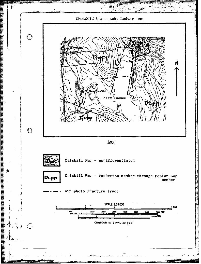
GIEUALOGIC MAV' - ake Ladore JDan
I A.Wnd
LAKE\IODORE '
- I~1 Catskill 17m. -Undifferentiatedf
Catskill Fm. -Packerton member through Poplar GapL~E~Jmember
-. -. air photf.o fracture trace
SCALE 1:24000D
2000 0 1030 MW0 3 mo swD500 E0 00 U
CONTOUR INTERvAL 20 FEETIv x-
I~ L
Related Documents