Monitoring Series No. C/S-18- MSTY-0198-1 THREE-YEAR COMPREHENSIVE MONITORING REPORT Coast 2050 Region 4 SABINE REFUGE PROTECTION C/S-18 First Priority List Shoreline Protection Project of the Coastal Wetlands Planning, Protection, and Restoration Act (Public Law 101-646) David L. Castellanos Louisiana Department of Natural Resources Coastal Restoration Division P.O. Box 94396 Baton Rouge, La 70804-9396 January 1998

Welcome message from author
This document is posted to help you gain knowledge. Please leave a comment to let me know what you think about it! Share it to your friends and learn new things together.
Transcript
Monitoring Series No. C/S-18- MSTY-0198-1
THREE-YEAR COMPREHENSIVE MONITORING REPORT
Coast 2050 Region 4
SABINE REFUGE PROTECTIONC/S-18
First Priority List Shoreline Protection Projectof the Coastal Wetlands Planning, Protection, and Restoration Act
(Public Law 101-646)
David L. Castellanos
Louisiana Department of Natural ResourcesCoastal Restoration Division
P.O. Box 94396Baton Rouge, La 70804-9396
January 1998
ii
TABLE OF CONTENTS
Page
LIST OF FIGURES . . . . . . . . . . . . . . . . . . . . . . . . . . . . . . . . . . . . . . . . . . . . . . . . . . . . . . . . . . . iii
LIST OF TABLES . . . . . . . . . . . . . . . . . . . . . . . . . . . . . . . . . . . . . . . . . . . . . . . . . . . . . . . . . . . . iv
ACKNOWLEDGMENTS . . . . . . . . . . . . . . . . . . . . . . . . . . . . . . . . . . . . . . . . . . . . . . . . . . . . . . . v
ABSTRACT . . . . . . . . . . . . . . . . . . . . . . . . . . . . . . . . . . . . . . . . . . . . . . . . . . . . . . . . . . . . . . . . . vi
INTRODUCTION . . . . . . . . . . . . . . . . . . . . . . . . . . . . . . . . . . . . . . . . . . . . . . . . . . . . . . . . . . . . . 1
METHODS . . . . . . . . . . . . . . . . . . . . . . . . . . . . . . . . . . . . . . . . . . . . . . . . . . . . . . . . . . . . . . . . . . 5
RESULTS . . . . . . . . . . . . . . . . . . . . . . . . . . . . . . . . . . . . . . . . . . . . . . . . . . . . . . . . . . . . . . . . . . . 8
DISCUSSION . . . . . . . . . . . . . . . . . . . . . . . . . . . . . . . . . . . . . . . . . . . . . . . . . . . . . . . . . . . . . . . 13
CONCLUSION . . . . . . . . . . . . . . . . . . . . . . . . . . . . . . . . . . . . . . . . . . . . . . . . . . . . . . . . . . . . . . 14
REFERENCES . . . . . . . . . . . . . . . . . . . . . . . . . . . . . . . . . . . . . . . . . . . . . . . . . . . . . . . . . . . . . . 15
APPENDIX A . . . . . . . . . . . . . . . . . . . . . . . . . . . . . . . . . . . . . . . . . . . . . . . . . . . . . . . . . . . . . A-1
APPENDIX B . . . . . . . . . . . . . . . . . . . . . . . . . . . . . . . . . . . . . . . . . . . . . . . . . . . . . . . . . . . . . . B-1
iii
LIST OF FIGURES
Figure Page
1. Sabine Refuge Protection (C/S-18) project area map . . . . . . . . . . . . . . . . . . . . . . . . . . . . 3
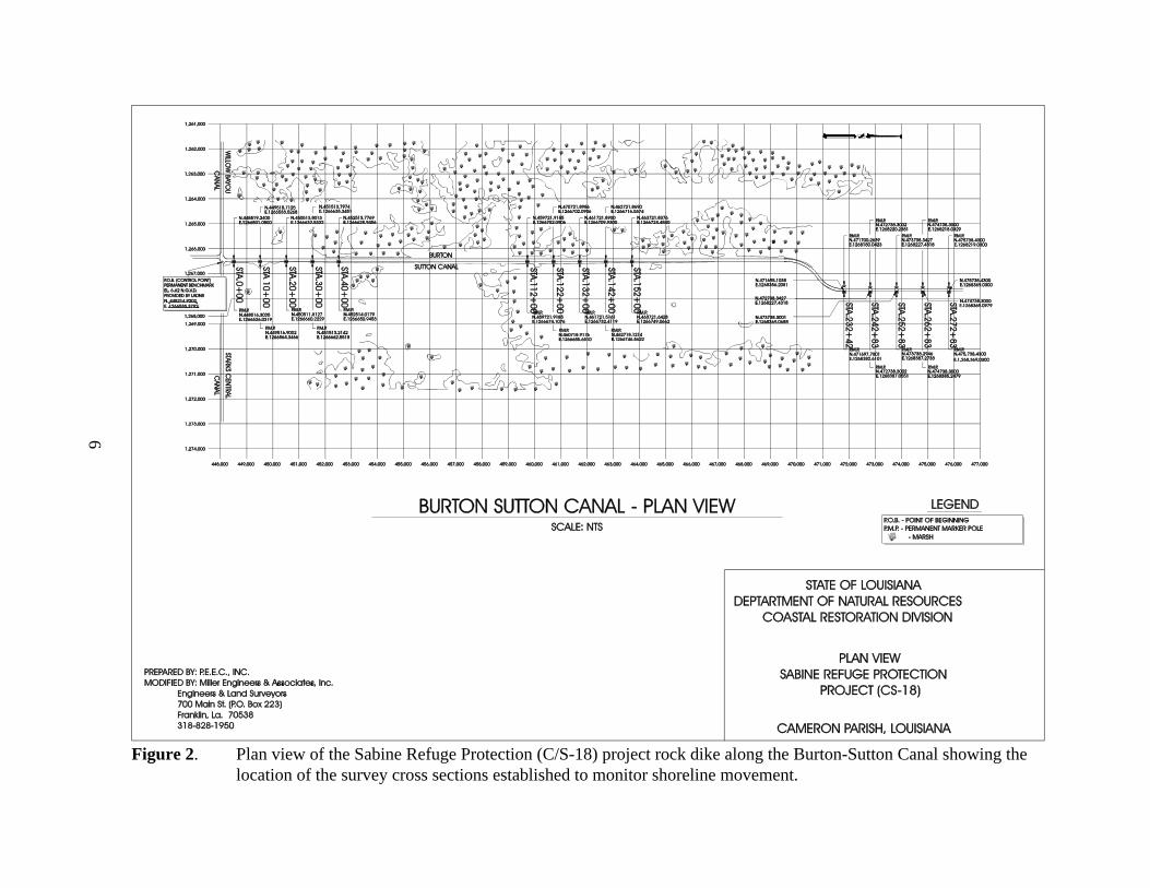
2. Plan view of the Sabine Refuge Protection (C/S-18) project rock dike along the Burton-Sutton Canal showing the location of the survey cross sections established to monitorshoreline movement . . . . . . . . . . . . . . . . . . . . . . . . . . . . . . . . . . . . . . . . . . . . . . . . . . . . . . 6
3. Selected USFWS Sabine Refuge vegetation sample stations . . . . . . . . . . . . . . . . . . . . . . 7
4. Sabine Refuge Protection (C/S-18) GIS analysis of project area preconstruction aerialphotography . . . . . . . . . . . . . . . . . . . . . . . . . . . . . . . . . . . . . . . . . . . . . . . . . . . . . . . . . . . . 9
5. Sabine Refuge Protection (C/S-18) GIS analysis of reference area preconstruction aerialphotography . . . . . . . . . . . . . . . . . . . . . . . . . . . . . . . . . . . . . . . . . . . . . . . . . . . . . . . . . . . 10
6. 1997 aerial photography for Sabine Refuge Protection (C/S-18) project and referenceareas . . . . . . . . . . . . . . . . . . . . . . . . . . . . . . . . . . . . . . . . . . . . . . . . . . . . . . . . . . . . . . . . . 11

iv
LIST OF TABLES
Table Page
1. Land/water analysis of the Sabine Refuge Protection (C/S-18) project and reference areasat preconstruction (November 1993). . . . . . . . . . . . . . . . . . . . . . . . . . . . . . . . . . . . . . . . . 8
v
ACKNOWLEDGMENTS
We acknowledge the U.S. Geological Survey, National Wetlands Research Center (NWRC),particularly Robert Greco and Holly Gaudet, for land-water analysis and assisting in the preparationof this comprehensive report. Diane Borden-Billiot of the U.S. Fish and Wildlife Service (USFWS)provided vegetation coverage and species composition data. Reviews of the draft report by GregSteyer, Ralph Libersat, and David Soileau of LDNR/CRD, and by Dr. John A. Nyman of theDepartment of Biology, University of Southwestern Louisiana, were helpful in improving thedocument.
vi
ABSTRACT
Several factors, both natural and human-induced, have lead to the loss of freshwater marsh orconversion to more saline habitat in the region of Chenier plain marshes between the Calcasieu andSabine Rivers in Louisiana. The U.S. Fish and Wildlife Service, in 1951, impounded an area of theSabine National Wildlife Refuge between the higher salinity Central Canal, Burton-Sutton Canal,North Canal, and Beach Canal in Cameron parish. This impoundment is now the only freshwatermarsh that exists between the Calcasieu and Sabine River systems. In order to protect the west leveeof the impoundment from boat wakes (and resultant erosion), a rock dike was constructed in 1995along the Burton-Sutton Canal/impoundment levee. To assess the effectiveness of the rock dike, amonitoring plan was established to measure any shoreline position changes using survey points alongthe vegetated edge of the levee. Aerial photography was used to document any changes in thevegetation composition in the impoundment that would presumably result from a failure of the leveeto keep out the saline waters of the surrounding canals. At this time, the only data available is fromthe first survey of shoreline, and the preconstruction aerial photography. Subsequent data will beused to determine if either the shoreline position or vegetation composition has changed.
1
INTRODUCTION
Wetland loss has been attributed to many natural and anthropogenic causes. The construction ofchannels and canals for navigation and access to oil and gas structures has caused immediatedestruction of some of Louisiana’s coastal wetlands. These artificial channels are usually deeper andstraighter than natural waterways, allowing greater flow velocities and greater intrusion of salineGulf waters especially during periods of low outflow from coastal wetlands. Saltwater intrusion hasbeen implicated as a major cause of wetland loss in coastal Louisiana. When saline water rapidlyinvades areas of fresh marsh, the existing vegetation may be killed leaving bare substrate subject toerosion before more salt tolerant plant species can revegetate the area (Turner and Cahoon 1987).Soil waterlogging will exacerbate the detrimental effects of saltwater intrusion by causing theaccumulation of toxic compounds due to the highly reduced conditions (Turner and Cahoon 1987).The spoil banks created as a by-product of canal construction may cause water to become strandedin marshes when banks are breached or topped. Impounded freshwater areas are therefore especiallysusceptible to vegetation loss caused by introduction of surrounding saline water in the event oflevee failure.
The earliest records of the Chenier Plain marshes between Cameron Creole and Sabine Lake indicatethat it was an extensive freshwater marsh dominated by Cladium jamaicense (saw grass) and Scirpuscalifornicus (giant bulrush) (U.S. Department of Agriculture [USDA] 1931). By 1949, the area wasdominated by freshwater marsh along with saw grass marsh and intermediate marsh (O’Neil 1949).Freshwater marsh species included Panicum hemitomon (maidencane), Typha spp. (cattail),Sagittaria lancifolia (bull-tongue), Eleocharis quadrangulata (squarestem spikesedge), Eleocharismacrostachya (largespike spikesedge - listed as synonymous with Eleocharis palustris), Eleochariscellulosa (gulfcoast spikesedge), Zizaniopsis miliacea (southern wildrice), C. jamaicense,Phragmites australis (common reed), S. californicus, and Scirpus tabernaemontani (softstembulrush). Saw grass marsh was dominated by C. jamaicense and included Typha spp., S.californicus, S. tabernaemontani, P. australis, S. lancifolia, Spartina cynosuroides (big cordgrass),Eleocharis spp., and Z. milliacea near the edges. Intermediate marsh consisted of C. jamaicense, P.australis, Typha spp., S. californicus, S. tabernaemontani, Scirpus americanus (bulrush), Spartinapatens (saltmeadow cordgrass), S. lancifolia, and S. cynosuroides. The marshes bordering Sabineand Calcasieu Lakes and the Gulf coast were largely brackish three corner marsh (predominately S.americanus) in 1949. The impoundment area was completely dominated by freshwater marsh (P.hemitomon, Hydrocotyl spp., Eichhornia crassipes [water hyacinth], Pontederia cordata[pickerelweed], Alternanthera philoxeroides [alligatorweed], and Sagittaria sp.) by 1968, and thearea just outside of the impoundment was mostly intermediate marsh (low salinity with typicalvegetation consisting of S. patens, Vigna luteola [deer pea], Sagittaria sp., Echinochloa walteri[water millet], S. californicus, C. jamaicense) (Chabreck and Linscombe 1968). Extensive brackishmarshes (marshes of moderate salinity with typical vegetation consisting of S. patens, S. americanus,Scirpus robustus [saltmarsh bulrush] and Ruppia maritima [widgeongrass]) were also present fromSabine Lake east to the impoundment and along Calcasieu Lake at this time. The amounts ofbrackish marsh and intermediate marsh in 1978 were similar to 1968 (Chabreck and Linscombe1978). By 1988, most of the area surrounding the impoundment consisted of brackish marsh except
2
for a large area of intermediate marsh south of the impoundment (Chabreck and Linscombe 1988).The impoundment is now virtually the only remaining area of coastal freshwater marsh between theCalcasieu and Sabine Rivers.
As early as the late 1800’s work was being conducted to widen and deepen the channels that connectSabine Lake and Calcasieu Lake to the Gulf of Mexico (Natural Resources Conservation Service[NRCS] 1993). Further widening and deepening of these channels continued through the 1970’s.Beginning in the early 1900’s several canals were dug which transverse the marshes between Sabineand Calcasieu Lakes. Also, the Gulf Intracoastal Waterway (GIWW) was constructed in the early1900’s, connecting the Sabine River to the Calcasieu River. Many of the small canals connected theinterior marshes to Sabine and Calcasieu Lakes. These lakes have become more saline over timebecause of the greater influx of gulf water allowed by the larger dredged channels. This moreefficient connection to saline water has contributed to the conversion of the interior marshes fromfresh to intermediate and brackish. Severe saltwater intrusion and flooding caused by hurricanesAudrey and Carla, in 1957 and 1961 respectively, and droughts in the early 1960’s have alsocontributed to the loss or conversion of freshwater marsh in the Calcasieu-Sabine area (Valentine1976).
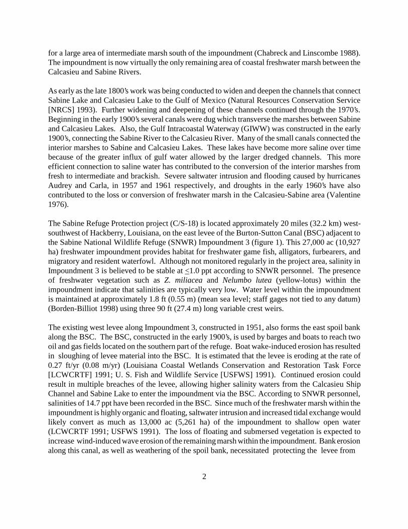
The Sabine Refuge Protection project (C/S-18) is located approximately 20 miles (32.2 km) west-southwest of Hackberry, Louisiana, on the east levee of the Burton-Sutton Canal (BSC) adjacent tothe Sabine National Wildlife Refuge (SNWR) Impoundment 3 (figure 1). This 27,000 ac (10,927ha) freshwater impoundment provides habitat for freshwater game fish, alligators, furbearers, andmigratory and resident waterfowl. Although not monitored regularly in the project area, salinity inImpoundment 3 is believed to be stable at <1.0 ppt according to SNWR personnel. The presenceof freshwater vegetation such as Z. miliacea and Nelumbo lutea (yellow-lotus) within theimpoundment indicate that salinities are typically very low. Water level within the impoundmentis maintained at approximately 1.8 ft (0.55 m) (mean sea level; staff gages not tied to any datum)(Borden-Billiot 1998) using three 90 ft (27.4 m) long variable crest weirs.
The existing west levee along Impoundment 3, constructed in 1951, also forms the east spoil bankalong the BSC. The BSC, constructed in the early 1900’s, is used by barges and boats to reach twooil and gas fields located on the southern part of the refuge. Boat wake-induced erosion has resultedin sloughing of levee material into the BSC. It is estimated that the levee is eroding at the rate of0.27 ft/yr (0.08 m/yr) (Louisiana Coastal Wetlands Conservation and Restoration Task Force[LCWCRTF] 1991; U. S. Fish and Wildlife Service [USFWS] 1991). Continued erosion couldresult in multiple breaches of the levee, allowing higher salinity waters from the Calcasieu ShipChannel and Sabine Lake to enter the impoundment via the BSC. According to SNWR personnel,salinities of 14.7 ppt have been recorded in the BSC. Since much of the freshwater marsh within theimpoundment is highly organic and floating, saltwater intrusion and increased tidal exchange wouldlikely convert as much as 13,000 ac (5,261 ha) of the impoundment to shallow open water(LCWCRTF 1991; USFWS 1991). The loss of floating and submersed vegetation is expected toincrease wind-induced wave erosion of the remaining marsh within the impoundment. Bank erosionalong this canal, as well as weathering of the spoil bank, necessitated protecting the levee from
3
Figure 1. Sabine Refuge Protection (C/S-18) project area map.
4
further deterioration. Maintaining this impounded area as a freshwater marsh depends on an intactlevee that encircles it.
Waves from passing vessels (boat wakes) cause erosion of navigation channel banks and damage toexisting vegetation communities (Good et al. 1995). Water displaced from the channel by vesselsmay be pushed over the banks of channels into the adjacent wetland areas causing soil and vegetationscour and rapid changes in water level. In the more fragile interior wetlands erosion acceleratesdramatically. Erosion of interior wetlands is exacerbated by “blowouts” where a connection isformed between a channel and an inland water body (Good et al. 1995).
Rock dikes have been designed to prevent boat wakes from eroding shorelines, but also to allowwave overtopping, resulting in sediment accretion behind the dike. A similar shoreline protectionproject along the GIWW at Cameron Prairie (Courville 1997) has resulted in some sediment buildupbehind the rock dike. The Sabine Refuge Protection project (C/S-18) is designed to prevent furthererosion of the Impoundment 3 west levee, and protect the existing freshwater wetlands fromsaltwater intrusion. Construction of approximately 5.5 linear mi (8.85 km) of free-standing,continuous rock dike was completed in January 1995. In addition, the levee was restored (usingdredge material from the canal) where it was once degraded, and maintenance work will beundertaken at the three weir sites and at three alligator crossings along the east bank of the BSC(which forms the west bank of the impoundment).
The project objectives are to protect the existing freshwater vegetation within Impoundment 3 ofSNWR adjacent to the BSC and to prevent the introduction of higher salinity water from the BSCinto the impoundment. The specific goals needed to achieve these objectives are to:
1. Restore and protect the west levee of Impoundment 3 using dredge material and afree-standing rock breakwater.
2. Protect existing freshwater vegetation in Impoundment 3 from saltwater intrusion viathe Burton-Sutton Canal.
5
METHODS
Near-vertical color-infrared aerial photography (1:24,000 scale) was used to measure vegetated andnon-vegetated areas for the project and reference areas. Aerial photography was scanned,mosaicked, and georectified by National Wetlands Research Center (NWRC) personnel accordingto the standard operating procedure described in the Quality Management Plan for Coastal WetlandsPlanning, Protection, and Restoration Act (Steyer et al.1995). The photography was obtained inNovember 1993 prior to construction and in November 1779 post-construction.
To document shoreline movement, shoreline markers denoting the vegetated marsh edge wereestablished at 1,000 ft (305 m) intervals along the east bank of the BSC adjacent to the northernmost,central, and southernmost portions of the rock dike (figure 2). Shoreline markers were alsoestablished along the west bank of the canal adjacent to the reference area. This baseline survey datawill be compared to future data sets to evaluate project effectiveness. Shoreline position relative tothe shoreline markers will be monitored by direct measurement at 5 yr intervals.
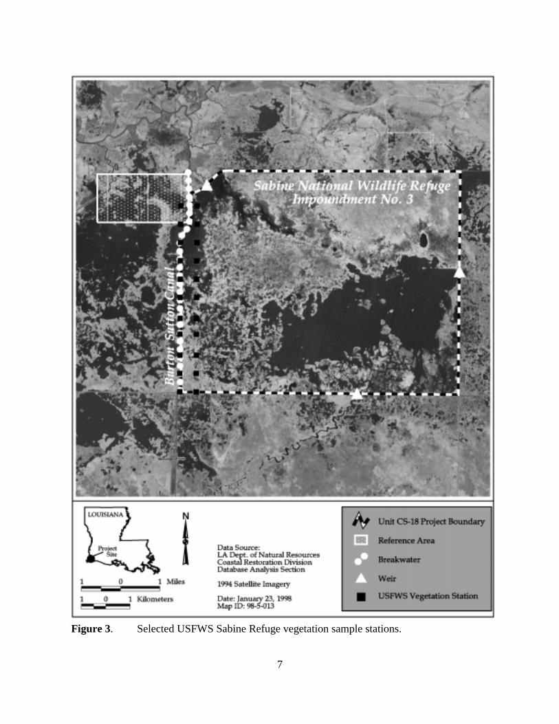
Additional data provided by SNWR personnel will be used to document the vegetated marsh to waterratio and vegetation composition in Impoundment 3. USFWS sampling was conducted December3-10, 1996. Samples were taken at 0.5 mi (0.8 km) intervals on east-west and north-south transects.The east-west lines were labeled A-M, and the north-south lines were labeled 1-19. Data in thisreport are from the two westernmost sampling transects in the impoundment, rows 18 and 19 (figure3 and appendix A). Sample locations were found using a hand held GPS unit. Data were collectedfrom two 10 ft x 15 ft (3.05 x 4.57 m) sites at each location, one on the left side of the airboat andone on the right side. The following data were collected for each site: percent of marsh to water(=100), plant species, and percent of each for both the marsh and water portions of each site (percentspecies of percent vegetation and percent species of percent site). Each site was identified by thealphanumeric name and E, W, N, or S, depending on the orientation of the airboat. The followingdata were collected at each location from one of the sites: water depth, water turbidity, consistencyof the bottom soil (hard or soft), and comments on wildlife observations. All data were dictated intoa cassette recorder for later transcription and entry into Quattro Pro spreadsheets. The percent ofeach plant species (percent species of plot) was then calculated for each site (appendix B).
6
Figure 2. Plan view of the Sabine Refuge Protection (C/S-18) project rock dike along the Burton-Sutton Canal showing thelocation of the survey cross sections established to monitor shoreline movement.
7
Figure 3. Selected USFWS Sabine Refuge vegetation sample stations.
8
RESULTS
Color-infrared aerial photography of the preconstruction project area was obtained on November 1,1993. The photography was checked for flight accuracy, color correctness, and clarity. Theduplicate photography was prepared for scanning and analysis. The original film was archived.
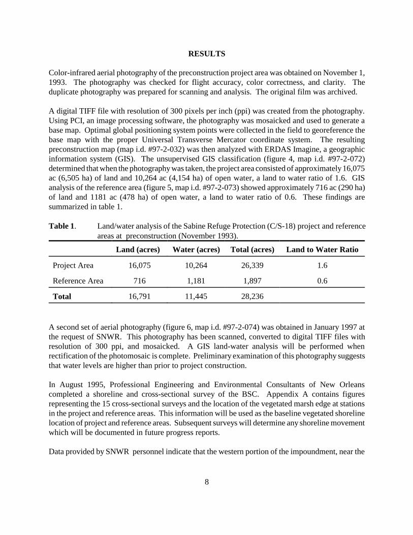
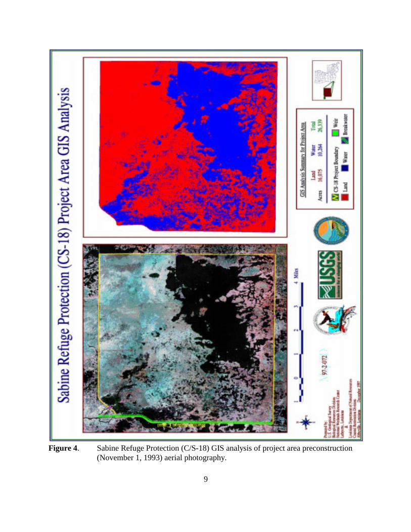
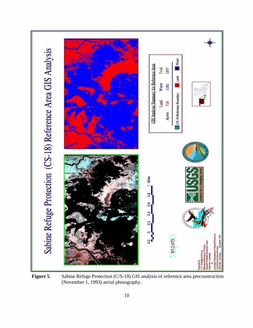
A digital TIFF file with resolution of 300 pixels per inch (ppi) was created from the photography.Using PCI, an image processing software, the photography was mosaicked and used to generate abase map. Optimal global positioning system points were collected in the field to georeference thebase map with the proper Universal Transverse Mercator coordinate system. The resultingpreconstruction map (map i.d. #97-2-032) was then analyzed with ERDAS Imagine, a geographicinformation system (GIS). The unsupervised GIS classification (figure 4, map i.d. #97-2-072)determined that when the photography was taken, the project area consisted of approximately 16,075ac (6,505 ha) of land and 10,264 ac (4,154 ha) of open water, a land to water ratio of 1.6. GISanalysis of the reference area (figure 5, map i.d. #97-2-073) showed approximately 716 ac (290 ha)of land and 1181 ac (478 ha) of open water, a land to water ratio of 0.6. These findings aresummarized in table 1.
Table 1. Land/water analysis of the Sabine Refuge Protection (C/S-18) project and referenceareas at preconstruction (November 1993).
Land (acres) Water (acres) Total (acres) Land to Water Ratio
Project Area 16,075 10,264 26,339 1.6
Reference Area 716 1,181 1,897 0.6
Total 16,791 11,445 28,236
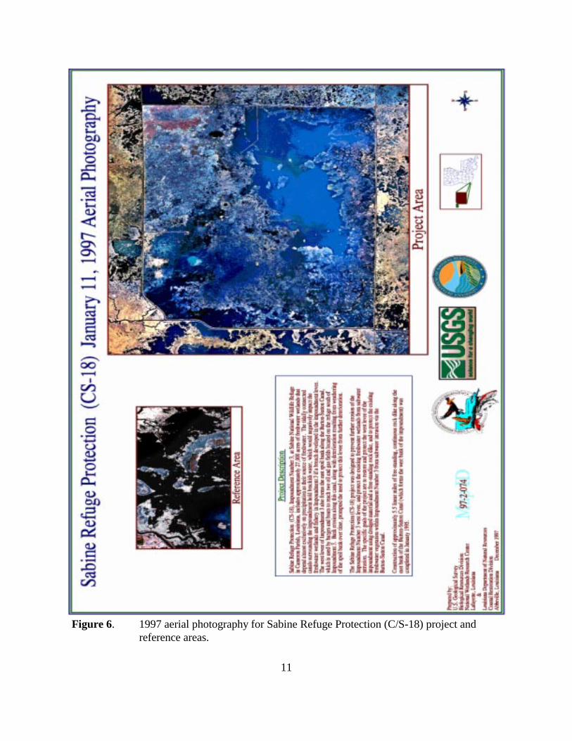
A second set of aerial photography (figure 6, map i.d. #97-2-074) was obtained in January 1997 atthe request of SNWR. This photography has been scanned, converted to digital TIFF files withresolution of 300 ppi, and mosaicked. A GIS land-water analysis will be performed whenrectification of the photomosaic is complete. Preliminary examination of this photography suggeststhat water levels are higher than prior to project construction.
In August 1995, Professional Engineering and Environmental Consultants of New Orleanscompleted a shoreline and cross-sectional survey of the BSC. Appendix A contains figuresrepresenting the 15 cross-sectional surveys and the location of the vegetated marsh edge at stationsin the project and reference areas. This information will be used as the baseline vegetated shorelinelocation of project and reference areas. Subsequent surveys will determine any shoreline movementwhich will be documented in future progress reports.
Data provided by SNWR personnel indicate that the western portion of the impoundment, near the
9
Figure 4. Sabine Refuge Protection (C/S-18) GIS analysis of project area preconstruction(November 1, 1993) aerial photography.
10
Figure 5. Sabine Refuge Protection (C/S-18) GIS analysis of reference area preconstruction(November 1, 1993) aerial photography.
11
Figure 6. 1997 aerial photography for Sabine Refuge Protection (C/S-18) project andreference areas.
12
protection levee, has remained fresh marsh since construction of the project. The area is dominatedby taxa that are indicative of persistent freshwater conditions (i.e. Typha spp., Hydrocotyle spp., S.lancifolia) (appendix B). The ratio of vegetated marsh to water was variable among stations.Subsequent sample data will be used to complement aerial photography data to document anyvegetated freshwater marsh loss.
Site inspection by Louisiana Department of Natural Resources (LDNR) monitoring personnel inDecember 1997 documented the composition of the reference area as brackish marsh dominated byS. patens. Parts of the western spoil bank of the BSC were also vegetated with stands of P. australisand C. jamaicense.
13
DISCUSSION
An exhaustive discussion is not possible at this time because postconstruction surveys will not beginuntil 2000 according to the monitoring plan. Examination of the engineers’ first annual inspectionreport (October 1996) and inspection by LDNR monitoring personnel in December 1997 providedevidence that the Sabine Refuge Impoundment 3 levee and the protective rock dike are in goodcondition. The goals and objectives of the project apparently are being met. The BSC has notencroached into the impoundment and the freshwater vegetation in the impoundment has beenpreserved. Boat traffic on the BSC has not increased to anticipated levels and thus the threat of waveerosion is not imminent; however, at low water substantial erosion can be seen at the base of theprotection levee. Large portions of exposed tree roots are visible. It is not known, however, the timeperiod over which this erosion occurred or how long it would take for the erosion to compromise thelevee.
Habitat mapping of the project and reference areas was complicated by two factors. First, anARC/INFO coverage of the reference area boundary was unavailable at the time of land-wateranalysis. Consequently, the boundary was digitized at the NWRC based on the boundary illustratedby the project and reference area map included in Sabine Refuge Protection Progress Report No. 4(Vincent 1997). Because this boundary might differ slightly from the original reference areaboundary, total acreage may not agree with previous estimates. Second, the project area includedboth floating and submerged aquatic vegetation and mudflats which were classified as land by theGIS software. Similarly, land areas shadowed by trees were sometimes incorrectly classified aswater. After these problem areas had been identified and reclassified, an accuracy assessment wasperformed. By comparing 256 randomly selected pixels with aerial photography, the accuracyassessment calculated an overall classification accuracy of 96.1% (± 5%).
14
CONCLUSION
According to available information the project appears to be effective at protecting the west leveeof Impoundment 3 and the existing freshwater vegetation within the impoundment. The baselineshoreline survey has been completed and the vegetation composition of the impoundment has beendocumented. The goals and objectives of the monitoring plan appear to have been met thus far.New information and data will be collected in the future according to the monitoring plan and willbe used to evaluate project effectiveness at that time
15
REFERENCES
Borden-Billiot, D. 1998. Personal communication on February 26. Hackberry, Louisiana: SabineNational Wildlife Refuge, Wildlife Biologist.
Chabreck, R., and G. Linscombe 1968. Vegetative type map of the Louisiana coastal marshes. NewOrleans: Louisiana Department of Wildlife and Fisheries. Scale 1:62,500.
Chabreck, R., and G. Linscombe 1978. Vegetative type map of the Louisiana coastal marshes. NewOrleans: Louisiana Department of Wildlife and Fisheries. Scale 1:62,500.
Chabreck, R., and G. Linscombe 1988. Vegetative type map of the Louisiana coastal marshes. NewOrleans: Louisiana Department of Wildlife and Fisheries. Scale 1:62,500.
Courville, C. J. 1997. Cameron Prairie Refuge Protection (ME-09) Three-year comprehensivemonitoring report. Open file monitoring series ME-09-MSTY-0797-1, for the period 3August 1994 to 4 August 1997. Baton Rouge: Louisiana Department of Natural Resources,Coastal Restoration Division. 17 pp.
Good, B., J. Buchtel, D. Meffert, J. Radford, K. Rhinehart, and R. Wilson, eds. 1995. Louisiana’smajor coastal navigation channels. Unpublished report. Baton Rouge: LouisianaDepartment of Natural Resources, Coastal Restoration Division. 57 pp.
Louisiana Coastal Wetlands Conservation and Restoration Task Force (LCWCRTF) 1991. CoastalWetlands Planning, Protection, and Restoration Act, first priority project list report.Appendix E, Tab F. Baton Rouge: Louisiana Coastal Wetlands Conservation andRestoration Task Force. 13 pp.
Natural Resources Conservation Service (NRCS) 1993. Calcasieu-Sabine cooperative river basinstudy report. Unpublished report. In cooperation with the Gulf Coast Soil and WaterConservation District, United States Fish and Wildlife Service, Louisiana Department ofNatural Resources, Louisiana Department of Wildlife and Fisheries, and LouisianaDepartment of Agriculture and Forestry. 151 pp.
O’Neil, T. 1949. The muskrat in the Louisiana coastal marshes: A study of the ecological,geological, biological, tidal, and climatic factors governing the production and managementof the muskrat industry in Louisiana. New Orleans, Louisiana: Federal Aid Section- Fishand Game Division Louisiana Department of Wildlife and Fisheries. 152 pp.
Steyer, G. D., R. C. Raynie, D. L. Steller, D. Fuller, and E. Swenson 1995. Quality managementplan for Coastal Wetlands Planning, Protection, and Restoration Act monitoring program.Open-file series no. 95-01. Baton Rouge: Louisiana Department of Natural Resources,Coastal Restoration Division.
16
Turner, R. E., and D. R. Cahoon, eds. 1987. Causes of Wetland loss in the Coastal Central Gulf ofMexico. Volume II: Technical Narrative. Final report submitted to Minerals ManagementService, New Orleans, LA. Contract No.14-12-0001-30252. OCS Study/MMS 87-0120.400 pp.
U. S. Department of Agriculture (USDA) 1931. Sabine Lake migratory bird refuge. Cameronparish, Louisiana. USDA.
U. S. Fish & Wildlife Service (USFWS) 1991. Reconstruction of the [Sabine National WildlifeRefuge] Impoundment 3 west levee. Proposed project information sheet [for wetland valueassessment]. Lafayette, Louisiana: U.S. Fish & Wildlife Service. 4 pp.
Valentine, J. M. 1976. Plant succession after saw-grass mortality in southwestern Louisiana.Proceedings of the Annual Conference of the Southeastern Association of Fish and WildlifeAgencies 30:634-640.
Vincent, K. 1997. Sabine Refuge Protection (C/S-18) Monitoring Series Progress Report No. 4.Baton Rouge: Louisiana Department of Natural Resources, Coastal Restoration Divsion. 5pp.
A-1
APPENDIX A
Sabine Refuge Protection (C/S-18) cross section drawings of project and reference stations
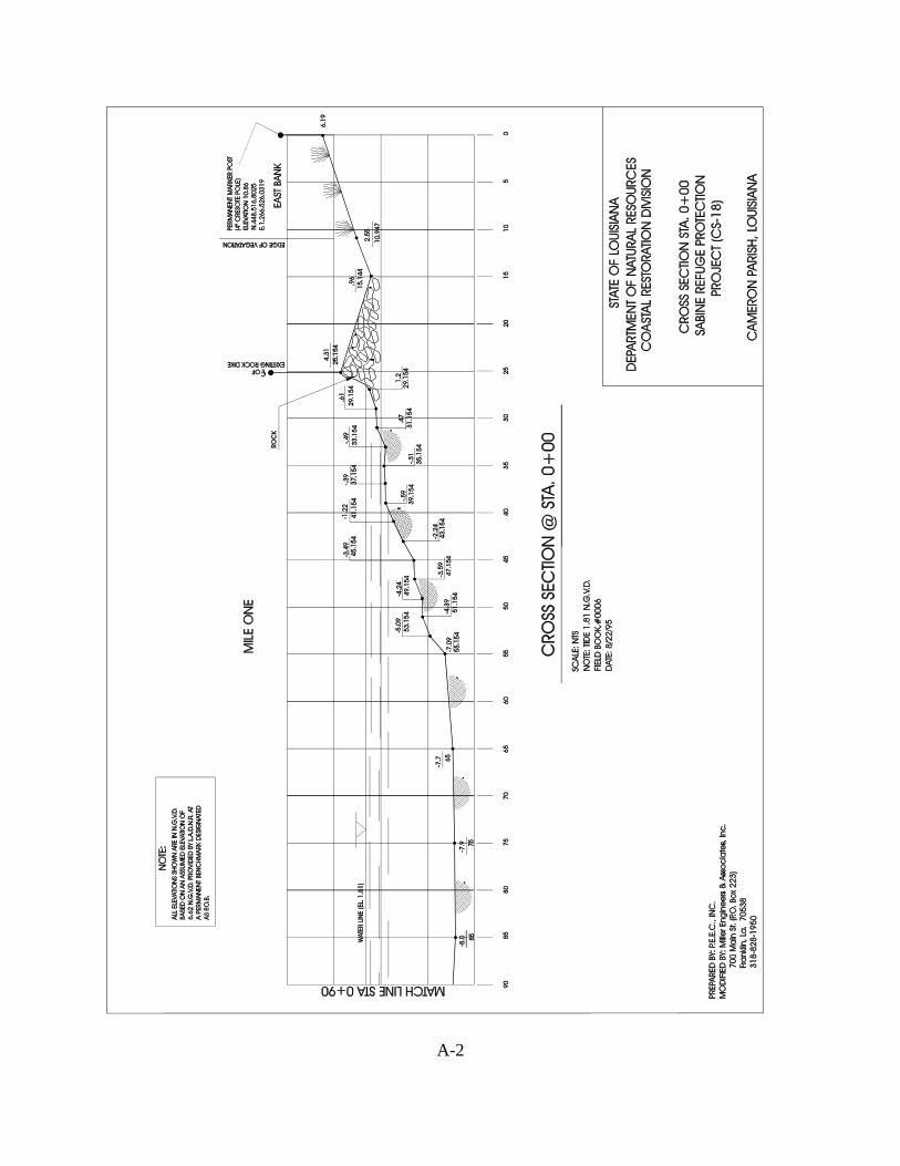
A-2
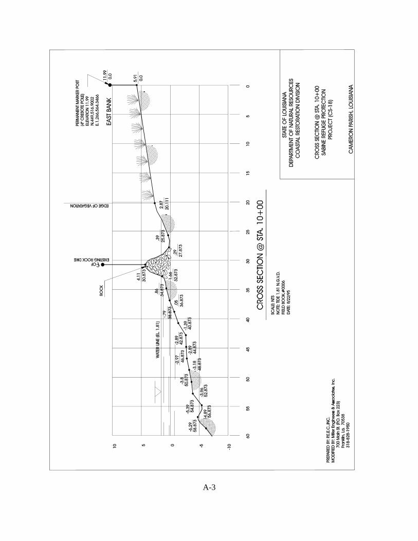
A-3
Related Documents