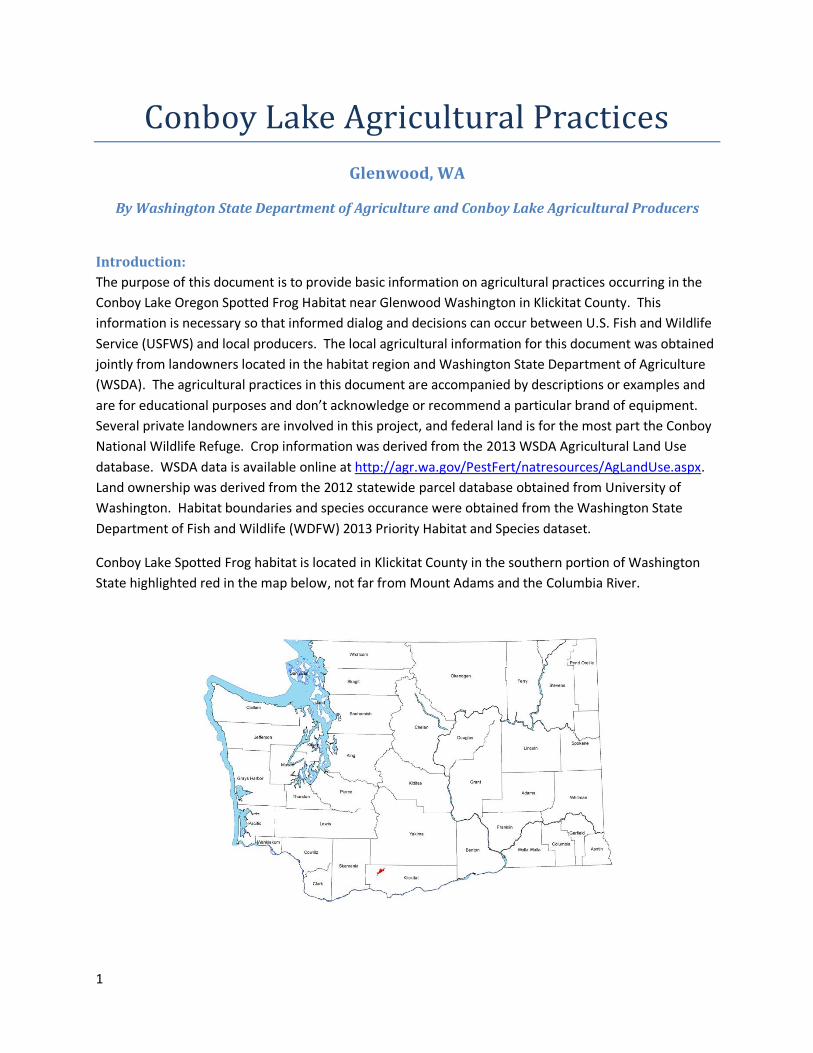
1 Conboy Lake Agricultural Practices Glenwood, WA By Washington State Department of Agriculture and Conboy Lake Agricultural Producers Introduction: The purpose of this document is to provide basic information on agricultural practices occurring in the Conboy Lake Oregon Spotted Frog Habitat near Glenwood Washington in Klickitat County. This information is necessary so that informed dialog and decisions can occur between U.S. Fish and Wildlife Service (USFWS) and local producers. The local agricultural information for this document was obtained jointly from landowners located in the habitat region and Washington State Department of Agriculture (WSDA). The agricultural practices in this document are accompanied by descriptions or examples and are for educational purposes and don’t acknowledge or recommend a particular brand of equipment. Several private landowners are involved in this project, and federal land is for the most part the Conboy National Wildlife Refuge. Crop information was derived from the 2013 WSDA Agricultural Land Use database. WSDA data is available online at http://agr.wa.gov/PestFert/natresources/AgLandUse.aspx . Land ownership was derived from the 2012 statewide parcel database obtained from University of Washington. Habitat boundaries and species occurance were obtained from the Washington State Department of Fish and Wildlife (WDFW) 2013 Priority Habitat and Species dataset. Conboy Lake Spotted Frog habitat is located in Klickitat County in the southern portion of Washington State highlighted red in the map below, not far from Mount Adams and the Columbia River.

Welcome message from author
This document is posted to help you gain knowledge. Please leave a comment to let me know what you think about it! Share it to your friends and learn new things together.
Transcript
1
Conboy Lake Agricultural Practices
Glenwood, WA
By Washington State Department of Agriculture and Conboy Lake Agricultural Producers
Introduction:
The purpose of this document is to provide basic information on agricultural practices occurring in the
Conboy Lake Oregon Spotted Frog Habitat near Glenwood Washington in Klickitat County. This
information is necessary so that informed dialog and decisions can occur between U.S. Fish and Wildlife
Service (USFWS) and local producers. The local agricultural information for this document was obtained
jointly from landowners located in the habitat region and Washington State Department of Agriculture
(WSDA). The agricultural practices in this document are accompanied by descriptions or examples and
are for educational purposes and don’t acknowledge or recommend a particular brand of equipment.
Several private landowners are involved in this project, and federal land is for the most part the Conboy
National Wildlife Refuge. Crop information was derived from the 2013 WSDA Agricultural Land Use
database. WSDA data is available online at http://agr.wa.gov/PestFert/natresources/AgLandUse.aspx.
Land ownership was derived from the 2012 statewide parcel database obtained from University of
Washington. Habitat boundaries and species occurance were obtained from the Washington State
Department of Fish and Wildlife (WDFW) 2013 Priority Habitat and Species dataset.
Conboy Lake Spotted Frog habitat is located in Klickitat County in the southern portion of Washington
State highlighted red in the map below, not far from Mount Adams and the Columbia River.
2
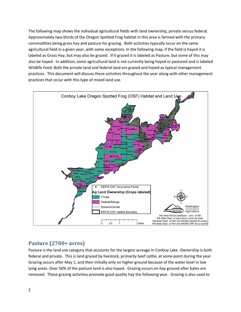
The following map shows the individual agricultural fields with land ownership, private versus federal.
Approximately two-thirds of the Oregon Spotted Frog habitat in this area is farmed with the primary
commodities being grass hay and pasture for grazing. Both activities typically occur on the same
agricultural field in a given year, with some exceptions. In the following map, if the field is hayed it is
labeled as Grass Hay, but may also be grazed. If it grazed it is labeled as Pasture, but some of this may
also be hayed. In addition, some agricultural land is not currently being hayed or pastured and is labeled
Wildlife Feed. Both the private land and federal land are grazed and hayed as typical management
practices. This document will discuss these activities throughout the year along with other management
practices that occur with this type of mixed land use.
Pasture (2700+ acres) Pasture is the land use category that accounts for the largest acreage in Conboy Lake. Ownership is both
federal and private. This is land grazed by livestock, primarily beef cattle, at some point during the year.
Grazing occurs after May 1, and then initially only on higher ground because of the water level in low
lying areas. Over 50% of the pasture land is also hayed. Grazing occurs on hay ground after bales are
removed. These grazing activities promote good quality hay the following year. Grazing is also used to
3
manage vegetation on ditches and canals. Cattle are removed after October during the winter when
fields are flooded for frost control.
Grass Hay (2500+ acres) Grass hay is an equally large land use category and constitutes a forage crop that is harvested for hay for
livestock feed. Land ownership for this category is both federal and private. The predominant grass
species grown for hay is Reed Canarygrass (Phalaris arundinacea).* Reed canarygrass is a rhizomatous,
long-lived, perennial grass, native to the temperate regions of Europe, Asia and North America attaining
heights from 2 to 8 feet. It can tolerate more water during the growing season than any other cultivated
grass and is therefore adapted to the Conboy Lake area. This grass is able to withstand ponding of
surface water for up to two months, and is tolerant of waterlogged soils. The dense sod and tall growth
of Reed canarygrass can produce an undesirable thick stand along ditches and canals causing silt buildup
and deterring water movement. This grass is susceptible to winterkill if there is not an adequate snow or
water cover to protect it. The tall growth of this species limits its usefulness for seeding in mixtures
because it tends to shade out the legumes. Seedlings are slow to establish, but once rhizomes begin to
form the grass is quite hardy. Reed canarygrass is exceptionally high-yielding for hay and the best
quality hay is obtained from stands that have been pastured, thus reducing the coarseness of growth.
Grass hay is harvested once in the summer starting the end of June after the water is drained and the
soil no longer has any standing water and continues through August. Most of the harvesting is done in
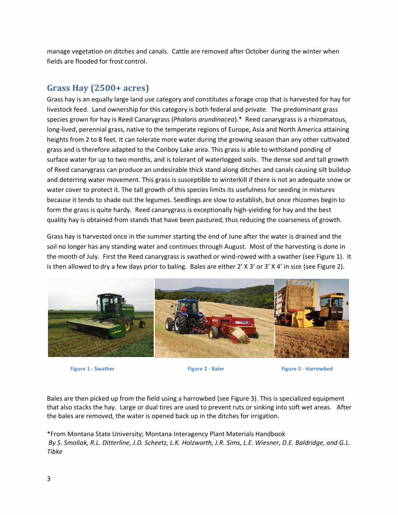
the month of July. First the Reed canarygrass is swathed or wind-rowed with a swather (see Figure 1). It
is then allowed to dry a few days prior to baling. Bales are either 2’ X 3’ or 3’ X 4’ in size (see Figure 2).
Figure 1 - Swather Figure 2 - Baler Figure 3 - Harrowbed
Bales are then picked up from the field using a harrowbed (see Figure 3). This is specialized equipment that also stacks the hay. Large or dual tires are used to prevent ruts or sinking into soft wet areas. After the bales are removed, the water is opened back up in the ditches for irrigation.
*From Montana State University; Montana Interagency Plant Materials Handbook By S. Smoliak, R.L. Ditterline, J.D. Scheetz, L.K. Holzworth, J.R. Sims, L.E. Wiesner, D.E. Baldridge, and G.L. Tibke

4
Wildlife Feed (1500+ acres) The land use category Wildlife Feed is the classification used for those historic agricultural fields that
have been established as wildlife habitat and are not currently being hayed or grazed. Reed canarygrass
and other species are left tall in these areas. This land is irrigated with the majority of it managed by the
Conboy Lake Wildlife Refuge as most of this land classification is federally owned.
Farming (refers to tillage and replant operations) Tillage: Pastures and hay fields are tilled infrequently to reseed with new Reed canarygrass for the sole
purpose of improving forage and hay quality, averaging once every 40-50 years. The entire field is not
tilled at once; usually tillage averages around 2% of the total acreage per year. Tillage is done in the
summer when it is dry after water has been shut off. It is rototilled twice (Figure 4), and then plowed
with a moldboard plow (Figure 5). After plowing, the ground is rototilled again and roller harrowed
(Figure 6) to further break up and level the soil. Tillage depth averages around 8 inches, but can be as
deep as 12 inches.
Figure 4 - Rototiller Figure 5- Plow Figure 6 – Roller harrow
Periodically the field is leveled with a drag. This is an implement that can be pulled across the field
without plugging up in old sod debris and consists of steel cross members that are pulled at a slight
angle to help fill in low areas (Figure 7). Sometimes a dozer is used to level deep or large uneven areas
of the field (Figure 8).
Figure 7 – Drag Figure 8 – Dozer Figure 9 - Drill
Seeding: After fields have been tilled and leveled, seed is planted using a drill or seeder (Figure 9).
Usually Reed canarygrass seed is planted, but sometimes oats will be planted the first year, then grass.
New pastures are seeded in the summer prior to irrigation. Plant establishment before winter is critical
for survival. Mowing is performed annually with a flail mower for several years on newly seeded grass
5
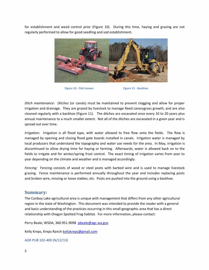
for establishment and weed control prior (Figure 10). During this time, haying and grazing are not
regularly performed to allow for good seedling and sod establishment.
Figure 10 - Flail mower Figure 11 - Backhoe
Ditch maintenance: Ditches (or canals) must be maintained to prevent clogging and allow for proper
irrigation and drainage. They are grazed by livestock to manage Reed canarygrass growth, and are also
cleaned regularly with a backhoe (Figure 11). The ditches are excavated once every 10 to 20 years plus
annual maintenance to a much smaller extent. Not all of the ditches are excavated in a given year and is
spread out over time.
Irrigation: Irrigation is all flood type, with water allowed to free flow onto the fields. The flow is
managed by opening and closing flood gate boards installed in canals. Irrigation water is managed by
local producers that understand the topography and water use needs for the area. In May, irrigation is
discontinued to allow drying time for haying or farming. Afterwards, water is allowed back on to the
fields to irrigate and for winter/spring frost control. The exact timing of irrigation varies from year to
year depending on the climate and weather and is managed accordingly.
Fencing: Fencing consists of wood or steel posts with barbed wire and is used to manage livestock
grazing. Fence maintenance is performed annually throughout the year and includes replacing posts
and broken wire, missing or loose stables, etc. Posts are pushed into the ground using a backhoe.
Summary: The Conboy Lake agricultural area is unique with management that differs from any other agricultural
region in the state of Washington. This document was intended to provide the reader with a general
and basic understanding of the practices occurring in this small geographic area that has a direct
relationship with Oregon Spotted Frog habitat. For more information, please contact:
Perry Beale, WSDA, 360.951.9098 [email protected]
Kelly Kreps, Kreps Ranch [email protected]
AGR PUB 102-400 (N/12/13)
Related Documents

![[Ken Conboy] Kopassus Inside Indonesia's Special](https://static.cupdf.com/doc/110x72/577c7e941a28abe054a1ae19/ken-conboy-kopassus-inside-indonesias-special.jpg)