Principal Gary Blumberg BSc(Eng)Civil MSc(Eng) MIEAust CPEng NPER3 © Copyright The concepts and information in this document are the property of Gary Blumberg & Associates Pty Ltd. Use of this document or passing onto others or copying, in part or in full, without the written permission of Gary Blumberg & Associates, is an infringement of copyright. 6A Market Street East P O Box 572 fax 02 9460 7664 NAREMBURN NSW 2065 CAMMERAY NSW 2062 ph 02 9460 7663 AUSTRALIA mobile 0416 037 336 E -mail [email protected] gpb:gpb/07-7/lr728 7 July, 2008 Watkinson Apperley Pty Ltd P O Box 495 NOWRA NSW 2541 Attention: Mr David Cannon Dear David PROPOSED 57 LOT RESIDENTIAL SUBDIVISION, MANYANA COASTAL ENGINEERING ASSESSMENT We refer to discussions between Mr Gary Blumberg of Gary Blumberg & Associates (GBA) and Mr David Cannon of Watkinson Apperley Pty Ltd (WA) regarding the above. WA has engaged GBA to examine coastal hazards, address protection and conservation of the sand dune, and provide advice on stormwater impacts and mitigation in relation to the coastal margin, for the proposed 57 lot residential subdivision at Manyana. Our advice is set out below under the following main headings: • Introduction • Collation and Review of Background Information • Site Inspection • Coastal Management Context • Assessment of Relevant Coastal Hazards and Mitigation Measures • Protection and Conservation of the Dunal System • Interaction between Creek Flooding and Coastal Inundation • Summary • References All reference to Relative Level (RL) in this report is made to Australian Height Datum (AHD) . AHD is approximately equal to Mean Sea Level. We acknowledge discussions and input provided by Mr Ray Massie, Shoalhaven City Council (SCC) , and Mr Muhammed Habib Ullah, Department of Environment and Climate Change (DECC) . Gary Blumberg & Associates Pty Ltd Consulting Engineers ACN 085 739 322 COASTAL, ESTUARY AND RIVER ENGINEERING SPECIALISTS

Welcome message from author
This document is posted to help you gain knowledge. Please leave a comment to let me know what you think about it! Share it to your friends and learn new things together.
Transcript
Principal Gary Blumberg BSc(Eng)Civil MSc(Eng) MIEAust CPEng NPER3 © Copyright The concepts and information in this document are the property of Gary
Blumberg & Associates Pty Ltd. Use of this document or passing onto others or copying, in part or in full, without the written permission of Gary Blumberg & Associates, is an infringement of copyright.
6A Market Street East P O Box 572 fax 02 9460 7664 NAREMBURN NSW 2065 CAMMERAY NSW 2062 ph 02 9460 7663 AUSTRALIA mobile 0416 037 336 E -mail [email protected] gpb:gpb/07-7/lr728
7 July, 2008 Watkinson Apperley Pty Ltd P O Box 495 NOWRA NSW 2541 Attention: Mr David Cannon Dear David PROPOSED 57 LOT RESIDENTIAL SUBDIVISION, MANYANA COASTAL ENGINEERING ASSESSMENT We refer to discussions between Mr Gary Blumberg of Gary Blumberg & Associates (GBA) and Mr David Cannon of Watkinson Apperley Pty Ltd (WA) regarding the above. WA has engaged GBA to examine coastal hazards, address protection and conservation of the sand dune, and provide advice on stormwater impacts and mitigation in relation to the coastal margin, for the proposed 57 lot residential subdivision at Manyana. Our advice is set out below under the following main headings: • Introduction • Collation and Review of Background Information • Site Inspection • Coastal Management Context • Assessment of Relevant Coastal Hazards and Mitigation Measures • Protection and Conservation of the Dunal System • Interaction between Creek Flooding and Coastal Inundation • Summary • References All reference to Relative Level (RL) in this report is made to Australian Height Datum (AHD). AHD is approximately equal to Mean Sea Level. We acknowledge discussions and input provided by Mr Ray Massie, Shoalhaven City Council (SCC), and Mr Muhammed Habib Ullah, Department of Environment and Climate Change (DECC).
Gary Blumberg & Associates Pty Ltd Consulting Engineers
ACN 085 739 322
CO
AST
AL,
EST
UARY
AN
D R
IVER
EN
GIN
EERI
NG
SPE
CIA
LIST
S
Gary Blumberg & Associates Manyana Subdivision Coastal Assessment Reference: gpb:gpb/07-7/lr728 7 July 2008
Page 2 of 27
1 INTRODUCTION
1.1 BACKGROUND
A joint venture between Vacenta Pty Ltd and JWA Enterprises Pty Ltd is proposing a 57 lot residential subdivision of three existing properties at Manyana in Shoalhaven LGA, NSW South Coast. The three properties (jointly referred to here as the subject property or site) form previous subdivisions, and the proposal seeks infill development of residual lots. WA has confirmed that the proposed 57 lots will be Torrens Title, covering 5.59 ha of the total 9.56 ha site. The residential land (3.97 ha), representing 40% of the site, is proposed to be dedicated to SCC as a public reserve lot (proposed Lot 158 in the subdivision). According to SCC the subject property falls within the Coastal Zone, with a strip along the eastern boundary classified as Sensitive Coastal location. WA advise that the subdivision therefore falls under SEPP (Major Projects) 2005. Stormwater and ASS management are components of the subdivision proposal. Sewerage infrastructure, owned and operated by SCC, is also a relevant consideration. The aim of GBA’s investigation was to develop a Coastal Hazard Assessment to satisfy the requirements of the Director General (Department of Planning) for input to an Environmental Assessment Report.
1.2 STUDY AREA
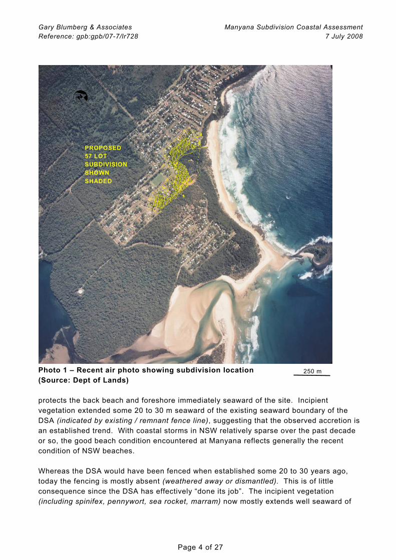
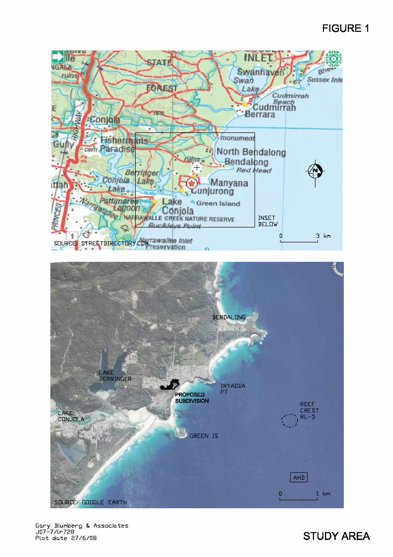
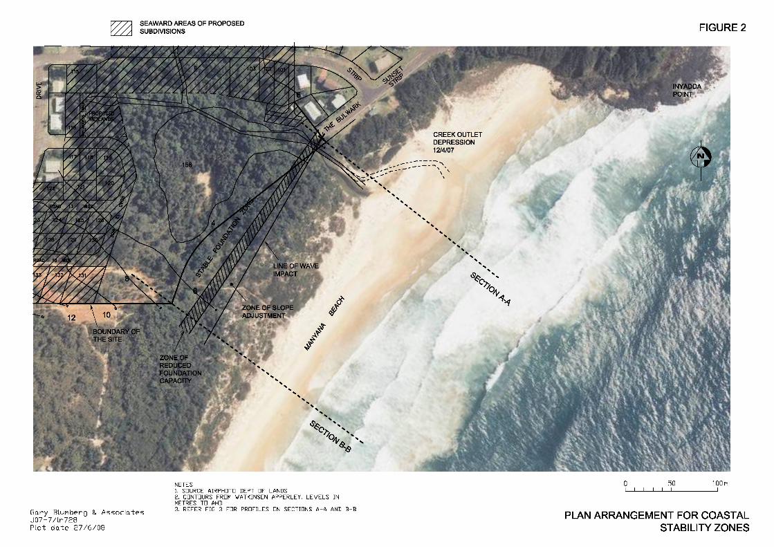
The study area includes the shoreline and adjoining foreshore between Green Island and Inyadda Point, immediately north of the entrance to Lake Conjola, NSW South Coast. The study area is shown in Figure 1 and Photo 1. A larger plan showing the seaward portion of the proposed subdivision in relation to Manyana Beach is presented in Figure 2.
1.3 SCOPE OF WORK
The agreed Scope of Work for the consultancy comprised the following main elements: • collation and review of relevant background information • site inspection • identification of suitable planning period • identification and assessment of relevant coastal hazards • measures for mitigation of coastal hazard (if required) • protection and conservation of dunal system • stormwater impacts and mitigation at coastal margin The Scope of Work addresses the scoping requirements as identified in the Brief, and the advice is suitable for DA purposes.
Gary Blumberg & Associates Manyana Subdivision Coastal Assessment Reference: gpb:gpb/07-7/lr728 7 July 2008
Page 3 of 27
Our investigation approach was canvassed broadly with SCC at the time of developing our consultancy proposal (Mr Ray Massie, SCC 8/3/07, pers comm).
2 COLLATION AND REVIEW OF BACKGROUND INFORMATION
An important requirement is to ascertain suitable design storm bite and shoreline recession values for inclusion in the coastal hazard assessment (Section 5.1). There is good generic information on storm erosion demand (storm bite) for the NSW coast, generally accepted by the NSW Government to support coastal assessments. This has been sourced and incorporated. GBA has confirmed with DECC that no aerial photogrammetry exists for Manyana Beach. The nearest open coastal sites with existing photogrammetry are the entrance to Lake Conjola, Narrawallee Beach and Currarong (Mr Bob Clout, DECC Coastal Section, Aerial Photogrammetry, 8/3/07 pers comm). We have also requested from DECC Coastal Section, South Coast, Mr Muhammed Habib Ullah (14/11/07 pers comm) and from SCC Coastal Officer Mr Ray Massie (8/3/07 pers comm) any existing information or available reports dealing with coastal hazards for Manyana or its immediate neighbouring beaches. While numerous water supply strategy investigations are available (1996 – 2001), no information exists on coastal hazards. We note that SCC is in the process of developing a Coastal Management Plan covering its LGA (Section 4.4). It is our understanding that Manyana is not a priority beach, confirmed in discussion with SCC. The Brief attached a preliminary Stormwater Treatment Plan prepared by Storm Consulting (18/1/06). An updated Stormwater Management Plan and Flood Study was supplied later in the investigation program (Watkinson Apperley, May 2008).
3 SITE INSPECTION
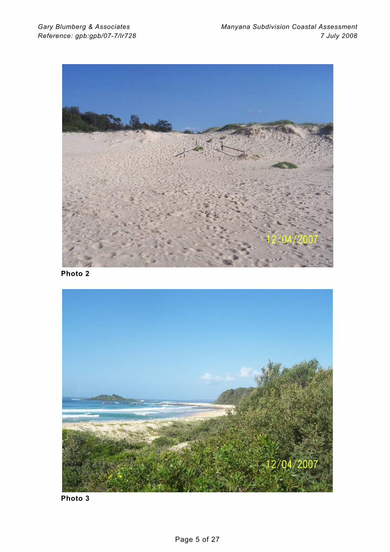
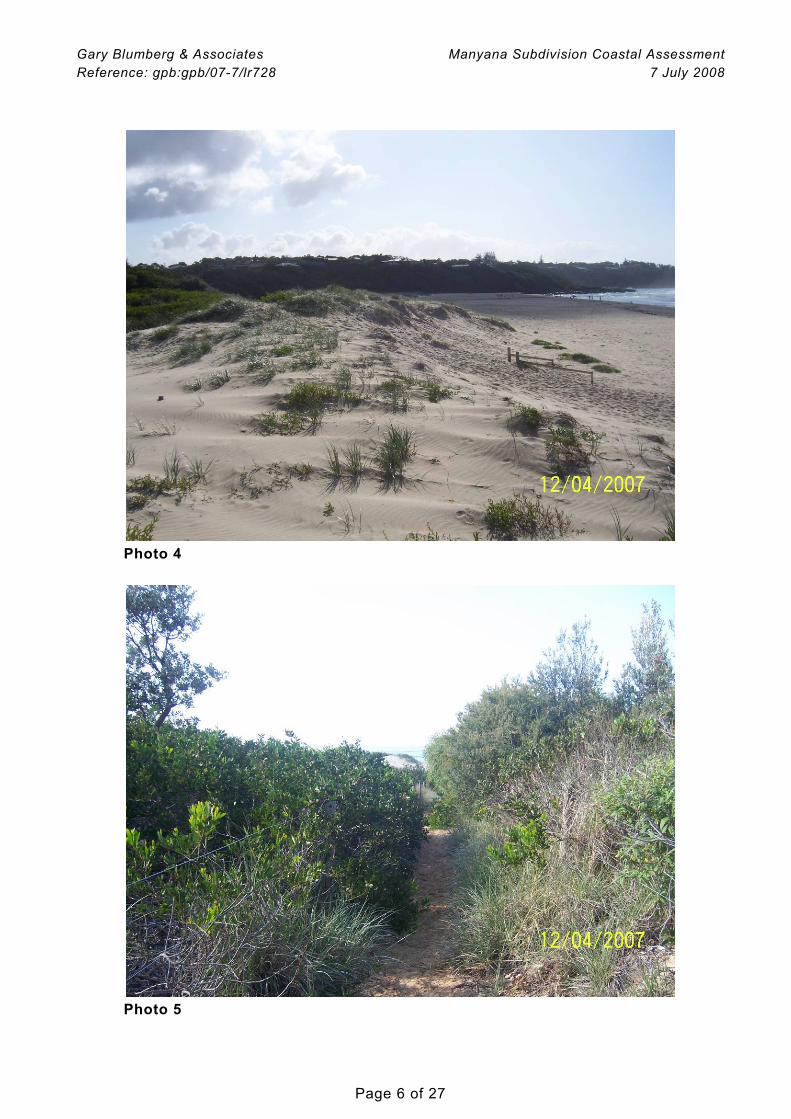
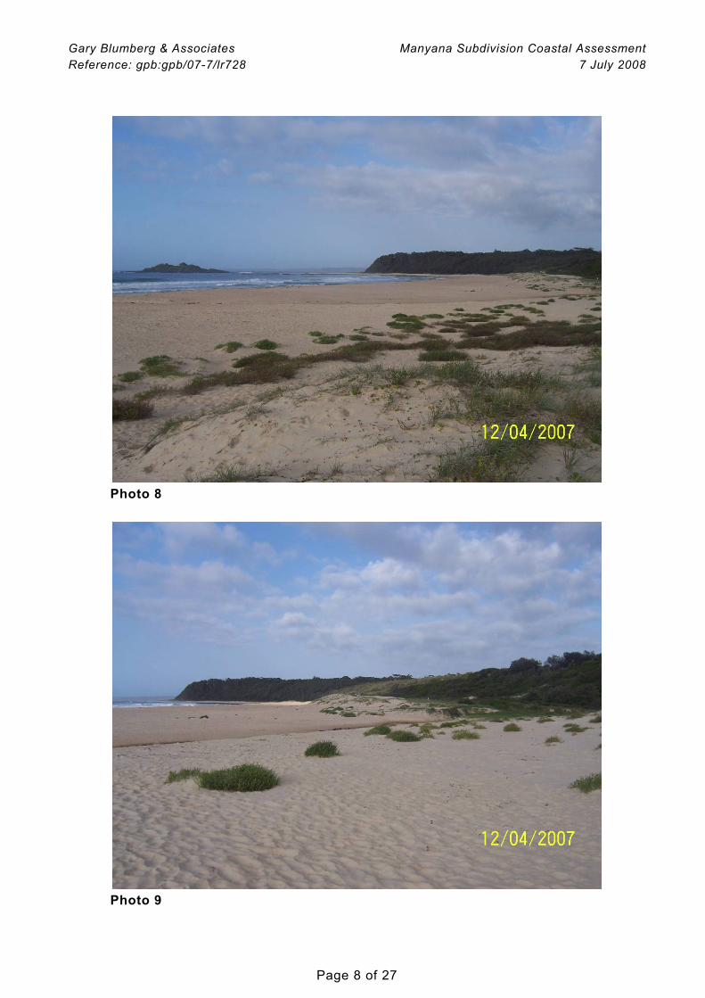
A site inspection was undertaken by Mr Gary Blumberg on 12/4/07 between 8.00 am and 10.00 am. Weather during the inspection was partly cloudy and the breeze light offshore. Showers had fallen in the previous 24 hours. The swell was about 1.5 m from the south, and the predicted tide fell during the inspection from RL -0.2 m to -0.4 m AHD. Tape measurements were used to dimension the subaerial beach and foredune profile. Selected photographs taken during the inspection are included below. Together with available survey and interpretation of aerial photography, these measurements permit an estimation of existing beach sand volumes above Mean Sea Level, included in our assessment of the Beach Stability Zones (Section 5.1). The inspection found the beach fronting the site in a relatively accreted condition. There was no sign of recent erosion of any significance. A Dune Stabilisation Area (DSA)
Gary Blumberg & Associates Manyana Subdivision Coastal Assessment Reference: gpb:gpb/07-7/lr728 7 July 2008
Page 4 of 27
Photo 1 – Recent air photo showing subdivision location (Source: Dept of Lands) protects the back beach and foreshore immediately seaward of the site. Incipient vegetation extended some 20 to 30 m seaward of the existing seaward boundary of the DSA (indicated by existing / remnant fence line), suggesting that the observed accretion is an established trend. With coastal storms in NSW relatively sparse over the past decade or so, the good beach condition encountered at Manyana reflects generally the recent condition of NSW beaches. Whereas the DSA would have been fenced when established some 20 to 30 years ago, today the fencing is mostly absent (weathered away or dismantled). This is of little consequence since the DSA has effectively “done its job”. The incipient vegetation (including spinifex, pennywort, sea rocket, marram) now mostly extends well seaward of
250 m
PROPOSED 57 LOT SUBDIVISION SHOWN SHADED
Gary Blumberg & Associates Manyana Subdivision Coastal Assessment Reference: gpb:gpb/07-7/lr728 7 July 2008
Page 5 of 27
Photo 2
Photo 3
Gary Blumberg & Associates Manyana Subdivision Coastal Assessment Reference: gpb:gpb/07-7/lr728 7 July 2008
Page 6 of 27
Photo 4
Photo 5
Gary Blumberg & Associates Manyana Subdivision Coastal Assessment Reference: gpb:gpb/07-7/lr728 7 July 2008
Page 7 of 27
Photo 6
Photo 7
Gary Blumberg & Associates Manyana Subdivision Coastal Assessment Reference: gpb:gpb/07-7/lr728 7 July 2008
Page 8 of 27
Photo 8
Photo 9
Gary Blumberg & Associates Manyana Subdivision Coastal Assessment Reference: gpb:gpb/07-7/lr728 7 July 2008
Page 9 of 27
Photo 10
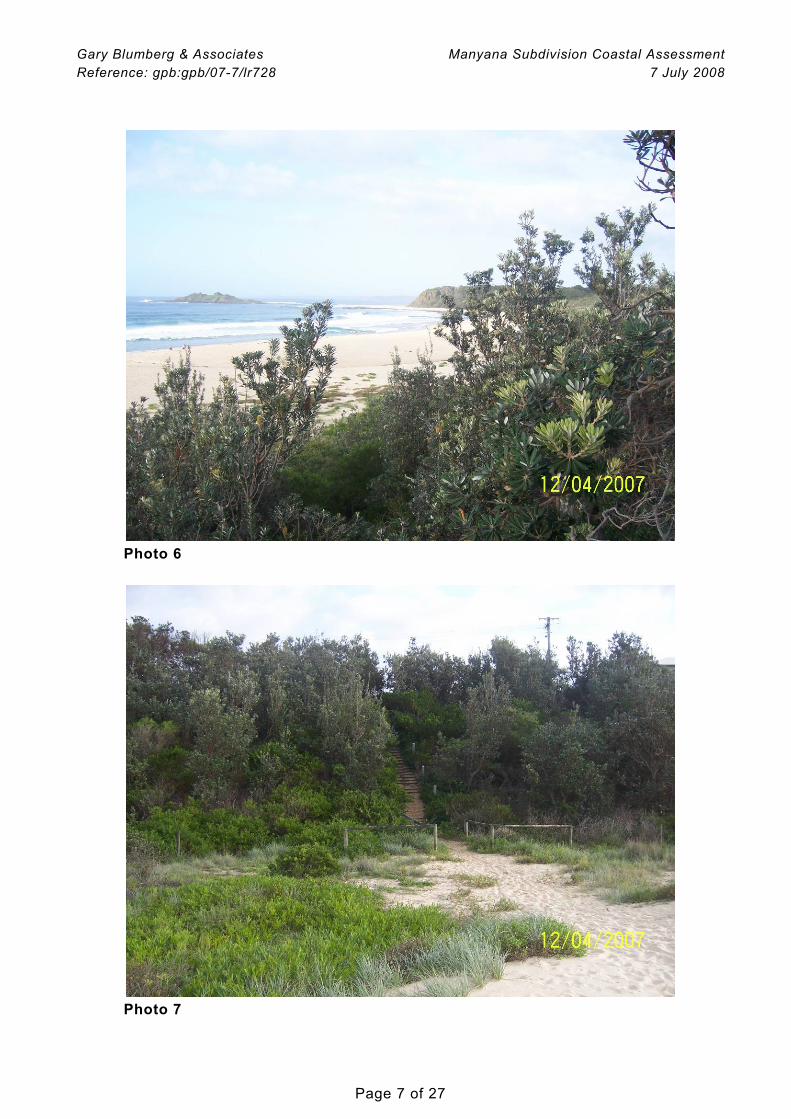
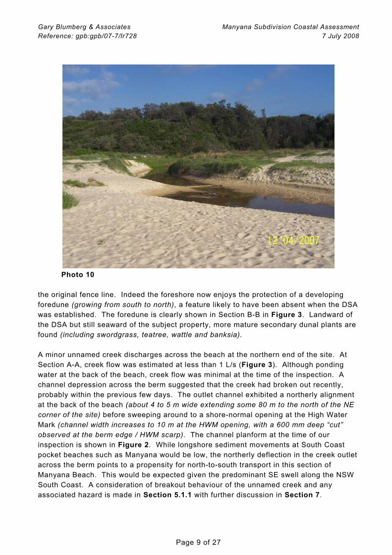
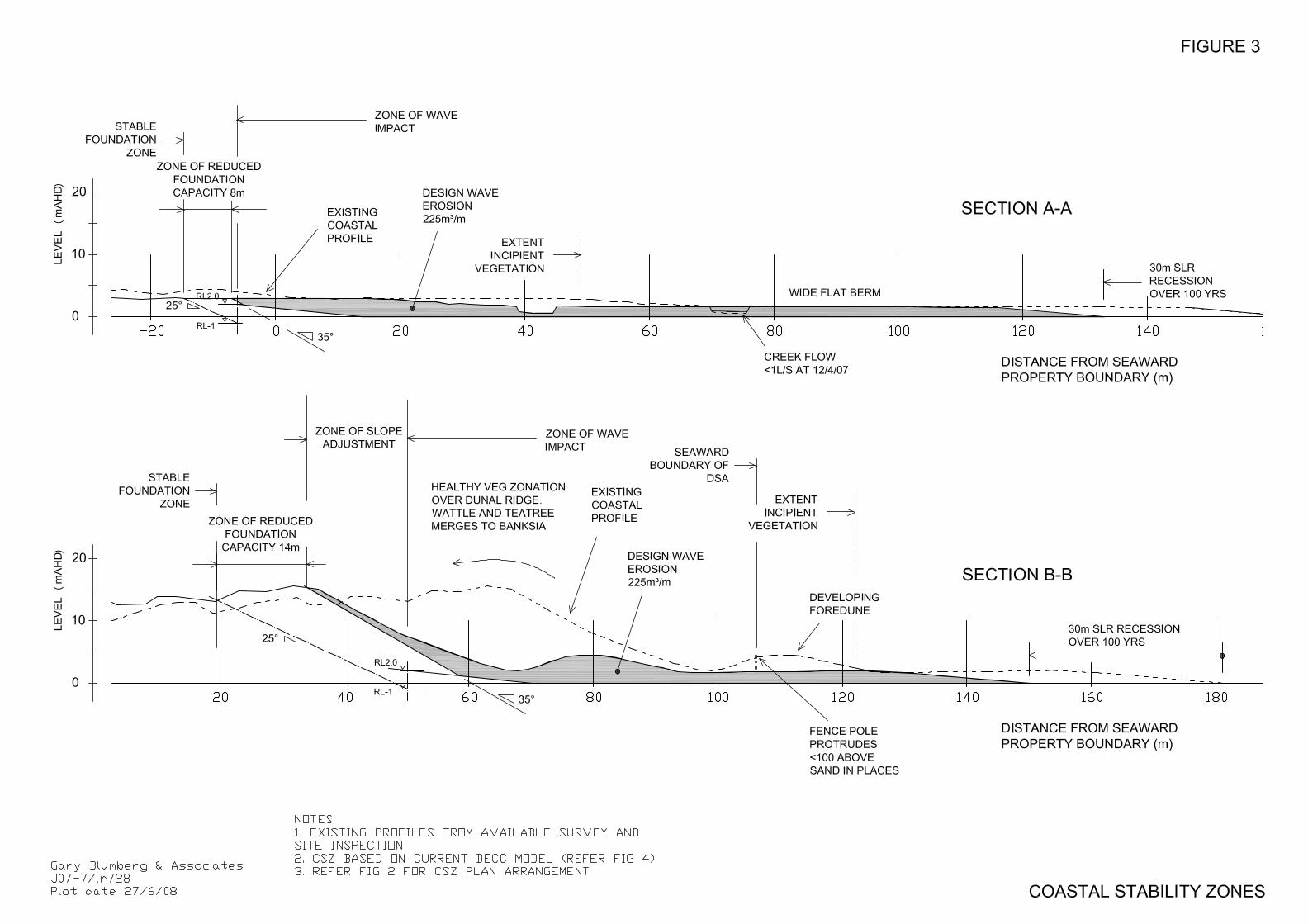
the original fence line. Indeed the foreshore now enjoys the protection of a developing foredune (growing from south to north), a feature likely to have been absent when the DSA was established. The foredune is clearly shown in Section B-B in Figure 3. Landward of the DSA but still seaward of the subject property, more mature secondary dunal plants are found (including swordgrass, teatree, wattle and banksia). A minor unnamed creek discharges across the beach at the northern end of the site. At Section A-A, creek flow was estimated at less than 1 L/s (Figure 3). Although ponding water at the back of the beach, creek flow was minimal at the time of the inspection. A channel depression across the berm suggested that the creek had broken out recently, probably within the previous few days. The outlet channel exhibited a northerly alignment at the back of the beach (about 4 to 5 m wide extending some 80 m to the north of the NE corner of the site) before sweeping around to a shore-normal opening at the High Water Mark (channel width increases to 10 m at the HWM opening, with a 600 mm deep “cut” observed at the berm edge / HWM scarp). The channel planform at the time of our inspection is shown in Figure 2. While longshore sediment movements at South Coast pocket beaches such as Manyana would be low, the northerly deflection in the creek outlet across the berm points to a propensity for north-to-south transport in this section of Manyana Beach. This would be expected given the predominant SE swell along the NSW South Coast. A consideration of breakout behaviour of the unnamed creek and any associated hazard is made in Section 5.1.1 with further discussion in Section 7.
Gary Blumberg & Associates Manyana Subdivision Coastal Assessment Reference: gpb:gpb/07-7/lr728 7 July 2008
Page 10 of 27
The sand comprising the beach and dune at Manyana is clearly medium to fine grained marine sand. Organics present in the sediments close to the creek entrance. Shell, and to a lesser extent lithics (terrestrial materials), also occur. An assessment of the composition, size and grading of shoreline sediments can be used to help characterise gross sediment transport pathways and trends. This is a specialised technique, useful where longshore transport behaviour is a primary consideration. Not so for this assessment where onshore-offshore behaviour is more relevant. Having inspected the site and appraised the coastal parameters, its our submission that little insight would be gleaned from a closer analysis of the shoreline sediments. The beach berm fronting the site was found to be relatively low, estimated at between RL 1.5 and 2.0 (Figure 3). For pocket beaches with relatively low sediment supply and movement (low sediment flux), a low berm would typically reflect low incident wave energy. This seems reasonable for Manyana given the shelter that Green Island would provide against S to SE swells. The berm width here is approximately 50 m. In relation to wave protection, we also note that the rock headland of Inyadda Point appears to extend offshore, protrude to RL 5 some 2 km from the coastline (AUS 807).
4 COASTAL MANAGEMENT CONTEXT
To provide a context for the coastal assessment at Manyana, the matter of planning period is discussed and a suitable period selected. Various relevant coastal planning and assessment documents are also briefly considered.
4.1 Planning Period
SCC typically requires a 50 year planning period for coastal engineering assessments for individual residential developments, although aspects of residential coastal planning applied at some beaches in the Shoalhaven (eg Mollymook) allow for a 100 year planning horizon. Infrastructure assets (eg roads, sewer mains etc) normally require a 100 year planning period. For beach-wide Local Government coastal planning in NSW, 50 years is most widely used (eg Coastal Management Plans) although there would seem to be a trend at the State level to a longer timeframe. We note that the NSW Government has recently adopted 100 years for its NSW Coastal Lands Risk Assessment (DIPNR, 2005). The appropriate planning period for coastal engineering assessments for residential subdivisions is less certain. For instance, it might be reasonable to apply 50 years to a minor subdivision, but 100 years to a larger subdivision which incorporates bona-fide infrastructural elements.
Gary Blumberg & Associates Manyana Subdivision Coastal Assessment Reference: gpb:gpb/07-7/lr728 7 July 2008
Page 11 of 27
For this coastal assessment GBA has adopted a conservative planning period of 100 years.
4.2 NSW Coastline Management Manual
The Coastline Management Manual (NSW Government, 1990) sets down a framework for local councils to manage the coastline in accordance with State Government requirements. The Coastline Management Manual forms part of the implementation of the NSW Coastal Policy. The Coastline Management Manual is the subject of a current review by DECC. The coastal hazard assessment for the site, set out in Section 5, is based on the methodology outlined in the current Coastline Management Manual.
4.3 SEPP 71 – Coastal Protection
The Department of Planning and SCC would be expected to refer this application to DECC under SEPP 71 – Coastal Protection. SEPP 71, gazetted in November 2002, was made to ensure consistency in respect of coastal planning and management in NSW, particularly for new development.
4.4 Coastline Risk Management in Shoalhaven LGA
SCC has developed a coastal hazard overview for developed coastal areas within the Shoalhaven (SMEC, 2004). The hazards identified comprised coastal erosion, coastline recession and oceanic inundation. Risks were assessed for the 1% event occurring today (2004), and at the end of 50 and 100 year planning periods. SCC is currently preparing a city-wide Coastal Management Plan. Scoped on the basis of SMEC (2004), this will detail sustainable development and emergency management of public and private assets in the coastal zone. The hazard studies are largely complete, however work is continuing with community consultations. At the time of preparing this report GBA had not sighted the draft CMP which was not yet a public document. Manyana Beach is notably excluded from the Shoalhaven coastal risk report, and we understand that the beach receives little if any reference within the CMP. Thus in the context of the Shoalhaven, Manyana Beach is not considered to pose a coastal risk. This is an important outcome, consistent with our discussion with SCC (Mr Ray Massie, 8/3/07 pers comm) and consistent with the findings of this investigation (Section 5).
Gary Blumberg & Associates Manyana Subdivision Coastal Assessment Reference: gpb:gpb/07-7/lr728 7 July 2008
Page 12 of 27
5 ASSESSMENT OF RELEVANT COASTAL HAZARDS AND MITIGATION MEASURES
The NSW Government Coastline Management Manual (1990) identifies the following potential coastal hazards for consideration in a Coastal Engineering Assessment: • beach erosion • shoreline recession • coastal entrance instability • sand drift • coastal inundation • stormwater erosion hazard • slope and cliff instability • climate change Beach erosion, shoreline recession and coastal entrance instability can markedly alter the shape of the coastline. If not properly catered for, these hazards can imperil coastal developments and reduce amenity. Sand drift may contribute to a permanent loss of sand from the beach. It is at best a nuisance, although it too can overwhelm nearby developments. Low-lying areas of the coast may be threatened by coastal inundation caused by storm surges and the action of large waves. Slope and cliff stability problems are a threat to the structural integrity of buildings constructed on coastal bluffs and steep sand dunes. Climate change attributed to the Greenhouse Effect can exacerbate all of the above hazards, but in particular shoreline recession and coastal inundation. The potential hazards for the site are listed in the Brief as shoreline recession (Section 5.1.2), storm bite (or beach erosion, Section 5.1.1), and wave run up and coastal inundation (Section 5.2 and Section 7). Coastal entrance stability is also relevant, related here to beach erosion (Section 5.1.1). To satisfy SCC and the NSW Government, the hazards of climate change need to be included (mainly impact of Greenhouse Sea Level Rise, Section 5.4). As indicated above, slope instability is also important to define the Beach Stability Zones, including the Stable Foundation Zone and Zone of Reduced Foundation Capacity (Section 5.1.4). These hazards are addressed below.
5.1 Beach Erosion and Shoreline Recession
Beach erosion refers to the loss of beach and dune sand in a storm or closely-linked series of storms. Shoreline recession refers to the long-term retreat of the shoreline, often attributed to incomplete beach recovery following erosion events. Sea Level Rise (SLR) due to the Greenhouse Effect also contributes to shoreline recession. 5.1.1 Beach Erosion
Beach erosion is commonly measured in volumetric terms above AHD. For the adopted 100 year planning period, design beach erosion on the NSW open coast
Gary Blumberg & Associates Manyana Subdivision Coastal Assessment Reference: gpb:gpb/07-7/lr728 7 July 2008
Page 13 of 27
typically ranges from 140 to 225 m3/m, depending on degree of coastal exposure (Gordon, 1987). For this assessment we have conservatively applied a maximum beach erosion value of 225 m3/m. As is common (and conservative) practice, GBA has applied the design storm erosion demand at the end of 100 years, following predicted shoreline recession (Section 5.1.2) and including the effects of Greenhouse Sea Level Rise SLR (Section 5.4). During a storm, beach erosion nominally consumes beach sand down to approximately Mean Sea Level (MSL). Fluidisation of the sand to a further 1 m below MSL can also occur along an eroding beach. Localised scour at a hard shore structure may even extend to lower levels. Also, the back beach erosion escarpment will be quite steep during the height of the storm, but will slump to a more gentle slope as the storm subsides and embankment dries out. To account for the effects of toe scour and post-storm slumping, it is common practice to apply slope stability techniques to define the Beach Stability Zones (Section 5.4.1). Natural entrances tend to migrate along a beach in response to freshwater flooding and coastal storm effects, potentially threatening any adjacent developments and compromising beach amenity (NSW Government, 1990). The morphology of the dune at the existing creek entrance would be expected to constrain the entrance location at the back of Manyana Beach, to more or less its existing location. GBA has observed the outlet channel depression across the berm, extending some 80 m to the north from its back beach position (Section 3). Larger excursions could occur in response to episodes of increased longshore sediment flux and intermittent creek flows. However, larger rainfall events associated with breakouts would tend to channel the outlet directly seaward of its back beach location rather than maintain or enhance a longshore excursion. Breakouts are usually associated with increased back beach scour, potentially lowering the subaerial beach within the breakout channel to approximately RL 0. Lower scour levels can occur, but this would most likely be limited to the influence of wave reflections from back beach features (eg dune) or shore structures. It would be our submission that the conservatively adopted 225 m3/m beach erosion (see above) would incorporate an allowance that might reasonably apply in respect of creek entrance hazard and Manyana Beach. Entrances can be structurally trained to manage longshore migration, however this is not common practice for a small creek and frequently causes more problems than it solves. Since the allotments and infrastructure comprising the proposed subdivision are well set back from the beach at Manyana, neither entrance migration nor breakout poses a risk to the project. Training of the creek entrance at Manyana is not proposed or required.
Gary Blumberg & Associates Manyana Subdivision Coastal Assessment Reference: gpb:gpb/07-7/lr728 7 July 2008
Page 14 of 27
5.1.2 Shoreline Recession
Shoreline recession may be quantified in volumetric terms (as above for beach erosion but in m3/m per yr) or in terms of horizontal retreat (simply m/yr). The latter approach is more commonly applied and understood, considered here for the subject property. No aerial photogrammetric assessment has been completed for Manyana Beach. This is not unexpected given the low coastal risk status attributed to the beach (Section 4.4). We understand from DECC Newcastle that the closest aerial photogrammetry covers the entrance to Lake Conjola south of the site, however this does not extend much beyond the entrance itself. Photogrammetry also exists for open coast Narrawallee and Mollymook Beaches (6 and 10 km to the south respectively), and Currarong Beach (over 40 km to the north). There is no evidence, anecdotal or otherwise, to suggest that the beach fronting the site is receding in the longer term. Indeed, the development of the frontal dune over the last 20 years or so points to accretion rather than recession (Section 3 and Figure 3). This is in spite of any recession which may have been expected over this period due to Greenhouse SLR. Note that tidal records along the NSW coast suggest that sea level may have risen by approximately 5 to 10 cm over the past 50 years (Mr James Carly, UNSW WRL, presentation to EA Maritime Panel, August 2006). According to the Bruun Rule, this sea level rise should have led to recession of some 2.5 to 5 m over this period which we do not observe at this time (Section 5.4). Disregarding SLR recession potential considered separately below, the beach at Manyana is likely to be accreting in the longer term. It is not common practice to adopt long term accretion when setting coastal hazard lines in NSW. For this assessment, GBA has chosen to conservatively fully disregard any long term accretion and adopt a zero long term recession rate for Manyana Beach. Separate to the assessment above, shoreline recession due to future Greenhouse SLR must be accounted for, addressed in Section 5.4.
5.1.3 Combined Beach Erosion and Shoreline Recession
The combination of design beach erosion and shoreline recession, including the effects of SLR, are depicted in Figure 3.
Gary Blumberg & Associates Manyana Subdivision Coastal Assessment Reference: gpb:gpb/07-7/lr728 7 July 2008
Page 15 of 27
5.1.4 Slope Instability
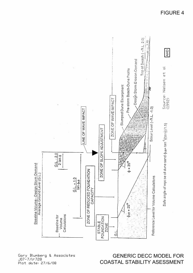
DECC currently adopts the model developed in Nielsen et al (1992) as the methodology for describing the Coastal Stability Zones. A schematic of the generic model identifying the various stability zones is shown in Figure 4. The soil mass located within the Stable Foundation Zone is assessed to develop a Factor Safety (FOS) against slumping which is generally in excess of 1.5. The soil mass located with the Zone of Reduced Foundation Capacity is assessed to develop an FOS against slumping which is generally between 1.0 and 1.5. The soil mass located within the Zone of Slope Adjustment is assessed to develop an FOS against slumping which is generally less than 1.0. An FOS of 1.5 would generally be regarded as a minimum acceptable FOS for embankment zones occupied by residential development. The Coastal Stability Zones for the Manyana site are depicted in Section A-A and Section B-B in Figures 2 and 3, representative of the northern and southern areas of the site respectively. The Line of Wave Impact is assessed to be located 50 m seaward of the SE corner of the site, but 6 m landward or inside the NE corner. The Zone of Reduced Foundation Capacity is well seaward of the property at its southern end, crossing the seaward property boundary (Lot 158) in the vicinity of the creek close to the NE corner (Figure 3). Since the subdivided lots are shown to be located well within the Stable Foundation Zone, even at the relatively exposed northern end of the site, for the purposes of this assessment it is considered reasonable to demarcate the stability zones based on the calculations at Section A-A and Section B-B, and to fit a line between these intercepts which broadly follows the sweep of the shoreline. There is no suggestion that the simplicity of the assessment could offset the substantial contingency that applies in respect of the large proposed coastal buffers to the subdivided residential sites and the subdivision infrastructure. This assessment is therefore quite clear – no beach erosion and shoreline recession hazard applies to the subdivision layout as proposed. Since all residential allotments fall within the Stable Foundation Zone, no special foundation treatments would be required.
Gary Blumberg & Associates Manyana Subdivision Coastal Assessment Reference: gpb:gpb/07-7/lr728 7 July 2008
Page 16 of 27
5.2 Coastal Inundation Coastal inundation is the flooding of coastal lands by ocean waters. Elevated coastal water levels during storms, and wave run up and overtopping, both contribute to coastal inundation. 5.2.1 Elevated Coastal Water Levels
Sustained coastal water levels in storms can be elevated considerably above normal tide levels. Having regard to numerous investigations carried out up and down the NSW coast, and making prudent allowance for astronomical tide (RL 1.0), storm surge (0.6 m) and wave setup (1.0 – 1.2 m), we would gauge the design 100 year ARI elevated coastal water level at Manyana Beach at approximately RL 2.6 to 2.8. This assessment recognises that Manyana Beach is reasonably exposed, but does enjoy some degree of protection from the high energy S to SE wave sector due to the presence of Green Island. There is also a submerged reef at approximately RL -5, located some 2 km offshore from Inyadda Point (Section 3 and Figure 1).
5.2.2 Wave Runup and Overtopping
Wave run up is the rush of water up the beach due to wave breaking. Wave run up is measured as the vertical height above Still Water Level (SWL) to which the rush of water reaches. Wave overtopping is the potential passing of water over the top of a back beach feature, eg back beach erosion escarpment or dune. There are a range of methods for calculating wave run up and overtopping, however few procedures apply to back beach situations. To make our assessment of design wave run up for the site, we have adopted procedures outlined in Hanslow and Nielsen (1995). We understand that this approach is broadly accepted by coastal engineers in NSW, including DECC, for calculation of wave run up on beaches (Mr David Hanslow, DECC, 2/11/07 pers comm). Based on their own field measurements of wave run up made at five NSW beaches, Hanslow and Nielsen propose a modification to the established method of Hunt (1959) to estimate wave run up based on wave height (H), inshore wave length (L) and beach slope (β). We have assumed the run up slope to equal the average slope between the wave break point and the design wave run up level (same assumption adopted by NSW Department of Commerce, Manly Hydraulics Laboratory, in the Yamba Coastline Management Study, MHL 2002). The procedure is iterative in that the run up slope is only established after calculation of run up level, however the solution quickly converges.
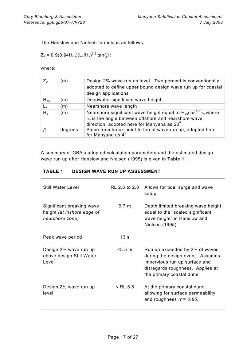
Gary Blumberg & Associates Manyana Subdivision Coastal Assessment Reference: gpb:gpb/07-7/lr728 7 July 2008
Page 17 of 27
The Hanslow and Nielsen formula is as follows: Z2 = 0.9(0.94Hos)(Ls/Hs)0.5 tan(β) where: Z2 (m) Design 2% wave run up level. Two percent is conventionally
adopted to define upper bound design wave run up for coastal design applications
Hos (m) Deepwater significant wave height Ls (m) Nearshore wave length Hs (m) Nearshore significant wave height equal to Hoscos1/2ao
where ao is the angle between offshore and nearshore wave direction, adopted here for Manyana as 20o
β degrees Slope from break point to top of wave run up, adopted here for Manyana as 4o
A summary of GBA’s adopted calculation parameters and the estimated design wave run up after Hanslow and Nielsen (1995) is given in Table 1. TABLE 1 DESIGN WAVE RUN UP ASSESSMENT
Still Water Level RL 2.6 to 2.8 Allows for tide, surge and wave
setup
Significant breaking wave height (at inshore edge of nearshore zone)
9.7 m Depth limited breaking wave height equal to the “scaled significant wave height” in Hanslow and Nielsen (1995)
Peak wave period 13 s Design 2% wave run up above design Still Water Level
<3.5 m Run up exceeded by 2% of waves during the design event. Assumes impervious run up surface and disregards roughness. Applies at the primary coastal dune
Design 2% wave run up level
< RL 5.8 At the primary coastal dune allowing for surface permeability and roughness (r = 0.85)
Gary Blumberg & Associates Manyana Subdivision Coastal Assessment Reference: gpb:gpb/07-7/lr728 7 July 2008
Page 18 of 27
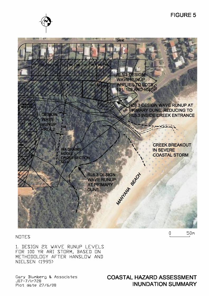
The calculation shows that the design 2% wave run up at the primary coastal dune ranges up to 3.5 m, disregarding surface permeability and roughness. Allowing for a nominal roughness factor of 0.85, the 3.5 m design wave run up would reduce to 3.0 m. When added to the design Still Water Level (SWL), this indicates design wave run up at the coastal dune not exceeding RL 5.8 (3.0 + 2.8). For the case of severe creek breakout which may occur at the same time as the design coastal storm, incident waves could penetrate the scoured entrance depending on the magnitude of the outlet flows. If it is assumed that the outlet flows do not impede wave penetration (confirmed for the design case, refer Section 7), then according to Hanslow and Nielsen a reduction in the design wave run up proportional to the effective reduction in bed slope might reasonably apply [Z2 is directly and linearly proportional to tan(β), see above]. In our assessment the adopted 4o run up slope β would reduce to approximately 2.5 o when the additional 150+ m distance between the break point and the run up point is included. The additional distance of 150 m (min) is the distance from the run up point on the primary coastal dune, to the run up point at the edge of the flooded creek inside the entrance. This suggests that the design wave run up at the edge of the flooded creek inside the entrance would be 35 to 40% less than that at the primary coastal dune, ie up to 1.7 to 2.0 m, or design run up level less than RL 4.8 (allows for permeability and roughness). Allowing for Greenhouse SLR of 0.5 m over the 100 year planning period (Section 5.4), GBA calculates design 2% wave run up level at RL 6.3 at the primary coastal dune, and RL 5.3 at the flooded creek margin inside the entrance. GBA recommends that the residential allotments proposed at Lots 101, 102 and 103 have regard to the design RL 5.3 coastal inundation level. The residential allotments proposed on the western side of Lot 158 are sufficiently removed from the creek entrance and protected from direct wave action by the primary dune such as not to be impacted by wave run up inside the creek entrance. It would be GBA’s submission that the 100 year ARI peak water levels presented in Table 4.2 of WA (2008) are in excess of the design wave run up levels, after allowance for Greenhouse SLR, that might reasonably apply west of WA Cross Section No 4, ie design wave run up level would be less than RL 4.2 m AHD. A summary of GBA’s coastal hazard inundation assessment is presented in Figure 4.
Gary Blumberg & Associates Manyana Subdivision Coastal Assessment Reference: gpb:gpb/07-7/lr728 7 July 2008
Page 19 of 27
5.3 Sand Drift Sand drift refers to beach sand which is blown landward from the beach and dune. No evidence of problematic blow-outs or sand drift were noted during the site inspection. The foredune in the vicinity of the site is reasonably stabilised with vegetation. Most importantly, the dune and hind dune areas along the coastal margins of the site and immediately seaward are well covered with shrubs and trees, limiting potential for ingress of wind blown sand. The substantial separation of the proposed allotments from the unstabilised back beach areas (>150 m), and the abundance of intervening vegetation, ensure that sand drift is not an issue for the proposed subdivision.
5.4 Climate Change
5.4.1 General
Sea level rise (SLR) is a potential hazard of the Greenhouse Effect. It is predicted to occur in response to the thermal expansion of the upper layers of the world’s oceans and melting of the polar ice sheet. The Intergovernmental Panel on Climate Change has recently reported its SLR scenarios to the years 2090/2099 (IPCC, 2007). IPCC’s current predictions are considered by DECC to be the best information available to assess the likely impact of climate change on sea levels. For coastline hazard assessments in NSW, it has been common practice to consider the average of the SLR scenarios which, for the current IPCC revision, translates to a conservative postulated rise of 0.49 m over the 100 years to 2090/2099. This is based on: (i) 0.34 m as the combined average of the model ranges (Table SPM-3,
IPCC 2007);
(ii) plus 0.15 m to account for uncertainties in carbon feedback and changes in ice sheet flow (p14, 3rd bullet, IPCC 2007).
SLR at the site would lead to shoreline recession, a coastal hazard which presently does not exist (Section 5.1.2). SLR would also increase coastal inundation (Section 5.2).
5.4.2 SLR Contribution to Shoreline Recession
Shoreline recession due to SLR may be estimated using the “Bruun Rule”, a simplified, readily applied and broadly accepted methodology which assumes that the coastal profile will translate landward by a distance equal to the product of the SLR and the slope of the active profile. While the Bruun Rule is limited by various assumptions, it remains the only practical approach to quantifying SLR recession as recognised by DECC (Ranasinghe et al, 2007).
Gary Blumberg & Associates Manyana Subdivision Coastal Assessment Reference: gpb:gpb/07-7/lr728 7 July 2008
Page 20 of 27
Based on a consideration of dune and seabed levels, and storm wave penetration and breaking, we believe it reasonable to adopt 1:60 (v:h) as the approximate slope of the active coastal profile at the site. Thus over the next 100 years, the Bruun Rule predicts shoreline recession due to SLR of approximately 30 m (0.49 x 60). This magnitude of SLR recession is quite reasonable if not conservative, based on our experience with design SLR recession values developed and applied elsewhere along the NSW coast. The above analysis has been incorporated into our assessment of overall shoreline recession and is included in developing the Coastal Stability Zones (Section 5.1, Figures 2 and 3).
5.4.3 SLR Contribution to Coastal Inundation
It would be reasonable to raise the wave run up level by 0.5 m to account for the effects of SLR. While increased wave action at the shoreline may also result due to climate change, the consequences for wave run up are considered to be small relative to SLR increment, and can be neglected. Thus design wave run up at the end of the 100 year planning period could be expected to attain a 2% level up to RL 6.3 at the primary coastal dune, and RL 5.3 at the flooded creek margin inside the entrance (Section 5.2.2).
6 PROTECTION AND CONSERVATION OF DUNAL SYSTEM
The crest of the primary dune at Manyana is observed to stand over 10 m above the beach. This dune crest coincides approximately with the seaward boundary of Lot 158. The subdivided residential allotments are located further landward, set back between approximately 50 and 150 m from the dune crest. The existing MHWM is a 150 m seaward of the dune crest. The dunal system at Manyana forms part of the barrier separating Lake Conjola and Berringer Lake from the ocean. In line with the evolutionary description of the NSW coast developed mainly by Roy and Thom (1981), it would appear that the dune forms part of a so-called Holocene bay head barrier. The evolutionary morphology of such systems are controlled by bedrock outcrops, the onshore movement of sand which accompanied the Holocene sea level rise (~6,000 yrs ago), and subsequent reworking of coastal deposits by wind, waves and currents. GBA understands that Holocene bay head barriers along the NSW South Coast are often “stationary“ in morphological timescales (Chapman et al, 1982). GBA has observed a healthy succession of native shrubs and trees occupying the seaward margin of the primary dune (including swordgrass, teatree, wattle and banksia, Section 3). Recent aerial photography shows that the dunal vegetation extends landward, well into the subject property (Photo 1).
Gary Blumberg & Associates Manyana Subdivision Coastal Assessment Reference: gpb:gpb/07-7/lr728 7 July 2008
Page 21 of 27
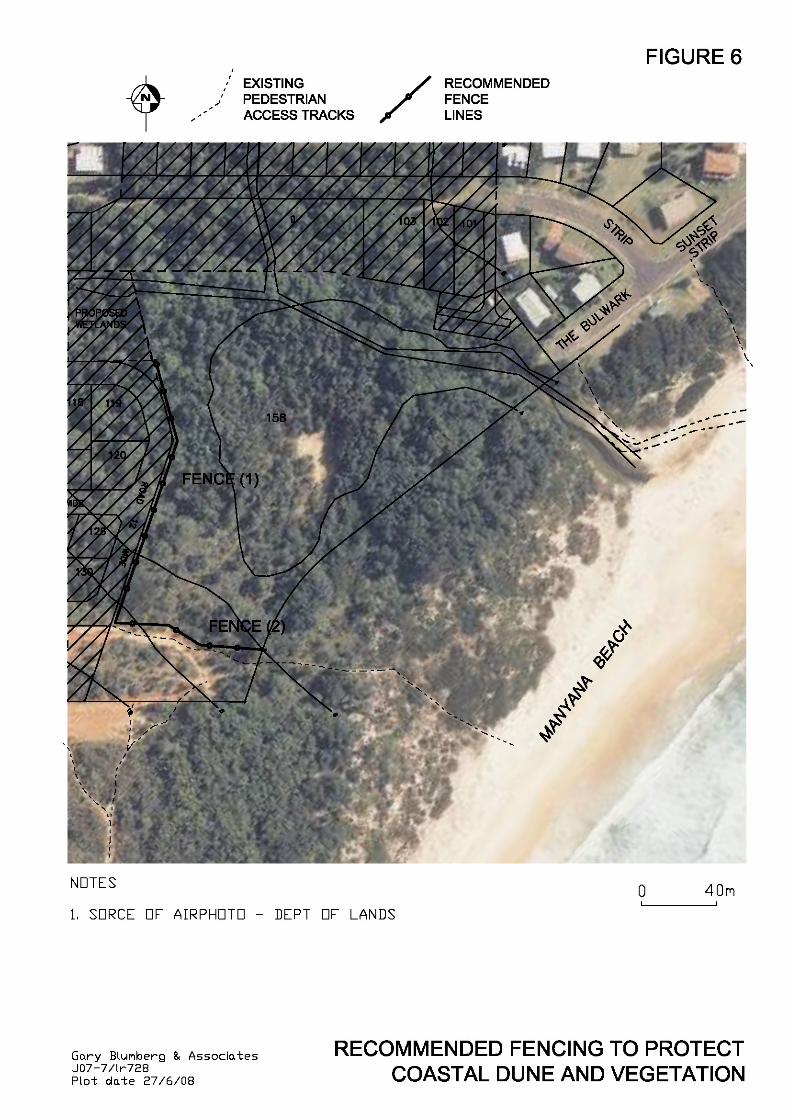
It is generally well known that dune vegetation is particularly susceptible to damage from pedestrian and vehicular traffic. Fences are commonly used for dune protection. Accessways are used to encourage pedestrian and authorised vehicle access across dunes to the beach in a manner that protects both the dunes and the adjoining vegetation. They are usually fenced, to confine the movement of pedestrian and vehicular traffic. The track surfaces are often protected themselves to prevent wind blown sand loss, and to provide traction for traffic (DLWC, 2001). From our understanding of the site and its adjoining dune, GBA believes that it would be prudent to introduce fencing to guide pedestrian access to and from the beach, protecting the dune and its vegetation. It would be beneficial to utilise existing paths where possible. Importantly, we observe no prominent access paths through Lot 158 and we believe this situation should be encouraged to continue. GBA recommends that consideration be given to incorporating two fences in to the proposal: (1) a fence along the eastern edge of the 12 m wide road reserve joining the proposed
wetland area at the NW corner of Lot 158, with the NE corner of Lot 131; and
(2) a fence from the NE corner of Lot 131, running eastward along the northern boundary of the existing footpath and terminating at the eastern boundary of vacant Lot 158.
Both fences could be of the conventional Bayco-type, with 100Ø treated pine poles at 5 m maximum spacing and three 4 mm wire strands (galvanised and PVC coated) equally separated and extending 1.2 m above the ground. Intermediate posts should penetrate 0.6 m into the ground, and end strainer posts 1.0 m into the ground. It is proposed that these fences would be located fully within Lot 158. We note that there is an existing beach accessway at the southern end of The Bulwark, and also near the intersection of The Bulwark and Sunset Strip. These two accessways, which are well established, should readily cater for increased pedestrian usage that may be expected from the northern allotments of the new subdivision. Since they are well defined and connect directly to the beach, no fencing of these accessways would be required. It would be our opinion that surfacing of the pedestrian accessways (eg board-and-chain, crushed sandstone, etc) is not required at Manyana because of low usage levels. Our recommendation for fencing to protect the dune and its vegetation adjacent to the subdivision is shown in Figure 6.
Gary Blumberg & Associates Manyana Subdivision Coastal Assessment Reference: gpb:gpb/07-7/lr728 7 July 2008
Page 22 of 27
7 INTERACTION BETWEEN CREEK FLOODING AND COASTAL INUNDATION HAZARD
The creek outlet at the beach would be mostly closed, breaking out at times of wet weather. During severe coastal storms, the breakout configuration would be directly across the berm, shown conceptually in Figure 5. Waves would attempt to penetrate the creek entrance in a design storm. These waves would be a complex combination of unbroken, breaking and broken wave forms. The incoming waves would interact with the outlet flows from the creek, with the waves generally slowing and steepening. From CERC (2002) it is understood that when an apposing depth-averaged current approaches 25% of the wave speed, the current effectively blocks wave transmission. According to WA (2008), the design 100 year ARI peak discharge at the creek outlet is approximately 26 m3/s. For a channel section set by the predicted 100 year ARI inundation limits (Fig 4.2 in WA 2008) and assuming a design scour of say RL 0 (Section 5.1.1), it follows that maximum velocities at the entrance throat would be unlikely to exceed approximately 0.8 m/s. As the maximum water depth through the entrance would range up to approximately 3 m, it can be shown that the maximum wave speed would be unlikely to exceed 5.5 m/s (square root of 3g for depth limited unbroken wave transmission). Since 0.8 m/s is less than 1.4 m/s (25% of 5.5), it follows that the exit flows from the creek in the design 100 year ARI flood event would be insufficient to block wave penetration into the flooded outlet. Wave penetration and run up at the margin of the flooded creek, upstream of the outlet, would therefore be feasible (Section 5.2.2). WA (2008) report that there is no increase in total peak flows as a result of the proposed development for the 100 year ARI storm. It follows that the entrance scour behaviour post-development would be the same as that pre-development. The peak entrance velocities of up to 0.8 m/s would be sufficient to scour the sandy bed and banks at the creek outlet.
8 SUMMARY
A joint venture between Vacenta Pty Ltd and JWA Enterprises Pty Ltd is proposing a 57 lot residential subdivision of three existing properties at Manyana in Shoalhaven LGA, NSW South Coast. GBA was retained to develop a Coastal Hazard Assessment to satisfy the requirements of the Director General (Department of Planning) for input to an Environmental Assessment Report. The agreed Scope of Work comprised the following: • collation and review of relevant background information • site inspection • identification of suitable planning period
Gary Blumberg & Associates Manyana Subdivision Coastal Assessment Reference: gpb:gpb/07-7/lr728 7 July 2008
Page 23 of 27
• identification and assessment of relevant coastal hazards • measures for mitigation of coastal hazard (if required) • protection and conservation of dunal system • stormwater impacts and mitigation at coastal margin We have confirmed with DECC that no aerial photogrammetry exists for Manyana Beach. While numerous water supply strategy investigations are available (1996 – 2001), no information exists on coastal hazards. We note that SCC is currently developing a Coastal Management Plan covering its LGA and it is our understanding that Manyana is not a priority beach. A site inspection was undertaken by Mr Gary Blumberg in April 2007. The inspection found Manyana Beach in a relatively accreted condition with a well vegetated Dune Stabilisation Area. Manyana Beach is sheltered by Green Island from S to SE swells. A 100 year planning period has been adopted. The assessment covers the following coastal hazards: • beach erosion • shoreline recession • coastal entrance instability • sand drift • coastal inundation • slope instability • climate change Beach erosion refers to the loss of beach and dune sand in a storm or closely-linked series of storms. Shoreline recession refers to the long-term retreat of the shoreline, often attributed to incomplete beach recovery following erosion events. Sea Level Rise (SLR) due to the Greenhouse Effect contributes to shoreline recession. A conservative maximum design beach erosion value of 225 m3/m has been adopted. This incorporates any allowance that might reasonably apply at Manyana in respect of creek entrance hazard. While available evidence suggests that Manyana Beach may be accreting in the longer term, this has been disregarded and a zero long term recession rate adopted. Applying DECC’s current Coastal Stability Zone model, our assessment has found that no beach erosion and shoreline recession hazard applies to the subdivision layout as proposed. Since all residential allotments fall within the Stable Foundation Zone, no special foundation treatments are required. The design elevated coastal water level at Manyana Beach is assessed at approximately RL 2.6 to 2.8 m AHD. The design 2% wave run up at the primary coastal dune is predicted not to exceed RL 5.8 m AHD.
Gary Blumberg & Associates Manyana Subdivision Coastal Assessment Reference: gpb:gpb/07-7/lr728 7 July 2008
Page 24 of 27
For the case of severe creek breakout (which may occur at the same time as the design coastal storm), incident waves could penetrate the scoured entrance. We estimate design wave run up at the edge of the flooded creek, inside the entrance, as 35 to 40% less than that at the primary coastal dune. For coastline hazard assessments in NSW, it has been common practice to consider the average of the Greenhouse Sea Level Rise (SLR) scenarios which, for the current IPCC revision, translates to a conservative postulated rise of 0.49 m over the 100 years to 2090/2099. This is based on 0.34 m as the combined average of the model ranges plus 0.15 m to account for uncertainties in carbon feedback and changes in ice sheet flow. Allowing for Greenhouse SLR of 0.5 m over 100 years, a design wave run up level of RL 6.3 applies at the primary coastal dune, reducing to RL 5.3 at the flooded creek margin inside the entrance. It is recommended that the residential allotments proposed at Lots 101, 102 and 103 have regard to the design RL 5.3 coastal inundation level. The residential allotments proposed on the western side of Lot 158 are sufficiently removed from the creek entrance and protected from direct wave action by the primary dune such as not to be impacted by wave run up inside the creek entrance. SLR at the site would lead to shoreline recession, a coastal hazard which presently does not exist (see above). Based on a consideration of dune and seabed levels, and storm wave penetration and breaking, GBA estimates shoreline recession due to SLR of approximately 30 m. GBA believes that it would be prudent to introduce fencing to guide pedestrian access to and from the beach, protecting the dune and its vegetation. Accordingly it is recommended that consideration be given to incorporating two fences in to the proposal: (1) a fence along the eastern edge of the 12 m wide road reserve joining the proposed
wetland area at the NW corner of Lot 158, with the NE corner of Lot 131; and
(2) a fence from the NE corner of Lot 131, running eastward along the northern boundary of the existing footpath and terminating at the eastern boundary of vacant Lot 158.
Both fences could be of the conventional Bayco-type. No fencing of other local accessways should be required. The substantial separation of the proposed allotments from the unstabilised back beach areas (>150 m), and the abundance of intervening vegetation, ensure that sand drift is not an issue for the proposed subdivision.
Gary Blumberg & Associates Manyana Subdivision Coastal Assessment Reference: gpb:gpb/07-7/lr728 7 July 2008
Page 25 of 27
9 REFERENCES
CERC (1984) Shore Protection Manual US Army Corps of Engineers, Vicksberg, USA CERC (2002) Coastal Engineering Manual EM 1110-2-1100 Chapman DM, Geary M, Roy PS and Thom BG (1982) Coastal Evolution and Coastal Erosion in NSW Coastal Council of NSW, ISBN 0724065822 DLWC (2001) Coastal Dune Management ISBN 0734752024, October 2001 Gordon AD (1987) Beach Fluctuations and Shoreline Change – 1987 8 th Australian Conference on Coastal and Ocean Engineering, Nov 1987 Hanslow D and Nielsen P (1995) Field Measurements of Runup on Natural Beaches !2th Australasian Coastal and Ocean Engineering Conference Melbourne, 28 May-2 June 1995 Hunt LA (1959) Design of Seawalls and Breakwaters Proc ASCE Vol 85, pp 123-152 IPCC (2007) Climate Change 2007 – The Physical Science Basis Summary for Policy Makers Fourth assessment report of Intergovernmental Panel on Climate Change, February 2007 Nielsen AF, Lord DB and Poulos HG (1992) Dune Stability Considerations for Building Foundations Aust. Civ. Eng. Trans., IEAust., Vol. CE 34, 2 NSW Department of Planning (2002) SEPP No 71 – Coastal Protection Gazetted November 2002
Gary Blumberg & Associates Manyana Subdivision Coastal Assessment Reference: gpb:gpb/07-7/lr728 7 July 2008
Page 26 of 27
NSW Government (1990) Coastline Management Manual ISBN 0730575063, September 1990 Roy PS and Thom BG (1981) Late Quaternary Marine Deposition in New South Wales Nielsen, AF, DB Lord, HG Poulos (1992) Dune Stability Considerations for Building Foundations Aust. Civ. Eng. Trans., IEAust., Vol. CE 34, 2 NSW Department of Planning (2002) SEPP No 71 – Coastal Protection Gazetted November 2002 Ranasinghe R, Watson P, Lord D, Hanslow D and Cowell P (2007) Sea Level Rise, Coastal Recession and the Bruun Rule Coasts and Ports 2007, Melbourne, 18-20 July 2007 SMEC (2004) Coastline Risk Management Report Prepared for Shoalhaven City Council, Doc No 31434-001, August 2004 Watkinson Apperley (2008) Stormwater Management Plan and Flood Study 58 Lot Residential Subdivision of Lot 682 DP 568678, Lot 705 DP 613881 and Lot 810 DP 247285, Manyana Drive, Manyana May 2008 We trust that the above advice meets your requirements in this matter. Should you wish to discuss or clarify any aspects, please do not hesitate to call the undersigned. Yours faithfully GARY BLUMBERG & ASSOCIATES Blumberg Principal
Gary Blumberg & Associates Manyana Subdivision Coastal Assessment Reference: gpb:gpb/07-7/lr728 7 July 2008
Page 27 of 27
List of Figures 1 Study Area 2 Plan Arrangement for Coastal Stability Zones 3 Coastal Stability Zones 4 Generic DECC Model for Coastal Stability Assessment 5 Coastal Hazard Inundation Assessment Summary 6 Recommended Fencing to Protect Coastal Dune and Vegetation
Related Documents