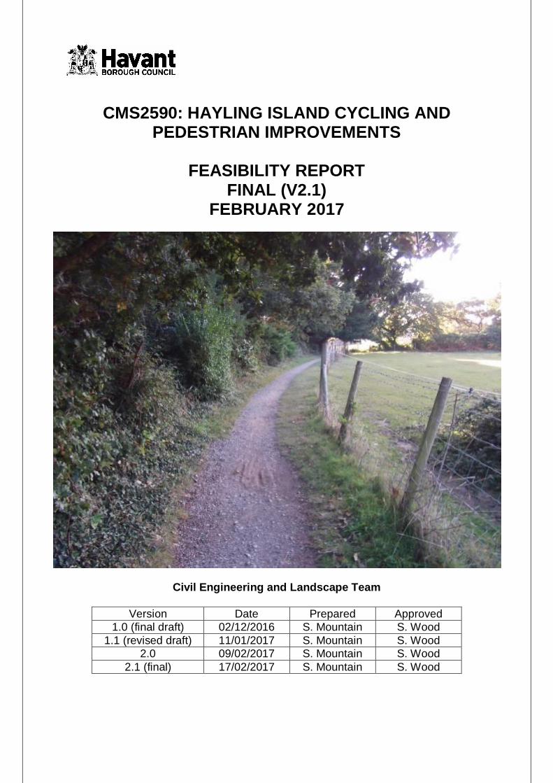
CMS2590: HAYLING ISLAND CYCLING AND PEDESTRIAN IMPROVEMENTS FEASIBILITY REPORT FINAL (V2.1) FEBRUARY 2017 Civil Engineering and Landscape Team Version Date Prepared Approved 1.0 (final draft) 02/12/2016 S. Mountain S. Wood 1.1 (revised draft) 11/01/2017 S. Mountain S. Wood 2.0 09/02/2017 S. Mountain S. Wood 2.1 (final) 17/02/2017 S. Mountain S. Wood

Welcome message from author
This document is posted to help you gain knowledge. Please leave a comment to let me know what you think about it! Share it to your friends and learn new things together.
Transcript
CMS2590: HAYLING ISLAND CYCLING AND PEDESTRIAN IMPROVEMENTS
FEASIBILITY REPORT
FINAL (V2.1) FEBRUARY 2017
Civil Engineering and Landscape Team
Version Date Prepared Approved 1.0 (final draft) 02/12/2016 S. Mountain S. Wood
1.1 (revised draft) 11/01/2017 S. Mountain S. Wood 2.0 09/02/2017 S. Mountain S. Wood
2.1 (final) 17/02/2017 S. Mountain S. Wood
Page | 1
Havant Borough Council
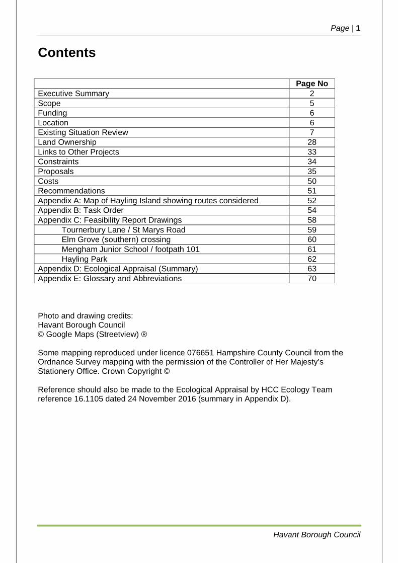
Contents Page No Executive Summary 2 Scope 5 Funding 6 Location 6 Existing Situation Review 7 Land Ownership 28 Links to Other Projects 33 Constraints 34 Proposals 35 Costs 50 Recommendations 51 Appendix A: Map of Hayling Island showing routes considered 52 Appendix B: Task Order 54 Appendix C: Feasibility Report Drawings 58
Tournerbury Lane / St Marys Road 59 Elm Grove (southern) crossing 60 Mengham Junior School / footpath 101 61 Hayling Park 62
Appendix D: Ecological Appraisal (Summary) 63 Appendix E: Glossary and Abbreviations 70 Photo and drawing credits: Havant Borough Council © Google Maps (Streetview) ® Some mapping reproduced under licence 076651 Hampshire County Council from the Ordnance Survey mapping with the permission of the Controller of Her Majesty’s Stationery Office. Crown Copyright © Reference should also be made to the Ecological Appraisal by HCC Ecology Team reference 16.1105 dated 24 November 2016 (summary in Appendix D).

Page | 2
Havant Borough Council
1 Executive Summary
1.1 Havant Borough Council has been commissioned by Hampshire County Council to investigate and assess the feasibility of a number of proposed improvements to cycle and pedestrian infrastructure across south Hayling. Any works carried out would be funded by ‘Section 106’ developer contributions from the ‘Halyards’ (“Land North of Goldring Close”) development. The Scope (Section 2 below) is defined within the Task Order (i.e. Brief) for the study and focuses on schemes listed in the s106 agreement. County and district members as well as the local community provided an input to the study scope at a meeting in November 2015.
1.2 Improving cycle and pedestrian infrastructure is important since access to Hayling Island is constrained by the single bridge crossing (A3023 Havant Road) of Chichester Harbour, with the bridge carriageway being 6.5m wide, with 2m wide off-carriageway cycle tracks both sides. The Hayling Ferry offers a second access for pedestrians and cyclists but only operates during the daytime and did not operate for long periods of 2016 due to insolvency of the previous operator. Any scheme which has the potential to remove traffic from local roads is of considerable value, notwithstanding the wider positive implications for health and air quality.
1.3 The intention of the Study is to consider the feasibility of measures proposed in the Brief to encourage the transfer of shorter journeys (typically less than 2 miles) from the private car onto more sustainable travel modes, principally walking and cycling, with particular emphasis on journeys to and from local schools and facilities.
1.4 The following recommendations are made in the Study (see sections 9 and 10
following for detailed discussion of these recommendations).
Proposed Scheme (as Brief) Est. cost £ Tournerbury Lane / St Marys Road Progress to detailed design for a scheme for tightening the radii at the Tournerbury Lane bellmouth. A design for a refuge island at St Marys Road junction be undertaken in 2017/18 but with implementation subject to the outcome of the planning application off St Marys Road.
100,000 (40,000 Tournerbury, 60,000 St Marys)
Elm Grove Crossings - north There is no feasible scheme to enable the conversion of the northern Elm Grove Zebra crossing to a Puffin crossing at this time until the outcome and impact of the development proposals for the Hayling Billy public house site is known – no further action
-
Elm Grove Crossings – south After public consultation commission detailed design from ITS to implement a new Puffin crossing north of Hollow Lane and remove the existing Zebra crossing.
60,000
Elm Grove Bus Stops No work required to southbound bus stops in Elm Grove
-
Elm Grove (extended scope) Upgrade Webb Lane westbound bus stop with associated changes to the road layout
45,000
Page | 3
Havant Borough Council
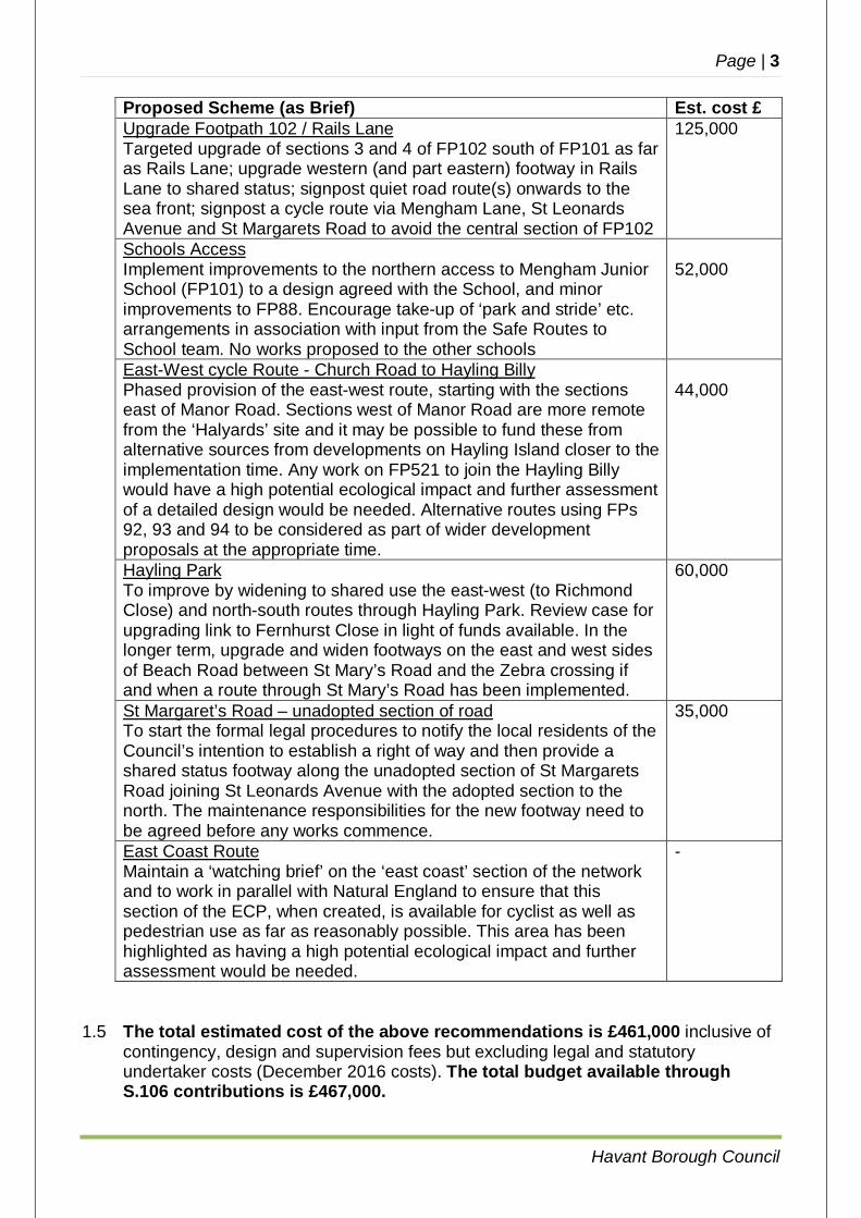
Proposed Scheme (as Brief) Est. cost £ Upgrade Footpath 102 / Rails Lane Targeted upgrade of sections 3 and 4 of FP102 south of FP101 as far as Rails Lane; upgrade western (and part eastern) footway in Rails Lane to shared status; signpost quiet road route(s) onwards to the sea front; signpost a cycle route via Mengham Lane, St Leonards Avenue and St Margarets Road to avoid the central section of FP102
125,000
Schools Access Implement improvements to the northern access to Mengham Junior School (FP101) to a design agreed with the School, and minor improvements to FP88. Encourage take-up of ‘park and stride’ etc. arrangements in association with input from the Safe Routes to School team. No works proposed to the other schools
52,000
East-West cycle Route - Church Road to Hayling Billy Phased provision of the east-west route, starting with the sections east of Manor Road. Sections west of Manor Road are more remote from the ‘Halyards’ site and it may be possible to fund these from alternative sources from developments on Hayling Island closer to the implementation time. Any work on FP521 to join the Hayling Billy would have a high potential ecological impact and further assessment of a detailed design would be needed. Alternative routes using FPs 92, 93 and 94 to be considered as part of wider development proposals at the appropriate time.
44,000
Hayling Park To improve by widening to shared use the east-west (to Richmond Close) and north-south routes through Hayling Park. Review case for upgrading link to Fernhurst Close in light of funds available. In the longer term, upgrade and widen footways on the east and west sides of Beach Road between St Mary’s Road and the Zebra crossing if and when a route through St Mary’s Road has been implemented.
60,000
St Margaret’s Road – unadopted section of road To start the formal legal procedures to notify the local residents of the Council’s intention to establish a right of way and then provide a shared status footway along the unadopted section of St Margarets Road joining St Leonards Avenue with the adopted section to the north. The maintenance responsibilities for the new footway need to be agreed before any works commence.
35,000
East Coast Route Maintain a ‘watching brief’ on the ‘east coast’ section of the network and to work in parallel with Natural England to ensure that this section of the ECP, when created, is available for cyclist as well as pedestrian use as far as reasonably possible. This area has been highlighted as having a high potential ecological impact and further assessment would be needed.
-
1.5 The total estimated cost of the above recommendations is £461,000 inclusive of
contingency, design and supervision fees but excluding legal and statutory undertaker costs (December 2016 costs). The total budget available through S.106 contributions is £467,000.
Page | 4
Havant Borough Council
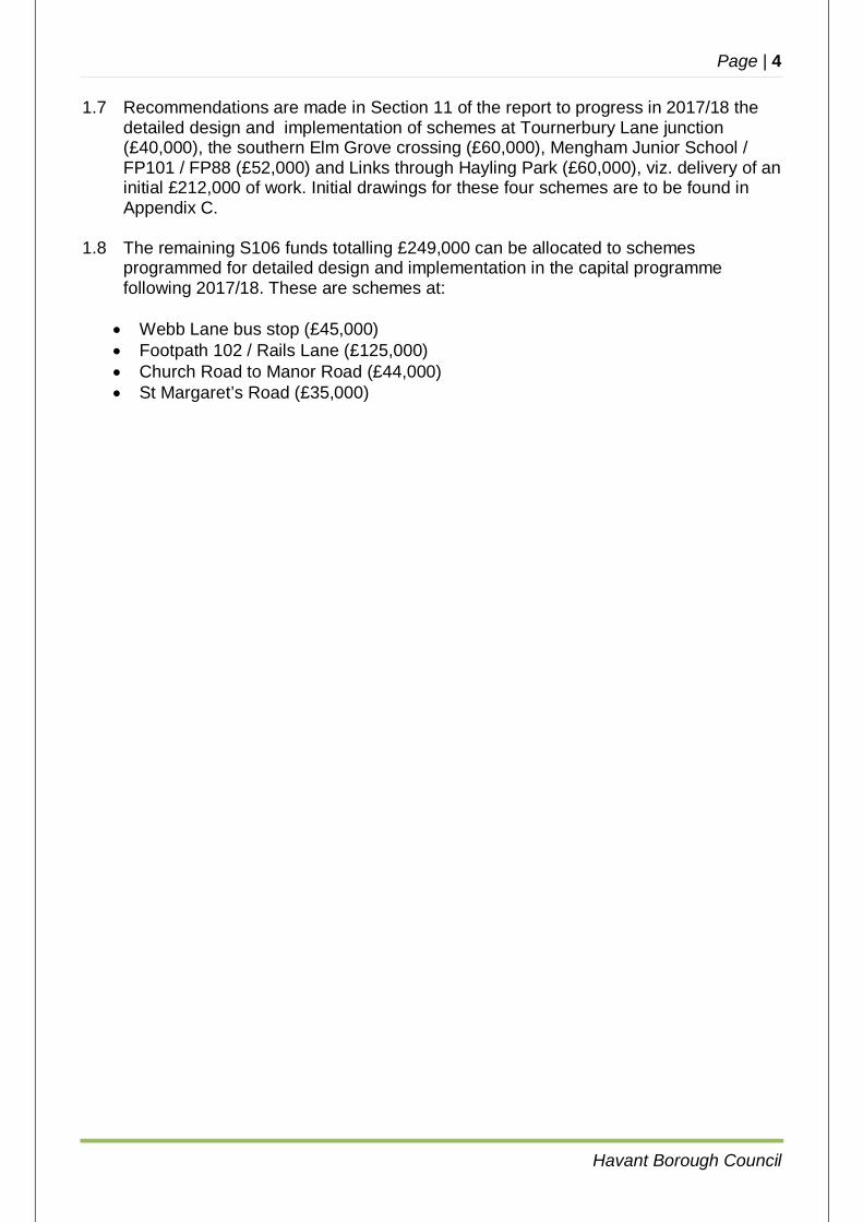
1.7 Recommendations are made in Section 11 of the report to progress in 2017/18 the detailed design and implementation of schemes at Tournerbury Lane junction (£40,000), the southern Elm Grove crossing (£60,000), Mengham Junior School / FP101 / FP88 (£52,000) and Links through Hayling Park (£60,000), viz. delivery of an initial £212,000 of work. Initial drawings for these four schemes are to be found in Appendix C.
1.8 The remaining S106 funds totalling £249,000 can be allocated to schemes
programmed for detailed design and implementation in the capital programme following 2017/18. These are schemes at:
Webb Lane bus stop (£45,000) Footpath 102 / Rails Lane (£125,000) Church Road to Manor Road (£44,000) St Margaret’s Road (£35,000)
Page | 5
Havant Borough Council
2 Scope
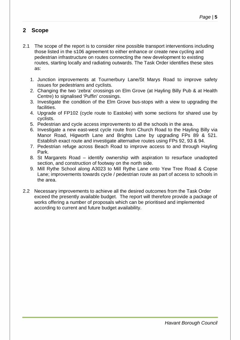
2.1 The scope of the report is to consider nine possible transport interventions including those listed in the s106 agreement to either enhance or create new cycling and pedestrian infrastructure on routes connecting the new development to existing routes, starting locally and radiating outwards. The Task Order identifies these sites as:
1. Junction improvements at Tournerbury Lane/St Marys Road to improve safety
issues for pedestrians and cyclists. 2. Changing the two ‘zebra’ crossings on Elm Grove (at Hayling Billy Pub & at Health
Centre) to signalised ‘Puffin’ crossings. 3. Investigate the condition of the Elm Grove bus-stops with a view to upgrading the
facilities. 4. Upgrade of FP102 (cycle route to Eastoke) with some sections for shared use by
cyclists. 5. Pedestrian and cycle access improvements to all the schools in the area. 6. Investigate a new east-west cycle route from Church Road to the Hayling Billy via
Manor Road, Higworth Lane and Brights Lane by upgrading FPs 89 & 521. Establish exact route and investigate alternative routes using FPs 92, 93 & 94.
7. Pedestrian refuge across Beach Road to improve access to and through Hayling Park.
8. St Margarets Road – identify ownership with aspiration to resurface unadopted section, and construction of footway on the north side.
9. Mill Rythe School along A3023 to Mill Rythe Lane onto Yew Tree Road & Copse Lane; improvements towards cycle / pedestrian route as part of access to schools in the area.
2.2 Necessary improvements to achieve all the desired outcomes from the Task Order
exceed the presently available budget. The report will therefore provide a package of works offering a number of proposals which can be prioritised and implemented according to current and future budget availability.
Page | 6
Havant Borough Council
3 Funding
3.1 Following the implementation of the ‘Halyards’ (“Land north of Goldring Close”) development, £20,000 was allocated from Hampshire County Council’s 2016/17 Feasibility Study budget to fund this Study.
3.2 ‘Section 106’ funding arising from the development of £467,000 is available to implement the works described in this Study.
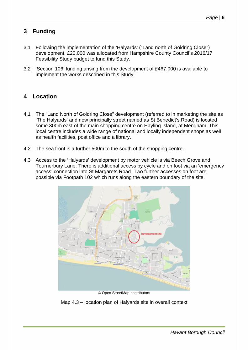
4 Location 4.1 The “Land North of Goldring Close” development (referred to in marketing the site as
‘The Halyards’ and now principally street named as St Benedict’s Road) is located some 300m east of the main shopping centre on Hayling Island, at Mengham. This local centre includes a wide range of national and locally independent shops as well as health facilities, post office and a library.
4.2 The sea front is a further 500m to the south of the shopping centre. 4.3 Access to the ‘Halyards’ development by motor vehicle is via Beech Grove and
Tournerbury Lane. There is additional access by cycle and on foot via an ‘emergency access’ connection into St Margarets Road. Two further accesses on foot are possible via Footpath 102 which runs along the eastern boundary of the site.
© Open StreetMap contributors
Map 4.3 – location plan of Halyards site in overall context
Page | 7
Havant Borough Council
5 Existing Situation Review
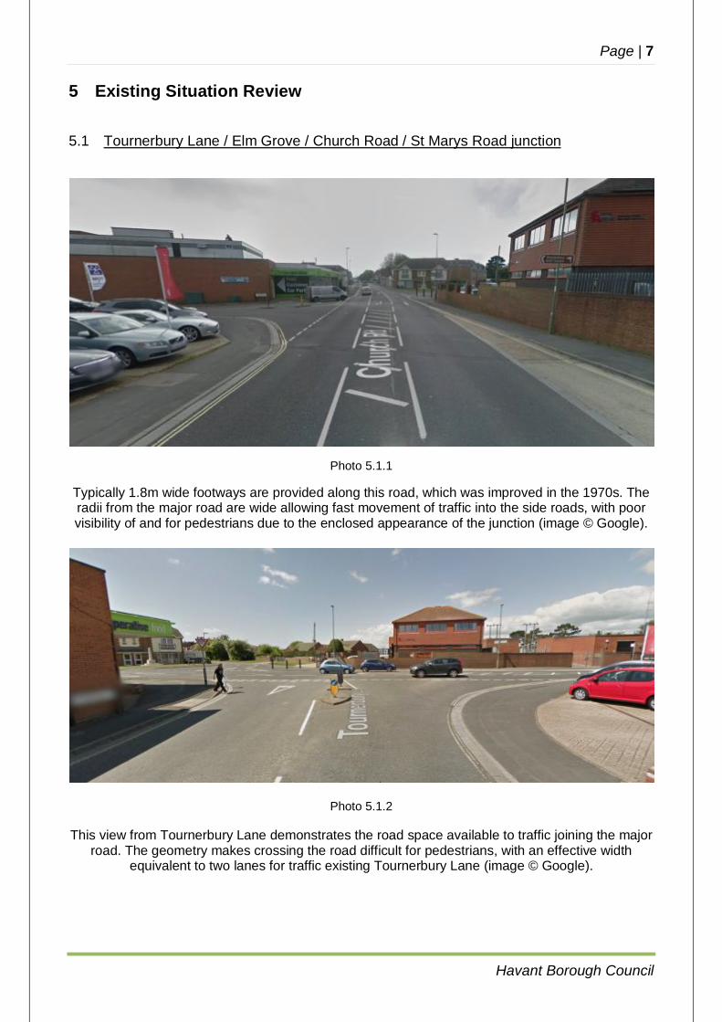
5.1 Tournerbury Lane / Elm Grove / Church Road / St Marys Road junction
Photo 5.1.1
Typically 1.8m wide footways are provided along this road, which was improved in the 1970s. The radii from the major road are wide allowing fast movement of traffic into the side roads, with poor visibility of and for pedestrians due to the enclosed appearance of the junction (image © Google).
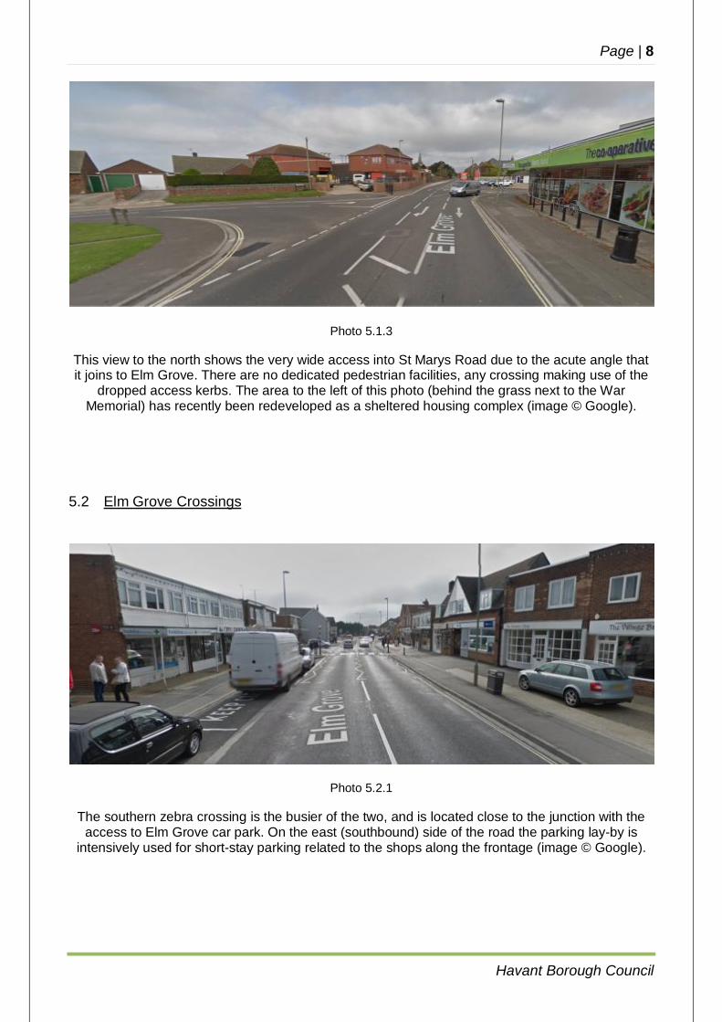
Photo 5.1.2
This view from Tournerbury Lane demonstrates the road space available to traffic joining the major road. The geometry makes crossing the road difficult for pedestrians, with an effective width
equivalent to two lanes for traffic existing Tournerbury Lane (image © Google).
Page | 8
Havant Borough Council
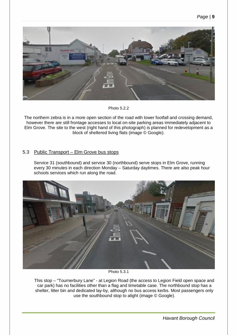
Photo 5.1.3
This view to the north shows the very wide access into St Marys Road due to the acute angle that it joins to Elm Grove. There are no dedicated pedestrian facilities, any crossing making use of the
dropped access kerbs. The area to the left of this photo (behind the grass next to the War Memorial) has recently been redeveloped as a sheltered housing complex (image © Google).
5.2 Elm Grove Crossings
Photo 5.2.1
The southern zebra crossing is the busier of the two, and is located close to the junction with the access to Elm Grove car park. On the east (southbound) side of the road the parking lay-by is
intensively used for short-stay parking related to the shops along the frontage (image © Google).
Page | 9
Havant Borough Council
Photo 5.2.2
The northern zebra is in a more open section of the road with lower footfall and crossing demand, however there are still frontage accesses to local on-site parking areas immediately adjacent to
Elm Grove. The site to the west (right hand of this photograph) is planned for redevelopment as a block of sheltered living flats (image © Google).
5.3 Public Transport – Elm Grove bus stops
Service 31 (southbound) and service 30 (northbound) serve stops in Elm Grove, running every 30 minutes in each direction Monday – Saturday daytimes. There are also peak hour schools services which run along the road.
Photo 5.3.1
This stop – “Tournerbury Lane” - at Legion Road (the access to Legion Field open space and car park) has no facilities other than a flag and timetable case. The northbound stop has a
shelter, litter bin and dedicated lay-by, although no bus access kerbs. Most passengers only use the southbound stop to alight (image © Google).
Page | 10
Havant Borough Council
Photo 5.3.2
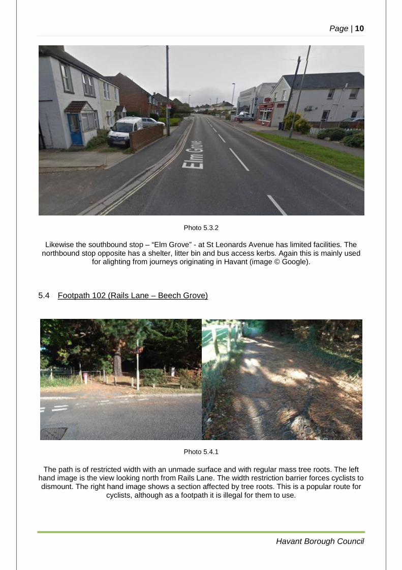
Likewise the southbound stop – “Elm Grove” - at St Leonards Avenue has limited facilities. The northbound stop opposite has a shelter, litter bin and bus access kerbs. Again this is mainly used
for alighting from journeys originating in Havant (image © Google).
5.4 Footpath 102 (Rails Lane – Beech Grove)
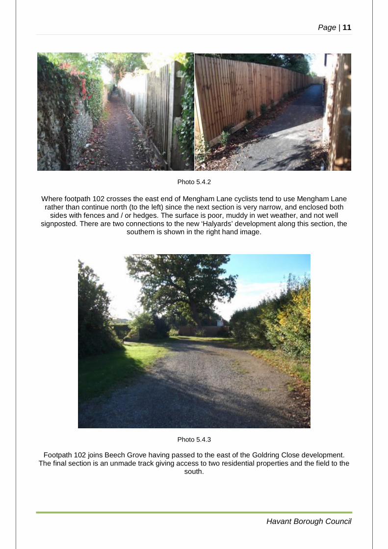
Photo 5.4.1
The path is of restricted width with an unmade surface and with regular mass tree roots. The left hand image is the view looking north from Rails Lane. The width restriction barrier forces cyclists to dismount. The right hand image shows a section affected by tree roots. This is a popular route for
cyclists, although as a footpath it is illegal for them to use.
Page | 11
Havant Borough Council
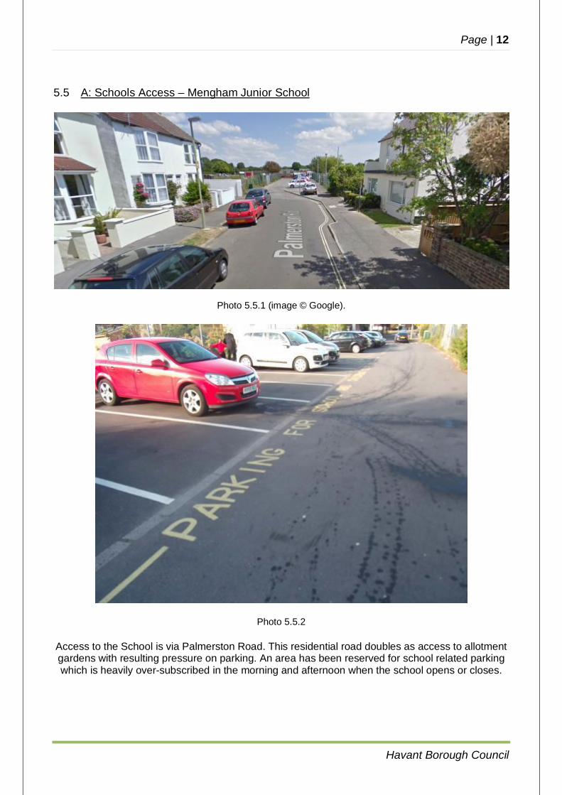
Photo 5.4.2
Where footpath 102 crosses the east end of Mengham Lane cyclists tend to use Mengham Lane rather than continue north (to the left) since the next section is very narrow, and enclosed both
sides with fences and / or hedges. The surface is poor, muddy in wet weather, and not well signposted. There are two connections to the new ‘Halyards’ development along this section, the
southern is shown in the right hand image.
Photo 5.4.3
Footpath 102 joins Beech Grove having passed to the east of the Goldring Close development. The final section is an unmade track giving access to two residential properties and the field to the
south.
Page | 12
Havant Borough Council
5.5 A: Schools Access – Mengham Junior School
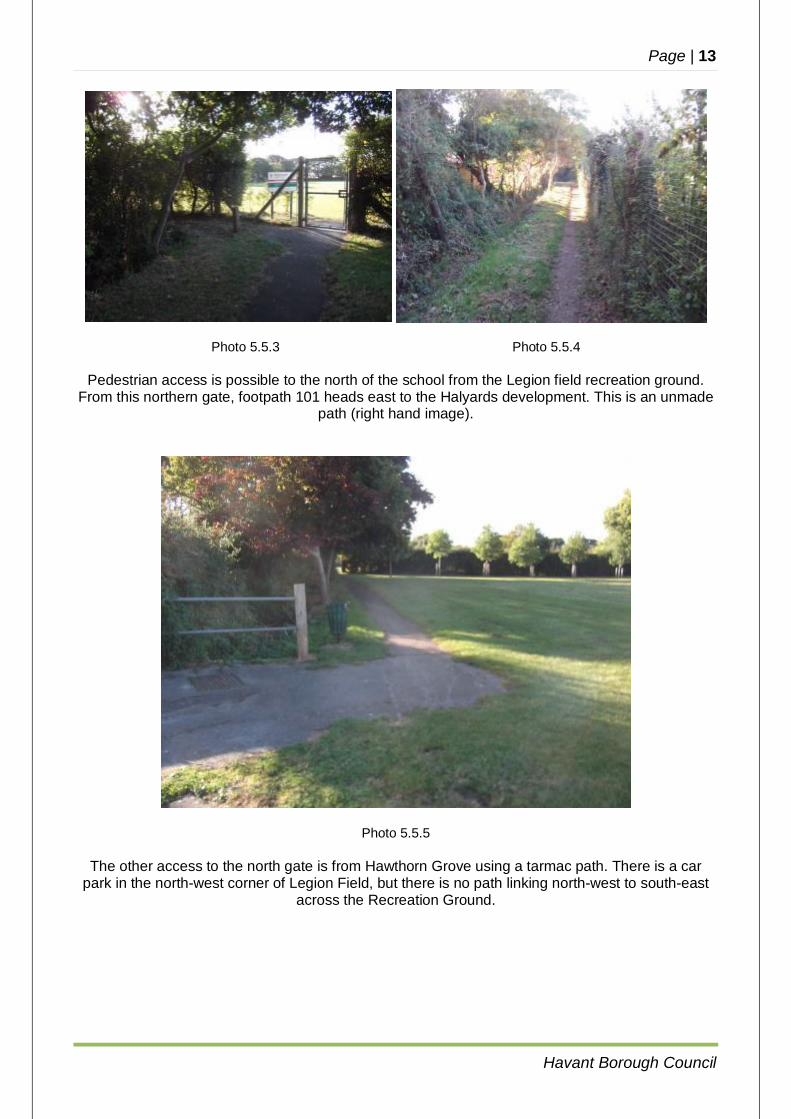
Photo 5.5.1 (image © Google).
Photo 5.5.2 Access to the School is via Palmerston Road. This residential road doubles as access to allotment gardens with resulting pressure on parking. An area has been reserved for school related parking which is heavily over-subscribed in the morning and afternoon when the school opens or closes.
Page | 13
Havant Borough Council
Photo 5.5.3 Photo 5.5.4
Pedestrian access is possible to the north of the school from the Legion field recreation ground. From this northern gate, footpath 101 heads east to the Halyards development. This is an unmade
path (right hand image).
Photo 5.5.5
The other access to the north gate is from Hawthorn Grove using a tarmac path. There is a car park in the north-west corner of Legion Field, but there is no path linking north-west to south-east
across the Recreation Ground.
Page | 14
Havant Borough Council
B: Schools Access – Mengham Infant School
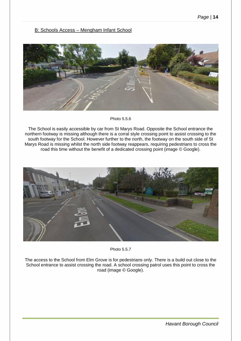
Photo 5.5.6
The School is easily accessible by car from St Marys Road. Opposite the School entrance the northern footway is missing although there is a corral style crossing point to assist crossing to the
south footway for the School. However further to the north, the footway on the south side of St Marys Road is missing whilst the north side footway reappears, requiring pedestrians to cross the
road this time without the benefit of a dedicated crossing point (image © Google).
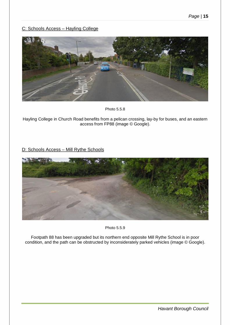
Photo 5.5.7 The access to the School from Elm Grove is for pedestrians only. There is a build out close to the School entrance to assist crossing the road. A school crossing patrol uses this point to cross the
road (image © Google).
Page | 15
Havant Borough Council
C: Schools Access – Hayling College
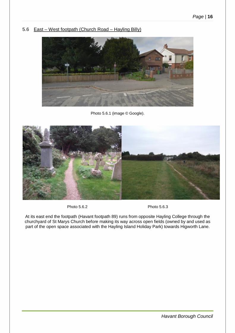
Photo 5.5.8 Hayling College in Church Road benefits from a pelican crossing, lay-by for buses, and an eastern
access from FP88 (image © Google).
D: Schools Access – Mill Rythe Schools
Photo 5.5.9
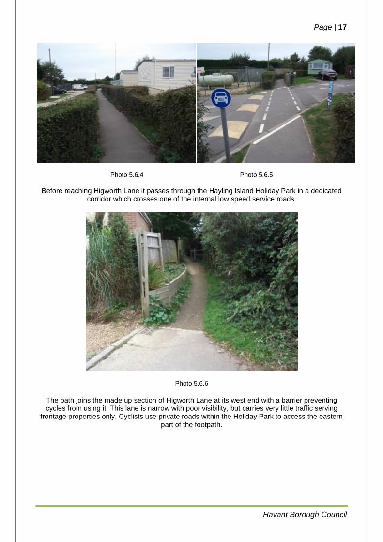
Footpath 88 has been upgraded but its northern end opposite Mill Rythe School is in poor condition, and the path can be obstructed by inconsiderately parked vehicles (image © Google).
Page | 16
Havant Borough Council
5.6 East – West footpath (Church Road – Hayling Billy)
Photo 5.6.1 (image © Google).
Photo 5.6.2 Photo 5.6.3
At its east end the footpath (Havant footpath 89) runs from opposite Hayling College through the churchyard of St Marys Church before making its way across open fields (owned by and used as part of the open space associated with the Hayling Island Holiday Park) towards Higworth Lane.
Page | 17
Havant Borough Council
Photo 5.6.4 Photo 5.6.5
Before reaching Higworth Lane it passes through the Hayling Island Holiday Park in a dedicated corridor which crosses one of the internal low speed service roads.
Photo 5.6.6
The path joins the made up section of Higworth Lane at its west end with a barrier preventing cycles from using it. This lane is narrow with poor visibility, but carries very little traffic serving
frontage properties only. Cyclists use private roads within the Holiday Park to access the eastern part of the footpath.
Page | 18
Havant Borough Council
Photo 5.6.7
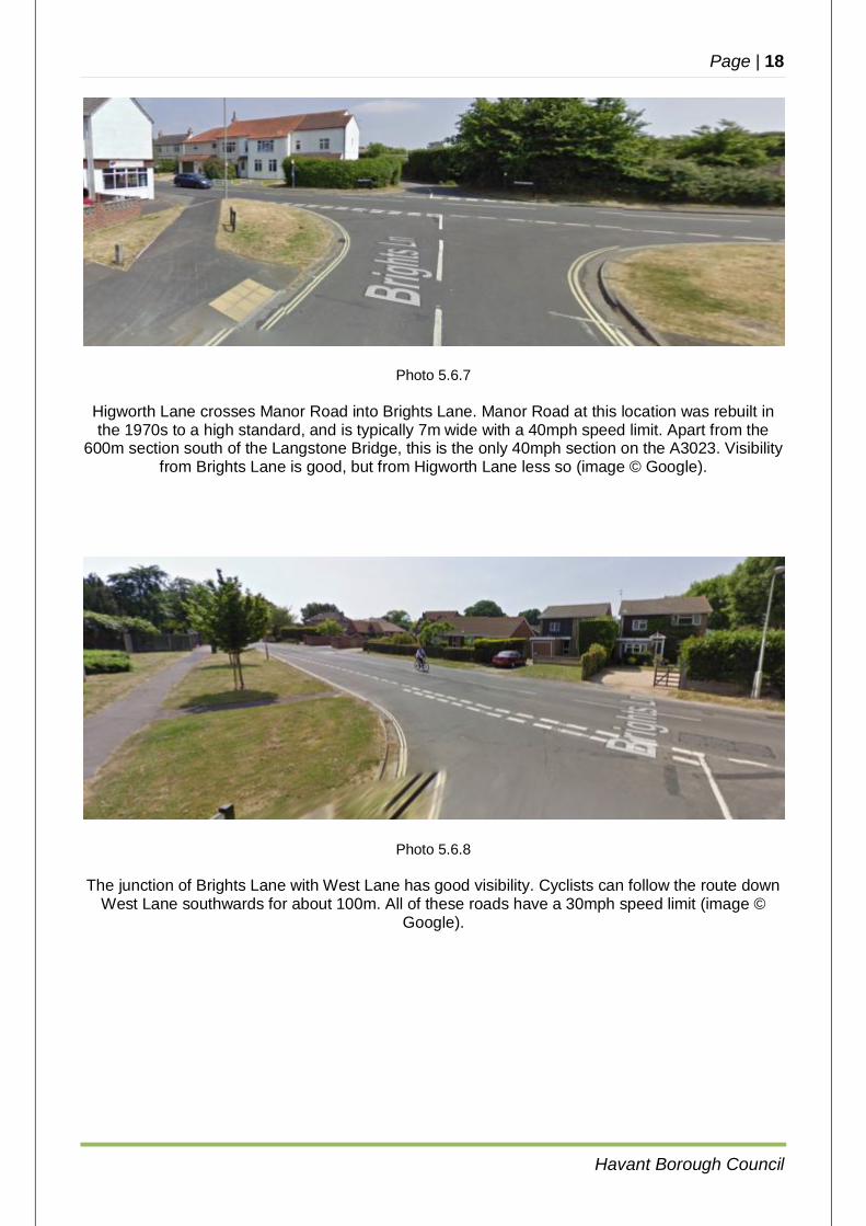
Higworth Lane crosses Manor Road into Brights Lane. Manor Road at this location was rebuilt in the 1970s to a high standard, and is typically 7m wide with a 40mph speed limit. Apart from the
600m section south of the Langstone Bridge, this is the only 40mph section on the A3023. Visibility from Brights Lane is good, but from Higworth Lane less so (image © Google).
Photo 5.6.8
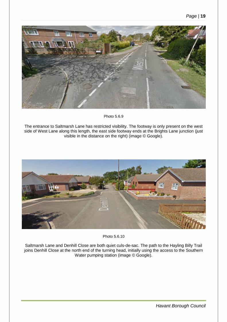
The junction of Brights Lane with West Lane has good visibility. Cyclists can follow the route down West Lane southwards for about 100m. All of these roads have a 30mph speed limit (image ©
Google).
Page | 19
Havant Borough Council
Photo 5.6.9
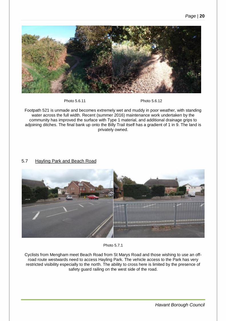
The entrance to Saltmarsh Lane has restricted visibility. The footway is only present on the west side of West Lane along this length, the east side footway ends at the Brights Lane junction (just
visible in the distance on the right) (image © Google).
Photo 5.6.10
Saltmarsh Lane and Denhill Close are both quiet culs-de-sac. The path to the Hayling Billy Trail joins Denhill Close at the north end of the turning head, initially using the access to the Southern
Water pumping station (image © Google).
Page | 20
Havant Borough Council
Photo 5.6.11 Photo 5.6.12
Footpath 521 is unmade and becomes extremely wet and muddy in poor weather, with standing water across the full width. Recent (summer 2016) maintenance work undertaken by the
community has improved the surface with Type 1 material, and additional drainage grips to adjoining ditches. The final bank up onto the Billy Trail itself has a gradient of 1 in 9. The land is
privately owned.
5.7 Hayling Park and Beach Road
Photo 5.7.1
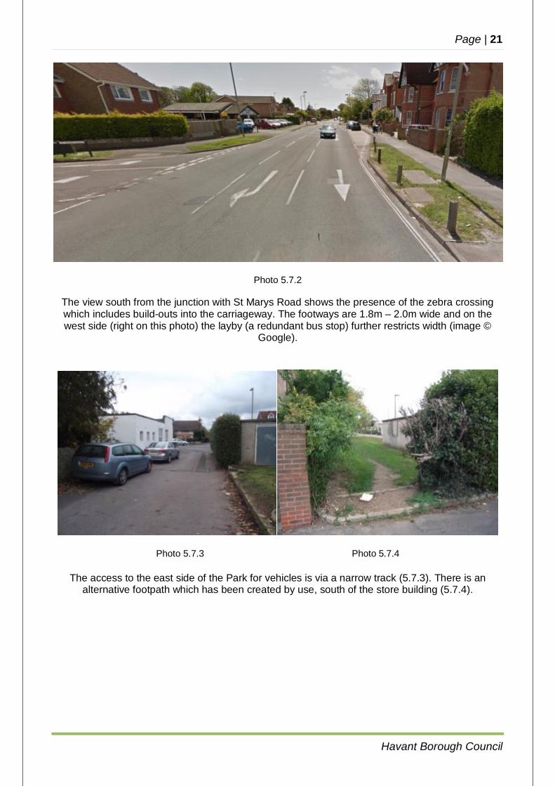
Cyclists from Mengham meet Beach Road from St Marys Road and those wishing to use an off-road route westwards need to access Hayling Park. The vehicle access to the Park has very
restricted visibility especially to the north. The ability to cross here is limited by the presence of safety guard railing on the west side of the road.
Page | 21
Havant Borough Council
Photo 5.7.2
The view south from the junction with St Marys Road shows the presence of the zebra crossing which includes build-outs into the carriageway. The footways are 1.8m – 2.0m wide and on the west side (right on this photo) the layby (a redundant bus stop) further restricts width (image ©
Google).
Photo 5.7.3 Photo 5.7.4
The access to the east side of the Park for vehicles is via a narrow track (5.7.3). There is an alternative footpath which has been created by use, south of the store building (5.7.4).
Page | 22
Havant Borough Council
Photo 5.7.5 Photo 5.7.6
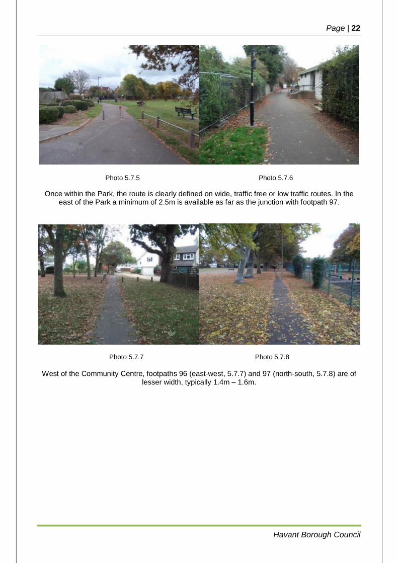
Once within the Park, the route is clearly defined on wide, traffic free or low traffic routes. In the east of the Park a minimum of 2.5m is available as far as the junction with footpath 97.
Photo 5.7.7 Photo 5.7.8
West of the Community Centre, footpaths 96 (east-west, 5.7.7) and 97 (north-south, 5.7.8) are of lesser width, typically 1.4m – 1.6m.
Page | 23
Havant Borough Council
Photo 5.5.9
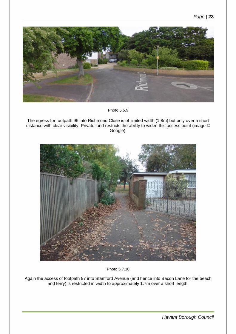
The egress for footpath 96 into Richmond Close is of limited width (1.8m) but only over a short distance with clear visibility. Private land restricts the ability to widen this access point (image ©
Google).
Photo 5.7.10
Again the access of footpath 97 into Stamford Avenue (and hence into Bacon Lane for the beach and ferry) is restricted in width to approximately 1.7m over a short length.
Page | 24
Havant Borough Council
Photo 5.7.11
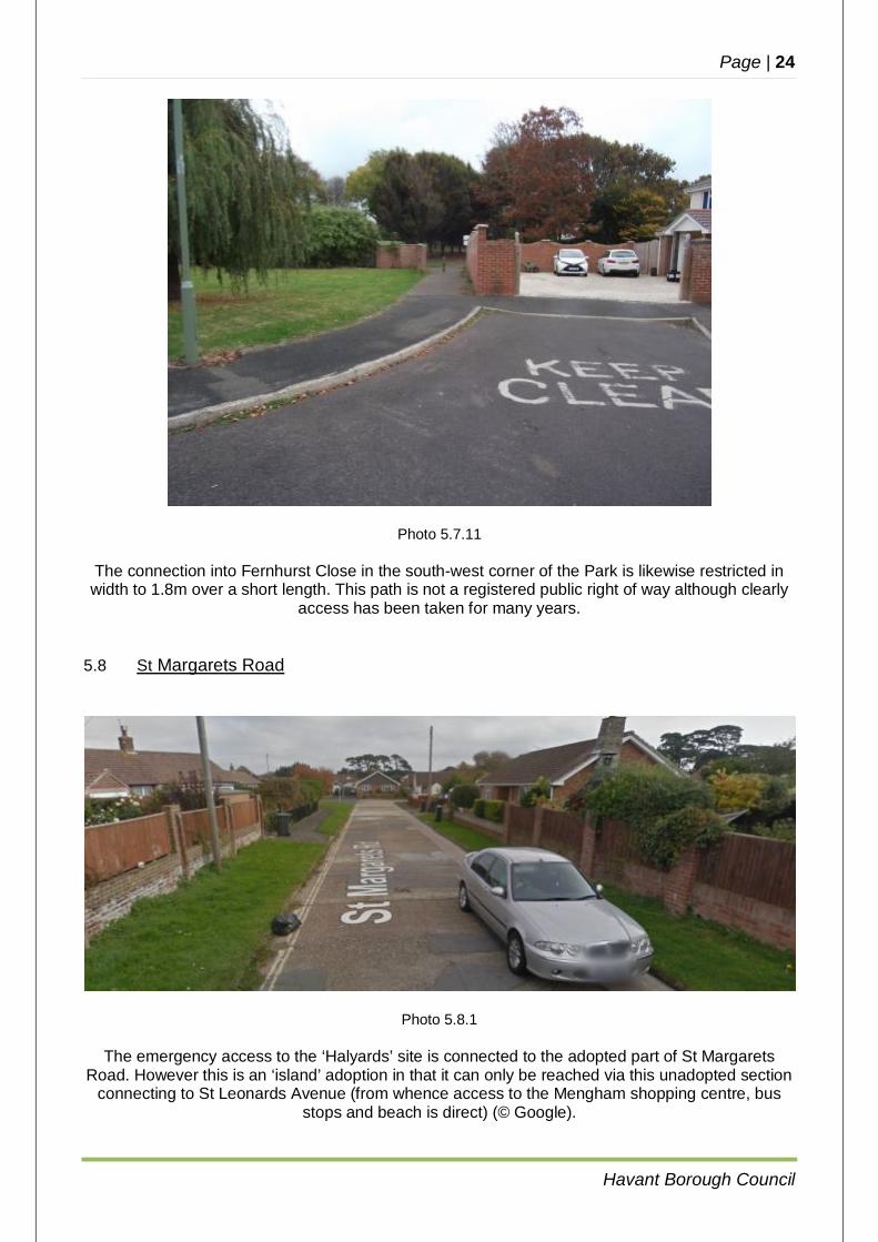
The connection into Fernhurst Close in the south-west corner of the Park is likewise restricted in width to 1.8m over a short length. This path is not a registered public right of way although clearly
access has been taken for many years.
5.8 St Margarets Road
Photo 5.8.1
The emergency access to the ‘Halyards’ site is connected to the adopted part of St Margarets Road. However this is an ‘island’ adoption in that it can only be reached via this unadopted section
connecting to St Leonards Avenue (from whence access to the Mengham shopping centre, bus stops and beach is direct) (© Google).
Page | 25
Havant Borough Council
5.9 Mill Rythe School to Copse Lane
Photo 5.9.1
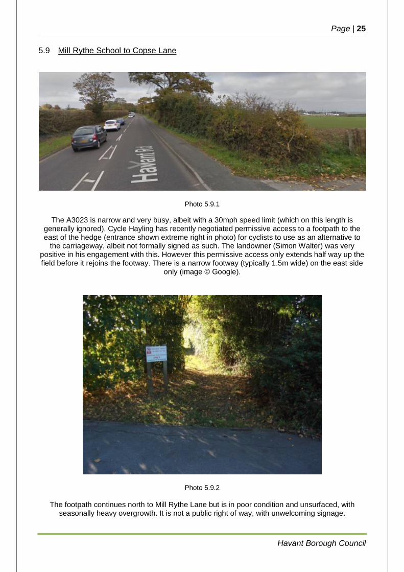
The A3023 is narrow and very busy, albeit with a 30mph speed limit (which on this length is generally ignored). Cycle Hayling has recently negotiated permissive access to a footpath to the east of the hedge (entrance shown extreme right in photo) for cyclists to use as an alternative to
the carriageway, albeit not formally signed as such. The landowner (Simon Walter) was very positive in his engagement with this. However this permissive access only extends half way up the field before it rejoins the footway. There is a narrow footway (typically 1.5m wide) on the east side
only (image © Google).
Photo 5.9.2
The footpath continues north to Mill Rythe Lane but is in poor condition and unsurfaced, with seasonally heavy overgrowth. It is not a public right of way, with unwelcoming signage.
Page | 26
Havant Borough Council
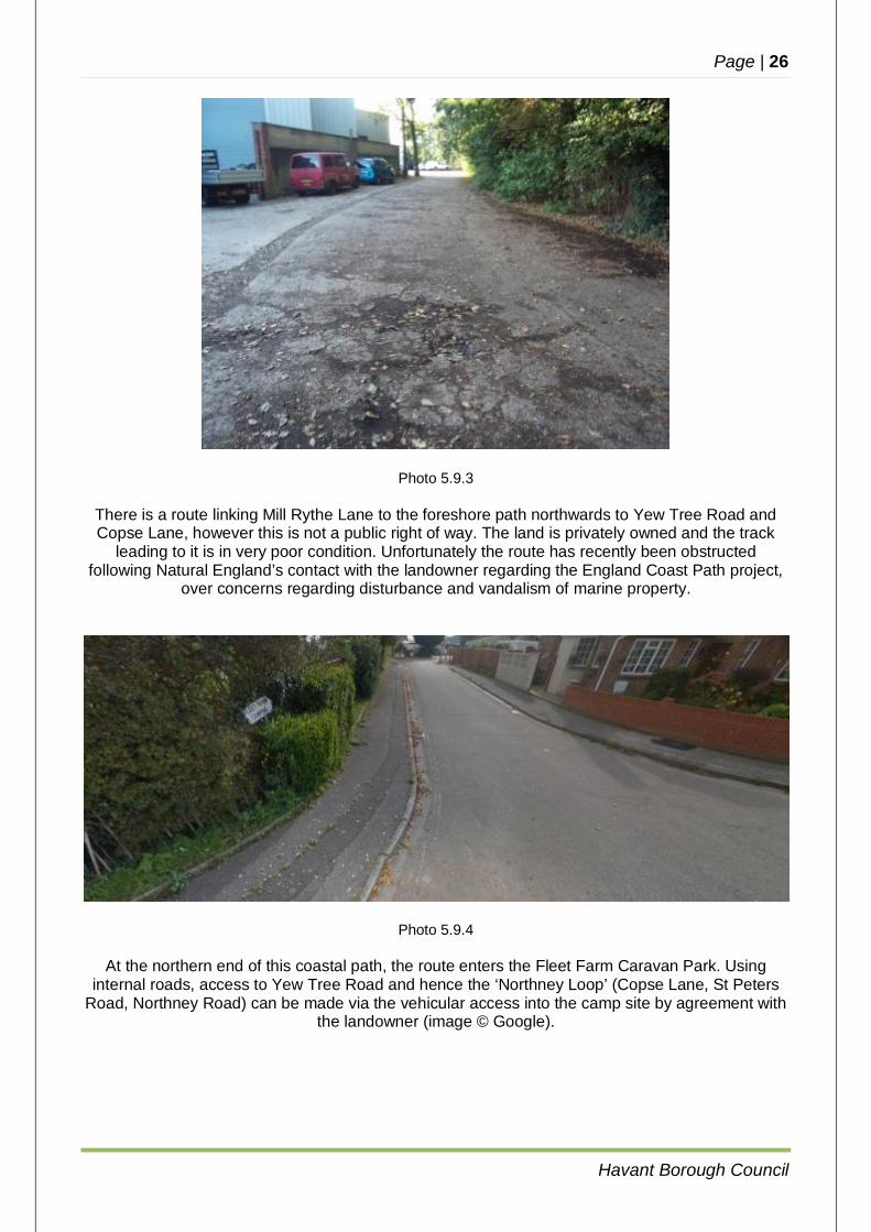
Photo 5.9.3
There is a route linking Mill Rythe Lane to the foreshore path northwards to Yew Tree Road and Copse Lane, however this is not a public right of way. The land is privately owned and the track
leading to it is in very poor condition. Unfortunately the route has recently been obstructed following Natural England’s contact with the landowner regarding the England Coast Path project,
over concerns regarding disturbance and vandalism of marine property.
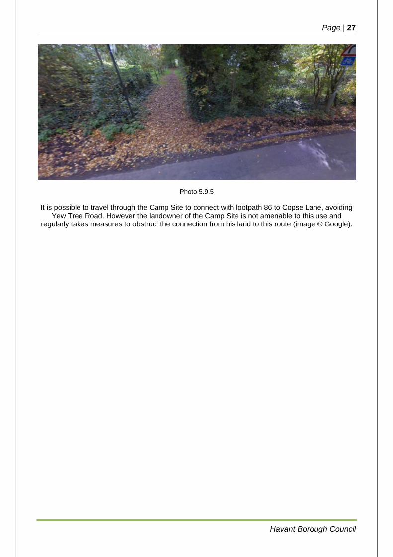
Photo 5.9.4
At the northern end of this coastal path, the route enters the Fleet Farm Caravan Park. Using internal roads, access to Yew Tree Road and hence the ‘Northney Loop’ (Copse Lane, St Peters
Road, Northney Road) can be made via the vehicular access into the camp site by agreement with the landowner (image © Google).
Page | 27
Havant Borough Council
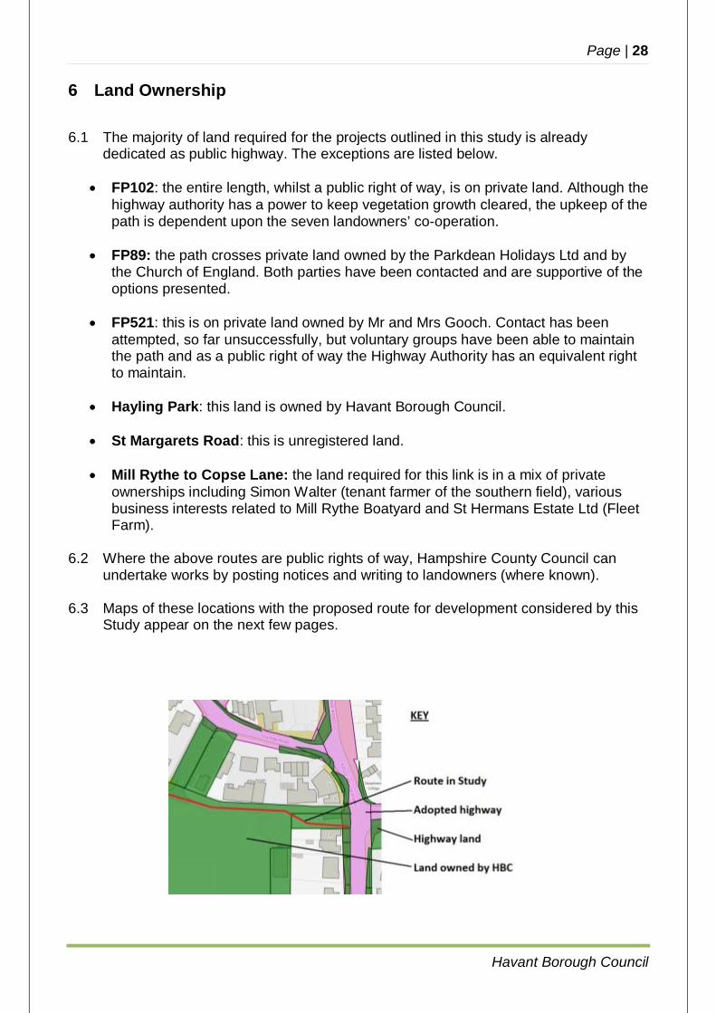
Photo 5.9.5
It is possible to travel through the Camp Site to connect with footpath 86 to Copse Lane, avoiding Yew Tree Road. However the landowner of the Camp Site is not amenable to this use and
regularly takes measures to obstruct the connection from his land to this route (image © Google).
Page | 28
Havant Borough Council
6 Land Ownership
6.1 The majority of land required for the projects outlined in this study is already dedicated as public highway. The exceptions are listed below.
FP102: the entire length, whilst a public right of way, is on private land. Although the
highway authority has a power to keep vegetation growth cleared, the upkeep of the path is dependent upon the seven landowners’ co-operation.
FP89: the path crosses private land owned by the Parkdean Holidays Ltd and by
the Church of England. Both parties have been contacted and are supportive of the options presented.
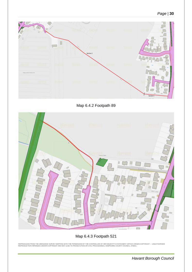
FP521: this is on private land owned by Mr and Mrs Gooch. Contact has been
attempted, so far unsuccessfully, but voluntary groups have been able to maintain the path and as a public right of way the Highway Authority has an equivalent right to maintain.
Hayling Park: this land is owned by Havant Borough Council.
St Margarets Road: this is unregistered land.
Mill Rythe to Copse Lane: the land required for this link is in a mix of private
ownerships including Simon Walter (tenant farmer of the southern field), various business interests related to Mill Rythe Boatyard and St Hermans Estate Ltd (Fleet Farm).
6.2 Where the above routes are public rights of way, Hampshire County Council can
undertake works by posting notices and writing to landowners (where known). 6.3 Maps of these locations with the proposed route for development considered by this
Study appear on the next few pages.

Page | 29
Havant Borough Council
Map 6.4.1 Footpath 102 REPRODUCED FROM THE ORDNANCE SURVEY MAPPING WITH THE PERMISSION OF THE CONTROLLER OF HER MAJESTY'S STATIONERY OFFICE CROWN COPYRIGHT � UNAUTHORISED REPRODUCTION INFRINGES CROWN COPYRIGHT AND MAY LEAD TO PROSECUTION OR CIVIL PROCEEDINGS. HAMPSHIRE COUNTY COUNCIL, 076651.
Page | 30
Havant Borough Council
Map 6.4.2 Footpath 89
Map 6.4.3 Footpath 521
REPRODUCED FROM THE ORDNANCE SURVEY MAPPING WITH THE PERMISSION OF THE CONTROLLER OF HER MAJESTY'S STATIONERY OFFICE CROWN COPYRIGHT � UNAUTHORISED REPRODUCTION INFRINGES CROWN COPYRIGHT AND MAY LEAD TO PROSECUTION OR CIVIL PROCEEDINGS. HAMPSHIRE COUNTY COUNCIL, 076651.
Page | 31
Havant Borough Council
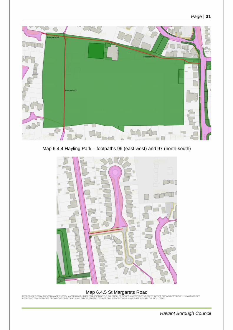
Map 6.4.4 Hayling Park – footpaths 96 (east-west) and 97 (north-south)
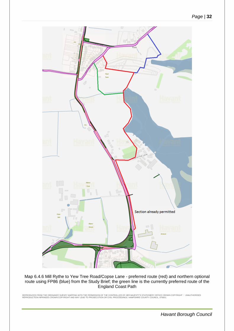
Map 6.4.5 St Margarets Road REPRODUCED FROM THE ORDNANCE SURVEY MAPPING WITH THE PERMISSION OF THE CONTROLLER OF HER MAJESTY'S STATIONERY OFFICE CROWN COPYRIGHT � UNAUTHORISED REPRODUCTION INFRINGES CROWN COPYRIGHT AND MAY LEAD TO PROSECUTION OR CIVIL PROCEEDINGS. HAMPSHIRE COUNTY COUNCIL, 076651.
Page | 32
Havant Borough Council
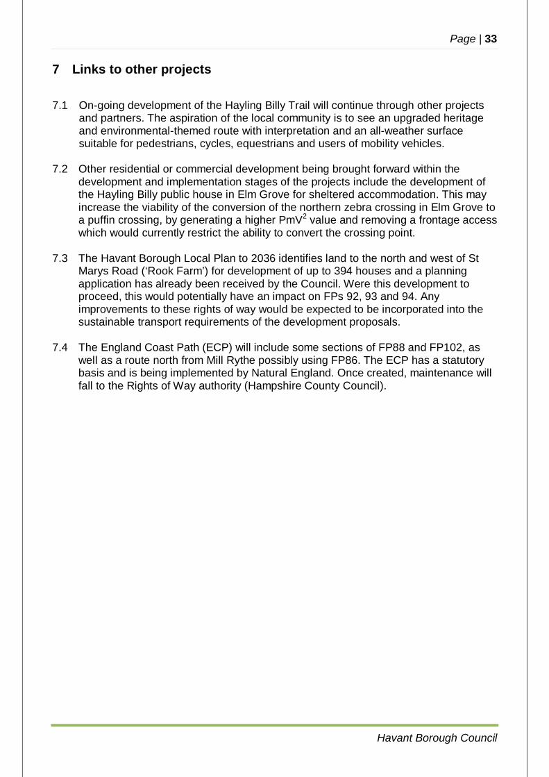
Map 6.4.6 Mill Rythe to Yew Tree Road/Copse Lane - preferred route (red) and northern optional route using FP86 (blue) from the Study Brief; the green line is the currently preferred route of the
England Coast Path
REPRODUCED FROM THE ORDNANCE SURVEY MAPPING WITH THE PERMISSION OF THE CONTROLLER OF HER MAJESTY'S STATIONERY OFFICE CROWN COPYRIGHT � UNAUTHORISED REPRODUCTION INFRINGES CROWN COPYRIGHT AND MAY LEAD TO PROSECUTION OR CIVIL PROCEEDINGS. HAMPSHIRE COUNTY COUNCIL, 076651.
Page | 33
Havant Borough Council
7 Links to other projects
7.1 On-going development of the Hayling Billy Trail will continue through other projects and partners. The aspiration of the local community is to see an upgraded heritage and environmental-themed route with interpretation and an all-weather surface suitable for pedestrians, cycles, equestrians and users of mobility vehicles.
7.2 Other residential or commercial development being brought forward within the
development and implementation stages of the projects include the development of the Hayling Billy public house in Elm Grove for sheltered accommodation. This may increase the viability of the conversion of the northern zebra crossing in Elm Grove to a puffin crossing, by generating a higher PmV2 value and removing a frontage access which would currently restrict the ability to convert the crossing point.
7.3 The Havant Borough Local Plan to 2036 identifies land to the north and west of St
Marys Road (‘Rook Farm’) for development of up to 394 houses and a planning application has already been received by the Council. Were this development to proceed, this would potentially have an impact on FPs 92, 93 and 94. Any improvements to these rights of way would be expected to be incorporated into the sustainable transport requirements of the development proposals.
7.4 The England Coast Path (ECP) will include some sections of FP88 and FP102, as
well as a route north from Mill Rythe possibly using FP86. The ECP has a statutory basis and is being implemented by Natural England. Once created, maintenance will fall to the Rights of Way authority (Hampshire County Council).

Page | 34
Havant Borough Council
8 Constraints
8.1 Part of the northern section of footpath 102 (section 3 on map 6.4.1, page 28) is heavily constrained by private property boundaries. Whilst this could form a key link for cyclists as part of a cycle route on the eastern side of the Island, no works involving widening are considered possible on this section of the route and so an alternative signed route using the quiet roads of Mengham Lane, St Leonards Avenue and St Margarets Road is suggested. This does not stop cyclists using footpath 102 as they do at present, however this would continue to be illegal and signposting / waymarking for this route would have to reflect this fact (i.e. signage would be for pedestrians only).
8.2 A key section of St Margarets Road is on unregistered land and is unadopted. The
existing concrete surface is poor and there is no footway. The provision of a better quality footway link for pedestrians on this section (as a minimum) is important to enable direct and safe access on foot between ‘Halyards’ and the shopping centre. This requires the co-operation of land owners (if and when identified through notification) for the improvements to be achieved.
8.3 Some outstanding perceived issues from the ‘Halyards’ development remain
unresolved and will do so until final occupation occurs in spring 2017. However the mechanism to resolve these reported issues (layout of access junction at south end of Beech Grove; perception of speeding in Beech Grove) would be through adjustments made by the developer under their S.278 agreement following Stage 3 Safety Audit. Consideration of such issues do not form part of the Study.
8.4 The co-operation of landowners is required to implement some of the
recommendations in this Study. However, where the above routes are public rights of way, Hampshire County Council can undertake works by posting notices and writing to landowners (where known).
8.5 An Ecological Appraisal has been carried out to identify key issues and to understand
the impact on some of the routes, including the time of year to undertake the works and the working method. See Appendix D for a summary of the findings of the Appraisal, listed by species / habitat and location. In summary, the Appraisal report highlights that FP521 (on the East-West Cycle Route) and 86 (possible part of the East coast Route) fall within designated sites and there is high potential for schemes in these areas to impact on habitats and wildlife. These implications are recognised in this Study with FP521 scheduled for implementation later in the programme allowing for mitigation to be designed (see 9.6 below) and FP86 being only one option in the East coast route which is primarily being implemented by Natural England (see 9.9 below). There is little ecological impact of the other schemes but as set out in the report recommendations care must be taken for the time of year to undertake works and mitigation measures, particularly with respect to birds.
Page | 35
Havant Borough Council
9 Proposals
9.1 Tournerbury Lane / Elm Grove / Church Road / St Marys Road junction
The major issue at this location is the ability of pedestrians to cross Tournerbury Lane given the speed at which traffic heading south in Church Road enters the street due to the dropped kerb serving the car sales site. There is also insufficient provision for pedestrians to cross St Marys Road at the junction. The two separate sites are considered below. It is proposed to widen the existing footways at the Tournerbury Lane junction by tightening kerb radii to effectively shorten the distance that pedestrians have to cross the road and to reduce the speed of traffic turning into Tournerbury Lane. This will also increase visibility of pedestrians and highlight the crossing by means of reflective bollards. It is proposed to slightly relocate the pedestrian refuge island, which would again reduce the speed of turning vehicles. The local introduction of ‘shared’ status footways which would mean that cyclists making turns at this junction could do so in a safer environment, has been considered but discounted due to the limited amount of shared area available which would mean cyclists would have to dismount in any event. The carriageway is wide enough to accommodate two lanes of turning traffic from Tournerbury Lane, left and right. Local concerns initially expressed over the amount of traffic generated from the ‘Halyards’ development site appear not to have been realised but there is scope to mark to lanes (left and right turns) on the approach to the junction to regulate the position of vehicles and make intentions clearer to people wishing to cross the road. A pedestrian refuge can be accommodated in the St Marys Road bellmouth by re-aligning the northbound carriageway by some 2m to create the space for the refuge island. This realignment is over the former route of the road and so buried services are expected to already be at carriageway depth and thus not require lowering. Whilst the realignment does have a slight impact on the access to the business premises on the north side of the junction, it is not to such an extent that it renders the arrangement unviable. More detailed design work is required to achieve a layout which can be deemed safe in all respects, but it should be borne in mind that proposals for future development at the nearby Rook’s Farm, with access to the development taken from St Mary’s road only 30m from the junction, may affect such a design. Therefore the detailed design should be progressed but implementation delayed until the situation regarding the development and planning application is clearer. An S.278 Agreement may provide an alternative funding source for this element of the works. A Feasibility Stage Road Safety Audit has been completed on the basis of outline designs for the two junctions as described above (see Appendix C below), which resulted in a change to the location of the crossing island in St Marys Road due to the above mentioned issue with access to the business premises.
Page | 36
Havant Borough Council
There appear to be no other means of enhancing the crossings for pedestrians other than by the measures discussed here. It is therefore proposed to progress a detailed design for these junctions in 2017/18 but to only implement the works in Tournerbury Lane at the present time. RECOMMENDATION: Progress to detailed design for a scheme for tightening the radii at the Tournerbury Lane bellmouth. A design for a refuge island at St Marys Road junction be undertaken in 2017/18 but with implementation subject to the outcome of the planning application off St Marys Road.
9.2 Upgrades to zebra crossings in Elm Grove
The two zebra crossings in Elm Grove are well used, although the southern crossing (adjacent to the car park entrance) is the busier. Surveys were carried out by HCC ITS in August 2016 (i.e. at a time to strike a balance between the presence of school children and the tourist season). 9.2(a) Northern site (adjacent to the Hayling Billy public house) The PmV2 value for this site is 1.77 x 10⁸. This is above the 1.0 x 10⁸ value required to justify a signal controlled crossing. The Zebra crossing is located at the end of a public footpath which links directly to the public car park accessed from St Marys Road. The car park is well used by those visiting the shops, etc., on this northern section of Elm Grove and therefore the current crossing is well sited on the desire line. There are two vehicle accesses immediately to the north of the Zebra crossing; a pub car park on the west side, and a shop forecourt car park on the east. Immediately to the south there is open frontage to a car sales site. In combination these vehicle accesses prevent the existing crossing location being suitable for direct conversion to a Puffin crossing. It may be possible to locate a Puffin crossing further north towards Legion Road junction. To provide suitable clearance from Legion Road, and the various vehicle accesses a Puffin could be located up to 40-50 metres to the north. However this is likely to take a Puffin crossing some way off the desire line and leaving it underused. The Zebra crossing would need to removed should a Puffin crossing be provided. It is highly likely that pedestrians would still attempt to cross at the former Zebra rather than divert to use the Puffin. Pedestrians crossing without the aid of a Zebra crossing at this location are likely to be at greater risk than when using the current Zebra crossing. The safety record records no injury accidents at this crossing in the last five years. In conclusion there is no feasible layout which could be adopted to upgrade the crossing to a Puffin crossing with the road in its present format. A suitable alternative location for a Puffin would take it away from the crossing desire line leaving it underused. The existing Zebra crossing is considered to be the most appropriate form of crossing at this location at the present time.
Page | 37
Havant Borough Council
A recently submitted planning application has been brought forward to redevelop the site of the Hayling Billy public house and its car park for sheltered accommodation with access taken from the St Marys Road frontage. Should this development proceed this would remove a major constraint from locating a Puffin crossing at this site, with only the accesses on the east side of the road influencing the location. It may be possible that the redevelopment of the site would enable a Puffin crossing to be justified on the basis of a higher PmV2 due to the demographic of the development, and also allow it to be installed closer to the desire line for the current Zebra crossing. RECOMMENDATION: no further action. Review the conversion of the crossing once the impact of the redevelopment of the Hayling Billy public house site is known. 9.2(b) Southern site (north of Selsmore Road) The PmV2 value for the southern site is 3.02 x 10⁸. This is significantly above the 1.0 x 10⁸ value required to justify a signal controlled crossing. However from a technical perspective the location raises a few issues. The position of the existing Zebra would not be suitable for conversion to a Puffin crossing as it would be too close to the Elm Grove car park access road. The access road is around 10 metres to the south of the crossing. A signal controlled crossing should be 20 metres away from a side road to allow drivers to turn right and then react to the crossing signals. However a Zebra crossing can be as close as 5 metres to a side road hence its current position. A further issue is the proximity of on-street parking bays on the east side of Elm Grove immediately in advance of the crossing. To provide a Puffin crossing would require the loss of a notable proportion of the parking bays. The loss of parking would be required for two reasons: to relocate the Puffin crossing 20 metres away from the side road to ensure that adequate driver/pedestrian visibility could be provided on the
southbound approach to the Puffin. The parking bays are well used by those visiting the adjacent shops along Elm Grove. There is a 100 space car park behind these shops with the opportunity for short term free parking, but the attractiveness to the shop keepers of their customers being able to park directly outside should not be underestimated even though peer-reviewed transport and retail studies indicate that the perception of trade from passing traffic is vastly over-estimated. The extent of the parking loss would need to be fully assessed although any reduction in the parking bays can be expected to be opposed by the shop keepers and, potentially, shoppers themselves. The five year safety record reveals that there have been three separate Personal Injury Accidents (PIAs) at the crossing. Two involved rear end collisions between vehicles; other was a rear end collision also injured a pedestrian on the crossing. To have three PIAs in five years at a crossing is quite a high accident rate given that the
Page | 38
Havant Borough Council
HCC average for a Zebra crossing would be 0.85 PIAs in five years (based on 2007-11 safety statistics). Although not borne out by the accident record there are a high proportion of elderly and vulnerable users of the Zebra. These users often require longer to cross and can feel more intimidated by the nature of a Zebra crossing. Puffin crossings can address the concerns of less mobile users by removing any uncertainty over whether vehicles will stop and how long they will stop (there is light control with no ‘flashing amber’ stage). Puffin crossings also provide longer crossing times for those who require the time since on-crossing detectors adjust the red time shown to drivers whilst people are occupying the crossing. On the above basis it would appear worthwhile converting the Zebra to a Puffin crossing although as discussed it would not be without potential delivery problems. In order to avoid these problems consideration has been given to locating the crossing to the south of the Elm Grove car park access road. This would require the complete removal of any form of crossing on the north side of the access road. It would appear technically possible to provide a Puffin between the car park access road and Hollow Lane. A midway position between the side roads (outside Ruby’s Tearoom and Elite Dressmakers) would achieve around 20m from each side road. There is a single vehicle access to the rear of shop premises which the proposed crossing position should be designed to avoid. The footways appear sufficiently wide on both sides and driver / pedestrian visibility is good, although an advance direction sign would need to be relocated to avoid fouling the crossing heads on the southbound approach. Of course while it may be feasible to site a crossing the potential usage would need to be established. This location would appear to provide a good link between the shops on the west side of Elm Grove and the main shopping street of Mengham Road on the east. However for those walking between the Elm Grove car park and the shops on the west side of the main road the new location would be less ideal. The new location would still be sited close to the Post Office so may not inconvenience those users too greatly. The new location could involve additional walking distance of 60 metres as well as having to cross the car park access road itself. A public survey of local users will be required to determine that a crossing in this location would serve those users’ needs. Particular attention will need to be paid to the origin and destination of pedestrian crossing movements and how many people would be disadvantaged from relocating the crossing. An illustrative design is included in Appendix C below. Early consultation is recommended over this scheme since the retention of the existing Zebra crossing on its existing site may be deemed preferable by the local community to upgrading the facility at a slightly different location. RECOMMENDATION: after public consultation, commission detailed design from ITS to implement a new Puffin crossing north of Hollow Lane and remove the existing Zebra crossing.
Page | 39
Havant Borough Council
9.3 Bus service facilities in Elm Grove
The two southbound stops in Elm Grove – ‘Tournerbury Lane’ and ‘Elm Grove’ – have the basic facility of a pole and flag, with a display case containing timetable information (provided by the bus company). The two northbound bus shelters are in good condition with timetable display cases, litter bins and, in the case of ‘Elm Grove’, raised bus access kerbs. There is no scope for providing shelters or bus access kerbs at the two southbound stops due to the width of the footway at the locations of the stops, and residential frontage activity. Fortunately this reflects the fact that the majority of users of these stops will be disembarking from services originating at Havant; in the same way this is probably the justification for the better facilities on the northbound stops. Only on Sundays, when the service is hourly in each direction, might passengers board for Havant from the southbound side of the road; at other times the frequency of the service and the fact that southbound services loop around Eastoke before returning to Havant, means that buses heading south arrive in Havant 47 minutes later, after the next bus heading north (19 minutes direct). For example, the 1149 southbound arrives Havant 1236, whilst the 1202 northbound arrives Havant 1221. As an alternative to work at the two southbound Elm Grove stops, the bus stops serving Mengham shops located in Selsmore Road (referred to as ‘Webb Lane’) were considered with the approval of the Client as an extension to the Scope. These stops are timing points and so early running buses will wait here until the timetabled departure time. The stops give direct access into the main shopping area in Mengham Road, and are among the busiest stops on the Island since people from the sea front area tend to use this stop to avoid a long detour on the Havant bound journey via Eastoke. Obviously the greater number of passengers board at the westbound stop, on service 30 heading direct for Havant with the aforementioned 21 minute journey time, and proposals are therefore focussed on this stop. It is well specified with a lay-by, bus access kerbs, shelter, litter bin, seating and timetable case although the latter, on its flag and post, is some 7m from the shelter, next to a lighting column. There is an attractive landscaped garden area to the south of the stop. The shelter has been vandalised on a number of occasions in the past five years and is in poor condition. The shelter should therefore be replaced with a higher specification unit reflecting the importance of the stop, perhaps to the standard used on the Gosport – Fareham BRT. The stop is located in a lay-by which could be removed to provide additional space for the shelter itself and to allow better pedestrian circulation - Selsmore Road is wide enough to allow a bus to wait without compromising capacity for other traffic, or the operation of the junction. There is also scope at this location to provide a ‘bike hub’ such as is becoming common elsewhere (such as on the aforementioned BRT), whereby prospective bus passengers could cycle to this major bus stop and transfer to the bus for onward travel to Havant. This is an aspiration for the future and is mentioned here as a prompt to be included in consideration of future infrastructure on the Island. The bus company has requested that ‘real time’ information be considered for implementation at this location. However this would only be effective covering other sites on the Island and would be a separate project driven by HCC’s PTG, perhaps with ‘Halyards’ S106 funding providing a contribution.
Page | 40
Havant Borough Council
RECOMMENDATION: no work to southbound stops in Elm Grove; upgrade Webb Lane westbound bus stop with associated changes to the road layout.
9.4 Footpath 102 (Beech Grove to Eastoke) footpath upgrade The route between the ‘Halyards’ development and the sea front at Eastoke can be considered in four discrete sections. (a) Section 1 - Beech Grove to FP101: the footpath runs north – south following but
outside of the eastern boundary of the ‘Halyards’ development site. After a short section at Beech Grove which gives frontage access to two properties the surface becomes narrow and is unmade. Since the Halyards development provides an alternative on-road route between these two points, it is not proposed to undertake any works to this section of the path, but to sign a route through St Benedicts Road. Normal maintenance of the footpath by the landowner and / or the access authority (HCC) as a public right of way will continue.
(b) Section 2 - FP101 to Oyster Close link: the footpath continues to follow the eastern boundary of the ‘Halyards’ development site. It is proposed to undertake minor drainage work on this section of the path, but to sign a main route through St Benedicts Road and Oyster Close. Normal maintenance of the footpath by the landowner and / or the access authority (HCC) as a public right of way will continue.
(c) Section 3 – Oyster Close link to Mengham Lane: FP102 continues as an
unmade, narrow footpath, constrained by enclosure between walls, hedges and fences of adjoining private property. There is insufficient width available to satisfactorily convert this path to shared use, although cyclists do currently use it and doubtless will continue to do so, albeit illegally. The surface is poor, undulating and in wet weather becomes impassable. It is proposed to undertake minor improvements to this section, infilling the worst potholes and improving drainage, but the path will legally remain a footpath. Cyclists will be signposted to take an alternative route using Mengham Lane, St Leonards Avenue and St Margarets Road to gain access to the ‘Halyards’ development and hence the route continuing northwards from Beech Grove; all of these are quiet roads. An option of routing cyclists via footpath 100 linking Mengham Lane with St Margaret’s Road was considered but discounted due to available width – it will remain as a footpath. Part of this route is given further consideration in 9.8 below.
(d) Section 4 - Mengham Lane to Rails Lane: this section of FP102 is the most
popular in terms of use. However the surface in places is poor, with mass tree roots forming part of the surface with the associated trip hazards. The route passes between open fields used for grazing horses, with typically 1.8m – 2.0m between facing fences some of which include barbed wire sections (illegal adjacent to a public right of way). Where the surface is seriously affected by tree roots safety measures such as providing additional soft surfacing (perhaps up to 1.0m wide) should be taken in these areas to make the route suitable for heavier use, or a permeable, root-friendly system such as ‘flexi-pave’ could be used to
Page | 41
Havant Borough Council
give a 1.8m wide surface which would flex and move with the roots. A full tarmac surface is inappropriate since the roots will cause heave and damage. Any scheme proposed here will need an arboricultural assessment and a method of working and timing to be agreed as part of the detailed design, to minimise the impact of vegetation clearance on habitats and nesting birds.
(e) Rails Lane: this section of highway is included since it provides the means of
access to the sea front and thereby the east-west cycle route to Beachlands and the ferry. The northern section of Rails Lane was rebuilt in the 1970s with the anticipation of future widening to 7.3m, so although the carriageway takes its original rather sinuous course, the footways follow a somewhat separate route reflecting the widening intentions. At the northern end, opposite the exit from FP102, a wide verge shows clear evidence of a desire line to access the east side footway which stops some way south of the Salterns Lane junction. This desire line should be formalised and surfaced as an extension to this incomplete footway. On the northern section of Rails Lane – which is fronted by 1970s development on the west side as far south as its junction with Fishery Lane – it would be possible to widen the west side footway to create a 3m wide off road shared cycle track. South of Fishery Lane, original properties front the carriageway and there is little scope for widening. Here a ‘quiet road’ solution for the cycle route – perhaps via Fishery Lane, Marshall Road and St Hermans Road for the east and Norman Road / St Andrews Road for the west – could be created to provide the onward link to Eastoke or the sea front. A crossing point would be provided south of the Salterns Lane junction to enable crossing from east to west.
The northbound bus stop at ‘Fishery Lane’ would either need to be removed from its lay-by, or the lay-by relocated north of the Norman Road junction. There are generally no footways to Rails Lane on the east side of the carriageway between Salterns Lane and Southwood Road, although in isolated places there are verges (none of which are wide enough to accommodate a 1.8m wide footway) and without moving the entire carriageway westwards by this amount (at an estimated overall cost well in excess of the funding currently available) there is little that can be achieved to assist pedestrian movement on that side of the road other than local improvements to crossing points to gain access onto the (widened) west side footway.
RECOMMENDATION: upgrade of FP102 south of FP101 as far as Rails Lane (Sections 3 and 4); upgrade western (and part eastern) footway in Rails Lane to shared status; signpost quiet road route(s) onwards to the sea front; signpost a cycle route via Mengham Lane, St Leonards Avenue and St Margarets Road to avoid the central section of FP102
9.5 Improved Pedestrian and Cycle Access to Schools
The four schools in the area covered by this study have varying degrees of access by sustainable means. Each school has a travel plan which identifies a number of aspirations for a modal shift towards cycling and walking, which is to be welcomed. However little progress has been made in implementing these aspirations.
Page | 42
Havant Borough Council
(a) Mengham Junior School: this school immediately adjoins the ‘Halyards’
development site and FP101 links the development to the northern access to the School. This northern access is also accessible from Hawthorne Grove on a surfaced path through ‘Legion Field’ public open space. Although the development at ‘Halyards’ has changed the route of FP101 it has not been upgraded and it is proposed to provide a tarmac surface (HCC standard type 1A footway) between Shute Close and the School. The form of this link (i.e. whether a mixture of part bound / unbound surface within the width of the footpath) will be considered in detailed design. The cost estimate provided in this report assumes a fully tarmac path.
Havant Borough Council as owners of Legion Field have no objection to the creation of a similar tarmac footpath along the route of FP101 linking the car park in its north-western corner to the north gate. This would provide a route to alternative parking. However a better route to the south of Legion Field, giving access to the play area and offering a more direct link between the car park and the school gate, has been considered and although it does not follow FP101 itself it is proposed to develop this route as being the more likely to maximise benefit. An illustrative layout for these elements is included in Appendix C below.
Such improved access to the north entrance will offer the opportunity to relieve
pressure on Palmerston Road which is used as the ‘drop off’ point for vehicular access, and encourage short walks as a starting point supporting wider implementation of pedestrian routes. Palmerston Road is a narrow residential road already giving access to the local allotment gardens with significant pressure on parking.
(b) Mengham Infant School: access to this school is currently good with foot access
via the Elm Grove gate and vehicle access via St Marys Road. The footways on St Marys Road are absent on the north side opposite the school, and then further north, the footway switches to be only present on the north side. Development proposals in the Local Plan 2036 Review for new housing to the north of St Marys Road (‘Rook Farm’) should be the trigger to reconsider how St Marys Road works, especially since as an east-west route Cherrywood Gardens is of a better standard and more direct. This could allow St Marys Road to cease to be a through route in some way (except for access and school buses), with the space gained used for wider footways provided from the school giving access to the bus stops at Tournerbury Lane. This is not a matter that can be realistically addressed within the funding released under this study, but could be linked as S278 works for any proposed development. At the present time the Local Plan Review is passing through the democratic process and no development sites, including Rook Farm, are being promoted in the revised version due to the impact on local infrastructure. An outline planning application has recently been lodged for the Rook Farm site.
(c) Hayling College: good access is already available from Church Road and FP88,
including a signalised crossing outside the School at the east end of the proposed eat-west route (see 9.6 below), and it is not proposed to carry out any significant works relating to this site. Consideration at some point in the future of
Page | 43
Havant Borough Council
conversion of the controlled crossing to a ‘toucan’ is dependent upon conversion of local paths to shared use but this is not within the scope of this study.
(c) Mill Rythe Schools: FP88, an unbound surfaced rural path, gives sustainable
access from the south e.g. Tournerbury Lane / Halyards, Eastoke. Although this has recently been improved, lack of maintenance has resulted in a loss of surface quality, and there is a need for some minor works at the north end of the route where it joins the access to the Holiday Camp where it is affected by inconsiderate parking. There is a significant problem at this School with parents dropping off their children by car, doubtless on the way to / from work or other activity off the Island. This leads to severe congestion in the vicinity of the school in the morning and afternoons and school ending times, with parking on verges and in the highway with little regard for safety. A separate HCC funded ‘minor works’ scheme to provide some additional parking in Rest-A-Wyle Avenue is presently being progressed, and an upgrade to the crossing facilities at Church road roundabout was completed in 2015 in support of a ‘Park and Stride’ scheme based at the nearby Church in Manor Road (which has since ceased operation).
The Safe Routes to School (SRtS) team at HCC should be engaged to re-invigorate the school’s Travel Plan to encourage fewer parents to drive their children to school.
The proposal at 9.9 below considers possible improvements to routes from the
north which could benefit the Schools. RECOMMENDATION: Implement improvements to the northern access to Mengham Junior School (FP101) to a design agreed with the School, and minor improvements to FP88. No major works at the present time to the other schools. Encourage take-up of ‘park and stride’ etc. arrangements in association with input from the Safe Routes to School team. No work at the present time at the other Schools.
9.6 East – West Cycle Route
The need for an upgraded east – west route has been long established. The existing footpath network (FP89 and FP521) is not well waymarked and many local people remain unaware of its existence. A significant barrier to this route is the crossing of Manor Road (A3023) which is one of the few roads on the Island to retain a 40mph speed limit. The route commences at Church Road almost opposite Hayling College, the crossing of Church Road being supported by a pelican crossing (this Study does not consider any potential upgrade of this facility). It passes through the churchyard of St Mary’s Church before crossing open fields and entering Hayling Island Holiday Park through which it passes, crossing the internal road system. It continues west by using Higworth Lane (an ancient highway) to reach Manor Road at a cross roads with Brights Lane, a popular east-west link between Manor Road and West Lane. At West Lane the route turns south and crosses into Saltmarsh Lane, and thence to Denhill Close. These roads are residential culs-de-sac. The final section (FP521) is
Page | 44
Havant Borough Council
an unmade and unsurfaced (earth) track through seasonally dense scrub and heath to join the Hayling Billy Trail by means of a short but steep ramp. There are five key sections of this route which are considered in turn, with a sixth (alternative) route added for completeness: (a) St Mary’s Churchyard: due to the sensitivity of the site and the considerations in
(b) below it is unlikely that formal shared use should be adopted. There is however a large number of cyclists who use the path and discussions with the Church have been carried out on the basis of works being undertaken to improve the path through the Churchyard to regulate use of the right of way corridor. The church has requested signs to be erected asking cyclists to dismount and walk their cycles through the churchyard with respect to the surroundings. Further discussions with the church will be held regarding possible fencing of the path through the Churchyard.
(b) Churchyard boundary to Higworth Lane: the footpath crosses open fields in the
ownership of Parkdean Leisure (the operators of the Holiday Park). The footpath is on land owned by Parkdean Holidays Ltd and is unmade (in places little more than a worn grass strip) which becomes very muddy in winter. In order to achieve an all weather route surfacing to HCC footpath standard Type 1A with a bound surface 2.5m wide is proposed subject to the agreement of the landowner. Through the Holiday Park itself the route has a tarmac surface 1.5m wide within a 2.2m wide fenced corridor enclosed by hedges, and crosses one of the internal service roads. The site owner has requested that measures are taken here to avoid conflict (e.g. better signs and visibility). The final section to Higworth Lane is unmade and has a cycle barrier which prevents cycle access, with the result that cyclists use the Holiday Park’s private roads. The Holiday Park owner has requested gates to be provided here so that, out of season, the footpath route can be isolated from the internal service roads. Due to the restricted width of the footpath through the Holiday Park, the most likely option is that this section is not considered suitable to upgrade the footpath route for cyclist use, but to upgrade the surface in tarmac matching the width of the already-surfaced section within the Park. The preferred option would be, with the Park’s agreement, to remove the hedges on the section through the Park and use the width released to widen the footpath which would allow up to 2.2m for a shared use path. The final section linking to Higworth Lane would however still be of restricted with since it is bordered by private property. This Study costs the preferred option.
(c) Manor Road: the 40mph speed limit runs from the Church Road roundabout to a
point north of Station Road. Although the road was re-engineered in the 1970s as part of development at the time, the frontage is almost wholly residential and a case could be made to reduce the speed limit to 30mph to match the inferior sections north of Church Road. However there is little likelihood of this reduction being implemented since there is no accident record and the site did not feature in the recent A and B road speed review undertaken by HCC. However a speed limit reduction around Northney (from 40mph to 30mph) has been implemented in December 2016 and it is possible that the speed limit here could similarly be reviewed in due course. At present a design for improving the crossing of Manor Road with its 40mph limit is proposed in this Study, involving highlighting the junction and local kerb realignment to reduce approach speed to make crossing
Page | 45
Havant Borough Council
Manor Road easier for the greater numbers of cyclists and pedestrians using the east-west route expected. It is considered that this location is of lower priority for improvement at the present time, with opportunities for funding separate from the ‘Halyards’ contribution likely to be forthcoming in the near future.
(d) West Lane, between the junctions of Brights Lane and Saltmarsh Lane, has
limited visibility reflecting its origin as a country lane which in some ways it still is (certainly north of the built up area). However the Brights Lane housing development created a visibility splay to the south of the junction, with a wide verge and offset footway. It is proposed to take cyclists off road at the west end of Brights Lane, using a widened footway converted to shared status as far as the Saltmarsh Lane junction where a safer crossing can be made, and with matching path widening on the west side of West Lane as far as Saltmarsh Lane where the route returns to the quiet cul-de-sac. Options with some kerb realignment and a possible pinch point have been considered but as in (c) above it is considered that this location is of relatively low priority for improvement at the present time, with opportunities for funding separate from the ‘Halyards’ contribution likely to be forthcoming in the near future.
(e) FP521 Denhill Close – Hayling Billy Trail: this footpath needs to be completely
rebuilt to HCC rural footpath standards. Although recent maintenance work has been carried out with new ‘type 1’ stone in the muddiest places and new drainage grips installed, the path needs to have a wider and more regular stone / gravel surface. The ramp onto the Billy Trail itself will need to be adjusted so that the gradient is compliant with disability standards. New drainage will be required to ensure that the route is available in all weather conditions. Again this is of lower priority at the present time due to landowner issues (the right of way does not correspond with the route indicated in the site deeds) and the relative distance from the ‘Halyards’ development site. FP521 falls within designated sites with a high potential for a scheme in this areas to impact on habitats and wildlife.therefore further ecological advice should be sought before progressing with this scheme.
(f) The study has also considered alternative routes using FPs 92, 93 and 94, which
link the southern side of St Mary’s Churchyard with various points in Newtown and West Town. Presently none of these routes are surfaced, and although are well used are on or immediately adjacent to land which is subject to possible development proposals as part of the Local Plan 2036 Review. If an east-west cycle route is to be established and FP89 is not suitable, then this southern alternative to upgrade this route (thereby connecting into Manor Road at the Newtown Hotel, and then to the Billy Trail using West Lane and Station Road) is possible but is very much ‘second best’ since it requires cyclists to cross and use sections of busier roads. It is therefore proposed that no further work on this alternative southern route network is considered at present, but that any developer will be expected to provide suitable routes within their development to provide the necessary links to an all-weather standard. These elements are not costed within this Study.
RECOMMENDATION: Phased provision of the east-west route, starting with the sections east of Manor Road. Sections west of Manor Road are more remote from the ‘Halyards’ site and it may be possible to fund these from alternative
Page | 46
Havant Borough Council
sources from developments on Hayling Island closer to the implementation time. Any work on FP521 to join the Hayling Billy would have a high potential ecological impact and further assessment of a detailed design would be needed. Alternative routes using FPs 92, 93 and 94 to be considered as part of wider development proposals at the appropriate time.
9.7 Hayling Park and Beach Road
This forms a key part of the route between the ‘Halyards’ area and the secondary shopping area at West Town; to the main sea front attractions at Beachlands; to the Hayling Community Centre; and to the ferry to Portsmouth. The Borough’s draft cycle network envisages cyclists entering the area via St Marys Road although nothing of this route currently has been implemented. There would be two options for crossing Beach Road: (a) Providing a new cycle / pedestrian refuge north of the St Marys Road junction.
This would ideally need to allow a 2.4m wide island within the existing hatched area north of the junction to allow cycles to stand within the island without overhanging the carriageway. However due to private accesses on the east side of the road and the car park access on the west, locating the refuge island without compromising frontage access is not possible without significant departures from standards and the resulting impact on free traffic flow caused by turning traffic not having a central refuge area in which to wait.
(b) An existing Zebra crossing exists to the south of the junction. Within the junction
configuration it would be possible to upgrade the footways both sides of Beach Road between St Marys Road and the crossing to provide shared off-road cycle tracks. On the west side north of the crossing a disused former bus lay-by is used fro frontage parking although covered by a Traffic Regulation Order which prohibits such use. Removing the lay-by would release adequate space on the west side for a similar off-road cycle track.
At the present time it is not recommended to progress with either of these options due to the lack of a cycle link in St Mary’s Road. However should at some point in the future such a link be created (perhaps from the proposed Rook Farm development), then it is recommended that option (b), with or without an upgrade to the Zebra crossing (i.e. to a toucan), is taken forward. From Beach Road access to Hayling Park is possible via the existing car park access; however visibility is poor along this narrow track, with little space to share between cars, pedestrians and cyclists. This track is also not in public ownership. However an informal footpath has been made through an area to the south of the former toilet block. To improve visibility of cyclists and pedestrians emerging from the Park, it is proposed to upgrade and formalise this track as a shared use footway / cycle track which also has the benefit of segregating cyclists and pedestrians from vehicles at this narrow point. This would in future support option (b) above, since cyclists would be approaching the entrance to the Park from the south. The land on which this track would be built is owned by Havant Borough Council.
Page | 47
Havant Borough Council
Once within the Park, there is access on a wide footpath (FP96) past the Community Centre to the junction with footpath 97. The erection of ‘shared use’ signs (TSRGD 956) will meet the requirements of the by-law currently prohibiting cycling which would be lifted with no further legal work. West of the junction with footpath 97, the east-west path into Richmond Close is only 1.5m wide and will need to be widened by at least 1m to ensure its safe use as a shared route. A pinch point of 1.8m width between private land frontages will remain for a short distance as it leaves the Park but visibility is good and the road is very low levels of use being a residential cul-de-sac at this point. There will also remain a short pinch point past the Community Centre building but again visibility is good and this is not anticipated to cause any safety issues. All land required for path widening is owned by Havant Borough Council who do not object to the proposal. The north-south footpath through the Park (connecting to Stamford Avenue and hence Bacon Lane – FP97) also needs to be widened by a minimum of 1m from its current width of 1.4m – 1.6m to accommodate shared use. This will require reconstruction of the tarmac surface, installation of drainage at the south end, and possible street lighting moves. Subject to arboricultural and ecological advice, small sections close to trees would be constructed with ‘flexi-pave’ surfacing. Havant Borough Council is the land owner and does not object to this proposal. A spur footpath into Fernhurst Close, currently 2m wide, would provide a second means of access towards the sea front. Although there is a slight, very short pinch point on the Park boundary where private gardens extend to the back of the footway (reducing the width to 1.8m), it is proposed to upgrade this path within the Park to offer this route as an option to access Bacon Lane should funding allow. This path does not currently form part of the Public Right of Way network although of course as part of the Park it has been used for many years as such. An illustrative layout for works in the Park is included in Appendix C below. RECOMMENDATION: to improve by widening to shared use the east-west (to Richmond Close) and north-south routes through Hayling Park. Review case for upgrading link to Fernhurst Close in light of funds available. In the longer term, upgrade and widen footways on the east and west sides of Beach Road between St Mary’s Road and the Zebra crossing if and when a route through St Mary’s Road has been implemented.
9.8 St Margarets Road
The emergency access from the ‘Halyards’ development in the south west direction, as well as pedestrians and cyclists, makes use of this residential street to connect to Mengham for onward travel to the sea front, shops and community centre. However although the connection itself is to a publically maintainable part of the street, this is an ‘island’ adoption and the connection to St Leonards Avenue is via a section of private road. This private road has a concrete surface with no footways, only verges. The concrete surface is poor and there is potential that with increased use by the public, the
Page | 48
Havant Borough Council
surface will deteriorate further. There is no street lighting, although lighting spills from adjacent roads. The key issue however is the lack of footway. The aspiration is, as a minimum, to construct a footway (adopted and maintained at the public expense) alongside the carriageway on the north side of the link to provide a continuous route for pedestrians and cyclists into St Leonards Avenue without having to use the uneven carriageway. A further stage could be to reconstruct this section of road to adoptable standards with footway(s) and then either the reconstructed section being adopted as public highway, or handed back to the ‘owners’ in a good state of repair so that their potential liability is reduced. St Margarets Road can be waymarked as part of an alternative route for cyclists to FP102 using Mengham Lane and St Leonards Road as described in 9.4(b) above. This Study was only charged with identifying ownership for this section of St Margarets Road and making initial contact with the residents affected. However the ownership search at Land Registry confirmed that the land occupied by the link is unregistered. This means that although there is a right to pass and re-pass held by the residents, it is uncertain who actually owns it. Therefore it would not be possible to upgrade the carriageway and hand back as originally intended, since there is technically no-one to hand it back to; it would have to be rebuilt to adoptable standards and become part of the public highway. To undertake any works it will be necessary to post Notices on site and in the ‘London Gazette’ to the effect that the County Council was proposing to undertake whatever works are necessary, and allow a period of 28 days for a response. In this way any owner not discovered through the Search process would be identified and involved in discussions. Otherwise with no representations received, after the 28 days have expired any proposed works could progress. RECOMMENDATION: To start the formal legal procedures to notify the local residents of the Council’s intention to establish a right of way and a shared use footway along the section of St Margarets Road joining St Leonards Avenue with the adopted section to the north. The maintenance responsibilities for the new footway will need to be agreed before any works commence.
9.9 Mill Rythe to Copse Lane
This route originates in a piece of work progressed over the past 3 - 5 years by a local community group - Cycle Hayling - to create an eastern route on Hayling to supplement the Hayling Billy Trail to the west. Although there is a footway on the east side of Havant Road on this section, this is narrow (in places no more than 1m wide) and despite a recent reduction in speed limit the perception persists that the traffic is too close to pedestrians and is moving at ‘high’ speed. Many cyclists therefore use the footway in preference to the busy road, in part doubtless due to intimidation - reports of aggressive driving have been compiled by Cycle Hayling. Working with the landowner and the local equestrian community, Cycle Hayling has been able to create an initial section of unsurfaced permissive route, running
Page | 49
Havant Borough Council
northwards from Mill Rythe School for a distance of some 200m before re-joining the ‘official’ footway. Any extension to this fledgling route – which would involve a further section of permissive route, Mill Rythe Lane and the coastal path to Yew Tree Road to re-join the highway, or extend through the caravan park to link to footpath 86 to Copse Lane – will require extensive consultation with a number of private landowners, some of whom are known to be hostile to the implementation of the England Coast Path and therefore, by extension, the cycle route proposed here. The amount of time taken by ‘Cycle Hayling’ in gaining permission to use the first section of path suggests this will not be a short process and may require a considerable investment of officer time. Nonetheless the opportunity to create this path has arisen due to the congruent requirement along parts of the same route to create the England Coast Path. This new National Trail will create for the first time a continuous path around the coast with very few frontage uses excluded. The opportunity therefore arises to use the implementation of the England Coast Path (ECP) to provide the new link under their legislative powers but to investigate whether once open the ECP can be upgraded to allow the use of the ECP route by cyclists as part of the aspirational eastern route. This work would usefully be carried out by Cycle Hayling whose concept this route is, and the top priority should be to complete the off road permissive route as far north as Mill Rythe Lane. Natural England has identified a third alternative route north of Verner Common, linking directly to the southern end of Yew Tree Road instead of using the access through the Fleet Farm site; this would have the benefit of avoiding concerns from one of the affected landowners. Although this route was not one of the two routes included in the Brief, it is suggested that should the ECP follow this route then the future east coast route should do likewise. RECOMMENDATION: maintain a ‘watching brief’ on this section of the network and to work in parallel with Natural England to ensure that this section of the ECP, when created, is available for cyclist as well as pedestrian use as far as reasonably possible.
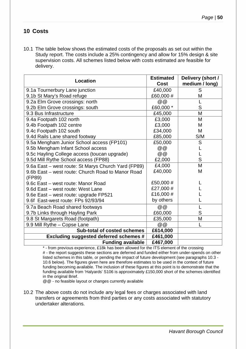
Page | 50
Havant Borough Council
10 Costs
10.1 The table below shows the estimated costs of the proposals as set out within the
Study report. The costs include a 25% contingency and allow for 15% design & site supervision costs. All schemes listed below with costs estimated are feasible for delivery.
Location Estimated Cost
Delivery (short / medium / long)
9.1a Tournerbury Lane junction 9.1b St Mary’s Road refuge
£40,000 £60,000 #
S M
9.2a Elm Grove crossings: north 9.2b Elm Grove crossings: south
@@ £60,000 *
L S
9.3 Bus Infrastructure £45,000 M 9.4a Footpath 102 north 9.4b Footpath 102 centre 9.4c Footpath 102 south 9.4d Rails Lane shared footway
£3,000 £3,000
£34,000 £85,000
M M M
S/M 9.5a Mengham Junior School access (FP101) 9.5b Mengham Infant School access 9.5c Hayling College access (toucan upgrade) 9.5d Mill Rythe School access (FP88)
£50,000 @@ @@
£2,000
S L L S
9.6a East – west route: St Marys Church Yard (FP89) 9.6b East – west route: Church Road to Manor Road (FP89) 9.6c East – west route: Manor Road 9.6d East – west route: West Lane 9.6e East – west route: upgrade FP521 9.6f East-west route: FPs 92/93/94
£4,000 £40,000
£50,000 # £27,000 # £16,000 # by others
M M
L L L L
9.7a Beach Road shared footways 9.7b Links through Hayling Park
@@ £60,000
L S
9.8 St Margarets Road (footpath) £35,000 M 9.9 Mill Rythe – Copse Lane @@ L
Sub-total of costed schemes £614,000 Excluding suggested deferred schemes # £461,000
Funding available £467,000 * - from previous experience, £18k has been allowed for the ITS element of the crossing # - the report suggests these sections are deferred and funded either from under-spends on other
listed schemes in this table, or pending the impact of future development (see paragraphs 10.3 - 10.6 below). The figures given here are therefore estimates to be used in the context of future funding becoming available. The inclusion of these figures at this point is to demonstrate that the funding available from ‘Halyards’ S106 is approximately £150,000 short of the schemes identified in the original Brief.
@@ - no feasible layout or changes currently available
10.2 The above costs do not include any legal fees or charges associated with land transfers or agreements from third parties or any costs associated with statutory undertaker alterations.
Page | 51
Havant Borough Council
10.3 During detailed design it would be expected that it will be possible to refine the funding estimates and reduce the contingency allowance. The funding available through the ‘Halyards’ S106 agreement will nominally enable the delivery of those items listed above where costs are allocated. Four schemes on the list are low priority, three (9.6c, 9.6d and 9.6e) on the east-west path most remote from the site; the St Mary’s Road junction and refuge (9.1b) are costed and could be progressed should additional funding be identified, for example through S.278 works related to Rook Farm.
10.4 Alternatively, the three elements of the east-west path (9.6c, 9.6d and 9.6e) could be
delivered and the footway work in Rails Lane (9.4d) be deferred instead. 10.5 No costs have been submitted for five items (9.2a, 9.5b, 9.5c, 9.7a and 9.9) where
the implementation is unlikely to be feasible or no changes have been identified as being necessary. Future works at these locations, should it be deemed necessary, could be expected to be met either by separate contributions from future local development or implemented by other parties (e.g. S278 works).
10.6 The east-west route alternative via FPs 92, 93 and 94 (9.6f) is not costed since it is
anticipated this would be brought forward as part of future development and as part of a wider set of improvements in that area of the Island.
11 Recommendations
11.1 The Study has demonstrated that a number of schemes are able to be implemented in the southern part of Hayling Island to link the ‘Halyards’ development site with the wider area, to the benefit of all local residents and to encourage travel by modes other than the private car. This includes support to walking, cycling and public transport.
11.2 It is suggested that the following schemes totalling £212,000 are progressed to
detailed design for implementation in the capital programme 2017/18:
9.1a Tournerbury Lane junction £40,000 9.2b Elm Grove crossings (south) £60,000 9.5a, 9.5d Mengham Junior School (FP101) and FP88 £52,000 9.7b Links through Hayling Park £60,000
11.3 The remaining S106 funds totalling £249,000 can be allocated to schemes
programmed for detailed design and implementation in the capital programme following 2017/18. These are schemes at:
Webb Lane bus stop £45,000 Footpath 102 / Rails Lane £125,000 Church Road to Manor Road £44,000 St Margaret’s Road £35,000
Page | 52
Havant Borough Council
APPENDIX A
MAP OF HAYLING ISLAND SHOWING ROUTES CONSIDERED
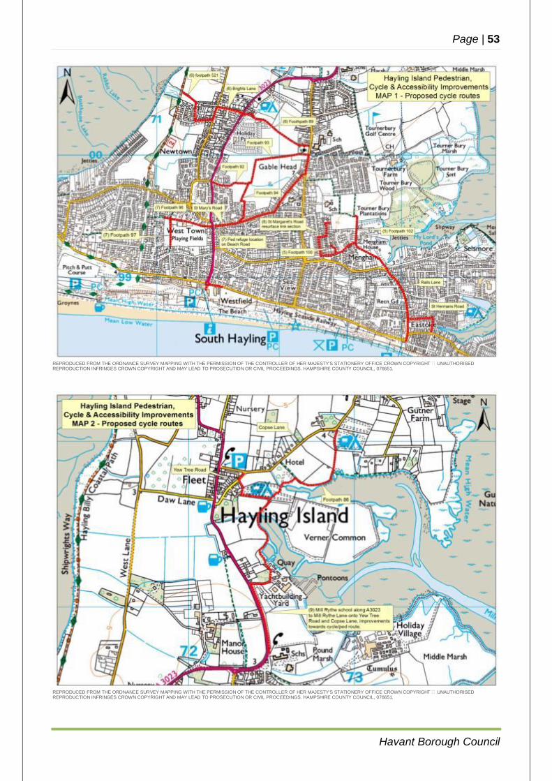
Page | 53
Havant Borough Council
REPRODUCED FROM THE ORDNANCE SURVEY MAPPING WITH THE PERMISSION OF THE CONTROLLER OF HER MAJESTY'S STATIONERY OFFICE CROWN COPYRIGHT � UNAUTHORISED REPRODUCTION INFRINGES CROWN COPYRIGHT AND MAY LEAD TO PROSECUTION OR CIVIL PROCEEDINGS. HAMPSHIRE COUNTY COUNCIL, 076651.
REPRODUCED FROM THE ORDNANCE SURVEY MAPPING WITH THE PERMISSION OF THE CONTROLLER OF HER MAJESTY'S STATIONERY OFFICE CROWN COPYRIGHT � UNAUTHORISED REPRODUCTION INFRINGES CROWN COPYRIGHT AND MAY LEAD TO PROSECUTION OR CIVIL PROCEEDINGS. HAMPSHIRE COUNTY COUNCIL, 076651.
Page | 54
Havant Borough Council
APPENDIX B
TASK ORDER
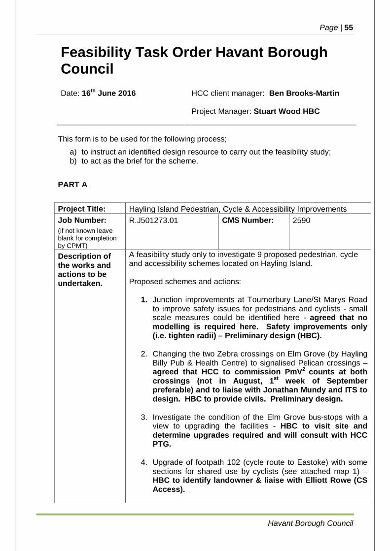
Page | 55
Havant Borough Council
Feasibility Task Order Havant Borough Council Date: 16th June 2016 HCC client manager: Ben Brooks-Martin
Project Manager: Stuart Wood HBC
This form is to be used for the following process;
a) to instruct an identified design resource to carry out the feasibility study; b) to act as the brief for the scheme.
PART A Project Title: Hayling Island Pedestrian, Cycle & Accessibility Improvements Job Number: (if not known leave blank for completion by CPMT)
R.J501273.01 CMS Number: 2590
Description of the works and actions to be undertaken.
A feasibility study only to investigate 9 proposed pedestrian, cycle and accessibility schemes located on Hayling Island. Proposed schemes and actions:
1. Junction improvements at Tournerbury Lane/St Marys Road to improve safety issues for pedestrians and cyclists - small scale measures could be identified here - agreed that no modelling is required here. Safety improvements only (i.e. tighten radii) – Preliminary design (HBC).
2. Changing the two Zebra crossings on Elm Grove (by Hayling
Billy Pub & Health Centre) to signalised Pelican crossings – agreed that HCC to commission PmV2 counts at both crossings (not in August, 1st week of September preferable) and to liaise with Jonathan Mundy and ITS to design. HBC to provide civils. Preliminary design.
3. Investigate the condition of the Elm Grove bus-stops with a
view to upgrading the facilities - HBC to visit site and determine upgrades required and will consult with HCC PTG.
4. Upgrade of footpath 102 (cycle route to Eastoke) with some sections for shared use by cyclists (see attached map 1) – HBC to identify landowner & liaise with Elliott Rowe (CS Access).
Page | 56
Havant Borough Council
5. Pedestrian and cycle access improvements to all the schools in the area (see attached map 1) – agreed that footpath 102 link to Mengham Jr school (eastern side).
6. Investigate a new east-west cycle route from Church Road to
the Hayling Billy via Manor road, Higworth Lane and Brights Lane Upgrading footpaths 89 & 521. Establish exact route, investigate alternative route footpaths 92 93 & 94 (see attached map 1) - HBC to consult HCC Countryside & Estates. Consider a crossing point Manor Road which has a 40mph speed limit.
7. Pedestrian refuge across Beach Road to improve access to
Hayling Park (see attached map 1) – agreed that ped refuge will be located at the top right hand corner of, opposite St Marys Rd. HBC to check on a status change for the paths 96 & 97 in the park, north-south from tennis courts to Bacon Lane, to enable cycling.
8. St Margaret’s Road resurface unadopted section, construction of footway on the north side (see attached map 1) – HBC to do land search on unadopted section and contact land owner. This section would form part of a cycle/ped route from the new development, and also forms part of a school route.
9. Mill Rythe school along A3023 to Mill Rythe Lane onto Yew Tree Road & Copse Lane; improvements towards cycle/ped route as part of access to schools in the area (see attached map 2) – HBC to investigate.
Attached:
Original gateway document.
Project Plan and Delivery Programme: Confirm that HBC are to undertake the following:
preparation of a Project Plan [overall content to be agreed with Client] based upon the requirements of this brief, minimally containing the information required / contained elsewhere;
provision of all required duties under CDM regulations 2015
during design and construction stages;
provision of attendance at inception, all project progress meetings [frequency to be confirmed by Client] and any
Page | 57
Havant Borough Council
other meeting as may be deemed necessary and called from time to time, including provision of all supporting materials and taking of minutes/records;
provision of all scheme progress and tracking information.
Required outputs and Formats: Full report with preliminary drawings/diagrams as appropriate; Summary table for each scheme proposal including cost estimates
for each; Overall conclusions and recommendations regarding the deliverability of each scheme.
PART B
Delivery Mechanism:
Havant Borough Council
Study Programme:
Feasibility Study Start Date: Study End Date: July 2016 Feb 2017
Funding Required:
This study has a £20k budget.
Funding Source: 2016/17 feasibility study budget Spend Forecast: 2016/17
£20k Local Members: Cllr Pearce Consultation: HBC to assist the HCC Client and provide suitable material
for any public consultation if required, including drawings text and confirmation of estimates; participate in the management of and attendance at the exhibitions, with the HCC Client team and others.
Mengham Fields Residents Group, local members and to be informed of progress by HBC and HCC, as and when required – attached notes from meeting (26.11.2015)
Local schools may also need to be considered. Environmental/ Ecological Constraints:
HCC to commission HCC Ecology. HCC Landscape to be a consultee - see email from Hannah
Walton - Landscapes. Comments: Known constraints:
Definitive footpaths 3rd party land
Any further constraints to be determined through this task.
Page | 58
Havant Borough Council
APPENDIX C
FEASIBILITY REPORT DRAWINGS (INITIAL SCHEMES)
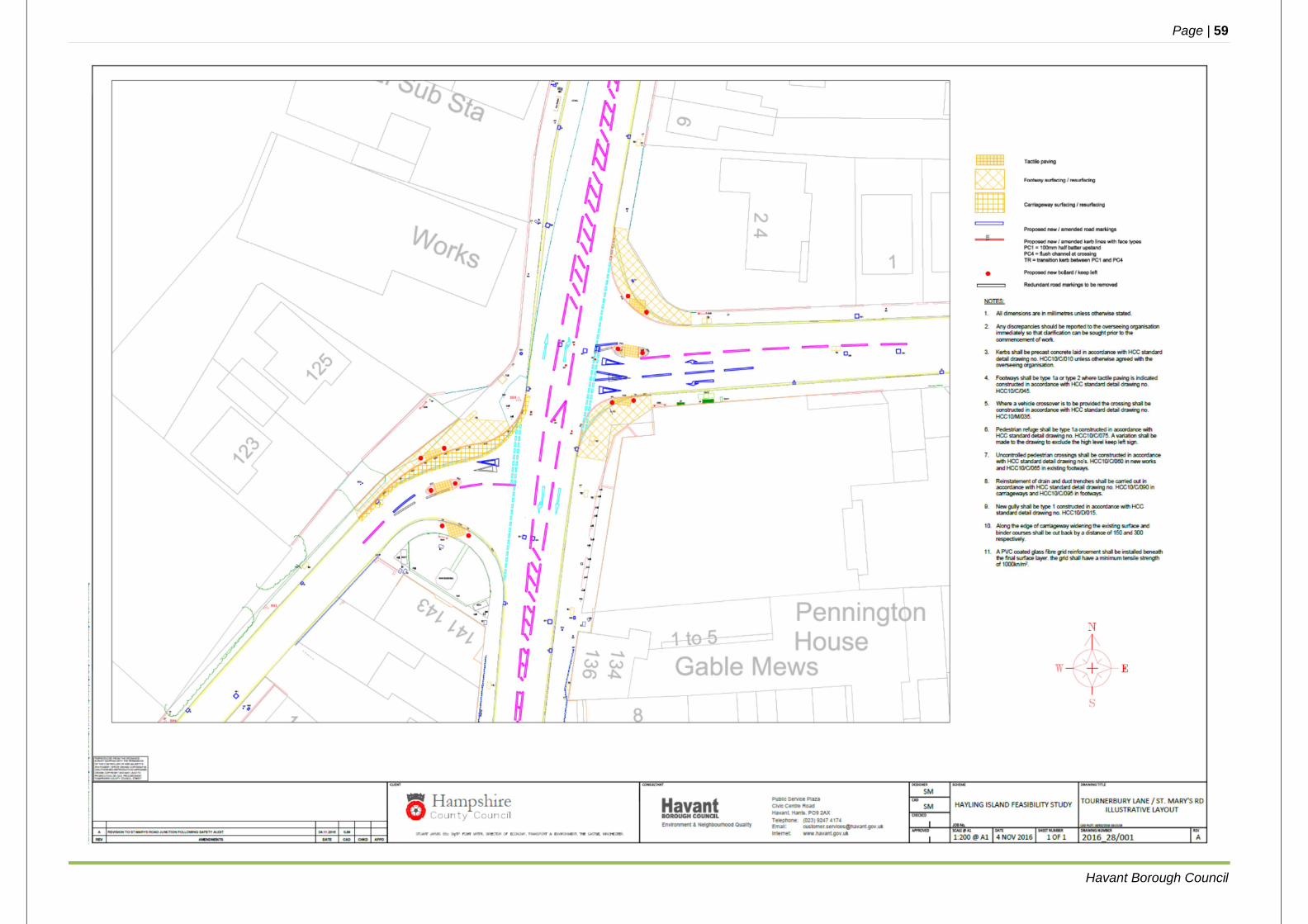
Page | 59
Havant Borough Council

Page | 60
Havant Borough Council
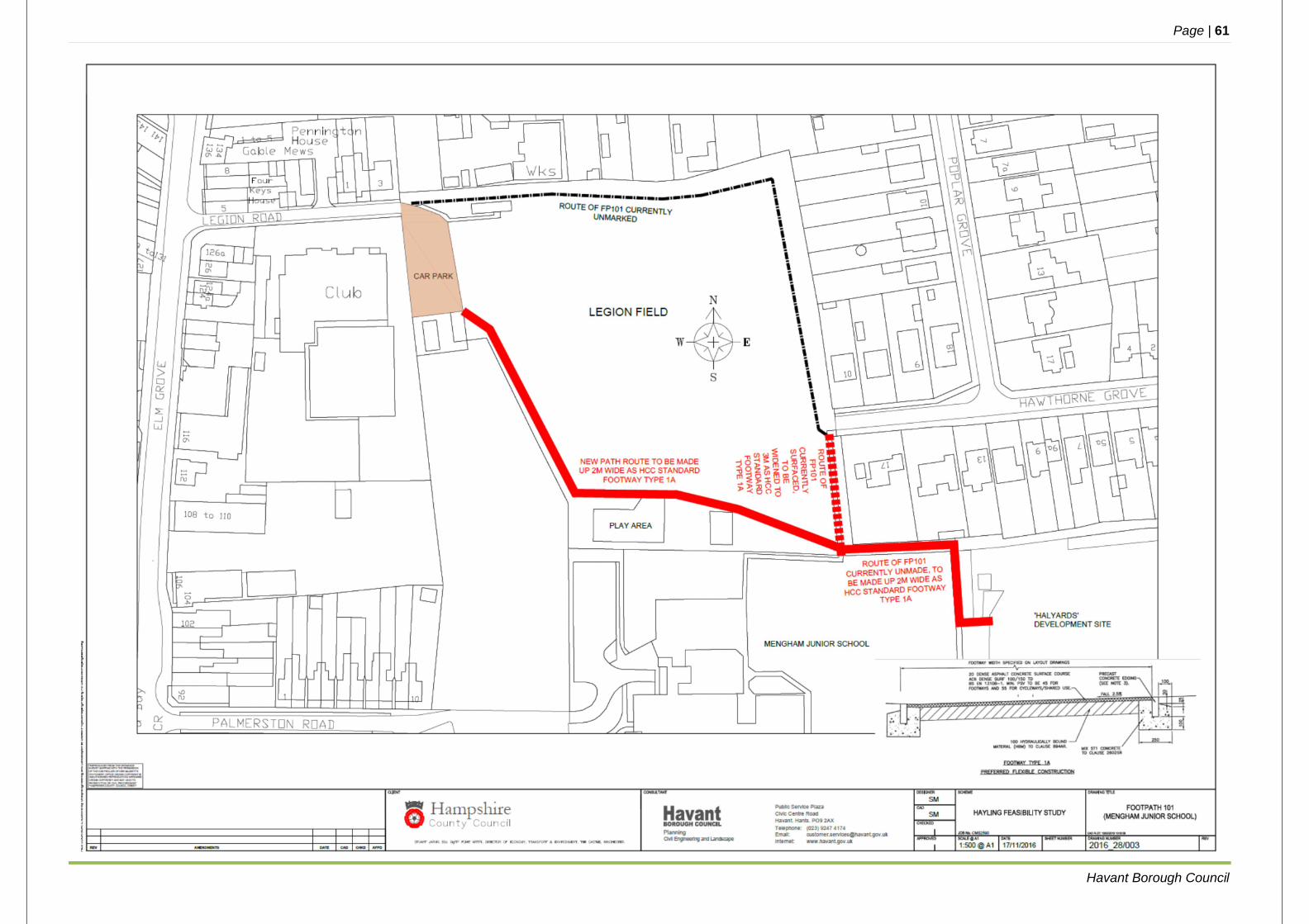
Page | 61
Havant Borough Council
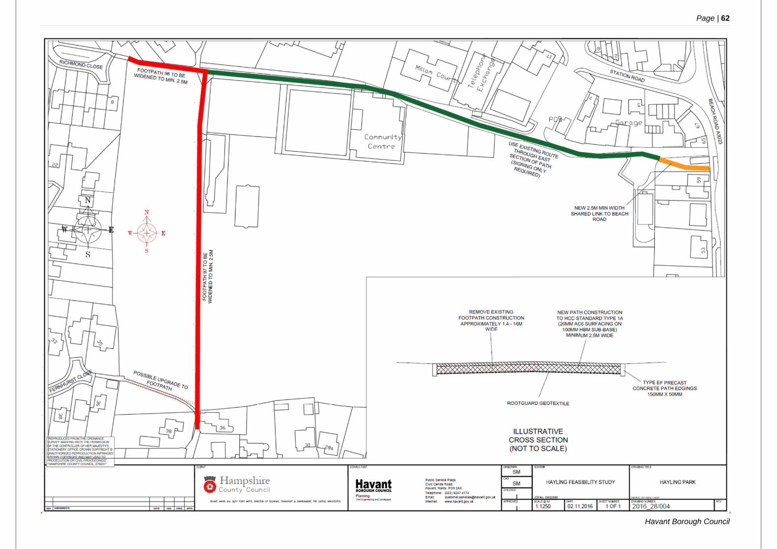
Page | 62
Havant Borough Council
Page | 63
Havant Borough Council
APPENDIX D
ECOLOGICAL APPRAISAL – SUMMARY
In the following appraisal, footpaths referred to are as per the sections in the report: Footpath 86 9.9 (part of east coast route) Footpath 89 9.6 (part of east-west route) Footpath 92 / 93 / 94 9.6 (alternatives to east-west route) Footpath 96 / 97 9.7 (Hayling Park) Footpath 100 9.4 (linking St Margaret’s Road to Mengham Lane) Footpath 102 9.4 (main route linking Rails Lane to ‘Halyards’ site) Footpath 521 9.6 (part of east-west route)
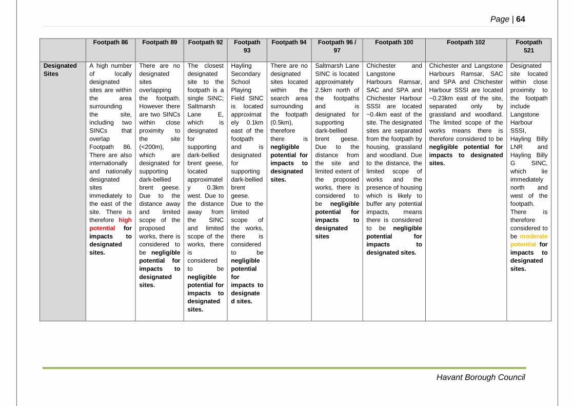
Page | 64
Havant Borough Council
Footpath 86 Footpath 89 Footpath 92 Footpath 93
Footpath 94 Footpath 96 / 97
Footpath 100 Footpath 102 Footpath 521
Designated Sites
A high number of locally designated sites are within the area surrounding the site, including two SINCs that overlap Footpath 86. There are also internationally and nationally designated sites immediately to the east of the site. There is therefore high potential for impacts to designated sites.
There are no designated sites overlapping the footpath. However there are two SINCs within close proximity to the site (<200m), which are designated for supporting dark-bellied brent geese. Due to the distance away and limited scope of the proposed works, there is considered to be negligible potential for impacts to designated sites.
The closest designated site to the footpath is a single SINC; Saltmarsh Lane E, which is designated for supporting dark-bellied brent geese, located approximately 0.3km west. Due to the distance away from the SINC and limited scope of the works, there is considered to be negligible potential for impacts to designated sites.
Hayling Secondary School Playing Field SINC is located approximately 0.1km east of the footpath and is designated for supporting dark-bellied brent geese. Due to the limited scope of the works, there is considered to be negligible potential for impacts to designated sites.
There are no designated sites located within the search area surrounding the footpath (0.5km), therefore there is negligible potential for impacts to designated sites.
Saltmarsh Lane SINC is located approximately 2.5km north of the footpaths and is designated for supporting dark-bellied brent geese. Due to the distance from the site and limited extent of the proposed works, there is considered to be negligible potential for impacts to designated sites
Chichester and Langstone Harbours Ramsar, SAC and SPA and Chichester Harbour SSSI are located ~0.4km east of the site. The designated sites are separated from the footpath by housing, grassland and woodland. Due to the distance, the limited scope of works and the presence of housing which is likely to buffer any potential impacts, means there is considered to be negligible potential for impacts to designated sites.
Chichester and Langstone Harbours Ramsar, SAC and SPA and Chichester Harbour SSSI are located ~0.23km east of the site, separated only by grassland and woodland. The limited scope of the works means there is therefore considered to be negligible potential for impacts to designated sites.
Designated site located within close proximity to the footpath include Langstone Harbour SSSI, Hayling Billy LNR and Hayling Billy G SINC, which lie immediately north and west of the footpath. There is therefore considered to be moderate potential for impacts to designated sites.
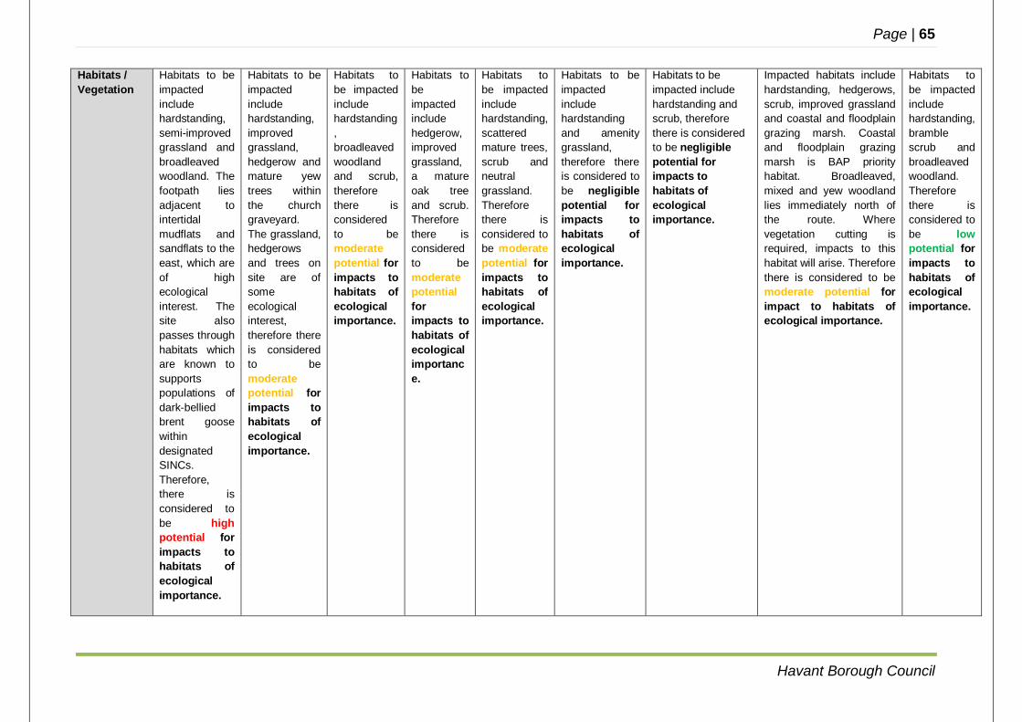
Page | 65
Havant Borough Council
Habitats / Vegetation
Habitats to be impacted include hardstanding, semi-improved grassland and broadleaved woodland. The footpath lies adjacent to intertidal mudflats and sandflats to the east, which are of high ecological interest. The site also passes through habitats which are known to supports populations of dark-bellied brent goose within designated SINCs. Therefore, there is considered to be high potential for impacts to habitats of ecological importance.
Habitats to be impacted include hardstanding, improved grassland, hedgerow and mature yew trees within the church graveyard. The grassland, hedgerows and trees on site are of some ecological interest, therefore there is considered to be moderate potential for impacts to habitats of ecological importance.
Habitats to be impacted include hardstanding, broadleaved woodland and scrub, therefore there is considered to be moderate potential for impacts to habitats of ecological importance.
Habitats to be impacted include hedgerow, improved grassland, a mature oak tree and scrub. Therefore there is considered to be moderate potential for impacts to habitats of ecological importance.
Habitats to be impacted include hardstanding, scattered mature trees, scrub and neutral grassland. Therefore there is considered to be moderate potential for impacts to habitats of ecological importance.
Habitats to be impacted include hardstanding and amenity grassland, therefore there is considered to be negligible potential for impacts to habitats of ecological importance.
Habitats to be impacted include hardstanding and scrub, therefore there is considered to be negligible potential for impacts to habitats of ecological importance.
Impacted habitats include hardstanding, hedgerows, scrub, improved grassland and coastal and floodplain grazing marsh. Coastal and floodplain grazing marsh is BAP priority habitat. Broadleaved, mixed and yew woodland lies immediately north of the route. Where vegetation cutting is required, impacts to this habitat will arise. Therefore there is considered to be moderate potential for impact to habitats of ecological importance.
Habitats to be impacted include hardstanding, bramble scrub and broadleaved woodland. Therefore there is considered to be low potential for impacts to habitats of ecological importance.
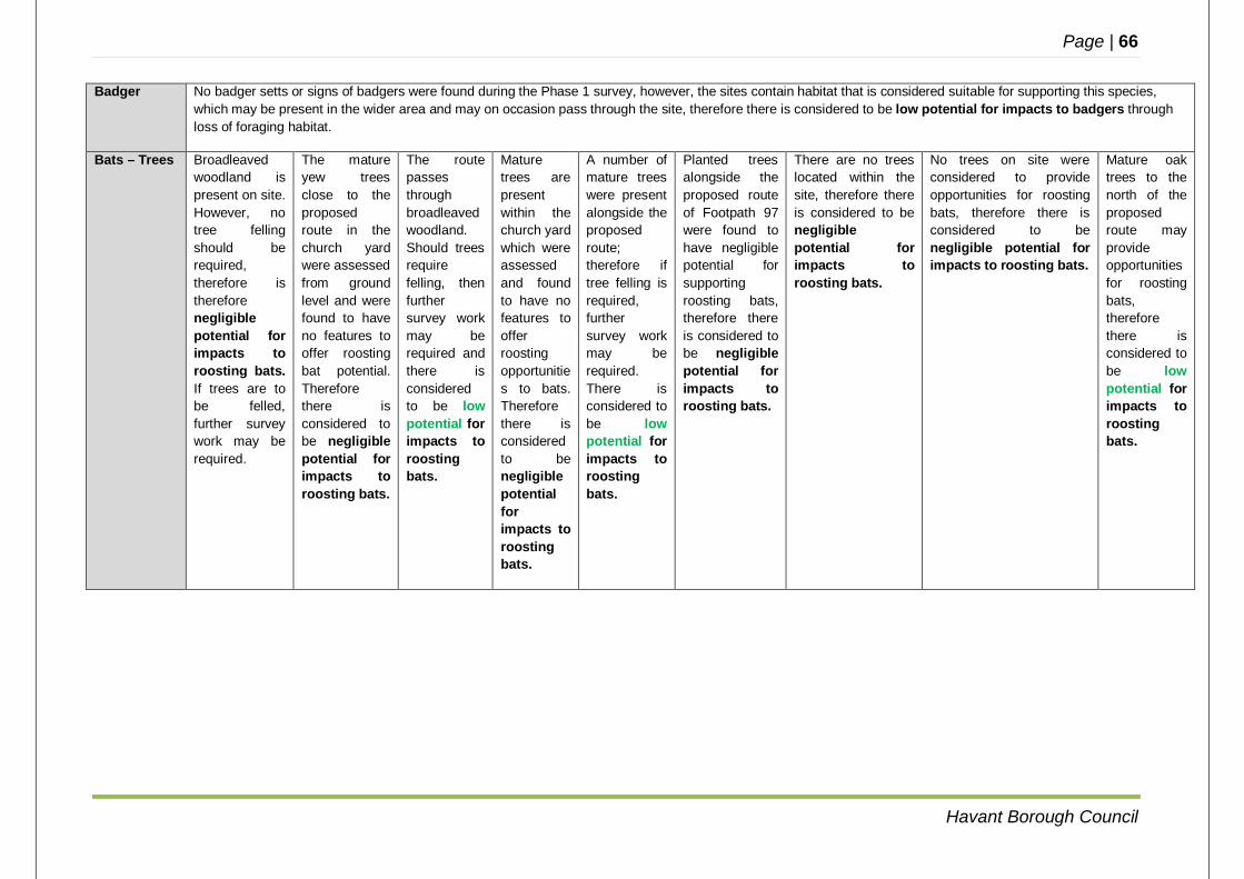
Page | 66
Havant Borough Council
Badger No badger setts or signs of badgers were found during the Phase 1 survey, however, the sites contain habitat that is considered suitable for supporting this species, which may be present in the wider area and may on occasion pass through the site, therefore there is considered to be low potential for impacts to badgers through loss of foraging habitat.
Bats – Trees Broadleaved woodland is present on site. However, no tree felling should be required, therefore is therefore negligible potential for impacts to roosting bats. If trees are to be felled, further survey work may be required.
The mature yew trees close to the proposed route in the church yard were assessed from ground level and were found to have no features to offer roosting bat potential. Therefore there is considered to be negligible potential for impacts to roosting bats.
The route passes through broadleaved woodland. Should trees require felling, then further survey work may be required and there is considered to be low potential for impacts to roosting bats.
Mature trees are present within the church yard which were assessed and found to have no features to offer roosting opportunities to bats. Therefore there is considered to be negligible potential for impacts to roosting bats.
A number of mature trees were present alongside the proposed route; therefore if tree felling is required, further survey work may be required. There is considered to be low potential for impacts to roosting bats.
Planted trees alongside the proposed route of Footpath 97 were found to have negligible potential for supporting roosting bats, therefore there is considered to be negligible potential for impacts to roosting bats.
There are no trees located within the site, therefore there is considered to be negligible potential for impacts to roosting bats.
No trees on site were considered to provide opportunities for roosting bats, therefore there is considered to be negligible potential for impacts to roosting bats.
Mature oak trees to the north of the proposed route may provide opportunities for roosting bats, therefore there is considered to be low potential for impacts to roosting bats.
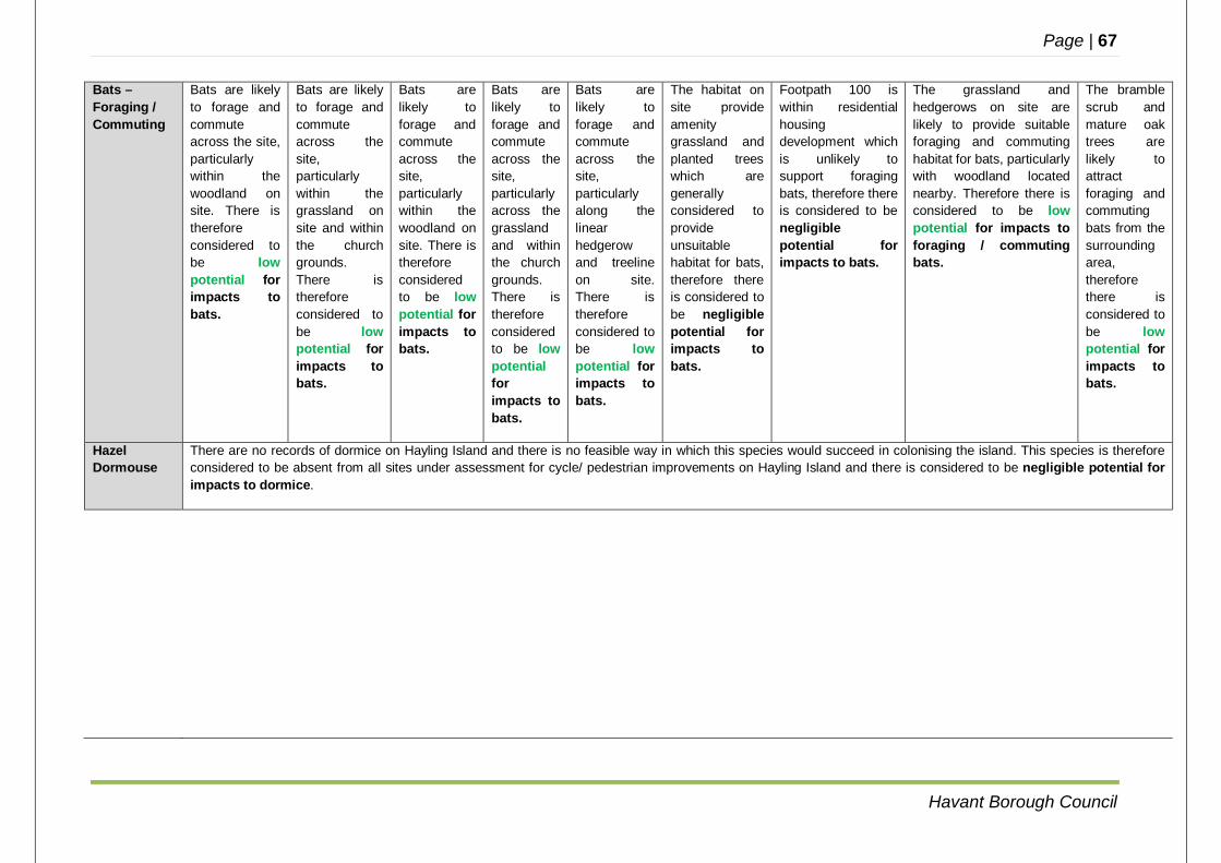
Page | 67
Havant Borough Council
Bats – Foraging / Commuting
Bats are likely to forage and commute across the site, particularly within the woodland on site. There is therefore considered to be low potential for impacts to bats.
Bats are likely to forage and commute across the site, particularly within the grassland on site and within the church grounds. There is therefore considered to be low potential for impacts to bats.
Bats are likely to forage and commute across the site, particularly within the woodland on site. There is therefore considered to be low potential for impacts to bats.
Bats are likely to forage and commute across the site, particularly across the grassland and within the church grounds. There is therefore considered to be low potential for impacts to bats.
Bats are likely to forage and commute across the site, particularly along the linear hedgerow and treeline on site. There is therefore considered to be low potential for impacts to bats.
The habitat on site provide amenity grassland and planted trees which are generally considered to provide unsuitable habitat for bats, therefore there is considered to be negligible potential for impacts to bats.
Footpath 100 is within residential housing development which is unlikely to support foraging bats, therefore there is considered to be negligible potential for impacts to bats.
The grassland and hedgerows on site are likely to provide suitable foraging and commuting habitat for bats, particularly with woodland located nearby. Therefore there is considered to be low potential for impacts to foraging / commuting bats.
The bramble scrub and mature oak trees are likely to attract foraging and commuting bats from the surrounding area, therefore there is considered to be low potential for impacts to bats.
Hazel Dormouse
There are no records of dormice on Hayling Island and there is no feasible way in which this species would succeed in colonising the island. This species is therefore considered to be absent from all sites under assessment for cycle/ pedestrian improvements on Hayling Island and there is considered to be negligible potential for impacts to dormice.
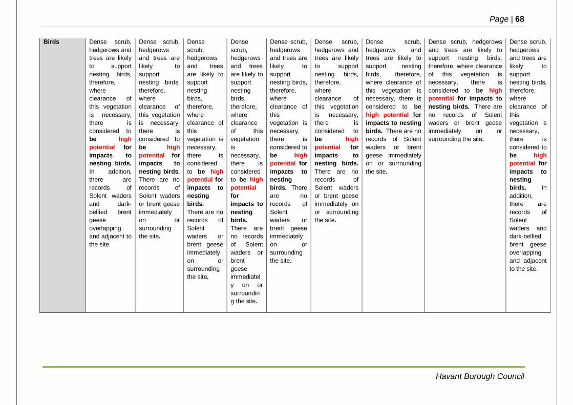
Page | 68
Havant Borough Council
Birds Dense scrub, hedgerows and trees are likely to support nesting birds, therefore, where clearance of this vegetation is necessary, there is considered to be high potential for impacts to nesting birds. In addition, there are records of Solent waders and dark-bellied brent geese overlapping and adjacent to the site.
Dense scrub, hedgerows and trees are likely to support nesting birds, therefore, where clearance of this vegetation is necessary, there is considered to be high potential for impacts to nesting birds. There are no records of Solent waders or brent geese immediately on or surrounding the site.
Dense scrub, hedgerows and trees are likely to support nesting birds, therefore, where clearance of this vegetation is necessary, there is considered to be high potential for impacts to nesting birds. There are no records of Solent waders or brent geese immediately on or surrounding the site.
Dense scrub, hedgerows and trees are likely to support nesting birds, therefore, where clearance of this vegetation is necessary, there is considered to be high potential for impacts to nesting birds. There are no records of Solent waders or brent geese immediately on or surrounding the site.
Dense scrub, hedgerows and trees are likely to support nesting birds, therefore, where clearance of this vegetation is necessary, there is considered to be high potential for impacts to nesting birds. There are no records of Solent waders or brent geese immediately on or surrounding the site.
Dense scrub, hedgerows and trees are likely to support nesting birds, therefore, where clearance of this vegetation is necessary, there is considered to be high potential for impacts to nesting birds. There are no records of Solent waders or brent geese immediately on or surrounding the site.
Dense scrub, hedgerows and trees are likely to support nesting birds, therefore, where clearance of this vegetation is necessary, there is considered to be high potential for impacts to nesting birds. There are no records of Solent waders or brent geese immediately on or surrounding the site.
Dense scrub, hedgerows and trees are likely to support nesting birds, therefore, where clearance of this vegetation is necessary, there is considered to be high potential for impacts to nesting birds. There are no records of Solent waders or brent geese immediately on or surrounding the site.
Dense scrub, hedgerows and trees are likely to support nesting birds, therefore, where clearance of this vegetation is necessary, there is considered to be high potential for impacts to nesting birds. In addition, there are records of Solent waders and dark-bellied brent geese overlapping and adjacent to the site.
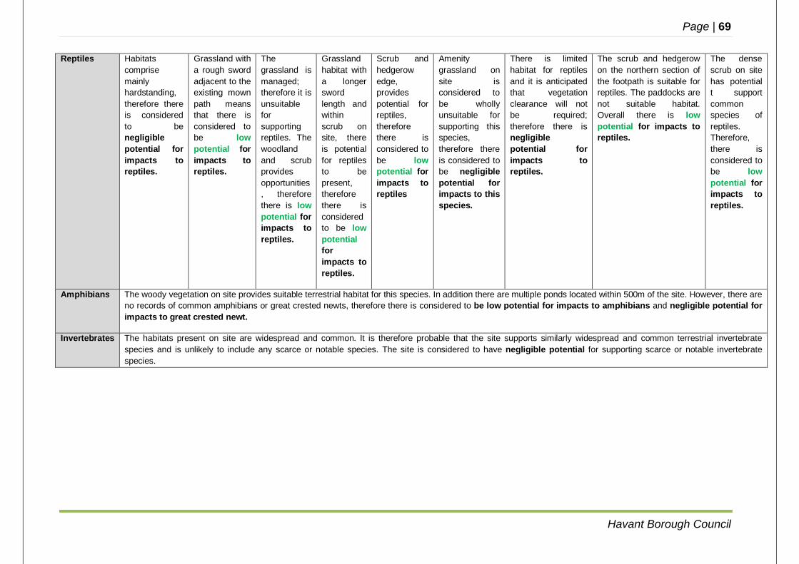
Page | 69
Havant Borough Council
Reptiles Habitats comprise mainly hardstanding, therefore there is considered to be negligible potential for impacts to reptiles.
Grassland with a rough sword adjacent to the existing mown path means that there is considered to be low potential for impacts to reptiles.
The grassland is managed; therefore it is unsuitable for supporting reptiles. The woodland and scrub provides opportunities, therefore there is low potential for impacts to reptiles.
Grassland habitat with a longer sword length and within scrub on site, there is potential for reptiles to be present, therefore there is considered to be low potential for impacts to reptiles.
Scrub and hedgerow edge, provides potential for reptiles, therefore there is considered to be low potential for impacts to reptiles
Amenity grassland on site is considered to be wholly unsuitable for supporting this species, therefore there is considered to be negligible potential for impacts to this species.
There is limited habitat for reptiles and it is anticipated that vegetation clearance will not be required; therefore there is negligible potential for impacts to reptiles.
The scrub and hedgerow on the northern section of the footpath is suitable for reptiles. The paddocks are not suitable habitat. Overall there is low potential for impacts to reptiles.
The dense scrub on site has potential t support common species of reptiles. Therefore, there is considered to be low potential for impacts to reptiles.
Amphibians The woody vegetation on site provides suitable terrestrial habitat for this species. In addition there are multiple ponds located within 500m of the site. However, there are no records of common amphibians or great crested newts, therefore there is considered to be low potential for impacts to amphibians and negligible potential for impacts to great crested newt.
Invertebrates The habitats present on site are widespread and common. It is therefore probable that the site supports similarly widespread and common terrestrial invertebrate species and is unlikely to include any scarce or notable species. The site is considered to have negligible potential for supporting scarce or notable invertebrate species.

Page | 70
Havant Borough Council
APPENDIX E
GLOSSARY AND ABBREVIATIONS
Page | 71
Havant Borough Council
GLOSSARY Cycle Hub A facility for cycles to be parked and stored, as part of a longer journey involving transfer between transport modes e.g. cycle to bus, cycle to rail. England Coast Path A project to create a National Trail around the coast of England arising from the Marine and Coastal Access Act 2009. PmV2 value A means of applying a standard test to justify improvement or conversion of a crossing. ‘P’ is the weighted value for pedestrians wishing to cross the road, ‘V’ is the weighted value of the volume of traffic, and ‘m’ is a local factor reflecting the width of the road, speed of traffic or type of pedestrian (e.g. elderly / schools / shopping etc.). Typically a value of above 1.0 x 10⁸ is required to justify a controlled crossing. Puffin Crossing A pedestrian user friendly intelligent crossing (puffin crossing) is a type of pedestrian crossing. The design is distinct in that the lights controlling the pedestrians are on the near side of the road, rather than on the opposite side as in the older pelican crossing it replaces. The system also utilises sensors which detect the presence of pedestrians waiting at the crossing, and as they are crossing the road, and extend the time the crossing shows red to traffic if pedestrians are still crossing. There is no flashing ‘amber’ stage. ABBREVIATIONS The following abbreviations are used throughout this document. ECP England Coast Path FP Footpath HBC Havant Borough Council HCC Hampshire County Council ITS Intelligent Transport Systems km kilometres m metres PIA Personal Injury Accident RTI Real Time Information S106 Section 106 (of the Town and Countryside Planning Act 1990) S278 Section 278 (of the Highways Act 1980) TSRGD Traffic Signs and Regulations General Directions 2016
Related Documents