ISSN: 1579-4377 EFFECTS OF CLIMATE CHANGE ON PLANNING AND MANGING WATER SERVICES IN THE POTOHAR REGION OF PAKISTAN ISLAM-UL-HAQUE 1 , ANUM 2 and RUHMMA 3 [email protected] 1. Managing Director water and sanitation Agency, Rawalpindi-Pakistan 2. FAST- National University of Computer and Emerging Sciences, Islamabad-Pakistan 3. Beacon house School System, Faisalabad- Pakistan ABSTRACT Glaciers in Pakistan cover 13,680 km2 which is 13% of the mountain regions of the Upper Indus Basin. Snow melt water from these glaciers contributes more than 60% to the river flows. The vast variations in temperature and precipitation patterns have created enormous impacts. An average variation of +5 to 10C has been observed in the northern part of Pakistan. During 2008, couple of glaciers slipped from their centuries old locations and blocked the flow of Hunza River besides blocking the Kurrakurm High Way and Sonoghur, in Chitral experienced a disaster where Sonoghur Glacier slipped on the village. The ever rising temperature has adversely impacted the rain fall patterns both temporally and spatially creating water quality, quantity and ground water aquifer depletion problems. Over and above, intense rains are not only affecting the ground water recharge mechanism but also causing abnormal flooding. Potohar Region has experienced sub zero temperature during 2007-08 which has slowed down the reaction of coagulant, resulting in slow sedimentation process with high consumption of chemicals. The future of water is the future of mankind which warrants establishing sustainable ecological policies, developing and implementing new technologies and harnessing available expertise. KEYWORDS Aquifer, basin, climate change, disaster, global, earth, glacier, technologies, magnitudes, temperature, water , sanitation, warming, sustainable, snow, ice melt, mountains, lakes, development, goals.

Welcome message from author
This document is posted to help you gain knowledge. Please leave a comment to let me know what you think about it! Share it to your friends and learn new things together.
Transcript
ISSN: 1579-4377
EFFECTS OF CLIMATE CHANGE ON PLANNING AND MANGING WATER SERVICES IN THE POTOHAR REGION OF
PAKISTAN
ISLAM-UL-HAQUE 1, ANUM 2 and RUHMMA 3 [email protected]
1. Managing Director water and sanitation Agency, Rawalpindi-Pakistan 2. FAST- National University of Computer and Emerging Sciences, Islamabad-Pakistan
3. Beacon house School System, Faisalabad- Pakistan
ABSTRACT
Glaciers in Pakistan cover 13,680 km2 which is 13% of the mountain regions of the Upper Indus Basin. Snow melt water from these glaciers contributes more than 60% to the river flows. The vast variations in temperature and precipitation patterns have created enormous impacts. An average variation of +5 to 10C has been observed in the northern part of Pakistan. During 2008, couple of glaciers slipped from their centuries old locations and blocked the flow of Hunza River besides blocking the Kurrakurm High Way and Sonoghur, in Chitral experienced a disaster where Sonoghur Glacier slipped on the village. The ever rising temperature has adversely impacted the rain fall patterns both temporally and spatially creating water quality, quantity and ground water aquifer depletion problems. Over and above, intense rains are not only affecting the ground water recharge mechanism but also causing abnormal flooding. Potohar Region has experienced sub zero temperature during 2007-08 which has slowed down the reaction of coagulant, resulting in slow sedimentation process with high consumption of chemicals. The future of water is the future of mankind which warrants establishing sustainable ecological policies, developing and implementing new technologies and harnessing available expertise.
KEYWORDS Aquifer, basin, climate change, disaster, global, earth, glacier, technologies, magnitudes, temperature, water , sanitation, warming, sustainable, snow, ice melt, mountains, lakes, development, goals.
Islam-Ul-Haque et al. EJEAFChe, 8 (8), 2009. [647-656]
648
INTRODUCTION Sixty-seven percent of world’s glaciers are retreating at a startling rate in the Himalayas and the major causal factor has been identified as climate change (Ageta and Kadota, 1992; Yamada et al., 1996; Fushinmi, 2000). Glacial melt will affect freshwater flows with dramatic adverse effects on biodiversity and livelihood, with possible long-term implications on regional food security. Over the past 200 years, emissions of greenhouse gases due to human activities have accumulated in the atmosphere, where, because of their long life, they stay from decades to centuries. As a result, since the Industrial Revolution, concentrations of carbon dioxide have increased by 30 per cent, methane by 145 per cent and nitrous oxide by 15 per cent.
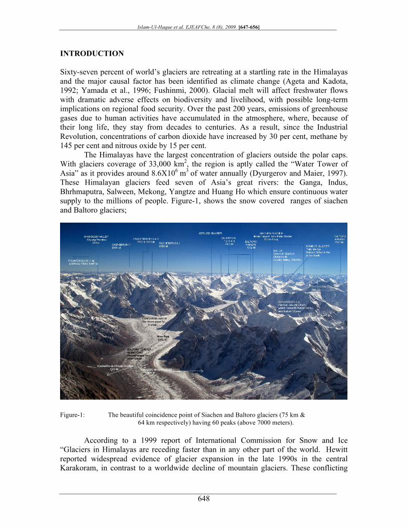
The Himalayas have the largest concentration of glaciers outside the polar caps. With glaciers coverage of 33,000 km2, the region is aptly called the “Water Tower of Asia” as it provides around 8.6X10⁶ m3 of water annually (Dyurgerov and Maier, 1997). These Himalayan glaciers feed seven of Asia’s great rivers: the Ganga, Indus, Bhrhmaputra, Salween, Mekong, Yangtze and Huang Ho which ensure continuous water supply to the millions of people. Figure-1, shows the snow covered ranges of siachen and Baltoro glaciers;
Figure-1: The beautiful coincidence point of Siachen and Baltoro glaciers (75 km & 64 km respectively) having 60 peaks (above 7000 meters).
According to a 1999 report of International Commission for Snow and Ice “Glaciers in Himalayas are receding faster than in any other part of the world. Hewitt reported widespread evidence of glacier expansion in the late 1990s in the central Karakoram, in contrast to a worldwide decline of mountain glaciers. These conflicting
Islam-Ul-Haque et al. EJEAFChe, 8 (8), 2009. [647-656]
649
findings make the impact of climate change on Karakoram glaciers and resultantly make Indus River flows very uncertain . The burning of fossil fuels such as coal, oil and natural gas in factories , cars and to generate electricity are the major causes. Moreover we have cleared more land for human use in the past 100 years than in all of prior human history. This has resulted in the loss of forests and wetlands, which absorb and store greenhouse gases and naturally regulate the atmosphere.
Resultantly, already, the average global temperature has increased by about 0.5° C in the past 100 years, and temperature increases over the next 100 years are expected to significantly surpass any such change of the past 10,000 years. Consequently, there is a increase in the temperature in the northern areas ( Himalayan Ranges) This increase in temperature has adversely impacted macro and micromanagements of water resources.
Climate Variation in Pakistan
Pakistan is a developing country whose economy mainly depends on agriculture which is more susceptible to the effects of climate changes. Due to lack of modern technical resources, Pakistan does not have adequate monitoring systems for the prediction of likelihood of occurrence of extreme events, or the assessment of possible changes in weather patterns, thus making the task of developing short term response or disaster mitigation strategies extremely difficult. There are several aspects that are circumstantial to the effects of climate change. In a country such as Pakistan, the pressures generated as a directly result of climate change impact multiple sectors including water, agriculture, forests, biodiversity, livestock, costal zones, etc.
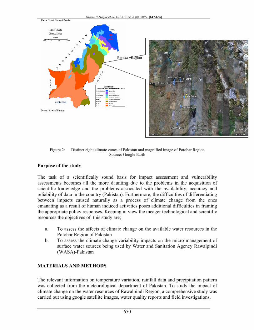
State The Survey of Pakistan classifies the country into eight climatic zones, as shown in figure-2, which roughly concur with the Koppen Geiger classification, where zones are defined on the basis of monthly temperature and precipitation data. According to the Koppen Geiger classification of climatic zones, where zones are defined on the basis of monthly temperature and precipitation data, there are 11 distinct as well as overlapping climatic zones in the country. These range from zones characterized by mild, moist winters and hot dry summers in the north to semi-arid and arid zones in the west and parts of the south. The north-eastern mountainous and sub-mountainous areas receive more than 1,700 mm annual precipitation with a major share (over 1,000 mm) from the summer monsoon. On the other hand, the extremely arid plains of southwest Balochistan province receive only 30 mm during the whole year. Thermal regimes exhibit extreme diurnal, seasonal, and annual variations as the temperatures can fall as low as -26°C over the northern mountains and go as high as 52°C over the central arid plains. In the semi-arid plains, temperatures of 42°C are recorded at various stations in the months of May and June. Areas comprising Pakistan have seen several droughts, the most recent of which was the worst experienced for the last hundred years and affected several districts of Sindh and Balochistan provinces from 1999-2000. The drought is estimated to have affected over 3.3 million people and 30 million heads of livestock.
Islam-Ul-Haque et al. EJEAFChe, 8 (8), 2009. [647-656]
650
Figure 2: Distinct eight climate zones of Pakistan and magnified image of Potohar Region Source: Google Earth
Purpose of the study The task of a scientifically sound basis for impact assessment and vulnerability assessments becomes all the more daunting due to the problems in the acquisition of scientific knowledge and the problems associated with the availability, accuracy and reliability of data in the country (Pakistan). Furthermore, the difficulties of differentiating between impacts caused naturally as a process of climate change from the ones emanating as a result of human induced activities poses additional difficulties in framing the appropriate policy responses. Keeping in view the meager technological and scientific resources the objectives of this study are;
a. To assess the affects of climate change on the available water resources in the Potohar Region of Pakistan
b. To assess the climate change variability impacts on the micro management of surface water sources being used by Water and Sanitation Agency Rawalpindi (WASA)-Pakistan
MATERIALS AND METHODS
The relevant information on temperature variation, rainfall data and precipitation pattern was collected from the meteorological department of Pakistan. To study the impact of climate change on the water resources of Rawalpindi Region, a comprehensive study was carried out using google satellite images, water quality reports and field investigations.
Potohar Region
Islam-Ul-Haque et al. EJEAFChe, 8 (8), 2009. [647-656]
651
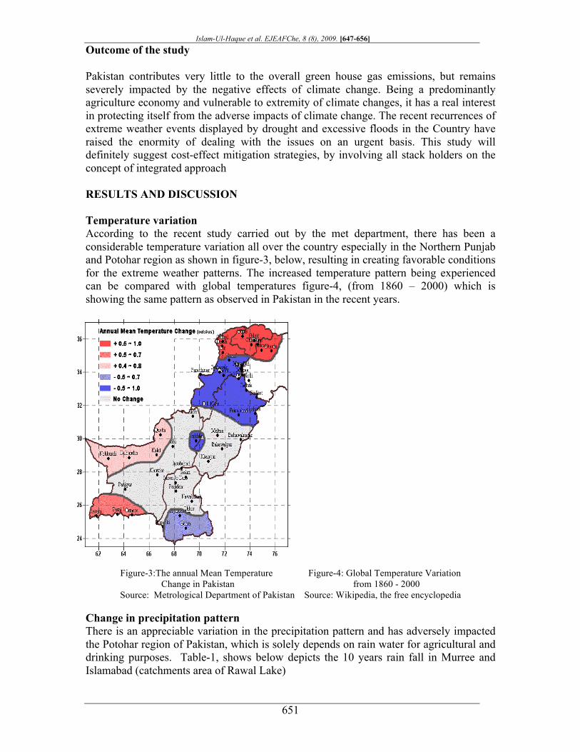
Outcome of the study Pakistan contributes very little to the overall green house gas emissions, but remains severely impacted by the negative effects of climate change. Being a predominantly agriculture economy and vulnerable to extremity of climate changes, it has a real interest in protecting itself from the adverse impacts of climate change. The recent recurrences of extreme weather events displayed by drought and excessive floods in the Country have raised the enormity of dealing with the issues on an urgent basis. This study will definitely suggest cost-effect mitigation strategies, by involving all stack holders on the concept of integrated approach RESULTS AND DISCUSSION Temperature variation According to the recent study carried out by the met department, there has been a considerable temperature variation all over the country especially in the Northern Punjab and Potohar region as shown in figure-3, below, resulting in creating favorable conditions for the extreme weather patterns. The increased temperature pattern being experienced can be compared with global temperatures figure-4, (from 1860 – 2000) which is showing the same pattern as observed in Pakistan in the recent years.
Figure-3:The annual Mean Temperature Figure-4: Global Temperature Variation
Change in Pakistan from 1860 - 2000 Source: Metrological Department of Pakistan Source: Wikipedia, the free encyclopedia
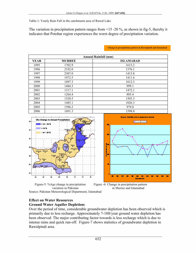
Change in precipitation pattern There is an appreciable variation in the precipitation pattern and has adversely impacted the Potohar region of Pakistan, which is solely depends on rain water for agricultural and drinking purposes. Table-1, shows below depicts the 10 years rain fall in Murree and Islamabad (catchments area of Rawal Lake)
Islam-Ul-Haque et al. EJEAFChe, 8 (8), 2009. [647-656]
652
Table-1: Yearly Rain Fall in the catchments area of Rawal Lake The variation in precipitation pattern ranges from +15 -20 %, as shown in fig-5, thereby it indicates that Potohar region experiences the worst degree of precipitation variation.
Figure-5: %Age change in precipitation Figure -6: Change in precipitation pattern
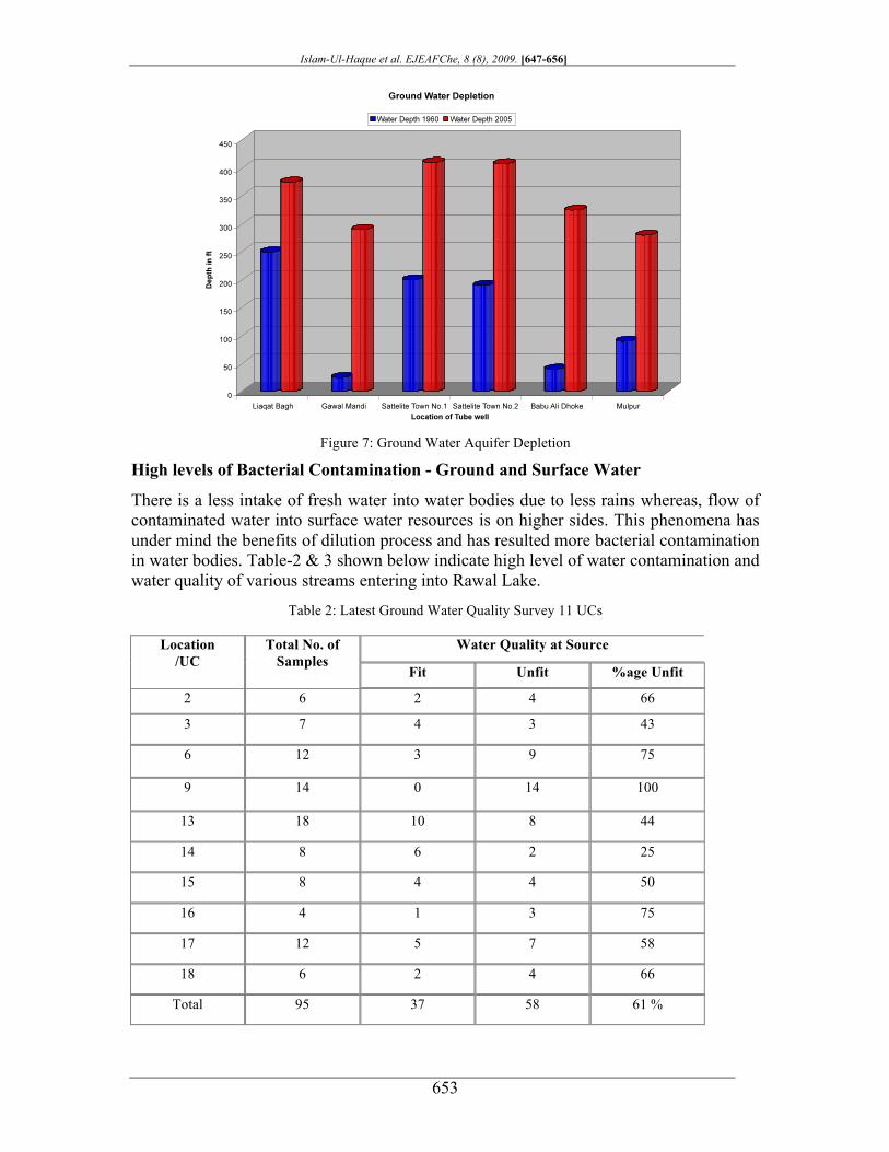
variation in Pakistan in Murree and Islamabad Source: Pakistan Meteorological Department, Islamabad Effect on Water Resources Ground Water Aquifer Depletion: Over the period of time, considerable groundwater depletion has been observed which is primarily due to less recharge. Approximately 7-10ft/year ground water depletion has been observed. The major contributing factor towards is less recharge which is due to intense rains and quick run-off. Figure-7 shows statistics of groundwater depletion in Rawalpindi area.
Annual Rainfall (mm) YEAR MURREE ISLAMABAD 1995 1702.9 1615.2 1996 2192.0 1376.1 1997 2307.0 1413.8 1998 1972.5 1411.6 1999 1897.3 1012.3 2000 1484.3 999.1 2001 1317.1 1472.1 2002 1264.4 885.4 2003 1520.5 1503.3 2004 1485.1 1026.3 2005 1596.2 979.0 2006 1691.3 1598.0
Change in precipitation pattern in Rawalpindi and Islamabad
Islam-Ul-Haque et al. EJEAFChe, 8 (8), 2009. [647-656]
653
Figure 7: Ground Water Aquifer Depletion
High levels of Bacterial Contamination - Ground and Surface Water
There is a less intake of fresh water into water bodies due to less rains whereas, flow of contaminated water into surface water resources is on higher sides. This phenomena has under mind the benefits of dilution process and has resulted more bacterial contamination in water bodies. Table-2 & 3 shown below indicate high level of water contamination and water quality of various streams entering into Rawal Lake.
Table 2: Latest Ground Water Quality Survey 11 UCs
Water Quality at Source Location /UC
Total No. of Samples
Fit Unfit %age Unfit
2 6 2 4 66
3 7 4 3 43
6 12 3 9 75
9 14 0 14 100
13 18 10 8 44
14 8 6 2 25
15 8 4 4 50
16 4 1 3 75
17 12 5 7 58
18 6 2 4 66
Total 95 37 58 61 %
Islam-Ul-Haque et al. EJEAFChe, 8 (8), 2009. [647-656]
654
Table 3: Bacteriological Water Quality Of Streams Recharging Rawal Lake
Study Conducted by WASA in 2004 Sample Code Sample Location
Total Coliform Bacteria / 100 ml
aS-4 Stream Coming from Noor Pur Shahan near Bari Imam Village TNTC*
aS-5 Stream from Quaid-e-Azam University Purely raw sewage Not Detectable
aS-6 Up Stream of bridge at Bara Kahu > 5000/ 100 ml
aRD-3 Korang River before chatter park near Sanam gardens 1320/ 100 ml
bRD-3 Korang River near chatter park 2200/ 100 ml
cRD-3 Stream at Chatter Park before entering Korang River 4200 / 100 ml
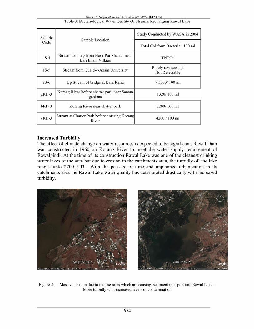
Increased Turbidity The effect of climate change on water resources is expected to be significant. Rawal Dam was constructed in 1960 on Korang River to meet the water supply requirement of Rawalpindi. At the time of its construction Rawal Lake was one of the cleanest drinking water lakes of the area but due to erosion in the catchments area, the turbidly of the lake ranges upto 2700 NTU. With the passage of time and unplanned urbanization in its catchments area the Rawal Lake water quality has deteriorated drastically with increased turbidity.
Figure-8: Massive erosion due to intense rains which are causing sediment transport into Rawal Lake – More turbidly with increased levels of contamination
Islam-Ul-Haque et al. EJEAFChe, 8 (8), 2009. [647-656]
655
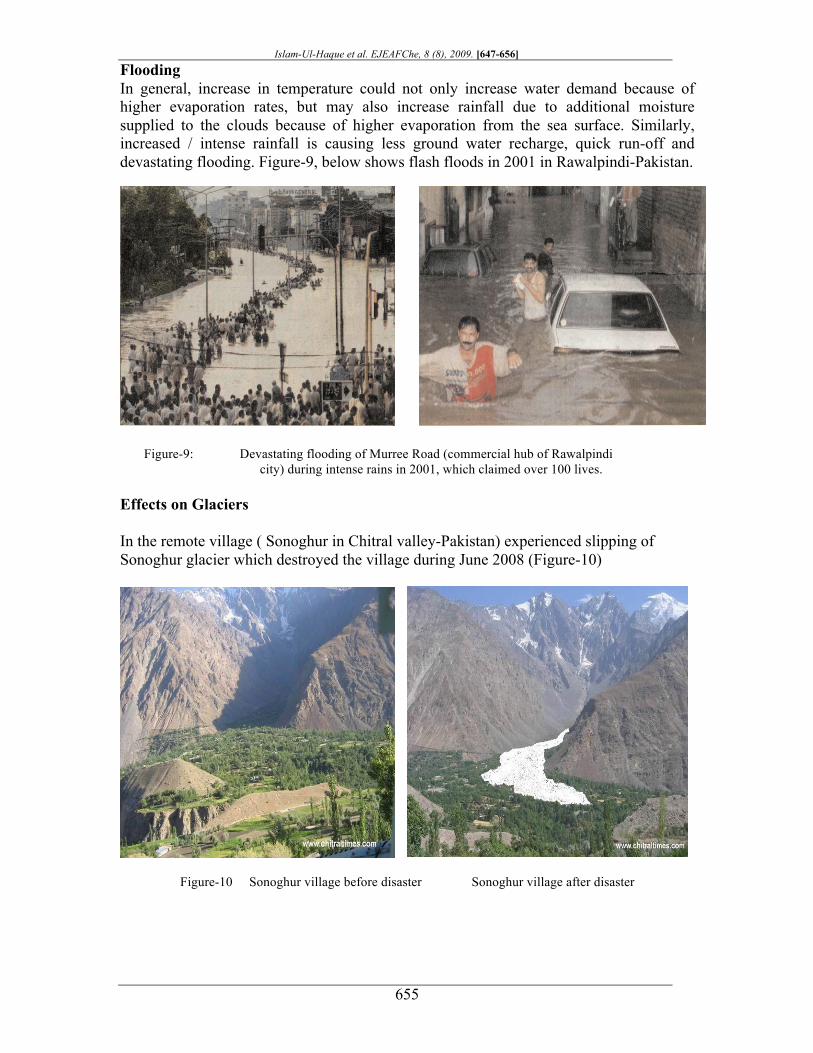
Flooding In general, increase in temperature could not only increase water demand because of higher evaporation rates, but may also increase rainfall due to additional moisture supplied to the clouds because of higher evaporation from the sea surface. Similarly, increased / intense rainfall is causing less ground water recharge, quick run-off and devastating flooding. Figure-9, below shows flash floods in 2001 in Rawalpindi-Pakistan.
Figure-9: Devastating flooding of Murree Road (commercial hub of Rawalpindi
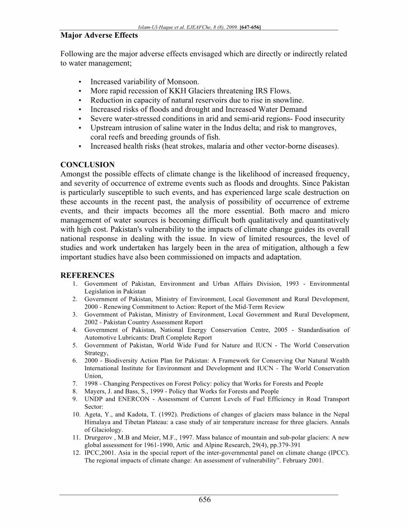
city) during intense rains in 2001, which claimed over 100 lives. Effects on Glaciers In the remote village ( Sonoghur in Chitral valley-Pakistan) experienced slipping of Sonoghur glacier which destroyed the village during June 2008 (Figure-10)
Figure-10 Sonoghur village before disaster Sonoghur village after disaster
Islam-Ul-Haque et al. EJEAFChe, 8 (8), 2009. [647-656]
656
Major Adverse Effects
Following are the major adverse effects envisaged which are directly or indirectly related to water management;
• Increased variability of Monsoon. • More rapid recession of KKH Glaciers threatening IRS Flows. • Reduction in capacity of natural reservoirs due to rise in snowline. • Increased risks of floods and drought and Increased Water Demand • Severe water-stressed conditions in arid and semi-arid regions- Food insecurity • Upstream intrusion of saline water in the Indus delta; and risk to mangroves,
coral reefs and breeding grounds of fish. • Increased health risks (heat strokes, malaria and other vector-borne diseases).
CONCLUSION Amongst the possible effects of climate change is the likelihood of increased frequency, and severity of occurrence of extreme events such as floods and droughts. Since Pakistan is particularly susceptible to such events, and has experienced large scale destruction on these accounts in the recent past, the analysis of possibility of occurrence of extreme events, and their impacts becomes all the more essential. Both macro and micro management of water sources is becoming difficult both qualitatively and quantitatively with high cost. Pakistan's vulnerability to the impacts of climate change guides its overall national response in dealing with the issue. In view of limited resources, the level of studies and work undertaken has largely been in the area of mitigation, although a few important studies have also been commissioned on impacts and adaptation. REFERENCES
1. Govemment of Pakistan, Environment and Urban Affairs Division, 1993 - Environmental Legislation in Pakistan
2. Government of Pakistan, Ministry of Environment, Local Govemment and Rural Development, 2000 - Renewing Commitment to Action: Report of the Mid-Term Review
3. Government of Pakistan, Ministry of Environment, Local Government and Rural Development, 2002 - Pakistan Country Assessment Report
4. Government of Pakistan, National Energy Conservation Centre, 2005 - Standardisation of Automotive Lubricants: Draft Complete Report
5. Government of Pakistan, World Wide Fund for Nature and IUCN - The World Conservation Strategy,
6. 2000 - Biodiversity Action Plan for Pakistan: A Framework for Conserving Our Natural Wealth International Institute for Environment and Development and IUCN - The World Conservation Union,
7. 1998 - Changing Perspectives on Forest Policy: policy that Works for Forests and People 8. Mayers, J. and Bass, S., 1999 - Policy that Works for Forests and People 9. UNDP and ENERCON - Assessment of Current Levels of Fuel Efficiency in Road Transport
Sector: 10. Ageta, Y., and Kadota, T. (1992). Predictions of changes of glaciers mass balance in the Nepal
Himalaya and Tibetan Plateau: a case study of air temperature increase for three glaciers. Annals of Glaciology.
11. Drurgerov , M.B and Meier, M.F., 1997. Mass balance of mountain and sub-polar glaciers: A new global assessment for 1961-1990, Artic and Alpine Research, 29(4), pp.379-391
12. IPCC,2001. Asia in the special report of the inter-governmental panel on climate change (IPCC). The regional impacts of climate change: An assessment of vulnerability”. February 2001.
Related Documents