City of Joondalup Mullaloo Foreshore Reserve Management Plan V1 – 09 November 2017 Natural Area Holdings Pty Ltd 99C Lord Street, Whiteman, WA, 6076 Ph: (08) 9209 2767 [email protected] www.naturalarea.com.au APPENDIX 15 ATTACHMENT 1

Welcome message from author
This document is posted to help you gain knowledge. Please leave a comment to let me know what you think about it! Share it to your friends and learn new things together.
Transcript
City of Joondalup
Mullaloo Foreshore Reserve Management Plan
V1 – 09 November 2017
Natural Area Holdings Pty Ltd
99C Lord Street, Whiteman, WA, 6076
Ph: (08) 9209 2767
www.naturalarea.com.au
APPENDIX 15 ATTACHMENT 1
City of Joondalup
Mullaloo Foreshore Reserve Management Plan
Page 1 of 92
Disclaimer
Natural Area Holdings Pty Ltd, trading as Natural Area Consulting Management Services (Natural Area), has
prepared this report for the sole use of the Client and for the purposes as stated in the agreement between
the Client and Natural Area under which this work was completed. This report may not be relied upon by any
other party without the express written agreement of Natural Area.
Natural Area has exercised due and customary care in the preparation of this document and has not, unless
specifically stated, independently verified information provided by others. No other warranty, expressed or
implied, is made in relation to the contents of this report. Therefore, Natural Area assumes no liability for
any loss resulting from errors, omission or misrepresentations made by others. This document has been
made at the request of the Client. The use of this document by unauthorised third parties without written
permission from Natural Area shall be at their own risk, and we accept no duty of care to any such third
party.
Any recommendations, opinions or findings stated in this report are based on circumstances and facts as
they existed at the time Natural Area performed the work. Any changes in such circumstances and facts
upon which this document is based may adversely affect any recommendations, opinions or findings
contained in this document.
No part of this document may be copied, duplicated or disclosed without the express written permission of
the Client and Natural Area.
City of Joondalup
Mullaloo Foreshore Reserve Management Plan
Page 2 of 92
Contents
Disclaimer ............................................................................................................................................................. 1
Contents ............................................................................................................................................................... 2
Acknowledgements .............................................................................................................................................. 5
Abbreviations and Acronyms ............................................................................................................................... 6
Executive Summary .............................................................................................................................................. 8
1.0 Introduction .............................................................................................................................................. 9
1.1 Background ........................................................................................................................................... 9
1.2 Natural Area Management Plans ......................................................................................................... 9
1.3 Study Area ............................................................................................................................................ 9
1.3.1 Tenure ......................................................................................................................................... 10
1.3.2 Land Use ..................................................................................................................................... 10
1.4 Purpose ............................................................................................................................................... 13
1.5 Aims and Objectives ........................................................................................................................... 13
1.6 Strategic Context ................................................................................................................................ 13
1.6.1 Local Government ...................................................................................................................... 13
1.6.2 State Government ...................................................................................................................... 15
1.6.3 Federal Government ................................................................................................................... 17
1.6.4 International Conventions or Listings ......................................................................................... 17
2.0 Description of Physical Environment ...................................................................................................... 18
2.1 Geology, Soils and Landforms ............................................................................................................ 18
2.1.1 Soils of the Swan Coastal Plain ................................................................................................... 18
2.1.2 Acid Sulphate Soils ...................................................................................................................... 20
2.1.3 Erosion ........................................................................................................................................ 20
2.1.4 Recommended Management Actions ........................................................................................ 22
2.2 Hydrology ........................................................................................................................................... 23
2.2.1 Groundwater .............................................................................................................................. 23
2.2.2 Drainage...................................................................................................................................... 23
2.3 Climate ................................................................................................................................................ 24
2.3.1 Climate Change ........................................................................................................................... 25
2.4 Vegetation .......................................................................................................................................... 25
2.4.1 Vegetation Complexes ................................................................................................................ 25
City of Joondalup
Mullaloo Foreshore Reserve Management Plan
Page 3 of 92
2.4.2 Floristic Community Types ......................................................................................................... 25
2.4.3 Vegetation Communities ............................................................................................................ 28
2.4.4 Vegetation Condition .................................................................................................................. 31
3.0 Biodiversity Management ...................................................................................................................... 33
3.1 Flora .................................................................................................................................................... 33
3.1.1 Flora Survey Methodology ......................................................................................................... 34
3.1.2 Native Flora ................................................................................................................................ 34
3.1.3 Weeds ......................................................................................................................................... 34
3.1.4 Revegetation ............................................................................................................................... 35
3.1.5 Current Management Approach ................................................................................................ 35
3.1.6 Recommended Management Actions ........................................................................................ 36
3.2 Fungi ................................................................................................................................................... 37
3.2.1 Fungi Field Survey ....................................................................................................................... 37
3.2.2 Current Management Approach ................................................................................................ 37
3.2.3 Recommended Management Action ......................................................................................... 37
3.3 Plant Diseases ..................................................................................................................................... 38
3.3.1 Current Management Approach ................................................................................................ 39
3.3.2 Recommended Management Action ......................................................................................... 39
3.4 Fauna .................................................................................................................................................. 39
3.4.1 Fauna Survey Methodology ........................................................................................................ 39
3.4.2 Fauna Habitat ............................................................................................................................. 40
3.4.3 Native Fauna ............................................................................................................................... 40
3.4.3 Non-native Fauna ....................................................................................................................... 42
3.4.5 Ecological Corridors .................................................................................................................... 43
3.4.6 Current Management Approach ................................................................................................ 44
3.4.7 Recommended Management Actions ........................................................................................ 44
3.5 Social and Built Environment ............................................................................................................. 46
3.5.1 History and Heritage ................................................................................................................... 46
3.5.2 Social Value ................................................................................................................................. 46
3.5.3 Access and Infrastructure ........................................................................................................... 46
3.5.4 Anti-social Behaviour .................................................................................................................. 52
3.5.5 Recommended Management Actions ........................................................................................ 52
3.6 Fire Management ............................................................................................................................... 55
City of Joondalup
Mullaloo Foreshore Reserve Management Plan
Page 4 of 92
3.6.1 Recommended Management Actions ........................................................................................ 57
3.7 Education and Training ....................................................................................................................... 58
3.7.1 Recommended Education and Training Management Actions .................................................. 59
4.0 Implementation Plan .............................................................................................................................. 60
4.1 Auditing and Inspection ...................................................................................................................... 60
4.2 Key Performance Indicators ............................................................................................................... 60
4.3 Management Plan Review .................................................................................................................. 61
4.4 Recommended Management Actions ................................................................................................ 61
5.0 References .............................................................................................................................................. 64
Appendix 1: Bush Forever Vegetation Structural Classes ............................................................................... 69
Appendix 2: Vegetation Condition Rating Scale ............................................................................................. 70
Appendix 3: Flora Species List for Mullaloo Foreshore .................................................................................. 71
Appendix 4: Fauna List for Mullaloo Foreshore .............................................................................................. 75
Appendix 5: Key Weed Species in Mullaloo Foreshore Reserve .................................................................... 80
Appendix 6: Weed Management .................................................................................................................... 83
Weed treatment types ................................................................................................................................... 83
Weed Control Methodology .......................................................................................................................... 84
Implementation Schedule .............................................................................................................................. 85
Appendix 7: Restoration and Regeneration ................................................................................................... 87
City of Joondalup
Mullaloo Foreshore Reserve Management Plan
Page 5 of 92
Acknowledgements
Natural Area Consulting Management Services (Natural Area) wish to acknowledge and thank the following
for assistance and input into the plan during its development:
▪ City of Joondalup staff
▪ Mullaloo Beach Community Group Inc.
City of Joondalup
Mullaloo Foreshore Reserve Management Plan
Page 6 of 92
Abbreviations and Acronyms
Abbreviation Description
AHD Australian Height Datum
BAM Act Biosecurity and Agriculture Management Act 2007 (WA)
BoM Bureau of Meteorology
the City City of Joondalup
CoJ City of Joondalup
Cwlth Commonwealth
DAFWA Department of Agriculture and Food WA
DBCA Department of Biodiversity, Conservation and Attractions (previously Department of
Parks and Wildlife)
DEC Department of Environment and Conservation (now Department of Parks and Wildlife)
DER Department of Environment Regulation (WA)
DEE Department of the Environment and Energy (Cwlth)
DPaW Department of Parks and Wildlife (WA)
DPIRD Department of Primary Industries and Regional Development (previously Department
of Agriculture and Food WA
DRF Declared rare flora
DWER Department of Water and Environmental Regulation (previously Department of
Environment Regulation)
EDOWA Environmental Defenders Office of WA (Inc)
EPBC Act Environment Protection and Biodiversity Conservation Act 1999 (Cwlth)
GIS Geographical information system
GPS Global positioning system
ha Hectare
IUCN International Union for Conservation of Nature
km Kilometre
km/h Kilometres per hour
m Metre
m2 Square metres
MBCG Mullaloo Beach Community Group Inc.
Natural Area Natural Area Consulting Management Services
NIASA Nursery Industry Accreditation Scheme Australia
PMST Protected Matters Search Tool
City of Joondalup
Mullaloo Foreshore Reserve Management Plan
Page 7 of 92
Abbreviation Description
NR Info NR Info portal
WA Western Australia
WALGA Western Australian Local Government Association
WAH Western Australian Herbarium
WONS Weeds of National Significance
City of Joondalup
Mullaloo Foreshore Reserve Management Plan
Page 8 of 92
Executive Summary
Natural Area Consulting Management Services (Natural Area) was contracted by the City of Joondalup to
prepare a Management Plan for the Mullaloo Foreshore Reserve. This Plan identifies management strategies
that will assist the City with ongoing management of the site over the next five years, with a focus on
maintaining both the environmental and recreational values of the area. This Management Plan is consistent
with the overarching Coastal Foreshore Natural Areas Management Plan whilst providing site-specific
recommendations for management of the Mullaloo Foreshore Reserve.
The site is located approximately 23 km north of the Perth Central Business District in the suburb of
Mullaloo. The site extends for 1.5 km from Merrifield Place in the south to the footpath just north of the
West View carpark on the boundary of Ocean Reef Foreshore Reserve in the north. It is bounded by
Oceanside Promenade to the east and the Indian Ocean to the west. The Reserve is recognised for its
regional environmental significance by the City and by its inclusion as a portion of Bush Forever Site 325.
The Mullaloo Coastal Foreshore Reserve is characterised by wide sandy beaches with low vegetated dunes
that vary in width between 100 – 150 m. Infrastructure includes car parks, shaded and non-shaded seating
and picnicking areas, barbeques, playgrounds, grassed and non-grassed recreational areas, the Mullaloo surf
lifesaving club, a kiosk, and access ways to the beach.
The majority of the native vegetation at Mullaloo Foreshore Reserve is in Very Good condition (Natural Area
Consulting Management Services, 2017) and is part of the regional ecological linkage chain that extends
along the coast from Burns Beach in the north to North Beach in the south. A total of 80 flora species
comprising one conifer, one moss, 19 monocotyledons and 59 dicotyledons were recorded during the 2016
spring flora survey; none were declared rare or priority listed species under the Wildlife Conservation Act
1950 (WA) and/or the Environment Protection and Biodiversity Conservation Act 1999 (Cwlth). A range of
mammal (4), bird (23), reptile (9) and invertebrate (28) species were observed within the reserve during the
fauna surveys undertaken by Natural Area in spring 2016 and autumn 2017, including the priority 4 listed
Southern Brown Bandicoot (Isoodon obesulus fusciventer). The range and diversity of species recorded
within the Reserve indicates a healthy ecological community.
A number of management actions are outlined within this Plan to address key environmental threats at
Mullaloo Foreshore Reserve. Management actions are to be implemented over a five-year period and
include the implementation of the City’s Pathogen Management Plan, erosion control, weed control,
revegetation, fire management, environmental education, and regular surveys for flora, fauna and fungi.
Management actions will be implemented by the City of Joondalup in partnership with key stakeholders and
community groups, where relevant.
City of Joondalup
Mullaloo Foreshore Reserve Management Plan
Page 9 of 92
1.0 Introduction
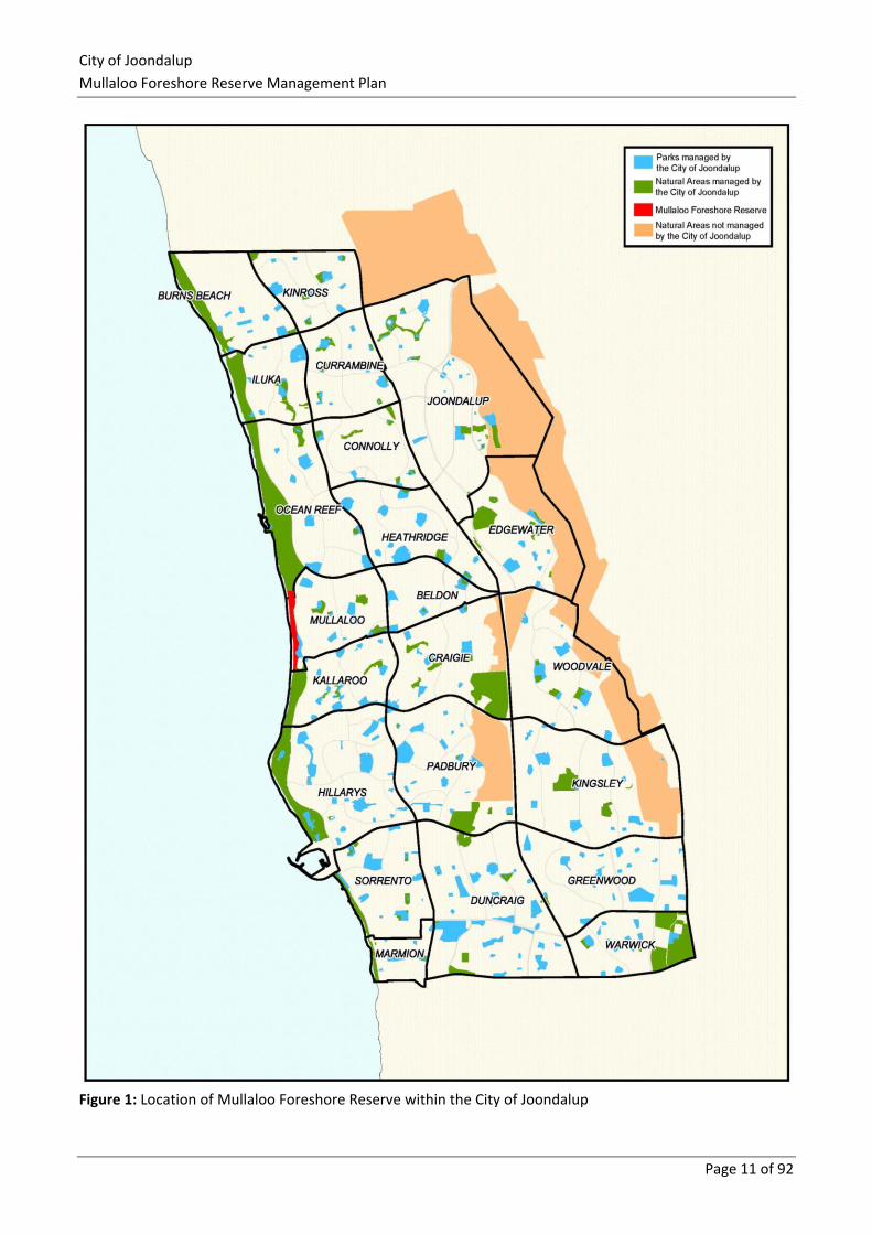
1.1 Background The City of Joondalup (the City) is situated on the Swan Coastal Plain, approximately 30 km north of the
Perth Central Business District. The City covers an area of 96.5 kilometres that encompasses a diverse range
of natural areas including 17 kilometres of coastal foreshore, a chain of wetlands and a variety of bushland
ecosystems (Figure 1). The City’s southern boundary is approximately 16 kilometres from the Perth Central
Business District, and is bounded by the City of Wanneroo to the east and north, the City of Stirling to the
south, and the Indian Ocean to the west.
There are a number of regionally, nationally and internationally significant natural areas located within the
City including Yellagonga Regional Park and a number of Bush Forever sites that contain species of high
conservation value. Significant natural areas adjacent to the City include Marmion Marine Park and
Neerabup National Park.
The City of Joondalup is committed to conserving and enhancing the City’s natural assets to ensure the long-
term protection of the environment for future generations.
1.2 Natural Area Management Plans The City is developing Natural Areas Management Plans and associated Action Plans to provide strategic and
operational management of the City’s natural areas to protect native vegetation and ecosystems. Natural
Areas Management Plans describe the potential environmental impacts and risks of activities and
environmental threats in natural areas, and the associated management strategies that are implemented to
minimise potential impacts.
Environmental threats have the potential to degrade natural areas and reduce biodiversity values.
Environmental threats addressed in this Plan include weeds, plant disease, fire, non-native fauna species,
human impacts, access and infrastructure.
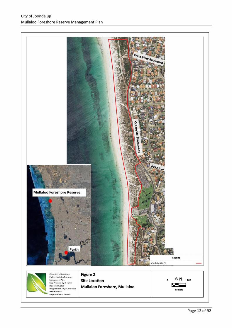
1.3 Study Area The study area for the Mullaloo Foreshore Reserve Management Plan is the Mullaloo Foreshore Reserve in
the suburb of Mullaloo (Figure 2). The reserve is located approximately 23 km north-west of the Perth
Central Business District, and covers an area of approximately 14.8 ha which includes native vegetation,
carparks, tracks and part of the sandy beach. The site extends south from Ocean Reef Foreshore Reserve to
Merrifield Place in the south, and is bounded by Oceanside Promenade and Merrifield Place to the east, and
the Indian Ocean to the west. An additional portion south of the surf club adjacent to Merrifield Place was
added to this Plan and surveyed during the autumn 2017 site assessments undertaken by Natural Area. This
portion was not previously included in the 2016 flora, fauna and fungi survey.
City of Joondalup
Mullaloo Foreshore Reserve Management Plan
Page 10 of 92
1.3.1 Tenure
The Mullaloo Foreshore Reserve is Crown Land with management orders assigned to the City of Joondalup; it
is reserved for Parks and Recreation under the Metropolitan Region Scheme (MRS)1. The site is zoned Parks
and Recreation under the City of Joondalup District Planning Scheme No. 22.
1.3.2 Land Use
The main use of the Mullaloo Foreshore Reserve is for passive recreational purposes, including walking, dog
exercise, photography, nature watching, and passing through the site to access the beach area and for
swimming.
1 Department of Planning, Lands and Heritage, (2017) 2 City of Joondalup, (2016)
City of Joondalup
Mullaloo Foreshore Reserve Management Plan
Page 11 of 92
Figure 1: Location of Mullaloo Foreshore Reserve within the City of Joondalup
City of Joondalup
Mullaloo Foreshore Reserve Management Plan
Page 12 of 92
City of Joondalup
Mullaloo Foreshore Reserve Management Plan
Page 13 of 92
1.4 Purpose The purpose of the Mullaloo Foreshore Reserve Management Plan is to:
▪ provide information to assist the City of Joondalup in prioritising maintenance schedules
▪ guide the future development of the City’s Conservation Capital Works Program
▪ increase opportunities for grant funding by having a detailed schedule of projects
▪ provide guidance to City employees, contractors and Friends Groups operating within the Mullaloo
Foreshore Reserve.
1.5 Aims and Objectives The aim of the Mullaloo Foreshore Reserve Management Plan is to provide a framework to protect and
enhance biodiversity values whilst maintaining appropriate community access and awareness of the natural
area.
The objectives of the Mullaloo Foreshore Reserve Management Plan are to:
▪ establish a baseline description of the environment to guide future environmental planning and
recommended management actions
▪ outline key environmental threats and the impact they have on conservation and recreational values
▪ outline management actions to address key threats, including monitoring and reporting.
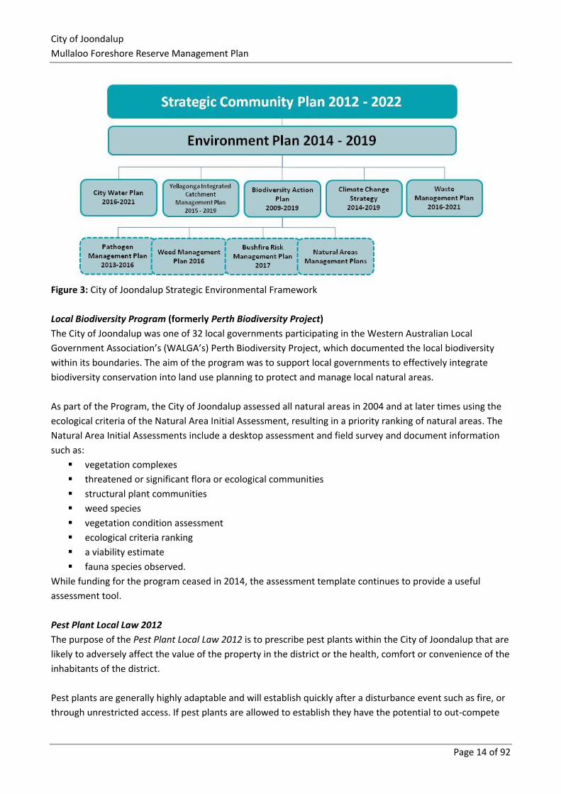
1.6 Strategic Context In order to ensure the Mullaloo Foreshore Management Plan complements other management initiatives
within the City, along with relevant legislation, policies, guidelines and documents were reviewed and are
summarised in this Section.
1.6.1 Local Government
Strategic Community Plan
The City of Joondalup’s Strategic Community Plan 2012 – 2022 is the long-term strategic planning document,
which outlines the commitment of the City to achieve its commitment to achieving the visions and
aspirations of its community and stakeholders.
Environmental Plan
The City of Joondalup’s Environmental Plan 2014 – 2019 was developed to guide the City’s strategic
response to local environmental pressures.
Biodiversity Action Plan
The City of Joondalup Biodiversity Action Plan 2009 – 2019 was prepared to provide direction for biodiversity
management activities within the City, with retention and enhancement of biodiversity a key priority.
Development of individual Natural Area Management Plans was included as a management action.
City of Joondalup
Mullaloo Foreshore Reserve Management Plan
Page 14 of 92
Figure 3: City of Joondalup Strategic Environmental Framework
Local Biodiversity Program (formerly Perth Biodiversity Project)
The City of Joondalup was one of 32 local governments participating in the Western Australian Local
Government Association’s (WALGA’s) Perth Biodiversity Project, which documented the local biodiversity
within its boundaries. The aim of the program was to support local governments to effectively integrate
biodiversity conservation into land use planning to protect and manage local natural areas.
As part of the Program, the City of Joondalup assessed all natural areas in 2004 and at later times using the
ecological criteria of the Natural Area Initial Assessment, resulting in a priority ranking of natural areas. The
Natural Area Initial Assessments include a desktop assessment and field survey and document information
such as:
▪ vegetation complexes
▪ threatened or significant flora or ecological communities
▪ structural plant communities
▪ weed species
▪ vegetation condition assessment
▪ ecological criteria ranking
▪ a viability estimate
▪ fauna species observed.
While funding for the program ceased in 2014, the assessment template continues to provide a useful
assessment tool.
Pest Plant Local Law 2012
The purpose of the Pest Plant Local Law 2012 is to prescribe pest plants within the City of Joondalup that are
likely to adversely affect the value of the property in the district or the health, comfort or convenience of the
inhabitants of the district.
Pest plants are generally highly adaptable and will establish quickly after a disturbance event such as fire, or
through unrestricted access. If pest plants are allowed to establish they have the potential to out-compete
City of Joondalup
Mullaloo Foreshore Reserve Management Plan
Page 15 of 92
the City’s unique floral biodiversity. The Pest Plant Local Law 2012 requires the owner or occupier of private
land within the City of Joondalup district to destroy, eradicate or otherwise control scheduled pest plants on
notice by the City. Currently one weed species is scheduled under the Local Law – Caltrop (Tribulus
terrestris). Caltrop was not identified in the Mullaloo Foreshore Reserve.
1.6.2 State Government
Relevant Legislation, Policies and Documents
Aboriginal Heritage Act 1972
The Act makes provision for the preservation on behalf of the community of places and objects customarily
used by or traditional to the original inhabitants of Australia or their descendants. The Mullaloo Foreshore
Reserve is not listed on any State or Federal Aboriginal heritage inventory or register. However, there is an
Aboriginal heritage site north of the Reserve boundary; this is Site 3673 Mullaloo Desert North.
Biosecurity and Agriculture Management Act 2007
The Act provides for the control of declared flora and fauna species (declared organisms) that are known to
be a significant environmental threat and makes provision for the management, control and prevention of
these declared plants and animals. The *One-leaf Cape Tulip (Moraea flaccida) was recorded within the
Foreshore Reserve, which is listed as a category C3 declared pest under the BAM Act 2007 (WA), which
requires the species to be managed by the land owner to reduce the impact and spread.
Bushfires Act 1954
The Act makes provision for diminishing the dangers resulting from bush fires and for the prevention, control
and extinguishment of bush fires.
Cat Act 2011
The Act makes provision for the control and management of cats, and promotes and encourages the
responsible ownership of cats. Cats may be seized where they are found wandering in public areas, such as
Mullaloo Foreshore Reserve, in accordance with the Cat Act 2011 (WA).
Dog Act 1976
The Act makes provisions for the control of dogs in public and private spaces and promotes the responsible
ownership of dogs. The Act requires dog owners to register their dogs and encompasses the ownership and
keeping of dogs and the obligations and rights of dog owners. Local governments are responsible for
administering, monitor compliance and enforcing the Act within their respective districts.
Tom Simpson Park within the Mullaloo Foreshore Reserve is designated as a place where dogs are not
permitted and dogs must be on a lead at all times on the coastal dual path by Council resolution in
accordance with the Dog Act 1976 (WA).
Environmental Protection Act 1986
The Act provides authority to the Environmental Protection Authority (EPA) for the prevention, control and
abatement of pollution and environmental harm, for the conservation, preservation, protection,
enhancement and management of the environment in Western Australia.
City of Joondalup
Mullaloo Foreshore Reserve Management Plan
Page 16 of 92
Heritage of Western Australia Act 1990
The Act provides for and encourages the conservation of places that have significance to the cultural
heritage in the State. The Mullaloo Foreshore Reserve is not listed on any State or Federal cultural heritage
inventory or register.
State Planning Policy 2.6 – State Coastal Planning Policy 2013
The purpose of the policy is to provide guidance for decision making in the coastal zone throughout Western
Australia, with objectives including:
▪ considering coastal processes during development
▪ identifying appropriate and sustainable land use
▪ providing for public use and access of coastal areas
▪ the development of coastal reserves to protect, conserve and enhance coastal biodiversity,
ecosystem functioning, and indigenous and non-indigenous cultural significance.
State Planning Policy 2.8 – Bushland Policy for the Perth Metropolitan Region
This policy aims to provide direction and an implementation framework that will ensure bushland protection
and management issues in the Perth Metropolitan Region are appropriately addressed, and integrated with
broader land use planning and decision-making.
State Planning Policy 3.7 – Planning in Bushfire Prone Areas
This policy aims to implement effective risk-based land use planning and development to protect life and
reduce the impact of bushfire on property and infrastructure, by identifying bushfire prone areas to be
addressed in regards to bushfire risk management within strategic planning documents, strategic planning
proposals, and subdivision and development applications.
Government of Western Australia ‘Bush Forever’ Strategy 2000
The Strategy identifies regionally significant bushland in the Perth Metropolitan Region to be retained,
managed and protected forever. The Mullaloo Foreshore Reserve forms part of Bush Forever Site 325, which
extends from Burns Beach south to Hillarys.
DPaW Weed Prioritisation Process 2013
The Department of Parks and Wildlife, now the Department of Biodiversity, Conservation and Attractions,
prepared the weed prioritisation process to assist with the on-ground management of weeds in a particular
location, considering their ecological impact, rate of dispersal and population trend.
Wildlife Conservation Act 1950
The Act provides the statute relating to conservation and legal protection of flora and fauna. Four fauna
species listed under the Wildlife Conservation Act 1950 are considered to either use or possibly use Mullaloo
Foreshore Reserve, these being:
▪ Australian Sealion (Neophoca cinerea) (mammal) – Specially Protected Fauna
▪ Black-striped Snake (Neelaps calonotos) (snake) – Priority 3
▪ Quenda (Isoodon obesulus fusciventer) (mammal) – Priority 5
▪ Graceful Sun Moth (Synemon gratiosa) (insect) – Priority 4.
City of Joondalup
Mullaloo Foreshore Reserve Management Plan
Page 17 of 92
Quenda tracks were observed during the November – December 2016 fauna survey undertaken by Natural
Area3.
1.6.3 Federal Government
Environment Protection and Biodiversity Conservation Act 1999
The Act provides for the protection of the environment and the conservation of biodiversity, and for related
purposes. Nine Environment Protection and Biodiversity Conservation (EPBC) Act 1999 listed species have
been recorded as occurring or potentially occurring within Mullaloo Foreshore Reserve1, these being:
▪ Australian Fairy Tern (Sternula nereis nereis) – Vulnerable
▪ Australian Lesser Noddy (Anous tenuirostris melanops) - Vulnerable
▪ Australian Painted Snipe (Rostratula australis) – Endangered
▪ Australian Sealion (Neophoca cinerea) – Vulnerable
▪ Bar-tailed Godwit (Limosa lapponica baueri) - Vulnerable
▪ Bar-tailed Godwit (Limosa lapponica menzbieri) - Vulnerable
▪ Carnaby’s Cockatoo (Calyptorhynchus latirostris) – Endangered
▪ Chuditch (Dasyurus geoffroii) – Vulnerable
▪ Forest red-tailed Black Cockatoos (Calyptorhynchus banksii naso) - Vulnerable.
While none of the above were observed by Natural Area1 during the November to December 2016 fauna
surveys, the Carnaby’s Cockatoo has been previously observed on site by the Mullaloo Beach Community
Group (MBCG).
Australia’s Biodiversity Conservation Strategy 2010-2030
The Strategy aims to protect biological diversity and maintain ecological processes and systems.
National Weeds Strategy 1997
The National Weeds Strategy 1997 provides a strategic framework for managing weeds at a national level.
As part of the implementation of the National Weeds Strategy, 32 Weeds of National Significance are
identified as nationally agreed priority plant species for control and management based on the criteria of
invasiveness and impact characteristics, potential and current area of spread and economic, environmental
and social impacts. The Mullaloo Foreshore Reserve contains no known Weeds of National Significance.
Threatened Species Strategy 2015
The Threatened Species Strategy 2015 outlines the Federal Government’s approach to threatened flora and
fauna species recovery through reversing population declines.
1.6.4 International Conventions or Listings
International Union for Conservation of Nature (ICUN) Red List of Threatened Species
The ICUN Red List of Threatened SpeciesTM provides taxonomic, conservation status and distribution
information on plants and animals that have been globally evaluated using the ICUN Red List Categories and
Criteria. The Carnaby’s Cockatoo (Calyptorhynchus latirostris) is an ICUN Red List species that has been
recorded within the Mullaloo area by the MBCG members.
3 Natural Area Consulting Management Services, (2017)
City of Joondalup
Mullaloo Foreshore Reserve Management Plan
Page 18 of 92
2.0 Description of Physical Environment
2.1 Geology, Soils and Landforms
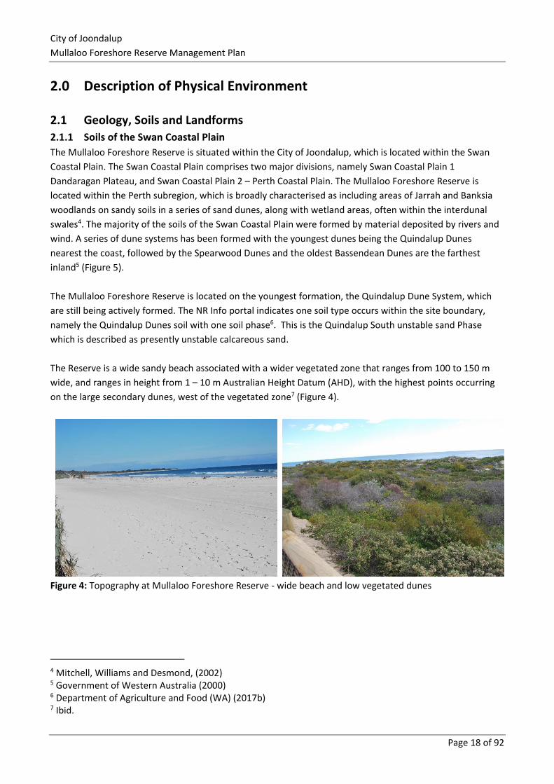
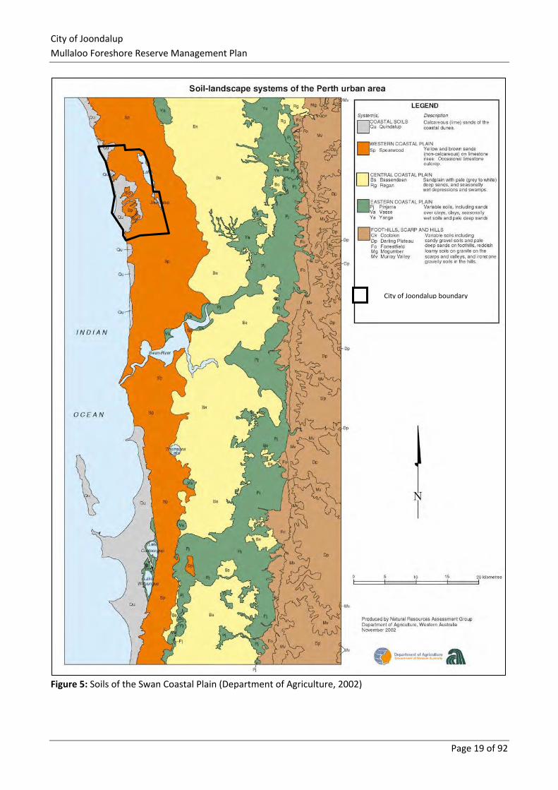
2.1.1 Soils of the Swan Coastal Plain
The Mullaloo Foreshore Reserve is situated within the City of Joondalup, which is located within the Swan
Coastal Plain. The Swan Coastal Plain comprises two major divisions, namely Swan Coastal Plain 1
Dandaragan Plateau, and Swan Coastal Plain 2 – Perth Coastal Plain. The Mullaloo Foreshore Reserve is
located within the Perth subregion, which is broadly characterised as including areas of Jarrah and Banksia
woodlands on sandy soils in a series of sand dunes, along with wetland areas, often within the interdunal
swales4. The majority of the soils of the Swan Coastal Plain were formed by material deposited by rivers and
wind. A series of dune systems has been formed with the youngest dunes being the Quindalup Dunes
nearest the coast, followed by the Spearwood Dunes and the oldest Bassendean Dunes are the farthest
inland5 (Figure 5).
The Mullaloo Foreshore Reserve is located on the youngest formation, the Quindalup Dune System, which
are still being actively formed. The NR Info portal indicates one soil type occurs within the site boundary,
namely the Quindalup Dunes soil with one soil phase6. This is the Quindalup South unstable sand Phase
which is described as presently unstable calcareous sand.
The Reserve is a wide sandy beach associated with a wider vegetated zone that ranges from 100 to 150 m
wide, and ranges in height from 1 – 10 m Australian Height Datum (AHD), with the highest points occurring
on the large secondary dunes, west of the vegetated zone7 (Figure 4).
Figure 4: Topography at Mullaloo Foreshore Reserve - wide beach and low vegetated dunes
4 Mitchell, Williams and Desmond, (2002) 5 Government of Western Australia (2000) 6 Department of Agriculture and Food (WA) (2017b) 7 Ibid.
City of Joondalup
Mullaloo Foreshore Reserve Management Plan
Page 19 of 92
Figure 5: Soils of the Swan Coastal Plain (Department of Agriculture, 2002)
City of Joondalup boundary
City of Joondalup
Mullaloo Foreshore Reserve Management Plan
Page 20 of 92
2.1.2 Acid Sulphate Soils
Acid sulphate soils are naturally occurring soils that contain iron sulphides, primarily in the form of pyrite
materials, formed under water logged conditions in fresh and saline wetlands around Western Australia. If
left and not exposed to the air, acid sulphate soils do not pose a significant risk to humans or the
environment. Exposure to air causes the formation of sulphuric acid, which can lead to the heavy metals
being released into the surrounding environment8.
Acid sulphate soils are categorised as potential acid sulphate soils or actual acid sulphate soils. Potential acid
sulphate soils have not been oxidised by exposure to air whilst actual acid sulphate soils have been disturbed
or exposed to oxygen and become acidic.9 The risk of acid sulphate soils is based on their likelihood of
occurring within soil profiles and has been mapped by the then Department of Environment Conservation
(DEC), now the Department of Water and Environmental Regulation (DWER), using available desktop
information and limited ground-truthing within areas where intensive on-ground mapping and soil analysis
work has been undertaken. Review of this mapping indicated that no potential acid sulphate soils are known
or likely in the Mullaloo Foreshore Reserve on the basis of origin of the geological units present, depth to
groundwater and partial ‘ground truthing’ or onsite investigation.
2.1.3 Erosion
The major function of vegetation within coastal dune systems is stabilising sand within dunes, with erosion
occurring where vegetative cover is absent or reduced. Erosion is a naturally occurring process on the coast,
particularly during winter months when rainfall and wind speed increase. Human factors can increase the
rate and extent of erosion via activities such as people and pets walking on the dunes instead of keeping to
nominated pathways, or the installation of infrastructure in dune areas. Over time, projected climate change
impacts are expected to include10:
▪ stronger winds during storm events
▪ increased storm surge potential
▪ lower rainfall, potentially leading to water stress on plants and impacts to flora and fauna habitat
▪ sea level rise and associated coastal inundation.
Accordingly, erosion is likely to be an ongoing issue that will impact on rehabilitation and ongoing
maintenance requirements. Climate change risks with the City of Joondalup are outlined in the Climate
Change Strategy 2014 – 201911, as are proposed mitigation and adaptation strategies.
The Mullaloo Foreshore Reserve was observed to be in good condition during the 2016 and 2017 site
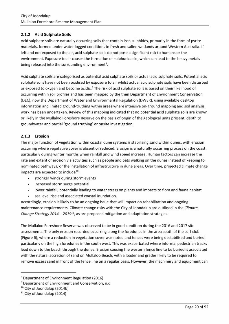
assessments. The only erosion recorded occurring along the foredunes in the area south of the surf club
(Figure 6), where a reduction in vegetation cover was noted and fences were being destabilised and buried,
particularly on the high foredunes in the south west. This was exacerbated where informal pedestrian tracks
lead down to the beach through the dunes. Erosion causing the western fence line to be buried is associated
with the natural accretion of sand on Mullaloo Beach, with a loader and grader likely to be required to
remove excess sand in front of the fence line on a regular basis. However, the machinery and equipment can
8 Department of Environment Regulation (2016) 9 Department of Environment and Conservation, n.d. 10 City of Joondalup (2014b) 11 City of Joondalup (2014)
City of Joondalup
Mullaloo Foreshore Reserve Management Plan
Page 21 of 92
sometimes get caught on the fence resulting in damage to the fence line with some of the chain link wire
being detached from the posts.
Figure 6: Erosion at the end of a concrete path and on higher foredunes in the south-west of the Reserve
While the majority of the site is currently showing minimal signs of erosion, ongoing monitoring is
recommended to prevent or mitigate any threatening processes that could result in future erosion.
Considerations for management of erosion will include:
▪ areas affected
▪ causes
▪ natural, conservation and human values of the affected area
▪ priorities for action in terms of feasibility of success in the medium to longer term
▪ techniques used to restore or stabilise affected areas.
The City has undertaken a coastal hazard assessment12, with the objective to update previous assessments
and provide consistent assessment across the whole city. The City’s Coastal Monitoring Program was
established in 2015/16 to monitor shoreline movements over time. The Program aims to:
▪ provide valuable information that can be used to inform planning decisions in the coastal zone
▪ inform maintenance and asset replacement schedules of coastal infrastructure
▪ provide early warning of any increased vulnerability of assets
▪ guide the timing and need for coastal adaptation works
▪ identify the requirement for updates to hazard and vulnerability assessments
▪ improve the City’s understanding of coastal processes and monitor actual shoreline erosion
compared to modelled erosion.
The Coastal Monitoring Program includes: photo monitoring at identified sites (every six months), shoreline
mapping from aerial photography (annually), beach profile surveys (biennially) and analysis and report
(biennially).
12 MP Rogers & Associates P/L, 2016
City of Joondalup
Mullaloo Foreshore Reserve Management Plan
Page 22 of 92
Erosion from both natural and human causes can largely be managed through sand stabilisation and access
control. Revegetation and rehabilitation activities are often the most effective means of stabilising sand
dune areas. These can include:
▪ applying appropriate revegetation techniques that will allow plants to become established and
stabilise the soil
▪ erecting sand trap fencing that allows wind-borne sand to collect and create incipient dunes over
time
▪ applying stabilising materials such as biodegradable jute or coir matting, brushing or mulch to
exposed areas to provide a stable surface that will allow seedlings to become established and grow
▪ use of signage to provide information about erosion and the need to keep off the dunes
▪ establishing barriers to deter human (and their pets) access to vegetated areas, and allowing bare
areas to regenerate.
2.1.4 Recommended Management Actions
Action Detail
Holistic
consideration of
erosion
Erosion issues to be considered holistically, with the most appropriate management
options determined on a case by case basis and recognising that all exposed sand does
not need to be covered by vegetation, reflecting what would occur within a natural
environment.
Brushing Brushing materials will be of suitable species that do not contain seed pods or other
materials that can propagate and result in the presence of weeds at the site.
Early consideration
of erosion
Address erosion issues as early as possible to avoid larger areas to be rehabilitated later.
Wider context Consider erosion in the wider context of climate change impacts that could occur over
time.
City of Joondalup
Mullaloo Foreshore Reserve Management Plan
Page 23 of 92
2.2 Hydrology
2.2.1 Groundwater
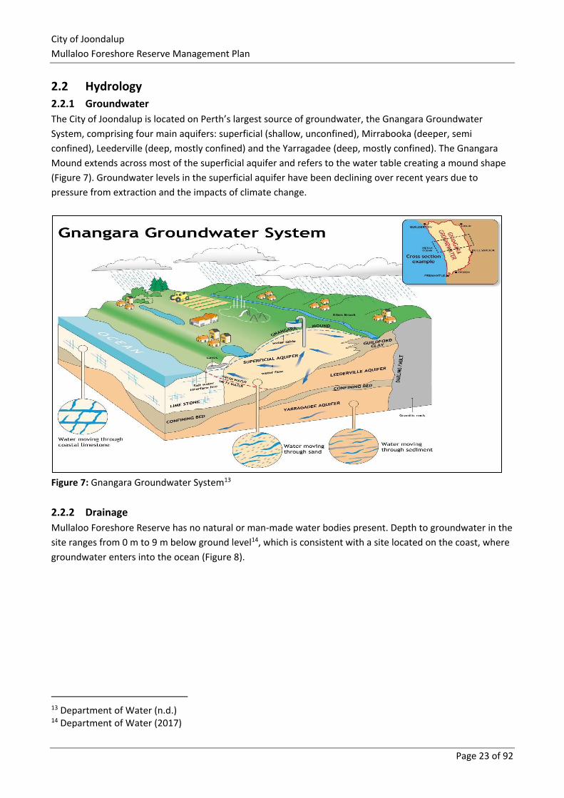
The City of Joondalup is located on Perth’s largest source of groundwater, the Gnangara Groundwater
System, comprising four main aquifers: superficial (shallow, unconfined), Mirrabooka (deeper, semi
confined), Leederville (deep, mostly confined) and the Yarragadee (deep, mostly confined). The Gnangara
Mound extends across most of the superficial aquifer and refers to the water table creating a mound shape
(Figure 7). Groundwater levels in the superficial aquifer have been declining over recent years due to
pressure from extraction and the impacts of climate change.
Figure 7: Gnangara Groundwater System13
2.2.2 Drainage
Mullaloo Foreshore Reserve has no natural or man-made water bodies present. Depth to groundwater in the
site ranges from 0 m to 9 m below ground level14, which is consistent with a site located on the coast, where
groundwater enters into the ocean (Figure 8).
13 Department of Water (n.d.) 14 Department of Water (2017)
City of Joondalup
Mullaloo Foreshore Reserve Management Plan
Page 24 of 92
Figure 8: Groundwater Depth Explanation15
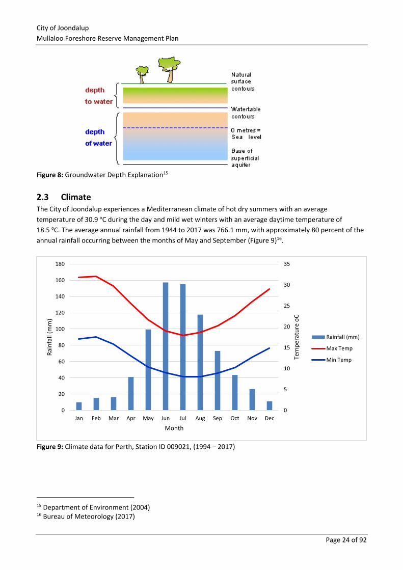
2.3 Climate The City of Joondalup experiences a Mediterranean climate of hot dry summers with an average
temperature of 30.9 oC during the day and mild wet winters with an average daytime temperature of
18.5 oC. The average annual rainfall from 1944 to 2017 was 766.1 mm, with approximately 80 percent of the
annual rainfall occurring between the months of May and September (Figure 9)16.
Figure 9: Climate data for Perth, Station ID 009021, (1994 – 2017)
15 Department of Environment (2004) 16 Bureau of Meteorology (2017)
0
5
10
15
20
25
30
35
0
20
40
60
80
100
120
140
160
180
Jan Feb Mar Apr May Jun Jul Aug Sep Oct Nov Dec
Tem
per
atu
re o
C
Rai
nfa
ll (m
m)
Month
Rainfall (mm)
Max Temp
Min Temp
City of Joondalup
Mullaloo Foreshore Reserve Management Plan
Page 25 of 92
2.3.1 Climate Change
The City of Joondalup is located in the south-west of Western Australia, and which is experiencing impacts
associated with climate change such as rising temperatures, decreased rainfall and sea level rise. According
to the Climate Commission, Western Australia’s temperature has been increasing steadily since the 1950’s,
with an overall rise of approximately 0.8 oC17.
The City has developed the draft Climate Change Strategy 2014 – 201918 to guide climate change activities,
both in terms of mitigation and adaptation, in coming years. Strategies to be adopted include:
▪ reduce greenhouse gas emissions
▪ offset carbon emissions
▪ improve understanding of future climate scenarios
▪ identify risks and how they can be managed
▪ support the community to prepare and adapt to climate change.
2.4 Vegetation Flora surveys were undertaken by Natural Area in September 2016 and additional areas in April 2017, with
outcomes provided in this section.
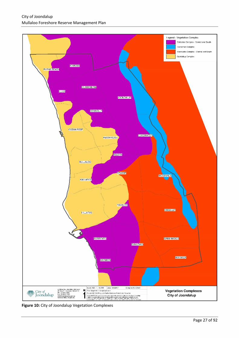
2.4.1 Vegetation Complexes
Vegetation complexes are classified by the soil and landforms contained in medium to large areas along the
Swan Coastal Plain. Regional scale mapping indicates that the Mullaloo Coastal Foreshore Reserve occurs
within the ‘Quindalup Complex on Quindalup Dunes’ (Figure 10). The Quindalup Complex is a coastal dune
complex consisting mainly of two alliances – the strand and foredune alliance and the mobile and stable
dune alliance. Local variations include the low closed forest of Melaleuca lanceolata – Callitris preissii and
the closed scrub of Acacia rostellifera19.
The pre-European extent remaining within the Swan Coastal Plain IBRA region for the Quindalup Complex is
55.38%20. The pre-European extent remaining within the City of Joondalup is 12.55%21.
2.4.2 Floristic Community Types
Seven Floristic Community Types (FCTs) have either been sampled within or inferred to occur within Bush
Forever Site 325 according to Bush Forever Vol. 2, with five likely to occur on site due to soil and landforms
present22. These include:
▪ 29a Coastal shrublands on shallow sands (sampled within Bush forever Site 325)
▪ 29b Acacia shrublands on taller dunes (inferred)
▪ S11 Northern Acacia rostellifera — Melaleuca acerosa shrublands (inferred)
▪ S13 Northern Olearia axillaris — Scaevola crassifolia shrublands (inferred)
17 Climate Commission, (2011) 18 City of Joondalup, (2014b) 19 Heddle et al. (1980) 20 WALGA (2013) 21 WALGA (2010) 22 Government of Western Australia (2000)
City of Joondalup
Mullaloo Foreshore Reserve Management Plan
Page 26 of 92
▪ S14 Spinifex longifolius grasslands and low shrublands (inferred).
According to Natural Area (2017), one FCT had a 22% similarity to the Mullaloo quadrats recorded on site
during 2016 site assessments, which was FCT 19 – Sedgelands in Holocene dune swales. This community is
listed as threatened under the Wildlife Conservation Act 1950 (WA) and as endangered under the
Environmental Protection and Biodiversity Conservation Act 1999 (Cwlth)23. The low similarity is not
considered to be significant and a closer look at the common species found by Gibson et al. (1994) in this
community type showed the only flora species consistent with the Mullaloo data were the weed species.
Therefore, this community type is unlikely to be present.
23 Natural Area Consulting Management Services (2017)
City of Joondalup
Mullaloo Foreshore Reserve Management Plan
Page 27 of 92
Figure 10: City of Joondalup Vegetation Complexes
City of Joondalup
Mullaloo Foreshore Reserve Management Plan
Page 28 of 92
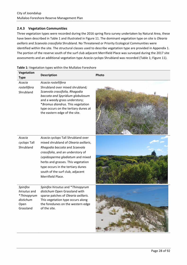
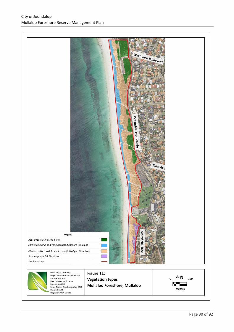
2.4.3 Vegetation Communities
Three vegetation types were recorded during the 2016 spring flora survey undertaken by Natural Area, these
have been described in Table 1 and illustrated in Figure 11. The dominant vegetation type on site is Olearia
axillaris and Scaevola crassifolia Shrubland. No Threatened or Priority Ecological Communities were
identified within the site. The structural classes used to describe vegetation type are provided in Appendix 1.
The portion of the reserve south of the surf club adjacent Merrifield Place was surveyed during the 2017 site
assessments and an additional vegetation type Acacia cyclops Shrubland was recorded (Table 1; Figure 11).
Table 1: Vegetation types within the Mullaloo Foreshore
Vegetation
Type Description Photo
Acacia
rostellifera
Shrubland
Acacia rostellifera
Shrubland over mixed shrubland; Scaevola crassifolia, Rhagodia baccata and Spyridium globulosum and a weedy grass understory; *Bromus diandrus. This vegetation type occurs on the tertiary dunes at the eastern edge of the site.
Acacia
cyclops Tall
Shrubland
Acacia cyclops Tall Shrubland over
mixed shrubland of Olearia axillaris,
Rhagodia baccata and Scaevola
crassifolia, and an understory of
Lepidosperma gladiatum and mixed
herbs and grasses. This vegetation
type occurs in the tertiary dunes
south of the surf club, adjacent
Merrifield Place.
Spinifex hirsutus and *Thinopyrum distichum Open Grassland
Spinifex hirsutus and *Thinopyrum distichum Open Grassland with sparse patches of Olearia axillaris. This vegetation type occurs along the foredunes on the western edge of the site.
City of Joondalup
Mullaloo Foreshore Reserve Management Plan
Page 29 of 92
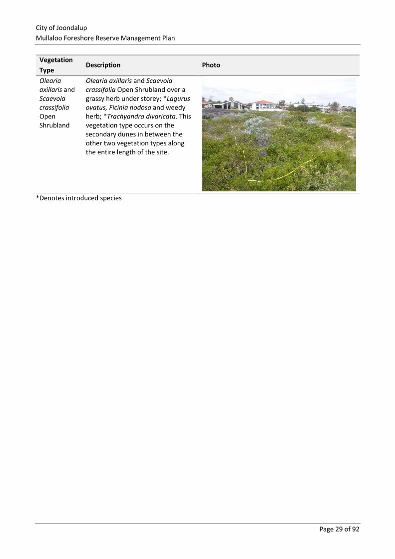
Vegetation
Type Description Photo
Olearia axillaris and Scaevola crassifolia Open Shrubland
Olearia axillaris and Scaevola crassifolia Open Shrubland over a grassy herb under storey; *Lagurus ovatus, Ficinia nodosa and weedy herb; *Trachyandra divaricata. This vegetation type occurs on the secondary dunes in between the other two vegetation types along the entire length of the site.
*Denotes introduced species
City of Joondalup
Mullaloo Foreshore Reserve Management Plan
Page 30 of 92
City of Joondalup
Mullaloo Foreshore Reserve Management Plan
Page 31 of 92
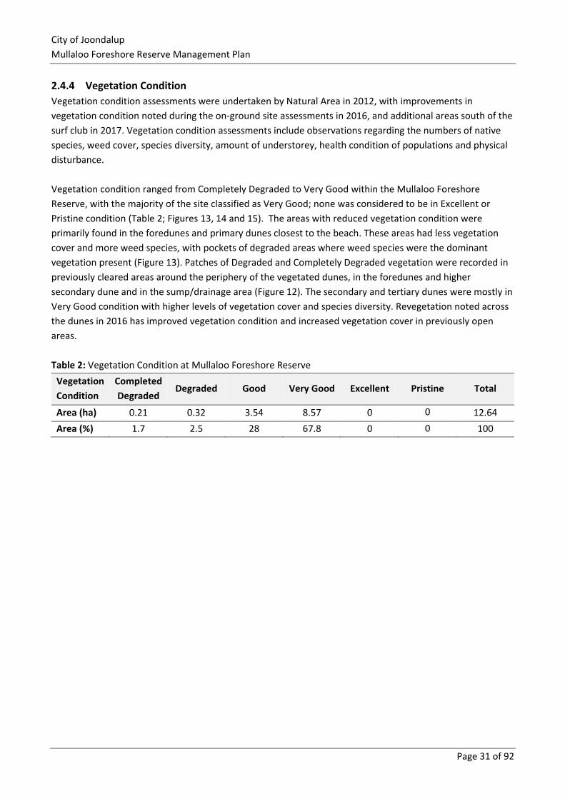
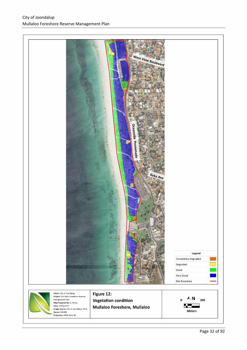
2.4.4 Vegetation Condition
Vegetation condition assessments were undertaken by Natural Area in 2012, with improvements in
vegetation condition noted during the on-ground site assessments in 2016, and additional areas south of the
surf club in 2017. Vegetation condition assessments include observations regarding the numbers of native
species, weed cover, species diversity, amount of understorey, health condition of populations and physical
disturbance.
Vegetation condition ranged from Completely Degraded to Very Good within the Mullaloo Foreshore
Reserve, with the majority of the site classified as Very Good; none was considered to be in Excellent or
Pristine condition (Table 2; Figures 13, 14 and 15). The areas with reduced vegetation condition were
primarily found in the foredunes and primary dunes closest to the beach. These areas had less vegetation
cover and more weed species, with pockets of degraded areas where weed species were the dominant
vegetation present (Figure 13). Patches of Degraded and Completely Degraded vegetation were recorded in
previously cleared areas around the periphery of the vegetated dunes, in the foredunes and higher
secondary dune and in the sump/drainage area (Figure 12). The secondary and tertiary dunes were mostly in
Very Good condition with higher levels of vegetation cover and species diversity. Revegetation noted across
the dunes in 2016 has improved vegetation condition and increased vegetation cover in previously open
areas.
Table 2: Vegetation Condition at Mullaloo Foreshore Reserve
Vegetation
Condition
Completed
Degraded Degraded Good Very Good Excellent Pristine Total
Area (ha) 0.21 0.32 3.54 8.57 0 0 12.64
Area (%) 1.7 2.5 28 67.8 0 0 100
City of Joondalup
Mullaloo Foreshore Reserve Management Plan
Page 32 of 92
City of Joondalup
Mullaloo Foreshore Reserve Management Plan
Page 33 of 92
3.0 Biodiversity Management
Mullaloo Foreshore Reserve supports a range of flora and fauna species, and provides an important
ecological linkage to adjacent coastal reserves. The long term protection of biodiversity values within the
reserve is critical to ensure the conservation of this habitat. The protection and enhancement of biodiversity
within the reserve also benefits the community through the provision of ecological services, including:
▪ the production of oxygen and capture of carbon dioxide
▪ noise and air quality regulation
▪ cooling of urban environments
▪ supporting seed dispersal and pollination
▪ a number of recreational and cultural experiences24.
Flora, fauna and fungi surveys are undertaken as part of the management plan review every five years within
the Mullaloo Foreshore Reserve.
A number of environmental threats pose a risk to the biodiversity of the Mullaloo Foreshore Reserve. The
key environmental threats include:
▪ weeds
▪ pathogens and disease
▪ non-native fauna species
▪ human impacts
▪ access and infrastructure
▪ fire.
Management strategies to mitigate the effects of key environmental threats have been established and are
discussed in the following sections. There are other additional environmental threats that are out of the
scope of this Plan and thus not addressed, such as climate change and groundwater decline.
3.1 Flora The Mullaloo Foreshore Reserve is located in the Southwest Australian biodiversity hotspot, which is one of
the world’s 35 biodiversity hotspots. It extends from Shark Bay in the North to Israelite Bay in the south, with
over 2,900 endemic plant species occurring within the region. Approximately 30% of the original vegetation
extent of this area remains, with habitat loss primarily due to agricultural expansion25.
Flora surveys enable collection of scientific data related to the occurrence and distribution of flora species
and vegetation communities. Information obtained from flora surveys is used as a baseline to monitor the
ecological health of flora populations and vegetation communities. Natural Area was engaged to undertake a
desktop and field flora survey of the Mullaloo Foreshore Reserve in September 2016. A total of 80 plant
species were recorded within the Reserve, including 37 native (46%) and 43 (54%) introduced species.26
24 City of Joondalup (2014a) 25 Conservation International (2017) 26 Natural Area Consulting Management Services (2017)
City of Joondalup
Mullaloo Foreshore Reserve Management Plan
Page 34 of 92
3.1.1 Flora Survey Methodology
Desktop and on-ground flora survey methodology for the Mullaloo Foreshore Reserve was undertaken by
Natural Area in September 2016 in accordance with EPA Technical Guide – Flora and Vegetation Surveys for
Environmental Impact Assessment (December 2016). The survey methodology undertaken included Natural
Area botanists setting up a series of quadrats in each vegetation type and documenting27:
▪ the landscape characteristics including soil type, soil colour, aspect, slope, and topography
▪ leaf litter depth
▪ percentage vegetative cover and percentage bare ground
▪ recording vegetation type and condition
▪ presence of native and non-native flora species present, including significant flora, along with habit,
life form, percentage cover and height
▪ walking the site to record incidental sightings of species not present in quadrats.
3.1.2 Native Flora
Native flora is an important part of the Mullaloo Foreshore Reserve ecosystem, providing habitat and
resources for fauna present. Reduction in flora species or vegetation cover can lead to a loss of fauna that
depend on it for resources and shelter. A total of 37 native plant species, of which none were Threatened or
Priority species, were recorded within the Reserve28.
3.1.3 Weeds
Weeds can be native or introduced species that have colonised an area where they did not originally exist.
An environmental weed generally reproduces quickly, and requires action to reduce its negative impact on
economic, social and environmental values of the area. Weeds are commonly introduced and distributed
within bushland areas through seed dispersal by water, wind, animals such as birds, fire, the dumping of
garden waste, and human or vehicle movement in natural areas. Weeds can have major economic,
environmental and social impacts in Australia and can:
▪ displace native plant species
▪ alter nutrient cycling and soil quality within ecosystems
▪ harbour pests and diseases
▪ increase fire fuel loads
▪ impact negatively on native flora and fauna and their habitats
▪ compete with native species for resources29.
Over 28,000 known alien plant species have been introduced to Australia with approximately 10% now being
established in the environment.30 Garden plants are the main source of Australia's weeds, accounting for
66% of recognised weed species.31
27 Natural Area Consulting Management Services (2017) 28 Ibid. 29 Department of the Environment (2015) 30 Groves, Bowden and Lonsdale (2005) 31 DSEWPC (2013)
City of Joondalup
Mullaloo Foreshore Reserve Management Plan
Page 35 of 92
A total of 43 weed species were recorded within the Mullaloo Foreshore Reserve by Natural Area during the
September 2016 surveys. No weeds of national significance (WoNS) were recorded, although one category
C3 declared pest, the One-leaf Cape Tulip (Moraea flaccida) listed on the WAOL under the Biosecurity and
Agriculture Management Act 2007 (WA) (BAM Act), was recorded within the Reserve. Three species are
listed on the City of Joondalup’s priority weed list, namely Geraldton Carnation Weed (Euphorbia terracina),
Gazania (Gazania linearis) and Rose Pelargonium (Pelargonium capitatum).
3.1.4 Revegetation
The City of Joondalup encourages natural bushland regeneration through weed management and
conservation fencing to allow the vegetation to re-establish itself and maintain species diversity and
populations. Revegetation is undertaken on an as required basis in Degraded, Completely Degraded, or Good
areas where further planting is considered to be beneficial using local provenance species.
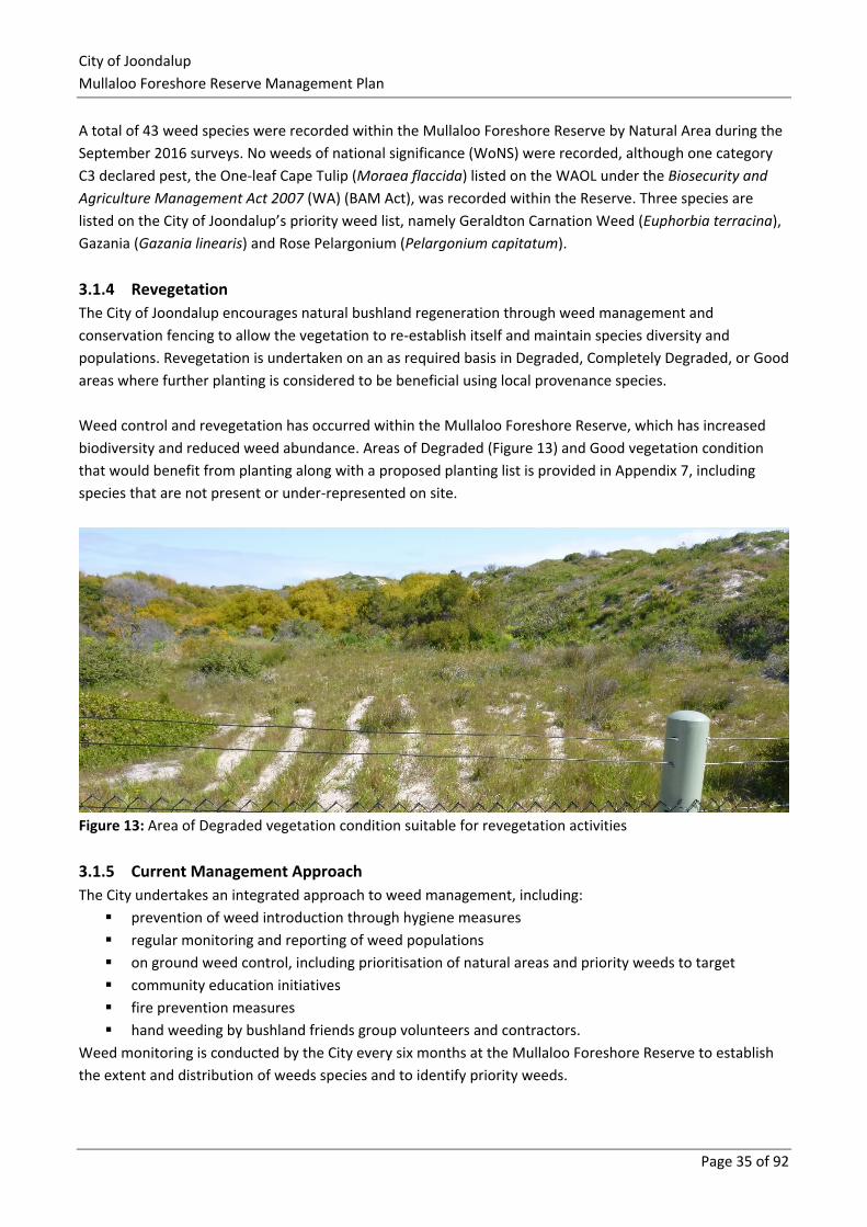
Weed control and revegetation has occurred within the Mullaloo Foreshore Reserve, which has increased
biodiversity and reduced weed abundance. Areas of Degraded (Figure 13) and Good vegetation condition
that would benefit from planting along with a proposed planting list is provided in Appendix 7, including
species that are not present or under-represented on site.
Figure 13: Area of Degraded vegetation condition suitable for revegetation activities
3.1.5 Current Management Approach
The City undertakes an integrated approach to weed management, including:
▪ prevention of weed introduction through hygiene measures
▪ regular monitoring and reporting of weed populations
▪ on ground weed control, including prioritisation of natural areas and priority weeds to target
▪ community education initiatives
▪ fire prevention measures
▪ hand weeding by bushland friends group volunteers and contractors.
Weed monitoring is conducted by the City every six months at the Mullaloo Foreshore Reserve to establish
the extent and distribution of weeds species and to identify priority weeds.
City of Joondalup
Mullaloo Foreshore Reserve Management Plan
Page 36 of 92
In accordance with Annual Maintenance Schedules and Weekly Maintenance Schedules, on ground weed
management occurs through weed spraying and hand weeding methods. In addition to this, contractors are
engaged to spray weeds and hand weed. City of Joondalup personnel act in accordance with internal
spraying procedures and conduct trials periodically to evaluate the most effective management methods.
Resources, such as the DBCA FloraBase website or Southern Weeds and their Control (DAFWA Bulletin 4744),
are also consulted in regard to weed control.
Environmental weeds are classified as priority by the City if they meet any of the following criteria:
▪ weed of national significance (WoNS)
▪ declared plant listed under the Biodiversity and Agriculture Management Act 2007 (WA)
▪ high priority weed according to the Swan Regional Ranking
▪ pest plant under Local Government Act 1995 (WA)
▪ major threat to vegetation
▪ major threat to the structure of vegetation communities
▪ contribute to a high fuel load, for example dry grasses.
A list of weeds and their priority rating according to the DBCA Swan Regional Ranking is provided in
Appendix 5, with the recommended weed treatment methodology for high priority weed species detailed in
Appendix 6.
The City of Joondalup Weed Management Plan has been adopted and provides an ongoing strategic
approach to the management of natural areas and parks in order to reduce the incidence of weeds. A
number of education initiatives are undertaken to raise the awareness of weeds with the community, these
include:
▪ delivery of gardening workshops
▪ development and distribution of two weed brochures – Environmental Weeds and Garden Escapees
(available in hard copy and on the City’s website)
▪ weed education workshops for local Friends Groups.
3.1.6 Recommended Management Actions
To monitor, conserve and protect native flora in the Mullaloo Foreshore Reserve, the following management
actions are proposed.
Action Detail
Weed monitoring Continue to undertake weed monitoring every six months.
Targeted weed control Continue to undertake a targeted weed control program, as described in
Appendix 6.
Ongoing weed control Continue to undertake coordinated approach to regular weed control by
implementing the Annual Maintenance Schedule.
Weed Management Plan Implement the City of Joondalup Weed Management Plan when it is finalised
to provide an ongoing strategic approach to the management of natural areas
in order to reduce the incidence of weeds.
Restoration Conduct restoration as outlined in the Revegetation Strategy in Appendix 7.
City of Joondalup
Mullaloo Foreshore Reserve Management Plan
Page 37 of 92
Action Detail
Friends Group Continue to support the activities of the MBCG.
3.2 Fungi It is estimated that there are 10 times more species of fungi than plants in the world, equating to
approximately 140,000 fungi and 14,000 plant species in Western Australia. The amount of species of fungi
present in bushland can be an indicator of ecosystem health. Fungi are strongly interconnected with plants
and animals as fungi are recyclers that break down litter and debris to provide nutrients for plants. Native
plants such as eucalypts, wattles and orchids have beneficial partnerships with fungi. Fungi also provide food
and/or habitat for fauna such as bandicoots and other fauna including invertebrates32.
Fungi surveys are important to provide baseline information, and to highlight changes in fungi occurrence
over time. Undertaking surveys also enables comparison of ecological data with other City of Joondalup
natural areas. The most common time to see the fruiting bodies of fungi is after autumn and winter rains.
3.2.1 Fungi Field Survey
No fungi species were identified within the Mullaloo Foreshore Reserve during the September 2016
opportunistic field survey conducted by Natural Area33. This was most likely due to the timing of survey
activities, which was not the optimum time to see fruiting bodies as it was too late in the year and the
weather warm and dry. Fungi species likely to occur are expected to be similar to those observed within the
Marmion Coastal Foreshore Reserve and other City of Joondalup bushland areas.
3.2.2 Current Management Approach
The City of Joondalup currently monitors fungi in the Reserve through surveying for incidental sightings of
fungi species every 5 years as part of the flora, fauna and fungi survey.
3.2.3 Recommended Management Action
To monitor fungi health in the Mullaloo Foreshore Reserve, the following management action is proposed:
Action Detail
Opportunistic
fungi survey
Continue to undertake opportunistic fungi sightings during other site activities.
32 Bougher (2009) 33 Natural Area Consulting Management Services (2017)
City of Joondalup
Mullaloo Foreshore Reserve Management Plan
Page 38 of 92
3.3 Plant Diseases Vegetation can be subject to diseases that result in plant health decline and potentially death in the longer
term. Pathogens are the organisms such as fungi, bacteria and viruses that cause plant diseases; with many
introduced into new areas through movement of infected plant material or soils, whilst some are naturally
occurring in the soil. Some pathogens will result in rapid plant death while others will lead to the slow
decline in plant health over time34.
Phytophthora dieback is a water-borne fungus and the most common plant disease encountered on the
Swan Coastal Plain, with the most common species encountered being Phytophthora cinnamomi. While
Phytophthora cinnamomi is considered the most destructive, other varieties are being described which may
have similar impacts, such as Phytophthora multivora which is known to attack a variety of species including
Eucalyptus gomphocephala, E. marginata and Agonis flexuosa and a range of Banksia species35. The nature
of the vegetation combined with the presence of limestone based soils within the foreshore reserve mean
that Phytophthora cinnamomi is unlikely. However, Phytophthora multivora is known to be tolerant of
alkaline conditions as it has been found in Tuart forests underlain by limestone soils south of Mandurah and
as far as Cape Naturaliste, where it has been associated with individual spot deaths and areas of tree
decline36. Phytophthora multivora has been recorded in urban areas of Perth, including inland dune systems
and within the City’s parks. If suspected within the foreshore reserve or other natural areas, it should be
treated in the same manner as Phytophthora cinnamomi.
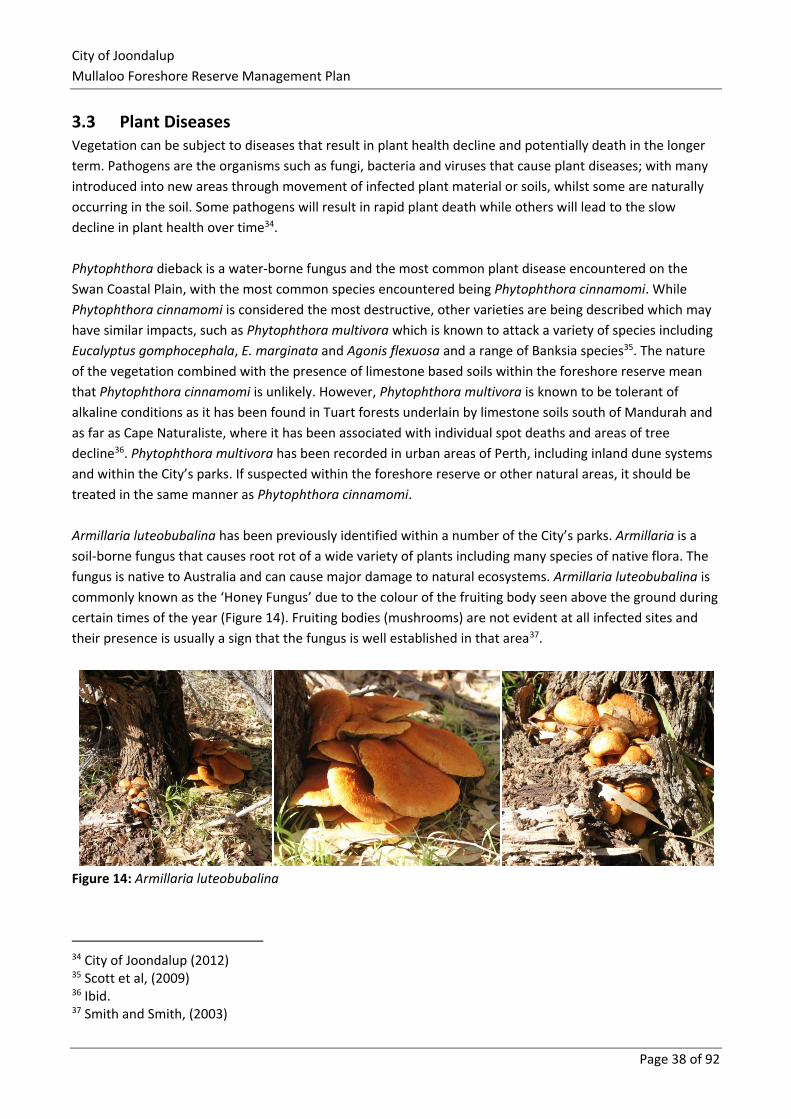
Armillaria luteobubalina has been previously identified within a number of the City’s parks. Armillaria is a
soil-borne fungus that causes root rot of a wide variety of plants including many species of native flora. The
fungus is native to Australia and can cause major damage to natural ecosystems. Armillaria luteobubalina is
commonly known as the ‘Honey Fungus’ due to the colour of the fruiting body seen above the ground during
certain times of the year (Figure 14). Fruiting bodies (mushrooms) are not evident at all infected sites and
their presence is usually a sign that the fungus is well established in that area37.
Figure 14: Armillaria luteobubalina
34 City of Joondalup (2012) 35 Scott et al, (2009) 36 Ibid. 37 Smith and Smith, (2003)
City of Joondalup
Mullaloo Foreshore Reserve Management Plan
Page 39 of 92
At present, there is no reliable mechanism for the complete eradication of Phytophthora species and the
control of Armillaria luteobubalina is both expensive and labour intensive.
3.3.1 Current Management Approach
The City of Joondalup has developed a Pathogen Management Plan 2013-2016 to protect native vegetation
and ecosystems by establishing the level of risk for areas to be infected by pathogens, prioritisation of areas
and detail preventative and management actions to be implemented within the City, including guidelines for
dieback-free purchasing of plant stock and materials and a hygiene procedure. The City has also developed
Pathogen and Weed Hygiene Guidelines38 and Purchasing Guidelines for the Supply of Landscaping
Materials39 to minimise the spread of pathogens.
Sampling undertaken by Arbor Carbon40 in 2015 found Phytophthora nicotianae in one location at Tom
Simpson Park.
3.3.2 Recommended Management Action
To prevent pathogen spread and protect biodiversity values at the Mullaloo Foreshore Reserve, the
following management action is recommended:
Action Detail
Pathogen
Management
Implement recommendations from the Pathogen Management Plan that are applicable to
the management of the Mullaloo Foreshore Reserve, particularly in sites affected by
pathogens.
Pathogen
Management
Implement Pathogen and Weed Hygiene Guidelines and Purchasing of Landscaping
Materials Guidelines to prevent the introduction or spread of weeds or pathogens into the
Mullaloo Foreshore Reserve
3.4 Fauna Fauna surveys were undertaken by Natural Area in November to December 2016 to establish a baseline of
species inhabiting the Reserve and document their occurrence, extent and minimum population numbers.
Outcomes of the Natural Area fauna surveys are presented in this section.
3.4.1 Fauna Survey Methodology
Desktop and field fauna survey activities were undertaken by Natural Area in accordance with EPA Guidance
Statement No. 56: Terrestrial Fauna Surveys for Environmental Impact Assessment in Western Australia,
along with the principles outlined in EPA Position Statement No. 3: Terrestrial Biological Surveys as an
element of Biodiversity Protection, and the Technical Guide – Terrestrial Vertebrate Fauna Surveys for
Environmental Impact Assessment. The methodology undertaken by Natural Area for the November –
December 2016 fauna surveys included:
▪ setting up a range of pitfall and funnel traps in a series of trap lines in each habitat type
38 City of Joondalup, (2016) 39 City of Joondalup, (2015) 40 Arbor Carbon, 2015
City of Joondalup
Mullaloo Foreshore Reserve Management Plan
Page 40 of 92
▪ setting up Elliott and cage traps in other locations within the reserve
▪ checking traps within 3-hours of sunrise, recording species captured and releasing them back into
the environment
▪ setting out a motion activated camera for 10 days to capture sightings of other animals that are
unable to be trapped
▪ walking the site to record opportunistic sightings or indications of (calls, tracks, scats, dens) of
vertebrate fauna
▪ recording incidental sightings or captures of invertebrates
▪ reporting outcomes41.
3.4.2 Fauna Habitat
Four vegetation communities were identified by Natural Area on site during the September 2016 surveys,
comprising low coastal shrubland, Spinifex Grasslands on foredunes and tall Acacia shrubland on low dunes
throughout the majority of the study area. In terms of habitat type, these vegetation communities can be
classed as Quindalup dune mixed shrublands on sandy soils.
This habitat type supports a range of coastal shrubland birds and terrestrial reptiles. No wetlands or open
water bodies occur on site meaning there is no habitat for aquatic species. Amphibians may be able to travel
to the site from nearby water sources in residential gardens or reserves. Large trees in the adjacent Tom
Simpson Park and car parks provides nesting and roosting habitat for birds.
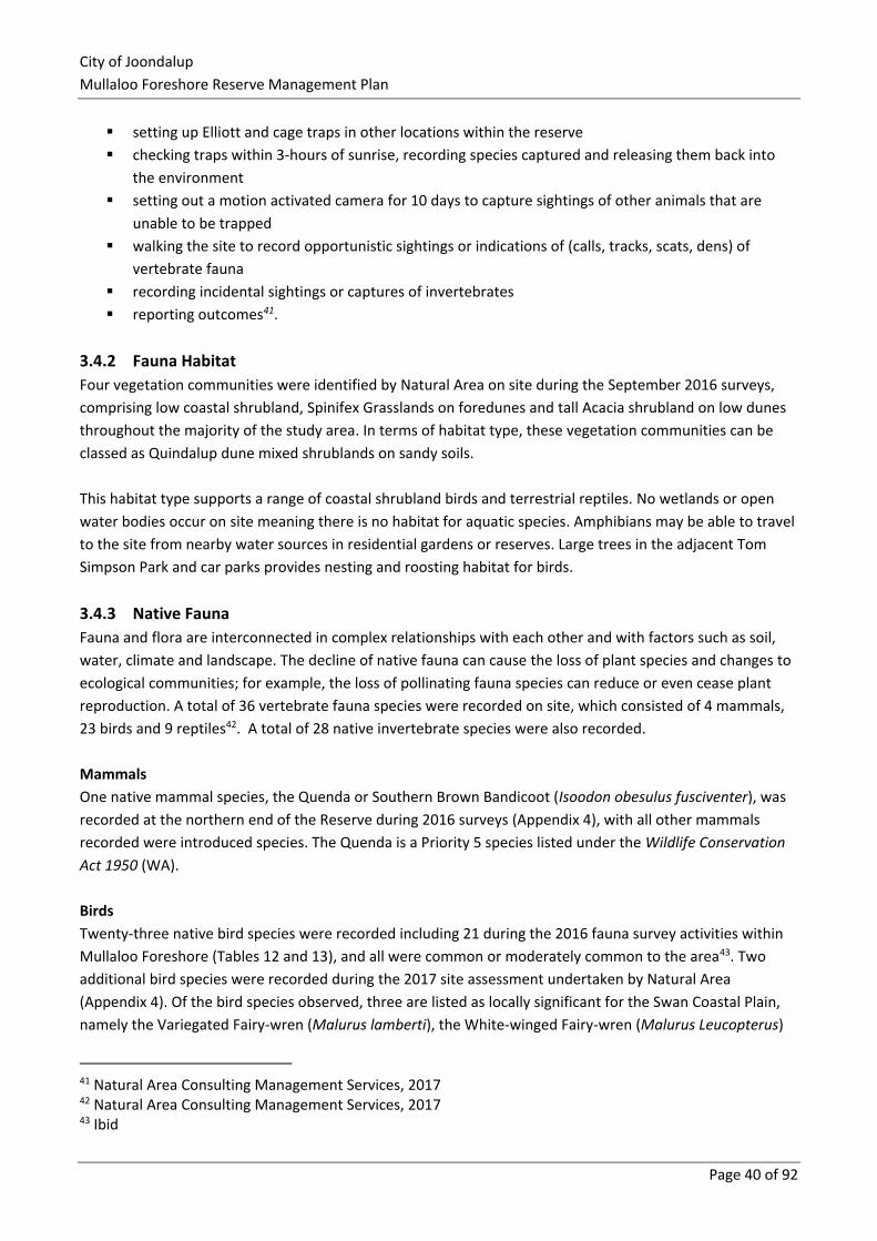
3.4.3 Native Fauna
Fauna and flora are interconnected in complex relationships with each other and with factors such as soil,
water, climate and landscape. The decline of native fauna can cause the loss of plant species and changes to
ecological communities; for example, the loss of pollinating fauna species can reduce or even cease plant
reproduction. A total of 36 vertebrate fauna species were recorded on site, which consisted of 4 mammals,
23 birds and 9 reptiles42. A total of 28 native invertebrate species were also recorded.
Mammals
One native mammal species, the Quenda or Southern Brown Bandicoot (Isoodon obesulus fusciventer), was
recorded at the northern end of the Reserve during 2016 surveys (Appendix 4), with all other mammals
recorded were introduced species. The Quenda is a Priority 5 species listed under the Wildlife Conservation
Act 1950 (WA).
Birds
Twenty-three native bird species were recorded including 21 during the 2016 fauna survey activities within
Mullaloo Foreshore (Tables 12 and 13), and all were common or moderately common to the area43. Two
additional bird species were recorded during the 2017 site assessment undertaken by Natural Area
(Appendix 4). Of the bird species observed, three are listed as locally significant for the Swan Coastal Plain,
namely the Variegated Fairy-wren (Malurus lamberti), the White-winged Fairy-wren (Malurus Leucopterus)
41 Natural Area Consulting Management Services, 2017 42 Natural Area Consulting Management Services, 2017 43 Ibid
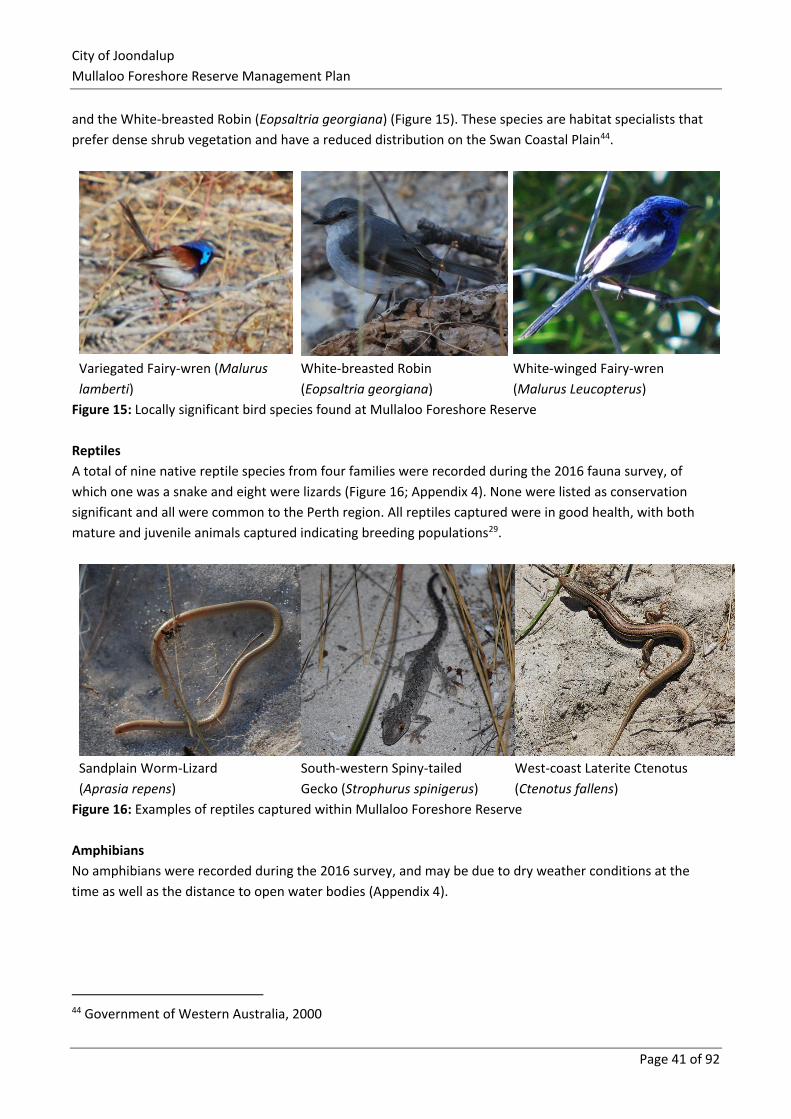
City of Joondalup
Mullaloo Foreshore Reserve Management Plan
Page 41 of 92
and the White-breasted Robin (Eopsaltria georgiana) (Figure 15). These species are habitat specialists that
prefer dense shrub vegetation and have a reduced distribution on the Swan Coastal Plain44.
Variegated Fairy-wren (Malurus
lamberti)
White-breasted Robin
(Eopsaltria georgiana)
White-winged Fairy-wren
(Malurus Leucopterus)
Figure 15: Locally significant bird species found at Mullaloo Foreshore Reserve
Reptiles
A total of nine native reptile species from four families were recorded during the 2016 fauna survey, of
which one was a snake and eight were lizards (Figure 16; Appendix 4). None were listed as conservation
significant and all were common to the Perth region. All reptiles captured were in good health, with both
mature and juvenile animals captured indicating breeding populations29.
Sandplain Worm-Lizard
(Aprasia repens)
South-western Spiny-tailed
Gecko (Strophurus spinigerus)
West-coast Laterite Ctenotus
(Ctenotus fallens)
Figure 16: Examples of reptiles captured within Mullaloo Foreshore Reserve
Amphibians
No amphibians were recorded during the 2016 survey, and may be due to dry weather conditions at the
time as well as the distance to open water bodies (Appendix 4).
44 Government of Western Australia, 2000
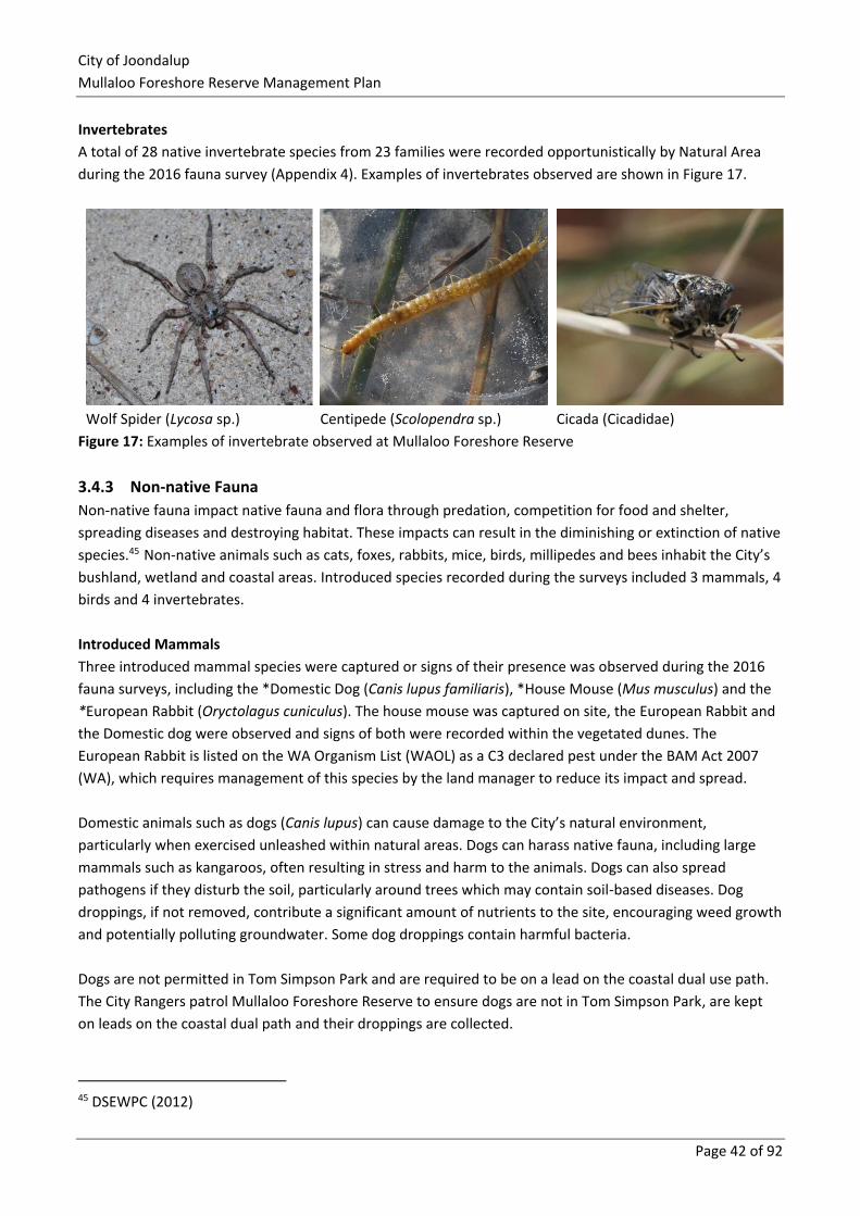
City of Joondalup
Mullaloo Foreshore Reserve Management Plan
Page 42 of 92
Invertebrates
A total of 28 native invertebrate species from 23 families were recorded opportunistically by Natural Area
during the 2016 fauna survey (Appendix 4). Examples of invertebrates observed are shown in Figure 17.
Wolf Spider (Lycosa sp.) Centipede (Scolopendra sp.) Cicada (Cicadidae)
Figure 17: Examples of invertebrate observed at Mullaloo Foreshore Reserve
3.4.3 Non-native Fauna
Non-native fauna impact native fauna and flora through predation, competition for food and shelter,
spreading diseases and destroying habitat. These impacts can result in the diminishing or extinction of native
species.45 Non-native animals such as cats, foxes, rabbits, mice, birds, millipedes and bees inhabit the City’s
bushland, wetland and coastal areas. Introduced species recorded during the surveys included 3 mammals, 4
birds and 4 invertebrates.
Introduced Mammals
Three introduced mammal species were captured or signs of their presence was observed during the 2016
fauna surveys, including the *Domestic Dog (Canis lupus familiaris), *House Mouse (Mus musculus) and the
*European Rabbit (Oryctolagus cuniculus). The house mouse was captured on site, the European Rabbit and
the Domestic dog were observed and signs of both were recorded within the vegetated dunes. The
European Rabbit is listed on the WA Organism List (WAOL) as a C3 declared pest under the BAM Act 2007
(WA), which requires management of this species by the land manager to reduce its impact and spread.
Domestic animals such as dogs (Canis lupus) can cause damage to the City’s natural environment,
particularly when exercised unleashed within natural areas. Dogs can harass native fauna, including large
mammals such as kangaroos, often resulting in stress and harm to the animals. Dogs can also spread
pathogens if they disturb the soil, particularly around trees which may contain soil-based diseases. Dog
droppings, if not removed, contribute a significant amount of nutrients to the site, encouraging weed growth
and potentially polluting groundwater. Some dog droppings contain harmful bacteria.
Dogs are not permitted in Tom Simpson Park and are required to be on a lead on the coastal dual use path.
The City Rangers patrol Mullaloo Foreshore Reserve to ensure dogs are not in Tom Simpson Park, are kept
on leads on the coastal dual path and their droppings are collected.
45 DSEWPC (2012)
City of Joondalup
Mullaloo Foreshore Reserve Management Plan
Page 43 of 92
Domestic and feral cats (Felis catus) have the potential to cause significant environmental harm when
allowed to roam within urban natural areas. Feral cats are attributed to be the major threat to mammalian
fauna extinction in Australia. The Australian Wildlife Conservancy estimates ‘feral cats kill at least 75 million
native animals every night across Australia46. The Federal Government in 2015 endorsed the National
Declaration of Feral Cats as Pests. In order to combat this threat to native fauna populations, the Australian
Government has set an objective through the Threatened Species Strategy 2015, for 2 million cats to be
culled across Australia by 2020.
The Cat Act 2011 (WA) encourages responsible pet ownership by ensuring cats are registered, sterilised and
microchipped. The Act also enables the City of Joondalup to seize cats if they are reported to be on private
property without the consent of the owner/occupier, and commenced cat control activities in its foreshore
reserves in 2017.
The City has a fox and rabbit control program and operates under the BAM Act to manage these non-native
mammals at Mullaloo Foreshore Reserve.
Introduced Birds
Four introduced bird species were recorded during the 2016 survey within the site, namely the *Rock Dove
(Columba livia domestica), *Spotted Turtle-Dove (Streptopelia chinensis), *Laughing Turtle-Dove
(Streptopelia senegalensis) and the *Rainbow Lorikeet (Trichoglossus haematodus)30 (Appendix 4). These
species are common throughout the Perth metropolitan region31. Introduced birds have a negative impact
on native species by increasing competition with native species for food and nesting resources.
Introduced Invertebrates
Four introduced invertebrates were recorded by Natural Area during the November to December 2016
survey including the *European Honey Bee (Apis mellifera), which was observed in several locations across
the site, however no bee hives were recorded47. This species can negatively impact native bird species by
increasing competition for nesting hollows and can pose a safety risk to people utilising the site. The
Portuguese Millipede (Ommatoiulus moreleti), Rolling Slater (Armadillidium vulgare) and the Purple
Woodlouse (Porcellionoides sp.) were also recorded throughout the site. The Portuguese Millipede is
considered to be a pest at high population levels and is avoided by many predators48. This species is
common within bushland and suburban areas across the Perth metropolitan region.
3.4.5 Ecological Corridors
Naturally connected landscapes and ecosystems are generally healthier than fragmented ones, supporting
and protecting a greater diversity of species, providing pathways for species movement and can store carbon
more effectively than degraded landscapes49. In urban areas, infrastructure can divide landscapes creating
barriers for native fauna movement, which may make it necessary to provide wildlife crossings such as
underpasses, tunnels, viaducts or overpasses to enable wildlife movement.
46 Australian Wildlife Conservancy, (2012/2013) 47 Natural Area Consulting Management and Services (2017) 48 Department of Agriculture and Food (WA) (2017a) 49 NWCPAG (2012)
City of Joondalup
Mullaloo Foreshore Reserve Management Plan
Page 44 of 92
The Mullaloo Foreshore Reserve is part of an ecological linkage coastal strip that extends from Burns Beach
in the north to North Beach in the south and inland to Periwinkle Park, Korella Park Natural Area and
Kallaroo Park Natural Area within the City of Joondalup (Figure 18).
3.4.6 Current Management Approach
The City of Joondalup is implementing a number of management actions to monitor native fauna and
address the environmental impacts of domestic and pest animals within the City’s natural areas. Monitoring
of native fauna occurs through fauna surveys. Control of non-native fauna is undertaken as required within
bushland, wetland and coastal areas. Control methods employed include trapping, baiting and exclusion
methods such as fencing.
The City’s current management practices have greatly reduced the incidence of pest animal populations
within the City, however continued and coordinated action is required to ensure that populations remain at
controllable numbers and that the impacts on natural areas remain at a minimum. The City also promotes
responsible pet ownership and encourages the community to ensure that domestic pets do not have a
negative impact on the natural environment.
3.4.7 Recommended Management Actions
Action Detail
Fauna Carry out follow-up fauna surveys in spring and a targeted invertebrate survey after five
years.
Feral animal
control
Continue to monitor feral animal populations and implement regular fox and rabbit control to
reduce pressures on native fauna and flora.
Dog control Control dogs in accordance with the Dog Act 1976 (WA) and City of Joondalup’s policies and
procedures in relation to removal on land managed by the City.
Cat control
The City commenced cat control in 2017 on foreshore reserves; to control cats in accordance
with the Cat Act 2011 (WA) and City of Joondalup’s policies and procedures in relation to their
trapping and removal on land managed by the City.
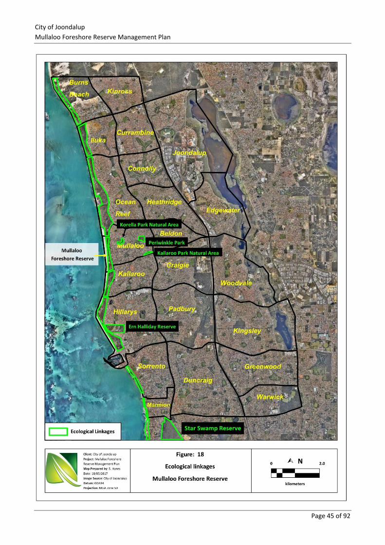
City of Joondalup
Mullaloo Foreshore Reserve Management Plan
Page 45 of 92
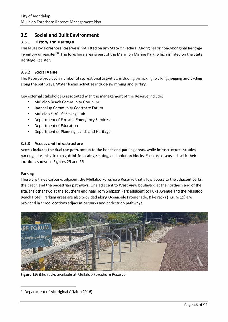
City of Joondalup
Mullaloo Foreshore Reserve Management Plan
Page 46 of 92
3.5 Social and Built Environment
3.5.1 History and Heritage
The Mullaloo Foreshore Reserve is not listed on any State or Federal Aboriginal or non-Aboriginal heritage
inventory or register50. The foreshore area is part of the Marmion Marine Park, which is listed on the State
Heritage Resister.
3.5.2 Social Value
The Reserve provides a number of recreational activities, including picnicking, walking, jogging and cycling
along the pathways. Water based activities include swimming and surfing.
Key external stakeholders associated with the management of the Reserve include:
▪ Mullaloo Beach Community Group Inc.
▪ Joondalup Community Coastcare Forum
▪ Mullaloo Surf Life Saving Club
▪ Department of Fire and Emergency Services
▪ Department of Education
▪ Department of Planning, Lands and Heritage.
3.5.3 Access and Infrastructure
Access includes the dual use path, access to the beach and parking areas, while infrastructure includes
parking, bins, bicycle racks, drink fountains, seating, and ablution blocks. Each are discussed, with their
locations shown in Figures 25 and 26.
Parking
There are three carparks adjacent the Mullaloo Foreshore Reserve that allow access to the adjacent parks,
the beach and the pedestrian pathways. One adjacent to West View boulevard at the northern end of the
site, the other two at the southern end near Tom Simpson Park adjacent to Iluka Avenue and the Mullaloo
Beach Hotel. Parking areas are also provided along Oceanside Promenade. Bike racks (Figure 19) are
provided in three locations adjacent carparks and pedestrian pathways.
Figure 19: Bike racks available at Mullaloo Foreshore Reserve
50 Department of Aboriginal Affairs (2016)
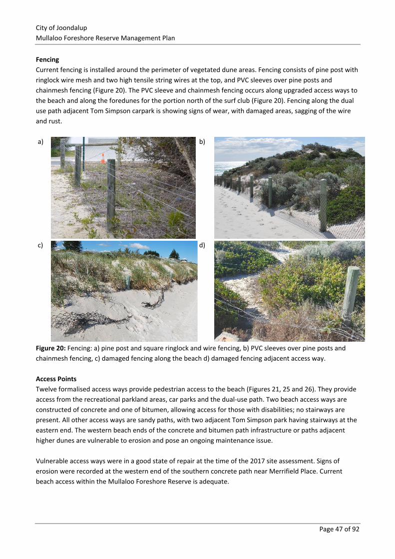
City of Joondalup
Mullaloo Foreshore Reserve Management Plan
Page 47 of 92
Fencing
Current fencing is installed around the perimeter of vegetated dune areas. Fencing consists of pine post with
ringlock wire mesh and two high tensile string wires at the top, and PVC sleeves over pine posts and
chainmesh fencing (Figure 20). The PVC sleeve and chainmesh fencing occurs along upgraded access ways to
the beach and along the foredunes for the portion north of the surf club (Figure 20). Fencing along the dual
use path adjacent Tom Simpson carpark is showing signs of wear, with damaged areas, sagging of the wire
and rust.
a)
b)
c)
d)
Figure 20: Fencing: a) pine post and square ringlock and wire fencing, b) PVC sleeves over pine posts and
chainmesh fencing, c) damaged fencing along the beach d) damaged fencing adjacent access way.
Access Points
Twelve formalised access ways provide pedestrian access to the beach (Figures 21, 25 and 26). They provide
access from the recreational parkland areas, car parks and the dual-use path. Two beach access ways are
constructed of concrete and one of bitumen, allowing access for those with disabilities; no stairways are
present. All other access ways are sandy paths, with two adjacent Tom Simpson park having stairways at the
eastern end. The western beach ends of the concrete and bitumen path infrastructure or paths adjacent
higher dunes are vulnerable to erosion and pose an ongoing maintenance issue.
Vulnerable access ways were in a good state of repair at the time of the 2017 site assessment. Signs of
erosion were recorded at the western end of the southern concrete path near Merrifield Place. Current
beach access within the Mullaloo Foreshore Reserve is adequate.
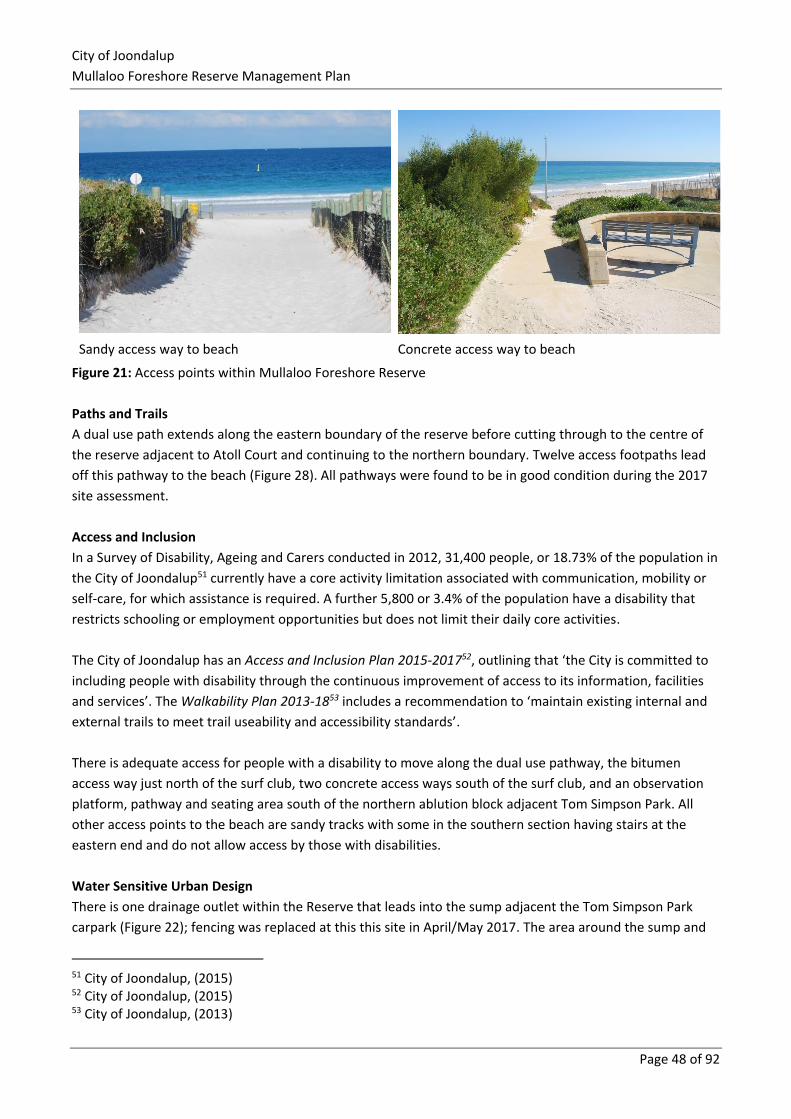
City of Joondalup
Mullaloo Foreshore Reserve Management Plan
Page 48 of 92
Sandy access way to beach Concrete access way to beach
Figure 21: Access points within Mullaloo Foreshore Reserve
Paths and Trails
A dual use path extends along the eastern boundary of the reserve before cutting through to the centre of
the reserve adjacent to Atoll Court and continuing to the northern boundary. Twelve access footpaths lead
off this pathway to the beach (Figure 28). All pathways were found to be in good condition during the 2017
site assessment.
Access and Inclusion
In a Survey of Disability, Ageing and Carers conducted in 2012, 31,400 people, or 18.73% of the population in
the City of Joondalup51 currently have a core activity limitation associated with communication, mobility or
self-care, for which assistance is required. A further 5,800 or 3.4% of the population have a disability that
restricts schooling or employment opportunities but does not limit their daily core activities.
The City of Joondalup has an Access and Inclusion Plan 2015-201752, outlining that ‘the City is committed to
including people with disability through the continuous improvement of access to its information, facilities
and services’. The Walkability Plan 2013-1853 includes a recommendation to ‘maintain existing internal and
external trails to meet trail useability and accessibility standards’.
There is adequate access for people with a disability to move along the dual use pathway, the bitumen
access way just north of the surf club, two concrete access ways south of the surf club, and an observation
platform, pathway and seating area south of the northern ablution block adjacent Tom Simpson Park. All
other access points to the beach are sandy tracks with some in the southern section having stairs at the
eastern end and do not allow access by those with disabilities.
Water Sensitive Urban Design
There is one drainage outlet within the Reserve that leads into the sump adjacent the Tom Simpson Park
carpark (Figure 22); fencing was replaced at this this site in April/May 2017. The area around the sump and
51 City of Joondalup, (2015) 52 City of Joondalup, (2015) 53 City of Joondalup, (2013)
City of Joondalup
Mullaloo Foreshore Reserve Management Plan
Page 49 of 92
drainage inlet has an increased risk of potential erosion, and weed and rubbish introduction via the
stormwater drains. No erosion was noted around the sump during the 2017 site assessment undertaken by
Natural Area. A high diversity and density of weeds was present within the sump and most likely introduced
via the stormwater drainage system. It is recommended that the drain and sump be regularly inspected for
erosion and other damage, and that maintenance activities include weed control and rubbish removal to
reduce the potential for blockages.
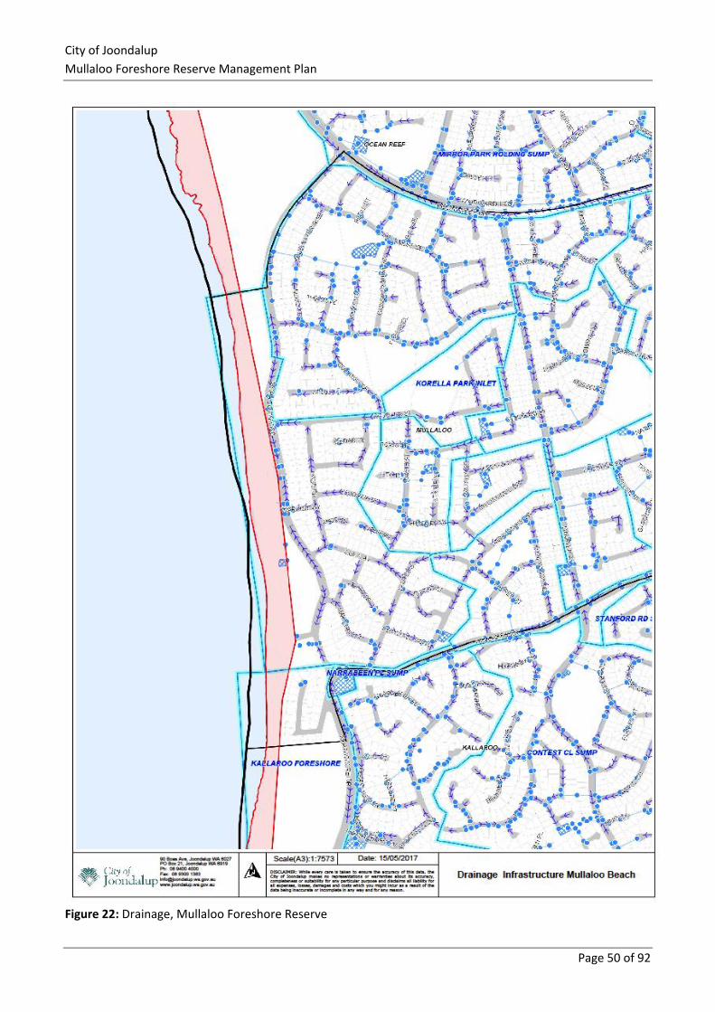
City of Joondalup
Mullaloo Foreshore Reserve Management Plan
Page 50 of 92
Figure 22: Drainage, Mullaloo Foreshore Reserve
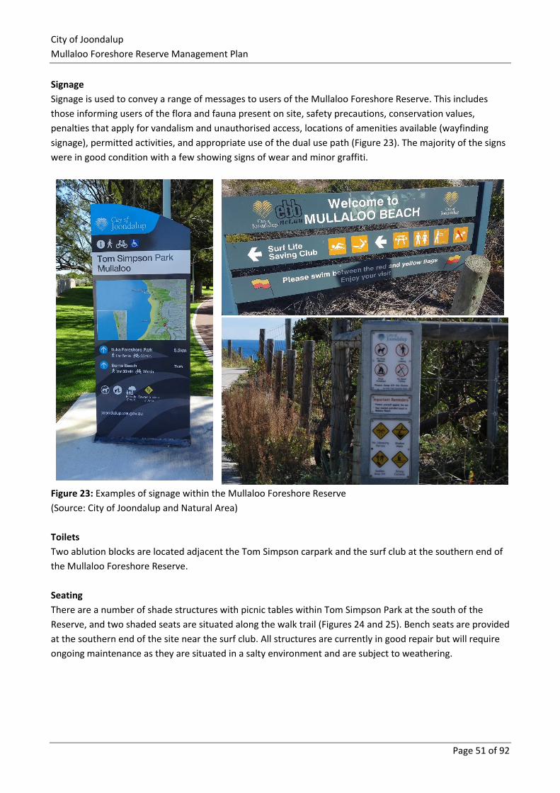
City of Joondalup
Mullaloo Foreshore Reserve Management Plan
Page 51 of 92
Signage
Signage is used to convey a range of messages to users of the Mullaloo Foreshore Reserve. This includes
those informing users of the flora and fauna present on site, safety precautions, conservation values,
penalties that apply for vandalism and unauthorised access, locations of amenities available (wayfinding
signage), permitted activities, and appropriate use of the dual use path (Figure 23). The majority of the signs
were in good condition with a few showing signs of wear and minor graffiti.
Figure 23: Examples of signage within the Mullaloo Foreshore Reserve
(Source: City of Joondalup and Natural Area)
Toilets
Two ablution blocks are located adjacent the Tom Simpson carpark and the surf club at the southern end of
the Mullaloo Foreshore Reserve.
Seating
There are a number of shade structures with picnic tables within Tom Simpson Park at the south of the
Reserve, and two shaded seats are situated along the walk trail (Figures 24 and 25). Bench seats are provided
at the southern end of the site near the surf club. All structures are currently in good repair but will require
ongoing maintenance as they are situated in a salty environment and are subject to weathering.
City of Joondalup
Mullaloo Foreshore Reserve Management Plan
Page 52 of 92
Rubbish Bins
Rubbish bins are located along the dual use pathway at the entrance to most access ways, within the
parkland areas near carparks and picnic areas where people congregate to enjoy the views or sit down and
rest (Figures 24 and 25). Minimal rubbish was recorded during the 2016 and 2017 site assessments, with the
majority being plastic bags, paper and cardboard on the periphery of vegetated areas adjacent to parklands
and roads, which has most likely blown in by the wind.
3.5.4 Anti-social Behaviour
Anti-social behaviour includes inappropriate use and activities such as graffiti vandalism to property,
construction of cubbies, destruction of natural and human assets, rubbish dumping, camping, and lighting of
fires on the beach. Impacts of such activities included decreased aesthetics, damage to the vegetation
through trampling and clearing, and increased maintenance costs to remove or repair damaged assets and
infrastructure. There was little evidence of anti-social behaviour within the Mullaloo Foreshore Reserve
during the 2016 and 2017 site assessment activities, with campfire construction being the most obvious
(Figure 26).
3.5.5 Recommended Management Actions
To enhance the social and built environment in the Mullaloo Foreshore Reserve, the following management
actions are proposed:
Action Detail
Access Implement recommendations outlined in the Walkability Plan as they relate to
the Mullaloo Foreshore Reserve.
Fencing Regularly review sand build up along the beach fence and arrange removal when
required.
Water erosion from
drainage
Monitor erosion and water pooling around the storm drains and restore when
required.
Signage maintenance
Continue signage inspections in conjunction with other monitoring activities in
accordance with the Annual Bushland Schedule and repair or replace damaged or
vandalised signs as required.
Inappropriate signage Remove any advertisement signage affixed to the fencing or other locations in
the Reserve by business owners or individuals when observed.
Rubbish Monitor rubbish around the reserve in accordance with the Annual Bushland
Schedule, with removal occurring when observed.
Anti-social behaviour
Monitor evidence of anti-social behaviour, promptly:
▪ removing any cubbies, or dumped rubbish
▪ repairing vandalised assets and/or infrastructure
▪ restoring damage to bushland areas as soon as possible after discovery.
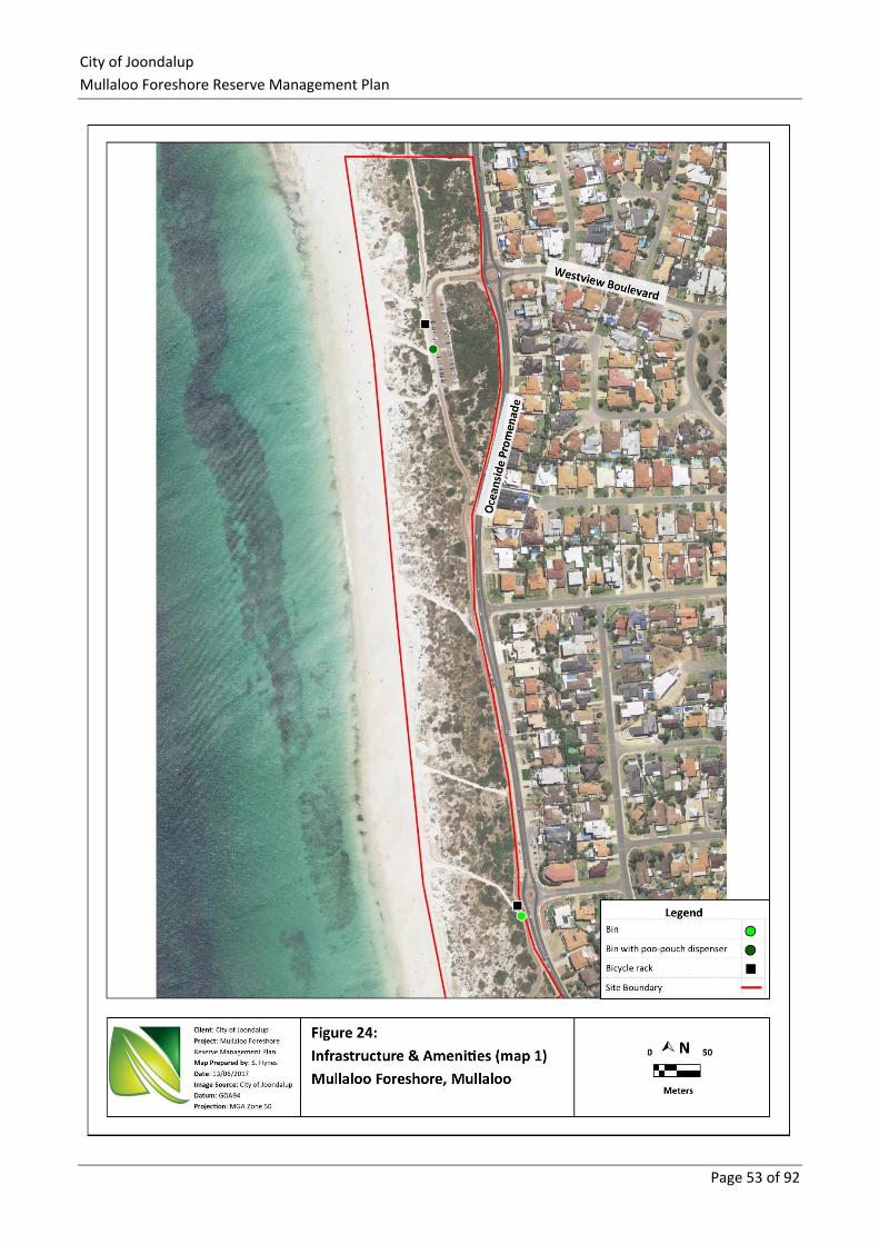
City of Joondalup
Mullaloo Foreshore Reserve Management Plan
Page 53 of 92
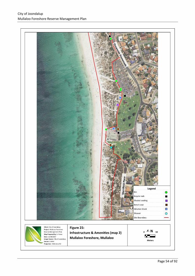
City of Joondalup
Mullaloo Foreshore Reserve Management Plan
Page 54 of 92
City of Joondalup
Mullaloo Foreshore Reserve Management Plan
Page 55 of 92
3.6 Fire Management Fire is an important natural feature of the Western Australian landscape as it helps to shape the diversity of
plant communities with many Australian native plants having adapted fire-reliant methods of reproduction.
Human activities such as accidents and arson have resulted in an increased incidence of fire within many
urban bushland reserves that threatens biodiversity, reduces the ability of native species to complete their
lifecycle and can encourage the growth of fire promoting invasive weeds. A high intensity fire may damage
infrastructure such as property, signage, fences and gates. Fire suppression methods may also compromise
the environmental values of the Reserve, such as clearing native vegetation for firebreaks.
Bushfires are unplanned fires that can be caused by events such as lightning, planned burning operations,
escape from industrial activities, damaged power transmission lines, discarded cigarette butts or deliberate
arson. Bushfires can cause significant damage to people, property and the environment.54 Management of
the Mullaloo Foreshore Reserve is the responsibility of the City of Joondalup, which has a ‘duty of care’ to
take all reasonable precautions to prevent any bushfire from spreading onto neighbouring property. The City
of Joondalup does not currently have a prescribed burn management regime for the area. The Department
of Fire and Emergency Services (DFES) work with the community and government to prevent, prepare for,
respond to and recover from a diverse range of emergencies, including fire.55 There are numerous water
hydrants located around the Reserve, which are installed and maintained by the Water Corporation.
Objectives
The objectives of fire management within the Mullaloo Foreshore Reserve are to:
▪ protect life, property and environment in Mullaloo, and adjacent residential areas
▪ fulfil obligations under the Bush Fires Act 1954 (WA)
▪ protect the ecological and amenity values
▪ protect landscape values (including flora and fauna) from uncontrolled fire and inappropriate
suppression techniques
▪ reduce the frequency, impact and area of unplanned fires
▪ minimise the spread of disease and weeds during fire-fighting operations and when establishing
emergency firebreaks, and during post-fire clean-up activities
▪ minimise impacts on air quality.
Fire Risk
The site has a low to moderate fire risk due to the coastal heath and shrubland vegetation present. Fine fire
fuels present such as dry grass, leaves, twigs and loose bark increase the risk of fire ignition and spread
within the Reserve. The highest risk for the site is from deliberately lit fires within the vegetated dune areas
and discarded cigarette butts. The steep slopes on higher dunes in the portion south of the surf club pose a
safety risk to fire respondents in the event of a fire, especially if there is low visibility due to smoke. Fire fuel
load assessments are carried out every year to determine fire risk based on fuel load, assessments should be
undertaken using methodology described in the Department of Fire and Emergency Services (DFES) Visual
Fuel Load Guide for the Swan Coastal Plain and Darling Scarp56.
54 EDOWA (2011) 55 DFES (2017a) 56 DFES (2015)
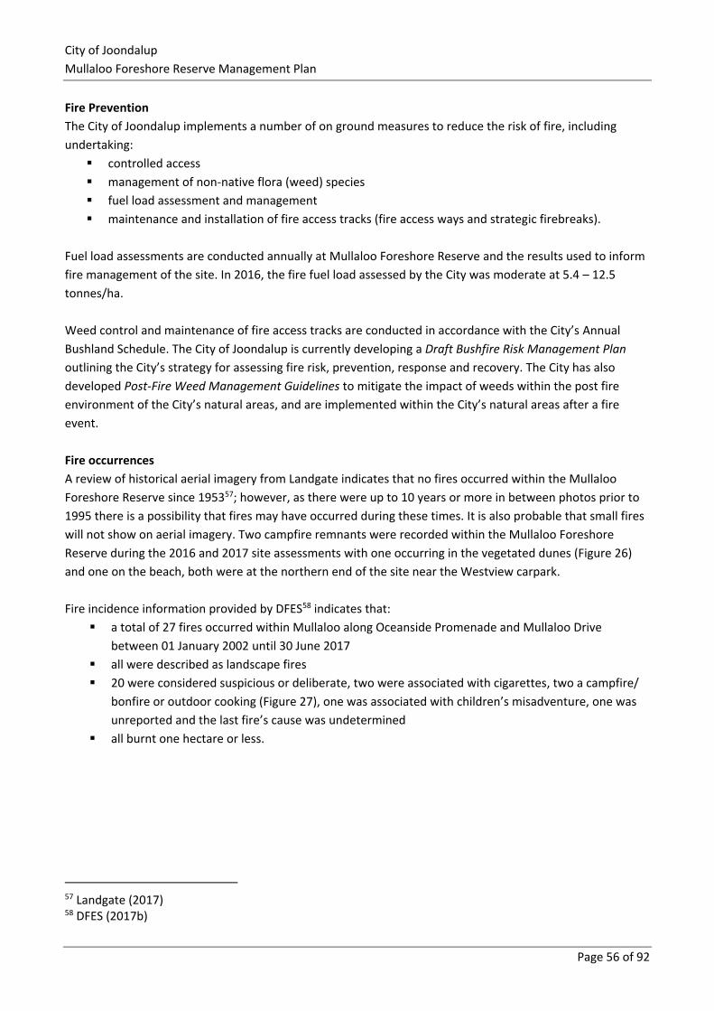
City of Joondalup
Mullaloo Foreshore Reserve Management Plan
Page 56 of 92
Fire Prevention
The City of Joondalup implements a number of on ground measures to reduce the risk of fire, including
undertaking:
▪ controlled access
▪ management of non-native flora (weed) species
▪ fuel load assessment and management
▪ maintenance and installation of fire access tracks (fire access ways and strategic firebreaks).
Fuel load assessments are conducted annually at Mullaloo Foreshore Reserve and the results used to inform
fire management of the site. In 2016, the fire fuel load assessed by the City was moderate at 5.4 – 12.5
tonnes/ha.
Weed control and maintenance of fire access tracks are conducted in accordance with the City’s Annual
Bushland Schedule. The City of Joondalup is currently developing a Draft Bushfire Risk Management Plan
outlining the City’s strategy for assessing fire risk, prevention, response and recovery. The City has also
developed Post-Fire Weed Management Guidelines to mitigate the impact of weeds within the post fire
environment of the City’s natural areas, and are implemented within the City’s natural areas after a fire
event.
Fire occurrences
A review of historical aerial imagery from Landgate indicates that no fires occurred within the Mullaloo
Foreshore Reserve since 195357; however, as there were up to 10 years or more in between photos prior to
1995 there is a possibility that fires may have occurred during these times. It is also probable that small fires
will not show on aerial imagery. Two campfire remnants were recorded within the Mullaloo Foreshore
Reserve during the 2016 and 2017 site assessments with one occurring in the vegetated dunes (Figure 26)
and one on the beach, both were at the northern end of the site near the Westview carpark.
Fire incidence information provided by DFES58 indicates that:
▪ a total of 27 fires occurred within Mullaloo along Oceanside Promenade and Mullaloo Drive
between 01 January 2002 until 30 June 2017
▪ all were described as landscape fires
▪ 20 were considered suspicious or deliberate, two were associated with cigarettes, two a campfire/
bonfire or outdoor cooking (Figure 27), one was associated with children’s misadventure, one was
unreported and the last fire’s cause was undetermined
▪ all burnt one hectare or less.
57 Landgate (2017) 58 DFES (2017b)
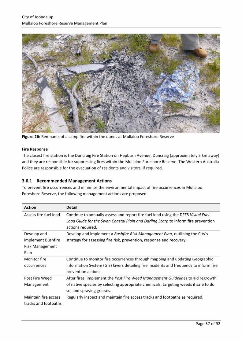
City of Joondalup
Mullaloo Foreshore Reserve Management Plan
Page 57 of 92
Figure 26: Remnants of a camp fire within the dunes at Mullaloo Foreshore Reserve
Fire Response
The closest fire station is the Duncraig Fire Station on Hepburn Avenue, Duncraig (approximately 5 km away)
and they are responsible for suppressing fires within the Mullaloo Foreshore Reserve. The Western Australia
Police are responsible for the evacuation of residents and visitors, if required.
3.6.1 Recommended Management Actions
To prevent fire occurrences and minimise the environmental impact of fire occurrences in Mullaloo
Foreshore Reserve, the following management actions are proposed:
Action Detail
Assess fire fuel load Continue to annually assess and report fire fuel load using the DFES Visual Fuel
Load Guide for the Swan Coastal Plain and Darling Scarp to inform fire prevention
actions required.
Develop and
implement Bushfire
Risk Management
Plan
Develop and implement a Bushfire Risk Management Plan, outlining the City’s
strategy for assessing fire risk, prevention, response and recovery.
Monitor fire
occurrences
Continue to monitor fire occurrences through mapping and updating Geographic
Information System (GIS) layers detailing fire incidents and frequency to inform fire
prevention actions.
Post Fire Weed
Management
After fires, implement the Post Fire Weed Management Guidelines to aid regrowth
of native species by selecting appropriate chemicals, targeting weeds if safe to do
so, and spraying grasses.
Maintain fire access
tracks and footpaths
Regularly inspect and maintain fire access tracks and footpaths as required.
City of Joondalup
Mullaloo Foreshore Reserve Management Plan
Page 58 of 92
3.7 Education and Training An important objective of this Plan is to ensure that the local community, visitors to the City’s natural areas
and those that manage the City’s natural areas have the necessary awareness, knowledge, motivation and
behaviour to assist in protecting the City’s natural areas. Environmental objectives cannot be achieved
through the actions of the City alone; the community can also affect the local environment in both positive
and negative ways. Environmental outcomes require the support of an engaged community that is aware
and participating in environmental activities.
The local community can protect and enhance Mullaloo Foreshore Reserve through the following actions:
▪ contact the City of Joondalup if they are interested in initiating or participating in an environmental
volunteer group such as the MBCG to assist with bushland restoration and maintenance activities
▪ minimising access and disturbance to the site by staying on paths, not taking vehicles into natural
areas, and not allowing dogs to run off-lead
▪ contain cats, particularly at night, and ensure they stay out of Mullaloo Foreshore Reserve.
▪ planting local, native species in gardens where possible
▪ avoid touching or feeding wildlife and picking wildflowers or native plants
▪ undertaking appropriate hygiene practices such as cleaning footwear when entering and leaving the
site, removing any weed seeds attached to clothing and removing and disposing appropriately of dog
excrement (may contain weed seed)
▪ not dumping garden rubbish or littering on site; litter could be collected from site when spotted, or
people could organise or get involved with a Clean Up Australia Day event.
Schools are also an important avenue for raising awareness and interest in environmental issues and
creating future community members that are aware of, appreciate and actively participate in local
environmental management. Mullaloo Beach Primary School is located within close proximity to Mullaloo
Foreshore Reserve which creates possible bushland learning opportunities for students.
Current Management Approach
The City implements an Annual Environmental Education Program to address key environmental issues and
encourage greater environmental stewardship by the community. The Environmental Education Program
includes a Think Green Biodiversity campaign, focussed on raising awareness of key environmental issues
within the City and encouraging community participation in protecting the natural environment.
The City implements an Adopt a Coastline Program to give primary school students the opportunity to take
part in an environmental program involving education, rehabilitation and conservation activities along the
coastline including on-ground coastal activities such as weeding, planting and care of dune systems.
In order to educate the community about how they can protect natural areas, the City has developed a
number of key brochures titled ‘Being WEEDwise: Garden Escapees in the City of Joondalup’, ‘Being
WEEDwise: Environmental Weeds in the City of Joondalup’ and ‘Protecting our Natural Areas and Parks’.
The City of Joondalup Natural Areas Team currently conducts regular plant identification training, including
weed management. New members in the Natural Areas team undertake training for the identification and
management of pathogens.
City of Joondalup
Mullaloo Foreshore Reserve Management Plan
Page 59 of 92
The City’s Friends Groups are instrumental in assisting to protect, preserve and enhance significant bushland
areas within the City and may also benefit from training related to pathogen hygiene and weed
management. The MBCG operate within Mullaloo Foreshore Reserve.
3.7.1 Recommended Education and Training Management Actions
Action Detail
Environmental
Education Program
Implement initiatives of a ‘Think Green Biodiversity’ campaign (part of the
Environmental Education Program) targeting environmental issues such as:
▪ pathogens
▪ weeds
▪ litter
▪ fire
▪ flora, fauna and fungi awareness
▪ prevention of hand feeding wildlife
▪ responsible pet ownership.
Adopt a Coastline
Program Continue implementing the Adopt a Coastline Program within Mullaloo.
Natural Areas Team
Training
Conduct regular Natural Areas Team plant identification training, including weed
management, to increase the effectiveness of weed control activities, as required.
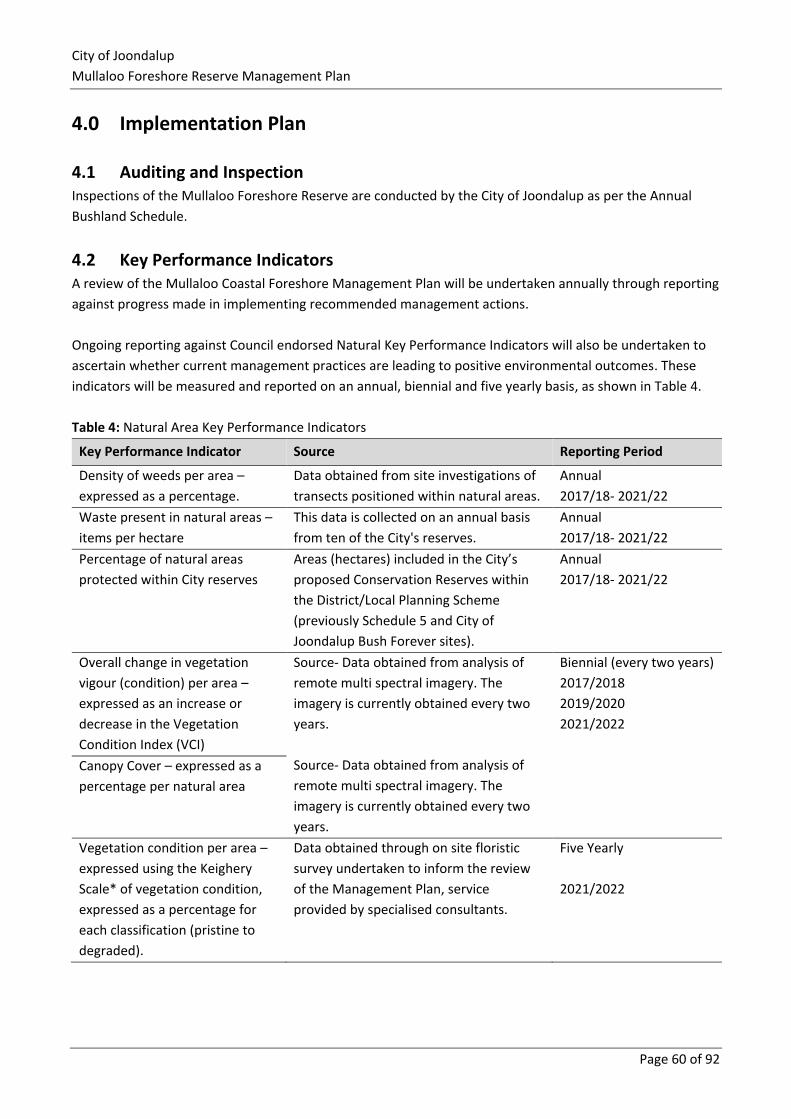
City of Joondalup
Mullaloo Foreshore Reserve Management Plan
Page 60 of 92
4.0 Implementation Plan
4.1 Auditing and Inspection Inspections of the Mullaloo Foreshore Reserve are conducted by the City of Joondalup as per the Annual
Bushland Schedule.
4.2 Key Performance Indicators A review of the Mullaloo Coastal Foreshore Management Plan will be undertaken annually through reporting
against progress made in implementing recommended management actions.
Ongoing reporting against Council endorsed Natural Key Performance Indicators will also be undertaken to
ascertain whether current management practices are leading to positive environmental outcomes. These
indicators will be measured and reported on an annual, biennial and five yearly basis, as shown in Table 4.
Table 4: Natural Area Key Performance Indicators
Key Performance Indicator Source Reporting Period
Density of weeds per area –
expressed as a percentage.
Data obtained from site investigations of
transects positioned within natural areas.
Annual
2017/18- 2021/22
Waste present in natural areas –
items per hectare
This data is collected on an annual basis
from ten of the City's reserves.
Annual
2017/18- 2021/22
Percentage of natural areas
protected within City reserves
Areas (hectares) included in the City’s
proposed Conservation Reserves within
the District/Local Planning Scheme
(previously Schedule 5 and City of
Joondalup Bush Forever sites).
Annual
2017/18- 2021/22
Overall change in vegetation
vigour (condition) per area –
expressed as an increase or
decrease in the Vegetation
Condition Index (VCI)
Source- Data obtained from analysis of
remote multi spectral imagery. The
imagery is currently obtained every two
years.
Source- Data obtained from analysis of
remote multi spectral imagery. The
imagery is currently obtained every two
years.
Biennial (every two years)
2017/2018
2019/2020
2021/2022
Canopy Cover – expressed as a
percentage per natural area
Vegetation condition per area –
expressed using the Keighery
Scale* of vegetation condition,
expressed as a percentage for
each classification (pristine to
degraded).
Data obtained through on site floristic
survey undertaken to inform the review
of the Management Plan, service
provided by specialised consultants.
Five Yearly
2021/2022
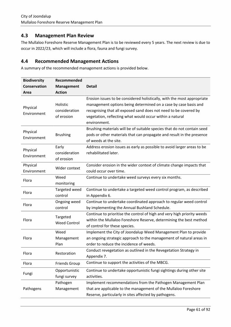
City of Joondalup
Mullaloo Foreshore Reserve Management Plan
Page 61 of 92
4.3 Management Plan Review The Mullaloo Foreshore Reserve Management Plan is to be reviewed every 5 years. The next review is due to
occur in 2022/23, which will include a flora, fauna and fungi survey.
4.4 Recommended Management Actions A summary of the recommended management actions is provided below.
Biodiversity
Conservation
Area
Recommended
Management
Action
Detail
Physical
Environment
Holistic
consideration
of erosion
Erosion issues to be considered holistically, with the most appropriate
management options being determined on a case by case basis and
recognising that all exposed sand does not need to be covered by
vegetation, reflecting what would occur within a natural
environment.
Physical
Environment Brushing
Brushing materials will be of suitable species that do not contain seed
pods or other materials that can propagate and result in the presence
of weeds at the site.
Physical
Environment
Early
consideration
of erosion
Address erosion issues as early as possible to avoid larger areas to be
rehabilitated later.
Physical
Environment Wider context
Consider erosion in the wider context of climate change impacts that
could occur over time.
Flora Weed
monitoring
Continue to undertake weed surveys every six months.
Flora Targeted weed
control
Continue to undertake a targeted weed control program, as described
in Appendix 6.
Flora Ongoing weed
control
Continue to undertake coordinated approach to regular weed control
by implementing the Annual Bushland Schedule.
Flora Targeted
Weed Control
Continue to prioritise the control of high and very high priority weeds
within the Mullaloo Foreshore Reserve, determining the best method
of control for these species.
Flora
Weed
Management
Plan
Implement the City of Joondalup Weed Management Plan to provide
an ongoing strategic approach to the management of natural areas in
order to reduce the incidence of weeds.
Flora Restoration Conduct revegetation as outlined in the Revegetation Strategy in
Appendix 7.
Flora Friends Group Continue to support the activities of the MBCG.
Fungi Opportunistic
fungi survey
Continue to undertake opportunistic fungi sightings during other site
activities.
Pathogens
Pathogen
Management
Implement recommendations from the Pathogen Management Plan
that are applicable to the management of the Mullaloo Foreshore
Reserve, particularly in sites affected by pathogens.
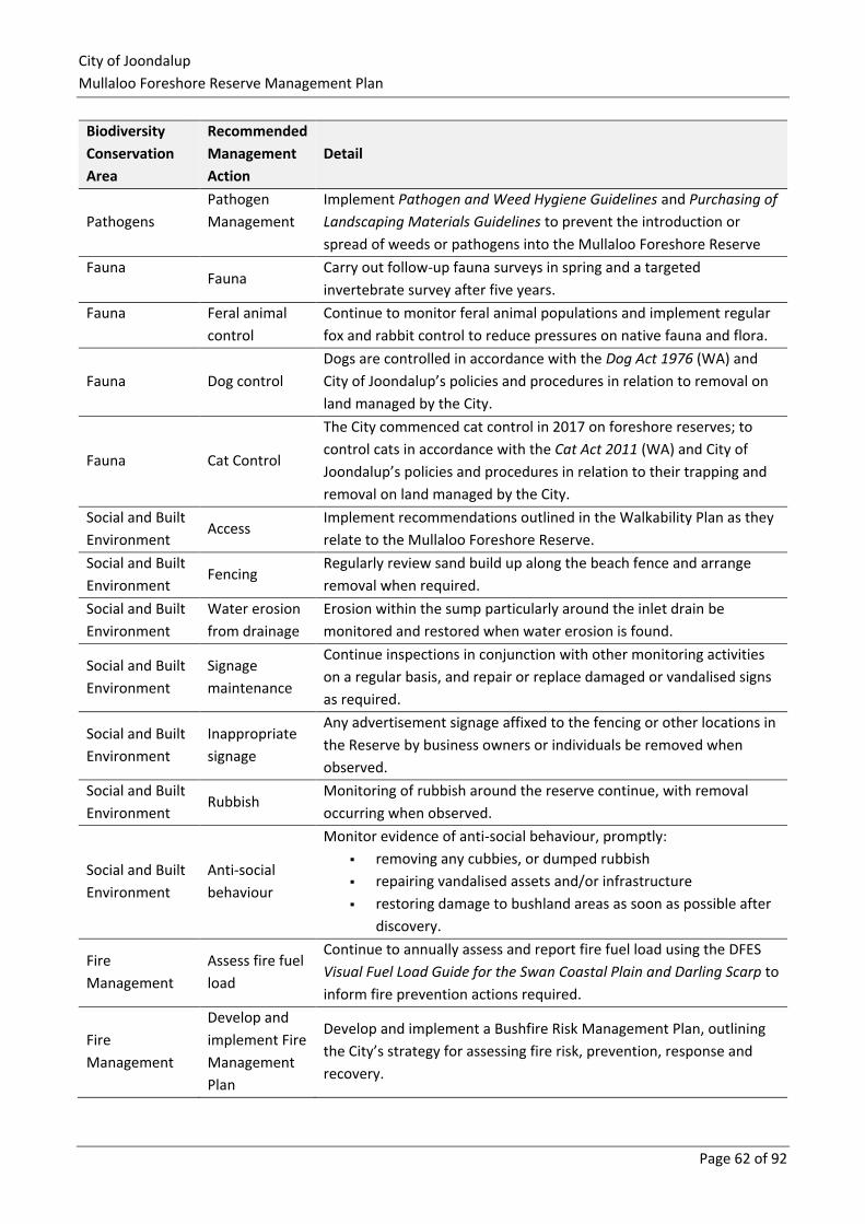
City of Joondalup
Mullaloo Foreshore Reserve Management Plan
Page 62 of 92
Biodiversity
Conservation
Area
Recommended
Management
Action
Detail
Pathogens
Pathogen
Management
Implement Pathogen and Weed Hygiene Guidelines and Purchasing of
Landscaping Materials Guidelines to prevent the introduction or
spread of weeds or pathogens into the Mullaloo Foreshore Reserve
Fauna Fauna
Carry out follow-up fauna surveys in spring and a targeted
invertebrate survey after five years.
Fauna Feral animal
control
Continue to monitor feral animal populations and implement regular
fox and rabbit control to reduce pressures on native fauna and flora.
Fauna Dog control
Dogs are controlled in accordance with the Dog Act 1976 (WA) and
City of Joondalup’s policies and procedures in relation to removal on
land managed by the City.
Fauna Cat Control
The City commenced cat control in 2017 on foreshore reserves; to
control cats in accordance with the Cat Act 2011 (WA) and City of
Joondalup’s policies and procedures in relation to their trapping and
removal on land managed by the City.
Social and Built
Environment Access
Implement recommendations outlined in the Walkability Plan as they
relate to the Mullaloo Foreshore Reserve.
Social and Built
Environment Fencing
Regularly review sand build up along the beach fence and arrange
removal when required.
Social and Built
Environment
Water erosion
from drainage
Erosion within the sump particularly around the inlet drain be
monitored and restored when water erosion is found.
Social and Built
Environment
Signage
maintenance
Continue inspections in conjunction with other monitoring activities
on a regular basis, and repair or replace damaged or vandalised signs
as required.
Social and Built
Environment
Inappropriate
signage
Any advertisement signage affixed to the fencing or other locations in
the Reserve by business owners or individuals be removed when
observed.
Social and Built
Environment Rubbish
Monitoring of rubbish around the reserve continue, with removal
occurring when observed.
Social and Built
Environment
Anti-social
behaviour
Monitor evidence of anti-social behaviour, promptly:
▪ removing any cubbies, or dumped rubbish
▪ repairing vandalised assets and/or infrastructure
▪ restoring damage to bushland areas as soon as possible after
discovery.
Fire
Management
Assess fire fuel
load
Continue to annually assess and report fire fuel load using the DFES
Visual Fuel Load Guide for the Swan Coastal Plain and Darling Scarp to
inform fire prevention actions required.
Fire
Management
Develop and
implement Fire
Management
Plan
Develop and implement a Bushfire Risk Management Plan, outlining
the City’s strategy for assessing fire risk, prevention, response and
recovery.
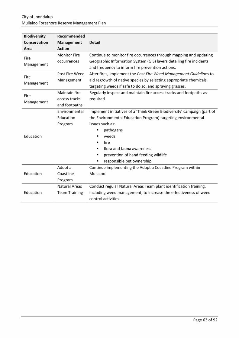
City of Joondalup
Mullaloo Foreshore Reserve Management Plan
Page 63 of 92
Biodiversity
Conservation
Area
Recommended
Management
Action
Detail
Fire
Management
Monitor Fire
occurrences
Continue to monitor fire occurrences through mapping and updating
Geographic Information System (GIS) layers detailing fire incidents
and frequency to inform fire prevention actions.
Fire
Management
Post Fire Weed
Management
After fires, implement the Post Fire Weed Management Guidelines to
aid regrowth of native species by selecting appropriate chemicals,
targeting weeds if safe to do so, and spraying grasses.
Fire
Management
Maintain fire
access tracks
and footpaths
Regularly inspect and maintain fire access tracks and footpaths as
required.
Education
Environmental
Education
Program
Implement initiatives of a ‘Think Green Biodiversity’ campaign (part of
the Environmental Education Program) targeting environmental
issues such as:
▪ pathogens
▪ weeds
▪ fire
▪ flora and fauna awareness
▪ prevention of hand feeding wildlife
▪ responsible pet ownership.
Education
Adopt a
Coastline
Program
Continue implementing the Adopt a Coastline Program within
Mullaloo.
Education
Natural Areas
Team Training
Conduct regular Natural Areas Team plant identification training,
including weed management, to increase the effectiveness of weed
control activities.
City of Joondalup
Mullaloo Foreshore Reserve Management Plan
Page 64 of 92
5.0 References
Arbor Carbon. (2015). Phase 2 Pathogen Sampling and Mapping Project – Final Report. Unpublished report
prepared for the City of Joondalup.
Australian Pesticides and Veterinary Medicines Authority. (2017). Agriculture and Veterinary Permits Search.
Retrieved May 2017 from: http://apvma.gov.au/search.
Australian Wildlife Conservancy. (2012/2013). Stopping the Slaughter: Fighting Back Against Feral Cats, in
Wildlife Matters, Summer 2012/2013, retrieved October 2017 from:
http://www.australianwildlife.org/media/27964/AWC-Wildlife-Matters-Summer-2012-2013.pdf.
Biosecurity and Agricultural Management Act 2007 (WA)
Bougher, N. (2009). Fungi of the Perth Region and Beyond: A Self-Managed Field Book. Perth. Western
Australia.
Brown, K., Brooks, B. (2002). Bushland Weeds. Greenwood, Western Australia: Environmental Weeds Action
Network (Inc.).
Bureau of Meteorology. (2017). Climate and Weather Statistics. Retrieved April 2017 from:
http://www.bom.gov.au/climate/data/.
Cat Act 2011 (WA)
City of Joondalup (CoJ). (2015). Access and Inclusion Plan 2015 – 2017. Retrieved October 2017 from
http://www.joondalup.wa.gov.au/Files/2015-2017%20Access%20and%20Inclusion%20Plan.pdf.
City of Joondalup (CoJ). (2014a). City of Joondalup Environment Plan 2014-2019. Retrieved June 2016 from:
http://www.joondalup.wa.gov.au/Files/8506%20Environment%20Plan%202014-2019%20Final%20WEB.pdf.
City of Joondalup (CoJ). (2014b). Climate Change Strategy 2014 – 2019. Retrieved May 2016 from:
http://www.joondalup.wa.gov.au/Files/Climate%20Change%20Strategy%202014-2019.pdf.
City of Joondalup (CoJ). (2015). City of Joondalup Purchasing Guidelines for the Supply of Landscaping
Materials – COJ BMM Guideline 4.0: Purchasing Materials. City of Joondalup, Western Australia.
City of Joondalup (CoJ). (2016a). Local Planning Scheme No. 2 – Updated to include AMD 84 GG 13/12/16.
Retrieved October 2017 from:
http://www.planning.wa.gov.au/LPS/DATA/Local%20Planning%20Schemes/Joondalup%20-
%20City%20of%20(Scheme%202)/index.aspx.
City of Joondalup
Mullaloo Foreshore Reserve Management Plan
Page 65 of 92
City of Joondalup (CoJ). (2012). Pathogen Management Plan. Retrieved October 2017 from:
http://www.joondalup.wa.gov.au/Files/7902%20COJ%20Pathogen%20Management%20Plan%202013-
2016%20V4%20Single%20Column%20Web%20Version.pdf.
City of Joondalup (CoJ). (2013). Walkability Plan 2013 – 2018. Retrieved October 2017 from:
http://www.joondalup.wa.gov.au/Files/8077%20Walkability%20Plan%201COLUMN%20V4.pdf.
City of Joondalup (CoJ). (2016b). Weed Management Plan 2016. Retrieved October 2017 from:
http://www.joondalup.wa.gov.au/Libraries/City_Policies/9463_Weed_Management_Plan_v4_2.pdf.
Climate Commission. (2011). The Critical Decade: Western Australian Climate Change Impacts. Retrieved
October 2017 from:
https://www.climatecouncil.org.au/uploads/e0d4e50478b96d1a50c821b7b2c022a4.pdf.
Conservation International. (2017). Hotspots. Retrieved April 2017 from:
http://www.conservation.org/How/Pages/Hotspots.aspx.
Department of Aboriginal Affairs. (2017). Aboriginal Heritage Inquiry System. Retrieved April 2017 from:
http://maps.dia.wa.gov.au/AHIS2/.
Department of Agriculture and Food, (2017a), Pest Insects – Portuguese millipedes (currently under review),
Retrieved April 2017 from: https://www.agric.wa.gov.au/pest-insects/portuguese-millipedes.
Department of Agriculture and Food WA. (2017b). Natural Resource Information – Soils and Contours.
Retrieved April 2017 from: https://maps.agric.wa.gov.au/nrm-info/.
Department of Parks and Wildlife. (2012). DPaW Weed Prioritisation Process – Swan Ranking Summary.
Retrieved October 2015 from:
http://www.dpaw.wa.gov.au/search?searchword=swan%20weed%20ranking%20summary&searchphrase=al
Department of Environment Regulation. (2016). Treatment and Management of Soil and Water in Acid
Sulfate Soil Landscapes. Department of the Environment, Western Australia.
Department of the Environment and Energy. (2016). Threatened Species Strategy. Retrieved May 2017 from:
https://www.environment.gov.au/biodiversity/threatened/publications/threatened-species-strategy
Department of the Environment and Energy. (2017). Weeds in Australia. Retrieved May 2017 from:
http://www.environment.gov.au/biodiversity/invasive/weeds/.
Department of Environment and Conservation. (undated). What are Acid Sulphate Soils? Retrieved June
2015 from: http://www.der.wa.gov.au/images/documents/your-environment/acid-sulfate-
soils/fact_sheets/ass_fact_sheets1.pdf.
City of Joondalup
Mullaloo Foreshore Reserve Management Plan
Page 66 of 92
Department of Fire and Emergency Services (DFES). (2015). Visual Fuel Load Guide for the Swan Coastal
Plain and Darling Scarp. Retrieved April 2017 from:
https://www.dfes.wa.gov.au/safetyinformation/fire/bushfire/VisualFuelLoadsPublications/Visual%20Fuel%2
0Load%20Guide%20Swan%20Coastal.pdf.
Department of Fire and Emergency Services (DFES). (2017a). The Department of Fire and Emergency Services
– Safety Information. Retrieved April 2017 from:
https://www.dfes.wa.gov.au/safetyinformation/Pages/default.aspx.
Department of Fire and Emergency Services (DFES). (2017b). Fire Callouts – Foreshore; at Mullaloo.
Unpublished report provided to Natural Area Consulting Management Services.
Department of Parks and Wildlife. (2016). Conservation Codes. Retrieved May 2016 from:
http://www.dpaw.wa.gov.au/images/documents/plants-animals/threatenedspecies/Listings /Conservation
_code_definitions_18092013.pdf.
Department of Planning, Heritage and Lands. (2017). Metropolitan Region Scheme. Retrieved October 2017
from: https://www.planning.wa.gov.au/1222.aspx.
Department of Water (DOW). (undated). Gnangara Groundwater System. Retrieved May 2015 from:
http://www.water.wa.gov.au/water-topics/groundwater/understanding-groundwater/gnangara-
groundwater-system.
Department of Water. (2017). Perth Groundwater Map. Retrieved April 2017 from:
https://maps.water.wa.gov.au/#/webmap/gwm.
Dog Act 1976 (WA)
Eco Logical Australia, (2016), Whitfords Nodes Foreshore Flora, Fauna and Fungi Survey, unpublished draft
report prepared by Eco Logical Australia for the City of Joondalup.
Environmental Defender’s Office WA (Inc.) (EDOWA). (2011). Bush Fires Fact Sheet No. 35. Perth, Western
Australia.
Environment Protection and Biodiversity Conservation Act 1999 (Cwlth)
Environmental Protection Authority (EPA) and Department of Environment and Conservation (DEC). 2010.
Technical Guide – Terrestrial Vertebrate Fauna Surveys for Environmental Impact Assessment (eds. B.M.
Hyder, J. Dell and M.A. Cowan). Perth, Western Australia.
Environmental Protection Authority. (2004a). Guidance for the Assessment of Environmental Factors.
Guidance Statement No. 56: Terrestrial Fauna Surveys for Environmental Impact Assessment in Western
Australia. Environmental Protection Authority, Perth Western Australia.
City of Joondalup
Mullaloo Foreshore Reserve Management Plan
Page 67 of 92
Environmental Protection Authority. (2004b). Guidance for the Assessment of Environmental Factors,
Guidance Statement 51: Terrestrial Flora and Vegetation Surveys for Environmental Impact Assessment in
Western Australia. Environmental Protection Authority, Perth Western Australia.
Environmental Protection Authority (EPA), (2015). Perth and Peel @ 3.5 Million Environmental impacts, risks
and remedies. Interim strategic advice of the Environmental Protection Authority to the Minister for
Environment under section 16 (e) of the Environmental Protection Act 1986.
Gibson N., Keighery B. J., Keighery G. J., Burbidge A. H. and Lyons M. N. (1994). A Floristic survey of the
southern Swan Coastal Plain. Unpublished report for the Australian Heritage Commission, prepared by the
Department of Conservation and Land Management and the Conservation Council of Western Australia
(Inc.).
Government of Western Australia. (2000). Bush Forever, Volume 2 – Directory of Bush Forever Sites. Perth
Western Australia: Department of Environmental Protection.
Groves R. H., Boden R. and Londsdale W.M. (2005) Jumping the Garden Fence: Invasive Garden Plants in
Australia and their Environmental and Agricultural Impacts. CSIRO report prepared for WWF-Australia.
Sydney, New South Wales.
Heddle, E.M., Loneragan, O.W. & Havel, J.J. (1980), Vegetation Complexes of the Darling System, Western
Australia, In: Atlas of Natural Resources, Darling System, Western Australia, Department of Conservation and
Environment, Perth, Western Australia.
Landgate. (2016). Map Viewer. Retrieved March 2016 from:
https://www.landgate.wa.gov.au/bmvf/app/mapviewer/.
Mitchell, Williams and Desmond, (2002), Swan Coastal Plain 2 (SWA2 – Swan Coastal Plain Subregion),
available World Wide Web URL:
http://www.dec.wa.gov.au/pdf/science/bio_audit/swan_coastal_plain02_p606-623.pdf, accessed October
2016.
M P Rogers and Associates P/L, (2016), Joondalup Coastal Hazard Assessment, unpublished report prepared
by M P Rogers and Associates for the City of Joondalup. Retrieved October 2017 from
http://www.joondalup.wa.gov.au/Files/Joondalup%20Coastal%20Hazard%20Assessment%202016.pdf.
National Wildlife Corridors Plan Advisory Group (NWCPAG), (2012), National Wildlife Corridors Plan,
Canberra, Australia.
Natural Area Consulting. (2013). Joondalup Coastal Foreshore, Natural Areas Management Plan.
Unpublished report prepared for the City of Joondalup.
Robinson, R., n.d. Forest Fungi: Lifestyles of the little-known. Department of Conservation and Land
Management. Manjimup, Western Australia.
City of Joondalup
Mullaloo Foreshore Reserve Management Plan
Page 68 of 92
Scott, P., Burgess, T., Barber, P., Shearer, B., Stukely, M., Hardy, G., and Jung, T. (2009). ‘Phytophthora
multivora sp. Nov., a New Species Recovered from Declining Eucalyptus, Banksia, Agonis and Other Plant
Species’. in Persoonia 22, 2009:1 – 13.
Smith, I., and Smith, D., (2003), Forest Fact Sheet – Armillaria Root Rot: A Disease of Native and Introduced
Trees, Forest Science Centre, Department of Sustainability and Environment, Victoria, available World Wide
Web URL: http://www.dse.vic.gov.au/__data/assets/pdf_file/0013/102145/Armillaria_Root_Rot.pdf,
accessed October 2013.
Western Australian Local Government Association (WALGA), (2010), Native vegetation extent by vegetation
complexes for each Local Government in Perth and Peel, Retrieved June 2016 from:
http://lbp.walga.asn.au/Publications.aspx.
Western Australian Local Government Association (WALGA), (2013), Native vegetation on the Swan Coastal
Plain. Retrieved June 2016 from: http://pbp.walga.asn.au/Home.aspx.
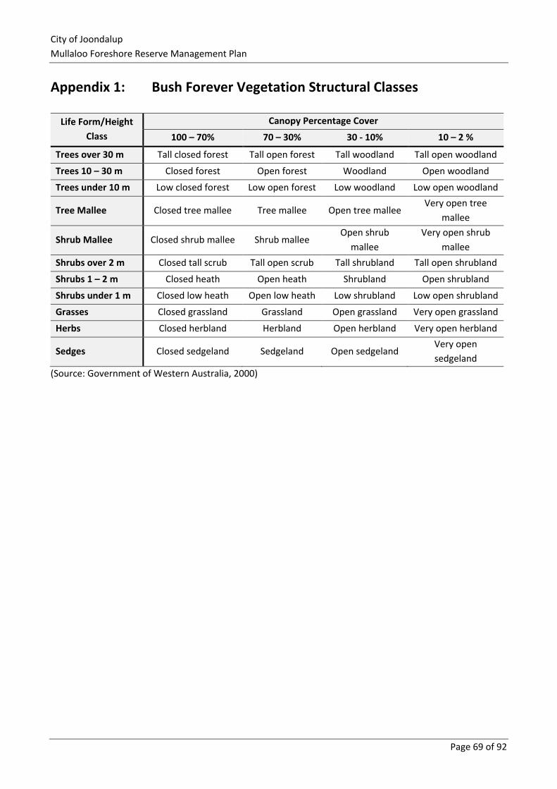
City of Joondalup
Mullaloo Foreshore Reserve Management Plan
Page 69 of 92
Appendix 1: Bush Forever Vegetation Structural Classes
Life Form/Height
Class
Canopy Percentage Cover
100 – 70% 70 – 30% 30 - 10% 10 – 2 %
Trees over 30 m Tall closed forest Tall open forest Tall woodland Tall open woodland
Trees 10 – 30 m Closed forest Open forest Woodland Open woodland
Trees under 10 m Low closed forest Low open forest Low woodland Low open woodland
Tree Mallee Closed tree mallee Tree mallee Open tree mallee Very open tree
mallee
Shrub Mallee Closed shrub mallee Shrub mallee Open shrub
mallee
Very open shrub
mallee
Shrubs over 2 m Closed tall scrub Tall open scrub Tall shrubland Tall open shrubland
Shrubs 1 – 2 m Closed heath Open heath Shrubland Open shrubland
Shrubs under 1 m Closed low heath Open low heath Low shrubland Low open shrubland
Grasses Closed grassland Grassland Open grassland Very open grassland
Herbs Closed herbland Herbland Open herbland Very open herbland
Sedges Closed sedgeland Sedgeland Open sedgeland Very open
sedgeland
(Source: Government of Western Australia, 2000)
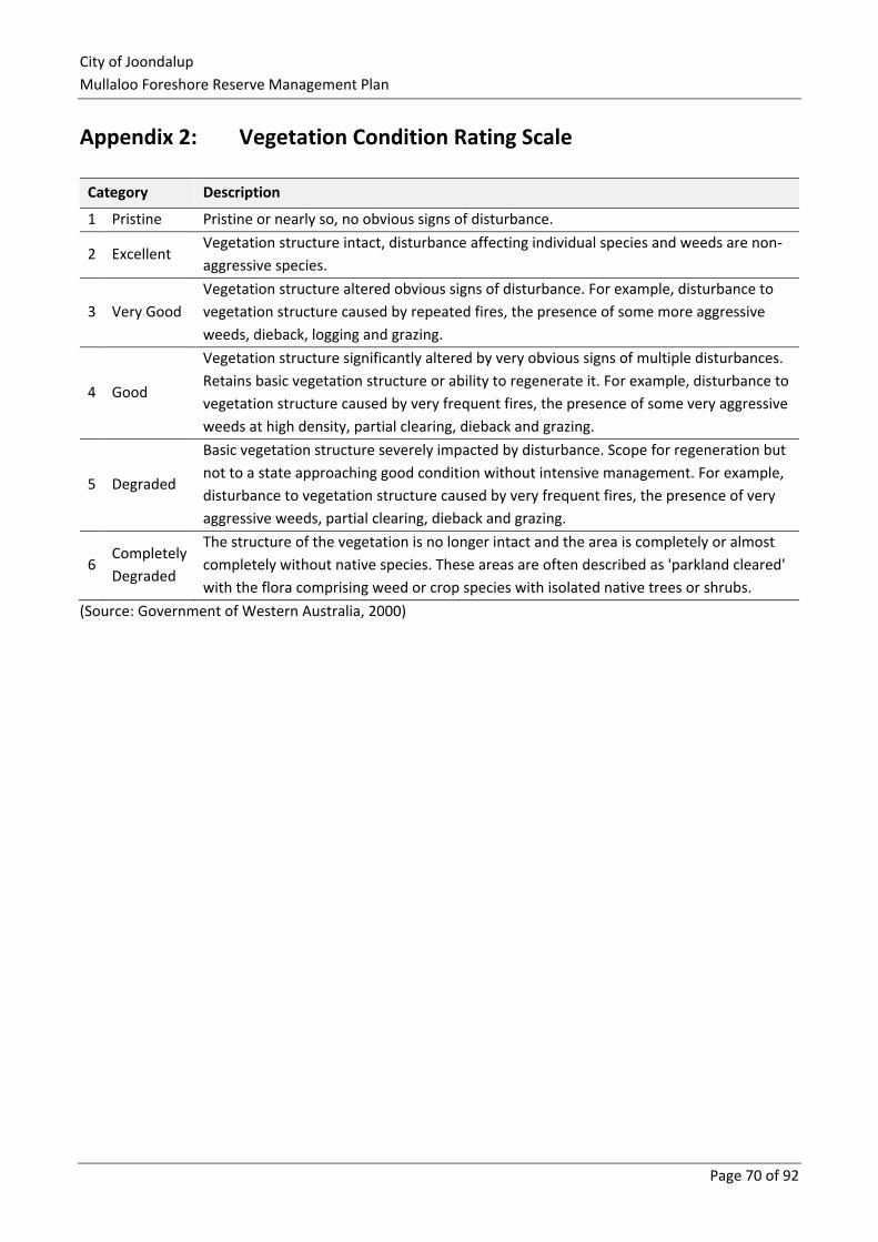
City of Joondalup
Mullaloo Foreshore Reserve Management Plan
Page 70 of 92
Appendix 2: Vegetation Condition Rating Scale
Category Description
1 Pristine Pristine or nearly so, no obvious signs of disturbance.
2 Excellent Vegetation structure intact, disturbance affecting individual species and weeds are non-
aggressive species.
3 Very Good
Vegetation structure altered obvious signs of disturbance. For example, disturbance to
vegetation structure caused by repeated fires, the presence of some more aggressive
weeds, dieback, logging and grazing.
4 Good
Vegetation structure significantly altered by very obvious signs of multiple disturbances.
Retains basic vegetation structure or ability to regenerate it. For example, disturbance to
vegetation structure caused by very frequent fires, the presence of some very aggressive
weeds at high density, partial clearing, dieback and grazing.
5 Degraded
Basic vegetation structure severely impacted by disturbance. Scope for regeneration but
not to a state approaching good condition without intensive management. For example,
disturbance to vegetation structure caused by very frequent fires, the presence of very
aggressive weeds, partial clearing, dieback and grazing.
6 Completely
Degraded
The structure of the vegetation is no longer intact and the area is completely or almost
completely without native species. These areas are often described as 'parkland cleared'
with the flora comprising weed or crop species with isolated native trees or shrubs.
(Source: Government of Western Australia, 2000)
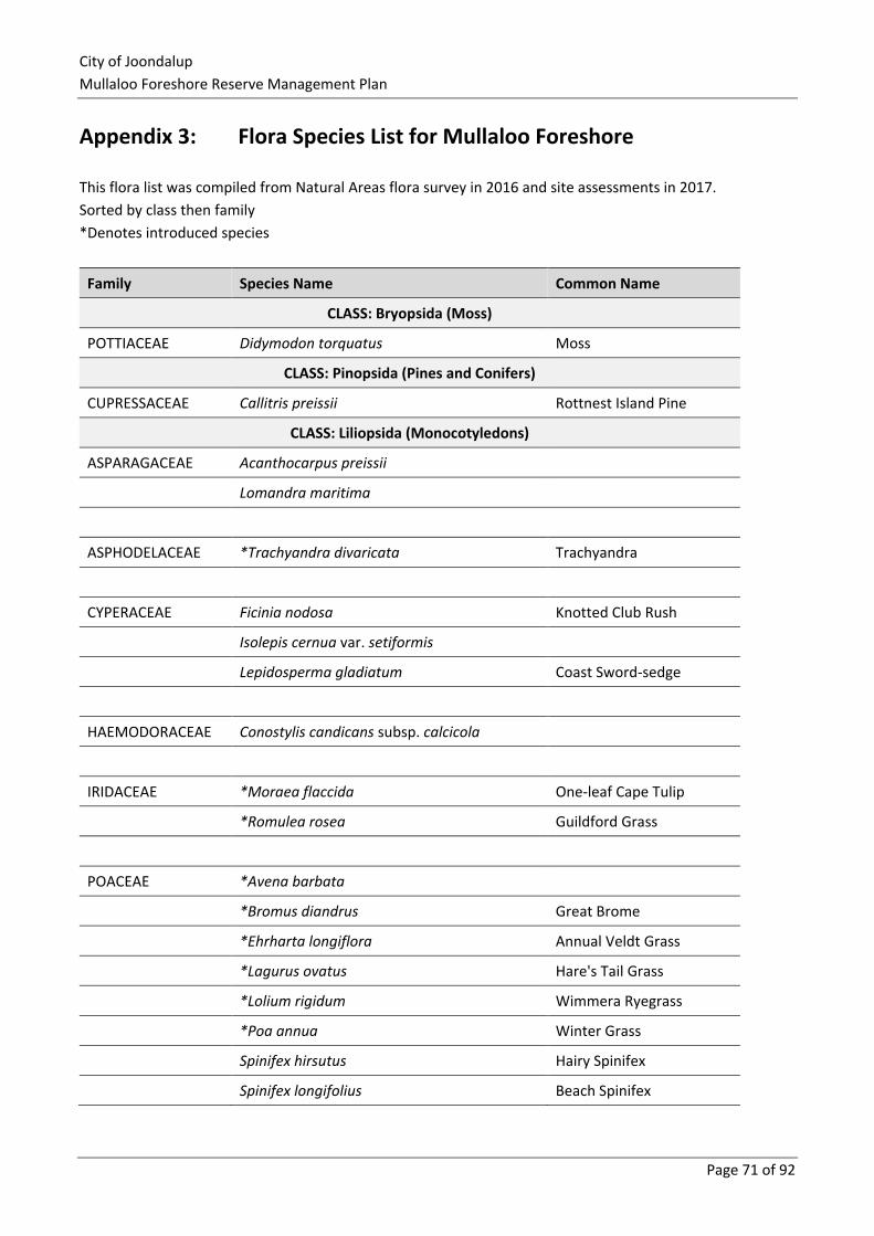
City of Joondalup
Mullaloo Foreshore Reserve Management Plan
Page 71 of 92
Appendix 3: Flora Species List for Mullaloo Foreshore
This flora list was compiled from Natural Areas flora survey in 2016 and site assessments in 2017.
Sorted by class then family
*Denotes introduced species
Family Species Name Common Name
CLASS: Bryopsida (Moss)
POTTIACEAE Didymodon torquatus Moss
CLASS: Pinopsida (Pines and Conifers)
CUPRESSACEAE Callitris preissii Rottnest Island Pine
CLASS: Liliopsida (Monocotyledons)
ASPARAGACEAE Acanthocarpus preissii
Lomandra maritima
ASPHODELACEAE *Trachyandra divaricata Trachyandra
CYPERACEAE Ficinia nodosa Knotted Club Rush
Isolepis cernua var. setiformis
Lepidosperma gladiatum Coast Sword-sedge
HAEMODORACEAE Conostylis candicans subsp. calcicola
IRIDACEAE *Moraea flaccida One-leaf Cape Tulip
*Romulea rosea Guildford Grass
POACEAE *Avena barbata
*Bromus diandrus Great Brome
*Ehrharta longiflora Annual Veldt Grass
*Lagurus ovatus Hare's Tail Grass
*Lolium rigidum Wimmera Ryegrass
*Poa annua Winter Grass
Spinifex hirsutus Hairy Spinifex
Spinifex longifolius Beach Spinifex
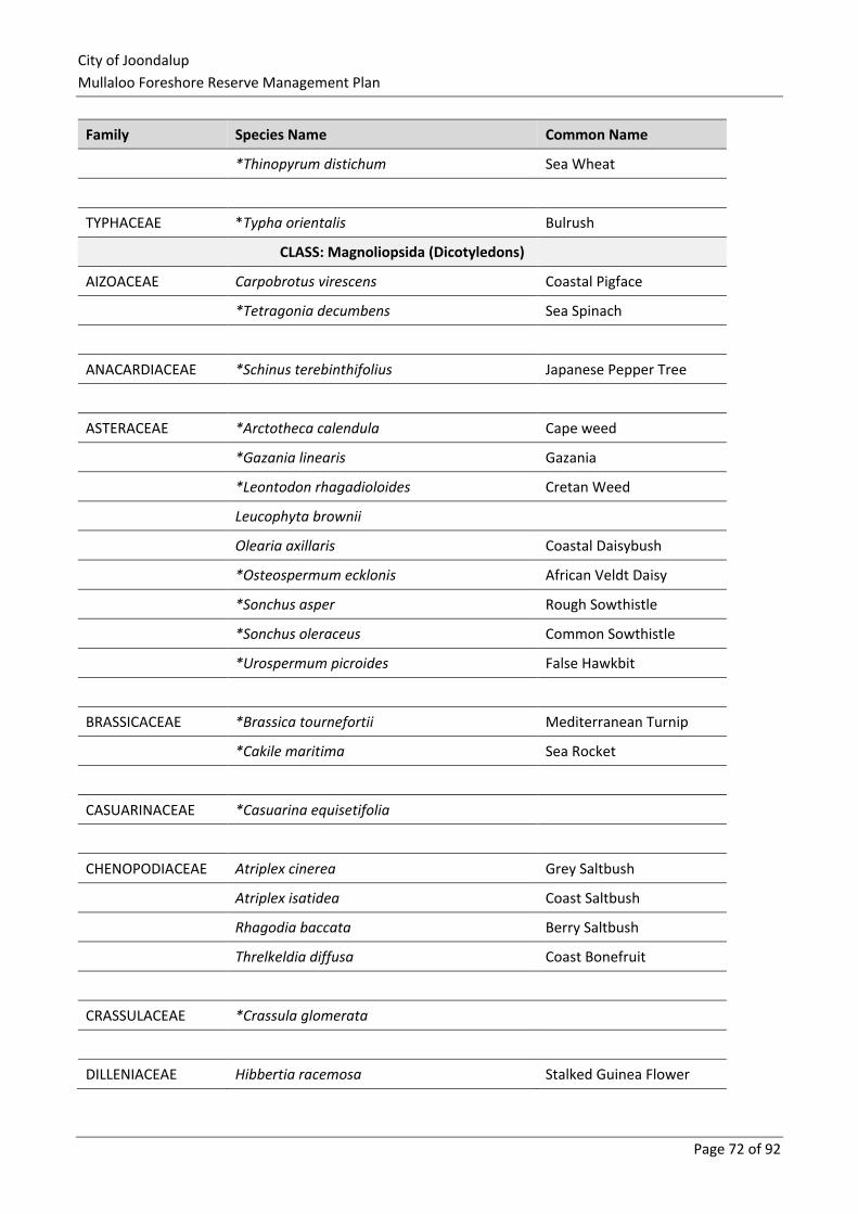
City of Joondalup
Mullaloo Foreshore Reserve Management Plan
Page 72 of 92
Family Species Name Common Name
*Thinopyrum distichum Sea Wheat
TYPHACEAE *Typha orientalis Bulrush
CLASS: Magnoliopsida (Dicotyledons)
AIZOACEAE Carpobrotus virescens Coastal Pigface
*Tetragonia decumbens Sea Spinach
ANACARDIACEAE *Schinus terebinthifolius Japanese Pepper Tree
ASTERACEAE *Arctotheca calendula Cape weed
*Gazania linearis Gazania
*Leontodon rhagadioloides Cretan Weed
Leucophyta brownii
Olearia axillaris Coastal Daisybush
*Osteospermum ecklonis African Veldt Daisy
*Sonchus asper Rough Sowthistle
*Sonchus oleraceus Common Sowthistle
*Urospermum picroides False Hawkbit
BRASSICACEAE *Brassica tournefortii Mediterranean Turnip
*Cakile maritima Sea Rocket
CASUARINACEAE *Casuarina equisetifolia
CHENOPODIACEAE Atriplex cinerea Grey Saltbush
Atriplex isatidea Coast Saltbush
Rhagodia baccata Berry Saltbush
Threlkeldia diffusa Coast Bonefruit
CRASSULACEAE *Crassula glomerata
DILLENIACEAE Hibbertia racemosa Stalked Guinea Flower
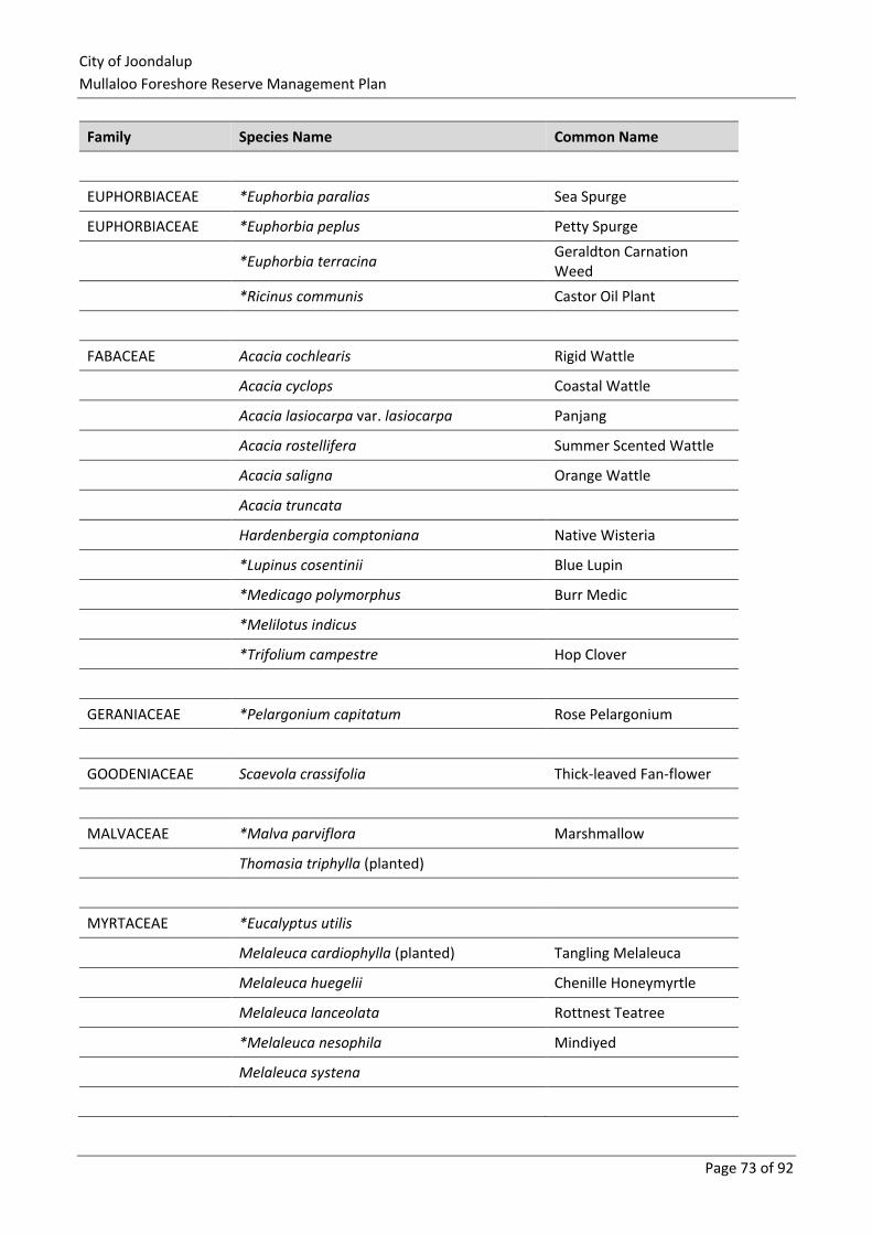
City of Joondalup
Mullaloo Foreshore Reserve Management Plan
Page 73 of 92
Family Species Name Common Name
EUPHORBIACEAE *Euphorbia paralias Sea Spurge
EUPHORBIACEAE *Euphorbia peplus Petty Spurge
*Euphorbia terracina Geraldton Carnation Weed
*Ricinus communis Castor Oil Plant
FABACEAE Acacia cochlearis Rigid Wattle
Acacia cyclops Coastal Wattle
Acacia lasiocarpa var. lasiocarpa Panjang
Acacia rostellifera Summer Scented Wattle
Acacia saligna Orange Wattle
Acacia truncata
Hardenbergia comptoniana Native Wisteria
*Lupinus cosentinii Blue Lupin
*Medicago polymorphus Burr Medic
*Melilotus indicus
*Trifolium campestre Hop Clover
GERANIACEAE *Pelargonium capitatum Rose Pelargonium
GOODENIACEAE Scaevola crassifolia Thick-leaved Fan-flower
MALVACEAE *Malva parviflora Marshmallow
Thomasia triphylla (planted)
MYRTACEAE *Eucalyptus utilis
Melaleuca cardiophylla (planted) Tangling Melaleuca
Melaleuca huegelii Chenille Honeymyrtle
Melaleuca lanceolata Rottnest Teatree
*Melaleuca nesophila Mindiyed
Melaleuca systena
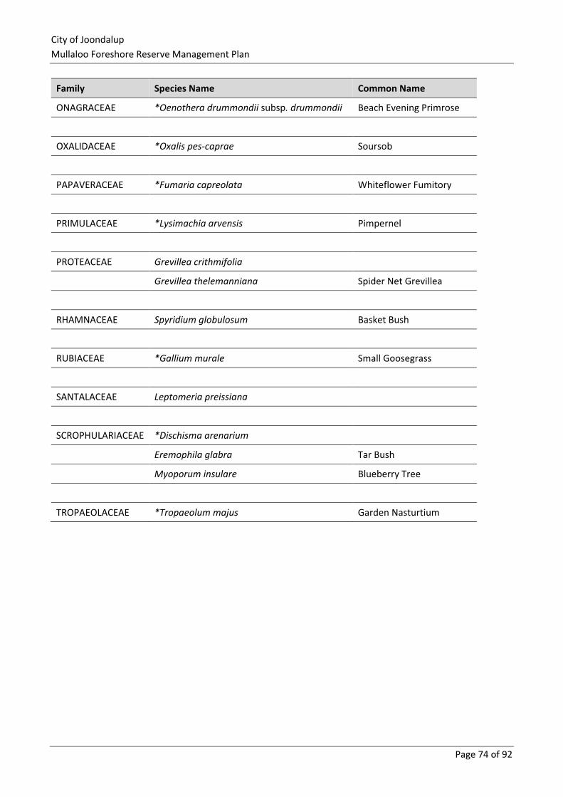
City of Joondalup
Mullaloo Foreshore Reserve Management Plan
Page 74 of 92
Family Species Name Common Name
ONAGRACEAE *Oenothera drummondii subsp. drummondii Beach Evening Primrose
OXALIDACEAE *Oxalis pes-caprae Soursob
PAPAVERACEAE *Fumaria capreolata Whiteflower Fumitory
PRIMULACEAE *Lysimachia arvensis Pimpernel
PROTEACEAE Grevillea crithmifolia
Grevillea thelemanniana Spider Net Grevillea
RHAMNACEAE Spyridium globulosum Basket Bush
RUBIACEAE *Gallium murale Small Goosegrass
SANTALACEAE Leptomeria preissiana
SCROPHULARIACEAE *Dischisma arenarium
Eremophila glabra Tar Bush
Myoporum insulare Blueberry Tree
TROPAEOLACEAE *Tropaeolum majus Garden Nasturtium
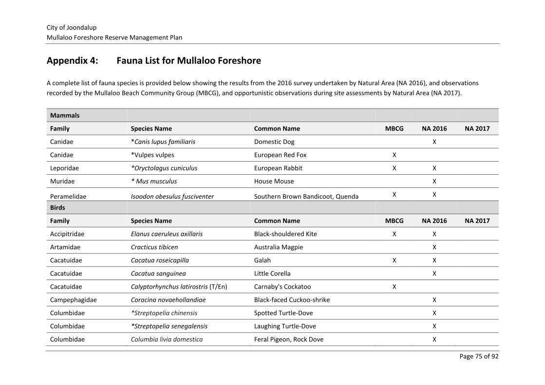
City of Joondalup
Mullaloo Foreshore Reserve Management Plan
Page 75 of 92
Appendix 4: Fauna List for Mullaloo Foreshore
A complete list of fauna species is provided below showing the results from the 2016 survey undertaken by Natural Area (NA 2016), and observations
recorded by the Mullaloo Beach Community Group (MBCG), and opportunistic observations during site assessments by Natural Area (NA 2017).
Mammals
Family Species Name Common Name MBCG NA 2016 NA 2017
Canidae *Canis lupus familiaris Domestic Dog X
Canidae *Vulpes vulpes European Red Fox X
Leporidae *Oryctolagus cuniculus European Rabbit X X
Muridae * Mus musculus House Mouse X
Peramelidae Isoodon obesulus fusciventer Southern Brown Bandicoot, Quenda X X
Birds
Family Species Name Common Name MBCG NA 2016 NA 2017
Accipitridae Elanus caeruleus axillaris Black-shouldered Kite X X
Artamidae Cracticus tibicen Australia Magpie X
Cacatuidae Cacatua roseicapilla Galah X X
Cacatuidae Cacatua sanguinea Little Corella X
Cacatuidae Calyptorhynchus latirostris (T/En) Carnaby's Cockatoo X
Campephagidae Coracina novaehollandiae Black-faced Cuckoo-shrike X
Columbidae *Streptopelia chinensis Spotted Turtle-Dove X
Columbidae *Streptopelia senegalensis Laughing Turtle-Dove X
Columbidae Columbia livia domestica Feral Pigeon, Rock Dove X
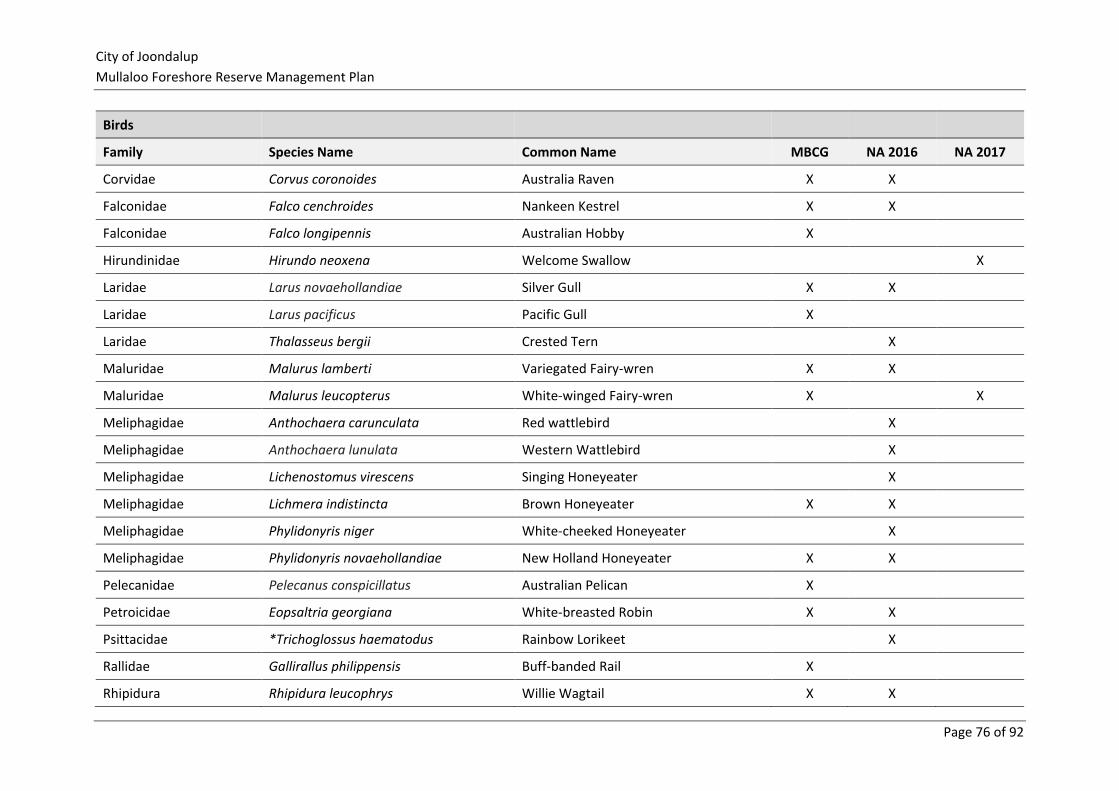
City of Joondalup
Mullaloo Foreshore Reserve Management Plan
Page 76 of 92
Birds
Family Species Name Common Name MBCG NA 2016 NA 2017
Corvidae Corvus coronoides Australia Raven X X
Falconidae Falco cenchroides Nankeen Kestrel X X
Falconidae Falco longipennis Australian Hobby X
Hirundinidae Hirundo neoxena Welcome Swallow X
Laridae Larus novaehollandiae Silver Gull X X
Laridae Larus pacificus Pacific Gull X
Laridae Thalasseus bergii Crested Tern X
Maluridae Malurus lamberti Variegated Fairy-wren X X
Maluridae Malurus leucopterus White-winged Fairy-wren X X
Meliphagidae Anthochaera carunculata Red wattlebird X
Meliphagidae Anthochaera lunulata Western Wattlebird X
Meliphagidae Lichenostomus virescens Singing Honeyeater X
Meliphagidae Lichmera indistincta Brown Honeyeater X X
Meliphagidae Phylidonyris niger White-cheeked Honeyeater X
Meliphagidae Phylidonyris novaehollandiae New Holland Honeyeater X X
Pelecanidae Pelecanus conspicillatus Australian Pelican X
Petroicidae Eopsaltria georgiana White-breasted Robin X X
Psittacidae *Trichoglossus haematodus Rainbow Lorikeet X
Rallidae Gallirallus philippensis Buff-banded Rail X
Rhipidura Rhipidura leucophrys Willie Wagtail X X
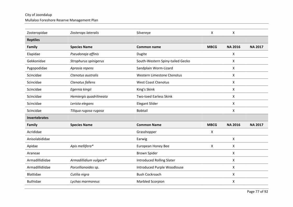
City of Joondalup
Mullaloo Foreshore Reserve Management Plan
Page 77 of 92
Zosteropidae Zosterops lateralis Silvereye X X
Reptiles
Family Species Name Common name MBCG NA 2016 NA 2017
Elapidae Pseudonaja affinis Dugite X
Gekkonidae Strophurus spinigerus South-Western Spiny-tailed Gecko X
Pygopodidae Aprasia repens Sandplain Worm-Lizard X
Scincidae Ctenotus australis Western Limestone Ctenotus X
Scincidae Ctenotus fallens West Coast Ctenotus X
Scincidae Egernia kingii King's Skink X
Scincidae Hemiergis quadrilineata Two-toed Earless Skink X
Scincidae Lerista elegans Elegant Slider X
Scincidae Tiliqua rugosa rugosa Bobtail X
Invertebrates
Family Species Name Common Name MBCG NA 2016 NA 2017
Acrididae Grasshopper X
Anisolabididae Earwig X
Apidae Apis mellifera* European Honey Bee X X
Araneae Brown Spider X
Armadillidiidae Armadillidium vulgare* Introduced Rolling Slater X
Armadillidiidae Porcellionoides sp. Introduced Purple Woodlouse X
Blattidae Cutilia nigra Bush Cockroach X
Buthidae Lychas marmoreus Marbled Scorpion X

City of Joondalup
Mullaloo Foreshore Reserve Management Plan
Page 78 of 92
Invertebrates
Family Species Name Common Name MBCG NA 2016 NA 2017
Carabidae Carab Beetle X
Chysomelidae Leaf Beetle X
Cicadidae Cicada X
Cossidae Goat Moth, Wood Moth X
Curculionidae Catasarcus sp. Weevil X X
Formicidae Camponotus minimus Ant X X
Formicidae Camponotus terebrans Ant X
Grillidae Field cricket X
Julidae Ommatioulus moreleti* Portuguese Millipede X X
Lepismatidae Ctenolepisma sp. Silverfish X
Lycosidae Lycosa sp. Wolf Spider X
Lymantiidae Tussock Moth X
Mutillidae Ephutomorpha sp. Velvet Ant X
Nymphalidae Vanessa kershawi Australian Painted Lady X
Pentatomidea Shield Bug X
Pyrgomorphidae Grasshopper X
Pieridae Pieris rapae Cabbage Butterfly X
Pisauridae Fishing Spider X
Pompilidae Spider wasp X
Reduviidae Assassin bug X
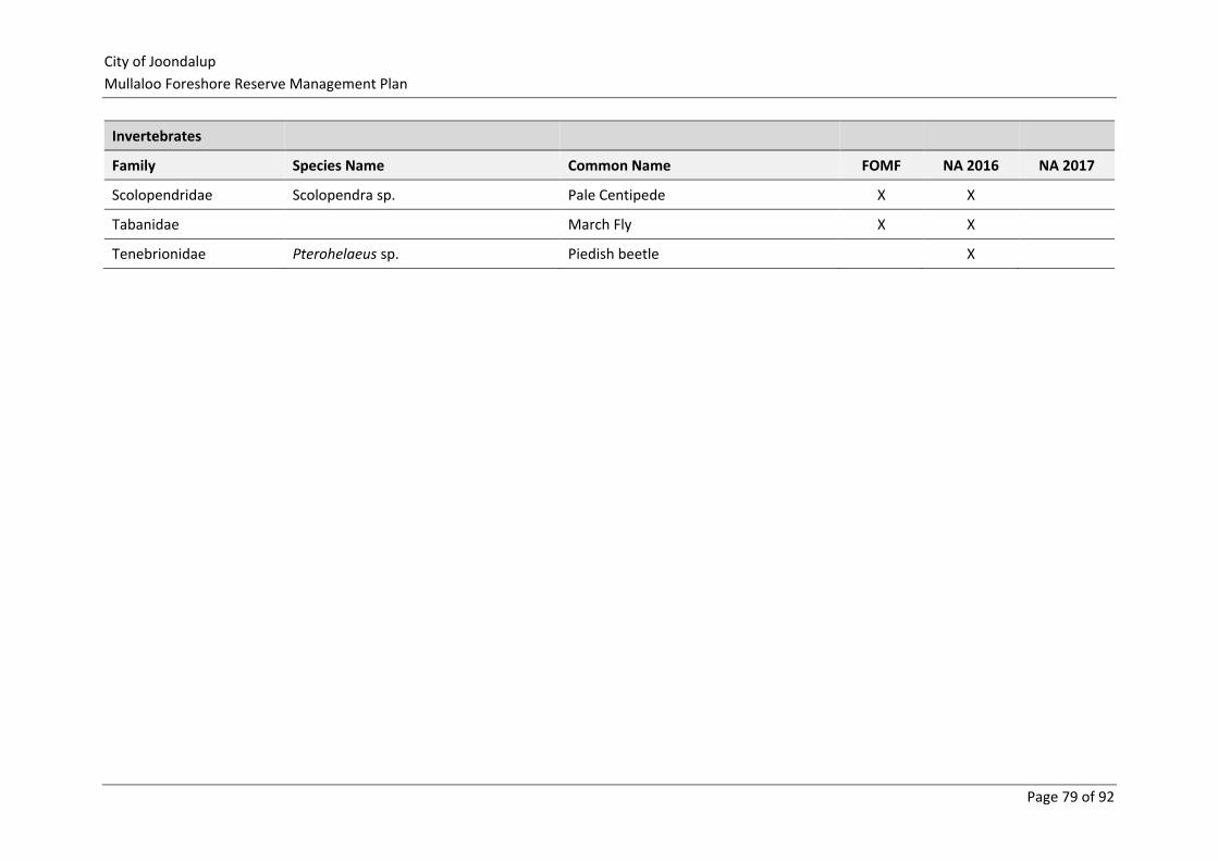
City of Joondalup
Mullaloo Foreshore Reserve Management Plan
Page 79 of 92
Invertebrates
Family Species Name Common Name FOMF NA 2016 NA 2017
Scolopendridae Scolopendra sp. Pale Centipede X X
Tabanidae March Fly X X
Tenebrionidae Pterohelaeus sp. Piedish beetle X
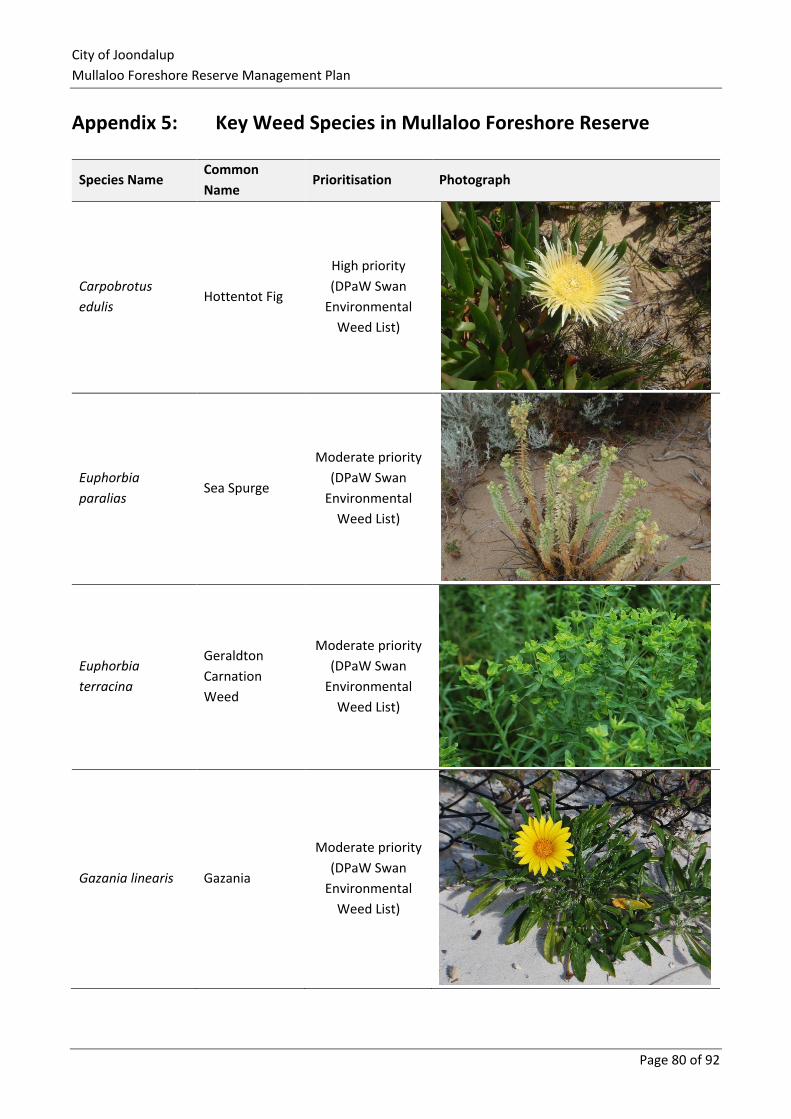
City of Joondalup
Mullaloo Foreshore Reserve Management Plan
Page 80 of 92
Appendix 5: Key Weed Species in Mullaloo Foreshore Reserve
Species Name Common
Name Prioritisation Photograph
Carpobrotus
edulis Hottentot Fig
High priority
(DPaW Swan
Environmental
Weed List)
Euphorbia
paralias Sea Spurge
Moderate priority
(DPaW Swan
Environmental
Weed List)
Euphorbia
terracina
Geraldton
Carnation
Weed
Moderate priority
(DPaW Swan
Environmental
Weed List)
Gazania linearis Gazania
Moderate priority
(DPaW Swan
Environmental
Weed List)
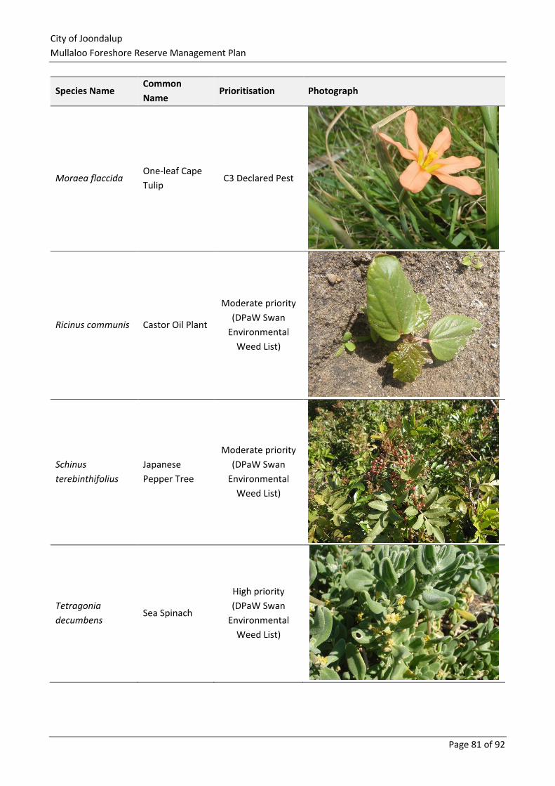
City of Joondalup
Mullaloo Foreshore Reserve Management Plan
Page 81 of 92
Species Name Common
Name Prioritisation Photograph
Moraea flaccida One-leaf Cape
Tulip C3 Declared Pest
Ricinus communis Castor Oil Plant
Moderate priority
(DPaW Swan
Environmental
Weed List)
Schinus
terebinthifolius
Japanese
Pepper Tree
Moderate priority
(DPaW Swan
Environmental
Weed List)
Tetragonia
decumbens Sea Spinach
High priority
(DPaW Swan
Environmental
Weed List)
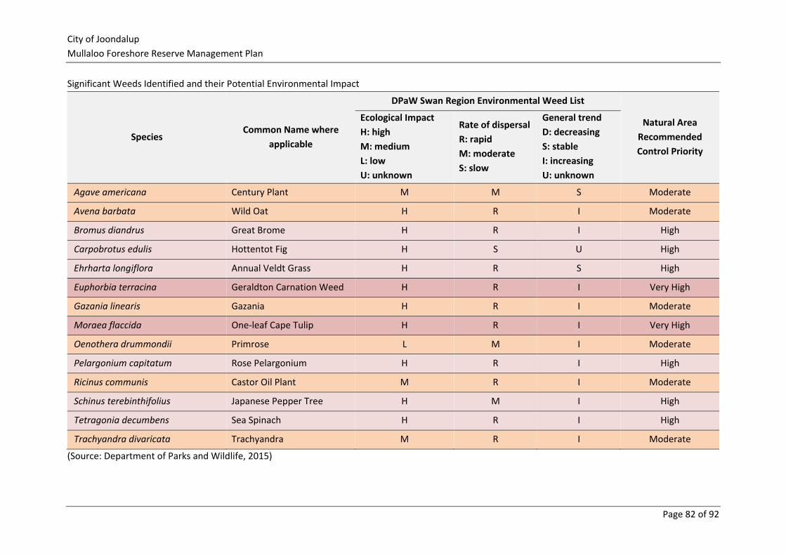
City of Joondalup
Mullaloo Foreshore Reserve Management Plan
Page 82 of 92
Significant Weeds Identified and their Potential Environmental Impact
Species Common Name where
applicable
DPaW Swan Region Environmental Weed List
Natural Area
Recommended
Control Priority
Ecological Impact
H: high
M: medium
L: low
U: unknown
Rate of dispersal
R: rapid
M: moderate
S: slow
General trend
D: decreasing
S: stable
I: increasing
U: unknown
Agave americana Century Plant M M S Moderate
Avena barbata Wild Oat H R I Moderate
Bromus diandrus Great Brome H R I High
Carpobrotus edulis Hottentot Fig H S U High
Ehrharta longiflora Annual Veldt Grass H R S High
Euphorbia terracina Geraldton Carnation Weed H R I Very High
Gazania linearis Gazania H R I Moderate
Moraea flaccida One-leaf Cape Tulip H R I Very High
Oenothera drummondii Primrose L M I Moderate
Pelargonium capitatum Rose Pelargonium H R I High
Ricinus communis Castor Oil Plant M R I Moderate
Schinus terebinthifolius Japanese Pepper Tree H M I High
Tetragonia decumbens Sea Spinach H R I High
Trachyandra divaricata Trachyandra M R I Moderate
(Source: Department of Parks and Wildlife, 2015)
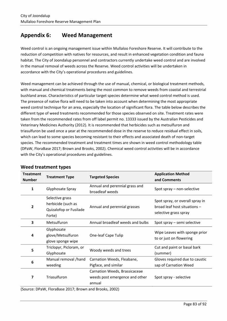
City of Joondalup
Mullaloo Foreshore Reserve Management Plan
Page 83 of 92
Appendix 6: Weed Management
Weed control is an ongoing management issue within Mullaloo Foreshore Reserve. It will contribute to the
reduction of competition with natives for resources, and result in enhanced vegetation condition and fauna
habitat. The City of Joondalup personnel and contractors currently undertake weed control and are involved
in the manual removal of weeds across the Reserve. Weed control activities will be undertaken in
accordance with the City’s operational procedures and guidelines.
Weed management can be achieved through the use of manual, chemical, or biological treatment methods,
with manual and chemical treatments being the most common to remove weeds from coastal and terrestrial
bushland areas. Characteristics of particular target species determine what weed control method is used.
The presence of native flora will need to be taken into account when determining the most appropriate
weed control technique for an area, especially the location of significant flora. The table below describes the
different type of weed treatments recommended for those species observed on site. Treatment rates were
taken from the recommended rates from off label permit no. 13333 issued by the Australian Pesticides and
Veterinary Medicines Authority (2012). It is recommended that herbicides such as metsulfuron and
triasulfuron be used once a year at the recommended dose in the reserve to reduce residual effect in soils,
which can lead to some species becoming resistant to their effects and associated death of non-target
species. The recommended treatment and treatment times are shown in weed control methodology table
(DPaW, FloraBase 2017; Brown and Brooks, 2002). Chemical weed control activities will be in accordance
with the City’s operational procedures and guidelines.
Weed treatment types Treatment
Number Treatment Type Targeted Species
Application Method
and Comments
1 Glyphosate Spray Annual and perennial grass and
broadleaf weeds Spot spray – non-selective
2
Selective grass
herbicide (such as
Quizalofop or Fusilade
Forte)
Annual and perennial grasses
Spot spray, or overall spray in
broad leaf host situations –
selective grass spray
3 Metsulfuron Annual broadleaf weeds and bulbs Spot spray – semi selective
4
Glyphosate
glove/Metsulfuron
glove sponge wipe
One-leaf Cape Tulip Wipe Leaves with sponge prior
to or just on flowering
5 Triclopyr, Picloram, or
Glyphosate Woody weeds and trees
Cut and paint or basal bark
(summer)
6 Manual removal /hand
weeding
Carnation Weeds, Fleabane,
Pigface, and similar
Gloves required due to caustic
sap of Carnation Weed
7 Triasulfuron
Carnation Weeds, Brassicaceae
weeds post emergence and other
annual
Spot spray - selective
(Source: DPaW, FloraBase 2017; Brown and Brooks, 2002)
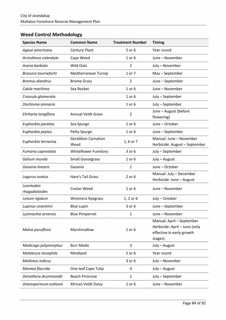
City of Joondalup
Mullaloo Foreshore Reserve Management Plan
Page 84 of 92
Weed Control Methodology
Species Name Common Name Treatment Number Timing
Agave americana Century Plant 5 or 6 Year round
Arctotheca calendula Cape Weed 1 or 6 June – November
Avena barbata Wild Oats 2 July – November
Brassica tournefortii Mediterranean Turnip 1 or 7 May – September
Bromus diandrus Brome Grass 2 June – September
Cakile maritima Sea Rocket 1 or 6 June – November
Crassula glomerata 1 or 6 July – September
Dischisma arenaria 1 or 6 July – September
Ehrharta longiflora Annual Veldt Grass 2 June – August (before
flowering)
Euphorbia paralias Sea Spurge 1 or 6 June – October
Euphorbia peplus Petty Spurge 1 or 6 June – September
Euphorbia terracina Geraldton Carnation
Weed 1, 6 or 7
Manual: June – November
Herbicide: August – September
Fumaria capreolata Whiteflower Fumitory 3 or 6 July – September
Galium murale Small Goosegrass 1 or 6 July – August
Gazania linearis Gazania 1 June – October
Lagurus ovatus Hare's Tail Grass 2 or 6 Manual: July – December
Herbicide: June – August
Leontodon
rhagadioloides Cretan Weed 1 or 6 June – November
Lolium rigidum Wimmera Ryegrass 1, 2 or 6 July – October
Lupinus cosentinii Blue Lupin 3 or 6 June – September
Lysimachia arvensis Blue Pimpernel 1 June – November
Malva parviflora Marshmallow 1 or 6
Manual: April – September
Herbicide: April – June (only
effective in early growth
stages)
Medicago polymorphus Burr Medic 3 July – August
Melaleuca nesophila Mindiyed 5 or 6 Year round
Melilotus indicus 3 or 6 July – November
Moraea flaccida One-leaf Cape Tulip 4 July – August
Oenothera drummondii Beach Primrose 1 July – September
Osteospermum ecklonis African Veldt Daisy 1 or 6 June – November
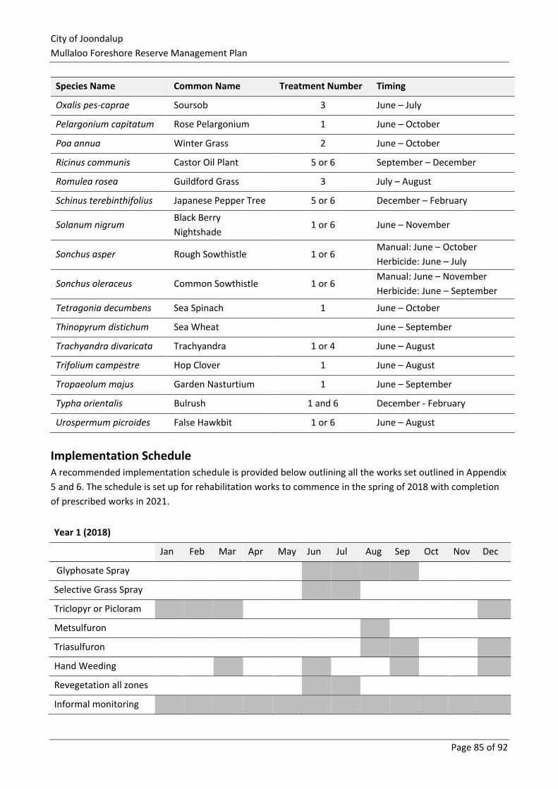
City of Joondalup
Mullaloo Foreshore Reserve Management Plan
Page 85 of 92
Species Name Common Name Treatment Number Timing
Oxalis pes-caprae Soursob 3 June – July
Pelargonium capitatum Rose Pelargonium 1 June – October
Poa annua Winter Grass 2 June – October
Ricinus communis Castor Oil Plant 5 or 6 September – December
Romulea rosea Guildford Grass 3 July – August
Schinus terebinthifolius Japanese Pepper Tree 5 or 6 December – February
Solanum nigrum Black Berry
Nightshade 1 or 6 June – November
Sonchus asper Rough Sowthistle 1 or 6 Manual: June – October
Herbicide: June – July
Sonchus oleraceus Common Sowthistle 1 or 6 Manual: June – November
Herbicide: June – September
Tetragonia decumbens Sea Spinach 1 June – October
Thinopyrum distichum Sea Wheat June – September
Trachyandra divaricata Trachyandra 1 or 4 June – August
Trifolium campestre Hop Clover 1 June – August
Tropaeolum majus Garden Nasturtium 1 June – September
Typha orientalis Bulrush 1 and 6 December - February
Urospermum picroides False Hawkbit 1 or 6 June – August
Implementation Schedule A recommended implementation schedule is provided below outlining all the works set outlined in Appendix
5 and 6. The schedule is set up for rehabilitation works to commence in the spring of 2018 with completion
of prescribed works in 2021.
Year 1 (2018)
Jan Feb Mar Apr May Jun Jul Aug Sep Oct Nov Dec
Glyphosate Spray
Selective Grass Spray
Triclopyr or Picloram
Metsulfuron
Triasulfuron
Hand Weeding
Revegetation all zones
Informal monitoring
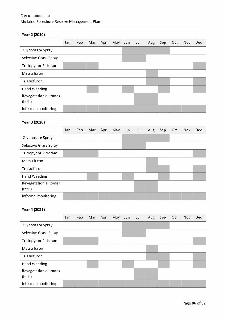
City of Joondalup
Mullaloo Foreshore Reserve Management Plan
Page 86 of 92
Year 2 (2019)
Jan Feb Mar Apr May Jun Jul Aug Sep Oct Nov Dec
Glyphosate Spray
Selective Grass Spray
Triclopyr or Picloram
Metsulfuron
Triasulfuron
Hand Weeding
Revegetation all zones
(Infill)
Informal monitoring
Year 3 (2020)
Jan Feb Mar Apr May Jun Jul Aug Sep Oct Nov Dec
Glyphosate Spray
Selective Grass Spray
Triclopyr or Picloram
Metsulfuron
Triasulfuron
Hand Weeding
Revegetation all zones
(Infill)
Informal monitoring
Year 4 (2021)
Jan Feb Mar Apr May Jun Jul Aug Sep Oct Nov Dec
Glyphosate Spray
Selective Grass Spray
Triclopyr or Picloram
Metsulfuron
Triasulfuron
Hand Weeding
Revegetation all zones
(Infill)
Informal monitoring
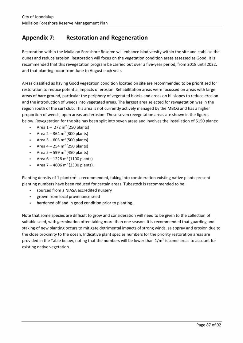
City of Joondalup
Mullaloo Foreshore Reserve Management Plan
Page 87 of 92
Appendix 7: Restoration and Regeneration
Restoration within the Mullaloo Foreshore Reserve will enhance biodiversity within the site and stabilise the
dunes and reduce erosion. Restoration will focus on the vegetation condition areas assessed as Good. It is
recommended that this revegetation program be carried out over a five-year period, from 2018 until 2022,
and that planting occur from June to August each year.
Areas classified as having Good vegetation condition located on site are recommended to be prioritised for
restoration to reduce potential impacts of erosion. Rehabilitation areas were focussed on areas with large
areas of bare ground, particular the periphery of vegetated blocks and areas on hillslopes to reduce erosion
and the introduction of weeds into vegetated areas. The largest area selected for revegetation was in the
region south of the surf club. This area is not currently actively managed by the MBCG and has a higher
proportion of weeds, open areas and erosion. These seven revegetation areas are shown in the figures
below. Revegetation for the site has been split into seven areas and involves the installation of 5150 plants:
▪ Area 1 – 272 m2 (250 plants)
▪ Area 2 – 364 m2 (300 plants)
▪ Area 3 – 603 m2 (500 plants)
▪ Area 4 – 254 m2 (250 plants)
▪ Area 5 – 599 m2 (450 plants)
▪ Area 6 – 1228 m2 (1100 plants)
▪ Area 7 – 4606 m2 (2300 plants).
Planting density of 1 plant/m2 is recommended, taking into consideration existing native plants present
planting numbers have been reduced for certain areas. Tubestock is recommended to be:
▪ sourced from a NIASA accredited nursery
▪ grown from local provenance seed
▪ hardened off and in good condition prior to planting.
Note that some species are difficult to grow and consideration will need to be given to the collection of
suitable seed, with germination often taking more than one season. It is recommended that guarding and
staking of new planting occurs to mitigate detrimental impacts of strong winds, salt spray and erosion due to
the close proximity to the ocean. Indicative plant species numbers for the priority restoration areas are
provided in the Table below, noting that the numbers will be lower than 1/m2 is some areas to account for
existing native vegetation.
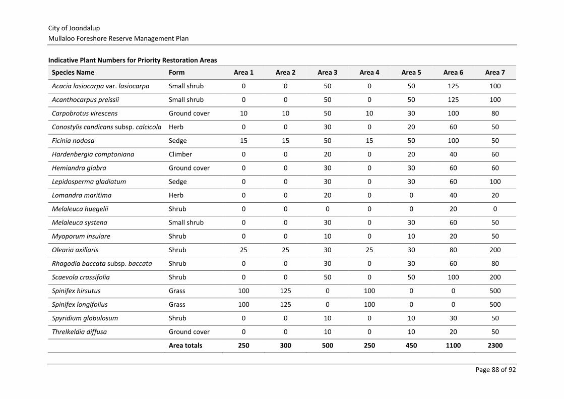
City of Joondalup
Mullaloo Foreshore Reserve Management Plan
Page 88 of 92
Indicative Plant Numbers for Priority Restoration Areas
Species Name Form Area 1 Area 2 Area 3 Area 4 Area 5 Area 6 Area 7
Acacia lasiocarpa var. lasiocarpa Small shrub 0 0 50 0 50 125 100
Acanthocarpus preissii Small shrub 0 0 50 0 50 125 100
Carpobrotus virescens Ground cover 10 10 50 10 30 100 80
Conostylis candicans subsp. calcicola Herb 0 0 30 0 20 60 50
Ficinia nodosa Sedge 15 15 50 15 50 100 50
Hardenbergia comptoniana Climber 0 0 20 0 20 40 60
Hemiandra glabra Ground cover 0 0 30 0 30 60 60
Lepidosperma gladiatum Sedge 0 0 30 0 30 60 100
Lomandra maritima Herb 0 0 20 0 0 40 20
Melaleuca huegelii Shrub 0 0 0 0 0 20 0
Melaleuca systena Small shrub 0 0 30 0 30 60 50
Myoporum insulare Shrub 0 0 10 0 10 20 50
Olearia axillaris Shrub 25 25 30 25 30 80 200
Rhagodia baccata subsp. baccata Shrub 0 0 30 0 30 60 80
Scaevola crassifolia Shrub 0 0 50 0 50 100 200
Spinifex hirsutus Grass 100 125 0 100 0 0 500
Spinifex longifolius Grass 100 125 0 100 0 0 500
Spyridium globulosum Shrub 0 0 10 0 10 30 50
Threlkeldia diffusa Ground cover 0 0 10 0 10 20 50
Area totals 250 300 500 250 450 1100 2300
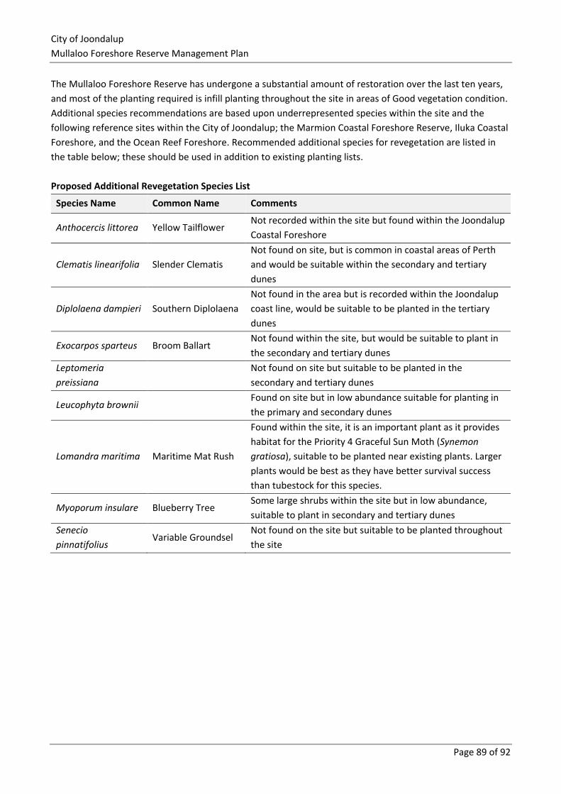
City of Joondalup
Mullaloo Foreshore Reserve Management Plan
Page 89 of 92
The Mullaloo Foreshore Reserve has undergone a substantial amount of restoration over the last ten years,
and most of the planting required is infill planting throughout the site in areas of Good vegetation condition.
Additional species recommendations are based upon underrepresented species within the site and the
following reference sites within the City of Joondalup; the Marmion Coastal Foreshore Reserve, Iluka Coastal
Foreshore, and the Ocean Reef Foreshore. Recommended additional species for revegetation are listed in
the table below; these should be used in addition to existing planting lists.
Proposed Additional Revegetation Species List
Species Name Common Name Comments
Anthocercis littorea Yellow Tailflower Not recorded within the site but found within the Joondalup
Coastal Foreshore
Clematis linearifolia Slender Clematis
Not found on site, but is common in coastal areas of Perth
and would be suitable within the secondary and tertiary
dunes
Diplolaena dampieri Southern Diplolaena
Not found in the area but is recorded within the Joondalup
coast line, would be suitable to be planted in the tertiary
dunes
Exocarpos sparteus Broom Ballart Not found within the site, but would be suitable to plant in
the secondary and tertiary dunes
Leptomeria
preissiana
Not found on site but suitable to be planted in the
secondary and tertiary dunes
Leucophyta brownii Found on site but in low abundance suitable for planting in
the primary and secondary dunes
Lomandra maritima Maritime Mat Rush
Found within the site, it is an important plant as it provides
habitat for the Priority 4 Graceful Sun Moth (Synemon
gratiosa), suitable to be planted near existing plants. Larger
plants would be best as they have better survival success
than tubestock for this species.
Myoporum insulare Blueberry Tree Some large shrubs within the site but in low abundance,
suitable to plant in secondary and tertiary dunes
Senecio
pinnatifolius Variable Groundsel
Not found on the site but suitable to be planted throughout
the site
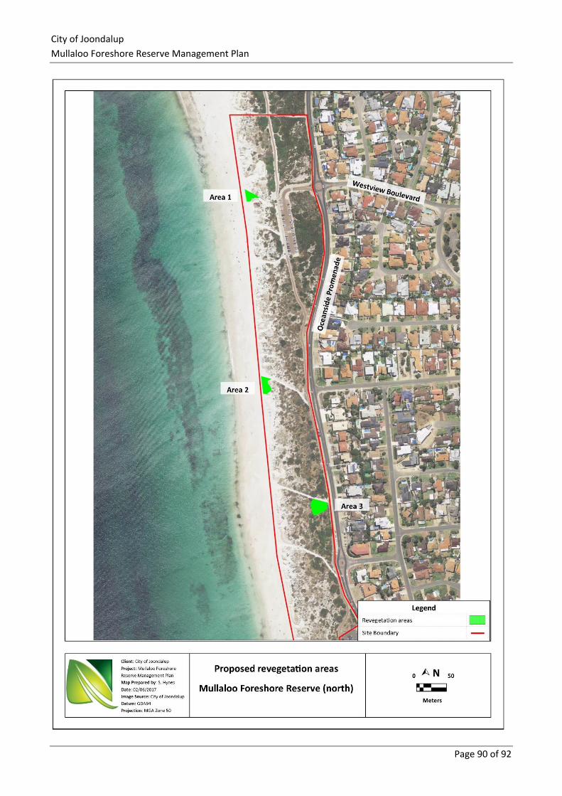
City of Joondalup
Mullaloo Foreshore Reserve Management Plan
Page 90 of 92
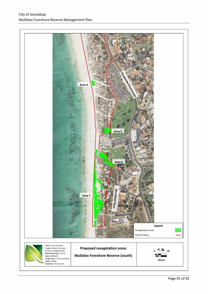
City of Joondalup
Mullaloo Foreshore Reserve Management Plan
Page 91 of 92
Related Documents