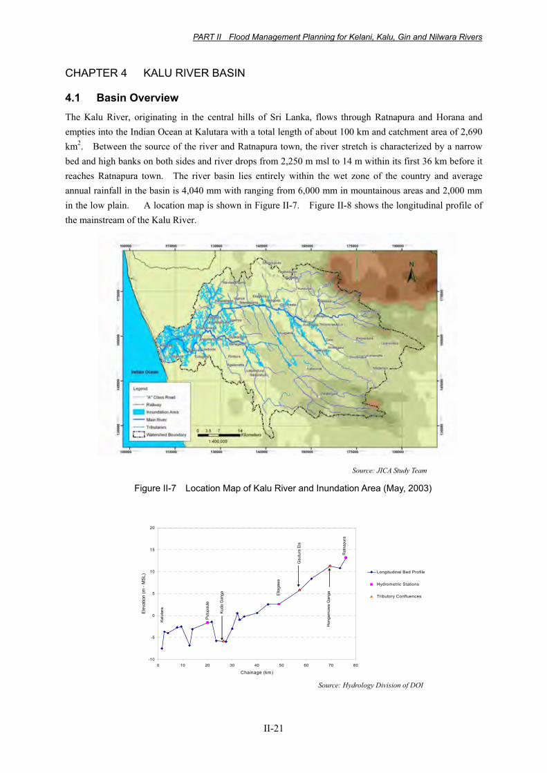
PART II Flood Management Planning for Kelani, Kalu, Gin and Nilwara Rivers II-21 CHAPTER 4 KALU RIVER BASIN 4.1 Basin Overview The Kalu River, originating in the central hills of Sri Lanka, flows through Ratnapura and Horana and empties into the Indian Ocean at Kalutara with a total length of about 100 km and catchment area of 2,690 km 2 . Between the source of the river and Ratnapura town, the river stretch is characterized by a narrow bed and high banks on both sides and river drops from 2,250 m msl to 14 m within its first 36 km before it reaches Ratnapura town. The river basin lies entirely within the wet zone of the country and average annual rainfall in the basin is 4,040 mm with ranging from 6,000 mm in mountainous areas and 2,000 mm in the low plain. A location map is shown in Figure II-7. Figure II-8 shows the longitudinal profile of the mainstream of the Kalu River. Source: JICA Study Team Figure II-7 Location Map of Kalu River and Inundation Area (May, 2003) -10 -5 0 5 10 15 20 0 10 20 30 40 50 60 70 80 Chainage (km) Elevation (m - MSL) Longitudinal Bed Profile Hydrometric Stations Tributory Confluences Ratnapura Hongamuwa Ganga Gautura Ela Putupaula Kalutara Kuda Ganga Ellagawa Source: Hydrology Division of DOI

Welcome message from author
This document is posted to help you gain knowledge. Please leave a comment to let me know what you think about it! Share it to your friends and learn new things together.
Transcript
PART II Flood Management Planning for Kelani, Kalu, Gin and Nilwara Rivers
II-21
CHAPTER 4 KALU RIVER BASIN
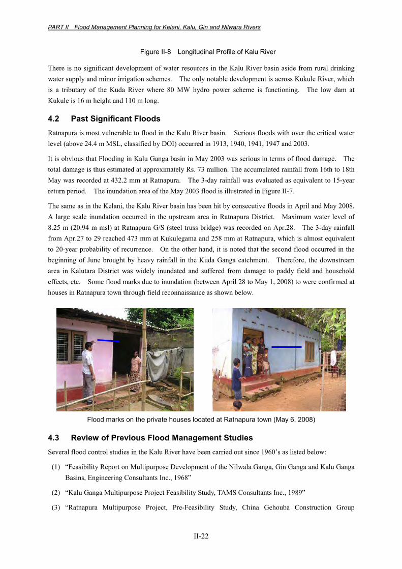
4.1 Basin Overview The Kalu River, originating in the central hills of Sri Lanka, flows through Ratnapura and Horana and empties into the Indian Ocean at Kalutara with a total length of about 100 km and catchment area of 2,690 km2. Between the source of the river and Ratnapura town, the river stretch is characterized by a narrow bed and high banks on both sides and river drops from 2,250 m msl to 14 m within its first 36 km before it reaches Ratnapura town. The river basin lies entirely within the wet zone of the country and average annual rainfall in the basin is 4,040 mm with ranging from 6,000 mm in mountainous areas and 2,000 mm in the low plain. A location map is shown in Figure II-7. Figure II-8 shows the longitudinal profile of the mainstream of the Kalu River.
Source: JICA Study Team
Figure II-7 Location Map of Kalu River and Inundation Area (May, 2003)
-10
-5
0
5
10
15
20
0 10 20 30 40 50 60 70 80
Chainage (km)
Ele
vatio
n (m
- M
SL)
Longitudinal Bed Profile
Hydrometric Stations
Tributory Confluences
Rat
napu
ra
Hon
gam
uwa
Gan
ga
Gau
tura
Ela
Put
upau
la
Kal
utar
a
Kuda
Gan
ga Ella
gaw
a
Source: Hydrology Division of DOI
PART II Flood Management Planning for Kelani, Kalu, Gin and Nilwara Rivers
II-22
Figure II-8 Longitudinal Profile of Kalu River
There is no significant development of water resources in the Kalu River basin aside from rural drinking water supply and minor irrigation schemes. The only notable development is across Kukule River, which is a tributary of the Kuda River where 80 MW hydro power scheme is functioning. The low dam at Kukule is 16 m height and 110 m long.
4.2 Past Significant Floods Ratnapura is most vulnerable to flood in the Kalu River basin. Serious floods with over the critical water level (above 24.4 m MSL, classified by DOI) occurred in 1913, 1940, 1941, 1947 and 2003.
It is obvious that Flooding in Kalu Ganga basin in May 2003 was serious in terms of flood damage. The total damage is thus estimated at approximately Rs. 73 million. The accumulated rainfall from 16th to 18th May was recorded at 432.2 mm at Ratnapura. The 3-day rainfall was evaluated as equivalent to 15-year return period. The inundation area of the May 2003 flood is illustrated in Figure II-7.
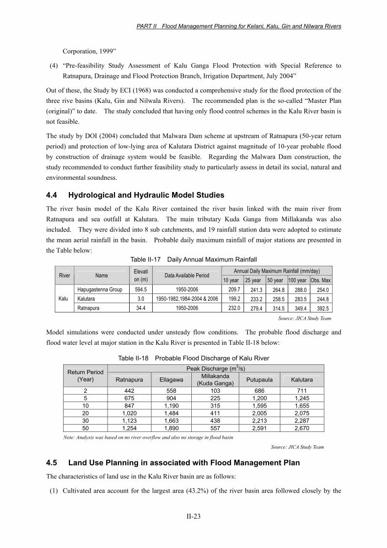
The same as in the Kelani, the Kalu River basin has been hit by consecutive floods in April and May 2008. A large scale inundation occurred in the upstream area in Ratnapura District. Maximum water level of 8.25 m (20.94 m msl) at Ratnapura G/S (steel truss bridge) was recorded on Apr.28. The 3-day rainfall from Apr.27 to 29 reached 473 mm at Kukulegama and 258 mm at Ratnapura, which is almost equivalent to 20-year probability of recurrence. On the other hand, it is noted that the second flood occurred in the beginning of June brought by heavy rainfall in the Kuda Ganga catchment. Therefore, the downstream area in Kalutara District was widely inundated and suffered from damage to paddy field and household effects, etc. Some flood marks due to inundation (between April 28 to May 1, 2008) to were confirmed at houses in Ratnapura town through field reconnaissance as shown below.
Flood marks on the private houses located at Ratnapura town (May 6, 2008)
4.3 Review of Previous Flood Management Studies Several flood control studies in the Kalu River have been carried out since 1960’s as listed below:
(1) “Feasibility Report on Multipurpose Development of the Nilwala Ganga, Gin Ganga and Kalu Ganga Basins, Engineering Consultants Inc., 1968”
(2) “Kalu Ganga Multipurpose Project Feasibility Study, TAMS Consultants Inc., 1989”
(3) “Ratnapura Multipurpose Project, Pre-Feasibility Study, China Gehouba Construction Group
PART II Flood Management Planning for Kelani, Kalu, Gin and Nilwara Rivers
II-23
Corporation, 1999”
(4) “Pre-feasibility Study Assessment of Kalu Ganga Flood Protection with Special Reference to Ratnapura, Drainage and Flood Protection Branch, Irrigation Department, July 2004”
Out of these, the Study by ECI (1968) was conducted a comprehensive study for the flood protection of the three rive basins (Kalu, Gin and Nilwala Rivers). The recommended plan is the so-called “Master Plan (original)” to date. The study concluded that having only flood control schemes in the Kalu River basin is not feasible.
The study by DOI (2004) concluded that Malwara Dam scheme at upstream of Ratnapura (50-year return period) and protection of low-lying area of Kalutara District against magnitude of 10-year probable flood by construction of drainage system would be feasible. Regarding the Malwara Dam construction, the study recommended to conduct further feasibility study to particularly assess in detail its social, natural and environmental soundness.
4.4 Hydrological and Hydraulic Model Studies The river basin model of the Kalu River contained the river basin linked with the main river from Ratnapura and sea outfall at Kalutara. The main tributary Kuda Ganga from Millakanda was also included. They were divided into 8 sub catchments, and 19 rainfall station data were adopted to estimate the mean aerial rainfall in the basin. Probable daily maximum rainfall of major stations are presented in the Table below:
Table II-17 Daily Annual Maximum Rainfall
Annual Daily Maximum Rainfall (mm/day) River Name
Elevation (m)
Data Available Period 10 year 25 year 50 year 100 year Obs. Max
Hapugastenna Group 594.5 1950-2006 209.7 241.3 264.8 288.0 254.0Kalutara 3.0 1950-1982,1984-2004 & 2006 199.2 233.2 258.5 283.5 244.8Kalu Ratnapura 34.4 1950-2006 232.0 279.4 314.5 349.4 392.5
Source: JICA Study Team
Model simulations were conducted under unsteady flow conditions. The probable flood discharge and flood water level at major station in the Kalu River is presented in Table II-18 below:
Table II-18 Probable Flood Discharge of Kalu River Peak Discharge (m3/s) Return Period
(Year) Ratnapura Ellagawa Millakanda (Kuda Ganga) Putupaula Kalutara
2 442 558 103 686 711 5 675 904 225 1,200 1,245 10 847 1,190 315 1,595 1,655 20 1,020 1,484 411 2,005 2,075 30 1,123 1,663 438 2,213 2,287 50 1,254 1,890 557 2,591 2,670
Note: Analysis was based on no river overflow and also no storage in flood basin
Source: JICA Study Team
4.5 Land Use Planning in associated with Flood Management Plan The characteristics of land use in the Kalu River basin are as follows:
(1) Cultivated area account for the largest area (43.2%) of the river basin area followed closely by the
PART II Flood Management Planning for Kelani, Kalu, Gin and Nilwara Rivers
II-24
chena area (38.9%) and homesteads/garden area (36.1%).
(2) The second largest utilization of the land is for crop field (33.6%), with rubber field accounting for the largest area (76.9%).
(3) Forest area occupies relatively large area (18.2%).
Kalutara is the city located at the river month of the Kalu River, its developed area is extended along the river. According to the Development Plan for Kalutara urban development area prepared by UDA, commercial zone, mixed residential zone, sacred zone and environmental sensitive zone have been incorporated in the Plan.
On the other hand, Ratnapura is the economic development center of the region (120,000 population). Currently Ratnapura New Urban Development Plan has been formulated and further development is presumed. Public and commercial areas are planned to be separated from the existing town center, which is frequently affected by the flooding. It should be noted that the river conservation area width is clearly demarcated along the Kalu River, which will be essential concept for flood management planning in this area.
4.6 Basic Concept for Flood Management Planning The planning scale as target to formulate Master Plan in the Kalu River was set at 30-year probability. Considering the required period of implementation of the proposed Master Plan, the target period was set for 15 years starting from 2010 and ending 2024.
Table II-19 Planning Scale of Kalu River Basin
Current Safety Level (Flow Capacity)
Experienced Max. Peak Flood
Future Land Use Planning Scale
Ratnapura: 2-year Kalutara: 10-year
Approx.30-year (May 2003 Flood)
Urbanization of Ratnapura and Kalutara will be proceeded. Among other area, industrial and residential development near Horana will be progressed as well.
30-year (2,300 m3/s at river mouth)
Source: Study Team
4.6.1 Key Issues for Formulation of Master Plan
(1) Current conditions of flood damages
• Habitual flooding at Ratnapura (inundation occurs by 2-year probable flood)
• Inundation at downstream area (no-flood bund in most of stretches) (by 10-year probable flood)
(2) Flooding at Ratnapura urban area
Ratnapura urban area is located at the confluence of the Kalu River and Wey Ganga. Since the flow capacity is insufficient, only 2-year probable flood (400 - 500 m3/s) causes inundation. Although Ratnapura area is habitual inundation area, no effective countermeasure against flooding has been undertaken.
PART II Flood Management Planning for Kelani, Kalu, Gin and Nilwara Rivers
II-25
(3) Development strategy of Malwala Dam
At approximately 3 km upstream from the confluence with the Wey Ganga, Malwala Dam site is proposed. The dam scheme has been originally proposed by the Three Basin Master Plan (by ECI, 1968) and then the Chinese group reviewed the dam scheme in 1999. After the devastating flood in May 2003, DOI updated their pre-feasibility study, and assessed whether the economic viability (EIRR) can be assured by harnessing of hydropower benefit as a multi-purpose dam development. However, due mainly to social environmental issues the scheme has not been realized (as well as those in other three river basins) despite the Government of Sri Lanka’s existing aspiration of implementation.
(4) Flood Bund at Kalutara Area
Being distinguished from the Gin and Nilwala River Basins, there is no flood bund or other protection structure at downstream area near Kalutara. Compared with the other river basins, installation of flood management structures has been delayed and the same level of flood protection is expected to be implemented. Further, as mentioned in Section 4.2, Kalutara area was heavily hit by overtopping of river banks in June 2008.
(5) Early warning and monitoring system (EWMS)
The Pilot Project of installation of automatic water level and rain gauges was conducted in association with community-based disaster management component of the current study together with those in the Kelani. It was verified and recognized through the Pilot Projects that the system could be effectively applied as one of non-structural measures in the Study area.
4.6.2 Basic Strategy
Basic strategy of flood management plan in the Kalu River was set up as follows:
(1) Target area: (i) Ratnapura area, (ii) Downstream non-flood bund stretches (Kalutara)
(2) Scale of countermeasures:
Short-term target Long-term target Ratnapura
1/10 (Qpeak=850 m3/s) 1/30 (Qpeak=1,130 m3/s)
Short-term target Long-term target Kalutara
1/10 (Qpeak=1,700 m3/s) 1/30 (Qpeak=2,300 m3/s)
(3) Basic strategy of flood protection:
To raise the flood protection level at downstream area
Since the Malwala dam scheme involves many issues to be solved, it is not considered as short-term measure. Thus, as a long-term measure, single purpose flood control dam is assumed and compared with other alternatives in the current Study. As for multi-purpose dam scheme, the pre-feasibility studies conducted in the past were referred to.
To prioritize the flood protection measures at Ratnapura and Kalutara
To protect agricultural area deployed at middle to lower reaches against inundation
PART II Flood Management Planning for Kelani, Kalu, Gin and Nilwara Rivers
II-26
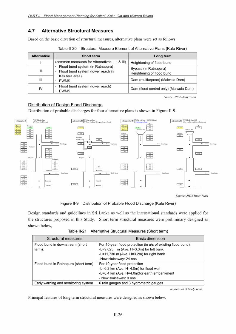
4.7 Alternative Structural Measures Based on the basic direction of structural measures, alternative plans were set as follows:
Table II-20 Structural Measure Element of Alternative Plans (Kalu River)
Alternative Short term Long term
I Heightening of flood bund
II Bypass (in Ratnapura) Heightening of flood bund
III
(common measures for Alternatives I, II & III)・ Flood bund system (in Ratnapura) ・ Flood bund system (lower reach in
Kalutara area) ・ EWMS Dam (multiurpose) (Malwala Dam)
IV ・ Flood bund system (lower reach) ・ EWMS
Dam (flood control only) (Malwala Dam)
Source: JICA Study Team
Distribution of Design Flood Discharge Distribution of probable discharges for four alternative plans is shown in Figure II-9.
W/O Malwala Dam W/O Malwala Dam W/ Malwala Dam (10, 30, 50 Years) W/ Malwala Dam (1/30)(W/ Flood Bund System) (W/Flood Bund and Ratnapura Bypass Canal) ( Multipurpose Dam) (Non-overflow condition at Ratnapura)
Inflow2-year Ratnapura 10-year 500 Inflow
10-year (329) (266) 30-Year 30-year (324) 650 30-year 64020-year 280 170 50-year 72030-year 500 350 50-year 590 460 650 Outflow Outflow
650 500 350 350 50720 580 450 500
500 520 580 500
450 300850
1,050 7001,150 160 950 5501,300 450 1,100
550 1,150 450 650650 650 750 750
Confluence610 110
1,300 4001,600 450 1,150 4001,800 500 500 1,600 5002,050 650 1,800 1,850 650 1,200 500
7201,7002,050 1,5502,300 2,1002,700 2,300 2,500 1,700
Malwala Dam Malwala Dam
Alternative IVAlternative I Alternative II Alterntative III
Kuda Ganga
Wey Ganga
Ratnapura
Dela
Ellagawa
Putupaula
Kalutara
Milakanda
Wey Ganga Wey Ganga
Kuda Ganga Kuda GangaKuda Ganga
Wey Ganga
RatnapuraBypass Canal
Dela
Ellagawa
Putupaula
Kalutara
Milakanda
350
850
Source: JICA Study Team
Figure II-9 Distribution of Probable Flood Discharge (Kalu River)
Design standards and guidelines in Sri Lanka as well as the international standards were applied for the structures proposed in this Study. Short term structural measures were preliminary designed as shown below,
Table II-21 Alternative Structural Measures (Short term)
Structural measures Basic dimension Flood bund in downstream (short term):
For 10-year flood protection (in u/s of existing flood bund) -L=9,625 m (Ave. H=3.3m) for left bank -L=11,730 m (Ave. H=3.2m) for right bank -New sluiceway: 24 nos.
Flood bund in Ratnapura (short term) For 10-year flood protection -L=6.2 km (Ave. H=4.0m) for flood wall -L=6.4 km (Ave. H=4.0m)for earth embankment - New sluiceway: 9 nos.
Early warning and monitoring system 6 rain gauges and 3 hydrometric gauges Source: JICA Study Team
Principal features of long term structural measures were designed as shown below.
PART II Flood Management Planning for Kelani, Kalu, Gin and Nilwara Rivers
II-27
Table II-22 Alternative Structural Measures (Long term) Structural measures Remark
Heightening of flood bund For 20-year flood protection (u/s of existing flood bund) -L=9,625 m for left bank, L=11,730 m for right bank
New pump house 13 nos. (Kalutara area) Bypass in Ratnapura Design discharge : 200 m3/s, L=9.0 km (between d/s of Malwala
dam site and d/s of Ratnapura) Dam (Malwala Dam) Malwala Dam (H=63.0 m, V=278.0 MCM) (ref. 2004 Pre-F/S)
Source: JICA Study Team
4.8 Promising Non-Structural Measures The same concept of the non-structural measures as introduced in the Kelani River basin was also applied in the Kalu River basin.
4.9 Construction Plan and Cost Estimation Implementation schedule of selected alternative is shown in Figure II-10
1 2 3 4 5 6 7 8 9 10 11 12 13 14 151 Short Term Measures
(1) Financial arrangement(2) New sluice(3) Ring levee (Ratnapura)(4) Flood bund (short term)
2 Long Term Measures(1) Financial arrangement(2) Flood bund (long term: heightening)(3) New pump house
3 Non Structure Measure(1) Early warning monitoring system
Legend: Financial Arrangement Design Construction
(Kalu River: Alternative I, Flood bund system + Heightening of flood bund)Short Term Long Term
2.56.5
Source: JICA Study Team
Figure II-10 Implementation Schedule of Alternatives in Kalu River (Alternative I selected as the Master Plan after evaluation)
The project costs of the alternative cases are summarized below:
Table II-23 Project Costs of Alternatives in Kalu River (unit: US$, thousand)
Alternative I
Alternative II
Alternative III
Alternative IV
Item Flood bund system + Heightening of
flood bund
Flood bund system + Bypass (in Ratnapura) +
Heightening of flood bund
Flood bund system + Dam
(multipurpose) (Malwala Dam)
Flood bund system + Dam (Flood
control) (Malwala Dam)
I. Construction cost short term measures 45,559 43,319 43,319 9,945 long-term short term measures 25,316 59,082 114,813 105,101
II. Land acquisition cost 24,397 24,740 45,568 26,835III. Engineering service cost 10,631 15,360 23,720 17,257IV. Administrative expenses 2,118 2,850 4,548 3,183V. Price escalation 68,955 116,577 306,521 266,189VI. Physical contingencies 10,802 14,535 23,197 16,232VII. Tax and duty 12,226 17,664 27,278 19,845
Grand Total 200,000 294,100 589,000 464,600Source: JICA Study Team
PART II Flood Management Planning for Kelani, Kalu, Gin and Nilwara Rivers
II-28
Operation and maintenance costs for alternatives are presented below.
Table II-24 Annual O&M Costs (Kalu River) (unit: US$, thousand)
O&M costs Alternative I Alternative II Alternative III Alternative IV Total 1,035 1,351 1,908 1,477
4.10 Project Benefit The items and conditions of estimate for project benefit are the same as those for Kelani river basin. The project benefit for each alternative plan was estimated as shown below.
Table II-25 Annual Average Benefit of Alternative Plans (Unit: Million Rs./year)
Alternatives Short term Long term Alternative I Flood bund system 1,223.5 1,584.4Alternative II Flood bund system + Bypass 1,399.3 1,961.5Alternative III Dam (multipurpose) 1,399.3 2,857.7Alternative IV Dam (flood control only) 1,016.8 2,743.6
Source: JICA Study Team
The results of economic evaluation of alternatives in the Kalu River basin are summarized in the Table below for all alternatives:
Table II-26 Results of Economic Analysis of All Alternative Plans
OverallShort
(PriorityProject)
Overall Short Overall Short Overall Short
B-C (Rs. mil.) 7,438 7,617 -1,399 1,484 -663 2,065 2,783 4,227B/C 2.24 2.89 0.88 1.21 0.95 1.32 1.32 3.08
EIRR (%) 20.7% 23.5% 8.8% 11.8% 9.5% 12.7% 13.4% 24.4%*1Note: *1, Only flood bund scheme in Kalutara area is included (excluding protection of Ratnapura area).
Index
Alterntive I Alternative II Alternative IIIFlood bund Flood Bund + Bypass Dam (Multipurpose) Dam (Flood control))
Alternative IV
Source: JICA Study Team
4.11 Environmental and Social Consideration The major negative impacts that may occur in relevance to the implementation of the structural measures studied for the Kalu River Basin, and proposed mitigation measures are indicated in the following.
(1) New sluice (Magnitude of Impact: Minor)
The construction of new sluices may have temporary impact to the water quality of the river by through increased turbulence, etc. Though the number of sluices may reach up to as much as 33, the impact is expected to be minor, taking into regard the scale of construction works, and that these sites will not be concentrated in certain locations. The surrounding environment including the position of near by housings should be taken into regard when deciding the location of the new sluices. Moreover, consensus should be built among relevant stakeholders on the location of the facilities.
(2) Ring levee (Ratnapura) (Magnitude of Impact: Moderate)
Due to the high density of economic / residential facilities in the central area of Ratnapura Municipality, the construction of the ring levee is expected to lead to the occurrence of involuntary resettlement particularly for those located along the river. In order to minimize such negative impact, the location of the ring levee shall be carefully examined, taking into view the installation of concrete walls instead of embankments. A
PART II Flood Management Planning for Kelani, Kalu, Gin and Nilwara Rivers
II-29
resettlement action plan with not only measures for land compensation, but also with clear measures to compensate for factors such as livelihood and economic activities must be prepared and implemented to mitigate the impact for those which resettlement is inevitable. For the areas beside central Ratnapura, the position of near by housings should be taken into regard when deciding the location, and countermeasures such as installation of access routes and staircases shall be taken to secure access to riverine resources.
(3) Flood bund (short term) (Magnitude of Impact: Moderate)
There is considerable possibility of involuntary resettlement occurring due to the extension of flood bunds. The magnitude of resettlement is expected to be limited due to the low density of housings along the river. However, detailed surveys for clarifying the number and location of residents should be conducted at the design stage, in order to examine the linear of the bund with minimum resettlement, as well as identifying necessary compensation for those of which resettlement is inevitable. Furthermore, extended flood bunds may obstruct access of local residents to riverine resources. This should be mitigated by taking countermeasures such as installation of access routes and staircases.
(4) Flood bund (long term) (Magnitude of Impact: Minor)
Heightening of flood bunds in the long term plans may obstruct access of local residents to riverine resources. However, the impact may be reduced to a minor level by taking countermeasures such as installation of access routes and staircases.
(5) New pump house (Magnitude of Impact: Minor)
Construction works of new pump houses may lead to temporary impact to water quality of the river through turbulence, etc. However, the impact is expected to be minor, taking into regard of the scale of construction works and that the location of the pump houses will not be dense. In order to minimize the necessity of land acquisition, the pump houses should be located within the river section as much as possible.
(6) Dam and reservoir (Malwala) (Magnitude of Impact: Significant)
The reservoir of Malwala dam, which is planed in the upper streams of Kalu River is expected to be 4km wide (East-West) and 8km long (North-South). Due to the formulation of the reservoir, many communities will be submerged, which is expected to lead to the occurrence of involuntary resettlement for hundreds of households. Furthermore, the farmlands formulated in the bottom of the valleys, together with the gem mining sites in the river beds will vanish. The partial submerging of a B class national road crossing the area will spread its impact to other districts as well as the adjacent areas of the dam site.
Furthermore, other factors that are expected to receive negative impact include; cultural / religious heritage, hydrology, flora/fauna and bio-diversity, landscape, and other factors relevant to construction work, and the overall negative impact of dam construction is expected to be significant. In order to minimize the impact of the dam and reservoir, a resettlement action plan with not only measures for land compensation, but also with clear measures to compensate for factors such as livelihood and economic activities must be prepared and implemented. Such action plan should be prepared based on detailed socio-economic surveys, disclosure of information / participation of local residents. Moreover, consensus on the resettlement action plan must be built with the local residents from the stage of preparation.
(7) Ratnapura bypass canal (Magnitude of Impact: Moderate)
Since Ratnapura bypass canal is planned to mainly go through agricultural lands, direct impact by
PART II Flood Management Planning for Kelani, Kalu, Gin and Nilwara Rivers
II-30
resettlement is expected to be limited. On the other hand, impact on local economic activities through the acquisition of farmland is expected, and necessary compensation should be examined. Though the area has been conventionally developed as agricultural land, the area is expected to be relatively rich in flora ad fauna. In this regard, detailed examination of the impact on flora/fauna and bio-diversity should be made when implementing the plan.
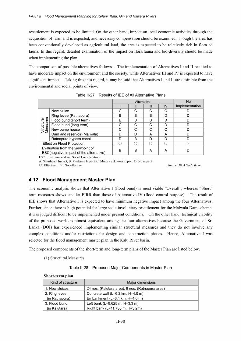
The comparison of possible alternatives follows. The implementation of Alternatives I and II resulted to have moderate impact on the environment and the society, while Alternatives III and IV is expected to have significant impact. Taking this into regard, it may be said that Alternatives I and II are desirable from the environmental and social points of view.
Table II-27 Results of IEE of All Alternative Plans Alternative
I II III IV No
ImplementationNew sluice C C C C D Ring levee (Ratnapura) B B B D D Flood bund (short term) B B B B D Flood bund (long term) C C C D D New pump house C C C C D Dam and reservoir (Malwala) D D A A D
Stru
ctur
al
Mea
sure
s
Ratnapura bypass canal D B D D D Effect on Flood Protection ○ ○ ○ ○ × Evaluation from the viewpoint of ESC(negative impact of the alternative) B B A A D
ESC: Environmental and Social Considerations A: Significant Impact, B: Moderate Impact, C: Minor / unknown impact, D: No impact ○: Effective, ×: Not effective Source: JICA Study Team
4.12 Flood Management Master Plan The economic analysis shows that Alternative I (flood bund) is most viable “Overall”, whereas “Short” term measures shows smaller EIRR than those of Alternative IV (flood control purpose). The result of IEE shows that Alternative I is expected to have minimum negative impact among the four Alternatives. Further, since there is high potential for large scale involuntary resettlement for the Malwala Dam scheme, it was judged difficult to be implemented under present conditions. On the other hand, technical viability of the proposed works is almost equivalent among the four alternatives because the Government of Sri Lanka (DOI) has experienced implementing similar structural measures and they do not involve any complex conditions and/or restrictions for design and construction phases. Hence, Alternative I was selected for the flood management master plan in the Kalu River basin.
The proposed components of the short-term and long-term plans of the Master Plan are listed below.
(1) Structural Measures
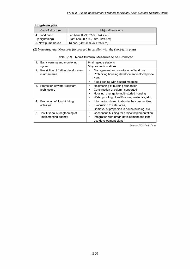
Table II-28 Proposed Major Components in Master Plan
Short-term plan Kind of structure Major dimensions
1. New sluices 24 nos. (Kalutara area), 9 nos. (Ratnapura area) 2. Ring levee (in Ratnapura)
Concrete wall (L=6.2 km, H=4.0 m) Embankment (L=6.4 km, H=4.0 m)
3. Flood bund (in Kalutara)
Left bank (L=9,625 m, H=3.3 m) Right bank (L=11,730 m, H=3.2m)
PART II Flood Management Planning for Kelani, Kalu, Gin and Nilwara Rivers
II-31
Long-term plan Kind of structure Major dimensions
4. Flood bund (heightening)
Left bank (L=9,625m, H=4.7 m) Right bank (L=11,730m, H=4.4m)
5. New pump house 13 nos. (Q=3.0 m3/s, H=5.0 m)
(2) Non-structural Measures (to proceed in parallel with the short-term plan)
Table II-29 Non-Structural Measures to be Promoted 1. Early warning and monitoring
system 6 rain gauge stations 3 hydrometric stations
2. Restriction of further development in urban area
・ Management and monitoring of land use ・ Prohibiting housing development in flood prone
area ・ Flood zoning with hazard mapping,
3. Promotion of water-resistant architecture
・ Heightening of building foundation ・ Construction of column-supported ・ Housing, change to multi-storied housing ・ Water proofing of wall/housing materials, etc.
4. Promotion of flood fighting activities
・ Information dissemination in the communities, ・ Evacuation to safer area, ・ Removal of properties in house/building, etc.
5. Institutional strengthening of implementing agency
・ Consensus building for project implementation ・ Integration with urban development and land
use development plans Source: JICA Study Team
PART II Flood Management Planning for Kelani, Kalu, Gin and Nilwara Rivers
II-32
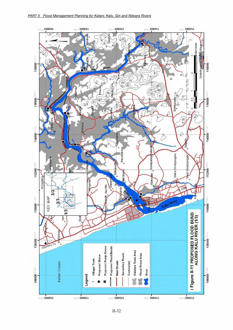
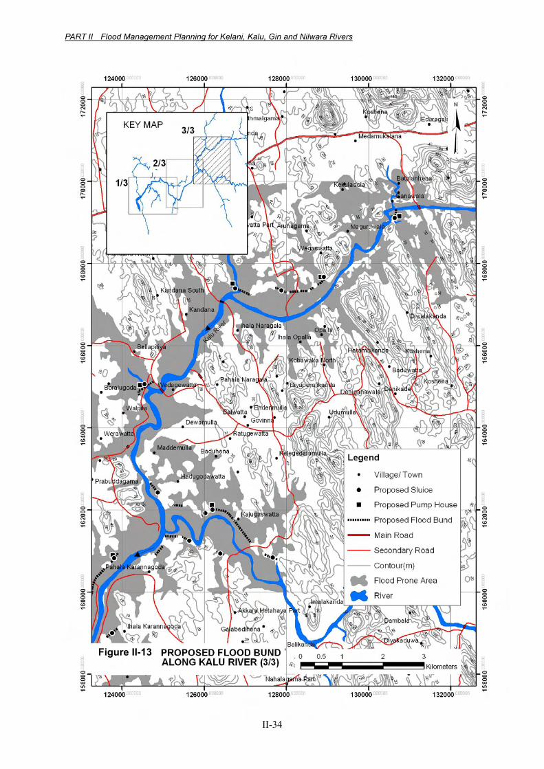
Figure II-11 Proposed Flood Bund Along Kalu River (1/3)
Figu
re II
-11
PART II Flood Management Planning for Kelani, Kalu, Gin and Nilwara Rivers
II-33
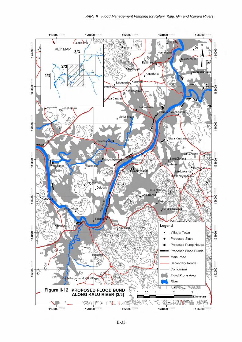
Figure II-12 Proposed Flood Bund Along Kalu River (2/3)
Figure II-12
PART II Flood Management Planning for Kelani, Kalu, Gin and Nilwara Rivers
II-34
Figure II-13 Proposed Flood Bund Along Kalu River (3/3)
Figure II-13
PART II Flood Management Planning for Kelani, Kalu, Gin and Nilwara Rivers
II-35
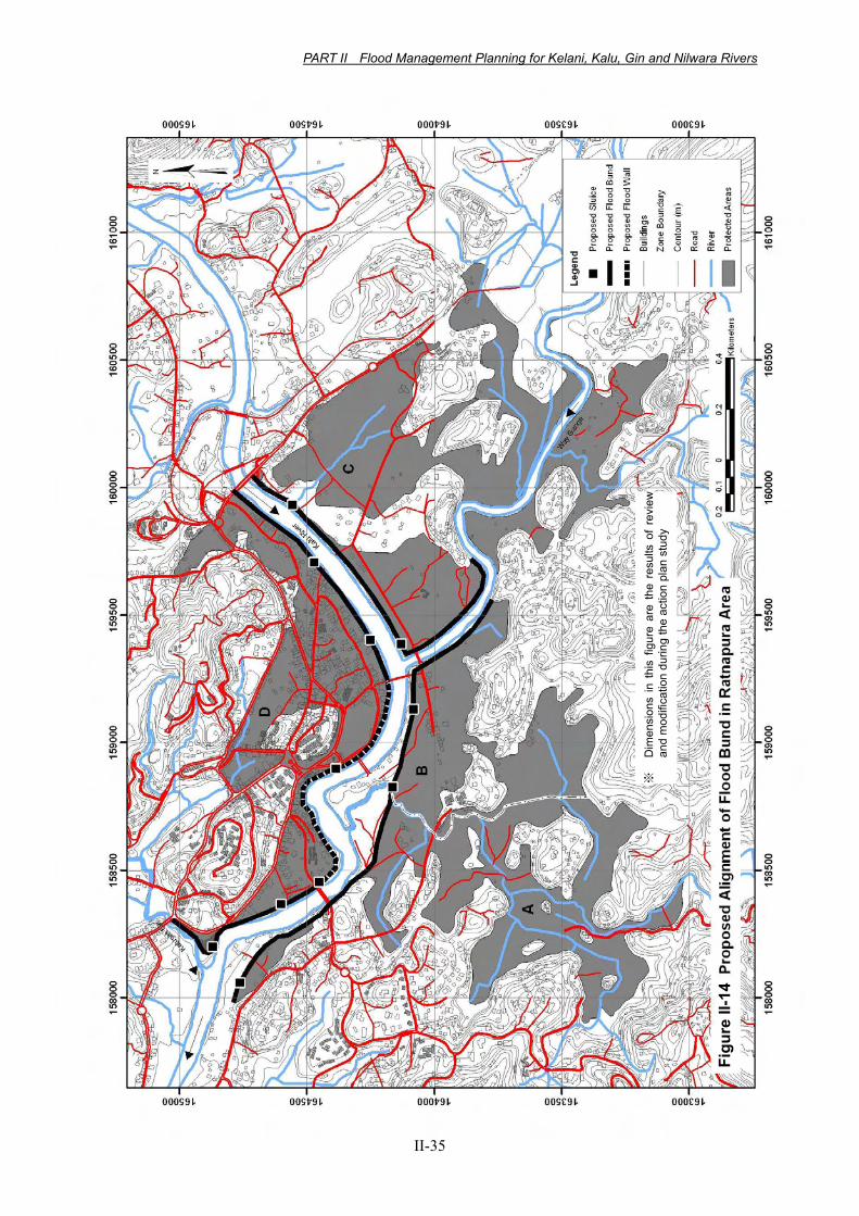
Figure II-14 Proposed Alignment of Flood Bund Ratnapura Area
Figu
re II
-14
※
Dim
ensi
ons
in t
his
figur
e ar
e th
e re
sults
of
revi
ewan
d m
odifi
catio
n du
ring
the
actio
n pl
an s
tudy
Related Documents