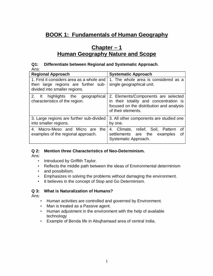
BOOK 1: Fundamentals of Human Geography Chapter – 1 Human Geography Nature and Scope Q1: Differentiate between Regional and Systematic Approach. Ans: Regional Approach Systematic Approach 1. First it considers area as a whole and then large regions are further sub- divided into smaller regions. 1. The whole area is considered as a single geographical unit. 2. It highlights the geographical characteristics of the region. 2. Elements/Components are selected in their totality and concentration is focused on the distribution and analysis of their elements. 3. Large regions are further sub-divided into smaller regions. 3. All other components are studied one by one. 4. Macro-Meso and Micro are the examples of the regional approach. 4. Climate, relief, Soil, Pattern of settlements are the examples of Systematic Approach. Q 2: Mention three Characteristics of Neo-Determinism. Ans: • Introduced by Griffith Taylor. • Reflects the middle path between the ideas of Environmental determinism • and possibilism. • Emphasizes in solving the problems without damaging the environment. • It believes in the concept of Stop and Go Determinism. Q 3: What is Naturalization of Humans? Ans: • Human activities are controlled and governed by Environment. • Man is treated as a Passive agent. • Human adjustment in the environment with the help of available technology • Example of Benda life in Abujhamaad area of central India. 1

Welcome message from author
This document is posted to help you gain knowledge. Please leave a comment to let me know what you think about it! Share it to your friends and learn new things together.
Transcript
BOOK 1: Fundamentals of Human Geography
Chapter – 1Human Geography Nature and Scope
Q1: Differentiate between Regional and Systematic Approach.Ans:Regional Approach Systematic Approach1. First it considers area as a whole andthen large regions are further sub-divided into smaller regions.
1. The whole area is considered as asingle geographical unit.
2. It highlights the geographicalcharacteristics of the region.
2. Elements/Components are selectedin their totality and concentration isfocused on the distribution and analysisof their elements.
3. Large regions are further sub-dividedinto smaller regions.
3. All other components are studied oneby one.
4. Macro-Meso and Micro are theexamples of the regional approach.
4. Climate, relief, Soil, Pattern ofsettlements are the examples ofSystematic Approach.
Q 2: Mention three Characteristics of Neo-Determinism.Ans:
• Introduced by Griffith Taylor.• Reflects the middle path between the ideas of Environmental determinism • and possibilism.• Emphasizes in solving the problems without damaging the environment.• It believes in the concept of Stop and Go Determinism.
Q 3: What is Naturalization of Humans?Ans:
• Human activities are controlled and governed by Environment.• Man is treated as a Passive agent.• Human adjustment in the environment with the help of available
technology• Example of Benda life in Abujhamaad area of central India.
1
CHAPTER 2The World Population: Distribution, Density and Growth
Q1: Why is there great Variation among various regions in doubling their population?Ans:
• Developed countries have controlled their growth rate due to expansion of educational facilities and advancement in medical facilities.
• Developed countries are taking more time to double their population.• Developing countries are taking less time to double their population• Due to lack of education and medical facilities.
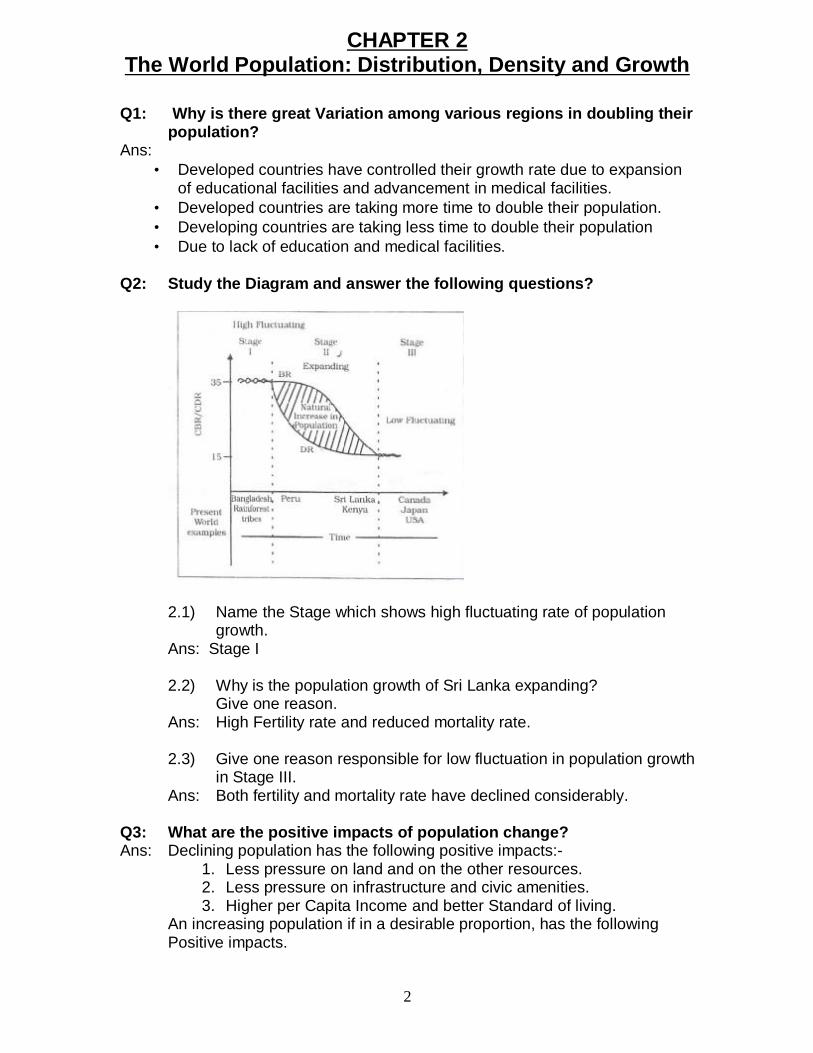
Q2: Study the Diagram and answer the following questions?
2.1) Name the Stage which shows high fluctuating rate of population growth.
Ans: Stage I
2.2) Why is the population growth of Sri Lanka expanding? Give one reason.
Ans: High Fertility rate and reduced mortality rate.
2.3) Give one reason responsible for low fluctuation in population growthin Stage III.
Ans: Both fertility and mortality rate have declined considerably.
Q3: What are the positive impacts of population change?Ans: Declining population has the following positive impacts:-
1. Less pressure on land and on the other resources.2. Less pressure on infrastructure and civic amenities.3. Higher per Capita Income and better Standard of living.
An increasing population if in a desirable proportion, has the following Positive impacts.
2
2. Favourable for expanding Economy.3. Resources can be utilized in a better way.4. Bio-diversity is kept intact.
CHAPTER-3Population Composition
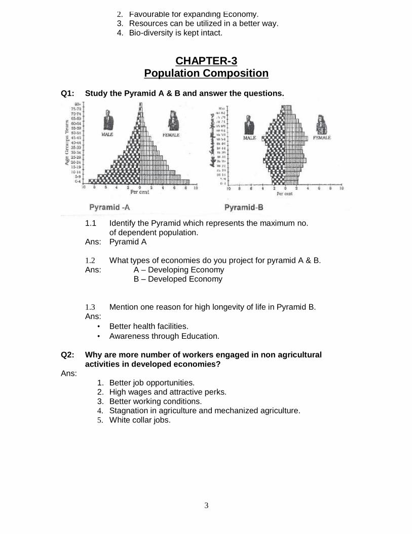
Q1: Study the Pyramid A & B and answer the questions.
1.1 Identify the Pyramid which represents the maximum no. of dependent population.Ans: Pyramid A
1.2 What types of economies do you project for pyramid A & B.Ans: A – Developing Economy
B – Developed Economy
1.3 Mention one reason for high longevity of life in Pyramid B.Ans:
• Better health facilities.• Awareness through Education.
Q2: Why are more number of workers engaged in non agricultural activities in developed economies?Ans:
1. Better job opportunities.2. High wages and attractive perks.3. Better working conditions.4. Stagnation in agriculture and mechanized agriculture.5. White collar jobs.
3
CHAPTER – 4Human Development
Q1: Briefly explain any three approaches of Human Development.Ans:
1. INCOME APPROACH: - • Human development is seen as being linked to Income.• Higher the level of Income, reveals higher human development.
2. WELFARE APPROACH: - • This approach argues for higher government expenditure on welfare
Schemes.
3. BASIC NEEDS APPROACH: -• Focused on Six basic needs such as health, education, food,
Water supply, sanitation and housing.
4. CAPABILITY APPROACH: - • Building Human capabilities in the areas of health, education
and access to resources.
Q2: Which factors affect the Human Development of a country?Ans:
• The pattern of Govt. Expenditure on the Social Sector – Expenditure on Education, Training & Health etc.• The Political Environment of the country.• The extent of freedom given to its people.
CHAPTER – 5Primary Activities
Q1: The number of pastoral nomads has been decreasing and the areas operated by them Shrinking. Why?Ans:
• Due to imposition of political boundaries.• New Settlement Plan by different countries.• Urbanization and Industrialization.• Due to development of Education and technology, nomads prefer to lead a settled life.
Q2: What is Truck Farming? Mention any two features of truck farming.Ans:
• This type of farming is practiced in the peripheral areas of Metropolitan cities where, vegetables and milk are brought daily to the cities by trucks by traveling overnight.• Farmers are engaged in growing of vegetables, fruits and flowers etc.• They use HYV seeds, Chemicals and fertilizers.• This farming requires a well developed network of roads
4
Q3: What is Plantation Agriculture? Why is it practiced mainly in tropical and sub-tropical areas of the world?
Ans: It is a special type of farming in which crops like tea, coffee, bananas and rubber etc. are grown in big estates by using modern techniques. Crops are grown for Commercial purposes.This agriculture requires more investment.
Reasons for plantation agriculture in tropical areas:-1. Hot and Humid Climate.2. fertile soil3. Availability of cheap labour due to high density of population.
CHAPTER – 6Secondary Activities
Q1: What are the Characteristics of modern large scale manufacturing?Ans:
• Specialization of skills/methods of production.• Mechanization• Technological innovations• Organizational Structure & Stratification.• Uneven geographic Distribution.
Q2: ‘Africa has immense natural resources and yet it is industrially the most backward continent’. Comment.Ans:
• Unfavourable Climatic conditions.• Low level of technological development.• Lack of Rapid network of transport & communication.• Lack of developed Energy Resources.• Lack of market facilities.
Q3: Large scale Industries are often called the Capital Intensive Industries. Why? Ans:
• A large amount of raw material is used and is procured from far off places.• A lot of energy is required to drive heavy machines.• Abundant and efficient labour is required.• Quality Control by Special experts.• Highly integrated transport system is needed.• Large amount of capital is needed.
Q4: What are the basis of recognizing a traditionally industrial region?Ans:
• High proportion of employment in manufacturing industries.
5
• Unattractive environment.• Problem of unemployment, emigration and abandoned land areas caused by closure of factories because of a worldwide fall in demand.
Q5: Why is cotton textiles industry witnessing a declining trend in some countries?Ans:
• Stiff Competition with synthetic fibres.• Lack of Ample raw material.• Higher Labour cost.
CHAPTER – 7Tertiary and Quaternary Activities
Q1: How tourism has become the single largest tertiary activity?
Ans: Tourism has become the single largest activity in the total registered jobs and total revenue because:-
1. It not only serves the purpose of recreation, it provides employment to many local people. They provide services like transport, accommodation, entertainment and other services.
2. Tourism fosters the growth of infrastructure industries, retail trading and craft industry.
3. It also increases National Income.
Q2: Demand & transport affect tourism. How?Ans:
Demand: -1. Demand for more holiday tour packages has increased rapidly due to higher paying capacity.2. Improvement in Standard of living and increasing leisure time.
Transport:-1. Traveling is easier with better road system.2. Expansion of air travel has made it more comfortable.3. Advent of package holidays has reduced the cost.
6
Q3: Distinguish between Retail Trading Services & Wholesale Trading Services.Ans:
Retail Trading Services Wholesale Trading Services 1. This is the business
concerned with the sale of goods directly to consumers.
1. Whole sale trading business Consists of bulk businessthrough numerous intermediary merchants andsupply houses.
2. Retail Trading takes place in fixed establishmentsor stores solely devoted toselling.
2. Whole sale Trading is done through large stores or godowns.
3. Retailers generally do not extend the credit facility to the consumers.
3. Whole sellers often extend credit to retailers
4. Example: Street peddling,door to door Vending Machines & Internet etc.
4. Example: Trading throughVarious Agency dealers & other suppliers etc.
Q4: What is ‘Digital Divide’? Ans: A divide or Gap which has emerged between the developed and
developing nations due to difference in economic, political and socialdisparities. In the field of Information and Communication Technology(ICT) developed countries in general have surged forward while Developing countries have lagged behind and this is known as the ‘Digital divide’.
CHAPTER – 8Transport and Communication
Q1: How does Modern Communication System strengthen the concept of global village? Discuss.
Ans: 1) Internet connecting about 1000 million people in more
than 100 countries.2) Satellite communication has increased accessibility of
people cutting across place and time.3) Fax, Telephone, mobile phone, television & Radio etc. are
widely used.4) Digitalization of the information has brought revolution.
Q2: List the factors which affect the Inland Water Transport?
7
1. Navigability of the water body/channel.2. Width and depth of the Canal/rivers etc.3. Continuity in the water flow.4. Transport technology.5. Demand
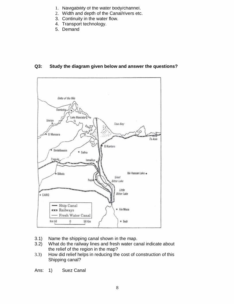
Q3: Study the diagram given below and answer the questions?
3.1) Name the shipping canal shown in the map.3.2) What do the railway lines and fresh water canal indicate about
the relief of the region in the map?3.3) How did relief helps in reducing the cost of construction of this
Shipping canal?
Ans: 1) Suez Canal
8
3) Construction cost is comparatively low due to plain terrain.
Q4: Suggest any five measures to overcome urban transport problem.Ans:
1. By imposing higher parking fee.2. Mass Rapid Transport (MRT).3. Improved Public Transport Services.4. Introducing Expressways.5. Increase in local train services.6. Promoting Metro Trains.7. Construction of Separate Traffic lanes, bridges & Flyovers etc.
CHAPTER – 9International Trade
Q1: W.T.O. is often criticized for widening the Gap between developed and developing countries. Examine critically.
Ans: 1. Free Trade does not make ordinary people’s life more prosperous.2. Developed countries in the W.T.O. focus on their own
Commercial interests.3. Many developed countries have not fully opened their market for
the entry of the products of the developing countries.4. Issues pertaining to health, labour rights, child labour and environment
are normally ignored.
Q2: Mention three merits & three demerits of International Trade.Ans:
Merits:-1) It leads to regional specialization.2) Helps in higher level of production.3) Worldwide availability of goods & services.4) Equalization of prices & wages.
Demerits:-1) It leads to dependence on other countries.2) Uneven levels of development.3) Commercial rivalry leading to wars.4) Global trade affects many aspect of life.
9
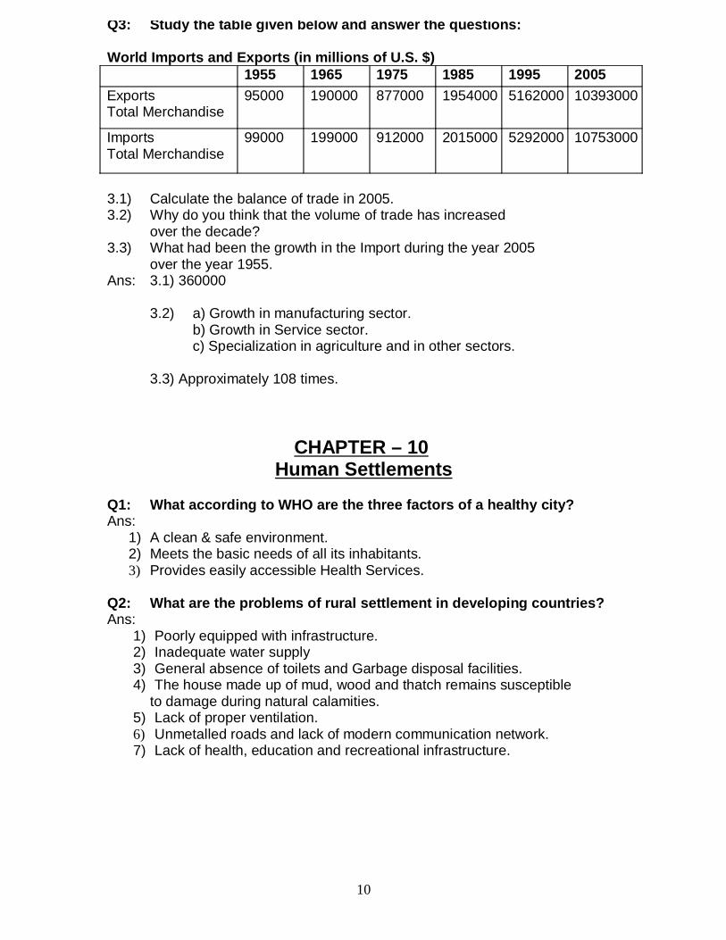
Q3: Study the table given below and answer the questions:
World Imports and Exports (in millions of U.S. $)1955 1965 1975 1985 1995 2005
ExportsTotal Merchandise
95000 190000 877000 1954000 5162000 10393000
ImportsTotal Merchandise
99000 199000 912000 2015000 5292000 10753000
3.1) Calculate the balance of trade in 2005.3.2) Why do you think that the volume of trade has increased
over the decade?3.3) What had been the growth in the Import during the year 2005
over the year 1955.Ans: 3.1) 360000
3.2) a) Growth in manufacturing sector.b) Growth in Service sector.c) Specialization in agriculture and in other sectors.
3.3) Approximately 108 times.
CHAPTER – 10Human Settlements
Q1: What according to WHO are the three factors of a healthy city?Ans:
1) A clean & safe environment.2) Meets the basic needs of all its inhabitants.3) Provides easily accessible Health Services.
Q2: What are the problems of rural settlement in developing countries?Ans:
1) Poorly equipped with infrastructure.2) Inadequate water supply3) General absence of toilets and Garbage disposal facilities.4) The house made up of mud, wood and thatch remains susceptible
to damage during natural calamities.5) Lack of proper ventilation.6) Unmetalled roads and lack of modern communication network.7) Lack of health, education and recreational infrastructure.
10
Q3: What is Sub-Urbanization? Mention two causes of Sub-urbanization.Ans: It is a new trend of people moving away from congested urban areas
to cleaner areas outside the city in search of a better quality of living.Causes of sub-urbanization:-
1) Congestion in urban areas.2) Deterioration in civic amenities.3) Un healthy environmental conditions.4) High rate of land.
Q4: What is Conurbation? Who had coined the term ‘conurbation’ first.Give two examples of Conurbation.
Ans: Conurbation refers to a large area of urban development that resulted from the merging of originally separate towns or cities,It was coined by Patrick Geddes in 1915.Greater London, Manchester, Chicago and Tokyo are some examples of Conurbation.
Note : - Any other relevant point may also be added to the answers given in this question bank.
11
BOOK 2 : India; People and EconomyChapter – 1
Population – Distribution, Density, Growth andComposition
Q1: “Socio-economic factors influence high density of population”. Givereasons with examples.
Ans: 1. Evolution of settled agriculture and agricultural development.2. Pattern of human settlement.3. Development of transport network.4. Industrialization5. UrbanizationExamples: - River Plains and Coastal areas; Urban centres/Industrial areas.
Q2: What are the Challenges for the society with regards to adolescentpopulation in India?
Ans:1. Lower age at marriage.2. Illiteracy- particularly among female population.3. School dropouts.4. Low intake of nutrients.5. High rate of maternal mortality of adolescent mothers.6. Drug abuse.7. Excessive exposure to the negative aspects of media in modern times.
Q3: What are the objectives of National Youth Policy of Govt. of India?Ans:
12
2. Reinforcing the qualities of patriotism and responsible citizenship.3. To shoulder responsibility towards constructive development of the country.4. To ensure effective participation in decision making.5. Empowering women and girl child to bring parity.6. To look into youth health, sports and recreation.7. Creativity and awareness in the field of science and technology.
Q4: Which two categories of workers dominate in the occupationalcomposition in India?
Ans: 1. Cultivators.2. Agricultural Labourers.3. Household, industrial workers.
Q5: Why is there a decline in the number of workers in agricultural sector?Ans:
1. Availability of limited farming.2. Lack of employment in rural areas due to mechanization of agriculture.3. Seasonal nature of employment.4. Large scale urbanization and industrialization.5. Attraction & access towards tertiary and quarternary occupation.
Q6: “Female participation rate is low in India” Why?Ans:
1. Joint family system.2. Low rate of literacy among females.3. Frequent child birth.4. Greater family responsibility.5. Male dominated society.
Chapter – 2Migration – types, causes & consequences
Q1: Give a brief account of three waves of Indian diaspora.Ans:
1. Migration in colonial period as labourers in plantation estates.2. Migration to neighboring countries mostly in South East Asia in search of
economic opportunities.3. High skilled professionals migrated after 1960’s
Q2: Which urban agglomeration of India has the highest share of migrantpopulation? Why.
Ans: Greater MumbaiReasons:-
1. More employment opportunities.2. Urbanization and Industrialization.3. Relatively higher wages.4. Better education facilities.5. Other civic amenities.
Q3: What are the impacts of intermixing of people on society due to migration?
13
1. Evolution of composite culture.2. Breaking down the narrow regional considerations.3. Widening of mental horizons of the people.
Negative impacts: -1. Anominity which creates social vacuum and a sense of dejection.2. Prone to fall in the trap of anti-social activities like crime and drug abuse etc.3. Develops feeling of insecurity in the people of minority group.
Chapter – 3Human development
Q1: Do you agree that “development must be woven around people, not thepeople around development”. Illustrate.
Ans: Yes.1. Orientation towards sustainable development.2. Empowerment of people.3. Encouraging democratization.4. Efforts to remove regional imbalances.5. Maximization of expenditure on welfare.6. Building human capabilities in the field of health, education and access to
resources.
Q2: How the inter-related aspect of development has direct bearing on thedeteriorating human conditions for the poor?
Ans: There are three inter-related processes of declining capabilities:-1. Social capabilities – due to displacement and weakening of social ties.2. Environmental capabilities – due to pollution3. Personal capabilities – due to increasing diseases and accidents.
Q3: The prime task before any development activity is to maintain paritybetween population and resources. Elaborate it in the light of Neo-Malthusian theory.
Ans: 1. Proper balance between population and resources.2. To reduce the gap between population and resources.3. Limited resources but increase in demand due to population explosion.4. To maintain parity between population and resources.5. Over exploitation of the resources by rich and powerful people leads to conflicts
and contradictions in the society.
Chapter – 4Human Settlements
Q1: “Compact or clustered villages is a universal feature in the northernplains”. Give reasons.
Ans: 1. Level and fertile land.
14
force.3. Abundant supply of water for various activities.4. Social security.5. Better transportation facilities.6. Major portion of the population is landless; hence they are bound to live together.
Q2: Mention any three criteria for a settlement to be classified as a townaccording to 2001 census.
Ans: 1. Population size should be 5000 or more.2. Density of population to be more than 400 persons/sq. km3. More than 75% of male workers should be engaged in non-agricultural activities.4. Administrative.
Q3: Why do the cities become multi-functional?Ans:
1. Each town has to perform a number of functions.2. Urban centers have to provide various services to cater to the needs of the
people.3. Almost in all cities there is a CBZ (Central Business Zone) which performs
multiple functions simultaneously.4. Effect of Globalization.
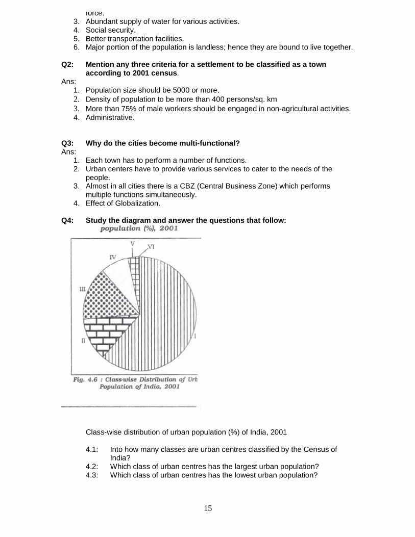
Q4: Study the diagram and answer the questions that follow:
Class-wise distribution of urban population (%) of India, 2001
4.1: Into how many classes are urban centres classified by the Census ofIndia?
4.2: Which class of urban centres has the largest urban population?4.3: Which class of urban centres has the lowest urban population?
15
4.1: Urban centres are classified into six classes.4.2: Class I has the largest urban population.4.3: Class VI has the lowest urban population.
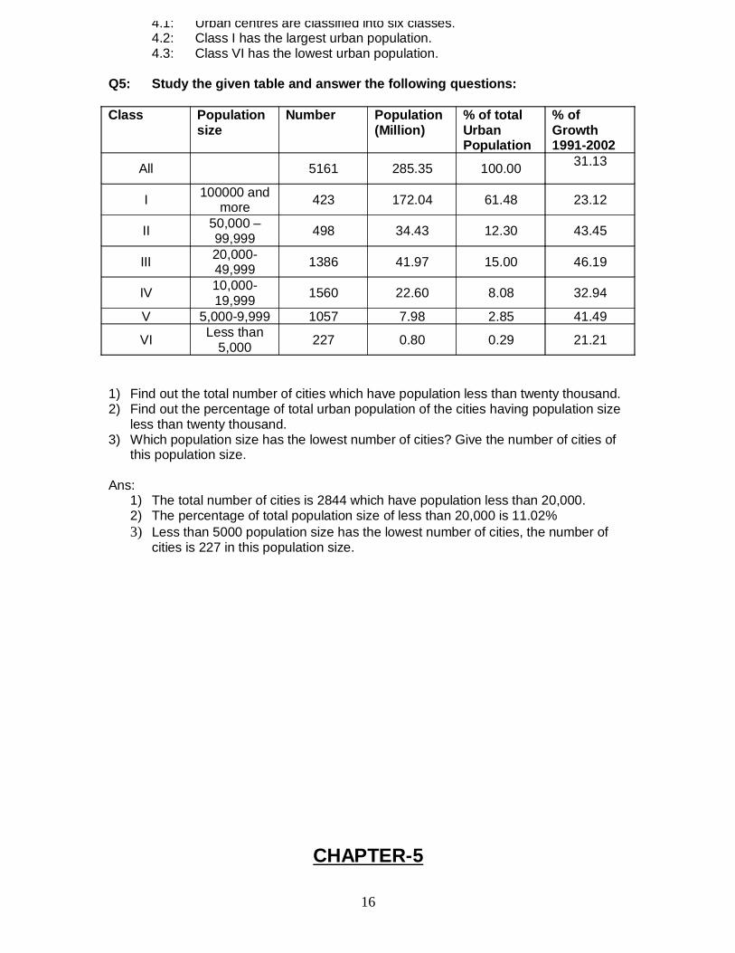
Q5: Study the given table and answer the following questions:
Class Populationsize
Number Population(Million)
% of totalUrbanPopulation
% ofGrowth1991-2002
All 5161 285.35 100.00 31.13
I 100000 andmore 423 172.04 61.48 23.12
II 50,000 –99,999 498 34.43 12.30 43.45
III 20,000-49,999 1386 41.97 15.00 46.19
IV 10,000-19,999 1560 22.60 8.08 32.94
V 5,000-9,999 1057 7.98 2.85 41.49
VI Less than5,000 227 0.80 0.29 21.21
1) Find out the total number of cities which have population less than twenty thousand.2) Find out the percentage of total urban population of the cities having population size
less than twenty thousand.3) Which population size has the lowest number of cities? Give the number of cities of
this population size.
Ans:1) The total number of cities is 2844 which have population less than 20,000.2) The percentage of total population size of less than 20,000 is 11.02%3) Less than 5000 population size has the lowest number of cities, the number of
cities is 227 in this population size.
CHAPTER-5
16
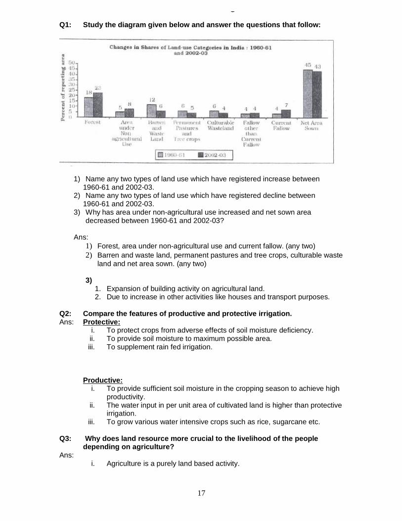
Land, Resources & AgricultureQ1: Study the diagram given below and answer the questions that follow:
1) Name any two types of land use which have registered increase between 1960-61 and 2002-03.
2) Name any two types of land use which have registered decline between 1960-61 and 2002-03.
3) Why has area under non-agricultural use increased and net sown areadecreased between 1960-61 and 2002-03?
Ans:1) Forest, area under non-agricultural use and current fallow. (any two)2) Barren and waste land, permanent pastures and tree crops, culturable waste
land and net area sown. (any two)
3)1. Expansion of building activity on agricultural land.2. Due to increase in other activities like houses and transport purposes.
Q2: Compare the features of productive and protective irrigation.Ans: Protective:
i. To protect crops from adverse effects of soil moisture deficiency.ii. To provide soil moisture to maximum possible area.iii. To supplement rain fed irrigation.
Productive:i. To provide sufficient soil moisture in the cropping season to achieve high
productivity.ii. The water input in per unit area of cultivated land is higher than protective
irrigation.iii. To grow various water intensive crops such as rice, sugarcane etc.
Q3: Why does land resource more crucial to the livelihood of the peopledepending on agriculture?
Ans:i. Agriculture is a purely land based activity.
17
iii. Land ownership in rural areas also has a social value and serves as asecurity for credit.
Q4: Why is traditional cropping pattern changing in India now a days?Ans:
i. Expansion in irrigation facilities has facilitated growth of non-traditional crops. Forexample growing rice in Punjab, wheat in W. Bengal etc.
ii. Modern technology or advent of package technology.iii. Changing food habits of people.iv. Initiation of policy of liberalization and free market economy.v. Easy credit facility to farmers.
Q5: Give three reasons why the green revolution was not equally successful inall parts of India?
Ans:i. Irrigation facilities were limited only to Punjab, Haryana and Western U.P.ii. Farmers were not aware of modern technology and its accessibility.iii. Good and high yielding varieties of seeds were not easily available because of
faulty distribution and storage system.iv. Poverty of farmers.v. Small size of land holdings.
vi. Lack of investment capacity.
Q6: “Indian farmers gamble with the monsoon”. Illustrate thisstatement.
Ans:i. Uneven distribution of rainfall-spatial and temporalii. Uncertainty of monsoon.
iii. Lack of irrigation facilitiesiv. Frequent flood and drought is a common phenomenon associated with the
monsoon.
Q7: “The environment factors provide strong base for Indian agriculture”.Discuss.
Ans:1. Vast agriculture area.2. High percentage of agricultural landuse.3. Fertile soil.4. Longer growing season.5. Wide range of climatic conditions to grow various crops.
Q8: Why do the large number of farmers produce crops for self consumption inIndia?
Ans: 1. Limited and small land holdings.2. Most of the farmers grow foodgrains to meet their family requirement.3. Lack of infrastructure and poor economic affordability.
Q9: Do you feel that the recent incidents of farmers’ suicides in different statesof the country are the result of indebtedness?
Ans: Yes, the reasons are as follows:1. Meagre income or savings.2. Crop failure.3. Difficult procedure of financial institution which has pushed them to
borrow from private money lenders at high rate of interest.
18
5. Low returns from agriculture.6. Lack of implementation of land reforms.
Chapter – 6Water Resources
Q1: Why is ground water utilization very high in some states of India?Ans: Punjab, Haryana, Rajasthan etc. have high ground water utilization.
1) Ground water table is highly accessible.2) Provisions for other alternatives irrigation facilities are limited.3) Emphasis on growing high yielding crops.4) To increase the productivity.5) Changing pattern of crops.
Q2: What are the adverse impacts of over exploitation of ground water?Ans:
1) Decline in ground water table.2) Increased fluoride concentration in ground water has led to increase in
concentration of arsenic matters for example. W. Bengal and Bihar.3) Deteriotation of water quality.
Q3: Why is irrigation more developed in northern plains than in peninsularIndia?
Ans:1) Northern plains have plain surface whereas in Peninsular India land is
undulating.2) Availability of adequate ground & surface water resource than that in Peninsular
India.3) Availability of perennial rivers.4) The slope of the land is so gentle that canal irrigation is convenient.5) Digging of canals and wells is easy due to nature of terrain and soft soil.
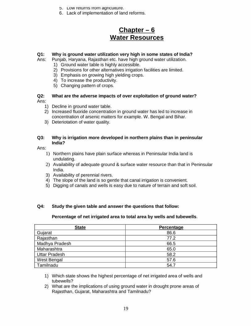
Q4: Study the given table and answer the questions that follow:
Percentage of net irrigated area to total area by wells and tubewells.
State PercentageGujarat 86.6Rajasthan 77.2Madhya Pradesh 66.5Maharashtra 65.0Uttar Pradesh 58.2West Bengal 57.6Tamilnadu 54.7
1) Which state shows the highest percentage of net irrigated area of wells andtubewells?
2) What are the implications of using ground water in drought prone areas ofRajasthan, Gujarat, Maharashtra and Tamilnadu?
19
Ans:1) Percentage of net irrigated area to total area by wells and tubewells is the
highest in Gujarat (86.6%)2)
i. The overuse of groundwater resources has led to decline ingroundwater table in these states.
ii. Over withdrawal has increased fluoride concentration in groundwater.iii. This practice in these states has led to increase in concentration of
arsenic matter in parts of Maharashtra and Tamilnadu.
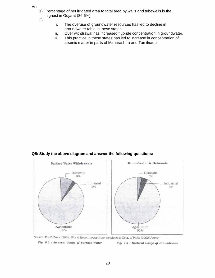
Q5: Study the above diagram and answer the following questions:
20
2) How much percent of surface water is utilized in domestic sector?3) In industrial sector, both groundwater and surface water utilization is low. Why?
Ans:1) Agricultural sector (89% and 92% surface and groundwater respectively).2) 9%3)
I. Because of low industrial development as compared to agricultural sector.II. Modern high tech. industries consume less amount of water.
Q6: Why do we need to encourage watershed development?Ans:
1) To prevent run-off.2) To increase storage and recharge of groundwater.3) Conservation, regeneration and judicious use of all resources like land, water,
plants, animal etc.4) To encourage community and people participation. For example Neeru-Meeru,
Haryali etc.
Chapter – 7Mineral & Energy Resources
Q1: Most of the mineral bearing rock formations in India are distributed inpeninsular plateau. Justify the statement by giving suitable examples.
Ans:1. Plateaus are the storehouse of minerals. Rocks of peninsular plateaus
are of Precambrian and Cambrian era.2. Older rock system associated with the Dharwar, Arawali, Vindhyan
and Gondwana System.3. These geological formations are rich in metallic and non-metallic
minerals.4. Most of the parts of peninsular plateau are formed of igneous and
metamorphic rocks.
Q2: Nuclear energy is the hope of future in India. Give three points.Ans:
1. India is deficient in mineral oil and its coal reserves would also exhaustsoon.
2. India has not been able to develop its potential of hydel power to suchextent that it may depend on it fully because of some constraints.
3. Technical know-how to harness nuclear energy is available.4. This power can play a complementary role in industrial and agricultural
development in India.5. Availability of sufficient reserves of nuclear minerals like uranium and
thorium.
21
Q3: Why is the petroleum referred to as “liquid gold”?Ans:
1. Crude petroleum consists of hydrocarbons of liquid and gaseous states varyingin chemical composition, colour and specific gravity.
2. Essential source of energy for all internal combustion engines in automobiles,railways and aircrafts.
3. Because of its scarcity and diversified uses.4. Its by-products are major raw-material for petro-chemical and other industries.
Q4: India has got a strong base for the development of metallurgicalindustries. Discuss.
Ans:1. India is endowed with abundant reserves of ferrous minerals.2. Largest reserves of iron ore in Asia, occur in India.3. Superior quality of iron ore deposits (Haematite and Magnetite).4. Proximity to coal fields adds to its advantages.5. Manganese which is widely used for smelting of iron ore and manufacturing of
Ferro alloys is found in almost all geological formations.
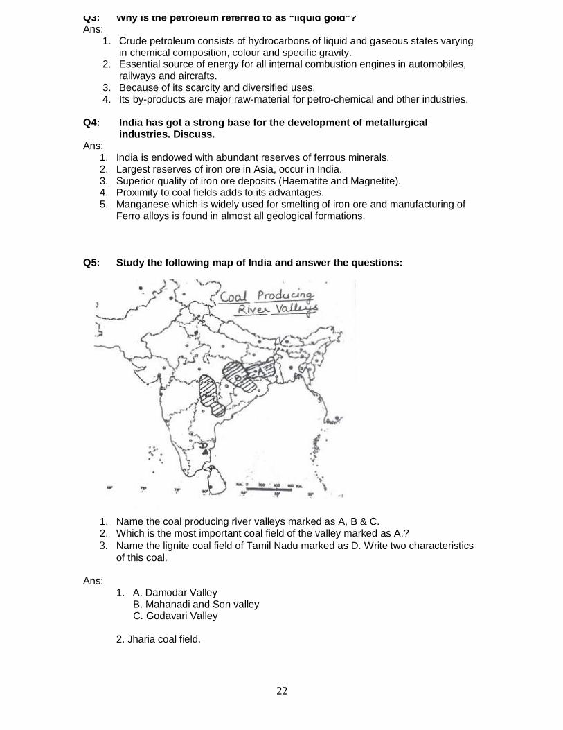
Q5: Study the following map of India and answer the questions:
1. Name the coal producing river valleys marked as A, B & C.2. Which is the most important coal field of the valley marked as A.?3. Name the lignite coal field of Tamil Nadu marked as D. Write two characteristics
of this coal.
Ans:1. A. Damodar Valley B. Mahanadi and Son valley C. Godavari Valley
2. Jharia coal field.
22
Characteristics1. Low graded coal contains high moisture.2. Low carbon content.3. Burns with high smoky flames and leaves much ash after being burnt.
Q6: Why is natural gas called precious gift of nature to man.Ans: In our power deficient country natural gas is a precious gift to us because of the
following reasons:
1. It is used as a source of power as it is relatively cheaper & Eco-friendly.2. It is also used as raw material in the petro-chemical industry.3. It helps in establishing a power plant based on natural gas.4. Fertilizers are also produced by natural gas which is a boon to our agriculture.5. Its transportation is very easy and economical as it is transported through
pipelines over long distances.
Q7: Why does Solar Energy in Rajasthan and Biogas in the plains and hills ofNorth India have greater potential as non-conventional source of energy?
Ans: Solar Energy has greater potential to be developed in Rajasthan because of thefollowing reasons. It has clear skies during most of the part of the year.
1. Abundant Sun Shine almost through out the year.2. Lack of other alternative sources of energy.3. Supportive govt. policies.
Biogas has a greater potential in the northern plain due to following reasons:-1. Large number of Cattle and Livestock.2. High density of population and hence use huge human waste material.3. Availability of large agricultural residue.
Q8: Wind energy is absolutely pollution free, inexhaustible source of energy. Itis not yet developed in India. Give reasons.
Ans: India already has started generating wind energy but is not well developed due tofollowing reasons:-
i. Lack of advance Technology.ii. Lack of Infrastructure
iii. Lack of government & non-Govt. Support and non Govt. agencies.iv. Initial high cost involved.
Chapter – 8Manufacturing Industries
Q1: Study the given map and answer the following questions:a) Identify the steel plant of India marked as ‘A’.b) Name the country which collaborated to setup this Steel Plant.c) Mention any three factors which have helped in the growth of this iron & steel
plant.
23
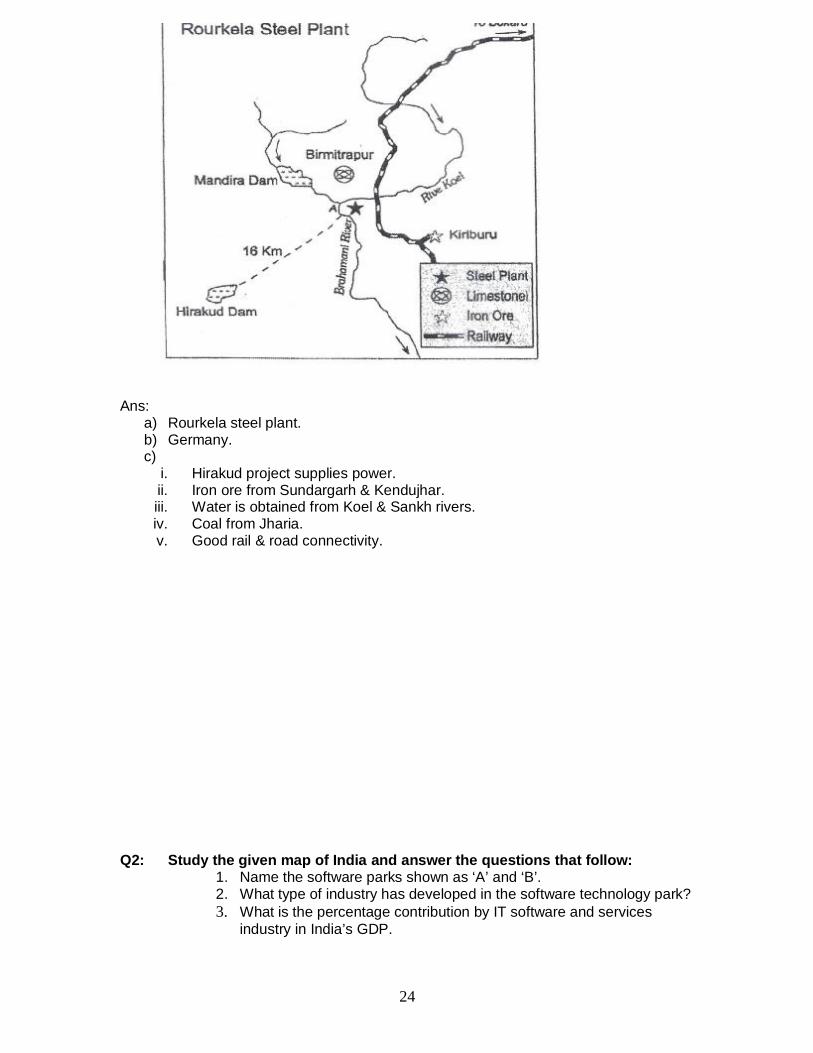
Ans:a) Rourkela steel plant.b) Germany.c)
i. Hirakud project supplies power.ii. Iron ore from Sundargarh & Kendujhar.iii. Water is obtained from Koel & Sankh rivers.iv. Coal from Jharia.v. Good rail & road connectivity.
Q2: Study the given map of India and answer the questions that follow:1. Name the software parks shown as ‘A’ and ‘B’.2. What type of industry has developed in the software technology park?3. What is the percentage contribution by IT software and services
industry in India’s GDP.
24
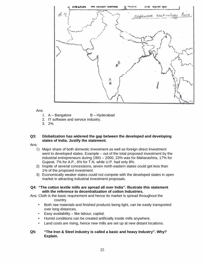
Ans:1. A – Bangalore B – Hyderabad2. IT software and service industry.3. 2%
Q3: Globalization has widened the gap between the developed and developingstates of India. Justify the statement.
Ans:1) Major share of both domestic investment as well as foreign direct investment
went to developed states. Example – out of the total proposed investment by theindustrial entrepreneurs during 1991 – 2000, 23% was for Maharashtra, 17% forGujarat, 7% for A.P., 6% for T.N. while U.P. had only 8%.
2) Inspite of several concessions, seven north eastern states could get less than1% of the proposed investment.
3) Economically weaker states could not compete with the developed states in openmarket in attracting industrial investment proposals.
Q4: “The cotton textile mills are spread all over India”. Illustrate this statementwith the reference to decentralization of cotton Industries.
Ans: Cloth is the basic requirement and hence its market is spread throughout thecountry.
• Both raw materials and finished products being light, can be easily transportedover long distances.
• Easy availability – like labour, capital.• Humid conditions can be created artificially inside mills anywhere.• Land costs are rising, hence new mills are set up at new distant locations.
Q5: “The Iron & Steel industry is called a basic and heavy Industry”. Why?Explain.
25

reasons:
1) The industry forms a base for all other industries.2) No industry can be imagined that does not make use of iron and steel in
one form or the other.3) The industry lays the foundation of rapid development of all other sectors
in the economy – agriculture, etc.4) It is a heavy industry because:-
• Its raw material is very bulky.• Other minerals used like limestone; manganese, etc. are also very bulky.• Coal used as source of power in blast furnaces is also very bulky.• And finally its finished products are also very bulky.
26
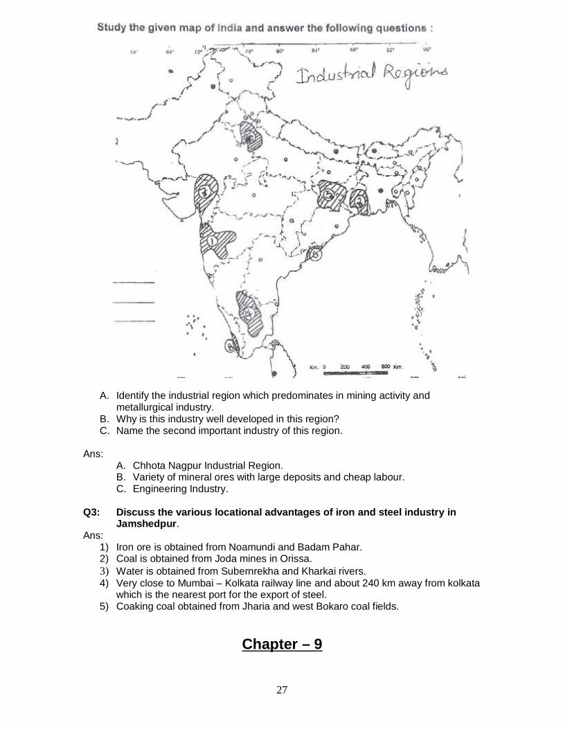
A. Identify the industrial region which predominates in mining activity andmetallurgical industry.
B. Why is this industry well developed in this region?C. Name the second important industry of this region.
Ans:A. Chhota Nagpur Industrial Region.B. Variety of mineral ores with large deposits and cheap labour.C. Engineering Industry.
Q3: Discuss the various locational advantages of iron and steel industry inJamshedpur.
Ans:1) Iron ore is obtained from Noamundi and Badam Pahar.2) Coal is obtained from Joda mines in Orissa.3) Water is obtained from Subernrekha and Kharkai rivers.4) Very close to Mumbai – Kolkata railway line and about 240 km away from kolkata
which is the nearest port for the export of steel.5) Coaking coal obtained from Jharia and west Bokaro coal fields.
Chapter – 9
27
Planning and Sustainable Development in IndianContext
Q1: Why does the ‘planning commission’ introduce the approaches of ‘targetarea planning’ and ‘target group’ planning?
Ans:1) In order to arrest the accentuations of regional social disparity. Example
command Area Development Programme.2) In order to arrest the accentuations of social disparity. Example the Small
Farmers Development Agency.
Q2: How did the notion of sustainable development emerge? Also, state someof its salient features.
Ans:1) Rise in the awareness of environmental issues in western world.2) Concern of people about undesirable effects of industrial development on the
environment.3) The publication like – “The population Bomb” and “The limits to Growth” further
raised the issue.
Salient features: -1) It takes care of ecological, social and economic aspects of development.2) It meets the needs of the present without compromising to the needs &
aspirations of the future generations.3) It takes into account the development of whole human being.
Q3: Discuss the negative affects of Indira Gandhi Canal Irrigation onEnvironment.
Ans: The negative affects of Indira Gandhi Canal Irrigation on environment are givenbelow:
1) Intensive irrigation and excessive use of water has led to the emergence of twinenvironment problems of water logging and soil salinity.
2) The ground water level is rising alarmingly in most parts of stage I of thecommand area.
3) Water logging and soil salinity have adversely affected soil fertility and agricultureproductivity.
Q4: Study the map of Bharmaur Tribal Region given and answer the followingquestions:
28
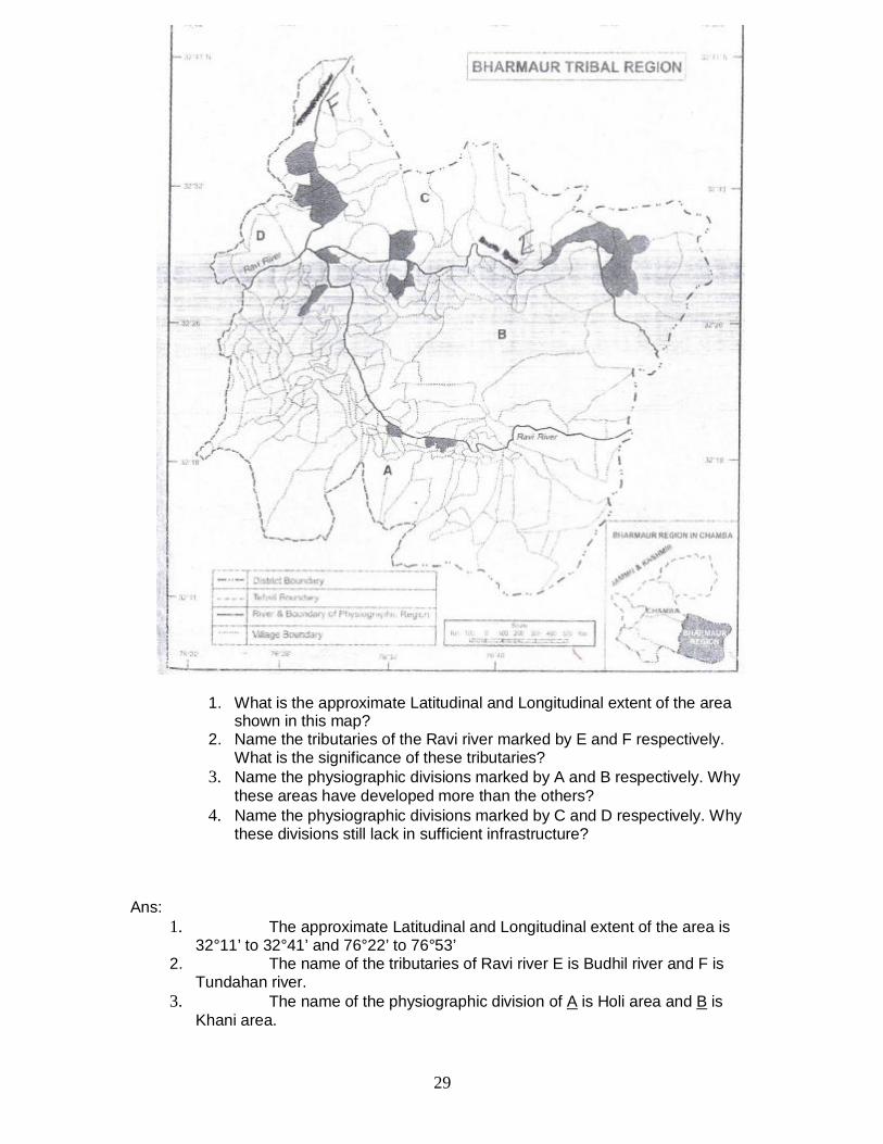
1. What is the approximate Latitudinal and Longitudinal extent of the areashown in this map?
2. Name the tributaries of the Ravi river marked by E and F respectively.What is the significance of these tributaries?
3. Name the physiographic divisions marked by A and B respectively. Whythese areas have developed more than the others?
4. Name the physiographic divisions marked by C and D respectively. Whythese divisions still lack in sufficient infrastructure?
Ans:1. The approximate Latitudinal and Longitudinal extent of the area is
32°11’ to 32°41’ and 76°22’ to 76°53’2. The name of the tributaries of Ravi river E is Budhil river and F is
Tundahan river.3. The name of the physiographic division of A is Holi area and B is
Khani area.
29
These two areas are comparatively more developed due to the development ofmeans of transport and communications, being the lower reaches of hilly tractsof land.
4. The name of the physiographic division of C and D is Kugti area and Tundaharea.
These divisions have lack of infrastructure due to the hilly steep terrain andbeing remote areas of villages as compared to Khani and Holi area.
Q5: Study the given map of Indira Gandhi Canal and answer the followingquestions:
30
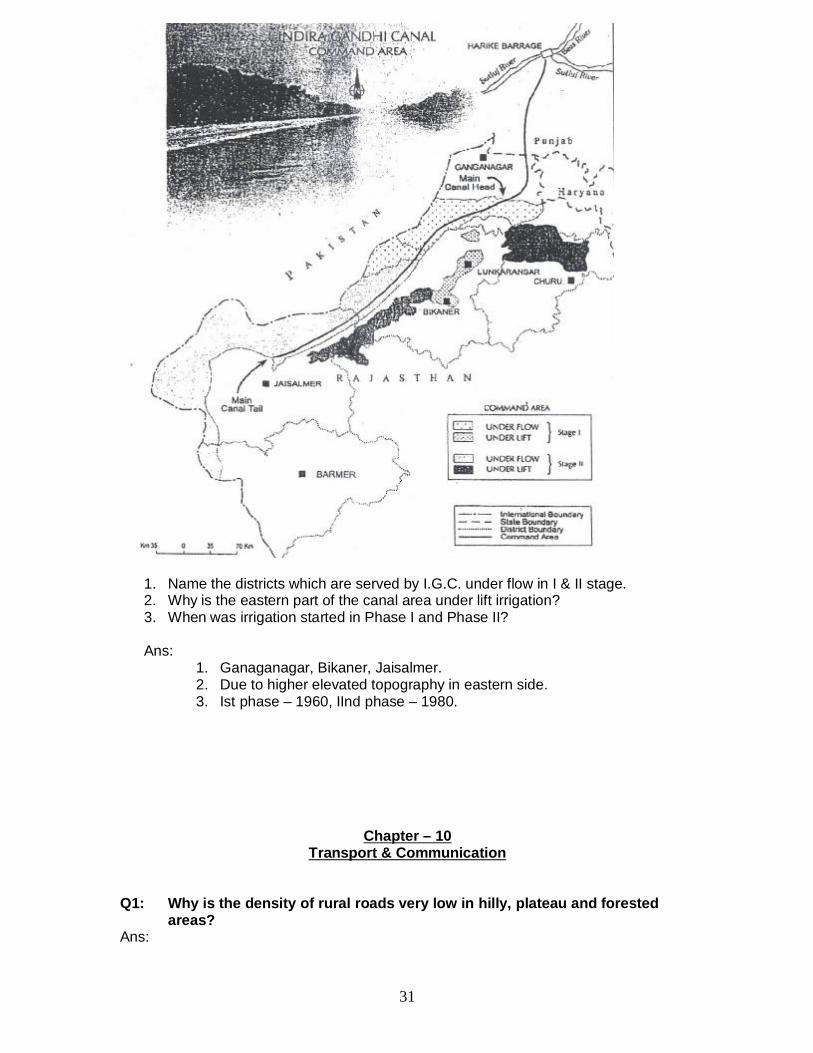
1. Name the districts which are served by I.G.C. under flow in I & II stage.2. Why is the eastern part of the canal area under lift irrigation?3. When was irrigation started in Phase I and Phase II?
Ans:1. Ganaganagar, Bikaner, Jaisalmer.2. Due to higher elevated topography in eastern side.3. Ist phase – 1960, IInd phase – 1980.
Chapter – 10Transport & Communication
Q1: Why is the density of rural roads very low in hilly, plateau and forestedareas?
Ans:
31
2. Low population density.3. Relatively lesser economic activity.4. Costs of construction are relatively higher.5. Settlements are located far away from one other.
Q2: When and why was the border Road Organization established?Ans: Border road Organization (BRO) was established in May – 1960.
Because –1. There was a need to accelerate economic development of the border
areas.2. To strengthen the defence preparedness and steady flow of arms and
ammunitions along the border in strategically sensitive areas.3. To promote the harmonious relationship with the neighboring countries.
Q3: “Among all the personal communication system internet is the mosteffective and advance one”. Give reasons.
Ans:1. Enables the user to establish direct contact.2. Widely used in urban areas.3. Acts like a huge central warehouse of data & other information.4. Provides an efficient access to information at relatively low cost.5. Increasingly used for e-commerce and many transactions.6. Saves time:- It is the most time efficient device.
Q4: Inspite of numerous rivers, why are India’s inland waterways poorlydeveloped?
Ans:1. Seasonal fluctuations in the volume of water level of most rivers.2. Higher silting in the river bed.3. Reduction in water level due to diversion of water for irrigation.4. Floods and swift currents.5. Tough competition from roads railways transport with regard to convenience.6. Lack of mechanized vessels.7. Undulating topography.
Q5: Why has The Container transport becomes more popular now a days?Ans:
1. It provides door to door service.2. It has reduced transport and delivery time.3. The service is economical both to the railways and its customers.4. Safety and security of product.
Q6: What is the “Open Sky policy”?Ans: To help the Indian exporters and make their export more competitive, the
government had introduced an “open sky policy” for Cargo in April 1992. Underthis policy, the government of India has allowed foreign airlines or association ofexporters to use the Indian sky for bringing any freighters to the country.
32
Chapter -11International Trade
Q1: What are the main characteristics of India’s foreign trade?Ans:
1. Very less share (0.5%) of India in International trade.2. Per capita trade is less.3. Priority to sea routes / Maximum trade is carried out through sea-routes.4. Unfavourable balance of trade.5. Variation in direction of trade.6. Variety of trade items/composition.7. High increase in import and export.
Q2: Explain the changing pattern of the international trade of India.Ans: Change in Export :
1. The share of agriculture and allied products has declined.2. Share of petroleum and its products increased.3. Share of mineral ores remained constant.4. The decline in traditional items due to tough competition like jute products.5. Significant growth in the export of engineering & leather goods.
Change in Import : 1. Share of foodgrains import is replaced by petroleum and fertilizers.2. Import of capital goods has increased.3. Import of edible oil and pulses in place of food items.4. Gold and Silver import has increased.5. Import of professional instruments has also increased.
Q3: Why does India import edible oil and pulses in spite of being anagriculturally rich country?
Ans:1. More demand due to rapid growth of population.2. Most of the cultivated land is under food crops.3. Per hectare productivity of pulses is low as compared to other crops.4. It is less profitable as compared to other crops.5. Risky Farming due to high vulnerability.6. Increase in the purchasing power of the individuals.
Q4: India’s international trade has undergone a sea-change in recent years.Give five arguments in support of this statement.
Ans: Change in India’s International trade: -1. There is a change in India’s international trade in terms of volume, composition
and direction.2. Although India’s contribution to world trade is low, yet it plays a significant role in
the world economy.3. In 1950-51, India’s external trade was worth Rs. 12140 million which rose to Rs.
8371330 million in 2004-05.4. The nature of India’s foreign has also changed and the volume of imports and
exports increased.5. The value of imports continues to be higher than the value of exports.6. Trade deficit increased mainly due to the price rise in crude petroleum.
Q5: Mention the measures adopted by the Govt. of India to double its share inthe international trade.
33
1. Liberalization of imports.2. Reduction in import duties.3. De-licensing and change from process to product patents.
Q6: Why does the west coast has more seaports than the east coast of India.Ans:
1. Availability of indented coastline.2. Depth of sea water is relatively more near coast.3. Early arrival of European traders and Arabs etc.4. Britishers encouraged to establish and promote the ports along the west coast to
strengthen the connectivity from Europe.5. Opening of Suez Canal also promoted and encouraged the emergence of sea
ports along the west coast.
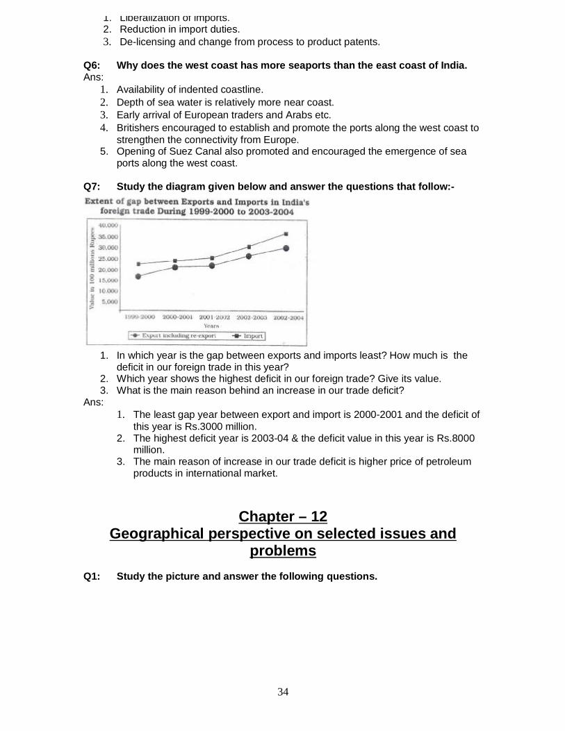
Q7: Study the diagram given below and answer the questions that follow:-
1. In which year is the gap between exports and imports least? How much is thedeficit in our foreign trade in this year?
2. Which year shows the highest deficit in our foreign trade? Give its value.3. What is the main reason behind an increase in our trade deficit?
Ans:1. The least gap year between export and import is 2000-2001 and the deficit of
this year is Rs.3000 million.2. The highest deficit year is 2003-04 & the deficit value in this year is Rs.8000
million.3. The main reason of increase in our trade deficit is higher price of petroleum
products in international market.
Chapter – 12Geographical perspective on selected issues and
problemsQ1: Study the picture and answer the following questions.
34
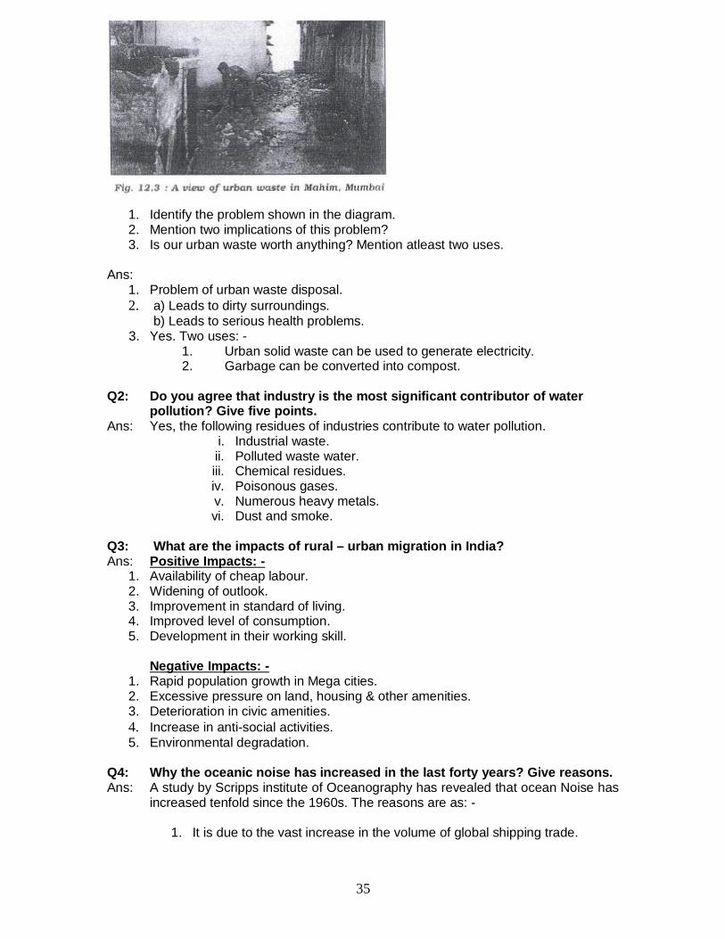
1. Identify the problem shown in the diagram.2. Mention two implications of this problem?3. Is our urban waste worth anything? Mention atleast two uses.
Ans:1. Problem of urban waste disposal.2. a) Leads to dirty surroundings.
b) Leads to serious health problems. 3. Yes. Two uses: -
1. Urban solid waste can be used to generate electricity.2. Garbage can be converted into compost.
Q2: Do you agree that industry is the most significant contributor of waterpollution? Give five points.
Ans: Yes, the following residues of industries contribute to water pollution.i. Industrial waste.ii. Polluted waste water.iii. Chemical residues.iv. Poisonous gases.v. Numerous heavy metals.vi. Dust and smoke.
Q3: What are the impacts of rural – urban migration in India?Ans: Positive Impacts: -
1. Availability of cheap labour.2. Widening of outlook.3. Improvement in standard of living.4. Improved level of consumption.5. Development in their working skill.
Negative Impacts: -1. Rapid population growth in Mega cities.2. Excessive pressure on land, housing & other amenities.3. Deterioration in civic amenities.4. Increase in anti-social activities.5. Environmental degradation.
Q4: Why the oceanic noise has increased in the last forty years? Give reasons.Ans: A study by Scripps institute of Oceanography has revealed that ocean Noise has
increased tenfold since the 1960s. The reasons are as: -
1. It is due to the vast increase in the volume of global shipping trade.
35

3. The higher speed of vessels.4. The population has increased around the globe in recent decades.5. Increase in marine activity (exploration of petroleum and natural gas etc.;
collection of marine food).6. Increase in naval activities.
Note : - Any other relevant point may also be added to the answers given inthis question bank.
36
Related Documents