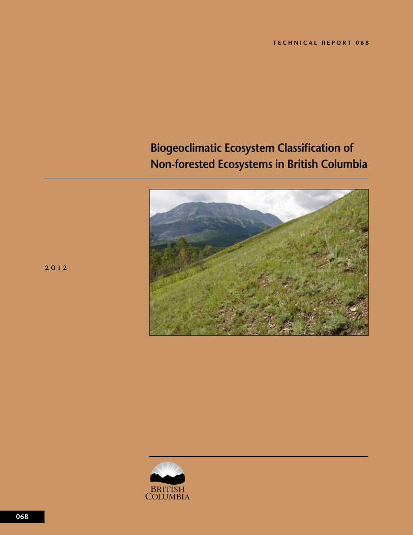
TECHNICAL REPORT 068 2012 068 Biogeoclimatic Ecosystem Classification of Non-forested Ecosystems in British Columbia

Welcome message from author
This document is posted to help you gain knowledge. Please leave a comment to let me know what you think about it! Share it to your friends and learn new things together.
Transcript
T e c h n i c a l R e p o R T 0 6 8
2 0 1 2
068
�e Best Place on Earth
Biogeoclimatic ecosystem classification of non-forested ecosystems in British columbia

Biogeoclimatic Ecosystem Classification of Non-forested Ecosystems in British Columbia
William MacKenzie
�e Best Place on Earth
ii
The use of trade, firm, or corporation names in this publication is for the information and convenience of the reader. Such use does not constitute an official endorsement or approval by the Government of British Columbia of any product or service to the exclusion of any others that may also be suitable. Contents of this report are presented for discussion purposes only. Funding assistance does not imply endorsement of any statements or information contained herein by the Government of British Columbia. Uniform Resource Locators (urls), addresses, and contact information contained in this document are current at the time of printing unless otherwise noted.
�CitationMacKenzie, W.H. 2012. Biogeoclimatic ecosystem classification of non-forested ecosystems in British Columbia. Prov. B.C., Victoria, B.C. Tech. Rep. 068.www.for.gov.bc.ca/hfd/pubs/Docs/Tr/Tr068.htm
Author’s�affiliationW.H. MacKenzieSkeena-Stikine DistrictMinistry of Forests, Lands and Natural Resource Operations3333 Tatlow Rd.Bag 6000Smithers, BC V0J 2N0
Copies of this report may be obtained from:Crown Publications, Queen’s PrinterPO Box 9452 Stn Prov GovtVictoria, BC v8w 9v71-800-663-6105www.crownpub.bc.ca
For more information on Forest Science Program publications, visit our web site at: www.for.gov.bc.ca/scripts/hfd/pubs/hfdcatalog/index.asp
© 2012 Province of British Columbia
When using information from this or any Forest Science Program report, please cite fully and correctly.
Library�and�Archives�Canada�Cataloguing�in�Publication
MacKenzie, William H Biogeoclimatic ecosystem classification of non-forested ecosystems in British Columbia / William H. MacKenzie.
(Technical report ; 068)Available also on the Internet.Includes bibliographical references.ISBN 978-0-7726-6564-5
1. Biotic communities--British Columbia--Classification. 2. Biodiversity --British Columbia. 3. Bioclimatology--British Co-lumbia. 4. Biogeography--British Columbia. 5. Environmental monitoring--British Columbia. I. British Columbia. II. Title.
QH106.2 B74 M32 2012 333.9509711 C2012-980057-0
(Technical report ; 068)Type of computer file: Electronic monograph in PDF format.Issued also in printed form.Includes bibliographical references.ISBN 978-0-7726-6565-2
QH106.2 B74 M32 2012 333.9509711 C2012-980058-9
iii
Contents
1� Introduction . . . . . . . . . . . . . . . . . . . . . . . . . . . . . . . . . . . . . . . . . . . . . . . . . . 11.1 Objective . . . . . . . . . . . . . . . . . . . . . . . . . . . . . . . . . . . . . . . . . . . . . . . . . . 1
2� Biogeoclimatic�Ecosystem�Classification�Framework . . . . . . . . . . . . . 22.1 Components of the Biogeoclimatic Ecosystem Classification
System . . . . . . . . . . . . . . . . . . . . . . . . . . . . . . . . . . . . . . . . . . . . . . . . . . . 22.2 The Site Association and Its Subdivisions . . . . . . . . . . . . . . . . . . . . . . 42.3 Units That Group the Site Association . . . . . . . . . . . . . . . . . . . . . . . . 4
3� Criteria�for�Non-forested�Terrestrial�Groups�and�Classes . . . . . . . . . . 63.1 Physiognomic Cover Criteria . . . . . . . . . . . . . . . . . . . . . . . . . . . . . . . . 63.2 Coding of Ecosystem Units . . . . . . . . . . . . . . . . . . . . . . . . . . . . . . . . . . 73.3 Non-forested Associations That Cross Class or Group Boundaries. 7
4� Site�Realms . . . . . . . . . . . . . . . . . . . . . . . . . . . . . . . . . . . . . . . . . . . . . . . . . . . 84.1 Core Realms . . . . . . . . . . . . . . . . . . . . . . . . . . . . . . . . . . . . . . . . . . . . . . 84.2 Interface Realms . . . . . . . . . . . . . . . . . . . . . . . . . . . . . . . . . . . . . . . . . . . 8
5� Groups�and�Classes�of�the�Terrestrial�Realm . . . . . . . . . . . . . . . . . . . . . 105.1 Alpine Group (A) . . . . . . . . . . . . . . . . . . . . . . . . . . . . . . . . . . . . . . . . . . 125.2 Beachland Group (B) . . . . . . . . . . . . . . . . . . . . . . . . . . . . . . . . . . . . . . 165.3 Flood Group (F) . . . . . . . . . . . . . . . . . . . . . . . . . . . . . . . . . . . . . . . . . . . 185.4 Grassland Group (G) . . . . . . . . . . . . . . . . . . . . . . . . . . . . . . . . . . . . . . . 205.5 Hydrogenic Group (H) . . . . . . . . . . . . . . . . . . . . . . . . . . . . . . . . . . . . . 225.6 Rock Group (R) . . . . . . . . . . . . . . . . . . . . . . . . . . . . . . . . . . . . . . . . . . . 245.7 Subalpine Shrub Group (S) . . . . . . . . . . . . . . . . . . . . . . . . . . . . . . . . . . 265.8 Avalanche Group (V) . . . . . . . . . . . . . . . . . . . . . . . . . . . . . . . . . . . . . . . 285.9 Disclimax Group (X) . . . . . . . . . . . . . . . . . . . . . . . . . . . . . . . . . . . . . . . 29
6� Classes�of�the�Estuarine�Realm� . . . . . . . . . . . . . . . . . . . . . . . . . . . . . . . . . 30
7� Classes�and�Groups�of�the�Wetland�Realm� . . . . . . . . . . . . . . . . . . . . . . . 337.1 Peatland Group . . . . . . . . . . . . . . . . . . . . . . . . . . . . . . . . . . . . . . . . . . . . 337.2 Mineral Wetland Group . . . . . . . . . . . . . . . . . . . . . . . . . . . . . . . . . . . . . 33
References . . . . . . . . . . . . . . . . . . . . . . . . . . . . . . . . . . . . . . . . . . . . . . . . . . . . . . 37
tables1 Ecosystem attributes used to differentiate between units of the same
biogeoclimatic hierarchical level . . . . . . . . . . . . . . . . . . . . . . . . . . . . . . . . 52 Tree-limiting environmental factors and dominant site gradients for
groups of the Terrestrial Realm . . . . . . . . . . . . . . . . . . . . . . . . . . . . . . . . . 10
Figures1 The Biogeoclimatic Ecosystem Classification framework . . . . . . . . . . . 32 Diagram of site realms . . . . . . . . . . . . . . . . . . . . . . . . . . . . . . . . . . . . . . . . . 63 Key to site realms . . . . . . . . . . . . . . . . . . . . . . . . . . . . . . . . . . . . . . . . . . . . . 94 Key to terrestrial groups . . . . . . . . . . . . . . . . . . . . . . . . . . . . . . . . . . . . . . . 115 Key to alpine classes . . . . . . . . . . . . . . . . . . . . . . . . . . . . . . . . . . . . . . . . . . . 136 Alpine Group (A) . . . . . . . . . . . . . . . . . . . . . . . . . . . . . . . . . . . . . . . . . . . . 147 Beachland Group (B) . . . . . . . . . . . . . . . . . . . . . . . . . . . . . . . . . . . . . . . . . . 168 Key to flood classes . . . . . . . . . . . . . . . . . . . . . . . . . . . . . . . . . . . . . . . . . . . 189 Flood Group (F) . . . . . . . . . . . . . . . . . . . . . . . . . . . . . . . . . . . . . . . . . . . . . . 1910 Key to grassland classes . . . . . . . . . . . . . . . . . . . . . . . . . . . . . . . . . . . . . . . . 2011 Grassland Group (G) . . . . . . . . . . . . . . . . . . . . . . . . . . . . . . . . . . . . . . . . . . 21
iv
12 Hydrogenic Group (H) . . . . . . . . . . . . . . . . . . . . . . . . . . . . . . . . . . . . . . . . 2313 Rock Group (R) . . . . . . . . . . . . . . . . . . . . . . . . . . . . . . . . . . . . . . . . . . . . . . 2514 Subalpine Shrub Group (S) . . . . . . . . . . . . . . . . . . . . . . . . . . . . . . . . . . . . . 2615 Avalanche Group (V) . . . . . . . . . . . . . . . . . . . . . . . . . . . . . . . . . . . . . . . . . 2816 Disclimax Group (X) . . . . . . . . . . . . . . . . . . . . . . . . . . . . . . . . . . . . . . . . . . 3017 Estuarine Realm . . . . . . . . . . . . . . . . . . . . . . . . . . . . . . . . . . . . . . . . . . . . . . 3118 Key to wetland classes . . . . . . . . . . . . . . . . . . . . . . . . . . . . . . . . . . . . . . . . . 3219 Wetland Realm (W) . . . . . . . . . . . . . . . . . . . . . . . . . . . . . . . . . . . . . . . . . . . 34
1
1 IntRoDUCtIon
Non-forested ecosystems are an important part of British Columbia’s land-scape and biological diversity. Plant community composition and vegetation structure of these ecosystems stand in contrast to the forests that are typical of much of British Columbia. These non-forested habitats supply critical life history requirements for many plant and animal species.
Biogeoclimatic Ecosystem Classification (BEC) has been applied exten-sively in characterizing forested ecosystems in British Columbia. However, the focus has largely been on mature forest stands; non-forested ecosystems have received relatively little classification effort in British Columbia. How-ever, with landscape planning initiatives and extensive ecosystem mapping work over the last decade, the need for a working classification of non–timber-producing ecosystems has become a priority.
The working site units of BEC, site series and site associations, are defined and identified in part by communities of plant species. Therefore, BEC relies on well-trained, knowledgeable users for proper application. The site series defines units that reflect the appropriate level of detail for the goals of forest management. However, for non–timber-producing ecosystems, a broader perspective is often better suited for management applications, and specific species information is less important at this level. A hierarchical classifica-tion system that generalizes site associations into functionally broader units requiring less detailed knowledge of species identification would therefore have the double advantage of appropriateness of scale and ease of application by non-technical users.
A hierarchy of broader units of this nature for wetlands and related eco-systems is presented in the Wetlands of British Columbia (MacKenzie and Moran 2004). The report that follows formalizes these hierarchical units into the BEC system and extends the system to all naturally occurring non-forested ecosystems in British Columbia, including alpine, subalpine krumm-holz and shrubland, grassland, rock outcrop and talus, beach and rocky headland, and persistent disclimax ecosystem.
This report formalizes new higher-level site units for BEC. These broader units of the hierarchy retain the BEC concept of vegetation as an integrator of environmental conditions; but, at a broader functional level with less focus on species. The site-based hierarchy is not intended to replace the upper levels of the vegetation hierarchy but to provide a comparable hierarchical framework for the BEC site component, expanding it to allow description of functionally broader but ecologically consistent units.
These upper site component levels provide the following benefits:
• facilitate an understanding of broader ecological relationships• provide broad ecosystem units for applications not requiring site series–
or site association–level detail• provide a classification unit where more specific information required for
association designation is not currently available• assist in communicating ecology and ecological management principles to
non-technical users• provide a framework and connotative coding system for organizing and
presenting site association information
1.1 objective
2
Some general principles for the creation of units and codes were consid-ered:
• Higher-level units should group ecologically similar ecosystems;• Development of units reflects a consistent methodology;• Unit names should employ common language, where possible;• Units should facilitate understanding by a non-technical audience;• Site groups should ideally contain a modest number of site classes; and• A priority of class designation should be constructed to aid placement of
ecosystems that might meet the definitions of two or more site units.
2 BIogeoClImatIC eCosystem ClassIfICatIon fRamewoRk
Biogeoclimatic Ecosystem Classification has been used to improve resource management in British Columbia since 1976. The objective of the BEC pro-gram has been to develop a “permanent,” land-based, ecological classification to organize our knowledge of ecosystems and serve as a framework within which to manage resources. The program has five main objectives:
1. identify and map regions of similar bioclimate (biogeoclimatic zone, subzone, variant) in British Columbia;
2. describe major ecosystems within each of the biogeoclimatic units;3. provide tools for field identification of classification units;4. develop management interpretations for site units or groups of site units;
and5. promote the concept of the ecosystem as a fundamental unit of resource
management.
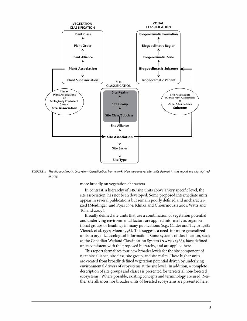
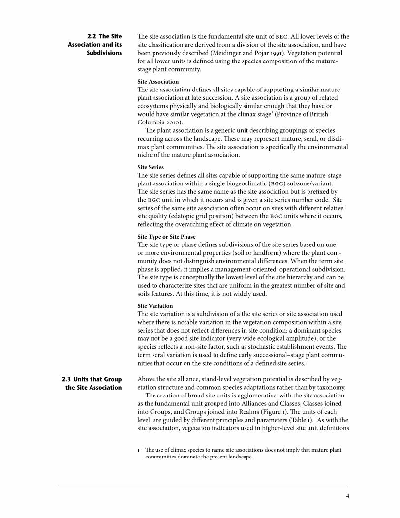
BEC is an integrated classification comprised of three component hierar-chies: vegetation, site, and zonal (Figure 1). The system is focussed on the site component; it aims to create units from sites with similar biological potential. BEC defines this potential at the association and series level by mature (cli-max) plant communities (vegetation hierarchy), which reflect both overarch-ing climatic factors (zonal hierarchy) and stand-level site and soil conditions. The site series represents an ecological attractor (Hauessler 2011) for a specific climate/site condition towards which vegetation will develop in a reasonably predictable manner over time.
The units of the vegetation and zonal components of BEC are defined by Meidinger and Pojar (1991). The units of the vegetation hierarchy are based on plant community species similarity throughout, and the resulting high-level units generally describe floristically related biogeographic zonal vegeta-tion or groups of ecosystems with strong site-level ecological factors. This is common for other plant community–based classifications (e.g., Rodwell et al. 2002; FGDC 2008).
A complete hierarchical classification is also presented for the zonal com-ponent of BEC. The biogeoclimactic zone, subzone, and variant are defined based on mature plant communities of zonal sites and are used extensively in BEC. Higher-level units apply global KÖppen bioclimatic types, which rely
2.1 Components of the Biogeoclimatic
ecosystem Classification system
3
more broadly on vegetation characters. In contrast, a hierarchy of BEC site units above a very specific level, the
site association, has not been developed. Some proposed intermediate units appear in several publications but remain poorly defined and uncharacter-ized (Meidinger and Pojar 1991; Klinka and Chourmouzis 2001; Watts and Tolland 2005 ).
Broadly defined site units that use a combination of vegetation potential and underlying environmental factors are applied informally as organiza-tional groups or headings in many publications (e.g., Calder and Taylor 1968; Viereck et al. 1992; Moen 1998). This suggests a need for more generalized units to organize ecological information. Some systems of classification, such as the Canadian Wetland Classification System (NWWG 1988), have defined units consistent with the proposed hierarchy, and are applied here.
This report formalizes four new broader levels for the site component of BEC: site alliance, site class, site group, and site realm. These higher units are created from broadly defined vegetation potential driven by underlying environmental drivers of ecosystems at the site level. In addition, a complete description of site groups and classes is presented for terrestrial non-forested ecosystems. Where possible, existing concepts and terminology are used. Nei-ther site alliances nor broader units of forested ecosystems are presented here.
Plant Class Biogeoclimatic Formation
Biogeoclimatic Region
Biogeoclimatic Zone
Biogeoclimatic Subzone
Biogeoclimatic Variant
Site Realm
Site Group
Site Class/Subclass
Site Association
Site Series
Site Alliance
Site Type
Plant Order
Plant Alliance
Plant Association
Plant Subassociation
VEGETATIONCLASSIFICATION
ZONALCLASSIFICATION
SITECLASSIFICATION
Climax Plant Associations
onEcologically Equivalent
Sites = Site Association
Site Association(Climax Plant Association)
ofZonal Sites defines
Subzone
Figure�1 The Biogeoclimatic Ecosystem Classification framework. New upper-level site units defined in this report are highlighted in grey.
4
The site association is the fundamental site unit of BEC. All lower levels of the site classification are derived from a division of the site association, and have been previously described (Meidinger and Pojar 1991). Vegetation potential for all lower units is defined using the species composition of the mature-stage plant community.
Site�AssociationThe site association defines all sites capable of supporting a similar mature plant association at late succession. A site association is a group of related ecosystems physically and biologically similar enough that they have or would have similar vegetation at the climax stage1 (Province of British Columbia 2010).
The plant association is a generic unit describing groupings of species recurring across the landscape. These may represent mature, seral, or discli-max plant communities. The site association is specifically the environmental niche of the mature plant association.
Site�SeriesThe site series defines all sites capable of supporting the same mature-stage plant association within a single biogeoclimatic (BGC) subzone/variant. The site series has the same name as the site association but is prefixed by the BGC unit in which it occurs and is given a site series number code. Site series of the same site association often occur on sites with different relative site quality (edatopic grid position) between the BGC units where it occurs, reflecting the overarching effect of climate on vegetation.
Site�Type�or�Site�PhaseThe site type or phase defines subdivisions of the site series based on one or more environmental properties (soil or landform) where the plant com-munity does not distinguish environmental differences. When the term site phase is applied, it implies a management-oriented, operational subdivision. The site type is conceptually the lowest level of the site hierarchy and can be used to characterize sites that are uniform in the greatest number of site and soils features. At this time, it is not widely used.
Site�VariationThe site variation is a subdivision of a the site series or site association used where there is notable variation in the vegetation composition within a site series that does not reflect differences in site condition: a dominant species may not be a good site indicator (very wide ecological amplitude), or the species reflects a non-site factor, such as stochastic establishment events. The term seral variation is used to define early successional–stage plant commu-nities that occur on the site conditions of a defined site series.
Above the site alliance, stand-level vegetation potential is described by veg-etation structure and common species adaptations rather than by taxonomy.
The creation of broad site units is agglomerative, with the site association as the fundamental unit grouped into Alliances and Classes, Classes joined into Groups, and Groups joined into Realms (Figure 1). The units of each level are guided by different principles and parameters (Table 1). As with the site association, vegetation indicators used in higher-level site unit definitions
1 The use of climax species to name site associations does not imply that mature plant communities dominate the present landscape.
2.3 Units that group the site association
2.2 the site association and its
subdivisions
5
Table�1 Ecosystem attributes used to differentiate between units of the same biogeoclimatic hierarchical level
BEC site unit Differentiating ecosystem attribute
Series Site association related to a specific biogeoclimatic unit
Association Biological (plant) community reflecting specific site and climate conditions
Alliance Species assemblages with broadly similar environmental requirements
Class Ecosystems with broadly similar site conditions along dominant environmental gradients as reflected in physiognomy (the life form, structure, and stature of vegetation) and species with similar adaptations. Subclasses describe subtypes of the Class based on physiognomic or gradient subdivisions.
Group Ecosystems that can be described by a common dominant environmental gradient(s)
Realm Ecosystems with common water source and character (and primary energy source)
are based on characteristics of mature vegetation. When classifying seral vegetation, stage of vegetation development should be taken into account, vegetation characteristics should be used with caution, and site and environ-mental characters should be emphasized.
Site�Alliance�The site alliance defines groups of site associations with broadly similar soil moisture and nutrient regimes, climatic regimes, and associated climax plant communities. Unlike the site class described below, species composition and regional climate are important defining characteristics of the alliance. The site alliance is related to the plant alliance or suborder of the vegetation compo-nent of BEC, but it is more broadly defined based on environmental factors. Diagnostic species groups reflect common climate, hydrology, and moisture/nutrient factors. An example of such a unit could be “rich, saturated boreal sedge fens” defined by basic groundwater, sedges indicative of permanent surface water levels (Carex limosa, Trichophorum alpinum, T. cespitosum), and brown mosses. The site alliance may be used for informal groupings of site associations, as no formal alliance units are currently described.
Site�Class/SubclassThe Class is the fundamental unit of the Canadian Wetland Classification System (NWWG 1988). Wetland classes are broad groupings of wetland ecosystems based on similar environmental factors (primarily hydrology), vegetation physiognomy, and, to a lesser extent, species “guilds.” The system is designed for nation-wide application and for non-technical users. Wetland classes are intentionally broad and not defined by species indicators. This unit is the conceptual basis for the site class presented in this report.
The site class describes ecosystems with similar basic underlying environ-mental attributes that support similar characteristic vegetation physiognomy and species adaptation guilds at climax. Subclasses may be designated for some classes based on physiognomic or environmental subdivisions.
Site�GroupThe site group designates a broad association of functionally similar eco-systems based on a dominant cluster of ecologically relevant environmental features. The site group joins site classes that may have different physiognomy but have common adaptations to a dominant environmental factor(s).
For this reason, each site group requires a different conceptual model of primary environmental drivers to describe ecosystem variability at the site
6
level. For example, the edatopic grid used for forested ecosystems uses soil moisture and soil nutrient gradients as the primary explanatory variables distinguishing site series. For the alpine group of ecosystems, however, snow cover is the primary determinant of site variability, so the classic edatopic grid is not suitable and must be replaced with an alternate model that uses snow cover regime as one of the primary axes.
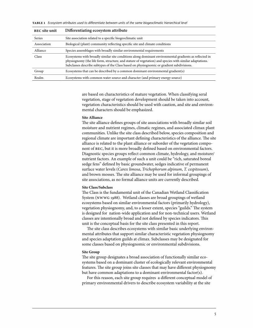
Site�RealmFigure 2 shows the relationship between broad ecosystem types (Fraser et al. 1995). The original intent was to help delineate areas of responsibility between agencies for ecological classification projects, but it also provides a high-level framework for relating terrestrial ecosystems to other ecosystems.
3.1 Physiognomic Cover Criteria
Figure�2 Diagram of site (ecosystem) realms (modified from Fraser et al. 1995). Core realms are unshaded; interface realms are shaded grey.
Freshwater Terrestrial
Marine
Wetland
Estuarine
Intertidal Wedge
Subterranean
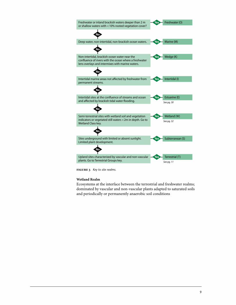
The site realm delineates major biotic types that reflect gross differences in water abundance, quality, and source. Units of the Terrestrial, Wetland, and Estuarine Realms are defined in this paper.
3 CRIteRIa foR non-foResteD teRRestRIal gRoUPs anD Classes
Site associations grouped into Classes and then Groups must reflect and be described by similar dominant environmental parameters. No strict rules are applied, but clear defining characters must be outlined in supporting models, descriptions, and keys. The site criteria used must be explanatory of the com-mon vegetation physiognomy and species guild.
Physiognomy (the life form, structure, and stature of vegetation) is an im-portant defining character in this broad classification system. We use a 10% average cover rule for all definitions (e.g., treed units have > 10% average tree cover) (Province of British Columbia 2002).2
2 Assignment of individual plots to associations will apply broader rules of cover cut-off. For associations with < 10% cut-offs (e.g., grassland versus shrubland), occasional plots with up to 15% cover may be included. For associations with a > 10% cut-off (i.e., forested versus non-forested), plots with as little as 7% may be included.
7
For the purposes of this paper, “forested” is broadly defined to include treed and woodland units:
Sites that support only sparse tree cover (< 10%) are non-forested. Sites with > 10% cover of trees > 10 m in height are treated as forested. Sites where maximum height of tree species at climax is < 10 m will be evaluated: forest types with continuous tree cover and normal growth form are generally considered to be “for-ested” even if stands do not meet the 10 m height criterion (e.g., bog woodlands).3
Letter codes are assigned to all units presented in this guide. For classes and associations, two-letter codes are used, and combine a higher-level letter codes with a class designation. For classes of the Terrestrial Realm, this code is a combination of the Group and the Class, as in the following examples:• Fl = Flood Group/Lowbench Class• At = Alpine Group/Tundra Class
For other realms, the code is a combination of the Realm and the Class: • Wb = Wetland Realm/Bog Class• Em = Estuarine Realm/Marsh Class
Site associations within each of these code groupings are given two-digit numerical identifiers. In MacKenzie and Moran (2004), the number series (01–99) was divided between coastal and interior types (01–49 for interior; 50–99 for coastal), but other conventions may be followed for other Groups. Generally, the most common types will be the first ecosystems in a number series, with less common ecosystems numbered later in the series.
There are some treed ecosystems that may receive both a typical BEC site series number and an association code designation. These include treed bogs and swamps, middle benches, forested avalanche ecosystems, and any other ecosystem that belongs to a group or class defined in this report but also meets the criteria for “forested” as defined above.
Examples:• ICHmc2/06(Fm02) Cottonwood – Dogwood middle benches• ICHmc2/07(Ws10) Redcedar – Skunk cabbage swamps• ICHmc2/08(Wb05) Black spruce – Water sedge – Peat-moss bogs
The site association is the working unit of the BEC system and is based on the plant association. In some site associations, the plant association does not discriminate among important site conditions that have been used to differ-entiate at the class level. For forested ecosystems, site series phases are used to describe different site or soil conditions of management interest within an ecosystem unit. We use the central concept principle for non-forested ecosystems, with units coded by the class that represents the typic condition. However, if the association occurs commonly across two (or more) classes, then the association is split into different classes, even though the plant asso-ciation may be the same. These two classes will occur together in a vegetation hierarchy.
For example, water sedge – beaked sedge communities are a very common plant association that occurs equally on mineral and peat substrates. Because this association is characterized by few species and large ecological amplitude
3 Note that this is a rule-of-thumb only and exceptions may be proposed.
3.2 Coding of ecosystem Units
3.3 non-forested associations that
Cross Class or group Boundaries
8
4.1 Core Realms
4.2 Interface Realms
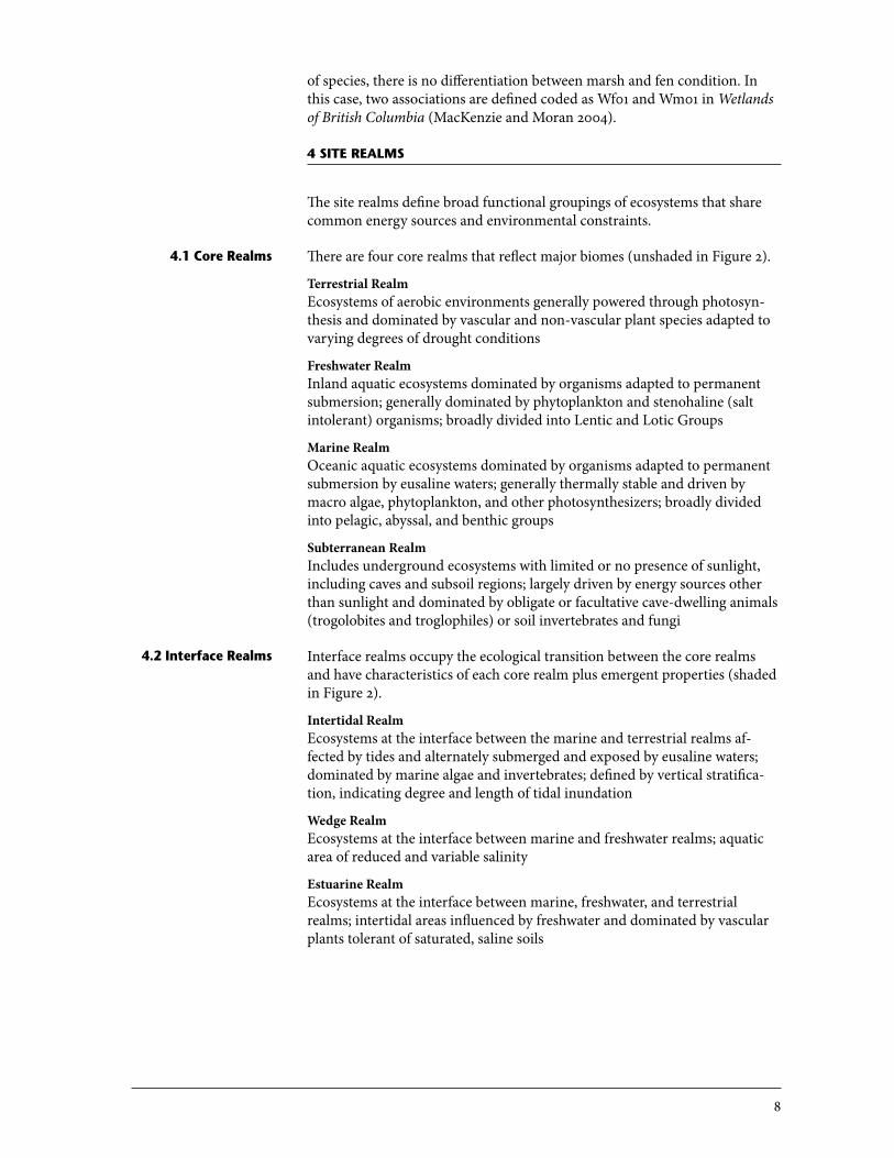
of species, there is no differentiation between marsh and fen condition. In this case, two associations are defined coded as Wf01 and Wm01 in Wetlands of British Columbia (MacKenzie and Moran 2004).
4 sIte Realms
The site realms define broad functional groupings of ecosystems that share common energy sources and environmental constraints.
There are four core realms that reflect major biomes (unshaded in Figure 2).
Terrestrial�RealmEcosystems of aerobic environments generally powered through photosyn-thesis and dominated by vascular and non-vascular plant species adapted to varying degrees of drought conditions
Freshwater�RealmInland aquatic ecosystems dominated by organisms adapted to permanent submersion; generally dominated by phytoplankton and stenohaline (salt intolerant) organisms; broadly divided into Lentic and Lotic Groups
Marine�RealmOceanic aquatic ecosystems dominated by organisms adapted to permanent submersion by eusaline waters; generally thermally stable and driven by macro algae, phytoplankton, and other photosynthesizers; broadly divided into pelagic, abyssal, and benthic groups
Subterranean�RealmIncludes underground ecosystems with limited or no presence of sunlight, including caves and subsoil regions; largely driven by energy sources other than sunlight and dominated by obligate or facultative cave-dwelling animals (trogolobites and troglophiles) or soil invertebrates and fungi
Interface realms occupy the ecological transition between the core realms and have characteristics of each core realm plus emergent properties (shaded in Figure 2).
Intertidal�RealmEcosystems at the interface between the marine and terrestrial realms af-fected by tides and alternately submerged and exposed by eusaline waters; dominated by marine algae and invertebrates; defined by vertical stratifica-tion, indicating degree and length of tidal inundation
Wedge�RealmEcosystems at the interface between marine and freshwater realms; aquatic area of reduced and variable salinity
Estuarine�RealmEcosystems at the interface between marine, freshwater, and terrestrial realms; intertidal areas influenced by freshwater and dominated by vascular plants tolerant of saturated, saline soils
9
Figure�3 Key to site realms.
Wetland�RealmEcosystems at the interface between the terrestrial and freshwater realms; dominated by vascular and non-vascular plants adapted to saturated soils and periodically or permanently anaerobic soil conditions
Freshwater (O)Yes
Marine (M)Yes
Wedge (K)Yes
Intertidal (I)Yes
Estuarine (E)Yes
Wetland (W)Yes
Subterranean (S)Yes
Terrestrial (T)Yes
Freshwater or inland brackish waters deeper than 2 m or shallow waters with < 10% rooted vegetation cover?
Deep water, non-intertidal, non-brackish ocean waters.
Non-intertidal, brackish ocean water near the confluence of rivers with the ocean where a freshwater lens overlays and intermixes with marine waters.
Intertidal marine areas not affected by freshwater from permanent streams.
No
Intertidal sites at the confluence of streams and ocean and affected by brackish tidal water flooding.
Semi-terrestrial sites with wetland soil and vegetation indicators or vegetated still waters < 2m in depth. Go to Wetland Class key.
Sites underground with limited or absent sunlight. Limited plant development.
Upland sites characterized by vascular and non-vascular plants. Go to Terrestrial Groups key.
No
No
No
No
No
No
See pg. 11
See pg. 32
See pg. 30
10
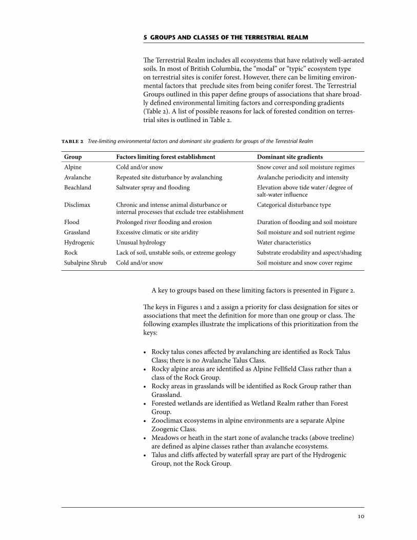
5 gRoUPs anD Classes of the teRRestRIal Realm
The Terrestrial Realm includes all ecosystems that have relatively well-aerated soils. In most of British Columbia, the “modal” or “typic” ecosystem type on terrestrial sites is conifer forest. However, there can be limiting environ-mental factors that preclude sites from being conifer forest. The Terrestrial Groups outlined in this paper define groups of associations that share broad-ly defined environmental limiting factors and corresponding gradients (Table 2). A list of possible reasons for lack of forested condition on terres-trial sites is outlined in Table 2.
Group Factors�limiting�forest�establishment Dominant�site�gradientsAlpine Cold and/or snow Snow cover and soil moisture regimesAvalanche Repeated site disturbance by avalanching Avalanche periodicity and intensityBeachland Saltwater spray and flooding Elevation above tide water / degree of
salt-water influenceDisclimax Chronic and intense animal disturbance or
internal processes that exclude tree establishmentCategorical disturbance type
Flood Prolonged river flooding and erosion Duration of flooding and soil moistureGrassland Excessive climatic or site aridity Soil moisture and soil nutrient regimeHydrogenic Unusual hydrology Water characteristicsRock Lack of soil, unstable soils, or extreme geology Substrate erodability and aspect/shadingSubalpine Shrub Cold and/or snow Soil moisture and snow cover regime
Table�2 Tree-limiting environmental factors and dominant site gradients for groups of the Terrestrial Realm
A key to groups based on these limiting factors is presented in Figure 2.
The keys in Figures 1 and 2 assign a priority for class designation for sites or associations that meet the definition for more than one group or class. The following examples illustrate the implications of this prioritization from the keys:
• Rocky talus cones affected by avalanching are identified as Rock Talus Class; there is no Avalanche Talus Class.
• Rocky alpine areas are identified as Alpine Fellfield Class rather than a class of the Rock Group.
• Rocky areas in grasslands will be identified as Rock Group rather than Grassland.
• Forested wetlands are identified as Wetland Realm rather than Forest Group.
• Zooclimax ecosystems in alpine environments are a separate Alpine Zoogenic Class.
• Meadows or heath in the start zone of avalanche tracks (above treeline) are defined as alpine classes rather than avalanche ecosystems.
• Talus and cliffs affected by waterfall spray are part of the Hydrogenic Group, not the Rock Group.
11
Figure�4 Key to terrestrial groups.
Avalanche (V)Yes
Rock (R)Yes
Flood (F)Yes
Zoogenic (Z)Yes
Hydrogenic (H)Yes
Beachlands (B)Yes
Subalpine (shrub) (S)
Yes
Alpine (A)Yes
Sites near or above treeline or on lower-elevation frost-prone sites where cold and/or snow are limiting factors.
Sites dominated (> 10% cover) by shrubs > 0.20 m in height.
Sites at lower elevations or not frost prone; not affected by severe cold.
Sites in supra-tidal areas affected by salt spray or occasional saltwater flooding. Species tolerant of saline soils.
Sites affected by continual waterfall spray, vernal flooding, mineral springs. Commonly herb or bryoid dominated.
Ecosystems maintained by severe and chronic animal activities (grazing, turbation, defecation, congregation). Typically highly localized and distinctive from adjacent sites.
Sites adjacent to flowing water or larger still waters and affected by prolonged flooding or subirrigation. Typically, tall deciduous shrubs and trees dominate.
Sites with thin and discontinuous soil, abundance of exposed rock, dominated by xerophytes, and commonly with low cover of vascular vegetation.
No
No
No
No
No
Sites with few shrubs > 0.20 m (< 10%). Higher cover of dwarf shrubs may occur.
Sites located in avalanche slide tracks and affected by snow scouring or accumulation.
Ecosystems of semi-arid climates or xeric, insulated sites in forested zones. Dominated by graminoids or moderate-statured drought-adapted shrubs.
Grassland (G)Yes
Persistent, self-maintained shrub or herb seral ecosystems with no apparent conifer-limiting site factors. Disclimax (X)Yes
No
No
No
No
Yes
Yes
While groups are defined primarily by environmental limiting factors and dominant differentiating gradients, each group also reflects broad biological potential and corresponding species groups.
12
The Alpine Group includes all ecosystems where cold, short growing seasons and harsh winters, in combination, are too extreme for the establishment and growth of trees or erect shrubs. The limited growing season can be the result of cold air or soil temperatures, high incidence of frost during the growing season, extreme winter conditions, or prolonged snow lay into the growing season. The modal condition for the group is the alpine zone above treeline where the alpine group of ecosystems constitute the entire vegetation. How-ever, alpine group ecosystems occur at lower elevations in azonal locations as well. Alpine-like site conditions and corresponding alpine group ecosystems are generally very common in the subalpine parkland, and become less fre-quent at lower elevations. Widespread occurrence of alpine group ecosystems at lower (montane) elevations is seen in some regions where sites affected by cold air during the growing season are common, such as the Chilcotin Plateau and the Boreal Mountains ecoregions.
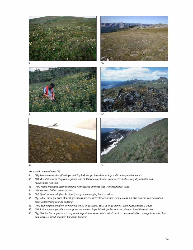
Because the Alpine Group describes an entire biome based on climatic limitations, it requires more classes to describe site variation than other groups presented in this report. Photographs of some ecosystems represent-ing each alpine class are presented in Figure 6.
Snow cover is the primary environmental gradient affecting alpine ecosys-tems, considering both winter snow cover (protection from winter weather and soil freezing) and growing-season cover (reduction in the effective grow-ing degree days). Soil moisture regime is an important secondary gradient.
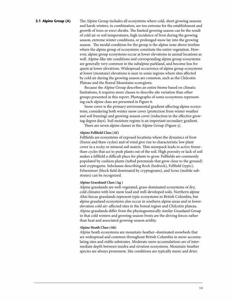
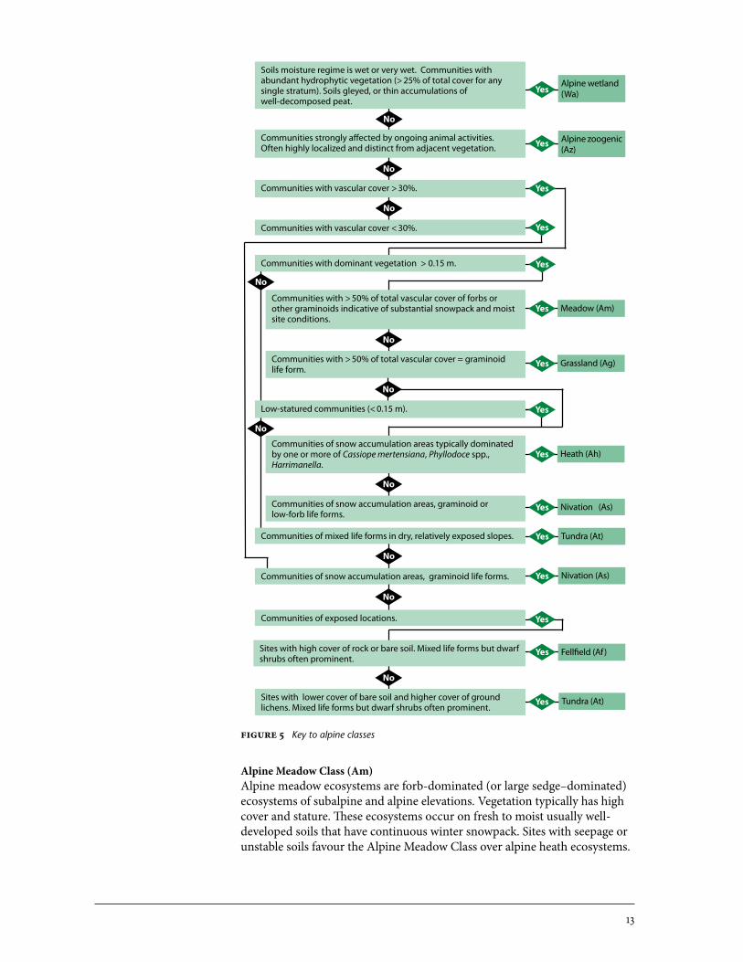
There are seven alpine classes in the Alpine Group (Figure 5).
Alpine�Fellfield�Class�(Af)�Fellfields are ecosystems of exposed locations where the dynamics of frost (freeze and thaw cycles) and of wind give rise to characteristic low plant cover in a rocky or mineral soil matrix. Thin snowpack leads to active freeze–thaw cycles that act to push plants out of the soil. High porosity or lack of soil makes a fellfield a difficult place for plants to grow. Fellfields are commonly populated by cushion plants (tufted perennials that grow close to the ground) and cryptogams. Subclasses describing Rock (bedrock), Fellfield (typic), Felsenmeer (block field dominated by cryptograms), and Scree (mobile sub-strates) can be recognized.
Alpine�Grassland�Class�(Ag�)�Alpine grasslands are well-vegetated, grass-dominated ecosystems of dry, cold climates with low snow load and well-developed soils. Northern alpine Altai fescue grasslands represent typic ecosystems in British Columbia, but alpine grassland ecosystems also occur in southern alpine areas and in lower-elevation cold air–affected sites in the boreal region and Chilcotin plateau. Alpine grasslands differ from the physiognomically similar Grassland Group in that cold winters and growing-season frosts are the driving forces rather than heat and associated growing-season aridity.
Alpine�Heath�Class�(Ah)Alpine heath ecosystems are mountain-heather–dominated snowbeds that are widespread and common throughout British Columbia in snow-accumu-lating sites and stable substrates. Moderate snow accumulations are of inter-mediate depth between tundra and nivation ecosystems. Mountain-heather species are always prominent. Site conditions are typically mesic and drier.
5.1 alpine group (a)
13
Alpine�Meadow�Class�(Am)�Alpine meadow ecosystems are forb-dominated (or large sedge–dominated) ecosystems of subalpine and alpine elevations. Vegetation typically has high cover and stature. These ecosystems occur on fresh to moist usually well-developed soils that have continuous winter snowpack. Sites with seepage or unstable soils favour the Alpine Meadow Class over alpine heath ecosystems.
Alpine wetland (Wa)Yes
Alpine zoogenic (Az)
Yes
Yes
Yes
Yes
Meadow (Am)Yes
Grassland (Ag)Yes
Yes
Heath (Ah)Yes
Nivation (As)Yes
Tundra (At)Yes
Nivation (As)Yes
Yes
Fellfield (Af)Yes
Tundra (At)Yes
Soils moisture regime is wet or very wet. Communities with abundant hydrophytic vegetation (> 25% of total cover for any single stratum). Soils gleyed, or thin accumulations of well-decomposed peat.
Communities strongly affected by ongoing animal activities. Often highly localized and distinct from adjacent vegetation.
Communities with vascular cover > 30%.
Communities with vascular cover < 30%.
No
Communities with dominant vegetation > 0.15 m.
Communities with > 50% of total vascular cover of forbs or other graminoids indicative of substantial snowpack and moist site conditions.
Communities with > 50% of total vascular cover = graminoid life form.
Low-statured communities (< 0.15 m).
No
No
No
No
No
No
Communities of snow accumulation areas typically dominated by one or more of Cassiope mertensiana, Phyllodoce spp., Harrimanella.
Communities of snow accumulation areas, graminoid or low-forb life forms.
Communities of mixed life forms in dry, relatively exposed slopes.
Communities of snow accumulation areas, graminoid life forms.
Communities of exposed locations.
Sites with high cover of rock or bare soil. Mixed life forms but dwarf shrubs often prominent.
Sites with lower cover of bare soil and higher cover of ground lichens. Mixed life forms but dwarf shrubs often prominent.
No
No
No
No
Figure�5 Key to alpine classes
14
6a 6b
6c
6e 6f
6d
Figure�6 Alpine Group (A). 6a (Ah) Mountain-heather (Cassiope and Phyllodoce spp.) heath is widespread in snowy environments. 6b (At) Mountain-avens (Dryas integrifolia and D. Octopetala) tundra occurs extensively in very dry climates and
favours base-rich soils.6c (Am) Alpine meadows occur commonly near treeline on moist sites with good snow cover.6d (Af) Northern fellfield on rocky peak.6e (As) Piper’s wood-rush (Luzula piperi) ecosystem emerging from snowbed.6f (Ag) Altai Fescue (Festuca altaica) grasslands are characteristic of northern alpine areas but also occur in lower-elevation
areas experiencing cold-air ponding.6g (Am) Some alpine meadows are dominated by large sedges, such as large-awned sedge (Carex macrochaeta).6h (Af) Active scree slopes often have sparse vegetation of specialized species that are tolerant of mobile substrates.6i (Ag) Treeline fescue grasslands may result in part from warm winter winds, which cause dessication damage to woody plants
and forbs (Flathead, southern Canadian Rockies).
15
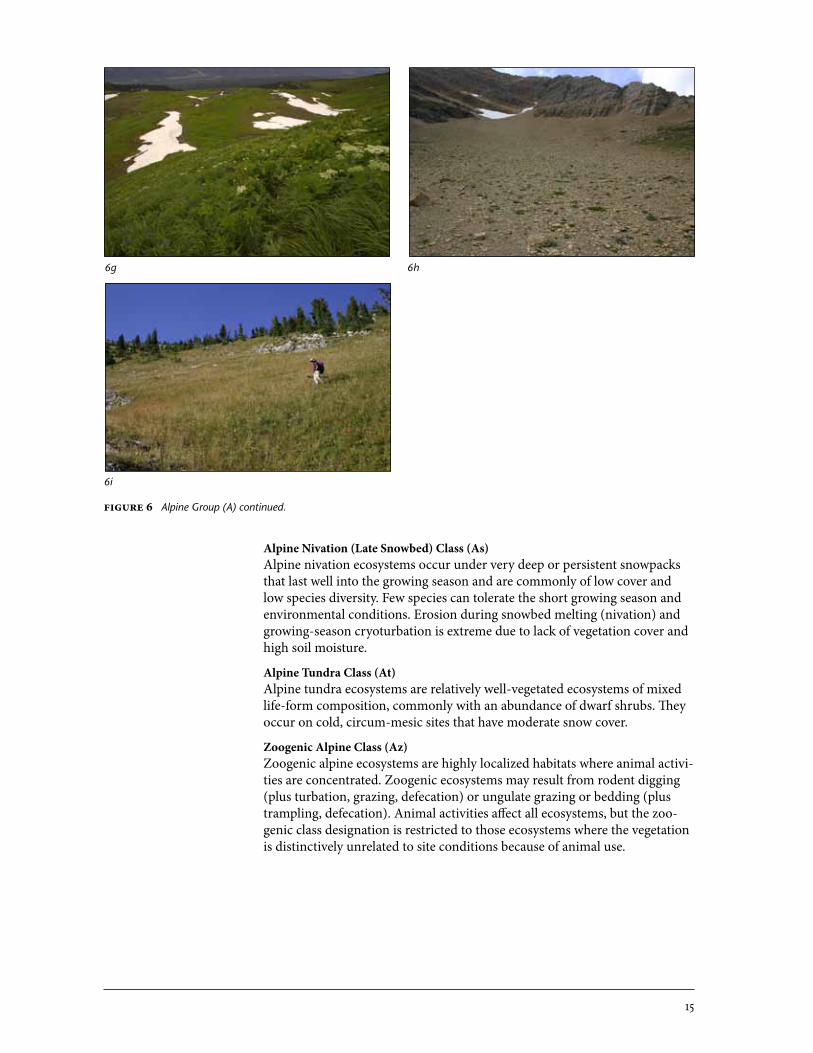
Alpine�Nivation�(Late�Snowbed)�Class�(As)Alpine nivation ecosystems occur under very deep or persistent snowpacks that last well into the growing season and are commonly of low cover and low species diversity. Few species can tolerate the short growing season and environmental conditions. Erosion during snowbed melting (nivation) and growing-season cryoturbation is extreme due to lack of vegetation cover and high soil moisture.
Alpine�Tundra�Class�(At)Alpine tundra ecosystems are relatively well-vegetated ecosystems of mixed life-form composition, commonly with an abundance of dwarf shrubs. They occur on cold, circum-mesic sites that have moderate snow cover.
Zoogenic�Alpine�Class�(Az)Zoogenic alpine ecosystems are highly localized habitats where animal activi-ties are concentrated. Zoogenic ecosystems may result from rodent digging (plus turbation, grazing, defecation) or ungulate grazing or bedding (plus trampling, defecation). Animal activities affect all ecosystems, but the zoo-genic class designation is restricted to those ecosystems where the vegetation is distinctively unrelated to site conditions because of animal use.
6g 6h
6i
Figure�6 Alpine Group (A) continued.
16
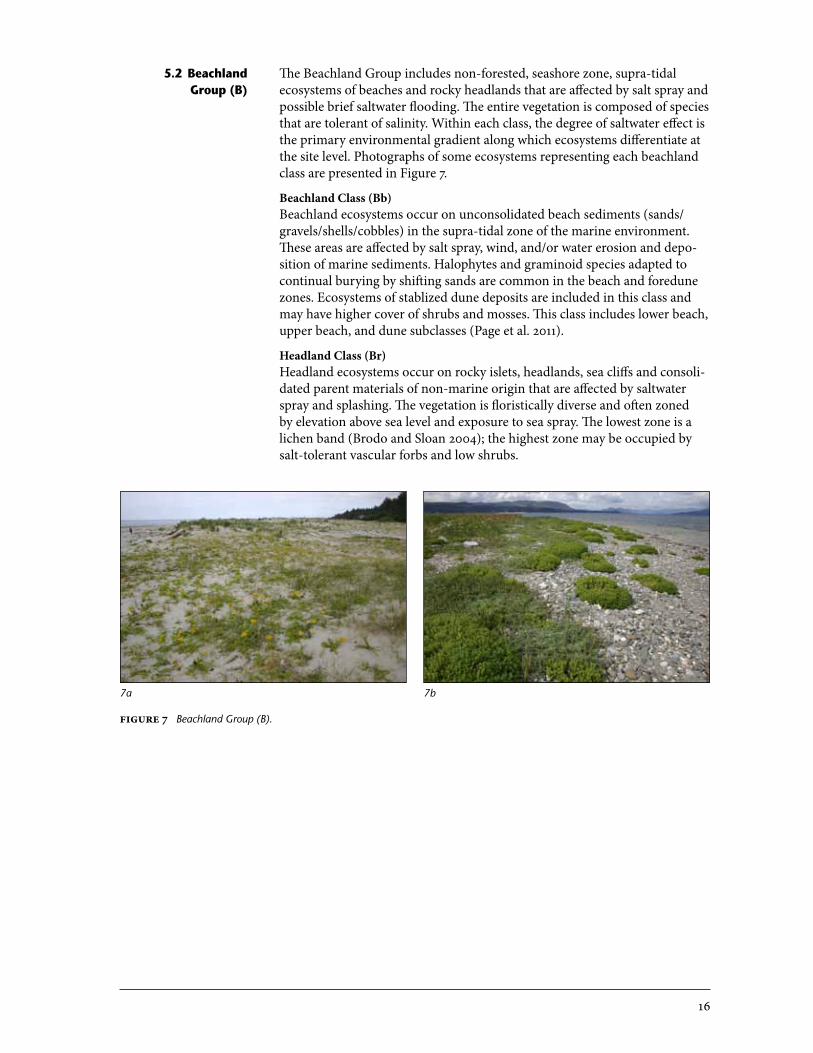
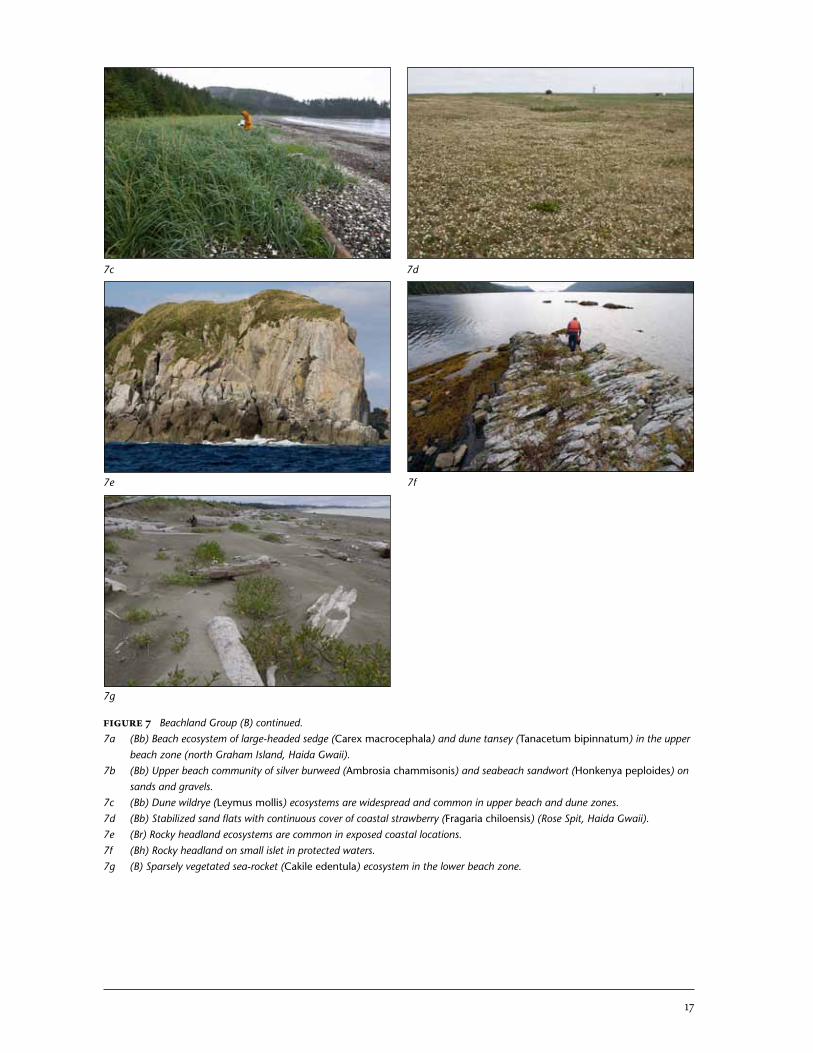
The Beachland Group includes non-forested, seashore zone, supra-tidal ecosystems of beaches and rocky headlands that are affected by salt spray and possible brief saltwater flooding. The entire vegetation is composed of species that are tolerant of salinity. Within each class, the degree of saltwater effect is the primary environmental gradient along which ecosystems differentiate at the site level. Photographs of some ecosystems representing each beachland class are presented in Figure 7.
Beachland�Class�(Bb)�Beachland ecosystems occur on unconsolidated beach sediments (sands/gravels/shells/cobbles) in the supra-tidal zone of the marine environment. These areas are affected by salt spray, wind, and/or water erosion and depo-sition of marine sediments. Halophytes and graminoid species adapted to continual burying by shifting sands are common in the beach and foredune zones. Ecosystems of stablized dune deposits are included in this class and may have higher cover of shrubs and mosses. This class includes lower beach, upper beach, and dune subclasses (Page et al. 2011).
Headland�Class�(Br)�Headland ecosystems occur on rocky islets, headlands, sea cliffs and consoli-dated parent materials of non-marine origin that are affected by saltwater spray and splashing. The vegetation is floristically diverse and often zoned by elevation above sea level and exposure to sea spray. The lowest zone is a lichen band (Brodo and Sloan 2004); the highest zone may be occupied by salt-tolerant vascular forbs and low shrubs.
5.2 Beachland group (B)
7a 7b
Figure�7 Beachland Group (B).
17
Figure�7 Beachland Group (B) continued.7a (Bb) Beach ecosystem of large-headed sedge (Carex macrocephala) and dune tansey (Tanacetum bipinnatum) in the upper
beach zone (north Graham Island, Haida Gwaii).7b (Bb) Upper beach community of silver burweed (Ambrosia chammisonis) and seabeach sandwort (Honkenya peploides) on
sands and gravels.7c (Bb) Dune wildrye (Leymus mollis) ecosystems are widespread and common in upper beach and dune zones.7d (Bb) Stabilized sand flats with continuous cover of coastal strawberry (Fragaria chiloensis) (Rose Spit, Haida Gwaii).7e (Br) Rocky headland ecosystems are common in exposed coastal locations.7f (Bh) Rocky headland on small islet in protected waters.7g (B) Sparsely vegetated sea-rocket (Cakile edentula) ecosystem in the lower beach zone.
7c 7d
7e
7g
7f
18
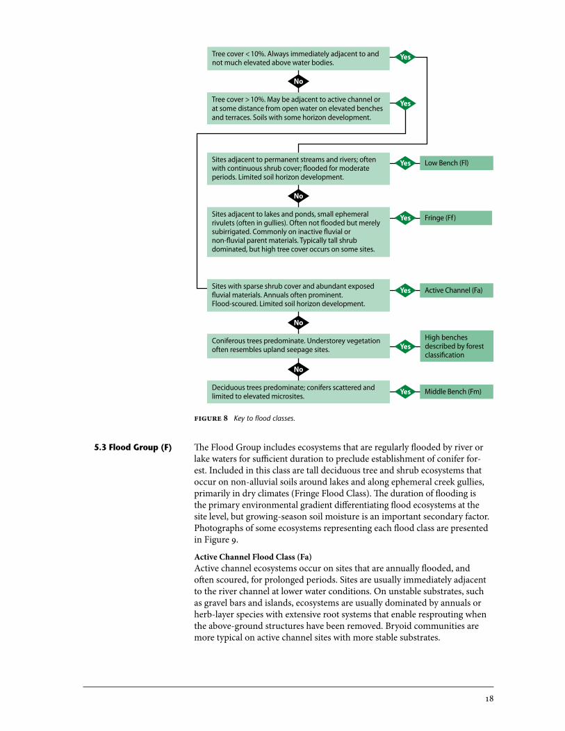
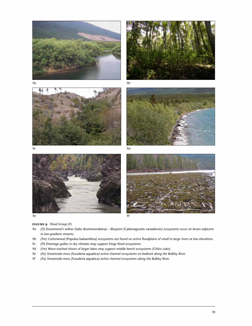
The Flood Group includes ecosystems that are regularly flooded by river or lake waters for sufficient duration to preclude establishment of conifer for-est. Included in this class are tall deciduous tree and shrub ecosystems that occur on non-alluvial soils around lakes and along ephemeral creek gullies, primarily in dry climates (Fringe Flood Class). The duration of flooding is the primary environmental gradient differentiating flood ecosystems at the site level, but growing-season soil moisture is an important secondary factor. Photographs of some ecosystems representing each flood class are presented in Figure 9.
Active�Channel�Flood�Class�(Fa)Active channel ecosystems occur on sites that are annually flooded, and often scoured, for prolonged periods. Sites are usually immediately adjacent to the river channel at lower water conditions. On unstable substrates, such as gravel bars and islands, ecosystems are usually dominated by annuals or herb-layer species with extensive root systems that enable resprouting when the above-ground structures have been removed. Bryoid communities are more typical on active channel sites with more stable substrates.
Yes
Yes
Low Bench (Fl)Yes
Fringe (Ff)Yes
Active Channel (Fa)Yes
High benches described by forest classification
Yes
Middle Bench (Fm)Yes
Tree cover < 10%. Always immediately adjacent to and not much elevated above water bodies.
Tree cover > 10%. May be adjacent to active channel or at some distance from open water on elevated benches and terraces. Soils with some horizon development.
Sites adjacent to permanent streams and rivers; often with continuous shrub cover; flooded for moderate periods. Limited soil horizon development.
Sites adjacent to lakes and ponds, small ephemeral rivulets (often in gullies). Often not flooded but merely subirrigated. Commonly on inactive fluvial or non-fluvial parent materials. Typically tall shrub dominated, but high tree cover occurs on some sites.
No
Sites with sparse shrub cover and abundant exposed fluvial materials. Annuals often prominent. Flood-scoured. Limited soil horizon development.
Coniferous trees predominate. Understorey vegetation often resembles upland seepage sites.
Deciduous trees predominate; conifers scattered and limited to elevated microsites.
No
No
No
Figure�8 Key to flood classes.
5.3 flood group (f)
19
Figure�9 Flood Group (F).9a (Fl) Drummond’s willow (Salix drummondiana) – Bluejoint (Calamagrostis canadensis) ecosystems occur on levees adjacent
to low-gradient streams.9b (Fm) Cottonwood (Populus balsamifera) ecosystems are found on active floodplains of small to large rivers at low elevations.9c (Ff) Drainage gullies in dry climates may support fringe flood ecosystems.9d (Fm) Wave-washed shores of larger lakes may support middle bench ecosystems (Chilco Lake). 9e (Fa) Streamside moss (Scouleria aquatica) active channel ecosystems on bedrock along the Bulkley River.9f (Fa) Streamside moss (Scouleria aquatica) active channel ecosystems along the Bulkley River.
9a 9b
9c 9d
9e 9f
20
Low�Bench�Flood�Class�(Fl)Low bench ecosystems occur on sites that are flooded for moderate periods (< 40 days) of the growing season—conditions that limit the canopy to tall shrubs, especially willows or alders. Annual erosion and deposition of sedi-ments (sands and silts) generally limit understorey and humus development. These ecosystems are most commonly associated with fluvial systems but also occur on wave-washed beaches of larger lakes. They are floristically related to many shrub swamps but occur on non-wetland soils and do not have an abundance of hydrophytes.
Middle�Bench�Flood�Class�(Fm)Middle bench ecosystems occur on sites briefly flooded (10–25 days) during freshet, allowing tree growth, but forests are dominated by flood-tolerant broadleaf species, such as black cottonwood and red alder. Conifers may oc-cur on elevated microsites but are less abundant than deciduous trees.
Fringe�Flood�Class�(Ff)Fringe flood ecosystems develop on subirrigated but rarely flooded non-alluvial soils next to lakes and other still waters, or in slope draws and gullies in areas with dry climates. High soil moisture and modified climates produce tall broadleaf shrub or low treed ecosystems that are distinct from the adja-cent upland. These ecosystems are differentiated from the Brushland Class in dry environments by tall shrub physiognomy and moist site conditions.
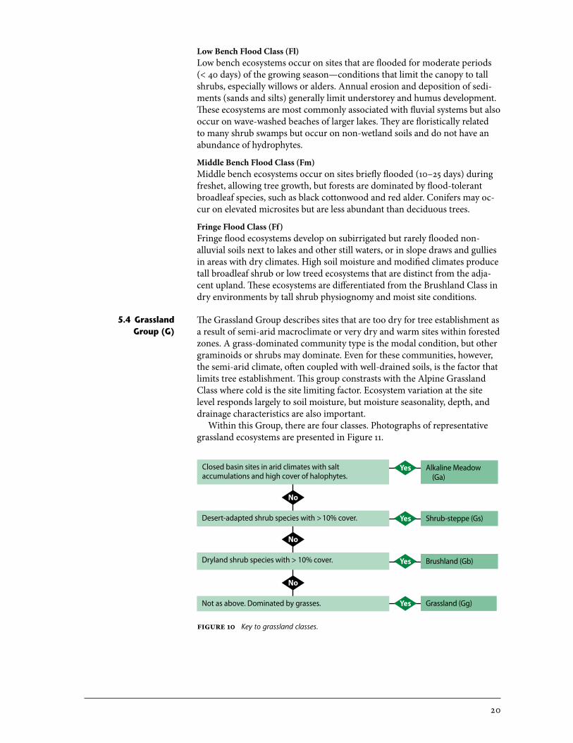
The Grassland Group describes sites that are too dry for tree establishment as a result of semi-arid macroclimate or very dry and warm sites within forested zones. A grass-dominated community type is the modal condition, but other graminoids or shrubs may dominate. Even for these communities, however, the semi-arid climate, often coupled with well-drained soils, is the factor that limits tree establishment. This group constrasts with the Alpine Grassland Class where cold is the site limiting factor. Ecosystem variation at the site level responds largely to soil moisture, but moisture seasonality, depth, and drainage characteristics are also important.
Within this Group, there are four classes. Photographs of representative grassland ecosystems are presented in Figure 11.
5.4 grassland group (g)
Alkaline Meadow (Ga)
Yes
Shrub-steppe (Gs)Yes
Brushland (Gb)Yes
Grassland (Gg)Yes
Closed basin sites in arid climates with salt accumulations and high cover of halophytes.
Desert-adapted shrub species with > 10% cover.
Dryland shrub species with > 10% cover.
Not as above. Dominated by grasses.
No
No
No
Figure�10 Key to grassland classes.
21
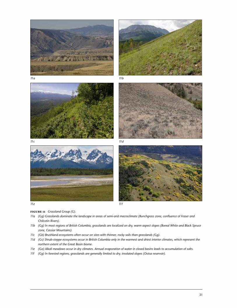
Figure�11 Grassland Group (G).11a (Gg) Grasslands dominate the landscape in areas of semi-arid macroclimate (Bunchgrass zone, confluence of Fraser and
Chilcotin Rivers).11b (Gg) In most regions of British Columbia, grasslands are localized on dry, warm aspect slopes (Boreal White and Black Spruce
zone, Cassiar Mountains).11c (Gb) Brushland ecosystems often occur on sites with thinner, rocky soils than grasslands (Gg).11d (Gs) Shrub-steppe ecosystems occur in British Columbia only in the warmest and driest interior climates, which represent the
northern extent of the Great Basin biome.11e (Ga) Alkali meadows occur in dry climates. Annual evaporation of water in closed basins leads to accumulation of salts.11f (Gg) In forested regions, grasslands are generally limited to dry, insolated slopes (Ootsa reservoir).
11a 11b
11c 11d
11e 11f
22
Grassland�Class�(Gg)�The Grassland Class defines typic grassland ecosystems that are widespread in semi-arid climates and on very dry sites in non-grassland climates. These ecosystems are graminoid-dominated associations that occur primarily on deep soils, but sites are dry because of very rapid soil drainage, insolation, and/or lack of precipitation. If shrubs occur, they are sparse (< 10%) or of lower stature than grasses. On thinner soils, these communities border on members of the Rock/Talus Group. Site conditions that are similar but are dominated by shrubs are part of the Shrub-steppe or Brushland Classes.
Shrub-Steppe�Class�(Gs)Shrub-steppe ecosystems occur only in the relatively hot, semi-arid climates of British Columbia (Bunchgrass / Ponderosa Pine and very dry and hot Interior Douglas-fir biogeoclimatic areas), and are dominated (> 10%) by semi-desert–adapted, drought- and heat-tolerant, woody shrubs of medium stature but greater stature than the herb layer. Shrub-steppe species such as sagebrush (Artemisia tridentata), or antelope-brush (Purshia tridentata) are prominent.
Brushland�Class�(Gb)Brushland ecosystems occur outside of warm semi-arid climates and are dominated (> 10%) by drought-tolerant woody shrubs of moderate stature. Temperate species such as saskatoon (Amelanchier alnifolia), junipers (Juni-perus spp.), cherries (Prunus spp.), and snowberry (Symphoricarpus spp.) are typical.
Alkaline/Saline�Meadow�Class�(Ga)Alkaline/saline meadows are graminoid- or halophyte-dominated sites that occur in shallow, closed basins of dry inland climates where evaporation of standing waters leads to the progressive accumulation of salts. These con-ditions occur only in the driest climates of British Columbia. Interannual variation in hydrology is typical for these closed basin systems. But generally, after a brief period of inundation, a surface water table drops below the root-ing zone for the growing season, resulting in a well-aerated rooting medium. This class was previously described and coded as Saline meadow Transition Class (Gs) in MacKenzie and Moran (2004). A halophyte subclass dominated by succulent species such as Suaeda spp. or Salicornia spp. is recognized.
The Hydrogenic Group includes a disparate suite of ecosystems that are affected by specialized water conditions not covered by other groups. These ecosystems are commonly highly localized and support uncommon spe-cies that are specifically adapted to the unusual environmental conditions. Environmental gradient differentiating ecosystems at the site level are largely related to hydrological characteristics and gradients that are specific to the class. Photos of some ecosystems representing each hydrogenic class are presented in Figure 12.
Spring-seepage�Class�(Hs)Spring-seepage ecosystems occur on mineral springs and seeps but do not meet the criteria for wetland ecosystems. Spring-seepage ecosystems often have very distinctive vegetation that is tolerate of the mineral accumula-tions and specific mineralogy of the seepage. These ecosystems include tufa, traverntine, and hydromagnesite springs and associated deposits. Spring-
5.5 hydrogenic group (h)
23
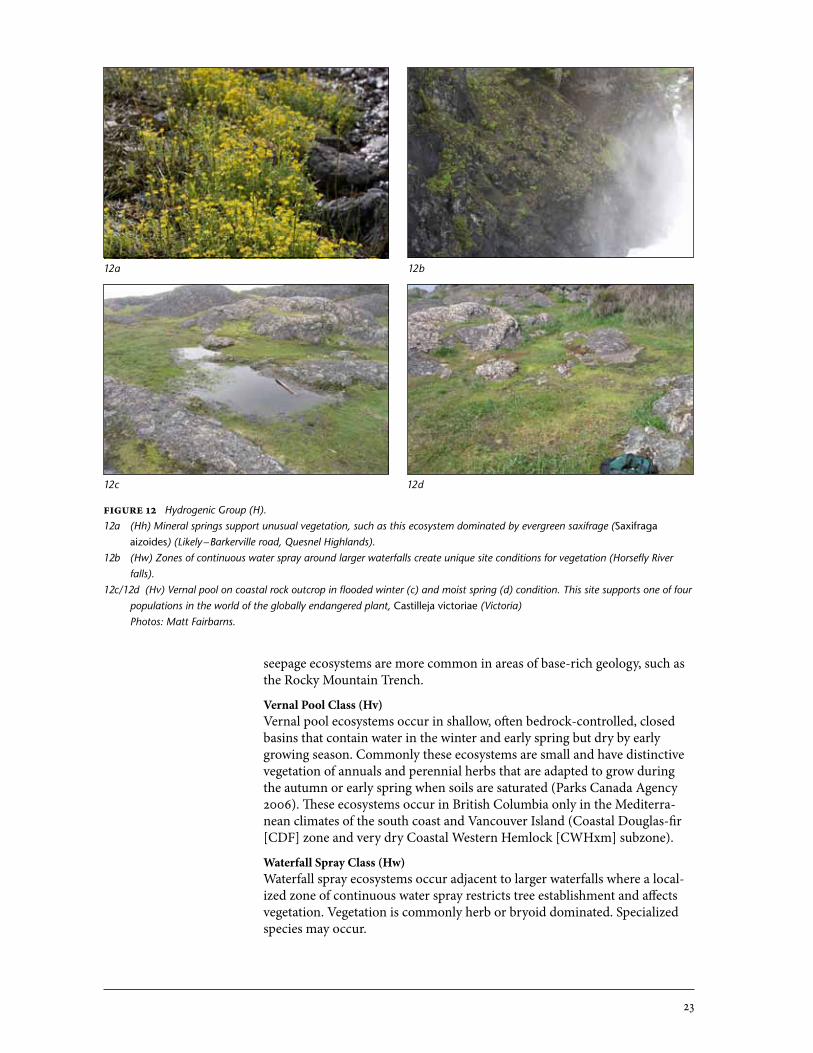
Figure�12 Hydrogenic Group (H).12a (Hh) Mineral springs support unusual vegetation, such as this ecosystem dominated by evergreen saxifrage (Saxifraga
aizoides) (Likely – Barkerville road, Quesnel Highlands).12b (Hw) Zones of continuous water spray around larger waterfalls create unique site conditions for vegetation (Horsefly River
falls).12c/12d (Hv) Vernal pool on coastal rock outcrop in flooded winter (c) and moist spring (d) condition. This site supports one of four
populations in the world of the globally endangered plant, Castilleja victoriae (Victoria) Photos: Matt Fairbarns.
12a
12c 12d
12b
seepage ecosystems are more common in areas of base-rich geology, such as the Rocky Mountain Trench.
Vernal�Pool�Class�(Hv)Vernal pool ecosystems occur in shallow, often bedrock-controlled, closed basins that contain water in the winter and early spring but dry by early growing season. Commonly these ecosystems are small and have distinctive vegetation of annuals and perennial herbs that are adapted to grow during the autumn or early spring when soils are saturated (Parks Canada Agency 2006). These ecosystems occur in British Columbia only in the Mediterra-nean climates of the south coast and Vancouver Island (Coastal Douglas-fir [CDF] zone and very dry Coastal Western Hemlock [CWHxm] subzone).
Waterfall�Spray�Class�(Hw)Waterfall spray ecosystems occur adjacent to larger waterfalls where a local-ized zone of continuous water spray restricts tree establishment and affects vegetation. Vegetation is commonly herb or bryoid dominated. Specialized species may occur.
24
5.6 Rock group (R) The Rock Group includes lowland sites with little soil, abundant cover of rock or bedrock, and generally low cover of vascular plants. Ecosystem variation at the site level is influenced by rock characteristics and small variances in site moisture (from microclimatic differences or patterns of periodic sheet flow)(Sadler 2007). This group does not include Alpine Fellfield or supra-tidal Headland Class. Photographs of some ecosystems representing each rock class are presented in Figure 13.
Cliff�Class�(Rc)Cliff ecosystems are vertical rock sites, commonly with high bryophyte cover (rock crusts), but small pockets of soils may support vascular vegetation.
Rock�Outcrop�Class�(Ro)Rock outcrop ecosystems are bluffs and knobs of bedrock with limited soil development and high cover of exposed rock. Drought-tolerant cryptogams are often prominent and vascular plants are limited. Subclasses based on geologic characteristics can be differentiated (e.g., ultramafic/serpentine; limestone subclasses).
Talus�Class�(Rt)Talus ecosystems are active and inactive talus (large rocks) and scree (smaller rocks and more soil). These ecosystems typically have a low herb layer cover because of mobile substrates or lack of soil. Stable talus may have high bryo-phyte cover, particularly on cool aspects with stable substrates, or vegetation similar to adjacent rock outcrop communities. Some stable talus ecosystems may have some cover of deciduous trees or shrubs. Unstable sites may have distinct communities of species that are tolerant of mobile substrates. Talus (stable) and Scree (unstable) subclasses can be described.
Lava�Flow�Class�(Rl)Lava flow ecosystems occur on basalt flows of pahoehoe pavement and broken aa lava forms. Vegetation structure and composition depends on the degree of soil accumulation and moisture, but there is generally a high cover of cryptogams and bryophytes. Other volcanic landforms such as columnar basalt towers and talus are described by the Rock Outcrop and Talus Classes. Subclasses based on flow type (pahoehoe or aa) can be differentiated.
Dune�Class�(Rd)Dune ecosystems are active inland aeolian deposits that remain sparsely vegetated due to high substrate mobility. Species that are tolerant of mobile substrates and abrasion are typical. The ecosystems are not strictly rock ecosystems but have species affinities with this group and so are placed here. Coastal dunes are part of the Beachland Group.
25
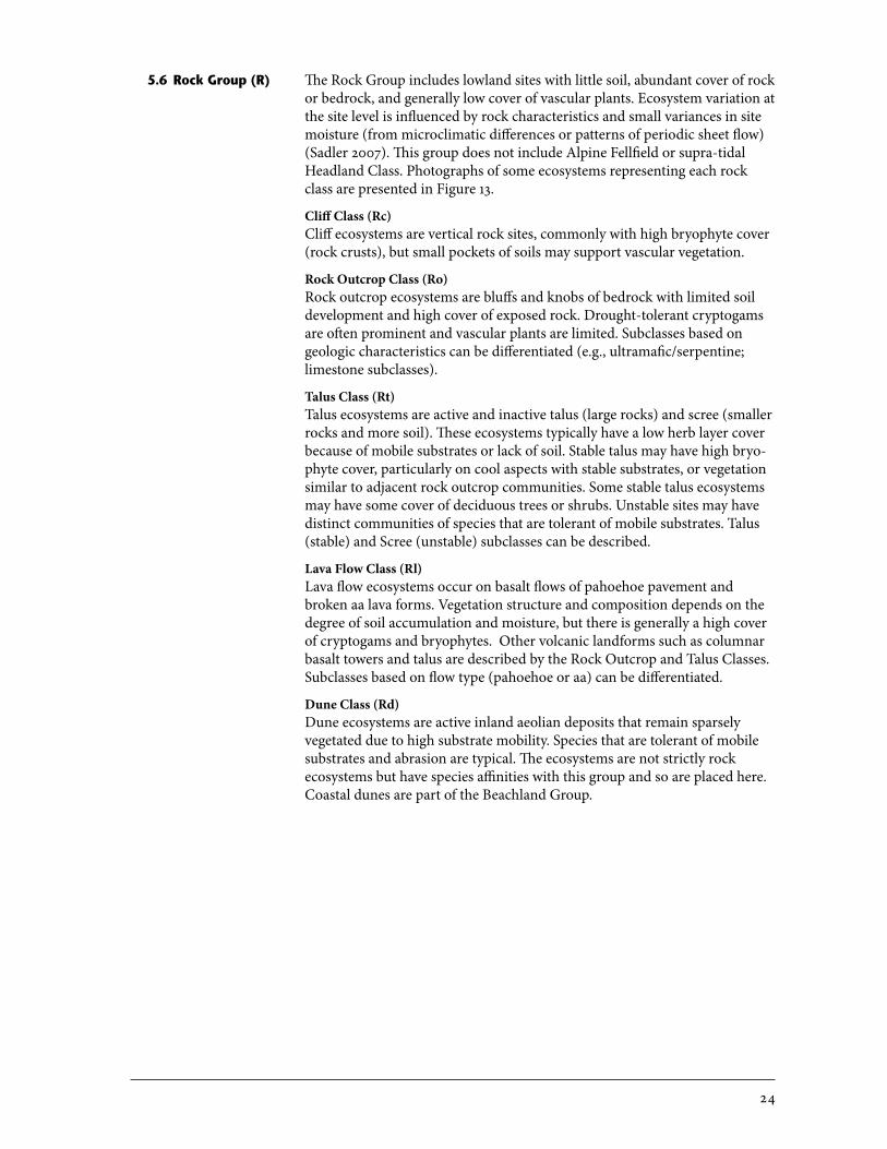
Figure�13 Rock Group (R).13a (Ro) Rock outcrops are commonly a mosaic of community types at a small scale based on variable aspect/shading or soil
depth.13b (Ro) A small rock outcrop infested with introduced grasses in the Gulf Islands.13c (Rt) Blocky talus with little herb- or moss-layer vegetation but moderate cover of trembling aspen.13d (Rc) Cliff habitat on mesa edge, Fort Nelson.13e (Rl) Lava flows can remain largely bryoid dominated for centuries since formation (Tseax lava beds, New Aiyansh).13f (Rd) Inland sand dunes often have unique but sparse vegetation.
13a 13b
13c 13d
13e 13f
26
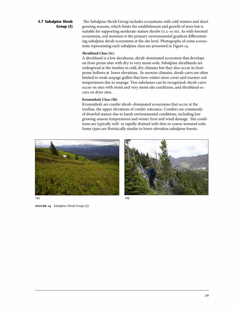
The Subalpine Shrub Group includes ecosystems with cold winters and short growing seasons, which limits the establishment and growth of trees but is suitable for supporting moderate-stature shrubs (0.2–10 m). As with forested ecosystems, soil moisture is the primary environmental gradient differentiat-ing subalpine shrub ecosystems at the site level. Photographs of some ecosys-tems representing each subalpine class are presented in Figure 14.
Shrubland�Class�(Sc)�A shrubland is a low deciduous, shrub-dominated ecosystem that develops on frost-prone sites with dry to very moist soils. Subalpine shrublands are widespread at the treeline in cold, dry climates but they also occur in frost-prone hollows at lower elevations. In snowier climates, shrub-carrs are often limited to weak seepage gullies that have winter snow cover and warmer soil temperatures due to seepage. Two subclasses can be recognized: shrub-carrs occur on sites with moist and very moist site conditions, and shrubland oc-curs on drier sites.
Krummholz�Class�(Sk)�Krummholz are conifer shrub–dominated ecosystems that occur at the treeline, the upper elevations of conifer tolerance. Conifers are commonly of dwarfed stature due to harsh environmental conditions, including low growing-season temperatures and winter frost and wind damage. Site condi-tions are typically well- to rapidly drained with thin or coarse-textured soils. Some types are floristically similar to lower-elevation subalpine forests.
5.7 subalpine shrub group (s)
14a 14b
Figure�14 Subalpine Shrub Group (S).
27
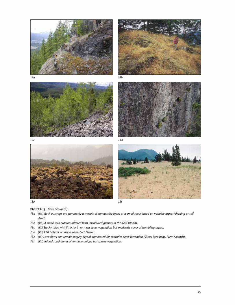
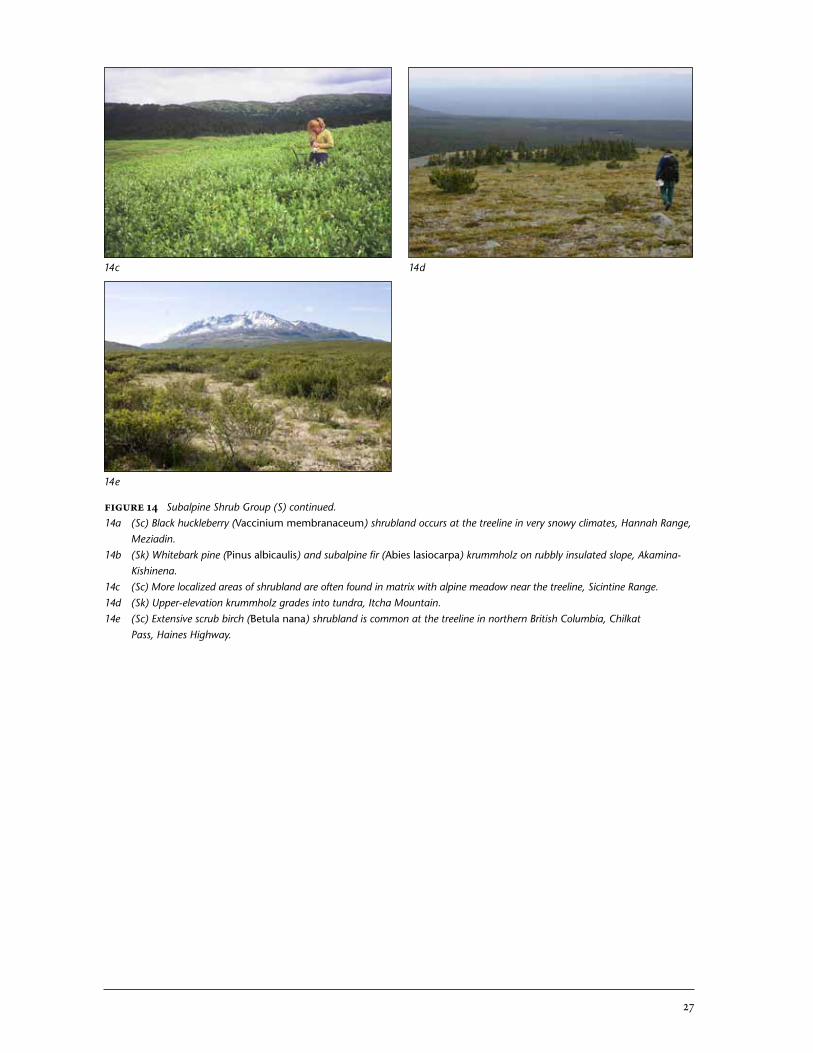
Figure�14 Subalpine Shrub Group (S) continued.14a (Sc) Black huckleberry (Vaccinium membranaceum) shrubland occurs at the treeline in very snowy climates, Hannah Range,
Meziadin.14b (Sk) Whitebark pine (Pinus albicaulis) and subalpine fir (Abies lasiocarpa) krummholz on rubbly insulated slope, Akamina-
Kishinena.14c (Sc) More localized areas of shrubland are often found in matrix with alpine meadow near the treeline, Sicintine Range.14d (Sk) Upper-elevation krummholz grades into tundra, Itcha Mountain.14e (Sc) Extensive scrub birch (Betula nana) shrubland is common at the treeline in northern British Columbia, Chilkat
Pass, Haines Highway.
14c 14d
14e
28
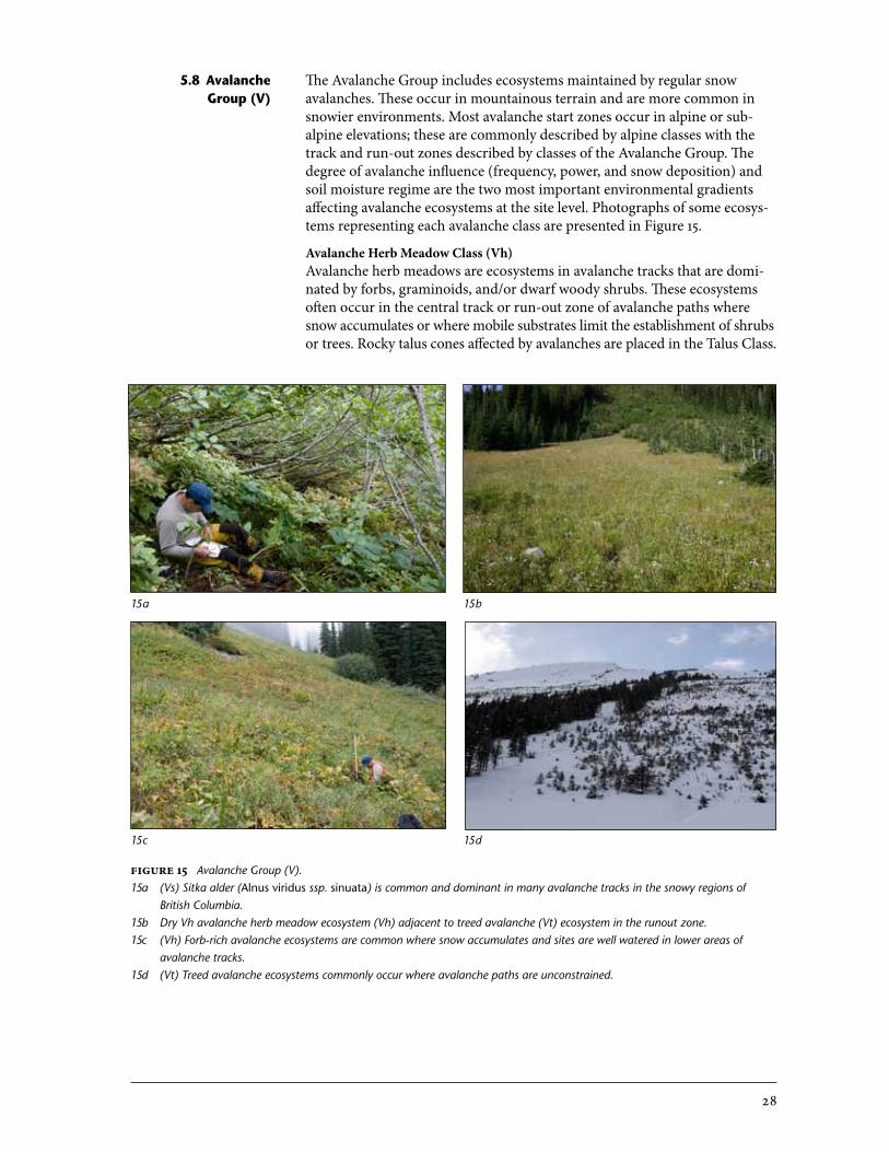
Figure�15 Avalanche Group (V).15a (Vs) Sitka alder (Alnus viridus ssp. sinuata) is common and dominant in many avalanche tracks in the snowy regions of
British Columbia.15b Dry Vh avalanche herb meadow ecosystem (Vh) adjacent to treed avalanche (Vt) ecosystem in the runout zone.15c (Vh) Forb-rich avalanche ecosystems are common where snow accumulates and sites are well watered in lower areas of
avalanche tracks.15d (Vt) Treed avalanche ecosystems commonly occur where avalanche paths are unconstrained.
15a 15b
15c 15d
5.8 avalanche group (V)
The Avalanche Group includes ecosystems maintained by regular snow avalanches. These occur in mountainous terrain and are more common in snowier environments. Most avalanche start zones occur in alpine or sub-alpine elevations; these are commonly described by alpine classes with the track and run-out zones described by classes of the Avalanche Group. The degree of avalanche influence (frequency, power, and snow deposition) and soil moisture regime are the two most important environmental gradients affecting avalanche ecosystems at the site level. Photographs of some ecosys-tems representing each avalanche class are presented in Figure 15.
Avalanche�Herb�Meadow�Class�(Vh)Avalanche herb meadows are ecosystems in avalanche tracks that are domi-nated by forbs, graminoids, and/or dwarf woody shrubs. These ecosystems often occur in the central track or run-out zone of avalanche paths where snow accumulates or where mobile substrates limit the establishment of shrubs or trees. Rocky talus cones affected by avalanches are placed in the Talus Class.
29
Avalanche�Shrub�Thicket�Class�(Vs)Avalanche shrub thickets are ecosystems in avalanche tracks that are domi-nated by deciduous shrubs and are most frequently associated with the track and lateral run-out portions of the avalanche path where deep snow lay oc-curs infrequently but site conditions are fresh or wetter.
Avalanche�Treed�Class�(Vt)Avalanche treed ecosystems are dominated by shrub-sized trees that are continually pruned by snow slides and are prevented from becoming forest. This does not include young forests that are regenerating from single ex-treme events; such forests are seral ecosystems. Trees in Vt ecosystems show evidence of pruning and bark damage from chronic avalanche events. Site conditions are typically dry.
The Disclimax Group describes ecosystems that are maintained by non-envi-ronmental factors. Photographs of some ecosystems representing disclimax classes are presented in Figure 16.
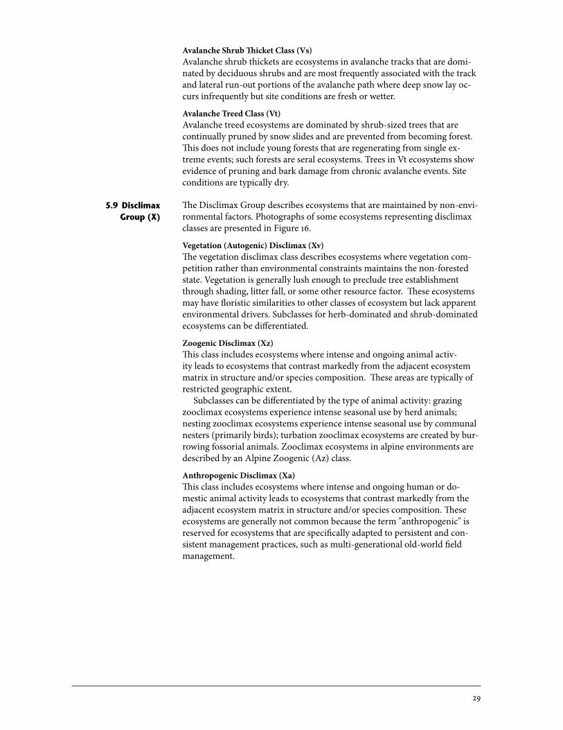
Vegetation�(Autogenic)�Disclimax�(Xv)�The vegetation disclimax class describes ecosystems where vegetation com-petition rather than environmental constraints maintains the non-forested state. Vegetation is generally lush enough to preclude tree establishment through shading, litter fall, or some other resource factor. These ecosystems may have floristic similarities to other classes of ecosystem but lack apparent environmental drivers. Subclasses for herb-dominated and shrub-dominated ecosystems can be differentiated.
Zoogenic�Disclimax�(Xz)This class includes ecosystems where intense and ongoing animal activ-ity leads to ecosystems that contrast markedly from the adjacent ecosystem matrix in structure and/or species composition. These areas are typically of restricted geographic extent.
Subclasses can be differentiated by the type of animal activity: grazing zooclimax ecosystems experience intense seasonal use by herd animals; nesting zooclimax ecosystems experience intense seasonal use by communal nesters (primarily birds); turbation zooclimax ecosystems are created by bur-rowing fossorial animals. Zooclimax ecosystems in alpine environments are described by an Alpine Zoogenic (Az) class.
Anthropogenic�Disclimax�(Xa)This class includes ecosystems where intense and ongoing human or do-mestic animal activity leads to ecosystems that contrast markedly from the adjacent ecosystem matrix in structure and/or species composition. These ecosystems are generally not common because the term "anthropogenic" is reserved for ecosystems that are specifically adapted to persistent and con-sistent management practices, such as multi-generational old-world field management.
5.9 Disclimax group (X)
30
Figure�16 Disclimax Group (X).16a (Xz) Distinctive vegetation community of Jacob's ladder (Polemonium sp.) and stonecrop (Sedum sp.) on a Herring Gull
nesting site, Atlin Lake. 16b (Xv) Differentiating vegetation disclimax ecosystems from seral ecosystems may present challenges. This low-elevation
meadow dominated by bracken fern (Pteridium aquilinum), cow-parsnip (Heracleum maximum), and Indian riceroot (Fritillaria camschatcensis) occurs in predictable locations and has very distinct soils, suggesting longevity. However, no clear rationale for its occurrence in the landscape is established.
16c (Xz) Stone's sheep winter habitat occurs on steep, south-facing slopes near the treeline in northern British Columbia. Plant communities of arctic sedge (Carex supina) and purple reedgrass (Calamagrostis purpurascens) are associated with these sites. Zoogenic disclimax designation of ecosystems such as these is only possible with detailed knowledge of controlling factors.
16a 16b
16c
6 Classes of the estUaRIne Realm
Estuarine ecosystems are coastal sites dominated by plants and other organ-isms that are tolerant of wet, brackish soils, and are found at the interface of a freshwater source and marine environment. These ecosystems are affected by occasional or diurnal tidal inundation. Estuarine ecosystems have simi-lar characteristics to wetland ecosystems, with the additional influence of diurnal fluctuations in the water table and variable salinity. The environmen-tal gradients describing site variation in this realm are (1) the degree of tidal flooding, which is closely related to height above mean tide level, and (2) the degree of freshwater influence. Some site associations of the Estuarine Realm are described by MacKenzie and Moran (2004). Photographs of some ecosys-tems representing each estuarine class are presented in Figure 17.
31
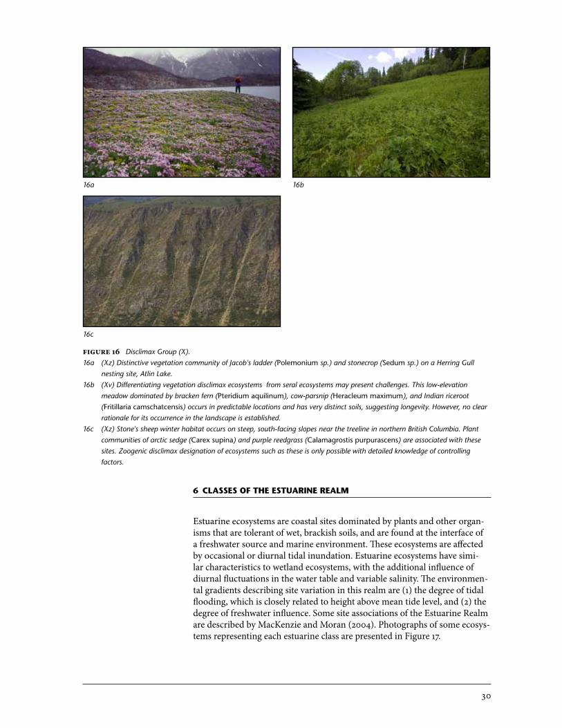
Estuarine�Meadow�Class�(Ed)Estuarine meadows occur in the high intertidal zone of estuaries, where tidal flooding occurs less frequently than daily and is tempered by freshwater mix-ing. Species composition is relatively diverse, typically with a mix of grami-noids and forbs.
Estuarine�Marsh�Class�(Em)An estuarine marsh is an intertidal ecosystem that is flooded diurnally and has simple communities dominated by salt-tolerant emergent graminoids and succulents. These marshes occur in the middle to upper tidal zones of estuaries where saltwater influences predominate.
Estuarine�Tidal�Flat�Class�(Et)Estuarine tidal flat sites are intertidal ecosystems dominated by benthic/bur-rowing fauna and macroalgae. These ecosystems occur in the mid to lower tidal zones of estuaries, where freshwater and salt water mix. Sites are flooded and exposed with most tidal cycles. Large flats of silts, sands, or pebbles are common.
Figure�17 Estuarine Realm.17a (Em) Lyngbye's sedge (Carex lyngbyei) marshes are one of the most common estuarine ecosystems in British Columbia.17b (Em) Dwarf alkaligrass (Puccinellia pumila) occurs where there is prolonged saltwater flooding in northern estuaries.17c (Ed) Estuarine meadows are common in larger estuaries at higher elevations.
17a
17c
17b
32
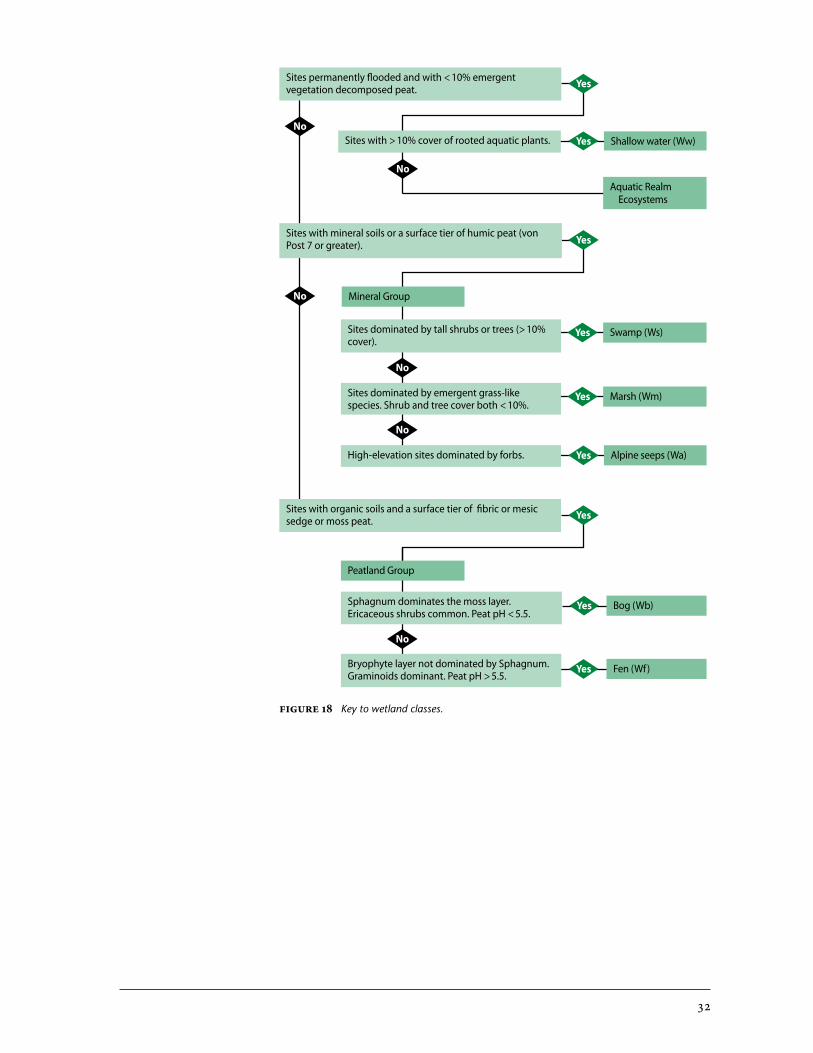
Yes
Yes
Shallow water (Ww)Yes
Swamp (Ws)Yes
Marsh (Wm)Yes
Alpine seeps (Wa)Yes
Bog (Wb)Yes
Sites permanently flooded and with < 10% emergent vegetation decomposed peat.
Sites with > 10% cover of rooted aquatic plants.
Sites with mineral soils or a surface tier of humic peat (von Post 7 or greater).
Sites with organic soils and a surface tier of fibric or mesic sedge or moss peat.
No
Sites dominated by tall shrubs or trees (> 10% cover).
Sites dominated by emergent grass-like species. Shrub and tree cover both < 10%.
High-elevation sites dominated by forbs.
Sphagnum dominates the moss layer. Ericaceous shrubs common. Peat pH < 5.5.
No
Aquatic Realm Ecosystems
Mineral Group
Peatland Group
Fen (Wf)YesBryophyte layer not dominated by Sphagnum. Graminoids dominant. Peat pH > 5.5.
No
Yes
No
No
No
Figure�18 Key to wetland classes.
33
7.1 Peatland group
7.2 mineral wetland group
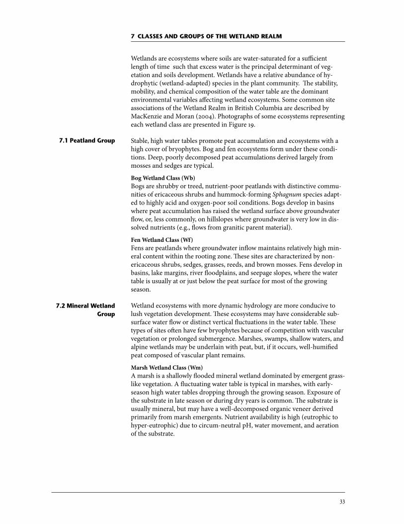
7 Classes anD gRoUPs of the wetlanD Realm
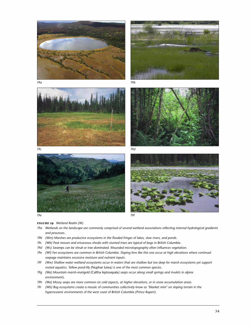
Wetlands are ecosystems where soils are water-saturated for a sufficient length of time such that excess water is the principal determinant of veg-etation and soils development. Wetlands have a relative abundance of hy-drophytic (wetland-adapted) species in the plant community. The stability, mobility, and chemical composition of the water table are the dominant environmental variables affecting wetland ecosystems. Some common site associations of the Wetland Realm in British Columbia are described by MacKenzie and Moran (2004). Photographs of some ecosystems representing each wetland class are presented in Figure 19.
Stable, high water tables promote peat accumulation and ecosystems with a high cover of bryophytes. Bog and fen ecosystems form under these condi-tions. Deep, poorly decomposed peat accumulations derived largely from mosses and sedges are typical.
Bog�Wetland�Class�(Wb)Bogs are shrubby or treed, nutrient-poor peatlands with distinctive commu-nities of ericaceous shrubs and hummock-forming Sphagnum species adapt-ed to highly acid and oxygen-poor soil conditions. Bogs develop in basins where peat accumulation has raised the wetland surface above groundwater flow, or, less commonly, on hillslopes where groundwater is very low in dis-solved nutrients (e.g., flows from granitic parent material).
Fen�Wetland�Class�(Wf)�Fens are peatlands where groundwater inflow maintains relatively high min-eral content within the rooting zone. These sites are characterized by non-ericaceous shrubs, sedges, grasses, reeds, and brown mosses. Fens develop in basins, lake margins, river floodplains, and seepage slopes, where the water table is usually at or just below the peat surface for most of the growing season.
Wetland ecosystems with more dynamic hydrology are more conducive to lush vegetation development. These ecosystems may have considerable sub-surface water flow or distinct vertical fluctuations in the water table. These types of sites often have few bryophytes because of competition with vascular vegetation or prolonged submergence. Marshes, swamps, shallow waters, and alpine wetlands may be underlain with peat, but, if it occurs, well-humified peat composed of vascular plant remains.
Marsh�Wetland�Class�(Wm)A marsh is a shallowly flooded mineral wetland dominated by emergent grass-like vegetation. A fluctuating water table is typical in marshes, with early-season high water tables dropping through the growing season. Exposure of the substrate in late season or during dry years is common. The substrate is usually mineral, but may have a well-decomposed organic veneer derived primarily from marsh emergents. Nutrient availability is high (eutrophic to hyper-eutrophic) due to circum-neutral pH, water movement, and aeration of the substrate.
34
Figure�19 Wetland Realm (W).19a Wetlands on the landscape are commonly comprised of several wetland associations reflecting internal hydrological gradients
and processes.19b (Wm) Marshes are productive ecosystems in the flooded fringes of lakes, slow rivers, and ponds.19c (Wb) Peat mosses and ericaceous shrubs with stunted trees are typical of bogs in British Columbia.19d (Ws) Swamps can be shrub or tree dominated. Mounded microtopography often influences vegetation.19e (Wf) Fen ecosystems are common in British Columbia. Sloping fens like this one occur at high elevations where continual
seepage maintains excessive moisture and nutrient inputs.19f (Ww) Shallow water wetland ecosystems occur in waters that are shallow but too deep for marsh ecosystems yet support
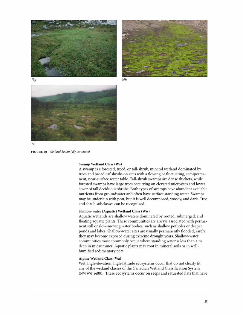
rooted aquatics. Yellow pond-lily (Nuphar lutea) is one of the most common species.19g (Wa) Mountain marsh-marigold (Caltha leptosepala) seeps occur along small springs and rivulets in alpine
environments.19h (Wa) Mossy seeps are more common on cold aspects, at higher elevations, or in snow accumulation areas.19i (Wb) Bog ecosystems create a mosaic of communities collectively know as "blanket mire" on sloping terrain in the
hyperoceanic environments of the west coast of British Columbia (Prince Rupert).
19a 19b
19c 19d
19e 19f
35
Swamp�Wetland�Class�(Ws)A swamp is a forested, treed, or tall-shrub, mineral wetland dominated by trees and broadleaf shrubs on sites with a flowing or fluctuating, semiperma-nent, near-surface water table. Tall-shrub swamps are dense thickets, while forested swamps have large trees occurring on elevated microsites and lower cover of tall deciduous shrubs. Both types of swamps have abundant available nutrients from groundwater and often have surface standing water. Swamps may be underlain with peat, but it is well decomposed, woody, and dark. Tree and shrub subclasses can be recognized.
Shallow-water�(Aquatic)�Wetland�Class�(Ww)Aquatic wetlands are shallow waters dominated by rooted, submerged, and floating aquatic plants. These communities are always associated with perma-nent still or slow-moving water bodies, such as shallow potholes or deeper ponds and lakes. Shallow-water sites are usually permanently flooded; rarely they may become exposed during extreme drought years. Shallow-water communities most commonly occur where standing water is less than 2 m deep in midsummer. Aquatic plants may root in mineral soils or in well-humified sedimentary peat.
Alpine�Wetland�Class�(Wa)�Wet, high-elevation, high-latitude ecosystems occur that do not clearly fit any of the wetland classes of the Canadian Wetland Classification System (NWWG 1988). These ecosystems occur on seeps and saturated flats that have
19g
19i
19h
Figure�19 Wetland Realm (W) continued.

36
site characteristics similar to lower-elevation swamps, but because of the constraints of cold climate, they support low-stature vegetation dominated by dwarf willows, forbs, and/or mosses. Sites may be underlain with mineral or very thin organic horizons; peat formation is limited because of low rates of accumulation. Permafrost may occur in some cases.
37
RefeRenCes
Brodo, I. M. and N.A. Sloan. 2004. Lichen zonation on coastal rocks in Gwaii Haanas National Park Reserve, Haida Gwaii (Queen Charlotte Islands), British Columbia. Can. Field Nat. 118: 405–424.
Calder, J.A. and R.L. Taylor. 1968. Flora of the Queen Charlotte Islands. Part 1: Systematics of the vascular plants. Can. Dep. Agric., Res. Br., Monogr. 4. Queen’s Printer, Ottawa, Ont.
Federal Geographic Data Committee (FGDC). 2008. National vegetation clas-sification standard, Version 2. FGDC - Vegetation Subcommittee. FGDC-STD-005-2008 (Version 2).
Fraser, D.F., A. Banner, and A. Harcombe. 1995. A framework for ecological classification in British Columbia. Unpubl. rep.
Haeussler, S. 2011. Rethinking biogeoclimatic ecosystem classification for a changing world. Environ. Rev. 19: 254–277 (2011).
Klinka, K. and C. Chourmouzis. 2001. The mountain hemlock zone of British Columbia. Scientia Silvica. Univ. British Columbia, For. Sci. Dep., Vancouver, B.C.
MacKenzie, W.H. and J.R. Moran. 2004. Wetlands of British Columbia: a guide to identification. B.C. Min. For., Res. Br., Victoria, B.C. Land Manag. Handb. 52.
Meidinger, D. and J. Pojar. 1991. Ecosystems of British Columbia. B.C. Min. For., Victoria, B.C. Spec. Rep. Ser. 6.
Moen, A. 1998. National atlas of Norway: vegetation. Statens Kartverk, Honefoss, Norway.
National Wetlands Working Group (NWWG). 1988. Wetlands of Canada. Environ. Can., Sustainable Dev. Br., Ottawa, Ont. Ecological Land Clas-sification Ser. 24.
Page, N., P. Lilley, I.J. Walker, and R.G. Vennesland. 2011. Status report on coastal sand ecosystems in British Columbia. Report prepared for the Coastal Sand Ecosystems Recovery Team.
Parks Canada Agency. 2006. Recovery strategy for multi-species at risk in vernal pools and other ephemeral wet areas in Garry oak and associated ecosystems in Canada. In: Species at Risk Act Recovery Strategy Ser., Ottawa, Ont.
Province of British Columbia. 2002. Vegetation Resources Inventory: the B.C. Land Cover Classification Scheme – Version 1.3. Vegetation Resources Inventory Committee, Terrestrial Ecosystems Task Force, Victoria, B.C.
38
—————. 2010. Field manual for describing terrestrial ecosystems. 2nd ed. Land. Manag. Handb. 25. Queen’s Printer, Victoria, B.C.
Rodwell, J.S., J.H.J. Schaminée, L. Mucina, S. Pignatti, J. Dring, and D. Moss. 2002. The diversity of European vegetation. An overview of phytoso-ciological alliances and their relationships to EUNIS habitats. National Reference Centre for Agriculture, Nature and Fisheries, Wageningen, Netherlands.
Sadler, K.D. 2007. Vegetation ecology of rock outcrop ecosystems. PhD thesis. Univ. British Columbia, Vancouver, B.C.
Viereck, L.A., C.T. Dyrness, A.R. Batten, and K.J. Wenzlick. 1992. The Alaska vegetation classification. U.S. Dep. Agric. For. Serv., Pac. N.W. Res. Stn., Portland, Oreg. Gen. Tech. Rep. PNW-GTR-286.
Watts, S.B. and L. Tolland (editors). 2005. Forestry handbook for British Co-lumbia. 5th ed. Univ. British Columbia, For. Undergraduate Soc., Vancouver, B.C.
Related Documents