U.S. Department of the Interior Bureau of Ocean Energy Management, Regulation and Enforcement Alaska OCS Region OCS EIS/EA BOEMRE 2010-027 Alaska Outer Continental Shelf Beaufort Sea and Chukchi Sea Planning Areas ION Geophysical, Inc. Geological and Geophysical Seismic Surveys Beaufort and Chukchi Seas, Alaska ENVIRONMENTAL ASSESSMENT Prepared By: Office of Leasing and Environment Alaska OCS Region September 2010

Welcome message from author
This document is posted to help you gain knowledge. Please leave a comment to let me know what you think about it! Share it to your friends and learn new things together.
Transcript
U.S. Department of the InteriorBureau of Ocean Energy Management, Regulation and EnforcementAlaska OCS Region
OCS EIS/EABOEMRE 2010-027
Alaska Outer Continental Shelf
Beaufort Sea and Chukchi Sea Planning AreasION Geophysical, Inc.Geological and GeophysicalSeismic SurveysBeaufort and Chukchi Seas, Alaska
ENVIRONMENTAL ASSESSMENT
Prepared By:Office of Leasing and EnvironmentAlaska OCS Region
September 2010

This Page Intentionally Left Blank
ION Geological & Geophysical Survey EA
CONTENTS i
CONTENTS
1. Purpose and Need ............................................................................................................................. 1 1.1. Purpose and Need of the Proposed Action............................................................................... 1 1.2. Previous Applicable NEPA Analyses and Biological Opinions .............................................. 2
2. Proposed Action and Alternatives..................................................................................................... 4 2.1. Documentation Provided to BOEMRE By ION Geophysical ................................................. 4 2.2. Alternative 1, the Proposed Action .......................................................................................... 4
2.2.1. Proposed Mitigation and Monitoring .......................................................................... 6 2.2.2. Marine Mammal Monitoring and Mitigation .............................................................. 6
2.3. Alternative 2 – Alternate Season Action ................................................................................ 10 2.4. Alternative 3 - No Action....................................................................................................... 10 2.5. Other Alternatives .................................................................................................................. 10 2.6. Other Mitigation..................................................................................................................... 10
3. Affected Environment..................................................................................................................... 11 3.1. Physical Environment ............................................................................................................ 11 3.2. Biological Environment ......................................................................................................... 11
3.2.1. Lower Trophic and Benthic Invertebrates................................................................. 12 3.2.2. Fish............................................................................................................................ 12 3.2.3. Coastal and Marine Birds.......................................................................................... 16 3.2.4. Marine Mammals ...................................................................................................... 21 3.2.5. Subsistence, Sociocultural Systems, and Environmental Justice .............................. 24 3.2.6. Archaeological Resources ......................................................................................... 27
4. Environmental Impacts ................................................................................................................... 28 4.1. Alternative 1 – The Proposed Action ..................................................................................... 29
4.1.1. Direct and Indirect Effects of Alternative 1 .............................................................. 30 4.1.2. Lower Trophic Levels and Benthic Invertebrates ..................................................... 30 4.1.3. Fish and Essential Fish Habitat. ................................................................................ 31 4.1.4. Coastal and Marine Birds.......................................................................................... 33 4.1.5. Marine mammals....................................................................................................... 34 4.1.6. Levels of Effects for Subsistence .............................................................................. 39 4.1.7. Cumulative Impacts of Alternative 1 ........................................................................ 42
4.2. Alternative 2 – Alternate Season Action ................................................................................ 45 4.2.1. Direct and Indirect Effects of Alternative 2 .............................................................. 46 4.2.2. Lower Trophic Levels and Benthic Invertebrates ..................................................... 46 4.2.3. Fish and Essential Fish Habitat ................................................................................. 46 4.2.4. Marine and Coastal Birds.......................................................................................... 47 4.2.5. Marine Mammals ...................................................................................................... 47 4.2.6. Subsistence................................................................................................................ 48 4.2.7. Cumulative Impacts of Alternative 2 ........................................................................ 48
4.3. Alternative 3 – the No Action Alternative ............................................................................. 48 4.3.1. Direct and Indirect Effects of Alternative 3 .............................................................. 48 4.3.2. Cumulative Impacts of Alternative 3 ........................................................................ 48
4.4. Conclusion and Recommendations ........................................................................................ 49
5. Consultation and Coordination ....................................................................................................... 50
ION Geological & Geophysical Survey EA
ii List of Tables
5.1. Opportunities for Public Input ................................................................................................51
6. Verification......................................................................................................................................54
7. Reviewers and Preparers .................................................................................................................55
8. Reference Material ..........................................................................................................................56
LIST OF TABLES
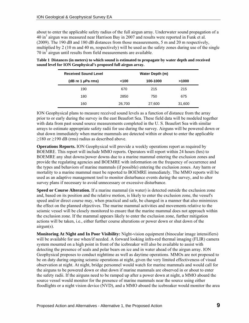
Table 1 Distances (in meters) to which sound is estimated to propagate by water depth and received sound level for ION Geophysical’s proposed full airgun array..........................9
Table 2 Marine and coastal birds in the Beaufort and Chukchi Seas most likely to be affected by the proposed action (MMS 2008-0055). ......................................................17
Table 3 The habitat, abundance (in the Chukchi and the Beaufort Sea if available), and ESA status of marine mammals occurring within the proposed survey area. (Allen and Angliss, 2010). ................................................................................................................21
Table 4 Arctic Icebreaker Missions and Seismic Vessels Operating in the Beaufort or Chukchi Seas, 2010.........................................................................................................44
LIST OF FIGURES
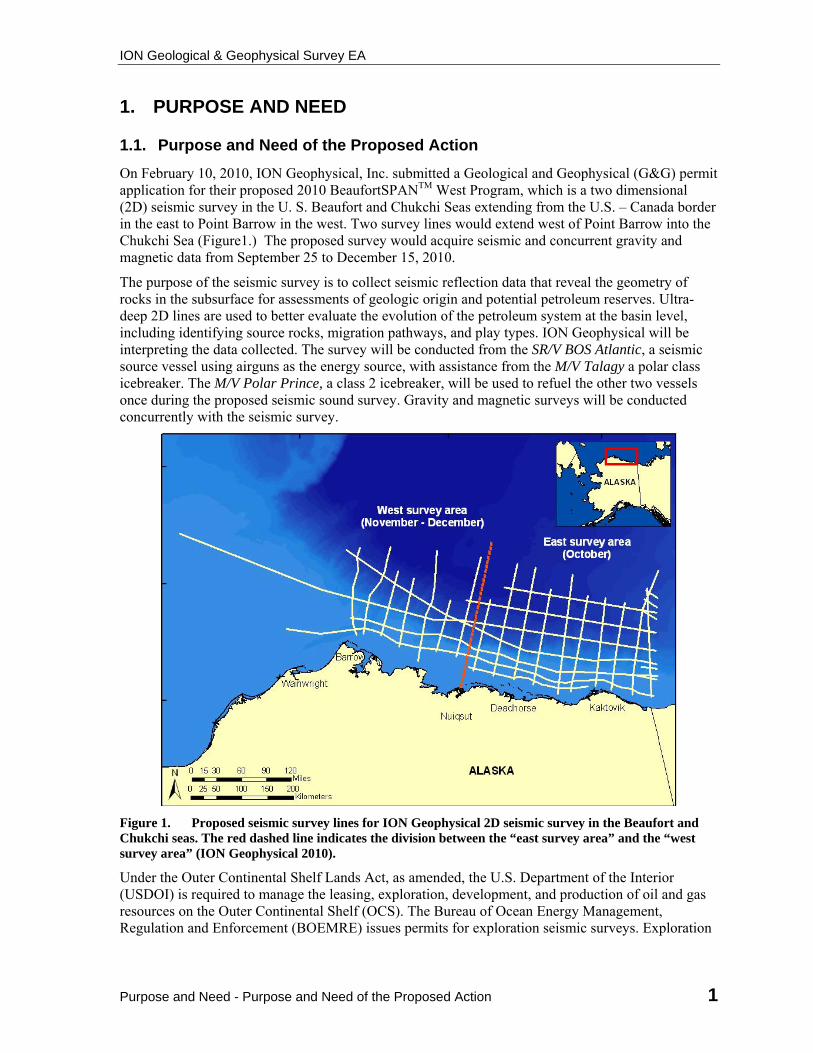
Figure 1. Proposed seismic survey lines for ION Geophysical 2D seismic survey in the Beaufort and Chukchi seas. The red dashed line indicates the division between the “east survey area” and the “west survey area” (ION Geophysical 2010). ........................1
Figure 2 Essential Fish Habitat for Arctic Cod (NPFMC 2009). ..................................................14
Figure 3 Essential Fish Habitat for Pacific Salmon (NPFMC 2009)............................................15
ION Geological & Geophysical Survey EA
Purpose and Need - Purpose and Need of the Proposed Action 1
1. PURPOSE AND NEED
1.1. Purpose and Need of the Proposed Action
On February 10, 2010, ION Geophysical, Inc. submitted a Geological and Geophysical (G&G) permit application for their proposed 2010 BeaufortSPANTM West Program, which is a two dimensional (2D) seismic survey in the U. S. Beaufort and Chukchi Seas extending from the U.S. – Canada border in the east to Point Barrow in the west. Two survey lines would extend west of Point Barrow into the Chukchi Sea (Figure1.) The proposed survey would acquire seismic and concurrent gravity and magnetic data from September 25 to December 15, 2010.
The purpose of the seismic survey is to collect seismic reflection data that reveal the geometry of rocks in the subsurface for assessments of geologic origin and potential petroleum reserves. Ultra-deep 2D lines are used to better evaluate the evolution of the petroleum system at the basin level, including identifying source rocks, migration pathways, and play types. ION Geophysical will be interpreting the data collected. The survey will be conducted from the SR/V BOS Atlantic, a seismic source vessel using airguns as the energy source, with assistance from the M/V Talagy a polar class icebreaker. The M/V Polar Prince, a class 2 icebreaker, will be used to refuel the other two vessels once during the proposed seismic sound survey. Gravity and magnetic surveys will be conducted concurrently with the seismic survey.
Figure 1. Proposed seismic survey lines for ION Geophysical 2D seismic survey in the Beaufort and Chukchi seas. The red dashed line indicates the division between the “east survey area” and the “west survey area” (ION Geophysical 2010).
Under the Outer Continental Shelf Lands Act, as amended, the U.S. Department of the Interior (USDOI) is required to manage the leasing, exploration, development, and production of oil and gas resources on the Outer Continental Shelf (OCS). The Bureau of Ocean Energy Management, Regulation and Enforcement (BOEMRE) issues permits for exploration seismic surveys. Exploration
ION Geological & Geophysical Survey EA
2 Purpose and Need - Previous Applicable NEPA Analyses
seismic surveys are regulated by 30 CFR 251. The permit application is at: http://www.BOEMRE.gov/alaska/re/recentgg/10-03app.pdf.
The BOEMRE prepares an Environmental Assessment (EA) to assess potential environmental impacts associated with an airgun array and echosounders operated during the proposed activity, as well as potential impacts from icebreaking during the survey. The EA was prepared pursuant to the National Environmental Policy Act (NEPA) and addresses potential impacts of the proposed seismic survey on marine mammals including cetaceans and ice seals which are under the jurisdiction of the National Marine Fisheries Service (NMFS), and polar bears and Pacific walrus, which are under the jurisdiction of the United States Fish and Wildlife Service (FWS). The EA also addresses potential impacts to eiders species, which are listed as threatened under the Endangered Species Act (ESA) and are under FWS jurisdiction. Much of the information presented in the EA for whale and ice seal species was also included in ION Geophysical’s Incidental Harassment Authorization (IHA) permit application to NMFS. Much of the information presented in the EA for Pacific walrus and polar bear was also included in ION Geophysical’s Letter of Authorization (LOA) request to the FWS. The EA also addresses potential impacts to lower trophic level organisms, fish species, Essential Fish Habitat (EFH), marine and coastal birds, and subsistence harvesting in the Beaufort and Chukchi seas.
1.2. Previous Applicable NEPA Analyses and Biological Opinions
The BOEMRE has prepared this EA to determine whether ION Geophysical’s proposed seismic survey would result in significant effects to the environment, as defined at 40 CFR 1508.27, that could trigger the need to prepare an environmental impact statement (EIS) and to assist with BOEMRE planning and decision-making (40 CFR 1501.3(b)).
This EA incorporates information by reference from previous NEPA documents prepared by BOEMRE (formerly MMS), the Fish and Wildlife Service (FWS) and the National Marine Fisheries Service (NMFS). These documents address issues and analyze potential effects of seismic surveys in the Arctic OCS. This process is detailed in NEPA's implementing regulations, 40 CFR 1502.21, and is intended to cut down on the bulk of the EA without impeding agency and public review of the action.
This EA incorporates by reference the following documents which provide a comprehensive characterization of the Arctic Ocean’s physical, biological and socio-economic resources and Alaska Native subsistence activities, and evaluate a broad spectrum of potential seismic survey-related impacts. These documents can be found at: http://www.BOEMRE.gov.
Final Programmatic Environmental Assessment, Arctic Ocean Outer Continental Shelf, Seismic Surveys – 2006 (OCS EIS/EA MMS 2006-038) June 2006. (2006 Final Seismic PEA).
Final Environmental Impact Statement, Beaufort Sea Planning Area Oil and Gas Lease Sales 186, 195 and 202—2003 (OCS EIS/EA MMS 2003-001) February 2003.
Environmental Assessment, Proposed OCS Lease Sale 202 Beaufort Sea Planning Area—2006 (OCS EIS/EA MMS 2006-001) August 2006.
Final Environmental Impact Statement, Chukchi Sea Planning Area Oil and Gas Lease Sale 193 —2007 (OCS EIS/EA MMS 2007-026) May 2007.
Draft Environmental Impact Statement, Beaufort Sea and Chukchi Sea Planning Areas Oil and Gas Lease Sales 209, 212, 217, and 221—2008 (OCS EIS/EA MMS 2008-0055) November 2008.
ION Geological & Geophysical Survey EA
Purpose and Need - Previous Applicable NEPA Analyses 3
Biological Opinion for Oil and Gas Leasing and Exploration Activities in the U.S. Beaufort and Chukchi Seas, Alaska; and Authorization of Small Takes Under the Marine Mammal Protection Act. NMFS, July 2008.
Biological Opinion for Beaufort and Chukchi Sea Program Area Lease Sales and Associated Seismic Surveys and Exploratory Drilling. FWS, September 2009.
Although the PEA and the environmental analyses listed above addressed activities throughout the proposed project area, in developing this EA BOEMRE has focused on site-specific information associated with the proposed action, considering and analyzing new information, such as recent environmental studies, that update information in previous NEPA analyses.
The BOEMRE reviewed ION Geophysical’s environmental assessment (LGL Alaska Research Associates, Inc, 2010) and other documentation listed in section 2.1, supplementing the information where necessary (40 CFR 1506.5(a)).
40 CFR 1506.5 Agency responsibility. (a) Information. If an agency requires an applicant to submit environmental information for possible use by the agency in preparing an environmental impact statement, then the agency should assist the applicant by outlining the types of information required. The agency shall independently evaluate the information submitted and shall be responsible for its accuracy. If the agency chooses to use the information submitted by the applicant in the environmental impact statement, either directly or by reference, then the names of the persons responsible for the independent evaluation shall be included in the list of preparers (Sec. 1502.17). It is the intent of this paragraph that acceptable work not be redone, but that it be verified by the agency.
ION Geological & Geophysical Survey EA
4 Proposed Action and Alternatives - Alternative 1, the Proposed Action
2. PROPOSED ACTION AND ALTERNATIVES
This EA analyzes the following alternatives for environmental impacts: Alternative 1, the proposed action; Alternative 2, an open water seismic survey alternative; and Alternative 3, the no action alternative.
2.1. Documentation Provided to BOEMRE By ION Geophysical
Environmental Assessment of a Marine Seismic Survey by ION Geophysical in the Beaufort Sea, October-December 2010. LGL Report P1128-1. February 2010.
Request by ION Geophysical for a Letter of Authorization to Allow the Incidental Take of Polar Bears and Pacific Walruses during a Marine Seismic Survey in the Beaufort Sea, October-December 2010. LGL Report P1128-2. February 2010.
Final Plan of Cooperation Beaufort Sea, Alaska. ASRC Energy Services. May 2010.
Request by ION Geophysical for an Incidental Harassment Authorization to Allow the Incidental Take of Marine Mammals during a Marine Seismic Survey in the Beaufort Sea, October-December 2010. LGL Report P1129-1. February 2010.
Revised Request by ION Geophysical for an Incidental Harassment Authorization to Allow the Incidental Take of Marine Mammals during a Marine Seismic Survey in the Beaufort Sea, October-December 2010. LGL Report P1129-1. August 2010.
Application for Permit to Conduct Geological or Geophysical Exploration for Mineral Resources or Scientific Research in the Outer Continental Shelf. ION Geophysical 901-01 Permit 10-03. February 2010.
Plan of Operations. ION Geophysical. February 2010.
2.2. Alternative 1, the Proposed Action
ION proposes to conduct a 2D seismic survey primarily in the U.S. Beaufort Sea with two survey lines extending into the Chukchi Sea (Fig. 1). The survey area would extend from 138º to 168º W longitude and 70º to 73º N latitude and range from about 12 to 250 kilometers (km) offshore in water depths from less than 20 meters (m) to greater than 3,500 m. Approximately 62% of the proposed survey lines would be conducted in water depths greater than 200 m, where fewer marine mammals occur. The survey area would cover the continental shelf, the continental slope, and the abyssal plain. The approximate total length of the proposed survey lines is 7,250 km. For mitigation and operational reasons the survey area has been bisected by a line running from 70.5° N, 150.5° W to 73° N, 148° W (Fig. 1). ION Geophysical plans to begin seismic survey operations in late September in the eastern survey area, in the northern portion of the U.S. Beaufort Sea, where the water is >1000 m deep. The survey would then progress to shallower waters in the southeastern survey area before moving to the west survey area in late October or early November. Ice conditions during the survey are expected to range from open water to 10/10 (91%-100%) ice cover.
The seismic sound source vessel to be used is the SR/V BOS Atlantic, an ice-strengthened, ice class 1A vessel. It is 65 m long, with a beam of 14 m and a draft (loaded) of 7.8 m. The SR/V BOS Atlantic has a cruising speed of 13 knots (kts), but would travel at a speed ranging from about 4 to 5 kts while conducting seismic operations. The vessel is equipped with standard navigation, radar, communication, and depth sounding equipment. The airguns and hydrophone streamer towed by the SR/V BOS Atlantic have been specially designed for operations in ice covered seas. ION Geophysical has previously conducted similar surveys in ice-covered waters in Canada.
ION Geological & Geophysical Survey EA
Proposed Action and Alternatives - Alternative 1, the Proposed Action 5
The vessels would enter the U.S. Beaufort Sea from Canadian waters on or about September 25 and return to Tuktoyutuk or Dutch Harbor on or before 30 December. The seismic survey is scheduled to occur over about 76 days during the timeframe from September 25 to December 15, 2010, with some possible variation given the uncertainties in ice conditions and other environmental variables.
The M/V Talagy is an Arctic Class 4 ice-breaking ship proposed to assist the SR/V BOS Atlantic. Under ideal conditions, an Arctic Class 4 ship can navigate in winter conditions through solid unbroken ice approximately 1.2 m thick at speeds ≥3 kts, and aggressively break large ridges by backing and ramming. The M/V Talagy is 88 m long, with a beam of 17.8 m and a draft of 8.3 m. It can travel at a speed of 15.5 kts, but cruising speed is 12.5 kts. It has two controllable pitch propellers and a bow thruster. The M/V Talagy would be used to break ice ahead of the SR/V BOS Atlantic when surveying or transitting in areas of ice. The M/V Talagy would normally operate about 0.5-1 km ahead of the SR/V BOS Atlantic, but ice conditions at the time would determine the optimal escort distance from the seismic vessel. At the end of the survey, both vessels would travel together to Dutch Harbor, Alaska.
A third vessel, the icebreaker M/V Polar Prince will make a single trip from Tuktoyaktuk in the Canadian Arctic to the SR/V BOS Atlantic’s position in the NW Beaufort Sea to refuel the SR/V BOS Atlantic and the M/V Talagy approximately 30 days or so after the onset of operations. The M/V Polar Prince will then either return to Tuktoyaktuk or proceed to Victoria, British Columbia, depending upon ice conditions.
The seismic sound source for the proposed geophysical survey would be composed of 28 Sercel G-gun airguns with a total operating volume of 4450 in3 (two airguns would serve as spares). The 28 airguns would be distributed in two 14 airgun sub-arrays. Individual airgun sizes range from 70 to 380 in³. Airguns would be operated at 2000 psi. The sub-arrays would be towed 25-50 m behind the source vessel and at a water depth of about 8.5 m. The seismic vessel would travel along pre-determined lines at speeds ranging from about 4 to 5 kts. The airgun array would discharge every 50 m or about every 20 seconds. The nominal zero-to-peak source pressure level at 1 m for each pulse is estimated as 250 decibels (dB) re 1 microPascal (μ Pa) (for 1-2000 Hertz (Hz)). The source pressure averaged over the length of the pulse root mean square (rms) is estimated to be Pa @ 1 m and the sound exposure level (SEL) at 1 m from the source is estimated as 229 dB re 1 µPa second (s). The pulse length (90% energy) is estimated to be 0.5 seconds (s) near the source (Zykov et al. 2010).
The seismic source vessel would tow a hydrophone streamer to receive the reflected signals from the subsurface, and then transfer the data to an on-board processing system. ION Geophysical is proposing to use a streamer called the DigiSTREAMER, which uses a proprietary solid fill material to produce a constant and consistent streamer buoyancy. The streamer would be about 8.5 km long, and would be towed about 9.5 m below the water surface. Approximately every 300 m along the streamer, DigiFIN units are attached to maintain the desired deployment depth. The survey vessel would have limited maneuverability while towing the streamer and thus would require a 10 km run-in for the start of a seismic line, and a 4-5 km run-out at the end of the line. If the full array continues operating during transit to the next survey line, then the seismic survey will continue on the next line as long as the exclusion zone remains clear of marine mammals. If a mitigation gun continues during transit to the next line, then ramp up may take place immediately as long as the exclusion zone is visibly clear of marine mammals. If a full shut down has occurred during transit to the next line, then the exclusion zone must be visibly clear of marine mammals for 30 minutes before ramp up may begin.
Along with airgun operations, additional acoustic systems operated during the cruise include two single-beam echo sounders. These sources would operate throughout most of the cruise, and would generally operate simultaneously with the airgun array.
ION Geological & Geophysical Survey EA
6 Proposed Action and Alternatives - Alternative 1, the Proposed Action
2.2.1. Proposed Mitigation and Monitoring
ION Geophysical’s planned seismic survey incorporates both design features and operational procedures for minimizing the potential for impacts to marine mammals, migratory birds and on subsistence hunts. Survey design features include: a) scheduling the survey to occur in late September–December to avoid periods of higher abundance of marine mammal species and most of the subsistence hunting activities that occur during the open-water season; b) planning the survey to proceed from east to west across the US Beaufort Sea to avoid, as much as possible, any remaining migratory animals and associated subsistence activities; and c) completing the survey prior to the time when ringed seals would establish and enter lairs for reproductive purposes, and early in the polar bear denning season. The Plan of Cooperation between the subsistence communities and ION Geophysical is dated October 1 -December 2010 and is designed to avoid conflicts with subsistence hunting.
2.2.2. Marine Mammal Monitoring and Mitigation
Vessel-based marine mammal observers (MMOs) would monitor for marine mammals near the seismic source vessel during all daytime airgun operations and before any ramp up of the airguns. Nighttime or periods of low visibility startups are not allowed unless a mitigation gun has been in continuous operation prior to the start or resumption of full seismic operations. When full shut down of all guns has occurred, marine mammal observers (MMOs) must be able to visually see that the exclusion zones are clear of all marine mammals for 30 minutes before ramp up may begin. When marine mammals in water are observed within, or about to enter, designated exclusion zones, operations would be powered down or shut down immediately. Marine mammals on ice would not trigger a shut down unless they entered the water within the exclusion zone.
In addition to monitoring, mitigation measures that will be adopted by ION Geophysical include, (1) speed or course alteration, provided that doing so will not compromise operational safety requirements, (2) power down or shut-down procedures, and (3) no start up of airgun operations unless the 180 dB safety zone is visible and clear of marine mammals for at least 30 min. In addition, the survey has been designed to occur during periods of low marine mammal density in an effort to minimize encounters. The seismic survey will begin in the deep water area of the northeastern Beaufort Sea where marine mammals are least abundant. The survey will progress toward shore and concentrate on the eastern half of the U.S. Beaufort Sea. Most bowhead and beluga whales will have migrated through this area before the vessels begin work in the eastern portion of the migration corridor in late October. The survey vessels will then proceed to the deep water area of the northwestern Beaufort Sea and progress toward shore in the western half of the U.S. Beaufort Sea. The two survey lines which extend into the Chukchi Sea will be done last, when most marine mammals, including whales and walrus have moved south or west of the area. Terms used throughout this EA are defined below:
Marine Mammal Observers (MMOs): Vessel-based monitoring for marine mammals would be performed by marine mammal biologists or specially trained observers, including locally hired Inupiat observers, throughout the period of survey activities to comply with expected provisions in the permits issued to ION Geophysical. An experienced field crew leader would supervise the MMO teams onboard the vessels. The observers would monitor the occurrence and behavior of marine mammals near the survey vessel during all daylight periods while airguns are active, and during most daylight periods when airgun operations are not occurring. MMO duties would include watching for and identifying marine mammals; recording their numbers, distances, and reactions to the survey operations; and documenting “take by harassment” as defined by NMFS and FWS.
Observer Qualifications and Training: Most observers will be individuals with recent experience during one or more seismic monitoring projects in Alaska, the Canadian Beaufort, or other offshore
ION Geological & Geophysical Survey EA
Proposed Action and Alternatives - Alternative 1, the Proposed Action 7
areas. Biologist-observers will have previous marine mammal observation experience, and field crew leaders will be highly experienced with previous vessel-based marine mammal monitoring and mitigation projects. Inupiat observers will be experienced in the region, familiar with the marine mammals of the area, and complete a NMFS approved observer training course designed to familiarize individuals with monitoring and data collection procedures. A marine mammal observers’ handbook, adapted for the specifics of the planned survey program, will be prepared and distributed beforehand to all MMOs (see summary below).
Most observers, including Inupiat observers, will also complete a minimum two-day training and refresher session on marine mammal monitoring, to be conducted shortly before the anticipated start of the seismic survey. Any exceptions will have equivalent experience or training. The training session(s) will be conducted by qualified marine mammalogists with extensive crew-leader experience during previous vessel-based seismic monitoring programs.
Number of Observers: Three MMOs would be stationed aboard the icebreaker to take advantage of this forward operating platform and provide advanced notice of marine mammals to the MMO on the survey vessel. Two MMOs would be stationed aboard the survey vessel to monitor the exclusion zones centered on the airguns. MMOs aboard the icebreaker operating 0.5–1 km ahead of the survey vessel would provide early detection of marine mammals along the survey track. The MMOs would be on watch for a maximum of 4 consecutive hours and a maximum of 12 hours of watch time per day. An additional two MMOs will be stationed aboard the refueling vessel, the M/V Polar Prince.
Specialized Field Equipment: ION Geophysical will provide or arrange for the following specialized field equipment for use by the onboard MMOs: 7×50 reticle binoculars, +20× binoculars, GPS unit, laptop computers, night vision binoculars, and possibly digital still and digital video cameras. A forward looking infra-red camera (FLIR) will also be available.
Monitoring zones: MMOs will monitor two acoustic exclusion zones based on sound radii around the seismic vessel for the presence of marine mammals. MMOs have the authority to initiate a power down or shut down. MMOs will instruct the geophysical operator to alter power to the seismic array depending on where a marine mammal is observed. During daylight, MMOs would watch for marine mammals near the seismic vessel during all periods of seismic activity and for a minimum of 30 min prior to the planned start of airgun operations after an extended shut down. Exclusion zones must be clear of marine mammals before the start of airgun operations.
Sound Source or Field Verification (SSV): ION Geophysical has proposed conducting sound source verification testing in the field in order to verify the radii of the isopleths (exclusion and power-down zones) within real-time conditions in the field. This provides for more accurate determination of monitoring zone radii rather than relying on modeling techniques before entering the field. When moving the seismic-survey operation into a new area, ION Geophysical proposes to verify the new radii of the monitoring zones by applying a sound-propagation series.
Power-down Zone: A 180 dB (for cetaceans and walrus) and 190 dB (for polar bears and ice seals) isopleth zone around the seismic-survey-sound source shall remain free of marine mammals before the survey can begin and must remain free of marine mammals during the survey. The purpose of the power-down zone is to protect marine mammals from Level A disturbance. If a marine mammal is observed within the power-down zone, the MMO will direct the geophysical operator to power down the seismic array to a level that will avoid exposing the marine mammal to 180 or 190 dB (depending upon the species). If the airgun array is powered down for any reason, it shall not be ramped up again until sighting conditions allow for the exclusion zone to be effectively monitored and shown to be free of marine mammals for 30 minutes.
Shut Down/Power Down Procedures. A seismic survey shall be suspended until the exclusion zone is free of marine mammals. All MMO's shall have the authority to, and will, instruct the geophysical
ION Geological & Geophysical Survey EA
8 Proposed Action and Alternatives - Alternative 1, the Proposed Action
operators to immediately de-energize the airgun array whenever a marine mammal is seen within the exclusion zone or to power down to a sound level where the marine mammal is no longer in the exclusion zone. If the airgun array is completely powered down for any reason during nighttime or poor sighting conditions, it shall not be re-energized until daylight or whenever sighting conditions allow for the exclusion zone to be effectively monitored from the source vessel.
Ramp Up Procedures. Ramp up is the gradual introduction of sound to deter marine mammals from potentially damaging sound intensities and from approaching the exclusion zone. This technique involves the gradual increase (usually 5-6 dB per 5-minute increment) in emitted sound levels, beginning with firing a single airgun and gradually adding airguns over a period of 20 to 40 minutes, until the desired operating level of the full array is obtained. Ramp-up procedures may begin after observers ensure the absence of marine mammals from the exclusion zone for at least 30 minutes. Ramp-up procedures shall not be initiated when monitoring the exclusion zone is not possible unless a mitigation gun (see below) has been active.
A single airgun operating at a minimum source level can be maintained for routine activities, such as making a turn between line transects, for maintenance needs or during periods of impaired visibility (e.g., darkness, fog, high sea states). This is referred to as a mitigation gun. As long as a mitigation gun remains in operation, the 30 minute clearance of the exclusion zone is not required before the airgun array is again ramped up to full output.
ION proposes that during turns and transit between seismic transects, at least one airgun will remain operational as a mitigation gun. The ramp-up procedure will still be followed when increasing the source levels from one air gun to the full arrays. However, keeping one airgun firing will avoid the prohibition of a cold start during darkness or other periods of poor visibility on the assumption that marine mammals will be alerted by the sounds from the single airgun and can move away. Given the responsiveness of bowhead and beluga whales to airgun sounds, it can be assumed that those species in particular will move away during a ramp up. Through use of this approach, seismic operations can resume upon entry to a new transect without a full ramp up and the associated 30-minute (min) lead-in observations. MMOs will be on duty whenever the airguns are firing during daylight, and during the 30-min periods prior to ramp-ups as well as during ramp-ups. Daylight will occur for about 11 hours per day (h/day) at the start of the survey in early October diminishing to about 3 h/day in mid December. MMOs will be called up at night to observe prior to and during any ramp up. The seismic operator and MMOs will maintain records of the times when ramp-ups start, and when the airgun arrays reach full power. Unless the MMOs have sufficient visibility to clear the 180/190 dB zone, ramp up will not occur. MMOs may use night vision binoculars, floodlights, and/ or FLIR to aid visibility during periods of darkness.
Proposed Exclusion Zone. ION Geophysical will follow current NMFS and FWS guidelines, exclusion zones for marine mammals around industrial sound sources are defined by these guidelines as the distances within which received sound levels are ≥180 dB re 1 µPa (rms) for whales and walrus and ≥190 dB re 1 µPa (rms) for ice seals and polar bears. These safety criteria are based on an assumption that sound energy received at lower received levels will not injure these animals or impair their hearing abilities, but that higher received levels might cause effects such as temporary threshold shifts. Disturbance or behavioral effects to marine mammals from underwater sound may occur after exposure to sound at distances greater than the safety radii, or at sound levels that are lower than the 180/ 190 dB received sound level (Richardson et al. 1995).
ION modeled received sound levels for the full 28 airgun, 4450 in3 array in relation to distance and direction from the source (Zykov et al. 2010). Based on the model results, Table 1 shows the distances from the airguns where ION Geophysical predicts that sound levels of 190, 180, and 160 dB re 1 μPa (rms) will be received. A single 70 in3 airgun will be used as a mitigation gun during turns or if a power down of the full array is necessary due to the presence of a marine mammal within or
ION Geological & Geophysical Survey EA
Proposed Action and Alternatives - Alternative 1, the Proposed Action 9
about to enter the applicable safety radius of the full airgun array. Underwater sound propagation of a 40 in3 airgun was measured near Harrison Bay in 2007 and results were reported in Funk et al. (2009). The 190 dB and 180 dB distances from those measurements, 5 m and 20 m respectively, multiplied by 2 (10 m and 40 m, respectively) will be used as the safety zones during use of the single 70 in3 airgun until results from field measurements are available.
Table 1 Distances (in meters) to which sound is estimated to propagate by water depth and received sound level for ION Geophysical’s proposed full airgun array.
Received Sound Level Water Depth (m)
(dB re 1 µPa rms) <100 100-1000 >1000
190 670 215 215
180 2850 750 675
160 26,700 27,600 31,600
ION Geophysical plans to measure received sound levels as a function of distance from the array prior to or early during the survey in the east Beaufort Sea. These field data will be modeled together with data from past sound source measurements completed in the U. S. Beaufort Sea with similar arrays to estimate appropriate safety radii for use during the survey. Airguns will be powered down or shut down immediately when marine mammals are detected within or about to enter the applicable ≥180 or ≥190 dB (rms) radius as described above.
Operations Reports. ION Geophysical will provide a weekly operations report as required by BOEMRE. This report will include MMO reports. Operators will report within 24 hours (hrs) to BOEMRE any shut downs/power downs due to a marine mammal entering the exclusion zones and provide the regulating agencies and BOEMRE with information on the frequency of occurrence and the types and behaviors of marine mammals (if possible) entering the exclusion zones. Any harm or mortality to a marine mammal must be reported to BOEMRE immediately. The MMO reports will be used as an adaptive management tool to monitor disturbance events during the survey, and to alter survey plans if necessary to avoid unnecessary or excessive disturbance.
Speed or Course Alteration. If a marine mammal (in water) is detected outside the exclusion zone and, based on its position and the relative motion, is likely to enter the exclusion zone, the vessel's speed and/or direct course may, when practical and safe, be changed in a manner that also minimizes the effect on the planned objectives. The marine mammal activities and movements relative to the seismic vessel will be closely monitored to ensure that the marine mammal does not approach within the exclusion zone. If the mammal appears likely to enter the exclusion zone, further mitigation actions will be taken, i.e., either further course alterations or power down or shut down of the airgun(s).
Monitoring At Night and In Poor Visibility: Night-vision equipment (binocular image intensifiers) will be available for use when/if needed. A forward looking infra-red thermal imaging (FLIR) camera system mounted on a high point in front of the icebreaker will also be available to assist with detecting the presence of seals and polar bears on ice and in water ahead of the airgun array. ION Geophysical proposes to conduct nighttime as well as daytime operations. MMOs are not proposed to be on duty during ongoing seismic operations at night, given the very limited effectiveness of visual observation at night. At night, bridge personnel would watch for marine mammals and would call for the airguns to be powered down or shut down if marine mammals are observed in or about to enter the safety radii. If the airguns need to be ramped up after a power down at night, a MMO aboard the source vessel would monitor for the presence of marine mammals near the source using either floodlights or a night vision device (NVD), and a MMO aboard the icebreaker would monitor the area
ION Geological & Geophysical Survey EA
10 Proposed Action and Alternatives - Alternative 2 – Alternate Season Action
using a forward-looking infrared (FLIR) system. The airguns will begin their ramp-up sequence once the seismic source exclusion zone has been clear of marine mammals for 30 minutes
Other proposed provisions associated with active seismic operations at night or in periods of poor visibility include the following:
During periods of poor visibility, such as foggy conditions or darkness, the full 180 dB (rms) exclusion zone may not be visible. In that case, the airguns could not start up after a full shut down until the entire 180 dB radius was visible.
During any nighttime operations, if the 180 dB safety radius is visible using vessel lights, NVD's and/or FLIR, then start up of the airgun array may occur following a 30-min period of observation without sighting marine mammals in the safety radius.
If one or more airguns have been operational before nightfall, they can remain operational throughout the night, even though the entire safety radius may not be visible.
2.3. Alternative 2 – Alternate Season Action
An alternative to conducting the survey during the period requested by the applicant is to conduct the survey during the summer open water time period. The same operations, including mitigation and monitoring, as proposed and described above would be conducted but the surveys would take place over 76 days during the summer open water season.
2.4. Alternative 3 - No Action
An alternative to conducting the proposed activities is the “No Action” alternative, i.e., the proposed geophysical survey will not be conducted.
2.5. Other Alternatives
Other alternatives and mitigation measures that are not considered as a part of the proposed action could minimize environmental effects. These include conducting the seismic survey over two or three operational years to reduce the yearly foot print while still collecting seismic data throughout the Beaufort and part of the Chukchi seas. These alternatives may not be feasible for several reasons: the prohibitive expense of gearing up for such a large scale operation two or three times instead of once, availability of ships and personnel for multiple short periods rather than one season, and other associated operational complications. In addition, reducing the yearly spatial foot print of the proposed survey, while extending the impacts in time, may not alter the overall level of impacts from the project and would add additional transit trips for vessels to and from the survey area, which would increase vessel traffic overall.
2.6. Other Mitigation
Additional mitigation measures that are not a part of the proposed action include using aerial surveys or additional small vessels with MMOs in the vicinity of seismic operations to identify concentrations of marine mammals to be avoided, and to aid in estimating take. This may be practical for the more nearshore areas during the open water season (Alternative 2), but not during the proposed survey time period (Alternative 1). It is unlikely that small planes would be able to safely fly the proposed survey areas offshore at that time of year due to darkness, weather and temperature constraints and at the distances from shore planned for the operations. Similarly, small vessels would not be able to safely operate in heavy ice conditions. Neither aerial nor small boat surveys would add very much additional information in poor weather or visibility conditions.
ION Geological & Geophysical Survey EA
Affected Environment - Physical Environment 11
3. AFFECTED ENVIRONMENT
A short discussion of the Beaufort and Chukchi seas environment that are pertinent to this EA is provided below. For a more in depth discussion of the physical and biological environment of the US Arctic, please see MMS 2006-038 and MMS 2008-0055 which are incorporated here by reference.
3.1. Physical Environment
The proposed project will be active primarily within the U. S. Beaufort Sea and to a lesser extent in the U. S. Chukchi Sea. The Beaufort Sea is a high-latitude marine region off the coast of northern Alaska and northwest Canada; it is dominated by an extreme arctic climate. Water depths are shallow in nearshore areas and gradually increase along the continental shelf and slope and into the abyssal plain where depths reach several thousand meters. A smaller portion of the proposed geophysical survey will occur in the northeastern Chukchi Sea (<500 km of the total 7,250 km). In contrast to the Beaufort Sea, the Chukchi Sea has a relatively shallow, uniform seafloor with depths generally <50 m. Most of the Beaufort Sea is ice-covered for the majority of the year, although there are major seasonal and annual variations. The Beaufort Gyre forms a clockwise drift pattern. Leads can occur north of Barrow at any time of year, and in that area there are varying amounts of open water from late spring through autumn. Data obtained from aerial and satellite remote sensing show that leads and open-water areas form within the pack-ice zone and particularly around the seaward landfast ice edge (Eicken et al., 2007). Sea ice generally begins forming in late September or early October, covering most of the project area by mid-November or the beginning of December. During October–December, the majority of the proposed study area will likely be covered by first-year ice. Depending upon wind conditions, multi-year ice could also move into the survey area.
3.2. Biological Environment
The Beaufort Sea and Chukchi Sea experience highly variable seasonal productivity. During winter, light penetration is limited due to low light conditions and the extent of sea-ice cover. Increasing daylight in the summer results in warmer temperatures, ice melt and significantly higher productivity. Phytoplankton blooms and subsequent zooplankton and meroplankton blooms depend on these cycles of ice flow, light, and nutrient energy in primary productivity. Secondary and tertiary production, in ice fields, surface, pelagic, and benthic environments are driven by this primary productivity cycle and in turn the total production provide the base of the food web for all other life in these waters. Various waterbird and fish species depend on marine waters (mainly over the continental shelf) for food and habitat during the summer. Marine mammals are also relatively diverse in the Beaufort Sea and Chukchi Sea during the open water season. Ringed seals and polar bears may be the most frequently encountered species during the fall and winter ice season.
Based on the information obtained from previous open water and on ice seismic survey-related EAs and EISs, Open Water meetings with stakeholders, traditional knowledge, and public hearings, the resources that follow are: (1) of primary concern; (2) are relative to ION Geophysical’s proposed activities either spatially or temporally and considered further in this EA; and (3) are briefly described.
Lower trophic organisms.
Fish, fisheries and essential fish habitat.
birds, including threatened and endangered species.
marine mammals, including threatened and endangered species.
subsistence resources and activities.
ION Geological & Geophysical Survey EA
12 Affected Environment - Lower Trophic and Benthic Invertebrates
More detailed descriptions of the aforementioned primary resources of concern and other biological and socioeconomic resources are provided in the 2006 Final Seismic PEA, Final Beaufort Sea EIS, and updated in the Draft Arctic Multi-Sale EIS.
3.2.1. Lower Trophic and Benthic Invertebrates
The shallow continental shelves of the U. S. Chukchi and Beaufort seas are among the largest in the world (Grebmeier, et al, 2006). These seas have the highest primary productivity found in the Arctic regions due to advective processes driving warm, nutrient-rich Pacific waters northward and meeting the upwelling of the adjacent deep Arctic Ocean abyssal depths (Codispoti, et al., 2005). Resultant biological processes produce a diverse invertebrate fauna with typically short food web interactions with vertebrate predators. Productivity in the OCS waters is reliant upon seasonal shifts in the deposition of carbon through phytoplankton blooms of spring and fall, and melting of sea-ice and subsequent release of ice algae to the pelagic and benthic environments, which in turn is the basis for marine food webs and fish habitats (Gradinger, 2009).
Offshore benthic communities can be quite diverse, but generally consist of echinoderms, polychaetes, copepods, and amphipods (Darnis, et al., 2008). Most seafloor substrates on the Chukchi and Beaufort Sea OCS consist of aggregations of fine sands, muds, and silts that are gouged frequently by ice keels under ice ridges. In the Beaufort, the substrate consists primarily of mud, ranging from 17% to 84% silt or mud concentrations (Brown et al, 2004). Epontic (on ice) organisms are distributed widely in both the Beaufort and Chukchi Seas, consisting primarily of euphausiids, amphipods and ice algae (MMS, 2006a; Lee et al, 2008). Ice algae, phytoplankton, and zooplankton species are important contributors to primary production in the proposed study area by both direct impact (consumption by filter feeding surface organisms such as the planktivorous bowhead whale) and indirect impact (particulate matter of dissolved phytoplankton material and subsequent release of organic material drifting to the benthos). Epontic organisms are strongly regulated by availability of light, which in turn is dependent upon seasonality and thickness of seasonal ice flows (Lee, et al., 2008; Cota, et al., 1991).
Phytoplankton blooms (with concurrent zooplankton and meroplankton stocks) tend to occur in early June and late July to August, with density and duration dependent upon weather conditions (MMS, 2006; Kirchman et al, 2009). Dunton, et al. (2006) calculated the typical biomass of benthos on the Beaufort seafloor. The study indicates that an average of about 30 grams of benthos invertebrate life per square meter exists on most of the OCS seafloor. The biomass is slightly lower in the eastern, deepwater portions of the Beaufort Sea and slightly higher in the western portion that is adjacent to the Chukchi Sea.
3.2.2. Fish
The Arctic seas, with their severe climate and perennial ice cover, present challenging conditions and logistical difficulties for research on fish in the region. Commercial fishing has not occurred in the Beaufort-Chukchi region aside from a few artisanal fisheries involving village fishers in State waters. Therefore, the typically published stock assessments and monitoring data associated with commercial fishing do not exist. Subsistence fishing has long been an integral part of rural life along the Beaufort and Chukchi seas.
Because of the logistical difficulties of scientific research and the lack of commercial fishing data, the published information on fish in the U.S. Arctic seas is mostly on adult fish in the nearshore environment during the open-water season. The literature that is available on North American Arctic fish more often addresses general distribution and abundance; very limited information is available at this time regarding discrete populations, migration, offshore occurrence and life history of most fish
ION Geological & Geophysical Survey EA
Affected Environment - Fish 13
species in the U.S. Arctic. While the research has been limited, the data allows for an adequate assessment of the potential level of effect on fish for each alternative.
Some information on fish that is pertinent to the proposed activities is summarized below.
In the summer of 2008, a field survey of western Beaufort Sea fish was conducted by NOAA/University of Washington/University of Alaska personnel (Loggerwell and Rand, in prep.) Some of the results of this 2008 survey include:
Across all bottom trawls, 6% of all weight was composed of vertebrate fish species and 94% by weight was invertebrates.
Arctic cod (Boreogadus saida) were the most abundant fish caught during the summer 2008 survey, both by weight and numbers. Walleye pollock (Theragra chalcogramma) were present, but primarily as subadults.
The pollock caught in the Beaufort Sea survey are in densities far lower than in the Bering Sea where they are fished commercially.
Fifteen species of smaller fish (eelpouts and sculpins) contributed a great number of fish to the total catch of the 2008 survey, however, they did not contribute much in terms of total biomass (weight).
No specimens of the five Pacific salmon species (Oncorhynchus sp.) were captured in any of the sampling in the 2008 survey.
Comparing the preliminary results of the NOAA 2008 data to opportunistic offshore bottom-trawl surveys conducted by Frost and Lowry (1983) in 1976 and 1977, the NOAA authors indicate that there has been a shift in fish species composition and community structure in the central Beaufort Sea over the past three decades.
Past and ongoing effects of climate change in the Arctic affect fish in several ways including changes in lower trophic food sources and changes in ice habitat extent and qualities (Hopcroft, et al, 2006).
Beaufort Sea: Fish Distribution and Behavior
Marine fishes in the Beaufort Sea prefer the colder, more saline water seaward of the nearshore brackish-water zone. As summer progresses, the nearshore zone becomes more saline due to decreased freshwater input from rivers and streams. During this time, some marine fishes move shorewards and feed nearshore on the abundant epibenthic fauna (Craig, 1984). In fall, when diadromous fishes have moved into freshwater systems to spawn and overwinter, some of these marine fish species remain in the nearshore area to feed.
As nearshore ice thickens in winter, marine fishes probably continue to feed under the ice but eventually depart the area and move further offshore as ice freezes to the bottom to approximately 2 m (6 ft) thick. Seaward of the bottomfast ice, marine fishes continue to feed and reproduce in nearshore waters all winter (Craig, 1984). Arctic cod spawn under the ice between November and February (Craig and Halderson, 1981).
Arctic cod and the five species of Pacific salmon are discussed further under the Essential Fish Habitat section.
3.2.2.1. Fisheries
Subsistence fishing occurs in the Barrow and Colville River delta areas but not in the proposed survey area. A small commercial fishery operates in the Colville River delta, >115 km southeast of the closest survey line. No large fisheries are operated in the U. S. Beaufort Sea or the northern Chukchi Sea.
ION Geological & Geophysical Survey EA
14 Affected Environment - Essential Fish Habitat
3.2.2.2. Essential Fish Habitat
Two of the Fishery Management Plans in Alaska apply to the area under consideration in this EA: the Fishery Management Plan for Fish Resources of the Arctic Management Area (NPFMC, 2009) (Arctic FMP); and the Salmon Fishery Management Plan for Coastal Alaska (1990). Essential Fish Habitat (EFH) overlaps with the area of proposed activities for the following species and life stages: Arctic Cod (Boreogadus saida) (adult and late juvenile) and the five species of Pacific salmon (Oncorhynchus sp.) (adult and late juvenile). Pacific salmon eggs and larvae EFH do not occur in the area of proposed activities nor does the Saffron cod and Opilio crab EFH, which was described in the Arctic FMP. The full description of EFH for these species is on the NMFS-Alaska website: (http://www.fakr.noaa.gov/npfmc/fmp/fmp.htm).
Arctic Cod
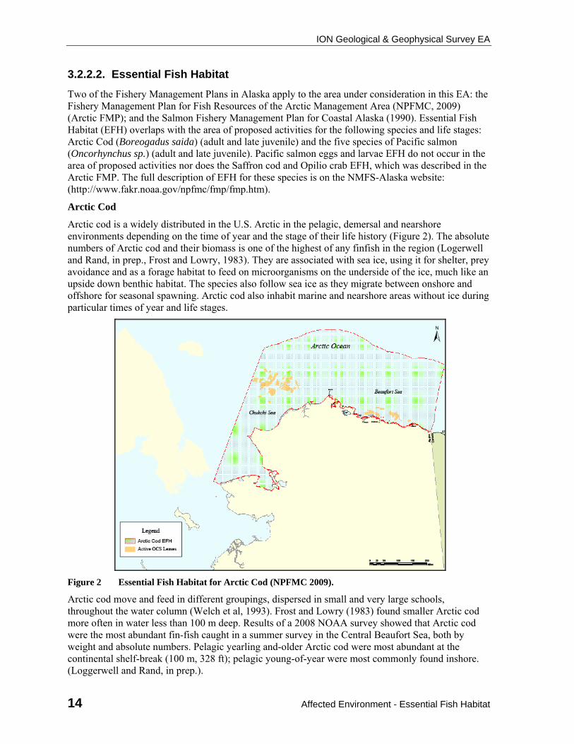
Arctic cod is a widely distributed in the U.S. Arctic in the pelagic, demersal and nearshore environments depending on the time of year and the stage of their life history (Figure 2). The absolute numbers of Arctic cod and their biomass is one of the highest of any finfish in the region (Logerwell and Rand, in prep., Frost and Lowry, 1983). They are associated with sea ice, using it for shelter, prey avoidance and as a forage habitat to feed on microorganisms on the underside of the ice, much like an upside down benthic habitat. The species also follow sea ice as they migrate between onshore and offshore for seasonal spawning. Arctic cod also inhabit marine and nearshore areas without ice during particular times of year and life stages.
Figure 2 Essential Fish Habitat for Arctic Cod (NPFMC 2009).
Arctic cod move and feed in different groupings, dispersed in small and very large schools, throughout the water column (Welch et al, 1993). Frost and Lowry (1983) found smaller Arctic cod more often in water less than 100 m deep. Results of a 2008 NOAA survey showed that Arctic cod were the most abundant fin-fish caught in a summer survey in the Central Beaufort Sea, both by weight and absolute numbers. Pelagic yearling and-older Arctic cod were most abundant at the continental shelf-break (100 m, 328 ft); pelagic young-of-year were most commonly found inshore. (Loggerwell and Rand, in prep.).
ION Geological & Geophysical Survey EA
Affected Environment - Essential Fish Habitat 15
Ringed seals, ribbon seals, spotted seals, beluga whales and several seabird species depend heavily on Arctic cod. Ice seals particularly depend upon Arctic cod in the winter (Bluhm and Gradinger, 2008; Dehn et al, 2007; Divoky et al, 1984; Frost and Lowry, 1984; Welch et al, (1993)). The biomass of Arctic cod (as both predator and prey) transfers energy throughout the food web. The abundance, wide distribution and the role in the food web of Arctic cod in the Beaufort Sea make this species very important in the ecosystem of the U.S. Arctic region.
Pacific Salmon
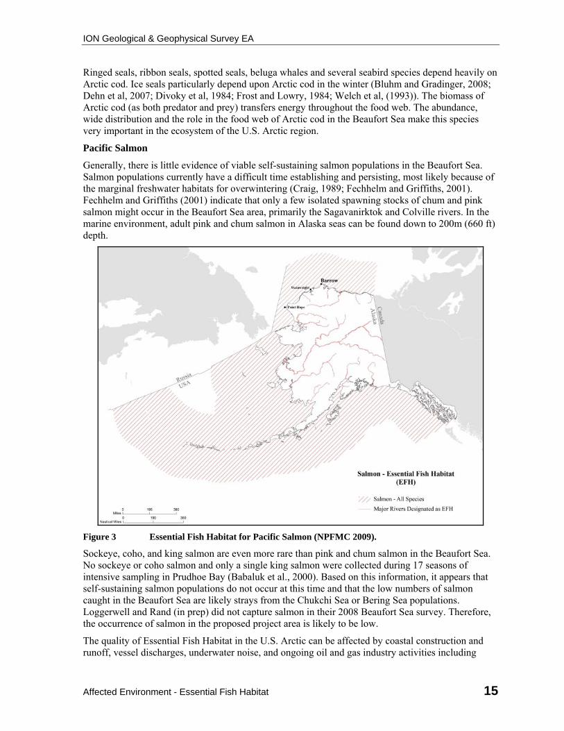
Generally, there is little evidence of viable self-sustaining salmon populations in the Beaufort Sea. Salmon populations currently have a difficult time establishing and persisting, most likely because of the marginal freshwater habitats for overwintering (Craig, 1989; Fechhelm and Griffiths, 2001). Fechhelm and Griffiths (2001) indicate that only a few isolated spawning stocks of chum and pink salmon might occur in the Beaufort Sea area, primarily the Sagavanirktok and Colville rivers. In the marine environment, adult pink and chum salmon in Alaska seas can be found down to 200m (660 ft) depth.
Figure 3 Essential Fish Habitat for Pacific Salmon (NPFMC 2009).
Sockeye, coho, and king salmon are even more rare than pink and chum salmon in the Beaufort Sea. No sockeye or coho salmon and only a single king salmon were collected during 17 seasons of intensive sampling in Prudhoe Bay (Babaluk et al., 2000). Based on this information, it appears that self-sustaining salmon populations do not occur at this time and that the low numbers of salmon caught in the Beaufort Sea are likely strays from the Chukchi Sea or Bering Sea populations. Loggerwell and Rand (in prep) did not capture salmon in their 2008 Beaufort Sea survey. Therefore, the occurrence of salmon in the proposed project area is likely to be low.
The quality of Essential Fish Habitat in the U.S. Arctic can be affected by coastal construction and runoff, vessel discharges, underwater noise, and ongoing oil and gas industry activities including
ION Geological & Geophysical Survey EA
16 Affected Environment - Invasive Species
petroleum spills. Climate change in the Arctic is a past and ongoing factor that affects the quality of EFH in several ways including: changes in seawater temperature and acidity; changes in extent and quality of sea ice habitat; and changes in freshwater discharge and nearshore salinities (Hopcroft, et al, 2006)
3.2.2.3. Invasive Species
An “invasive species" is defined as a species whose introduction does cause, or is likely to cause, economic or environmental harm or harm to human health where it is introduced (Invasive Species, Executive Order 13112, 1999). Potential vectors for introducing aquatic invasive species are ballast-water discharge, fouled ship hulls, oil rigs, and equipment placed overboard (e.g., anchors, seismic airguns, hydrophone arrays, ocean-bottom-survey cables).
The Nonindigenous Aquatic Nuisance Prevention and Control Act (NANPCA) (16 U.S.C. 4701-4751) was passed in 1990 and amended by the National Invasive Species Act of 1996 (NISA). The U.S. Coast Guard developed regulations that implement provisions of this Act and its amendment. Vessels brought into the State of Alaska or Federal waters are subject to these Coast Guard regulations which are intended to reduce the transfer of invasive species. The regulations require the “removal of fouling organisms from hull, piping, and tanks on a regular basis and dispose of any removed substances in accordance with local, State, and Federal regulations.” The regulations, however, do not specifically call for the same removal procedures for ocean-bottom cables or seismic equipment.
A non-native marine crustacean (amphipod) has been found in harbors ranging from Ketchikan in Southeast Alaska to Dutch Harbor in the Aleutian Islands. This is one of the few known cases to date of non-native marine organisms spread widely in Alaska (Ashton, et al., 2008) A non-native spider crab species was identified in coastal waters of Antarctica (Southern Ocean) in this decade, raising the discussion regarding the ability of a temperate species to cross over and thrive in a polar environment. In this case, however, the researchers were not able to specifically identify the pathway of the spider crab species into Antarctic coastal waters (Tavares and De Melo, 2004).
3.2.3. Coastal and Marine Birds
The general distribution and abundance of birds for the Beaufort Sea has been updated from resource information contained in the Beaufort Multi-Sale (MMS 2003-001; pages III-49 through III-54). Most marine birds that occur in the Beaufort and Chukchi seas are there during the open-water season. Arrival times usually coincide with the formation of leads during spring migration to coastal breeding areas. Migration times vary between species, but spring migration for most species takes place between late March and late May.
Some birds that breed on the North Slope migrate to or through the project area twice each year. Some marine and coastal birds may breed outside the project area, but spend time in the Beaufort Sea after breeding or during their non-breeding seasons. Departure times from the Beaufort Sea for the fall and winter vary between species and often by sex within the same species, but most marine and coastal birds will have moved out of the Beaufort Sea by late October before the formation of sea ice.
Climate Change Effects
Scientific and public interest in the Arctic is at an all-time high, attributed largely to a multitude of warming-induced changes now under way and a growing appreciation for the region’s importance to the global climate system. Temperatures over Arctic land areas have risen and continue to rise at roughly twice the rate of the rest of the world. Some trends from climate change to coastal and marine birds are evident and are anticipated to continue. Section 3.3.5.1 of the draft Arctic Multi-Sale EIS (MMS 2008-0055) briefly described likely ongoing effects on coastal and marine birds from changes
ION Geological & Geophysical Survey EA
Affected Environment - Coastal and Marine Birds 17
in oceanographic processes and sea-ice distribution, duration of snow and ice cover, distribution of wetlands and lakes, and sea level rise. These descriptions are not repeated here. That section concluded that continued climate change can result in short- and long-term and beneficial or detrimental population-level effects on coastal and marine birds. Exactly how Arctic birds/bird groups are responding to climate change over time and space cannot be predicted.
Descriptions of Species or Species Groups
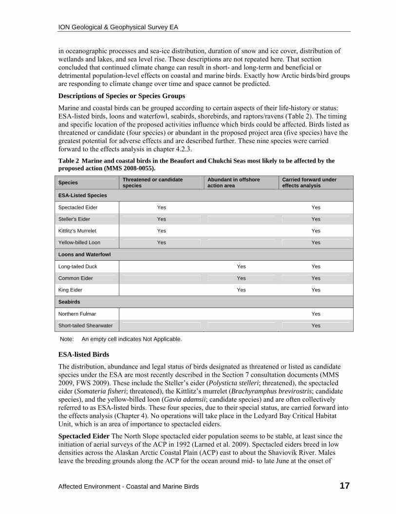
Marine and coastal birds can be grouped according to certain aspects of their life-history or status: ESA-listed birds, loons and waterfowl, seabirds, shorebirds, and raptors/ravens (Table 2). The timing and specific location of the proposed activities influence which birds could be affected. Birds listed as threatened or candidate (four species) or abundant in the proposed project area (five species) have the greatest potential for adverse effects and are described further. These nine species were carried forward to the effects analysis in chapter 4.2.3.
Table 2 Marine and coastal birds in the Beaufort and Chukchi Seas most likely to be affected by the proposed action (MMS 2008-0055).
Species Threatened or candidate species
Abundant in offshore action area
Carried forward under effects analysis
ESA-Listed Species
Spectacled Eider Yes Yes
Steller's Eider Yes Yes
Kittlitz's Murrelet Yes Yes
Yellow-billed Loon Yes Yes
Loons and Waterfowl
Long-tailed Duck Yes Yes
Common Eider Yes Yes
King Eider Yes Yes
Seabirds
Northern Fulmar Yes
Short-tailed Shearwater Yes
Note: An empty cell indicates Not Applicable.
ESA-listed Birds
The distribution, abundance and legal status of birds designated as threatened or listed as candidate species under the ESA are most recently described in the Section 7 consultation documents (MMS 2009, FWS 2009). These include the Steller’s eider (Polysticta stelleri; threatened), the spectacled eider (Somateria fisheri; threatened), the Kittlitz’s murrelet (Brachyramphus brevirostris; candidate species), and the yellow-billed loon (Gavia adamsii; candidate species) and are often collectively referred to as ESA-listed birds. These four species, due to their special status, are carried forward into the effects analysis (Chapter 4). No operations will take place in the Ledyard Bay Critical Habitat Unit, which is an area of importance to spectacled eiders.
Spectacled Eider The North Slope spectacled eider population seems to be stable, at least since the initiation of aerial surveys of the ACP in 1992 (Larned et al. 2009). Spectacled eiders breed in low densities across the Alaskan Arctic Coastal Plain (ACP) east to about the Shaviovik River. Males leave the breeding grounds along the ACP for the ocean around mid- to late June at the onset of
ION Geological & Geophysical Survey EA
18 Affected Environment - Coastal and Marine Birds
incubation by female eiders. Males are followed by females whose nests fail, and finally by successful breeding females and young birds in August and September. Female spectacled eiders have been documented migrating west along the Alaska coast as far as 40 km offshore (TERA 1999). Most spectacled eiders will have migrated from the Beaufort Sea by mid-October, although small numbers of spectacled eiders could be encountered in nearshore locations of the Beaufort Sea.
Steller’s Eider A small number of Steller’s eiders breed on the ACP of Alaska, most conspicuously near Barrow. Steller’s eiders have been observed east of Barrow to the Prudhoe Bay area where they are considered rare (TERA 1997). They are rare east of Barrow and even rarer as the season progresses due to molt migration, failed breeding, etc. As with the more common spectacled eider, these birds move to nearshore coastal waters after their breeding season. Few if any Steller’s eiders would likely be in the southern Beaufort Sea during or after the open water season.
Yellow-billed Loon Yellow-billed loons typically nest on low islands or narrow peninsulas on the edges of large, deep, tundra lakes (Johnson and Herter, 1989). The yellow-billed loon is relatively rare in the arctic region (North, 1994). Dau and Larned (2005, 2006, 2007) observed 23, 99, and 1 yellow-billed loon(s), respectively, during a late-June survey of the coast and barrier islands between Omalik Lagoon and the Canadian Border. Of the approximately 3,300 yellow-billed loons present on the breeding grounds on the North Slope, primarily between the Meade and Colville rivers in the National Petroleum Reserve-Alaska (NPR-A), it is likely that there are fewer than 1,000 nesting pairs because some of the 3,300 are nonbreeders. Additionally, there are approximately 1,500 yellow-billed loons (presumably juvenile nonbreeders) that remain in nearshore marine waters or in large rivers during the breeding season. In total, there are fewer than 5,000 yellow-billed loons on the North Slope breeding grounds and nearshore marine habitat (Earnst et al., 2005).
Satellite-tagging of eight yellow-billed loons from the ACP showed that in late September most yellow-billed loons leave arctic waters as they migrate to the Kamchatka Peninsula or the Kuril Islands (Rizollo and Schmutz, 2008).
Kittlitz’s Murrelet This species may nest as far north as Cape Beaufort (100 km northeast of Cape Lisburne). Kittlitz’s murrelets have been observed on a regular basis in the Chukchi Sea in late summer and early fall by Divoky (1987), but they have not been subsequently observed by others on similar cruises in the Chukchi Sea, suggesting that there is a great deal of annual variation in their occurrence. Murrelet foraging areas may occur near Barrow. The Kittlitz’s murrelet was reported just west of Barrow in September-October 2007 (Renner, Hunt, and Kuletz, 2008). The only recent notable change in the baseline information provided in the MMS 2008-0055 is that individual Kittlitz’s murrelets have recently been documented to occur in the Beaufort Sea, immediately east of Barrow. A few individual Kittlitz’s murrelets could be assumed to occur in close proximity to Barrow during the open water season.
Loons and Waterfowl
MMS 2003-001 and MMS 2008-0055 described the Pacific loon (Gavia pacifica), red-throated loon (G. stellata), Pacific brant (Branta bernicla nigricans), lesser snow goose (Chen caerulescens caerulescens), greater white-fronted goose (Anser albifrons frontalis), and tundra swan (Cygnus columbianus) as occurring in nearshore coastal waters of the Beaufort and Chukchi seas. Waterfowl species that are more abundant and occur in more offshore areas of the Beaufort and Chukchi seas include the long-tailed duck, the common eider, and the king eider and are described below.
Long-Tailed Duck (Clangula hyemalis). The long-tailed duck has decreased considerably since 1989, but remains a common species in the Beaufort Sea during the open-water period (Mallek, Platte, and Stehn, 2007). Many long-tailed ducks molt in the lagoons along the Beaufort Sea coast. In late June and early July, most male and nonbreeding female long-tailed ducks migrate to coastal molting areas where they are flightless for a 3- to 4-week period. Breeding females molt on
ION Geological & Geophysical Survey EA
Affected Environment - Coastal and Marine Birds 19
freshwater lakes during the last phases of duckling development before departing the North Slope in fall (Johnson and Herter, 1989). While most long-tailed ducks migrate within 45 km (28 mi) of shore (roughly along the 20-m [~ 66-ft] isobath), infrequent observations of long-tailed ducks in pelagic waters occur in late September (Divoky, 1987).
The molt is an energetically costly time, and long-tailed ducks have abundant food resources in the shallow water lagoons (Flint et al., 2003). During the molt, long-tailed ducks tend to stay in or near the lagoons, especially near passes between the lagoon and the sea (Johnson, Frost, and Lowry, 1992; Johnson, Wiggins, and Wainwright, 1992; Kinney, 1985). Brackney and Platte (as cited in Lysne, Mallek, and Dau, 2004) observed long-tailed ducks feeding heavily in passes between barrier islands.
Common Eider (Somateria mollissima). Common eiders nest on barrier islands or spits along the Beaufort Sea coast. Dau and Larned (2005) observed 1,819 common eiders along the Beaufort Sea coast with 652 on barrier islands and 1,167 on the mainland. Dau and Larned (2007) observed a total of 1,936 common eiders. Of these, 871 were along the Beaufort Sea coast with 423 along the barrier islands and 448 along the mainland. The highest concentrations were on survey segments on both sides of Kaktovik. In 2007, total birds and indicated breeding pairs were down 37.6% and 44.0%, respectively, from 2006 counts of 3,102 birds and 1,207 pairs. Total birds and indicated breeding pairs in 2007 were down 30.0 and 27.8%, respectively, from the 1999-2006 averages of 2,766+885 (1 standard deviation, range 1,353-4,449) birds and 937+264 (1 standard deviation, range 572-1,340) pairs (Dau and Larned, 2007).
After the molt is completed, some common eiders move offshore into pelagic waters, but most eiders remain close to shore (Divoky, 1987). When traveling along the northwest coast of Alaska, these eiders tend to stay along the 20-m isobath, approximately 48 km (29 mi) from shore. Most males are out of the Beaufort Sea by late August or early September, and most females were gone by late October or early November. Most breeding female common eiders and their young begin to migrate to molt locations in late August and September, although large numbers of female common eiders were observed molting in the eastern Beaufort Sea in Canada (Johnson and Herter, 1989).
The common eider population in the Beaufort Sea declined by 53% between 1976 and 1996 (Suydam et al., 2000). Common eiders were surveyed in marine waters within 100 km of the Beaufort Sea shoreline between Barrow and Demarcation Point by Fischer and Larned (2004) during summers in 1999-2001. In general, common eiders were concentrated in shallow waters (<10 m [<33 ft]), with the highest densities occurring in segments between Oliktok Point and Prudhoe Bay and between Tigvariak Island and Brownlow Point. Common eiders were most commonly associated with barrier islands in these segments, becoming less commonly observed up to 50 km seaward. Common eider densities were highest in areas of low ice cover.
Fischer and Larned (2004) concluded that because eider densities did not vary between summer months, the eiders they observed near barrier islands were local breeders rather than molt or fall migrants. This is consistent with Petersen and Flint (2002), who showed that satellite-tagged common eider hens remained in shallow waters close to their breeding sites through September.
Our most recent information still indicates that male common eiders begin moving out of the Beaufort Sea beginning in late June. Most males are out by late August or early September, and most females were gone by late October or early November. When traveling west along the Beaufort Sea coast, approximately 90% of the common eiders migrate within 48 km of the coast; 7% migrate 13-16 km from shore, roughly along the 17-20 m isobath (Johnson and Herter, 1989, citing Bartels, 1973).
King Eider (Somateria spectabilis). Most king eiders begin to arrive in the Beaufort Sea by the middle of May. Arrival times in the Beaufort Sea are dependent upon the location and timing of offshore leads along the Chukchi Sea (Barry, 1986). Most king eiders nesting on the North Slope between Icy Cape and the western boundary of ANWR nested in three general areas: between the
ION Geological & Geophysical Survey EA
20 Affected Environment - Coastal and Marine Birds
Colville River and Prudhoe Bay, southeast of Teshekpuk Lake and a large area near Atqasuk (Larned, Stehn, and Platte, 2006). Dau and Larned (2005, 2006, 2007) surveyed the Chukchi and Beaufort Seas’ coastlines found 800, 3,045, and 1,621 king eiders in 2005, 2006, and 2007, respectively.
The king eider population in the Beaufort Sea appeared to remain stable between 1953 and 1976 but declined by 56% between 1976 and 1996 (Suydam et al., 2000). Fischer and Larned (2004) surveyed king eiders in marine waters within 100 km of the Beaufort Sea shoreline between Barrow and Demarcation Point during summers in 1999 and 2001. King eiders were the second most abundant species counted during the survey periods. King eider densities varied according to water depth, offshore distance, and percent of ice cover. Large flocks of king eiders concentrated in the mid-depth (10-20 m [33-66 ft]) zone offshore of Barrow and Oliktok Point. In 1999 and 2000, these flocks were in waters >10 m (>33 ft) deep but were found in the shallow (<10 m [<33 ft]) and mid-depth zone in July 2001. King eiders were unique among species surveyed by occurring in higher densities in low (31%) and moderate (31-60%) ice cover (Fischer and Larned, 2004).
Satellite telemetry was used to determine that most king eiders spent more than 2 weeks staging offshore in the Beaufort Sea prior to fall migration (Phillips, 2005; Powell et al., 2005). Female king eiders may need to remain in the Beaufort Sea longer than males to replenish fat stores depleted during egg laying and incubation (Powell et al., 2005). Prior to molt migration, king eiders in the Beaufort Sea usually were found about 13 km offshore; however, during migration to molting areas, king eiders occupied a wide area ranging from shoreline to >50 km (>31 mi) offshore (Phillips, 2005).
Seabirds
The MMS 2003-001 and MMS 2008-0055 described the common murre (Uria aalge), thick-billed murre (U. lomvia), tufted puffin (Fratercula cirrhata), horned puffin (F. corniculata), black-legged kittiwake (Rissa tridactyla), black guillemot (Cepphus grylle), Ross’ gull (Rhodostethia rosea), ivory gull (Pagophila eburnea), arctic tern (Sterna paradisaea), pomarine jaeger (S. pomarinus), parasitic jaeger (S. parasiticus), long-tailed jaeger (S. longicaudus), and glaucous gull (Larus hyperboreus) as occurring in the Beaufort Sea. Seabird species that are more abundant and occur in offshore areas of the Beaufort Sea include the northern fulmar and the short-tailed shearwater and are described below.
Northern Fulmar (Fulmarus glacialis). Fulmars do not breed in the Beaufort Sea region, and those observed during the summer are nonbreeders or failed breeders from southern areas. Fulmars are most numerous from late August to mid-September.
Short-Tailed Shearwater (Puffinus tenuirostris). Shearwaters do not breed in the Beaufort Sea region. These birds breed in the southern hemisphere. At northern latitudes, short-tailed shearwaters likely forage at highly productive patches of euphausiids and amphipods. Divoky (1987) reported short-tailed shearwaters north of Barrow and into Arctic Canada, depending on the presence of sea ice. In certain years, an estimated 100,000 short-tailed shearwaters passed Point Barrow in 1 day in mid-September (Divoky, 1987).
Shorebirds
The most common shorebird species include dunlin (Calidris alpina) and phalaropes (Phalaropus spp.) (Alaska Shorebird Group, 2004). Nearshore and shoreline habitats are especially important habitats where shorebirds replenish energy reserves after breeding and prior to southward migration, but these areas are out of the project action area and these species are not evaluated further.
Raptors and Ravens
Raptors along nearshore and shoreline areas of the Beaufort Sea consist of small numbers of snowy owls and transient peregrine falcons, golden eagles, northern harriers, and rough-legged hawks. Ravens have recently expanded their distribution across portions of the North Slope. These species do
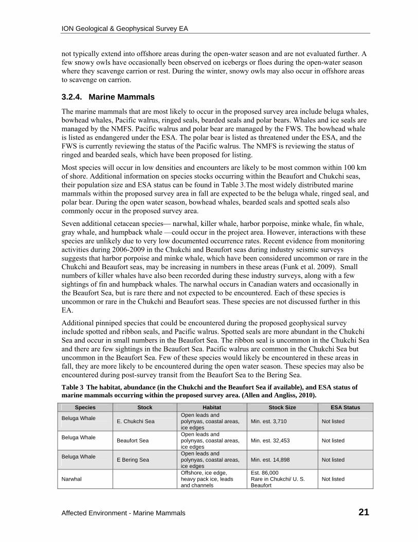
ION Geological & Geophysical Survey EA
Affected Environment - Marine Mammals 21
not typically extend into offshore areas during the open-water season and are not evaluated further. A few snowy owls have occasionally been observed on icebergs or floes during the open-water season where they scavenge carrion or rest. During the winter, snowy owls may also occur in offshore areas to scavenge on carrion.
3.2.4. Marine Mammals
The marine mammals that are most likely to occur in the proposed survey area include beluga whales, bowhead whales, Pacific walrus, ringed seals, bearded seals and polar bears. Whales and ice seals are managed by the NMFS. Pacific walrus and polar bear are managed by the FWS. The bowhead whale is listed as endangered under the ESA. The polar bear is listed as threatened under the ESA, and the FWS is currently reviewing the status of the Pacific walrus. The NMFS is reviewing the status of ringed and bearded seals, which have been proposed for listing.
Most species will occur in low densities and encounters are likely to be most common within 100 km of shore. Additional information on species stocks occurring within the Beaufort and Chukchi seas, their population size and ESA status can be found in Table 3.The most widely distributed marine mammals within the proposed survey area in fall are expected to be the beluga whale, ringed seal, and polar bear. During the open water season, bowhead whales, bearded seals and spotted seals also commonly occur in the proposed survey area.
Seven additional cetacean species— narwhal, killer whale, harbor porpoise, minke whale, fin whale, gray whale, and humpback whale —could occur in the project area. However, interactions with these species are unlikely due to very low documented occurrence rates. Recent evidence from monitoring activities during 2006-2009 in the Chukchi and Beaufort seas during industry seismic surveys suggests that harbor porpoise and minke whale, which have been considered uncommon or rare in the Chukchi and Beaufort seas, may be increasing in numbers in these areas (Funk et al. 2009). Small numbers of killer whales have also been recorded during these industry surveys, along with a few sightings of fin and humpback whales. The narwhal occurs in Canadian waters and occasionally in the Beaufort Sea, but is rare there and not expected to be encountered. Each of these species is uncommon or rare in the Chukchi and Beaufort seas. These species are not discussed further in this EA.
Additional pinniped species that could be encountered during the proposed geophysical survey include spotted and ribbon seals, and Pacific walrus. Spotted seals are more abundant in the Chukchi Sea and occur in small numbers in the Beaufort Sea. The ribbon seal is uncommon in the Chukchi Sea and there are few sightings in the Beaufort Sea. Pacific walrus are common in the Chukchi Sea but uncommon in the Beaufort Sea. Few of these species would likely be encountered in these areas in fall, they are more likely to be encountered during the open water season. These species may also be encountered during post-survey transit from the Beaufort Sea to the Bering Sea.
Table 3 The habitat, abundance (in the Chukchi and the Beaufort Sea if available), and ESA status of marine mammals occurring within the proposed survey area. (Allen and Angliss, 2010).
Species Stock Habitat Stock Size ESA Status
Beluga Whale
E. Chukchi Sea Open leads and polynyas, coastal areas, ice edges
Min. est. 3,710 Not listed
Beluga Whale
Beaufort Sea Open leads and polynyas, coastal areas, ice edges
Min. est. 32,453 Not listed
Beluga Whale
E Bering Sea Open leads and polynyas, coastal areas, ice edges
Min. est. 14,898 Not listed
Narwhal Offshore, ice edge, heavy pack ice, leads and channels
Est. 86,000 Rare in Chukchi/ U. S. Beaufort
Not listed
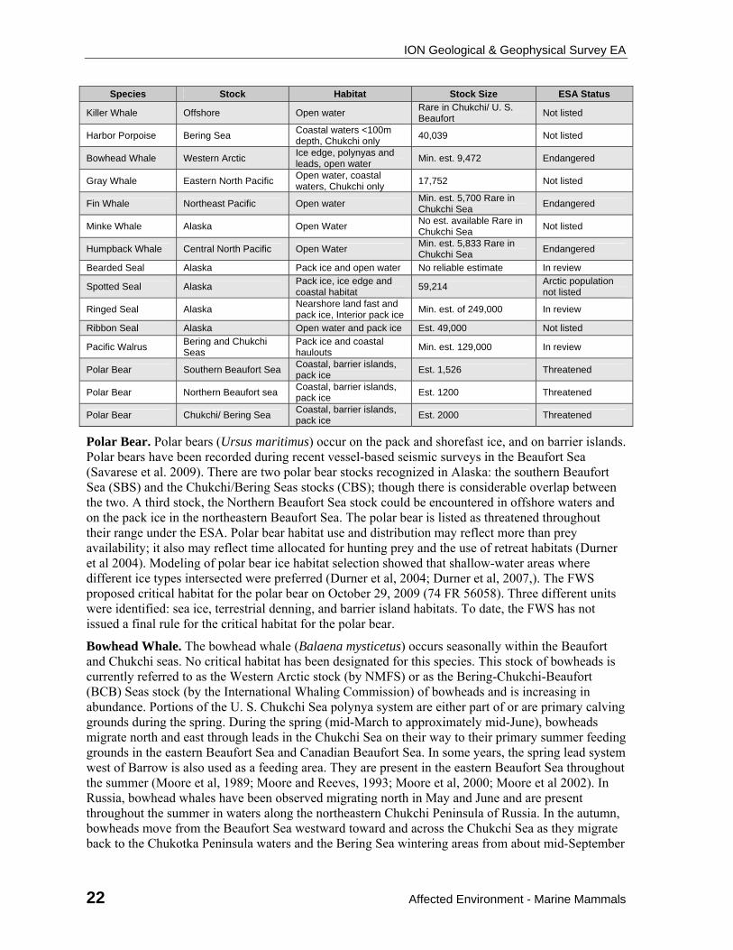
ION Geological & Geophysical Survey EA
22 Affected Environment - Marine Mammals
Species Stock Habitat Stock Size ESA Status
Killer Whale Offshore Open water Rare in Chukchi/ U. S. Beaufort
Not listed
Harbor Porpoise Bering Sea Coastal waters <100m depth, Chukchi only
40,039 Not listed
Bowhead Whale Western Arctic Ice edge, polynyas and leads, open water
Min. est. 9,472 Endangered
Gray Whale Eastern North Pacific Open water, coastal waters, Chukchi only
17,752 Not listed
Fin Whale Northeast Pacific Open water Min. est. 5,700 Rare in Chukchi Sea
Endangered
Minke Whale Alaska Open Water No est. available Rare in Chukchi Sea
Not listed
Humpback Whale Central North Pacific Open Water Min. est. 5,833 Rare in Chukchi Sea
Endangered
Bearded Seal Alaska Pack ice and open water No reliable estimate In review
Spotted Seal Alaska Pack ice, ice edge and coastal habitat
59,214 Arctic population not listed
Ringed Seal Alaska Nearshore land fast and pack ice, Interior pack ice
Min. est. of 249,000 In review
Ribbon Seal Alaska Open water and pack ice Est. 49,000 Not listed
Pacific Walrus Bering and Chukchi Seas
Pack ice and coastal haulouts
Min. est. 129,000 In review
Polar Bear Southern Beaufort Sea Coastal, barrier islands, pack ice
Est. 1,526 Threatened
Polar Bear Northern Beaufort sea Coastal, barrier islands, pack ice
Est. 1200 Threatened
Polar Bear Chukchi/ Bering Sea Coastal, barrier islands, pack ice
Est. 2000 Threatened
Polar Bear. Polar bears (Ursus maritimus) occur on the pack and shorefast ice, and on barrier islands. Polar bears have been recorded during recent vessel-based seismic surveys in the Beaufort Sea (Savarese et al. 2009). There are two polar bear stocks recognized in Alaska: the southern Beaufort Sea (SBS) and the Chukchi/Bering Seas stocks (CBS); though there is considerable overlap between the two. A third stock, the Northern Beaufort Sea stock could be encountered in offshore waters and on the pack ice in the northeastern Beaufort Sea. The polar bear is listed as threatened throughout their range under the ESA. Polar bear habitat use and distribution may reflect more than prey availability; it also may reflect time allocated for hunting prey and the use of retreat habitats (Durner et al 2004). Modeling of polar bear ice habitat selection showed that shallow-water areas where different ice types intersected were preferred (Durner et al, 2004; Durner et al, 2007,). The FWS proposed critical habitat for the polar bear on October 29, 2009 (74 FR 56058). Three different units were identified: sea ice, terrestrial denning, and barrier island habitats. To date, the FWS has not issued a final rule for the critical habitat for the polar bear.
Bowhead Whale. The bowhead whale (Balaena mysticetus) occurs seasonally within the Beaufort and Chukchi seas. No critical habitat has been designated for this species. This stock of bowheads is currently referred to as the Western Arctic stock (by NMFS) or as the Bering-Chukchi-Beaufort (BCB) Seas stock (by the International Whaling Commission) of bowheads and is increasing in abundance. Portions of the U. S. Chukchi Sea polynya system are either part of or are primary calving grounds during the spring. During the spring (mid-March to approximately mid-June), bowheads migrate north and east through leads in the Chukchi Sea on their way to their primary summer feeding grounds in the eastern Beaufort Sea and Canadian Beaufort Sea. In some years, the spring lead system west of Barrow is also used as a feeding area. They are present in the eastern Beaufort Sea throughout the summer (Moore et al, 1989; Moore and Reeves, 1993; Moore et al, 2000; Moore et al 2002). In Russia, bowhead whales have been observed migrating north in May and June and are present throughout the summer in waters along the northeastern Chukchi Peninsula of Russia. In the autumn, bowheads move from the Beaufort Sea westward toward and across the Chukchi Sea as they migrate back to the Chukotka Peninsula waters and the Bering Sea wintering areas from about mid-September
ION Geological & Geophysical Survey EA
Affected Environment - Marine Mammals 23
through November (Moore et al, 1995). Bowheads migrate southward through the Bering Strait in late October through early November. Bowheads are often associated with heavy ice cover and remain over the shallow continental shelf most of the year. The BCB stock of bowhead whales overwinter in the central and western Bering Sea, where most mating probably occurs. Important winter habitat includes the marginal ice zone and polynyas along the northern Gulf of Anadyr, St. Mathew Island and St. Lawrence Island, and recent satellite telemetry data indicate use of areas in the Chukchi and Bering seas with extensive ice as well (Moore and DeMaster, 1997; Moore et al, 2000b).
Seals (ringed, bearded, spotted, ribbon). The seal most likely to be encountered in the proposed action area is the ringed seal. Ringed seals numbers are considerably higher than other seal species in the Beaufort and Chukchi seas, particularly during the winter and spring (Burns, 1970). Ringed seals have the unique ability to maintain breathing holes in thick ice. They are closely associated with ice, and in early summer the highest densities of ringed seals are found in nearshore fast and pack ice. During the open water season, ringed seals are dispersed throughout the open water. Ringed seals construct lairs in landfast or drifting pack ice, and give birth in mid-March through April (Smith and Stirling, 1975; Smith and Hammill, 1981). Ringed seals are an important subsistence species for Alaska Native hunters. The Alaska stock of ringed seals is not classified by NMFS as a strategic stock.
Bearded seals are the largest of the northern phocids, and have a circumpolar distribution. During the open-water period, bearded seals occur mainly in relatively shallow areas, preferring areas no deeper than 200 meters. Most bearded seals are found in the Bering and Chukchi seas and are predominantly benthic feeders, feeding primarily on a variety of invertebrates (Burns, 1970; Stirling et al, 1982; Stirling, 1997). The Alaska stock of bearded seals is not classified by NMFS as a strategic stock. Bearded seals are an important subsistence species for Alaska Native hunters.
Spotted seals are common in the coastal Alaskan waters in ice-free seasons. They migrate south from the Chukchi Sea and into the Bering Sea in October-November (Burns, 1970; Stirling et al, 1982; Stirling, 1997). Spotted seals are an important subsistence species for Alaska Native hunters. The Alaska stock of spotted seals is not classified by NMFS as a strategic stock.
Ribbon seal range northward from Bristol Bay in the Bering Sea and into the Chukchi and western Beaufort seas. They are found in the open sea, on pack ice, and rarely on shorefast ice (Burns, 1970; Stirling et al, 1982; Stirling, 1997). The Alaska stock of ribbon seal is not classified by NMFS as a strategic stock. Ribbon seals occasionally are harvested by Alaska Native hunters.
Pacific Walrus. The Pacific walrus population (which comprises about 80% of the world population), in general, is associated with the moving pack ice year-round. They winter in the Bering Sea and the majority of the population summers throughout the Chukchi Seas and the westernmost part of the Beaufort Sea. Although capable of diving to deeper depths, Pacific walruses are usually found in waters of 100 meters or less, possibly because of higher productivity of their benthic foods in the shallower water (Fay, 1982). Recent reports indicate the climate change has caused walrus to move to terrestrial haulouts in the Chukchi Sea in summer when the sea ice retreats northward. This increases the likelihood of injury, and death during stampedes at crowded haulouts, particularly for calves (Fischbach et al, 2009). The Pacific walrus is an important subsistence species for the Alaska Native hunter.
Beluga. The Beaufort Sea and Chukchi Sea beluga whale stocks winter in the Bering Sea and summer in the Beaufort and Chukchi seas, migrating around western and northern Alaska along the spring lead system in April and May. Belugas generally are associated with ice and relatively deep water throughout the summer and autumn. During late summer and autumn, most belugas migrate westward far offshore near the pack ice (Frost et al. 1988; Hazard 1988; Clarke et al. 1993; Miller et al. 1999). During fall aerial surveys in the U. S. Beaufort Sea, Christie et al. (2009) reported the highest beluga sighting rates during the first two weeks of September and in the northern part of their survey area.
ION Geological & Geophysical Survey EA
24 Affected Environment - Subsistence
Moore (2000) and Moore et al. (2000b) suggested that beluga whales select deeper water near the continental shelf break independent of ice cover. However, during the westward migration in late summer and autumn, small numbers of belugas are sometimes seen near the north coast of Alaska (e.g., Johnson 1979). Christie et al. (2009) reported higher beluga sighting rates at locations >60 km offshore than at locations nearer shore during aerial surveys in the U. S. Beaufort Sea in 2006–2008. Belugas were not recorded, however, during Arctic cruises by the Healy in 2005 or 2006 (Haley 2006; Haley and Ireland 2006). This could be due to avoidance of the icebreaker by beluga. Icebreakers may be audible to beluga over distances of 35 to 78 km (Erbe and Farmer, 2000). Eastern Chukchi belugas move into coastal areas along Kotzebue Sound and Kasegaluk Lagoon in late June and remain there until mid to late July. Subsistence hunting occurs on this stock during their time in these waters. Neither stock is listed as “depleted” or classified as a strategic stock under the Marine Mammal Protection Act (MMPA).
Gray whales. Gray whale occurs regularly in continental shelf waters along the Chukchi Sea coast in summer and to a lesser extent along the Beaufort Sea coast. Gray whales return annually to primary feeding areas in the northern Bering Sea and Chukchi Sea. However, in recent years more gray whales have been observed entering the Beaufort Sea east of Point Barrow, especially in the late summer and autumn. Gray whales are the only baleen whales that are mainly bottom feeders, and prefer areas of little or no ice cover. Gray whale feeding habitat in the northern Chukchi Sea appears limited to shoal and coastal waters and their selection of shoal and coastal habitat is greatest in the summer (Allen and Angliss, 2010). The eastern North Pacific stock is not designated as “depleted” under the MMPA nor considered a strategic stock by NMFS.
3.2.5. Subsistence, Sociocultural Systems, and Environmental Justice
Subsistence activities are a central element in the North Slope Borough (NSB) socioeconomic system. The following sections of the EA address specific components of these resources that are most relevant to the Beaufort Sea coastal communities of Kaktovik, Nuiqsut, and Barrow: subsistence, environmental justice, and community health. Proposed seismic survey activities would be conducted offshore of all three communities and their subsistence whaling areas from late September to late December 2010.
3.2.5.1. Subsistence Activities
Subsistence activities are assigned the highest cultural values by the Inupiat Eskimo of the North Slope and provide a sense of identity in addition to being an important economic pursuit. Subsistence is viewed by Alaska Natives not just as an activity that is imbedded in the culture; it is viewed as the very culture itself (Wheeler and Thornton, 2005).
The bowhead whale is a subsistence resource of paramount importance, and, consequently, descriptions of the social organization pertaining to the crew, the hunt, quantity, and distribution of the whale dominate subsistence discourse in North Slope Inupiat Eskimo communities (USDOI, MMS, 2006).
Bowhead whaling traditions underscore the central values and activities for the Inupiat of the North Slope. Bowhead whale hunting strengthens family and community ties and the sense of a common Iñupiat heritage, culture, and way of life, and provides a strength, purpose, and unity in the face of rapid change (USDOI, MMS, 2008; EDAW/AECOM, 2007). Although bowhead whaling traditions are unquestionably significant, harvest of other wild resources, including caribou, fish, avian species, and other marine mammals also are important to the local inhabitants to provide a variety in the diet and nutrition or to provide nutritional needs if few or no bowhead whales are taken (USDOI, MMS, 2006).
ION Geological & Geophysical Survey EA
Affected Environment - Subsistence 25
At issue in terms of greatest potential impacts to subsistence activities and resources from the proposed activities would be the potential noise disturbance to subsistence whaling from ongoing seismic and icebreaking activities. The seismic survey will begin in the deep water off the northeastern Beaufort Sea. The subsistence whaling seasons for Kaktovik and Nuiqsut would be expected to have concluded by the date the seismic survey begins. Barrow's fall bowhead hunt occurs from early September to late October. Seismic survey activities will not begin moving northwestward into deep water of the western Beaufort Sea until late October when Barrow's fall bowhead hunt would be expected to have concluded.
Subsistence Communities
This discussion focuses on the subsistence activities, related subsistence resources, and subsistence distribution levels of the communities whose subsistence use areas overlap with the proposed project area.
Kaktovik. Kaktovik’s subsistence-harvest areas are depicted in detail in Figures 3.4.2-1 through 3.4.2-7 of the Arctic Multiple-Sale Draft EIS (USDOI, MMS, 2008a) and in the MMS OCS Study 2009-003, Subsistence Mapping of Nuiqsut, Kaktovik, and Barrow (SRB&A, 2010: Maps 61-110). Subsistence resources used by Kaktovik are listed in Tables 3.4.2-3 through 3.4.2-5 of the Arctic Multiple-Sale Draft EIS. Kaktovik’s annual harvest of bowhead whales from the 1980s to 2005 is shown in Table 3.4.2-9 of the Arctic Multiple-Sale Draft EIS.
The bowhead whaling effort takes precedence over any other subsistence activity, and occurs only in the fall. Whaling crews use Kaktovik as their home base, leaving the village and returning on a daily basis. The core whaling area is within 12 mi of the village with a periphery ranging about 8 mi farther, if necessary. ION Geophysical’s seismic surveys would approach Kaktovik's core subsistence whaling area well after the completion of the Kaktovik bowhead whaling season. The timing of the Kaktovik bowhead whale hunt roughly parallels the Cross Island whale hunt (Impact Assessment Inc, 1990b; SRB&A, 2010: Map 64). The Arctic Multiple-Sale Draft EIS (USDOI, MMS, 2008a) describes the hunting of beluga whales from Kaktovik. As best as can be ascertained, about one beluga is harvested annually in conjunction with the bowhead whale hunt, but most households obtain beluga through exchanges with other communities.
Nuiqsut. Nuiqsut’s subsistence-harvest areas are depicted in detail in Figures 3.4.2-11 through 3.4.2-27 of the Arctic Multiple-Sale Draft EIS (USDOI, MMS, 2008a) and in the MMS OCS Study 2009-003, Subsistence Mapping of Nuiqsut, Kaktovik, and Barrow (SRB&A, 2010: Maps 111-162). Subsistence resources used by Nuiqsut are listed in Tables 3.4.2-7 through 3.4.2-8 of the Arctic Multiple-Sale Draft EIS. Nuiqsut’s annual harvest of bowhead whales from the 1980s to 2005 is shown in Tables 3.4.2-9 of the Arctic Multiple-Sale Draft EIS.
During summer, the people of Nuiqsut harvest whitefish, primarily along channels of the Colville River. They also harvest Arctic char, dog salmon, pink salmon, and the spotted seals that follow the fish upriver. Waterfowl are hunted, as are summer caribou (Galginaitis et al., 1984; SRB&A, 2010: Map 112). Although seal is not a preferred meat for human consumption, people use the oil as a condiment. Seals are hunted in nearshore waters during this time. There was general agreement that the best place to harvest them is off the Colville delta (Impact Assessment Inc., 1990a; USDOI, MMS, 2009a).
Bowhead whaling takes precedence over any other subsistence activity, and occurs only in the fall. The 2008 Cross Island bowhead whale hunting season started earlier than any other, with the first crew arriving on August 29, and lasted for 14 days, including days set aside for traveling, butchering, weather days, and scouting days. The captains agreed to stop whaling on September 9 because the four landed whales were considered to be a sufficient harvest. Whale strikes occurred at an average distance of 10.5 km (6.5 mi) from Cross Island. The shorter 2008 season compares with the 21-day
ION Geological & Geophysical Survey EA
26 Affected Environment - Subsistence
season in 2006 and the 27-day season in 2005. Over the past 7 years of reported monitoring (2001-2008), the majority of the bowhead whales have been harvested in the northeast quadrant off Cross Island (Galganitis., 2009a; USDOI, MMS, 2009b; SRB&A, 2010: Maps 113 and 114).
In recent years, the Cross Island whalers focus exclusively on taking bowhead whales. They do not hunt for belugas, and crew members must ask for permission from the whaling captain to kill a polar bear that might be in the vicinity of the harvested whale carcasses because it would entail hours away from the bowhead whale hunt (Impact Assessment Inc., 2009a). Scheduling and logistical conflicts with bowhead whaling do not mean that the people have abandoned these beluga whale and polar bear as subsistence resources, and hunts for these resources may resume in the future (Sverre Pedersen, 2009, pers. commun.).
Barrow. Barrow’s subsistence-harvest areas are depicted in detail in Figures 3.4.2-53, 3.4.2-56, 3.4.2-57 and 3.4.2-58 of the Arctic Multiple-Sale Draft EIS (USDOI, MMS, 2008a) and in the MMS OCS Study 2009-003, Subsistence Mapping of Nuiqsut, Kaktovik, and Barrow (SRB&A, 2010: Maps 8-48). Subsistence resources used by Barrow are listed in Tables 3.3.2-1, 3.3.2-2, 3.3.2-8, and 3.3.2-10 of the Arctic Multiple-Sale Draft EIS. Barrow’s annual harvest of bowhead and beluga whales, walrus, and polar bear from the 1980s to 2005 are shown in Tables 3.4.2-9 (bowhead), 3.4.2-10 (beluga), 3.4.2-11 (walrus), and 3.4.2-6 (polar bear) of the Arctic Multiple-Sale Draft EIS.
Barrow residents hunt bowhead whales during both spring and fall; in the past, more whales were harvested during the spring whale hunt, but with changing ice conditions the fall hunt has increased in importance as the major whaling season. Hunters use aluminum skiffs with outboard motors to pursue the whales during the fall migration, which takes place in open water up to 30 mi offshore. No other marine mammal is harvested with the intensity and concentration of effort that is expended on the bowhead whale. Subsistence studies conducted in the early 1990’s indicated that 58.2% of Barrow’s total subsistence harvest was marine mammals, and 43.3% of the total harvest was bowhead whales (USDOI, MMS 2008, 2009b; SRB&A, 2010: Map 10).
Beluga whales are available from the beginning of the spring whaling season through June and occasionally in July and August in ice-free waters. Belugas are harvested in the leads between Point Barrow and Skull Cliff. Later in summer, belugas occasionally are harvested on both sides of the barrier islands of Elson Lagoon.
The hunting of bearded seals (ugruk) is an important subsistence activity in Barrow, because the bearded seal is a preferred food and because bearded seal skins are the preferred covering material for the skin boats used in whaling. Most bearded seals are harvested during the spring and summer months and from open water during the pursuit of other marine mammals in both the Chukchi and Beaufort seas. Seals are harvested during the winter months, especially from February through March. Seals are harvested primarily during the winter months, especially from February through March. The harvesting of bearded and ringed seals can occur well offshore although in recent years winter ice conditions have kept the highest area of use within about 25 mi from shore, with the most intense harvest period occurring in the summer months (USDOI, MMS, 2008a, 2009b SRB&A, 2010: Maps 29-32).
Barrow residents harvest marine and freshwater fishes, but their dependency on fish varies according to the availability of other resources. Capelin, char, cod, grayling, salmon, sculpin, trout, and whitefish are harvested. Fishing occurs primarily in the summer and fall months and peaks in September and October. Most fishing occurs at inland fish camps, particularly in lakes and rivers that flow into the southern end of Dease Inlet quite distant from ION Geophysical’s proposed survey activities in the Beaufort Sea (USDOI, MMS, 2008a, 2009b; SRB&A, 2010: Maps 16-24).
Walrus are harvested during the summer marine-mammal hunt west of Point Barrow and southwest to Peard Bay. Most hunters travel no more than 15-20 mi to hunt walruses, although more recent

ION Geological & Geophysical Survey EA
Affected Environment - Sociocultural Systems 27
interviews indicated hunters are traveling as far as 100 mi north from Point Barrow in pursuit of walrus. The major walrus-hunting effort occurs from late June through mid-September, with the peak season in August (SRB&A, 2010: Map 33). Barrow residents hunt polar bears from October to June as far as 60 mi offshore.
3.2.5.2. Sociocultural Systems and Environmental Justice
Sociocultural systems encompass three concepts: (1) social organization, (2) cultural values, and (2) institutional organizations of communities. By “social organization” we mean how people are divided into social groups and networks. By “cultural values” we mean desirable values that are widely shared explicitly and implicitly by members of a social group. By “institutional organization” we refer to the government and on government entities that provide services to the community. These three concepts are interrelated. For most Alaska Natives, subsistence (and the relationship between people, land, water, and its resources) is the idiom of cultural identity, and production of subsistence foods is the activity around which social organization occurs. Institutional organizations, in turn, reflect and affect the social organization and cultural values. For the North Slope of Alaska, Iñupiat traditions and practices largely define social organization and cultural values, while the civil and tribal governments and Native corporations largely define institutional organization. A detailed explanation of Sociocultural factors appears in Section 3.4.3 of the MMS 2008-0055.
Although there have been substantial social, economic, and technological changes in Iñupiat lifestyle, subsistence continues to be the central organizing value of Iñupiat sociocultural systems and it is primarily through impacts to subsistence activities that impacts to sociocultural systems are assessed (USDOI, MMS, 2008).
The Environmental Justice (EJ) Executive Order 12898 requires each Federal Agency to make the consideration of EJ part of its mission. The Executive Order requires an evaluation in an EIS or EA as to whether the proposed project would have “disproportionately high adverse human health (i.e., community health) and environmental effects…on minority populations and low income populations.” Alaska Iñupiat Natives, a recognized minority, are the predominant residents of the North Slope Borough, the area potentially affected by survey activities. The ethnic composition of Kaktovik, Nuiqsut, and Barrow demonstrates that all three communities would be classed as minority communities on the basis of their proportional American Indian and Alaska Native membership. The Statewide population is 15.4% American Indian and Alaska Native. On this basis, an evaluation of disproportionate impacts is required. Generally, disproportionate impacts on minority and low income populations are assessed based on the impacts to subsistence practices and consequent impacts on sociocultural systems (USDOI, MMS, 2008).
The health and welfare of the residents of the NSB is a primary concern, and more specific community health effects are assessed based on impacts to (1) General Health and Well-being; (2) Psychosocial issues; (3) Accidents and Injuries; (4) Contaminant Exposure; (5) Food, Nutrition, and Physical Activity; (6) Noncommunicable and Chronic Disease; (7) Cancer; (8) Infectious Diseases; (9) Maternal-Child Health; (10) Water and Sanitation; (11) Health Services Infrastructure and Capacity; and (12) Occupational/Community Health Intersection as discussed in great detail in Appendix J of MMS 2008-0055.
3.2.6. Archaeological Resources
Because no bottom disturbing activities are proposed in ION Geophysical’s seismic survey plan, proposed survey activities would have no impact on historic properties and no further analysis will be included in this EA.
ION Geological & Geophysical Survey EA
28 Environmental Impacts - level of effects
4. ENVIRONMENTAL IMPACTS
The following terms are used throughout this EA to describe the level of effects to each resource:
Negligible:
No measurable impacts and no population-level effects.
May cause brief behavioral reactions such as temporary avoidances of or deflections around an area.
Localized, short-term disturbance or habitat effects experienced during one season are not anticipated to accumulate across multiple seasons.
No mortality or detectable impacts to reproductive success or recruitment are anticipated.
Mitigation measures are fully implemented or are not necessary.
Minor:
Low but measurable impacts with no population-level effects.
A small number of mortalities are unlikely but possible.
May cause behavioral reactions such as avoidances of or deflections around an area.
Localized, disturbance or habitat effects experienced during one season may accumulate across subsequent seasons, but not over one year.
Mitigation measures are fully implemented or are not necessary.
Moderate:
Mortalities or disturbances could occur, but no detectable population-level effects.
A small number of mortalities are likely, but not to an extent resulting in detectable population level effects.
Adverse impacts to ESA-listed species could occur.
Widespread annual or chronic disturbances or habitat effects could persist for more than one year and up to a decade.
Widespread implementation of mitigation measures for similar activities may be effective in reducing the level of avoidable adverse effects.
Unmitigated or unavoidable adverse effects may be short term and widespread, or are long term and localized.
Major:
Mortalities or disturbances occur that have detectable population-level effects.
For marine mammals, mortality might occur at or above the estimated Potential Biological Removal (PBR) as a result of the proposed action.
For fish and benthic invertebrates, the anticipated mortality is estimated or measured in terms of tens of thousands of individuals or >20% of a local breeding population and/or >5% of a regional population, which may produce population-level effects.
Widespread seasonal or chronic effects are cumulative and are likely to persist for more than one decade.
ION Geological & Geophysical Survey EA
Environmental Impacts - Alternative 1 – The Proposed Action 29
Mitigation measures are implemented only for a small portion of similar impacting activities, but more widespread implementation for similar activities could be more effective in reducing the level of avoidable adverse effects.
Unmitigatable or unavoidable adverse effects are widespread and long lasting.
4.1. Alternative 1 – The Proposed Action
Resources not considered in Alternative 1. Previous BOEMRE seismic survey-related environmental assessments (e.g. 2006 Final Seismic PEA) concluded that the following resources would be negligibly or not impacted by 2D seismic survey operations in the Chukchi Sea or Beaufort Sea: (1) air quality; (2) coastal wetlands; (3) freshwater fishes; (4) sediments; (5) terrestrial mammals; and (6) water quality, as potentially affected by vessels discharges and petroleum and other lubricant spills. These categories are either not present in the area at the time of the proposed action or the potential for the proposed action to result in a significant effect is so small that it cannot effect BOEMRE's outcome in making a reasoned choice between the alternatives. Therefore, the aforementioned resources are not considered further in this EA. See Section III-D (Preliminary Screening of Seismic-survey Activities and Potential Impacts) in the Final Seismic PEA for a detailed discussion on this topic.
Pacific walrus, ribbon seals, and spotted seals may occur in the project area during other seasons, but are not anticipated to be present during the proposed action and are not discussed further under Alternative 1.
Petroleum Spill Scenario for Alternative 1. A fuel spill scenario has been developed to aid in the evaluation of the potential for a fuel spill to affect resources present in the area. The most likely source of a fuel spill would be during fuel transfers at sea between the M/V Polar Prince, the SR/V BOS Atlantic and the M/V Talagy during its single refueling, which is likely to take place in late October or early November in the western Beaufort Sea. The fuel used will be marine gas oil (MGO) which is made from distillate only. MGO does not contain heavy fuel oil or waste products (such as used motor oil) as marine diesel fuels sometimes do.
The M/V Polar Prince will be used for fuel transfer to the SR/V BOS Atlantic and the M/V Talagy. The Polar Prince is fitted with dry connect positive pressure fuel hoses. The pump controls are located at the fueling station on the Polar Prince deck. The use of dry quick disconnect couplings are designed to snap closed should the valve become disconnected with the poppet open, thus significantly limiting liquid loss. The use of positive pressure fuel hoses are designed to stop pumping if the pressure is lost in the hose due to a break. Using the Polar Prince fuel transfer pump, with a 10 second reaction time to stop the pump by the pump operator and a 4” transfer fuel line, the maximum spill amount would be ~0.63-0.75 barrels.
For purposes of analysis MMS estimates 1 bbl as the volume spilled for a vessel fuel transfer accident assuming dry quick disconnect and positive pressure hoses. The MMS also reviews a 13 bbl spill should any spill prevention measures fail. The 1 bbl assumes pollution prevention measures, such as quick dry disconnect and positive pressure hoses, operate normally. The 13 bbl fuel spill, assumes the proposed pollution prevention measures fail. Factors considered for the analysis included oil volume, time, temperature, wind speed, ice concentration, and professional judgment regarding vessel turbulence while refueling in route. The Sintef Oil Weathering Model (OWM) estimates that a 1 bbl fuel oil spill could persist 30 hours in open water and up to 5 days in ice without ship turbulence. The Sintef OWM estimates that a 13 bbl fuel oil spill could persist 2 days in open water and up to 10 days in ice without ship turbulence. Since refueling will take place while underway, ship turbulence would likely increase dispersion and thereby reduce the persistence time of a spill on water.
ION Geological & Geophysical Survey EA
30 Environmental Impacts - Alternative 1 – The Proposed Action
4.1.1. Direct and Indirect Effects of Alternative 1
The noise and energy emitted from airguns, the acoustic source for the 2D seismic surveys, have the potential to cause adverse impacts. Vessel traffic, vessel noise, icebreaking activity and lights associated with seismic surveys also have associated potential adverse impacts.
Issues and concerns associated with seismic-survey operations have been documented by the scientific community, in government publications, and at scientific symposia. The more prominent issues and concerns applicable to this EA include the:
protection of subsistence resources and the Inupiat culture and way of life.
disturbance to bowhead whale migration patterns.
impacts of seismic and icebreaker operations on marine fish and essential fish habitat.
harassment and potential harm to polar bears, including denning bears, and to the sea ice element of proposed critical habitat.
harassment and potential harm to ice seals, beluga and marine birds, by seismic and icebreaker operations.
impacts to sea ice habitat and associated primary productivity.
difficulties of monitoring for the presence of marine mammals within exclusion zones during extensive periods of darkness.
The 2006 Final Seismic PEA, Final Chukchi Sea 193 EIS, and Draft Arctic Multi-Sale EIS provided a detailed analysis of potential environmental impacts from seismic survey operations and an analysis of icebreaker operations in the Arctic Ocean. The following synopsis describing potential environmental impacts was excerpted from those documents and updated with new published information where available, and is applicable to the analysis of potential environmental impacts from ION Geophysical’s proposed seismic survey.
4.1.2. Lower Trophic Levels and Benthic Invertebrates
Potential effects from activities within the proposed study area associated with Alternative 1, the proposed action, are limited to refined petroleum spills due to the refueling of the SR/V BOS Atlantic, vessel traffic and vessel noise from icebreaking activities, the icebreaking activities, and energy emitted during 2D seismic testing.
Refined petroleum spills due to the refueling of the SR/V BOS Atlantic could result in a spill of 1-13 bbls. The effects of these spills would have only localized effect on nearby planktonic organisms present during time of refueling, and therefore effects of these actions would be negligible.
Vessel operations and associated vessel noise of ship operations and ice breaking activities, particularly when conducted in the deeper waters shown in Figure 1 of section 1.1, Purpose and Need, are not known to have adverse effects on benthic invertebrate populations. This is especially applicable when the late season scheduling of these activities is considered, due to timing of most invertebrate reproductive cycles. Shallow water areas of the Beaufort and Chukchi Seas have a potential of negative effects on these populations due to sediment disturbance from vessels and towed arrays. However, these actions are regarded here as being negligible due to the timing and locations of the operations as described within Section 1.1 of this document. Therefore, these actions would have negligible effects on benthic invertebrates.
Effects of ice breaking activities on lower benthic invertebrates and lower trophic levels may include a temporary increase in primary productivity. This increase would be a result of potentially higher
ION Geological & Geophysical Survey EA
Environmental Impacts - Alternative 1 – The Proposed Action 31
levels of light available to the epontic ice environment, depending upon classification of effected ice and timing and location of vessel activity, allowing for temporary growth increase of ice algae. Ice breakup would also include release of organic carbon within a potentially narrow ecological zone near transects of the seismic vessel. These effects would be negligible to the described environments.
Energy emitted during the seismic testing has not been shown to have effects on invertebrate populations. Although available evidence suggests that seismic energy in the environment is not completely without consequences to benthic invertebrate populations, it must be concluded that these effects are negligible in the proposed study area.
4.1.3. Fish and Essential Fish Habitat.
Fish
Pelagic, schooling species, such as adult Arctic cod, adult salmon and similar species would likely display avoidance behavior in areas where airguns are discharging, in which case, they would scatter during ramp-up and receive reduced levels of seismic energy. Sedentary, burrowing, benthic-obligated fish, and shallower near-shore fish in the project area would be exposed to a higher level of seismic activity due to their limited swimming behaviors, obligate life history characteristics or spatial limitations. Egg and young salmon inhabit freshwater streams and lakes; therefore, would not be exposed to the proposed seismic activity.
Marine seismic streamers do not physically disrupt the benthic habitat, therefore, are not expected to cause direct or long-lasting alteration of benthic habitat in the survey area of the Beaufort and Chukchi Seas.
The proposed action would entail ice breaking along approximately 7,250 km of trackline in the Beaufort Sea and eastern Chukchi seas where Arctic cod are abundant. Arctic cod use sea ice for shelter, prey avoidance and as a forage habitat to feed on microorganisms on the underside depending on the time of year and their life history stage. The species also follow sea ice as they migrate between onshore and offshore. Based on the existing scientific information available on Arctic cod, these fish will be nearshore in the project area feeding in late summer and early autumn and move offshore as the ice thickens, where they will spawn under the ice between November and February.
The proposed seismic ice-breaking tracklines are planned from October through December in the following order in the project area: northeast Beaufort, southeast Beaufort, northwest Beaufort, southwest Beaufort, Chukchi. The tracklines would overlap with Arctic cod open water and sea ice habitat. Ice-breaking would likely have localized disturbance effects on Arctic cod between October and December, if the icebreaking and migration/ spawning areas occur coincidentally in the same area and (Arctic cod is discussed further in the section on Essential Fish Habitat).
There is a temporary low probability risk of introducing invasive species through deployment of seismic equipment brought in from other seas. The risk is decreased by the fact that the vessels are currently working in the Canadian Beaufort Sea.
It is expected that the proposed seismic ice-breaking activities would have direct and indirect, localized, negligible effects on fish, their habitat and prey in the immediate vicinity of the icebreaker. Across the project area and across the 3-month activity period; however, the combined effects of the activities would have a minor level of effect.
Mitigation
Some of the mitigation measures listed in Section 2.2.1, as well as the spacing of seismic surveys and airgun ramp-up would mitigate some of the effects of the proposed acton on fish.
ION Geological & Geophysical Survey EA
32 Environmental Impacts - Alternative 1 – The Proposed Action
Cumulative Effects
There are several factors that are currently influencing the Arctic environment, such as cargo barges, cruise ships, research vessels and ongoing oil and gas industrial activities. These activities could cause vessel fuel spills, petroleum spills and nonpoint runoff to the sea.
In light of the baseline of these existing activities, the proposed icebreaker seismic over a 3-month period described in this document would contribute a minor effect to the current overall cumulative effects on fish and their habitat. The Proposed Action, when combined with past, present and reasonably foreseeable future activities, would be minor for fish and fish habitat dispersed through the region.
Essential Fish Habitat
The Magnuson-Stevens Fishery Conservation and Management Act requires an analysis of the potential adverse effects on managed species; in this case, Arctic cod (adult and late juvenile), Pacific salmon (adult and late juvenile), saffron cod (adult and late juvenile) and their designated Essential Fish Habitat (EFH), which includes both waters and substrate. This EFH discussion incorporates by reference the “Supplemental Essential Fish Habitat Analysis” for the Beaufort and Chukchi seas (BOEMRE, May 2010).
Ice-breaker seismic activities are proposed (October-December, 2010) which overlap with Beaufort Sea and Chukchi Sea EFH, to varying degrees for these species (Figures 2 and 3). All of the proposed seismic tracklines occur in designated adult and late juvenile Arctic cod and Pacific salmon EFH; the western-most proposed Chukchi tracklines overlap with a very small section of the eastern-most adult and late juvenile saffron cod EFH.
The potential direct and indirect effects from the proposed icebreaker seismic activities on adult and late juvenile Arctic cod, Pacific salmon, saffron cod, their habitat and their prey include:
Temporary exposure to acoustic profiling instruments (including air-guns) causing temporary disturbance and displacement, cessation of normal behaviors, startle responses, avoidance swim responses, exposure of fish to seismic sound pressure levels that they are unable to avoid and associated physiologic effects.
Vessel and ice-breaking noise causing disturbance or displacement of fish.
Localized physical break-up and disturbance to arctic cod sea-ice habitat.
Temporary exposure to a vessel transfer fuel spill at sea (1-13 bbl spill estimated to persist 30 hrs-2 days) and regulated vessel discharge causing avoidance and physiologic effects.
Temporary risk of introducing invasive species through deployment of acoustic equipment.
The following information was considered in reaching a determination on the effects of the proposed actions on EFH:
Arctic cod has a wide range and is abundant in the range in which they occur.
Arctic cod adults and juveniles are pelagic-swimmers or demersal-swimmers (commonly schooling) that are capable of avoiding some activities.
Pacific salmon are at the northern edge of its range and are rare in the marine and estuarine area of the region where the project will occur.
The proposed activities will not occur near designated Pacific salmon freshwater spawning and rearing EFH.
ION Geological & Geophysical Survey EA
Environmental Impacts - Alternative 1 – The Proposed Action 33
The overlap of the proposed activities is at the very edge of the Saffron cod EFH and represents a very small amount of the entire EFH designated for the species.
Mitigation
Mitigation measures are presented in Section 2.2.1 Some of these measures, and requirements of the Clean Water Act National Pollutant Discharge Elimination System (NPDES) permits, airgun ramp-up and U. S. Coast Guard regulations would mitigate some of the effects of the proposed activities on fish and fish habitat through reduction of waste water discharged, and decrease in likelihood of introducing invasive species.
Cumulative Effects
It is expected that the proposed seismic ice-breaking activities would have direct and indirect, localized, negligible effects on these EFH species, their habitat and prey in the immediate vicinity of the icebreaker. Across the project area and across the 3-month activity period, the combined effects of the activities would have a minor level of effect. The activities are not expected to affect these species at the population level or to affect the overall designated EFH of these species in the Arctic.
There are several factors that are currently influencing the Arctic environment, such as cargo barges, research vessels and ongoing oil and gas industrial activities. These activities could cause vessel fuel spills, petroleum spills and nonpoint runoff to the sea. Climate change is currently having an effect on the Arctic environment including warming sea surface, reduction in sea ice and increased acidity and these effects would be continuing during the proposed activities. Overall, the cumulative effects of the proposed activities over a three month period, in combination with the existing activities, would be minor and dispersed in a regional and population context.
EFH Determination
The proposed activities could cause temporary, localized effects on any one trackline overlapping EFH, and dispersed effects over the entire project area and over the three-month survey.
Based on this EFH analysis BOEMRE has determined that there would be temporary adverse effects to adult and late juvenile Arctic cod, Pacific salmon, saffron cod and their designated EFH.
4.1.4. Coastal and Marine Birds
Potential negative effects of the proposed seismic-survey activities on coastal and marine birds can be summarized in categories of:
Disturbance from the physical presence of vessels.
Disturbance from noise by vessels, icebreaking or seismic airguns.
Collision with vessels.
Mortality from fuel spills from vessels.
Vessels could disturb birds in their path. There is an energetic cost to repeatedly moving away from vessel disturbances as well as a cost in terms of lost foraging opportunities or displacement to an area of lower prey availability. Seismic-vessel activity is expected to have only temporary and localized disturbance effects on relatively small numbers of certain marine bird species that are distributed in low density over a large action area. Any displacement to these birds is expected to be temporary.
During the course of normal feeding or escape behavior, some birds could conceivably be near enough to an airgun to be injured by a pulse. The reactions of birds to airgun noise suggest that a bird would have to be very close to the airgun to receive a pulse strong enough to cause injury, if that were possible at all. Injury to birds in offshore waters is expected to result in a negligible level of effect
ION Geological & Geophysical Survey EA
34 Environmental Impacts - Alternative 1 – The Proposed Action
because birds are most likely to move away from slow-moving seismic vessels well in advance of the towed seismic-airgun array.
Many seabirds, attracted to lights and vessels in nearshore waters, could collide with structures and be injured or killed. No birds were reported to have collided with seismic survey vessels during open water seismic surveys when these mitigation measures were in effect. Birds have been observed to alight on vessels to rest, but were not there as a result of a collision. Given the time frame, in which the vast majority of birds have migrated out of the survey area, few, if any, birds would be in the operating area of the proposed action. Few, if any, birds would likely be injured through collisions with ION Geophysical’s vessels. As some mortality is remotely possible, a minor level of effect could occur from collisions with vessels.
Should a spill occur during refueling, a small number of birds in the immediate vicinity of the vessel could be affected, depending on current and wind patterns. See Section 4.1 for a discussion of spills during refueling. Few birds are likely to be in the northwestern U. S. Beaufort Sea in early November, which is the predicted time and place for refueling. As there is some potential for a limited amount of individual bird mortality from this hypothetical spill (and all birds contacted are assumed to die), a minor level of effect would be anticipated, but it is most likely that spill prevention and response measures would minimize adverse effects to marine and coastal bird populations.
4.1.5. Marine mammals
Potential negative effects of the proposed seismic-survey activities on marine mammals can be summarized in categories of:
Disturbance from the physical presence of vessels.
Disturbance from noise by vessels, icebreaking or seismic airguns.
Collision with vessels.
Direct and indirect results of fuel spills from vessels.
The marine mammal species likely to be present in the proposed survey area during all or part of the proposed survey period (September 25 through December 15) are bowhead whales, beluga, ringed seal, bearded seal, and polar bear. Other marine mammal species are not discussed under Alternative 1 because they are very unlikely to overlap in time or space with the proposed survey; and therefore, would not be affected by the survey.
Generally, in open water most marine mammals move away from or avoid vessels, including vessels during active seismic operations. In ice covered waters, marine mammals concentrate in open leads. Marine mammal species may take advantage of the open water leads created by the icebreaker. For some species, taking advantage of the open lead created by the icebreaker may be of higher value than moving away from the seismic noise. Careful monitoring during this project will be necessary to avoid impacting marine mammals and could provide important information on interactions between icebreakers and marine mammals during icebreaking operations. Because the frequencies for noise from ice breaking and ships’ engines are higher than the frequencies of seismic airguns, one would not mask the other, nor would they be additive. The engine noise from the ships would be similar and that would be additive. Impacts to marine mammals from noise are expected to be limited to disturbance.
ION Geophysical has proposed that MMOs be on duty during daylight hours only, and that the crew monitor the exclusion zones for marine mammals in addition to their other duties during night time operations. Crew members are not trained MMOs and may not have the skills necessary to locate and identify marine mammals within the exclusion zones. Crew members would presumably be preoccupied with their other duties and would not be available to focus solely on marine mammal
ION Geological & Geophysical Survey EA
Environmental Impacts - Alternative 1 – The Proposed Action 35
monitoring. BOEMRE will require that MMOs be on duty during all periods when the seismic source array is operating. Adequately monitoring for the presence of marine mammals requires trained observers dedicated to that purpose, and trained to use the specialized night time equipment that ION Geophysical has proposed be on board.
If a marine mammal enters the exclusion zone, the seismic airgun array is powered down or shut down (as per FWS and NMFS requirements.) Shut downs very rarely occur, as most marine mammals avoid seismic operations vessels in open water. ION Geophysical has stipulated that should a shut down occur during periods of darkness, an MMO would be brought to the bridge to clear the zone of marine mammals for 30 minutes prior to the ramp up of the airgun array. Depending upon water depth, this would require that the MMOs be capable of viewing a minimum of 215 meters from the vessel in all directions. In water depths of <100 m, where marine mammals more commonly occur, the exclusion zone could be as much as 2,850 m (see Table 1, Section 2.2.1). In the past, BOEMRE has not allowed night time ramp ups from a complete shut down of the seismic airgun array due to concerns about being able to adequately view the exclusion zone. Night vision binoculars have limited usefulness in locating marine mammals at night and FLIR equipment also has a limited effective range. In order to mitigate the potential for impacts to marine mammals, the policy on night time start ups should be consistent with other BOEMRE permitted seismic surveys and night time start ups after a shut down not be allowed.
Few vessel-based seismic surveys have taken place outside of the open water season. To address the potential for impacts from the icebreaking in combination with seismic sound surveys, BOEMRE evaluated reports from previous seismic surveys using icebreakers. Although this is a relatively new methodology, some similar work has been done. Previous surveys were conducted from August through September and did not extend later in the fall. These surveys did not result in a moderate or major level of effect to marine mammal species, as defined in this EA (LGL, 2010; Mosher et al, 2009, Haley and Ireland, 2006; Haley, 2006; Haley et al, 2009).
In order to address the potential for icebreaking to adversely affect the ice habitat itself or alter the mechanical behavior of the surrounding ice, BOEMRE supported a literature review and analysis by subject matter experts with an emphasis on Arctic expertise. This review and analysis suggested that icebreaker activity in fall/winter, when temperatures are cold and the ice is forming quickly, have very little impact on the availability of ice as habitat. Icebreaker track lines refreeze very quickly, within a matter of several hours in many cases. Icebreaker effects are overshadowed by the natural variation in land fast ice, which involves constant re-breaking, and even more so in pack ice. In spring when the ice is melting and retreating further north the effects would be more prolonged and widespread. Any icebreaking activity in spring/summer could open new leads which could remain open and expand as the open water absorbed more light and further melting occurred. Impacts from icebreaker tracklines in fall/ winter would be very short term (Eicken and Mahoney pers. commun., 2010; Mahoney, 2010).
The SR/V Bos Atlantic and the M/V Talagy are currently conducting surveys in the Canadian Beaufort Sea. All three vessels will enter the U. S. Beaufort from the Canadian Beaufort in mid-late September. When the survey is complete, or when ice conditions or weather end the survey, the SR/V Bos Atlantic and the M/V Talagy will depart the Chukchi Sea for Dutch Harbor. Impacts during the transit are expected to be limited to temporary disturbance and do not differ from the impacts of any other ship traffic.
Bowhead whale. Available information indicates that bowhead whales, an endangered species, are responsive to anthropogenic noise in their environment. The bowhead’s primary response to 2D seismic surveys most likely would be avoidance of such operations, sometimes at considerable distance; however, responses are variable. Avoidance behavior could reduce the likelihood of bowhead whales incurring hearing injuries from airguns. Seismic surveys during the open-water
ION Geological & Geophysical Survey EA
36 Environmental Impacts - Alternative 1 – The Proposed Action
period also have the potential to cause bowhead whales to avoid areas used for resting and feeding, and data indicate that fall migrating bowhead whales can show greater avoidance of active seismic survey vessels than do feeding bowhead whales (Richardson, et al 1995; Richardson et al, 1995b). The potential cumulative adverse effects of long-term added noise, disturbance, and related avoidance of feeding and resting habitat from all sources of disturbance in an extremely long-lived species such as the bowhead whale are unknown. However, to date, monitoring of the population indicates that it is continuing to grow. Bowhead whale responses are likely to vary with time of year; sex and reproductive status of individuals exposed; activity levels and their characteristics (e.g., airgun source levels, array configuration and placement in the water column); context (e.g., feeding versus migrating whales); the individual’s motivation to be in an area; and the individual’s options for alternative travel routes and places to feed. Available information does not indicate that there were detectable, long-term population-level adverse effects on the BCB stock of the bowhead whale population from the high level of seismic surveys and exploration drilling during the late 1970’s and 1980’s in the Beaufort and Chukchi seas, or during seismic surveys conducted in 2006-2008. However, sublethal impacts (such as reduced hearing or increased stress) could occur.
The proposed action takes place after the bulk of the bowhead whale population has moved west of the survey area, specifically in order to reduce possible conflicts with subsistence hunting and also the fall bowhead whale migration through the Beaufort Sea. Few bowheads are likely to be encountered in the eastern offshore area of the Beaufort Sea in early October. The survey is designed to move westward after the bowhead whale population has migrated out of the area. The proposed action would likely greatly reduce the number of bowheads that might be encountered during the proposed survey. Sound source models provided by ION Geophysical indicate that received sound levels of 160 dB could occur at distances of 26.7 km to 31.6 km depending upon water depth. Individual bowhead whales, particularly those toward the end of the migration could be exposed to seismic sound. The increased darkness during the proposed survey period substantially decreases the ability of shipboard personnel to identify bowhead whales within safety zones for power down or shut down purposes, but few whales are likely to be present. The single refueling of the seismic vessel is likely to take place in late October or early November in the NW Beaufort Sea when few bowheads are likely to be present near the seismic vessel. MMOs will be on duty with sufficient daylight visibility to clear the area of marine mammals before refueling takes place. Despite the limitations due to the environmental conditions for the mitigation measures, the proposed action design still mitigates most impact on the bowhead whales. Alternative 1 likely would result in a negligible level of impact to bowhead whales.
Beluga. The main fall migration corridor of beluga whales is ~100+ km north of the coast. Satellite-linked telemetry data show that some belugas of this population migrate west considerably farther offshore, as far north as 76º to 78ºN latitude (Richard et al. 1997, 2001), which would be well beyond the range of the proposed survey. Beluga whales from the Beaufort Sea population could be encountered during the proposed survey, but most of these whales will have migrated into the Chukchi Sea by the time the vessels reach the western Beaufort Sea. The proposed survey would begin after most beluga have migrated through the area. Research has shown that beluga may be displaced by seismic or icebreaker noise (Erbe and Farmer 2000), however few beluga are expected to be in the proposed survey area at the time of the survey. The single refueling of the seismic vessel is likely to take place in late October or early November in the NW Beaufort Sea when few belugas are likely to be present near the seismic vessel. MMOs will be on duty with sufficient daylight visibility to clear the area of marine mammals before refueling takes place. Beluga that remain late in the season would be likely to avoid the noise of the seismic survey and icebreaking operations. Alternative 1 likely would result in a negligible level of impact to beluga whales.
Bearded Seals. Bearded seals have occasionally been reported to maintain breathing holes in sea ice; however, in winter they are found primarily in areas with persistent leads or cracks in broken areas within the pack ice, particularly if the water depth is <200 m. Bearded seals apparently also feed on
ION Geological & Geophysical Survey EA
Environmental Impacts - Alternative 1 – The Proposed Action 37
ice-associated organisms when they are present, and this allows a few bearded seals to live in areas 200 m deep or more. It is unlikely that large numbers of bearded seals would be encountered during the proposed survey because most would typically migrate south into the Chukchi and Bering seas in fall with the advancing pack ice. It is possible that some bearded seals would be encountered during the Chukchi sea portion of the survey and the transit south following operations. Impacts to bearded seals from the proposed action would primarily be disturbance or displacement. The 190 dB received sound level varies from 670 m to 215 m depending upon water depth. MMOs are unlikely to identify bearded seals at these distances, particularly during periods of poor visibility or darkness. Some individual bearded seals may be exposed to sound at the 190 dB level with minor short term impacts. Impacts to bearded seals from Alternative1are anticipated to be negligible.
Ringed Seals. Ringed seals are likely to be the most commonly encountered marine mammal during the proposed action. During late fall and winter, ringed seals occupy landfast ice and offshore pack ice of the Bering, Chukchi and Beaufort seas (Allen and Angliss, 2010). In winter and spring, the highest densities of ringed seals are found on stable shorefast ice. However, in some areas where there is limited fast ice but wide expanses of pack ice, including the Beaufort Sea, Chukchi Sea and Baffin Bay, total numbers of ringed seals on pack ice may exceed those on shorefast ice (Burns 1970; Stirling et al. 1982; Finley et al. 1983). Shorefast ice begins to form in October–November, and persists until May–July, depending on the location. At its maximum extent the shorefast ice extends seaward to about the 20 m isobath, which may be 40 km or more offshore (Stringer et al. 1980). Ringed seals make breathing holes in the newly formed ice and maintain the breathing holes as the ice thickens (Smith and Stirling 1975; Smith and Hammill 1981).
During late fall and winter, a seasonal shift in the ringed seal diet from hyperiid amphipods to Arctic cod occurs in the central Beaufort Sea (Lowry et al. 1980; Bluhm and Gradinger 2008). Arctic cod occur in nearshore areas and spawn during November – February (Craig et al. 1982), and this ephemeral prey resource may attract ringed seals. Impacts to Arctic cod in the proposed survey area could lead to short term localized impacts on ringed seal prey availability.
The availability of sea ice habitat used by ringed seals varies on short (daily and weekly) as well as long (annual and decadal) time scales. Weather at the time of freeze-up and throughout the winter affects the ice roughness and snow cover, which in turn determine the suitability of ice as ringed seal habitat. Even within the same season, snow and ice conditions may change drastically within just a few days. This is particularly true along the coastlines of Alaska, where fast ice occurs as an unprotected, linear band that abuts the pack ice and may be heavily impacted by storms and ocean currents. This variability makes between-year comparisons along the Alaska coast very difficult (Frost et al. 1988).
Savarese et al. (2009) reported that ringed seal was the most abundant seal species in the Beaufort Sea during vessel-based surveys in 2006–2008 with densities up to 0.068 and 0.096 seals/km2 in the summer and fall, respectively. Haley et al. (2009) also reported that ringed seal was the most abundant seal species during similar vessel-based surveys in the Chukchi Sea during the same period with densities up to 0.054 and 0.171 seals/km2 in summer and fall, respectively. Many unidentified seals during these surveys may have also been ringed seals and actual densities may have been higher.
Ringed seals may be disturbed by the icebreaker traffic and seismic vessel and forced to temporarily abandon the area. This disturbance is anticipated to have a temporary minor effect. Conversely, ringed seals may be drawn to the open water created by the icebreakers and may remain within the area in spite of the seismic activity. This could lead to an increase in hearing effects such as masking or temporary threshold shifts (TTS). Impacts to ringed seals are anticipated to be limited to disturbance, displacement or temporary affects on hearing and communication. The 190 dB received sound level varies from 670 m to 215 m depending upon water depth. MMOs are unlikely to identify ringed seals at these distances, particularly during periods of poor visibility or darkness. Some ringed
ION Geological & Geophysical Survey EA
38 Environmental Impacts - Alternative 1 – The Proposed Action
seals may be exposed to sound at the 190 dB level with minor short term impacts. Impacts to ringed seals from Alternative1are anticipated to be minor.
Polar Bear. Polar bears may be impacted by noise and disturbance from seismic and icebreaker activities or from changes to their sea ice habitat from icebreaking. Polar bears that are encountered while on the ice are unlikely to be physically impacted by air gun effects. Polar bears in the water are usually swimming near the surface. Received sound levels near the surface are substantially reduced due to the pressure release effects near the water surface (Amstrup, 2003; Amstrup and DeMaster, 1988). The most likely impacts to polar bears from seismic surveys and associated activities would be disturbance and possible impacts to bears’ food resources. Reactions to vessel noise, icebreaking or seismic sound would be similar. Polar bears on ice may move into the water to avoid the area that the vessels are operating in. Polar bears may be stressed by energy expenditures related to avoiding ships or traffic in the lead systems. Polar bears may move away from the icebreaker and seismic ship at distances of several kilometers. Anderson and Aars (2008) found that on average, polar bears react to avoid snowmobiles at a distance of approximately 1 km and may be displaced by as much as 3 km. Females with cubs react at greater distances and with more intense and persistent responses, thus expending more energy, than adult males or lone adult females. Brueggeman et al. (1991) observed polar bears in the Chukchi Sea during oil and gas activities and recorded their response to an icebreaker. While bears did respond (walking toward, stopping and watching, walking/swimming away) to the vessel, their responses were brief. Although it is very difficult to assess cumulative population-level effects from short-term disturbance of individual animals, bears that already are nutritionally stressed may be impacted by repeated disturbances over time. In addition, polar bears are vulnerable to heat stress (Best, 1982; Stirling, 1988), and they may become overheated if forced to run to evade vessels in warm weather.
Any impacts of seismic activity to polar bear food resources will probably be minor, local and brief in nature. Bearded and ringed seals are the primary prey of polar bears in the action area, and abundance and availability of these seals are not expected to be significantly altered by the proposed seismic surveys and associated activities. Polar bears may be drawn to icebreaker and seismic vessels by curiosity or may avoid them. Reactions vary by individual bear, with females with cubs being the most cautious. If ringed seals are drawn to the open leads created by the icebreaker, polar bears may be drawn to the area as well. The location of leads influences the distribution of foraging polar bears (Stirling 1997), and they may take advantage of leads created by icebreakers, however leads created by icebreakers tend to refreeze quickly. Polar bears have been observed to take advantage of the leads that form downstream of drilling platforms, which are routinely used by seals (Stirling 1988).
Vessel refueling will occur once during the proposed project while ships are underway. In the unlikely event that fuel spilled during a fuel transfer and a polar bear were to encounter the spilled fuel in water or on ice, its coat could become fouled. Polar bears rely on their thick fur to avoid hypothermia, and a heavily oiled bear would likely not survive. Polar bears could also ingest toxins while grooming or by foraging on seals that had become oiled (Amstrup et al, 2000; Amstrup et al, 1989; Durner and Amstrup, 2000). MMOs on board will verify that the 190 dB zone is clear of any marine mammals prior to the start of refueling. Given polar bears dispersed distribution, it is likely that a small spill that would persist for less than 2-30 days would affect few polar bears.
Winter ice-breaking activity has some potential to affect polar bears denning in sea ice habitats <300 m water depth. The distribution of maternal dens appears to have changed in recent years; from 62% offshore dens (1985-1994) to 37% offshore dens (1998-2004) (Fischbach, 2007; Fischbach, Amstrup and Douglas 2007). Fischbach, Amstrup, and Douglas (2007) concluded that the changes in the den distribution were in response to delays in ice formation and reduced availability and quality of the more stable pack ice suitable for denning, due to increasingly thinner and less stable ice in the fall. Amstrup and Garner (1994) noted that only a small proportion (4%) of the southern Beaufort Sea polar bear population den on the shore-fast ice adjacent to the mainland coast of Alaska. The overall
ION Geological & Geophysical Survey EA
Environmental Impacts - Alternative 1 – The Proposed Action 39
occurrence of dens on sea ice in the Arctic is thought to be relatively low based on current studies using radio-telemetry (Amstrup 1995; Amstrup et al 2006) and is decreasing as more polar bears den on land (Schleibe et al. 2008).
Females typically den in November (Amstrup 2003). Polar bears denning on sea ice usually select deep snow drifts adjacent to pressure ridges or jumbles of multi year ice (Durner et al, 2004). The seismic survey vessel cannot operate in this kind of ice, but it is possible that the icebreaker and survey vessel may transit through or near some multi-year ice or pressure ridges during the survey. Bears that are disturbed from their dens early in the season, before they have given birth, are believed to move to a new den site fairly readily, as other bear species do (Amstrup 1993). Bears that are disturbed from their dens early in the spring after they have given birth may lose their cubs, (however polar bears give birth in late December or early January, after the survey will be completed in the Chukchi Sea. Polar bear dens have occurred throughout the proposed survey area (USGS polar bear den data base, unpublished data). It is likely that bears are sometimes forced to locate new den sites early in the year due to storms that cause the ice to break up and re-form. Some bears may be disturbed from their dens by the icebreaker and seismic survey vessel. These bears would be likely to move to another den site. Most impacts to polar bears from Alternative 1 are likely to be limited to disturbance. Impacts to the polar bear are anticipated to be minor, careful monitoring of the project will be necessary to determine the effectiveness of the monitoring and mitigation measures for seismic surveys taking place during this time frame and in ice rather than open water.
Proposed polar bear critical habitat. Proposed polar bear critical habitat is made up of three units, terrestrial denning habitat, barrier islands and sea ice. The proposed seismic sound survey will be ≥ 13 mi from the barrier islands and shorelines, therefore no effects to terrestrial denning habitats or barrier islands are anticipated.
The proposed seismic sound survey overlaps only with Unit 1, sea ice. The Primary Constituent Element for Unit 1, sea ice, is “space for individual and population growth and for normal behavior” for polar bears using that habitat for feeding, breeding, denning, and movements (74 FR 56058, 2009).
Ice-breaking has been shown to result in short term openings in the pack ice. As the ice is typically subject to large scale pressure from currents, winds, or neighboring ice, in fall and winter the openings typically close quickly, most frequently within hours of ice breaker passage. If sea water temperatures fall below -1.8 degrees C (28.8 degrees F), new ice will form in the openings. Under certain wind, current, water temperature situations, the openings could persist for longer periods. Ice breaking activities associated with the proposed action would take place in fall when the sea ice is forming. The proposed action would affect relatively small areas of proposed critical habitat at any given time, as the ice will re-freeze behind the icebreaker and survey ship within a few hours to a few days (H. Eicken and A. Mahoney, pers. commun.; Mahoney, 2010) No long-term or widespread effects on the areal extent and distribution of proposed critical habitats are anticipated because the ice is likely to be constantly shifting and moving during transit. Any adverse effects from ice breaking are expected to be short term and localized. No adverse modification of critical habitat is anticipated.
4.1.6. Levels of Effects for Subsistence
In evaluating the potential adverse effects from OCS activities, BOEMRE examines both the magnitude and duration of disruption. For the site-specific analysis in this EA, we used the following four categories of impact levels ranging from negligible to high:
Negligible:
Periodic, short-term effects that have no consequent effects to subsistence resources or harvests.
ION Geological & Geophysical Survey EA
40 Environmental Impacts - Alternative 1 – The Proposed Action
Minor:
One or more subsistence resources would be affected for up to 1 year (1 harvest season), but none of these resources would become unavailable, undesirable for use, or experience population reductions, and, therefore, would not alter subsistence harvests.
Moderate:
Although one of more subsistence resources would be unavailable, undesirable for use, or experience population reductions for a period up to 1 year (1 harvest season), with subsistence harvests being affected for that period, the affected subsistence resources and harvests would be expected to recover completely if proper mitigation is applied or proper remedial action is taken once mitigation is implemented.
Major:
Major is the highest level of effect and is similar to the moderate definition, except affected subsistence resources and harvests would not be expected to fully recover within 1 year, even if proper mitigation is applied during the life of the proposed action, or even if proper remedial action is taken once the impacting agent is eliminated.
4.1.6.1. Proposed Action Mitigation Measures for Subsistence Activities
Besides ION Geophysical’s timing and locating of its seismic survey operations to avoid bowhead whale harvest areas and harvest periods for Kaktovik, Nuiqsut, and Barrow, ION Geophysical intends to incorporate mitigation in their proposed activities to lessen or alleviate the impacts associated with its surveys on subsistence activities. Besides marine mammal monitoring protocols and the local hire of marine mammal observers who will be placed onboard seismic vessels, additional subsistence mitigation measures would need to include measures required by NMFS as part of ION Geophysical's IHA. If ION Geophysical does not have an IHA from NMFS, BOEMRE would not allow start of seismic operations without the authorizations and the ITS from NMFS. The issuing of an IHA ensures that "no unmitigable adverse effects to subsistence" will occur. It is expected that an approved IHA would include a communication plan to ensure that ION Geophysical coordinates its activities with local subsistence users in order to minimize further risk of impacting marine mammals and interfering with the subsistence hunt. IHAs issued to other applicants have required that a communication plan be implemented before initiating survey operations to coordinate activities with local subsistence users, as well as village whaling associations, in order to minimize the risk of interfering with subsistence hunting activities, and keep operators current as to the timing and status of the bowhead whale migration and the timing and status of other subsistence hunts.
A Final Plan of Cooperation (POC) has been drafted by ION Geophysical and distributed to potentially affected stakeholders, subsistence users, and community groups, as well as NMFS, FWS and BOEMRE. In addition, ION Geophysical is working to develop a conflict avoidance agreement (CAA) with the AEWC and a communication plan with the Barrow Search & Rescue office, but details of the communication plan or the terms of the CAA are unavailable at this time.
4.1.6.2. Effects Analysis for Subsistence Activities
The areas of subsistence use by the communities of Kaktovik, Nuiqsut and Barrow are discussed in Section 3.2.5.1. An important consideration in assessing potential effects on subsistence activities is that ION Geophysical activities would occur after traditional bowhead whaling hunts have concluded in Kaktovik, Nuiqsut, and Barrow. ION Geophysical’s proposed action does not extend into the subsistence use areas of Wainwright, Pt. Lay or Pt, Hope and these villages are not discussed.
ION Geological & Geophysical Survey EA
Environmental Impacts - Alternative 1 – The Proposed Action 41
Based on the timing and spatial location of seismic surveys, bowhead whale migration would have passed to the westward before ION Geophysical commenced survey activities in the eastern Beaufort Sea, and potential impacts would be expected to have no or negligible effect on the availability of bowhead whales for the Kaktovik, Nuiqsut, and Barrow subsistence whaling harvests. Two seismic survey lines would extend west of Point Barrow into the Chukchi Sea but surveys would occur long after Barrow's fall subsistence bowhead whaling season had concluded. If conflicts with subsistence resources and practices did arise, they would be expected to be addressed and alleviated by prescribed IHA communication protocols. Beluga whales are not a prevailing subsistence resource in the communities of Kaktovik and Nuiqsut, and Barrow's traditional beluga whale hunt would be concluded by the time seismic surveys reach the western Beaufort Sea. Impacts on subsistence beluga whale hunts in the Beaufort Sea would be expected to be negligible.
Seals are an important subsistence resource and ringed and bearded seals make up the bulk of the seal harvest of Kaktovik, Nuiqsut, and Barrow. It is assumed that effects on subsistence seal harvests in Kaktovik and Nuiqsut would be negligible given that the timing of the surveys would occur after fall sealing activities have concluded in these two communities. In Barrow, seals were traditionally harvested primarily during the winter months, especially from February through March. The harvesting of bearded and ringed seals can occur well offshore and seismic survey activities could potentially conflict with the subsistence seal hunt although in recent years winter ice conditions have kept the highest area of use within about 25 mi (40 km) from shore, with the most intense harvest period occurring in the summer months. Negligible effects on Barrow's subsistence seal harvest would be expected (USDOI, MMS, 2008, SRB&A, 2010: Maps 29-32).
The spatial location and timing of seismic survey activities to avoid interference with the annual fall bowhead whale hunts in Kaktovik, Nuiqsut (at Cross Island), and Barrow; the use of marine mammal observers (MMOs) onboard survey vessels, as specified in the POC; and coordination and communication with local coastal subsistence communities are expected to keep impacts on subsistence resources and hunts in Kaktovik, Nuiqsut, and Barrow at a negligible level.
4.1.6.3. Community Health and Environmental Justice
The health and welfare of the residents of the NSB is a primary concern. ION Geophysical’s project activities are offshore, of limited duration, and would be performed according to all applicable statutes and regulations from a number of Federal, State, and local jurisdictions and agencies. More specifically, the terms of any IHA issued by NMFS and any Letter of Authorization (LOA) issued by FWS would typically mitigate industry conflicts with subsistence activities by specifying: (1) that Marine Mammal Observers (MMOs) will be aboard all ION Geophysical vessels to monitor for marine mammals and lessen exposure to project noise sources; and (2) MMOs will be in direct contact with local community Communication Centers which who are in direct contact with ION Geophysical to resolve potential conflicts with subsistence activities. In addition, provisions of any NMFS IHA (as authorized by the Marine Mammal Protection Act) require activities to have no unmitigable adverse effects on subsistence harvests. The provisions of any IHA and its required communication plan would insure that no adverse impacts on the health of NSB residents, and specifically on the health of residents in the communities of Kaktovik, Nuiqsut, and Barrow would occur. In terms of Environmental Justice, planned activities because of their expected negligible impact on subsistence resources, subsistence practices, and sociocultural systems would be expected to have no disproportionate adverse impacts on low-income or minority populations.
The following analysis addresses the factors most likely to affect community health.
Vessels for the proposed seismic surveys will access the Beaufort Sea from Canadian waters, be self-contained in terms of fuel and personnel resupply for the duration of the project and then depart the Chukchi Sea at the end of December and proceed directly to Dutch Harbor. Because no use of local
ION Geological & Geophysical Survey EA
42 Environmental Impacts - Alternative 1 – The Proposed Action
infrastructure or local purchase of goods and service would occur, no adverse effects on community health are expected. Local hire would occur through the MMO program.
Based on the fact that (1) activities will avoid key bowhead whale subsistence harvest areas during critical harvest periods, and (2) BOEMRE will require the operator to have an Incidental Harassment Authorization (IHA) for incidental take of marine mammals that will involve a protocol for Inupiat Communicators/MMO's on work vessels communicating with local communities to avoid subsistence hunting conflicts, it is anticipated that potential vessel disturbance from seismic survey and icebreaking vessels and the disturbance from seismic survey activities would have negligible impacts on subsistence resources. Because these proposed survey activities are expected to have negligible to no impact on subsistence resources, negligible impacts would be expected on sociocultural systems, environmental justice, and public health and safety.
4.1.7. Cumulative Impacts of Alternative 1
Cumulative impacts can result from individually minor but collectively significant actions taking place over time. The main agents of the cumulative activities scenario are past, present, and foreseeable: (1) marine seismic surveys; (2) vessel traffic and movements (including icebreakers); (3) aircraft traffic; (4) oil and gas exploration in Federal and State waters; and (5) miscellaneous activities and factors. The miscellaneous activities and factors include subsistence-harvest activities, military activities, industrial development, community development, and climate change. Incorporated by reference into this EA is the cumulative activities scenario (Section III.C, pages III-12 through III-18) and cumulative impact assessment (Section III.H, pages III-197 through III-235) from the Seismic PEA (MMS 2006-038) and the Draft Arctic Multi-sale (MMS 2007-0055). Major findings and conclusions from the Seismic PEA and the Arctic Multi-Sale are summarized below.
The activities analyzed in the Seismic PEA included conducting marine-streamer 3D and 2D seismic surveys, high resolution site-clearance seismic surveys, and ocean-bottom-cable seismic surveys. The PEA’s cumulative activities scenario and cumulative impact analysis focused on oil- and gas-related and non-oil and gas related noise-generating events/activities in both Federal and State of Alaska waters that were likely and foreseeable. Other appropriate factors, such as Arctic warming, military activities, and noise contributions from community and commercial activities, also were considered.
Shipping noise, often at source levels of 150-190 dB, since 1950 has contributed to a worldwide 10- to 20-dB increase in the background noise in the sea. The types of vessels that produce noise in the Beaufort and Chukchi seas include barges, skiffs with outboard motors, icebreakers, scientific research vessels, and vessels associated with geological and geophysical exploration and oil and gas development and production. In the Beaufort and Chukchi seas, vessel traffic and associated noise presently is limited primarily to late spring, summer, and early autumn.
In shallow water, vessels more than 10 km away from a receiver generally contribute only to background noise (Richardson et al., 1995a). In deep water, traffic noise up to 4,000 km away may contribute to background-noise levels (Richardson et al., 1995a). Shipping traffic is most significant at frequencies from 20-300 Hz (Richardson et al., 1995a). Barging associated with activities such as onshore and limited offshore oil and gas activities, fuel and supply shipments, and other activities contributes to overall ambient noise levels in some regions of the Beaufort Sea. The use of aluminum skiffs with outboard motors during fall subsistence whaling in the Alaskan Beaufort Sea also contributes noise. Fishing boats in coastal regions also contribute sound to the overall ambient noise. Sound produced by these smaller boats typically is at a higher frequency, around 300 Hz (Richardson et al., 1995a).
Icebreaking vessels used in the Arctic for activities including research and oil and gas activities produce stronger, but also more variable, sounds than those associated with other vessels of similar power and size (Richardson et al., 1995a). Even with rapid attenuation of sound in heavy ice
ION Geological & Geophysical Survey EA
Environmental Impacts - Alternative 1 – The Proposed Action 43
conditions, the elevation in noise levels attributed to icebreaking can be substantial out to at least 5 km (Richardson et al., 1991). In some instances, icebreaking sounds are detectable from more than 50 km away. In general, spectra of icebreaker noise are wide and highly variable over time (Richardson et al., 1995a).
In fall, when ION Geophysical proposes to begin operations in the U.S. Beaufort Sea, most local barge and boat traffic will have ended for the season. Several icebreaker operations may overlap with ION Geophysical’s proposed seismic sound survey temporally, but will not overlap spatially (Table 4). These include the Xuelong, the Hanseatic, the Healey, the Khromov, and the Marai. During August and September, when ION Geophysical will be operating in the Canadian Beaufort Sea, the Hanseatic will pass through the Canadian Beaufort on their way from Greenland to Barrow. As the Hanseatic is a tourism cruise, it is likely to remain nearshore and it is unlikely that the two vessels would occur in the same area at the same time.
One open water seismic sound source survey is also taking place over a 70 day period between August and November. The Geo Celtic is operating in the central U. S. Chukchi Sea and is south of ION Geophysical’s proposed action area. The Geo Celtic will probably have completed their data acquisition before ION Geophysical’s vessels move into the Chukchi Sea. In addition to other research, the Mt. Mitchell is conducting some shallow hazard seismic sound surveys nearshore in the Beaufort Sea, possibly operating into October. Shallow hazard surveys are designed to identify potential hazards near the surface of the ocean bottom. Since the sound does not need to penetrate as deeply, the total array is smaller and produces less sound. The Mt. Mitchell and ION Geophysical’s vessels will be operating in different areas of the Beaufort Sea.
In general, impacts from planned seismic operations as well as from icebreaker operations are short term and localized. The footprint from ION Geophysical’s icebreaking operations and vessel traffic would last a few minutes to a few hours in most cases, depending upon temperature and wind or storm conditions. The acoustic footprint of the seismic sound source of the full array at 180 dB would extend from 2850 m (28.5 km) to 675 m (6.75 km) depending upon water depth (Table 1).
Anthropogenic disturbances associated with the proposed action may interact with the effects of climate change and accelerate potential impacts to fish habitat; changes may be beneficial, adverse, or both. Seismic surveys, especially as mitigated, are not expected to add significantly to the fishery impacts from past, present, and future activities.
Seismic surveys on the OCS and in State waters and by vessel and air traffic have a collective potential to affect marine and coastal birds in the Chukchi Sea; however the incremental increased potential for impacts from seismic survey activities, including the inclusion of mitigation measures, is not expected to add significantly to the impacts from past, present, and future activities.
Overall, seismic surveys are likely to result in incremental cumulative effects to bowhead whales through the potential exclusion or avoidance by bowhead whales of feeding or resting areas and the disruption of important associated biological behaviors. Mitigation measures, including those imposed through the MMPA and ESA authorizations process, are designed to avoid Level A Harassment (injury), reduce the potential for population-level significant adverse effects on bowhead, and beluga, and avoid an unmitigable adverse impact on their availability for subsistence purposes. Given that ION Geophysical’s proposed seismic survey will take place after most bowhead and beluga have migrated out of the action area, it is not expected to add significantly to the cumulative impacts on bowhead or beluga from past, present, and future activities.
Due to the ongoing effects of climate change in the Arctic, and because of the observed and predicted impacts that climate change can have on them, continued close attention and effective mitigation practices with respect to marine mammals populations and distributions are warranted, particularly with respect to ringed seals and polar bears, which will likely be among the first marine mammals to
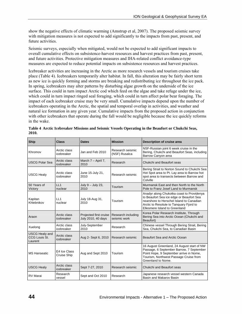
ION Geological & Geophysical Survey EA
44 Environmental Impacts - Alternative 1 – The Proposed Action
show the negative effects of climatic warming (Amstrup et al, 2007). The proposed seismic survey with mitigation measures is not expected to add significantly to the impacts from past, present, and future activities.
Seismic surveys, especially when mitigated, would not be expected to add significant impacts to overall cumulative effects on subsistence-harvest resources and harvest practices from past, present, and future activities. Protective mitigation measures and IHA-related conflict avoidance-type measures are expected to reduce potential impacts on subsistence resources and harvest practices.
Icebreaker activities are increasing in the Arctic as more research vessels and tourism cruises take place (Table 4). Icebreakers temporarily alter habitat. In fall, this alteration may be fairly short term as new ice is quickly forming and storms are breaking and redistributing ice throughout the ice pack. In spring, icebreakers may alter patterns by disturbing algae growth on the underside of the ice surface. This could in turn impact Arctic cod which feed on the algae and take refuge under the ice, which could in turn impact ringed seal foraging, which could in turn affect polar bear foraging. The impact of each icebreaker cruise may be very small. Cumulative impacts depend upon the number of icebreakers operating in the Arctic, the spatial and temporal overlap in activities, and weather and natural ice formation in any given year. Cumulative impacts from the proposed action in conjunction with other icebreakers that operate during the fall would be negligible because the ice quickly reforms in the wake.
Table 4 Arctic Icebreaker Missions and Seismic Vessels Operating in the Beaufort or Chukchi Seas, 2010.
Ship Class Dates Mission Description of cruise area
Khromov Arctic class icebreaker
Jan and Feb 2010 Research seismic (NSF) Rusalca
NSF-Russian joint 6 week cruise in the Bering, Chukchi and Beaufort Seas, including Barrow Canyon area
USCG Polar Sea Arctic class icebreaker
March 7 – April 7, 2010
Research Chukchi and Beaufort seas
USCG Healy Arctic class icebreaker
June 15-July 21, 2010
Research seismic
Bering Strait to Norton Sound to Chukchi Sea Hot Spot area to Pt. Lay area to Barrow hot spot area to transects between Barrow and Colville
50 Years of Victory
LL1 nuclear
July 9 – July 23, 2010
Tourism Murmansk East and then North to the North Pole to Franz Josef Land to Murmansk
Kapitan Khlebnikov
LL1 nuclear
July 18-Aug 31, 2010
Tourism
Anadyr along Chukotka coast to Providenya to Beaufort Sea ice edge or Beaufort Sea nearshore to Herschel Island to Canadian Arctic to Resolute to Tanquary Fjord to Ellesmere Island to Greenland
Araon Arctic class icebreaker
Projected first cruise July 2010, 40 days
Research including seismic work
Korea Polar Research Institute, Through Bering Sea into Arctic Ocean (Chukchi and Beaufort)
Xuelong Arctic class icebreaker
July-September 2010
Research Chinese vessel Through Bering Strait, Bering Sea, Chukchi Sea, to Canadian Basin
USCG Healy and CCG Louis St. Laurent
Arctic class icebreaker
Aug 2- Sept 6, 2010 Research seismic Beaufort Sea and Arctic Ocean
MS Hanseatic E4 Ice Class Cruise Ship
Aug and Sept 2010 Tourism
16 August Greenland, 24 August start of NW Passage, 6 September Barrow, 7 September Point Hope, 9 September arrive in Nome, Tourism, Northwest Passage Cruise from Greenland to Nome.
USCG Healy Arctic class icebreaker
Sept 7-27, 2010 Research seismic Chukchi and Beaufort seas
RV Marai Research vessel
Sept and Oct 2010 Research Japanese research vessel western Canada Basin and Makarov Basin
ION Geological & Geophysical Survey EA
Environmental Impacts - Alternative 2 – Alternate Season Action 45
Ship Class Dates Mission Description of cruise area
Talagy and the Polar Prince
Arctic class icebreaker
August – September, 2010
O&G seismic exploration
Western portion of the Canadian Beaufort Sea
SR/V Bos Atlantic Seismic survey vessel
August – September, 2010
O&G seismic exploration
Western portion of the Canadian Beaufort Sea
Talagy and the Polar Prince
Arctic class icebreaker
Sept 25 – Dec 15, 2010
O&G seismic exploration
Throughout the US Beaufort, beginning in the NE to SE to NW to SW. (From mid-July through End of September may be ice management vessel associated with O&G exploration in the Chukchi).
SR/V Bos Atlantic Seismic survey vessel
Sept 25 – Dec 15, 2010
O&G seismic exploration
Throughout the US Beaufort, beginning in the NE to SE to NW to SW. (From mid-July through End of September may be ice management vessel associated with O&G exploration in the Chukchi).
Oshoru Maru Arctic class icebreaker
unknown Research unknown
SR/V Geo Celtic Seismic survey vessel
August 21 – November 30
O&G seismic exploration
Central U. S. Chukchi Sea
M/V Mt. Mitchell Research vessel
July - October Research, including shallow hazard seismic
Nearshore Beaufort Sea, from Harrison Bay east through Camden Bay to Pt. Thompson
Note: *An additional 10 icebreaker (tourism) cruises are planned for the Canadian Arctic, Spitsbergen, and/or Greenland in summer 2010. The Talagy, Polar Prince and Bos Atlantic together will be ION Geophysical’s ships for this proposed action.
4.2. Alternative 2 – Alternate Season Action
The overall schedule for the SR/V BOS Atlantic and the accompanying icebreaker has been established to accomplish this survey and other objectives in a coordinated and optimized manner. The personnel and specialized equipment, including the vessels, to be deployed on the SR/V BOS Atlantic and the accompanying icebreaker are available for the planned period but not necessarily for other periods, including the open water season. Issuance of the permit for a substantially different range of dates would require changes in scheduling of personnel and equipment which would extend the start date of the survey until at least 2011, given the probable inability to amend the schedules for all of the required project components.
Conducting the proposed survey during the open water season would decrease effects to some species and increase effects to others. If conducted during the open water season, an icebreaker may not be needed.
Resources not considered further in Alternative 2. From our review of the ION Geophysical Seismic EA and recent lease sale EIS’s and EA’s, BOEMRE has concluded that negligible impacts will result from Alternative 2 for the following resources: Air Quality; Water Quality; Terrestrial Mammals; Vegetation and Wetlands; and Socioeconomics. These subjects are not analyzed further in this EA. Narwhal, fin whales, humpback, and gray whales, may occur in the project area in very small numbers during the summer open water season, but are not anticipated to be affected by Alternative 2 and are not discussed further under Alternative 2.
Petroleum Spill Scenario for Alternative 2. A fuel spill scenario has been developed to aid in the evaluation of the potential for a fuel spill to affect resources present in the area. The most likely source of a fuel spill would be during fuel transfers between the M/V Polar Prince, the M/V Talagy and the SR/V BOS Atlantic during its single refueling, which is likely to take place in late October or early November in the western Beaufort Sea.
ION Geological & Geophysical Survey EA
46 Environmental Impacts - Alternative 2 – Alternate Season Action
4.2.1. Direct and Indirect Effects of Alternative 2
The noise and energy emitted from airguns, the acoustic source for the 2D seismic surveys, have the potential to cause adverse impacts. Vessel traffic, vessel noise and lights associated with seismic surveys also have associated potential adverse impacts.
Issues and concerns associated with seismic-survey operations have been documented by the scientific community, in government publications, and at scientific symposia. The more prominent issues and concerns applicable to this EA include the:
protection of subsistence resources and the Inupiat culture and way of life.
disturbance to bowhead whale migration patterns.
impacts of seismic operations on marine fish and essential fish habitat.
harassment and potential harm to polar bears.
harassment and potential harm to ice seals, beluga and marine birds, by seismic operations.
The 2006 Final Seismic PEA, Final Chukchi Sea 193 EIS, and Draft Arctic Multi-Sale EIS provided a detailed analysis of potential environmental impacts from seismic survey operations and an analysis of icebreaker operations in the Arctic Ocean. The following synopsis describing potential environmental impacts was excerpted from those documents and updated with new published information where available, and is applicable to the analysis of potential environmental impacts from ION Geophysical’s proposed seismic survey.
4.2.2. Lower Trophic Levels and Benthic Invertebrates
Activities within the proposed study area associated with Alternative 2, the alternative season action which changes the timing of the ION Geophysical seismic survey to the summer months of 2010, are identical to Alternative 1, Section 4.1.2, with exception to effects of ice breaking on the affected environment. No ice breaking activities would be undertaken during this season. Therefore, described activities are limited to refined petroleum spills due to refueling, vessel traffic during ship operations, and energy emitted during 2D seismic testing and its effects on invertebrates.
Refined petroleum spills due to refueling could result in a spill of 1-13 bbls of MGO. The effects of these spills would have localized effect on nearby planktonic organisms present during the time of refueling, which if occurring during summer months would increase the chances of pelagic plankton blooms occurring in the area of the vessels. The effects of these actions would still be considered negligible due to the small volume and localized nature of a potential refueling spill.
Vessel operations in shallow waters ( ≤ 20 m) have a potential of negligible effects on these populations due to sediment disturbance from vessels and towed arrays. Overall, the proposed actions of Alternative 2 would result in negligible effects on benthic invertebrates.
Energy emitted during the seismic testing has not been shown to have effects on invertebrate populations. Although available evidence suggests that seismic energy in the environment is not completely without consequences to benthic invertebrate populations, it must be concluded that the effects of Alternative 2 would be negligible for the proposed study area.
4.2.3. Fish and Essential Fish Habitat
Impacts to fish and EFH during open water seismic surveys have been evaluated in the Seismic PEA (MMS 2006-038). In summary, vessel sound and seismic signal disturbance to adult and juvenile fish could result in temporary cessation of behavior, movement away, or avoidance swim responses. Prey that are sedentary or attached to the substrate will experience exposure to elevated levels of sound
ION Geological & Geophysical Survey EA
Environmental Impacts - Alternative 2 – Alternate Season Action 47
pressure to varying degrees, depending on the species and their strategies, resulting in dispersed effects over the region. Adults and juveniles and fish-prey exposed to a fuel spill would exhibit localized effects near the vessel. Effects to fish and EFH are expected to be negligible.
4.2.4. Marine and Coastal Birds
Impacts to marine and coastal birds during open water seismic surveys have been thoroughly evaluated in the Seismic PEA (MMS 2006-038). In summary, the proposed seismic survey could have a variety of potential impacts to marine birds from the physical presence and noise produced by vessels, sound produced by the seismic airguns, and the physical presence and noise produced by support aircraft, if used. Marine birds could be exposed to petroleum products in the event of an accidental spill.
Seismic-vessel activity is expected to have only temporary and localized disturbance effects on relatively small numbers of certain marine bird species that are distributed in low density over a large action area. Similarly, disturbance to pelagic species are expected to be minimal, because they are expected to move away from the slow-moving seismic vessel well in advance of the towed seismic- airgun array. Any displacement to these birds is expected to be temporary and short term in nature. Implementation of mitigation measures largely would avoid and minimize disturbance impacts to marine birds in the action area from vessel or airgun noise.
Many seabirds can be attracted to lights and vessels in nearshore waters. A marine bird striking a vessel could be injured or killed. Potential mortality from being attracted to and colliding with seismic-survey vessels is more likely to occur inside the 20-m isobath, where the majority of seabirds and waterfowl are believed to migrate. An unknown number of seabirds and waterfowl are expected to occasionally be attracted to the lights of seismic vessels during the survey period, but implementation of mitigation measures could further reduce risk that birds fly into survey vessels. Similar measures outside the 20-m isobath could reduce impacts to more pelagic species.
Direct effects of contact with oil are loss of insulation; death from hypothermia, exhaustion, or ingestion and absorption; transfer of toxicity to eggs and ducklings; and death of eggs and ducklings.
Indirect affects to marine birds could result from oil spilled when they are or are not present in the survey areas. Indirect effects might be contamination of food resources that would lessen the diversity, abundance, or caloric value of food resources. Indirect affects on food resources ultimately could affect nesting success and overwinter survival.
Overall, potential impacts from seismic-survey activities could have a minor level of affect on small numbers of low-density marine bird species across a large area on a temporary basis, including candidate, threatened and endangered species present in the action area during the open water season. These are the spectacled and Steller’s eiders, kittlitz murrelets, and yellow-billed loon. Implementation of mitigation measures is believed to reduce direct and indirect impacts to higher density species in concentration areas or in important habitats.
4.2.5. Marine Mammals
Selecting this alternative could decrease potential impacts to ringed seals, polar bears and polar bear critical habitat, but could increase potential impacts to other marine mammal species including bowhead and beluga whales, Pacific walrus, spotted and bearded seals. One of the most effective measures to minimize impacts to these species from seismic operations is to perform these activities during a time period when few individuals of these species are present in the area. Impacts to marine mammals during open water seismic surveys have been thoroughly evaluated in the Seismic PEA (MMS 2006-038). If conducted during the open water season, the survey would take place when bowhead with young calves and beluga are moving through the Beaufort Sea. Pacific walrus would
ION Geological & Geophysical Survey EA
48 Environmental Impacts - Alternative 3 – the No Action Alternative
also be present with their calves in the Chukchi Sea, with some occurring in the western Beaufort Sea. In summary, conducting the survey during the open water season would likely result in the take by level B harassment of higher numbers of marine mammals overall, but fewer polar bears and possibly fewer ringed seals. Alternative 2 would result in a minor effect to marine mammals.
4.2.6. Subsistence
Fall whaling activities begin in Kaktovik around late August or early September and the whaling season generally progresses on later dates at Nuiqsut and Barrow as the bowhead migration progresses westward across the US Beaufort Sea. The latest fall whaling occurs at Barrow from late September into October. Conducting the proposed survey during the open water season could conflict with the Kaktovik and Nuiqsut bowhead hunting season. There would also be the potential to impact the bowhead hunt in Barrow. The Plan of Cooperation requires that both vessels communicate with the whaling communities prior to approaching any villages and coordinate their activities with those of whalers to eliminate any potential disturbance to ongoing whaling activities. The plan to conduct the survey working from east to west across the Beaufort Sea is intended to avoid or limit any operations in regions where bowhead subsistence hunting may occur. This coordination would take place regardless of the season during which the survey is conducted, but there may be more potential for impacts during a summer open water survey. Hunts for seals and polar bears typically do not begin until after the open water or the preferred timing of the survey.
4.2.7. Cumulative Impacts of Alternative 2
The cumulative impacts of conducting the survey during the open water season would differ from the proposed action. The primary cumulative impacts would be due to the increase in vessel traffic and associated noise. During the open water season, additional seismic work may take place and overlap temporally and spatially with the ION Geophysical surveys, increasing the potential for repeated disturbance of the same animals from vessel or seismic activity. Several scientific research cruises are also planned for the open water season in the Beaufort and Chukchi seas in 2011. These include marine mammal and seabird surveys, and placement of acoustic and oceanographic buoys. Resupply barges will be providing the villages along the Beaufort Sea coast with fuel, and other commodities. The proposed survey would add incrementally to the overall level of traffic and potential for disturbance in the Beaufort and Chukchi seas.
4.3. Alternative 3 – the No Action Alternative
4.3.1. Direct and Indirect Effects of Alternative 3
If the survey were not conducted, the “No Action” alternative would result in no disturbance to any animals attributable to the proposed seismic activities. Likewise, there would then be no effects on fisheries or on accessibility of marine mammals for subsistence hunting. Nor would there be any effects on critical habitat.
4.3.2. Cumulative Impacts of Alternative 3
If the survey were not conducted, no additional effects would be added to the baseline of cumulative effects that are ongoing in the Beaufort or Chukchi seas (Section 3). See MMS 2006-038 and MMS 2003-001 for a more detailed description of baseline cumulative impacts in the Beaufort and Chukchi seas.
ION Geological & Geophysical Survey EA
Environmental Impacts - Conclusion and Recommendations 49
4.4. Conclusion and Recommendations
ION Geophysical’s proposed 2010 seismic survey activities are within and less than the scope of activities covered by the 2006 Final Seismic PEA FONSI and other BOEMRE seismic survey-related NEPA documents even when analyzed cumulatively with other seismic activities in the Arctic. The 2006 Final Seismic PEA/FONSI concluded that four concurrently operating seismic surveys in the Beaufort or Chukchi Sea could result in adverse but not significant effects. In addition, potential cumulative impacts are not likely to exceed those described in the 2006 Final Seismic PEA or the Final Chukchi Sea 193 EIS.
ION Geophysical’s proposed action is also within the scope of our previous: (1) ESA/Section 7 consultation with the NMFS and FWS; and (2) EFH consultation with NMFS. The finding of informal consultation with the FWS was that no adverse impacts on threatened, endangered, or candidate species under their jurisdiction would occur. The NMFS stated in their 2008 Arctic Region Biological Opinion (ARBO) that the activities associated with seismic surveys in the Beaufort or Chukchi Sea might adversely affect but not jeopardize the continued existence of the endangered bowhead whale, which is under their jurisdiction.
Further coordination with the State of Alaska State Historic Protection Officer is not required because ION Geophysical is not proposing to conduct ocean-bottom-cable seismic survey operations in the Beaufort or Chukchi Sea.
MMPA coordination with NMFS and FWS regarding MMPA-related mitigation and monitoring requirements and analysis of ION Geophysical’s proposed action has lead BOEMRE subject matter experts to recommend the following:
MMO's shall be on duty during all periods when the seismic source array is operating. Adequately monitoring for the presence of marine mammals requires trained observers dedicated to that purpose, and trained to use the specialized night time equipment that ION Geophysical has proposed be on board (for analysis, see Section 4.1.5).
Night time start ups not be allowed. In the past, BOEMRE has not allowed night time ramp ups from a complete shut down of the seismic airgun array due to concerns about being able to adequately view the exclusion zone.
ION Geophysical shall not be allowed to begin seismic survey operations in the Beaufort and Chukchi seas until such time that they provide BOEMRE copies of their MMPA authorizations from the NMFS and FWS to further prevent unmitigable adverse impacts to marine mammals and marine mammal subsistence activities and to comply with the ESA.
BOEMRE has concluded that no significant adverse affects (40 CFR 1508.27) on the quality of the human environment would occur from ION Geophysical's seismic survey activities as proposed in their G&G permit application (10-03). Our recommended and required measures: (1) represent those that are under the jurisdiction of the BOEMRE, (2) complement those measures likely to be included in NMFS and FWS MMPA-related IHAs and/or LOAs; and (3) address concerns from local, state, and Federal agencies, non-governmental agencies, Alaska Native Tribes, and the general public. Furthermore, we acknowledge and endorse the mitigation and marine mammal requirements in MMPA-authorizations will have precedence over any comparable marine-mammal-related G&G permit requirements.
BOEMRE has concluded that no further NEPA analysis for ION Geophysical's permit application (10-03) for proposed seismic survey activities in the Beaufort and Chukchi Seas is required. Therefore, a FONSI will be issued.
ION Geological & Geophysical Survey EA
50 Consultation and Coordination - Consultation and Coordination
5. CONSULTATION AND COORDINATION
The BOEMRE considered the potentially affected resources and species as related to our permitting activities. Several “effect determinations” have been prepared as they relate to required consultations for the resources and species potentially affected by the Proposal:
Essential Fish Habitat as defined by the MSFCMA.
Federally listed or proposed threatened/endangered species (or those species’ designated proposed critical habitat) as defined by the Endangered Species Act (ESA).
The most recent EFH consultation for OCS exploration activities in the Beaufort Sea was conducted concurrently with the preparation and public review of the Arctic Multiple-Sale Draft EIS. The BOEMRE received NMFS’ conservation recommendations in a letter dated June 26, 2009. On May 4, 2010, BOEMRE re-initiated consultation for Arctic cod, saffron cod, and opilio crab EFH in the U. S. Beaufort and Chukchi Seas. On June 24, 2010, NMFS provided BOEMRE comments on the supplemental EFH analysis, but offered no further EFH conservation recommendations. BOEMRE responded to the NFMS comments on July 8, 2010.
The results of the Endangered Species Act (ESA) consultation indicated that the Fish and Wildlife Service (FWS) concurred through informal consultation that there will be no adverse impacts on threatened, endangered, or candidate species under their jurisdiction, and the National Marine Fisheries Service (NMFS) stated that the activities associated with seismic surveys in the Beaufort and Chukchi seas may adversely affect but not jeopardize the continued existence of any species listed under the ESA that are under the jurisdiction of the NMFS.
To ensure compliance with the Marine Mammal Protection Act (MMPA), MMS is also requiring ION Geophysical to obtain from NMFS and FWS an incidental take authorization (ITA)—which could be in the form of an incidental harassment authorization (IHA) or letter of authorization (LOA)—before commencing MMS-permitted seismic-survey activities. The ITA’s mitigation and monitoring requirements would further ensure that potential impacts to marine mammals will be negligible and that there will be no unmitigable impacts to subsistence uses. The MMPA requires that authorized activities have no unmitigable adverse impact on subsistence uses of marine mammals.
The various “effect determinations” are discussed in this section. Reviewers of the documents outlined in Section 2.2 of this EA will note that “significant” findings have been modified to reflect: (1) BOEMRE analysis of potential impact; (2) BOEMRE levels of effect; and (3) additional mitigation measures identified subsequent to submittal of the permit application, which have been incorporated in the proposed action or become requirements for the proposed action.
The BOEMRE has received and considered public and stakeholders input on issues, concerns, alternatives, and mitigation related to seismic surveying in the Arctic Ocean.
The BOEMRE and NMFS prepared a programmatic environmental assessment on seismic surveying in the Arctic OCS for the 2006 open water season. The draft PEA (OCS EIS/EA BOEMRE 2006-019) was published for public review and comment and a final PEA (OCS EIS/EA BOEMRE 2006-038) and Finding of No Significant Impact were posted on the BOEMRE website: http://www.BOEMRE.gov/alaska/.
The BOEMRE prepared a draft (OCS EIS/EA BOEMRE 2006-060) and final (OCS EIS/EA BOEMRE 2007-026) environmental impact statement Chukchi Sea Planning Area, Oil and Gas Lease Sale 193 and Seismic Surveying Activities. The EISs were published and released for public review and comment, and public hearings and government-to-government meetings were held. The subject documents were posted on the BOEMRE website: http://www.BOEMRE.gov/alaska/.
ION Geological & Geophysical Survey EA
Consultation and Coordination - Public Input 51
Applications for seismic survey-related G&G permits in the Arctic Ocean OCS have been and continue to be posted on the BOEMRE website at http://www.BOEMRE.gov/alaska/re/ recentgg/recentgg.htm and are available for public review. The BOEMRE also provides written notification of these permit applications to the North Slope Borough and potentially affected Alaska Native Tribes and communities.
5.1. Opportunities for Public Input
Public participation regarding ION Geophysical’s proposed activities has been provided for through a combination of notification of receipt of application, a public notice of EA preparation, presentations at the 2010 NMFS Open Water and Scientific Review Committee (Peer Review) meetings in Anchorage, meetings with potentially affected stakeholders, and the NMFS Incidental Harassment Authorization (IHA) process. In addition, opportunities for public input on seismic surveying in the Arctic OCS and related issues have been provided during several prior NEPA processes. These opportunities for public input are briefly summarized below.
Notification of Application. The G&G permit application from ION Geophysical was posted on the MMS website at http://www.boemre.gov/alaska/re/recentgg/recentgg.htm. The BOEMRE notified by mail stakeholders who may be impacted by the activity of the proposed action. The notification provided the BOEMRE website link to the permit application and contact information for the BOEMRE G&G Permit Coordinator so interested parties could obtain additional information about the application. Interested parties were given an opportunity to provide comments on this proposed activity.
Notification of Preparation of the EA. On August 6, 2010, a notice of preparation of an EA on ION Geophysical’s proposed seismic survey was sent to potentially affected stakeholders and posted on the Alaska OCS Region website. The notice provided “additional opportunity for the public to provide views, prior to a decision being made by the Responsible Official(s), that may inform the decision making process, including issues or information regarding potential environmental effects that should be considered in the preparation of the EA.” The notice stated that written comments would be accepted for consideration through August 20, 2010.
In response to the notice, BOEMRE received comments from the Center for Biological Diversity (CBD), Earthjustice, Natural Resources Defense Council (NRDC), the Northern Alaska Environmental Center and Pacific Environment. BOEMRE has accepted the comments for consideration. A brief summary of the substantive issues in the comments received and our consideration of them was prepared for the responsible BOEMRE decision maker.
NMFS Open Water/Peer Review Meetings. ION Geophysical presented operational, environmental monitoring and a POC for the proposed seismic program at the 2010 Open Water Meeting, sponsored by NMFS and BOEMRE and attended by interested stakeholders. The proposed seismic program was also presented and reviewed at the Scientific Peer Review meeting, scheduled immediately after the Open Water Meeting. The BOEMRE was present at these public meetings and took note of discussions among the participants regarding the proposed action.
Potentially Affected Stakeholders ION Geophysical met with the following subsistence user between December 2009 and August 2010: North Slope Borough- Department of Wildlife Management, Alaska Eskimo Whaling Commission and Village Whaling Captains, North Slope Borough Planning Commission, Kaktovik leadership and public, Nuiqsut leadership and public, and Barrow leadership and public.
NMFS IHA process. As described elsewhere in this EA, the applicant has applied for incidental harassment authorization issued under the MMPA by NMFS. The NMFS IHA review and decision process includes opportunities for public participation. The Open Water and Peer Review meetings
ION Geological & Geophysical Survey EA
52 Consultation and Coordination - Public Input
are part of the IHA process. NMFS publishes draft authorizations in the Federal Register for public review and comment.
In addition to the public involvement opportunities related specifically to ION Geophysical’s proposed action, the public has participated in the on-going discussion of seismic survey activities throughout preparation of the several environmental analyses and related processes. A brief summary of the public input opportunities with previous BOEMRE NEPA processes is provided below. The environmental documents listed below are available at: http://www.boemre.gov/Alaska /ref/EIS_EA.htm. The BOEMRE has considered the issues, alternatives, and mitigation measures identified from this ongoing process during preparation of this EA.
Programmatic EA for Arctic Ocean Outer Continental Shelf Seismic Surveys (OCS EIS/EA MMS 2006-038). The BOEMRE and NMFS jointly prepared the PEA. A draft PEA was circulated for public review. The majority of comments received by BOEMRE addressed similar issues (e.g., EIS versus EA, significance criteria, potential mitigation measures, reasonable alternatives, data quality, and data needs). A summary of the major categories of comments and our response to those comments can be found in Appendix D of the PEA. After careful consideration and evaluation, many of these substantive comments resulted in modifying the text in the PEA.
Final Environmental Impact Statement, Oil and Gas Lease Sale 193 and Seismic Surveying Activities in the Chukchi Sea (OCS EIS/EA MMS 2007-026). Scoping meetings for the EIS were held in Barrow, Wainwright, Point hope, Point Lay, and Anchorage, Alaska, in January-February 2006. Government-to-Government Consultation meetings were held with the Native Villages of Point Hope, Point Lay, Wainwright, and Barrow and the Inupiat Community of the Arctic Slope (ICAS) in January-February 2006. Public hearings on the draft EIS were held in Barrow, Wainwright, Point hope, Point Lay, and Anchorage, Alaska, in November-December 2006. See Section VI of the FEIS for a description of public involvement process. Volume II of the Final EIS contains the substantive comments and responses to those comments, which include comments on seismic surveying activities. NMFS was a cooperating agency for this EIS.
Draft Environmental Impact Statement - Beaufort and Chukchi Sea Planning Areas - Oil and Gas Lease Sales 209, 212, 217, and 221 OCS EIS/EA MMS 2008-055. Scoping meetings for the EIS were held in Barrow, Kaktovik, Nuiqsut, Wainwright, Point Hope, Point Lay, and Anchorage in September-November 2007. Government-to-Government meetings were held with the Nuiqsut Tribal Council, the Native Village of Point Hope, and ICAS in September and October 2007. The draft EIS was filed with the EPA and the Notice of Availability (NOA) was announced in the Federal Register on December 19, 2008. The NOA provided for a 90-day public comment period, which was extended by 2 weeks. Public hearings were held in January-March 2009, in Barrow, Kaktovik, Nuiqsut, Wainwright, Point Hope, Point Lay, and Anchorage. Government-to-Government consultation meetings with the Native Villages of Nuiqsut and Barrow, and ICAS were also held during this period. The Government-to-Government meeting with the Native Village of Point Hope did not occur because of lack of a quorum. The BOEMRE requested Government-to-Government meetings with the Native Villages of Kaktovik, Point Lay, and Wainwright, but the requests were declined or no response was received. A number of comments received on the draft EIS related to seismic surveys and mitigation. Volume III, Chapter V, describes the public involvement process. Although responses to comments were prepared, no FEIS was issued, therefore, any comments received on the DEIS were not incorporated in an FEIS.
Environmental Impact Statement on the Effects of Oil and Gas Activities in the Arctic Ocean, February 2010. NMFS, with BOEMRE as a cooperating agency, is preparing an EIS to analyze the environmental impacts of issuing incidental take authorizations pursuant the Marine Mammal Protection Act to the oil and gas industry for the taking of marine mammals incidental to offshore exploration seismic surveying and exploration drilling activities in the Beaufort and Chukchi Seas
ION Geological & Geophysical Survey EA
Consultation and Coordination - Public Input 53
including seismic surveys. The BOEMRE participated with NMFS in the public scoping meetings for this EIS in February and March, 2010, in Anchorage, Barrow, Kaktovik, Kotzebue, Nuiqsut, Point Hope, Point Lay, and Wainwright.
National Marine Fisheries Service Annual Open Water meetings in Anchorage, Alaska, 2006 through 2010. At the annual Open Water meetings, industry representatives, the BOEMRE and NMFS, other federal and state agencies; tribal government representatives, subsistence stakeholders, and other interested parties including the public participate in presentations and discussions about activities that occur during the open water season. Lessons learned and opportunities to improve mitigation measures are emphasized, as well as coordination and communication between all interested parties.

ION Geological & Geophysical Survey EA
54 Verification
6. VERIFICATION
Pursuant to the CEQ regulations (40 CFR 1506.5(a), (b)) that acceptable work by an applicant not be redone but be verified by the agency, the BOEMRE reviewed, evaluated, and verified the information and analysis provided in ION Geophysical’s EA (LGL, February 2010), which BOEMRE considered in preparation of this EA.
ION Geological & Geophysical Survey EA
Reviewers and Preparers 55
7. REVIEWERS AND PREPARERS
As required by 40 CFR 1506.5(a),(b), the persons responsible for the review of ION Geophysical’s permit application and supporting information and analysis, and preparation of this EA are listed below:
Name Title
Gene Augustine Biologist
Sue Banet Geophysicist
Michael Burwell Socio-cultural Specialist
Mary Cody Wildlife Biologist
Cleve Cowles Regional Supervisor, Leasing and Environment
Debbie Cranswick Supervisory Environmental Specialist
Jeffrey Denton Wildlife Biologist
Nancy Deschu Fisheries Biologist
Dan Holiday Biological Oceanographer
Jana Lage Geophysicist
James Lima Supervisory Environmental Specialist
Mark Schroeder Wildlife Biologist
Pete Sloan Geophysicist
Caryn Smith Oceanographer / Oil Spill Analysis
Joseph Talbott NEPA Coordinator & Technical Editor
ION Geological & Geophysical Survey EA
56 Reference Material
8. REFERENCE MATERIAL
Alaska Shorebird Working Group. 2004. Alaska Shorebird Conservation Plan, 2nd ed., B.J. McCaffery and R.E. Gill, Coords. Anchorage, AK: ASWG, 68 pp.
Amstrup, S.C. 1993. Human Disturbance of Denning Polar Bears in Alaska. Arctic 463:245-250.
Amstrup, S.C. 1995. Movements, Distribution, and Population Dynamics of Polar Bears in the Beaufort Sea. M.S. Thesis. Fairbanks, AK: University of Alaska, 299 pp.
Amstrup, S.C., 2003. Polar Bear Ursus maritimus. In: Wild Mammals of North America: Biology, Management, and Conservation, G.A. Feldhamer, B.C. Thompson, and J.A. Chapman, eds. Baltimore, MD: Johns Hopkins University Press, pp. 587-610
Amstrup, S.C. and D.P. DeMaster. 1988. Polar Bear. In: Selected Marine Mammals of Alaska: Species Accounts with Research and Management Recommendations, J.W. Lentfer, ed. Washington, DC: Marine Mammal Commission, pp. 39-56.
Amstrup, S.C. and C. Garner. 1994. Polar Bear Maternity Denning in the Beaufort Sea. Journal Wildlife Mangement 581:1-10.
Amstrup, S.C., G.M. Durner, and T.L. McDonald. 2000. Estimating Potential Effects of Hypothetical Oil Spills from the Liberty Oil Production Island on Polar Bears. Anchorage, AK: U.S. Geological Survey, Biological Resource Div., 42 pp.
Amstrup, S.C., C. Gardner, K.C. Myers, and F.W. Oehme. 1989. Ethylene Glycol (Antifreeze) Poisoning in a Free-Ranging Polar Bear. Vet. Hum. Toxicol. 31:317-319.
Amstrup, S.C., B.G. Marcot, and D.C. Douglas. 2007. Forecasting the Range-Wide Status of Polar Bears at Selected Times in the 21st Century. Adminitrative Report. Reston, VA: USGS.
Amstrup, S.C., G.M. Durner, G. York, E. Regehr, K.S. Simac, D. Douglas, T.S. Smith, S.T. Partridge, TR. O’Hara, T. Bentzen, and C. Kirk. 2006. USGS Polar Bear Research in the Beaufort Sea, 2005. In: PBTC Meeting, St. Johns, Newfoundland, October 2006. U.S. Geological Survey.
Anderson, M. and J. Aars. 2008. Short-Term Behavioral Response of Polar Bears (Ursus maritimus) to Snowmobile Disturbance. Polar Biology 31:501-507.
Allen, B. M., and R. P. Angliss. 2010. Alaska Marine Mammal Stock Assessments. NOAA Technical Memorandum NMFS-AFSC-193.
Ashton, G., E. Reidlecker, and G. Ruiz. 2008. First Non-Native Crustacean Established in Coastal Waters of Alaska. Aquatic Biology 3(2):133-137.
Babaluk, J.A., J.D. Reist, J.D. Johnson, and L. Johnson. 2000. First Records of Sockeye Salmon (Oncorhynchus nerka) and Pink Salmon (O. gorbuscha) from Banks Island and Other Records of Pacific Salmon in Northwest Territories, Canada. Arctic 532:161-164.
Barry, T.W., 1986. Eiders of the Western Canada Arctic. In: Eider Ducks in Canada, A. Reed, ed. CWS Report Series No. 47. Ottawa, Ont., Canada: Canadian Wildlife Series, pp. 74-80.
Best, R.C. 1982. Thermoregulation in Resting and Active Polar Bears. Journal of Comparative Physiology 14(6):63-73.
Bluhm, B.A. and R. Gradinger. 2008. Regional Variability in Food Availability for Arctic Marine Mammals. Ecological Applications 18(2):S77-S96.
ION Geological & Geophysical Survey EA
Reference Material 57
Brown, J., P. Boehm, L. Cook, T. Trefry, W. Smith, and G. Durell, 2004. cANIMIDA (Continued Arctic Nearshore Impact Monitoring in the Development Area Program). Final Report, Hydrocarbon and Metal Characterization of Sediments in the cANIMIDA Study Area, OCS Study MMS 2010-004 Submitted to Department of the Interior, Minerals Management Service.
Brueggeman, J.J., R.A. Grotefendt, M.A. Smultea, G.A. Green, R.A. Rowlett, C.C. Swanson, D.P. Volsen, C.E. Bowlby, C.I. Malme, R. Mlawski, and J.J. Burns. 1992. Final Report, Chukchi Sea 1991, Marine Mammal Monitoring Program (Walrus and Polar Bear) Crackerjack and Diamond Prospects. Anchorage, AK: Shell Western E&P Inc. and Chevron U.S.A., Inc.
Burns, J.J. 1970. Remarks on the distribution and natural history of pagophilic pinnipeds in the Bering and Chukchi Seas. J. Mammal. 51(3):445-454.
Christie, K., C. Lyons, and W.R. Koski. 2009. Beaufort Sea aerial monitoring program. Chapter 7 In Funk, D.W., D.S. Ireland, R. Rodrigues, and W.R. Koski (eds.). 2009. Joint monitoring program in the Chukchi and Beaufort seas, July–November 2006-2008. LGL Alaska Report P1050-1. Report from LGL Alaska Research Associates, Inc., Anchorage, Ak, LGL Ltd., environmental research associates, King City, Ont., Greeneridge Sciences, Inc., Goleta, CA, and JASCO Research, Victoria, B.C., for Shell Offshore, Inc. and other Industry contributors, National Marine Fisheries Service, and U.S. Fish and Wildlife Service. 488 p. plus appendices.
Clarke, J.T., S.E. Moore and M.M. Johnson. 1993. Observations on beluga fall migration in the Alaskan Beaufort Sea, 198287, and northeastern Chukchi Sea, 198291. Rep. Int. Whal. Comm. 43:387-396.
Codispoti, L.A., C. Flagg, V. Kelly, and J.H. Swift, 2005. Hydrographic Conditions During the 2002 SBI Process Experiments. Deep Sea Research Part II: Topical Studies in Oceanography 52:3199-3226.
Cota, G.F., L. Legendre, M. Gosselin, and R.G. Graham, 1991. Ecology of Bottom Ice Algae: I. Environmental Controls and Variability. Journal of Marine Systems 2:257-277.
Craig, P.C. 1989. An Introduction to Amphidromous Fishes in the Alaskan Arctic, D.W. Norton, ed. Biological Papers 24. Fairbanks, AK: University of Alaska, Fairbanks, Institute of Arctic Biology, pp. 27-54.
Craig, P.C. 1984. Fish Resources. In: Proceedings of a Synthesis Meeting: The Barrow Arch Environment and Possible Consequences of Planned Offshore Oil and Gas Development (Sale 85), Girdwood, Ak., Oct. 30-Nov. 1, 1983. Anchorage, AK: USDOC, NOAA, OCSEAP and USDOI, MMS, pp. 240-266.
Craig, P.C., W.B. Griffiths, L. Haldorson, and H. McElderry. 1982. Ecological Studies of Arctic Cod (Boreogadus saida) in Beaufort Sea coastal waters, Alaska. Can. J. Zool. 39: 395-406.
Craig, P.C. and L. Halderson. 1981. Beaufort Sea Barrier Island-Lagoon Ecological Processes Studies: Final Report, Simpson Lagoon, Part 4, Fish. Environmental Assessment of the Alaskan Continental Shelf. Final Reports of Principal Investigators, Vol. 7 Biological Studies (Feb. 1981). Boulder, CO and Anchorage, AK: USDOC, NOAA, OCSEAP and USDOI, BLM, pp. 384-678.
Darnis, G., D.G. Barber, and L. Fortier, 2008. Sea Ice and the Onshore-Offshore Gradient in Pre-Winter Zooplankton Assemblages in Southeastern Beaufort Sea. Journal of Marine Systems 74:994-1011.
Dau, C.P. and W.W. Larned, 2005. Aerial Population Survey of Common Eiders and Other Waterbirds in Near Shore Waters and Along Barrier Islands of the Arctic Coastal Plain of Alaska, 24-27 June 2005. Anchorage, AK: Department of the Interior, Fish and Wildlife Service, Migratory Bird Management.
ION Geological & Geophysical Survey EA
58 Reference Material
Dau, C.P. and W.W. Larned, 2006. Aerial Population Survey of Common Eider and Waterbirds in Near Shore Waters and along Barrier Islands of the Arctic Coastal Plain of Alaska, 25-27 June 2006. Anchorage, AK: Department of the Interior, Fish and Wildlife Service, 19 pp.
Dau, C.P. and W.W. Larned, 2007. Aerial Population Survey of Common Eiders and Other Waterbirds in Near Shore Waters and Along Barrier Islands of the Arctic Coastal Plain of Alaska, 22-24 June 2007. Anchorage, AK: Department of the Interior, Fish and Wildlife Service, 18 pp.
Dehn, L.A., G.G. Sheffield, E.H. Follmann, L.K. Duffy, D.L. Thomas, and T.M. O'Hara. 2007. Feeding ecology of phocid seals and some walrus in the Alaskan and Canadian Arctic as determined by stomach contents and stable isotope analysis. Polar Biology 30:167-181.
Divoky, G.J. 1984. The pelagic and nearshore birds of the Alaskan Beaufort Sea: biomass and trophics. P. 417-437 in Barnes, P.W., D.M. Schell, and E. Reimnitz (eds.) The Alaskan Beaufort Sea, Ecosystems and Environments. Academic Press, Inc. Orlando, FL, 466 pp.
Divoky, G.J., 1987. The Distribution and Abundance of Birds in the Eastern Chukchi Sea in Late Summer and Early Fall. Unpublished final report. Anchorage, AK: Department of Commerce, National Ocean and Atmospheric Administration and Department of the Interior, Minerals Management Service, 96 pp.
Dunton, K.H. and S.V. Schomberg, 2000. The Benthic Faunal Assemblage of the Boulder Patch Kelp Community. In: The Natural History of an Arctic Oil Field. Development of the Biota, J. C. Truet and S. R. Johnson, eds. San Diego, CA: Academic Press, Inc.
Dunton, K.H., J.L. Goodall, S.V. Schonberg, J.M. Grebmeier, and D.R. Maidment, 2006. Multidecadal Synthesis of Benthic–Pelagic Coupling in the Western Arctic: a Role of Cross-Shelf Advective Processes. Deep-Sea Research II 52, 3462–3477.
Durner, G.M. and S.C. Amstrup. 2000. Estimating the Impacts of Oil Spills on Polar Bears. Arctic Research 14:33-37.
Durner, G.M., S.C. Amstrup, R. Neilson, and T. McDonald. 2004. The Use of Sea Ice Habitat by Female Polar Bears in the Beaufort Sea. OCS Study MMS 2004-014. Anchorage AK: USDOI, MMS, Alaska OCS Region, 41 pp.
Durner, G.M., D.C. Douglas, R.M. Nielsen, S.C. Amstrup, and T.L. MacDonald. 2007. Predicting the Future Distribution of Polar Bear Habitat in the Polar Basin from Resource Selection Functions Applied to 21st Century General Circulation Model Projections of Sea Ice. USGS Administrative Report. U.S. Geological Survey.
Earnst, S.L., R.A. Stehn, R.M. Platte, W.W. Larned, and E.J. Mallek. 2005. Population Size and Trend of Yellow-Billed Loons in Northern Alaska. The Condor 107:289-304.
EDAW/ AECOM, 2007. Quantitative Description of Potential Impacts of OCS Activities on Bowhead Whale Hunting Activities in the Beaufort Sea. MMS OCS Study 2007-062. Anchorage, AK: USDOI, MMS, Alaska OCS Region.
Eicken, H., R. Gradinger, A. Gaylord, A. Mahoney, I. Rigor, and H. Melling. 2007. Sediment transport by sea ice in the Chukchi and Beaufort Seas: Increasing importance due to changing ice conditions? Deep Sea Research Part II: Topical Studies in Oceanography, Volume 52, Issues 24-26, December 2005, Pages 3281-3302
Eicken, H., and A. Mahoney. Pers commun. via email, March 2010.
Erbe, C. and D.M. Farmer. 2000. Zones of impact around icebreakers affecting beluga whales in the Beaufort Sea. J. Acoust. Soc. Am. 108: 1332-1340.
ION Geological & Geophysical Survey EA
Reference Material 59
Fay, F. H. 1982. Ecology and Biology of the Pacific Walrus, Odobenus rosmarus divergens illiger. USDOI, Fish and Wildlife Service, North American Fauna No. 74. 280 pp.
Fechhelm, R G and W.B. Griffiths. 2001. Status of Pacific Salmon in the Beaufort Sea, 2001. Anchorage, AK: LGL Alaska Research Assocs., Inc., 13 pp.
Federal Register, 2009. Designation of Critical Habitat for the Polar Bear (Ursus maritimus) in the United States; Proposed Rule. Federal Register 74(208):56058-56086
Fischbach, A. S., D. H. Monson and C. V. Jay. 2009. Enumeration of Pacific Walrus Carcasses on Beaches of the Chukchi Sea in Alaska Following a Mortality Event, September 2009. USDOI, US Geological Survey, open file report 2009-1291. 10pp
Fischbach, A. 2007. Landward Shift in Polar Bear Denning Determined from Satellite Telemetry in Alaska. In: Presentation at the 2007 Alaska Marine Science Symposium, Anchorage, Ak., Jan. 27, 2007.
Fischbach, A.S., S.C. Amstrup, and D.C. Douglas. 2007. Leeward and Eastward Shift of Alaskan Polar Bear Denning Associated with Recent Sea Ice Changes. Abstract of a talk presented at the 2007 Alaska Marine Science Symposium, Jan. 22, 2007.
Fischer, J.B. and W.W. Larned, 2004. Summer Distribution of Marine Birds in the Western Beaufort Sea. Arctic 57(2):143-159.
Finley, K.J., G.W. Miller, R.A. Davis and W.R. Koski. 1983. A distinctive large breeding population of ringed seals (Phoca hispida) inhabiting the Baffin Bay pack ice. Arctic 36(2):162-173.
Flint, P.L., J.A. Reed, J.C. Franson, T.E. Hollmen, J.B. Grand, M.D. Howell, R.B. Lanctot, D.L. Lacroix, and C.P. Dau. 2003. Monitoring Beaufort Sea Waterfowl and Marine Birds. OCS Study, MMS 2003-037. Anchorage, AK: USDOI, MMS, Alaska OCS Region, 125 pp.
Frost, K.J. and L.F. Lowry. 1983. Demersal Fishes and Invertebrates Trawled in the Northeastern Chukchi and Western Beaufort Seas, 1976-1977. NOAA Technical Report NMFS SSRF-764. Seattle, WA: USDOC, NOAA, NMFS, 22 pp.
Frost, K.J. and L.F. Lowry. 1984. Ringed Seal Monitoring: Relationships of Distribution and Abundance to Habitat Attributes and Industrial Activities. OCS Study MMS 84-0210. Anchorage, AK: USDOI, MMS, Alaska OCS Region
Frost, K.J., L.F. Lowry and J.J. Burns. 1988. Distribution, abundance, migration, harvest, and stock identity of beluga whales in the Beaufort Sea. p. 27-40 In: P.R. Becker (ed.), Beaufort Sea (Sale 97) information update. OCS Study MMS 86-0047. Nat. Oceanic & Atmos. Admin., Ocean Assess. Div., Anchorage, AK. 87 p.
Funk, D.W., R. Rodrigues, D.S. Ireland, and W.R. Koski (eds.). 2009. Joint Monitoring Program in the Chukchi and Beaufort seas, July-November 2006-2008. LGL Alaska Report P1050-1. Report from LGL Alaska Research Associates, Inc., Anchorage, AK, LGL Ltd., environmental research associates, King City, Ont., Greeneridge Sciences, Inc., Santa Barbara, CA, and JASCO Research, Ltd., Victoria, BC, for Shell Offshore, Inc., Anchorage, AK, other Industry contributors, the National Marine Fisheries Service, Silver Springs, MD, and the U.S. Fish and Wildlife Service, Anchorage, AK. 488 p. plus appendices.
Galginaitis, M. 2009. Annual Assessment of Subsistence Bowhead Whaling Near Cross Island, 2001-2007. MMS OCS Study MMS 2009-038. Anchorage, AK: USDOI, MMS, Alaska OCS Region.
Gradinger, R., 2009. Sea-ice Algae: Major Contributors to Primary Production and Algal Biomass in the Chukchi and Beaufort Seas During May/June 2002. Deep-Sea Research II 56:1201-1212.
ION Geological & Geophysical Survey EA
60 Reference Material
Grebmeier, J.M., L.W. Cooper, H.M. Feder, and B.I. Sirenko, 2006. Ecosystem Dynamics of the Pacific-influenced Northern Bering and Chukchi Seas in the Amerasian Arctic. Progress in Oceanography 71:331-361.
Haley, B. 2006. Marine mammal monitoring during University of Texas at Austin’s marine geophysical survey of the western Canada Basin, Chukchi Borderland and Mendeleev Ridge, Arctic Ocean, July–August 2006. Report from LGL Alaska Research Associates, Inc., Anchorage AK, and LGL Ltd., King City, Ont., for the University of Texas at Austin, the Nat. Mar. Fish. Serv., Silver Springs, MD, and the U.S. Fish and Wildl. Serv., Anchorage, AK.
Haley, B. and D. Ireland. 2006. Marine mammal monitoring during University of Alaska Fairbanks' marine geophysical survey across the Arctic Ocean, August-September 2005. LGL Rep. TA4122-3. Rep. from LGL Ltd., King City, Ont., for Univ. Alaska Fairbanks, Fairbanks, AK, and Nat. Mar. Fish. Serv., Silver Spring, MD. 80 p.
Haley, B., J. Beland, D.S. Ireland, R. Rodrigues, and D.M. Savarese. 2009. Chapter 3 In Funk, D.W., D.S. Ireland, R. Rodrigues, and W.R. Koski (eds.). Joint monitoring program in the Chukchi and Beaufort seas, July–November 2006-2008. LGL Alaska Report P1050-1. Report from LGL Alaska Research Associates, Inc., Anchorage, Ak, LGL Ltd., environmental research associates, King City, Ont., Greeneridge Sciences, Inc., Goleta, CA, and JASCO Research, Victoria, B.C., for Shell Offshore, Inc. and other Industry contributors, National Marine Fisheries Service, and U.S. Fish and Wildlife Service. 488 p. plus appendices.
Hazard, K. 1988. Beluga whale, Delphinapterus leucas. p. 195-235 In: J.W. Lentfer (ed.), Selected Marine Mammals of Alaska. Mar. Mamm. Comm., Washington, DC. 275 p. NTIS PB88-178462. 275 p.
Hopcroft, R., B. Bluhm, R. Gradinger, T. Whitledge, T. Weingartner, B. Norcross, and A. Springer. 2006. Arctic Ocean Synthesis: Analysis of Climate Change Impacts in the Chukchi and Beaufort Seas with Strategies for Future Research. Fairbanks, AK: University of Alaska, Fairbanks, Institute of Marine Science, 153 pp.
Impact Assessment, Inc., 1990a. Subsistence Resource Harvest Patterns: Nuiqsut. OCS Study MMS 90-0038. Anchorage, AK: Department of the Interior, Minerals Management Service, Alaska OCS Region.
Impact Assessment Inc, 1990b. Subsistence Resource Harvest Patterns: Kaktovik. OCS Study MMS 909-0039. Anchorage, AK: Department of the Interior, Minerals Management Service, Alaska OCS Region.
Johnson, S.R. 1979. Fall observations of westward migrating white whales (Delphinapterus leucas) along the central Alaskan Beaufort Sea coast. Arctic 32(3):275-276.
Johnson, S.R. and D.R. Herter, 1989. The Birds of the Beaufort Sea. Anchorage, AK: BPXA.
Johnson, S.R., D.A. Wiggins, and P.F. Wainwright., 1992. Use of Kasegaluk Lagoon, Chukchi Sea, Alaska, by Marine Birds and Mammals, II: Marine Birds. Unpublished report. Herndon, VA: Department of the Interior, Minerals Management Service, pp. 57-510.
Kinney, P.J., ed., 1985. Environmental Characterization and Biological Utilization of Peard Bay. OCS Study MMS 85-0102. Anchorage, AK: Department of the Interior, Minerals Management Service, Alaska OCS Region, pp. 97-440.
Kirchman, D.L., V. Hill, M.T. Cottrel, R. Gradinger, R.R. Malmstrom, and A. Parker, 2009. Standing Stocks, Production, and Respiration of Phytoplankton and Heterotrophic Bacteria in the Western Arctic Ocean. Deep-Sea Research II 56:1237-1248.
ION Geological & Geophysical Survey EA
Reference Material 61
Larned, W.W., R. Stehn, and R. Platte, 2006. Eider Breeding Population Survey Arctic Coastal Plain, Alaska 2006. Anchorage, AK: Department of the Interior, Fish and Wildlife Service.
Larned, W., R. Stehn and R. Platte. 2009. Eider breeding population survey, Arctic Coastal Plain, Alaska 2008. USFWS, Migratory Bird Management, Waterfowl Management, Soldatna and Anchorage, AK.
Lee, S.H., T.E. Whitledge and S.Kang, 2010. Spring Time Production of Bottom Ice Algae in the Landfast Sea Ice Zone at Barrow, Alaska. Journal of Experimental Marine Biology and Ecology 12:204-212.
LGL Alaska Research Associates, Inc. (LGL). 2010. Environmental Assessment of a marine seismic survey by ION Geophysical in the Beaufort Sea, October–December 2010. Prepared by LGL Alaska Research Assoc. Inc., Anchorage, AK, for ION Geophysical, Houston, TX. 173 pages.
Logerwell, E. and K. Rand. In prep. Beaufort Sea Marine Fish Monitoring 2008: Pilot Survey and Test of Hypotheses. Anchorage, AK: USDOI, MMS, Alaska OCS Region.
Lowry, L.F., K.J. Frost, and J.J. Burns. 1980. Variability in the diet of ringed seals, Phoca hispida. Can. J. Fish. Aquat. Sci. 37:2254-2261
Lysne, L.A., E.J. Mallek, and C.P. Dau, 2004. Near Shore Surveys of Alaska’s Arctic Coast, 1999-2003. Fairbanks, AK: Department of the Interior, Fish and Wildlife Service, 60 pp.
Mahoney, A. 2010. Literature Review of Potential Icebreaker Impacts on Sea Ice as They Relate to the Beaufort and Chukchi Seas. Addition to CMI Agreement No. AK-09-04 MMS09HQPA0004T. 17pp.
Miller, G.W., R.E. Elliott, W.R. Koski, V.D. Moulton and W.J. Richardson. 1999. Whales. p. 5-1 to 5-109 In: W.J. Richardson (ed.), Marine mammal and acoustical monitoring of Western Geophysical’s open-water seismic program in the Alaskan Beaufort Sea, 1998. LGL Rep. TA2230-3. Rep. from LGL Ltd., King City, Ont., and Greeneridge Sciences Inc., Santa Barbara, CA, for Western Geophysical, Houston, TX and U.S. Nat. Mar. Fish. Serv., Anchorage, AK, and Silver Spring, MD. 390 p.
Moore, S.E. 2000. Variability in cetacean distribution and habitat selection in the Alaskan Arctic, autumn 1982-91. Arctic 53(4):448-460
Moore, S.E. and R.R. Reeves. 1993. Distribution and movement. p. 313-386 In: J.J. Burns, J.J. Montague and C.J. Cowles (eds.), The Bowhead Whale. Spec. Publ. 2. Soc. Mar. Mammal., Lawrence, KS. 787 p.
Moore, S.E., J.C. George, K.O. Coyle, and T.J. Weingartner. 1995. Bowhead whales along the Chukotka coast in autumn. Arctic 48(2):155-160.
Moore, S.E., and DeMaster, D.P. 1997. Cetacean habitats in the Alaskan Arctic. J. Northw. Atl. Fish. Sci. 22:55-69
Moore, S.E., J.T. Clarke and D.K. Ljungblad. 1989. Bowhead whale (Balaena mysticetus) spatial and temporal distribution in the central Beaufort Sea during late summer and early fall 1979-86. Rep. Int. Whal. Comm. 39:283-290.
Moore, S.E., J.M. Waite, L.L. Mazzuca and R.C. Hobbs. 2000. Mysticete whale abundance and observations of prey associations on the central Bering Sea shelf. J. Cetac. Res. Manage. 2(3): 227-234.
Moore, S.E., D.P. DeMaster and P.K. Dayton. 2000b. Cetacean habitat selection in the Alaskan Arctic during summer and autumn. Arctic 53(4):432-447.
ION Geological & Geophysical Survey EA
62 Reference Material
Moore, S.E., J.M. Waite, N.A. Friday, and T. Honkalehto. 2002. Distribution and comparative estimates of cetqacean abundance on the central and southeastern Bering Sea shelf with observations on bathymetric and prey associations. Progr. Oceanogr. 55:249-262.
Mosher, D. C., J. W. Shimeld, and D. R. Hutchinson. 2009. 2009 Canada Basin seismic reflection and refraction survey, western Arctic Ocean: CCGS Louis S. St-Laurent expedition report. Geological Survey of Canada, open file 6343. 235 pp.
NPFMC (North Pacific Fishery Management Council). 2009. Fishery Management Plan for Fish Resources of the Arctic Management Area. Anchorage, AK: NPFMC, 147 pp.
NPFMC, (North Pacific Fishery Management Council). 1990. Fishery Management Plan for the Salmon Fisheries in the EEZ off the Coast of Alaska. Anchorage, AK:NPFMC, 210 p.
Pedersen, S., 2009. Personal Communication on August 13, 2009 from S. Pedersen, AlaskaDepartment of Fish and Game, Subsistence Division, to C. Campbell, Anchorage, AK: Department of the Interior, Minerals Management Service, Alaska OCS Region; subject: subsistence hunting and fishing at Kaktovik, AK.
Petersen, M.R. and P.L. Flint, 2002. Population Structure of Pacific Common Eiders Breeding in Alaska. The Condor 104(4):780-787.
Phillips, L., 2005. Migration Ecology and Distribution of King Eiders. M.S. Thesis. Fairbanks, AK: University of Alaska, Fairbanks.
Powell, A., N.L. Phillips, E.A. Rexstad, and E. J. Taylor, 2005. Importance of the Alaskan Beaufort Sea to King Eiders (Somateria spectabilis). OCS Study MMS 2005-057. Anchorage, AK: Department of the Interior, Minerals Management Service, Alaska OCS Region.
Renner, H., G.L. Hunt, Jr., and K.J. Kuletz. 2008. A Post-Breeding Season Transect Through the Beaufort, Chukchi, and Bering Seas in the Lowest Ice Year on Record. Abstract. In: 35th Annual Meeting of the Pacific Seabird Group, Blaine, Wash., Feb. 27- Mar. 1, 2008.
Richard, P.R., A.R. Martin and J.R. Orr. 1997. Study of summer and fall movements and dive behaviour of Beaufort Sea belugas, using satellite telemetry: 1992-1995. ESRF Rep. 134. Environ. Stud. Res. Funds, Calgary, Alb. 38 p.
Richard, P.R., A.R. Martin and J.R. Orr. 2001. Summer and autumn movements of belugas of the eastern Beaufort Sea stock. Arctic 54(3):223-236.
Richardson, W.J., C.R. Greene, Jr., C.I. Malme and D.H. Thomson. 1995. Marine Mammals and Noise. Academic Press, San Diego. 576 p.
Richardson, W.J., C.R. Greene Jr., J.S. Hanna, W.R. Koski, G.W. Miller, N.J. Patenaude and M.A. Smultea, with R. Blaylock, R. Elliott and B. Würsig. 1995b. Acoustic effects of oil production activities on bowhead and white whales visible during spring migration near Pt. Barrow, Alaska – 1991 and 1994 phases. OCS Study MMS 95-0051; LGL Rep. TA954. Rep. from LGL Ltd., King City, Ont., for U.S. Minerals Manage. Serv., Herndon, VA. 539 p. NTIS PB98-107667.
Rizzolo, D.J. and J.A. Schmutz. 2008. Monitoring marine birds of concern in the eastern Chukchi nearshore area (loons). Annual Report 2008 for Minerals Management Service, Alaska Region OCS. Alaska Science Center, U.S. Geological Survey. 37 pp.
ION Geological & Geophysical Survey EA
Reference Material 63
Savarese, D.M., C.R. Reiser, D.S. Ireland, and R. Rodrigues. 2009. Beaufort Sea vessel-based monitoring program. Chapter 6 In Funk, D.W., D.S. Ireland, R. Rodrigues, and W.R. Koski (eds.). 2009. Joint monitoring program in the Chukchi and Beaufort seas, July–November 2006-2008. LGL Alaska Report P1050-1. Report from LGL Alaska Research Associates, Inc., Anchorage, Ak, LGL Ltd., environmental research associates, King City, Ont., Greeneridge Sciences, Inc., Goleta, CA, and JASCO Research, Victoria, B.C., for Shell Offshore, Inc. and other Industry contributors, National Marine Fisheries Service, and U.S. Fish and Wildlife Service. 488 p. plus appendices.
Schliebe, S K., D. Rode, J.S. Gleason, J. Wilder, K. Proffitt, T.J. Evans, and S. Miller. 2008. Effects of Sea Ice Extent and Food Availability on Spatial and Temporal Distribution of Polar Bears during the Fall Open-Water Period in the Southern Beaufort Sea. Polar Biology.
Smith, T.G. and I. Stirling. 1975. The breeding habitat of the ringed seal (Phoca hispida). the birth lair and associated structures. Can. J. Zool. 53(9):1297-1305.
Smith, T.G., and M.O. Hammill. 1981. Ecology of the ringed seal, Phoca hispida, in its fast ice breeding habitat. Can. J. Zool. 59:966-981
Stephen R. Braund & Associates. (SRB&A) 2010. Subsistence Mapping of Nuiqsut, Kaktovik, and Barrow. MMS OCS Study Number 2009-003. Anchorage, Alaska: Stephen R. Braund and Associates.
Stirling, I. 1988. Attraction of Polar Bear Ursus maritimus to Offshore Drilling Sites in the Eastern Beaufort Sea. Polar Record 24:1-8.
Stirling, I. 1997. The Importance of Polynyas, Ice Edges, and Leads to Marine Mammals and Birds. Journal of Marine Systems 10:9-21.
Stirling, I., M. Kingsley and W. Calvert. 1982. The distribution and abundance of seals in the eastern Beaufort Sea, 1974-79. Can. Wildl. Serv. Occas. Pap. 47:25 p.
Stringer, W., S. Barrett, L. Schreurs. 1980. Nearshore ice conditions and hazards in the Beaufort, Chukchi and Bering Seas. Report UAGR #274. Available from the Geophysical Institute, University of Alaska Fairbanks, 903 Koyukuk Drive, Fairbanks, Alaska 99775-7320, U.S.A.
Suydam, R.S., D.L. Dickson, J.B. Fadely, and L.T. Quakenbush, 2000. Population Declines of King and Common Eiders of the Beaufort Sea. The Condor 102(1):219-222.
Tavares, M. and G. De Melo. 2004. Discovery of the First Known Benthic Invasive Species in the Southern Ocean: The North Atlantic Spider Crab Hyas araneus Found in the Antarctic Peninsula. Antarctic Science 16(2):129-134.
TERA. 1997. Distribution and abundance of spectacled eiders in the vicinity of Prudhoe Bay, Alaska: 1997 status report. Unpublished report prepared by Troy Environmental Research Associates, Anchorage, AK.
TERA. 1999. Spectacled eiders in the Beaufort Sea: distribution and timing of use. Unpublished report prepared by Troy Ecological Research Associates, Anchorage, AK.
Troy Ecological Research Associates. 1997. Distribution and abundance of spectacled eiders in the vicinity of Prudhoe Bay, Alaska: 1996 Status report for BP Exploration (Alaska), Inc., Anchorage, Alaska. 11 pp.
Troy Ecological Research Associates. 1999. Spectacled eiders in the Beaufort Sea: Distribution and timing of use. Report for BPXA, Anchorage, Alaska. 19 pp.
ION Geological & Geophysical Survey EA
64 Reference Material
USDOC, NMFS. 2008. Oil and Gas Leasing and Exploration Activities in the U.S. Beaufort and Chukchi Seas, Alaska; and Authorization of Small Takes Under the Marine Mammal Protection Act. Juneau, AK: NMFS, July 2008.
USDOC, NMFS. 2009. Environmental Assessment, Regulatory Impact Review and Regulatory Flexibility Analysis for the Arctic Fishery Management Plan and Amendment 29 to the Fishery Management Plan for Bering Sea/Aleutian Islands King and Tanner Crabs. Juneau, AK: NMFS, 308 pp.
USDOI, BOEMRE. 2010. Supplementary Essential Fish Habitat Analysis: Arctic Cod, Saffron Cod and Opilio Crab, Beaufort and Chukchi Sea Planning Areas. Department of Interior, Bureau of Ocean Energy Management, Regulation and Enforcement, Alaska OCS Region. 26 p.
USDOI, FWS. 2009. Biological Opinion for Beaufort and Chukchi Sea Program Area Lease Sales and Associated Seismic Surveys and Exploratory Drilling.
USDOI, MMS. 2007. Final Environmental Impact Statement, Chukchi Sea Planning Area, Oil and Gas Lease Sale 193 and Seismic Surveying Activities in the Chukchi Sea. OCS EIS/EA MMS 2007-026. Anchorage, AK: Department of the Interior, Minerals Management Service, Alaska OCS Region.
USDOI, MMS, 2003. Final Environmental Impact Statement, Beaufort Sea Planning Area, Oil and Gas Lease Sales 186, 195, and 202. OCS EIS/EA MMS 2003- 001. Anchorage, AK: Department of the Interior, Minerals Management Service, Alaska OCS Region.
USDOI, MMS. 2006. Environmental Assessment, Proposed OCS Lease Sale 202 Beaufort Sea Planning Area. OCS EIS/EA MMS 2006-001.Anchorage, AK: Department of the Interior, Minerals Management Service, Alaska OCS Region.
USDOI, MMS. 2006. Final Programmatic Environmental Assessment, Arctic Ocean Outer Continental Shelf, Seismic Surveys. OCS EIS/EA MMS 2006-038. Anchorage, AK: Department of the Interior, Minerals Management Service, Alaska OCS Region.
USDOI, MMS, 2008. Draft Environmental Impact Statement, Beaufort and Chukchi Sea Planning Areas Oil and Gas Lease Sales 209, 212, 217, and 221. OCS EIS/EA MMS 2008- 0055. Anchorage, AK: Department of the Interior, Minerals Management Service, Alaska OCS Region.
Welch, H.E., Crawford, R.E., and Hop, H.1993 Occurrence of Arctic cod (Boreogadus saida) schools and their vulnerability to predation in the Canadian High Arctic, 46:331-339
Wheeler, P. and T. Thornton. 2005. Subsistence Research in Alaska: A Thirty Year Retrospective. Alaska Journal of Anthropology 3(1):69-103.
Zykov, M., T. Deveau, and D. Hannay, 2010. Modeling of Underwater Sound from GXT’s Beaufort 4 Source in the Alaskan Beaufort Sea. Report by JASCO Applied Sciences Ltd. for LGL, Alaska.
Related Documents


![Petroleum Hydrocarbon–Degrading Microbial Communities in Beaufort–Chukchi Sea ... · 2019. 10. 14. · and 2% asphaltic hydrocarbons [Atlas 1975]. Degradation of the different](https://static.cupdf.com/doc/110x72/60bfc4977aedec0749326eac/petroleum-hydrocarbonadegrading-microbial-communities-in-beaufortachukchi-sea.jpg)