GOVERNMENT OF INDIA MINISTRY OF WATER RESOURCES CENTRAL GROUND WATER BOARD GROUND WATER INFORMATION BOOKLET BANGALORE RURAL DISTRICT, KARNATAKA SOUTH WESTERN REGION BANGALORE NOVEMBER 2008

Welcome message from author
This document is posted to help you gain knowledge. Please leave a comment to let me know what you think about it! Share it to your friends and learn new things together.
Transcript
GOVERNMENT OF INDIA
MINISTRY OF WATER RESOURCES
CENTRAL GROUND WATER BOARD
GROUND WATER INFORMATION BOOKLET
BANGALORE RURAL DISTRICT,
KARNATAKA
SOUTH WESTERN REGION
BANGALORE
NOVEMBER 2008
Page 2 of 18
FOREWORD
Ground water contributes to about eighty percent of the drinking water
requirements in the rural areas, fifty percent of the urban water requirements and
more than fifty percent of the irrigation requirements of the nation. Central
Ground Water Board has decided to bring out district level ground water
information booklets highlighting the ground water scenario, its resource
potential, quality aspects, recharge – discharge relationship, etc., for all the
districts of the country. As part of this, Central Ground Water Board, South
Western Region, Bangalore, is preparing such booklets for all the 27 districts of
Karnataka state, of which six of the districts fall under farmers’ distress category.
The Bangalore Ruaral district Ground Water Information Booklet has
been prepared based on the information available and data collected from
various state and central government organisations by several hydro-scientists of
Central Ground Water Board with utmost care and dedication. This booklet has
been prepared by Shri A. Kannan, Scientist-B under the guidance of Dr. K. Md.
Najeeb, Superintending Hydrogeologist, Central Ground Water Board, South
Western Region, Bangalore. The figures were prepared by S/Sri.
H.P.Jayaprakash, Scientist-C and K.Rajarajan, Assistant Hydrogeologist. The
efforts of Report processing section in finalising and bringing out the report in this
format are commendable.
I take this opportunity to congratulate them for the diligent and careful
compilation and observation in the form of this booklet, which will certainly serve
as a guiding document for further work and help the planners, administrators,
hydrogeologists and engineers to plan the water resources management in a
better way in the district.
(T.M.HUNSE)
Regional Director
Page 3 of 18
BANGALORE RURAL DISTRICT
1.0 INTRODUCTION 1.1 Location.
Bangalore district is located in the southeastern part of Karnataka state. Bangalore is the district head quarters and also capital of the state. Bangalore Rural district is located in the southeastern part of Karnataka state between the north latitude 12° 15’ and 13° 31’ and East longitude 77° 04’ and 77° 59’, covering parts of the toposheets 57 G and H. The district is bounded by Kolar and Tumkur district in the north, Mandya district on the west, Chamarajanagar district on the south and towards southeast by Tamilnadu state. Bangalore district is well served by road railway and airways. The National Highways passing through the district is connecting the state capital with other major cities like Hyderabad, Pune and Chennai. The interior villages are well connected by metalled roads. Bangalore district is also well served by Railways. The railway line connects Bangalore to New Delhi, Hyderabad Bombay and Chennai.
1.3 Administrative Setup
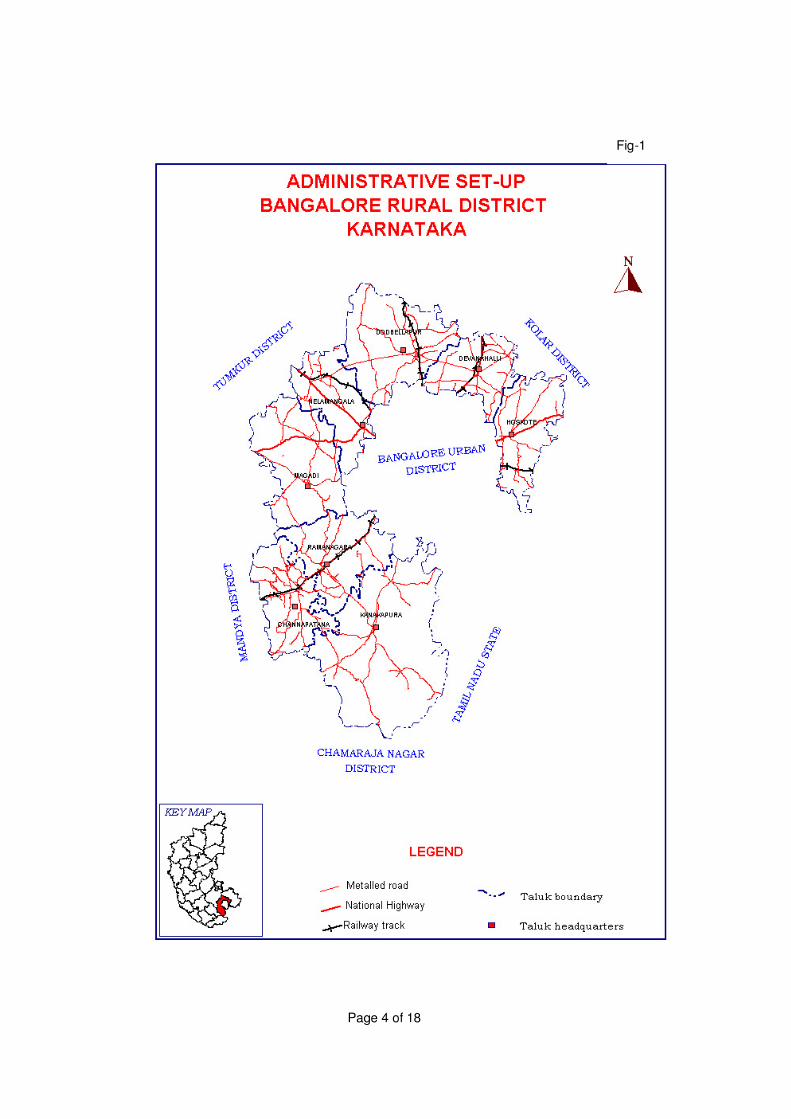
For administrative convenience it is divided in to Bangalore rural and Bangalore urban districts. The Bangalore rural district is divided in to eight taluks having a total geographical area of 5814 sq. kms. Has 35 hobalies, 228 grampanchayaths, 1721 inhabited and 154 un-inhabited villages. There are four town/urban agloramation and 5 Municipalities. A map showing administrative setup of the district is given as Fig-1.
1.4 Population
The total population in the district is 1881514 (as per 2001 census), out of which rural population constitutes 1474118 and urban population constitutes 407396. The schedule cast population constitutes 323636 lakhs and the schedule tribe population constitutes 54333. The sex ratio in the district is 955 females for every 1000 males. And the density of population is 323 per sq.km. The main occupation of the people in the district is cultivation and most of them are agricultural laborers. The literacy rate is 61.9% in rural parts of which male literacy rate is 72.4% and 51.1% is female literacy rate. And in urban parts of the district the literacy rate is 76.2 % of which male literacy rate is 81.9% and female literacy rate is 70.10%.
1.5 Land use pattern
The district has 81268 hectares of forests, which constitutes (13.88%) of the total geographical area of the district (585431 ha). The fallow land in the district is around 39426 ha. Net area sown during the year is 2005-06 was around 318211 ha. And 8163 hectares of land was sown more than once.
Page 4 of 18
Fig-1
Page 5 of 18
1.6 Crops The main crops grown in the district are Paddy, jowar, Bajara, Maize,
Wheat pulses oilseeds like groundnut, sunflower vegetables fruits and cash crop like sugarcane and others.
1.7 Irrigation
At present Bangalore district is served by two medium irrigation projects viz (i) Byramangala reservoir project and (ii) Kanuva reservoir project. Apart from these, three more medium irrigation projects are under construction. The area under number of minor irrigation projects playing an important role in the development of agriculture by providing irrigational facilities particularly in the area. These schemes consist of tanks, lift irrigation anicut/pickups and others. Net area irrigated during the year 2004-05 was 75033 ha out of which 6679 ha was irrigated under canals, 13057ha was irrigated under tanks, and 15362 were irrigated by dug wells, 34094ha as irrigated by tube/bore wells.
1.8 Industries
Plenty of quarries and crushing plants are spread over the entire district Granite quarrying and crushing is going on for the past three decades and density of crushing plants in the district is high. Bangalore rural district has 24 textiles 31 chemical 86 engineering factories are the important industries in the district and their total employees are 37190.
1.9 Studies carried out by CGWB The Central Ground Water Board has drilled 62 bore wells under ground water exploration programme. The statistics of these bore wells comprising number of bore wells, depth range, discharge range etc., and the periodic monitoring of DTW of observation dug wells in the district are also carried out by CGWB for January, May, August and November of every year, which are discussed in Hydrogeology part. Earlier systematic Hydrological surveys in parts of Bangalore district with taluks, as reference block were carried out during 1957 to 1992 by different persons under different F.S.P, and was followed by reappraisal Hydrological surveys during 1992 to1995 and Reappraisal Hydrological surveys in parts of Arkavathi River Basin Karnataka during the FSP1997 to 98 and District Ground Water Management Studies carried out during the Field season program 2004 to 2005. 2.0 RAINFALL AND CLIMATE.
The climate in Bangalore rural district is quite solubnous., with three different seasons. The premonsoon starts from January to May. This period can be divided in to winter January to February and summer (march-may) winter is charaterised by generally clear skies and very little rainfall. From April onwards-erratic thunderstorms occur increasing during the month of may .temparature is lowest during December and January
Page 6 of 18
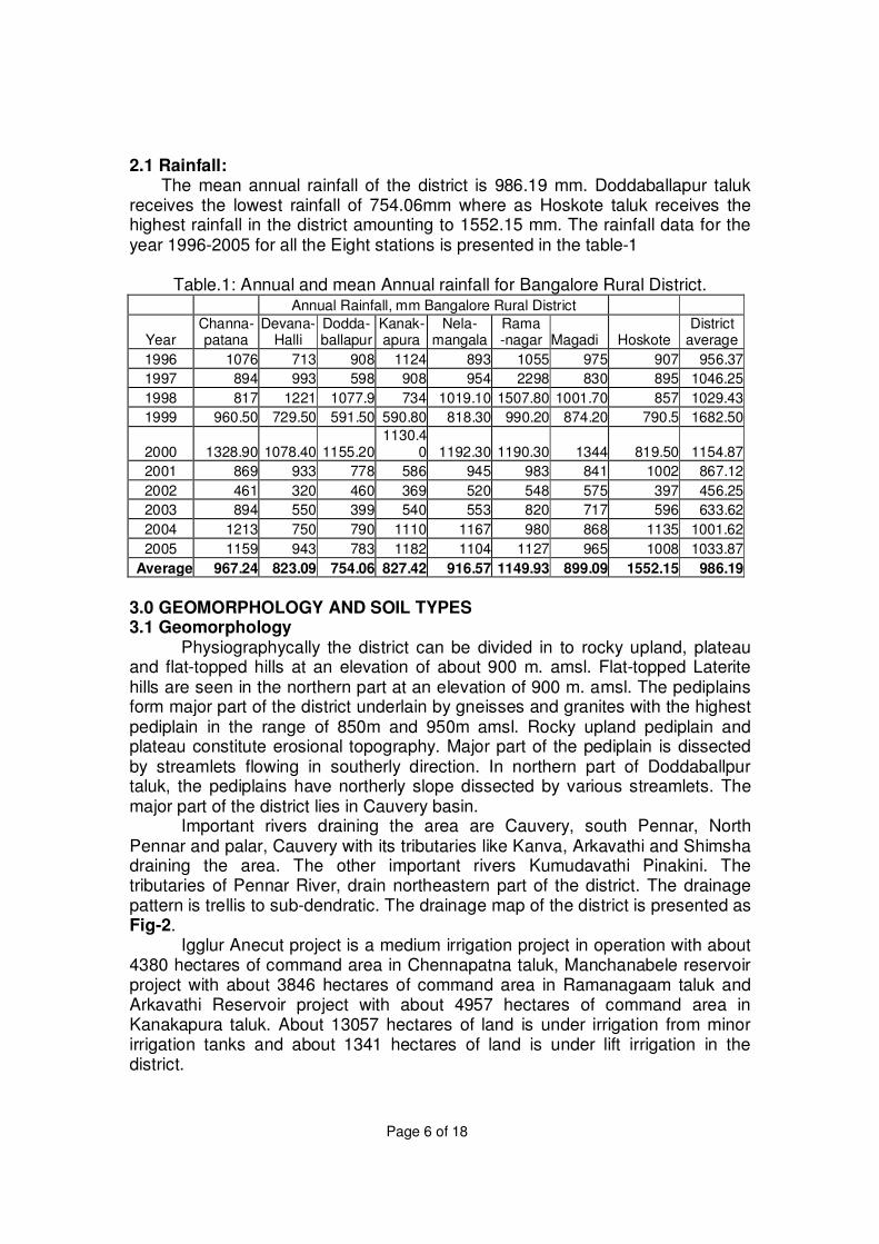
2.1 Rainfall: The mean annual rainfall of the district is 986.19 mm. Doddaballapur taluk
receives the lowest rainfall of 754.06mm where as Hoskote taluk receives the highest rainfall in the district amounting to 1552.15 mm. The rainfall data for the year 1996-2005 for all the Eight stations is presented in the table-1
Table.1: Annual and mean Annual rainfall for Bangalore Rural District. Annual Rainfall, mm Bangalore Rural District
Year Channa- patana
Devana- Halli
Dodda- ballapur
Kanak-apura
Nela- mangala
Rama -nagar Magadi Hoskote
District average
1996 1076 713 908 1124 893 1055 975 907 956.37
1997 894 993 598 908 954 2298 830 895 1046.25
1998 817 1221 1077.9 734 1019.10 1507.80 1001.70 857 1029.43
1999 960.50 729.50 591.50 590.80 818.30 990.20 874.20 790.5 1682.50
2000 1328.90 1078.40 1155.201130.4
0 1192.30 1190.30 1344 819.50 1154.87
2001 869 933 778 586 945 983 841 1002 867.12
2002 461 320 460 369 520 548 575 397 456.25
2003 894 550 399 540 553 820 717 596 633.62
2004 1213 750 790 1110 1167 980 868 1135 1001.62
2005 1159 943 783 1182 1104 1127 965 1008 1033.87
Average 967.24 823.09 754.06 827.42 916.57 1149.93 899.09 1552.15 986.19
3.0 GEOMORPHOLOGY AND SOIL TYPES 3.1 Geomorphology
Physiographycally the district can be divided in to rocky upland, plateau and flat-topped hills at an elevation of about 900 m. amsl. Flat-topped Laterite hills are seen in the northern part at an elevation of 900 m. amsl. The pediplains form major part of the district underlain by gneisses and granites with the highest pediplain in the range of 850m and 950m amsl. Rocky upland pediplain and plateau constitute erosional topography. Major part of the pediplain is dissected by streamlets flowing in southerly direction. In northern part of Doddaballpur taluk, the pediplains have northerly slope dissected by various streamlets. The major part of the district lies in Cauvery basin.
Important rivers draining the area are Cauvery, south Pennar, North Pennar and palar, Cauvery with its tributaries like Kanva, Arkavathi and Shimsha draining the area. The other important rivers Kumudavathi Pinakini. The tributaries of Pennar River, drain northeastern part of the district. The drainage pattern is trellis to sub-dendratic. The drainage map of the district is presented as Fig-2.
Igglur Anecut project is a medium irrigation project in operation with about 4380 hectares of command area in Chennapatna taluk, Manchanabele reservoir project with about 3846 hectares of command area in Ramanagaam taluk and Arkavathi Reservoir project with about 4957 hectares of command area in Kanakapura taluk. About 13057 hectares of land is under irrigation from minor irrigation tanks and about 1341 hectares of land is under lift irrigation in the district.
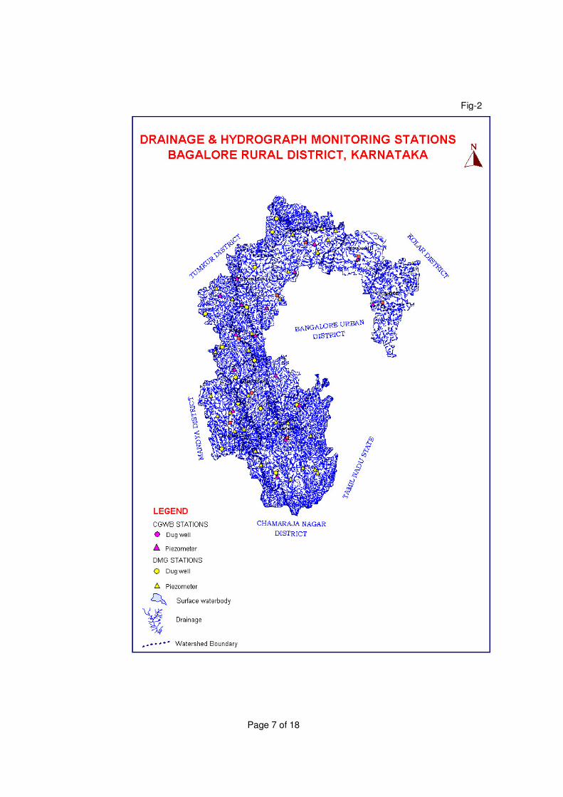
Page 7 of 18
Fig-2
Page 8 of 18
3.2 Soil types The soils of Bangalore Rural districts are broadly classified in to four categories viz (i). Loamy soil (ii) Lateritic soil (iii) Lateritic gravelly soil and (iv) Red sandy soil. Red loamy soils generally occur on hilly to undulating land slope on granite and granite gneisses. Lateritic soil occurs in undulating terrain forming plain to gently sloping topography of peninsular gneiss region. Lateritic gravelly soils occur in upland regions of lateritic soils, Red sandy soil occurs in undulating land slopes. These soils are derived from acidic rocks granites and granitic gneiss. 4.0 GROUND WATER SCENARIO 4.1.1 Occurrence of Ground Water
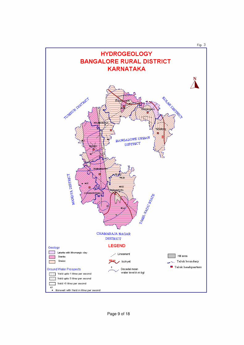
Geology of the Bangalore rural district is broadly described under two groups (i) the dominating Archaean crystalline formation comprising peninsular gneissic complex with a small patch of horn blend schist in the northern part and intrusive closepet granite all along the western part of the district (ii) smaller stretches of unconsolidated sediments. The granite gneisses are mainly of migmatitic type, highly banded in composition from granite to diorite. The Hydrogeology map of the district is presented as Fig-3. The ground water occurs in the open spaces of weathered fractured gneisses and granites. In these rocks the water bearing and yielding properties are primarily due to weathering and fracturing. In the weathered zone, ground water occurs under water table conditions and in the fractured and jointed formations it occurs under semi-confined conditions. In Laterite ground water occurs under phreatic condition. Alluvium along the river courses, though limited in thickness and aerial extent possess substantial ground water potential.
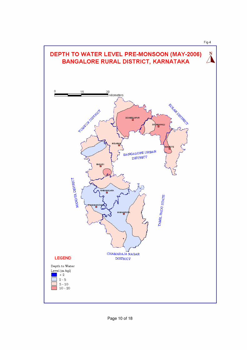
4.1.2 Depth to water levels Out of 31 National Hydrograph stations located in Bangalore Rural District,
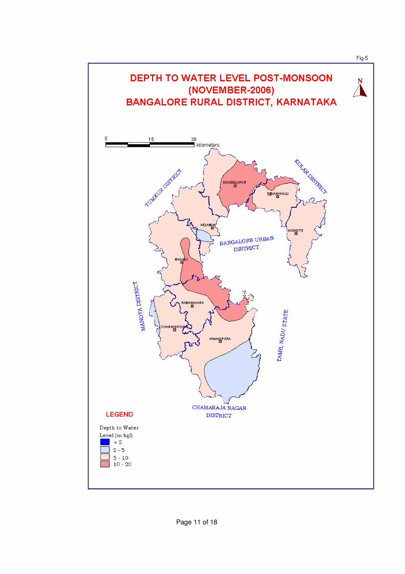
8 were found to be dry. The pre-monsoon depth to water level map of the district for the year 2006 is presented as Fig-4. During November 2006 10 National Hydrograph stations located in Bangalore Rural District were found to be dry. The post-monsoon depth to water level map of the district for the year 2006 is presented as Fig-5.
4.1.3 Seasonal water level fluctuation
The seasonal water level fluctuation for the year 2006 in 31 national hydrograph network stations were in the range of -0.10 to 2.14m.
Page 9 of 18
Page 10 of 18
Page 11 of 18
Page 12 of 18
4.1.4 Long-term water level trends Out of seventy-seven premonsoon water level trend data available for
national hydrograph network stations, Sixteen (20.7%) in the range of 0.0018 to 1.0529m/year are having rising trends and remaining five are having falling trends. In the range of 0.0136 to 2.3539m/year, remaining 59.74% of the wells have gone dry where as long term post monsoon water level trend data at national hydrograph network stations, six (7.79%) wells are showing rising trends in the range of 0.0011m/year and remaining thirty (38.96%) are having falling trends. in the range of 0.0217 to 3.0606 m/year remaining 51.94% were found to be dry 4.1.5 Ground Water Exploration Ground water exploration was undertaken in the district between the period from 1990 to 1996 (First Phase of ground water Exploration) to ascertain the presence of productive aquifer zones, quality of ground water, yield of aquifer zones and determine aquifer parameter. And their occurrence in depth to 250m below ground level the discharge varies from 1 to 8lps.
4.1.6 Results of ground water exploration
On the basis of the hydrogeological surveys followed by resistivity surveys total of 29 EW sites were recommended for the deep drilling to a depth of 287.09m. in Bangalore rural district The drilling results available indicated the fractures at 14.0m, 108 m, 110m and 123 m ,134m, 136m, 138mdepth. The exploratory bore wells drilled at a depth range of 33.0 to 287.09m The yield cum recuperation tests conducted on the wells show that the discharge of the wells ranges from 0.10 to 9.13lps. The transmissivity (T) in general ranges from 7.4 to 535.72 m2/day.
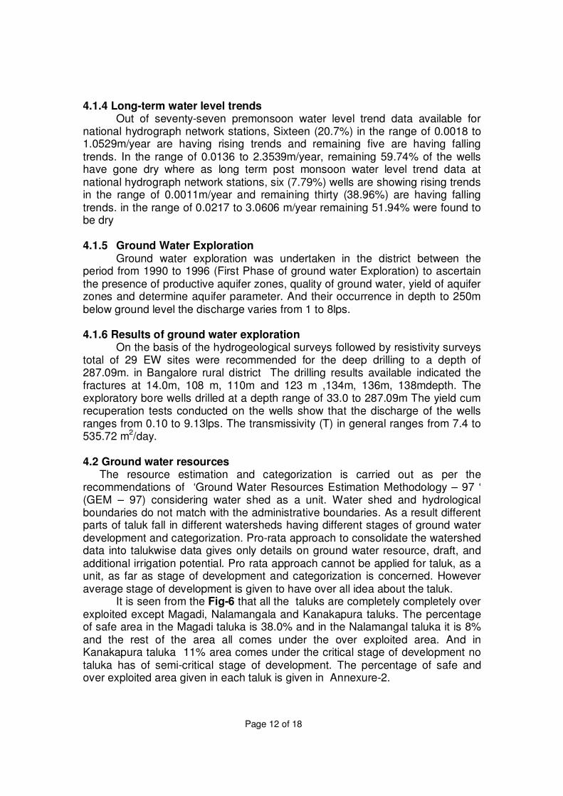
4.2 Ground water resources
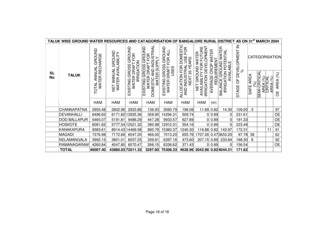
The resource estimation and categorization is carried out as per the recommendations of ‘Ground Water Resources Estimation Methodology – 97 ‘ (GEM – 97) considering water shed as a unit. Water shed and hydrological boundaries do not match with the administrative boundaries. As a result different parts of taluk fall in different watersheds having different stages of ground water development and categorization. Pro-rata approach to consolidate the watershed data into talukwise data gives only details on ground water resource, draft, and additional irrigation potential. Pro rata approach cannot be applied for taluk, as a unit, as far as stage of development and categorization is concerned. However average stage of development is given to have over all idea about the taluk.
It is seen from the Fig-6 that all the taluks are completely completely over exploited except Magadi, Nalamangala and Kanakapura taluks. The percentage of safe area in the Magadi taluka is 38.0% and in the Nalamangal taluka it is 8% and the rest of the area all comes under the over exploited area. And in Kanakapura taluka 11% area comes under the critical stage of development no taluka has of semi-critical stage of development. The percentage of safe and over exploited area given in each taluk is given in Annexure-2.
Page 13 of 18
Fig-6
Page 14 of 18
1. Annual Ground Water Recharge = 46007.40 ham 2. Natural discharge = 4600.74 ham 3. Net Ground water availability = 43880.03 ham 4. Gross Draft Irrigation = 72011.33 ham 5. Gross Domestic and Industrial draft = 3297.00 ham 6. Total Draft = 75308.33 ham 7. Net Ground Water Balance = 4044.31 ham 8. Allocation for Domestic and Industrial Requirement up to 2029 = 4628.96 ham 9. Net ground water availability for irrigation = 2042.98 ham 10. Stage of development = 171. 62 %
5. GROUND WATER MANAGEMENT STRATEGY A well-planned groundwater resource management strategy is
essential to make economical, efficient and judicious use of ground water, to make the availability of ground water, sustainable. Making aware, the water users on ground water conditions in the different terrain conditions and encouraging its judicious use, adaptation of conjunctive use techniques of ground water and surface water can improve the ground water scenario. In view of the ever-growing population and increasing demand for groundwater for various developmental activities, it is suggested to adopt methods to artificially recharge the ground water in the water level depleting areas, in order to increase the ground water availability. The ground water management will also help in environmental management and ecological stability in the area. The development of water management model should be resource based and the whole problem should be tackled in its totality, Vis a Vis surface and subsurface resources. Thereby, enabling us to meet the ever-growing demand for this precious natural resource by practicing conjunctive use in canal command areas. Apart from above, farmers should be encouraged to grow crops that require less water for its production and should be discouraged from growing water intensive crops like sugarcane and paddy, especially in the areas where water levels are falling. Transfer of water from areas where water levels are rising to the areas where water levels are falling can also be thought off. 4.3. Ground water quality.
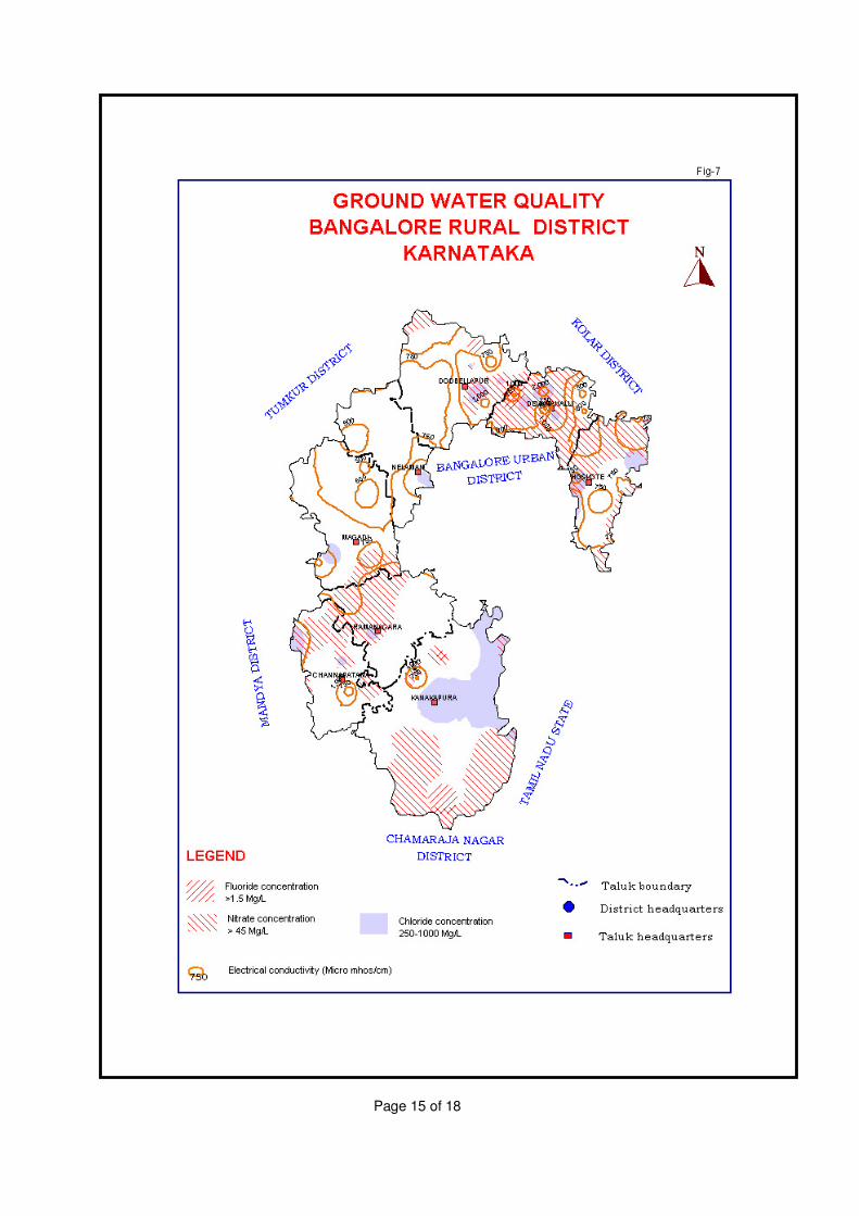
The Electrical conductivity values are in the major part of the district are in the range between 750 to 1000 micro mhos and in magadi and Nelamangala taluka the EC varies from 500 to 750 micromhos. In northern part of Devenahalli taluka EC values are more than 2000 micromhos /cm. Have been observed.
Southern part of Kanakapura, northern part of Ramanaga, major part of Devenahalli, and in northern part of Hoskote taluka is having excess Nitrate in ground water(Nitrate content more than 45 ppm).
Flouride content in Kanakapura, Chennapatna Ramanagara Magadi Nelamangala Devenahalli and Hoskote are within the permissible limits and as a small patch in northern part of Dodaballapur taluk having fluoride concentration more than 1.5mg/L. (Flouride content more than 1.5 ppm) confined.
Page 15 of 18
Page 16 of 18
Chloride problem in the district (Chloride content more than 250 to 1000mg/L) is observed in Central eastern part of Kanakapura taluka and in small patches of Ramanagara Magadi Nelamangala Doddaballapur Devena halli and in Hoskote taluka are observed.
A map showing the distribution of electrical conductivity, Flouride, Chloride and Nitrate concentration in ground water of Bangalore Rural District is presented as Fig-7. 5.1 Ground water development Further ground water development should be encouraged only in Northeastern part of Magadi taluka, which are categorised as safe. In the major parts of the district, areas categorised as over exploited and critical growing crops like paddy, sugarcane etc having high water requirement from ground water irrigation may be avoided. Advance irrigation methods like drip and sprinkler irrigation may be practiced. And southern part of Kanakapura, North eastern part of Magadi, North western part of magadi, Northwestern part of Nelamangala, Major parts of Dodaballapur, Devenahalli and Hoskote taluk suitable artificial recharge structure may be constructed. In the irrigation command areas conjunctive use of surface and ground water may be practiced to avoid long-term hazards like water logging and ground water as well as soil salinity problems. And the status of Groundwater utilization in Bangalore rural district is presented as Fig-6. 5.2 Water conservation and Artificial Recharge In the district where the topography is comparatively rugged, artificial recharge structures like nalla and gully plugs contour bunds and contour trenches and nallabunds may be constructed and in comparatively plain areas percolation tanks and point recharge structures like recharge shafts recharge pits and recharging through existing dug/bore wells may be practiced. In semi-urban areas in the district/Taluka Head quarters like Doddaballapur, Nelamangala, Magadi, Chennapatna, Devanahalli, Hoskote, Kannakapura and Ramanagaram towns, lot of roof area is available for rooftop rain water harvesting. So in these semi-urban areas rooftop rainwater harvesting practices may be encouraged. This will help in reducing the load on urban water supply systems. 6. Awareness and Training Activity : No MAP/Traning programe organised by CGWB . 7. Recommendations
Considering the prevailing scenario of the groundwater resources and development the following recommendations are made for the optimum drawl with sustainable development of resources in the area. 1. Construction of check dams and sub surface dykes at appropriate places
across the nallahs and streams in the water table depleting areas, over exploited, critical and areas of the district and the areas where water quality problem exists may be taken on priority basis.
2. Considering the fresh water scarcity in the district, a comprehensive
Page 17 of 18
programme should be formulated to harvest the rain water through roof top, check dams, surface tanks, bunds and subsurface dykes to use the resources directly from the structures, which in turn to arrest the sub surface flows and augment the groundwater resources.
3. The ground water worthy areas such as topographic lows, valley portions low fluctuations zones should be developed with an adequate soil conservation measures to prevent the soil erosions during rainy seasons.
4. Constant monitoring of ground water quality should be carried out in the fluoride-contaminated areas to prevent further deterioration and related problems. The determination of trace elements and organic compound be done to help in categorizing the quality of water.
5. A detailed geophysical study with the help of the state of the art technology should be conducted to demarcate the extent of potential aquifers and it is geometry, especially in central plain region.
6. Except Nelamangala and Magadi other taluks are comes under over exploited categories. In these taluks Ground water legislation should be implemented to avoid further adverse effects of ground water system of the area
7. Conjunctive use of both Surface and Ground water to be implemented in the canal command areas, which will improve the quality of ground water, prevent the water logging conditions and availability of canal water to the tail end areas.
8. In semi-urban areas in the district in taluk Head quarters like
Doddaballapur, Nelamangala, Magadi, Chennapatna, Devanahalli, Hoskote, Kannakapura and Ramanagaram towns, lot of roof area is available for rooftop rain water harvesting. So in these semi-urban areas rooftop rainwater harvesting practices may be encouraged. This will help in reducing the load on urban water supply systems.
Page 18 of 18
TALUK WISE GROUND WATER RESOURCES AND CATAGORISATION OF BANGALORE RURAL DISTRICT AS ON 31
st MARCH 2004
CATEGORISATION
TO
TA
L A
NN
UA
L G
RO
UN
D
WA
TE
R R
EC
HA
RG
E
NE
T A
NN
UA
L G
RO
UN
D
WA
TE
R A
VA
ILA
BIL
ITY
EX
IST
ING
GR
OS
S G
RO
UN
D
WA
TE
R D
RA
FT
FO
R
IRR
IGA
TIO
N
EX
IST
ING
GR
OS
S G
RO
UN
D
WA
TE
R D
RA
FT
FO
R
DO
ME
ST
IC A
ND
IN
DU
ST
RIA
L
WA
TE
R S
UP
PL
Y
EX
IST
ING
GR
OS
S G
RO
UN
D
WA
TE
R D
RA
FT
FO
R A
LL
U
SE
S
AL
LO
CA
TIO
N F
OR
DO
ME
ST
IC
AN
D IN
DU
ST
RIA
L U
SE
FO
R
NE
XT
25
YE
AR
S
NE
T G
RO
UN
D W
AT
ER
A
VA
ILA
BIL
ITY
FO
R F
UT
UR
E
IRR
IGA
TIO
N D
EV
EL
OP
ME
NT
AV
ER
AG
E C
RO
P W
AT
ER
R
EQ
UIR
EM
EN
T
BA
LA
NC
E G
RO
UN
D W
AT
ER
IR
RIG
AT
ION
PO
TE
NT
IAL
A
VA
ILA
BL
E
ST
AG
E O
F D
EV
EL
OP
ME
NT
IN
%
SA
FE
AR
EA
(%)
SE
MI-
CR
ITIC
AL
A
RE
A (
%)
CR
ITIC
AL
A
RE
A (
%)
OE
A
RE
A (
%) SL
No TALUK
HAM HAM HAM HAM HAM HAM HAM (m)
CHANNAPATNA 2950.48 2802.96 2923.86 136.93 3060.79 196.08 11.69 0.82 14.30 109.20 3 97
DEVANHALLI 6496.65 6171.82 13935.36 358.95 14294.31 509.74 0 0.89 0 231.61 OE
DOD BALLAPUR 5465.07 5191.81 9486.29 447.28 9933.57 627.89 0 0.89 0 191.33 OE
HOSKOTE 6081.62 5777.54 12521.32 390.98 12912.31 554.16 0 0.89 0 223.49 OE
KANAKAPURA 9383.61 8914.43 14469.58 890.79 15360.37 1240.30 116.88 0.82 142.97 172.31 11 91
MAGADI 7376.98 7172.66 6547.20 466.00 7013.20 655.76 1707.26 0.47 3653.20 97.78 38 62
NELAMANGALA 3992.15 3801.01 6057.25 339.91 6397.16 473.60 207.15 0.89 233.84 168.30 8 92
RAMANAGARAM 4260.84 4047.80 6070.47 266.15 6336.62 371.43 0 0.89 0 156.54 OE
TOTAL 46007.40 43880.03 72011.33 3297.00 75308.33 4628.96 2042.98 0.82 4044.31 171.62
Related Documents