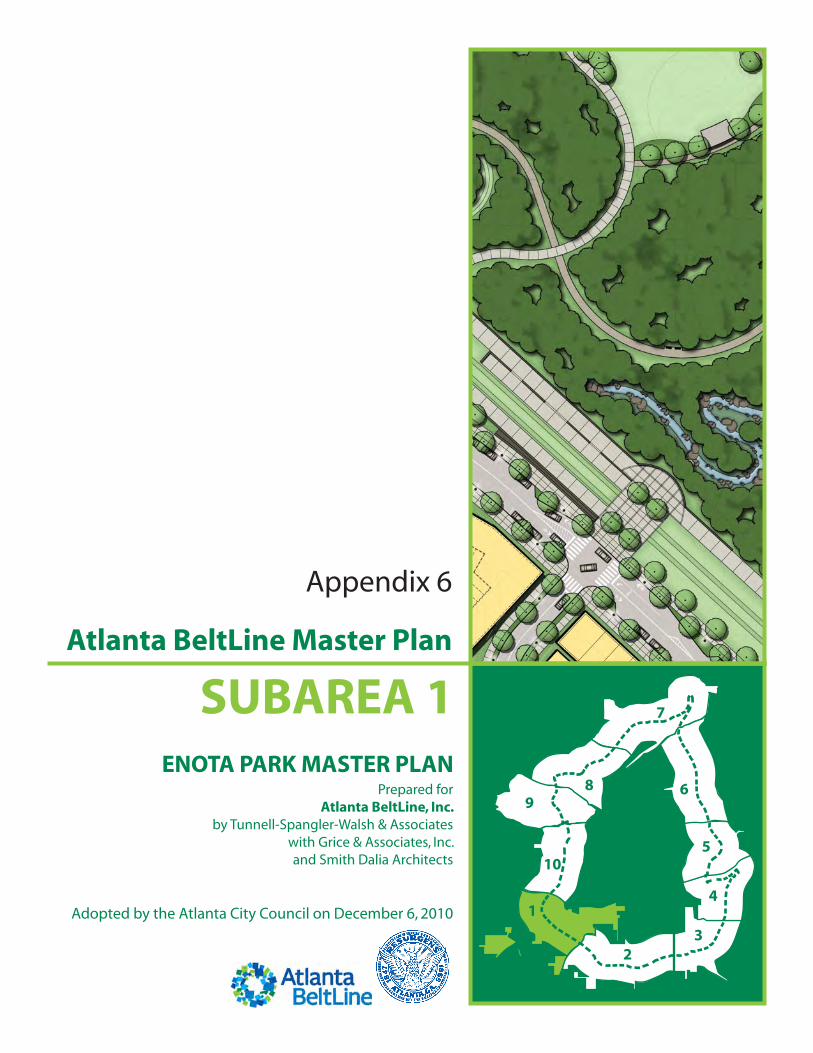
SUBAREA 1 ENOTA PARK MASTER PLAN Prepared for Atlanta BeltLine, Inc. by Tunnell-Spangler-Walsh & Associates with Grice & Associates, Inc. and Smith Dalia Architects Adopted by the Atlanta City Council on December 6, 2010 Appendix 6 Atlanta BeltLine Master Plan

Welcome message from author
This document is posted to help you gain knowledge. Please leave a comment to let me know what you think about it! Share it to your friends and learn new things together.
Transcript
SUBAREA 1
ENOTA PARK MASTER PLANPrepared for
Atlanta BeltLine, Inc.by Tunnell-Spangler-Walsh & Associates
with Grice & Associates, Inc. and Smith Dalia Architects
Adopted by the Atlanta City Council on December 6, 2010
Appendix 6
Atlanta BeltLine Master Plan

this page left intentionally blankthis report has been formatted to be printed double-sided in an effort to save paper
ACKNOWLEDGEMENTS
The Honorable Mayor Kasim Reed
ATLANTA CITY COUNCIL
Ceasar Mitchell, President
Carla Smith, District 1
Kwanza Hall, District 2
Ivory Lee Young, Jr., District 3
Cleta Winslow, District 4
Natalyn Mosby Archibong, District 5
Alex Wan, District 6
Howard Shook, District 7
Yolanda Adrean, District 8
Felicia A. Moore, District 9
C. T. Martin, District 10
Keisha Bottoms, District 11
Joyce Sheperd, District 12
Michael Julian Bond, Post 1 at Large
Aaron Watson, Post 2 at Large
H. Lamar Willis, Post 3 at Large
ATLANTA BELTLINE, INC. BOARD OF DIRECTORS
Elizabeth B. Chandler, Chair
Clara Axam, Vice Chair, Enterprise Community Partners, Inc.; MARTA Board of Directors
Joseph A. Brown, Director of Equity/Structured Finance, Centerline Capital Group
LaChandra Butler, Atlanta Board of Eduction
The Honorable Emma Darnell, Fulton County Board of Commissioners District 5
The Honorable Kasim Reed, City of Atlanta Mayor
The Honorable Joyce M. Shepherd, Atlanta City Council District 12
John Somerhalder, AGL Resources, Chair of the Board, BeltLine Partnership
SUBAREA 1 PLANNING COMMITTEE
Michael Altermann, West End Mall
Patrick Berry, Westview
Bakari Brooks, Atlanta Housing Authority
Allean Brown, NPU S Liaison
Danielle Carney, NPU T Liaison
Ed Chang, KIPP Strive
Jo Ann Chitty, Selig Enterprises
Teeya Davis, Cleta Winslow’s Office
Reverend Elligan
Douglas Fitzgerald, Donnelly Gardens Apartments
Vonda Henry, West End
Deudishar Jenkins, Mimms Enterprises
Herb Joseph, Atlanta Public Schools
Nia Knowles, NPU T
Travie Leslie, NPU V
Felicia Phillips, Oakland City
Derek Roqumore, Outdoor Activity Center
David Sitt (out of town participant), Kroger Citi Center
Scott Smith, Westview
Debra Stevens, Atlanta Housing Authority
Yamara Valez, West End
Oluyemi Yikealo, West End Merchants Association
ACKNOWLEDGEMENTS
ATLANTA BELTLINE INC. STAFF
James Alexander, Project Manager
Brian Leary, President and CEO
Nathan Conable, Senior Project Manager
Rukiya S. Eaddy, Community Engagement Advocate
E. Fred Yalouris, Director of Design
CITY OF ATLANTA STAFF
Jonathan Lewis, Senior Planner
Paul Taylor, Deputy Director of Park Design
CONSULTANT TEAM
Tunnell-Spangler-Walsh and Associates
Caleb Racicot, Principal
Woody Giles, Community Planner
Ryan Jenkins, Landscape Architect
Grice and Associates
John Funny, Principal
Julie Doyle, PE, PTOE
Smith Dalia Architects
Dan Koch, Principal-in-Charge
Trina Jang, Project Coordinator

CONTENTS
Preface . . . . . . . . . . . . . . . . . . . . . . . . . . . . . . . . . . . . . . . . . . . . . . . . . . . . . . . . . . . . . . . . . . . . . . . . . . 1Purpose . . . . . . . . . . . . . . . . . . . . . . . . . . . . . . . . . . . . . . . . . . . . . . . . . . . . . . . . . . . . . . . . . . . . . . . . . . . . . . . . . . . . . . . . . . 1BeltLine Planning Efforts . . . . . . . . . . . . . . . . . . . . . . . . . . . . . . . . . . . . . . . . . . . . . . . . . . . . . . . . . . . . . . . . . . . . . . . . . . 1Master Planning Process . . . . . . . . . . . . . . . . . . . . . . . . . . . . . . . . . . . . . . . . . . . . . . . . . . . . . . . . . . . . . . . . . . . . . . . . . . 2
Site Inventory . . . . . . . . . . . . . . . . . . . . . . . . . . . . . . . . . . . . . . . . . . . . . . . . . . . . . . . . . . . . . . . . . . . . 2Overview . . . . . . . . . . . . . . . . . . . . . . . . . . . . . . . . . . . . . . . . . . . . . . . . . . . . . . . . . . . . . . . . . . . . . . . . . . . . . . . . . . . . . . . . . 2Location and Extent . . . . . . . . . . . . . . . . . . . . . . . . . . . . . . . . . . . . . . . . . . . . . . . . . . . . . . . . . . . . . . . . . . . . . . . . . . . . . . . 2History . . . . . . . . . . . . . . . . . . . . . . . . . . . . . . . . . . . . . . . . . . . . . . . . . . . . . . . . . . . . . . . . . . . . . . . . . . . . . . . . . . . . . . . . . . . 3Previous Park Plan . . . . . . . . . . . . . . . . . . . . . . . . . . . . . . . . . . . . . . . . . . . . . . . . . . . . . . . . . . . . . . . . . . . . . . . . . . . . . . . . 3
Needs Analysis . . . . . . . . . . . . . . . . . . . . . . . . . . . . . . . . . . . . . . . . . . . . . . . . . . . . . . . . . . . . . . . . . . . 9Successful Urban Parks . . . . . . . . . . . . . . . . . . . . . . . . . . . . . . . . . . . . . . . . . . . . . . . . . . . . . . . . . . . . . . . . . . . . . . . . . . . . 9Opportunities and Constraints . . . . . . . . . . . . . . . . . . . . . . . . . . . . . . . . . . . . . . . . . . . . . . . . . . . . . . . . . . . . . . . . . . . . 9Summary of Community Input . . . . . . . . . . . . . . . . . . . . . . . . . . . . . . . . . . . . . . . . . . . . . . . . . . . . . . . . . . . . . . . . . . . . 9
Concept Development . . . . . . . . . . . . . . . . . . . . . . . . . . . . . . . . . . . . . . . . . . . . . . . . . . . . . . . . . . . 10Concept Process . . . . . . . . . . . . . . . . . . . . . . . . . . . . . . . . . . . . . . . . . . . . . . . . . . . . . . . . . . . . . . . . . . . . . . . . . . . . . . . . . 10Concept Plan A . . . . . . . . . . . . . . . . . . . . . . . . . . . . . . . . . . . . . . . . . . . . . . . . . . . . . . . . . . . . . . . . . . . . . . . . . . . . . . . . . . 10Concept Plan B . . . . . . . . . . . . . . . . . . . . . . . . . . . . . . . . . . . . . . . . . . . . . . . . . . . . . . . . . . . . . . . . . . . . . . . . . . . . . . . . . . 11
Master Plan . . . . . . . . . . . . . . . . . . . . . . . . . . . . . . . . . . . . . . . . . . . . . . . . . . . . . . . . . . . . . . . . . . . . . 12Overview . . . . . . . . . . . . . . . . . . . . . . . . . . . . . . . . . . . . . . . . . . . . . . . . . . . . . . . . . . . . . . . . . . . . . . . . . . . . . . . . . . . . . . . . 12Final Master Plan . . . . . . . . . . . . . . . . . . . . . . . . . . . . . . . . . . . . . . . . . . . . . . . . . . . . . . . . . . . . . . . . . . . . . . . . . . . . . . . . . 13Rendered Perspective . . . . . . . . . . . . . . . . . . . . . . . . . . . . . . . . . . . . . . . . . . . . . . . . . . . . . . . . . . . . . . . . . . . . . . . . . . . . 15Passive Recreation Areas . . . . . . . . . . . . . . . . . . . . . . . . . . . . . . . . . . . . . . . . . . . . . . . . . . . . . . . . . . . . . . . . . . . . . . . . . 18Active Recreation Areas . . . . . . . . . . . . . . . . . . . . . . . . . . . . . . . . . . . . . . . . . . . . . . . . . . . . . . . . . . . . . . . . . . . . . . . . . . 23
Implementation . . . . . . . . . . . . . . . . . . . . . . . . . . . . . . . . . . . . . . . . . . . . . . . . . . . . . . . . . . . . . . . . . 27Construction Phasing . . . . . . . . . . . . . . . . . . . . . . . . . . . . . . . . . . . . . . . . . . . . . . . . . . . . . . . . . . . . . . . . . . . . . . . . . . . . 27
Detailed Cost Estimates . . . . . . . . . . . . . . . . . . . . . . . . . . . . . . . . . . . . . . . . . . . . . . . . . . . . . . . . . . 29

this page left intentionally blankthis report has been formatted to be printed double-sided in an effort to save paper
ENOTA PARK MASTER PLAN • December 6, 2010 SUBAREA 1
1
Preface
Purpose
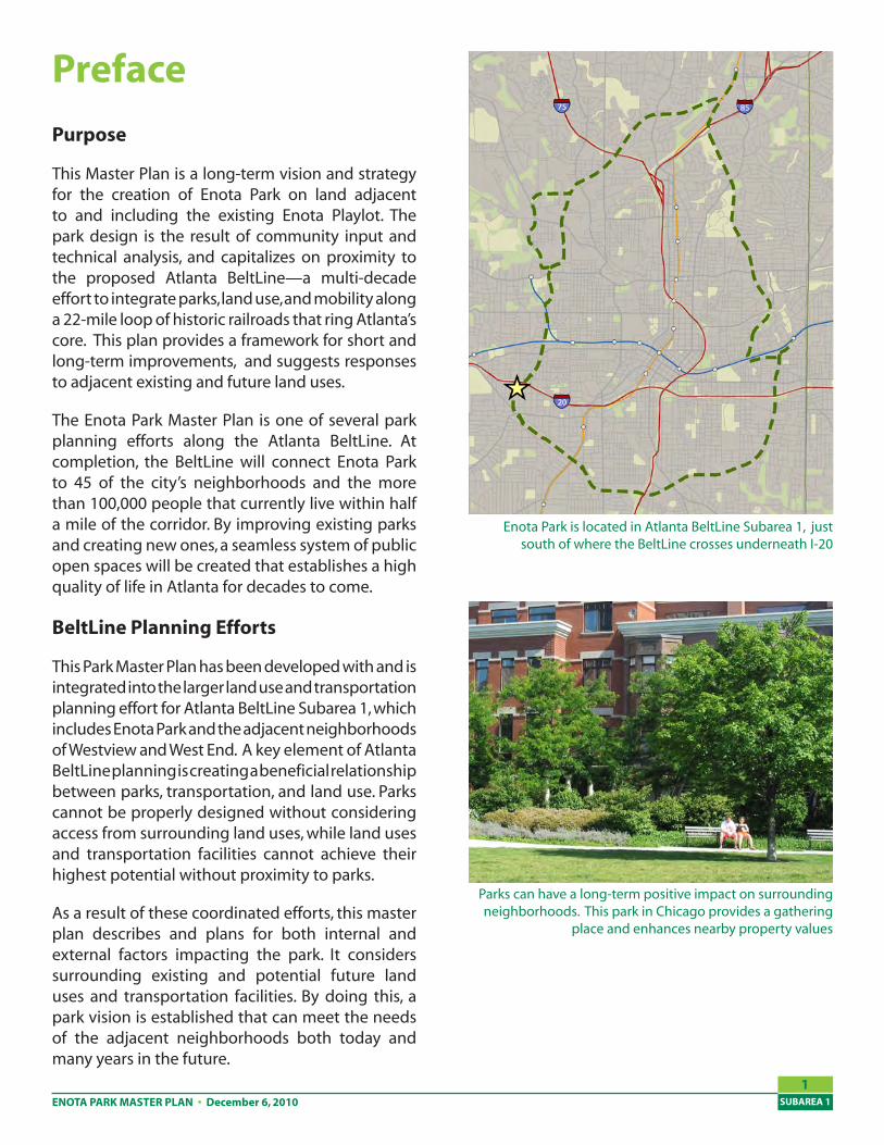
This Master Plan is a long-term vision and strategy for the creation of Enota Park on land adjacent to and including the existing Enota Playlot. The park design is the result of community input and technical analysis, and capitalizes on proximity to the proposed Atlanta BeltLine—a multi-decade effort to integrate parks, land use, and mobility along a 22-mile loop of historic railroads that ring Atlanta’s core. This plan provides a framework for short and long-term improvements, and suggests responses to adjacent existing and future land uses.
The Enota Park Master Plan is one of several park planning efforts along the Atlanta BeltLine. At completion, the BeltLine will connect Enota Park to 45 of the city’s neighborhoods and the more than 100,000 people that currently live within half a mile of the corridor. By improving existing parks and creating new ones, a seamless system of public open spaces will be created that establishes a high quality of life in Atlanta for decades to come.
BeltLine Planning Efforts
This Park Master Plan has been developed with and is integrated into the larger land use and transportation planning effort for Atlanta BeltLine Subarea 1, which includes Enota Park and the adjacent neighborhoods of Westview and West End. A key element of Atlanta BeltLine planning is creating a beneficial relationship between parks, transportation, and land use. Parks cannot be properly designed without considering access from surrounding land uses, while land uses and transportation facilities cannot achieve their highest potential without proximity to parks.
As a result of these coordinated efforts, this master plan describes and plans for both internal and external factors impacting the park. It considers surrounding existing and potential future land uses and transportation facilities. By doing this, a park vision is established that can meet the needs of the adjacent neighborhoods both today and many years in the future.
Parks can have a long-term positive impact on surrounding neighborhoods. This park in Chicago provides a gathering
place and enhances nearby property values
Enota Park is located in Atlanta BeltLine Subarea 1, just south of where the BeltLine crosses underneath I-20
ENOTA PARK MASTER PLANSUBAREA 1
2
Master Planning Process
The planning process used to develop the Enota Park Master Plan involved several steps. These included a review of previous park planning efforts, an inventory and analysis of existing conditions, stakeholder and community discussions, draft concept creation and testing, and the development of final recommendations and implementation plans.
Guiding this process was a Steering Committee of representatives from key area organizations, as well as a Study Group made up of members of the general public. A series of meetings was held throughout the process to allow both groups review and comment on plans.
Site Inventory
Overview
This section contains an inventory and analysis of existing conditions in the Enota Park area as they existed in early 2010. These conditions have been compiled from site visits, previous plans, community comments, and existing data sources and services. They were then analyzed to understand existing conditions and provide a baseline for park improvement efforts.
Location and Extent
The Enota Park site is located on mostly unimproved land between Langhorn Street and Enota Place, just south of I-20. The proposed park is between the Westview and West End neighborhoods, and is a few minutes’ walk north of the intersection of Ralph David Abernathy Boulevard and Cascade Road. Within a ten-minute walk of the park are an estimated 4,000-5,000 residents.
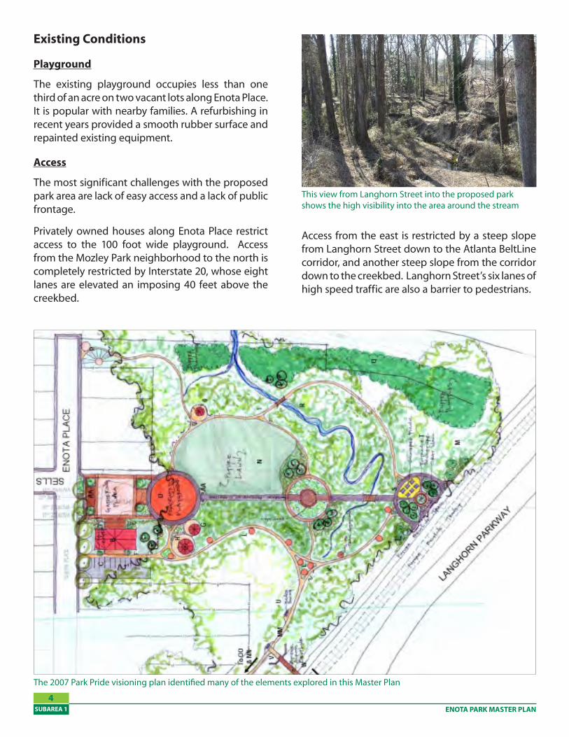
The existing Enota Playlot is less than one third of an acre, but the proposed boundaries of the park incorporate a significant amount of surrounding land, as shown in the Master Plan. The majority of lands proposed for acquisition and inclusion in Enota Park are currently vacant.
Existing Enota Playlot and surrounding area, showing the Atlanta BeltLine Tax Allocation District in orange
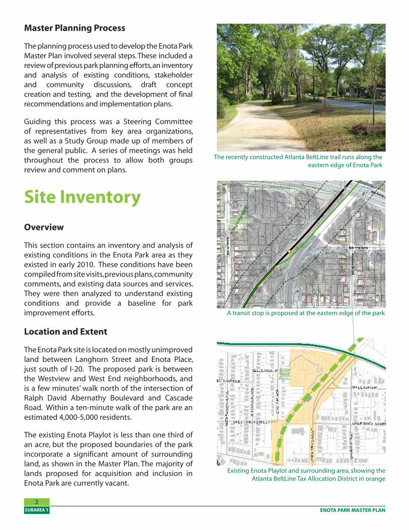
The recently constructed Atlanta BeltLine trail runs along the eastern edge of Enota Park
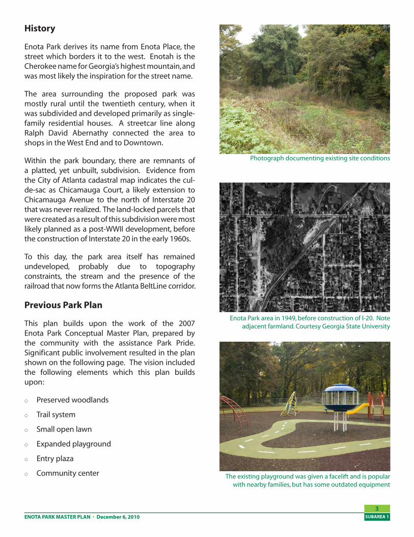
A transit stop is proposed at the eastern edge of the park
980990
970
960
10001010
950
1020
940
1030
1040
980
950
1000
940
1030
950
1000
1020
980
1000
980
9801040
990
1000
990
960
970
1000
970
1010
990
1010
990
1030
970
990
960
990 1010
1010
960
1010
960
1000
950
990
950
1030
Green Leaf Circle
Enota Place Playlot
Napoleon Circle
Langhorn St SW
I-20 Exwy SW
I-20 SW
Westview Dr SW
Hopkins St SW
Enota Pl SW
W Fair St SW
Lucile Ave SW
Sells Ave SW
Altoona Pl SW
Greenwich St SW
Calhoun Ter SW
Napoleon D
r SW
Chicam
auga Ave SW
Mozley Pl SW
Atw
ood St SW
Latham St SW
Rockmart Dr SW
Chicamauga Pl SW
I-20 Exwy SW
I-20 SW
Greenwich St SW
Hopkins St SW
Sells Ave SW
�
SW-2
0
200
100
FeetBELTLINE CORRIDOR ENVIRONMENTAL STUDY
CONCEPTUAL TRAIL AND TRANSIT ALIGNMENTSHEET NO.:10
Multi-Use Trail
MARTA Rail/Stations
Rail Transit Alternative
Rail Transit Stations
Rail Transit
Impact Assessm
ent Area (150ft buffer)
BuildingsParcel Boundary
ParksStreets
Railroads
Rail Transit/Multi-Use Trail
Contours
Multi-Use Trail Alternative
990
ENOTA PARK MASTER PLAN • December 6, 2010 SUBAREA 1
�
History
Enota Park derives its name from Enota Place, the street which borders it to the west. Enotah is the Cherokee name for Georgia’s highest mountain, and was most likely the inspiration for the street name.
The area surrounding the proposed park was mostly rural until the twentieth century, when it was subdivided and developed primarily as single-family residential houses. A streetcar line along Ralph David Abernathy connected the area to shops in the West End and to Downtown.
Within the park boundary, there are remnants of a platted, yet unbuilt, subdivision. Evidence from the City of Atlanta cadastral map indicates the cul-de-sac as Chicamauga Court, a likely extension to Chicamauga Avenue to the north of Interstate 20 that was never realized. The land-locked parcels that were created as a result of this subdivision were most likely planned as a post-WWII development, before the construction of Interstate 20 in the early 1960s.
To this day, the park area itself has remained undeveloped, probably due to topography constraints, the stream and the presence of the railroad that now forms the Atlanta BeltLine corridor.
Previous Park Plan
This plan builds upon the work of the 2007 Enota Park Conceptual Master Plan, prepared by the community with the assistance Park Pride. Significant public involvement resulted in the plan shown on the following page. The vision included the following elements which this plan builds upon:
Preserved woodlands
Trail system
Small open lawn
Expanded playground
Entry plaza
Community center
Enota Park area in 1949, before construction of I-20. Note adjacent farmland. Courtesy Georgia State University
Photograph documenting existing site conditions
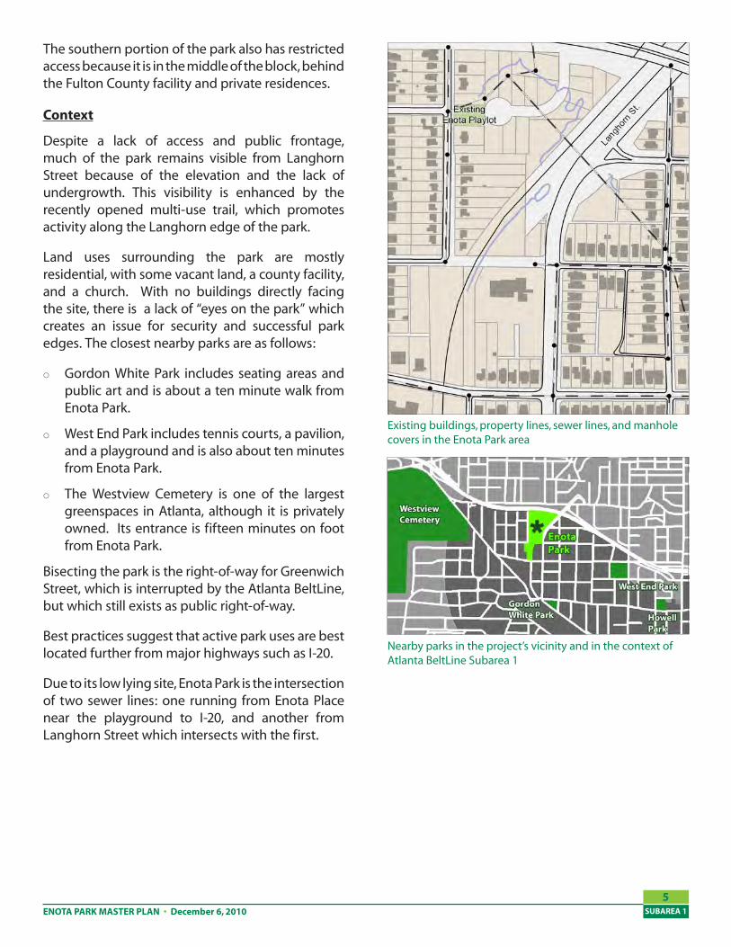
The existing playground was given a facelift and is popular with nearby families, but has some outdated equipment
ENOTA PARK MASTER PLANSUBAREA 1
�
Existing Conditions
Playground
The existing playground occupies less than one third of an acre on two vacant lots along Enota Place. It is popular with nearby families. A refurbishing in recent years provided a smooth rubber surface and repainted existing equipment.
Access
The most significant challenges with the proposed park area are lack of easy access and a lack of public frontage.
Privately owned houses along Enota Place restrict access to the 100 foot wide playground. Access from the Mozley Park neighborhood to the north is completely restricted by Interstate 20, whose eight lanes are elevated an imposing 40 feet above the creekbed.
Access from the east is restricted by a steep slope from Langhorn Street down to the Atlanta BeltLine corridor, and another steep slope from the corridor down to the creekbed. Langhorn Street’s six lanes of high speed traffic are also a barrier to pedestrians.
This view from Langhorn Street into the proposed park shows the high visibility into the area around the stream
The 2007 Park Pride visioning plan identified many of the elements explored in this Master Plan
ENOTA PARK MASTER PLAN • December 6, 2010 SUBAREA 1
�
The southern portion of the park also has restricted access because it is in the middle of the block, behind the Fulton County facility and private residences.
Context
Despite a lack of access and public frontage, much of the park remains visible from Langhorn Street because of the elevation and the lack of undergrowth. This visibility is enhanced by the recently opened multi-use trail, which promotes activity along the Langhorn edge of the park.
Land uses surrounding the park are mostly residential, with some vacant land, a county facility, and a church. With no buildings directly facing the site, there is a lack of “eyes on the park” which creates an issue for security and successful park edges. The closest nearby parks are as follows:
Gordon White Park includes seating areas and public art and is about a ten minute walk from Enota Park.
West End Park includes tennis courts, a pavilion, and a playground and is also about ten minutes from Enota Park.
The Westview Cemetery is one of the largest greenspaces in Atlanta, although it is privately owned. Its entrance is fifteen minutes on foot from Enota Park.
Bisecting the park is the right-of-way for Greenwich Street, which is interrupted by the Atlanta BeltLine, but which still exists as public right-of-way.
Best practices suggest that active park uses are best located further from major highways such as I-20.
Due to its low lying site, Enota Park is the intersection of two sewer lines: one running from Enota Place near the playground to I-20, and another from Langhorn Street which intersects with the first.
Existing buildings, property lines, sewer lines, and manhole covers in the Enota Park area
Nearby parks in the project’s vicinity and in the context of Atlanta BeltLine Subarea 1
ENOTA PARK MASTER PLANSUBAREA 1
6
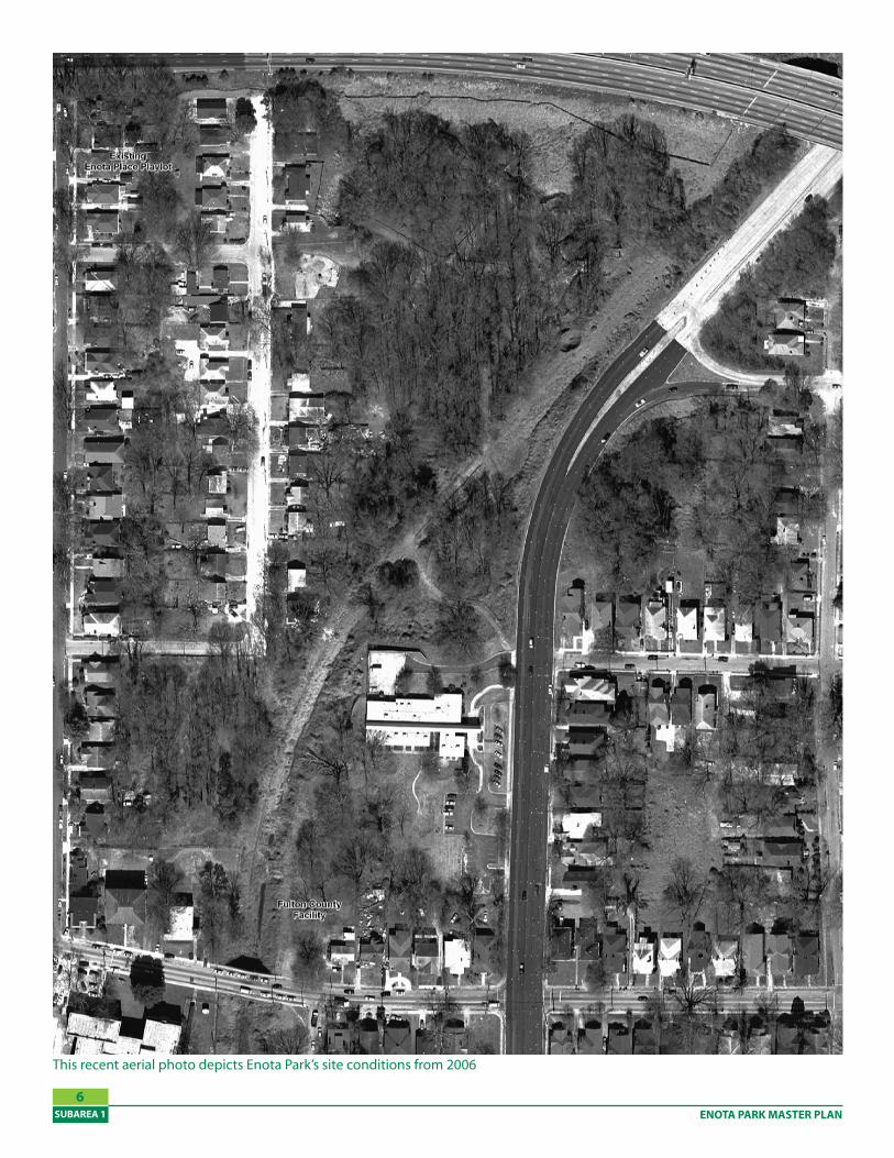
This recent aerial photo depicts Enota Park’s site conditions from 2006
ENOTA PARK MASTER PLAN • December 6, 2010 SUBAREA 1
7
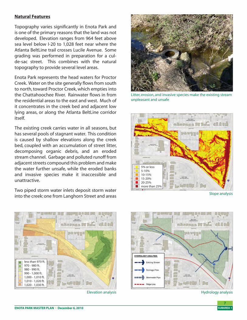
Natural Features
Topography varies significantly in Enota Park and is one of the primary reasons that the land was not developed. Elevation ranges from 964 feet above sea level below I-20 to 1,028 feet near where the Atlanta BeltLine trail crosses Lucile Avenue. Some grading was performed in preparation for a cul-de-sac street. This combines with the natural topography to provide several level areas.
Enota Park represents the head waters for Proctor Creek. Water on the site generally flows from south to north, toward Proctor Creek, which empties into the Chattahoochee River. Rainwater flows in from the residential areas to the east and west. Much of it concentrates in the creek bed and adjacent low lying areas, or along the Atlanta BeltLine corridor itself.
The existing creek carries water in all seasons, but has several pools of stagnant water. This condition is caused by shallow elevations along the creek bed, coupled with an accumulation of street litter, decomposing organic debris, and an eroded stream channel. Garbage and polluted runoff from adjacent streets compound this problem and make the water further unsafe, while the eroded banks and invasive species make it inaccessible and unattractive.
Two piped storm water inlets deposit storm water into the creek: one from Langhorn Street and areas
Slope analysis
Hydrology analysis
5% or less5-10%10-15%15-20%20-25%more than 25%
Elevation analysis
less than 970 ft.970 - 980 ft.980 - 990 ft.990 - 1,000 ft.1,000 - 1,010 ft.1,010 - 1,020 ft.1,020 - 1,030 ft.
Litter, erosion, and invasive species make the existing stream unpleasant and unsafe
ENOTA PARK MASTER PLANSUBAREA 1
�
to the east and another near the playground that drains from streets to the west. A third pipe allows the creek to travel under Interstate 20.
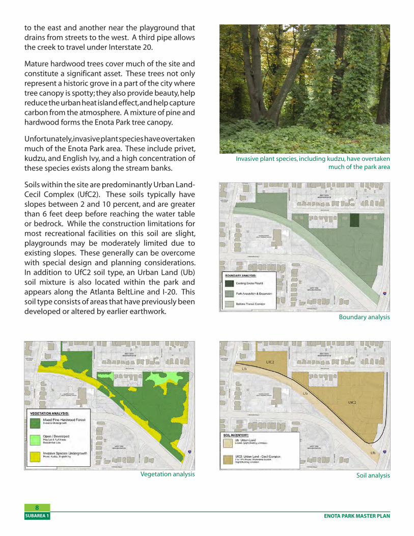
Mature hardwood trees cover much of the site and constitute a significant asset. These trees not only represent a historic grove in a part of the city where tree canopy is spotty; they also provide beauty, help reduce the urban heat island effect, and help capture carbon from the atmosphere. A mixture of pine and hardwood forms the Enota Park tree canopy.
Unfortunately, invasive plant species have overtaken much of the Enota Park area. These include privet, kudzu, and English Ivy, and a high concentration of these species exists along the stream banks.
Soils within the site are predominantly Urban Land-Cecil Complex (UfC2). These soils typically have slopes between 2 and 10 percent, and are greater than 6 feet deep before reaching the water table or bedrock. While the construction limitations for most recreational facilities on this soil are slight, playgrounds may be moderately limited due to existing slopes. These generally can be overcome with special design and planning considerations. In addition to UfC2 soil type, an Urban Land (Ub) soil mixture is also located within the park and appears along the Atlanta BeltLine and I-20. This soil type consists of areas that have previously been developed or altered by earlier earthwork.
Soil analysis
Boundary analysis
Vegetation analysis
Invasive plant species, including kudzu, have overtaken much of the park area
ENOTA PARK MASTER PLAN • December 6, 2010 SUBAREA 1
9
Ideally, urban parks of all sizes should be surrounded by streets and buildings that face directly into them
Needs Analysis
Successful Urban Parks
Successful urban parks share the common features of accessibility, visibility, and management. Together, these features activate a park and directly improve safety in and around it.
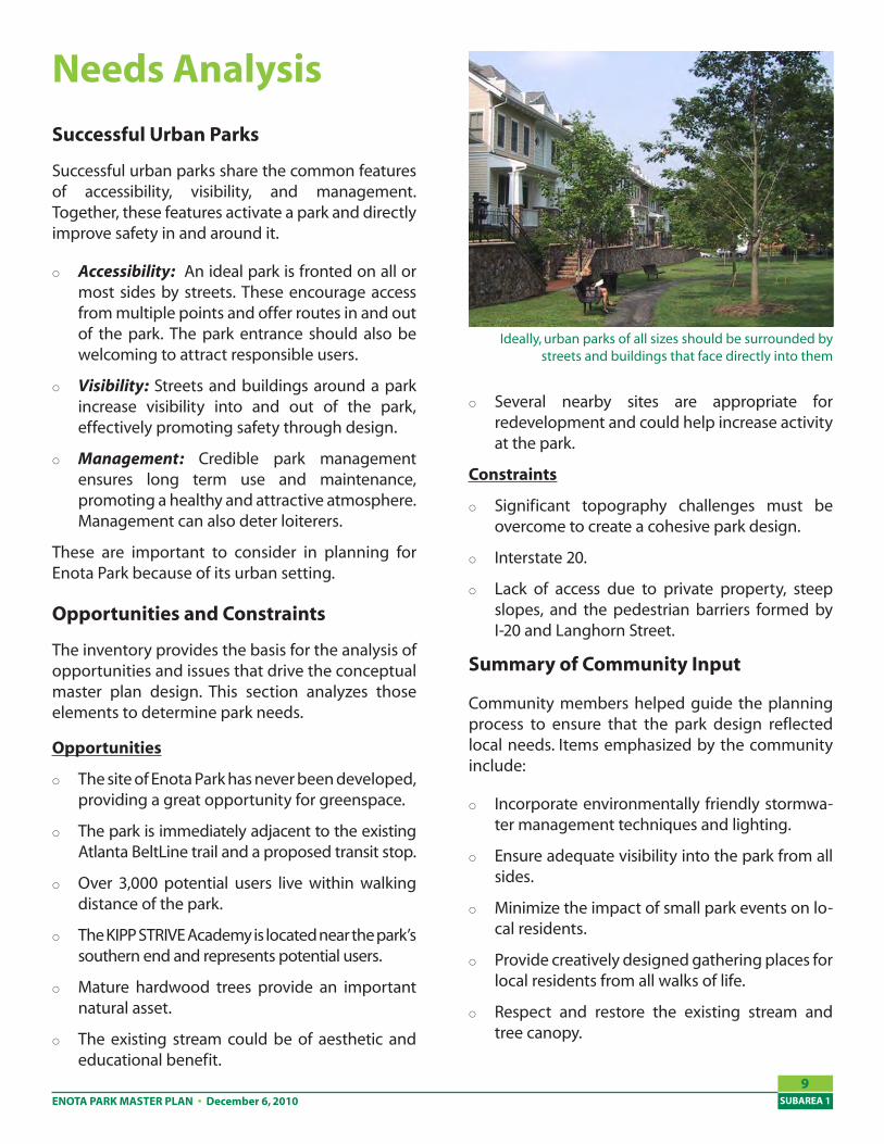
Accessibility: An ideal park is fronted on all or most sides by streets. These encourage access from multiple points and offer routes in and out of the park. The park entrance should also be welcoming to attract responsible users.
Visibility: Streets and buildings around a park increase visibility into and out of the park, effectively promoting safety through design.
Management: Credible park management ensures long term use and maintenance, promoting a healthy and attractive atmosphere. Management can also deter loiterers.
These are important to consider in planning for Enota Park because of its urban setting.
Opportunities and Constraints
The inventory provides the basis for the analysis of opportunities and issues that drive the conceptual master plan design. This section analyzes those elements to determine park needs.
Opportunities
The site of Enota Park has never been developed, providing a great opportunity for greenspace.
The park is immediately adjacent to the existing Atlanta BeltLine trail and a proposed transit stop.
Over 3,000 potential users live within walking distance of the park.
The KIPP STRIVE Academy is located near the park’s southern end and represents potential users.
Mature hardwood trees provide an important natural asset.
The existing stream could be of aesthetic and educational benefit.
Several nearby sites are appropriate for redevelopment and could help increase activity at the park.
Constraints
Significant topography challenges must be overcome to create a cohesive park design.
Interstate 20.
Lack of access due to private property, steep slopes, and the pedestrian barriers formed by I-20 and Langhorn Street.
Summary of Community Input
Community members helped guide the planning process to ensure that the park design reflected local needs. Items emphasized by the community include:
Incorporate environmentally friendly stormwa-ter management techniques and lighting.
Ensure adequate visibility into the park from all sides.
Minimize the impact of small park events on lo-cal residents.
Provide creatively designed gathering places for local residents from all walks of life.
Respect and restore the existing stream and tree canopy.
ENOTA PARK MASTER PLANSUBAREA 1
10
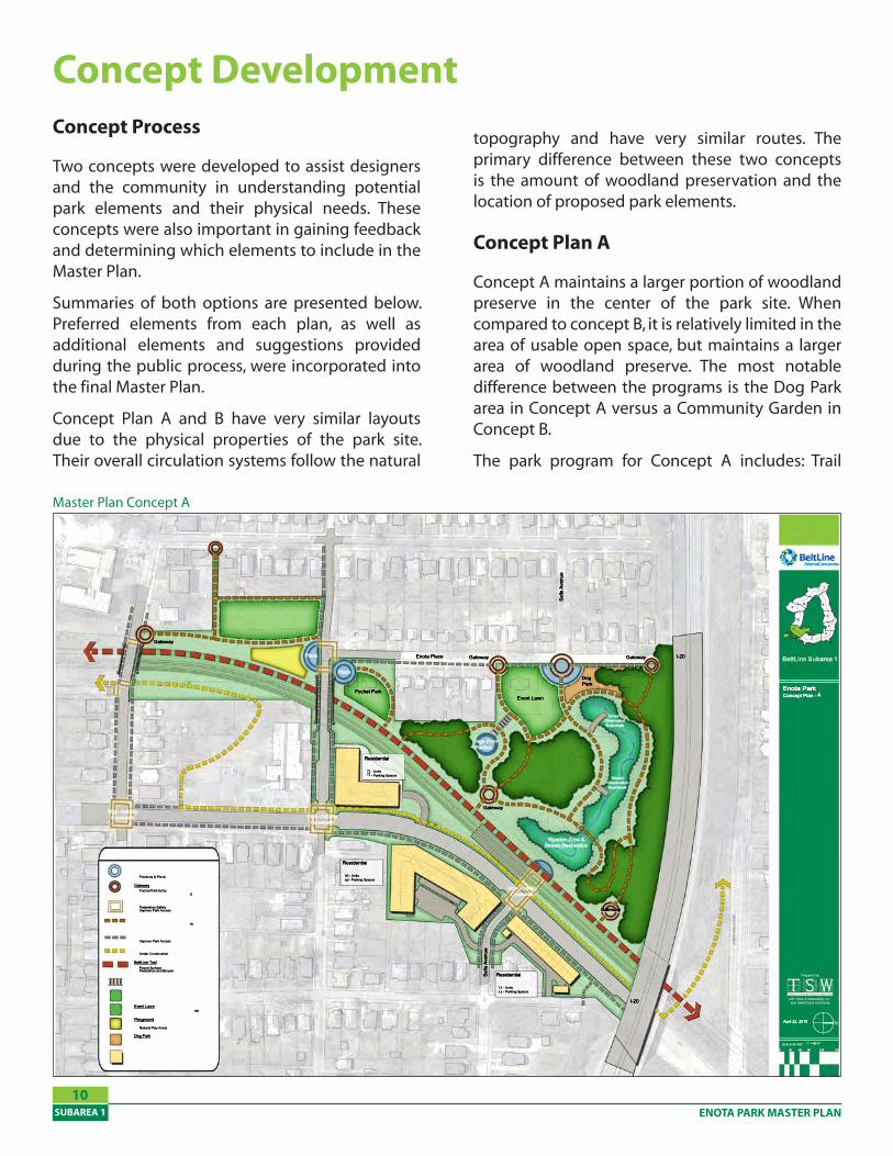
Concept Process
Two concepts were developed to assist designers and the community in understanding potential park elements and their physical needs. These concepts were also important in gaining feedback and determining which elements to include in the Master Plan.
Summaries of both options are presented below. Preferred elements from each plan, as well as additional elements and suggestions provided during the public process, were incorporated into the final Master Plan.
Concept Plan A and B have very similar layouts due to the physical properties of the park site. Their overall circulation systems follow the natural
Concept Development
Master Plan Concept A
topography and have very similar routes. The primary difference between these two concepts is the amount of woodland preservation and the location of proposed park elements.
Concept Plan A
Concept A maintains a larger portion of woodland preserve in the center of the park site. When compared to concept B, it is relatively limited in the area of usable open space, but maintains a larger area of woodland preserve. The most notable difference between the programs is the Dog Park area in Concept A versus a Community Garden in Concept B.
The park program for Concept A includes: Trail
ENOTA PARK MASTER PLAN • December 6, 2010 SUBAREA 1
11
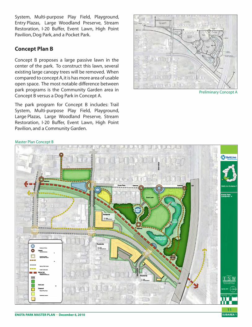
Master Plan Concept B
System, Multi-purpose Play Field, Playground, Entry Plazas, Large Woodland Preserve, Stream Restoration, I-20 Buffer, Event Lawn, High Point Pavilion, Dog Park, and a Pocket Park.
Concept Plan B
Concept B proposes a large passive lawn in the center of the park. To construct this lawn, several existing large canopy trees will be removed. When compared to concept A, it is has more area of usable open space. The most notable difference between park programs is the Community Garden area in Concept B versus a Dog Park in Concept A.
The park program for Concept B includes: Trail System, Multi-purpose Play Field, Playground, Large Plazas, Large Woodland Preserve, Stream Restoration, I-20 Buffer, Event Lawn, High Point Pavilion, and a Community Garden.
Preliminary Concept A
ENOTA PARK MASTER PLANSUBAREA 1
12
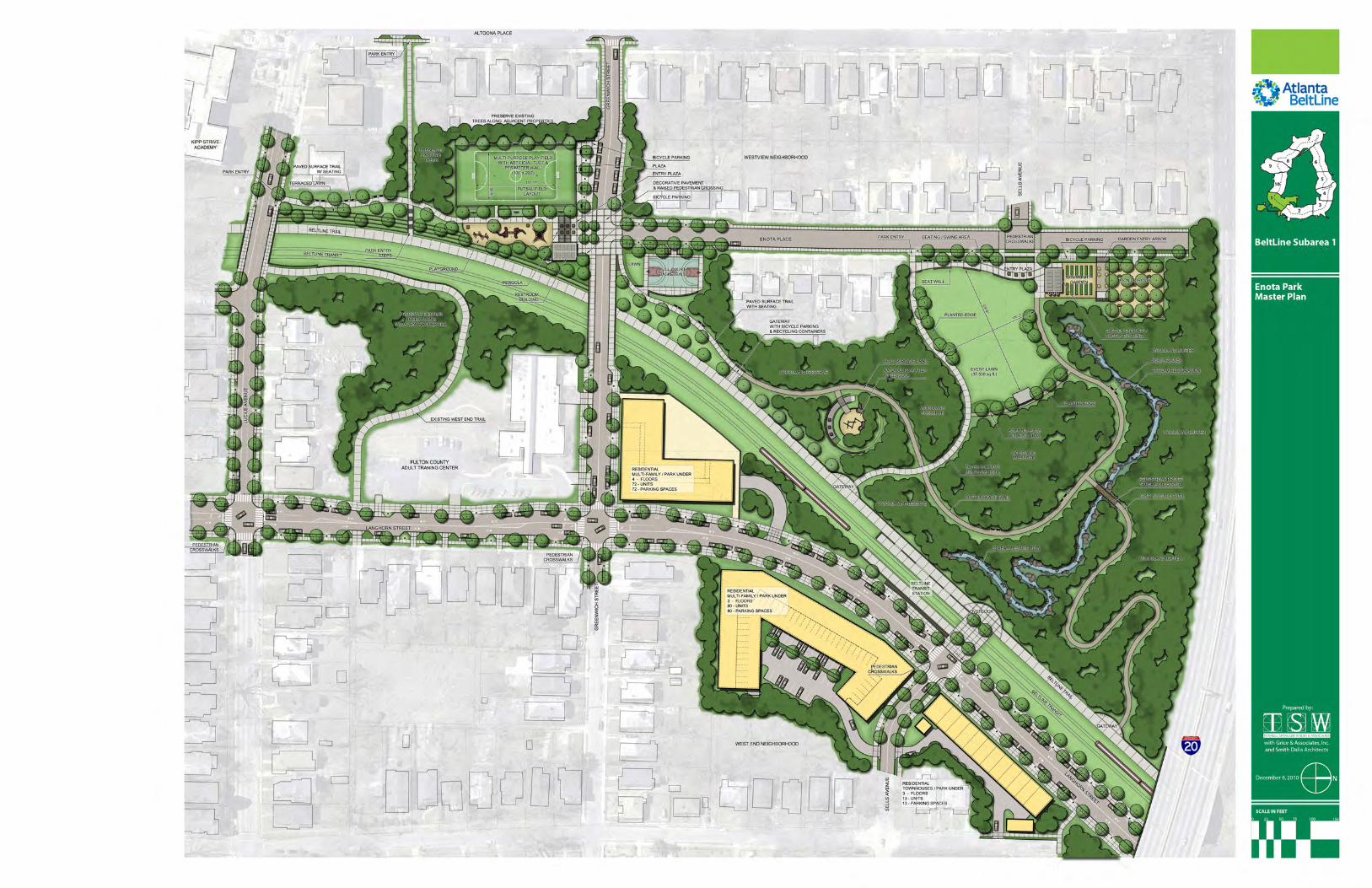
Master Plan
Overview
As one of thirteen park ‘jewels’ originally identified in Alexander Garvin’s 2005 “Emerald Necklace” study, Enota Park’s expansion represents one of the Atlanta BeltLine’s few greenspaces with a designated woodland area and natural walking trails. Another uniquely defining characteristic will be the Atlanta BeltLine’s proximity as a prominent public edge along Enota Park’s entire eastern boundary, providing direct access from the adjacent West End and Westview neighborhoods.
Due to its geographic location, however, the Enota Park site has several unique challenges to overcome. These issues were first identified during the context and site analysis phase of this project and include the following:
The Enota Park site has very little existing public access. Nearly all of the boundaries for this site join private or inaccessible properties.
The Enota Park site is very secluded with very little visual access into the park.
The existing woodland and stream are in poor environmental condition. Several invasive species have intruded in the woodland areas, and the stream is polluted by several surrounding non-point sources.
To adequately address these issues and develop a successful park master plan, three design principles have been developed to inform the process.
Environmental Restoration
Healthy urban forests and streams are extremely beneficial to the natural environment and our own human health; however, their occurrence is rare in urban neighborhoods. Where they do exist, urban forest and woodlands should be preserved and enhanced as a critical part of the overall community.
•
•
•
1.
Safety and Security
Park safety and security hinge on the level of visual accessibility into the park, and on the number of people who regularly use the park. Public park edges should be maximized and designed to promote views into the park. Additionally, the park program must be developed with community input to encourage a high level of park users.
Access and Circulation
To ensure the development of a successful park master plan, public park frontage and access must be maximized. Circulation systems must be designed to encourage and allow nearby residents to easily access the park.
To fully address each of these design principles, the overall master plan extends beyond the park boundaries to show additional neighborhood planning strategies that can be utilized to adequately resolve the unique issues related to Enota Park. Three additional planning strategies were developed in response to the design principles.
Langhorn Street Road Diet
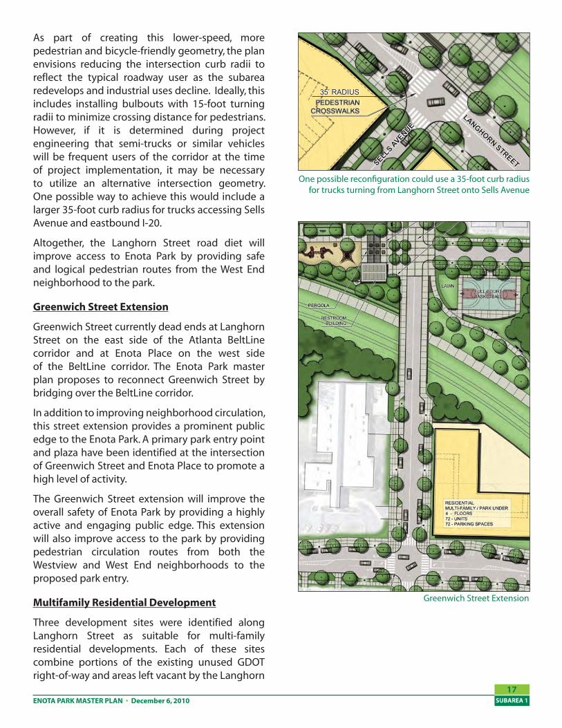
Langhorn Street currently has five travel lanes with very few pedestrian facilities. It promotes high travel speeds and serves as a pedestrian barrier between the West End neighborhood and the Westview neighborhood. As part of the Enota Park master plan and based on recommendations from the City of Atlanta Transportation Plan, Langhorn Street would be narrowed to two 12-foot travel lanes (one in each direction) with left turn lanes at each major intersection.
The intersection at Langhorn Street and Sells Avenue will be significantly transformed from a high-speed “Y” style intersection with large turning radii to a lower-speed “T” style intersection. The newly configured intersection would be signalized to promote safer interactions between pedestrians and vehicles. It will also serve as the logical crossing point to access the proposed Atlanta BeltLine corridor and transit stop.
2.
3.

ENOTA PARK MASTER PLAN • December 6, 2010 SUBAREA 1
17
As part of creating this lower-speed, more pedestrian and bicycle-friendly geometry, the plan envisions reducing the intersection curb radii to reflect the typical roadway user as the subarea redevelops and industrial uses decline. Ideally, this includes installing bulbouts with 15-foot turning radii to minimize crossing distance for pedestrians. However, if it is determined during project engineering that semi-trucks or similar vehicles will be frequent users of the corridor at the time of project implementation, it may be necessary to utilize an alternative intersection geometry. One possible way to achieve this would include a larger 35-foot curb radius for trucks accessing Sells Avenue and eastbound I-20.
Altogether, the Langhorn Street road diet will improve access to Enota Park by providing safe and logical pedestrian routes from the West End neighborhood to the park.
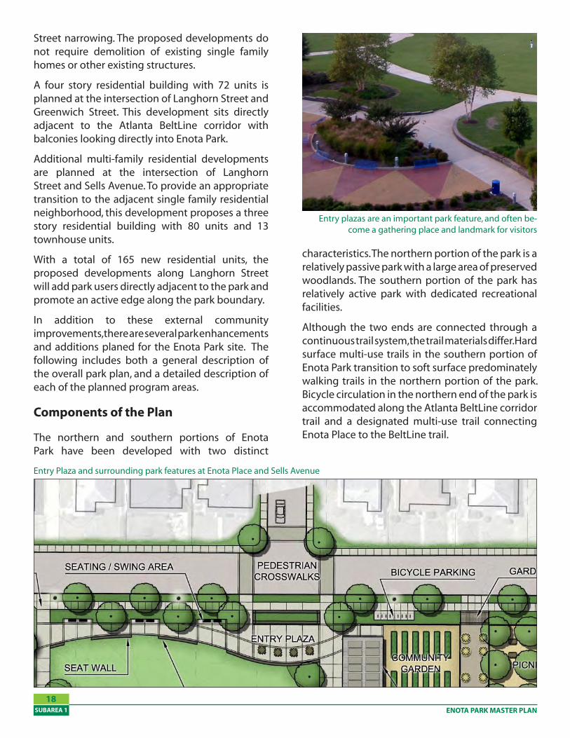
Greenwich Street Extension
Greenwich Street currently dead ends at Langhorn Street on the east side of the Atlanta BeltLine corridor and at Enota Place on the west side of the BeltLine corridor. The Enota Park master plan proposes to reconnect Greenwich Street by bridging over the BeltLine corridor.
In addition to improving neighborhood circulation, this street extension provides a prominent public edge to the Enota Park. A primary park entry point and plaza have been identified at the intersection of Greenwich Street and Enota Place to promote a high level of activity.
The Greenwich Street extension will improve the overall safety of Enota Park by providing a highly active and engaging public edge. This extension will also improve access to the park by providing pedestrian circulation routes from both the Westview and West End neighborhoods to the proposed park entry.
Multifamily Residential Development
Three development sites were identified along Langhorn Street as suitable for multi-family residential developments. Each of these sites combine portions of the existing unused GDOT right-of-way and areas left vacant by the Langhorn
Greenwich Street Extension
One possible reconfiguration could use a 35-foot curb radius for trucks turning from Langhorn Street onto Sells Avenue
LANGHORN STREETSELLS AVENUE
35’ RADIUS
ENOTA PARK MASTER PLANSUBAREA 1
1�
Street narrowing. The proposed developments do not require demolition of existing single family homes or other existing structures.
A four story residential building with 72 units is planned at the intersection of Langhorn Street and Greenwich Street. This development sits directly adjacent to the Atlanta BeltLine corridor with balconies looking directly into Enota Park.
Additional multi-family residential developments are planned at the intersection of Langhorn Street and Sells Avenue. To provide an appropriate transition to the adjacent single family residential neighborhood, this development proposes a three story residential building with 80 units and 13 townhouse units.
With a total of 165 new residential units, the proposed developments along Langhorn Street will add park users directly adjacent to the park and promote an active edge along the park boundary.
In addition to these external community improvements, there are several park enhancements and additions planed for the Enota Park site. The following includes both a general description of the overall park plan, and a detailed description of each of the planned program areas.
Components of the Plan
The northern and southern portions of Enota Park have been developed with two distinct
Entry Plaza and surrounding park features at Enota Place and Sells Avenue
characteristics. The northern portion of the park is a relatively passive park with a large area of preserved woodlands. The southern portion of the park has relatively active park with dedicated recreational facilities.
Although the two ends are connected through a continuous trail system, the trail materials differ. Hard surface multi-use trails in the southern portion of Enota Park transition to soft surface predominately walking trails in the northern portion of the park. Bicycle circulation in the northern end of the park is accommodated along the Atlanta BeltLine corridor trail and a designated multi-use trail connecting Enota Place to the BeltLine trail.
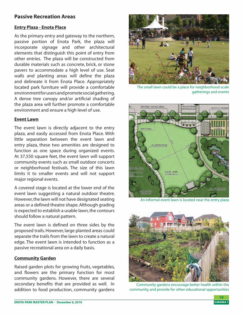
Entry plazas are an important park feature, and often be-come a gathering place and landmark for visitors
ENOTA PARK MASTER PLAN • December 6, 2010 SUBAREA 1
19
Passive Recreation Areas
Entry Plaza - Enota Place
As the primary entry and gateway to the northern, passive portion of Enota Park, the plaza will incorporate signage and other architectural elements that distinguish this point of entry from other entries. The plaza will be constructed from durable materials such as concrete, brick, or stone pavers to accommodate a high level of use. Seat walls and planting areas will define the plaza and delineate it from Enota Place. Appropriately located park furniture will provide a comfortable environment for users and promote social gathering. A dense tree canopy and/or artificial shading of the plaza area will further promote a comfortable environment and ensure a high level of use.
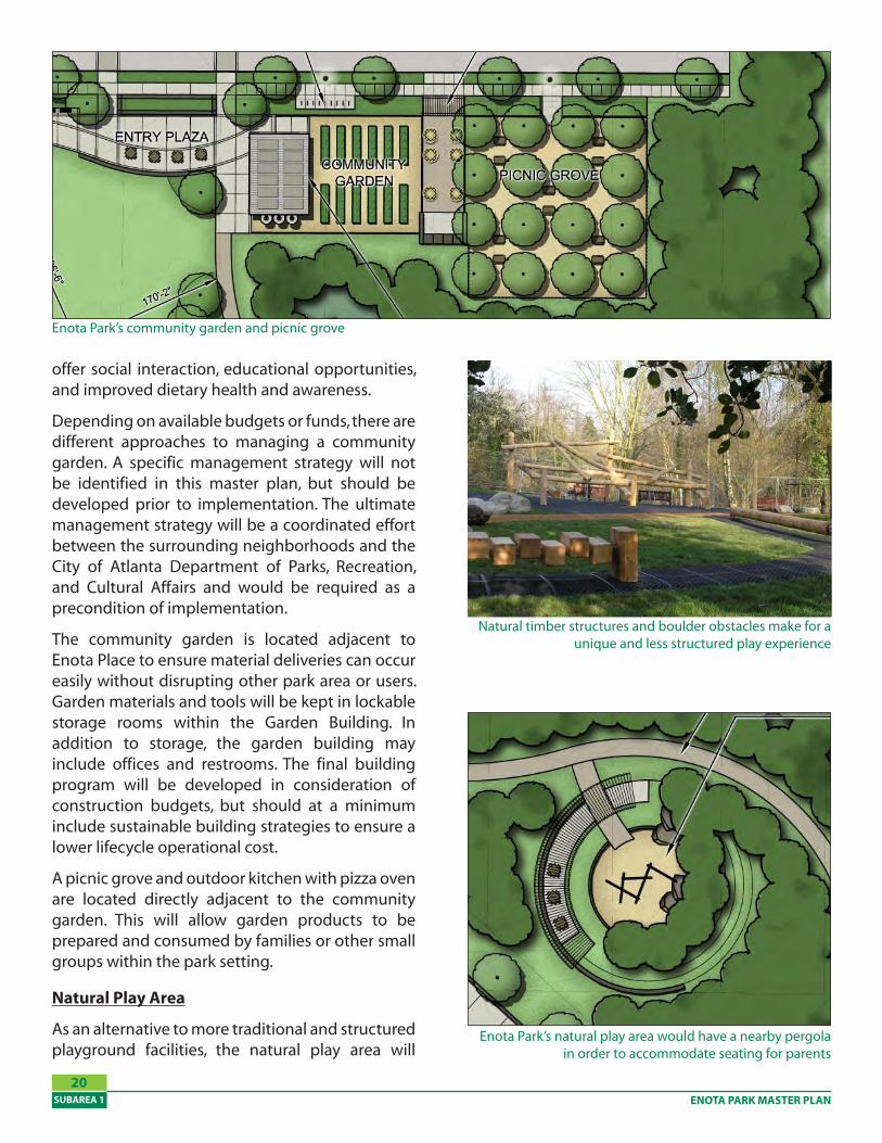
Event Lawn
The event lawn is directly adjacent to the entry plaza, and easily accessed from Enota Place. With little separation between the event lawn and entry plaza, these two amenities are designed to function as one space during organized events. At 37,550 square feet, the event lawn will support community events such as small outdoor concerts or neighborhood festivals. The size of this lawn limits it to smaller events and will not support major regional events.
A covered stage is located at the lower end of the event lawn suggesting a natural outdoor theatre. However, the lawn will not have designated seating areas or a defined theatre shape. Although grading is expected to establish a usable lawn, the contours should follow a natural pattern.
The event lawn is defined on three sides by the proposed trails. However, large planted areas could separate the trails from the lawn to create a natural edge. The event lawn is intended to function as a passive recreational area on a daily basis.
Community Garden
Raised garden plots for growing fruits, vegetables, and flowers are the primary function for most community gardens. However, there are several secondary benefits that are provided as well. In addition to food production, community gardens
An informal event lawn is located near the entry plaza
Community gardens encourage better health within the community, and provide for other educational opportunities
The small lawn could be a place for neighborhood-scale gatherings and events
ENOTA PARK MASTER PLANSUBAREA 1
20
offer social interaction, educational opportunities, and improved dietary health and awareness.
Depending on available budgets or funds, there are different approaches to managing a community garden. A specific management strategy will not be identified in this master plan, but should be developed prior to implementation. The ultimate management strategy will be a coordinated effort between the surrounding neighborhoods and the City of Atlanta Department of Parks, Recreation, and Cultural Affairs and would be required as a precondition of implementation.
The community garden is located adjacent to Enota Place to ensure material deliveries can occur easily without disrupting other park area or users. Garden materials and tools will be kept in lockable storage rooms within the Garden Building. In addition to storage, the garden building may include offices and restrooms. The final building program will be developed in consideration of construction budgets, but should at a minimum include sustainable building strategies to ensure a lower lifecycle operational cost.
A picnic grove and outdoor kitchen with pizza oven are located directly adjacent to the community garden. This will allow garden products to be prepared and consumed by families or other small groups within the park setting.
Natural Play Area
As an alternative to more traditional and structured playground facilities, the natural play area will
Enota Park’s natural play area would have a nearby pergola in order to accommodate seating for parents
Enota Park’s community garden and picnic grove
Natural timber structures and boulder obstacles make for a unique and less structured play experience
ENOTA PARK MASTER PLAN • December 6, 2010 SUBAREA 1
21
include a variety of play structures built from a combination of natural and manmade materials. For example, actual granite boulder can be used as climbing features instead of plastic walls and steel posts. Natural wood timbers and ropes can be combined to create unique climbing obstacles. Sand and water can also be combined with native plant materials to simulate natural environments where kids may play.
Although the natural play area is less structured than a traditional playground, it will be a defined area with typical park amenities. Accessible routes, appropriate furnishings, and signage will be provided. Similar to traditional playgrounds, play structures will be provided for children of all ages and abilities.
Trails, Gateways, and Overlook
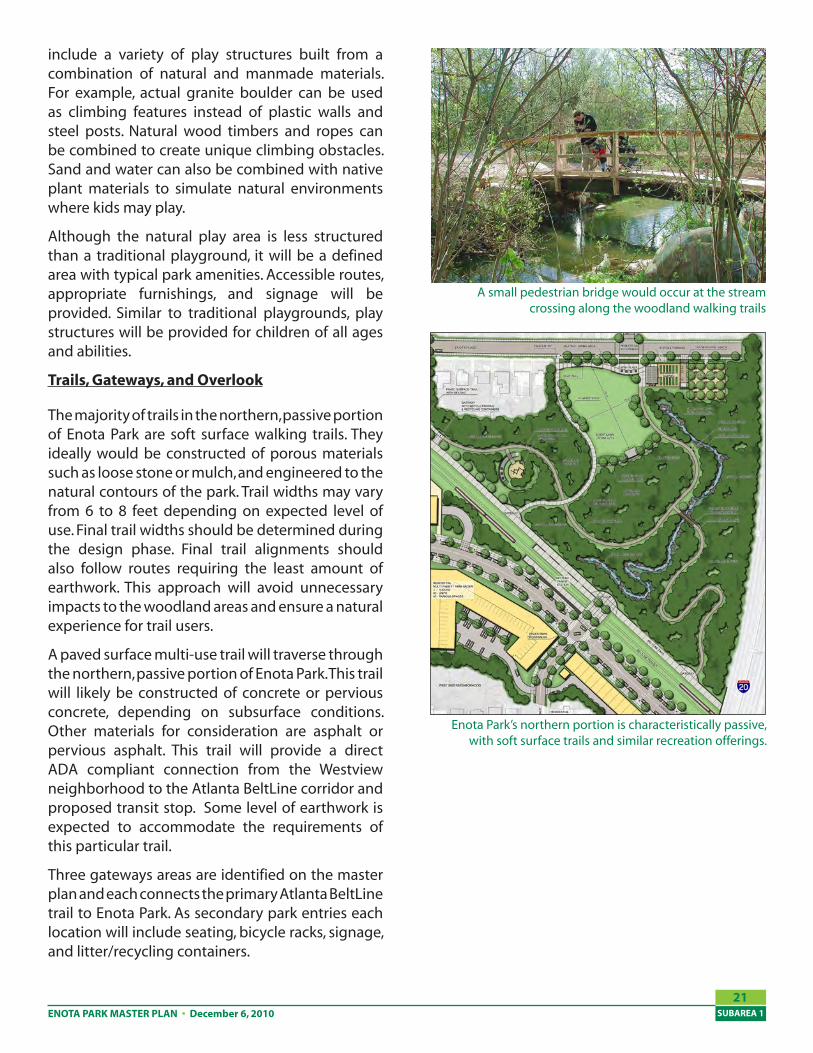
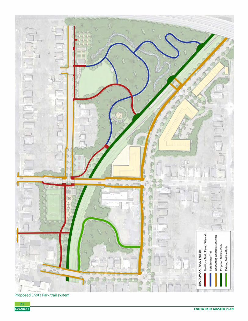
The majority of trails in the northern, passive portion of Enota Park are soft surface walking trails. They ideally would be constructed of porous materials such as loose stone or mulch, and engineered to the natural contours of the park. Trail widths may vary from 6 to 8 feet depending on expected level of use. Final trail widths should be determined during the design phase. Final trail alignments should also follow routes requiring the least amount of earthwork. This approach will avoid unnecessary impacts to the woodland areas and ensure a natural experience for trail users.
A paved surface multi-use trail will traverse through the northern, passive portion of Enota Park. This trail will likely be constructed of concrete or pervious concrete, depending on subsurface conditions. Other materials for consideration are asphalt or pervious asphalt. This trail will provide a direct ADA compliant connection from the Westview neighborhood to the Atlanta BeltLine corridor and proposed transit stop. Some level of earthwork is expected to accommodate the requirements of this particular trail.
Three gateways areas are identified on the master plan and each connects the primary Atlanta BeltLine trail to Enota Park. As secondary park entries each location will include seating, bicycle racks, signage, and litter/recycling containers.
Enota Park’s northern portion is characteristically passive, with soft surface trails and similar recreation offerings.
A small pedestrian bridge would occur at the stream crossing along the woodland walking trails
ENOTA PARK MASTER PLANSUBAREA 1
22
Proposed Enota Park trail system
ENOTA PARK MASTER PLAN • December 6, 2010 SUBAREA 1
2�
Near the proposed Atlanta BeltLine transit station an overlook area has been provided. At this particular location, the natural topography allows for long distance views into the park. Seating and litter/recycling containers will be provided at the overlook.
Woodland Restoration
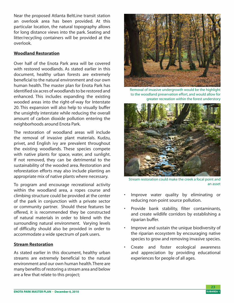
Over half of the Enota Park area will be covered with restored woodlands. As stated earlier in this document, healthy urban forests are extremely beneficial to the natural environment and our own human health. The master plan for Enota Park has identified six acres of woodlands to be restored and enhanced. This includes expanding the existing wooded areas into the right-of-way for Interstate 20. This expansion will also help to visually buffer the unsightly interstate while reducing the overall amount of carbon dioxide pollution entering the neighborhoods around Enota Park.
The restoration of woodland areas will include the removal of invasive plant materials. Kudzu, privet, and English ivy are prevalent throughout the existing woodlands. These species compete with native plants for space, water, and sunlight. If not removed, they can be detrimental to the sustainability of the wooded area. Restoration and reforestation efforts may also include planting an appropriate mix of native plants where necessary.
To program and encourage recreational activity within the woodland area, a ropes course and climbing structure could be provided at the center of the park in conjunction with a private sector or community partner. Should these features be offered, it is recommended they be constructed of natural materials in order to blend with the surrounding natural environment. Varying levels of difficulty should also be provided in order to accommodate a wide spectrum of park users.
Stream Restoration
As stated earlier in this document, healthy urban streams are extremely beneficial to the natural environment and our own human health. There are many benefits of restoring a stream area and below are a few that relate to this project;
Improve water quality by eliminating or reducing non-point source pollution.
Provide bank stability, filter contaminants, and create wildlife corridors by establishing a riparian buffer.
Improve and sustain the unique biodiversity of the riparian ecosystem by encouraging native species to grow and removing invasive species.
Create and foster ecological awareness and appreciation by providing educational experiences for people of all ages.
•
•
•
•
Stream restoration could make the creek a focal point and an asset
Removal of invasive undergrowth would be the highlight to the woodland preservation effort, and would allow for
greater recreation within the forest understory
ENOTA PARK MASTER PLANSUBAREA 1
2�
Active Recreation Areas
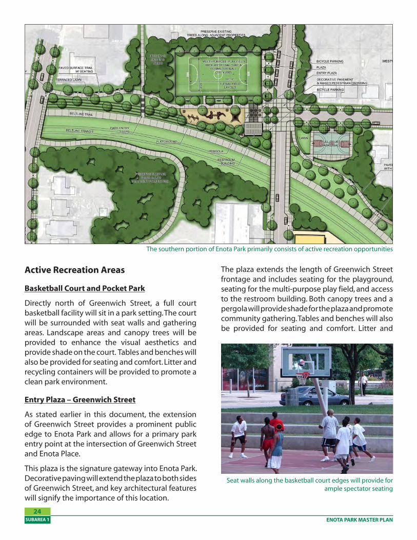
Basketball Court and Pocket Park
Directly north of Greenwich Street, a full court basketball facility will sit in a park setting. The court will be surrounded with seat walls and gathering areas. Landscape areas and canopy trees will be provided to enhance the visual aesthetics and provide shade on the court. Tables and benches will also be provided for seating and comfort. Litter and recycling containers will be provided to promote a clean park environment.
Entry Plaza – Greenwich Street
As stated earlier in this document, the extension of Greenwich Street provides a prominent public edge to Enota Park and allows for a primary park entry point at the intersection of Greenwich Street and Enota Place.
This plaza is the signature gateway into Enota Park. Decorative paving will extend the plaza to both sides of Greenwich Street, and key architectural features will signify the importance of this location.
The southern portion of Enota Park has a number of compo-nents can be characterized as active recreation.
The plaza extends the length of Greenwich Street frontage and includes seating for the playground, seating for the multi-purpose play field, and access to the restroom building. Both canopy trees and a pergola will provide shade for the plaza and promote community gathering. Tables and benches will also be provided for seating and comfort. Litter and
Seat walls along the basketball court edges will provide for ample spectator seating
The southern portion of Enota Park primarily consists of active recreation opportunities
ENOTA PARK MASTER PLAN • December 6, 2010 SUBAREA 1
2�
recycling containers will be provided to promote a clean park environment. Bicycle parking will be provided in this location and throughout to park to promote alternative modes of transportation.
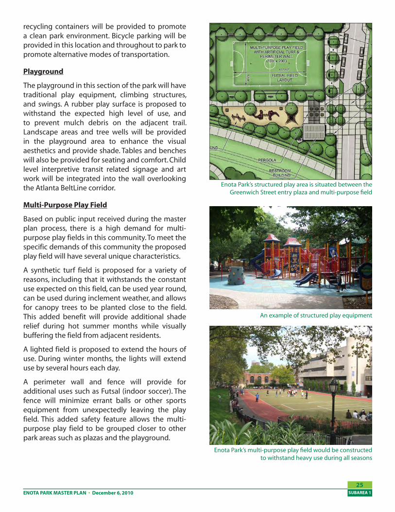
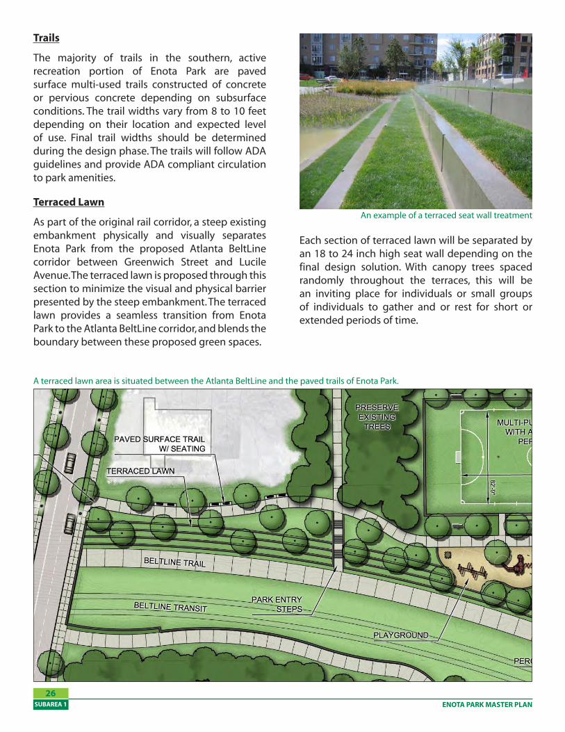
Playground
The playground in this section of the park will have traditional play equipment, climbing structures, and swings. A rubber play surface is proposed to withstand the expected high level of use, and to prevent mulch debris on the adjacent trail. Landscape areas and tree wells will be provided in the playground area to enhance the visual aesthetics and provide shade. Tables and benches will also be provided for seating and comfort. Child level interpretive transit related signage and art work will be integrated into the wall overlooking the Atlanta BeltLine corridor.
Multi-Purpose Play Field
Based on public input received during the master plan process, there is a high demand for multi-purpose play fields in this community. To meet the specific demands of this community the proposed play field will have several unique characteristics.
A synthetic turf field is proposed for a variety of reasons, including that it withstands the constant use expected on this field, can be used year round, can be used during inclement weather, and allows for canopy trees to be planted close to the field. This added benefit will provide additional shade relief during hot summer months while visually buffering the field from adjacent residents.
A lighted field is proposed to extend the hours of use. During winter months, the lights will extend use by several hours each day.
A perimeter wall and fence will provide for additional uses such as Futsal (indoor soccer). The fence will minimize errant balls or other sports equipment from unexpectedly leaving the play field. This added safety feature allows the multi-purpose play field to be grouped closer to other park areas such as plazas and the playground.
Enota Park’s structured play area is situated between the Greenwich Street entry plaza and multi-purpose field
An example of structured play equipment
Enota Park’s multi-purpose play field would be constructed to withstand heavy use during all seasons
ENOTA PARK MASTER PLANSUBAREA 1
26
Trails
The majority of trails in the southern, active recreation portion of Enota Park are paved surface multi-used trails constructed of concrete or pervious concrete depending on subsurface conditions. The trail widths vary from 8 to 10 feet depending on their location and expected level of use. Final trail widths should be determined during the design phase. The trails will follow ADA guidelines and provide ADA compliant circulation to park amenities.
Terraced Lawn
As part of the original rail corridor, a steep existing embankment physically and visually separates Enota Park from the proposed Atlanta BeltLine corridor between Greenwich Street and Lucile Avenue. The terraced lawn is proposed through this section to minimize the visual and physical barrier presented by the steep embankment. The terraced lawn provides a seamless transition from Enota Park to the Atlanta BeltLine corridor, and blends the boundary between these proposed green spaces.
Each section of terraced lawn will be separated by an 18 to 24 inch high seat wall depending on the final design solution. With canopy trees spaced randomly throughout the terraces, this will be an inviting place for individuals or small groups of individuals to gather and or rest for short or extended periods of time.
An example of a terraced seat wall treatment
A terraced lawn area is situated between the Atlanta BeltLine and the paved trails of Enota Park.
ENOTA PARK MASTER PLAN • December 6, 2010 SUBAREA 1
27
ImplementationConstruction Phasing
The Master Plan described here is a vision for creating an Enota Park that will serve the needs of current and future users, both from the local community and from Atlanta as a whole as the BeltLine begins to reconnect the city. Given that full implementation of the Master Plan will take time to achieve, overall improvements have been phased according to individual park areas.
Prior to the start of the three construction phases identified, an acquisition phase will ensue that will establish the expanded park boundary.
A more detailed cost estimate, as well as individual graphics illustrating each construction phase, can be found on the pages that follow.
Trails $282,090.00
Woodland Preservation $156,500.00
Stream Cleanup $50,000.00
Phase One Subtotal $360,425.00
Contingency (20%) $72,085.00
Design and Engineering (7.5%) $27,031.88
Phase One Total $��9,��1.��
Cost Summary: Phase One
Cost Summary: Phase Two
Stream Restoration $202,500.00
Event Lawn $223,425.00
Entry Plaza - Enota Place $206,920.00
Community Garden $398,097.00
Natural Play Area $148,405.00
Basketball Court & Pocket Park $257,717.50
Entry Plaza - Greenwich Street $413,120.00
Multi-purpose Play Field $480,305.00
Trails $264,115.00
Playground $293,650.00
Terraced Lawn $282,330.00
Phase Two Subtotal $3,170,584.50
Contingency (20%) $634,116.90
Design and Engineering (7.5%) $237,793.84
Phase Two Total $�,0�2,�9�.2�
Phase One $459,541.88
Phase Two $4,042,495.24
Enota Park Total $�,�02,0�7.11
Cost Summary: Total
ENOTA PARK MASTER PLANSUBAREA 1
2�
Phase Two
In the park’s second phase, all remaining recreational facilities would be constructed, and the stream would be fully restored. Implementation includes the event lawn, community garden and picnic grove, both playgrounds, the basketball court, and the multi-purpose play field. Further neighborhood linkages would also be created with new pedestrian entry points at Lucille Avenue and Altoona Place, and with the Greenwich Street and Enota Place entry plazas.
Phase Three
The third and final phase in the realization of Enota Park’s Master Plan would install all supporting transportation and infrastructure on neighboring streets. However, because implementation of these improvements may be further off, this phase should be considered separately from all proposed park improvements. During this phase, Greenwich Street would be extended and Langhorn Street would receive its road diet. Pedestrian facilities would also be installed along both of these streets, as well as Enota Place and Lucille Avenue.
Construction Phase Two includes all remaining park facilities.
Phase Three would highlight all transportation and infrastructure improvements within the immediate vicinity.
The first phase of construction in Enota Park’s Master Plan
Phase One
As the first construction phase in Enota Park’s master plan, this work would create a solid foundation on which to build the more intensive park facilities seen in the second phase. Stream cleanup and woodland preservation are the primary focus, as both natural assets are remediated for recreational enjoyment. Much of this work could be completed with the help of community volunteer groups. Within the forest understory, a soft surface trail loop would be constructed and would connect Enota Place at the west to the Atlanta BeltLine corridor to the east. Upon completion, a pedestrian bridge would span the remediated stream channel.
ENOTA PARK MASTER PLAN • December 6, 2010 SUBAREA 1
29
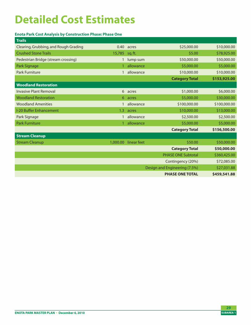
Detailed Cost Estimates
Trails
Clearing, Grubbing, and Rough Grading 0.40 acres $25,000.00 $10,000.00
Crushed Stone Trails 15,785 sq. ft. $5.00 $78,925.00
Pedestrian Bridge (stream crossing) 1 lump sum $50,000.00 $50,000.00
Park Signage 1 allowance $5,000.00 $5,000.00
Park Furniture 1 allowance $10,000.00 $10,000.00
Category Total $1��,92�.00
Woodland Restoration
Invasive Plant Removal 6 acres $1,000.00 $6,000.00
Woodland Restoration 6 acres $5,000.00 $30,000.00
Woodland Amenities 1 allowance $100,000.00 $100,000.00
I-20 Buffer Enhancement 1.3 acres $10,000.00 $13,000.00
Park Signage 1 allowance $2,500.00 $2,500.00
Park Furniture 1 allowance $5,000.00 $5,000.00
Category Total $1�6,�00.00
Stream Cleanup
Stream Cleanup 1,000.00 linear feet $50.00 $50,000.00
Category Total $�0,000.00
PHASE ONE Subtotal $360,425.00
Contingency (20%) $72,085.00
Design and Engineering (7.5%) $27,031.88
PHASE ONE TOTAL $��9,��1.��
Enota Park Cost Analysis by Construction Phase: Phase One
ENOTA PARK MASTER PLANSUBAREA 1
�0
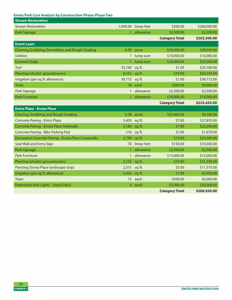
Stream Restoration
Stream Restoration 1,000.00 linear feet $200.00 $200,000.00
Park Signage 1 allowance $2,500.00 $2,500.00
Category Total $202,�00.00
Event Lawn
Clearing, Grubbing, Demolition, and Rough Grading 0.95 acres $30,000.00 $28,500.00
Utilities 1 lump sum $10,000.00 $10,000.00
Covered Stage 1 lump sum $25,000.00 $25,000.00
Turf 33,160 sq. ft. $1.00 $33,160.00
Planting (shrubs/ groundcovers) 6,555 sq. ft. $10.00 $65,550.00
Irrigation (per sq. ft. allowance) 39,715 sq. ft. $1.00 $39,715.00
Trees 18 each $500.00 $9,000.00
Park Signage 1 allowance $2,500.00 $2,500.00
Park Furniture 1 allowance $10,000.00 $10,000.00
Category Total $22�,�2�.00
Entra Plaza - Enota Place
Clearing, Grubbing, and Rough Grading 0.38 acres $25,000.00 $9,500.00
Concrete Paving - Entry Plaza 5,405 sq. ft. $7.00 $37,835.00
Concrete Paving - Enota Place Sidewalks 3,180 sq. ft. $7.00 $22,260.00
Concrete Paving - Bike Parking Pad 210 sq. ft. $7.00 $1,470.00
Decorative Concrete Paving - Enota Place Crosswalks 2,790 sq. ft. $12.00 $33,480.00
Seat Wall and Entry Sign 70 linear feet $150.00 $10,500.00
Park Signage 1 allowance $2,500.00 $2,500.00
Park Furniture 1 allowance $15,000.00 $15,000.00
Planting (shrubs/ groundcovers) 3,135 sq. ft. $10.00 $31,350.00
Planting (Enota Place landscape strip) 2,315 sq. ft. $5.00 $11,575.00
Irrigation (per sq. ft. allowance) 5,450 sq. ft. $1.00 $5,450.00
Trees 12 each $500.00 $6,000.00
Pedestrian Pole Lights - Enota Place 4 each $5,000.00 $20,000.00
Category Total $206,920.00
Enota Park Cost Analysis by Construction Phase: Phase Two
ENOTA PARK MASTER PLAN • December 6, 2010 SUBAREA 1
�1
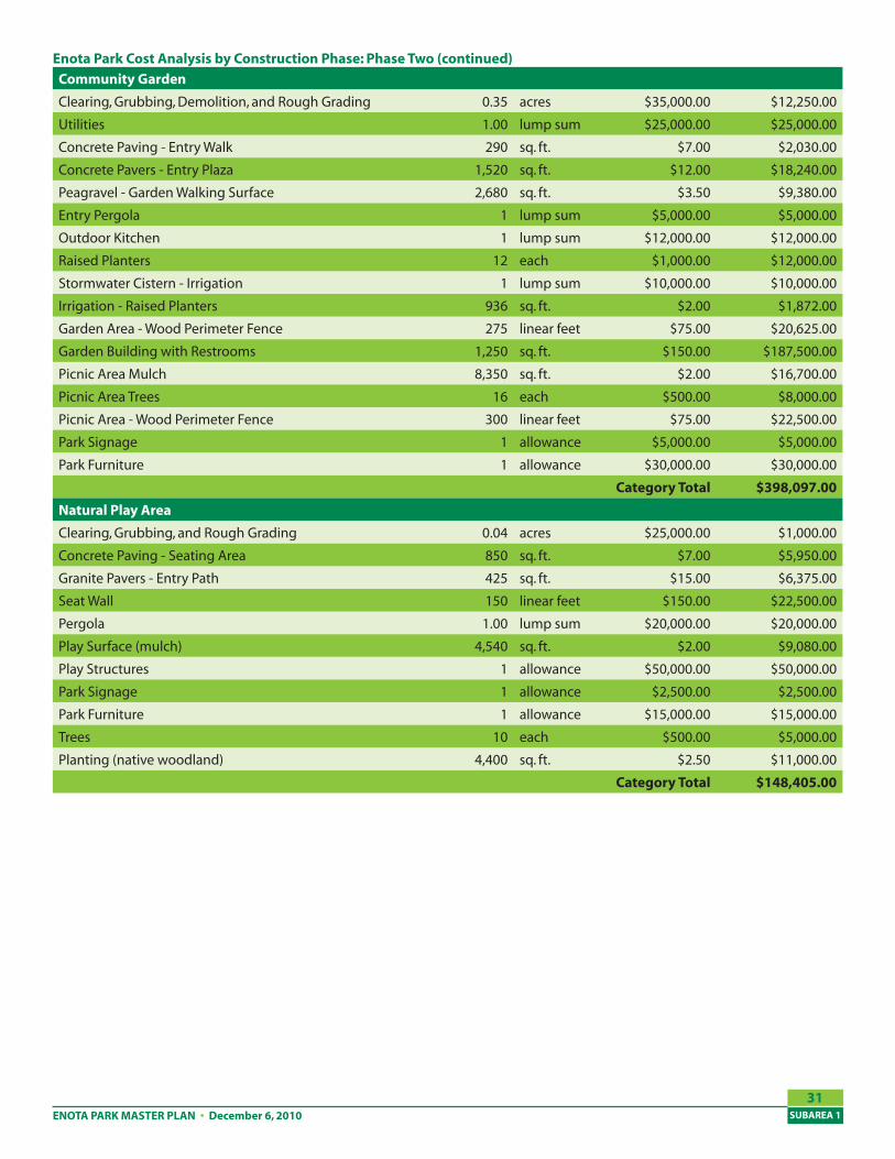
Community Garden
Clearing, Grubbing, Demolition, and Rough Grading 0.35 acres $35,000.00 $12,250.00
Utilities 1.00 lump sum $25,000.00 $25,000.00
Concrete Paving - Entry Walk 290 sq. ft. $7.00 $2,030.00
Concrete Pavers - Entry Plaza 1,520 sq. ft. $12.00 $18,240.00
Peagravel - Garden Walking Surface 2,680 sq. ft. $3.50 $9,380.00
Entry Pergola 1 lump sum $5,000.00 $5,000.00
Outdoor Kitchen 1 lump sum $12,000.00 $12,000.00
Raised Planters 12 each $1,000.00 $12,000.00
Stormwater Cistern - Irrigation 1 lump sum $10,000.00 $10,000.00
Irrigation - Raised Planters 936 sq. ft. $2.00 $1,872.00
Garden Area - Wood Perimeter Fence 275 linear feet $75.00 $20,625.00
Garden Building with Restrooms 1,250 sq. ft. $150.00 $187,500.00
Picnic Area Mulch 8,350 sq. ft. $2.00 $16,700.00
Picnic Area Trees 16 each $500.00 $8,000.00
Picnic Area - Wood Perimeter Fence 300 linear feet $75.00 $22,500.00
Park Signage 1 allowance $5,000.00 $5,000.00
Park Furniture 1 allowance $30,000.00 $30,000.00
Category Total $�9�,097.00
Natural Play Area
Clearing, Grubbing, and Rough Grading 0.04 acres $25,000.00 $1,000.00
Concrete Paving - Seating Area 850 sq. ft. $7.00 $5,950.00
Granite Pavers - Entry Path 425 sq. ft. $15.00 $6,375.00
Seat Wall 150 linear feet $150.00 $22,500.00
Pergola 1.00 lump sum $20,000.00 $20,000.00
Play Surface (mulch) 4,540 sq. ft. $2.00 $9,080.00
Play Structures 1 allowance $50,000.00 $50,000.00
Park Signage 1 allowance $2,500.00 $2,500.00
Park Furniture 1 allowance $15,000.00 $15,000.00
Trees 10 each $500.00 $5,000.00
Planting (native woodland) 4,400 sq. ft. $2.50 $11,000.00
Category Total $1��,�0�.00
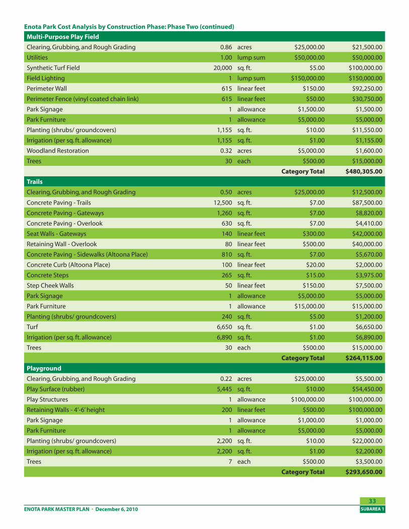
Enota Park Cost Analysis by Construction Phase: Phase Two (continued)
ENOTA PARK MASTER PLANSUBAREA 1
�2
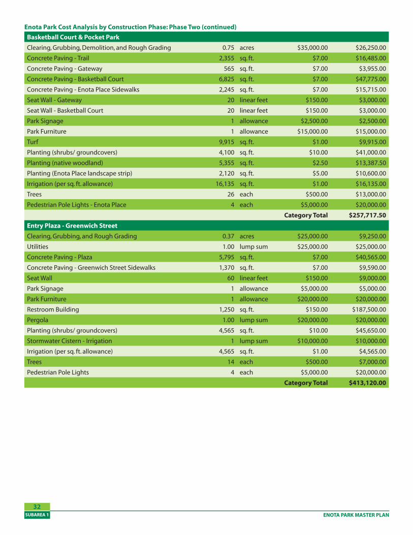
Basketball Court & Pocket Park
Clearing, Grubbing, Demolition, and Rough Grading 0.75 acres $35,000.00 $26,250.00
Concrete Paving - Trail 2,355 sq. ft. $7.00 $16,485.00
Concrete Paving - Gateway 565 sq. ft. $7.00 $3,955.00
Concrete Paving - Basketball Court 6,825 sq. ft. $7.00 $47,775.00
Concrete Paving - Enota Place Sidewalks 2,245 sq. ft. $7.00 $15,715.00
Seat Wall - Gateway 20 linear feet $150.00 $3,000.00
Seat Wall - Basketball Court 20 linear feet $150.00 $3,000.00
Park Signage 1 allowance $2,500.00 $2,500.00
Park Furniture 1 allowance $15,000.00 $15,000.00
Turf 9,915 sq. ft. $1.00 $9,915.00
Planting (shrubs/ groundcovers) 4,100 sq. ft. $10.00 $41,000.00
Planting (native woodland) 5,355 sq. ft. $2.50 $13,387.50
Planting (Enota Place landscape strip) 2,120 sq. ft. $5.00 $10,600.00
Irrigation (per sq. ft. allowance) 16,135 sq. ft. $1.00 $16,135.00
Trees 26 each $500.00 $13,000.00
Pedestrian Pole Lights - Enota Place 4 each $5,000.00 $20,000.00
Category Total $2�7,717.�0
Entry Plaza - Greenwich Street
Clearing, Grubbing, and Rough Grading 0.37 acres $25,000.00 $9,250.00
Utilities 1.00 lump sum $25,000.00 $25,000.00
Concrete Paving - Plaza 5,795 sq. ft. $7.00 $40,565.00
Concrete Paving - Greenwich Street Sidewalks 1,370 sq. ft. $7.00 $9,590.00
Seat Wall 60 linear feet $150.00 $9,000.00
Park Signage 1 allowance $5,000.00 $5,000.00
Park Furniture 1 allowance $20,000.00 $20,000.00
Restroom Building 1,250 sq. ft. $150.00 $187,500.00
Pergola 1.00 lump sum $20,000.00 $20,000.00
Planting (shrubs/ groundcovers) 4,565 sq. ft. $10.00 $45,650.00
Stormwater Cistern - Irrigation 1 lump sum $10,000.00 $10,000.00
Irrigation (per sq. ft. allowance) 4,565 sq. ft. $1.00 $4,565.00
Trees 14 each $500.00 $7,000.00
Pedestrian Pole Lights 4 each $5,000.00 $20,000.00
Category Total $�1�,120.00
Enota Park Cost Analysis by Construction Phase: Phase Two (continued)
ENOTA PARK MASTER PLAN • December 6, 2010 SUBAREA 1
��
Multi-Purpose Play Field
Clearing, Grubbing, and Rough Grading 0.86 acres $25,000.00 $21,500.00
Utilities 1.00 lump sum $50,000.00 $50,000.00
Synthetic Turf Field 20,000 sq. ft. $5.00 $100,000.00
Field Lighting 1 lump sum $150,000.00 $150,000.00
Perimeter Wall 615 linear feet $150.00 $92,250.00
Perimeter Fence (vinyl coated chain link) 615 linear feet $50.00 $30,750.00
Park Signage 1 allowance $1,500.00 $1,500.00
Park Furniture 1 allowance $5,000.00 $5,000.00
Planting (shrubs/ groundcovers) 1,155 sq. ft. $10.00 $11,550.00
Irrigation (per sq. ft. allowance) 1,155 sq. ft. $1.00 $1,155.00
Woodland Restoration 0.32 acres $5,000.00 $1,600.00
Trees 30 each $500.00 $15,000.00
Category Total $��0,�0�.00
Trails
Clearing, Grubbing, and Rough Grading 0.50 acres $25,000.00 $12,500.00
Concrete Paving - Trails 12,500 sq. ft. $7.00 $87,500.00
Concrete Paving - Gateways 1,260 sq. ft. $7.00 $8,820.00
Concrete Paving - Overlook 630 sq. ft. $7.00 $4,410.00
Seat Walls - Gateways 140 linear feet $300.00 $42,000.00
Retaining Wall - Overlook 80 linear feet $500.00 $40,000.00
Concrete Paving - Sidewalks (Altoona Place) 810 sq. ft. $7.00 $5,670.00
Concrete Curb (Altoona Place) 100 linear feet $20.00 $2,000.00
Concrete Steps 265 sq. ft. $15.00 $3,975.00
Step Cheek Walls 50 linear feet $150.00 $7,500.00
Park Signage 1 allowance $5,000.00 $5,000.00
Park Furniture 1 allowance $15,000.00 $15,000.00
Planting (shrubs/ groundcovers) 240 sq. ft. $5.00 $1,200.00
Turf 6,650 sq. ft. $1.00 $6,650.00
Irrigation (per sq. ft. allowance) 6,890 sq. ft. $1.00 $6,890.00
Trees 30 each $500.00 $15,000.00
Category Total $26�,11�.00
Playground
Clearing, Grubbing, and Rough Grading 0.22 acres $25,000.00 $5,500.00
Play Surface (rubber) 5,445 sq. ft. $10.00 $54,450.00
Play Structures 1 allowance $100,000.00 $100,000.00
Retaining Walls - 4’-6’ height 200 linear feet $500.00 $100,000.00
Park Signage 1 allowance $1,000.00 $1,000.00
Park Furniture 1 allowance $5,000.00 $5,000.00
Planting (shrubs/ groundcovers) 2,200 sq. ft. $10.00 $22,000.00
Irrigation (per sq. ft. allowance) 2,200 sq. ft. $1.00 $2,200.00
Trees 7 each $500.00 $3,500.00
Category Total $29�,6�0.00
Enota Park Cost Analysis by Construction Phase: Phase Two (continued)
ENOTA PARK MASTER PLANSUBAREA 1
��
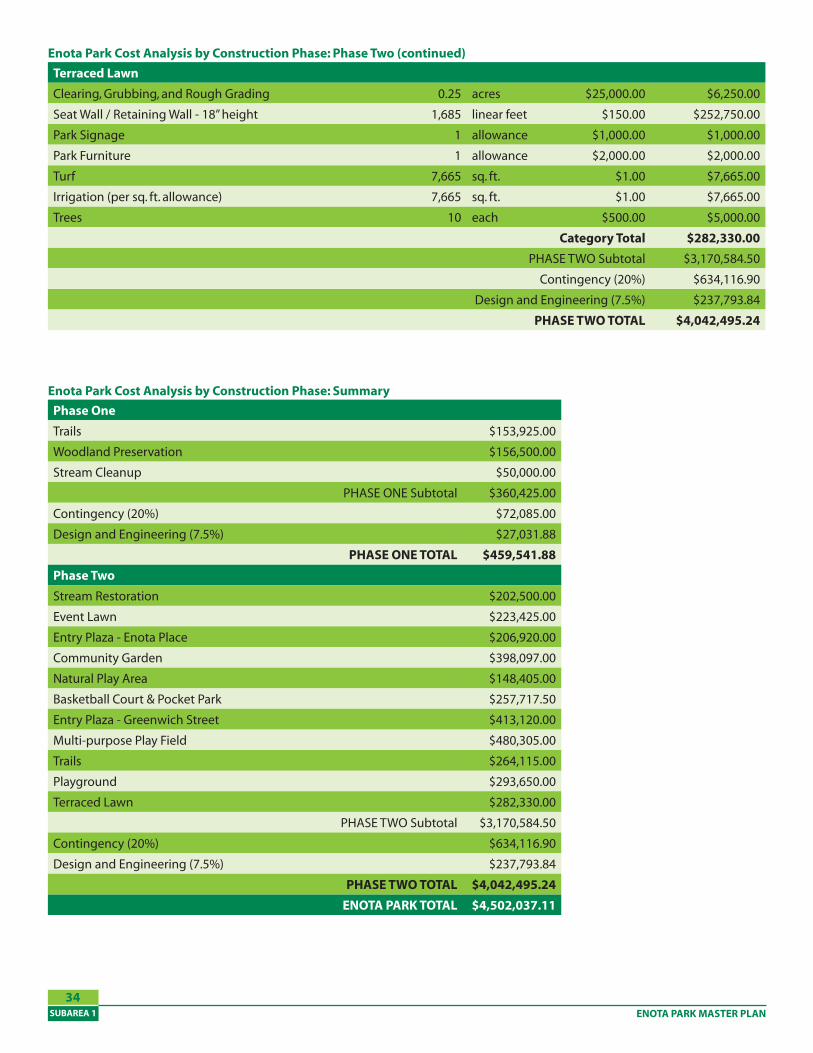
Terraced Lawn
Clearing, Grubbing, and Rough Grading 0.25 acres $25,000.00 $6,250.00
Seat Wall / Retaining Wall - 18” height 1,685 linear feet $150.00 $252,750.00
Park Signage 1 allowance $1,000.00 $1,000.00
Park Furniture 1 allowance $2,000.00 $2,000.00
Turf 7,665 sq. ft. $1.00 $7,665.00
Irrigation (per sq. ft. allowance) 7,665 sq. ft. $1.00 $7,665.00
Trees 10 each $500.00 $5,000.00
Category Total $2�2,��0.00
PHASE TWO Subtotal $3,170,584.50
Contingency (20%) $634,116.90
Design and Engineering (7.5%) $237,793.84
PHASE TWO TOTAL $�,0�2,�9�.2�
Enota Park Cost Analysis by Construction Phase: Phase Two (continued)
Enota Park Cost Analysis by Construction Phase: Summary
Phase One
Trails $153,925.00
Woodland Preservation $156,500.00
Stream Cleanup $50,000.00
PHASE ONE Subtotal $360,425.00
Contingency (20%) $72,085.00
Design and Engineering (7.5%) $27,031.88
PHASE ONE TOTAL $��9,��1.��
Phase Two
Stream Restoration $202,500.00
Event Lawn $223,425.00
Entry Plaza - Enota Place $206,920.00
Community Garden $398,097.00
Natural Play Area $148,405.00
Basketball Court & Pocket Park $257,717.50
Entry Plaza - Greenwich Street $413,120.00
Multi-purpose Play Field $480,305.00
Trails $264,115.00
Playground $293,650.00
Terraced Lawn $282,330.00
PHASE TWO Subtotal $3,170,584.50
Contingency (20%) $634,116.90
Design and Engineering (7.5%) $237,793.84
PHASE TWO TOTAL $�,0�2,�9�.2�
ENOTA PARK TOTAL $�,�02,0�7.11
Related Documents