Amendment GC28 Donnybrook / Woodstock PSP Expert Evidence – Traffic and Transport CG140549 Prepared for Norton Rose Fulbright on behalf of Mirvac (Victoria) Pty Ltd 9 May 2016 Amendment GC28 Donnybrook / Woodstock PSP Expert Evidence – Traffic and Transport CG140549

Welcome message from author
This document is posted to help you gain knowledge. Please leave a comment to let me know what you think about it! Share it to your friends and learn new things together.
Transcript
Amendment GC28 Donnybrook / Woodstock PSP
Expert Evidence – Traffic and Transport CG140549
Prepared for Norton Rose Fulbright on behalf of Mirvac (Victoria) Pty Ltd 9 May 2016
Amendment GC28 Donnybrook / Woodstock PSP
Expert Evidence – Traffic and Transport CG140549
Amendment GC28 Donnybrook / Woodstock PSP
Expert Evidence – Traffic and Transport
9 May 2016 Cardno ii
Document Information
Prepared for Norton Rose Fulbright on behalf of Mirvac (Victoria) Pty Ltd
Project Name Expert Evidence – Traffic and Transport
File Reference CG140549_PAN001F01.docx
Job Reference CG140549
Date 9 May 2016
Contact Information
Cardno Victoria Pty Ltd Trading as Cardno ABN 47 106 610 913 Level 4 501 Swanston Street Melbourne Victoria 3000 Australia Telephone: (03) 8415 7777 Facsimile: (03) 8415 7788 International: +61 3 8415 7777 [email protected] www.cardno.com
© Cardno. Copyright in the whole and every part of this document belongs to Cardno and may not be used, sold, transferred, copied or reproduced in whole or in part in any manner or form or in or on any media to any person other than by agreement with Cardno.
This document is produced by Cardno solely for the benefit and use by the client in accordance with the terms of the engagement. Cardno does not and shall not assume any responsibility or liability whatsoever to any third party arising out of any use or reliance by any third party on the content of this document.
Amendment GC28 Donnybrook / Woodstock PSP
Expert Evidence – Traffic and Transport
9 May 2016 Cardno iii
Table of Contents
1 Qualifications and Expertise 1
2 Introduction 3
3 Background 4 3.1 Locality 4 3.2 Surrounding PSP Areas 5 3.3 Road Network 5
3.3.1 Donnybrook Road 5 3.3.2 Merriang Road 6 3.3.3 Outer Metropolitan Ring / E6 Transport Corridor 6
4 Donnybrook / Woodstock PSP 7 4.1 Amendment GC28 7 4.2 Overview 7 4.3 Street Network 8 4.4 Public Transport and Shared Path Network 10 4.5 PSP Traffic Modelling (GTA) 10 4.6 PSP Road Network Infrastructure 12
5 PSP Road and Intersection Design 13 5.1 Internal PSP Intersections 13 5.2 Donnybrook Road Intersections 14 5.3 PSP Road Reserve Boundaries 16
6 Gunns Gully Road Alignment 18
7 Cameron Street Classification 19
8 North-South Connector Road Classification 20
9 Conclusions 21
Appendices
Appendix A PSP TRAFFIC MODELLING SCENARIOS
Appendix B Patterson Drive / donnybrook Road Interim ICP Intersection Comparison
Appendix C Patterson Drive / donnybrook Road Interim Intersection – Pre-Interim Layout
Appendix D Alternate Gunns Gully Road Alignment (CG140549-TR-SK02 R3)
Tables
Relevant Traffic Modelling Scenarios – PSP Road Network Daily Volume Summary (cpu) 11
Predicted Daily Traffic Volumes – Cameron Street between Patterson and Koukoura Drives 19
Predicted Daily Traffic Volumes – North-South Connector Street 20
Amendment GC28 Donnybrook / Woodstock PSP
Expert Evidence – Traffic and Transport
9 May 2016 Cardno iv
Figures
Figure 3-1 Locality Plan with Urban Growth Boundary shown 4
Figure 3-2 Zoning Map with E6-OMR Public Acquisition Overlay shown 5
Figure 4-1 Donnybrook / Woodstock PSP – Future Urban Structure 7
Figure 4-2 Donnybrook / Woodstock PSP – Road Network as exhibited 8
Figure 4-3 Amendment GC28 Exhibited PAO 9
Figure 4-4 Donnybrook / Woodstock PSP – Public Transport Network as exhibited 10
Figure 5-1 Donnybrook Road / Patterson Drive ICP Intersection 14
Figure 5-2 Donnybrook Road Intersections IN-01 to IN-03 – Land Budget Area (OMG) 15
Figure 5-3 Donnybrook Road / Patterson Drive Intersection – Recommended Pre-Interim Treatment 16
Figure 5-4 Example PSP Road Network Land Budget Plan (One Mile Grid) 17
Amendment GC28 Donnybrook / Woodstock PSP
Expert Evidence – Traffic and Transport
9 May 2016 Cardno 1
1 Qualifications and Expertise
My name is Stephen John Hunt and I have been retained by Norton Rose Fulbright on behalf of Mirvac (Victoria) Pty Ltd to provide expert evidence at the forthcoming Panel Hearing for Planning Scheme Amendment GC28 to the Whittlesea and Mitchell Planning Schemes.
In accordance with the Guide to Expert Evidence prepared by Planning Panels Victoria, my qualifications and expertise to undertake this work are summarised below:-
Name: Stephen John Hunt
Address: Cardno
Level 4, 501 Swanston Street
Melbourne Vic 3000
Professional Qualifications: Bachelor of Engineering (Civil), 1975, Swinburne University of Technology
Graduate Diploma of Highway and Traffic Engineering, 1981, Chisholm Institute of Technology
Professional Experience: Consultant, Cardno Victoria: 2007 - present
Director, Grogan Richards Pty Ltd: 1988 – 2006
Traffic Engineer with Cities of Doncaster and Templestowe, Caulfield and Prahran: 1975 - 1988
Areas of Expertise: > Car parking and traffic.
> Traffic advice and assessment of land uses and development proposals to planning authorities, government agencies, corporations and developers (including major residential, retail, commercial, industrial, institutional and mixed use projects).
> Preparation and presentation of evidence before VCAT and Planning Panels Victoria.
Expertise to Prepare This Report: My training and experience including involvement with all forms of development over many years qualifies me to comment on the traffic implications of the proposal.
Instructions which Defined the Scope of this Report: I have been requested to address the following matters:
1. The alignment of Gunns Gully Road between Lockerbie and Patterson Drive in relation to the Conservation Zone to the north;
2. The classification of Cameron Street east of Patterson Drive;
3. The standard of interim intersections specified in the Infrastructure Contributions Plan and supporting documents, particularly the standard of interim intersections required along Patterson Drive;
4. The requirement for agreed pre-interim intersections at locations where the interim intersection cannot be constructed until road widening is taken, specifically the intersection of Patterson Drive and Donnybrook Road;
Amendment GC28 Donnybrook / Woodstock PSP
Expert Evidence – Traffic and Transport
9 May 2016 Cardno 2
5. Widening of road reserves on the approach to bridges and culverts to allow for batters in the road reserve, increasing land take requirements; and
6. A submission that the north south connector road west of Patterson Drive be upgraded to an arterial road and included in the ICP.
Facts, Matters And Assumptions Relied Upon: > Donnybrook / Woodstock Precinct Structure Plan (MPA, November 2015)
> Donnybrook – Woodstock Draft Precinct Infrastructure Plan Projects (MPA, November 2015)
> PSP 1067 & 1096, Donnybrook / Woodstock Precinct Structure Plan Background Report (MPA, November 2015)
> Traffic Modelling for PSP 1067 Donnybrook and PSP 1096 Woodstock (GTA Consultants, 11 November 2014)
> Donnybrook & Woodstock PSP Road, Intersection and Culvert / Bridge Design and Costings (One Mile Grid, 26 October 2015)
> PSP 1067 & 1096, Donnybrook / Woodstock Precinct Structure Plan Part A Submission (MPA, April 2016)
> Amendment GC28 documentation as exhibited
> Submissions received on the exhibited documents
Identity of Persons Undertaking the Work: Stephen Hunt assisted by Benjamin Mentha and Aaron Walley of Cardno
‘I have made all the inquiries that I believe are desirable and appropriate and no matters of significance which I regard as relevant have to my knowledge been withheld from the Panel.’
Stephen Hunt
Consultant
for Cardno
Amendment GC28 Donnybrook / Woodstock PSP
Expert Evidence – Traffic and Transport
9 May 2016 Cardno 3
2 Introduction
Mirvac owns the land at 1025 Donnybrook Road, Donnybrook, identified as property No. 20 in the Precinct Structure Plan (PSP). Mirvac also has an interest (as developer under a Joint Venture with Boral Property Group) in several parcels of land owned by Boral, which are identified as property Nos. 7, 8 and 10 in the PSP.
I have been requested to address the following matters:
1. The alignment of Gunns Gully Road between Lockerbie and Patterson Drive in relation to the Conservation Zone to the north;
2. The classification of Cameron Street east of Patterson Drive;
3. The standard of interim intersections specified in the Infrastructure Contributions Plan and supporting documents, particularly the standard of interim intersections required along Patterson Drive;
4. The requirement for agreed pre-interim intersections at locations where the interim intersection cannot be constructed until road widening is taken, specifically the intersection of Patterson Drive and Donnybrook Road;
5. Widening of road reserves on the approach to bridges and culverts to allow for batters in the road reserve, increasing land take requirements; and
6. A submission that the north south connector road west of Patterson Drive be upgraded to an arterial road and included in the ICP.
The following sets out my opinions with respect to these matters.
Amendment GC28 Donnybrook / Woodstock PSP
Expert Evidence – Traffic and Transport
9 May 2016 Cardno 4
3 Background
3.1 Locality
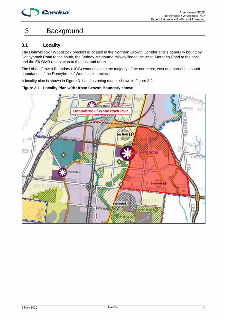
The Donnybrook / Woodstock precinct is located in the Northern Growth Corridor and is generally bound by Donnybrook Road to the south, the Sydney-Melbourne railway line to the west, Merriang Road to the east, and the E6-OMR reservation to the east and north.
The Urban Growth Boundary (UGB) extends along the majority of the northeast, east and part of the south boundaries of the Donnybrook / Woodstock precinct.
A locality plan is shown in Figure 3-1 and a zoning map is shown in Figure 3-2.
Figure 3-1 Locality Plan with Urban Growth Boundary shown
Donnybrook / Woodstock PSP
Amendment GC28 Donnybrook / Woodstock PSP
Expert Evidence – Traffic and Transport
9 May 2016 Cardno 5
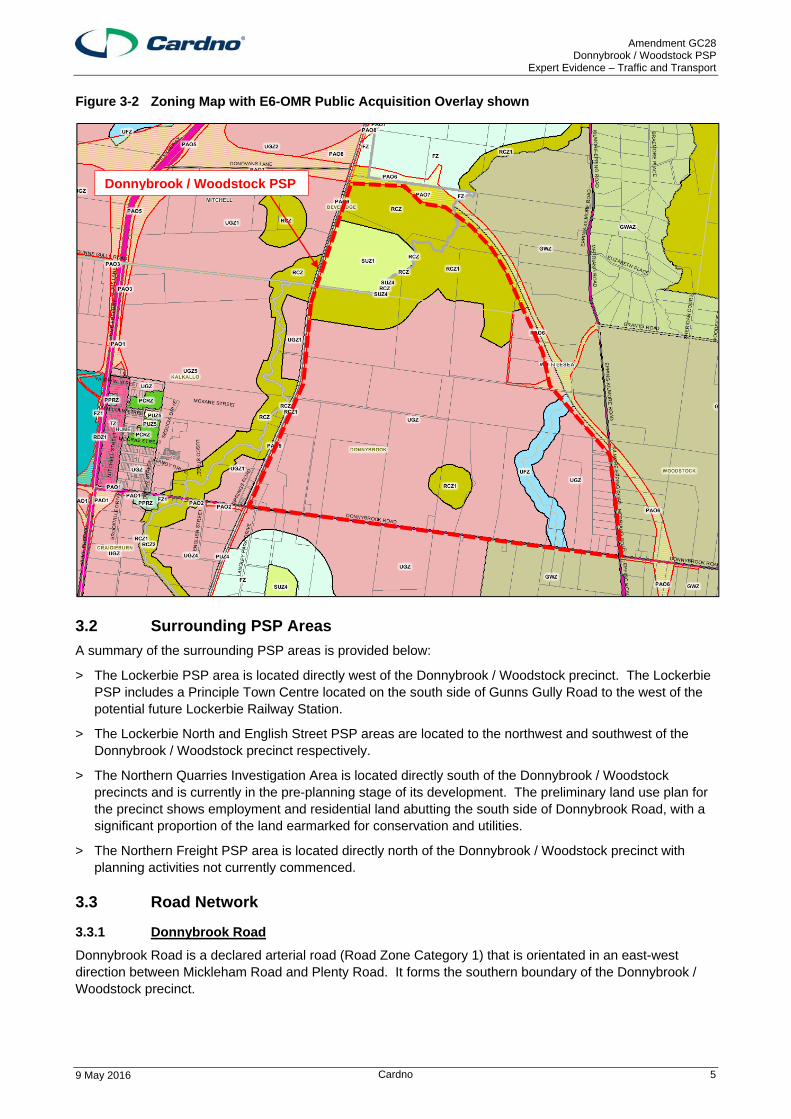
Figure 3-2 Zoning Map with E6-OMR Public Acquisition Overlay shown
3.2 Surrounding PSP Areas
A summary of the surrounding PSP areas is provided below:
> The Lockerbie PSP area is located directly west of the Donnybrook / Woodstock precinct. The Lockerbie PSP includes a Principle Town Centre located on the south side of Gunns Gully Road to the west of the potential future Lockerbie Railway Station.
> The Lockerbie North and English Street PSP areas are located to the northwest and southwest of the Donnybrook / Woodstock precinct respectively.
> The Northern Quarries Investigation Area is located directly south of the Donnybrook / Woodstock precincts and is currently in the pre-planning stage of its development. The preliminary land use plan for the precinct shows employment and residential land abutting the south side of Donnybrook Road, with a significant proportion of the land earmarked for conservation and utilities.
> The Northern Freight PSP area is located directly north of the Donnybrook / Woodstock precinct with planning activities not currently commenced.
3.3 Road Network
3.3.1 Donnybrook Road
Donnybrook Road is a declared arterial road (Road Zone Category 1) that is orientated in an east-west direction between Mickleham Road and Plenty Road. It forms the southern boundary of the Donnybrook / Woodstock precinct.
Donnybrook / Woodstock PSP
Amendment GC28 Donnybrook / Woodstock PSP
Expert Evidence – Traffic and Transport
9 May 2016 Cardno 6
Along the precinct frontage, Donnybrook Road is constructed with an undivided carriageway providing a single traffic lane and shoulder in each direction. Road safety barriers are generally installed along the south side of the road.
3.3.2 Merriang Road
Merriang Road (also known as Epping – Kilmore Road) is a declared arterial road that is orientated in a north-south direction. It forms part of the eastern boundary of the Donnybrook / Woodstock precinct.
Along the precinct frontage, Merriang Road is constructed with an undivided carriageway providing a single traffic lane and shoulder in each direction.
3.3.3 Outer Metropolitan Ring / E6 Transport Corridor
A Public Acquisition Overlay (PAO) for the Outer Metropolitan Ring / E6 Transport Corridor (OMR / E6) bounds the northern and part of the eastern boundaries of the Donnybrook / Woodstock precinct.
The planning for the transport corridor provides options for an ultimate freeway standard road, capable of up to four lanes in each direction and four railway tracks in the median for interstate freight and high-speed passenger trains between Werribee and Kalkallo and capable of ultimately being a six-lane freeway standard road elsewhere.
Amendment GC28 Donnybrook / Woodstock PSP
Expert Evidence – Traffic and Transport
9 May 2016 Cardno 7
4 Donnybrook / Woodstock PSP
4.1 Amendment GC28
Amendment GC28 to the Whittlesea and Mitchell Planning Schemes has been prepared by the Metropolitan Planning Authority (MPA), in consultation with the City of Whittlesea and Shire of Mitchell.
Amendment GC28 proposes to insert and implement the following documents into the Planning Schemes:
▪ Donnybrook / Woodstock Precinct Structure Plan; and ▪ Donnybrook / Woodstock Background Report.
4.2 Overview
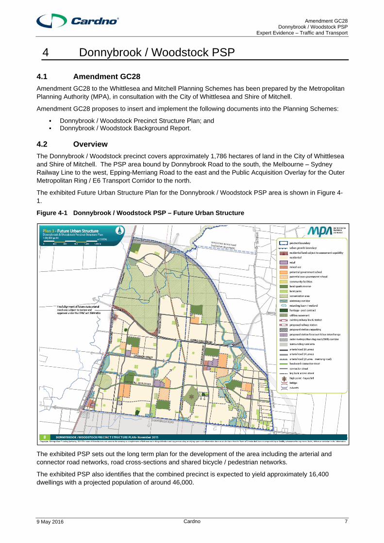
The Donnybrook / Woodstock precinct covers approximately 1,786 hectares of land in the City of Whittlesea and Shire of Mitchell. The PSP area bound by Donnybrook Road to the south, the Melbourne – Sydney Railway Line to the west, Epping-Merriang Road to the east and the Public Acquisition Overlay for the Outer Metropolitan Ring / E6 Transport Corridor to the north.
The exhibited Future Urban Structure Plan for the Donnybrook / Woodstock PSP area is shown in Figure 4-1.
Figure 4-1 Donnybrook / Woodstock PSP – Future Urban Structure
The exhibited PSP sets out the long term plan for the development of the area including the arterial and connector road networks, road cross-sections and shared bicycle / pedestrian networks.
The exhibited PSP also identifies that the combined precinct is expected to yield approximately 16,400 dwellings with a projected population of around 46,000.
Amendment GC28 Donnybrook / Woodstock PSP
Expert Evidence – Traffic and Transport
9 May 2016 Cardno 8
4.3 Street Network
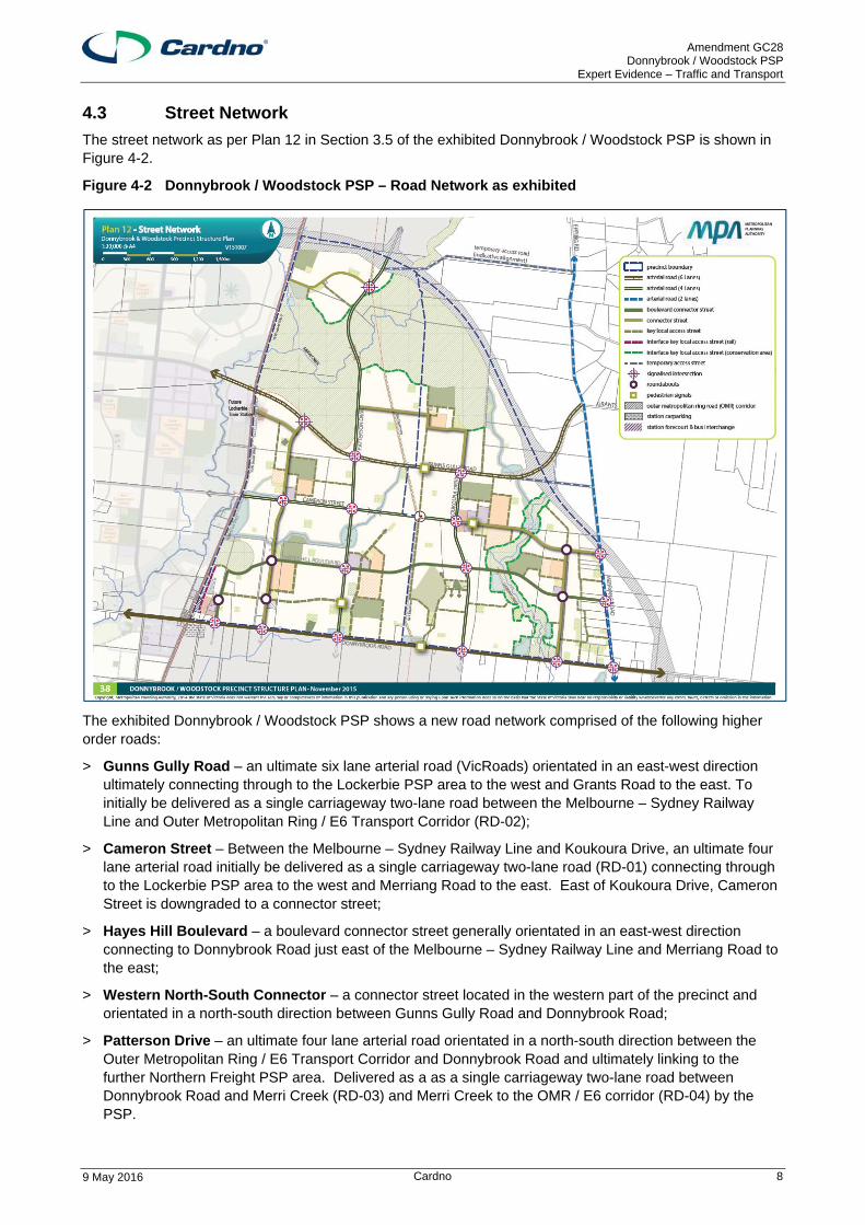
The street network as per Plan 12 in Section 3.5 of the exhibited Donnybrook / Woodstock PSP is shown in Figure 4-2.
Figure 4-2 Donnybrook / Woodstock PSP – Road Network as exhibited
The exhibited Donnybrook / Woodstock PSP shows a new road network comprised of the following higher order roads:
> Gunns Gully Road – an ultimate six lane arterial road (VicRoads) orientated in an east-west direction ultimately connecting through to the Lockerbie PSP area to the west and Grants Road to the east. To initially be delivered as a single carriageway two-lane road between the Melbourne – Sydney Railway Line and Outer Metropolitan Ring / E6 Transport Corridor (RD-02);
> Cameron Street – Between the Melbourne – Sydney Railway Line and Koukoura Drive, an ultimate four lane arterial road initially be delivered as a single carriageway two-lane road (RD-01) connecting through to the Lockerbie PSP area to the west and Merriang Road to the east. East of Koukoura Drive, Cameron Street is downgraded to a connector street;
> Hayes Hill Boulevard – a boulevard connector street generally orientated in an east-west direction connecting to Donnybrook Road just east of the Melbourne – Sydney Railway Line and Merriang Road to the east;
> Western North-South Connector – a connector street located in the western part of the precinct and orientated in a north-south direction between Gunns Gully Road and Donnybrook Road;
> Patterson Drive – an ultimate four lane arterial road orientated in a north-south direction between the Outer Metropolitan Ring / E6 Transport Corridor and Donnybrook Road and ultimately linking to the further Northern Freight PSP area. Delivered as a as a single carriageway two-lane road between Donnybrook Road and Merri Creek (RD-03) and Merri Creek to the OMR / E6 corridor (RD-04) by the PSP.
Amendment GC28 Donnybrook / Woodstock PSP
Expert Evidence – Traffic and Transport
9 May 2016 Cardno 9
> Koukoura Drive – an ultimate four lane arterial road orientated in a north-south direction between Gunns Gully Road and Donnybrook Road, continuing north of Gunns Gully Road as a connector standard road. Between Gunns Gully Road and Donnybrook Road, to initially be delivered as a single carriageway two-lane road (RD-05);
As per Table 10 of the exhibited PSP and the November 2015 draft Donnybrook – Woodstock Draft Precinct Infrastructure Plan Projects document, all sections of the above roads identified as arterial roads include the funding for the purchase of land required for the ultimate road cross section and the development of an initial two-lane two-way carriageway, as ICP funded projects.
Arterial / arterial and arterial / connector intersections, including those with Donnybrook Road and Merriang Road, are shown as controlled (signalised) intersections with land for the ultimate footprint (part only for Donnybrook Road intersections) and delivery of an interim treatment also included as ICP projects within Table 10 of the exhibited PSP and the draft Infrastructure Plan (as IN-01 through IN-16).
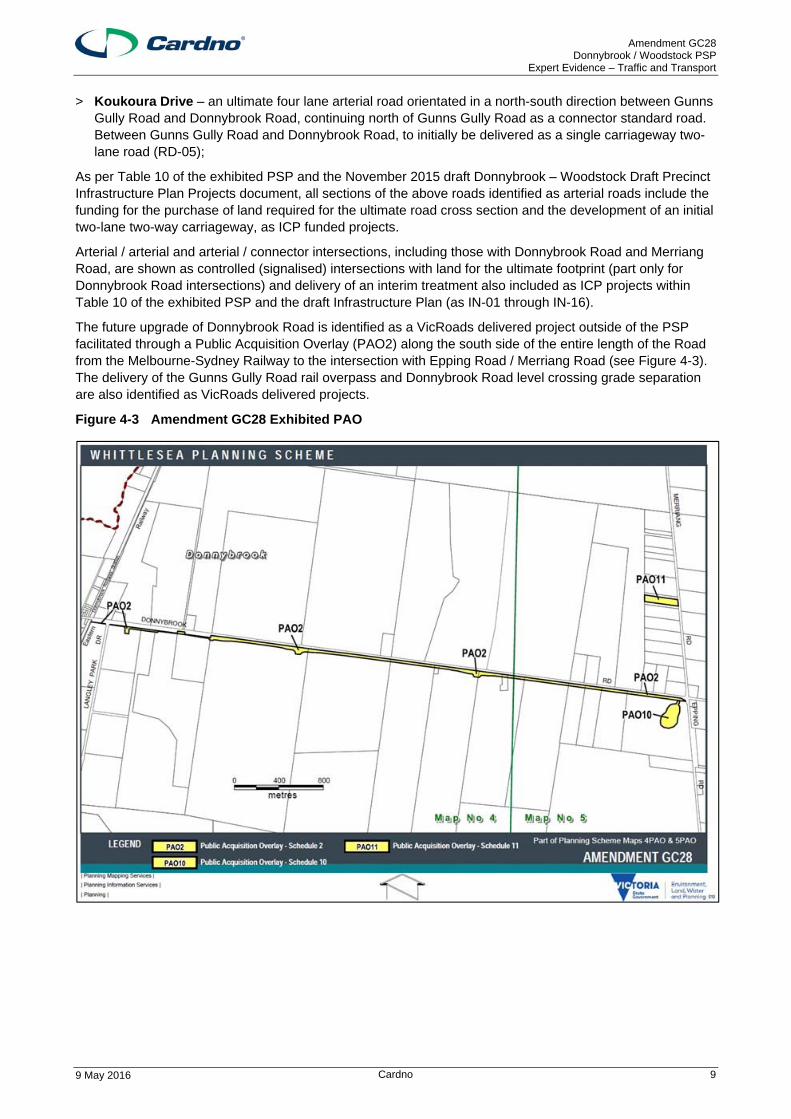
The future upgrade of Donnybrook Road is identified as a VicRoads delivered project outside of the PSP facilitated through a Public Acquisition Overlay (PAO2) along the south side of the entire length of the Road from the Melbourne-Sydney Railway to the intersection with Epping Road / Merriang Road (see Figure 4-3). The delivery of the Gunns Gully Road rail overpass and Donnybrook Road level crossing grade separation are also identified as VicRoads delivered projects.
Figure 4-3 Amendment GC28 Exhibited PAO
Amendment GC28 Donnybrook / Woodstock PSP
Expert Evidence – Traffic and Transport
9 May 2016 Cardno 10
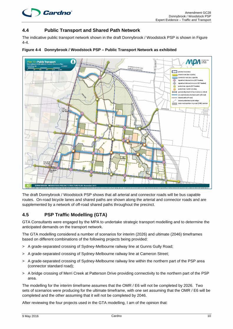
4.4 Public Transport and Shared Path Network
The indicative public transport network shown in the draft Donnybrook / Woodstock PSP is shown in Figure 4-4.
Figure 4-4 Donnybrook / Woodstock PSP – Public Transport Network as exhibited
The draft Donnybrook / Woodstock PSP shows that all arterial and connector roads will be bus capable routes. On-road bicycle lanes and shared paths are shown along the arterial and connector roads and are supplemented by a network of off-road shared paths throughout the precinct.
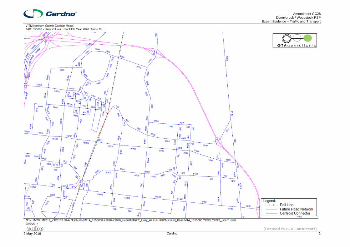
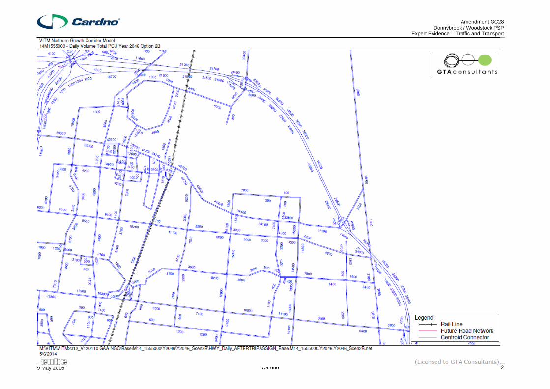
4.5 PSP Traffic Modelling (GTA)
GTA Consultants were engaged by the MPA to undertake strategic transport modelling and to determine the anticipated demands on the transport network.
The GTA modelling considered a number of scenarios for interim (2026) and ultimate (2046) timeframes based on different combinations of the following projects being provided:
> A grade-separated crossing of Sydney-Melbourne railway line at Gunns Gully Road;
> A grade-separated crossing of Sydney-Melbourne railway line at Cameron Street;
> A grade-separated crossing of Sydney-Melbourne railway line within the northern part of the PSP area (connector standard road);
> A bridge crossing of Merri Creek at Patterson Drive providing connectivity to the northern part of the PSP area.
The modelling for the interim timeframe assumes that the OMR / E6 will not be completed by 2026. Two sets of scenarios were producing for the ultimate timeframe, with one set assuming that the OMR / E6 will be completed and the other assuming that it will not be completed by 2046.
After reviewing the four projects used in the GTA modelling, I am of the opinion that:
Amendment GC28 Donnybrook / Woodstock PSP
Expert Evidence – Traffic and Transport
9 May 2016 Cardno 11
> The grade-separated rail crossing at Gunns Gully Road is dependent on State Government funding. Given its strategic importance this is likely to ultimately occur, however, delivery is likely to be linked to the upgrade of Gunns Gully Road to the ultimate 6 lane cross-section or potentially linked to the construction of the OMR.
> The grade-separated rail crossing at Cameron Street and the Patterson Drive crossing of Merri Creek are included in the list of draft ICP projects and consequently I am of the opinion that these projects are likely to proceed in a timely manner.
> The grade-separated rail crossing within the northern part of the PSP area is not shown in the PSP documentation. I am of the opinion that this crossing has negligible strategic importance and unlikely to be funded in the foreseeable future.
I consider the following scenarios to be the likely outcomes for the interim and ultimate timeframes:
2026 – without OMR
> Scenario 1B – does not include the rail crossing at Gunns Gully Road, but does include the northern connector road crossing (no 2026 scenario was modelled without both rail crossings)
2046 – with OMR
> Scenario 2A – includes the crossing at Gunns Gully Road
2046 – without OMR
> Scenario 3B – does not include the crossing at Gunns Gully Road; or
> Scenario 4A – includes the crossing at Gunns Gully Road
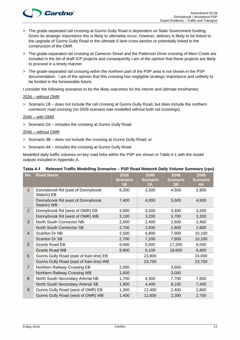
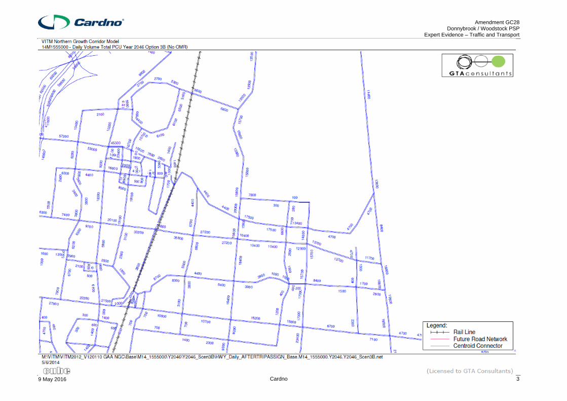
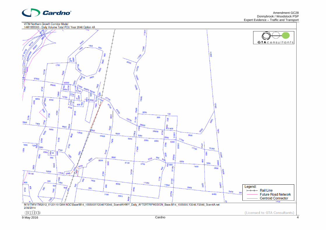
Modelled daily traffic volumes on key road links within the PSP are shown in Table 4-1 with the model outputs included in Appendix A.
Relevant Traffic Modelling Scenarios – PSP Road Network Daily Volume Summary (cpu)
No. Road Name 2026 Scenario
1B
2046 Scenario
2A
2046 Scenario
3B
2046 Scenario
4A 1 Donnybrook Rd (east of Donnybrook
Station) EB 6,200 2,500 4,500 2,900
Donnybrook Rd (east of Donnybrook Station) WB
7,400 4,000 5,500 4,600
2 Donnybrook Rd (west of OMR) EB 3,000 3,200 3,400 3,200
Donnybrook Rd (west of OMR) WB 3,100 3,200 3,700 3,200
3 North South Connector NB 2,600 2,400 2,600 2,400
North South Connector SB 2,700 2,600 2,600 2,800
4 Scanlon Dr NB 2,500 6,800 7,900 10,100
Scanlon Dr SB 2,700 7,200 7,800 10,200
5 Grants Road EB 9,400 5,500 17,200 6,000
Grants Road WB 9,800 6,100 18,600 6,400
6 Gunns Gully Road (east of train-line) EB 23,800 24,000
Gunns Gully Road (east of train-line) WB 23,700 23,700
7 Northern Railway Crossing EB 2,000 3,600
Northern Railway Crossing WB 1,600 3,000
8 North South Secondary Arterial NB 1,700 4,300 7,700 7,600
North South Secondary Arterial SB 1,900 4,400 8,100 7,400
9 Gunns Gully Road (west of OMR) EB 1,300 12,400 2,400 2,800
Gunns Gully Road (west of OMR) WB 1,400 12,600 2,300 2,700
Amendment GC28 Donnybrook / Woodstock PSP
Expert Evidence – Traffic and Transport
9 May 2016 Cardno 12
4.6 PSP Road Network Infrastructure
The Victorian Government has recently passed new legislation to introduce a new simplified system for funding local infrastructure, referred to as an Infrastructure Contributions Plan (ICP). Previously, this local infrastructure would have been funded through a PSP specific Development Contributions Plan (DCP).
The new system will apply a standard levy rate for funding local infrastructure. A supplementary infrastructure levy can also be applied to fund additional infrastructure. The new system has not formally taken effect, as the Minister for Planning has not issued a Ministerial Direction outlining the ICP rate and the basic and essential infrastructure that an ICP can fund.
I understand that the ICP that will apply to this PSP will be formally exhibited when the new system is in place.
The MPA has prepared a document titled Donnybrook / Woodstock Draft Precinct Infrastructure Plan Projects (November 2015) that sets out the road, intersection, bridge, community building and sporting reserve projects to be included in the ICP. Infrastructure costings are not included within this document.
Amendment GC28 Donnybrook / Woodstock PSP
Expert Evidence – Traffic and Transport
9 May 2016 Cardno 13
5 PSP Road and Intersection Design
One Mile Grid were engaged by MPA to undertake the following tasks for the Donnybrook / Woodstock PSP area:
> Intersection Analysis
> Intersection Design
> Road Design
> Bridge / Culvert Design
The output of this work is provided within the October 2015 Donnybrook & Woodstock PSP Road, Intersection and Culvert / Bridge Design report. Included projects are consistent with the road, intersection and bridge / culvert projects listed within the draft Precinct Infrastructure Plan Projects document and with work undertaken extending to land take requirements to facilitate these projects for the purpose of land budget calculations.
5.1 Internal PSP Intersections
Internal PSP interim and ultimate designs for identified ICP intersections are included in Appendix C and D of the One Mile Grid report. In preparing these designs, One Mile Grid adopted the following assumptions:
> Existing road reserve and property boundaries relying on digital cadastral information provided by the MPA;
> The use of standard VicRoads intersection treatment templates have informed the layout and approach to design of the interim and ultimate arterial road intersections;
> Turn lane lengths have been based on anticipated road posted speeds and horizontal geometry considers the requirements Austroads Guide to Road Design Part 4A, taking into consideration VicRoads Supplement to Austroads Guide to Road Design Part 4A; and
> Swept path analysis for a suitable design vehicle has been used to confirm concept designs.
The methodology approach adopted by One Mile Grid in preparing intersections designs is generally consistent with best practice.
However, the adoption of standard VicRoads templates results in an ‘outside-in’ approach to the staging / delivery of ICP intersections, with the intersection designed to match to the outer kerb alignment of the ultimate intersection with the premise to minimise reconstruction works required in association with the ultimate duplication of the road.
This approach results in the local duplication of arterial road approaches and results in a significantly larger intersection footprint, through the provision of wider medians, than necessary considering the identified ICP intersection configuration. The resulting intersection geometry to achieve this intersection footprint, while matching back to the single arterial road carriageway attributable to the PSP results in a significantly extended intersection approach design.
In my opinion the requirement for the interim intersection to match ultimate to minimise lost works when the relevant arterial road is duplicated, while being sensible from a staging of works and overall cost point of view, effectively loads intersection costs within the DCP such that ultimate duplication works are being subsidised.
While it is sensible to minimise lost works where possible, if the intersections were to be constructed as proposed, a proportion of the costs of the works should be met from other sources, equivalent to the savings in ultimate duplication costs when the intersecting roads are ultimately duplicated.
As this is unlikely to be achievable practically, in my opinion reduced standards of intersections should be accepted and costed into the ICP, whereby interim intersections only need to meet the requirements for mitigation of development traffic without the additional costs of matching projected ultimate layouts.
Amendment GC28 Donnybrook / Woodstock PSP
Expert Evidence – Traffic and Transport
9 May 2016 Cardno 14
5.2 Donnybrook Road Intersections
Acknowledging the inclusion of PAO2 along the southern side of Donnybrook Road, interim and ultimate intersection designs undertaken by One Mile Grid are positioned across the existing road reserve and PAO area. The approach to design and staging of identified Donnybrook Road ICP intersections undertaken by One Mile Grid is consistent with that adopted for internal intersections, with the resulting interim intersection layouts assuming local duplication on arterial road approaches and with the intersection layout matching to the ultimate footprint.
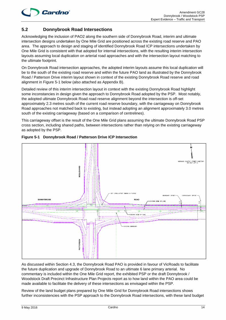
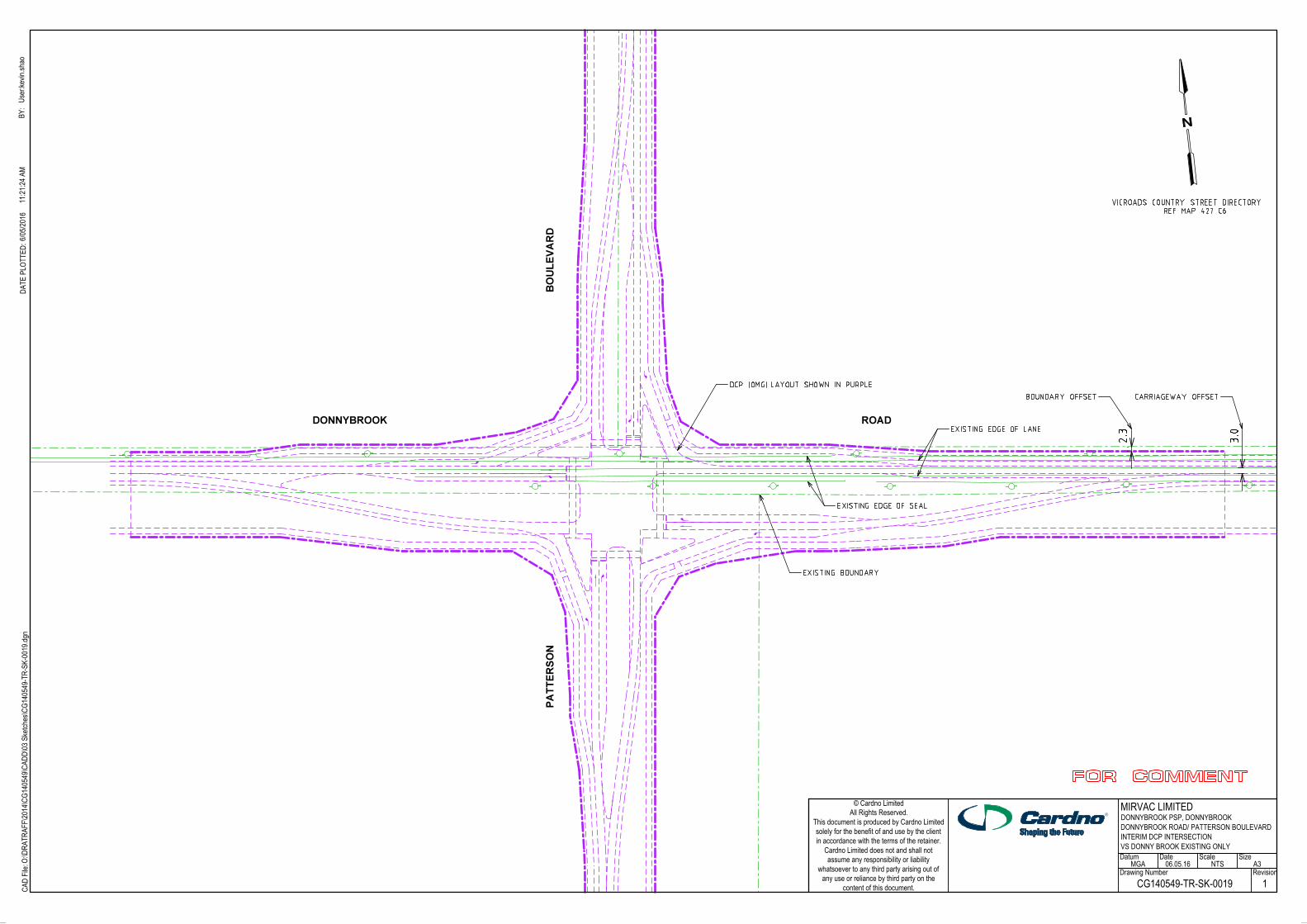
On Donnybrook Road intersection approaches, the adopted interim layouts assume this local duplication will be to the south of the existing road reserve and within the future PAO land as illustrated by the Donnybrook Road / Patterson Drive interim layout shown in context of the existing Donnybrook Road reserve and road alignment in Figure 5-1 below (also attached as Appendix B).
Detailed review of this interim intersection layout in context with the existing Donnybrook Road highlight some inconstancies in design given the approach to Donnybrook Road adopted by the PSP. Most notably, the adopted ultimate Donnybrook Road road reserve alignment beyond the intersection is off-set approximately 2.3 metres south of the current road reserve boundary, with the carriageway on Donnybrook Road approaches not matched back to existing, but instead adopting an alignment approximately 3.0 metres south of the existing carriageway (based on a comparison of centrelines).
This carriageway offset is the result of the One Mile Grid plans assuming the ultimate Donnybrook Road PSP cross section, including shared paths, between intersections rather than relying on the existing carriageway as adopted by the PSP.
Figure 5-1 Donnybrook Road / Patterson Drive ICP Intersection
As discussed within Section 4.3, the Donnybrook Road PAO is provided in favour of VicRoads to facilitate the future duplication and upgrade of Donnybrook Road to an ultimate 6 lane primary arterial. No commentary is included within the One Mile Grid report, the exhibited PSP or the draft Donnybrook / Woodstock Draft Precinct Infrastructure Plan Projects report as to how land within the PAO area could be made available to facilitate the delivery of these intersections as envisaged within the PSP.
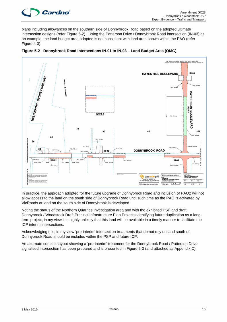
Review of the land budget plans prepared by One Mile Grid for Donnybrook Road intersections shows further inconsistencies with the PSP approach to the Donnybrook Road intersections, with these land budget
Amendment GC28 Donnybrook / Woodstock PSP
Expert Evidence – Traffic and Transport
9 May 2016 Cardno 15
plans including allowances on the southern side of Donnybrook Road based on the adopted ultimate intersection designs (refer Figure 5-2). Using the Patterson Drive / Donnybrook Road intersection (IN-03) as an example, the land budget area adopted is not consistent with land area shown within the PAO (refer Figure 4-3).
Figure 5-2 Donnybrook Road Intersections IN-01 to IN-03 – Land Budget Area (OMG)
In practice, the approach adopted for the future upgrade of Donnybrook Road and inclusion of PAO2 will not allow access to the land on the south side of Donnybrook Road until such time as the PAO is activated by VicRoads or land on the south side of Donnybrook is developed.
Noting the status of the Northern Quarries Investigation area and with the exhibited PSP and draft Donnybrook / Woodstock Draft Precinct Infrastructure Plan Projects identifying future duplication as a long-term project, in my view it is highly unlikely that this land will be available in a timely manner to facilitate the ICP interim intersections.
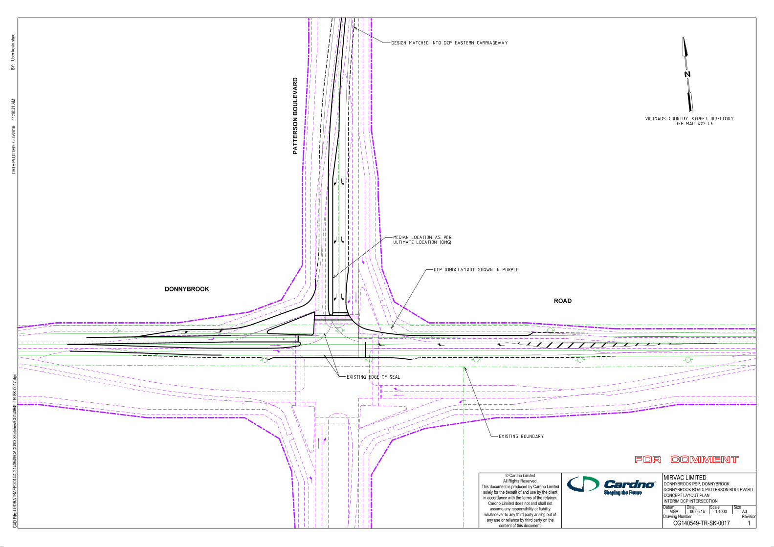
Acknowledging this, in my view ‘pre-interim’ intersection treatments that do not rely on land south of Donnybrook Road should be included within the PSP and future ICP.
An alternate concept layout showing a ‘pre-interim’ treatment for the Donnybrook Road / Patterson Drive signalised intersection has been prepared and is presented in Figure 5-3 (and attached as Appendix C).
Amendment GC28 Donnybrook / Woodstock PSP
Expert Evidence – Traffic and Transport
9 May 2016 Cardno 16
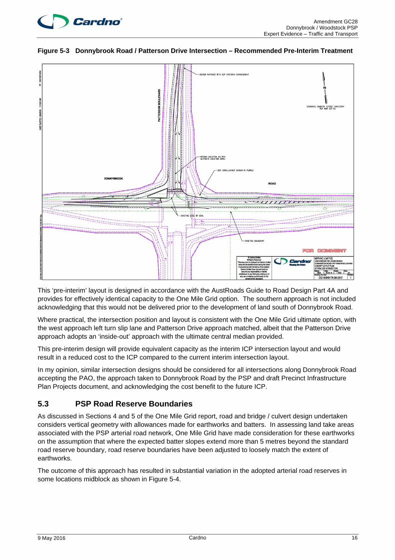
Figure 5-3 Donnybrook Road / Patterson Drive Intersection – Recommended Pre-Interim Treatment
This ‘pre-interim’ layout is designed in accordance with the AustRoads Guide to Road Design Part 4A and provides for effectively identical capacity to the One Mile Grid option. The southern approach is not included acknowledging that this would not be delivered prior to the development of land south of Donnybrook Road.
Where practical, the intersection position and layout is consistent with the One Mile Grid ultimate option, with the west approach left turn slip lane and Patterson Drive approach matched, albeit that the Patterson Drive approach adopts an ‘inside-out’ approach with the ultimate central median provided.
This pre-interim design will provide equivalent capacity as the interim ICP intersection layout and would result in a reduced cost to the ICP compared to the current interim intersection layout.
In my opinion, similar intersection designs should be considered for all intersections along Donnybrook Road accepting the PAO, the approach taken to Donnybrook Road by the PSP and draft Precinct Infrastructure Plan Projects document, and acknowledging the cost benefit to the future ICP.
5.3 PSP Road Reserve Boundaries
As discussed in Sections 4 and 5 of the One Mile Grid report, road and bridge / culvert design undertaken considers vertical geometry with allowances made for earthworks and batters. In assessing land take areas associated with the PSP arterial road network, One Mile Grid have made consideration for these earthworks on the assumption that where the expected batter slopes extend more than 5 metres beyond the standard road reserve boundary, road reserve boundaries have been adjusted to loosely match the extent of earthworks.
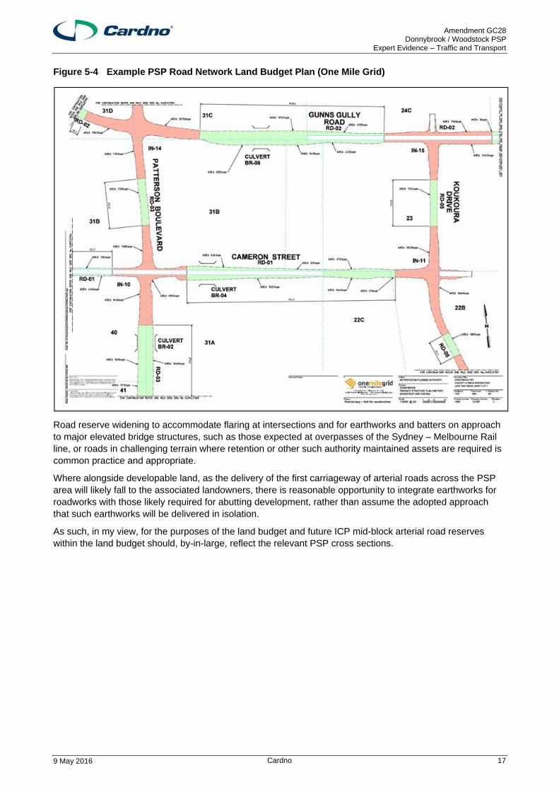
The outcome of this approach has resulted in substantial variation in the adopted arterial road reserves in some locations midblock as shown in Figure 5-4.
Amendment GC28 Donnybrook / Woodstock PSP
Expert Evidence – Traffic and Transport
9 May 2016 Cardno 17
Figure 5-4 Example PSP Road Network Land Budget Plan (One Mile Grid)
Road reserve widening to accommodate flaring at intersections and for earthworks and batters on approach to major elevated bridge structures, such as those expected at overpasses of the Sydney – Melbourne Rail line, or roads in challenging terrain where retention or other such authority maintained assets are required is common practice and appropriate.
Where alongside developable land, as the delivery of the first carriageway of arterial roads across the PSP area will likely fall to the associated landowners, there is reasonable opportunity to integrate earthworks for roadworks with those likely required for abutting development, rather than assume the adopted approach that such earthworks will be delivered in isolation.
As such, in my view, for the purposes of the land budget and future ICP mid-block arterial road reserves within the land budget should, by-in-large, reflect the relevant PSP cross sections.
Amendment GC28 Donnybrook / Woodstock PSP
Expert Evidence – Traffic and Transport
9 May 2016 Cardno 18
6 Gunns Gully Road Alignment
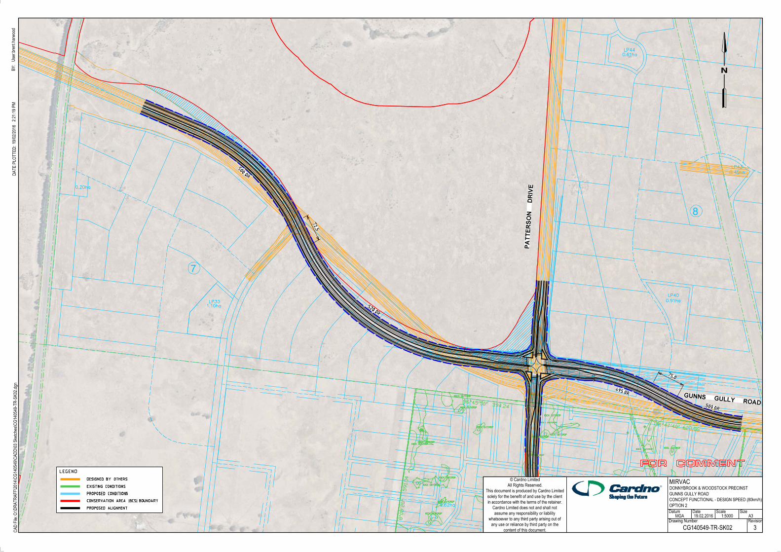
The alignment of Gunns Gully Road to the west of Patterson Drive (as shown on the One Mile Grid plans prepared to accompany the Donnybrook / Woodstock PSP) impinges on the conservation area shown in the Donnybrook / Woodstock PSP.
Cardno has previously prepared a concept functional layout plan of the proposed realignment of Gunns Gully Road (see Appendix D). In addition to better responding to the conservation area interface and limiting impact on this area, the proposed alignment provides for a more standard perpendicular treatment at the Gunns Gully Road / Patterson Drive intersection, with the potential for additional developable land the south-west corner of this intersection.
The proposed realignment will also require minor realignment of the North-South Connector Road to meet Gunns Gully Road at right angles. I am satisfied that this can be achieved without any material loss of developable land.
VicRoads advised by email on 1 April 2016 that they support the proposed alignment and redesign. VicRoads noted the following outcomes of the proposed alignment, which it considered acceptable and appropriate:
> The alternative alignment avoids the need to apply to the Commonwealth Government (via DELWP) for a change to the CA boundary and thus avoid the need to find the same or better replacement land needed to demonstrate “no net loss”, and
> The alternative alignment minimises the area of land left between the road reserve and the CA. Because the road alignment cannot exactly match the shape of the CA, the MPA will include any remaining land between the road reserve and the CA in the area required for the road reserve to be funded by the ICP. Meaning that the small amount of land remaining will be purchased as Road Reserve.
Amendment GC28 Donnybrook / Woodstock PSP
Expert Evidence – Traffic and Transport
9 May 2016 Cardno 19
7 Cameron Street Classification
The Donnybrook / Woodstock PSP describes Cameron Street as a four lane secondary arterial road between the western boundary of the PSP and Koukoura Drive. East of Koukoura Drive it is identified as a connector street.
Referring to the traffic modelling for the Donnybrook / Woodstock precinct prepared by GTA consultants, expected daily traffic volumes for the section of Cameron Street between Patterson Drive and Koukoura Drive for the likely model scenarios are set out below.
Predicted Daily Traffic Volumes – Cameron Street between Patterson and Koukoura Drives1
Scenario East of Patterson Drive West of Koukoura Drive
2026
1B 9,700 pcu 7,900 pcu
2046
2A 3,000 pcu 4,200 pcu
3B 10,400 pcu 12,900 pcu
4A 3,300 pcu 5,000 pcu
PSP Notes – Our Roads: Connecting People published by the Metropolitan Planning Authority sets out the following indicative traffic volumes for a connector street and a secondary arterial road:
> Connector Street – 3,000 – 7,000 vehicles per day
> Secondary Arterial Road – 12,000 – 40,000 vehicles per day.
The traffic volumes for the majority of the modelled scenarios fall within the recommended range for a connector street, with the 2046 3B scenario indicating that volumes, at 12,900 pcu, would fall at the lower end of the secondary arterial road range for the section between Koukoura Drive and the key local access street to the west. Volumes on the balance of Cameron Drive would be less at 10,400 vehicles per day.
The two scenarios (1B and 3B) where the predicted traffic volumes are higher than the recommended range for a connector street were modelled on the basis that Gunns Gully Road would not connect across the Sydney – Melbourne railway line, thus redistributing traffic onto Cameron Street.
Gunns Gully Road is the principal east-west road through the precinct and it provides a direct connection to the Lockerbie Principle Town Centre to the west of the precinct. The Road will initially be delivered as a single carriageway two-way road will be delivered as an ICP item between the Sydney – Melbourne railway line and OMR / E6 reservation. The future upgrade, rail overpass and extension through to Grants Road (noting an existing POA exists for this extension outside of the PSP area) will be delivered by VicRoads.
Noting the strategic importance of Gunns Gully Road to the Lockerbie and Woodstock / Donnybrook PSP area, I am of the opinion that it is unlikely that the Sydney – Melbourne railway line overpass would not be delivered prior to 2046 such that volumes on Cameron Street east of Patterson Drive would remain within the target range for a connector street. Nonetheless, should the delivery of the Gunns Gully Overpass occur post 2046, in my view the interim volumes on Cameron Street do not warrant classification as an arterial road.
I note that this view has been accepted by MPA in their April 2016 Part A submission, with Cameron Street between Patterson Drive and Koukoura Drive now to be designated as a Connector Boulevard.
1 The GTA modelling measured the traffic volumes in Passenger Car Units (pcu), which include adjustment factors to convert commercial vehicles to an equivalent number of cars. The more typical measure of vehicles per day (vpd) would be slightly less the reported pcu, however, for simplicity I have adopted the pcu values for my assessment.
Amendment GC28 Donnybrook / Woodstock PSP
Expert Evidence – Traffic and Transport
9 May 2016 Cardno 20
8 North-South Connector Road Classification
The Donnybrook / Woodstock PSP identifies a North-South Connector Street located to the west of Patterson Drive. This North-South Connector Street is located approximately 1.0 kilometre west of Patterson Boulevard, less than the typical 1.6 kilometre arterial road spacing, with the catchment to the west limited by the Sydney – Melbourne Rail Line and also supported by the western end of Hays Boulevard as it turns south to Donnybrook Road.
Considering the relevant 2014 GTA modelling scenarios, expected daily traffic volumes for the section of Cameron Street between Patterson Drive and Koukoura Drive for the likely model scenarios are set out below. This modelling includes some allowance for traffic that will be generated by future development in the Northern Quarries Investigation Area to the south of Donnybrook Road.
The daily two-way traffic volumes predicted by the GTA modelling is set out below.
Predicted Daily Traffic Volumes – North-South Connector Street2
Scenario Donnybrook to Hayers Hill Bvd
Hayers Hill Bvd to Cameron St
Cameron St to Gunns Gully Rd
2026
1B 2,700 pcu 5,700 pcu 6,400 pcu
2046
2A 2,800 pcu 7,700 pcu 9,100 pcu
3B 3,800 pcu 6,600 pcu 6,700 pcu
4A 3,000 pcu 7,400 pcu 8,800 pcu
The GTA modelling has consideration for future development to the south of Donnybrook Road within the northern extent of the Northern Quarries Investigation area.
PSP Notes – Our Roads: Connecting People published by the Metropolitan Planning Authority sets out the following indicative traffic volumes for a connector street and a secondary arterial road:
> Connector Street – 3,000 – 7,000 vehicles per day
> Secondary Arterial Road – 12,000 – 40,000 vehicles per day.
The traffic volumes identified in the GTA modelling across all scenarios are typically fall within or slightly above the identified target range for a connector street. For the 2046 scenarios, where exceeded, this is limited to the northern end of the street, with volumes well below than the minimum threshold for a secondary arterial road and generally fall within the recommended volumes for a Connector Street.
Aside from the ultimate traffic volumes falling below the minimum threshold for a secondary arterial road, I also note that the street does not fulfil any arterial function from a strategic perspective.
I am satisfied that it is appropriate to categorise the North-South Connector Street as a ‘connector street’ and that the proposed 25.0m cross-section for a connector street set out in the PSP (providing a 3.5m wide through lane, plus a 2.1m wide indented parking lane in each direction) can adequately accommodate the anticipated traffic volumes.
2 The GTA modelling measured the traffic volumes in Passenger Car Units (cpu), which include adjustment factors to convert commercial vehicles to an equivalent number of cars. The more typical measure of vehicles per day (vpd) would be slightly less the reported cpu, however, for simplicity I have adopted the pcu values for my assessment.
Amendment GC28 Donnybrook / Woodstock PSP
Expert Evidence – Traffic and Transport
9 May 2016 Cardno 21
9 Conclusions
Based on my assessment of the Donnybrook / Wollert PSP as exhibited, I have concluded the following with respect to the issues I have been asked to assess.
1. The adopted approach to the staging / delivery of ICP intersections results in a larger intersection footprint and extended intersection approaches than necessary to accommodate identified intersection configuration attributable to the PSP. Whilst being sensible from a staging of works and overall cost point of view, the staging / delivery of ICP intersections effectively loads intersection costs within the DCP such that ultimate duplication works are being subsidised.
2. While it is sensible to minimise lost works where possible, if the intersections were to be constructed as proposed, a proportion of the costs of the works should be met from other sources, equivalent to the savings in ultimate duplication costs when the intersecting roads are ultimately duplicated.
3. As this is unlikely to be achievable practically, in my opinion reduced standards of intersections should be accepted, whereby interim intersections only need to meet the requirements for mitigation of development traffic without the additional costs of matching projected ultimate layouts.
4. The delivery of interim Donnybrook Road intersections as proposed rely on land within the proposed Donnybrook Road Public Acquisition Overlay area provided in favour of VicRoads to facilitate the future widening and duplication of Donnybrook Road. With access to this land unlikely within the short to medium term, pre-interim intersection option that rely on the existing Donnybrook Road reserve only will be required and should be include within the ICP.
5. Where alongside developable land, reasonable opportunity exists to integrate earthworks for roadworks with those likely required for abutting development. As such for the purposes of the land budget, future ICP mid-block arterial road reserves within the land budget should reflect the relevant PSP cross sections.
6. The alternate Gunns Gully Road alignment designed by Cardno better responds to the conservation area’s interface, provides a more standard perpendicular treatment at the Gunns Gully Road / Patterson Drive intersection and has a negligible impact on developable land. VicRoads have accepted this alternate alignment.
7. Considering expected traffic volumes as per the relevant PSP traffic modelling scenarios, I agree with the view now accepted by MPA that Cameron Street between Patterson Drive and Koukoura Drive should be designated as a Connector Boulevard.
8. Considering expected traffic volumes as per the relevant PSP traffic modelling scenarios and the strategic function of in the context of the broader PSP road network, it is my view that classification of the western North-South Connector Road is appropriate.
Amendment GC28 Donnybrook / Woodstock PSP
Expert Evidence – Traffic and Transport
9 May 2016 Cardno 22
Expert Evidence – Traffic and Transport
APPENDIX
A PSP TRAFFIC MODELLING SCENARIOS
Amendment GC28 Donnybrook / Woodstock PSP
Expert Evidence – Traffic and Transport
9 May 2016 Cardno 1
Amendment GC28 Donnybrook / Woodstock PSP
Expert Evidence – Traffic and Transport
9 May 2016 Cardno 2
Amendment GC28 Donnybrook / Woodstock PSP
Expert Evidence – Traffic and Transport
9 May 2016 Cardno 3
Amendment GC28 Donnybrook / Woodstock PSP
Expert Evidence – Traffic and Transport
9 May 2016 Cardno 4
Amendment GC28 Donnybrook / Woodstock PSP
Expert Evidence – Traffic and Transport
6 May 2016 Cardno 2
Expert Evidence – Traffic and Transport
APPENDIX
B PATTERSON DRIVE / DONNYBROOK ROAD INTERIM ICP INTERSECTION COMPARISON
SizeScale
Drawing Number Revision
DateDatum
User:kevin.shao
BY:
content of this document.
any use or reliance by third party on the
whatsoever to any third party arising out of
assume any responsibility or liability
Cardno Limited does not and shall not
in accordance with the terms of the retainer.
solely for the benefit of and use by the client
This document is produced by Cardno Limited
All Rights Reserved.
Cardno Limited©
®
CA
D File:O:\D
RATR
AFF\2014\C
G140549\C
AD
D\03 S
ketches\C
G140549-T
R-S
K-0
019.dgn
DATE P
LO
TTE
D:6/05/2016
11:21:24 A
M
A3
FOR COMMENT
1
MIRVAC LIMITED
MGA 06.05.16
CG140549-TR-SK-0019
DONNYBROOK ROAD
REF MAP 427 C6
VICROADS COUNTRY STREET DIRECTORY
DONNYBROOK PSP, DONNYBROOK
DONNYBROOK ROAD/ PATTERSON BOULEVARD
EXISTING BOUNDARY
DCP (OMG) LAYOUT SHOWN IN PURPLE
INTERIM DCP INTERSECTION
VS DONNY BROOK EXISTING ONLY
EXISTING EDGE OF SEAL
EXISTING EDGE OF LANE
PA
TTE
RS
ON
BO
ULE
VA
RD
2.3
3.0
NTS
BOUNDARY OFFSET CARRIAGEWAY OFFSET

Amendment GC28 Donnybrook / Woodstock PSP
Expert Evidence – Traffic and Transport
6 May 2016 Cardno 4
Expert Evidence – Traffic and Transport
APPENDIX
C PATTERSON DRIVE / DONNYBROOK ROAD INTERIM INTERSECTION – PRE-INTERIM LAYOUT
SizeScale
Drawing Number Revision
DateDatum
User:kevin.shao
BY:
content of this document.
any use or reliance by third party on the
whatsoever to any third party arising out of
assume any responsibility or liability
Cardno Limited does not and shall not
in accordance with the terms of the retainer.
solely for the benefit of and use by the client
This document is produced by Cardno Limited
All Rights Reserved.
Cardno Limited©
®
CA
D File:O:\D
RATR
AFF\2014\C
G140549\C
AD
D\03 S
ketches\C
G140549-T
R-S
K-0
017.dgn
DATE P
LO
TTE
D:6/05/2016
11:18:31 A
M
A3
FOR COMMENT
1
MIRVAC LIMITED
CONCEPT LAYOUT PLAN
MGA 06.05.16
CG140549-TR-SK-0017
PA
TTE
RS
ON B
OU
LE
VA
RD
DONNYBROOK
ROAD
REF MAP 427 C6
VICROADS COUNTRY STREET DIRECTORY
DONNYBROOK PSP, DONNYBROOK
DONNYBROOK ROAD/ PATTERSON BOULEVARD
EXISTING BOUNDARY
ULTIMATE LOCATION (OMG)
MEDIAN LOCATION AS PER
DCP (OMG) LAYOUT SHOWN IN PURPLE
DESIGN MATCHED INTO DCP EASTERN CARRIAGEWAY
INTERIM DCP INTERSECTION
EXISTING EDGE OF SEALEXISTING EDGE OF SEAL
1:1000

Amendment GC28 Donnybrook / Woodstock PSP
Expert Evidence – Traffic and Transport
6 May 2016 Cardno 5
Expert Evidence – Traffic and Transport
APPENDIX
D ALTERNATE GUNNS GULLY ROAD ALIGNMENT (CG140549-TR-SK02 R3)
0.62ha
1.23ha
1.31ha
1.10ha
0.61ha
0.45ha
0.91ha
0.20ha
LP40
LP43
LP44
LP33
8
7
ROCK OUTCROP
ROCL OUTCROP
ROCK OUTCROP
ROCK OUTCROP
ROCK OUTCROP
ROCK OUTCROP
ROCK OUTCROP
ROCK OUTCROP
ROCK OUTCROP
ROCK OUTCROP
ROCK OUTCROP
ROCK OUTCROP
ROCK OUTCROP
ROCK OUTCROP
ROCK OUTCROP
ROCK OUTCROP
591.0
4
623.86
394.24
BUSLANE
BUSLANE
BUSLANE
BUSLANE
BUSLANE
BUS
LANE
BUS
LANE
BUS
LANE
BUS
LANE
BUS
LANE
BUS
LANE
SizeScale
Drawing Number Revision
DateDatum
User:bre
nt.harw
ood
BY:
content of this document.
any use or reliance by third party on the
whatsoever to any third party arising out of
assume any responsibility or liability
Cardno Limited does not and shall not
in accordance with the terms of the retainer.
solely for the benefit of and use by the client
This document is produced by Cardno Limited
All Rights Reserved.
Cardno Limited©
®
CA
D File:O:\D
RATR
AFF\2014\C
G140549\C
AD
D\03 S
ketches\C
G140549-T
R-S
K02.dgn
DATE P
LO
TTE
D:19/02/2016
2:21:19 P
M
GUNNS GULLY ROAD
PA
TTE
RS
ON D
RIV
E
BUS
LANE
BUS
LANE
LEGEND
EXISTING CONDITIONS
DESIGNED BY OTHERS
PROPOSED CONDITIONS
PROPOSED ALIGNMENT
CONSERVATION AREA (BCS) BOUNDARY
A3
FOR COMMENT
3CG140549-TR-SK02
MIRVACDONNYBROOK & WOODSTOCK PRECINST
GUNNS GULLY ROAD
OPTION 2
MGA 1:5000
CONCEPT FUNCTIONAL - DESIGN SPEED (80km/h)
75.0
72.5
19.02.2016
495.0R
500.0R
500.0R
520.0R
Related Documents