AGENDA PLANNING & ZONING COMMISSION PUBLIC HEARING August 8, 2017 STARTING AT 5:00 PM LOCATION: 150 Courthouse Dr, Driggs, ID 83422 1st Floor Meeting Room Teton County Page 1 Updated 8/4/2017 10:42 AM 1. Approval of Minutes Tuesday June 27, 2017 Tuesday July 11, 2017 2. Chairman Business 3. Administrator Business 5:00 PM – Item #1. – PUBLIC HEARING: CONDITIONAL USE PERMIT: Spud Drive-In Jed and Katie Mumm, representing Lenny Zaban, owner of The Spud Drive-In, is seeking a Conditional Use Permit to allow for a Campground/Rv Park /Travel Trailer camp with ten cabin sites. The Spud Drive-In is located between Victor and Driggs at 2175 S. Hwy 33 on 4.66 acres. Legal Description: RP04N45E111200, N2SW4, N2SE4 LESS N2NE4SE4, S2SE4 LESS HANSEN MEADOWS SEC 12 T4N R45E – Item #2. – PUBLIC HEARING: PRELIMINARY PLAT REVIEW: Cutthroat Creek Subdivision- POSTPONED Teton Partners, Ltd. is proposing a 24 lot (241.3 acres) subdivision. The residential lots will range from 3.55-62.6 acres, with 55.28 acres in open space easements and 103.94 acres in farm easements. This project is located east of Tetonia and north of Driggs on E 5000 N and N 2250 E, near Stateline Road and is zoned A-2.5. Legal Description: RP06N46E324805; SW4 LESS #3183 & #3330 SEC 32 T6N R46E 5:30 PM – Item #3. – PUBLIC HEARING: CONDITIONAL USE PERMIT: Aspen Self Storage Jason O’Neill is seeking a Conditional Use Permit to allow for a Self Storage facility of 45,000 sq. ft. on a 2.83 acre parcel of land with C-3 zoning, located between Driggs and Victor near State Hwy 33. At 4710 S 500 W (Lot 19 Peak View Estates). Legal Description: RP001470000190, TAX # 5512 SEC 23 T4N R45E PARCEL 2 – Item #4. – SCENIC CORRIDOR DESIGN REVIEW: Robson Scenic Corridor Design Review Gary and Marlene Robson are requesting approval for constructing an attached garage and mud room onto their existing home located in the scenic corridor of State Hwy 32. The property is 2.76 acres and has an existing home. The property is zoned A 2.5. Legal Description: RP07N45E326000, TAX #2700 SEC 32 T7N R45E Written comments received by 5:00 pm, August 1, 2017 will be provided to the Planning & Zoning Commission prior to the hearing. Comments received after this date will not be included at the public hearing. Information on the above application(s) is available for public viewing in the Teton County Planning and Zoning Office at the Courthouse between the hours of 9am and 5pm Monday through Friday. The application(s) and related documents are posted, at www.tetoncountyidaho.gov. To view these items, click on the Meeting Information Live Audio button on the home page and select the Planning & Zoning Commission Public Hearing of August 8, 2017 under Upcoming Meetings.

Welcome message from author
This document is posted to help you gain knowledge. Please leave a comment to let me know what you think about it! Share it to your friends and learn new things together.
Transcript

AGENDA PLANNING & ZONING COMMISSION
PUBLIC HEARING August 8, 2017
STARTING AT 5:00 PM
LOCATION: 150 Courthouse Dr, Driggs, ID 83422 1st Floor Meeting Room
Teton County Page 1 Updated 8/4/2017 10:42 AM
1. Approval of Minutes
Tuesday June 27, 2017
Tuesday July 11, 2017
2. Chairman Business
3. Administrator Business
5:00 PM – Item #1. – PUBLIC HEARING: CONDITIONAL USE PERMIT: Spud Drive-In Jed and Katie Mumm, representing Lenny Zaban, owner of The Spud Drive-In, is seeking a Conditional Use Permit to allow for a Campground/Rv Park /Travel Trailer camp with ten cabin sites. The Spud Drive-In is located between Victor and Driggs at 2175 S. Hwy 33 on 4.66 acres.
Legal Description: RP04N45E111200, N2SW4, N2SE4 LESS N2NE4SE4, S2SE4 LESS HANSEN MEADOWS SEC 12 T4N R45E
– Item #2. – PUBLIC HEARING: PRELIMINARY PLAT REVIEW: Cutthroat Creek Subdivision-POSTPONED Teton Partners, Ltd. is proposing a 24 lot (241.3 acres) subdivision. The residential lots will range from 3.55-62.6 acres, with 55.28 acres in open space easements and 103.94 acres in farm easements. This project is located east of Tetonia and north of Driggs on E 5000 N and N 2250 E, near Stateline Road and is zoned A-2.5.
Legal Description: RP06N46E324805; SW4 LESS #3183 & #3330 SEC 32 T6N R46E
5:30 PM – Item #3. – PUBLIC HEARING: CONDITIONAL USE PERMIT: Aspen Self Storage Jason O’Neill is seeking a Conditional Use Permit to allow for a Self Storage facility of 45,000 sq. ft. on a 2.83 acre parcel of land with C-3 zoning, located between Driggs and Victor near State Hwy 33. At 4710 S 500 W (Lot 19 Peak View Estates).
Legal Description: RP001470000190, TAX # 5512 SEC 23 T4N R45E PARCEL 2
– Item #4. – SCENIC CORRIDOR DESIGN REVIEW: Robson Scenic Corridor Design Review Gary and Marlene Robson are requesting approval for constructing an attached garage and mud room onto their existing home located in the scenic corridor of State Hwy 32. The property is 2.76 acres and has an existing home. The property is zoned A 2.5.
Legal Description: RP07N45E326000, TAX #2700 SEC 32 T7N R45E
Written comments received by 5:00 pm, August 1, 2017 will be provided to the Planning & Zoning Commission prior to the hearing. Comments received after this date will not be included at the public hearing.
Information on the above application(s) is available for public viewing in the Teton County Planning and Zoning Office at the Courthouse between the hours of 9am and 5pm Monday through Friday.
The application(s) and related documents are posted, at www.tetoncountyidaho.gov. To view these items, click on the Meeting Information Live Audio button on the home page and select the Planning & Zoning Commission Public Hearing of August 8, 2017 under Upcoming Meetings.

Agenda Teton County Planning & Zoning Commission August 8, 2017
Teton County Page 2 Updated 8/4/2017 10:42 AM
Comments may be emailed to [email protected]. Written comments may be mailed or dropped off at: Teton County Planning Department, 150 Courthouse Drive, Room 107, Driggs, Idaho 83422. Faxed comments may be sent to (208) 354-8410.
Public comments at this hearing are welcome.
Any person needing special accommodations to participate in the above noticed meeting should contact the Board of County Commissioners’ office 2 business days prior to the meeting at 208-354-8775.
Adjourn
MINUTES PLANNING & ZONING COMMISSION
WORK SESSION June 27, 2017
STARTING AT 5:00 PM
LOCATION: 150 Courthouse Dr, Driggs, ID 83422 1st Floor Meeting Room
Teton County Page 1 Updated 8/2/2017 8:58 AM
Commissioners Present: Sarah Johnston Jack Haddox David Breckenridge Marlene Robson Pete Moyer Cleve Booker Chris Larson Staff Present Joshua Chase Mary Gibson Sharon Fox
Item #1. – AIRPORT OVERLAY: Airport Overlay in Driggs Area of Impact The Driggs and Teton County P&Z Commission will separately hold public hearings to consider an ordinance for a ZONING TEXT AMENDMENT & ZONING MAP AMENDMENT to amend the Driggs Area of Impact zone map and zoning regulations specific to the Airport Overlay Zone and the Light Industrial (M-1) zone. The proposed amendment would modify the Airport Overlay Zone to include different districts and establish land use regulations in each airport district. The Light Industrial (M-1) zone is proposed to be amended to identify “hangars” and “accessory dwelling units” as allowed uses. The Supplementary Regulations would also be amended to add provisions related to accessory dwelling units in the M-1 zone. The Area of Impact Zone Map would be amended to show the new boundaries of the Airport Overlay Zone and each of the airport districts within.
Mr. Chase explained that an Airport Overlay Zone and related standards are proposed to be adopted in the Area of Impact (AOI). The standards are similar to Division 9.2 that was adopted inside Driggs city limits in Sept 2016. The proposal also includes an amendment to the M-1 Light Industrial zone to permit accessory dwelling units. The City and County entered into an Area of Impact (AOI) Agreement in 2011. This Agreement created a boundary around the city limits where the city’s zoning applies, but is administered by the County. Since 2011 the city has made several amendments to the zoning regulations and most recently overhauled the entire zoning code. Teton County is in process of revising its land use ordinances and eventually will review the zoning and development standards for the entire AOI, but in the meantime amendments are needed to address zoning around the airport. When the Airport Master Plan was formally approved by the Federal Aviation Administration (FAA) in July 2013 it was determined that the land use recommendations from the Plan be incorporated into the Driggs Zoning Ordinance and Map in order to become regulatory and enforceable. The city adopted an Airport Overlay Zone as part of the new Land Development Code in September and now needs similar regulations adopted in the AOI. The regulations help protect the airport from incompatible land uses that would threaten future FAA investment in the airport. Mr. Chase addressed the notification requirements next. The proposed amendments affected more than 200 property owners so the minimum legal requirement was to post an ad in the newspaper. However, in an effort to
1.1
Packet Pg. 3
Min
ute
s A
ccep
tan
ce:
Min
ute
s o
f Ju
n 2
7, 2
017
5:00
PM
(A
pp
rova
l of
Min
ute
s)
Minutes Teton County Planning & Zoning Commission June 27, 2017
Teton County Page 2 Updated 8/2/2017 8:58 AM
better notify landowners, Staff also sent mailed notices to all the property owners within the Airspace Protection Overlay so they were directly made aware of the changes. As of the date of this Report, Staff has received a verbal question from Brent Blue, a property owner in Sweetwater, asking for assurance that a residential house can still be constructed in the Sweetwater Subdivision. Staff confirmed that the LSZ permits single family residences. Teton County also received two emails from property owners in support of the amendments, but the letters were submitted in March 2017 prior to county work sessions. PUBLIC COMMENT: There was no public comment. COMMISSION DELIBERATION: Mr. Larson commented about the Lateral Safety Zone, feeling it wasn't clear that hotel/motel land use is not allowed in this zone. Mr. Chase commented they would make sure it is clarified before the BoCC hearing. Mr. Haddox asked about the life flight helicopter operation because they are required to fly at night for training. He was concerned with the lights out and noise restrictions. Ms. Koehler commented that the Airport Board had received a complaint about the life flight noise at night. It was decided that the helicopter would be parked behind the Teton Aviation building at night to accommodate the noise issues. She explained that the language was taken from the City of Driggs Comp Plan and is somewhat vague. Mr. Booker asked if someone could apply for a CUP for an additional use in the hangar like a cabinet shop or other types of shops. Mr. Chase commented the City’s M-1 zoning is different than the County M-1 zoning and it specifies what uses are allowed so it has nothing to do with what the County allows.
MOTION: Motion to recommend to the Teton County Board of County Commissioners that the Airport Overlay Zone Map and proposed amendments be adopted in the Driggs Area of Impact. This recommendation is based on the findings that the amendments conform to the Comprehensive Plan as identified in the Staff Report and the Airport Master Plan.
RESULT: APPROVED [UNANIMOUS] MOVER: Chris Larson, Vice Chair SECONDER: Jack Haddox AYES: Sarah Johnston, Jack Haddox, David Breckenridge, Marlene Robson, Pete Moyer, Cleve
Booker, Chairman, Chris Larson, Vice Chair
ADJOURN
MOTION: Move to adjourn at 5: 50 PM. at
RESULT: ADOPTED [UNANIMOUS] AYES: Sarah Johnston, Jack Haddox, David Breckenridge, Marlene Robson, Pete Moyer, Cleve
Booker, Chairman, Chris Larson, Vice Chair
1.1
Packet Pg. 4
Min
ute
s A
ccep
tan
ce:
Min
ute
s o
f Ju
n 2
7, 2
017
5:00
PM
(A
pp
rova
l of
Min
ute
s)
MINUTES PLANNING & ZONING COMMISSION
PUBLIC HEARING July 11, 2017
STARTING AT 5:00 PM
LOCATION: 150 Courthouse Dr, Driggs, ID 83422 1st Floor Meeting Room
Teton County Page 1 Updated 7/25/2017 1:56 PM
Commissioners Present: Sarah Johnston Jack Haddox David Breckenridge Pete Moyer Chris Larson Marlene Robson -- Absent Chairman Cleve Booker -- Absent Staff Present Joshua Chase Mary Gibson Sharon Fox
1. Approval of Minutes
Tuesday June 13, 2017
RESULT: ACCEPTED [UNANIMOUS] MOVER: Sarah Johnston SECONDER: Pete Moyer AYES: Sarah Johnston, Jack Haddox, David Breckenridge, Pete Moyer, Chris Larson, Vice Chair ABSENT: Marlene Robson, Cleve Booker, Chairman
2. Chairman Business There was no Chairman business to discuss.
3. Administrator Business Mr. Chase explained the need to continue the hearings until August 8th due to the adjacent land owner notices being sent out late. Applicants have been informed in advance of the need to continue the hearing and the adjacent property owner letters reflected the continuation to August 8th. Regarding the issue of a quorum, Mr. Chase commented that according to the Ordinances a majority of the members is required and the County Attorney has agreed that four Commissioners present is enough for a quorum. Ms. Gibson informed the Commissioners that the BoCC will be discussing on July 12th whether or not to fill the two vacant positions. She then updated the Commissioners with the current priorities of staff.
Item #1. – PUBLIC HEARING: CONDITIONAL USE PERMIT: Spud Drive-In Jed and Katie Mumm, representing Lenny Zaban, owner of The Spud Drive-In, is seeking a Conditional Use Permit to allow for a Campground/Rv Park /Travel Trailer camp with ten cabin sites. The Spud Drive-In is located between Victor and Driggs at 2175 S. Hwy 33 on 4.66 acres.
1.2
Packet Pg. 5
Min
ute
s A
ccep
tan
ce:
Min
ute
s o
f Ju
l 11,
201
7 5:
00 P
M (
Ap
pro
val o
f M
inu
tes)
Minutes Teton County Planning & Zoning Commission July 11, 2017
Teton County Page 2 Updated 7/25/2017 1:56 PM
Legal Description: RP04N45E111200, N2SW4, N2SE4 LESS N2NE4SE4, S2SE4 LESS HANSEN MEADOWS SEC 12 T4N R45E
Mr. Chase explained the applicant, Leonard Zaban, is seeking a permit to develop a Campground under the provisions of the Campground, RV Park or Travel Trailer Camp Conditional Use Provisions of the zoning ordinance. The property is located between the Cities of Victor and Driggs on the Sate Hwy 33 corridor. They are proposing 10 permanently located structures such as yurts, teepees, sheep wagons and two refurbished Airstream trailers. The Spud Drive-In is located within the Scenic Corridor Overlay, however, the portion of the site that will be utilized for the proposed use will be outside of the scenic corridor. There is existing fencing which, along with the movie screen, serves to screen the property from the Highway. No other overlay areas are identified on the County’s maps. The proposed uses are permitted in the A 2.5 zone. The applicant is working with Eastern Idaho Public Health regarding additional septic systems and with the Fire Marshall to ensure emergency access. Ms. Johnston asked if the campground CUP request would be a conforming use in addition to the non-conforming uses of the drive-in operation. Mr. Chase commented the use is allowed through the CUP process and it would be a conforming use for the zone.
Mr. Breckenridge asked if the structures would all be temporary like RV parking or if they would be renting cabins. Mr. Chase explained that some of the sites would be permanent and would require building permits but the Airstream and the sheep wagons would not be permanent structures.
Mrs. Katie Mumm, representing the applicant, reviewed the history of the Spud Drive-in and explained the request for 10 short term rental units for temporary use only due to the requirements involved with rental cabins. She stated it was important to the applicant to maintain the drive-in successfully and so they are requesting other ways to make the operation more financially feasible. She commented they would be removing all old vehicles and machinery that is not being used when they put in the short term rental structures. She stated they have talked to MD Nursery about the application and will help to maintain the fence between MD and The Spud to screen the short term rentals and MD has agreed to allow their road to be used for emergency access to the camping sites. Their intent is to start with the four yurts the first year. The teepees and wagons would be moved in the second year unless demand dictates sooner.
Mr. Jed Mumm, representing the applicant, explained that they would be able to work with MD Nursery to allow emergency services to use their private road on the north boundary if necessary, and they did not feel using the existing entrance/exit for the short term rentals would be a problem for the evening movie traffic.
Mr. Moyer asked about the septic systems. Mrs. Mumm explained they have three septic systems available on-site that can accommodate the short term rentals. One is being used for the existing home on-site, one is being used by the snack bar and will accommodate the two Airstream trailers, and the third one can be used for the additional rental units.
PUBLIC COMMENT:
Mr. Shawn Hill, representing VARD, commented he felt it was a great proposal because it supported recreational uses compatible with the surrounding neighborhoods and because it supports the Comp Plan goals.
Mr. Larson continued the public hearing until August 8th.
COMMISSION DELIBERATION:
Mr. Breckenridge asked for clarification from the applicant if the Fire Department is going to require using MD's road and that the applicant work it out before the August hearing.
MOTION: I move to continue The Spud Drive-In campground CUP application until the August 8th public hearing.
1.2
Packet Pg. 6
Min
ute
s A
ccep
tan
ce:
Min
ute
s o
f Ju
l 11,
201
7 5:
00 P
M (
Ap
pro
val o
f M
inu
tes)

Minutes Teton County Planning & Zoning Commission July 11, 2017
Teton County Page 3 Updated 7/25/2017 1:56 PM
RESULT: APPROVED [UNANIMOUS] MOVER: Sarah Johnston SECONDER: Jack Haddox AYES: Sarah Johnston, Jack Haddox, David Breckenridge, Pete Moyer, Chris Larson, Vice Chair ABSENT: Marlene Robson, Cleve Booker, Chairman
Item #2. – PUBLIC HEARING: PRELIMINARY PLAT REVIEW: Cutthroat Creek Subdivision Teton Partners, Ltd. is proposing a 24 lot (241.3 acres) subdivision. The residential lots will range from 3.55-62.6 acres, with 55.28 acres in open space easements and 103.94 acres in farm easements. This project is located east of Tetonia and north of Driggs on E 5000 N and N 2250 E, near Stateline Road and is zoned A-2.5.
Legal Description: RP06N46E324805; SW4 LESS #3183 & #3330 SEC 32 T6N R46E
Mr. Chase explained Teton Partners, Ltd. is proposing a 24 lot (241.22 acres) subdivision (this is a reduction in the number of lots proposed at concept resulting from consolidation of four lots on the SE corner to two lots). The residential lots will range from 3.55 acres to 62.6 acres. The proposed subdivision is adjacent to South Leigh Creek, and was designed to integrate recommendations from the natural resources and wildlife study and maintain some land in agricultural use. He discussed the natural resources study and the change in the existing Ordinance regarding requirements, which is a consideration for this application going forward. The delay in moving forward with preliminary review was the requirement for ground water monitoring for two seasons as a component of an NP evaluation. The review was done by DEQ and they concurred with the findings by Harmony Design, who was the consultant that did the NP evaluation. Mr. Chase also commented that Idaho Fish & Game has received the natural resources evaluation and will be providing comments prior to the August 8th hearing. Mr. Randy Blough with Harmony Design & Engineering, representing the applicant, explained the proposal to produce a high quality residential development that will maintain the quality of the natural resources. Mr. Blough commented that the riparian area will not be disturbed by development because it will be focused on the interior of the parcel away from sensitive areas with a 200’ minimum setback. He discussed the elimination of two lots in order to have only one entrance from 5000 N., the agricultural easements that will be farmed, and the open space/recreation easements. He commented that the interior roads will be constructed to county standards and discussed the improvements to be done on 5000 N. for safety reasons. Ms. Jennifer Zung, with Harmony Design & Engineering, discussed the NP study that was conducted and the results that were reviewed and approved by DEQ. The results showed no significant impact from the proposed residential use assuming two four bedroom homes on each lot. She noted that all the proposed building envelopes are located out of the floodplain or above the base flood elevation for a 100 year flood. She discussed the proposed changes to the floodplain maps that are scheduled to be adopted some time this year and how they would be adjusting the plat if necessary. Mr. Zander Strong, one of the managing members of Teton Partners Ltd., commented on the proposed subdivision and the visions of the developers. Regarding the natural resource assessment he stated they would like to supplement the existing natural resource assessment to be compliant with the current regulations, if possible. If a new assessment is required they will redo the study. Mr. Breckenridge asked if the fire pond and the irrigation pond were connected. Mr. Blough explained the ponds are connected with a culvert. If the fire pond were to overflow the water would go into the irrigation pond. Mr. Breckenridge also asked if the Hog Canal members had agreed to the changes. Mr. Blough commented they have a verbal agreement but have nothing in writing. The road needs to be redesigned in that spot so they have not finalized the cost yet.
1.2
Packet Pg. 7
Min
ute
s A
ccep
tan
ce:
Min
ute
s o
f Ju
l 11,
201
7 5:
00 P
M (
Ap
pro
val o
f M
inu
tes)

Minutes Teton County Planning & Zoning Commission July 11, 2017
Teton County Page 4 Updated 7/25/2017 1:56 PM
PUBLIC COMMENT: Ms. Heather Garrison, 2580 E. 5000 N., asked about the previous stipulation to have two roads. Mr. Blough explained that they removed two lots in order to solve the problem of the 2nd access road. The two remaining lots will have a private access drive that will require culverts beneath it. She also asked if there would be public trails or private trails for recreation. Mr. Blough commented the trails are for the owners, but there is an option of a public trail if there are trails to connect to. Mr. Shawn Hill, representing VARD, commented they supported the development at the concept stage and were in favor of the conservation of the natural resources and the design presented. Regarding the natural resources analysis, he felt it should be redone to meet with the current intentions of the ordinance. He wanted to see the true location of the natural resources overlay identified, which would require new mapping. He suggested not having Fish & Game review the development until a new analysis is done. Mr. Rich Eidem, owner adjacent to lots 1 & 2, commented he walked the property with the developer after the concept hearing and wanted to be sure lots 1 & 2 would have a culvert requirement so as not to disturb the natural flow of water. He stated they were pleased with developer's changes since the concept hearing. Ms. Monica Hoth, 2510 E. 5000 N., wanted to see a new wildlife assessment conducted because she lives adjacent to the property and sees a lot of wildlife throughout the year. She asked about test pit #16 that is listed in the natural resource assessment and felt there was a conflict in the data presented. Mr. Larson continued the public hearing until August 8th. COMMISSION DELIBERATION: Mr. Breckenridge asked when the Natural Resources study was conducted. Mr. Chase commented the ordinance does not specify how recent the study has to be or an expiration date. Ms. Johnston wanted to see a natural resource study that meets the current requirements and felt the applicant should decide what they need to do in order to achieve that. Mr. Larson felt an update to the existing study would be sufficient. Ms. Johnston wanted to see Fish & Game's analysis as well. Mr. Larson wanted to make sure the auxiliary fire access is identified on the plat. He also wanted to see the financial analysis on the Hog Canal improvements. Mr. Larson felt that it would be a hardship on the developer to ask for public trails that have no place to connect to.
MOTION: I move to continue Item #2 on the agenda until the August 8th public hearing.
RESULT: APPROVED [UNANIMOUS] MOVER: Sarah Johnston SECONDER: David Breckenridge AYES: Sarah Johnston, Jack Haddox, David Breckenridge, Pete Moyer, Chris Larson, Vice Chair ABSENT: Marlene Robson, Cleve Booker, Chairman
Item #3. – PUBLIC HEARING: CONDITIONAL USE PERMIT: Aspen Self Storage Jason O’Neill is seeking a Conditional Use Permit to allow for a Self Storage facility of 45,000 sq. ft. on a 2.83 acre parcel of land with C-3 zoning, located between Driggs and Victor near State Hwy 33. At 4710 S 500 W (Lot 19 Peak View Estates).
1.2
Packet Pg. 8
Min
ute
s A
ccep
tan
ce:
Min
ute
s o
f Ju
l 11,
201
7 5:
00 P
M (
Ap
pro
val o
f M
inu
tes)
Minutes Teton County Planning & Zoning Commission July 11, 2017
Teton County Page 5 Updated 7/25/2017 1:56 PM
Legal Description: RP001470000190, TAX # 5512 SEC 23 T4N R45E PARCEL 2
Mr. Chase explained the applicant, Mr. O’Neill, is requesting a permit to develop a self-storage business under the provisions of Storage Units which are permitted conditionally in M-1 zones and permitted with a Conditional Use Permit in C-3 zones. The property is within the C-3 Wholesale/Light Manufacturing Commercial zone. He is proposing a 45,000 sq. ft. facility on 2.83 acres. The property is located in the Peak View Estates Subdivision (lot 19) which was approved and recorded on June 29, 1993. It includes an internal road, Peak View Estates Road, which accesses off of county road S 500 W, a frontage road running along the west side of State Highway 33, situated between Driggs and Victor. The subdivision plat identifies this lot, and lot 1 to the north, as “Commercial.” The Current Zoning designation is C-3, Wholesale/Light Manufacturing Commercial. It is located in the Scenic Corridor overlay and it is on a lot that was approved as a commercial lot when the subdivision was approved. He discussed the proposed access and the Fire Marshal requirements.
Mr. Jason O'Neill, applicant and owner of Aspen Self Storage, explained the intent was to build only two buildings initially and to build the next two when the need dictates. He also commented on a driveway change based on input from Road & Bridge, the decision not to have a residential component above the office, and screening for the front of the site in the scenic corridor.
Mr. Haddox asked about the CC&Rs and the maintenance of the interior road. Mr. O'Neill commented that the lots he is purchasing are not part of the HOA, and the developer owns most of the lots and plans on updating the CC&Rs which could eventually include his lots. Mr. Haddox also asked if most of the lot will be paved with asphalt. Mr. O'Neill commented all the driveways will be asphalt.
PUBLIC COMMENT:
Mr. Shawn Hill, representing VARD, commented he felt the information was somewhat lacking and felt more information should be provided before a decision is reached. He wanted to see building elevations and a landscape plan, along with a review of how the application complies with the Comp Plan and the CUP criteria. He discussed landscape possibilities based on input from a local landscape architect.
Mr. Larson continued the public hearing to August 8th.
COMMISSION DELIBERATION:
Mr. Haddox asked about stormwater runoff plan and how it will be dealt with. He felt there should be something documented for that in order to manage contamination. Ms. Johnston also wanted to see a stormwater plan and a landscape plan. Due to the constraints of the overhead power lines and the irrigation ditch in front of the property Ms. Johnston wanted the applicant to produce a landscape plan that they could say yes or no to rather than a general condition of approval to landscape the area in the scenic corridor.
Mrs. Charlotte O'Neill, applicant, commented it was their intent to screen the site as well as their existing storage unit site in Victor. As far as stormwater runoff, she commented they have never had an industrial spill at their existing facility and they believe that the use for storage is more residential than commercial storage.
Mr. Breckenridge commented, for the record, that he does not like fences or berms in the scenic corridor. He wanted to see a landscape plan that would help reduce the impact with a minimum of berming. Mr. Larson wanted to see a phasing plan for buildout and some breakup or vertical relief in the design of the roof of the first building.
MOTION: I move to continue Item #3 on the agenda to the August 8th public hearing.
1.2
Packet Pg. 9
Min
ute
s A
ccep
tan
ce:
Min
ute
s o
f Ju
l 11,
201
7 5:
00 P
M (
Ap
pro
val o
f M
inu
tes)

Minutes Teton County Planning & Zoning Commission July 11, 2017
Teton County Page 6 Updated 7/25/2017 1:56 PM
RESULT: APPROVED [UNANIMOUS] MOVER: Sarah Johnston SECONDER: David Breckenridge AYES: Sarah Johnston, Jack Haddox, David Breckenridge, Pete Moyer, Chris Larson, Vice Chair ABSENT: Marlene Robson, Cleve Booker, Chairman
ADJOURN
MOTION: Adjourn at 7:00 PM
RESULT: ADOPTED [UNANIMOUS] MOVER: Sarah Johnston SECONDER: Jack Haddox AYES: Sarah Johnston, Jack Haddox, David Breckenridge, Pete Moyer, Chris Larson, Vice Chair ABSENT: Marlene Robson, Cleve Booker, Chairman
1.2
Packet Pg. 10
Min
ute
s A
ccep
tan
ce:
Min
ute
s o
f Ju
l 11,
201
7 5:
00 P
M (
Ap
pro
val o
f M
inu
tes)
A REQUEST FOR A CONDITIONAL USE PERMIT BY: The Spud Drive-In
FOR: Campground, RV Park or Travel Trailer Camp WHERE: 2175 S. Hwy 33
Prepared for the Planning & Zoning Commission Public Hearing of July 11, 2017
APPLICANT: Jedd and Katie Mumm LANDOWNER: Wydaho Group, LLC (Leonard Zaban)
APPLICABLE COUNTY CODE: Conditional Use Permit pursuant to Title 8, Chapter 6 Teton County Zoning Ordinance, (revised 09-09-2013); Teton County Comprehensive Plan (A Vision & Framework 2012-2030)
REQUEST: Jedd and Katie Mumm, managers of the Spud Drive-In, are seeking a permit to develop a Campground under the provisions of the Campground, RV Park or Travel Trailer Camp Conditional Use Provisions of the zoning ordinance. The property is located between the Cities of Victor and Driggs on the Sate Hwy 33 corridor.
LEGAL DESCRIPTION: RP04N45E111254, TAX #6226 SEC 11 T4N R45E; RP04N45E111200, TAX #6225 SEC 11 T4N R45E
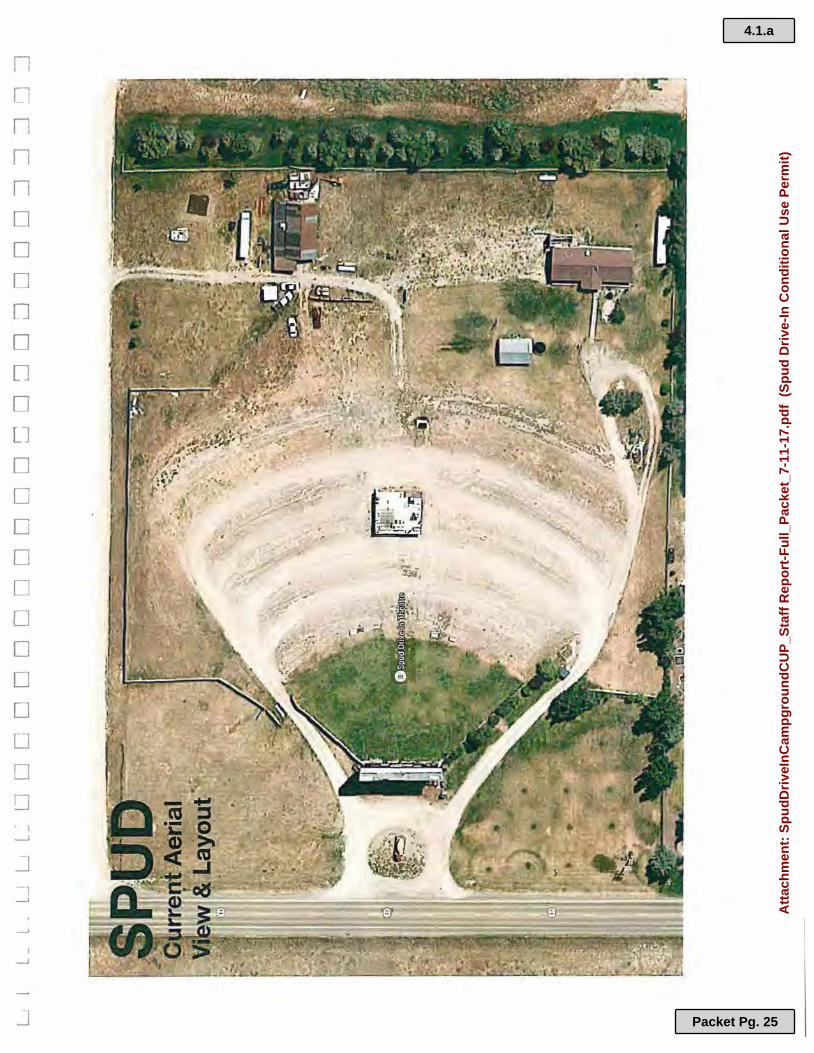
LOCATION: 2175 S. Hwy 33 ZONING DISTRICT: A-2.5 PROPERTY SIZE: 7.51 acres VICINITY MAP:
The Spud Drive-In Campground CUP Application Planning & Zoning Commission
4.1.a
Packet Pg. 11
Att
ach
men
t: S
pu
dD
rive
InC
amp
gro
un
dC
UP
_Sta
ff R
epo
rt-F
ull_
Pac
ket_
7-11
-17.
pd
f (
Sp
ud
Dri
ve-I
n C
on
dit
ion
al U
se P
erm
it)
PROJECT BACKGROUND:
Mrs. Mumm submitted an application for a Conditional Use Permit on May, 26th 2017, proposing to develop 10 camp sites with a variety of permanently located structures as described in the application materials. The Spud Drive in is located within the Scenic Corridor Overlay, however the portion of the site that will be utilized for the proposed use will be outside of the scenic corridor. There is existing fencing, which along with the movie screen, serves to screen the property from the Highway. No other overlay areas are identified on the County's maps.
The Spud Drive-In is currently zoned A-2.5. The drive in would be categorized as a non-conforming use in the Zoning Ordinance (Title 8 - Zoning Regulations, Chapter 7 - Nonconforming Uses). Nonconforming uses can be continued and expanded but only on the lot occupied by the land use on the effective date of the zoning ordinance in effect on March 11, 1996. The proposed use is not an expansion of the existing use but a proposal for a new use.
KEY ISSUES: Planning Staff comments: The applicant was encouraged to work closely with Eastern Idaho Public Health (EIPH) and submit estimated occupancy for wastewater flows to determine if an Nutrient Pathogen (NP) evaluation will be required. The application materials identify that the use will remain under the threshold for a large soil absorption system (the threshold is the potential to produce 2500 gallon of wastewater per day). It appears that the proposed use would not be required to pursue an NP evaluation.
The only overlay present on the site is the Scenic Corridor as discussed above.
The current ordinance includes provisions for a Campground as a conditional use in the ARR 2.5 Zone, which the entire parcel is zoned currently. This use is permitted in the zone through a Conditional Use Permit.
INTER-AGENCY AND DEPARTMENTAL REVIEW COMMENTS Eastern Idaho Public Health- The applicant has consulted with Mike Dronen at EIPH to determine flow rates for the proposed uses in order to calculate wastewater and determine if a Nutrient Pathogen evaluation is required. It appears that it is not required.
Teton County Fire District- Teton County fire marshal, Earle Giles, determined that the proposed use will not require provision of a fire suppression system based on the definition of permanent structures. It is recommended that the applicants continue to develop a plan for fire control and other emergency situations on site, until emergency services are able to arrive for both current uses and proposed uses. County Engineer- There is no proposed additional access or development of roads. _It was discussed with the applicant the willingness of MD Nursery to allow access from the private road to the North for the proposed use. The existing use of the Drive - In and previous temporary uses have the
The Spud Drive-In Campground CUP Application Planning & Zoning Commission 2
4.1.a
Packet Pg. 12
Att
ach
men
t: S
pu
dD
rive
InC
amp
gro
un
dC
UP
_Sta
ff R
epo
rt-F
ull_
Pac
ket_
7-11
-17.
pd
f (
Sp
ud
Dri
ve-I
n C
on
dit
ion
al U
se P
erm
it)

potential to back up traffic on Hwy 33. Although not associated with this permit it is recommended the applicants seek ways to address this issue by adding additional capacity to move traffic through ticketing.
SPECIFIC REQUIREMENTS FOR PUBLIC HEARING NOTICE: Idaho Code, Title 67; Section, 67-6512 Special Use Permits, and Title 8, Section 8-6-1-B.4. of the Teton County Zoning Ordinance. The public hearing for the Planning & Zoning Commission was duly noticed in the Teton Valley News. A notification was sent via mail to surrounding property owners within a 300-foot buffer area and all adjacent subdivision lot owners. A notice was also posted on site on June 30, 2017. The public hearing will be continued to the August 8th agenda to allow adequate time for public input.
COMMENTS FROM NOTIFIED PROPERTY OWNERS & PUBLIC AT LARGE No public comments have been received at the time the staff report was prepared.
SECTION 8-6-1-B-7 CRITERIA FOR APPROVAL OF A CONDITIONAL USE The following findings of fact shall be made if the Conditional Use is recommended for approval. If the application is being recommended for denial, the Commission should likewise specify the reasons for denial based on the items listed below.
1. Location is compatible to other uses in the general neighborhood. The proposed use is located on a site with an existing non-conforming use, the drive-in. It is surrounded by property with commercial zoning on the north, south and east. It fronts State Highway 33 on the west and across the highway the use is agriculture .. There are residential uses farther to the north separated by agricultural land. It is expected that the proposed use will not significantly increase impacts to adjacent properties beyond the existing impacts from the primary use. The public hearing, with notice to adjacent owners, is a good opportunity to discuss potential conflict with any adjacent landowners as it provides them an opportunity to identify potential conflicts.
2. Use will not place undue burden on existing public services and facilities in the vicinity. The application asserts that the proposed use will not create undue burden on existing public services or facilities. The primary considerations would seem to be wastewater and fire safety which have been discussed. Other agencies have been given an opportunity to respond to the application as discussed above. The Commission should determine whether any additional studies or information is necessary to determine that the proposed use will not place undue burden on services and facilities.
3. Site is large enough to accommodate the proposed use and other features as required by this title. The site consists of 7.51 total acres for the proposed 10 camp sites and the existing uses related to the drive-in. As shown on the site plan, there appears to be adequate space to physically accommodate the proposed uses and existing uses, including access and parking.
4. Proposed use is in compliance with and supports the goals, policies and objectives of the Comprehensive Plan.
The Spud Drive-In Campground CUP Application Planning & Zoning Commission 3
4.1.a
Packet Pg. 13
Att
ach
men
t: S
pu
dD
rive
InC
amp
gro
un
dC
UP
_Sta
ff R
epo
rt-F
ull_
Pac
ket_
7-11
-17.
pd
f (
Sp
ud
Dri
ve-I
n C
on
dit
ion
al U
se P
erm
it)

The Commission is encouraged to consider the following policies in determining if the application is in compliance and in determining appropriate conditions of approval.
CONSISTENCY WITH THE APPLICABLE GOALS & OBJECTIVES OF THE TETON COUNTY COMPREHENSIVE PLAN 2012-2030
Goal Economic Develpment 1: Develop a coordinated and collaborative economic
development strategy that encourages, promotes and supports locally-owned businesses and creates a hospitable and attractive environment for businesses and tourists. Goal ED 1, Policy 1.3: Encourage and support local commerce. Goal ED 1, Policy 1.6: Encourage and pursue economic diversity, innovation and creativity to
keep our economy stable. Goal ED 1, Policy 1.7 : Support the expansion of recreational, cultural, and entertainment
options that would improve the visitor experience and boost economic development.
Goal ED 2: Preserve our rural character and heritage and promote local agricultural industries. Goal ED 2, Policy 2.1: Encourage development and land use proposals that support prime
economic values of rural character and heritage. Goal ED 2, Policy 2.3: Promote smart growth strategies that help preserve rural character by
enhancing existing communities and directing development towards them. Goal ED 2, Policy 2.4: Encourage and attract businesses that are economically and
environmentally friendly, and promote stewardship and accountability in business. Goal ED 2, Policy 2.5: Encourage development that adheres to environmental standards.
Goal ED 3: Recognize that tourism and lifestyle are fundamental components of our economy and are dependent on healthy natural resources.
Goal ED 3, Policy 3.1: Encourage economic development through the promotion of recreational opportunities and natural resources.
Goal ED 3, Policy 3.2: Conserve Teton County's natural resources in order to enhance economic development.
Goal ARH 1: Preserve and enhance Teton Valley's s~all town feel, rural heritage and distinctive identity. Goal ARH 1 Policy 1.3: Goal ARH 1 Policy 1.4:
corridors.
Ensure that open spaces are managed responsibly. Maintain the County's rural heritage through the scenic
Goal ARH 1 Policy 1.5: Support the preservation of open space, farmland, natural beauty, and critical environmental areas.
Specific provisions related to Campground Conditional Uses:
Campground, RV Park, Travel Trailer Camp (CU)
CAMPGROUND, RV PARK OR TRAVEL TRAILER CAMP Definition: A parcel of land under single, unified ownership or control, within which spaces are rented or used by the ownership for
The Spud Drive-In Campground CUP Application Planning & Zoning Commission 4
4.1.a
Packet Pg. 14
Att
ach
men
t: S
pu
dD
rive
InC
amp
gro
un
dC
UP
_Sta
ff R
epo
rt-F
ull_
Pac
ket_
7-11
-17.
pd
f (
Sp
ud
Dri
ve-I
n C
on
dit
ion
al U
se P
erm
it)
occupancy by two (2) or more recreational vehicles and may include tent sites, cabin sites, or travel trailer sites for nightly or short-term rental. 8-4-2 Land Use Definitions;
The proposal appears to meet the definition of a Campground, RV Park, Travel Trailer Camp as defined in the Teton County Zoning Ordinance.
Staff analysis of conditions and restrictions on specific uses.
In regards to studies, studies are typically driven by either the presence of overlays or the scale of a development. As mentioned the site does not include overlays other than the scenic corridor. The applicant has discussed the potential need to conduct an NP evaluation with the Health District. The applicant identifies a plan to remove or have previously removed materials from the site in an effort to "clean up" the site.
Planning staff would suggest that the camping use generally meets the four criteria for reviewing a CUP application, however the criteria are generic and allow for specific conditions to be applied based on the nature of the use and the site.
RECOMMENDED MINIMUM CONDITIONS OF APPROVAL
• Compliance with Dark Sky Lighting Ordinance: All exterior lighting must conform to Teton County Ordinance 9.4.12., for both the existing uses and the new proposed use.
• Applicant obtains all necessary permits/approvals from Teton County as well as other regulating agencies including water and wastewater permits from EIPH/IDEO/IDWR, and as discussed in inter-agency and departmental review comments above.
• a. Buffer: Buffers not less than 20 feet in width from all property lines shall be provided and maintained, unless otherwise specified. (Permanent structures must meet current county setbacks for the zone which are more restrictive.)
• b. Screening: Screening from adjacent uses or developments, including across a county road from such a use or development, shall be provided and maintained. Screening shall be accomplished by landscaping at least six (6) feet high and should be high altitude, native plant material, trees and shrubs or existing vegetation.
• c. Lighting: Outdoor lighting, current and future, shall comply with the Outdoor Lighting provisions of this Title, Section 8-4-6.
• d. Parking: The parking requirements of Title 8, Table 3 shall be met and the Americans with Disabilities Act (ADA) required handicap parking spaces provided. In lieu of the above, a parking plan prepared by a professional in the field shall be submitted to the planning administrator for consideration.
• e. Hours of Operation: Hours of operation shall be determined through this hearing process as well as any seasonal restrictions.
• f. Signage: Signage shall comply with the Title 8, Chapter 9 sign requirements.
• g. Outside Storage: Where outside storage is permitted, such use shall be located in the rear yard and a sight proof fence or natural screening shall be provided and maintained around the storage area at least one foot higher than the stored material
The Spud Drive-In Campground CUP Application Planning & Zoning Commission 5
4.1.a
Packet Pg. 15
Att
ach
men
t: S
pu
dD
rive
InC
amp
gro
un
dC
UP
_Sta
ff R
epo
rt-F
ull_
Pac
ket_
7-11
-17.
pd
f (
Sp
ud
Dri
ve-I
n C
on
dit
ion
al U
se P
erm
it)

• h. Building Height: Maximum height is 45 feet in the C-1, C-2, C-3, and M-1 districts, and 30 feet in all other districts, unless specified in Title 8.
• i. Technical Studies: The Commission should determine any studies required
• j. Onsite Inspection: The planning administrator may determine that there is a need for an inspection at any time.
• Other conditions could be discussed by the Commission and considered where relevant and included in a motion to make recommendation to the Board.
PLANNING & ZONING COMMISSION ACTION:
D. Continue to a future PZC Public Hearing with reasons given as to the continuation or need for additional information.
PLANNING STAFF RECOMMENDATION: ACTION D, Continue to a future PZC Public Hearing with reasons given as to the continuation or need for additional information.
The following motions could be given:
Having reviewed the application materials for The Spud Drive-In campground, as well as the additional material provided by staff and other agencies; I hereby move to CONITINUE THE HEARING TO THE AUGUST 8TH PLANNING AND ZONING MEETING in order to meet notice requirements and provide adequate notice to surrounding property owners, and to request any additional information as follows ...
Prepared by Joshua Chase Attachments: • Application
o Original Application Packet o Narrative packet o Site Plan o Map of noticed properties
End of Staff Report
The Spud Drive-In Campground CUP Application 6
Planning & Zoning Commission
4.1.a
Packet Pg. 16
Att
ach
men
t: S
pu
dD
rive
InC
amp
gro
un
dC
UP
_Sta
ff R
epo
rt-F
ull_
Pac
ket_
7-11
-17.
pd
f (
Sp
ud
Dri
ve-I
n C
on
dit
ion
al U
se P
erm
it)

CONDITIONAL USE PERMIT APPLICATION
Teton County, Idaho
The planning staff is available to discuss this application and answer questions. Once a complete application is received, it will be reviewed by the planning administcator or his designee and then scheduled for a public hearing with the Planning and Zoning Commission, who will make a recommendation to the Board of County Commissioners. A second public hearing will be scheduled with the Board of County Commissioners who will make the final decision. It is recommended that the applicant review Title 8 of the Teton County Code and 67-6512 of the Idaho Code. Application materials may be viewed on the Teton County Idaho website at www.tetoncountyidaho.gov.
To <!xpedite tbe rf!·view of your llpplication, please be ;ure tu llcldrcss em:b of the fullowiug items.
SECTION I: PERSONAL AND PROPER1Y RELATED DATA
Owner: i./,aA,-..,tb ::Z,A\:zhf'
Applicant: ~ f'1.,.mv:r, E-mail: :'be:< >ps,..,¼J,tivl. ;f'\Qb"""'"i\ -~
Phone: c ic,'6) ·1s, {% 1£\' Mailing Address: __ ];,.x...:..,\ 7....;...,J$'----'S=--_____ \~"'-"'9~"'....;.."V_t..-+'7-Y'--:z __ _
City: --'Q.....,__,/'='.)¥~~~--,,.---- - - - ----S.tatc: ::c.() Zip Code: ~> C.fZ,Z.
Engineering Firm: ___ ______ Conmct Person: ______ Phone: ( >~----Address:. ______ ____________ E-mail: ___ __________ _
Location and Zoning District:
Address: 1,..\ ·3 ? S (J) ~p O 4 N 4 5 6 l I l t 4
\\:. '&,wry 3~ Parcel Numb~ lP Qt..¼ N L/ Sf. 1] 1 ' 0 Section: _ ____ Township: ____ _ .Range: ____ Total Acreage: 7 • 5 \ Zoning District: _________ .Requested Land Use: ________ _ _ _____ _ _
I, the undersigned, have reviewed the attached information and found it to be correct I also understand that the items listed below ace required for my application to be considered complete and for it to be scheduled on the agenda for the Board of County Commissioners public hearing.
• Applicant Signa"~ ta Z[ ;;.;..-=r ~ Date: _a_3-/z_ .. ,_/__,__\ 7 ___ Fees are 11on-refi1ndable.
T1..·ton Comtr\\ lifaho/( .or11.lit1n11:1I l 1$(; \pplic~nion -J.~6.~ll l I I of3
4.1.a
Packet Pg. 17
Att
ach
men
t: S
pu
dD
rive
InC
amp
gro
un
dC
UP
_Sta
ff R
epo
rt-F
ull_
Pac
ket_
7-11
-17.
pd
f (
Sp
ud
Dri
ve-I
n C
on
dit
ion
al U
se P
erm
it)
I, the undersigned, am the owner of the referenced property and do hereby give my permission to ---------,.. _ to be my agent and represent me in the matters of this application. I have read the attached information regarding t4e application and property and find it to be correct.
• Owner Signature:. ___________________ Date: ________ _
SECTION I: REQUIRED ITEMS
1. Latest Recorded Deed to the Property 2. Affidavit of Legal Interest 3. Application fe
1~- paid in full in accordance with current fee schedule
4. Twelve (~) 'l:opies of information and data (pictures, diagrams, etc.) necessary to assure the fullest presentation of the facts for evaluation of the request.
5. Twelve ~~pies of a site plan drawn to scale. 6. Narrative explaining the following:
• Location is compatible to other uses in the general neighborhood. • Use will not place undue burden on existing public services and facilities in the vicinity. • Site is large enough to accommodate that proposed use and other features of this ordinance. • Proposed use is in compliance with and supports the goals, policies, and objectives of the
Comprehensive Plan
SECTION III: CRITERIA FOR RECOMMENDATIONS AND DECISIONS
t. Upon the granting of a conditional use pennit, conditions may be attached to a conditional use permit including, but not limited to, those: • Minimizing adverse impact on other development; • Controlling the sequence and timing of development: • Controlling the duration of development; • Assuring that development is maintained properly; • Designating the exact location and nature of development; • Requiring the provision for on-site or off-site public facilities or services; • Requiring more restrictive standards than those generally required in this Title; • Designating the number of non-family employees in the home occupation and home business based
on the type of business and the location; • Requiring mitigation of effects of the proposed development upon service delivery by any political
subdivision, including school districts, providing services within the planning jurisdiction. 2. Prior to granting a conditional use pennit, studies may be required of the social, economic, fiscal, and
environmental f:ffects of the proposed conditional use. A condit_ional use pennit shall not be considered as establishing a binding precedent to grant other conditional use pennits. A conditional use pennit is not transferable from one (I) parcel of land to another.
3. Commercial Development Agreement for all land uses in the C-1, C-2, C-3, and M zoning designations are required to include the following, as applicable: • A site plan and/or survey prepared by a professional surveyor to include current and proposed
plan; • A professionally prepared landscaping plan; • Financial guarantee for public improvements which may include but not be limited to: roads,
phone, electric, water, sewer, fire protection, and lighting; • Professionally prepared final construction drawings.
2of3
J
.\
l. I
ii ·)
l
4.1.a
Packet Pg. 18
Att
ach
men
t: S
pu
dD
rive
InC
amp
gro
un
dC
UP
_Sta
ff R
epo
rt-F
ull_
Pac
ket_
7-11
-17.
pd
f (
Sp
ud
Dri
ve-I
n C
on
dit
ion
al U
se P
erm
it)
SECTION IV: SPECIFIC REQUIREMENTS FOR PUBLIC HEARING AND NOTICE
Notification is required for both hearings in accordance with Title 67, Chapter 65; Section 6509 of the Idaho Code. Notice shall be provided by mail to property owners \vithin the land being considered, and within three hundred (300) feet of the external boundaries of the land being considered, and any additional area that may be impacted by the proposed change. Notice shall also be posted on the premises not less than one (1) week prior to the hearing. At least fifteen (15) days prior to the hearing, notice of the time, date and place and a summary of the plan to be discussed shall be published in the newspaper of general circulation within the jurisdiction. This procedure \vill be completed by the planning staff.
SECTION V: STAFF SUMMARY ANALYSIS, REASONING AND FACT FINDING
SECTION VI: PLANNING AND ZONING COMMISSION ACTION
SECTION VII: BOARD OF COUNTY COMMISSIONERS ACTION
3 of3
4.1.a
Packet Pg. 19
Att
ach
men
t: S
pu
dD
rive
InC
amp
gro
un
dC
UP
_Sta
ff R
epo
rt-F
ull_
Pac
ket_
7-11
-17.
pd
f (
Sp
ud
Dri
ve-I
n C
on
dit
ion
al U
se P
erm
it)

4.1.a
Packet Pg. 20
Att
ach
men
t: S
pu
dD
rive
InC
amp
gro
un
dC
UP
_Sta
ff R
epo
rt-F
ull_
Pac
ket_
7-11
-17.
pd
f (
Sp
ud
Dri
ve-I
n C
on
dit
ion
al U
se P
erm
it)
PL..\2'":\'l!'i"G A;\'D Bl"ILDJl\G DEPART)IE:'iT ,\ff,\DA \'IT Of LEGAL l:'ITERf:ST aud
LETTER OF Al'THORIZ..-\TIO:\'.
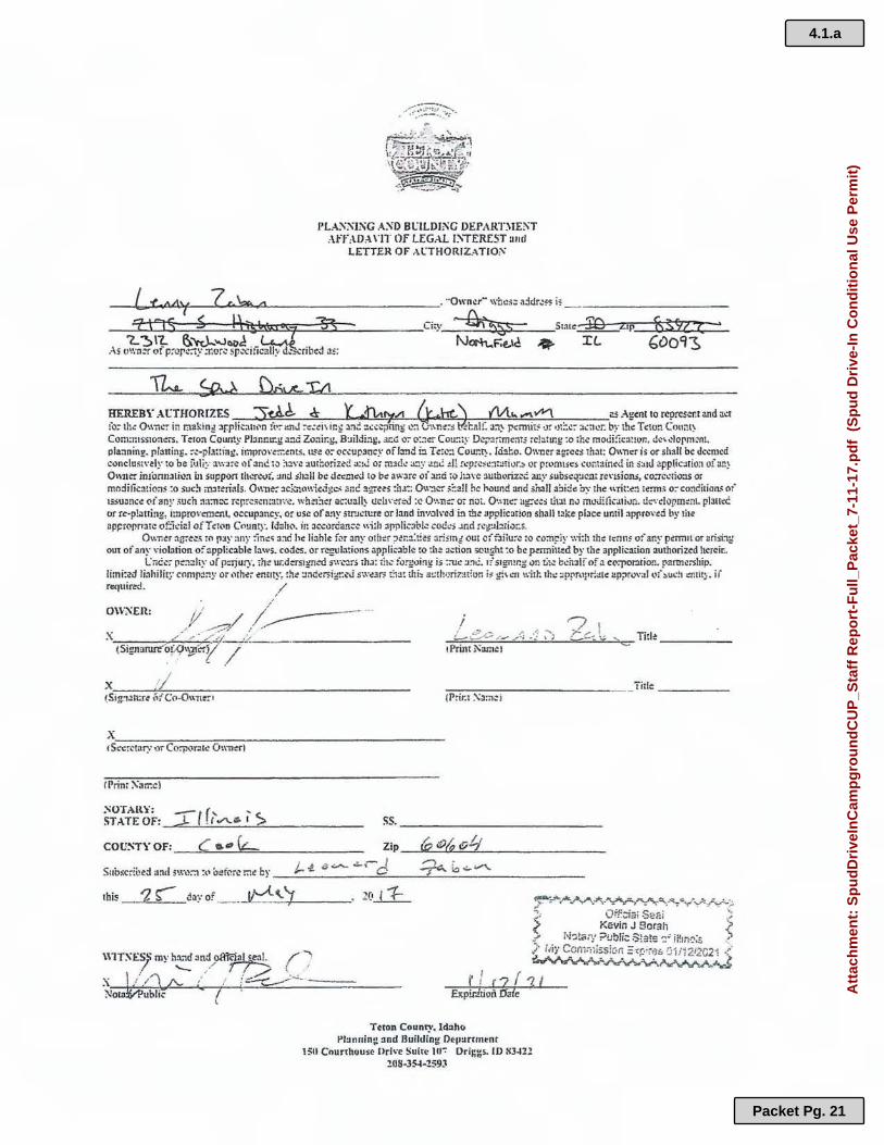
HEREBY . .U:TJIORrZES tA~ ¢ i.. ..-,. v'Y\ as .J.2:cnl 10 rcorcsent and act 10: th~ Ownc!' in rna1dng :ir-plkath,n ?C':- enJ :-e:~h ir.g ant : .:~~ tin~ ~:1 u ,"n.::-s d:al!: a:1~ pc:m1ii~ tJr ,,t=:..::- :tLt1~r: by th:: Tc:ton Coum~ Con1:n1s~tone:-s. Teton Coun!y Pfannu:.g a...~d Zo:iir.g, B:iildi=iy, .:1.C.G o:- o::?er Cou~Ly De~:?ri:me;ns re!~tmg :o ,h.: motii:ic:itton, d~\ i!lorm~nt plarmin¥- platting. ~~-pla:tin:,:, impro\'= cnts. us~ o~ Qc,upam:y ofl:md i:;. Tc,~:! Cour.ri, . ld:iho. Owner zgre~s 1ha1: O,mer is or sb3II be deemed c1>nclus1,·t ly to be ii.tliy awJrc ,,fant.!.1~ :l:tv.: 3.Uthorizl!'C a::J or m:1d..! a:l)" an&! .!I! r~prcsi.::1t~rh,r.!i l'r pronnsc:s .:ontain<d in :i:s1U app{ic;nion ofan} O\\111::: imomllli~:i in support lhl!n!r.ll: :md sh:?11 b.: deemed to be awJrc .:,i ami ;;:, l::ivc !lulhoriz~;;;. any subscq~c.nt re\·1sioru, co:rectio:is o: modifications :o suc!t rri~t~rials. 0,\11.:: :1c~1.o,•.ic.ige,,. am: agrc~:i :b..1:: Q\,-:1,:r s!:aH he hllund 3Ild sha11 abid~ h~.- the \\rit:.?:1 term; o:-conCitian..( of 1;;suance oiany .,uch :1a:m:.:: rcr,rc.,cn,a:1ve. wh:1:1~r ac;l!all~ t!chn:r=d :c O\•.n;:: or no,. O\,111:: ,1~ees tl1;1! nv mllJitica1i,m. d;:,·dop.m~nl. plan,c or re-platting, i:nprovam:nt, occupancy. or use of any S'!r'Jcll:re or land in'loh·ed in the application shall !~ke place: umil appro\·ed by 1be api:r(lpr,arc of:kfal ofTcwn Cmmtr. ldah;:,. in acc.:,rcian;;.: wi:h applkal,,l.: cod.:; .Jnd rcg,Jbii;:,::s.
Own~r :ig:~~:\ ro 11:iy :my :in~-li :i:,d h.: li:ihle for any othc!r ;,t1~:i:t:es ~rismi out cf flHu:~ :o co:n~iy wi:h thi:: 1;:nn$ of an~· pennn or arisbg out of any viobtion of zpplicable laws. codes • .:,r rcgula!fons applk :i!Jlc :o :he Jction sought :o be pmnil~d by the application authorized herein.
e iiCl!'r p;::,;:Jty llf p:rjury. rh~ u;.d~1gno::l s .. ·.-~r5 th.1: &h.: fo!];•Jing is :=ut! :1~1.!. 1! s1gnmg on L1..-: bd1:df of .1 cCt:po~iori_ partnership .. li:ni:~d linhilit:: comp;!:,y or ,1th.?i entny~ !h~ :.1nder5ig::.:J s;v~3r5= ~:'i:!t ihh at:th,;riz:-!tfon i~ g!\ c..-i1 wit~ thi: :!p;,n11,r:at.: up?rov:tl or'" !)ud1 ~mif;,. ii' require-J. ,/
OW~Ell: /
I ,(/ / --------..-7,/ : -X ,,,., .... - .. -·· .. :,_· _ _ .> _ ______________ _ (Signarure-~J:.<;l,~cry ./
L-~~--~..,,, _ . .!; /} .. ;
1Print 1',amct
71 ;.....-f:;. \::;; "c TiII~ ______ _
x __ ..,.,/,----.,,..----------(Sig:mur~ M Co-O" ~=r•
x,_---.....,=-----,,.---------------------1 Sccr~tary or Co:r,vr:il~ Own~rl
IPrint ~an:e)
~OTAlt">!; ST ATE OF:_:r=·~ f_f_,'.......__a._1~>~--- --- ss. ------------- ---COU:o;TY OF: _ _.,,.C:......c;e._.,_~==------- Zip_-<P .... (f),~*~O~t/,__ _____ _
t--1. t) ~~r-J ~ra~V"\.. St1bscribed and s•.r.-~::t :(., O!?t~~rl! r.-tc! by - --- -------'---~-~-------------
this 1 S-- a;i:: of _ _ ~ _\.....,7-------
\\lTXES~ my ha:id and ,,~a7'"~ /' "'r / - .· / ( ... I / ,..,.~ . ' :" :::-- --- ----
-~ ~ I L.:::: ,,. • , ----Nota ~ ublic / ·
' E.'tpir.ltiozi !5aie
Teton County, ldJho Pl:inning :md Building Dtp:irrrnent
150 Courthous~ Ilri,·e Suite 111-: Driggs. ID 83-121 ?08-3~-259J
Tiilc ______ _
4.1.a
Packet Pg. 21
Att
ach
men
t: S
pu
dD
rive
InC
amp
gro
un
dC
UP
_Sta
ff R
epo
rt-F
ull_
Pac
ket_
7-11
-17.
pd
f (
Sp
ud
Dri
ve-I
n C
on
dit
ion
al U
se P
erm
it)

4.1.a
Packet Pg. 22
Att
ach
men
t: S
pu
dD
rive
InC
amp
gro
un
dC
UP
_Sta
ff R
epo
rt-F
ull_
Pac
ket_
7-11
-17.
pd
f (
Sp
ud
Dri
ve-I
n C
on
dit
ion
al U
se P
erm
it)

l • l. 1 l l J u L _ ~ Ll L 1 Ll LJ u L J ~ 1 ~ J c J l o _c CJ . o o o ::::J o o =i =i =i =i :J
TH,E SPUD HISTORIC DRIVE-IN
CAMPGROUNDDEVELOPMENTPROPOSAL ·
4.1.a
Packet Pg. 23
Att
ach
men
t: S
pu
dD
rive
InC
amp
gro
un
dC
UP
_Sta
ff R
epo
rt-F
ull_
Pac
ket_
7-11
-17.
pd
f (
Sp
ud
Dri
ve-I
n
l _ L . l _ l __ L~ [~ C ~ D n D D D O n D O D D CJ :J D D O u =1 D =1 :J :J =.J :J
INTRODUCTION
The Spud Drive-in was built by Ace Wood in 1953. Still in operation to this day, making it one of the few remaining operational drive-ins in the U.S. The Drive-in resides just off Hwy 33 between Victor and Driggs, Idaho; with views of the Big Hole mountain range. Along with showing films and offering a full service snack bar the Spud regularly holds concerts, shows and other events. The Spud sits on 5 Beautiful acres that offer a variety of commercial opportunities. Due to the unique nature of the Teton valley as a destination area year round thanks to nearby Ski resorts and other attractions the Spud could easily capitalize on a consistent visiting population.
This development review will serve as a concept-campground proposal to install 10 short term rental units.
4.1.a
Packet Pg. 24
Att
ach
men
t: S
pu
dD
rive
InC
amp
gro
un
dC
UP
_Sta
ff R
epo
rt-F
ull_
Pac
ket_
7-11
-17.
pd
f (
Sp
ud
Dri
ve-I
n
n [l
n n n D D
D
n D []
D
Ll D D D D D
D D
D
D
D
D
D _j
__J
I __J
_j
4.1.a
Packet Pg. 25
Att
ach
men
t: S
pu
dD
rive
InC
amp
gro
un
dC
UP
_Sta
ff R
epo
rt-F
ull_
Pac
ket_
7-11
-17.
pd
f (
Sp
ud
Dri
ve-I
n C
on
dit
ion
al U
se P
erm
it)
L . L l . L. L . L . L_. l - LJ LJ L .l L~ D L] n n D D D ~ D D D LJ D D D =i =i =i =] =i
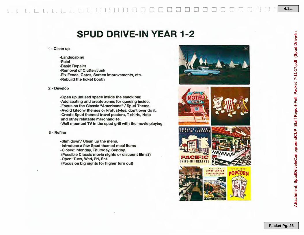
SPUD DRIVE-IN YEAR 1-2 1 - Clean up
-Landscaping -Paint -Basic Repairs -Removal of Clutter/Junk -Fix Fence, Gates, Screen improvements, etc. -Rebuild the ticket booth
2- Develop
-Open up unused space inside the snack bar. -Add seating and create zones for queuing inside. -Focus on the Classic "Americana" / Spud Theme. -Avoid kitschy themes or kraft styles. don't over do it. -Create Spud themed travel posters, T-shirts, Hats and other relatable merchandise. -Wall mounted TV in the spud grill with the movie playing
3 - Refine
-Slim down/ Clean up the menu. -Introduce a few Spud themed meal items -Closed: Monday, Thursday, Sunday. (Possible Classic movie nights or discount films?)
-Open: Tues, Wed, Fri, Sat. (Focus on big nights for higher turn out)
4.1.a
Packet Pg. 26
Att
ach
men
t: S
pu
dD
rive
InC
amp
gro
un
dC
UP
_Sta
ff R
epo
rt-F
ull_
Pac
ket_
7-11
-17.
pd
f (
Sp
ud
Dri
ve-I
n
n n n n n D []
D
D
D
D []
D
D
D D
D D
0
D
D D
D
=1 7 _j
=i
=i :J
1 __,
, --'
..:
• $-i,
' .. I . .
./ ', . ',; ~ 1 •• ~,( ~-.., .:
4.1.a
Packet Pg. 27
Att
ach
men
t: S
pu
dD
rive
InC
amp
gro
un
dC
UP
_Sta
ff R
epo
rt-F
ull_
Pac
ket_
7-11
-17.
pd
f (
Sp
ud
Dri
ve-I
n C
on
dit
ion
al U
se P
erm
it)

L L . L . L LJ L L. LJ L:_; D C D D [l n D D D D ~ D D D D D D :J =:J :J :J =:J
4 - Build
-Install short term vacation rentals: 4 yurts, 2 tipis, 2 sheep wagons 2 Silver Streaks RVs (similar to airstreams).
-Silver Streaks complete the Americana drive-in theme. They will be placed within viewing distance of the screen for . overnight rentals.
-Look to add appropriate value to unused space at the Spud, not overdoing anything but always de-cluttering and evaluating every area to find the perfect balance of historic American landmark and profitable business.
. Focus on creating a full purpose destination at the Spud. Continue cleaning and building/updating the grounds and amenities. Seek to make the Spud an historical landmark and place where people have reason to regularly attend for films and places to stay. Introduce a variety of lodgings and multi-day rentals for people on vacation or traveling.
There is so much potential to be found at the Spud. Cleaning, updating and building could help to make it successful In the future.
4.1.a
Packet Pg. 28
Att
ach
men
t: S
pu
dD
rive
InC
amp
gro
un
dC
UP
_Sta
ff R
epo
rt-F
ull_
Pac
ket_
7-11
-17.
pd
f (
Sp
ud
Dri
ve-I
n

-~- , •••• I ~ - , ,.
.;.,. /
LEGEND
I ••••••• 4' Low height Split rail
fence to tidy up and I separate areas.
, t--+ Potential areas for gates · and traffic flow control.
f 'b./~ llpfs & Shepard wagons
aim Yurts
.... :v- , -I •
,;_Eitfployeiinmd·:: ;overria'1tr~11tal ·: ij~~.!119i · ... , ·
:... ~.- .... -.,..,-~ - ,!
1 ',(Lt., J -.··-
-.(!-_' · _ 1 --IJ . .
. • t.' . I
.~ -
,I:- }!. '1~
--.,
4.1.a
Packet Pg. 29
Att
ach
men
t: S
pu
dD
rive
InC
amp
gro
un
dC
UP
_Sta
ff R
epo
rt-F
ull_
Pac
ket_
7-11
-17.
pd
f (
Sp
ud
Dri
ve-I
n

n n n n n n n D D [1
D
0 [l
C [_;
D ,~ L
[J
[J
=i
~
__J
-, ....J
Eastern Idaho Public Health District: Mike Dronen: Septic Systems
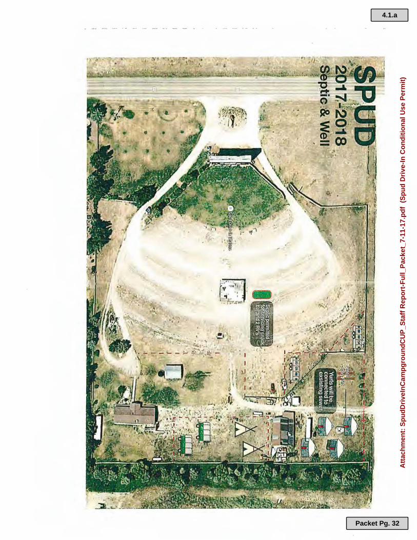
We have contacted the Eastern Idaho Public Health District concerning septic permitting. A 1,000 gallon septic system currently exists on the South East end of the property that is permitted to support a four bedroom home. A septic system currently exists on the North East side of the property where the proposed units will exist. This septic system is 1,000 gallons, and the drain field is located on the west section of property near the units. The units will be placed at least 10 feet away from the drain field to the East By installing each unit without a kitchen, four individual units can be considered a four bedroom residence. We will then place a community kitchen among the units for all units to use. These four units will be connected to the existing septic that is on the North East end of the property, which currently is not supporting any residences or units. When we expand to put an additional 4 more units on this end of the property, we must double the size of the drain field and add an additional tank.
There is one more septic system located adjacent to the Snack Bar building which services the drive-in guests. This system is permitted for the Snack Bar plus an additional 2 RV's. This is where we will drain the waste from the proposed two Silverstreaks.
A large soil absorption system is not something that we are interested in installing. Once a property is using more than 2,500 gallons of waste/day, it is necessary to put in a large soil absorption system. A four bedroom residence will use 300 gallons of waste/day. Each RV uses 150 gallons of waste/day (as itis considered a one bedroom residence because it contains a kitchen). We will have 2 RV's serving as short term rental units. At this time, we are using 300 gallons/waste per a day with our 4 bedroom home on the South East side of the property. The 4 units on the North East side of the property will use 300 gallons/waste per a day. With the existing 4 bedroom home, the proposed 4 unit residence, and the 2 RVs, we will be using a total 900 gallons of waste/ day. Adding an additional 4 units in the near future will bring the total up to 1,200.
State of Idaho Department of Water Resources: Cooper Fritz: Water Permitting
We have applied through the State ofldaho Department of Water Resources for a water permit for the proposed units on the South East end of the property. This application is for 10 units (2 RV's and 8 units).
We have applied for a Commercial Exempt water permit. This allows for 2,500 gallons/day, with 18 gallons/minute per a unit.
1
4.1.a
Packet Pg. 30
Att
ach
men
t: S
pu
dD
rive
InC
amp
gro
un
dC
UP
_Sta
ff R
epo
rt-F
ull_
Pac
ket_
7-11
-17.
pd
f (
Sp
ud
Dri
ve-I
n C
on
dit
ion
al U
se P
erm
it)
n n n n n D n D D
n D [l
D l7 D C
D
--, __J
l
_j
_J
_J
_J
J
Each unit, including the two RV's, will have the capacity to sleep 4 people.
50 gallons of water is used per a day per a person. 10 units housing 4 each equals 40 people per a day. 40 people using 50 gallons of water each equals a total of 2,000 gallons per a day.
It will be necessacy to install a pressure tank system in the center in order to get 18 gallons/ minute.
Teton County Fire Department: Earl Giles: Emergency Preparedness
Earl Giles is working with us to ensure fire safety is met He informed us that certain units, such as yurts, tepees, and sheep stations, do not have the same fire safety requirements as a cabin. If we placed such units on the property, we will not be required to install a fire pond, an underground cistern, or fire hydrants. These conditions apply as long as the units are not fixed to a foundation and are not considered a permanent structure, as stated by the international fire code. The legal definition of a permanent structure is a structure that is placed on the land that is affixed to the ground.
Compliance with the Comprehensive Plan
We believe that the proposed is in compliance with and supports the goals, policies, and objectives of the Comprehensive Plan.
We are not located in a big game migration corridor, a flood plane, or wet lands.
We believe that this economic development is suitable for this county, as the proposed plan will support and preserve a business that has been here since 1953.
Undue Burden on Existing services and Facilities in the Vicinity
MD Nursery is located on our South side, as well as our East side. The proposed units will be located along the property that borders the East side of MD, where MD has a gravel/ equipment pit
On our North side is located Del and Terry Fullmer's farm. There are several acres of farm fields between our proposed units and their farm home. We have established a healthy business relationship with the Fullmers, with positive and constructive communication.
The proposed units will not place undue burden on existing services and facilities in the vicinity, and is compatible to other uses i~ the general neighborhood.
2
4.1.a
Packet Pg. 31
Att
ach
men
t: S
pu
dD
rive
InC
amp
gro
un
dC
UP
_Sta
ff R
epo
rt-F
ull_
Pac
ket_
7-11
-17.
pd
f (
Sp
ud
Dri
ve-I
n C
on
dit
ion
al U
se P
erm
it)
4.1.a
Packet Pg. 32
Att
ach
men
t: S
pu
dD
rive
InC
amp
gro
un
dC
UP
_Sta
ff R
epo
rt-F
ull_
Pac
ket_
7-11
-17.
pd
f (
Sp
ud
Dri
ve-I
n C
on
dit
ion
al U
se P
erm
it)

L .. I L - L - L . t__ LJ L l I I I ' n '7 D :7 n ~ D n I -, I Teton County", Idaho _ _, _J - '.__J _J _j _j
--, __ J
July 5, 2017
RP04N45E111200 WYDAHO GROUP LLC
RP04N45E"111 :100
2175; 5 Hi9l1w;-iy . ..
I
RP04N45E·t '1060·1 FULLMER. DELL
..
RP04N45E11·12s,i VYDAHO GROUP LLC
L ~.:i, 10~
l't ll.'•4
In lvlr; 1'1•~ r1,.~at,!,,
MO NURSERY. & LANDS GAPING tNC
1.11 1 1•1111 · ' ' '·
D County Boundary Sections Road Surface
11
• Address
o Sub Address
Parcels Pavement (asphalt/ chip seal)
Gravel
RP04N4-'iH11 253
l I I I I
B & M Ll~ND & LEASING LLC
Earth/ Unimproved 0 0.0175
0 0.02 0.04
I I
I I
i
1:2,257 0.035
0.08 km
Souccea: Earl, HERE, DaLDrme, lnermap, lncremert p Corp., GEBCO, USGS, FAO, NPS, NRCAN, GecBeae, IGN, Kadaaler NL, Or<hlnce Sc.nay,
.l
TelOnCouray GIS
4.1.a
Packet Pg. 33
Att
ach
men
t: S
pu
dD
rive
InC
amp
gro
un
dC
UP
_Sta
ff R
epo
rt-F
ull_
Pac
ket_
7-11
-17.
pd
f (
Sp
ud
Dri
ve-I
n

4.1.a
Packet Pg. 34
Att
ach
men
t: S
pu
dD
rive
InC
amp
gro
un
dC
UP
_Sta
ff R
epo
rt-F
ull_
Pac
ket_
7-11
-17.
pd
f (
Sp
ud
Dri
ve-I
n C
on
dit
ion
al U
se P
erm
it)
EASTERN IDAHO PUBLIC HEAL TH DISTRICT 112001
SEPTIC SYSTEM INSPECTION REPORT Travel Tim~: IS J-\-111\i Inspection Time "3 S ,w_..J
INSPECTION CONDUCTED FOR: Name __ (Z_._<.J-__,_{--'-,..e::>_. __ t-J_c.:._~ ________ Permit No '-/ l O 7 l ~ 7 LOCATION OF INSPECTION: Street Address -2.._~f s~';rt tf w[ ~> City .UiZdcG~
Legal Description: ¼ Section ,,.-:: Section t 1 Township q N Range L.f S@:... ::>
Subdivision: ------===========--- -------Lot ~Block .,., --==== SEPTIC TANK INSPECTION
• Capacity Tank /Q.X)gatlons. A TU ~ gpd. Scp(ic Tank capacity= or greater than permit requirements'? No No No No
NIA • Was Septic Tank construction in comt>fianc:e with Stare regulations and was tank State approved? • Were inlet and outlet properly sealed? • · Did Septic Tank meet minimum separation requircm~ as required by permit? . • Was extension of manhole required? Yes ~ Deprh from final grade to manhole.---'--
~ I reet •
• • • • •
SUBSURFACE DISPOSAL (DRAINFIELD) INSPECTION Type of Disposal System installed ~lU:«;.S Tlr ....JLli- Meets pc:nnit requirements'? Disposal Area Si22 3 9 Co Square Feet In compliance with Permit Issued? Did Disposal System meet the minimum separation distance as required by the Permit? Was Disposal System constructed in ~pfe with the State Technical Guidance Manual?
Maximum depth of Disposal System I Fce1. In compliance with Pennit Issued?
ORA WING: (Show buildi~ septic system compon,:nlS., waia- lincs. ~ waters. & wells within 300 fed of septf(:syslcm. lmponanl to show dislan0c::s.)
w
No No No No No
SELF•INSPECTION; If given approval for self inspection, Installer certifies that infonnation provided is accurate and system was installed as shown. Installers Si nature X License #: Date: ·
~ -, .... _, C _ \ Official Use Only Installed by: ~ '-'..., C:::..>C..4'-JJ\.7"'7\.Y'V License#:
This System appears to: . /"-:~ I . Be in Substantial Compliance with pennit and is approved. ~ 2. Have Minor deficiencies which could cause premature failure. but still in substantial compliance with Intent of Rules.
Recommend that deficiencies be corrected. which could improve your system, but system is still approved. Yes• 3. Have Maior ddidenchs which violate the Intent of Rules and must be corrected. system not approved.
Yes*
NIA
*See Comments
E
/4 cV • ..... I
4.1.a
Packet Pg. 35
Att
ach
men
t: S
pu
dD
rive
InC
amp
gro
un
dC
UP
_Sta
ff R
epo
rt-F
ull_
Pac
ket_
7-11
-17.
pd
f (
Sp
ud
Dri
ve-I
n C
on
dit
ion
al U
se P
erm
it)
.. STRICT·SEVEN HEALTlfDEPA-RTMENT._-·:· .. /· ·· . ·Activity Code: f,~(r
E-PTic:sys~E~INSPECT!_ON)~tEP,Ql{1;.·:.:::f.:·. /t--· __ Travet:Ti~e::;:.: ._:~~;: ••
. · 4/9~ ... . /\__:
~ .
INSPECTION CONDUCTED FOR: Name __ ~£~· ~' c..._, ..... l•~·'~\._· ..... t '_v._v __ ; O,:,....a.,o __ r' ________ Penn it No 4)9 J2, / l l. 2)
LOCATION OF INSPECTION: Street Address _Z.__.3 ......... 1 __ >_. _____ t./..a.•vaa..,'(,-.........:3---·=-3-----,...-..------City {,i r' t 1 ti $ Legal Description: ¼ Section ___ Section I I Township __ ll-.... JJ __ Range 4-S £. Subdivision: /V f ( N •'Ii,. 81e 'C. '"'cf ''$tvd D_r, Vl Z-,,,.. •· Lot ____ Block _____ _
[.:::::·/· . ... ·:---.::·' · · ··\::::.-·· ~:{~,·:'>-:·: ;< ·:-.-:t-:;·.::_:- :·._.,-:;;-~·_;._'.··,;::::::1~:SEP.TI(.tt~:iNS'PECTiot~t?~ :_ ·. :\'} : · .. :.,{:_:: :::·\·~:;;-_- . · ,r_·. \~::?Y:~}i~{ ::/?:~::·· ·<?·: ICu ..,,,./- &1
• Capacity of Septic Tank Installed I OOU ·gallons . . Septic Tank capacity= or greater than permit requirements?
• Was Septic Tank construction in compliance with State regulations and was tank State approved?
• Were inlet and outlet properly scaled?
•
es cs
No NIA No No-'.\t No - ~--· Did Septic Tank meet minimum separation requirements as required by permit? .
• Was extension of manhole required'! Yes @ Depth fiom final grade to manhole. I-
l I y,, feet
IEt.:':\·~::·:,:::::.':.'·::,_:~:!::::-::: :•:<·: :;:;:.-;·:·:.:-;:·:·'.::·:··:. ;'SUBSIJRF-!A('.3E-;DISP.OS~,~LDj~INSPE-011.0N!: ... : : ··:.}l'~-'--::~t'.2'.':'~:;.::::::::·:>~-::~·:,._: ··. ·-:·t :·:
I ~i • • • • •
Type of Disposal System installed · Tt(j,. c:., · t k · · . . ,_Meets pennit requirements'! Disposal Arca Site 4-q l..- Square Feet In compliance with Pennit Issued'! Did Disposal System meet the minimum separation· distance as required by the Pcnnit'! Was Disposal System constructed in co£iancc with the State Technical Guidance Manual? Maximum depth of Disposal System Feet In compliance with Pennit Issued?
NIA
DRAWING: (Show buildings, septic system components, water lines, surface waters, & wells within 300 feet of septic systcm. lmportant to show distances.}
iELF-INSPECTION; If given approval for self inspection Installer certifies that information provided is accurate and system was installed as sho~_.,. ... .. ·· . . .,J:;.!:·,:·- · ·-·
nstallers Signature x _ __________ ______ _____ Llcease #: _______ Date: __ ,_,,,,,.r' · <·
4.1.a
Packet Pg. 36
Att
ach
men
t: S
pu
dD
rive
InC
amp
gro
un
dC
UP
_Sta
ff R
epo
rt-F
ull_
Pac
ket_
7-11
-17.
pd
f (
Sp
ud
Dri
ve-I
n C
on
dit
ion
al U
se P
erm
it)
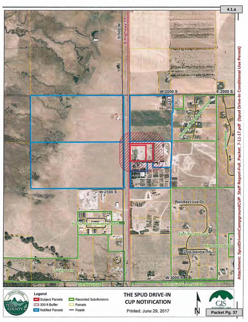
:::ib, ~-"-~·
~ Subject Parcels
fZ2I 300 ft Buffer
1:::1 Notified Parcels
c:::I Recorded Subdivisions
r::::J Parcels
- Roads
I '4
t ,/> I
·'
..
I
~
THE SPUD DRIVE-IN CUP NOTIFICATION
Printed: June 29, 2017
1
·)
,.
11-:"IO"IC.:OUNll' · IIWIO C.ZCXJI.M'HIC NOA,,MAIKr.<ril
S1SltMS
4.1.a
Packet Pg. 37
Att
ach
men
t: S
pu
dD
rive
InC
amp
gro
un
dC
UP
_Sta
ff R
epo
rt-F
ull_
Pac
ket_
7-11
-17.
pd
f (
Sp
ud
Dri
ve-I
n C
on
dit
ion
al U
se P
erm
it)

4.1.a
Packet Pg. 38
Att
ach
men
t: S
pu
dD
rive
InC
amp
gro
un
dC
UP
_Sta
ff R
epo
rt-F
ull_
Pac
ket_
7-11
-17.
pd
f (
Sp
ud
Dri
ve-I
n C
on
dit
ion
al U
se P
erm
it)

The Spud Drive-In Campground CUP Application Planning & Zoning Commission 1
This is an addendum to the staff report prepared for the July 11, 2017 agenda. Please see that staff report for additional information.
APPLICANT: Jedd and Katie MummLANDOWNER: Wydaho Group, LLC (Leonard Zaban)
COMMENTS FROM NOTIFIED PROPERTY OWNERS & PUBLIC AT LARGEOne public comment was received in support of the application at the time this staff report was
prepared.
RECOMMENDED MINIMUM CONDITIONS OF APPROVAL
• Compliance with Dark Sky Lighting Ordinance: All exterior lighting must conform to Teton County Ordinance 9.4.12., for both the existing uses and the new proposed use.
• Applicant obtains all necessary permits/approvals from Teton County as well as other regulating agencies including water and wastewater permits from EIPH/IDEQ/IDWR, andas discussed in inter-agency and departmental review comments above.
• a. Buffer: Buffers not less than 20 feet in width from all property lines shall be provided and maintained, unless otherwise specified. (Permanent structures must meet current county setbacks for the zone which are more restrictive.)
• b. Screening: Screening from adjacent uses or developments, including across a county road from such a use or development, shall be provided and maintained. Screening shall be accomplished by landscaping at least six (6) feet high and should be high altitude, native plant material, trees and shrubs or existing vegetation.
• c. Lighting: Outdoor lighting, current and future, shall comply with the Outdoor Lighting provisions of this Title, Section 8-4-6.
• d. Parking: The parking requirements of Title 8, Table 3 shall be met and the Americans with Disabilities Act (ADA) required handicap parking spaces provided. In lieu of the above, a parking plan prepared by a professional in the field shall be submitted to the planning administrator for consideration.
• e. Hours of Operation: Hours of operation shall be determined through this hearing process as well as any seasonal restrictions.
• f. Signage: Signage shall comply with the Title 8, Chapter 9 sign requirements.
• g. Outside Storage: Where outside storage is permitted, such use shall be located in the rear yard and a sight proof fence or natural screening shall be provided and maintained around the storage area at least one foot higher than the stored material
A REQUEST FOR A CONDITIONAL USE PERMIT BY: The Spud Drive-In
FOR: Campground, RV Park or Travel Trailer CampWHERE: 2175 S. Hwy 33
Prepared for the Planning & Zoning Commission Public Hearing of August 8, 2017
4.1.b
Packet Pg. 39
Att
ach
men
t: M
icro
soft
Wo
rd -
Ad
den
du
mS
pu
dD
rive
InC
amp
gro
un
dC
UP
_Sta
ff R
epo
rt-P
ZC
8-8
-17
(S
pu
d D
rive
-In
Co
nd
itio
nal
Use
Per
mit
)

The Spud Drive-In Campground CUP Application Planning & Zoning Commission 2
• h. Building Height: Maximum height is 45 feet in the C-1, C-2, C-3, and M-1 districts, and 30 feet in all other districts, unless specified in Title 8.
• i. Technical Studies: The Commission should determine any studies required
• j. Onsite Inspection: The planning administrator may determine that there is a need for an inspection at any time.
• Other conditions could be discussed by the Commission and considered where relevantand included in a motion to make recommendation to the Board.
PLANNING & ZONING COMMISSION ACTION:
A. Recommend approval of the CUP, with the recommended conditions of approval listed in this staff report, having provided the reasons and justifications for the approval.
B. Recommend approval of the CUP with modifications to the application request, or adding conditions of approval, having provided the reasons and justifications for the approval and for any modifications or conditions.
C. Recommend denial of the CUP application request and provide the reasons and justifications for the denial.
D. Continue to a future PZC Public Hearing with reasons given as to the continuation or need for additional information.
PLANNING STAFF RECOMMENDATION:
ACTION A., Approval with conditions.
The following motions could be given:
Having reviewed the application materials for The Spud Drive –In Conditional Use Permit, as well as the additional material provided by staff and other agencies; I hereby move to RECOMMEND APPROVAL OF THE APPLICATION WITH THE RECOMMENDED CONDITIONS OF APPROVAL and any additional conditions as follows:
______________________________________________________________________________ Prepared by Joshua ChaseAttachments:
• Application o Original Application Packeto Narrative packeto Site Plan o Map of noticed properties
End of Staff Report
4.1.b
Packet Pg. 40
Att
ach
men
t: M
icro
soft
Wo
rd -
Ad
den
du
mS
pu
dD
rive
InC
amp
gro
un
dC
UP
_Sta
ff R
epo
rt-P
ZC
8-8
-17
(S
pu
d D
rive
-In
Co
nd
itio
nal
Use
Per
mit
)

Cutthroat Creek Subdivision (Preliminary) | 07-11-2017 Planning & Zoning Commission Page 1 of 1
A REQUEST FOR PRELIMINARY PLAT APPROVAL BY: Teton Partners, Ltd
FOR: Cutthroat Creek Subdivision WHERE: 5375 N 2250 E & 5457 N 2250 E
PREPARED FOR:
Planning & Zoning Commission Public Hearing of Aug 8, 2017
APPLICANT & LANDOWNER: Teton Partners, Ltd. PLANNING & ZONING COMMISSION ACTION: D. Continue to a future PZC Public Hearing with reasons given as to the continuation or need for additional information. PLANNING STAFF RECOMMENDATION: The Planning Staff recommends ACTION D: CONTINUE to a future PZC Public Hearing of September 12, 2017 to allow for submission of a revised natural resources analysis and wildlife habitat assessment which meets all of the requirements of Teton County ordinances Title 8 and Title 9. POSSIBLE MOTIONS The following motions could provide a reasoned statement if a Commissioner wanted to approve or deny the application: Having reviewed the application materials for Cutthroat Creek Subdivision, as well as the additional material provided by staff and other agencies; I hereby move to CONITINUE THE HEARING TO THE SEPTEMBER 12, 2017 PLANNING AND ZONING MEETING or pending receipt of updated studies that meet the requirements of Title 8 and Title 9. Prepared by Joshua Chase
End of Staff Report
4.2.a
Packet Pg. 41
Att
ach
men
t: C
utt
hro
atC
reek
Pre
limin
ary_
Sta
ffR
epo
rt_8
.8.2
017
(C
utt
hro
at C
reek
)

Aspen Self Storage CUP Application Planning & Zoning Commission 07-11-2017 1
APPLICANT: Jason O’Neill LANDOWNER: Grand Teton Log Homes, LLC – William A Field
APPLICABLE COUNTY CODE: Conditional Use Permit pursuant to Title 8, Chapter 6 Teton County Zoning Ordinance, (revised 09-09-2013); Teton County Comprehensive Plan (A Vision & Framework 2012-2030)
REQUEST: Mr. O’Neill is requesting permit to develop a Self-Storage business under the provisions of Storage Units which are permitted conditionally in M-1 zones and permitted with a Conditional Use Permit in C-3 zones. The property is within the C-3 Wholesale/Light Manufacturing Commercial zone.
LEGAL DESCRIPTION: RP001470000190; LOT 19 PEAK VIEW ESTATES SEC 23 T4N R45E LOCATION: 4710 S 500 W, VICTOR ID ZONING DISTRICT: C-3 Wholesale/Light Manufacturing Commercial PROPERTY SIZE: 2.83 acres VICINITY MAP:
PROJECT BACKGROUND: The property on which the Conditional Use is proposed is located in the Peak View Estates Subdivision (lot 19) which was approved and recorded on June 29, 1993. It includes an internal road, Peak View Estates Road, which accesses off of county road S 500 West, a frontage road running along the west side of State Highway 33, situated between Driggs and Victor. The
A REQUEST FOR A CONDITIONAL USE PERMIT BY: Jason O’Neill
FOR: Self Storage Units WHERE: 4710 S 500 W
Prepared for the Planning & Zoning Commission Public Hearing of July 11, 2017
City of Driggs
City of Victor
Proposed Aspen Self
Storage
4.3.a
Packet Pg. 42
Att
ach
men
t: A
spen
Sel
fSto
rag
eCU
P_S
taff
Rep
ort
-PZ
C 7
-11-
17.p
df
(A
spen
Sel
f S
tora
ge)

Aspen Self Storage CUP Application Planning & Zoning Commission 07-11-2017 2
subdivision plat identifies this lot, and lot 1 to the north, as “commercial.” The Current Zoning designation is C-3, Wholesale/Light Manufacturing Commercial. Because of its proximity to Highway 33, the front portion (approximately the front half) of the lot is within the scenic corridor, and so subsequent construction will be subject to scenic corridor design review. This should be a consideration in reviewing this application and determining appropriate conditions to mitigate impacts in the scenic corridor appropriately. The applicant is proposing a landscaped berm similar to his existing self-storage business in the City of Victor, and shown in the application materials. No other overlay areas are identified on the County’s maps on the subject property. Mr. O’Neill submitted an application for a Conditional Use Permit on May 24th, 2017. The application proposes 45,000 square feet of Self –Storage on 122,000 square feet of land. The application narrative states, “The current proposal’s rendering show two plans: one with an office and shop only and one with a second story that would house a 1200 sq. ft. single family residence for employee housing. If allowed and if economically feasible we will consider building the residence.” In subsequent conversation the applicant identified that he will not pursue the residential use option. KEY ISSUES: Planning Staff comments: Land uses permitted through various permits or permitted by right in the various zones of the county are outlined in the land use matrix of the Zoning Ordinance, Title 8.4.1. Storage Units are included in the table as a use permitted conditionally in the M-1 zone, and permitted through a Conditional Use Permit in the C-3 zone, (which the property is zoned) and is not permitted in other zones in the County. The application initially included the potential for a living space over office space. From the most recent conversation with the applicant, Mr. O’Neill is no longer proposing the residential component. INTER-AGENCY AND DEPARTMENTAL REVIEW COMMENTS Eastern Idaho Public Health- The applicant contacted the City of Victor to see if he could connect to the sewer line as the preferred option. The City of Victor would prefer to make a single connection available to the whole subdivision rather than allow single connections. Therefor the applicant needs to work with the Health District to permit a septic system onsite for the bathroom facility in the office. Teton County Fire District- The mixed use residential over office space would require a sprinkler fire suppression system (application identified that he is not pursuing this use). County Engineer_- In consultation with the Teton County Public Works Director, it is determined that, based on separation distance requirements, an additional access from the frontage road, 500 West, would not be granted. The traffic generated from the project will need to access off of the subdivision road, Peak View Estates Road onto the property. Planner – The proposed use is located in the scenic corridor and consideration should be given to measures to mitigate visual impacts. The applicant is proposing a landscaped berm.
4.3.a
Packet Pg. 43
Att
ach
men
t: A
spen
Sel
fSto
rag
eCU
P_S
taff
Rep
ort
-PZ
C 7
-11-
17.p
df
(A
spen
Sel
f S
tora
ge)

Aspen Self Storage CUP Application Planning & Zoning Commission 07-11-2017 3
SPECIFIC REQUIREMENTS FOR PUBLIC HEARING NOTICE: Idaho Code, Title 67; Section, 67-6512 Special Use Permits, and Title 8, Section 8-6-1-B.4. of the Teton County Zoning Ordinance. The public hearing for the Planning & Zoning Commission was duly noticed in the Teton Valley News. A notification was sent via mail to surrounding property owners within a 300-foot buffer area and all adjacent subdivision lot owners. A notice was also posted on site on June 30, 2017. The public hearing will be continued to the August 8th agenda to allow adequate time for public input. COMMENTS FROM NOTIFIED PROPERTY OWNERS & PUBLIC AT LARGE No comments have been received as of July 5, 2017. (Written comments may still be submitted for the August hearing.) SECTION 8-6-1-B-7 CRITERIA FOR APPROVAL OF A CONDITIONAL USE The following findings of fact shall be made if the Conditional Use is recommended for approval. If the application is being recommended for denial, the Commission should likewise specify the reasons for denial based on the items listed below. 1. Location is compatible to other uses in the general neighborhood. The location is in a subdivision with adjacent residential lots, however owners of those lots would likely have been aware of the commercial zoning designation as it is indicated on the subdivision plat. They would therefore have an expectation of the potential for a commercial use on the lot which could include any of those uses permitted within the land use tables. As of 9/11/2016, the aerial imagery on the county GIS indicates that two of the subdivision lots to the northwest of the property have residential uses established. The application states “The general area consists of a commercial agricultural operation and a mix of residential 2.5, C-3 and M-1. The property that is located directly across HWY 33 and to the North is also zoned M-1.”
4.3.a
Packet Pg. 44
Att
ach
men
t: A
spen
Sel
fSto
rag
eCU
P_S
taff
Rep
ort
-PZ
C 7
-11-
17.p
df
(A
spen
Sel
f S
tora
ge)

Aspen Self Storage CUP Application Planning & Zoning Commission 07-11-2017 4
2. Use will not place undue burden on existing public services and facilities in the vicinity. The proposed use is accessed off of an existing internal subdivision road with access to a frontage road, (500 W) paralleling state Hwy 33, and should provide adequate access. The site plan shows two potential access locations, from the internal subdivision road (as described), and directly from W 500 South (frontage road). In reviewing the application with the Public Works Director, it is determined that an additional access from the frontage road, 500 West, would not meet separation distance requirements. The application was reviewed by the Teton County the Fire Marshal. Internal access lanes should be adequate for emergency vehicles as shown on the site plan drawings. The application references language from the ordinance related to the use’s compatibility in the C-3 zone. It states that the self-storage industry “has low traffic volume and is considerably lighter use than those allowed in the current code.” The application proposes “paved driveways and strict rules in the lease agreement” to address issues with noise and dust abatement. The applicant pursued connection to the Sewer line running from Victor to Driggs for a restroom facility in the office. 3. Site is large enough to accommodate the proposed use and other features as required by this title. The site consists of 2.83 acres for the proposed use. The applicant is proposing “to build 45,000 square feet of storage on 122,000 square feet of land, which provides adequate room for driveways, screening and snow storage.” The site plan identifies setbacks and demonstrates compliance with required property boundary setbacks. It also identifies a proposed perimeter fence and landscaped berm. 4. Proposed use is in compliance with and supports the goals, policies and objectives of the Comprehensive Plan. The Commission is encouraged to consider the goals and policies of the comprehensive plan in determining if the application is consistent with the plan, and in determining appropriate conditions of approval. The applicant’s narrative discusses how he believes the proposal supports the comprehensive plan. Specific provisions related to the Storage Unit Use: There are standards established for “Storage Units” (listed below) when reviewed as a use permitted conditionally, on a property located in the M-1 zone. There are also standards for approval for “Storage Facility” uses if permitted as a use permitted conditionally, (PC uses), with very similar criteria. These standards or requirements are not the criteria for review for approval of the proposed use, but they could be considered as potential conditions for approval in the CUP process. Storage Units (M-1) a. The use shall be conducted entirely within a non-combustible building or area screened on all sides; b. Any such screening shall: i. Have a height adequate to obscure all materials, parts, supplies, or other items from normal view of the public; ii. Have a height of at least eight (8) feet; iii. Have a uniform height, texture,
4.3.a
Packet Pg. 45
Att
ach
men
t: A
spen
Sel
fSto
rag
eCU
P_S
taff
Rep
ort
-PZ
C 7
-11-
17.p
df
(A
spen
Sel
f S
tora
ge)
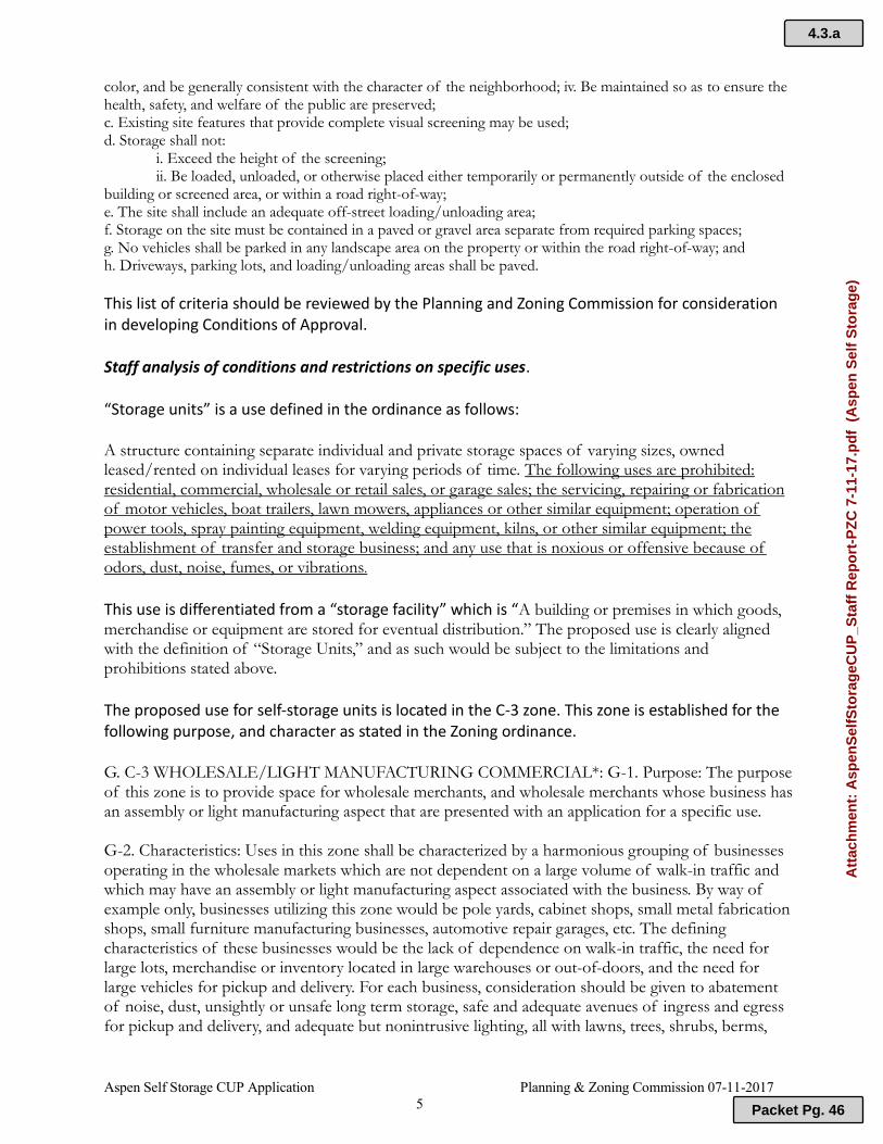
Aspen Self Storage CUP Application Planning & Zoning Commission 07-11-2017 5
color, and be generally consistent with the character of the neighborhood; iv. Be maintained so as to ensure the health, safety, and welfare of the public are preserved; c. Existing site features that provide complete visual screening may be used; d. Storage shall not:
i. Exceed the height of the screening; ii. Be loaded, unloaded, or otherwise placed either temporarily or permanently outside of the enclosed
building or screened area, or within a road right-of-way; e. The site shall include an adequate off-street loading/unloading area; f. Storage on the site must be contained in a paved or gravel area separate from required parking spaces; g. No vehicles shall be parked in any landscape area on the property or within the road right-of-way; and h. Driveways, parking lots, and loading/unloading areas shall be paved.
This list of criteria should be reviewed by the Planning and Zoning Commission for consideration in developing Conditions of Approval. Staff analysis of conditions and restrictions on specific uses. “Storage units” is a use defined in the ordinance as follows: A structure containing separate individual and private storage spaces of varying sizes, owned leased/rented on individual leases for varying periods of time. The following uses are prohibited: residential, commercial, wholesale or retail sales, or garage sales; the servicing, repairing or fabrication of motor vehicles, boat trailers, lawn mowers, appliances or other similar equipment; operation of power tools, spray painting equipment, welding equipment, kilns, or other similar equipment; the establishment of transfer and storage business; and any use that is noxious or offensive because of odors, dust, noise, fumes, or vibrations.
This use is differentiated from a “storage facility” which is “A building or premises in which goods, merchandise or equipment are stored for eventual distribution.” The proposed use is clearly aligned with the definition of “Storage Units,” and as such would be subject to the limitations and prohibitions stated above.
The proposed use for self-storage units is located in the C-3 zone. This zone is established for the following purpose, and character as stated in the Zoning ordinance. G. C-3 WHOLESALE/LIGHT MANUFACTURING COMMERCIAL*: G-1. Purpose: The purpose of this zone is to provide space for wholesale merchants, and wholesale merchants whose business has an assembly or light manufacturing aspect that are presented with an application for a specific use. G-2. Characteristics: Uses in this zone shall be characterized by a harmonious grouping of businesses operating in the wholesale markets which are not dependent on a large volume of walk-in traffic and which may have an assembly or light manufacturing aspect associated with the business. By way of example only, businesses utilizing this zone would be pole yards, cabinet shops, small metal fabrication shops, small furniture manufacturing businesses, automotive repair garages, etc. The defining characteristics of these businesses would be the lack of dependence on walk-in traffic, the need for large lots, merchandise or inventory located in large warehouses or out-of-doors, and the need for large vehicles for pickup and delivery. For each business, consideration should be given to abatement of noise, dust, unsightly or unsafe long term storage, safe and adequate avenues of ingress and egress for pickup and delivery, and adequate but nonintrusive lighting, all with lawns, trees, shrubs, berms,
4.3.a
Packet Pg. 46
Att
ach
men
t: A
spen
Sel
fSto
rag
eCU
P_S
taff
Rep
ort
-PZ
C 7
-11-
17.p
df
(A
spen
Sel
f S
tora
ge)

Aspen Self Storage CUP Application Planning & Zoning Commission 07-11-2017 6
setbacks, lighting etc. to maintain the safety, peace and quiet of surrounding businesses in this zone and surrounding zoning districts. G-3. Uses: Use of this zone is encouraged adjacent to Industrial/Manufacturing zones, as a buffer to Industrial/Manufacturing zones, and along the major highways and byways of the county where truck traffic and the movements of large quantities of merchandise can be best accommodated.
The proposed use is not for wholesale (or retail) sales as the primary use, nor does it have a manufacturing component. It would not rely on walk in traffic. The applicant addressed in narrative how issues of noise and dust abatement are mitigated. The applicant is proposing to include landscaping and perimeter fencing on the property. The character and uses of the zone as described here are relevant in determining if this would be an appropriate zone designation in a potential rezone. The fundamental consideration is that the use is listed as a use permitted through a CUP in this zone. RECOMMENDED MINIMUM CONDITIONS OF APPROVAL
Compliance with Dark Sky Lighting Ordinance: All exterior lighting must conform to Teton County Ordinance 9.4.12.
Applicant obtains all necessary permits/approvals from Teton County as well as other regulating agencies including water and wastewater permits from EIPH/IDEQ/IDWR, and as discussed in inter-agency and departmental review comments above.
a. Buffer: Buffers not less than 20 feet in width from all property lines shall be provided and maintained, unless otherwise specified. (The application materials show conformance with setback/buffering requirements. Permanent structures must meet current county setbacks for the zone in which they are located.)
b. Screening: Screening from adjacent uses or developments, including across a county road from such a use or development, shall be provided and maintained. Screening shall be accomplished by landscaping at least six (6) feet high and should be high altitude, native plant material, trees and shrubs or existing vegetation.
c. Lighting: Outdoor lighting, current and future, shall comply with the Outdoor Lighting provisions of this Title, Section 8-4-6.
d. Parking: The parking requirements of Title 8, Table 3 shall be met and the Americans with Disabilities Act (ADA) required handicap parking spaces provided. In lieu of the above, a parking plan prepared by a professional in the field shall be submitted to the planning administrator for consideration.
e. Hours of Operation: Any restrictions on hours of operation should be determined through this hearing procedure.
f. Signage: Signage shall comply with the Title 8, Chapter 9 sign requirements.
g. Outside Storage: Where outside storage is permitted, such use shall be located in the rear yard and a sight proof fence or natural screening shall be provided and maintained around the storage area at least one foot higher than the stored material
h. Building Height: Maximum height is 45 feet in the C-1, C-2, C-3, and M-1 districts, and 30 feet in all other districts, unless specified in Title 8.
i. Technical Studies: The Commission should determine any studies required
4.3.a
Packet Pg. 47
Att
ach
men
t: A
spen
Sel
fSto
rag
eCU
P_S
taff
Rep
ort
-PZ
C 7
-11-
17.p
df
(A
spen
Sel
f S
tora
ge)

Aspen Self Storage CUP Application Planning & Zoning Commission 07-11-2017 7
j. Onsite Inspection: The planning administrator may determine that there is a need for an inspection at any time.
The following uses (of individual storage units) are prohibited: residential, commercial, wholesale or retail sales, or garage sales; the servicing, repairing or fabrication of motor vehicles, boat trailers, lawn mowers, appliances or other similar equipment; operation of power tools, spray painting equipment, welding equipment, kilns, or other similar equipment; the establishment of transfer and storage business; and any use that is noxious or offensive because of odors, dust, noise, fumes, or vibrations.
PLANNING & ZONING COMMISSION ACTION: D. Continue to a future PZC Public Hearing with reasons given as to the continuation or need for additional information. PLANNING STAFF RECOMMENDATION: ACTION D, Continue to a future PZC Public Hearing with reasons given as to the continuation or need for additional information. The following motions could be given: Having reviewed the application materials for Aspen Self Storage Units, as well as the additional material provided by staff and other agencies; I hereby move to CONITINUE THE HEARING TO THE AUGUST 8TH PLANNING AND ZONING MEETING in order to meet notice requirements and provide adequate for surrounding property owners to comment, and to request any additional information as follows… ______________________________________________________________________________ Prepared by Joshua Chase Attachments: • Application
o Original Application Packet o Narrative o Site Plan o Map of noticed properties
End of Staff Report
4.3.a
Packet Pg. 48
Att
ach
men
t: A
spen
Sel
fSto
rag
eCU
P_S
taff
Rep
ort
-PZ
C 7
-11-
17.p
df
(A
spen
Sel
f S
tora
ge)
4.3.b
Packet Pg. 49
Att
ach
men
t: A
dd
end
um
Asp
enS
elfS
tora
geC
UP
_Sta
ff R
epo
rt-P
ZC
8-8
_17
(A
spen
Sel
f S
tora
ge)
4.3.b
Packet Pg. 50
Att
ach
men
t: A
dd
end
um
Asp
enS
elfS
tora
geC
UP
_Sta
ff R
epo
rt-P
ZC
8-8
_17
(A
spen
Sel
f S
tora
ge)

4.3.b
Packet Pg. 51
Att
ach
men
t: A
dd
end
um
Asp
enS
elfS
tora
geC
UP
_Sta
ff R
epo
rt-P
ZC
8-8
_17
(A
spen
Sel
f S
tora
ge)
4.3.b
Packet Pg. 52
Att
ach
men
t: A
dd
end
um
Asp
enS
elfS
tora
geC
UP
_Sta
ff R
epo
rt-P
ZC
8-8
_17
(A
spen
Sel
f S
tora
ge)

4.3.b
Packet Pg. 53
Att
ach
men
t: A
dd
end
um
Asp
enS
elfS
tora
geC
UP
_Sta
ff R
epo
rt-P
ZC
8-8
_17
(A
spen
Sel
f S
tora
ge)

4.3.b
Packet Pg. 54
Att
ach
men
t: A
dd
end
um
Asp
enS
elfS
tora
geC
UP
_Sta
ff R
epo
rt-P
ZC
8-8
_17
(A
spen
Sel
f S
tora
ge)
4.3.b
Packet Pg. 55
Att
ach
men
t: A
dd
end
um
Asp
enS
elfS
tora
geC
UP
_Sta
ff R
epo
rt-P
ZC
8-8
_17
(A
spen
Sel
f S
tora
ge)
4.3.b
Packet Pg. 56
Att
ach
men
t: A
dd
end
um
Asp
enS
elfS
tora
geC
UP
_Sta
ff R
epo
rt-P
ZC
8-8
_17
(A
spen
Sel
f S
tora
ge)
4.3.b
Packet Pg. 57
Att
ach
men
t: A
dd
end
um
Asp
enS
elfS
tora
geC
UP
_Sta
ff R
epo
rt-P
ZC
8-8
_17
(A
spen
Sel
f S
tora
ge)
4.3.b
Packet Pg. 58
Att
ach
men
t: A
dd
end
um
Asp
enS
elfS
tora
geC
UP
_Sta
ff R
epo
rt-P
ZC
8-8
_17
(A
spen
Sel
f S
tora
ge)
4.3.b
Packet Pg. 59
Att
ach
men
t: A
dd
end
um
Asp
enS
elfS
tora
geC
UP
_Sta
ff R
epo
rt-P
ZC
8-8
_17
(A
spen
Sel
f S
tora
ge)
4.3.b
Packet Pg. 60
Att
ach
men
t: A
dd
end
um
Asp
enS
elfS
tora
geC
UP
_Sta
ff R
epo
rt-P
ZC
8-8
_17
(A
spen
Sel
f S
tora
ge)
Gary and Marlene Robson | Scenic Corridor Review Planning & Zoning Commission | Aug. 8, 2017 Page 1 of 4
APPLICANT: Gary and Marlene Robson LANDOWNER: Same APPLICABLE COUNTY CODE: Teton County Zoning Ordinance Section 8-5-2-D (SC) Scenic Corridor Overlay Regulations. REQUEST: Gary and Marlene Robson are requesting approval for constructing an attached garage and mud room onto their existing home located in the scenic corridor of State Hwy 32. The property is 2.76 acres and has an existing home. LEGAL DESCRIPTION: RP07N45E326000, TAX #2700 SEC 32 T7N R45E LOCATION: 11185 N HWY 32, FELT ID ZONING DISTRICT: A/RR-2.5 PROPERTY SIZE: 2.76 acres VICINITY MAP:
SCENIC CORRIDOR REVIEW for: Gary and Marlene RobsonWHERE: 11185 N HWY 32
Prepared for the Planning & Zoning Commission August 8, 2017
Stat
e H
wy
32
Felt Townsite
City of Tetonia
Robson Home
4.4.a
Packet Pg. 61
Att
ach
men
t: G
aryM
arle
neR
ob
son
Sce
nic
Co
rrid
or_
Sta
ffR
epo
rt_8
.8.2
017
(1)
(R
ob
son
Sce
nic
Co
rrid
or
Des
ign
Rev
iew
)

Gary and Marlene Robson | Scenic Corridor Review Planning & Zoning Commission | Aug. 8, 2017 Page 2 of 4
PROJECT BACKGROUND: Mrs. Robson submitted a scenic corridor design review application on June 26, 2017. Before a building permit for the attached garage can be approved, a scenic corridor design review must be conducted and approved for the proposed structure. The Robson property is currently zoned A-2.5. The property fronts on State Hwy 32. The application materials notes that the home is visible from traffic from the north and south but due to the location of the home on a hill and the fact that the state highway is located in a cut, the home is not visible from the road directly adjacent to the property. The proposed building will be approximately 28’ X 40’ and will connect with the existing roofline and at the same height as the existing home. It will be constructed with wood siding to match the existing home as well, (shown on submitted photos). The application also identifies that there is screening from existing landscaping including mature spruce on the south and west of the home. OVERVIEW OF SCENIC CORRIDOR REVIEW: 8-2-1-A. GENERAL DEFINITIONS: Scenic Corridor Overlay includes all lands lying within 330 feet of both sides of the rights-of-way for Idaho State Highways 31, 32, 33 and Ski Hill Road from Driggs City limits to the Wyoming state line. 8-5-1-D. PURPOSE: The purpose of this overlay area is to provide a design review procedure to ensure that key roads in Teton County are sufficiently protected from unsightly and incompatible land uses. 8-5-2-D (1) DESIGN REVIEW: All development shall be subject to design review to ensure that the location, scale, and appearance of buildings, structures, and development of land shall preserve the rural character of the areas bordering Idaho State Highways and Ski Hill Road and to prevent the construction of buildings that project upward beyond the ridgeline of any hill located within one (1) mile of major roads when viewed from those major roads. Title 8 of the Teton County Code authorizes the Planning & Zoning Commission to make a final determination on scenic corridor applications. A development application shall only be approved if the Planning Commission finds that it meets the design review criteria.
4.4.a
Packet Pg. 62
Att
ach
men
t: G
aryM
arle
neR
ob
son
Sce
nic
Co
rrid
or_
Sta
ffR
epo
rt_8
.8.2
017
(1)
(R
ob
son
Sce
nic
Co
rrid
or
Des
ign
Rev
iew
)

Gary and Marlene Robson | Scenic Corridor Review Planning & Zoning Commission | Aug 8, 2017 Page 3 of 4
8-5-2-D (3). DESIGN REVIEW CRITERIA: STAFF COMMENTS:
SETBACKS
No permanent structures may be built within 50 feet of the outer edge of the road right of way, unless the parcel does not contain any buildable sites outside of the setback.
It appears the proposed garage will be located a minimum of 175 feet from the outer edge of Highway 32. (complies)
BUILDING ENVELOPE
1. Building envelopes shall be located so that existing topography and natural vegetation will screen buildings from view from the State Highways and Ski Hill Road to the maximum extent feasible.
There is existing vegetation on the property, that serves to screen the existing and proposed construction. The topography also serves to screen the building from views directly adjacent to the proposed construction.
2. Where existing topography and natural vegetation cannot be used to screen buildings, building envelopes should be located at the rear or side edges of an open meadow or pasture, or at the foot of a hill or ridge, rather than in the middle of a meadow, pasture, or hillside.
Not applicable (see comments above).
3. Building envelopes shall be located so that no portion of a building up to 30 feet tall shall be visible over the ridge of the hillside on which it is located when viewed from the State Highways and Ski Hill Road.
The proposed construction is an addition to an existing home constructed in the early 1980s, prior to designation of the scenic corridor. This standard is relevant to establishing envelopes in new developments.
BUILDING MATERIALS
All non-agricultural buildings shall not be of highly reflective materials according to ASTM C6007, Light Reflectivity Index.
The proposed addition proposes to use wood siding and match the materials on the existing home. The materials will not be highly reflective.
ROADS & DRIVEWAYS
Roads and driveways shall be designed to eliminate the need to back out onto the State Highways or Ski Hill Road. Existing roads and driveways shall be used where practical. When it is not practical to use existing roads, then new roads and driveways shall be located to skirt the edge of meadows and pastures (i.e. avoid dividing them) to the maximum extent feasible
This property is accessed from Highway 32.. It is a large parcel and there will be no issue with vehicles backing out onto a state Highway.
SCREENING
Landscaping shall be used to screen the view of any resource extraction sites, outdoor storage areas, outdoor trash collection areas, satellite dishes over two (2) meters in diameter, and areas with inoperable equipment or more than four (4) inoperable cars or trucks. Required landscaping should be high altitude, native plant material, trees and shrubs
Nothing is proposed which would require screening.
THERE ARE ADDITIONAL PROVISIONS FOR SATELLITE DISHES, REVEGETATION, UTILITIES, AND SIGNS.
The applicant is not proposing a satellite dish, utilities, or signs. Disturbance will be minimal for construction, so it is staff’s opinion that a revegetation plan is not needed..
POSSIBLE CONDITIONS OF APPROVAL:
1. Must comply with all federal, state, and local regulations. 2. All structures require a Teton County Building Permit and must comply with the Teton County
Building Code. 3. Building materials shall not be highly reflective materials.
4.4.a
Packet Pg. 63
Att
ach
men
t: G
aryM
arle
neR
ob
son
Sce
nic
Co
rrid
or_
Sta
ffR
epo
rt_8
.8.2
017
(1)
(R
ob
son
Sce
nic
Co
rrid
or
Des
ign
Rev
iew
)
Marlene and Gary Robson| Scenic Corridor Review Planning & Zoning Commission | Aug 8, 2017 Page 4 of 4
POSSIBLE PLANNING & ZONING COMMISSION ACTIONS: A. Approve the scenic corridor permit request with the recommended conditions of approval listed in this staff report, having provided the reasons and justifications for the approval. B. Approve the scenic corridor permit request, with modifications to the application request, or adding conditions of approval, having provided the reasons and justifications for the approval and for any modifications or conditions. C. Deny the scenic corridor permit request and provide the reasons and justifications for the denial. D. Continue to a future PZC Meeting with reasons given as to the continuation or need for additional information. POSSIBLE MOTION: The following motions could provide a reasoned statement if a Commissioner wanted to approve or deny the application: Approval Having found that the proposed development for Gary and Marlene Robson is consistent with the Teton County development ordinances, specifically Title 8-5-2-D, and Idaho State Statute, I move to approve the scenic corridor permit with the following conditions of approval:
1. Must comply with all federal, state, and local regulations. 2. All structures require a Teton County Building Permit and must comply with the Teton County
Building Code. 3. Building materials shall not be highly reflective materials.
Denial Having found that the proposed development for Gary and Marlene Robson is not consistent with the Teton County development ordinances, specifically Title 8-5-2-D, and Idaho State Statute, I move to deny the scenic corridor permit. The following could be done to obtain approval… Prepared by Joshua Chase, Senior Planner, 7/13/2017 Attachments: 1. Application (3 pages) 2. Narrative (1 page) 3. Deed (2 pages) 4. Site Plan with setbacks (2 pages) 5. Roof and Siding Material Design Options (3 pages)
End of Staff Report
4.4.a
Packet Pg. 64
Att
ach
men
t: G
aryM
arle
neR
ob
son
Sce
nic
Co
rrid
or_
Sta
ffR
epo
rt_8
.8.2
017
(1)
(R
ob
son
Sce
nic
Co
rrid
or
Des
ign
Rev
iew
)
Related Documents