AERIAL PHOTOGRAPHIC SURVEYS IN SOUTHEASTERN ALASKA By R. H. SARGENT and FRED H. MOFFIT INTRODUCTION Making maps from airplane photographs is a relatively new under taking which did not become practicable until the great advances in airplane construction and operation arising from the necessities of the World War took place. Airplane photographs and maps made from them were of inestimable value to the conduct of the war by both sides, and since the war they have become increasingly important for the peace-time enterprises of all countries. In the United States pri- vate interests have devoted much thought and spent large sums of money in the development of methods for adapting airplane photo- graphs to map making. Different departments and bureaus of the Federal Government also have not only been engaged in investiga- tions of the same kind but have during the last few years photo- graphed for map making considerable areas in different parts of the United States. This work has received special attention from the engineers of the United States Army, who have had a leading part in the development of the method used in the surveys here to be described. The application of the underlying principles of the cameras employed in these surveys to map making appears to have been made first by an Austrian army engineer, Theodor Schiempflug, but the idea of adapting the cameras for surveys in this country and the method of using the pictures obtained with them originated with Maj. J. W. Bagley, now of the Corps of Engineers, U. S. Army, while he was connected with the United States Geological Survey, where he had already made extensive use of the panoramic camera in Alaskan topographic surveys. 1 Major Bagley was commissioned in the Army just before the United States entered the World War and since then has had the most prominent part in the development of the multiple-lens camera for map surveys from aircraft. The multiple-lens camera is but 1 Bagley, J. W., The use of the panoramic camera in topographic surveying: U. S. Geol. Survey Bull. 657, 1917. 6097° 29 10 143

Welcome message from author
This document is posted to help you gain knowledge. Please leave a comment to let me know what you think about it! Share it to your friends and learn new things together.
Transcript
AERIAL PHOTOGRAPHIC SURVEYS IN SOUTHEASTERNALASKA
By R. H. SARGENT and FRED H. MOFFIT
INTRODUCTION
Making maps from airplane photographs is a relatively new under taking which did not become practicable until the great advances in airplane construction and operation arising from the necessities of the World War took place. Airplane photographs and maps made from them were of inestimable value to the conduct of the war by both sides, and since the war they have become increasingly important for the peace-time enterprises of all countries. In the United States pri vate interests have devoted much thought and spent large sums of money in the development of methods for adapting airplane photo graphs to map making. Different departments and bureaus of the Federal Government also have not only been engaged in investiga tions of the same kind but have during the last few years photo graphed for map making considerable areas in different parts of the United States. This work has received special attention from the engineers of the United States Army, who have had a leading part in the development of the method used in the surveys here to be described.
The application of the underlying principles of the cameras employed in these surveys to map making appears to have been made first by an Austrian army engineer, Theodor Schiempflug, but the idea of adapting the cameras for surveys in this country and the method of using the pictures obtained with them originated with Maj. J. W. Bagley, now of the Corps of Engineers, U. S. Army, while he was connected with the United States Geological Survey, where he had already made extensive use of the panoramic camera in Alaskan topographic surveys. 1
Major Bagley was commissioned in the Army just before the United States entered the World War and since then has had the most prominent part in the development of the multiple-lens camera for map surveys from aircraft. The multiple-lens camera is but
1 Bagley, J. W., The use of the panoramic camera in topographic surveying: U. S. Geol. Survey Bull. 657, 1917.
6097° 29 10 143
144 MINERAL RESOURCES OF ALASKA, 1926
one of a considerable number of cameras devised for this purpose, but unlike most of the others it is regarded primarily as an instru ment which makes use of the principles of plane-table surveying for constructing a map rather than an instrument for picturing the sur face of the earth.
It was evident to those who had followed the progress of aerial photographic mapping and were most familiar with the surveys for topographic maps in Alaska, where the panoramic camera had al ready been employed for years and had been thoroughly tried out, that here was an opportunity to test this new method in regions where large areas are peculiarly adapted to its success and the com mon methods are difficult to apply because the country is remote and many parts of it are, at present, almost inaccessible. Topographic mapping in Alaska has been carried on in a systematic way by the Geological Survey for nearly 30 years, yet in that time less than half its vast area has been covered. The method employed in all these surveys is the plane-table method or the modification of it which in volves the use of the panoramic camera. This method is undoubtedly the best that was applicable, but the field work is slow in comparison with the aerophotographic method, it involves a great amount of physical labor expended in overcoming the natural obstacles to travel through the country and a consequent loss of time, and because of its relative slowness it is unable to take as great advantage of favorable weather. On the other hand, the time required to photo graph the surface of the land is limited only by the speed of the plane in traversing the chosen area; the resulting photographs con tain an embarrassing amount of detail, so that it becomes necessary to choose what shall be used; and most of the physical labor of climb ing and getting about is done by a machine. Both methods have ad vantages and disadvantages, but the outstanding advantage of the aerophotographic method is its speed in completing the field work.
ORGANIZING THE EXPEDITION
When it became evident that a small part of the appropriation for the fiscal year 1924 25, applicable to the making of topographic sur veys in Alaska, was available for aerial survey, a search was made for some arrangement by which the project could be carried out. The Geological Survey has no airplanes and could not undertake the work without the cooperation of some Government organization which has them. An approach was therefore made to the War De partment, the branch of the Government that was most experienced in making airplane photographs for map surveys, but it was learned that this department, though willing to undertake the work, was unable to do so unless the Geological Survey would contribute as its share of the expense a sum greater than was available.
AERIAL PHOTOGRAPHIC SURVEYS IN SOUTHEASTERN ALASKA 145
Cooperation was next sought from the Navy Department, which undertook to photograph certain portions of southeastern Alaska. The wide lowland areas of the Yukon and Kuskokwim Valleys and other parts of the Territory having low relief doubtless offer greater promise of successful application of the aerophotographic method in its present development than the areas of great relief like southeast ern Alaska, yet it was plain that here also the photographs would have great value for map making, notwithstanding the complications arising from the rugged character of the land. Many reasons were involved in the choice of southeastern Alaska as the area in which to begin the work. First of all, its numerous waterways make it easily accessible to the boats of the Navy, which were to provide ac commodations for the men and care for the planes of the expedition. This in itself was almost a deciding reason, because any other plan would have involved a much greater expenditure of money. Again, this part of Alaska includes the most extensive and valuable of its forests, extensive mining and fishing interests, and a considerable proportion of the population. Furthermore, the work of the Coast and Geodetic Survey in southeastern Alaska furnishes much control for assembling the data contained in the pictures, and the need of maps of this region is immediate and great.
The Alaskan Aerial Survey Expedition was accordingly organized by the Navy Department to carry out the undertaking. Immediate charge of the expedition was given to Lieut. Ben. H. Wyatt, of the Bureau of Aeronautics. The executive officer was Lieut. Wallace M. Dillon, of the same bureau. Other officers were Lieut. E. F. Burkett, personnel officer; Lieut. Richard Whitehead, photographic officer; Lieut. Elory Carr, paymaster; and Lieut. Commander A. C. Smith, surgeon. The tender Gam/net, with Lieut. W. R. Spear in command, was detailed from the Bureau of Operations and was well equipped for the work, as her regular duty was service as tender for the airplane carrier Langley. A barge 140 feet long and 40 feet wide, housed over and provided, with a bulkhead forward sufficiently strong to withstand any seas she might meet, furnished additional room, especially that required for the photographic oper ations of the expedition.
The barge was equipped and manned as a separate unit and could function properly in the absence of the G-annet. All the photo graphic operations were performed on her, and for this purpose three rooms were provided as photographic laboratories. A small room was used for developing, fixing, and washing the film; a somewhat larger one for printing and enlarging photographs; and a third room con siderably larger contained a large drying reel of the kind used for drying moving-picture film. The rest of her space was taken up with
146 MINERAL RESOURCES OF ALASKA. 1926
a kitchen, dining room, office for the clerical force, rooms for the commanding officer, other offices, hospital, the petty officers' and enlisted men's quarters, engine repair shop, store room, and barber shop. On the after end was a loft for carrier pigeons. An electric lighting system was installed to furnish light when the Gcmnet was separated from the barge.
The total Navy personnel of the expedition, including the com missioned officers, warrant officers, and enlisted men, numbered 112, of whom. 75 were connected with the Gannet and 37 were with the aerial and photographic section, on the barge. In addition to these men of the Navy, a civilian, Capt. C. W. Call, who was familiar with the waters of southeastern Alaska, was attached to the expedi tion as pilot during the entire season. R. H. Sargent was designated representative of the Geological Survey to accompany the expedition. Mr. Sargent was to act in an advisory capacity only and was directed also to cooperate so far as practicable with the other Government bureaus and with civilians who had an interest in the work. The choice of the specific areas to be flown rested with him and also the preparation of the flight charts, which gave the spacing and direc tion of the flights. He later inspected the developed film to make certain that sufficient overlap of pictures was being provided and that no areas were left uncovered by the pictures. Finally he received the film and transmitted it to the Geological Survey in Washington.
Southeastern Alaska possesses no landing fields for airplanes, and the construction of such fields would have required time and a large additional expense, so that airplanes able to land on the water were practically a necessity for carrying out the project. The original plans contemplated the use of four Loening amphibian planes. This type of plane was chosen because it is not only able to take off and make landings in the water but, being provided with landing gear in addition to its boatlike fuselage, it can be operated on land where fields are available or it can readily be drawn up on shore when not in use or when overhauling is necessary. This ability to be drawn out of the water easily is of great advantage in time of storm or heavy winds, when the difficulty of holding a plane safely on a rough sea is great, and has an additional advantage in preventing the plane from becoming water-logged and thus adding to its weight. Unfor tunately, one of the planes was wrecked on the way from San Diego to Seattle, and its pilot, Lieutenant Dillon, and the chief petty officers, Messrs. Peterson and Volz, were injured. Because of this accident only three planes were available for the undertaking. Two of them were fitted up for photographic work by providing them with the proper mountings for holding the cameras and by cutting
147
a small observation hatch in the bottom of the fuselage, which could be opened after the plane left the water. The third plane was equipped with radio apparatus and was reserved for use in emer gency.
The cameras for map work included three tri-lens cameras of the type known to Army engineers as T-l. This is a compound camera taking three pictures at the same instant and possesses the advantage of being able to include a larger area of land surface at a given alti tude of flight than any other camera used in this country for making land surveys. This advantage was the main reason for its choice. The other camera equipment included two single-lens mapping cam eras of the Fairchild type, a moving-picture camera, and other cam eras for general work. Both types of mapping cameras are mounted in gimbal rings within the plane when surveys are made and have their lenses directed through an opening in the bottom of the fuse lage. Although all the cameras were used at times, only those of the T-l type were employed in taking the pictures which were de sired by the Geological Survey. The Fairchild mapping cameras were used for taking oblique pictures over the side of the airplane fuselage.
The organization of the Alaskan Aerial Survey Expedition was completed at San Diego, Calif., and after picking up the barge at Bremerton Navy Yard, near Seattle, on June 5, 1926, the G-annet with the barge in tow sailed from Seattle for Alaska. The planes left Seattle one day later and joined the ship at Alert Bay, B. C., to be refueled and resupplied, before proceeding to Ketchikan, where they arrived on the afternoon of June 9. The Gannet with the barge reached Ketchikan on the afternoon of June 10. The expedition re mained in Ketchikan from June 10 to August 9. It then proceeded northward, stopping at Wrangell on the night of August 9 and at Petersburg August 10 and 11, and arrived at Juneau on the after noon of August 12. It remained at Juneau until September 10, when both ship and planes left for the homeward journey. Two days were spent by the Gannet at Ketchikan, but the planes left one day earlier to take advantage of favorable flying weather. The Gannet arrived at the Bremerton Navy Yard on September 19, when Mr. Sargent left the expedition and returned to Washington.
COOPERATION
Although the primary purpose of making aerial photographs of southeastern Alaska was to furnish the Geological Survey with data for the basis of future topographic surveys and the construction of maps of the region, it was believed that the photographs would be of value to other bureaus which had interests in Alaska, and it was
148 MINERAL RESOTJKCES OF ALASKA, 1926
felt that the cooperation of all should be invited and every oppor tunity offered to any branch of the Government to profit by the re sults. Accordingly the Director of the Geological Survey addressed communications to the chiefs of the following bureaus, informing them of the project which was to be undertaken and inviting their cooperation: Coast and Geodetic Survey, Forest Service, Inter national Boundary Commission, General Land Office, Bureau of Fisheries, Bureau of Public Roads, Federal Power Commission, Bu reau of Lighthouses, Coast Guard, and Board of Road Commis sioners of Alaska. All these bureaus were interested in the project, and all cooperated during the season to the extent of their oppor tunities. In particular the bureaus that operate boats in southeastern Alaska instructed the officers to render such service as they could. In this way 27 boats of various sizes, 7 of them as large as the Gamnet, Avere under instructions to cooperate with the expedition in carrying out its work.
The Bureau of Lighthouses tendered the use of its dock at Ketch ikan and the privilege of its machine and carpenter shops, storage space, and the use of a room for wireless apparatus. The Coast Guard on several occasions patrolled the waters of Clarence Strait and Behm Canal when the planes were making long flights from Ketchikan. The Forest Service offered boats and the use of auto mobiles. Like assistance was given by other bureaus.
The cooperation of private companies and individuals was no less ready and helpful than that of the Government .bureaus. The Cit izens Light, Power & Water Co. of Ketchikan connected the Gannet and barge with its mains and supplied, free of charge, all the water used by the expedition while it was stationed there. Mr. Archie W. Shiels, general manager of the Jracific American Fisheries, offered the use of the cannery buildings belonging to his company at Gambier Bay and Hoonah Bay, without charge, as quarters for the expedition. Mr. Emile Gastonguay, business manager of the Gastineau Mining Co., tendered the use of the dock and unused buildings of his company at Thane, near Juneau, without charge. These privileges were en joyed from August 12 to September 10 and included use of the dock, a large and well-equipped machine shop and carpenter shop, housing facilities for the plane, the building that served as a radio transmit ting and receiving station, a large amusement hall which was kept open for the men, a dancing floor which was enjoyed on appropriate occasions, and adequate housing for those officers and families who desired to avail themselves of the privilege. In addition to this, water was supplied from the company's water mains during the entire stay, and light was furnished from the power house of the company free of charge on such occasions as the expedition was unable to supply its own light.
AERIAL PHOTOGRAPHIC SURVEYS IN SOUTHEASTERN ALASKA 149
FIELD OPERATIONS
The first requirements for surveying an extensive area by airplane photography are a systematic plan for taking the photographs and the choice of an appropriate height for flying. The height of flying depends in part on the relief of the country to be photographed and the height of the clouds, if any are present, but is limited by the ability of the plane to reach and fly economically at the desired alti tude. The altitude adopted for the work in southeastern Alaska was 10,000 feet, although the detail of the photographs would have been amply sufficient and a greater area could have been covered with the same number of pictures if it had been practicable to fly at a higher altitude. This altitude gave the resulting photographs a scale of approximately 1:20,000, which is much greater than the pub lication scale of the maps that are to be made from them.
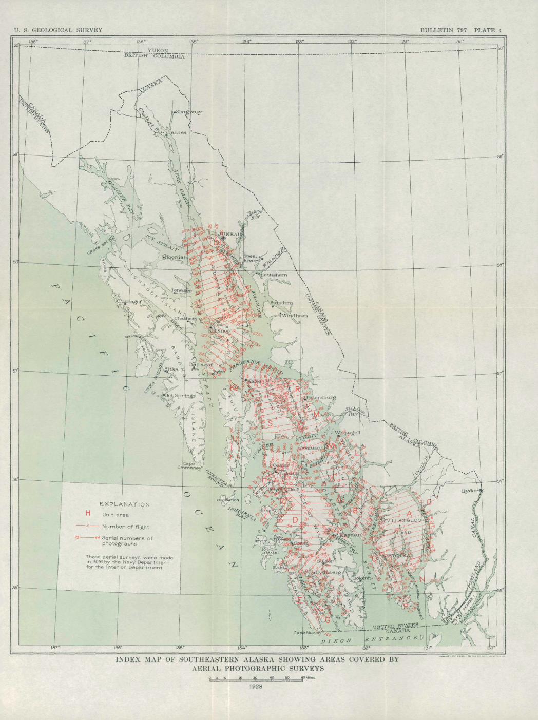
The other requirement was met by preparing a series of flight charts on which were plotted lines representing the courses to be flown. The larger islands were designated by letters of the alphabet as an assistance in marking the film and flown as units, and the courses to be followed were laid out so that their beginning and end ing, as nearly as possible, were perpendicular to the shore lines that were later to be used for controlling the maps. (See pi. 4.) A spacing of 31/2 miles provided a proper overlap of the pictures in adjoining flights. Coast and Geodetic Survey charts were used as bases for the flight charts and had marked on them not only the courses to be followed in making the photographs but also the courses between the home station and the areas where the photographic flights were made and points that were the most advantageous places for landing if a plane were forced down. When a plane left the beach the time of its return was computed, and it was arranged that if it did not return within 30 minutes of the computed time the emergency plane was to go in search of it, following the previously laid out course of the photographic plane and searching particularly in the designated landing spots. If the plane was found to be in trouble the emer gency plane was to report by radio to the Gannet, which was ready at all times to leave the dock at a moment's notice. Fortunately no occasion arose for the use of these emergency measures. Copies of the flight charts were kept on the Gannet, on the barge, and on the beach where the planes were landed, and other copies containing plans for only the immediate work were taken into the air by the navigator and the pilot of the photographic planes.
The crew of each of the photographic planes comprised a naviga tor, a pilot, and a photographer. It was the business of the pilot to fly his plane on the given course, as nearly as possible at a con-
150 MINERAL RESOURCES OF ALASKA, 1926
stant altitude, and keep it on an even keel while the navigator gave him the information which enabled him to do this. Signals were transmitted from the navigator to the pilot by small electric lights and by reins of cord attached to each side of the pilot's flying suit, giving the means for directing him to make right and left turns. When the plane was " crabbing" or drifting sidewise, owing to heavy side winds, it was the navigator's duty to inform the photog rapher, who then turned his camera in its gimbals so as to orient the long dimension of the photographs at right angles to the direction of flight. The photographer's whole time was devoted to keeping his camera level and in proper orientation, to making the exposures at the proper time, and to winding off the film. Exposures were not made automatically but by pressure on a shutter release.
Proper spacing of consecutive pictures was obtained by giving equal intervals of time between exposures when conditions were favorable or by choosing the proper moment for exposure by observ ing the images of objects on the ground on a ground-glass grid in the bottom of the fuselage when conditions for the first method were less favorable. The proportion of overlap of one picture on another was 60 per cent in the direction of flight and 25 per cent in the other direction that is, the overlap of the pictures of one flight over those of the adjacent parallel flights on both sides and great care was exercised to see that this overlap was maintained at all times, so as to give the topographers who were eventually to compile the map a large number of points common to adjacent pictures and to provide insurance against the loss of a picture in the series. The T-l type of camera requires roll film, which is provided in lengths of about 400 feet wound on metal spools. An emulsion of supersensitivity is coated on the celluloid base of the film, and before exposure the rolls are kept at a low temperature in order that the sensitivity may not be lost. For the same reason they are used as soon as is practicable after they are received from the factory. The film was developed immediately after return from the flight, so as to discover any failure of the cameras to function properly and to be able to compare strips made in adjoining flights, for it was necessary to make sure that good negatives were obtained and that the negatives overlapped as has been described, with no areas between flights remaining uncovered.
FLYING CONDITIONS
The weather is of the greatest importance in aerophotographic mapping and determines the time when the planes may take the air and when the cameras may be operated with success. Southeastern Alaska is a region of heavy precipitation and a large proportion of rainy or cloudy days. At certain seasons, particularly in early fall,
U. S. GEOLOGICAL SURVEY BULLETIN 797 PLATE 4
_ ______
_L .YUKON JBRITISH COLUMBIA
EXPLANATION
Unit area
Number of flight
These aerial surveys were made in 1926 by the Navy Department for the Interior Department
. , UNITED .STATES -- -"CANADA
Caps MuzO?r^>v ""
D I X O133*
ENTRANCE,
132
INDEX MAP OF SOUTHEASTERN ALASKA SHOWING AREAS COVERED BYAERIAL PHOTOGRAPHIC SURVEYS
30_____4O____50____60 Miles
1928
fogs are so prevalent as to interfere seriously with navigation, and vessels sometimes put out to sea around Vancouver Island rather than attempt the inside passage. Consequently it was recognized from the beginning that photographic work in the air in this region would be impossible on many days and that full advantage must be taken of all the favorable weather. Dense clouds and rain were manifestly unfavorable to the work, but it was found that when the clouds were high enough and not too dense the illumination was suf ficiently great and the light values were sufficiently uniform to per mit work, although the clouds might cover the sky completely. Scat tered drifting clouds at high altitudes often interfered as seriously as a complete cloud blanket, for the heavy shadows cast by them con trast strongly with a brightly illuminated sunlit landscape and de stroy the details of the objects to be photographed. Such clouds at low altitudes float below the plane and cut off the view entirely.
As had been anticipated, there was much time when photography was impossible because of rain or heavy clouds. It was observed that after such weather had prevailed for some time a sudden change was likely to take place and the unfavorable condition would be fol lowed by a day or more of fine weather with a cloudless sky. After one rain four perfect days came in succession, and owing to the fact that there was no smoke in the air and the dust had been practically all washed out the conditions were ideal for photographic work. Special effort was made to forecast flying and photographic condi tions. Meteorologic observations were kept, and the reports of the several weather-recording stations throughout Alaska were received by radio and recorded and charted on a forecast chart. In addition sounding balloons were sent up twice daily, at approximately 9 o'clock and 1 o'clock, and their speed and direction were observed and recorded to assist in ascertaining the condition of the upper air currents. The possibility that the bad weather in one place was a local condition and that better weather might be found at some other place naturally suggested itself at times of enforced delay, and to test out this suggestion the assistance of the Government wireless station at Ketchikan was obtained. The chief of the southeastern Alaska section requested each one of the Government stations in southeastern Alaska to send a record each morning of the weather conditions, condition of the sky, type of clouds, if any, and direction and speed of the wind. In addition to the assistance of the Govern ment stations, several private individuals were asked for this same cooperation, which they gave willingly. In this way the aeronautical officer of the expedition received reports from 22 southeastern Alaska stations, in addition to his own careful observations and the weather reports forwarded to the Washington Weather Bureau and inter-
152 MINERAL RESOURCES OF ALASKA, 1926
cepted and delivered to him. Ari analysis of these reports showed that when conditions were unfavorable for flying in the vicinity of Ketchikan no other place in southeastern Alaska afforded better con ditions except at times the upper part of Lynn Canal from Haines northward. After 10 days of such records it was obvious that a change of station was unlikely to prove advantageous, and the matter was not considered further. When the season's work was ended it was found that only about 15 days out of 90 had been favorable for airplane surveys with the T-l type of camera, although there were many more days that could be classed as fair and were favorable for making aerial photographs for other purposes.
In the beginning some difficulty was experienced with the camera shutters, which at times functioned perfectly in the laboratory or even in the planes while on the ground but failed to open when high in the air. This difficulty however, was largely overcome after the first few flights by making some slight changes in the shutter mechan ism, and in the later part of the season it was almost absent.
RESULTS OF THE FIELD WORK
The season's field work when completed was represented only by developed rolls of film from which prints were to be made in the office. Each of these rolls consisted of several pieces, the film having been cut to facilitate the developing. Each roll contained on the average about 180 sets of three negatives, or a total of 540 negatives to the roll. The total number of negatives from which prints were to be made was approximately 17,280. The area covered by these negatives is about 10,000 square miles and includes a large part of southeastern Alaska specifically the islands of Revillagigedo, Ann ette, Gravina, and Duke, Cleveland Peninsula and Chickamin River, the islands of Wrangell, Woronkofski, Etolin, Zarembo, Long, Dall. Sikkwan, Prince of Wales, Tuxekan, Heceta, Kosciusko, Mitkof, Kupreanof, Kuiu, and Admiralty, and Lindenberg Peninsula. The choice of areas to be flown was based primarily upon their economic importance to the work of the Geological Survey and other bureaus interested, principally the Forest Service. The islands of south eastern Alaska and the Cleveland Peninsula were included because they presented small units of well-controlled country for which it was believed the office compilation of control data could be made easily. The southeastern part of Prince of Wales Island was not flown, because that area had been reconnoitered by the Forest Service and good maps of it are already in existence, so that it appeared justifiable to leave that area for future work if such work were undertaken,
AERIAL, PHOTOGRAPHIC SURVEYS IN SOUTHEASTERN ALASKA 153
Several areas remain in southeastern Alaska of which aerial photo graphs may profitably be made. One is the mainland between Port land Canal and Behm Canal, a stretch of country much of which has not been traversed by white men and which offers considerable jeop ardy to flying because of the high mountains and the absence of water areas into which a disabled plane might" glide if necessary. The entire area of Baranof and Chichagof Islands might profitably be covered by aerial photographs and also the remainder of Kuiu Island and Prince of Wales Island, of which portions were flown this season. Photographs of numerous areas on the mainland would be of economic importance to the Forest Service.
Photographs taken with the T-l type of camera made up by far the larger part of the pictures obtained during the summer, but in addition Lieutenant Wyatt made many oblique pictures with the Fairchild camera, primarily for the Forest Service. Other pictures were made for the Fish Commission, the International Boundary Commission, the Bureau of Public Roads, the Federal Power Com mission, the Board of Road Commissioners for Alaska, the Bureau of Lighthouses, and the Governor of Alaska. Finally a number of rolls of moving-picture film were made, showing the activities of the expedition and other subjects of interest.
PRINTING THE PICTURES
The rolls of developed film were forwarded to the Geological Survey in Washington for printing and the compilation of the data required for the map. Each roll contained nearly 400 feet of film, which had been cut into lengths corresponding for the most part to individual flights of the planes. The T-l camera differs from most other cameras designed for map making in that it is a multiple camera with three lenses and three camera boxes all rigidly combined into one instrument. An accurate tripping device actuates the shutters of the lenses so that three exposures are made simultaneously. When the camera is correctly adjusted in the fuselage of the airplane the film of the central camera is horizontal at the instant of exposure and the films of the two side cameras are inclined at an angle of 35° to the horizon, with the axis of one lens directed to the right and the other to the left of the line of flight. This arrangement obviously makes it possible to include on the combined prints a much wider area than is possible with a single-lens camera, as photographic lenses of such wide angle combined with sufficient speed have not been constructed. It unfortunately introduces also certain difficulties which must be overcome before the pictures are adapted to the construction of maps. An aerial photograph of objects in a horizontal plane, made with the photographic plate in a horizontal position, or parallel to the plane,
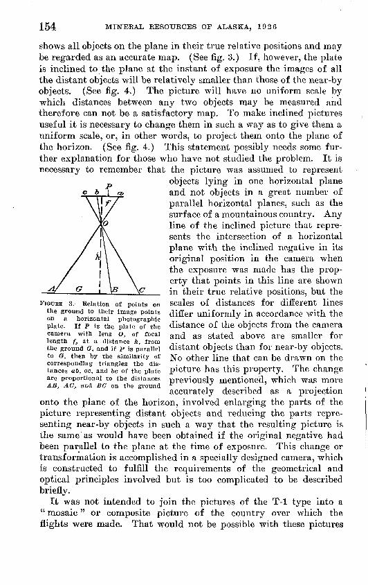
154 MINERAL RESOURCES OF ALASKA, 1926
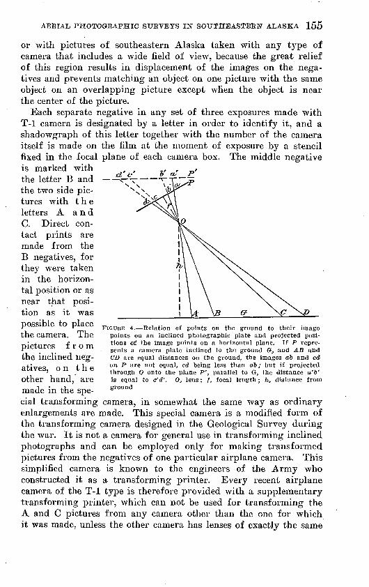
shows all objects on the plane in their true relative positions and may be regarded as an accurate map. (See fig. 3.) If, however, the plate is inclined to the plane at the instant of exposure the images of all the distant objects will be relatively smaller than those of the near-by objects. (See fig. 4.) The picture will have no uniform scale by which distances between any two objects may be measured and therefore can not be a satisfactory map. To make inclined pictures useful it is necessary to change them in such a way as to give them a uniform scale, or, in other words, to project them onto the plane of the horizon. (See fig. 4.) This statement possibly needs some fur ther explanation for those who have not studied the problem. It is necessary to remember that the picture was assumed to represent
objects lying in one horizontal plane and not objects in a great number of parallel horizontal planes, such as the surface of a mountainous country. Any line of the inclined picture that repre sents the intersection of a horizontal plane with the inclined negative in its original position in the camera when the exposure was made has the prop erty that points in this line are shown in their true relative positions, but the
FIGDBE 3. Relation of points on scales of distances for different lines the ground to their image points differ uniformly in accordance with theon a horizontal photographic ... , .plate, if p is the plate of the distance of the objects from the camera camera with lens o, of focal anc[ as stated above are smaller forlength f, at a distance h, from -,.,,,.,,, « , i . ,the ground &, and if p is parallel distant objects than tor near-by objects, to a, then by the similarity of j^o other line that can be drawn on thecorresponding triangles the dis- . , mi itances ab, ac, and 60 of the plate picture has this property. I he change are proportional to the distances previously mentioned, which was moreAB, AC, and BG on the ground 1 , -, -, -IT ,
accurately described as a projectiononto the plane of the horizon, involved enlarging the parts of the picture representing distant objects and reducing the parts repre senting near-by objects in such a way that the resulting picture is the same as would have been obtained if the original negative had been parallel to the plane at the time of exposure. This change or transformation is accomplished in a specially designed camera, which is constructed to fulfill the requirements of the geometrical and optical principles involved but is too complicated to be described briefly.
It was not intended to join the pictures of the T-l type into a " mosaic" or composite picture of the country over which the flights were made. That would not be possible with these pictures
AERIAL PHOTOGRAPHIC SURVEYS IN SOUTHEASTERN ALASKA 155
or with pictures of southeastern Alaska taken with any type of camera that includes a wide field of view, because the great relief of this region results in displacement of the images on the nega tives and prevents matching an object on one picture with the same object on an overlapping picture except when the object is near the center of the picture.
Each separate negative in any set of three exposures made with T-l camera is designated by a letter in order to identify it, and a shadowgraph of this letter together with the number of the camera itself is made on the film at the moment of exposure by a stencil fixed in the focal plane of each camera box. The middle negative is marked with the letter B and the two side pic tures with the letters A and C. Direct con tact prints are made from the B negatives, for they were taken in the horizon tal position or as near that posi tion as it was possible to place the camera. The pictures from the inclined neg atives, on the other hand, are made in the spe cial transforming camera, in somewhat the same way as ordinary enlargements are made. This special camera is a modified form of the transforming camera designed in the Geological Survey during the war. It is not a camera for general use in transforming inclined photographs and can be employed only for making transformed pictures from the negatives of one particular airplane camera. This simplified camera is known to the engineers of the Army who constructed it as a transforming printer. Every recent airplane camera of the T-l type is therefore provided with a supplementary transforming printer, which can not be used for transforming the A and C pictures from any camera other than the one for which it was made, unless the other camera has lenses of exactly the same
FIGURE 4. Relation of points on the ground to their image points on an inclined photographic plate and projected posi tions of the image points on a horizontal plane. If P repre sents a camera plate inclined to the ground Q-, and AB and CD are equal distances on the ground, the images aft and co" on, P are not equal, cd being less than oft/ but if projected through Q onto the plane P', parallel to G, the distance o'ft' is equal to c'd'. O} lens; f, focal length ; h, distance from ground
156 MINERAL RESOURCES OP ALASKA, 1926
focal length and side pictures inclined at the same angle to the center picture. The difficulty of getting several lenses of precisely the same focal length is so great that no attempt is made to equip two type T-l cameras Avith them, although the focal lengths of the two side lenses of each camera are equal.
The negatives are marked also with register marks on all four sides, which are used to find the principal point of the picture that is, the point where the axis of the lens cuts the negative and to adjust the negative to its proper position in the transforming printer. These four marks are shadowgraphs of notches or points on the frame that outlines the negative in the airplane camera. Other register marks, corresponding to those of the negative, are placed on the frame of the transforming printer, and the two sets of marks are brought accurately into coincidence before prints are made from the negative. Accuracy in this adjustment is made more probable and the possibility of placing the negative wrong end to in the printer is eliminated by punching a small hole at the proper place on the margin of the film and fitting this hole over a pin on the frame of the printer before making an exposure.
The operation of printing pictures from the two side negatives therefore consists in punching the holes in the A and C films, alter nately on the two sides, placing each film in turn in position in the printer, making the proper exposure, and developing the prints. An arc light with an opal-glass diffusing screen furnished light for the exposure. Some trouble was experienced at first with the sheets of glass used as diffusing screens. The sheets measure 17 by 14 inches and under the unequal expansion due to the heat of the arc lamp are liable to break. This trouble was eliminated by cutting the glass into strips about 2i/£> inches wide and replacing them in their original order in the frame of the lamp, where they are held -in place by strips or tape. This plan minimizes the strains from unequal expan sion, and no screen broke after it was adopted.
The transforming printer is advantageously placed in tfie wall between the dark room, where the printing paper is handled and the exposed prints are developed, and a lighted room where the film is adjusted to the printer frame and the arc light for making the exposures is installed. Two men are thus required to carry on the work, one in the dark room and one in the lighted room. The print ing paper is placed in a special holder having a chamber in its back from which the air is partly removed by an air pump. The front wall of this chamber, against which the paper rests, is per forated with numerous small holes, and the pressure of the air on the paper forces it against the wall, thus giving it a plane surface with no irregularities. This is necessary in order to avoid distortion
AERIAL PHOTOGRAPHIC SURVEYS IIST SOITTHEASTERN ALASKA 157
of the image on the print, which would often occur if the paper were not held firmly in its proper place in the plane of the image.
Airplane photographs are commonly "flat," or lacking in con trast, and for this reason it is a usual practice to stain the film to remedy this defect as much as possible. The film used ,in southeastern Alaska was thus stained, but the experience gained in making prints from the negatives indicates that staining was unnecessary if not undesirable, for the contrast,, in the landscape of this region is sufficiently great almost everywhere and staining merety adds to the time required for exposing the prints. This point probably requires more attention than was realized if time in making prints is a con sideration, as it is almost certain to be when so large a number of prints must be made.
Aside from the use of the special transforming printer and the accuracy required in adjusting the film on the frame of the printer, no more unusual procedure is involved in making the transforma tions than in making common enlargements, and the work becomes largely a matter of routine, in which, however, the need for care is never absent.
The printed pictures are trimmed and mounted with dry mount ing tissue on special lithographed cards on which are lines for con trolling the position of the prints. This work also requires careful attention and is the last operation in preparing the pictures for map making. Compilation of the data for the topographic base and the adjustment of the data to the control sheets are the next steps in the use of the pictures, but the detailed description of that work is outside the scope of this paper. Nevertheless a short account of the manner of using the prints will be of interest to those familiar with the more common methods of map making. For reasons already explained the finished prints are not joined together to make "mosaics" but are used in a modified plane-table method, known as the radial-line method, to determine the positions of chosen points. Lines are drawn from the station points of two or more pictures to objects common to both, and the intersections of these lines determine the positions of the objects, just as on the plane table. The station points of the pictures are the images of points on the ground above which the airplane was flying at the instant of exposing the film. They are the central points of the B pictures from negatives that were in a horizontal posi tion when exposed but are points displaced from the centers of nega tives that were inclined to the horizon plane and when so displaced are in error by an amount depending on the amount and direction of the tilt of the plane. The importance of maintaining a horizontal position for the B negative when the exposure is made therefore be comes apparent. It is necessary to establish the positions of the
158 MINERAL RESOURCES OF ALASKA, 1926
station points on the compilation sheet in order to use them for lo cating additional points, and this is done substantially as follows:
Three or more points whose positions on the ground have been determined by one of the usual surveying methods must be identified on the first of each series of photographs. These known points serve to determine the scale of the map, the azimuth of the line of flight, and the position of the station point of the picture. This last-mentioned object is accomplished,.as in the three-point method of plane-table surveying, by drawing radial lines from the station point to the images of the known points on the pictures and shifting these lines over the plotted positions of the known points on the compila tion sheet till the lines pass through the plotted points. If, further more, the known points are common to the first two sets of photo graphs they serve also to orient the second set with reference to the first by a similar application of the three-point method. Continuing this process the draftsman is able by choosing suitable points com mon to the overlapping sets of pictures to join all the pictures of a flight, or, more accurately, to plot from the successive sets of over lapping pictures the positions of as many common points as he may need or be able to identify. All this work is done on a sheet of trac ing linen, not on the pictures themselves, and yields a series of strips representing individual flights which in turn must be assembled into the final sheet. The separate sheets are not necessarily on the same scale and when of different scales are adjusted to one another by the known control point. In Plate 5 this control for scale, azimuth, and geodetic position was furnished by the charts of the United States Coast and Geodetic Survey.
This method of using the pictures gives the positions of stream courses, roads, and similar features, but does not make it possible to draw contour lines and construct a topographic map. Other methods must be used if topography is to be represented.
Experience has shown that the stereoscope is a most helpful instru ment for determining the positions of mountain crests and stream courses on the overlapping photographs and that its use is almost a necessity in settling many doubtful problems.
PURPOSE AND VALUE OF THE WORK
The aerophotographic surveys in southeastern Alaska were in a certain degree experimental. Their purpose was to apply a new method of surveying, which has certain marked advantages over the older methods, as well as some disadvantages, and which was being used with success in parts of the United States and else where, to a region where surveying by any method meets with many difficulties. The photographs were not expected to furnish all the
AERIAL, PHOTOGRAPHIC SURVEYS I1ST SOUTHEASTERN ALASKA 159
data for a completed map but to give quickly certain features, such as crest lines, stream courses, distribution of forests, and culture, with a detail and accuracy that could be obtained by the usual surveying methods only by the expenditure of much time and money. It was recognized that the pictures would not have in themselves all the control required for combining them into a map. The photo graphic work was preliminary to further field work in which the ma terial compiled from the pictures will supply a base map which the topographer will take into the field and on which he will sketch the topography according to the usual methods. The pictures furnish detail that fills in a network of triangulation points which, for the present at. least, must be obtained on the ground rather than in the air. Although the final maps can not be drawn till additional field work is done, it is expected to issue as rapidly as they can be drawn up, preliminary maps of selected areas of which maps seem to be particularly needed. The preliminary maps will not be coutour maps but will give all the other features usually found on the topographic maps of Alaska issued by the Geological Survey. They will be subject to correction when more accurate horizontal control is ob tained and the topography is sketched, but it is believed that they will serve a useful purpose. Such maps will also serve as base maps for tHe preliminary geologic surveys that are planned for this region. The first of these preliminary maps, which represents the Ketchikan-Hyder region, appears as Plate 5 of this paper.
Interest in the photographs has been expressed by many people in southeastern Alaska and elsewhere, and requests have been received for pictures of different localities, showing that a public demand exists for them aside from their use in map making. To satisfy this demand an agreement was made between the Geological Survey and the Forest Service by which the Forest Service undertakes to supply on request pictures from negatives taken with the T-l type of camera, at a charge which is intended to cover simply the cost of making them. The needs of most persons requiring prints will probably be better met by contact prints than by the transformed pictures, which unfortunately lose much of their sharpness in the process of trans formation. The cost of transforming pictures is naturally greater than the cost of contact prints of the same size and character, as the work of making them is greater. An announcement of the pur pose of this agreement with the Forest Service appeared in the press in June, 192T, and a part of it is given here substantially as pub lished.
In order that the " phototopographic " views made in southeastern Alaska lastsummer by the Navy Department at the request of the Geological Survey maybe available to the general public at as early a date as possible, arrangementshave been recently entered into between the Geological Survey of the Interior
6097° 29 11
160 MINERAL, RESOURCES OF ALASKA, 1926
Department and the Forest Service of the Department of Agriculture whereby prints of the pictures may be obtained at a small price. It should be distinctly understood, however, that several prints of adjacent areas can not be joined so as to form an undistorted mosaic.
Nearly 5,000 sets of exposures were made during the summer, each consisting of three parts a central picture which represents the ground directly under the airplane and two side pictures which represent adjoining areas on each side of the central picture. The central picture is taken with a camera pointed vertically downward, and the two side pictures are made at the same moment by two supplementary cameras directed obliquely to each side and fixed at a definite angle to the vertical. A set of three pictures thus taken represents an area of about 11 square miles when the plane flies at the preferred elevation of 10,000 feet, and the whole series covers practically all of southeastern Alaska, except Baranof and Chichagof Islands. The series, however, is made up of pictures which are in part duplicates, for in order to use the pictures in con structing maps it is necessary to have each set of exposures overlap the area covered by the next preceding and following exposures by about 60 per cent, and the sets of each successive flight overlap those of the preceding and follow ing flights by a somewhat smaller amount. The middle picture is about 5% inches square. Direct-contact prints of the oblique pictures of each set are of about the same size, but for use in making maps they are corrected or " trans formed" so as to give them a uniform scale, that of the middle picture, and in this transformation their original rectangular form is changed so that they become wedge-shaped and have dimensions of 4% inches on. one side, 8^/4, inches on the other, and a length of 8% inches. As stated above, however, successive sets of pictures can not be pasted together to give a continuous group that will join correctly.
Official sets of all the prints have been made, and ono set has been placed on file for inspection in the district office of the Forest Service at Juneau, Alaska, and another in the office of the Alaskan branch of the Geological Survey at Washington, D. C. Orders for prints may be made by number from these file sets. Those to whom these file sets are not readily accessible may request from the Forest Service, Washington, D. C., a copy of an index map which shows the location of the area covered by each photograph or may for ward orders specifying the location of the precise tract of which photographs are desired, the name of the island on which the tract is located, and the size of the tract. Some delay will occur in filing personal orders for prints, as precedence will be given to the preparation of prints required for official pur poses. All orders should be addressed to the Forest Service, Washington, D. C., and accompanied by a money order of the proper amount to pay for the prints. The price for each group of three pictures is $1, if unmounted, or $1.40, if mounted.
Related Documents