Summer Symposium 8am to 5pm, Friday 2 nd December 2005 Bulawayo School of Mines SPONSORS:- Z G S Geological Society of Zimbabwe

Welcome message from author
This document is posted to help you gain knowledge. Please leave a comment to let me know what you think about it! Share it to your friends and learn new things together.
Transcript
Summer Symposium
8am to 5pm, Friday 2nd December 2005 Bulawayo School of Mines
SPONSORS:-
Z G
S
Geological Society of Zimbabwe

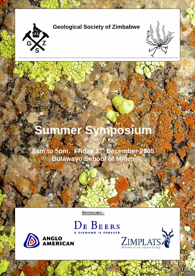
Start Topic Speaker
08:00 Registration
08:15 Welcome A du Toit, Chairman Geol Soc
08:30 Openning
08:50 Large Quarternary Eruptions at Mt. Meru, Northern Tanzania Dr Martin Roberts – De Beers Zimbabwe
09:10 Geological Society - Atlas Project Hilary Gumbo - vice Chairman Geol Soc
09:30 Proposed Changes to the Mines and Minerals Act David Matyanga - Chamber of Mines
09:50 Tea
10:10
10:30 The Use of Remote Sensing Techniques in Mineral Exploration George Pybus – De Beers Zimbabwe
10:50
11:10 Kalahari stratigraphy and its implications on diamond exploration Iyanai Murimba – De Beers Zimbabwe
11:30 Development of a groundwater flow and contaminant transport model for unlined tailings dumps
Seedwell Ravengai - Dept Geology UZ
11:50 Geology of base metal deposits of the Bushmanland Group of South Africa: Implications for exploration strategies with special emphasis
Joseph Chimvinga - Zimplats
12:10 Past systematic gold exploration activities on the Gwanda greenstone belt (implications on recent discoveries by panners and small scale miners)
J Nyagumbo - Blanket Mine
12:30 Cross Section Modeling of the Main Sulphide Zone, Great Dyke, Zimbabwe
Andrew du Toit - Zimplats
12:50 Lunch
14:00 Uncontrolled Small-Scale Gold Mining: Implications for Environmental Degradation and Gold Exploration in the Gwanda
P Zizhou - Blanket Mine
14:20 Granites and hunger: relationships between geology and livelihood challenges in Zimbabwe’s communal lands
David Love - Waternet
14:40 Smale Scale Mining in Matabeleland W Dube - Geological Survey
15:00 Summary Dr Martin Roberts – De Beers Zimbabwe
15:20 Tea
16:30 8th A.M. MACGREGOR MEMORIAL LECTURE 130 Years of Regional Geological MappingZimbabwe’s Heritage and a Challenge to the Future
Tim Broderick
Zimbabwe Geological Society Summer Symposium 20052nd December 2005, Bulawayo School Of Mines
LARGE QUARTERNARY ERUPTIONS AT MT. MERU, NORTHERN TANZANIA
DR MARTIN ROBERTS
De Beers, Zimbabwe
The Mt. Meru pumice and ash deposits, and the Mt. Meru debris avalanche deposit represent two of the largest eruptive episodes of Mt. Meru. Eruption from a magma chamber strongly zoned due to fractional crystallization produced the pumice and ash deposits. This eruptive phase consisted of numerous individual eruptions, and the climactic phase of the eruption (represented by Units A through C) produced a minimum estimated tephra volume of ~ 2.1 km3. Reconstruction of this climactic phase suggests variable eruption column heights up to 23 km, and a easterly wind speed of ~ 16 ms-1 during the eruption, and suggests that primary fall deposits several mm in thickness would have been deposited in the main rift. Units A and C represent Plinian eruptions comparable in size to the 18 May 1980 Mt. St. Helens eruption. The Mt. Meru debris avalanche deposit (~ 8600 BP; Heckey, 1971; in Wilkinson et al., 1983, 1986) has produced the spectacular 5 km wide, 10 km long and 1.3 km high scar which characterizes the edifice. The debris avalanche flowed eastwards and up the lower slopes of Mt. Kilimanjaro, with a run out length of ~ 33 km and an aerial extent of ~ 390 km2. Both block facies and matrix facies deposits are preserved. By reconstructing Mt. Meru’s morphology prior to the debris avalanche collapse event and then subtracting the post-collapse morphology (present-day morphology minus the ash cone and Kitoto lava flows), a debris avalanche volume of ~ 28 km3 is obtained, making the Mt. Meru debris avalanche one of the largest sub-aerial debris avalanches yet described. This volume requires an average debris avalanche deposit thickness of ~ 70 m, which is argued to be reasonable for the Mt. Meru debris avalanche. The trigger for the Mt. Meru debris avalanche is unclear, but a tectonic control is thought to be the most likely, with the orientation of the Mt. Meru and Mawenzi (Mt. Kilimanjaro) collapses consistent with the regional stress fields. Although Wilkinson et al. (1983 and 1986) suggest a genetic (and close temporal) link between the tephra deposits and the debris avalanche deposits, it is rather thought that they are unrelated, and that the tephra deposits preceded the collapse.
GEOLOGICAL SOCIETY – ATLAS PROJECT
HILARY GUMBO
Vice Chairman - Geological Society The sitting committee came up with the idea of compiling a brochure of all geological sites of interest. This is a follow-up to last year’s introduction of associate membership, aimed at creating greatre participation in the GSZ field activities. This atlas project was inspired by the kind of literature produced by other societies such as the “Bird Society”. There are a lot of geological locations of interest throughout Zimbabwe that we unknowingly drive or walk past in our everyday lives that would be brought to our attention by this compilation. The objectives of this atlas are to provide geologists and enthusiasts alike with a field guide of outcrops of geological significance throughout Zimbabwe. This is aimed at Promoting greater participation in field trips Promote geological “tourism” Enable easier access to the sites whose exact location was previously un-documented Trigger geological adventure (treasure hunt) Provide guidelines on documenting geological sites of interest for easier access by
others For the compilation of the atlas the following information is required: 1. Name of the location 2. UTM coordinates 3. Brief description of how to get to the location including a map reference 4. Stratigraphic location 5. Detailed description of the geology of the location 6. Permission for visiting location 7. A location map (topo or sketch) 8. References for further reading on location The GSZ would like to invite everybody to contribute to the atlas project. The sites of interest may well be underground at a mine or anywhere in Zimbabwe. It maybe possible in the future to have a classification of the sites into different categories based on the degree of significance to the understanding of the geology of Zimbabwe. These may even be plotted on a 1: million map.
PROPOSED CHANGES TO THE MINES AND MINERALS ACT
DAVID MATYANGA
Chamber of Mines
THE USE OF REMOTE SENSING TECHNIQUES IN MINERAL EXPLORATION
GEORGE PYBUS
De Beers Zimbabwe
A brief definition of remote sensing, narrowing down to the satellite and airborne infra-red systems will be provided. The basic principles of spectroscopy behind the method, and the areas of challenge inherent in this, will be discussed (e.g. atmospheric effects, detection limits). Some of the different platforms in use (within the experience of the author) will be discussed, and some of the very latest developments in high resolution satellite imagery will be mentioned. The general geological applicability of the different types of sensor will be discussed, from the point of view of a few different deposit types, and their alteration settings. This will include porphyry deposits, diamonds, and one or two others. In general, it is clear that these techniques are most useful in assisting desk-top studies of remote and inaccessible areas for geological mapping in both a general and specific sense, but can also be used for detailed alteration mapping in a prospecting license, generating a digital elevation model, selecting targets for further investigation, logistics assistance etc.. Different techniques have different levels of usefulness and it is important not to view the technique as a black-box do-it-all technique. The path from measured physical property (number of photons) to the derived geological information is much longer than in traditional techniques. This implies that more care needs to be taken generating interpretations so that the alternative interpretations are catered for. The technique is best used in conjunction with other information in a GIS context.
POTENTIAL EXPLOITATION OF GREAT DYKE ELUVIAL CHROMITE
CASTON T MUSA
Zimbabwe Alloys limited
Apart from the concentrations of chromite in layers within the Great Dyke and other ultramafic complexes, chromite also occurs as interstitial grains throughout the olivine-bearing rock-types. These olivine-bearing rocks include norites, gabbros, dunites and pyroxenites. Chromite concentration (% Cr2O3) in these rocks varies from 0.48 to 3.09 per cent of the rock (Ahrens, 1965; Worst, 1960). A small portion of this chromite settled to form chromitite seams whilst the remainder is retained within the rock mass as finely disseminated chromite and chromite interstitial to olivine. This retained chromite is much finer grained than seam chromite and is the primary source of eluvial chromite (Cotterill, 1981). During weathering of the serpentine rock and transportation by rainwater, the heavier chromite and magnetite grains are re-deposited along watercourses and vleis or valleys as the speed of the water is retarded sufficiently for the heavier particles to settle. The lighter serpentine material is removed and the chromite concentration in the soil is increased, thus resulting in eluvial chromite (Keech et al, 1961; Worst, 1960; Prendergast, 1978). This concentration of chromite in soil can be up to 15 or more % Cr2O3 concentration resulting in economic exploitable deposits particularly along the Great Dyke flacks. A preliminary evaluation of the indicate that the Great Dyke could be host to over 10 million tonnes of potential chromite concentrates which could be processed from such eluvial concentrates. These chrome rich soils can be mined more cheaply than the traditional seams and processed into chromite concentrates through simple mechanical processing techniques of Spirals and Nelson concentrators. The resultant chromite concentrates are of high quality and can used to produce briquettes, which are alternative to lumpy chromite feed for smelters. Challenges to eluvial mining include possible environmental concerns and the widespread distribution of these eluvial necessitating mobile plants and extensive infrastructural requirements. All these challenges are not insurmountable and test mining and a previous production runs have proved profitable.
KALAHARI STRATIGRAPHY AND ITS IMPLICATIONS ON DIAMOND EXPLORATION
IYANAI MURIMBA
De Beers Zimbabwe
An extensive drilling project was undertaken in the kalahari area (Gokwe Project), in the fourth quarter of 2004 by De Beers Zimbabwe Prospecting Limited. A brief overview on a number of drill hole profiles, in conjunction with geophysical surveys to illustrate the Kalahari Stratigraphy.
DEVELOPMENT OF A GROUNDWATER FLOW AND CONTAMINANT TRANSPORT MODEL FOR UNLINED TAILINGS DUMPS
S. RAVENGAI, R. OWEN, D. LOVE AND M. MECK
University of Zimbabwe
Mining and mineral processing has a long history in Zimbabwe. Modern mining operations are bound by current environmental legislation, which is becoming more stringent in most countries. However, many places in Zimbabwe have a legacy of old mines and dumps that were not subjected to the same level of environmental legislation, because such legislation did not exist at the time. The production processes employed during mineral processing has necessitated the disposal of a variety of waste materials (tailings) and industrial effluents in a number of tailings dams located around the mine site. Most of the older tailings dumps in Zimbabwe are unlined and were originally operated under poor management practises. Several studies carried out around old mine dumps in Zimbabwe showed that the unlined tailings dumps develop pollution plumes beneath that pollute the groundwater resources. The studies also show that even if the old unlined waste dumps no longer actively receive waste, they continue to discharge chemical pollution into the ground. A preliminary groundwater flow and contaminant transport model has been constructed using VISUAL MODFLOW for a site in northern Zimbabwe. The model shows that groundwater flow from the dumps site discharges into the headwaters of the a nearby river, and that over each model period of 10 years, an average volume in of approx. 5,000,000 m3 of groundwater is discharged into the stream that drains the site. Since the groundwater samples show significant chemical contamination, it is certain that some of this discharge carries chemical contamination into the wider environment. The contaminant transport model shows that pollution plumes have developed associated with the unlined tailings dams, and these plumes have flowed towards and into the River. The model shows that although the closing of the unlined waste dumps has helped the situation by reducing the fluid effluent discharged onto these dumps, these dumps still contain materials that continue to react with the infiltrating natural groundwater recharge and thus continue to contaminate the aquifer, albeit at a reduced rate. The volumes of contaminant may be calculated from the model. The model can be used to develop scenarios for the future of the dump site and to predict the duration and extent of the pollution under different effluent management practices.
GEOLOGY OF BASE METAL DEPOSITS OF THE BUSHMANLAND GROUP OF SOUTH AFRICA: IMPLICATIONS FOR EXPLORATION STRATEGIES WITH
SPECIAL EMPHASIS ON ARID SETTINGS.
JOSEPH CHIMVINGA
Zimplats A 3 day field visit was carried out on the Aggeneys mining district of South Africa to familiarise with the geology of the base metal deposits in this area. The area consists of 3 massive sulphide deposits from east to west; Gamsberg, Broken hill and Black mountain. The massive sulphides are host to Zinc (Zn), Lead (Pb), Copper (Cu) and Silver (Ag). Mineralisation is hosted in the mid-Proterozoic Bushmaland Group of metasediments and metavolcanics which is part of the broad Namaqualand metamorphic complex. The rocks have been metamorphosed to amphibolite facies. The regional stratigraphic sequence, from base to top, consists of a leucocratic gneiss, an aluminous schist unit, crystalline quartzite, the Agenneys ore formation which hosts the massive sulphide ore bodies, and the hangingwall formation of amphibolites, gneisses and conglomerates. In the ore formation, banded iron formation (BIF), consisting of magnetite and ferruginous quartzite form envelops around the massive sulphide ore bodies. The Gamsberg deposit is rich in Zn and Pb at average grades 5.8% and 0.5% respectively. At Broken Hill the massive sulphide deposit has 0.45% Cu, 6.35% Pb, 2.87% Zn and 82g/tonne Ag. The Black mountain is sub-economic and has 0.75% Cu, 2.67% Pb, 0.59% Zn and 30g/t Ag. These metal content trends show that there is a general regional zonation of base metal mineralization in this area, from Gamsberg to Black Mountain. There is a general decrease in Zn mineralization from Gamsberg to Black Mountain and a notable increase in Cu mineralization for the same trend. Pb decreases away from the Broken hill deposit in both directions. Initial reconnaissance work in the area involved regional aeromagnetics which picked up high magnetic anomalies caused by the banded iron formations and ferruginous quartzites associated with the massive sulphide ore bodies. Induced polarisation was used as a follow up on these anomalies to establish drill test targets. Geochemical sampling involved assaying of gossanous material found at the surface on each of these three deposits. In low lying pans gossanous fragments trapped in calcretes were also analysed in search of base metal signatures. In stream sediments indicator minerals which are associated with these base metal deposits were used to trace back to their source. These indicator minerals include Zn spinels like chromium, ganhite and ilmenite.
PAST SYSTEMATIC GOLD EXPLORATION ACTIVITIES ON THE GWANDA GREENSTONE BELT (IMPLICATIONS ON RECENT DISCOVERIES BY
PANNERS AND SMALL SCALE MINERS)
J NYAGUMBO
Blanket Mine
Despite the Gwanda greenstone belt having gone through various gold EPO tenures there has been limited amount of detailed systematic exploration activities carried out on this belt. Rhodesia Stratmore (Pvt) Ltd, Blanket Mine (1983) (Pvt) Ltd, Oversite, Trillion Resources, Antares, Masasa mines, Cluff Resources and Prospecting Ventures have carried out notable amount of work. Of late new organizations have applied for EPO ground on the Gwanda greenstone belt. In most cases little or no fieldwork has been done under the tenures of these EPOs (possibly due to the location of Gwanda?). Very few projects have been developed to reach to the ore resource definition stage. In some cases there has been no single fieldwork done under certain EPOs. High powered “consultants and earth practitioners” have visited and wrote papers and books on the Gwanda greenstone but there has been little or no follow up work on recommendations made. Interestingly recent “random” surface to sub-surface exploration by gold panners (& small scale miners) has identified virgin vein deposits. New deposits have been picked up especially on the Central Gwanda and Collen Bawn Deformation zones. Such deposits are only being exploited to the upper horizons (leaving deeper sections untapped). Lack of expertise and resources to mine deeper make these “new mines” die closer to surface. Discoveries of this magnitude, although small in certain instances could be the tip of huge gold deposits underneath. As earth scientists gold panners and small scale miners are posing a serious challenge to us. In certain instances gold panners have discovered deposits where some of the “so called” multinational companies have walked through.
CROSS SECTION MODELLING OF THE MAIN SULPHIDE ZONE, GREAT DYKE, ZIMBABWE
ANDREW DU TOIT
Zimplats
The Great Dyke is a layered mafic-ultramafic intrusion that transects the Zimbabwean Archaean Craton in a north-north-east trending direction. The Dyke is highly elongate, slightly sinuous, 550km long, with a maximum width of 12 km. The Main Sulphide Zone (MSZ) of the Hartley Complex of the Great Dyke contains a large resource of platinum group elements. The MSZ forms a doubly plunging synform, often described as an open canoe shape some 100km long and up to 12km wide and 1.2km deep . Resource drilling has been carried out on wide spaced grids, with drill spacings of 250m, 500m, 1km and wider. This paper outlines one approach to gaining the most information from this drilling.. Zimplats is currently mining platinum near to southern end of the complex, by open pit methods to depths up to 50m and by room and pillar extraction in the axis of the synform. As mining progresses northwards the extent to which room and pillar mining is appropriate is limited by the dip of the MSZ. The location and characterization of faults on all scales is an ongoing challenge. Three dimensional computer models of the MSZ in areas with sparse drilling are distorted by drill spacing and positioning. This leads to significant errors and uncertainty in the positioning of dip contours. In areas of relatively dense drilling even significant faults are difficult to detect on these models. Manual interpolation gives a more intuitive cross sectional shape but does not highlight where the changes in dip are due to faults rather than the synformal structure of the zone making the interpretation of faults difficult and subjective. In order to overcome these limitations, a mathematically describable model of the shape was investigated. This model would allow quantitative comparison of the structure in different areas and provide a reference against which to compare the intersections in order to increase the resolution with which faults can be detected. As a result it was found that the cross sectional shape of the MSZ approximates to an arc of a circle. Having such a simple, mathematically describable curve has a number of useful applications. Fitting an arc to the drill intersected elevations allows the dimensions of the curve to be estimated for a particular area. Once the centre of the circle and radius of curvature are known, the position of a particular dip contour can be calculated even in areas where there is sparse drilling data. This increases to the confidence with which dip contours can be modeled.
The shape of the curve described simply by the radius of curvature is a parameter that is easily visualized, understood and communicated and allows quantitative comparison of different areas of the MSZ. Where groups of holes along a cross-section fit circles with different centres, the position and throw of otherwise subtle faults can be deduced. A simple mathematical model of the shape of the MSZ has proved useful in analyzing and communicating the cross sectional structure. Work is now focused on finding similar mathematical descriptions of the long range trends in the thickness and metal content of the MSZ over the whole complex.
UNCONTROLLED SMALL-SCALE GOLD MINING: IMPLICATIONS FOR ENVIRONMENTAL DEGRADATION AND GOLD EXPLORATION IN THE
GWANDA GREENSTONE BELT
P ZIZHOU
Blanket Mines The Gwanda greenstone belt is host to a multitude of dormant and active small-scale to large-scale gold producers. Gold mining in the belt dates back to the early 1600s when local inhabitants presumably worked ore from gossanous outcrops. Pre-1980 most of the Gwanda belt was under commercial farmers who heavily censured mining as a disruptive occupation hence allowed only large producers such as Blanket and Vubachikwe to peg and prospect for gold. With the advent of the land reform program the land in Gwanda was opened for indiscriminate pegging and mining by all and sundry. Due to the hyper-inflationary environment prevailing in Zimbabwe, most major gold producers have scaled down exploration activities thus creating a vacuum that has been ably, if haphazardly filled in by illegal gold panners. Uncontrolled mining has not only resulted in severe degradation and denudation of the environment but also great pollution from such chemicals as mercury being indiscriminately used to capture free gold during panning. However for exploration companies the presence of illegal gold panners, though unwelcome, is in the short term a useful pointer when designing exploration programs.
GRANITES AND HUNGER: RELATIONSHIPS BETWEEN GEOLOGY AND LIVELIHOOD CHALLENGES IN ZIMBABWE’S COMMUNAL LANDS
DAVID LOVE
WaterNet
Approximately one third of Zimbabwe is underlain by granitic rocks. Although the granite-greenstone contacts provide much of the gold that sustains parts of the national economy, granite does not provide for good agriculture, our other mainstay. Granite provides poor to very poor soils. The soils are sandy, since granites are, in a large part, composed of quartz, which weathers to sand. Since quartz is a resistate mineral, it tends to form large grains (sand rather than silt), which drain very rapidly. They hold water for short periods of time, even under irrigation. By the end of the dry season, i.e. just before planting, the top 0.3 m of the soil horizon frequently holds negligible water content – although this is due also to climatic factors. Due to the mineralogy of the parent rock, granitic soils are acidic, shallow, and infertile, deficient in nitrates, phosphates and sulphur. Crop yields are, as a result, low and erratic. In Zimbabwe, smallholder farmers – amongst the poorest sectors of our society – are concentrated on these poor soils. This has been only partially redressed under the conventional and fast-track land reform programmes, with approximately 190,000 beneficiaries resettled since independence. The majority of the rural population remains on the granites, leading to the ironic (and unjust) situation that the worst soils have the highest population density. Naturally, the rising populations have placed an increasing burden on the soils. It is thus unsurprising that districts such as Gwanda have both a high population density and a high global acute malnutrition rating. Some solutions exist in terms of soil fertility management strategies. Micro-dosing – applying small amounts of fertiliser with the seed at planting time – can allow plants to capture more water and increase yield. The technique is also more readily accessible to the poor farmer due to lower costs. However, major increases in yield can only be obtained when soil fertility management is combined with soil-water conservation practices such as timely planting and weeding, thus reducing periods of potential moisture stress/competition. Some in field water management technologies, such as basin tillage, have proven effective at reducing runoff, thus increasing infiltration and water access to the crops. Conservation tillage approaches, such as ripping, have also proven very effective in increasing water availability to crops But granite itself can offer some solutions: the granite backbone of the Zimbabwe Craton is a secondary aquifer and it has been shown that the use of structural techniques in siting boreholes can liberate high groundwater yields. Short dryspells - not necessarily water scarcity measured at an annual scale - are often the major cause of low yields and loss of food security. Therefore a limited period of supplementary irrigation, sourced from groundwater, could turn a disaster into plenty. However, longer-term solutions are needed and represent a major challenge. Is it possible that large parts – wards, districts – of our rural areas cannot sustain crop-based livelihoods? What other strategies could be considered? Or do we need to look at larger scale
translocations of population than have so far taken place? It is the purpose of this contribution to provoke debate: Solutions must be found or else a substantial proportion of our population shall remain largely excluded from the national economy and frequently below the poverty and malnutrition lines.
SMALL SCALE MINING IN MATABELELAND
W DUBE
Geological Survey
Related Documents