A59 Kex Gill Diversion Scheme Option Assessment Report i A59 Kex Gill Diversion Scheme Options Assessment Report May 2017 Prepared for: Prepared by:

Welcome message from author
This document is posted to help you gain knowledge. Please leave a comment to let me know what you think about it! Share it to your friends and learn new things together.
Transcript
A59 Kex Gill Diversion Scheme
Option Assessment Report
i
A59 Kex Gill Diversion Scheme
Options Assessment Report
May 2017
Prepared for:
Prepared by:

A59 Kex Gill Diversion Scheme
Option Assessment Report
i
Document Control Sheet
Project Title A59 Kex Gill Diversion Scheme
Report Title Option Assessment Report
Report ref no. 1075976/OAR/DR/v2.0
Version 2.0
Status Draft
Report Date 24/05/2017
Record of Issue
Version Status Author Date Checked by Date Approved by Date
1.0 Draft DS/RD 21/03/2017 AC/PS 22/03/2017 AC 22/03/2017
2.0 Draft DS/SM 24/05/2017 RD 24/05/2017 AC 26/05/2017
Distribution
Date Organisation Contact Format Copies
22/03/2017 North Yorkshire County Council Andrew Bainbridge/James Gilroy Electronic 1
26/05/2017 North Yorkshire County Council Andrew Bainbridge/James Gilroy Electronic 1
A59 Kex Gill Diversion Scheme
Option Assessment Report
ii
Limitations
This report is presented to North Yorkshire County Council in respect of the A59 Kex Gill
Diversion Scheme and may not be used or relied on by any other person. It may not be
used by North Yorkshire County Council in relation to any other matters not covered
specifically by the agreed scope of this Report.
Notwithstanding anything to the contrary contained in the report, Mouchel Limited is
obliged to exercise reasonable skill, care and diligence in the performance of the
services required by North Yorkshire County Council and Mouchel Limited shall not be
liable except to the extent that it has failed to exercise reasonable skill, care and
diligence, and this report shall be read and construed accordingly.
This report has been prepared by Mouchel Limited. No individual is personally liable in
connection with the preparation of this report. By receiving this report and acting on it,
the client or any other person accepts that no individual is personally liable whether in
contract, tort, for breach of statutory duty or otherwise.
A59 Kex Gill Diversion Scheme
Option Assessment Report
iii
Contents
1 Executive Summary ........................................................................................... 1
2 Introduction...................................................................................................... 11
3 Understanding the Current Situation ............................................................. 19
4 Understanding the Future Situation ............................................................... 56
5 Establishing the Need for Intervention .......................................................... 66
6 Identifying Objectives ..................................................................................... 71
7 Geographical Area of Impact .......................................................................... 76
8 Generating Options/Corridors ........................................................................ 78
9 Assessment and Sifting of Corridors ............................................................. 88

A59 Kex Gill Diversion Scheme
Option Assessment Report
iv
Page left intentionally blank

A59 Kex Gill Diversion Scheme
Option Assessment Report
1
1 Executive Summary
1.1.1 Importance of the A59 Route and Kex Gill Landscape
The A59 provides a key strategic east-west connection in North Yorkshire, linking
Harrogate and Skipton, which are the key settlements within their respective
authority areas, (see Figure 1-1). Whilst the A59 does not form part of the Strategic
Road Network (SRN), it is viewed by residents and businesses as a critical strategic
route for east-west connectivity in the north of England, offering an important
connection to sections of the SRN, most notably Junction 31 of the M6 and Junction
47 of the A1(M)1. In addition to this strategic connectivity, the A59 also provides an
important link for smaller settlements and communities in this area, providing
accessibility to the wider transport network and key facilities and services.
Figure 1-1 – Route of A59 through North Yorkshire
At Kex Gill, the A59 route passes through a rural and open landscape, designated as
the Nidderdale Area of Outstanding Natural Beauty (AONB). The surrounding
landscape is considered to be of very attractive quality and highly valued for its
recreational resource. In addition, large parts of the area are designated as Site of
Special Scientific Interest (SSSI), Special Protection Area (SPA) and Special Area of
Conservation (SAC).
1.1.2 A59 Kex Gill Landslips
There is a long history of landslips on the land above the A59 at Kex Gill (see Figure
1-2). These landslips deposit material onto the road leading to unpredictable
closures of the A59. Analysis of existing geotechnical information indicates that the
primary cause of these landslips is heavy rainfall, coupled with relatively unstable
1 The route also forms part of Transport for the North’s (TfN) plans for a Major Route Network (MRN)

A59 Kex Gill Diversion Scheme
Option Assessment Report
2
land on the hillside slopes, leading to earthwork failures. The most recent landslip
occurred in early 2016 and resulted in a road closure of approximately 8 weeks. In
addition, the cost to North Yorkshire County Council (NYCC) for emergency slope
stabilisation and associated carriageway work was around £625,000.
Figure 1-2 – Timeline of Road Closures on A59, Kex Gill
Whilst various engineering works have been undertaken, adjacent to the existing
A59, to remediate past landslips and to reduce the landslide risk, in view of the
extent of the area at risk and the large scale of the existing or potential landslide
features, full stabilisation of the area at risk would require extensive and very
substantial engineering works and is unlikely to be practicable or environmentally
acceptable. It is thus probable that the existing A59 or any online improvement would
remain susceptible to landslides and related disruption.
Furthermore, whilst the specific effects on landslide activity are difficult to quantify,
landslide events are frequently related to individual extreme rainfall events or years
with generally higher winter rainfall. It is therefore probable that, given the projections
of future climate change, which indicate increased rainfall in winter months, this will
result in some increase in the frequency of individual landslide events and/or the re-
activation or increased movement of existing and/or relict landslide features.
1.1.3 The Need for Intervention
Fortunately, to date, although a vehicle has been caught by a landslip, there have
been no personal injuries as a result of a landslip at Kex Gill. However, without
intervention, there continues to be a significant risk that road users could be caught
in any future landslip, (potentially resulting in serious injuries or fatalities).
The main effect of historic landslide events has been to deposit debris on the
carriageway, but the highway itself has remained substantially intact. However, there
is a significant risk that larger scale events may occur in the future extending across
and below the road, causing extensive damage to or breach of the highway itself,
resulting in an extended closure over several months whilst the highway is
reinstated.

A59 Kex Gill Diversion Scheme
Option Assessment Report
3
The clear-up costs and continued high level of maintenance and monitoring required
at Kex Gill results in a significant cost to NYCC. Further to the costs identified in
Figure 1-2, NYCC continues to typically spend around £240,000 per year on
maintenance and monitoring. In times of emergency, the cost of implementing a full
road closure together with diversion routes for one week can cost around £40k.
In the event of a landslip at Kex Gill, the A59 is closed and users are forced to use
the diversion route which adds approximately 10km to the journey distance, resulting
in significant impacts on journey times and costs to A59 users and adversely impacts
the resilience of the route, journey time reliability and consequently, east-west
connectivity. Furthermore, the official diversion route runs through a number of towns
in West Yorkshire. The additional traffic and congestion which occurs when the A59
is closed results in adverse impacts to the communities of Ilkley, Burley in
Wharfedale and Otley, amongst others. A number of other roads are also used by
vehicles as a diversion when the A59 is closed at Kex Gill, creating adverse impacts
to the communities along these routes also. These roads are generally either B Road
or a lower standard and hence are not necessarily suitable for large volumes of
traffic, or significant numbers of HGVs in particular. The routes do not necessarily
offer a shorter distance compared to the official diversion route, but may be being
used to avoid congestion on the official diversion route.
Further to the issues associated with landslips and closures at Kex Gill, NYCC are
keen to improve connectivity on the A59 between Harrogate and Skipton to support
sustainable economic growth. Outside of any periods of closure, the main constraint
on journey time reliability is the formation of convoys behind slow moving vehicles
(usually Heavy Goods Vehicles (HGVs)) on this section of the A59, due to the
challenging topography and alignment of the road and the lack of overtaking
opportunities. There are also a significant number of accidents occurring along the
A59 route, with sections of the A59 in the study area displaying accident rates twice
the national average. Again, these factors affect the reliability and resilience of the
route.
Figure 1-3 summarises these important issues which affect the A59 at Kex Gill,
demonstrating a clear need for intervention.

A59 Kex Gill Diversion Scheme
Option Assessment Report
4
Figure 1-3 – The Need for Intervention
1.1.4 Scheme Objectives and Area of Impact
A hierarchy of objectives have been established, (see Figure 1-4), developed in
consultation with the client (NYCC) and representatives of Harrogate Borough
Council (HBC) and Craven District Council (CDC).
Figure 1-4 – A59 Kex Gill Diversion Scheme Objectives

A59 Kex Gill Diversion Scheme
Option Assessment Report
5
1.1.5 Option/Corridor Development
Given the nature of the problems at Kex Gill, which are primarily related to landslips,
it is not appropriate to consider a wider range of measures or interventions to
address travel behaviours. However, Public Transport, pedestrian/cycle
improvements or smarter measures, whilst potentially reducing the traffic flows along
the route, would not tackle the issue of landslip risk. The only way to ensure
continued east-west connectivity on the A59 is to divert the Kex Gill section of the
route out of the landslip risk area or to develop a slope stabilisation scheme capable
of providing near 100% confidence that there would be no further failures. With no
other suitable east-west connection in the area, it is imperative that a robust A59
alignment continues to be provided. As a result, the options which have been
developed are all highways focussed. These options are focused on the intervention
area, see (Figure 1-5), which illustrates the geographical extents for the development
of options. The figure also illustrates the wider area of impact – illustrating the
anticipated geographic extent of the key travel market anticipated to be impacted by
the scheme, including the communities located along the official diversion route.
Figure 1-5 – Intervention Area and Wider Area of Impact
Option development began with an internal ‘problems and issues’ workshop,
attended by the study team technical leads (Environment, Geotechnical, Highways,
Quantity Surveying and Transport Planning), thus ensuring consideration of a wide
range of factors. Subsequently, the Highways team developed initial designs for
A59 Kex Gill Diversion Scheme
Option Assessment Report
6
options2 and a further workshop was held to review these initial options. As a result
of the discussions at the workshop, several new option alignments were created. On
the 11th January, an ‘initial options’ workshop was held at NYCC area offices in
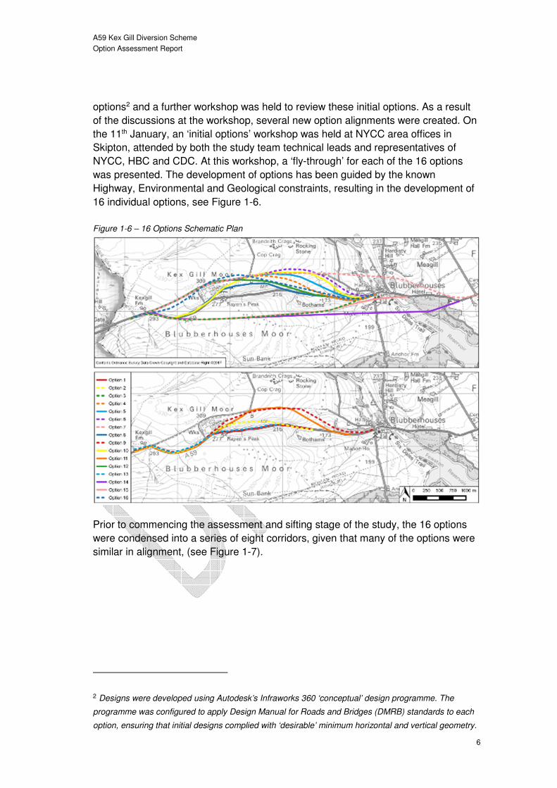
Skipton, attended by both the study team technical leads and representatives of
NYCC, HBC and CDC. At this workshop, a ‘fly-through’ for each of the 16 options
was presented. The development of options has been guided by the known
Highway, Environmental and Geological constraints, resulting in the development of
16 individual options, see Figure 1-6.
Figure 1-6 – 16 Options Schematic Plan
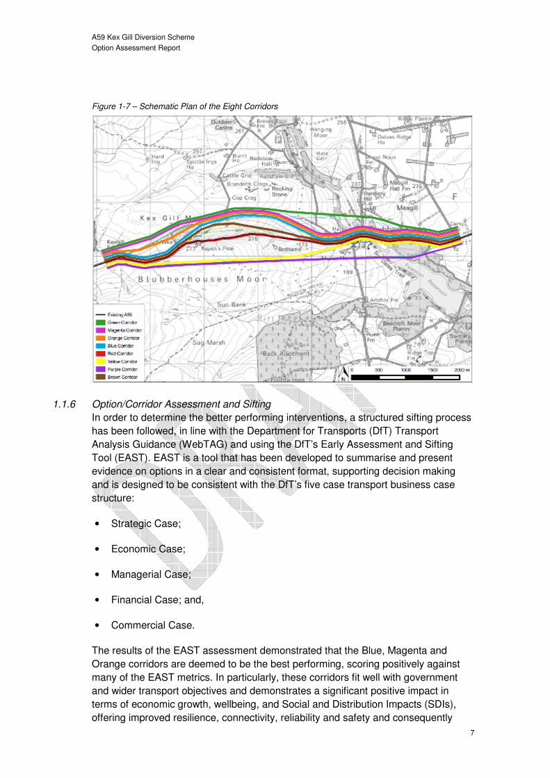
Prior to commencing the assessment and sifting stage of the study, the 16 options
were condensed into a series of eight corridors, given that many of the options were
similar in alignment, (see Figure 1-7).
2 Designs were developed using Autodesk’s Infraworks 360 ‘conceptual’ design programme. The
programme was configured to apply Design Manual for Roads and Bridges (DMRB) standards to each
option, ensuring that initial designs complied with ‘desirable’ minimum horizontal and vertical geometry.
A59 Kex Gill Diversion Scheme
Option Assessment Report
7
Figure 1-7 – Schematic Plan of the Eight Corridors
1.1.6 Option/Corridor Assessment and Sifting
In order to determine the better performing interventions, a structured sifting process
has been followed, in line with the Department for Transports (DfT) Transport
Analysis Guidance (WebTAG) and using the DfT’s Early Assessment and Sifting
Tool (EAST). EAST is a tool that has been developed to summarise and present
evidence on options in a clear and consistent format, supporting decision making
and is designed to be consistent with the DfT’s five case transport business case
structure:
• Strategic Case;
• Economic Case;
• Managerial Case;
• Financial Case; and,
• Commercial Case.
The results of the EAST assessment demonstrated that the Blue, Magenta and
Orange corridors are deemed to be the best performing, scoring positively against
many of the EAST metrics. In particularly, these corridors fit well with government
and wider transport objectives and demonstrates a significant positive impact in
terms of economic growth, wellbeing, and Social and Distribution Impacts (SDIs),
offering improved resilience, connectivity, reliability and safety and consequently

A59 Kex Gill Diversion Scheme
Option Assessment Report
8
meeting the specific scheme objectives, in particularly, removing the risk of landslip
related closures of the A59. These three corridors are considered to be amongst the
more affordable corridors, demonstrate some of the shortest implementation
timescales and offer a good degree of flexibility, should wider circumstances change.
Given that these corridors involve offline construction, they will have significant
impacts in environmentally sensitive areas. As such, it will be important to minimise
any harm caused to this sensitive environment. This is a key issue which needs
further consultation with stakeholders. However, despite this, these corridors are
among those anticipated to be most acceptable to the public.
Whilst the Yellow, Green and Purple corridors also score well against many of the
metrics, there are several reasons why, overall, they are not considered to be
amongst the better performing corridors:
• Costs in excess of £70m (£100m in the case of the Green and Purple
corridors) therefore becoming increasingly unaffordable, particularly as they
are unlikely to offer a similar level of increase in benefits.
• Implementation timescales are shown to be longer than that of other
corridors.
• Significant adverse environmental impact on environmentally sensitive areas
resulting from the extensive construction in areas designated as AONB,
SSSI, SPA and SAC also resulting in lower public acceptability.
• Finally, the practical feasibility of delivering these corridors is lower, partly
due to the need to deal with extensive peat deposits with water courses
crossing route causing stability/drainage issues and, in the case of the Green
and Purple corridors, the need for substantial structures.
The Brown corridor, whilst being amongst the corridors deemed to be most
affordable and having one of the shortest implementation timescales, does not score
well in terms of scale of impact, failing to substantively meet many of the scheme
objectives, primarily as it is located in an area of continues landslip risk and therefore
offer little in the way of increased resilience, reliability, connectivity or safety. In
addition, the corridor also requires construction in an environmentally sensitive area,
though not on the scale of Yellow, Green and Purple corridors. The fact that this
corridor involves construction in the AONB, SSSI, SPA and SAC whilst still being
subject to the same landslip risks as the current route, means that this corridor is
considered to be one of the worst performing in terms of public acceptability.
The key strength of the Red Corridor (online) is that is avoids extensive construction
within the environmentally sensitive areas of the study area. Furthermore, it is
amongst the more affordable corridors and has similar implementation timescales to
others. However, as the corridor continues to be located in an area of continuing
landslip risk it scores poorly against many of the metrics, in particular the overall
scale of impact, based on its limited impacts resilience, reliability, connectivity or
A59 Kex Gill Diversion Scheme
Option Assessment Report
9
safety improvements. These factors, combined with the fact that its construction
would see extensive disruption to A59 users, as an extensive diversion would need
to be put in place, means that the public acceptability of this corridor is low. The
inability to use the existing A59 as a diversion route during construction also means
that this corridor scores poorly in terms of flexibility and practical feasibility.
1.2 Next Steps
1.2.1 Development of Scheme Design
The completion of the Option Assessment Report (OAR) has resulted in the
identification of three preferred corridors; Blue, Magenta and Orange. These
corridors (and therefore the initial options on which they are based) are all broadly
similar – being located on the north side of the Kex Gill valley; involving improvement
to the Kex Gill Farm corner; a diversion around the key area of landslip risk; and
tying back into the existing A59 alignment around Blubberhouses. The only
substantive difference between the preferred corridors is whether they diverge from
the existing A59 at Kex Gill Farm or further east along the existing A59, (the latter
option also incorporating a smoothing of Kex Gill Farm corner) and the actual
specific alignment of the section diverting around the key landslip risk area. Both of
these areas require further investigation and testing before a decision can be made
as to which is the preferred arrangement. Key to enabling this refinement, is the
need for further ground condition and topographical surveys in the vicinity of the
preferred corridors. This information will be critical in being able to narrow down the
exact alignment of a preferred option.
1.2.2 Engagement with Stakeholders and the Public
Whilst some initial engagement with a limited number of stakeholders has taken
place, it will be important to engage with a wider range of key stakeholders in more
depth, now that preferred corridor alignments are beginning to emerge and other
potential options (particular online options) are being discarded. In particular, the
need for consultation with environmental stakeholders is paramount, in order to
discuss the need for the scheme and understand the strength of feeling regarding
the impacts of construction in environmentally sensitive areas, (as this is likely to be
a key area of opposition) versus the benefits of a new alignment outside of an area
of substantial landslip risk. Furthermore, it will be important to discuss potential areas
of mitigation, such as returning the landscape of the existing section of the A59 to its
original state.
Similarly, the next steps need to include for initial public consultation. Given that any
offline option is likely to result in the need for a public inquiry, engaging the public
from an early point in the study will be important in order to ensure that clear
messages are being broadcast and that local communities feel that they are being
engaged with early in the study process. Establishing a communications plan will be
vital to ensure that stakeholders and the public are kept up to date throughout the
subsequent stages of the study, limiting the risk of objections during the anticipated
public inquiry.

A59 Kex Gill Diversion Scheme
Option Assessment Report
10
1.2.3 Development of Outline Business Case
Alongside both the development of the scheme design and the stakeholder/public
consultation, there is a need to develop a robust business case, both to secure
potential DfT funding and to clearly illustrate to stakeholders (and the public) the
benefits of implementing a Kex Gill Diversion scheme. Aligned with the development
of a business case is the need to refine the cost estimating work done to date, in
particular, developing a more detailed risk register and quantification of risks, and
developing greater cost certainty over both the capital and revenue cost estimates.
Clearly, the additional ground investigation and topographical surveys that are
recommended will enable increased confidence in the development of scheme cost
estimates, which currently include a substantial allowance for contingency and
optimism bias.
Finally, in order to develop a robust business case which includes an accurate
representation of the quantification of benefits associated with a Kex Gill Diversion
Scheme and the corresponding Benefit Cost Ratio (BCR) and Value for Money
(VfM), (which again will be imperative for both securing funding and demonstrating
the benefits of intervention to stakeholders and the public), consideration needs to
be given to the need for some form of appraisal tool (e.g. transport model) to enable
this quantification. Early discussion have taken place between NYCC, Mouchel and
the DfT in relation to modelling requirements and these will continue over the coming
months.
A59 Kex Gill Diversion Scheme
Option Assessment Report
11
2 Introduction
2.1 Study Area Overview
The A59 is a key strategic route, approximately 170km in length, which runs from
Wallasey in Merseyside to York in North Yorkshire, passing through a number of
towns and cities including Liverpool, Ormskirk, Preston, Clitheroe, Skipton,
Harrogate and Knaresborough (see Figure 2-1). Whilst the A59 does not form part of
the Strategic Road Network (SRN), it is seen as a key strategic route for east-west
connectivity in the north of England, (it is part of the MRN – Major Route Network –
being developed by Transport for the North (TfN)) and provides connection to
sections of the SRN, most notably Junction 31 of the M6, to the east of Preston, and
Junction 47 of the A1(M) to the east of Harrogate. The A59 also provides key links to
other important sections of the road network, including the A61 which connects to
Leeds and the A65 connecting to Cumbria in the northwest of England. As can be
seen in Figure 2-1, to the immediate north of the A59, there are no other east-west
routes that are viable for strategic travel in this region. Consequently it is a very
important route in this area.
Figure 2-1 – A59 Extents
The focus of this study is the section of the A59 at Kex Gill, between Skipton and
Harrogate, see Figure 2-2. The A59 provides a key strategic east-west connection in
this part of the country, linking Harrogate and Skipton which are the key settlements
within their respective authority areas. Furthermore, the section of the A59, linking
the A1 and Harrogate to Skipton and Craven District is identified in the York, North

A59 Kex Gill Diversion Scheme
Option Assessment Report
12
Yorkshire and East Riding (YNYER) Local Enterprise Partnership’s (LEP) Strategic
Economic Plan3 (SEP) as a priority route.
The A59 also provides an important link for smaller settlements and communities in
this area, providing accessibility to the wider transport network and key facilities and
services. The route is a particularly important link for the local communities and
businesses in Skipton and Harrogate, given that travel by alternative modes is not
necessarily viable; there are no direct bus or rail links between the two towns4.
Figure 2-2 – A59 Kex Gill Location Plan
The route between the two towns is a predominantly a rural single carriageway,
subject to the national speed limit. There are, however, two short sections with lower
speed limits, including a 1.5km section with a 50mph speed limit, to the east of
Bolton Bridge and a 1.7km section with a 40mph speed limit, immediately to the west
of the A61 junction at Harrogate (see Figure 2-3). In addition, this section of the route
3 Strategic Economic Plan, York, North Yorkshire & Ear Riding Local Enterprise Partnership, (2016)
4 A journey by bus requires travelling via Leeds or Addingham and changing services; this journey
would take around two hours. Similarly, a journey by rail requires changing trains at Leeds City Station,
with a journey time ranging between 1.5-2 hours. A car journey along the A59 under normal conditions
would be expected to take around 40 minutes.

A59 Kex Gill Diversion Scheme
Option Assessment Report
13
is undulating, with some steep sections of carriageway, including at Kex Gill. As a
result, there are three sections of climbing lane, including two sections eastbound
near Beamsley, and to the east of Bolton Bridge and, a westbound section near
Halton East; to the west of the Bolton Bridge junction.
Figure 2-3 - A59, Location of Climbing Lanes and Speed Limit Changes
The A59 has an Average Annual Daily Traffic Flow (AADF) of approximately 8,8005.
As illustrated by Figure 2-4, the traffic level has remained relatively constant over the
time period analysed. Cars make up approximately 80% of the traffic flow, but there
is also a significant number of Lights Goods Vehicles (LGVs) and Heavy Goods
Vehicles (HGVs) using the route (approximately 1,200 and 750 respectively).
Figure 2-4 – A59 Average Annual Daily Flow 2008-2015
Source: Department for Transport (DfT)
5 2015, based on DfT traffic count site on A59, east of Blubberhouses: http://www.dft.gov.uk/traffic-
counts/
01,0002,0003,0004,0005,0006,0007,0008,0009,000
10,00011,000
AA
DF
Year
Traffic Volumes on A59, 2008-2015
Cars LGVs HGVs All Motor Vehicles

A59 Kex Gill Diversion Scheme
Option Assessment Report
14
2.2 Kex Gill Landslips
Kex Gill is a narrow and steep sided valley located on the A59 in North Yorkshire,
situated approximately 16km west of Harrogate and 15km east of Skipton, see
Figure 2-5 and Figure 2-6. The A59 at Kex Gill passes through a rural and open
landscape, designated as the Nidderdale Area of Outstanding Natural Beauty
(AONB). The landscape of the area within the Nidderdale AONB is considered to be
of very attractive quality and highly valued for its recreational resource, with
numerous footpaths and bridleways. In addition, large parts of the area are
designated as a Site of Special Scientific Interest (SSSI), Special Protection Area
(SPA) and Special Area of Conservation (SAC).
There is a long history of landslips on the land above the A59 at Kex Gill. These
landslips deposit material onto the road leading to unpredictable closures. The
primary cause of the landslips is heavy rainfall coupled with relatively unstable land
on the hillside slopes in the area leading to earthwork failure. The most recent
landslip occurred in early 2016 and resulted in a road closure of approximately 8
weeks duration. In addition, the cost to North Yorkshire County Council (NYCC) for
emergency slope stabilisation and associated carriageway work was around
£625,000. Fortunately, to date, although a vehicle has been caught by a landslip,
there have been no personal injuries as a result of a landslip at Kex Gill. However,
without intervention, there continues to be a risk that road users could be caught in
any future landslip or of larger landslips leading to much longer road closures and an
associated significant maintenance cost liability to NYCC.
Figure 2-5 – Schematic Location Plan
A59 Kex Gill Diversion Scheme
Option Assessment Report
15
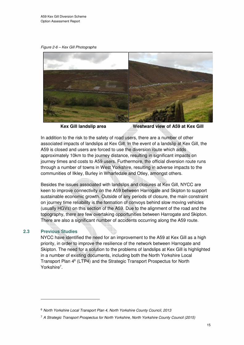
Figure 2-6 – Kex Gill Photographs
Kex Gill landslip area Westward view of A59 at Kex Gill
In addition to the risk to the safety of road users, there are a number of other
associated impacts of landslips at Kex Gill. In the event of a landslip at Kex Gill, the
A59 is closed and users are forced to use the diversion route which adds
approximately 10km to the journey distance, resulting in significant impacts on
journey times and costs to A59 users. Furthermore, the official diversion route runs
through a number of towns in West Yorkshire, resulting in adverse impacts to the
communities of Ilkley, Burley in Wharfedale and Otley, amongst others.
Besides the issues associated with landslips and closures at Kex Gill, NYCC are
keen to improve connectivity on the A59 between Harrogate and Skipton to support
sustainable economic growth. Outside of any periods of closure, the main constraint
on journey time reliability is the formation of convoys behind slow moving vehicles
(usually HGVs) on this section of the A59. Due to the alignment of the road and the
topography, there are few overtaking opportunities between Harrogate and Skipton.
There are also a significant number of accidents occurring along the A59 route.
2.3 Previous Studies
NYCC have identified the need for an improvement to the A59 at Kex Gill as a high
priority, in order to improve the resilience of the network between Harrogate and
Skipton. The need for a solution to the problems of landslips at Kex Gill is highlighted
in a number of existing documents, including both the North Yorkshire Local
Transport Plan 46 (LTP4) and the Strategic Transport Prospectus for North
Yorkshire7.
6 North Yorkshire Local Transport Plan 4, North Yorkshire County Council, 2013
7 A Strategic Transport Prospectus for North Yorkshire, North Yorkshire County Council (2015)
A59 Kex Gill Diversion Scheme
Option Assessment Report
16
NYCC has previously commissioned a number of geotechnical investigations of the
land in the Kex Gill area, in order to try to develop their understanding of the
geotechnical issues resulting in landslips, the include:
• Report on Ground Investigation at A59, Kex Gill, Norwest Holst Soil
Engineering, 2008. This report summarised that the ground investigation
broadly concurred with published geology reports. Including presence of very
weak to medium strong carboniferous strata and groundwater in the
exploratory boreholes.
• A59 Kex Gill Geotechnical Interpretative Report, Jacobs, 2009. The
report concluded that ground failures appeared to be due to a planar slide of
superficial deposits. The risk of a massive rotational failure above the road
was considered to be low, however, a risk of continued shallow planar
failures in the slope above the road was identified. Recommendation for re-
grading of the slope face and provision of a rock berm was provided.
• A59 Bypass Preparatory works – Geotechnical Walkover and High Level
Geotechnical Risk Register, Jacobs, 2015. In summary, the site walkover
concluded that there was a possibility of embankment bearing failure and
settlement issues and potential for landslides. It also noted that quarrying in
the area has altered the general landscape and there may be cut and fill in
unexpected places. Other key risk hazards noted included, soft weak soils,
level of groundwater and stability of slopes and excavation of rock to create
cuttings.
• Landslip A59 Kex Gill, Blubberhouses – Preliminary Sources (Desk)
Study, Capita, 2015. Three options were investigated. Option 1, to stabilise
the existing slope – this was perceived to be beneficial for reducing impacts
to the AONB. However, further detailed ground investigation was
recommended to assess feasibility. Option 2 referred to realignment of the
road along Old Kex Gill Turnpike. This option was considered to have many
potential benefits. Option 3 included realigning the road into the valley
bottom, this option however was discounted due to the potential for an
increase in fluvial flooding downstream of the option.
• Kex Gill Preliminary Environmental Appraisal (Draft), Capita, 2016. The
report, which is currently still being finalised, will set out findings relating to
the likely environmental effects of construction of a new road alignment on a
range of environmental topics.
• Kex Gill Options Summary Report, Capita, 2016. This report was
commissioned to provide a high level options assessment for relocation of the
A59. Five options were considered and they were all considered to offer high
Value for Money (VfM). It was noted however, that there is potential for
adverse environmental impacts. It was recommended that the options are
A59 Kex Gill Diversion Scheme
Option Assessment Report
17
examined in greater detail in a full options assessment, followed by formal
consultation.
A further geotechnical study of the Kex Gill area is currently being undertaken by
Capita. It is anticipated that a report of the findings will be available by April 2017.
NYCC also previously commissioned a study into the economic and environmental
feasibility of a potential diversion scheme at Kex Gill8. This study informed the
Yorkshire Dales Landslips Package Local Highways Maintenance Challenge Fund
bid, submitted by NYCC to the Department for Transport (DfT) in 2015. The bid was
for a landslip prevention scheme comprising slope stabilisation and support, and
drainage enhancement. The estimated cost was approximately £10m for a package
of works covering Kex Gill and Swaledale (west of Richmond). The bid demonstrated
high VfM with a Benefit Cost Ratio (BCR) of 2.9. Whilst, the bid was unsuccessful on
this occasion, it instigated a dialogue between the DfT and NYCC over the need for
a solution the issues affecting the A59 at Kex Gill, a dialogue which has continued
alongside the development of this Option Assessment Report (OAR).
This OAR documents the process of identifying the need for intervention (based on
the current and future issues) and the process of option development and sifting.
The remainder of the document is structured as follows:
• Chapter 3 outlines the current situation in the study area in terms of current
transport (and other) policy, travel demands and opportunities and
constraints;
• Chapter 4 sets out the future transport situation, taking into account future
land-use policies, changes to the transport system and travel demands;
• Chapter 5 establishes the need for intervention, based on the current and
future transport-related problems in the area and the underlying causes of
these problems;
• Chapter 6 presents a clear set of intervention-specific objectives;
• Chapter 7 establishes the geographical area of impact to be addressed by an
intervention, based on an understanding of the scope of the travel market,
key origins and destinations and the extent of current and future transport
problems;
• Chapter 8 outlines the option generation process;
8 A59 Harrogate to Skipton Preparatory Works Package: Kex Gill Diversion Economic & Environmental
Feasibility Study, Jacobs, 2015

A59 Kex Gill Diversion Scheme
Option Assessment Report
18
• Chapter 9 discusses the process of how the options were appraised and
sifted to identify preferred options;
• Chapter Error! Reference source not found. summaries the findings of the
OAR and outlines the next steps for the Kex Gill Diversion Scheme.

A59 Kex Gill Diversion Scheme
Option Assessment Report
19
3 Understanding the Current Situation
3.1 Overview
This section of the report provides a summary of the current situation and problems
affecting the A59 at Kex Gill, including a commentary on current transport and other
relevant policies, current travel demand and level of service, and current
opportunities and constraints.
The key issue is the occurrence of landslips at Kex Gill which result in closures of the
A59, and associated adverse impacts on A59 users and the communities and
businesses which rely on the route. However, even outside of periods of closure,
there are issues associated with the route which have a detrimental impact on east-
west connectivity. The remainder of this section discusses these two key issues in
more detail.
3.2.1 History of Landslips
There is a long history of landslips on the valley slopes above the A59 at Kex Gill.
These landslips result in material being deposited onto the road, leading to the
closure of the road. Table 3-1 summarises the main landslip events and periods of
maintenance/remedial work that have occurred over the last 16 years. The last full
closure of the A59 was an 8 week closure in January 2016. The direct cost to NYCC
relating to the management of the closures and implementation of repairs (including
removal of debris, repair of damaged infrastructure, traffic management and
stabilisation of embankments) has been approximately £1.7m over the most recent 6
year timeframe9.
Table 3-1 – Road Closure History at Kex Gill
Date Event Action Works
Duration Costs
Oct 2000
Landslips in two locations during heavy rainfall. 1. Minor slip west of Raven's Peak, small amount of material slumped onto carriageway. 2. Significant landslip west of Paradise, depositing a large amount of saturated material onto the carriageway, blocking the road.
Road Closed. Removal of saturated material from the carriageway and from the adjacent slope. Construction of stabilisation works involving large rock retaining wall against the carriageway, backfilled with free draining crushed rock.
3 weeks Not known
9 Where costs are known. Costs associated with some of the earlier landslips are unknown.

A59 Kex Gill Diversion Scheme
Option Assessment Report
20
Date Event Action Works
Duration Costs
Jun 2007
Significant landslip west of Paradise occurring during heavy rainfall (approx. 30m east of 2000 landslip), depositing a large amount of saturated material onto the carriageway, blocking the road. Passing vehicle trapped by landslip.
Road Closed. Removal of saturated material from the carriageway and from the adjacent slope. Construction of stabilisation works involving large rock retaining wall against the carriageway, backfilled with free draining crushed rock.
3 weeks Not known
Sep 2010
Significant landslip west access to Botham’s Farm, depositing a large amount of weathered mudstone, soil and trees onto the carriageway, partially blocking the road. A different failure mechanism to the slips of 2000 and 2007; this time involving the uprooting of trees during high winds.
Road Closed. Removal of slipped material from the carriageway and from the adjacent slope. Trimmed back weathered rock face to approx. 60 degrees angle, formed rock trap behind large rock retaining wall alongside the carriageway.
1 week £100k
Jun 2011
Planned Stabilisation Works.
Road Closed. Main works were west of Paradise encompassing the landslips of 2000 and 2007. Other works included repairs to blocked watercourses at Myers Wood and east of Black Dyke; repairs to retaining walls north of A59 and carriageway resurfacing.
5 weeks
£410k (Slope) £300k (c/way works)
May 2012
Landslip within the area of previous stabilisation works undertaken in 2011, during heavy rainfall. Large amounts of water coming out of the slope face washing out substantial amounts of material over the rock retaining wall and onto the carriageway. Also a second area of slippage occurred at the eastern limit of the remediated slope.
Temporary traffic lights installed initially, then road closure to carry out excavation works. Removal of washed out material from the carriageway and from the slope above the retaining wall.
3 days
(A59 closed for 2 days)
£25k
Mar 2014
Planned slope drainage works.
Road remained open under temporary traffic lights. Construction of herringbone drains on the slope face. Difficult construction methods involving cable climbing plant on the slope anchored to heavy plant at top of slope.
6 weeks
(A59 kept open)
£220k
Jan 2016
Significant movement observed in the slope above and within the area of previous
Road Closed. Construction of combined drainage and access track
8 weeks £550k (Slope)

A59 Kex Gill Diversion Scheme
Option Assessment Report
21
Date Event Action Works
Duration Costs
stabilisation works undertaken in 2011. Large tension cracks observed in the area, with vertical movements up to 800mm occurring after a prolonged period of rain with intense rainfall just after Christmas 2015.
from near the buildings at Paradise to the waterfall at the top of the slope. Construction of additional rock retaining walls above the existing walls adjacent to the A59, and backfilling with free draining crushed rock
£75k (c/way works)
Figure 3-1 illustrates the locations of the landslips and remedial works that have
been undertaken since 2000.

A59 Kex Gill Diversion Scheme
Option Assessment Report
22
Figure 3-1 – Location of Road Closures
Source: North Yorkshire County Council (NYCC)

A59 Kex Gill Diversion Scheme
Option Assessment Report
23
3.2.2 Existing Ground Conditions
Road closures at Kex Gill are primarily as a result of landslips depositing large
amounts of material on to the carriageway. The principal cause of the landslips at
Kex Gill is heavy rainfall on the relatively unstable natural hillside slopes in the area
leading to earthwork failure.
The general ground conditions in the Kex Gill area comprise two major beds of
competent sandstone within more general weaker mudstone and shale strata. Kex
Gill itself is a steep sided valley where natural erosion processes have created over-
steepened slopes. Together with a probable high water table, this creates conditions
which are inherently susceptible to natural landslide activity including possible large
deep seated landslides. In addition to the reported landslide activity affecting the
existing A59 highway on the southern side of the valley, the northern slopes of the
valley also show visible evidence of large historic and relict landslide features and
some evidence of recent smaller scale landslide activity. Much of the Kex Gill valley
is thus potentially at risk from landslides, as indicated on the plan below, either from
new landslide events or re-activation of existing historic landslide features.
Figure 3-2 – Geotechnical Constraints Plan
Various engineering works have been undertaken adjacent to the existing A59 to
remediate past landslips and to reduce the landslide risk, including the provision of
rock fill support and provision of drainage works. However, in view of the extent of
the area at risk and the large scale of the existing or potential landslide features, full
stabilisation of the area at risk would require extensive and very substantial
engineering works and is unlikely to be practicable or environmentally acceptable. It

A59 Kex Gill Diversion Scheme
Option Assessment Report
24
is thus probable that the existing A59 or any online improvement would remain
susceptible to landslides and related disruption.
It is difficult to predict the changes in future weather events with any certainty, but
the global scientific consensus is that the world’s climate is changing. The United
Kingdom (UK) Climate Projections 09 (UKCP09)10 report sets out key projections of
future climate change in the UK. This report notes that, overall, there will be relatively
little change in the total amount of precipitation that falls annually. However, there is
expected to be an increase in rainfall in the winter (offset by a decrease in rainfall in
the summer) for much of the UK. The report illustrates that, over the past 45 years,
in winter, all regions of the UK have experienced an increase in heavy precipitation
events.
Significant changes that have been observed in the UK climate include an increase
in the relative importance of heavy precipitation events in winter. Precipitation, in the
winter is expected to increase in the range of +10 to +30% over the majority of the
country. In broad terms, climate models suggest that we should expect to see a
continuation of the changes that have been observed in the UK, albeit at an
increased rate.
It is noted that assets deteriorate more quickly due to changes in average climatic
conditions with transport assets being more badly damaged as a result of more
extreme climatic events. The possible effects of climate change will be an increase in
the demands placed on existing assets, such as their ability to perform under higher
temperature and greater rainfall intensity, also an increase in their rate of
deterioration. This will exacerbate the issues at Kex Gill due to the instability of the
embankments.
The UKCP09 report sets out projected changes for the 2080s for a medium
emissions scenario include increased winter rainfall, rising sea levels and more
frequent storm surges which may increase flood risk. These changes are likely to
exceed current natural variability and consequently, services that are demonstrably
sensitive to current weather events are likely to become increasingly vulnerable in
the future. The specific effects on landslide activity are difficult to quantify, but as
landslide events are frequently related to individual extreme rainfall events or years
with generally higher winter rainfall, it is probable that the projections of future
climate change will result in some increase in the frequency of individual landslide
events and/or the re-activation or increased movement of existing and/or relict
landslide features.
It is expected landslips will continue but current investigations are underway to better
understand the reasons for the ground failures and instability of the slopes which
10 UK Climate Projections is a climate analysis tool, funded by Defra, providing information on future
climate projections

A59 Kex Gill Diversion Scheme
Option Assessment Report
25
results in the landslips. This will inform the optioneering process so appropriate
measures can be considered.
3.2.3 Maintenance Challenges
In addition to the landslips that have taken place (and sustained risk of future
landslips), there are a number of significant factors associated with the condition of
the A59 carriageway at Kex Gill.
A large proportion of the A59 carriageway through the Kex Gill valley is lined by
stone walls, a large proportion of which is in need of extensive maintenance. NYCC
confirm that they have several reports of loose stones becoming dislodged from the
wall and being struck by vehicles in the carriageway.
NYCC geotechnical engineers outlined that the retaining wall supporting the A59 at
Kex Gill has been repaired on a number of occasions over the years. As a result, the
quality of the retaining at different locations is variable. Recent highway surveys
have indicated that there is cracking evident which will again require extensive
maintenance.
In addition, NYCC note that there are other issues associated with the A59
carriageway at Kex Gill which require addressing in the near future, including sinking
man hole covers, drainage failures and failures of the carriageway surface itself.
3.2.4 Impact of Landslips
Direct Impacts
To date, the main effect of landslide events has been to deposit debris on the
carriageway, but the highway itself has remained substantially intact. However, there
is a significant risk that larger scale events may occur in the future extending across
and below the road, causing extensive damage to or breach of the highway itself,
resulting in an extended closure over several months whilst the highway is
reinstated.
Fortunately, although a vehicle has been caught by a landslip, there have been no
personal injuries as a result of a landslip at Kex Gill to date. However, landslips at
Kex Gill can occur without warning. Given the significant traffic flows along the A59,
there is a significant risk of a serious accident occurring, with the potential for
multiple vehicles to be involved.
The clear-up costs and continued high level of maintenance and monitoring required
at Kex Gill results in a significant cost to NYCC. Further to the costs identified in
Table 3-1, NYCC continues to typically spend around £240,000 per year on
maintenance and monitoring. In times of emergency, the cost of implementing a full
road closure together with diversion routes for one week would cost around £40k.
Indirect Impacts

A59 Kex Gill Diversion Scheme
Option Assessment Report
26
In the event of landslip at Kex Gill, the A59 needs to be closed, sometimes for an
extended period (as demonstrated in Section 3.2.1). This closure results in a number
of further impacts, summarised below and explained in further detail in Section 3.3:
• Impacts on journey times/distance – the diversion route adds
approximately 10km to journey distances, resulting in significant impacts on
journey times, vehicle operating costs and east-west connectivity. A59 users
are directed to use the official diversion route, which runs through a number
of towns and villages in West Yorkshire which are already experiencing
congestion. This results in a further detrimental impact on journey time
reliability for both diverting A59 users and existing users of the routes which
make up the official diversion route.
• Severance – closure of the A59 creates a major severance issue for east-
west journeys, resulting in poor connectivity. Furthermore, increased traffic
volumes passing through the towns and villages on diversion routes
exacerbates issues of local severance, adversely impacting local
communities and businesses.
3.3.1 A59 Closure and Diversion Route
In the event of a landslip at Kex Gill (or another incident requiring a road closure), a
significant stretch of the A59 must be closed, see Figure 3-3. The cost of
implementing a full road closure, together with implementation of diversion route, for
one week, costs around £40k. Significant signage is deployed to alert drivers to the
road closure. In addition to barriers physically preventing access to the road that is
closed, diversion and road closure signage is provided at all major junctions and in
the main settlements including Harrogate, Skipton, Addingham, Ilkely, Otley and
Pool-in-Wharfedale.
Figure 3-3 – A59 Closure Extents and Diversion Routes

A59 Kex Gill Diversion Scheme
Option Assessment Report
27
Figure 3-3 also illustrates the official diversion route which A59 users are directed to
follow in the event of a closure at Kex Gill. A journey between Skipton and Harrogate
is approximately 10km further using the official diversion route, compared to using
the A59. This leads to longer journey times for travellers, not just because of the
extra distance, but also because the diversion routes passes through several towns
where 30mph speed limits are in place and congestion is already evident, particularly
at peak times. The additional traffic from the A59 exacerbates the congestion issues,
adversely effecting both existing users of these routes and the communities and
businesses along them.
Figure 3-3 highlights that a number of other roads are used by vehicles as a
diversion when the A59 is closed at Kex Gill11. These roads are generally either B
Road or a lower standard and hence are not necessarily suitable for large volumes
of traffic, or significant numbers of HGV’s in particular. The routes do not offer a
shorter distance compared to the official diversion route, but may be being used to
avoid congestion on the official diversion route.
3.3.2 Traffic Flow Impacts
Given the relatively long diversion route, traffic flows vary on the surrounding roads
when a road closure is in place compared to normal conditions. Figure 3-4 below
illustrates a summary of traffic data at various locations on the road network,
11 This is based on an examination of traffic flow data for periods where the A59 is closed which
demonstrated a notable increase in low on these routes during periods of closure.

A59 Kex Gill Diversion Scheme
Option Assessment Report
28
illustrating how the Annual Average Daily Traffic (AADT) movements vary when a
road closure is in place.
Figure 3-4 – Traffic Flow Changes AADT – A59 Open/Closed
Figure 3-4 summarises the average daily traffic flows at locations on roads in the
vicinity of Kex Gill during times when the A59 is open and during times when it is
closed due to a landslip. In summary, this illustrates that:
• Traffic flows on the official diversion route increase when the A59 is closed;
proportional increases ranging from 6% to 23%.
• Traffic on local roads, not forming part of the official diversion, show a
relatively higher proportional traffic increase ranging from 21%-33%.
Indicating that roads unsuitable for large traffic volumes and vehicles are
being used as a diversion route.
3.3.3 Journey Time/Reliability Impacts of A59 Closure
The closure of the A59 at Kex Gill has a significant impact on journey times for users
of the A59. In addition, the increase in traffic on the official diversion route has an
adverse impacts on the journeys of those already using the route. Trafficmaster12
journey time data has been analysed in order to interpret the impact on journey times
12 Trafficmaster data is collected from in-vehicle GPS (Global Positioning System) tracking devices
which can be used to derive average speed, journey time, journey time variability and other statistics.

A59 Kex Gill Diversion Scheme
Option Assessment Report
29
for both A59 users and those already using routes which become diversion routes in
the event of a closure of the A59 at Kex Gill. Figure 3-5 highlights the five routes
which have been considered. Note that the impact on both a local (Skipton to
Harrogate) journey and strategic (Skipton to east of Harrogate) journey has been
analysed – as illustrated by the solid / dashed line on Figure 3-5). The exact extents
of each of these types of journey are:
• Local Journey: A6131 The Bailey/A59 junction, Skipton to B6162 Otley
Road/A61 York Place junction, Harrogate.
• Strategic Journey: A6131 The Bailey/A59 junction, Skipton to A59/A658
junction, east of Knaresborough.
Figure 3-5 –Diversion Routes between Skipton and Harrogate
Table 3-2 summarises the results of the Trafficmaster analysis for Skipton to
Harrogate journey, demonstrating that all of the diversion routes involved users
travelling a significantly longer distance. Whilst a journey on the A59 route is
approximately 34km, a similar journey using the official diversion routes is
approximately 43km, some 9km longer. Other diversion routes result in a journey
which is approximately 7-17km longer.
Clearly, such an increase in distance for local and strategic trips will have a profound
impact on journey times. Table 3-2 highlights that, in the AM Peak, average journey
times on the A59 are approximately 35 minutes for eastbound trips and 34 mins for
westbound trips. However, when the A59 is closed, users of the official diversion

A59 Kex Gill Diversion Scheme
Option Assessment Report
30
routes experience average journey times of approximately 69 and 56 minutes for
eastbound and westbound journeys respectively, some 34 and 23 minutes longer
than comparable journeys using the A59. Users of some of the other, unofficial,
diversion routes would see average journey times of 60-63 minutes for eastbound
journeys and 51-56 minutes for westbound journeys, again, significantly longer than
a corresponding trip using the A59. In terms of average speeds, users of the official
diversion route are subject to drop in average speed of 20kph for eastbound
journeys and 14kph for westbound journeys.
A similar picture is evident in the PM Peak. Table 3-2 highlights that average journey
times on the A59 are 32 minutes for eastbound and westbound trips. However, when
the A59 is closed, users of the official diversion routes experience average journey
times of 58 and 62 minutes for eastbound and westbound journeys respectively,
some 26 and 30 minutes longer than a comparable journey using the A59. Users of
some of the other, unofficial, diversion routes would see average journey times of
55-59 minutes for eastbound journeys and 55-58 minutes for westbound journeys,
again, significantly longer than a corresponding trip using the A59. In terms of
average speeds, users of the official diversion route are subject to drop in average
speed of 19kph for eastbound journeys and 21kph for westbound journeys.
In terms of the impact of an A59 closure on existing users of the routes which make
up the official diversion route (A65, A660 and A658), Table 3-2 demonstrates that
there is a significant impact. In the AM Peak, users experience an increase in
average journey time of 18 minutes eastbound and 7 minutes westbound. In the PM,
the increase in average journey time is 10 minutes eastbound and 13 minutes
westbound. With the exception of westbound movements on the Blubberhouses and
Greenhow Hill diversions in the AM Peak, users of the other diversion routes also
experience substantial increase in average journey times.

A59 Kex Gill Diversion Scheme
Option Assessment Report
31
Table 3-2 – AM, Inter and PM Peak Journey Times and Average Speeds between Skipton and Harrogate (Local journey)
Route Option A59 Official
Diversion Diversion via
Blubberhouses Diversion via Greenhow Hill
Diversion via Beckwithshaw
Route Direction EB WB EB WB EB WB EB WB EB WB
Distance (km) 34.0 43.1 45.1 51.2 41.1
AM Peak
(08:00-09:00)
Average Journey
Time (mins)
A59 Open 35.1 33.8 51.1 49.8 54.9 52.4 49.5 56.6 49.9 48.8
A59 Closed - - 68.8 56.4 60.3 51.4 61.6 53.2 62.9 56.5
Change - - 17.8 6.6 5.4 -1.0 12.1 -3.4 12.9 7.7
A59 Comparison - - 33.7 22.5 25.2 17.5 25.5 19.4 27.7 22.6
Average Speed (kph)
A59 Open 58.1 59.4 50.7 51.9 49.2 51.0 62.1 53.8 49.4 50.6
A59 Closed - - 37.6 45.9 44.8 52.0 49.9 57.2 39.2 43.7
Change - - -13.1 -6.0 -4.4 1.0 -12.2 3.4 -10.2 -6.9
A59 Comparison - - -20.5 -13.5 -13.2 -7.4 -8.2 -2.2 -18.8 -15.7
PM Peak
(17:00-18:00)
Average Journey
Time (mins)
A59 Open 31.9 31.9 47.7 48.7 49.2 49.1 41.7 48.8 45.5 47.5
A59 Closed - - 57.9 61.6 55.4 55.0 54.9 55.6 59.3 57.9
Change - - 10.2 12.9 6.2 5.8 13.2 6.8 13.8 10.4
A59 Comparison - - 26.1 29.7 23.5 23.1 23.0 23.8 27.5 26.0
Average Speed (kph)
A59 Open 64.0 63.1 54.2 53.1 54.9 54.4 73.7 62.4 54.2 52.0
A59 Closed - - 44.6 42.0 48.8 48.6 56.0 54.8 41.6 42.7
Change - - -9.6 -11.1 -6.1 -5.8 -17.7 -7.7 -12.6 -9.4
A59 Comparison - - -19.4 -21.1 -15.2 -14.5 -8.0 -8.3 -22.4 -20.4
EB = Eastbound; WB = Westbound

A59 Kex Gill Diversion Scheme
Option Assessment Report
32
Table 3-3 summarises the results for journeys between Skipton and east of
Harrogate, replicating a strategic journey along the A59. The table demonstrates that
a strategic journey via one of the diversion routes, would be 8-17km further
compared to a journey using the A59. Again, this has a substantial impact on journey
times. Table 3-3 highlights that, in the AM Peak, average journey times on the A59
are approximately 50 minutes for eastbound and westbound trips. However, when
the A59 is closed, users of the official diversion routes experience average journey
times of approximately 68 and 60 minutes for eastbound and westbound journeys
respectively, some 18 and 11 minutes longer than comparable journeys using the
A59. Users of some of the other, unofficial, diversion routes would see average
journey times of 79-83 minutes for eastbound journeys and 72-80 minutes for
westbound journeys, again, significantly longer than a corresponding trip using the
A59. In terms of average speeds, users of the official diversion route are subject to
drop in average speed of 6kph for eastbound journeys and 1kph for westbound
journeys.
A similar picture is evident in the PM Peak. Table 3-3 highlights that average journey
times on the A59 are 46 minutes for eastbound trips and 45 minutes for westbound
trips. However, when the A59 is closed, users of the official diversion routes
experience average journey times of 59 and 62 minutes for eastbound and
westbound journeys respectively, some 11 and 12 minutes longer than a comparable
journey using the A59. Users of some of the other, unofficial, diversion routes would
see average journey times of 69-78 minutes for eastbound journeys and 70-76
minutes for westbound journeys, again, significantly longer than a corresponding trip
using the A59. In terms of average speeds, users of the official diversion route are
subject to drop in average speed of 4kph for eastbound journeys and 5kph for
westbound journeys.
In terms of the impact of an A59 closure on existing users of the routes which make
up the official diversion route (A65, A660 and A658), Table 3-3 demonstrates that
there is a significant impact. In the AM Peak, users experience an increase in
average journey time of 16 minutes eastbound and 9 minutes westbound. In the PM,
the increase in average journey time is 11 minutes eastbound and 12 minutes
westbound. Users of the other diversion routes also experience a substantial
increase in average journey times.

A59 Kex Gill Diversion Scheme
Option Assessment Report
33
Table 3-3 – AM, Inter and PM Peak Journey Times and Average Speeds between Skipton and east of Knaresborough (Strategic journey)
Route Option A59 Official
Diversion Diversion via
Blubberhouses Diversion via Greenhow Hill
Diversion via Beckwithshaw
Route Direction EB WB EB WB EB WB EB WB EB WB
Distance (km) 40.6 48.6 51.6 57.8 49.4
AM Peak
(08:00-09:00)
Average Journey
Time (mins)
A59 Open 49.8 49.8 52.0 51.7 69.5 68.3 64.1 72.6 68.7 67.3
A59 Closed - - 68.2 60.4 78.6 72.0 79.8 73.9 82.7 79.7
Change - - 16.2 8.7 9.0 3.7 15.7 1.3 14.0 12.4
A59 Comparison - - 18.4 10.6 28.8 22.2 30.1 24.1 32.9 29.9
Average Speed (kph)
A59 Open 48.9 48.9 56.1 56.3 44.5 45.3 54.1 47.8 43.2 44.1
A59 Closed - - 42.7 48.2 39.4 43.0 43.4 47.0 35.9 37.2
Change - - -13.3 -8.1 -5.1 -2.3 -10.6 -0.8 -7.3 -6.9
A59 Comparison - - -6.2 -0.7 -9.5 -5.9 -5.5 -1.9 -13.0 -11.7
PM Peak
(17:00-18:00)
Average Journey
Time (mins)
A59 Open 45.7 46.5 48.4 49.2 63.0 63.7 55.5 63.4 63.9 64.3
A59 Closed - - 59.2 61.6 69.1 70.3 68.6 71.0 78.3 75.7
Change - - 10.8 12.3 6.1 6.6 13.0 7.6 14.4 11.4
A59 Comparison - - 13.6 15.1 23.4 23.8 22.9 24.5 32.7 29.2
Average Speed (kph)
A59 Open 53.3 52.4 60.2 59.1 49.1 48.6 62.4 54.8 46.4 46.2
A59 Closed - - 49.2 47.3 44.8 44.1 50.6 48.9 37.9 39.2
Change - - -11.0 -11.8 -4.3 -4.5 -11.9 -5.9 -8.6 -7.0
A59 Comparison - - -4.1 -5.2 -8.4 -8.4 -2.7 -3.5 -15.4 -13.2
EB = Eastbound; WB = Westbound

A59 Kex Gill Diversion Scheme
Option Assessment Report
34
3.3.4 Severance Impacts
The road closures resulting from landslips can impact people’s lives in a number of
ways. The closure of the A59 creates a physical issue of severance with poor
connectivity resulting between the areas to the east and west of the closure. This
impacts on people traveling east-west along this route, as the diversion route
involves a significant increase in journey distance, meaning journey time, costs and
reliability are all adversely affected. The increased traffic volumes passing through
the various towns and villages along the diversion route also presents problems and
can exacerbate issues of severance in these communities. Figure 3-4 illustrates that
traffic flow can increase by over 20% when a road closure is in place, highlighting
that significant increased flows are evident. The increased flows can create a
‘barrier’ effect and can essentially divide communities through perceived difficulties
in crossing the ‘barrier’, which in this case is a heavily trafficked road, which can
impact all users in particular pedestrians and cyclists. This severance impact can
change the journeys of people going to work, to shop, to school, to local amenities
and for leisure uses.
The increased traffic, particularly HGV’s, through the communities along the
alternative routes will also exacerbate issues of adverse noise and air quality
impacts. This will be detrimental to the people working and living in these
communities as well as deterring visitors and business. Furthermore the increased
traffic flows, particularly during peak periods could represent a safety issue with
increased risk of conflict between vulnerable road users and vehicles.
The previous section has outlined the impacts and issues associated with closures of
the A59 resulting from landslips. However, even when the route is fully open, there
are a number of existing issues effecting the section of the A59 through Kex Gill that
impact on users. These are primarily associated with:
• Journey time reliability.
• Accidents.
3.4.1 Journey Time Reliability
Journey time reliability is a key issue affecting the A59 at Kex Gill when the route is
open and can be explained by three key issues:
• Topography of route – the topography at Kex Gill is particularly undulating
which results in a challenging horizontal and vertical alignment for users. This
in turn impacts on vehicle speeds across the route, particularly for HGVs.
• Significant proportion of HGVs – the A59 carries a relatively high number
of HGVs and this coupled with the undulating terrain can result in convoys of
slow moving traffic regularly forming behind HGVs or other slow moving
vehicles.

A59 Kex Gill Diversion Scheme
Option Assessment Report
35
• Lack of overtaking opportunities – the challenging horizontal and vertical
alignment of the route combined with a lack of formal overtaking opportunities
(i.e. dual carriageway or climbing lanes) exacerbates issues of poor journey
time reliability. It can also create a safety related issue (see Section 3.4.2).
Figure 3-6 summarises the above issues in the form of a Venn diagram.
Figure 3-6 – Journey Reliability Impacts
Analysis of Trafficmaster journey time data for the A59 route between Skipton and
Harrogate indicates that there are notable journey time differences between cars and
HGVs. During the inter-peak period, for eastbound journeys, average journey times
for HGVs are approximately 3 minutes longer than those of cars. Similarly, for
westbound journeys, the difference is approximately 2 minutes. This is equivalent to
a 4-7kph difference in average speed over this section of the route. This gives some
indication of the possible impact on vehicles which find themselves in a convoy of
slower moving vehicles behind a HGV.
3.4.2 A59 Accident History
A59 between Harrogate and Skipton
A desktop based analysis of Personal Injury Accident (PIA) collisions data has been
undertaken, in order to determine whether there are any particular sections of the
route with potential road safety issues. The analysis also seeks to determine whether
there are any specific causes or re-occurring factors associated with the collisions.

A59 Kex Gill Diversion Scheme
Option Assessment Report
36
The desktop based research has analysed collisions for the latest available five year
period; 2011- 201513. Table 3-4 summarises the accidents that have occurred along
the A59, between its junction with the A61 at Harrogate and the A59/A65 junction
near Skipton, over this 5 year period, split by severity. In addition, Figure 3-7
provides an illustration of the same data.
Table 3-4 – Summary of Accident Severity
Year
Total 2011 2012 2013 2014 2015
Severity
Fatal 1 1 1 1 0 4
Serious 4 3 5 6 4 22
Slight 16 23 25 19 20 103
Total 21 27 31 26 24 129
KSI severity rate 0.238 0.148 0.194 0.269 0.167 0.202
Figure 3-7 – Location of Collisions (2011-2015) on A59 between Skipton and Harrogate
Table 3-4 demonstrates that there has been a total of 129 accidents on this stretch
13 Whilst data for the first 6 months of 2016 was provided, the analysis has focused on full years’ worth
of collisions data only.

A59 Kex Gill Diversion Scheme
Option Assessment Report
37
of the A59, 103 of which were categorised as ‘slight14’, 22 as ‘serious15’ and 4 as
‘fatal’. The KSI16 rate (the ratio of fatal or serious injury accidents/all accidents) for
this stretch of the A59 was 0.202, marginally higher than the national average KSI
rate for a rural A-Road (0.19617).
Whilst, it is clear that there are a number of accidents along the A59 route, the focus
of this study is the Kex Gill area. NYCC are investigating safety across the A59
corridor as part of a separate ongoing study. The following analysis, focuses on the
accidents that have occurred in the Kex Gill study area.
A59 at Kex Gill
An accident rate analysis has been undertaken, in order to allow comparison of the
accident rates on the A59 with national averages for similar road types. Accident
rates are calculated based on the number of accidents per billion vehicle miles. The
accident rate analysis requires the A59 study area to be split into a series of
separate links, where there is a change in the characteristics of the route.
Characteristics considered included:
• Speed limit.
• Urban/rural setting.
• Straight/winding stretch of road.
• Changes in topography (e.g. undulating or flat).
• Open/enclosed (e.g. open moorland or enclosed by woodland).
Figure 3-8 illustrates the four different links identified for the Kex Gill study area
section of the A59.
Figure 3-8 – Accident Rate Analysis Links
14 Slight accident: One in which at least one person is slightly injured (an injury of a minor character
such as a sprain (including neck whiplash), bruise or cut which are not judged severe, or slight shock requiring roadside attention, Includes injuries not requiring medical treatment) but no person is killed or seriously injured.
15 Serious accident: One in which at least one person is seriously injured (An injury for which a person
is detained in hospital, or any of the following injuries whether or not they are detained in hospital:
fractures, concussion, internal injuries, crushing’s, burns, severe cuts, severe general shock requiring
medical treatment and injuries causing death 30 or more days after the accident.) but no person (other
than a confirmed suicide) is killed.
16 Killed or Seriously Injured
17 Department for Transport Statistics Table RAS10002 “Reported accidents and accident rates by road
class and severity, Great Britain, 2010-14 average, 2008 – 2015”

A59 Kex Gill Diversion Scheme
Option Assessment Report
38
Table 3-5 summarises the accident rates calculated for each separate link illustrated
in Figure 3-8. As it can be seen, all four of the links have accident rates higher than
the relevant national average rate. Of particular note is that links 1, 2, and 4 all have
an accident rate of more than double the national average, potentially highlighting a
specific road safety concern on those sections of the A59.
Table 3-5 – Accident Rate Comparison – All Injury
Link Description Slight Serious Fatal
Accident Rate
(per 1 billion vehicle miles)
National Average Accident Rate18,19
Difference from
National Average
(%)
1
A59 (Summerscales/ Kex Gill Farm to New Moor Rd)
6 5 0 627.8 280 224%
2 A59 (New Moor Rd to Bothams Farm)
10 2 0 579.5 280 207%
3 A59 (Bothams Farm to Blubberhouses)
3 2 0 313.9 280 112%
4
A59 (Blubberhouses to near Busky Dike Lane)
6 1 1 623.7 280 223%
An analysis of the causality associated with the accidents on the four links has also
been undertaken. Figure 3-9 illustrates that 30% of accidents were weather related,
for example vehicles skidding in wet/icy conditions. However, a large proportion of
18 Department for Transport Statistics Table RAS10002 “Reported accidents and accident rates by road
class and severity, Great Britain, 2010-14 average, 2008 – 2015”
19 Note that links 1-10 are compared against the rural A-Road national average and link 11 is compared
against the urban A-Road national average

A59 Kex Gill Diversion Scheme
Option Assessment Report
39
the accidents relate to issues associated with the road alignment and general
location within the Kex Gill valley, including:
• 17% of accidents were due to loss of control/road layout; mainly attributed to
the winding nature of the road.
• 17% of accidents were associated with overtaking, possibly resulting from
drivers frustration of being caught behind slow moving vehicles and a lack of
opportunities to overtake;
• 8% of accidents were associated with objects in the road (potentially
associated with debris falling from the Kex Gill slopes).
Figure 3-9 – Road Traffic Accident Causation, A59 Kex Gill
An accident cluster analysis has also been undertaken in order to identify any
specific locations of accident clusters and to attempt to identify if there is a prevailing
cause associated with them. This analysis identified three accident cluster sites as
illustrated in Figure 3-10 and Table 3-6. Further details are provided in Appendix 1.
17%
14%
11%
30%
17%
8% 3%
Loss of control/road layoutDriver failed to lookDriver error e.g. careless driving, fatigue, alcohol related etcWeather related e.g. snow, wet, iceOvertakingObject in Road e.g. rock, mudMechanical failure of vehicle

A59 Kex Gill Diversion Scheme
Option Assessment Report
40
Figure 3-10 – Accident Cluster Locations
Table 3-6 – Accident Cluster Collisions and Fatal Accident Sites
Cluster Site Slight Serious Fatal Total
Kex Gill Farm 3 3 0 6
Dovestone 3 1 0 4
Blubberhouses 6 0 1 7
Total 12 4 1 17
Official Diversion Route Accident History
A high level review of the accidents along the official diversion route has also been
undertaken using collision data available on CrashMap20. This analysis has
demonstrated that there are several locations along the route which have a
significant number of accidents. Figure 3-11 illustrates sections with particularly poor
accident records.
Figure 3-11 – Official Diversion Route Accidents
20 Crashmap is an online tool making road casualty data publically available

A59 Kex Gill Diversion Scheme
Option Assessment Report
41
Adding further traffic volumes to these routes, when a road closure at Kex Gill is in
place could exacerbate the already poor safety records at these locations. Therefore
providing a scheme that removes the need for A59 closures and subsequent
diversion of traffic onto the official diversion route is important.
3.5.1 Existing Environmental Sensitivities in Study Area
The Kex Gill area is within a particularly environmentally sensitive area. The
following sections summarise the environmental sensitivities including:
• Landscape Character.
• Visual Context.
• Biodiversity.
• Water Environment.
• Historic Environment.
• Air Quality.
• Noise.
Landscape Character

A59 Kex Gill Diversion Scheme
Option Assessment Report
42
The A59 through Kex Gill goes through a rural and open landscape, designated as
an AONB – Nidderdale AONB. The landscape of the area within the Nidderdale
AONB is of very attractive quality and highly valued for its recreational resource, with
numerous footpaths and bridleways, such as along the River Withan on the Five
Dales Trail, over remote moorlands and through green picturesque river valleys on
lower ground. This national designation covers a large area stretching from the high
moorland of Great Whernside to the south with the edge of the Vale of York to the
east. To the east of the study area, is the Yorkshire Dales, National Park, an area of
great scenic beauty.
The study area lies within two of Natural England’s National Character Areas (NCA):
the western extents falls within NCA 21: Yorkshire Dales and the eastern extents
falls within NCA 22: Pennine Dales Fringe. These character areas are characterised
by large-scale upland landscapes of high, exposed moorland, with blanket bog and
heath, dissected by dales which are often deep and have their own distinctive
character. There are also remnants of semi-natural broadleaved woodland on valley
sides and in gills, contrasting with large, rectangular blocks of conifers in some
dales. The field boundaries are formed by drystone walls on higher ground and
hedges in lower areas.
Figure 3-12 – View west from bridleway along stone walled field boundaries
See Figure 3-1321 for the extent of the Yorkshire Dale National Park, the National
Landscape Character Area boundaries and network of footpaths, bridleways and
trails around the scheme area.
21 See Appendix 2 for A3 sized high resolution version of the image.

A59 Kex Gill Diversion Scheme
Option Assessment Report
43
Figure 3-13 – Landscape Character Areas
Visual Context
The visual context of the study area and the existing A59 corridor is characterised by
the gently rolling upland hills between Harrogate and Skipton, immediately east of
the Yorkshire Dales National Park and lying within Nidderdale AONB. Blubberhouses
Moor and Kex Gill Moor flank the A59 to the south and north respectively as the
existing road travels through a local valley leading to Blubberhouses and Fewston
reservoir. Views from the bridleway to the north of the A59 are broad and open and
although the road can be heard, there is a degree of wildness and tranquillity, until
re-connecting with the main road to the west or dropping down into the village of
Blubberhouses to the east.
Figure 3-14 – View west from bridleway looking back towards Kex Gill Farm
Biodiversity
Land around the A59 at Kex Gill supports a number of protected habitats and
species and is designated as a nature conservation site at an international, national

A59 Kex Gill Diversion Scheme
Option Assessment Report
44
and local level. A significant amount of land to the south and north of the study area
section of the A59 fall within North Pennine Moors SAC and SPA; both international
nature conservation designations. The North Pennine Moors is designated a SAC
because it contains much of the upland heathland of northern England and is the
major area of blanket bog in England. It is also designated as a SPA because it
encompasses extensive tracts of semi-natural moorland habitats with blanket bog
and upland and supports populations of European species of importance listed on
Annex I of the Birds Directive.
The area making up the SPA and SAC is also designated at a national level as a
SSSI – West Nidderdale, Barden and Blubberhouses Moors. A number of Sites of
Importance for Nature Conservation (SINCs) have also been designated by the
Local Authority to the north and south of the A59. One of these SINCs, West End
Marsh, is adjacent to the A59 and occupies land outside the SPA, SAC and SSSI
designations. Two ancient woodlands, Blubberhouses Hall Wood and Hewness
House Wood, are found at the eastern end of the study area; either side of the
village of Blubberhouses. See Figure 3-1522 for the location of the afore-mentioned
nature conservation sites.
Figure 3-15 – Ecological Constraints Plan
The habitats within the study area may support protected and notable plant and
animal species. Using aerial photographs and following a desk top study, habitats
22 See Appendix 2 for A3 sized high resolution version of the image.

A59 Kex Gill Diversion Scheme
Option Assessment Report
45
suitable to breeding birds, bats, badgers, reptiles and otters, water voles, fish and
invertebrates can be found around the scheme length.
Water Environment
The study section of the A59 crosses River Washburn at Blubberhouses. River
Washburn feeds into the Fewston Reservoir. Kex Beck, a tributary of River Wharfe,
flows from east to west crossing the existing A59 approximately 50m east of the
junction with Kex Gill Road/North Moor Road. There are a number of drains and
dikes that flow off the moorland, to the north and south; some of these have
associated small bodies of standing water. The wet peaty surface of the moorland
means that it is boggy in places and provides the source for these watercourses.
According to the Environment Agency’s flood mapping, the majority of the study area
is not at risk of flooding. However, some of the area around Blubberhouses, in the
immediate vicinity of the River Washburn and Fewston Reservoir, lies within Flood
Zone 3 meaning that the probability of flooding is high (1 in 100 or greater annual
probability of river flooding). See Figure 3-1623 for the location of these waterbodies
and Flood Zone.
Figure 3-16 – Non-Ecological Constraints Plan
Historic Environment
The historic environment of the study area is characterised by post medieval roads,
enclosures, hamlets, farms and barns, fields, quarries, trackways and hollow ways,
23 See Appendix 2 for A3 sized high resolution version of the image.

A59 Kex Gill Diversion Scheme
Option Assessment Report
46
building platforms, wells and boundaries and boundary stones. There are a number
of Listed Buildings within the study area, but these are primarily found close to the
A59 at Blubberhouses. Other characteristic non-designated cultural heritage assets
include 18th-19th century milestones and boundary stones, bridges, churches,
mileposts, mills and a public house. See Figure 3-16 for the location of the Listed
Buildings. The local Historic Environment Records (HER) contains finds of numerous
antenna arrays within the study area, and one aircraft crash site. There are also
several find spots of prehistoric axes, flint scatters and roman or medieval coins.
There is a concentration of HER sites to the east of the study area consisting largely
of fields, quarries, track ways and find spots. This is most likely indicative of a
concentration of research in this area and a high potential of unknown archaeological
assets across the intervention area. See Figure 3-1724 for the location of Historic
Non-Designated Heritage Assets around the study area.
Figure 3-17 – Non Designated Heritage Assets
Air Quality
Harrogate Borough Council (HBC) does not have any NO2 monitoring sites within
2km of the scheme area. A review of Defra’s background pollutant concentrations
mapping for transport related pollutants of concern (NO2 and PM10) within the study
area between 2015 and 2017 revealed that these were all well under the European
Union (EU) set limit of 40µg/m3.
24 See Appendix 2 for A3 sized high resolution version of the image.

A59 Kex Gill Diversion Scheme
Option Assessment Report
47
Air Quality Management Areas (AQMAs) are mainly declared for areas where the EU
limits and Government standards adopted for NO2 and PM10 are not being achieved
or are unlikely to be achieved. The A59 at Kex Gill is not situated in an AQMA and
there are none within 2km of the study area. In the absence of any evidence to
suggest otherwise, and given the open and rural area of the location, the existing
baseline conditions are assumed to be good quality.
Noise
Defra Noise Important Areas (NIA) are locations where the 1% of the population are
affected by the highest noise levels from major roads according to the results of
Defra's strategic noise maps. There are no NIAs within 1km of the scheme area. The
study area is sparsely populated area with limited number of high value sensitive
receptors, including residential dwellings and Listed Buildings, particularly towards
the eastern and western extent of the area. There are a few scattered farm houses
along the route of the existing A59 and these are set back from the road.

A59 Kex Gill Diversion Scheme
Option Assessment Report
48
A review of the existing key transport, economic and planning policies and strategies
for the study area has been undertaken. Many of these documents support the case
for intervention, outlining the problems that affect the A59 at Kex Gill and
demonstrating the need for a scheme to address the issues. Kex Gill is situated
within an area administered by a two-tiered structure of local government; falling
within the administrative boundaries of HBC and NYCC. These authorities are the
main stakeholders relating to improvements at Kex Gill, with NYCC being the
principal stakeholder as Highway Authority for this stretch of the A59. At a more
Environmental Sensitivities – Summary
Landscape Character – The A59 passes through the Nidderdale AONB
and the wider study area also lies within two of Natural England’s NCAs.
Visual Context – the area is characterised by gently rolling hills with
broad and open views to the north of the A59 from the bridleway.
Biodiversity – there are a number of protected habitats and species in
the vicinity of the A59. This includes the North Pennine Moors SAC and
SPA. This is also nationally designated as a SSSI and SINC.
Water Environment – the majority of the study area is not in a flood risk
area. However, some of the options cross an area designated as Flood
Zone 3 at the River Washburn and Kex Beck.
Historic Environment - There are a number of Listed Buildings within
the study area, primarily near to the A59 at Blubberhouses as well as
non-designated cultural heritage assets including 18th-19th century
milestones and boundary stones, bridges, churches, mileposts, mills and
a public house .
Air Quality - The A59 at Kex Gill is not situated in an AQMA and there
are none within 2km of the study area. The existing baseline conditions
are assumed to be good quality.
Noise - There are no NIAs within 1km of the scheme area. The study
area is sparsely populated area with limited number of high value
sensitive receptors,

A59 Kex Gill Diversion Scheme
Option Assessment Report
49
strategic level, North Yorkshire falls within the YNYER LEP area, as such proposals
will need to accord with the LEP’s strategic goals. Neighbouring authorities’ aims and
objectives will also need to be considered in the context of a road improvement on
the A59 at Kex Gill. The A59 connects westwards from Kex Gill towards Skipton,
which falls within Craven District Council’s (CDC) administrative area. The official
diversion route, used when the A59 is closed, passes through the administrative
areas of Leeds City Council (LCC) and City of Bradford Metropolitan District Council
(DBMDC), so impacts within the boundaries of those authorities also need to be
considered. The following documents have been reviewed:
• North Yorkshire Local Transport Plan 4 (2015).
• A Strategic Transport Prospectus for North Yorkshire (2015).
• West Yorkshire Local Transport Plan 2011 – 2026 (2015).
• Transport for the North - The Northern Transport Strategy: One Agenda. One
Economy. One North.
• York, North Yorkshire & East Riding Local Enterprise Partnership - Strategic
Economic Plan.
• York, North Yorkshire & East Riding Local Enterprise Partnership - Local
Growth Deal 3.
• Harrogate Borough Council Corporate Plan 2014-2017 (April 2016).
• Harrogate Borough Council – Local Plan.
• Harrogate Borough Council – Core Strategy.
• Nidderdale Area of Outstanding Natural Beauty Management Plan 2014-
2019.
• Craven District Council ‘Council Plan 2016 -2019.
• Craven District Council Local Plan (adopted July 1999).
• Leeds City Council – Core Strategy.
• City of Bradford Metropolitan District Council - Unitary Development Plan.
A number of key themes come out of the policy documents referred to above,
including:
• Economic Growth – Contributing to economic growth by delivering reliable
and efficient transport networks and services, facilitating provision of housing
and employment opportunities.

A59 Kex Gill Diversion Scheme
Option Assessment Report
50
• Quality of life/road safety – Improving road and transport safety and the
quality of life of communities.
• Accessibility – Improving equality of opportunity by facilitating access to
services for all.
3.6.1 Economic Growth
It is recognised that transport is essential to the health of the economy across all of
the relevant policy documents reviewed. In accordance with this, NYCC needs to
make sure that its transport network and services are as reliable and efficient as
possible to support the existing economy as well as helping facilitate future economic
growth. This is emphasised in NYCC’s LTP4 which highlights that “the highway is the
main network for travel in North Yorkshire and since it affects everyone, maintaining
the highway network is the County Council’s highest transport priority”. As such
improvements to underperforming sections of road in the county is essential to aid
movement of people and goods in the region. Improvement of the A59 at Kex Gill will
facilitate this.
Addressing the impacts of peripherality are also identified within the LTP as being
important for economic growth in the region. North Yorkshire is part of the Northern
Powerhouse and sits adjacent to two City Regions (Tees Valley City Region and
Leeds City Region). Improving road and rail connections into these City Regions
remains an important element of LTP4 to encourage economic growth in ‘The North’.
Furthermore there are a number of areas in North Yorkshire with underperforming
economies, because of their distance from the central transport corridor. Due to the
distances involved (e.g. Skipton being 50km from the A1(M)) major improvements in
journey times to these areas are difficult to achieve. The road and rail networks to
the peripheral areas are also often of a poor standard which has a major impact on
journey time reliability; this impacts on the wider economy of the area. Improvements
of the A59 at Kex Gill will help address this issue of peripherality through provision of
a more resilient route providing a viable route for connection in the area, in particular
east-west connectivity, forming part of a greater strategic route.
The strategies and policy plans for this area of North Yorkshire also outline
aspirations for economic growth through the provision of new homes, businesses
and employment opportunities. The creation of over 3,000 jobs and 500 new homes
in the wider area around Kex Gill (in Skipton, Harrogate, Northallerton and Pickering)
forms part of the Growth Deal proposals set out in the YNYER LEP’s SEP. This
growth will increase demand for travel along the A59 exacerbating the issues
currently being experienced; provision of a more resilient route will better cater for
this planned growth.
The YNYER LEP also cites constraints to the economic performance in the region
being as a result of poor connectivity. Journey time reliability on east-west routes is
highlighted as a particular issue and is often raised by businesses as a problem in
terms of the predictability of deliveries and staff punctuality. One of the LEP’s main
priorities is for a well-connected economy. Improving road connectivity along the

A59 Kex Gill Diversion Scheme
Option Assessment Report
51
A59, in the form of a road realignment, is specifically highlighted as a key project for
the LEP area. The strategic importance of east-west connectivity for economic
growth in the north is also echoed in TfNs Northern Transport Strategy which sets
out an aim of transforming economic growth in the North. Through provision of a
more resilient road route along the A59 through Kex Gill will help achieve these
aims.
Improving the resilience of the A59 route through Kex Gill will also be beneficial to
neighbouring authorities in West Yorkshire, as it will minimise the rerouting of traffic
through the area during times of road closure. The West Yorkshire LTP 2011 – 2026
sets out a vision for West Yorkshire’s transport system “to connect people and
places in ways that support the economy, the environment and quality of life and
enhancing the quality of life of people living in, working in and visiting West
Yorkshire”. It is recognised that one of the biggest challenges in the area is potential
future road traffic growth related to housing and economic growth and the
dominance of the car as the main mode of travel. Reducing the need for traffic from
the A59 rerouting onto West Yorkshires roads will help improve accessibility and
economic growth in that region. The CBMDC and LCC’s planning policy documents
also highlight that there is a need to reduce the impact of travel by managing growth
of traffic and minimising its impact on communities and the environment. Provision of
a more resilient route on the A59 can indirectly help reduce congestion on roads
within the Bradford and Leeds areas by reducing rerouting traffic when the A59 is
closed.
3.6.2 Quality of Life/Road Safety
Improvements to quality of life and road safety are key objectives throughout the
policy documents relevant to the Kex Gill area. In particular NYCC’s LTP4 and West
Yorkshire’s LTP highlight that there is a higher than average road casualty rate in the
region. Any new road option will seek to address the issue of accidents along its
route through the provision of a smoother alignment in terms of gradient and
horizontal alignment.
NYCC states that it is committed to providing efficient and sympathetic highway
management, maintenance and improvement works within its environmentally
sensitive areas. It also seeks to reduce some of the negative effects of transport,
such as air pollution. The HBC Local Plan reiterates these aspirations by seeking “to
Support for Intervention – Economic Growth
It is recognised that good transport links are vital for economic growth and
vitality across a wide range of policy documentation. As such the provision of
a resilient and reliable A59 will help achieve the policy objectives for economic
growth in this region by improving connectivity, accessibility and help facilitate
additional demands on the highway network.

A59 Kex Gill Diversion Scheme
Option Assessment Report
52
encourage the development of a safe and efficient transport system which minimises
environmental harm and serves existing and future development”. Objectives include
taking measures to reduce congestion, promotion of a safe and attractive traffic
environment, and promotion of transportation that will lead to improvements in air
quality due to a reduction in traffic emissions. Improvements to the A59 at Kex Gill
can assist the flow of traffic and reduce re-routing of traffic through neighbouring
towns and villages when road closures are in place, thereby reducing adverse
impacts that result. Smoother road alignments, vertically and horizontally, will
support more reliable travel speeds and times helping reduce accidents resulting
from winding, undulating routes and lack of overtaking opportunities.
The high quality environment in this area of North Yorkshire is identified within policy
and strategies covering the area. HBC’s Core Strategy notes that the Nidderdale
AONB is internationally and nationally recognised for its geological and ornithological
interest. As such policies are in place to protect the integrity of internationally
important biodiversity sites. In particular HBC’s Core Strategy Policies EQ1
“Reducing Risks to the Environment” and EQ2 “The Natural and Built Environment
and Green Belt” highlight the importance of the area, environmentally, and how the
landscape should be protected. This is further emphasised in the Nidderdale AONB
Management Plan which seeks to maintain and enhance the special qualities of the
AONB’s landscape including priority wildlife habitats and restore damaged or
degraded feature. Provision of a new road through this area will undoubtedly impact
on the AONB, however the design of the road will aim to limit the impacts as much
as possible and it is envisaged the existing road alignment will be ‘greened’ to
reincorporate it back into the natural landscape, where possible.
3.6.3 Accessibility/Connectivity
A well-connected economy and improved road connectivity along the A59 have
previously been highlighted as aspirations for the area. Improved east-west
connectivity is an aspiration of TfN who are developing a MRN, which will identify the
most important local highway authority roads that are considered to perform a
'strategic' role. This will allow for better targeting of investment and improvements to
achieve greater connectivity in the region and support economic growth across local
authority boundaries. NYCC has also identified a number of priority east–west routes
for potential improvement in the LTP4, including the A59 route, to enhance
connectivity between the A1(M), Skipton and onwards to East Lancashire. The A59
Support for Intervention –Quality of Life/Road Safety
Improvements to the quality of life and overall road traffic safety is recognised
as being important in local policy strategy documents. Improvements to the
A59 at Kex Gill can assist the flow of traffic and reduce the adverse impacts of
re-routing of traffic through neighbouring towns and villages when road
closures are in place. A smoother alignment can also reduce the accident
risks along the route.

A59 Kex Gill Diversion Scheme
Option Assessment Report
53
at Kex Gill forms part of this route and improvement of that specific stretch of the
A59, in order to address the issues of landslip related road closures, is referenced in
a number of NYCC’s strategy/policy documents. A new road alignment to avoid the
areas at risk of landslips is the suggested intervention required to improve the
situation.
NYCC’s Strategic Transport Prospectus highlights issues of connectivity, in particular
it notes that the Craven district has been disadvantaged for many years by poor
transport links and action is needed urgently to address the variable journey times on
the A59. The proposed scheme identified to address this is provision of three
additional climbing lanes between Harrogate and Skipton including a major re-
alignment at Kex Gill in order to address the major landslip risk. The provision of a
road diversion scheme is therefore recognised as being an important piece of
infrastructure within the area to enhance accessibility and connectivity.
The improvement proposed at Kex Gill is not a standalone piece of infrastructure
enhancement, it forms part of wider plans for improved east-west connectivity across
the county. Improvement at Kex Gill is seen as being an important element to build
resilience into the highway network in the region; this is identified in NYCC’s LTP4
and Strategic Transport Prospectus as well as the LEP’s SEP. The LEP also has
aims for a transformational change to east-west transport links across its area, this
will involve significant improvements to road, including the A59, and rail networks
over the next 20 years.
At a more local level HBC notes that transport connectivity and traffic congestion are
a longstanding issue in the district. One of its priorities, directly relevant to proposed
improvements at Kex Gill, is for the area to have a strong local economy with
excellent travel and transport connectivity. HBC also identifies that improving
accessibility is an important factor to be addressed in order to achieve the Core
Strategy Plan’s vision of sustainable living, prosperity and access for all. This is
echoed in CDC’s Local Plan which highlights an objective of provision and
maintenance of a safe and efficient transport network to achieve social, economic
and environmental wellbeing. It is considered this can be achieved by protecting
routes, as required, for new roads and road improvements where construction would
lead to significant environmental benefits and would assist the free flow of traffic. A
road diversion at Kex Gill would be in accordance with this aspiration as it will reduce
the need for road closures maintaining access at all times.
An intervention on the A59 at Kex Gill is not specifically trying to address any
congestion issues between Harrogate and Skipton. However, the frequent road
closures involve diversions along more congested routes in West Yorkshire. The
West Yorkshire LTP identifies that the road network, particularly in Leeds, is
currently operating at or close to its practical capacity and congestion on the roads
impacts a range of transport modes, in particular it causes the bus network to run
inefficiently. Improvements on the A59 can indirectly help reduce impacts on West
Yorkshire’s roads by reducing the volume of re-routing traffic during times of road
closure at Kex Gill on to its roads.

A59 Kex Gill Diversion Scheme
Option Assessment Report
54
This section of the OAR has presented information from a range of policy, strategy
and data sources to provide the evidence base for the current situation and
identification of challenges at Kex Gill.
Support for Intervention –Accessibility/Connectivity
The A59 is recognised as a key east-west link in a number of policy
documents. Improvements to the resilience of the A59 at Kex Gill will enhance
accessibility and connectivity due to reduced risk of closures as well as
improved journey times/reliability.

A59 Kex Gill Diversion Scheme
Option Assessment Report
55
Understanding the Current Situation – Summary
Landslips at Kex Gill
• The valley slopes above the A59 at Kex Gill have a long history
of landslips leading to closure of the A59.
• The principal cause of the landslips at Kex Gill is heavy rainfall on
the relatively unstable embankments leading to earthwork failure.
• In the past five years the A59 at Kex Gill has been closed on
average around 2.5 weeks per year due to landslips and
associated remedial work.
Impacts of A59 Kex Gill Closure
• A major severance issue for east-west journeys;
• Poor connectivity and poor journey time reliability;
• Increased traffic volumes passing through towns and villages
adversely impacts on local communities and businesses.
Other A59 Constraints
The main constraint on the A59 is journey time reliability mainly due to:
• the formation of convoys behind slow moving vehicles (usually
HGVs);
• the alignment of the road and the undulating topography;
• there being few overtaking opportunities between Harrogate and
Skipton
This also creates a safety issue with drivers attempting overtaking
manoeuvres when it is not safe to do so; this section of the A59 has a
relatively poor safety record.
Environmental Constraints
• Kex Gill is located within an environmentally sensitive area (with
European, national and local designations).
• Any new road alignment would result in loss and/or fragmentation
of habitats and heritage features.
Support for Intervention
• Many of the relevant policy and strategy documents covering this
area of North Yorkshire support the case for intervention at Kex
Gill,
• Improvements at Kex Gill will help policy objectives for supporting
economic growth, road safety/quality of life and
accessibility/connectivity.

A59 Kex Gill Diversion Scheme
Option Assessment Report
56
4 Understanding the Future Situation
The DfT’s Transport Analysis Guidance (WebTAG) guidance states that an
understanding should be developed of the future transport situation, taking into
account
• Future land-uses and policies;
• Future changes to the transport system; and
• Future travel demands and levels of service.
This section of the OAR sets out the way in which the areas surrounding Kex Gill are
expected to grow over the coming years, highlighting the locations for significant
development. Whilst the area in the immediate vicinity of Kex Gill and Blubberhouses
is not expected to experience any significant growth, given that it is within the
Nidderdale AONB, there are significant housing and employment development plans
for Skipton, Harrogate and other towns and communities in both North Yorkshire and
West Yorkshire. The planned (committed and uncommitted) transport network
improvements have also been summarised.
4.2.1 Craven District Council (CDC) Emerging Local Plan
CDC is currently preparing its new Local Plan. The latest draft Local Plan25,
published for consultation in April/May 2016, sets out its vision for Craven in 2032,
which is for Craven to have experienced a period of steady, sustainable growth and
change and for it to be an attractive place to live, work and visit, offering a fulfilling
and vibrant community life. In terms of transport and growth, the vision is for new
homes to have good access, by all transport modes, to local facilities, employment
areas, town centres and the countryside, as we all as there being new well
connected employment locations enabling residents to work locally.
The draft Local Plan for consultation, highlights an objective to provide sufficient and
suitable employment land to enable business to grow, as well as to accommodate
new businesses. The document highlights employment needs across the district,
based on a 2013 evidence base, identifying the need for around 28 hectares of
additional employment land during the plan period. It is noted that a separate
consultation regarding preferred site allocations/options is required. This will inform
the total amount of employment land to be provided. An earlier draft Local Plan26,
25 Draft Craven Local Plan, Craven District Council (2016)
26 Draft Craven Local Plan, Craven District Council (2014)

A59 Kex Gill Diversion Scheme
Option Assessment Report
57
consulted on in 2014, indicated nearly 15 hectares of employment provision would
be provided in Skipton.
In July 2016, CDC published a draft Local Plan Sites for Housing consultation
document27, setting out housing provision for the area. The draft policy in this
document sets out that, to meet the housing needs of Craven, provision needs to be
made for a minimum of 5,120 net additional dwellings across the district during the
plan period (April 2012 to March 2032); 50% of these are to be provided in Skipton.
4.2.2 Harrogate Borough Council (HBC) Emerging Local Plan
The draft Harrogate District Local Plan28, published for consultation in October 2016,
sets out in draft policy GS1: Providing new homes and jobs, that provision will be
made for 11,700 new homes as a minimum, and 20-25 hectares of new employment
land over the period 2014-2035 across the district. This is based on the objectively
assessed need for 557 dwellings per annum and the Council's Employment Land
Review, which forecast 7,930 additional jobs across all sectors in the borough.
Updates of the housing and employment evidence requirements are scheduled to
take place prior to submission of the plan due to regular updating of population and
economic forecasts and to ensure that they are both aligned.
The Strategic Housing and Economic Land Availability Assessment29, undertaken in
2016, which forms part of the evidence base for the draft Local Plan, outlines that
approximately 5,500 dwellings and 7.8 hectares of employment land is expected to
be delivered in the town of Harrogate.
It is important to note that, development proposals that would have an adverse
impact on the natural beauty and special qualities of the Nidderdale AONB will be
resisted, unless it can be demonstrated that the benefits of the proposal clearly
outweighs any adverse impact and that the proposal cannot be located elsewhere, in
a less damaging location.
27 Draft Craven Local Plan – Preferred Sites for Housing, Craven District Council (2016) 28 Harrogate District Draft Local Plan, Harrogate Borough Council (2016)
29 Strategic Housing and Economic Land Availability Assessment, Harrogate Borough Council (2016)
Craven District Skipton
28ha of employment land 15ha of employment land
5,120 dwellings 2,560 dwellings

A59 Kex Gill Diversion Scheme
Option Assessment Report
58
4.2.3 Leeds City Council (LCC) – Local Development Framework
LCC’s Core Strategy30, adopted in November 2014, is the main document within the
districts Local Development Framework (LDF). The strategy sets out the overall
vision and strategic level policies to guide the delivery of development and
investment decisions and the overall future for the Leeds District up to 2028.
The strategy outlines that 70,000 (net) new dwellings will be accommodated
between 2012 and 2028 in the Leeds District, 2,000 of which are planned to be
delivered in the Outer North West area, which includes the Otley and Pool-in-
Wharfedale, communities located on the official diversion route.
To ensure that the potential for future job growth is supported, the strategy outlines a
requirement for a further 706,250 square metres of office space and 493 hectares of
industrial and warehousing land, to be provided by 2028. This type of land use will
be targeted for delivery in the city and town centres within the Leeds District.
4.2.4 City of Bradford Metropolitan District Council (CBMDC) – Local Plan
The CBMDC is currently preparing a new Local Plan for the district. The Core
Strategy31 is the main document which sets out the broad aims and objectives for
sustainable development within the Bradford District, up to 2030. Overall, sufficient
land is to be identified to provide over 42,100 new homes. In addition, 135 hectares
of employment land is required to allow businesses and industry to grow.
The Allocations Development Plan32 is currently being developed and highlights that
the Wharfedale area, which is located along the official diversion route, is expected
to provide 2,500 new homes:
• Ilkley - 1,000.
30 Leeds Core Strategy, Leeds City Council (2014)
31 Core Strategy Development Plan Document, City of Bradford Metropolitan District Council (2014)
32 Allocations Development Plan Document, City of Bradford Metropolitan District Council (2016)
Harrogate District Harrogate
25ha of employment land 8ha of employment land
11,700 dwellings 5,500 dwellings
Leeds District Outer North West Area
493ha of employment land employment land and office space
700,000 sqm of office space target in town centres
70,000 dwellings 2,000 dwellings

A59 Kex Gill Diversion Scheme
Option Assessment Report
59
• Burley-in-Wharfedale – 700.
• Menston – 600.
• Addingham – 200.
In terms of employment land, the Council’s Employment Land Review33 recognised
that there was a market for small to medium business enterprises in the Wharfedale
area. The Core Strategy highlights the requirement for an allocation of 5 hectares of
new employment land in Wharfedale, to accommodate future employment needs.
4.2.5 Developments at Kex Gill
In terms of specific developments in close proximity to Kex Gill, a planning
application has been submitted seeking to extend the period of time for the
extraction of silica sand at Blubberhouses Quarry. Mineral extraction at the quarry (of
silica sand) commenced in 1987 and the site was operational until 1991. There are
currently no buildings at the site, as the original processing plant was demolished in
2007. However, it is understood that there are significant mineral reserves that
remain un-worked (4 million tonnes). The planning application seeks a 25 year
extension to the permission for mineral extraction. In terms of the impact to the A59,
the planning application supporting documents state that the quarry would be
expected to generate (on an average day) 80 loaded vehicle movements to/from the
site. The planning application is currently undetermined.
It should be noted that NYCC, the City of York Council and the North York Moors
National Park Authority, as minerals and waste planning authorities, are currently
preparing a joint minerals and waste plan. The current timetable programmes
adoption in November 2017. Once finalised the plan will set out new planning
policies for minerals and waste developments across all three areas which will guide
decisions on planning applications up to 2030.
A consultation on the publication draft34 was undertaken in November/December
2016, this document makes reference to Blubberhouses Quarry. It is noted that silica
sand is a scarce and nationally significant mineral which was formerly worked at
Blubberhouses Quarry, where reserves still remain. The reserves at Blubberhouses
are considered to contain sand suitable for high-quality glass manufacture and
33 Employment Land Review Update, City of Bradford Metropolitan District Council (2011)
34 Minerals and Waste Joint Plan, North Yorkshire County Council, City of York Council and the North
York Moors National Park Authority (2016)
Bradford District Wharfedale
135ha of employment land 5ha of employment land
42,000 dwellings 2,500 dwellings

A59 Kex Gill Diversion Scheme
Option Assessment Report
60
proposals for development of the resources, as such there are proposals to
safeguard the resource and proposals to develop the silica sand at Blubberhouses
will be supported in principle subject to mitigation of the environmental impacts and
compliance with the relevant regulations.
Figure 4-1 summarises the housing and employment growth plans for the study
area.
Figure 4-1 – Summary of Strategic Growth Proposals in the Vicinity of Kex Gill
4.2.6 Air Quality Management Area (AQMA)
Pool-in-Wharfedale, to the north of Leeds, is situated along the route of the official
diversion route to be used when the A59 is closed at Kex Gill. This village currently
suffers from traffic congestion and ‘canyoning’ effects meaning traffic pollutants of
concern, including Nitrogen Dioxide (NO2) and particulate matter with an
aerodynamic diameter of less than 10µm (PM10,) do not disperse rapidly creating
adverse air quality conditions in the village. Main Street in Pool has been identified
as having levels of pollution consistently above the EU set limit of 40µg/m3.
Consequently, an AQMA is being proposed at this location. Increased traffic flow,
particularly HGVs resulting from further closure and diversion of traffic from the A59
towards this area will exacerbate this issue.
Proposed changes to the wider transport system need to be considered as part of
the development of transport proposals, in order to understand the potential effects

A59 Kex Gill Diversion Scheme
Option Assessment Report
61
on demand and travel patterns and also in order to understand the cumulative
impact of transport interventions on the study area.
This section sets out proposed changes to the transport system that could influence
connectivity and accessibility across the A59 corridor between Skipton and
Harrogate, impacting on proposals for a Kex Gill Diversion scheme.
4.3.1 North Yorkshire County Council (NYCC) – Local Transport Plan Four (LTP4)
The NYCC LTP435 sets out a range of strategic transport priorities for the period
2016 to 2045. These priorities include the need to improve east-west connectivity
and enhancing the reliability of the transport network.
The plan stresses that improvements to east-west links are considered necessary in
order to help to boost the economic performance of North Yorkshire, by improving
access to businesses, unlocking housing growth and enabling the area to be
accessed more easily from other areas of the country and the strategic transport
network (e.g. A1(M) and East Coast Mainline).
The LTP4 highlights that the A59 is a primary east-west corridor which currently
experiences poor journey times and reliability. The provision of a road improvement
scheme at Kex Gill is regarded as a high priority, forming part of wider, strategic
plans for improved east-west connectivity across the county. In addition, the LTP4
outlines plans for the introduction of three additional climbing lanes (providing
overtaking opportunities). On the A59 between Skipton and Harrogate.
4.3.2 A Strategic Transport Prospectus for North Yorkshire (2015)
In 2015, NYCC published a Transport Prospectus for North Yorkshire36, outlining
how NYCC would like to work with the government, TfN and the Northern City
Regions to ensure that improved transport connections allow North Yorkshire to both
contribute to and share in the economic benefits of the Northern Powerhouse. The
prospectus sets out a number of initiatives for improvements to the transport network
in the county by 2030. Figure 4-2 illustrates the initiatives which are likely to have
direct a direct impact on the A59 between Skipton and Harrogate and therefore are
an important consideration in terms of the development of the Kex Gill Diversion
scheme.
35 Local Transport Plan 4, North Yorkshire County Council (2016)
36 A Strategic Transport Prospectus, North Yorkshire County Council (2015)

A59 Kex Gill Diversion Scheme
Option Assessment Report
62
Figure 4-2 – Strategic Transport Prospectus Initiatives on A59 Corridor
The following bullet points provide additional details regarding each of these key
initiatives:
• A1(M)/A59 Junction 47 Upgrade – Proposals to improve the capacity at the
A1(M)/A59 Junction 47 including the provision of wider slip roads and the
introduction of traffic signal control to the existing motorway roundabout
junction to reduce the effects of congestion, minimising queues and delays.
The scheme is anticipated to cost approximately £1 million and is scheduled
to be delivered during 2017. NYCC is also investigating further options to
increase the capacity of the junction to accommodate planned future growth.
• Harrogate Relief Road – Proposals for a scheme to address east-west
connectivity and traffic congestion issues in the town which currently result in
delays and unreliable journey times. A study is currently underway to
consider the need for and alignment of a relief road. Expectations are that
any scheme would cost in the region of £75 - £100 million and take 10-15
years to deliver.
• A59 Harrogate to Skipton Overtaking Opportunities Package (including
a Kex Gill Diversion Scheme) – A package including three additional
climbing lanes on the A59 between Harrogate and Skipton at Killinghall,
Blubberhouses and Kex Gill (potentially, as part of the main landslip related
diversion scheme). Previous forecasts for the package are in the region of
£30 million with an estimated delivery period of 5-10 years.

A59 Kex Gill Diversion Scheme
Option Assessment Report
63
Whilst all these improvements seek to improve east-west connectivity, their impact
will be limited if there continues to be a risk of closures of the A59 at Kex Gill.
A review of the West Yorkshire LTP37 and West Yorkshire Combined Authority
(WYCA) Transport Strategy38 did not identify and major schemes either impacting
the on the A59 or the official diversion route.
In addition to the issue of landslips impacting on connectivity, accessibility and
creating severance issues, journey time reliability is also a significant constraint on
the A59. The existing alignment, landscape topography and volume of traffic
together with few overtaking opportunities results in the formation of convoys of
traffic behind slow moving vehicles (typically HGVs). This coupled with the relatively
high landslip risk means that journey times are unreliable between Skipton and
Harrogate. Future travel demand for the A59 as a result of planned growth in the
region may exacerbate this.
The potential future travel demand for the A59 has been assessed principally by
looking at the level of growth expected in the region, using the DfT’s National
Transport Model. A high level assessment of highway capacity has been undertaken,
the results of which are set out below. Traffic flows for the base year (2015) were
obtained from the DfT traffic counts website and NYCC traffic data website. Future
year39 traffic flows (for 2030) have been forecast by applying a growth factor to the
base year (2015) counts. The growth factor is produced by the Transport Analysis
and Strategic Modelling (TASM) Division of the DfT using the National Transport
Model (NTM). The output is presented as a percentage increase in car miles for
Yorkshire and Humberside. In accordance with the guidance a 17.4% growth factor
has been applied to observed 2015 traffic counts (see Table 4-1). The Congestion
Reference Flow (CRF) for this section of the carriageway has also been calculated.
The CRF is an estimate of the AADF at which the carriageway is likely to be
‘congested’ in the peak periods on an average day. The CRF40 measures the
performance of a road between junctions (therefore the effect of junctions would
need to be considered separately). Finally, the ‘Route Stress’ ratio has been
calculated. Route Stress is the ratio of the annual average daily flow to the CRF. The
output is presented as a percentage and is an estimation as to the level of
congestion on the link.
Stress levels are considered to be as follows:
37 ‘My Journey’ Third West Yorkshire Local Transport Plan, Metro (2011) 38 West Yorkshire Transport Strategy 2016-2036 Consultation Draft, WYCA (2016)
39 Future year flows are based on a do minimum scenario without future improvements included. 40 The equation for calculating CRF is found in the DMRB TA 46/97, Annex D

A59 Kex Gill Diversion Scheme
Option Assessment Report
64
• 0 – 84% – not congested.
• 85 – 99% – congested.
• 100% and over – severely congested.
Table 4-1 – Existing Highway Provision: Base Year 2015
Location
2015
Year AADF
(2 way) CRF
Route
Stress (%)
A59 Kex Gill 2015 8,800 29,300 30
2030 10,300 29,300 35
The results in Table 4-1 demonstrate that currently, the A59 at Kex Gill is not
generally operating under stress. In addition, despite predicted future growth in
traffic, the Kex Gill section of the A59 is still expected to be in an uncongested state
by 2030. Clearly, future traffic growth is not anticipated to be an issue for the Kex Gill
section of the A59.

A59 Kex Gill Diversion Scheme
Option Assessment Report
65
Understanding the Future Situation – Summary
Land-uses and Policies
• A new road alignment at Kex Gill is in accordance with a range of
policies at national, regional and local level and is a key transport
proposal in North Yorkshire.
• Growth of the economy is a key aim in many relevant policy
documents. Improvements at Kex Gill will enhance accessibility
and east-west connectivity helping businesses develop and grow
through improved access to their markets, customers and other
relevant services, ultimately aiding economic growth.
• Safety improvements are a key policy aspiration and
improvements at Kex Gill will help meet this policy objective.
Changes to the Transport System
• Improvements to east-west links are considered necessary to
boost the economic performance of North Yorkshire.
• Improving access to businesses, unlocking housing growth and
enabling the area to be accessed more easily from the strategic
transport network are also key aspirations.
• Three key improvements are planned for the A59 between
Skipton and Harrogate:
o A1(M)/A59 Junction 47 Upgrade
o Harrogate Relief Road
o A59 Harrogate to Skipton Overtaking Opportunities
Package
Future Travel Demand
• Travel demand on the A59 is set to increase as a result of the
planned growth in the vicinity of Kex Gill; principally in Skipton
and Harrogate but also in the major urban areas of Leeds and
Bradford.
• The impacts of landslips will be exacerbated if there’s greater
demand for travel occurs on A59.
• Removal of the risk of road closures from landslips will reduce
the level of adverse impacts resulting from the landslips and
facilitate more reliable journeys for a greater number of road
users.

A59 Kex Gill Diversion Scheme
Option Assessment Report
66
5 Establishing the Need for Intervention
The purpose of this chapter is to set out the need for intervention; taking into account
current and future transport-related problems in the Kex Gill area and examining the
underlying causes of these problems. The previous sections of the report have
identified that there are a number of problems, issues and constraints affecting the
A59 at Kex Gill. These principal issues can be grouped into two key themes:
• Continuing Landslip Risk.
• Need for Improved A59 Connectivity.
Figure 5-1 illustrates the key issues associated with these two key areas whilst the
subsequent text provides further justification for the need for intervention.

A59 Kex Gill Diversion Scheme
Option Assessment Report
67
Figure 5-1 – The Need for Intervention

A59 Kex Gill Diversion Scheme
Option Assessment Report
© Mouchel 2017 105
The evidence has demonstrated that there is a history of landslips at Kex Gill. The
peat and clay ground conditions on the steep slopes in the Kex Gill valley become
unstable after periods of intense rainfall which can lead to landslips. Figure 5-2
summarises the recent landslip history, illustrating the increasing frequency of
landslip and maintenance events. Whist work is ongoing to investigate the ground
conditions that lead to these landslip events, it is widely agreed that there is no
solution that will completely remove the risk of the valley slopes at Kex Gill failing
again in the future. Furthermore, given the predictions for climate change, which
show a propensity for increased heavy rainfall events through winter months, there
could be an increasing risk of future landslips at Kex Gill.
Figure 5-2 – Timeline of Road Closures on A59, Kex Gill
The previous sections of the report have demonstrated that there are a number of
major impacts associated with landslip events at Kex Gill. These are summarised
below.
5.2.1 Safety Impact
Fortunately, to date, there have been no personal injuries recorded as a result of the
landslips that have occurred at Kex Gill, although a vehicle has been caught by a
landslip. However, there remains a very real risk that any future landslip could result
in a major accident involving vehicles using the A59. It is not possible to predict with
any certainty when a landslip may occur. The potential for a large landslip at Kex Gill
exists, given the significant volume of traffic using the A59 throughout the day, there
is a significant risk of injury or loss of life and this is one of the key factors behind the
need for intervention.
5.2.2 Financial Impact
The remedial works necessary to maintain the route also represent a significant
financial burden to NYCC, with costs associated with traffic management and repair
and remedial works being approximately £1.7m over the last 6 years. In addition, the
high level of monitoring also has a significant cost associated with it. Without
intervention, NYCC will continue to be burdened with a significant maintenance
liability and risk of significant costs associated with further remedial works. In
addition, the potential for a much larger landslip exists, this could destroy a large

A59 Kex Gill Diversion Scheme
Option Assessment Report
© Mouchel 2017 105
section of the A59 and result in a significant cost to rebuild the route. This is another
key reason why intervention is needed.
5.2.3 Impact on A59 Users
In the event of a landslip at Kex Gill (or other major incident) a large section of the
A59 is closed and users are directed to follow the official diversion route (although
evidence indicates that other routes are also used as a diversion route to) which
passes through a number of towns and villages in West Yorkshire. This closure has
a major impact on A59 users, adding approximately 10km to the journey length,
effecting both strategic east-west trips and more localised journeys. Analysis of the
available Trafficmaster data has demonstrated substantial increases in average
journey times during periods when the A59 is closed:
• AM Peak:
• Eastbound – 34 minute increase.
• Westbound – 23 minute increase.
• PM Peak:
• Eastbound – 26 minute increase.
• Westbound – 30 minute increase.
Users of other diversion routes, via Blubberhouses, Greenhow Hill or Beckwithshaw
also experience similar increase in average journey times.
In addition, journey time reliability is impacted, as the increase in traffic on the official
diversion route due to the closure of the A59, leads to increased congestion. The
increase in journey length/time and reduction in journey time reliability also has an
economic cost to A59 users, both in terms of increased vehicle operating costs and
loss of time. Safeguarding the A59 route and removing the impact on A59 users of
any future landslip at Kex Gill is a major factor supporting the need for intervention.
The forecast future housing and employment development in the study area is likely
to result in a higher number of trips in the area, resulting in a greater number of
people being adversely impacted by future landslip events at Kex Gill.
5.2.4 Impact on Communities
The severance impact associated with a closure of the A59 has a major impact on
the local communities and businesses across the study area. Given the strategic
importance of this east-west link, the wider impacts of a prolonged closure of the A59
are significant. In addition, the additional traffic which occurs on the official diversion
route adversely impacts on the communities along this route, including:
• Ilkley.

A59 Kex Gill Diversion Scheme
Option Assessment Report
© Mouchel 2017 105
• Burley-in-Wharfedale.
• Otley.
• Pool-in-Wharfedale.
• Pannal.
The communities can experience increased noise, severance congestion and air
quality issues. Reducing the impact of any future landslip on the local communities is
a key aim for any intervention.
The evidence has demonstrated that, even when the A59 route is fully open, there
are a number of issues effecting users journeys.
5.3.1 Journey Time Reliability Issues
The analysis of journey time data indicates that, as a result of the topography and
the corresponding horizontal/vertical alignment of the A59 route through Kex Gill,
HGV’s journey times are impacted on this section of the route, with journey times
between Skipton and Harrogate shown to be 2-3 minutes slower than for a car.
Given the lack of overtaking opportunities across the route, convoys of cars can
develop behind slower moving vehicles, thus impacting on the journey time reliability
for users of the A59. Improving journey time reliability and east-west connectivity is a
key objective for NYCC and is supported in a number of existing policies and
strategies.
5.3.2 Safety Issue
The evidence outlined in Section 3 clearly demonstrated that there were a significant
number of accidents on the Kex Gill section of the A59 over the five year period
analysed. The analysis identified three accident cluster sites as well as indicating
that some section of the route had an accident rate double the national average. As
well as the safety risk for users, incidents along the route can result in delays and
closures, further impacting on the journey time reliability of the route. Improving the
safety of the A59 is a clear objective for NYCC and developing interventions that can
seek to reduce the number of accidents at Kex Gill is an important consideration.

A59 Kex Gill Diversion Scheme
Option Assessment Report
© Mouchel 2017 105
6 Identifying Objectives
The definition of objectives plays a key role in steering the development of transport
schemes and assessing whether they have been successful once delivered.
Essentially, objectives set out what a scheme, or indeed transport strategy, is
designed to achieve. The development of objectives for this project has been
informed by Transport Appraisal Process guidance from DfT’s WebTAG.
What a scheme should achieve can be expressed at a very high level, in terms of an
aim and strategic objectives, or in much more detail including very specific objectives
associated with detailed problems and issues. At this stage of the scheme
development process, objectives should be higher level, avoiding indications of
preferred solutions but enabling more specific objectives to be developed as the
project proceeds and options are identified.
Objectives at this stage should also be consistent with specific challenges, identified
in the preceding sections of this report, and should be based on a realistic
understanding of the issues and context of a project, reflecting the specific
opportunities and constraints identified. Whilst objectives should be consistent with
wider local, regional and national objectives, they should focus on addressing
identified need, rather than seeking to contribute to all policy objectives.
As stated in DfT’s WebTAG, consideration should be given to developing a hierarchy
of objectives, which provides a framework for future appraisal and evaluation:
• High level or strategic outcomes – These would typically express the desired
end state, and reflect the aims and ambitions for the area or population (e.g.
prevention of A59 landslip related closures). These are generally objectives to
which transport contributes, but not always in a direct manner.
• Specific or intermediate objectives – These would typically represent the
intermediate effects of the transport intervention, including the direct and short
term objectives which need to be achieved for the high level or strategic
outcomes to be realised.
• Operational objectives – These normally represent the desirable outputs which
are necessary for the intermediate objectives to be achieved.
Figure 6-1 summarises the hierarchy of objectives for the A59 Kex Gill Diversion
Scheme. These objectives have been developed in consultation with the client
(NYCC) and representatives of HBC and CDC.

A59 Kex Gill Diversion Scheme
Option Assessment Report
© Mouchel 2017 72

A59 Kex Gill Diversion Scheme
Option Assessment Report
© Mouchel 2017 73
Figure 6-1 – A59 Kex Gill Diversion Scheme Objectives

A59 Kex Gill Diversion Scheme
Option Assessment Report
© Mouchel 2017 74
The following bullet points outline the justification for the specific/intermediate and
operational objective’s outlined above:
• Prevent any future landslip related closures of the A59 at Kex Gill – The
evidence has demonstrated that the closure of the A59 at Kex Gill results in
significant impacts on A59 users due to increased journey times whilst using the
diversion route, both in terms of the increase in journey time when using
diversion routes and the uncertainty over journey time reliability. There is also an
adverse impact on communities and existing users of the diversion routes during
closure periods. Finally, whilst no road users have been caught in previous
landslips events, there remains a very real risk of injury or death to A59 users
due to future landslips. A key focus of any intervention is that it allows the A59
route to remain open, should there be another landslip at Kex Gill, resulting in
increased resilience of the route.
• Improve journey time reliability and journey times on the A59 between
Skipton and Harrogate – Improving journey time reliability is a key focus.
Currently, there are few overtaking opportunities along the route. As such,
convoys form behind slow moving vehicles (such as HGVs), due to the
alignment of the route and the topography, which impact on user journey time
reliability. The significant number of accidents along the route can also effect
reliability. The high level of maintenance and monitoring of the route can also
result in periods of road works, whilst inspections/remedial works are conducted,
again effecting journey time reliability. In the event of a complete closure of the
A59 due to a landslip (or other incident) the diversion route creates a much
longer journey for users. It is therefore important that intervention look to
address journey time reliability issues.
• Reduce road accident casualties – the analysis of accident data has
demonstrated that there are a number of accident clusters along the A59 and
sections of the route that have accident rates above the national average. A key
factor of any option will be to aim to address these accident problems and
provide a safer route.
• Reduce the volume of traffic using diversion routes in the event of a
landslip at Kex Gill – currently, in the event of a landslip at Kex Gill, the route is
closed and users are required to follow a lengthy diversion route. This increase
in traffic volumes on the diversion route can lead to increased congestion and
adverse impacts associated with noise, air quality and severance for
communities along these routes. It is a key aim of any intervention to reduce this
impact.
• Minimise environmental impact of the A59 route on the built and natural
environment – land around the A59 at Kex Gill is of high nature conservation
and landscape value, as a result it is designated a SAC, SPA, SSSI and AONB.
Any diversion route in this area could adversely affect the conservation

A59 Kex Gill Diversion Scheme
Option Assessment Report
© Mouchel 2017 75
objectives of these sites. To address this, the design and assessment of any
options should seek to avoid/minimise these impacts as reasonably as possible.
• Reduce the impact of scheduled/unscheduled maintenance on the A59
users and communities on diversion routes – maintenance works on the A59
at Kex Gill, requiring either a full closure or contra-flow working, result in
significant delays to users. Furthermore, when a full closure is in place, the
resulting increase in traffic on diversion routes result in adverse impacts to
existing users of these routes and the communities along them. Reducing the
impact of scheduled/unscheduled maintenance is a key objective.
• Reduce the financial impact of scheduled/unscheduled maintenance on
NYCC – the continued monitoring and maintenance of the A59 at Kex Gill
results in a significant cost to NYCC. In addition, the remedial works needed
following a landslip at Kex Gill present a significant cost risk to NYCC. It is
therefore important that any intervention reduces the maintenance/monitoring
cost to NYCC.

A59 Kex Gill Diversion Scheme
Option Assessment Report
© Mouchel 2017 76
7 Geographical Area of Impact
This section of the report defines the geographical area of impact to be addressed by
the intervention, i.e. the area it should be bounded by. DfT WebTAG guidance sets
out that the geographic area of impact for a study should be based on:
• Understanding of the geographical scope of the travel market and key origins
and destinations; and
• Analysis of the geographical extent of current and future transport problems and
underlying drivers.
In the case of the Kex Gill Diversion Scheme, two areas of impact have been
developed:
• Intervention Area – determining the geographical extents for the development
of options, focussed on the key current and future transport problems.
• Wider Area of Impact – illustrating the anticipated geographic extent of the key
travel market anticipated to be impacted by the scheme, including the
communities located along the official diversion route.
The geographic extents for the development of options are illustrated in Figure 7-1.
Clearly, the key focus of the intervention area is in allowing for the development of
options which seeks to tackle the problem of landslips at the A59 Kex Gill. However,
the intervention area stretches wider than the known area of landslips. At the
western extent, the intervention area includes Kex Gill Farm corner, which has been
shown to suffer from a high number of accidents. At the eastern extent, the
intervention area stretches as far as the A59/Meagill Lane junction, allowing for
options which may include elements targeted at addressing the identified journey
time reliability problems, associated with a lack of overtaking opportunities.
As previously outlined, whilst the intervention area determines the area in which the
development of options should be focussed, it is also important to understand the
wider area over which options are likely to have an impact. In addition to the
intervention area, Figure 7-1 illustrates the wider area of impact which, primarily,
includes the A59 route corridor between its junction with the A65 near Skipton and its
junction with A61 in Harrogate). This reflects that options in the intervention area
which address the issues of landslips (and also safety and journey time reliability
issues) will provide connectivity benefits to journeys on this section of the A59.
Furthermore, Section 2 of this report illustrated that during a landslip event at Kex
Gill, a significant length of the A59 must be closed and a lengthy diversion put in
place. This official diversion route (A65, A660, A658 and A61) passes through a

A59 Kex Gill Diversion Scheme
Option Assessment Report
© Mouchel 2017 77
number of communities including Ilkley, Burley in Wharfedale and Otley, amongst
others, leading to adverse impacts associated with increased traffic flows on these
communities. Other roads are also used as diversion routes, some of which are not
suitable for large vehicles due to the topography and relatively narrow and winding
alignment. Clearly, any option in the intervention area which removes the need for
closures of the A59 will be providing a positive impact on the communities along
these diversion routes. Therefore, the wider area of impact includes these extents.
Figure 7-1 – Intervention Area and Wider Area of Impact

A59 Kex Gill Diversion Scheme
Option Assessment Report
© Mouchel 2017 78
8 Generating Options/Corridors
8.1 Overview
This section of the OAR sets out the range of options considered to address the
problems and meet the objectives set out in the previous sections of the report. The
purpose of option generation is to develop a range of alternative measures or
interventions focussed on addressing the identified problem and meeting the
identified objectives.
In many circumstances, it would be appropriate to consider a wider range of
measures or interventions, including all modes, infrastructure, regulation, pricing and
other ways of influencing travel behaviour. Options could include measures that
reduce or influence the need to travel, as well as those that involve capital spend.
However, in the case of Kex Gill, the primary problem is not related to the volume of
traffic, or congestion, but to the very real risk of future landslips and the associated
adverse impacts this has been shown to result in. With no other suitable east-west
connection in the area, it is imperative that a robust A59 east-west road link
continues to be provided. Public Transport options alone, including increase bus or
rail services/frequencies, whilst potentially reducing the traffic flows along the route,
would not tackle the issue of landslip risk. In addition, pedestrian/cycle improvements
or smarter measures would not address the key issues that have been identified.
The only way to ensure continued east-west connectivity on the A59 is to divert the
Kex Gill section of the route out of the landslip risk area or to develop a slope
stabilisation scheme capable of giving near 100% confidence that there would be no
further failures. As a result, the options which have been developed are all highways
focussed.
The following sections outline the process adopted for the generation of these
highway focussed options as well as summarising the resulting 16 options.
8.2 Approach and Key Considerations
8.2.1 Option Development Approach
At the outset, an internal ‘problems and issues’ workshop was arranged and
attended by the study team technical leads from the five disciplines (Environment,
Geotechnical, Highways, Quantity Surveying and Transport Planning), in order to
ensure that all aspects affecting the development of options would be considered. At
this workshop, each technical lead presented a summary of the key issues and
constraints impacting on option development, based on the desktop analysis and
investigation they had conducted.
Following the internal ‘problems and issues’ workshop, the Highways team began to
produce initial designs for options, using Autodesk’s Infraworks 360 ‘conceptual’
design programme. Infraworks 360 provides the ability to combine readily available
digital terrain information with aerial photography to produce a three dimensional

A59 Kex Gill Diversion Scheme
Option Assessment Report
© Mouchel 2017 79
virtual world, within which, conceptual designs for the various options can be
provided, as illustrated in Figure 8-1.
Figure 8-1 – Example of Infraworks 3-D Layout Plan – Illustrative Purposes Only
The programme was configured to apply Design Manual for Road and Bridges
(DMRB) standards to each option, ensuring that initial designs complied with
‘desirable’ minimum horizontal and vertical geometry. All horizontal and vertical
alignments, and therefore quantities, have a relative degree of accuracy as they
were derived using a 5m Grid Digital Terrain with a horizontal accuracy of ± 1m
RMSE (Root Mean Squared Error) and a vertical Accuracy ±1.5m RMSE. Similarly,
the aerial photography had a pixel resolution of 25cm with an overall accuracy ±1.5m
RMSE.
A second internal ‘initial options review’ workshop was then held to review the initial
options generated by the highways team. Again, all discipline team leads attended.
As a result of the discussions at the workshop, several new option alignments were
created.
On the 11th January, an ‘initial options’ workshop was held at NYCC area offices in
Skipton, attended by both the study team technical leads and representatives of
NYCC, HBC and CDC. At this workshop, a ‘fly-through’ for each of the 16 options
was presented.
8.2.2 Key Option Development Considerations
The development of options has been guided by a number of key issues and
constraints, summarised below:
Geological Constraints
The key geological and geotechnical constraints are as follows (see also Figure 3-2
in Section 3:
• Relict, historic and potential future landslides in the Kex Gill valley.

A59 Kex Gill Diversion Scheme
Option Assessment Report
© Mouchel 2017 80
• High ground water and thick peat over sandstone in the area to the south of
the Kex Gill valley.
• Peat 1-2m thick in the area north of the Kex Gill valley, increasing in
thickness towards the western and eastern ends of the scheme.
• Potential soft soils in the valley floor to the east of Blubberhouses village.
• Quarry workings, plant areas and spoil tips of the disused Blubberhouses
Quarry north of A59.
Environmental Constraints
The key environmental constraints are as follows (see also Section 3.5 and Figure
3-13 to Figure 3-17):
• Potential significant adverse effects on the setting of and views within the
Nidderdale AONB as well as recreation users experience of the immediate
landscape.
• Potential significant adverse effects on local character.
• Potential severance of existing well-used footpaths and bridleways.
• Potential significant adverse visual effects for Kex Gill Farm.
• Potential significant visual effects for receptors in and around Blubberhouses,
including Blubberhouses Hall, Manor House and Scaife Hall Farm.
• Potential significant adverse effects on the nature conservation objectives of
North Pennine Moors SAC and SPA and West Nidderdale, Barden and
Blubberhouses Moors SSSI.
• Potential loss of ancient woodland.
• Potential effects on the settings of Listed Buildings around Blubberhouses.
• Potential flood risk and water quality impacts.
Highway Design Constraints
The key constraints that guided the development of highway option were restricted to
the topographic nature of the landscape and were as follows:
• The alignment of the existing A59.
• The Kex Gill valley and the locations of known landslips.
• Existing residential buildings.

A59 Kex Gill Diversion Scheme
Option Assessment Report
© Mouchel 2017 81
• Quarry workings, plant areas and spoil tips of the disused Blubberhouses
Quarry north of A59.
• Fewston Reservoir.
8.3 Options
Following the process outlined in Section 8.2, 16 individual options were developed.
Figure 8-2 illustrates the 16 options that have been developed. The following
paragraphs provide a brief description of each option.
8.3.1 Online Options
Option 1
Option 1 is an on-line scheme and follows the route of the existing A59 from Kex Gill
Farm east, passing along the south side of the Kex Gill valley, before following the
existing road through Blubberhouses and along to Meagill Lane. Any on-line solution
would require the construction, should they be feasible, of new retaining structures
on the south side of the existing road within the Kex Gill valley to prevent future
landslips.
Option 13
Option 13 follows the route of the existing A59 from Kex Gill Farm, past North Moor
Road, and follows the route along the south side of the valley, with improved
geometry and retaining structures on the south side of the road. The option then
follows the route of the existing A59 through Blubberhouses to Meagill Lane.
8.3.2 Options to North of Kex Gill Valley
Option 2
Option 2 follows the existing A59 from Kex Gill Farm, to a point just east of the
junction with North Moor Road, where the option leaves the existing A59 to travel
centrally down the Kex Gill valley, bypassing the area of existing landslips before
tying back in to the A59 approximately 1.2km later. From here the option continues
along the existing A59 route through Blubberhouses to Meagill Lane.
Option 4
Option 4 begins at Kex Gill Farm following the existing A59 leaving the road after
100m to utilise the line of an existing bridleway that runs north easterly towards
North Moor Road. The option then follows this road for approximately 900m, to a
point, where the existing North Moor Road turns sharply north. At this point the
option turns south easterly to begin a long 2.5km descent across the north face of
the valley to re-join the A59 immediately east of Blubberhouses, from where it
follows the route of the existing road through Blubberhouses onto Meagill Lane.
Option 5
Option 5 begins at Kex Gill Farm following the existing A59 leaving the road after
100m to utilise the line of an existing bridleway that runs north easterly towards
North Moor Road. At this point the option continues in an easterly direction following
an existing farm track that runs along the northern edge of Kex Gill valley. It

A59 Kex Gill Diversion Scheme
Option Assessment Report
© Mouchel 2017 82
maintains this route for approximately 1km before turning south east to descend
across the north slopes of the valley re-joining the A59 immediately east of
Blubberhouses. The option then follows the route of the existing road through
Blubberhouses onto Meagill Lane.
Option 6
Option 6 begins at Kex Gill Farm following the existing A59 leaving the road after
100m to utilise the line of an existing bridleway that runs north easterly towards
North Moor Road. At this point the option continues in an easterly direction following
an existing farm track that runs along the northern edge of Kex Gill valley. It
maintains this easterly route for 1.4km above the north face of Kex Gill valley. It then
turns south easterly to begin a slightly quicker 1km descent of the valley face down
to the existing A59 at the Blubberhouses junction. The option then follows route of
the existing road up to Meagill lane.
Option 7
Option 7 follows the route of the existing bridleway from Kex Gill farm to North Moor
Road. The option then follows the route of North Moor Road until that turns north,
where the option continues travelling east for about 1.7km, where is meets West End
Lane. After the junction, the option continues to travel east for around 400m before
crossing a new viaduct spanning 350m over the River Washburn, prior to a junction
with Hardisty Hill. Around 200m after the junction, the option curves south-east,
crossing another new viaduct, spanning about 170m. After the second viaduct, the
option continues south-east for another 500m, before curving north-east to Meagill
Lane.
Option 8
Option 8 follows the route of the existing A59 from Kex Gill, to the junction with North
moor lane, where the option continues north-east, and then travels east for 900m,
about 120m south of North Moor Road. The option the curves south east, and joins
the route of the existing A59 around 1km west of the Blubberhouses junction. The
option then follows the existing route of the A59 through Blubberhouses to Meagill
Lane.
Option 9
Option 9 follows the route of the existing A59 from Kex Gill Farm beyond the junction
with North Moor Road, where the option continues north-east for around 1km, and
then travels east just after the route of North Moor Road turns north. The option then
runs east for about 700m, before turning south-east, and travelling down to meet the
existing A59 at the junction at Blubberhouses. The option then follows the route of
the existing A59 to Meagill Lane.
Option 10
Option 10 follows the route of the existing A59 from Kex Gill Farm beyond the
junction with North Moor Road, where the option continues travelling north-east for
about 1km. From just after the point where North Moor Road curves north, the option
travels east for around another 1km, before curving south-east down the side of the

A59 Kex Gill Diversion Scheme
Option Assessment Report
© Mouchel 2017 83
valley to meet the existing A59 at the Blubberhouses junction. The option then
follows the route of the existing A59 to Meagill Lane.
Option 11
Option 11 follows the existing A59 from Kex Gill Farm beyond the junction with North
Moor Road, where the existing route travels along the south side of the valley. The
option continues north-east for about 1km, before continuing east for about 500m,
before turning south-east quite sharply and travelling down the side of the valley to
meet the route of the existing A59 about 900m west of the Blubberhouses junction.
The option then follows the existing route of the A59 through Blubberhouses to
Meagill Lane.
Option 12
Option 12 follows the route of the existing bridleway from Kex Gil Farm to North Moor
Road. The option then joins the route of North Moor Road for about 500m, before
gradually turning south-east and descending down the valley to meet the existing
A59 around 1km west of the junction at Blubberhouses. The option then follows the
route of the existing A59 through Blubberhouses and on to Meagill Lane.
Option 16
Option 16 travels from Kex Gill Farm around 80m south of the existing bridleway, but
following the same direction for around 1km, when the option turns north-east and
crosses North Moor Road as it turns east. The option travels around 80m north of
North Moor Road for another 900m, before turning south-east and descending down
the side of the valley, about 250m North of the existing A59 for around 1.5km, before
crossing Hall Lane and joining the existing A59 around 200m east of the
Blubberhouses junction. The option then follows the route of the existing A59.
8.3.3 Options to South of Kex Gill Valley
Option 3
Option 3 follows the route of the existing road heading south-east for about 500m
past from Kex Gill Farm. Where the exiting road curves to travel north-east, Option 3
continues south-east until it is around 400m south of the existing road, and then
travels east for about 2.5km, before curving north east, and joining the route of the
existing road around 300m south west of the Blubberhouses junction. The option
then follows the route of the existing road to Meagill Lane.
Option 14
Option 14 follows the route of the existing A59 south-east from Kex Gill Farm for
about 500m. Where the existing route turns north-east, the option continues
travelling east for around 3.8km, where the option crosses Shepherd Hill, around
350m south of Blubberhouses junction. After the junction the option continues east
for around 500m, before crossing a new viaduct spanning about 370m over Fewston
Reservoir. After the viaduct, the option curves north-east, passing over Busky Dike
Lane, before meeting the existing A59 around 350m south west of Meagill Lane.

A59 Kex Gill Diversion Scheme
Option Assessment Report
© Mouchel 2017 84
Option 15
Option 15 follows the route of the existing A59 from Kex Gill Farm, heading south-
east for about 500m, before travelling east where the existing road turns north-east.
The option continues east for around 2.8km, before gradually turning north-east, and
meeting Shepherd Hill around 100m south of the Blubberhouses junction. After the
new junction, the option continues east for about 250m before crossing a new
viaduct spanning about 200m over the River Washburn. The option then joins the
existing A59 about 450m west of the Hopper Lane Hotel, before following the route
of the existing A59 to Meagill Lane.

A59 Kex Gill Diversion Scheme
Option Assessment Report
© Mouchel 2017 85
Figure 8-2 – 16 Options Schematic Plan

A59 Kex Gill Diversion Scheme
Option Assessment Report
© Mouchel 2017 86
8.4 Corridors
Ahead of the sifting stage, which looks to use the DfT’s Early Assessment and Sifting
Tool (EAST) in order to shortlist preferred interventions, the 16 options were
condensed into a series of corridors, given that many of the options were similar in
alignment, thus allowing the EAST stage (which is a high level sift) to focus on
shortlisting a preferred corridor(s).
Table 8-1 summarises the eight corridors that have been developed as well as
indicating the original options that broadly form each corridor. In addition, Figure 8-3
illustrates, schematically, the eight corridors that have been taken forward to be
considered during the EAST based sifting exercise.
Table 8-1 – Corridor Descriptions
Corridor Initial
Option Description
Red 1, 13
- Smoothing the bend at Kex Gill Farm - Utilise existing A59 or improve its horizontal alignment, where
the land slips have taken place, and provide geotechnical/structural protection.
Blue 9, 10,
11
- Smoothing the bend at Kex Gill Farm - Utilise existing A59 and create new alignment to the north of the
valley, where the land slips have taken place, returning to existing A59 before Blubberhouse.
Yellow 3, 15
- Smoothing the bend at Kex Gill Farm - Utilise existing A59 and create new alignment to the south of
the valley, above where the land slips have taken place, returning to existing A59 before or just after Blubberhouse.
Magenta 4, 5, 6,
12
- Start at Kex Gill Farm utilising the bridleway to take the corridor along the north edge of the valley beyond where the land slips have taken place before returning to the existing A59 before Blubberhouse.
Orange 16
- Start at Kex Gill Farm heading south of the bridleway to take the corridor along the north edge of the valley beyond where the land slips have taken place.
- Maintain the corridor parallel with the existing A59 before returning to the existing A59 at Blubberhouse.
Green 7
- Start at Kex Gill Farm utilising the bridleway to take the corridor along the north edge of the valley beyond where the land slips have taken place.
- Maintain the corridor parallel with the existing A59 and north of Blubberhouse and the Hopper Lane pub before returning to the existing A59 at the Meagill Lane junction.
Purple 14
- Smoothing the bend at Kex Gill Farm - Utilise existing A59 and create new alignment to the south of
the valley, above where the land slips have taken place (Yellow Corridor), returning to existing A59 at Meagill Lane.
Brown 2, 8
- Smoothing the bend at Kex Gill Farm - Utilise existing A59 and create new alignment to the north of the
existing alignment, midway up the valley, returning to existing A59 before Blubberhouses.

A59 Kex Gill Diversion Scheme
Option Assessment Report
© Mouchel 2017 87
Figure 8-3 – Schematic Plan of the Eight Corridors

A59 Kex Gill Diversion Scheme
Option Assessment Report
© Mouchel 2017 88
9 Assessment and Sifting of Corridors
9.1 Overview
In order to determine the better performing interventions, a structured sifting process
has been followed, in line with the DfT’s Transport Appraisal Process guidance. The
sifting of the corridors identified in the previous chapter, was undertaken using the
DfT’s EAST.
EAST is a tool that has been developed to summarise and present evidence on
options in a clear and consistent format. This consistent approach supports decision
making and aids comparison of how different interventions perform against a wide
range of metrics. The EAST is designed to be consistent with the DfT’s five case
transport business case structure and considers the impact of the scheme under the
following business case headings:
• Strategic;
• Economic;
• Managerial;
• Financial; and,
• Commercial.
The aim of the EAST based sifting is to present the strengths and weaknesses of
each corridor in a consistent format that will allow the schemes to be compared and
evaluated and conclusions drawn on which are the preferred corridor(s) which
should be taken forward for further development and investigation.
9.2 Assessment Methodology
As detailed above, the EAST assessment examines the Strategic, Economic,
Managerial, Financial and Commercial Cases for each corridor. Within each of these
cases, there a series of metrics which each corridor is scored against. Table 9-1
summarises the metrics within each of the five cases and includes an outline of the
scoring mechanism used to assess each corridor.

A59 Kex Gill Diversion Scheme
Option Assessment Report
© Mouchel 2017 89
Table 9-1 – EAST Metrics
Case Metric Description Scoring Mechanism
Str
ate
gic
Identification of the problems and objectives.
A description of the identified problems in the study area and the key scheme objectives.
Qualitative statement.
Scale of impact. An overall assessment of the impact of the scheme against the scheme objectives. (This assessment draws on the scores from a number of the EAST metrics to determine how the intervention meets the objectives of the scheme.
‘1’ (Very small) – ‘5’ (Fully addresses the problem).
Fit with wider transport and government objectives.
Assessment of the schemes fit with key transport and government objectives. Including:
TfN – The Northern Transport Strategy: One Agenda. One Economy. One North
YNYER LEP – SEP and Local Growth Deal
NYCC – LTP4, Strategic Transport Prospectus, Emerging Minerals and Waste Plan
Metro – West Yorkshire LTP
WYCA – Transport Strategy
HBC – Local Plan, Core Strategy. Corporate Plan, Emerging Local Plan
CDC – Council Plan, Local Plan, Emerging Local Plan
LCC – Core Strategy
CBMDC – Replacement UDP, Emerging Local Plan.
Nidderdale AONB – Management Plan
‘1’ (Poor fit) – ‘5’ (Excellent fit).
Fit with other objectives Assessment of the schemes fit with key transport and government objectives.
Not assessed. All relevant policy objectives assessed in previous category.
Key uncertainties. Summary of the key uncertainties relating to the strategic objectives and the assumptions that have been made.
Qualitative statement.

A59 Kex Gill Diversion Scheme
Option Assessment Report
© Mouchel 2017 90
Case Metric Description Scoring Mechanism
Degree of consensus over outcomes.
Assessment of the level consultation that has taken to place and/or the level of agreement around the impact of the intervention.
‘1’ (Little/no consultation/High level of disagreement) – ‘5’ (Extensive consultation/High degree of consensus)
Eco
no
mic
Economic growth. Assessment of the impact of the scheme on:
- Connectivity. - Reliability. - Resilience. - Delivery of housing. - Wider economic impacts.
RAG41 scoring. (‘1’ Red – ‘5’ Green).
See Appendix 3 for further details.
Carbon emissions. Assessment of the impact of the scheme on:
- Activity. - Embedded carbon. - Carbon content. - Efficiency. - Overall effect on carbon emissions.
RAG scoring. (‘1’ Red – ‘5’ Green).
See Appendix 3 for further details.
Social and distributional impacts.
Assessment of the impact of the scheme on:
- Social and distributional impacts (Air Quality/Noise). - Economy. - Severance/Accessibility. - Safety.
RAG scoring. (‘1’ Red – ‘5’ Green).
See Appendix 3 for further details.
Local environment. Assessment of the impact of the scheme on:
- Air quality. - Noise. - Natural environment, heritage and landscape. - Streetscape and urban environment.
RAG scoring. (‘1’ Red – ‘5’ Green).
See Appendix 3 for further details.
Wellbeing. Assessment of the impact of the scheme on: RAG scoring. (‘1’ Red – ‘5’ Green).
41 RAG 5 level scoring system: Red, Red/Amber, Amber, Amber/Green, Green

A59 Kex Gill Diversion Scheme
Option Assessment Report
© Mouchel 2017 91
Case Metric Description Scoring Mechanism
- Physical activity. - Injury or death. - Severance. - Crime. - Access to a range of goods, services, people and places.
See Appendix 3 for further details.
Expected VfM category. Discussion on the potential VfM category for the intervention (i.e. the BCR)42.
RAG (1 red to 5 green)
Fin
an
cia
l
Affordability. Assessment of affordability, the estimated scheme cost against the level of funding anticipated.
‘1’ (Not Affordable) – ‘4’ (Affordable).
Capital cost. Consideration of the estimated capital cost for delivery of the intervention.
‘1’ (£100m+) – ‘4’ (<£30m).
Revenue cost. Consideration of the estimated revenue cost for the operation/maintenance of the intervention.
‘0’ (continued high maintenance and monitoring costs) – ‘1’ (reduced maintenance and monitoring costs).
Cost profile. Qualitative statement regarding the anticipated profile of scheme costs, both capital and revenue.
Qualitative statement.
Overall cost risk. Assessment of the key areas of risk associated with assumptions informing the cost estimates. Summary of the level of risk and uncertainty contained within the estimates (e.g. level of optimism bias, proportion of contingency/uncertainty allowance).
‘1’ (High Risk) – ‘5’ (Low Risk).
Man
ag
em
en
t
Implementation timetable.
Estimate of the timescales for implementation, from inception through to delivery.
‘1’ (54-60 months) – ‘10’ (0-6 months).
Public acceptability. Assessment of the level of public acceptability associated with the scheme, including the likely issues of importance to the public.
‘1’ (Low) – ‘5’ (High).
42 Note, at this stage of the study, it has not been possible to calculate actual Benefit Cost Ratios.

A59 Kex Gill Diversion Scheme
Option Assessment Report
© Mouchel 2017 92
Case Metric Description Scoring Mechanism
Practical feasibility. Assessment of the practical feasibility of delivering the option, including consideration of the statutory powers needed, planning implications and the construction/engineering feasibility of delivering the option.
‘1’ (Low) – ‘5’ (High).
Quality of supporting evidence.
Consideration of the quality/applicability of the information used as part of the scheme development and assessment.
‘1’ (Low) – ‘5’ (High).
Key risks. Summary of the key scheme risks to the delivery of the intervention. Qualitative statement.
Co
mm
erc
ial
Flexibility of option. Assessment of the extent to which the intervention can be scaled up or down, depending on the level of funding available, or amended to fit with changing circumstances.
‘1’ (Static) – ‘5’ (Dynamic).
Where is funding coming from?
Qualitative statement regarding the funding of the investment/operation costs for the intervention and the level of certainty.
Qualitative statement.
Any income generated? High level estimate of the level of income generated, if applicable. Yes/No.

A59 Kex Gill Diversion Scheme
Option Assessment Report
© Mouchel 2017 93
9.3 EAST Assessment Results
The following paragraphs provide a summary of the scoring for each of the eight
corridor against each metric within the five cases. Table 9-2 provides an overall
summary of the results of the EAST assessment of the eight corridors. Appendix 4
contains the full EAST assessment for each of the eight corridors.
9.3.1 Strategic Case
Scale of Impact – the scale of impact has been assessed based on how each
corridor scored against the specific scheme objectives, identified in Section 7:
• Prevent any future landslip related closures of the A59 at Kex Gill.
• Improve journey time reliability and journey times on the A59 between
Skipton and Harrogate.
• Reduce road accident casualties.
• Reduce the volume of traffic using diversion routes in the event of a landslip
at Kex Gill.
• Minimise environmental impact of the A59 route on the built and natural
environment.
• Reduce the impact of scheduled/unscheduled maintenance on A59 users
and communities on diversion routes.
• Reduce the financial impact of scheduled/unscheduled maintenance on
NYCC.
Overall the Blue, Yellow, Magenta, Orange, Green and Purple corridors scored
positively against these objectives, with the exception of the objective to minimise
environmental impact, given the need for offline construction in an environmentally
sensitive area. The Brown and Red corridors did not fit as well with the objectives,
primarily due to the fact that their alignment continues to be within the area of
landslip risk and the associated adverse effect of this on the majority of objectives.
Fit with wider transport and government objectives and other objectives – for
this metric a number of regional and local policies and strategies have been
reviewed in order to determine how well each corridor aligns with key strategic
objectives, including:
• Economic growth.
• Connectivity.
• Safety.
• Maintaining, protecting, and enhancing environmental quality.

A59 Kex Gill Diversion Scheme
Option Assessment Report
© Mouchel 2017 94
• Accessibility.
• Resilience.
Offline corridors (Blue, Yellow, Magenta, Orange, Green and Purple) align well with
the majority key policies and strategies with the exception of those regarding the
environment, given the need for construction in environmentally sensitive areas. The
Brown and Red corridors do not score as well, given that they would be located in
the area of landslip risk, therefore continue to have significant risks associated with
safety and resilience of the route and therefore connectivity and economic growth.
Key Uncertainties – a qualitative assessment has considered the key uncertainties
associated with development of an intervention. It is considered that these are
equally applicable to each corridor. The key uncertainties include:
• Scheme costs – the cost estimates are high level in nature and based on
limited information, particularly regarding ground conditions.
• Funding availability – funding is not committed.
• Future landslip frequency/severity – the frequency/severity of future
landslips is an unknown quantity.
• Ground conditions – there is potential for unforeseen issues, including
uncertain depth of soft soil, ground instability, bedrock conditions and
groundwater conditions.
• Acceptability – stakeholder/public support for scheme is not currently fully
understood.
• Level of benefits – the level of benefits has not been quantified at this stage.
Degree of consensus over outcomes – All corridors score the same for this metric.
No public consultation has taken place to date and limited stakeholder engagement
has been undertaken. Whilst it is considered that there is broad support for
intervention to address the issues of landslips at Kex Gill at associated closure of the
A59, it is not known whether there is a strong consensus for particular corridor, or
indeed whether the solution should be offline or online.
9.3.2 Economic Case
Economic Growth – Appendix 3 sets out the factors considered as part of the
assessment of economic growth. Based on the EAST RAG43 scoring assessment the
Blue, Yellow, Magenta, Orange, Green and Purple corridors score an Amber/Green
rating, as they each demonstrate an improvement in connectivity, reliability and
43 RAG 5 level scoring system: Red, Red/Amber, Amber, Amber/Green, Green

A59 Kex Gill Diversion Scheme
Option Assessment Report
© Mouchel 2017 95
resilience in the study area. The Brown and Red corridors score an Amber rating, as
these corridors are located in the area of landslips risk and therefore cannot be
guaranteed to provide a significant improvement in connectivity, reliability and
resilience.
Carbon Emissions – Appendix 3 sets out the factors considered as part of the
assessment of carbon emissions. The RAG scoring identified Blue, Yellow, Magenta,
Orange, Green and Purple corridors as having an Amber rating, as emissions are
considered to largely remain the same albeit there would be a slight improvement as
a result of improved fuel efficiency on a smoother route and reduced risk of long
diversions. The Red and Brown corridors will still be at risk of closure due to landslip
events and so no benefits are expected, as such, a rating of Red/Amber has been
applied. All corridors will result in embedded carbon due to the large scale
construction work required. In addition, none of the corridors will impact on the
update of a lower carbon content fuel.
Social and Distributional Impacts (SDI) – Appendix 3 sets out the factors
considered as part of the assessment of SDI impacts. Based on the RAG scoring
assessment, the Blue, Yellow, Magenta, Orange, Green and Purple corridors are
anticipated to offer the best level of SDI impacts. This is due to the improved safety,
connectivity and accessibility and reduction in severance associated with providing
an alignment outside of the main area of landslip risk. In addition, the improved
connectivity and resilience they offer may have some impact on any regeneration
and economic growth. Conversely, the Red and Brown corridors do not score as
well, as they continue to be affected by the adverse impacts associated with being
located in the landslip risk area.
Local Environment – Appendix 3 sets out the factors considered as part of the
assessment of local environment. The assessment of this metric concluded that the
Red Corridor had an Amber rating, given the route will not represent significant
change to existing conditions and avoids substantial new construction within the
environmentally sensitive areas. The Blue, Magenta and Orange corridors score an
Amber/Red rating as they are expected to adversely impact on the environmentally
sensitive areas. The Yellow, Green and Purple routes have the most adverse score,
a Red rating. This is primarily due to extensive construction required within
environmentally sensitive areas.
Wellbeing – Appendix 3 sets out the factors considered as part of the assessment of
wellbeing. Based on the RAG assessment for this metric, the Red and Brown
corridors received an Amber rating, largely as a result of there being no improvement
in severance, injury and accessibility factors as a result of the implementation of
these corridors, as they remain in the main area of landslip risk. The remaining
corridors score an Amber/Green rating, as they should all help reduce accidents
along the route as well as providing a reduced risk of severance and improved
accessibility through being located outside the landslip risk area.

A59 Kex Gill Diversion Scheme
Option Assessment Report
© Mouchel 2017 96
Value for Money (VfM) – At this stage of the study it is not possible to develop an
accurate assessment of the VfM of a corridor. Whilst high level indicative scheme
cost estimates have been produced, in the absence of a suitable traffic model, it has
not been possible to quantify the level of benefits offered by any corridor. This will be
a key area of development as the study progresses.
9.3.3 Financial Case
Capital Cost – High level capital cost estimates44 have been prepared for the
construction of each corridor, including the following elements:
• Roadworks
• Structures
• Preliminaries
• Accommodation works
• Contingencies (10%)
• Other major items
• Works by others
• Land costs
• Preparation, design, management, supervision
• Risk allowance
• Optimism bias (45%)
• Inflation
• Non recoverable VAT.
The analysis demonstrated that the Blue, Magenta, Orange, Red and Brown
corridors are have capital costs in the range of £30-£70m and are therefore
considered to be affordable. Capital costs for the remaining corridors are in excess
of £70m and therefore become increasingly unaffordable.
Revenue Costs – At this stage it has not been possible to develop accurate
assessments of the maintenance, operating and monitoring costs for each corridor.
What is known is that NYCC currently deems the existing route to be a high
44 The capital cost estimates are developed for each of the 16 options. Based on these estimates,
capital cost ranges are developed for each corridor.

A59 Kex Gill Diversion Scheme
Option Assessment Report
© Mouchel 2017 97
maintenance route and spends a significant proportion of its maintenance budget
monitoring and maintain the route in the landslip risk area. In addition, the remedial
works necessary after a landslip are an additional cost. Consequently, the Red and
Brown corridors45 are anticipated to continue to have high revenue costs associated
with them, as they remain within the area of landslip risk. All other corridors are
assumed to offer a lower level of revenue cost, given that they will be outside of the
area of landslip risk46.
Affordability – At this stage, the assessment of affordability has been based on the
level of funding available, relative to the anticipated capital costs of each corridor47.
The DfT has established a fund/budget for resilience schemes across the country
and it is considered that a scheme at Kex Gill could be a strong contender for a
financial contribution from this fund. The Blue, Magenta, Orange, Red and Brown
corridors are have capital costs in the range of £30-£70m and are considered to be
affordable. Capital costs for the remaining corridors are in excess of £70m and
therefore become increasingly unaffordable.
Cost Profile – At this stage of the study, no cost profiles have been developed for
corridors. Whilst high level cost estimates have been developed for each corridor,
further detailed consideration of the ground conditions and construction approach is
needed before accurate cost profiles can be developed.
Cost Risks – In terms of cost risk, a high degree of risk exists for all corridors. The
initial estimates developed for both capital and revenue costs are at high level and
there is large uncertainty surrounding the inputs, particularly the known ground
conditions for the majority of the study area, which have the potential to have a
significant impact on the earthworks related costs. Given the high level of
uncertainty, the capital costs developed include:
• Contingencies 10%.
• Optimism Bias 45%.
9.3.4 Management Case
Implementation – High level implementation timeframes have been produced to
assess the corridors ability to be delivered in line with indicative funding timeframes
(i.e. construction by 2019/2020). This has included a consideration of the timescales
associated with preliminary design, detailed design, statutory procedures,
45 Even if slope stabilisation schemes are implemented, the risk of landslip risk remains and NYCC will
continue to have to monitor the route closely at a cost.
46 It is assumed that for all offline corridors, the existing A59 alignment will be completely removed. New
access for existing properties will be incorporated into the new designs.
47 Revenue costs have not been considered in the assessment of affordability as it is anticipated that
these would be funded through NYCC maintenance budgets.

A59 Kex Gill Diversion Scheme
Option Assessment Report
© Mouchel 2017 98
construction preparation and construction itself. The Blue and Brown corridors score
the highest due to the fact they have the shortest timeframes for implementation.
Yellow, Green and Purple corridors have the lowest score as they have the longest
implementation timeframe.
Public Acceptability – To date, there has been no public engagement regarding
proposals. However, in line with the EAST guidance the assessment looked to
consider whether there were likely to be any issues around public acceptability. This
included consideration of the following factors:
• Requirement for construction in environmentally sensitive areas (e.g. SSSI,
AONB, SAC, SPA).
• Providing a route free of the risk of landslip.
• Avoidance of disruption during construction.
• Delivery of improved route resilience and journey time reliability.
• Distance from existing properties/structures.
• Likelihood of the need for a Public Inquiry.
Blue, Magenta and Orange corridors performed the best when considered against
these issues, as they were deemed to positively align with the factors identified, with
the exception that they would involve construction in the environmentally sensitive
areas and would be likely to require the need for a Public Inquiry. The Red and
Brown corridors had the lowest scores, mainly due to the fact that they would
continue to be located in the main area of landslip risk. It is assumed that the public
would look extremely unfavourably on the spending of funds to deliver a route which
would still carry the risk of being impacted by future landslips.
Practical Feasibility – A wide range of factors were considered in the assessment
of the practical feasibility for each corridor, including:
• Type of option tested and proven to be practical and effective.
• Statutory powers and governance/legal protocols in place.
• Planning implications.
• High level assessment of ground conditions:
o Extensive peat deposits with water courses crossing route causing
stability/drainage issues.
o Deep soft ground deposits at western end of Kex Gill, potential for
large embankment settlements.

A59 Kex Gill Diversion Scheme
Option Assessment Report
© Mouchel 2017 99
o Construction of embankment’s over soft ground in valley floor in
vicinity of Blubberhouses.
o Online construction on existing A59 between Kex Gill Farm and
Blubberhouses
o Stabilisation of existing landslip features.
• Ability to use the existing A59 alignment as a diversion route during
construction.
• Need for extensive structures.
• Need for departures from standard.
Based on the assessment of the above factors the Blue, Magenta and Orange
corridors scored the best against this metric, primarily due to the ground conditions
along their alignments, the ability to keep the existing route open during construction
and the fact that, compared to some other corridors, the need for extensive
structures was lower. Conversely Green and Purple corridors scored the lowest due
to the need for large structures and the problematic ground conditions along sections
of their alignments.
Quality of supporting evidence – the quality of supporting evidence informing the
analysis of corridors is considered to be appropriate at this stage and the same
score has been afforded for all corridors. In summary:
• For this stage of the study, there is a good level of information available
regarding accidents, traffic flows, journey times, journey time reliability,
closures of the road (including costs and durations).
• Mapping and highway related data available for developing conceptual
designs (appropriate for this stage of the study) is also good.
• The environmental analysis has been undertaken as a desktop based
exercise, appropriate to this stage of the study, and provides the necessary
level of data to enable an understanding of the key environmental
sensitivities.
• The quality of the available geotechnical data is mixed:
o Ground Conditions - poor quality evidence – generally reliant on
geological maps and site walkover inspection.
o Landslip activity – good records of locations of existing landslide
activity but lacking detail of ground conditions and landslip
mechanisms.

A59 Kex Gill Diversion Scheme
Option Assessment Report
© Mouchel 2017 100
o Groundwater conditions: Poor quality of evidence. Some anecdotal
evidence along Red corridor48.
Key Risks – An assessment of the key risks has been undertaken, these are
considered to be equally applicable to each corridor at this point in the study:
• Cost/affordability –DfT funding allocation for this scheme is not committed.
Risk that scheme costs are in excess of any allocated funding and will
therefore require additional funding to be secured.
• Acceptability – Stakeholder/public support is not known at this stage.
Potential for adverse reaction to construction in the environmentally sensitive
areas.
• Consents/Approvals – Statutory procedures need to be followed and
permissions secured. It is likely that a Public Inquiry will be needed for the
majority of corridors. Business case approval will also be required to secure
DfT funding.
• Ground conditions:
o Risk of future landslip events (low risk).
o Unforeseen ground conditions
o Increased earthworks construction costs
o Increased cost of structural foundations
o Increased drainage costs – relating to groundwater conditions
o Future maintenance costs.
• Design – Uncertainties relating to ground conditions and statutory
undertakers can impact design suitability.
• Construction programme and contractual risks – Risks associated with
procurement and timely implementation of the scheme exist.
9.3.5 Commercial Case
Flexibility of option – The assessment of the flexibility of each corridor has
considered a number of factors including:
48 Note that the ongoing GI on the central area of the Red corridor will provide extra data in the coming
months.

A59 Kex Gill Diversion Scheme
Option Assessment Report
© Mouchel 2017 101
• Degree to which elements of the scheme can be de-scoped, or the alignment
amended, as a result of changing circumstances.
• Requirement for large/complex structures as part of the scheme.
• Ability to keep the existing A59 route open for a significant proportion of the
construction timescale.
• Degree to which the corridor can be future proofed (e.g. widened, NMU
provision enhanced).
Based on an assessment of these factors, it was concluded that the Blue, Yellow,
Magenta and Orange corridors offered the best level of flexibility, whilst the Brown
and Red corridors were considered to be the least flexible.
Where is the funding coming from – As previously outlined, the DfT has
established a fund/budget for resilience schemes across the country and it is
considered this scheme is a strong contender for receiving some funding49. The
exact requirements for securing the funding (e.g. level of business case/competitive
tender) are still to be confirmed. It is anticipated that NYCC would need to fund any
additional cost over and above the potential funding from the DfT. Given the nature
of the scheme, developer/private contributions are unlikely. This is equally applicable
to all corridors.
Income Generated – As there are no plans to introduce any form of user charging
along this section of the A59 (e.g. tolling), none of the corridors are expected to
generate any income.
9.4 Overall Results of Initial EAST Sift
Table 9-2 presents a summary of the EAST assessment of the seven corridors.
Table 9-2 – EAST Corridor Assessment Results
Case Indicator Scale Corridor
R B Y M O G P Br
Str
ate
gic
Scale 1 (small) to 5 (significant)
2 4 4 4 4 4 4 2
Fit with wider transport and government objectives
1 (low) to 5 (high) 3 4 4 4 4 4 4 3
Fit with other objectives 1 (low) to 5 (high) Not assessed.
Key uncertainties Qualitative Scheme costs; funding availability; ground conditions; future landslip frequency/severity; acceptability; level of benefits.
49 One of the requirements of the funding is that it must be spent by the end of the 2019/20 financial
year.

A59 Kex Gill Diversion Scheme
Option Assessment Report
© Mouchel 2017 102
Case Indicator Scale Corridor
R B Y M O G P Br
Consensus over outcomes
1 (little) to 5 (majority)
2 2 2 2 2 2 2 2
Ec
on
om
ic
Economic growth
RAG scale
A A/G A/G A/G A/G A/G A/G A
Carbon emissions R/A A A A A A A R/A
SDI A A/G A/G A/G A/G A/G A/G A
Local environment A R/A R R/A R/A R R R/A
Wellbeing A A/G A/G A/G A/G A/G A/G A
Expected VfM 1 (poor) to 5 (very high)
Not assessed.
Fin
an
cia
l
Affordability 1 (not affordable) to 4 (affordable)
3 3 2 3 3 1 1 3
Capital cost (£m) 1 (£100m+) to 4 (<£30m)
3 3 2 3 3 1 1 3
Revenue cost (£m) 1 (£1000m+) to 10 (£0m)
0 1 1 1 1 1 1 0
Cost profile Qualitative Cost profiles not developed at this stage.
Overall cost risk 1 (high risk) to 5 (low risk)
1 1 1 1 1 1 1 1
Ma
na
ge
men
t
Implementation timetable
1 (10+ years) to 7 (0-1 month)
3 4 2 3 3 2 2 4
Public acceptability 1 (low) to 5 (high) 2 4 3 4 4 3 3 2
Practical feasibility 1 (low) to 5 (high) 3 4 3 4 4 2 2 3
Quality of supporting evidence
1 (low) to 5 (high) 3 3 3 3 3 3 3 3
Key risks Text field Costs/affordability; acceptability; consents/approvals; ground conditions; design; construction programme and contractual
Co
mm
erc
ial
Flexibility of option 1 (static) to 5 (dynamic)
2 4 4 4 4 3 3 2
Where is funding coming from
Text field
DfT £100m resilience fund established. Kex Gill scheme is a strong contender for receiving a contribution from this fund. NYCC to fund any additional costs.
Income generated Yes/No No No No No No No No No
Table 9-2 demonstrates that the Blue, Magenta and Orange corridors are amongst
those which score positively against many of the EAST metrics. In particularly, the
assessment has demonstrated that these corridors fit well with government and
wider transport objectives and demonstrates a significant positive impact in terms of
economic growth, wellbeing, and SDI impacts, offering improved resilience,
connectivity, reliability and safety. These factors also mean that these corridors
score well in terms of their scale of impact, meeting the specific scheme objectives,
in particularly, removing the risk of landslip related closures of the A59. These three
corridors are considered to be some of the more affordable corridors, demonstrate
some of the shortest implementation timescales and offer a good degree of flexibility,

A59 Kex Gill Diversion Scheme
Option Assessment Report
© Mouchel 2017 103
should wider circumstances change. The key disadvantage associated with these
corridors is in relation to the need for construction within environmentally sensitive
area, a key drawback of all of the offline highway interventions, though the degree of
opposition to this is unknown, as stakeholder engagement is only just beginning.
Despite this, these corridors are among those anticipated to be most acceptable to
the public. Overall the Blue, Magenta and Orange corridors are deemed to be the
best performing corridors.
Whilst the Yellow, Green and Purple corridors also score well against many of the
same metrics analysed, there are several key reasons why, overall, they are not
considered to be amongst the better performing corridors. The analysis of capital
costs has demonstrated these corridors would require a step change in the level of
funding, being in excess of £70m and in the case of the Green and Purple corridors,
in excess of £100m. This means that there are deemed to be increasingly
unaffordable, particularly as it is considered that they are unlikely to offer as marked
an increase in the level of benefits over other, cheaper corridors, though this is still to
be analysed in detail50. In addition, the implementation timescales are shown to be
longer than that of other corridors. However, the key adverse factor associated with
these corridor is the significant adverse impact on environmentally sensitive areas
resulting from the extensive construction in areas designated as AONB, SSSI, SPA
and SAC. This factor also manifests itself in a lower public acceptability scores.
Finally, the practical feasibility of delivering these corridors is lower, partly due to the
need to deal with extensive peat deposits with water courses crossing route causing
stability/drainage issues and, in the case of the Green and Purple corridors, the need
for large structures.
The Brown corridor, whilst being amongst the corridors deemed to be most
affordable and having one of the shortest implementation timescales, does not score
well in terms of scale of impact, failing to substantively meet many of the scheme
objectives, primarily as it is located in an area of continues landslip risk and therefore
offer little in the way of increased resilience, reliability, connectivity or safety. This
factor manifest itself in low sores against many of the Economic Case metrics too. In
addition, the corridor still requires construction in an environmentally sensitive area,
though not on the scale of Yellow, Green and Purple corridors. The fact that this
corridor involves construction in the AONB, SSSI, SPA and SAC whilst still being
subject to the same landslip risks as the current route, means that this corridor is
considered to be one of the worst performing in terms of public acceptability.
The Red Corridors is a predominantly online corridor, as such, its key strength is that
is avoids extensive construction within the environmentally sensitive areas of the
study area. Furthermore, it is amongst the more affordable corridors and has similar
implementation timescales to others. However, as the corridor continues to be
located in an area of continuing landslip risk it scores poorly against many of the
50 It has not been possible to assess Value for Money (VfM) at this stage. In the absence of a suitable
traffic model, it has not been possible to quantify the level of benefits offered by any corridor.

A59 Kex Gill Diversion Scheme
Option Assessment Report
© Mouchel 2017 104
metrics, in particular many of those within the economic case and the overall scale of
impact, based on its limited impacts on the scheme objectives, as a result of offering
little in the way of resilience, reliability, connectivity or safety improvements. These
factors, combined with the fact that its construction would see extensive disruption to
A59 users, as an extensive diversion would need to be put in place, means that the
public acceptability of this corridor is low. The inability to use the existing A59 as a
diversion route during construction also means that this corridor scores poorly in
terms of flexibility and practical feasibility.
In summary, the Blue, Magenta and Orange corridors are deemed to be the
preferred corridors, warranting further investigation. Conversely, the Yellow, Green,
Purple, Brown and Red corridors are not considered to warrant any further
development or consideration. The Red and Brown corridors continue to be located
in an area of significant landslip risk and therefore fail to address the principal aim of
an intervention, continuing to be subject to the same risks and issues which currently
exist. Whilst Yellow, Green and Purple corridor offer many of the advantages of the
Blue, Magenta and Orange corridors, the involve extensive construction in an
environmentally significant area and involve a step change in the level of funding
required, being in excess of £70m, whilst being unlikely to offer any comparable
increase in the level of benefits.

A59 Kex Gill Diversion Scheme
Option Assessment Report
© Mouchel 2017 105
Appendices
Related Documents


![449429 Kex Pma Brochure Web Final[1]](https://static.cupdf.com/doc/110x72/547a95b8b37959a22b8b49e7/449429-kex-pma-brochure-web-final1.jpg)