Bulletin of the South Texas Geological Society February 2015 South Texas Geological Society 32 Technical Arcle A New Look at Maverick Basin Basement Tectonics Michael Alexander, Integrated Geophysics Corporation 50 Briar Hollow Lane, Suite 400W Houston,Texas 77027 ABSTRACT The current Eagle Ford play in South Texas has regenerated exploration interest in the Maverick Basin area. The greater Maverick Basin is shown to consist of several sub-basins, each having a unique tectonic character. Three broad Cretaceous basins overlie narrow Jurassic basins that are considered to be part of a left-stepping rift system associated with a regional southeast-northwest shear zone. The northern Maverick area contains two deep and narrow Jurassic sub-basins, the Moody and the Paloma, both of which trend southeast-northwest. This northern area is separated from the central Maverick area by a southwesterly trend of interpreted basement highs associated with the Edwards Arch. A Jurassic rift basin, the Chittim Basin, is located in the central Maverick area. The Chittim Anticline, a Cretaceous thrust structure, overlies the Jurassic basin. Two key elements in the interpretation of the northern and central basins are the qualitative and quantitative gravity/ magnetic 2D structural models, made along seismic profiles and constrained by well data and surface geology. This paper does not include an interpretation of the southern Maverick area, but recognizes that it appears to be a wider rift basin than the two to the north. This new look at the Maverick area basement tectonics may not provide direct leads to current Cretaceous plays but it could well provide new concepts regarding the evolution and relationships of the various sub-basins and regional faulting. More importantly, it could stimulate new ideas about exploring for several potential new and deeper plays in the Jurassic and pre-Jurassic section. INTRODUCTION Much of the current literature considers the greater Maverick Basin to be a classic Jurassic rift valley. Some papers describe the northern sub-basin as a deep Jurassic rift bounded to the southwest by northeast-directed folds or anticlines produced by Laramide compression from Mexico. Other papers describe the central sub-basin as a Cretaceous-Jurassic half-graben with the Chittim Anticline located over its steep northeast flank. This new integrated interpretation of seismic, subsurface, gravity and magnetic data ties the sub- basins together as a complex tectonic pattern of deep localized rifts in a left-stepping pattern along a southeast-northwest regional shear. The deep rift sub-basins are offset by local southwest- northeast left-lateral shears, with the character of each local Jurassic rift basin being influenced by adjacent deep basement features (Fig. 1). In order to overcome a lack of both deep well control and published regional seismic data, this interpretation of pre-Cretaceous structure relies heavily on quantitative interpretation of magnetic data (Figure 2) and qualitative interpretation of

Welcome message from author
This document is posted to help you gain knowledge. Please leave a comment to let me know what you think about it! Share it to your friends and learn new things together.
Transcript
Bulletin of the
South Texas Geological Society
February 2015 South Texas Geological Society 32
Te
chn
ical
Arti
cle
A New Look at Maverick Basin Basement Tectonics
Michael Alexander, Integrated Geophysics Corporation
50 Briar Hollow Lane, Suite 400W Houston, Texas 77027
ABSTRACT
The current Eagle Ford play in South Texas has regenerated exploration interest in the Maverick Basin area. The greater Maverick Basin is shown to consist of several sub-basins, each having a unique tectonic character. Three broad Cretaceous basins overlie narrow Jurassic basins that are considered to be part of a left-stepping rift system associated with a regional southeast-northwest shear zone.
The northern Maverick area contains two deep and narrow Jurassic sub-basins, the Moody and the Paloma, both of which trend southeast-northwest. This northern area is separated from the central Maverick area by a southwesterly trend of interpreted basement highs associated with the Edwards Arch. A Jurassic rift basin, the Chittim Basin, is located in the central Maverick area. The Chittim Anticline, a Cretaceous thrust structure, overlies the Jurassic basin. Two key elements in the interpretation of the northern and central basins are the qualitative and quantitative gravity/magnetic 2D structural models, made along seismic profiles and constrained by well data and surface geology. This paper does not include an interpretation of the southern Maverick area, but recognizes that it appears to be a wider rift basin than the two to the north.
This new look at the Maverick area basement tectonics may not provide direct leads to current Cretaceous plays but it could well provide new
concepts regarding the evolution and relationships of the various sub-basins and regional faulting. More importantly, it could stimulate new ideas about exploring for several potential new and deeper plays in the Jurassic and pre-Jurassic section.
INTRODUCTION
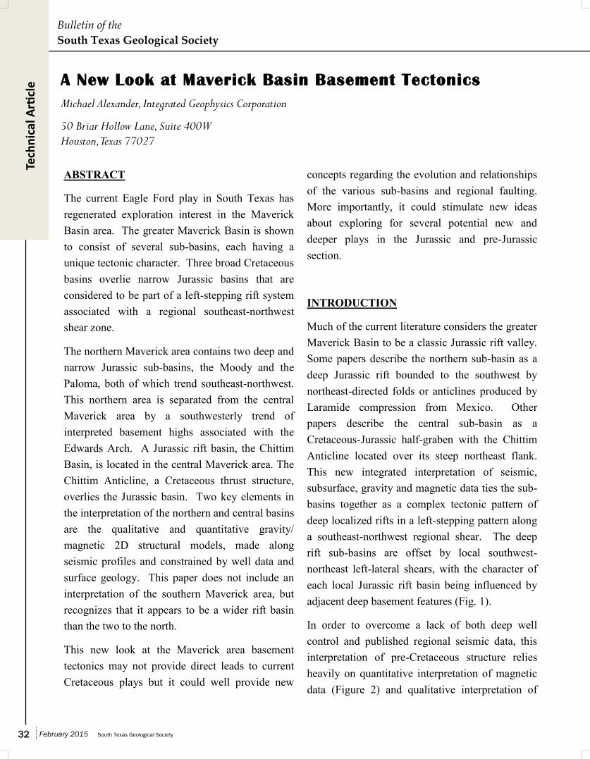
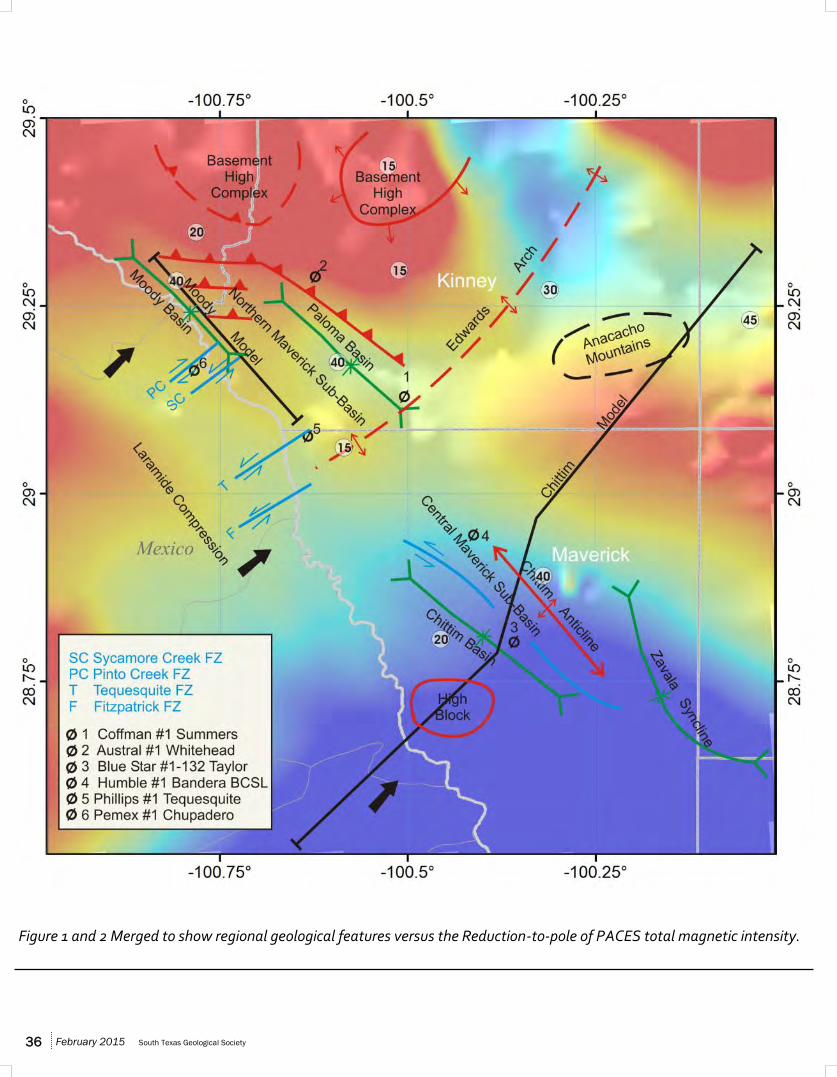
Much of the current literature considers the greater Maverick Basin to be a classic Jurassic rift valley. Some papers describe the northern sub-basin as a deep Jurassic rift bounded to the southwest by northeast-directed folds or anticlines produced by Laramide compression from Mexico. Other papers describe the central sub-basin as a Cretaceous-Jurassic half-graben with the Chittim Anticline located over its steep northeast flank. This new integrated interpretation of seismic, subsurface, gravity and magnetic data ties the sub-basins together as a complex tectonic pattern of deep localized rifts in a left-stepping pattern along a southeast-northwest regional shear. The deep rift sub-basins are offset by local southwest-northeast left-lateral shears, with the character of each local Jurassic rift basin being influenced by adjacent deep basement features (Fig. 1).
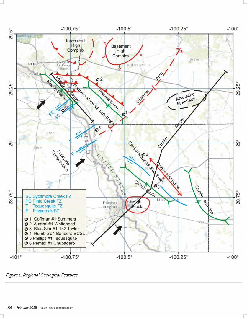
In order to overcome a lack of both deep well control and published regional seismic data, this interpretation of pre-Cretaceous structure relies heavily on quantitative interpretation of magnetic data (Figure 2) and qualitative interpretation of
February 2015 South Texas Geological Society 34
Figure 1. Regional Geological Features
South Texas Geological Society February 2015 35
Figure 2. Reduction-to-pole of PACES total magnetic intensity.
February 2015 South Texas Geological Society 36
Figure 1 and 2 Merged to show regional geological features versus the Reduction-to-pole of PACES total magnetic intensity.
South Texas Geological Society February 2015 37
gravity data. The magnetic data was extracted from Pan American Center for Earth & Environmental Studies (PACES) public-source files and proprietary gravity data was provided by Gravity Map Service.
NORTHERN MAVERICK BASIN
The northern sub-basin, a part of the greater Maverick Basin, is centered in northwestern Kinney County-southeastern Val Verde County. Northeast-trending basement high blocks of the Edwards Arch separate it at depth from the broader and deeper sub-basins to the southeast in Maverick and Dimmit counties. Structural patterns of the sub-basin area are complex. The Devils River Uplift in Val Verde County, immediately to the northwest, is recognized as a basement-thrust uplift of Late Paleozoic age (Webster, 1980; Nicholas, 1983.) Laramide compression from Mexico produced folded or thrusted anticlines along the southwest flank of the basin. Basement high blocks in Kinney County acted as a buttress impeding northeast-directed thrusting and possibly inducing back-thrusting.
The sub-basin can be separated into two deep Jurassic rift basins, the Moody and the Paloma. The Moody Basin trends northwesterly along the Rio Grande and is interpreted to be the narrower and more structured of the two. The Paloma Basin lies south and east of the Moody Basin; the two are offset by the Pinto Creek and Sycamore Creek left-lateral shears. The Paloma is interpreted as a little wider and less-structured than the Moody.
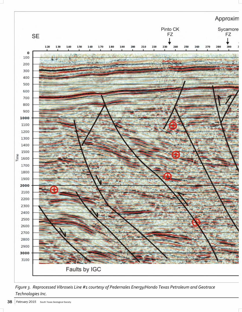
With the exception of a 1984 paper by Evans and Zoerb, relatively little has been published about either of these rift basins. Their 1984 paper shows an interpretation of Vibroseis Line 1 running northwesterly up the axis of the Moody Basin to the southern end of the Devils River Uplift. An estimated time-depth conversion places the 1984
interpretation of Jurassic and pre-Jurassic seismic basement as deep as 45,000-50,000 ft subsea, in agreement with this author’s quantitative magnetic depth analyses. The 1984 basement interpretation appears relatively flat except at the southeastern and northern ends of the section; faults were shown as essentially north-directed thrusts with both high-angle and low-angle “sled-runner” patterns.
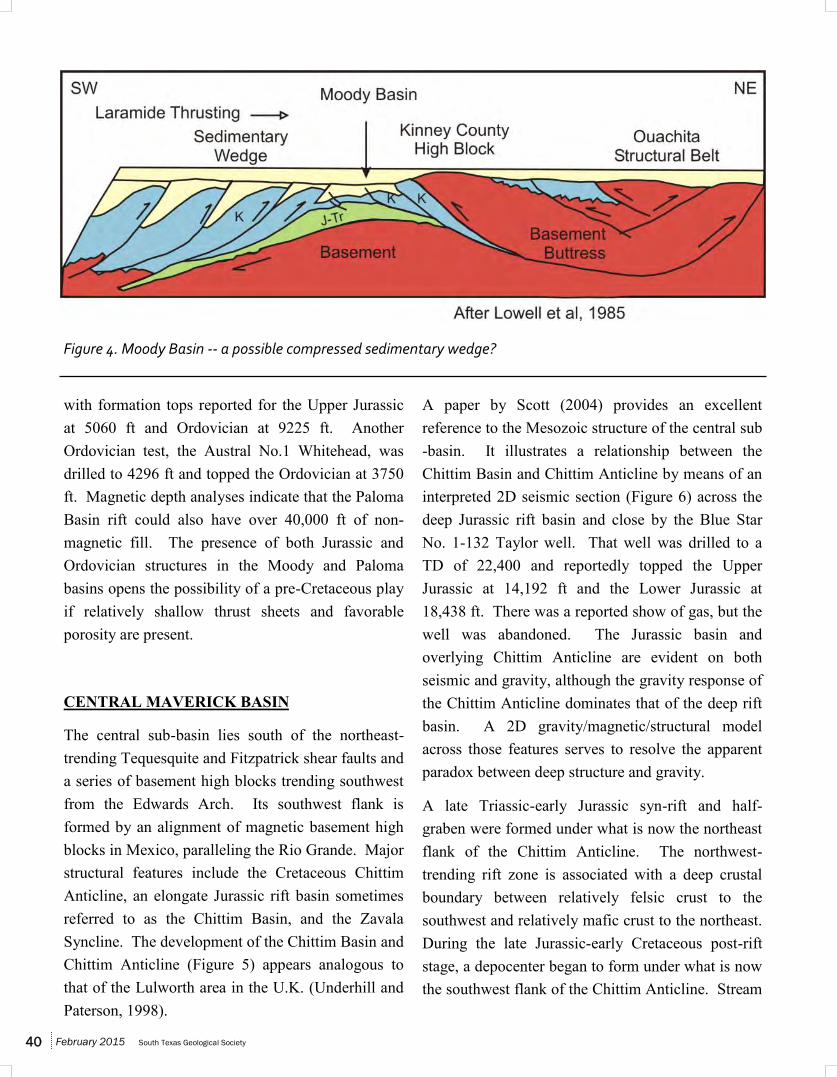
The Vibroseis line was later reprocessed and data resolution was improved to the extent that the alternative structural interpretation presented here (Figure 3) not only appears more complex, but is in better agreement with off-line gravity/magnetic data. Moody Basin’s northeast flank can now be interpreted as a series of narrow thrust sheets which correlate in location and depth with segments of high-energy bands on the seismic section. Depth conversion places the bands between 2.000 and 2.300 ms at depths ranging from 20,000 to 30,000 ft, with many of the segments correlating closely in depth and location with magnetic depth estimates. Offsets between the segments can be best resolved with interpreted thrust faults which fit the seismic, magnetic, and gravity data. Although not evident on the 2D seismic, a magnetic depth map interpretation using off-line magnetic depth estimates shows the thrust sheets as semi-parallel to the northeast flank of the Jurassic rift. They may be the result of back-thrusting caused by the rift sediments being compressed against major basement high blocks in Val Verde and Kinney counties. Given that scenario, the Moody Basin would not be a simple extensional rift but rather a sedimentary wedge trapped between opposing thrusts. This concept, based on a clay cake model (ref. Lowell et al, 1985), is illustrated as Figure 4.
There are no deep wells drilled in the Moody Basin, and there are no published seismic sections in the Paloma Basin. At the south end of the Paloma, the Coffman No. 1 Summers well has a TD of 13,500 ft,
February 2015 South Texas Geological Society 38
Figure 3. Reprocessed Vibroseis Line #1 courtesy of Pedernales Energy/Hondo Texas Petroleum and Geotrace
Technologies Inc.
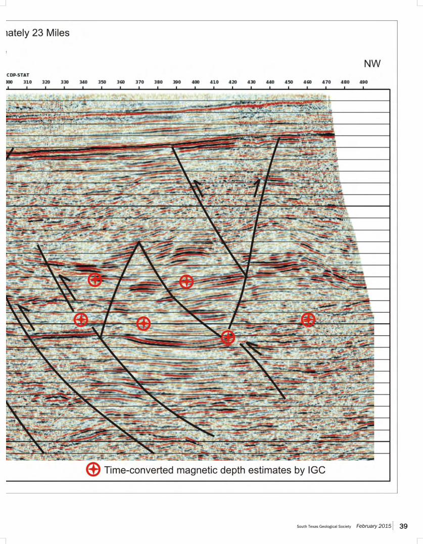
South Texas Geological Society February 2015 39
February 2015 South Texas Geological Society 40
with formation tops reported for the Upper Jurassic at 5060 ft and Ordovician at 9225 ft. Another Ordovician test, the Austral No.1 Whitehead, was drilled to 4296 ft and topped the Ordovician at 3750 ft. Magnetic depth analyses indicate that the Paloma Basin rift could also have over 40,000 ft of non-magnetic fill. The presence of both Jurassic and Ordovician structures in the Moody and Paloma basins opens the possibility of a pre-Cretaceous play if relatively shallow thrust sheets and favorable porosity are present.
CENTRAL MAVERICK BASIN
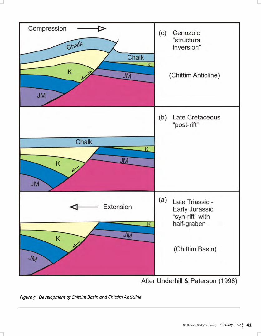
The central sub-basin lies south of the northeast-trending Tequesquite and Fitzpatrick shear faults and a series of basement high blocks trending southwest from the Edwards Arch. Its southwest flank is formed by an alignment of magnetic basement high blocks in Mexico, paralleling the Rio Grande. Major structural features include the Cretaceous Chittim Anticline, an elongate Jurassic rift basin sometimes referred to as the Chittim Basin, and the Zavala Syncline. The development of the Chittim Basin and Chittim Anticline (Figure 5) appears analogous to that of the Lulworth area in the U.K. (Underhill and Paterson, 1998).
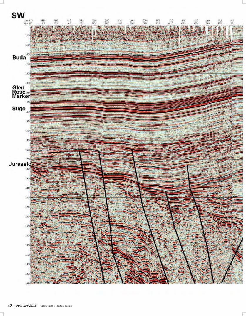
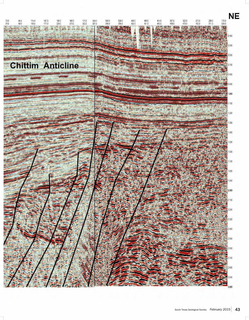
A paper by Scott (2004) provides an excellent reference to the Mesozoic structure of the central sub-basin. It illustrates a relationship between the Chittim Basin and Chittim Anticline by means of an interpreted 2D seismic section (Figure 6) across the deep Jurassic rift basin and close by the Blue Star No. 1-132 Taylor well. That well was drilled to a TD of 22,400 and reportedly topped the Upper Jurassic at 14,192 ft and the Lower Jurassic at 18,438 ft. There was a reported show of gas, but the well was abandoned. The Jurassic basin and overlying Chittim Anticline are evident on both seismic and gravity, although the gravity response of the Chittim Anticline dominates that of the deep rift basin. A 2D gravity/magnetic/structural model across those features serves to resolve the apparent paradox between deep structure and gravity.
A late Triassic-early Jurassic syn-rift and half-graben were formed under what is now the northeast flank of the Chittim Anticline. The northwest-trending rift zone is associated with a deep crustal boundary between relatively felsic crust to the southwest and relatively mafic crust to the northeast. During the late Jurassic-early Cretaceous post-rift stage, a depocenter began to form under what is now the southwest flank of the Chittim Anticline. Stream
Figure 4. Moody Basin -- a possible compressed sedimentary wedge?
South Texas Geological Society February 2015 41
Figure 5. Development of Chittim Basin and Chittim Anticline
February 2015 South Texas Geological Society 42
South Texas Geological Society February 2015 43
February 2015 South Texas Geological Society 44
offsets mapped by surface geology suggest that the crustal fault underwent left-lateral shearing and a flower structure was subsequently formed. Following a Comanchean stage of fairly uniform deposition, the Laramide Orogeny compressed and inverted the late-Jurassic-early Cretaceous depocenters, thus forming the Chittim Anticline. A cross section based on surface mapping shows that the anticline was breached during the late Cretaceous-early Tertiary, and steep dips on its northeast flank suggest that the flank overlies a southwest-dipping thrust.
Regional concepts of the thrust patterns and of basement configuration are illustrated by an extended 2D model from Coahuila, Mexico, across the Chittim features, and into Uvalde County, Texas.
CONCLUSIONS
The deep tectonic patterns of the greater Maverick Basin have not been well documented in the literature due to the sparsity of pre-Upper Jurassic wells and published seismic data. However, the fact that several deep wells have been drilled and that some gas was encountered indicates that the deep Maverick could be a future exploration province under favorable economic circumstances. Deep structures and tectonic patterns must be better understood and mapped. All available geologic and geophysical data must be evaluated and integrated to provide results that are mutually compatible.
This paper should prompt a new look at Maverick Basin tectonics and serve to highlight those areas where more data or a more concentrated interpretation will serve to confirm or alter the concepts presented here.
ACKNOWLEDGMENTS
Pedernales Energy/Hondo Texas Petroleum (Hondo) and Geotrace Technologies, Inc. granted permission to show the reprocessed seismic Line #1. Mr. Kelley of Hondo also provided some extremely helpful information concerning the Moody and Paloma basin areas.
R.S. Scott and J.J. Willis of GCAGS granted permission to show seismic Line #2.
Robert Neese of Gravity Map Service (GMS) granted permission to show the gravity profiles accompanying each model. Mr. Neese also granted permission to show gravity anomaly trends derived by Integrated Geophysics Corporation from proprietary GMS data.
I thank Integrated Geophysics Corporation (GMS) for technical and logistic support for this paper.
REFERENCES
Evans, S. L. and R. M. Zoerb, 1984, Possible relationships between deep structure and shallow fault patterns, northwest Maverick Basin, Val Verde County, Texas, in Stratigraphy and structure of the Maverick Basin and Devils River trend, Lower Cretaceous, southwest Texas, South Texas Geological Society, p. 94-98
Ewing, T. E., 2011, Tectonic domains in the Rio Grande / Rio Bravo border region, Texas and Mexico: Laramide structures suggest earlier history: Gulf Coast Association of Geological Societies Transactions, v. 61, p. 141-155.
Lowell, J. D. et al, 1985, Compressive blocks and basement thrusts, in J. D. Lowell, ed., Structural styles in petroleum exploration, OGCI Publications, p. 127-190
Nicholas, R. L. and R. A. Rozendal, 1975,
South Texas Geological Society February 2015 45
Subsurface positive elements within the Ouachita foldbelt in Texas and their relation to Paleozoic cratonic margins: American Association of Petroleum Geologists Bulletin, v. 59, p. 193-216
Scott, R. J., 2004, The Maverick basin: New technology---new success: Gulf Coast Association of Geological Societies Transactions, v. 54, p. 603-620.
Underhill, J. R. and S. Paterson, 1998, Genesis of tectonic inversion: seismic evidence for the development of key structures along the Purbeck-Isle of Wight Disturbance: Journal of the Geological Society, London, v. 155, p. 975-992
Webster, R. E., 1980, Structural analysis of Devils River Uplift—southern Val Verde Basin, southwest Texas: American Association of Petroleum Geologists Bulletin, v. 64, no. 10, p. 221-241
BIOGRAPHY
Mike Alexander is a geophysical advisor for Integrated Geophysics Corporation in Houston, Texas. He graduated from Colorado School of Mines in 1952 with a degree in Geophysical Engineering. Alexander immediately went to work with Humble Oil, where he worked multiple facets of seismic interpretation and seismic acquisition projects. He worked with Humble/Exxon’s onshore, marsh, offshore and seismic operations until 1970. When Humble/Exxon formed a new Gravity/Magnetics Section, he was reassigned to that and supervised it from 1973-1990. After retirement from Exxon, he began consulting for Integrated Geophysics Corporation where he continues his interests in gravity/magnetic interpretation and seismic data integration to achieve geologic solutions for clients.
Related Documents