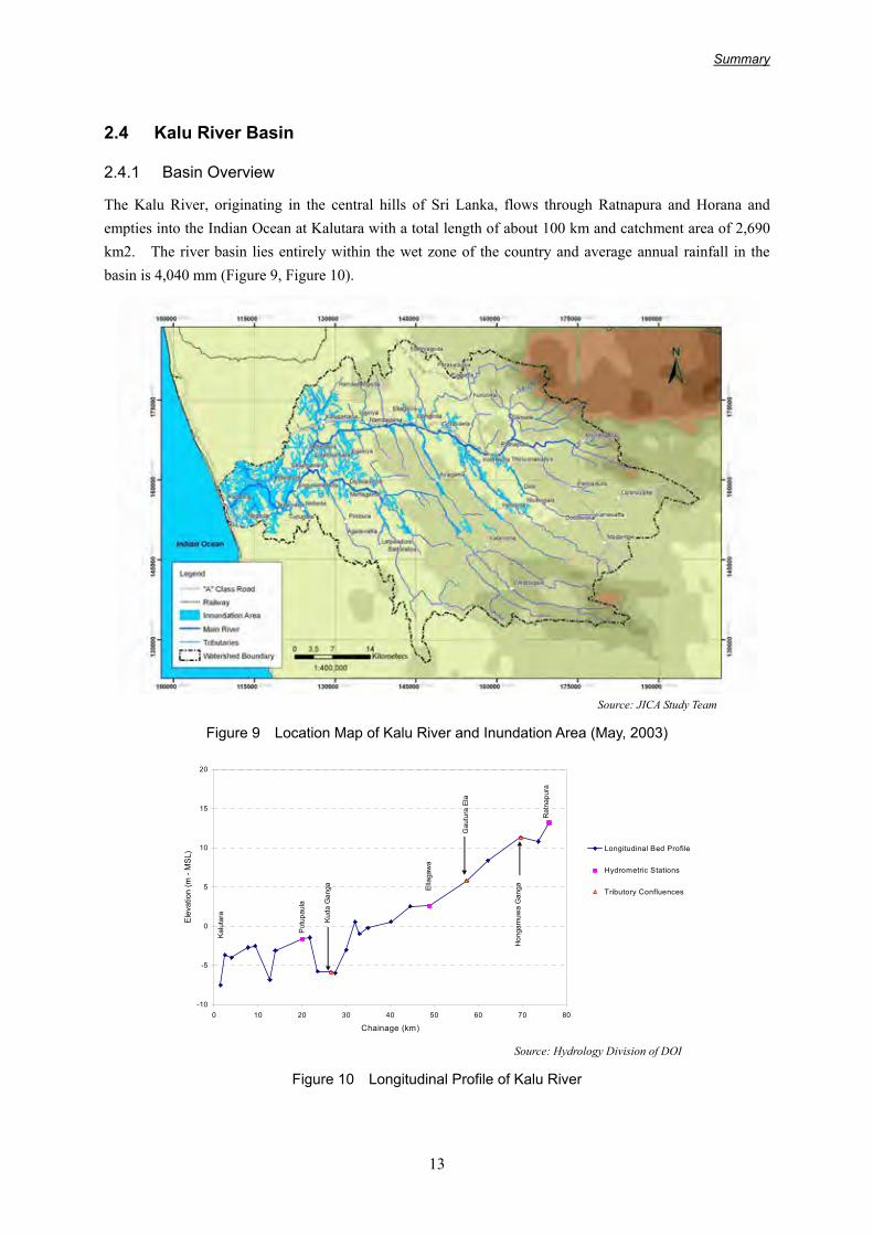
Summary 13 2.4 Kalu River Basin 2.4.1 Basin Overview The Kalu River, originating in the central hills of Sri Lanka, flows through Ratnapura and Horana and empties into the Indian Ocean at Kalutara with a total length of about 100 km and catchment area of 2,690 km2. The river basin lies entirely within the wet zone of the country and average annual rainfall in the basin is 4,040 mm (Figure 9, Figure 10). Source: JICA Study Team Figure 9 Location Map of Kalu River and Inundation Area (May, 2003) -10 -5 0 5 10 15 20 0 10 20 30 40 50 60 70 80 Chainage (km) Elevation (m - MSL) Longitudinal Bed Profile Hydrometric Stations Tributory Confluences Ratnapura Hongamuwa Ganga Gautura Ela Putupaula Kalutara Kuda Ganga Ellagawa Source: Hydrology Division of DOI Figure 10 Longitudinal Profile of Kalu River

Welcome message from author
This document is posted to help you gain knowledge. Please leave a comment to let me know what you think about it! Share it to your friends and learn new things together.
Transcript
Summary
13
2.4 Kalu River Basin
2.4.1 Basin Overview
The Kalu River, originating in the central hills of Sri Lanka, flows through Ratnapura and Horana and empties into the Indian Ocean at Kalutara with a total length of about 100 km and catchment area of 2,690 km2. The river basin lies entirely within the wet zone of the country and average annual rainfall in the basin is 4,040 mm (Figure 9, Figure 10).
Source: JICA Study Team
Figure 9 Location Map of Kalu River and Inundation Area (May, 2003)
-10
-5
0
5
10
15
20
0 10 20 30 40 50 60 70 80
Chainage (km)
Ele
vatio
n (m
- M
SL)
Longitudinal Bed Profile
Hydrometric Stations
Tributory Confluences
Rat
napu
ra
Hon
gam
uwa
Gan
ga
Gau
tura
Ela
Putu
paul
a
Kalu
tara Kuda
Gan
ga Ella
gaw
a
Source: Hydrology Division of DOI
Figure 10 Longitudinal Profile of Kalu River
Summary
14
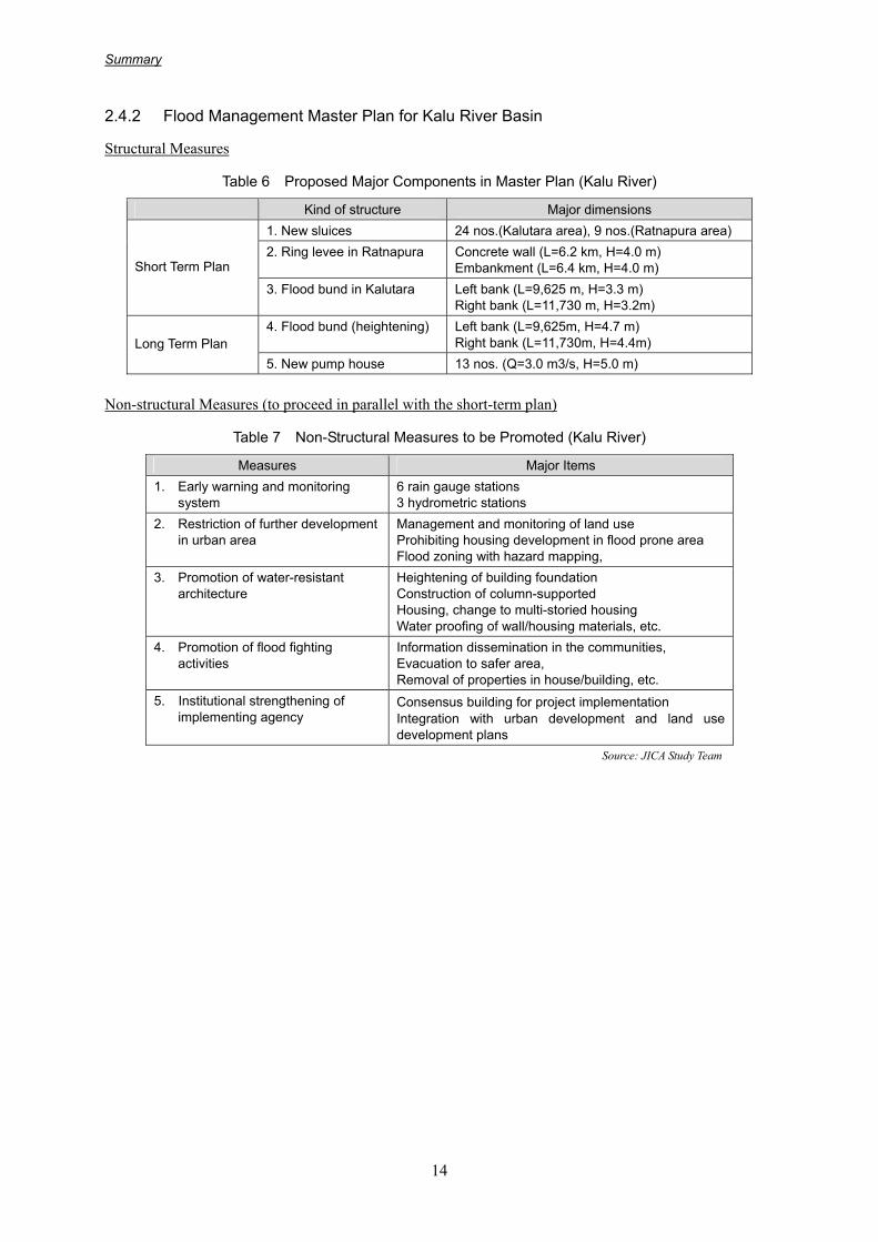
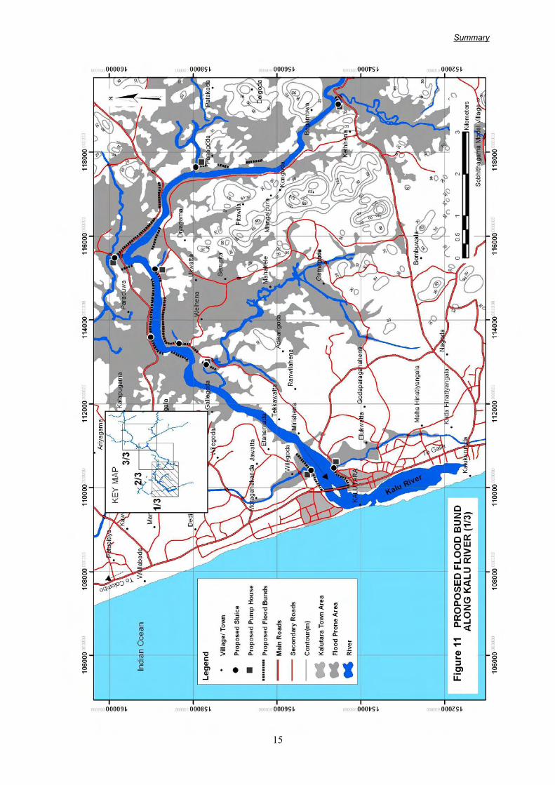
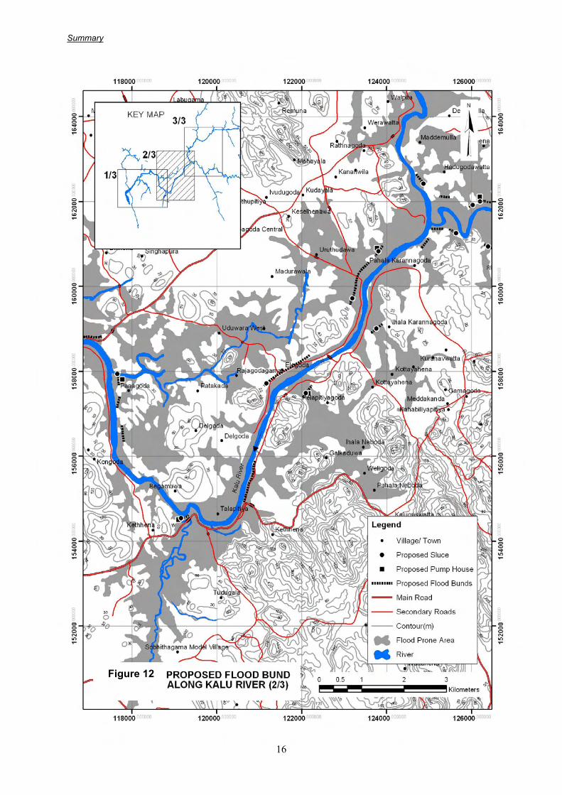
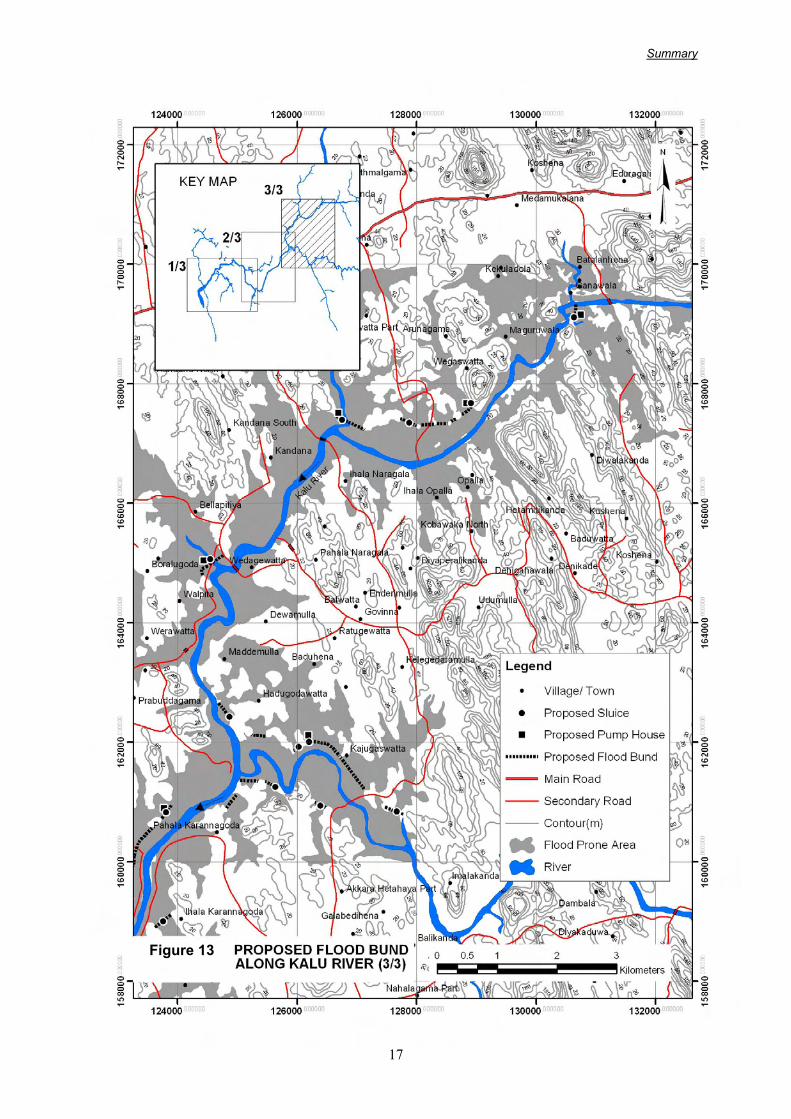
2.4.2 Flood Management Master Plan for Kalu River Basin
Structural Measures
Table 6 Proposed Major Components in Master Plan (Kalu River)
Kind of structure Major dimensions 1. New sluices 24 nos.(Kalutara area), 9 nos.(Ratnapura area) 2. Ring levee in Ratnapura Concrete wall (L=6.2 km, H=4.0 m)
Embankment (L=6.4 km, H=4.0 m) Short Term Plan
3. Flood bund in Kalutara Left bank (L=9,625 m, H=3.3 m) Right bank (L=11,730 m, H=3.2m)
4. Flood bund (heightening) Left bank (L=9,625m, H=4.7 m) Right bank (L=11,730m, H=4.4m) Long Term Plan
5. New pump house 13 nos. (Q=3.0 m3/s, H=5.0 m)
Non-structural Measures (to proceed in parallel with the short-term plan)
Table 7 Non-Structural Measures to be Promoted (Kalu River)
Measures Major Items 1. Early warning and monitoring
system 6 rain gauge stations 3 hydrometric stations
2. Restriction of further development in urban area
Management and monitoring of land use Prohibiting housing development in flood prone area Flood zoning with hazard mapping,
3. Promotion of water-resistant architecture
Heightening of building foundation Construction of column-supported Housing, change to multi-storied housing Water proofing of wall/housing materials, etc.
4. Promotion of flood fighting activities
Information dissemination in the communities, Evacuation to safer area, Removal of properties in house/building, etc.
5. Institutional strengthening of implementing agency
Consensus building for project implementation Integration with urban development and land use development plans
Source: JICA Study Team
Summary
15
Figure 11 Proposed Flood Bund Along Kalu River (1/3)
Figu
re 1
1
Summary
16
Figure 12 Proposed Flood Bund Along Kalu River (2/3)
Figure 12
Summary
17
Figure 13 Proposed Flood Bund Along Kalu River (3/3)
Figure 13

Summary
18
Figure 14 Proposed Alignment of Flood Bund Ratnapura Area
Figu
re 1
4
※
Dim
ensi
ons
in t
his
figur
e ar
e th
e re
sults
of
revi
ewan
d m
odifi
catio
n du
ring
the
actio
n pl
an s
tudy
Related Documents