1 Advancements in Data Assimilation for NCEP Operational High- Resolution Triple-Nested HWRF Vijay Tallapragada Environmental Modeling Center, NCEP/NOAA/NWS, Camp Springs, MD 20746. JPSS Proving Ground and GOES-R3 risk reduction projects Kick-Off Meeting, May 18, 2012

1 Advancements in Data Assimilation for NCEP Operational High-Resolution Triple-Nested HWRF Vijay Tallapragada Environmental Modeling Center, NCEP/NOAA/NWS,
Dec 18, 2015
Welcome message from author
This document is posted to help you gain knowledge. Please leave a comment to let me know what you think about it! Share it to your friends and learn new things together.
Transcript
1
Advancements in Data Assimilation for NCEP Operational High-Resolution Triple-Nested HWRF
Vijay TallapragadaEnvironmental Modeling Center,
NCEP/NOAA/NWS, Camp Springs, MD 20746.
JPSS Proving Ground and GOES-R3 risk reduction projects Kick-Off Meeting, May 18, 2012
2
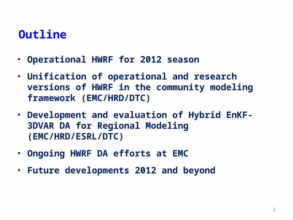
Outline
• Operational HWRF for 2012 season
• Unification of operational and research versions of HWRF in the community modeling framework (EMC/HRD/DTC)
• Development and evaluation of Hybrid EnKF-3DVAR DA for Regional Modeling (EMC/HRD/ESRL/DTC)
• Ongoing HWRF DA efforts at EMC
• Future developments 2012 and beyond
3
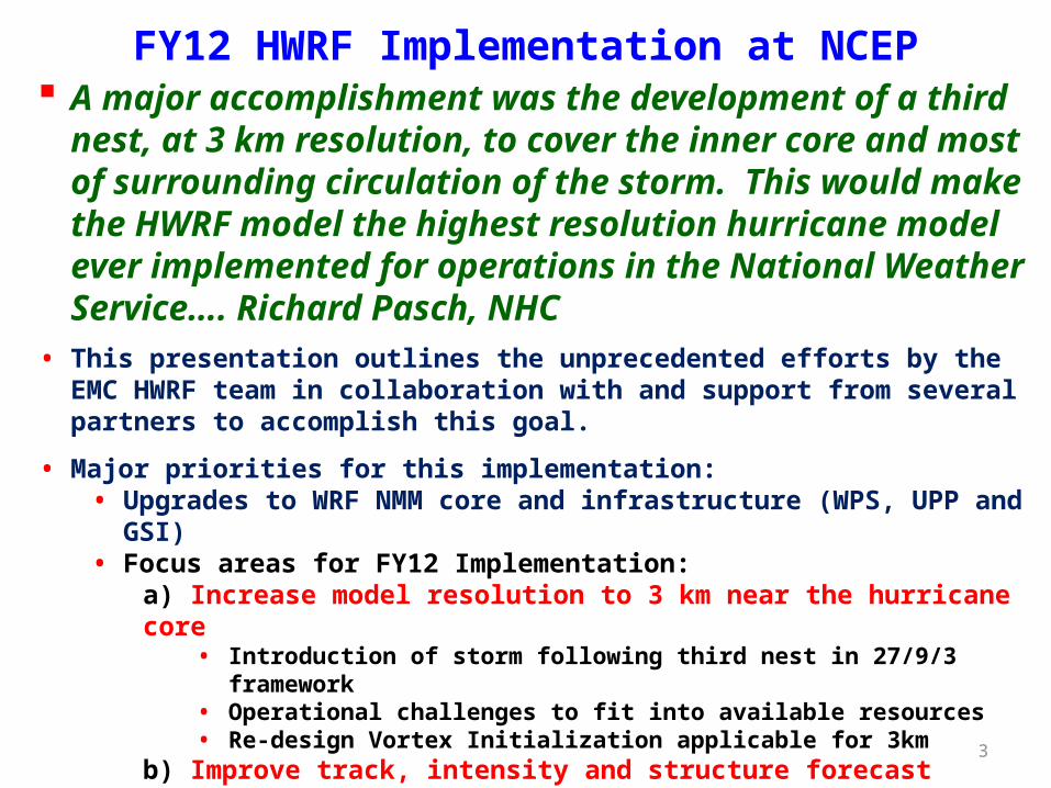
FY12 HWRF Implementation at NCEP A major accomplishment was the development of a third nest, at 3
km resolution, to cover the inner core and most of surrounding circulation of the storm. This would make the HWRF model the highest resolution hurricane model ever implemented for operations in the National Weather Service…. Richard Pasch, NHC
• This presentation outlines the unprecedented efforts by the EMC HWRF team in collaboration with and support from several partners to accomplish this goal.
• Major priorities for this implementation:• Upgrades to WRF NMM core and infrastructure (WPS, UPP and GSI)• Focus areas for FY12 Implementation:
a) Increase model resolution to 3 km near the hurricane core• Introduction of storm following third nest in 27/9/3 framework• Operational challenges to fit into available resources• Re-design Vortex Initialization applicable for 3km
b) Improve track, intensity and structure forecast skills and w-p relationship• Explicit convection in 3km domain, New GFS Shallow Convection• Modified surface physics, PBL, microphysics and convection• 1-D POM coupling for the Eastern Pacific basin• Upgrade HWRF-GSI to V3.5 and reduce the impact of assimilation of observations in
hurricane environment
4
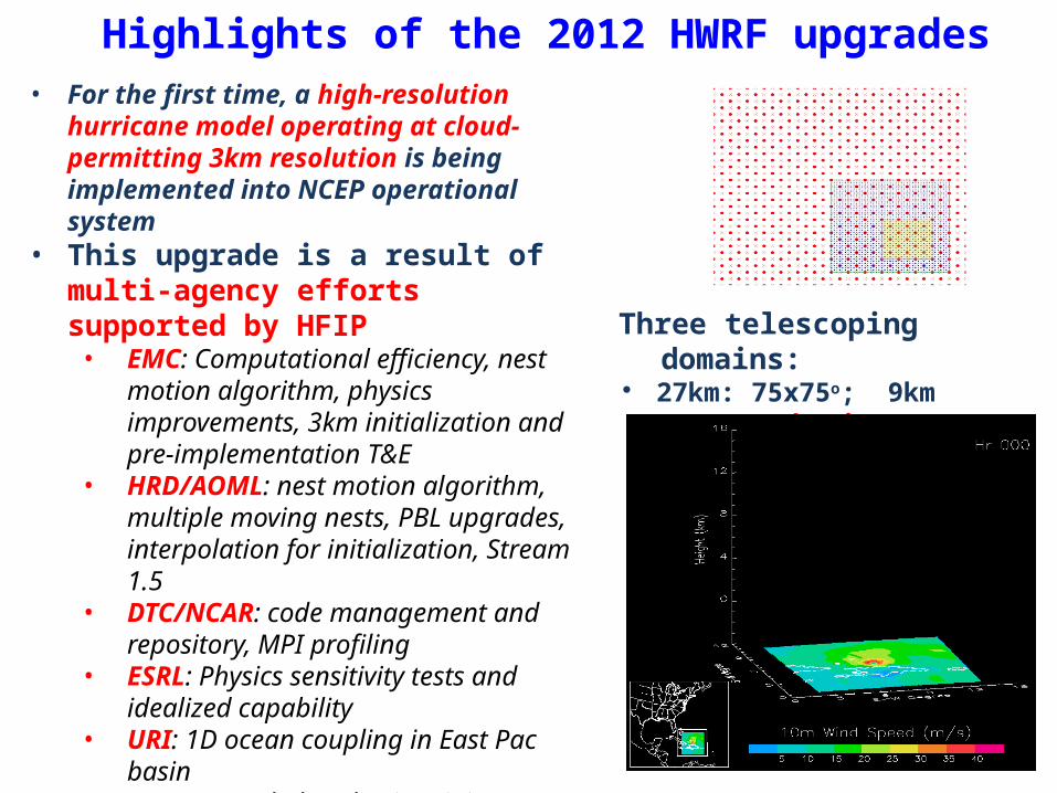
Highlights of the 2012 HWRF upgrades• For the first time, a high-resolution hurricane
model operating at cloud-permitting 3km resolution is being implemented into NCEP operational system
• This upgrade is a result of multi-agency efforts supported by HFIP• EMC: Computational efficiency, nest
motion algorithm, physics improvements, 3km initialization and pre-implementation T&E
• HRD/AOML: nest motion algorithm, multiple moving nests, PBL upgrades, interpolation for initialization, Stream 1.5
• DTC/NCAR: code management and repository, MPI profiling
• ESRL: Physics sensitivity tests and idealized capability
• URI: 1D ocean coupling in East Pac basin• GFDL: Knowledge sharing, joint T&E• NHC: Diagnostics and evaluation of the
HWRF pre-implementation tests
Three telescoping domains: 27km: 75x75o; 9km ~11x10o 3km
inner-most nest ~6x6o
5
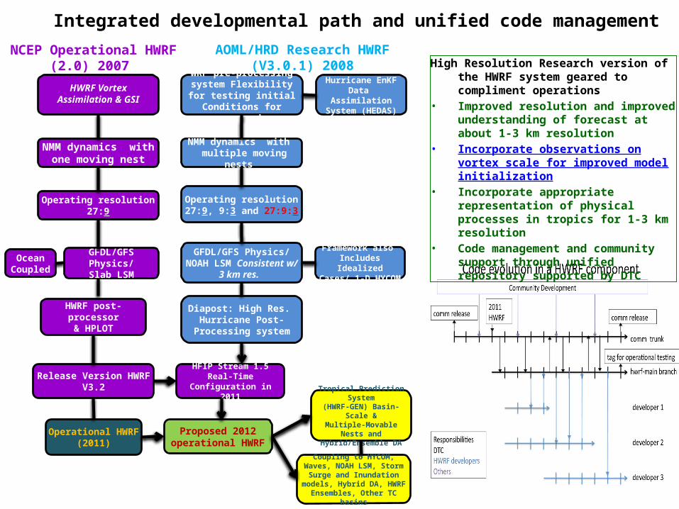
HWRF VortexAssimilation & GSI
WRF pre-processing system Flexibility for testing initial
Conditions for research
NMM dynamics withone moving nest
Operating resolution 27:9
GFDL/GFS Physics/Slab LSM
HWRF post-processor& HPLOT
NMM dynamics with multiple moving nests
Operating resolution27:9, 9:3 and 27:9:3
GFDL/GFS Physics/NOAH LSM Consistent w/ 3
km res.
Diapost: High Res. Hurricane Post-Processing system
Hurricane EnKF Data Assimilation System
(HEDAS)
Framework also Includes Idealized
Cases/ 1-D HYCOM
Release Version HWRF V3.2
Proposed 2012 operational HWRF
Operational HWRF (2011)
Tropical Prediction System(HWRF-GEN) Basin-Scale &
Multiple-Movable Nests and Hybrid/Ensemble DA
Ocean Coupled
NCEP Operational HWRF (2.0) 2007
AOML/HRD Research HWRF (V3.0.1) 2008
HFIP Stream 1.5 Real-Time Configuration in 2011
High Resolution Research version of the HWRF system geared to compliment operations
• Improved resolution and improved understanding of forecast at about 1-3 km resolution
• Incorporate observations on vortex scale for improved model initialization
• Incorporate appropriate representation of physical processes in tropics for 1-3 km resolution
• Code management and community support through unified repository supported by DTC
Coupling to HYCOM, Waves, NOAH LSM, Storm Surge and
Inundation models, Hybrid DA, HWRF Ensembles, Other TC basins
Integrated developmental path and unified code management
6
Track errors Superior Track FSP
2010-2011 Atlantic Track Verification
~20% improvement
FY2012 HWRF FY2012 HWRF
Intensity errors
Improved Intensity Bias
HOPS: operational HWRFH212: 2012 HWRF
~10% improvement
FY2012 HWRF FY2012 HWRF
7
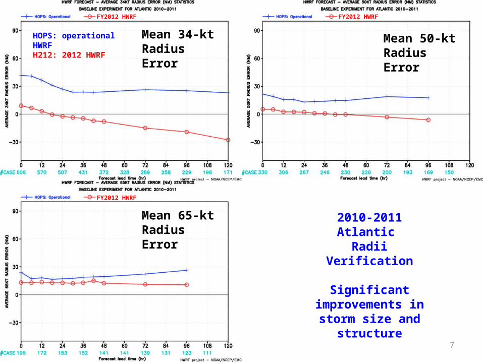
Mean 34-kt Radius Error
Mean 50-kt Radius Error
Mean 65-kt Radius Error
2010-2011 Atlantic Radii Verification
Significant improvements in storm
size and structure
HOPS: operational HWRFH212: 2012 HWRF
FY2012 HWRF FY2012 HWRF
FY2012 HWRF
8
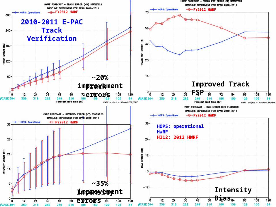
Track errors Improved Track FSP
2010-2011 E-PACTrack Verification
~20% improvement
FY2012 HWRFFY2012 HWRF
Intensity errors Intensity Bias
HOPS: operational HWRFH212: 2012 HWRF
~35% improvement
FY2012 HWRF
FY2012 HWRF
9
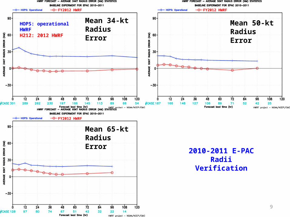
Mean 34-kt Radius Error
Mean 50-kt Radius Error
Mean 65-kt Radius Error
2010-2011 E-PACRadii Verification
HOPS: operational HWRFH212: 2012 HWRF
FY2012 HWRF FY2012 HWRF
FY2012 HWRF FY2012 HWRF
10
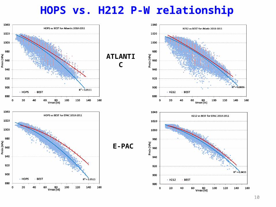
HOPS vs. H212 P-W relationship
ATLANTIC
E-PAC
11
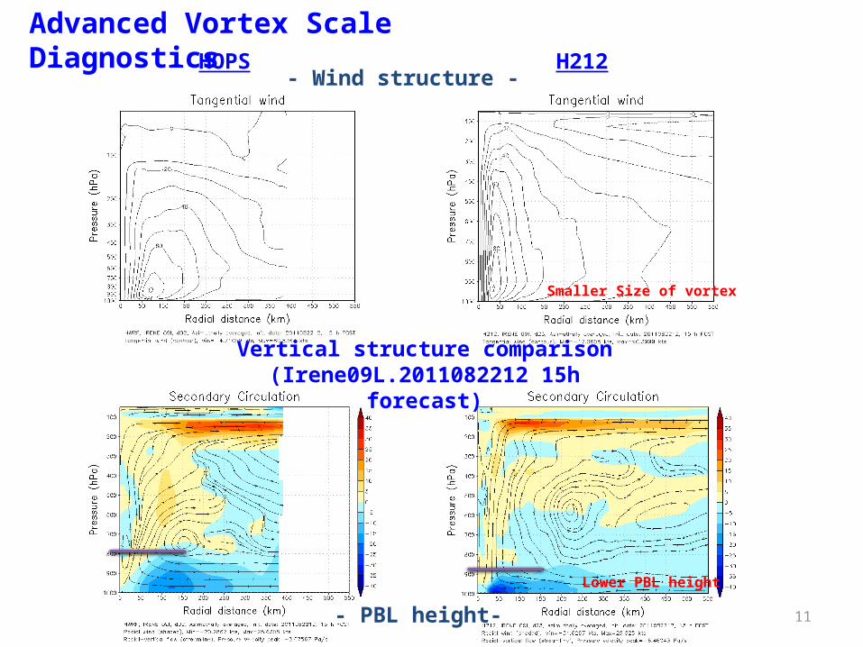
Advanced Vortex Scale DiagnosticsHOPS H212
- Wind structure -
- PBL height-
Smaller Size of vortex
Lower PBL height
Vertical structure comparison (Irene09L.2011082212 15h forecast)
12
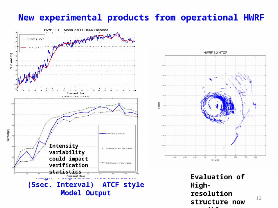
High Temporal Resolution (5sec. Interval) ATCF style Model Output
Intensity variability could impact verification statistics
Evaluation of High-resolution structure now possible
New experimental products from operational HWRF
13
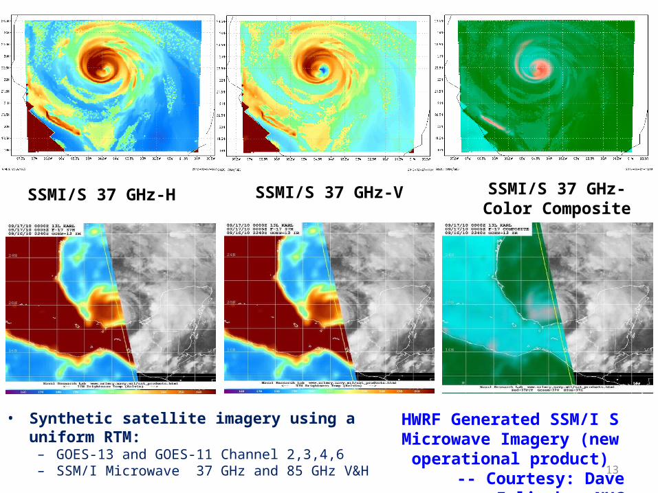
SSMI/S 37 GHz-H SSMI/S 37 GHz-Color Composite
SSMI/S 37 GHz-V
HWRF Generated SSM/I S Microwave Imagery (new
operational product)-- Courtesy: Dave Zelinsky, NHC
• Synthetic satellite imagery using a uniform RTM:– GOES-13 and GOES-11 Channel 2,3,4,6– SSM/I Microwave 37 GHz and 85 GHz V&H
14
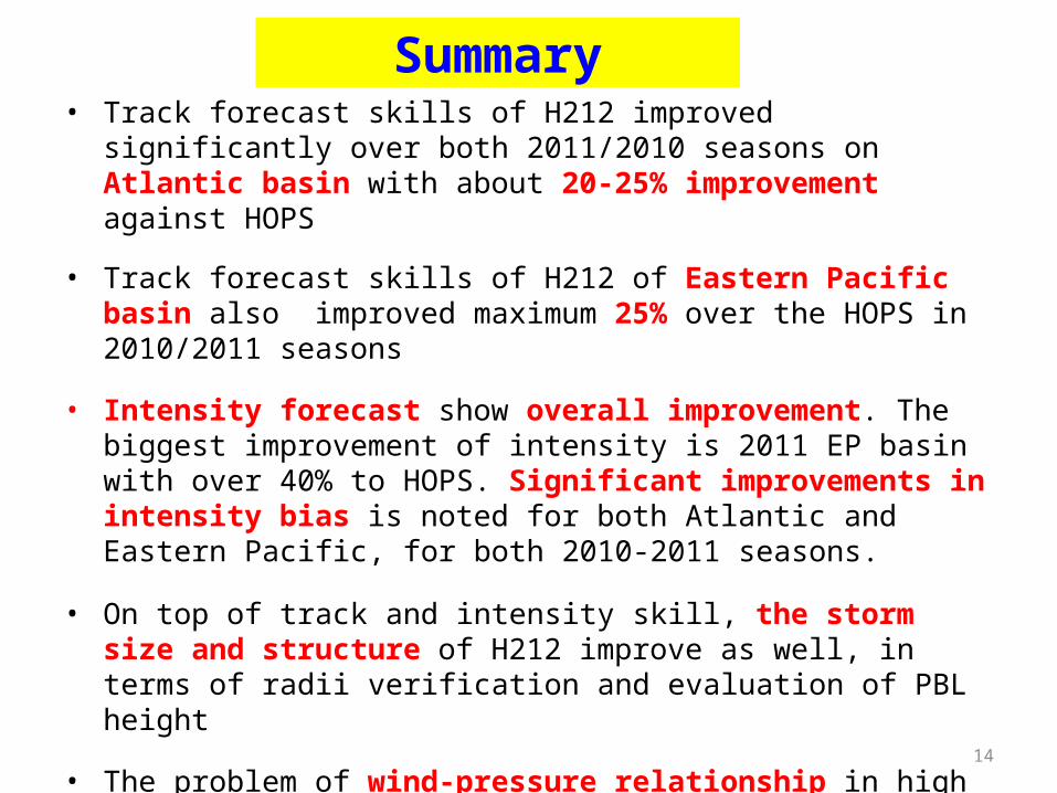
Summary• Track forecast skills of H212 improved significantly over both 2011/2010
seasons on Atlantic basin with about 20-25% improvement against HOPS
• Track forecast skills of H212 of Eastern Pacific basin also improved maximum 25% over the HOPS in 2010/2011 seasons
• Intensity forecast show overall improvement. The biggest improvement of intensity is 2011 EP basin with over 40% to HOPS. Significant improvements in intensity bias is noted for both Atlantic and Eastern Pacific, for both 2010-2011 seasons.
• On top of track and intensity skill, the storm size and structure of H212 improve as well, in terms of radii verification and evaluation of PBL height
• The problem of wind-pressure relationship in high wind speed regime also significantly improved in H212
• With high resolution and improved physics, we are laying foundation for improved intensity predictions through improved storm structure.
• HWRF Model (EMC, HRD)– Multiple moving nests within a basin scale domain &
improved multi-scale interactions
• HWRF Physics (URI, GFDL, ESRL,HRD)– Surface fluxes, sea spray and wave coupling, Physics for
high-resolution (convection, micro physics, PBL, LSM )
• HWRF Diagnostics (HFIP, EMC, NHC, FSU, CIRA, HRD, UMBC/UMD)
– Hurricane model diagnostics, evaluation and verification, Develop a common and comprehensive diagnostics framework and tools to integrate model output with available observations for verification, Enhanced real-time product display and navigation
• HWRF Ensembles– Large Scale Flow, Structure and Physics Perturbations;
EnKF based perturbations in support of DA
• Hybrid EnKF-GSI Data Assimilation for HWRF— Real-time transmission of the P3 TDR data flow from
aircraft to NCO/TOC/AOC and assimilation using advanced GSI and improved vortex initialization (model consistent 3-D balanced vortex); Ensemble data assimilation - hybrid EnKF (Planned Demo for 2012 hurricane season (HFIP Stream 2); Improved use of satellite radiance datasets, Model vertical levels and top consistent with NAM
• HWRF for World Oceans— Real-time testing of 27/9/3 HWRF for Western Pacific
region (in support of JTWC)— Operational implementation of HWRF in India and
advanced workshop in July 2012 15
FY2012 and beyond…
Typhoon Megi
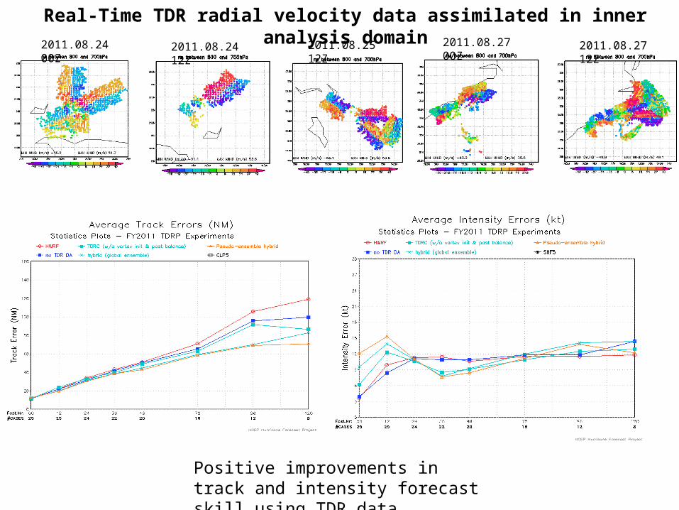
Real-Time TDR radial velocity data assimilated in inner analysis domain2011.08.24 00Z 2011.08.24 12Z 2011.08.27 12Z2011.08.27 00Z2011.08.25 12Z
Positive improvements in track and intensity forecast skill using TDR data
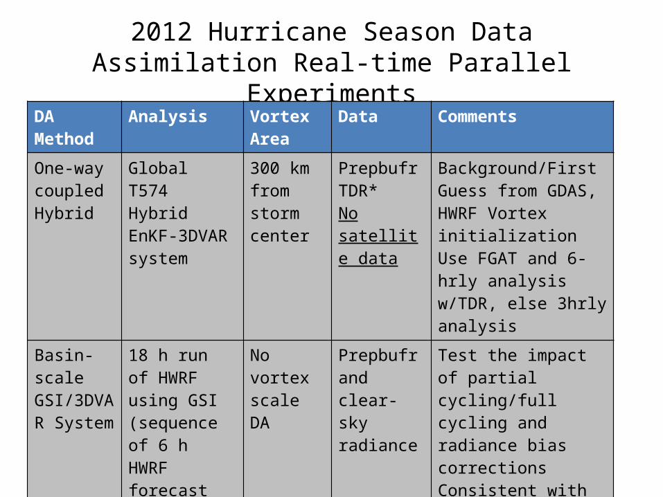
2012 Hurricane Season Data Assimilation Real-time Parallel Experiments
DA Method Analysis Vortex Area
Data Comments
One-way coupled Hybrid
Global T574 Hybrid EnKF-3DVAR system
300 km from storm center
PrepbufrTDR*No satellite data
Background/First Guess from GDAS, HWRF Vortex initializationUse FGAT and 6-hrly analysis w/TDR, else 3hrly analysis
Basin-scale GSI/3DVAR System
18 h run of HWRF using GSI (sequence of 6 h HWRF forecast and 3 GSI analyses)
No vortex scale DA
Prepbufr and clear-sky radiance
Test the impact of partial cycling/full cycling and radiance bias correctionsConsistent with regional hybrid DA
Regional Hybrid DA
Dual-res (80 member HWRF ensembles)
No vortex scale DA
Prepbufr and satellite radiance
Collaborative effort supported by HFIP
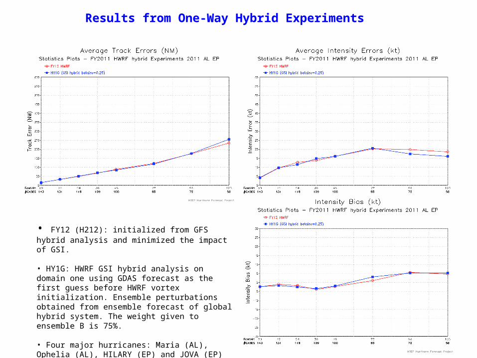
• FY12 (H212): initialized from GFS hybrid analysis and minimized the impact of GSI.
• HY1G: HWRF GSI hybrid analysis on domain one using GDAS forecast as the first guess before HWRF vortex initialization. Ensemble perturbations obtained from ensemble forecast of global hybrid system. The weight given to ensemble B is 75%.
• Four major hurricanes: Maria (AL), Ophelia (AL), HILARY (EP) and JOVA (EP)
Results from One-Way Hybrid Experiments
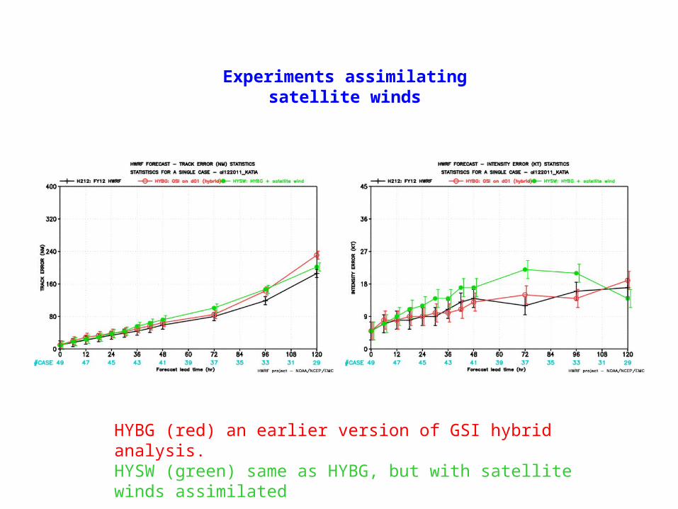
HYBG (red) an earlier version of GSI hybrid analysis. HYSW (green) same as HYBG, but with satellite winds assimilated
Experiments assimilating satellite winds
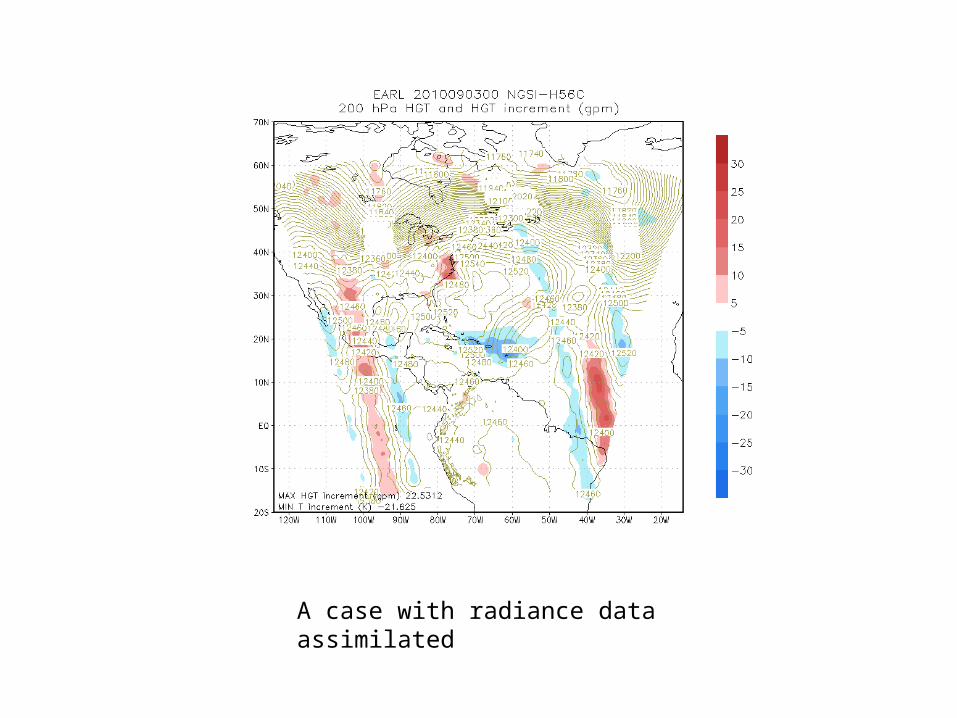
A case with radiance data assimilated
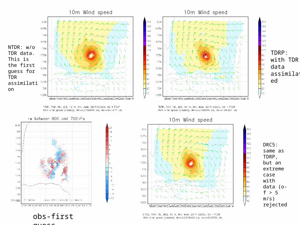
NTDR: w/o TDR data. This is the first guess for TDR assimilation
obs-first guess
TDRP: with TDR data assimilated
DRC5: same as TDRP, but an extreme case with data (o-f > 5 m/s) rejected
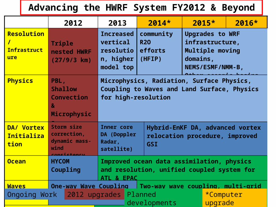
Advancing the HWRF System FY2012 & Beyond
.
2012 2013 2014* 2015* 2016*
Resolution/ Infrastructure Triple nested
HWRF (27/9/3 km)
Increased vertical resolution, higher model top
community R2O efforts (HFIP)
Upgrades to WRF infrastructure, Multiple moving domains, NEMS/ESMF/NMM-B, Other oceanic basins
Physics PBL, Shallow Convection & Microphysics
Microphysics, Radiation, Surface Physics, Coupling to Waves and Land Surface, Physics for high-resolution
DA/ Vortex Initialization
Storm size correction, dynamic mass-wind consistency
Inner core DA (Doppler Radar, satellite)
Hybrid-EnKF DA, advanced vortex relocation procedure, improved GSI
Ocean HYCOM Coupling
Improved ocean data assimilation, physics and resolution, unified coupled system for ATL & EPAC
Waves One-way Wave Coupling Two-way wave coupling, multi-grid surf zone physics, effects of sea spray
Diagnostics and Product Development
HWRF Ensembles, Coupling to Hydrological/ Surge/ Inundation models, diagnostics, product development
Ongoing Work 2012 upgrades Planned developments *Computer upgrade
23
Thanks for your attention
Questions?
Real-time and pre-implementation T&E HWRF products:
http://www.emc.ncep.noaa.gov/gc_wmb/vxt/index.html
Acknowledgements:
HWRF team at EMC
EMC and HFIP Management
Collaborations with NHC, DTC, HRD, GFDL, URI, CIRA and other HFIP partners
Related Documents