Pre-Print In-Press June 25 2007 1 2 Brett L. Walker 3 Wildlife Biology Program, College of Forestry and Conservation, 32 Campus Drive, 4 University of Montana, Missoula, MT 59812. 5 406-546-4709 (phone) 6 406-243-4557 (FAX) 7 [email protected] (email) 8 9 Sage-grouse populations and energy development · Walker et al. 10 Greater sage-grouse population response to energy development and habitat loss 11 Brett L. Walker, Wildlife Biology Program, College of Forestry and Conservation, University of 12 Montana, Missoula, MT 59812 USA 13 David E. Naugle, Wildlife Biology Program, College of Forestry and Conservation, University 14 of Montana, Missoula, MT 59812 USA 15 Kevin E. Doherty, Wildlife Biology Program, College of Forestry and Conservation, University 16 of Montana, Missoula, MT 59812 USA 17 Abstract: Modification of landscapes due to energy development may alter both habitat use and 18 vital rates of sensitive wildlife species. Greater sage-grouse (Centrocercus urophasianus) in the 19 Powder River Basin (PRB) of Wyoming and Montana have experienced rapid, widespread 20 changes to their habitat due to recent coal-bed natural gas (CBNG) development. We analyzed 21 lek-count, habitat, and infrastructure data to assess how CBNG development and other landscape 22 features influenced trends in the numbers of male sage-grouse observed and persistence of leks 23 in the PRB. From 2001-2005, the number of males observed on leks in CBNG fields declined 24 more rapidly than leks outside of CBNG. Of leks active in 1997 or later, only 38% of 26 leks in 25 CBNG fields remained active by 2004-2005, compared to 84% of 250 leks outside CBNG fields. 26 By 2005, leks in CBNG fields had 46% fewer males per active lek than leks outside of CBNG. 27 Persistence of 110 leks was positively influenced by the proportion of sagebrush habitat within 28

Welcome message from author
This document is posted to help you gain knowledge. Please leave a comment to let me know what you think about it! Share it to your friends and learn new things together.
Transcript
Pre-Prin
t In-Pres
s
June 25 2007 1 2 Brett L. Walker 3 Wildlife Biology Program, College of Forestry and Conservation, 32 Campus Drive, 4 University of Montana, Missoula, MT 59812. 5 406-546-4709 (phone) 6 406-243-4557 (FAX) 7 [email protected] (email) 8 9 Sage-grouse populations and energy development · Walker et al. 10
Greater sage-grouse population response to energy development and habitat loss 11
Brett L. Walker, Wildlife Biology Program, College of Forestry and Conservation, University of 12
Montana, Missoula, MT 59812 USA 13
David E. Naugle, Wildlife Biology Program, College of Forestry and Conservation, University 14
of Montana, Missoula, MT 59812 USA 15
Kevin E. Doherty, Wildlife Biology Program, College of Forestry and Conservation, University 16
of Montana, Missoula, MT 59812 USA 17
Abstract: Modification of landscapes due to energy development may alter both habitat use and 18
vital rates of sensitive wildlife species. Greater sage-grouse (Centrocercus urophasianus) in the 19
Powder River Basin (PRB) of Wyoming and Montana have experienced rapid, widespread 20
changes to their habitat due to recent coal-bed natural gas (CBNG) development. We analyzed 21
lek-count, habitat, and infrastructure data to assess how CBNG development and other landscape 22
features influenced trends in the numbers of male sage-grouse observed and persistence of leks 23
in the PRB. From 2001-2005, the number of males observed on leks in CBNG fields declined 24
more rapidly than leks outside of CBNG. Of leks active in 1997 or later, only 38% of 26 leks in 25
CBNG fields remained active by 2004-2005, compared to 84% of 250 leks outside CBNG fields. 26
By 2005, leks in CBNG fields had 46% fewer males per active lek than leks outside of CBNG. 27
Persistence of 110 leks was positively influenced by the proportion of sagebrush habitat within 28
Pre-Prin
t In-Pres
s
Walker et al. 2
6.4 km of the lek. After controlling for habitat, we found support for negative effects of CBNG 29
development within 0.8 km and 3.2 km of the lek and for a time lag between CBNG 30
development and lek disappearance. Current lease stipulations that prohibit development within 31
0.4 km of sage-grouse leks on federal lands are inadequate to ensure lek persistence and may 32
result in impacts to breeding populations over larger areas. Seasonal restrictions on drilling and 33
construction do not address impacts caused by loss of sagebrush and incursion of infrastructure 34
that can affect populations over long periods of time. Regulatory agencies may need to increase 35
spatial restrictions on development, industry may need to rapidly implement more effective 36
mitigation measures, or both, to reduce impacts of CBNG development on sage-grouse 37
populations in the PRB. 38
The Journal of Wildlife Management 00(0): 000-000 20XX 39
Keywords: agriculture, Centrocercus urophasianus, coal-bed natural gas, coal-bed methane, 40
energy development, greater sage-grouse, lek count, population, Powder River Basin, sagebrush 41
Large-scale modification of habitat associated with energy development may alter habitat 42
use or vital rates of sensitive wildlife species. Populations in developed areas may decline if 43
animals avoid specific features of infrastructure such as roads or power lines (Trombulak and 44
Frissell 2000, Nelleman et al. 2001, 2003) or if energy development negatively affects survival 45
or reproduction (Holloran 2005, Aldridge and Boyce 2007). For example, mortality caused by 46
collisions with vehicles and power lines reduces adult and juvenile survival in a variety of 47
wildlife species (reviewed in Bevanger 1998 and Trombulak and Frissell 2000). Indirect effects 48
of energy development on populations are also possible due to changes in predator or parasite 49
communities (Knight and Kawashima 1993, Steenhof et al. 1993, Daszak et al. 2000) or changes 50
in vegetation structure and composition associated with disturbance (Trombulak and Frissell 51

Pre-Prin
t In-Pres
s
Walker et al. 3
2000, Gelbard and Belnap 2003). Negative impacts may be exacerbated if features of 52
development that attract animals (e.g., ponds) simultaneously reduce survival and thereby 53
function as ecological traps (Gates and Gysel 1978). 54
Rapidly expanding coal-bed natural gas (CBNG) development is a concern for 55
conservation of greater sage-grouse (Centrocercus urophasianus) in the Powder River Basin 56
(PRB) of northeastern Wyoming and southeastern Montana. The PRB supports an important 57
regional population, with over 500 leks documented between 1967-2005 (Connelly et al. 2004). 58
In the past decade, the PRB has also experienced rapidly increasing CBNG development, with 59
impacts on wildlife habitat projected to occur over an area of approximately 24,000 km2 (Bureau 60
of Land Management 2003a, b). Coal-bed natural gas development typically requires 61
construction of 2-7 km of roads and 7-22 km of power lines per km2 as well as an extensive 62
network of compressor stations, pipelines, and ponds (Bureau of Land Management 2003b). 63
Approximately 10% of surface lands and 75% of mineral reserves in the PRB are federally 64
owned and administered by the Bureau of Land Management (BLM) (Bureau of Land 65
Management 2003a, b). Over 50,000 CBNG wells have been authorized for development on 66
federal mineral reserves in northeastern Wyoming, at a density of 1 well per 16-32 ha, and as 67
many as 18,000 wells are anticipated in southeastern Montana (Bureau of Land Management 68
2003a, b). According to data from the Wyoming Oil and Gas Conservation Commission and 69
Montana Board of Oil and Gas Conservation, by the beginning of 2005, approximately 28,000 70
CBNG wells had been drilled on federal (~31%), state (~11%), and private (~58%) mineral 71
holdings in the PRB. Mitigation for sage-grouse on BLM lands typically includes lease 72
stipulations prohibiting surface infrastructure within 0.4 km of sage-grouse leks as well as 73
restrictions on timing of drilling and construction within 3.2 km of documented leks during the 74
Pre-Prin
t In-Pres
s
Walker et al. 4
15 March - 15 June breeding season and within crucial winter habitat from 1 December - 31 75
March (Montana only) (Bureau of Land Management 2003a, b). These restrictions can be 76
modified or waived by BLM, or additional conditions of approval applied, on a case-by-case 77
basis. In contrast, most state and private minerals have been developed with few or no 78
requirements to mitigate impacts on wildlife. 79
Coal-bed natural gas development and its associated infrastructure may affect sage-80
grouse populations via several different mechanisms, and these mechanisms can operate at 81
different scales. For example, males and females may abandon leks if repeatedly disturbed by 82
raptors perching on power lines near leks (Ellis 1984), by vehicle traffic on nearby roads (Lyon 83
and Anderson 2003), or by noise and human activity associated with energy development during 84
the breeding season (Braun et al. 2002, Holloran 2005, Kaiser 2006). Collisions with nearby 85
power lines and vehicles and increased predation by raptors may also increase mortality of birds 86
at leks (Connelly et al. 2000a, 2000b). Alternatively, roads and power lines may indirectly affect 87
lek persistence by altering productivity of local populations or survival at other times of the year. 88
For example, sage-grouse mortality associated with power lines and roads occurs year-round 89
(Patterson 1952, Beck et al. 2006, Aldridge and Boyce 2007), and ponds created by CBNG 90
development may increase risk of West Nile virus (WNv) mortality in late summer (Walker et al. 91
2004, Zou et al. 2006, Walker et al. 2007). Loss and degradation of sagebrush habitat can also 92
reduce carrying capacity of local breeding populations (Swenson et al. 1987, Braun 1998, 93
Connelly et al. 2000b, Crawford et al. 2004). Alternatively, birds may simply avoid otherwise 94
suitable habitat as the density of roads, power lines, or energy development increases (Lyon and 95
Anderson 2003, Holloran 2005, Kaiser 2006, Doherty et al. 2008). 96

Pre-Prin
t In-Pres
s
Walker et al. 5
Understanding how energy development affects sage-grouse populations also requires 97
that we control for other landscape features that affect population size and persistence, including 98
the extent of suitable habitat. Sage-grouse are closely tied to sagebrush habitats throughout their 99
annual cycle, and variation in the amount of sagebrush habitat available for foraging and nesting 100
is likely to influence the size of breeding populations and persistence of leks (Ellis et al. 1989, 101
Swenson et al. 1987, Schroeder et al. 1999, Leonard et al. 2000, Smith et al. 2005). For this 102
reason, it is crucial to quantify and separate the effects of habitat loss from those of energy 103
development. 104
To assess how CBNG development and habitat loss influence sage-grouse populations 105
in the PRB, we conducted 2 analyses based on region-wide lek-count data. Lek counts are 106
widely used for monitoring sage-grouse populations, and at present, are the only data suitable for 107
examining trends in population size and distribution at this scale (Connelly et al. 2003, 2004). 108
First, we analyzed counts of the numbers of males displaying on leks (lek counts) to assess 109
whether trends in the number of males counted and proportion of active and inactive leks 110
differed between areas with and without CBNG development. Second, we used logistic 111
regression to model lek status (i.e., active or inactive) in relation to landscape features 112
hypothesized to influence sage-grouse demographics and habitat use at 3 spatial scales. The 113
objectives of the lek-status analysis were first, to identify the scale at which habitat and non-114
CBNG landscape features influence lek persistence and second, to evaluate and compare effects 115
of CBNG development at different scales with those of non-CBNG landscape features after 116
controlling for habitat. 117
Study Area 118
Pre-Prin
t In-Pres
s
Walker et al. 6
We analyzed data from sage-grouse leks within an approximately 50,000-km2 area of 119
northeastern Wyoming and southeastern Montana (Figure 1). This area included all areas with 120
existing or predicted CBNG development in the PRB (Bureau of Land Management 2003a, b) as 121
well as surrounding areas without CBNG. Land use in this region was primarily cattle ranching 122
with limited dry-land and irrigated tillage agriculture. Natural vegetation consisted of sagebrush-123
steppe and mixed-grass prairie interspersed with occasional stands of conifers. Sagebrush-steppe 124
was dominated by Wyoming big sagebrush (Artemisia tridentata wyomingensis) with an 125
understory of native and non-native grasses and forbs. Plains silver sagebrush (A. cana cana) 126
and black greasewood (Sarcobatus vermiculatus) co-occurred with Wyoming big sagebrush in 127
drainage bottoms. 128
Methods 129
Lek-count trend analyses 130
Lek-count data. We used sage-grouse lek-count data in public databases maintained by 131
Wyoming Game and Fish Department and Montana Department of Fish, Wildlife, and Parks as 132
the foundation for analyses. We augmented databases with lek counts provided by consultants 133
and by the BLM’s Miles City field office for 37 leks (36 in Montana, 1 in Wyoming) known to 134
have been counted but for which data were missing. We checked for and, when possible, 135
corrected errors in the database after consultation with database managers and regional biologists 136
for each state. We excluded records with known errors, surveys in which lek status was not 137
determined, leks without supporting count data, and duplicate leks prior to analysis. 138
Coal-bed natural gas development. We obtained data on the type, location, status, 139
drilling date, completion date, and abandonment date of wells from public databases maintained 140
by the Wyoming Oil and Gas Conservation Commission and Montana Board of Oil and Gas 141
Pre-Prin
t In-Pres
s
Walker et al. 7
Conservation. Because wells are highly correlated with other features of development, such as 142
roads, power lines, and ponds (D. E. Naugle, University of Montana, unpublished data), using 143
well locations is a reliable way to map and measure the extent of CBNG development. We 144
retained only those wells that were clearly in the ground, associated with energy development 145
(gas, oil, stratification test, disposal, injection, monitoring, and water source wells), and likely to 146
have infrastructure. We excluded wells that were plugged and abandoned, wells waiting on 147
permit approval, wells drilled or completed in 2005 or later, and those with status reported as dry 148
hole, expired permit, permit denied, unknown, or no report. We included wells in analyses 149
starting in the year in which they were drilled or completed (i.e., started producing). For active 150
wells without drilling or completion dates, we estimated start year based on approval and 151
completion dates of nearby wells and those in the same unit lease. We included wells with status 152
reported as dormant, temporarily abandoned, or permanently abandoned only until the year prior 153
to when they were first reported as abandoned. Because capped wells (also commonly referred 154
to as shut-in wells) may or may not have associated infrastructure, we included them only in 155
years in which they were surrounded by, or within 1 km of, a producing gas field. 156
We estimated the extent of CBNG development around each lek in each year. We first 157
approximated the area affected by CBNG development by creating a 350-m buffer around all 158
well locations using ArcInfo 8.2 (ESRI, Inc., Redlands, CA) and dissolving boundaries where 159
buffers overlapped. We then estimated the proportion of the area within 3.2 km of the lek center 160
that was covered by the buffer around wells. At current well density (1 well per 32-64 ha), a 161
350-m buffer around wells estimates the extent of CBNG development more accurately than 162
larger or smaller buffer sizes. This metric is less sensitive to variation in spacing of wells than 163

Pre-Prin
t In-Pres
s
Walker et al. 8
measures such as well density and therefore more accurate for estimating the total area affected 164
by CBNG development. 165
Trends in lek counts. We examined lek-count data from 1988-2005. In each year, we 166
categorized a lek as in CBNG if ≥40% of the area within 3.2 km was developed or if ≥25% 167
within 3.2 km was developed and ≥1 well was within 350 m of the lek center. We categorized a 168
lek as outside CBNG if <40% of the area within 3.2 km was developed and no wells were within 169
350 m of the lek center. However, because few leks in CBNG were counted in consecutive years 170
prior to 2001, we analyzed trends in lek-counts only from 2001-2005. We calculated the rate of 171
increase in the number of males counted on leks for each year-to-year transition by summing 172
count data across leks within each category (in CBNG vs. outside CBNG) according to their 173
stage of development at the end of the first year of each year-to-year transition (Connelly et al. 174
2004). We summed data across leks to reduce the influence of geographic variation in 175
detectability and used the maximum annual count for each lek to reduce the influence of within-176
year variation in detectability on the estimated rate of increase. We derived data for each 177
transition only from leks counted in both years and known to be active in at least 1 of the 2 years 178
of the transition. We estimated mean rates of increase in CBNG versus outside CBNG fields 179
based on the slope of a linear regression of interval length versus rate of increase (Morris and 180
Doak 2002). Wells completed between January and March (i.e., before lek counts were 181
conducted) in the second year of each transition may have caused us to underestimate the amount 182
of CBNG development around leks at the time counts were conducted. However, if CBNG 183
development negatively affects populations, this would cause the difference between trends in 184
lek-count data in CBNG and outside CBNG to be underestimated and would produce a 185
conservative estimate of impacts. 186
Pre-Prin
t In-Pres
s
Walker et al. 9
Timing of lek disappearance. If CBNG development negatively affects lek persistence, 187
most leks in CBNG fields that became inactive should have done so following CBNG 188
development. To explore this prediction, we examined the timing of lek disappearance in 189
relation to when a lek was first classified as being in a CBNG field (i.e., ≥40% development 190
within 3.2 km or ≥25% development within 3.2 km and ≥1 well within 350 m of the lek center) 191
for leks confirmed active in 1997 or later. 192
Lek-status analysis 193
Definition of leks. We defined a lek as a site where multiple males were documented 194
displaying on multiple visits within a single year or over multiple years. We defined a lek 195
complex as multiple leks located <2.5 km from the largest and most regularly attended lek in the 196
complex (Connelly et al. 2004). We defined an initial set of lek complexes based on those 197
known prior to 1990. We considered leks discovered in 1990 or later as separate complexes, 198
even if they occurred <2.5 km from leks discovered in previous years. We did this to avoid 199
problems with the location of already-defined leks and lek complexes shifting as new leks were 200
discovered or if new leks formed in response to nearby CBNG development. We grouped leks 201
discovered within 2.5 km of each other in the same year in the same lek complex. We used lek 202
complexes as the sample unit for calculating proportion of active and inactive leks and in the lek-203
status analysis, but because the term lek complex can refer either to multiple leks or to a single 204
lek, we refer to both simply as a lek. 205
Lek status. We determined the final status of leks by examining count data from 2002-206
2005. We considered a lek active if ≥ 1 male was counted in 2004 or 2005, whichever was the 207
last year surveyed. To minimize problems with non-detection of males, we considered a lek 208
inactive only if: 1) at least 3 consecutive ground or air visits in the last year surveyed failed to 209
Pre-Prin
t In-Pres
s
Walker et al. 10
detect males, or 2) if surveys in the last 3 consecutive years the lek was checked (2002-2004 or 210
2003-2005) failed to detect males. We classified the status of leks that were not surveyed or 211
were inadequately surveyed in 2004 or 2005 as unknown. Survey effort in the PRB increased 5-212
fold from 1997-2005 and included systematic aerial searches for new leks and repeated air and 213
ground counts of known leks within and adjacent to CBNG fields. Therefore, it is unlikely that 214
leks shifted to nearby sites without being detected. Many leks in the PRB disappeared during a 215
region-wide population decline in 1991-1995 (Connelly et al. 2004), well before most CBNG 216
development in the PRB began. To eliminate leks that became inactive for reasons other than 217
CBNG, we calculated proportions of active and inactive leks in CBNG and outside CBNG based 218
only on leks active in 1997 or later. 219
Scale. We calculated landscape metrics at 3 distances around each lek: 0.8 km (201 ha), 220
3.2 km (3,217 ha), and 6.4 km (12,868 ha). We selected the 0.8-km scale to represent processes 221
that impact breeding birds at or near leks, while avoiding problems with spatial error in lek 222
locations. We selected the 6.4-km scale to reflect processes that occur at larger scales around the 223
lek, such as loss of nesting habitat, demographic impacts on local breeding populations, or 224
landscape-scale avoidance of CBNG fields. The 3.2-km scale is that at which state and federal 225
agencies apply mitigation for CBNG impacts (e.g., timing restrictions), and it is important to 226
determine the appropriateness of managing at a 3.2-km scale versus at smaller or larger scales. 227
Habitat variables. Each model represented a distinct hypothesis, or combination of 228
hypotheses, regarding how landscape features influence lek persistence. We included 2 types of 229
habitat variables in the analysis, the proportion of sagebrush habitat and the proportion of tillage 230
agriculture in the landscape around each lek. Because the scale at which habitat most strongly 231
influenced lek persistence was unknown, we considered habitat variables at all 3 scales. We 232

Pre-Prin
t In-Pres
s
Walker et al. 11
calculated the amount of sagebrush habitat and tillage agriculture around each lek at each scale 233
using ArcInfo 8.2 based on classified SPOT-5 satellite imagery taken in August 2003 over an 234
approximately 15,700 km2 area of the PRB. We restricted the lek-status analysis to leks within 235
the SPOT-5 satellite imagery because the only other type of classified imagery available for this 236
region (Thematic Mapper at 30-m resolution) is unreliable for measuring the extent of sagebrush 237
habitat (Moynahan 2004). We visually identified and manually digitized areas with tillage 238
agriculture from the imagery. Classification accuracy was 83% for sagebrush habitat (i.e., 239
sagebrush-steppe and sagebrush-dominated grassland). We excluded 20 leks for which >10% of 240
classified habitat data were unavailable due to cloud cover or proximity to the edge of the 241
imagery. 242
Road, power line, and CBNG variables. We hypothesized that infrastructure can affect 243
lek persistence in 3 ways and included different variables to examine each hypothesis. Roads, 244
power lines, and CBNG development may affect lek persistence in proportion to their extent on 245
the landscape. Alternatively, the effects of roads and power lines may depend their distance 246
from the lek, in which case they are expected to drop off rapidly as distance increases. Coal-bed 247
natural gas development may also influence lek status depending on how long the lek has been in 248
a CBNG field. If CBNG increases mortality, it may be several years before local breeding 249
populations are reduced to the point that males no longer attend the lek (Holloran 2005). 250
Avoidance of leks in CBNG fields by young birds (Kaiser 2006) combined with site fidelity of 251
adults to breeding areas (Schroeder et al. 1999) would also result in a time lag between CBNG 252
development and lek disappearance. 253
We used TIGER/Line® 1995 public-domain road layers for Wyoming and Montana (U.S. 254
Census Bureau 1995) to estimate the proportion of each buffer around each lek within 350 m of a 255
Pre-Prin
t In-Pres
s
Walker et al. 12
road at each of the 3 scales. We used 1995 data, rather than a more recent version, to represent 256
roads that existed on the landscape prior to CBNG development. We obtained autumn 2005 GIS 257
coverages of power lines directly from utility companies and used this layer to estimate the 258
proportion of each buffer around each lek within 350 m of a power line at each scale. Year-259
specific power line coverages were not available, so this variable includes both CBNG and non-260
CNBG power lines. We estimated the extent of CBNG development around each lek at each 261
scale by calculating the proportion of the total buffer area around the lek center covered by a 262
dissolved 350-m buffer around well locations. If a lek was a complex, we first placed a buffer 263
around all lek centers in the complex then dissolved the intersections to create a single buffer. 264
We selected a 350-m buffer around roads, power lines, and CBNG wells for 2 reasons. First, 265
quantitative estimates of the distance at which infrastructure affects habitat use or vital rates of 266
sage-grouse were not available, and 350 m is a reasonable distance over which to expect impacts 267
to occur, such as increased risk of predation near power lines or increased risk of vehicle 268
collisions near roads. Second, we also wished to maintain a consistent relationship between 269
well, road, and power line variables and the amount of area affected by each feature. We 270
measured how long a lek was in a CBNG field as the number of years prior to 2005 during which 271
the lek had ≥40% CBNG development within 3.2 km (or ≥25% CBNG within 3.2 km and ≥ 1 272
well within 350 m of the lek center). 273
Analyses. We used a hierarchical analysis framework to evaluate how landscape features 274
influenced lek status (i.e., active or inactive). Our first goal was to identify the scale at which 275
habitat, roads, and power lines affected lek persistence. Our second goal was to evaluate and 276
compare effects of CBNG development at different scales with those of roads and power lines 277
after controlling for habitat. In both cases, we used an information-theoretic approach (Burnham 278
Pre-Prin
t In-Pres
s
Walker et al. 13
and Anderson 2002) to select the most parsimonious model from a set of plausible candidate 279
models. We conducted all analyses using logistic regression in R (version 2.3.1, R Development 280
Core Team 2006). We used a logit-link function to bound persistence estimates within a (0,1) 281
interval. Almost all CBNG development within the extent of the SPOT-5 imagery occurred after 282
1997, so we restricted our analysis to leks known to have been active in 1997 or later to 283
eliminate those that disappeared for reasons other than CBNG development. We also excluded 4 284
leks known to have been destroyed by coal mining. 285
To identify the most relevant scale(s) for each landscape variable, we first allowed 286
univariate models at different scales to compete. Variables assessed for scale effects included: 287
(1) proportion sagebrush habitat, (2) proportion tillage agriculture, (3) proportion area affected 288
by power lines, and (4) proportion area affected by non-CBNG roads. We then used the scale for 289
each variable that best predicted lek status to construct the final set of candidate models. We 290
also included models with squared distance to nearest road and squared distance to nearest power 291
line in the final model set. To assess different possible mechanisms of CBNG impacts, we 292
evaluated models with the extent of CBNG development or the number of years since the lek 293
was classified as in a CBNG field. To assess the scale at which CBNG impacts occur, we 294
included models with the extent of CBNG effects at all 3 scales. We also included models with 295
interactions between habitat and CBNG metrics to evaluate whether effects of CBNG 296
development are amelioriated by the amount of sagebrush habitat around the lek. To avoid 297
problems with multicollinearity, we did not allow models with correlated variables (i.e., r > |0.7|) 298
in the final model set. 299
We judged models based on Akaike’s Information Criterion adjusted for small sample 300
size (AICc) and examined beta coefficients and associated standard errors in all models to 301
Pre-Prin
t In-Pres
s
Walker et al. 14
determine the direction and magnitude of effects. We estimated overdispersion by dividing the 302
deviance of the global model by the deviance degrees of freedom. We conducted goodness-of-fit 303
testing in R following methods described in Hosmer et al. (1997). We used parametric 304
bootstrapping (Efron and Tibshirani 1993) to obtain means, standard errors, and 95% confidence 305
limits for persistence estimates because coefficients of variation for most beta estimates were 306
large (Zhou 2002). Due to model uncertainty, we used model averaging to obtain unconditional 307
parameter estimates and variances (Burnham and Anderson 2002). We compared the relative 308
importance of habitat, CBNG, and infrastructure in determining lek persistence by summing 309
Akaike weights across all models containing each class of variable (Burnham and Anderson 310
2002). We also calculated evidence ratios to compare the likelihood of the best approximating 311
habitat-plus-CBNG model versus the best approximating habitat-plus-infrastructure and habitat-312
only models. 313
To assess whether a known West Nile virus outbreak or habitat loss associated with 314
tillage agriculture disproportionately influenced model selection and interpretation, we also 315
reanalyzed the dataset after removing specific leks. The first analysis excluded 4 leks near 316
Spotted Horse, Wyoming known to have disappeared after 2003 likely due to WNv-related 317
mortality (Walker et al. 2004). The second analysis excluded 20 leks that had ≥5% agriculture at 318
1 or more of the 3 scales examined. 319
To evaluate the effectiveness of the stipulation for no surface infrastructure within 0.4 km 320
of a lek, we examined the estimated probability of lek persistence without development versus 321
that under full CBNG development with a 0.4-km buffer. 322
Results 323
Pre-Prin
t In-Pres
s
Walker et al. 15
Trends in lek counts. From 2001-2005, lek-count indices in CBNG fields declined by 324
82%, at a rate of 35% per year (mean rate of increase in CBNG = 0.65, 95% CI: 0.34-1.25) 325
whereas indices outside CBNG declined by 12%, at a rate of 3% per year (mean rate of increase 326
outside CBNG = 0.97, 95% CI: 0.50-1.87) (Figure 2). The mean number of males per active lek 327
was similar for leks in CBNG and outside CBNG in 2001, but averaged 45% ± 8% (mean ± SE; 328
range 33-55%) lower for leks in CBNG from 2002-2005 (Figure 3). 329
Lek status. Among leks active in 1997 or later, fewer leks remained active by 2004-2005 330
in CBNG fields (38%) than outside CBNG fields (84%) (Table 1). Of the 10 remaining active 331
leks in CBNG fields, all were classified as being in CBNG in 2000 or later. 332
Timing of lek disappearance. Of 12 leks in CBNG fields monitored intensively enough 333
to determine the year when they disappeared, 12 became inactive after or in the same year that 334
development occurred (Figure 4). The average time between CBNG development and lek 335
disappearance for these leks was 4.1 ± 0.9 years (mean ± SE). 336
Lek-status analysis. We analyzed data from 110 leks of known status within the SPOT-5 337
imagery that were confirmed active in 1997 or later. Proportion sagebrush habitat and 338
proportion tillage agriculture best explained lek persistence at the 6.4-km scale (Table 2). 339
Proportion power lines also best explained lek persistence at the 6.4-km scale (although power 340
line effects at the 3.2-km scale were also supported), whereas proportion roads best explained lek 341
persistence at the 3.2-km scale. 342
The final model set consisted of 19 models: 2 models based on habitat only (i.e., 343
sagebrush, sagebrush plus tillage agriculture), 4 models with habitat plus power line variables, 4 344
models with habitat plus road variables, and 9 models with habitat plus CBNG variables (Table 345
3). Goodness-of-fit testing using the global model revealed no evidence of lack of fit (P = 0.49). 346

Pre-Prin
t In-Pres
s
Walker et al. 16
Our estimate of the variance inflation factor based on the global model (ĉ = 0.96) indicated no 347
evidence of overdispersion, so we based model selection on AICc values (Burnham and 348
Anderson 2002). 349
Despite substantial model uncertainty, the top 8 of 19 models all included a moderate to 350
strong positive effect of sagebrush habitat on lek persistence and a strong negative effect of 351
CBNG development, measured either as proportion CBNG development within 0.8 km, 352
proportion CBNG development within 3.2 km, or number of years in a CBNG field. These 8 353
models were well supported, with a combined Akaike weight of 0.96. Five of the 8 models were 354
within 2 ΔAICc units of the best approximating model, whereas all habitat-plus-infrastructure 355
and habitat-only models showed considerably less support (> 6 ΔAICc units lower). Evidence 356
ratios indicate that the best habitat-plus-CBNG model was 28 times more likely to explain 357
patterns of lek persistence than the best habitat-plus-infrastructure model and 50 times more 358
likely than the best habitat-only model. Models 1 and 2 both included a negative effect of 359
proportion CBNG development within 0.8 km. Models with a negative effect of number of years 360
in CBNG (model 3) or proportion CBNG development within 3.2 km (model 4) also had 361
considerable support. Although regression coefficients suggested that CBNG within 6.4 km also 362
had a negative impact on lek persistence (Table 4), models with CBNG at 6.4 km showed 363
considerably less support (~5-7 ΔAICc units lower). Tillage agriculture appeared in 1 well-364
supported model (model 2), and the coefficient suggested that tillage agriculture had a strong 365
negative effect on lek persistence. However, this effect was poorly estimated, and the same 366
model without tillage agriculture (model 1) was more parsimonious. Regression coefficients 367
suggested negative effects of proximity to power lines and of proportion power line development 368
within 6.4 km (Table 4), but models with power line effects were only weakly supported (~6-8 369
Pre-Prin
t In-Pres
s
Walker et al. 17
ΔAICc units lower) (Table 3). Models containing effects of roads unrelated to CBNG 370
development received little or no support. Coefficients for interaction terms did not support an 371
interaction between habitat and CBNG variables. The best approximating model accurately 372
predicted the status of 79% of 79 active leks and 47% of 31 inactive leks. The summed Akaike 373
weight for CBNG variables (0.97) was almost as large as that of sagebrush habitat (1.00) and 374
greater than that for the effects of tillage agriculture (0.26), power lines (0.02) or non-CBNG 375
roads (0.01). Unconditional, model-averaged estimates and 95% confidence limits for beta 376
estimates and odds ratios show that loss of sagebrush habitat and addition of CBNG development 377
around leks had effects of similar magnitude (Table 4). 378
The model-averaged estimate for the effect of CBNG within 0.8 km was close to that of 379
the best approximating model (model 1, βCBNG 0.8 km = -3.91 ± 1.11 SE) (Table 4). Thus, we 380
illustrate the effects CBNG within 0.8 km on lek persistence using estimates from that model 381
(Figure 5a). We also illustrate results from model 3, which indicated that leks disappeared, on 382
average, within 3-4 years of CBNG development (Figure 5b). 383
The current 0.4-km stipulation for no surface infrastructure leaves 75% of the landscape 384
within 0.8 km and 98% of the landscape within 3.2 km open to CBNG development. In an 385
average landscape around a lek (i.e., 74% sagebrush habitat, 26% other land cover types), 75% 386
CBNG development within 0.8 km would drop the probability of lek persistence from 86% to 387
24% (Figure 5a). Similarly, 98% CBNG development within 3.2 km would drop the average 388
probability of lek persistence from 87% to 5%. 389
Secondary analyses. Analysis of reduced datasets did not meaningfully change model fit, 390
model selection, or interpretation, nor did it alter the magnitude or direction of estimated CBNG 391
effects. After excluding leks affected by WNv, the top 8 of 19 models and all 3 models within 2 392
Pre-Prin
t In-Pres
s
Walker et al. 18
ΔAICc units included a positive effect of sagebrush within 6.4 km and a negative effect of 393
CBNG development. Model-averaged estimates of CBNG effects were similar to those from the 394
original analysis (βSagebrush 6.4 km = 3.96 ± 1.97 SE; βCBNG 0.8 km = -3.48 ± 1.15 SE; βCBNG 3.2 km = -395
4.39 ± 1.52 SE; βCBNG 6.4 km = -4.57 ± 2.06 SE; βYears in CBNG = -1.30 ± 0.61 SE). After excluding 396
leks with ≥5% tillage agriculture, the top 4 of 11 models and 4 of 5 models within 2 ΔAICc units 397
included a positive effect of sagebrush within 6.4 km and a negative effect of CBNG 398
development. Estimates of CBNG effects were again similar to the original model-averaged 399
values (βSagebrush 6.4 km = 4.03 ± 2.29 SE; βCBNG 0.8 km = -3.34 ± 1.41 SE; βCBNG 3.2 km = -4.83 ± 2.06 400
SE; βCBNG 6.4 km = -4.76 ± 3.21 SE; βYears in CBNG = -2.44 ± 1.25 SE). 401
Discussion 402
Coal-bed natural gas development appeared to have substantial negative effects on sage-403
grouse breeding populations as indexed by male lek attendance and lek persistence. Although 404
the small number of transitions (n = 4) in the trend analysis limited our ability to detect 405
differences between trends, effect sizes were nonetheless large and suggest more rapidly 406
declining breeding populations in CBNG fields. Effects of CBNG development explained lek 407
persistence better than effects of power lines, pre-existing roads, WNv mortality, or tillage 408
agriculture, even after controlling for availability of sagebrush habitat. Strong support for 409
models with negative effects of CBNG at both the 0.8-km and 3.2-km scales indicate that the 410
current restriction on surface infrastructure within 0.4 km is insufficient to protect breeding 411
populations. Moreover, support for a lag time between CBNG development and lek 412
disappearance suggests that monitoring effects of a landscape-level change like CBNG may 413
require several years before changes in lek status are detected. 414
Pre-Prin
t In-Pres
s
Walker et al. 19
Although CBNG development was clearly associated with population declines, the 415
relative contribution of different components of infrastructure to overall population impacts 416
remains unclear. Models with power line effects were weakly supported compared to models 417
with CBNG, but coefficients nonetheless suggested that power lines (including those associated 418
with CBNG) had a negative effect on lek persistence. In our study, non-CBNG roads did not 419
appear to influence lek persistence, even though collisions with vehicles and disturbance of leks 420
near roads can have negative impacts on sage-grouse (Lyon and Anderson 2003, Holloran 2005). 421
This may be because most roads in sage-grouse habitat in the PRB prior to CBNG development 422
were rarely-traveled dirt tracks rather than the more heavily traveled, all-weather roads 423
associated with CBNG development. West Nile virus has also contributed to local lek 424
extirpations in the PRB (Walker et al. 2004). However, unless CBNG development facilitates 425
the spread of WNv into sage-grouse habitat, impacts of the virus should be similar in areas with 426
and without CBNG. Thus, the impact of WNv by itself cannot explain declining breeding 427
populations in CBNG. Rather, increased WNv-related mortality may be an indirect effect of 428
CBNG development (Zou et al. 2006). Other indirect effects, such as changes in livestock 429
grazing due to newly-available CBNG water, or changes in predator abundance caused by 430
addition of ponds or power lines, may also contribute to the cumulative effect of CBNG 431
development on sage-grouse populations. 432
Although CBNG development and loss of sagebrush habitat both contributed to declines 433
in lek persistence, more of the landscape in the PRB has potential for CBNG than for tillage 434
agriculture, which suggests that CBNG may eventually have a greater impact on region-wide 435
populations. In our analyses, we were unable to distinguish between conversion of sagebrush to 436
cropland that would have occurred without CBNG development and that which occurred because 437
Pre-Prin
t In-Pres
s
Walker et al. 20
CBNG water became available for irrigation following development. Although sage-grouse 438
sometimes use agricultural fields during brood-rearing (Schroeder et al. 1999, Connelly et al. 439
2000b), conversion of sagebrush habitat to irrigated cropland in conjunction with CBNG 440
development may be detrimental (Swenson et al. 1987, Leonard et al. 2000, Smith et al. 2005), 441
particularly if birds in agricultural areas experience elevated mortality due to mowing, pesticides, 442
or WNv (Patterson 1952, Connelly et al. 2000b, Naugle et al. 2004). 443
Accumulated evidence across studies suggests that sage-grouse populations typically 444
decline following energy development (Braun 1986, Remington and Braun 1991, Braun et al. 445
2002, Holloran 2005), but our study is the first to quantify and separate effects of energy 446
development from those of habitat loss. Our results are similar to those of Holloran (2005:49), 447
who found that “natural gas field development within 3-5 km of an active greater sage-grouse lek 448
will lead to dramatic declines in breeding populations,” leks heavily impacted by development 449
typically became inactive within 3-4 years, and energy development within 6.2 km of leks 450
decreased male attendance. As in other parts of their range, sage-grouse populations in the PRB 451
likely have declined due to cumulative impacts of habitat loss combined with numerous other 452
known and unknown stressors. New threats, such as WNv, have also emerged (Naugle et al. 453
2004, Walker et al. 2007). Nonetheless, our analysis indicates that energy development has 454
contributed to recent localized population declines in the PRB. More importantly, the scale of 455
future development in the PRB suggests that, without more effective mitigation, CBNG will 456
continue to impact populations over an even larger area. 457
It is unclear whether declines in lek attendance within CBNG fields were caused by 458
impacts to breeding birds at the lek, reduced survival or productivity of birds in the surrounding 459
area, avoidance of developed areas, or some combination thereof. We simultaneously observed 460
Pre-Prin
t In-Pres
s
Walker et al. 21
less support for models with CBNG effects and increasing magnitude of those effects at larger 461
scales around leks, but model uncertainty precluded identification of a specific mechanism 462
underlying impacts. Experimental research using a before-after, control-impact design with 463
radio-marked birds would be required to rigorously evaluate these hypotheses. Although this 464
would allow us to identify mechanisms underlying declines, based on our findings and those of 465
others (e.g., Holloran 2005, Aldridge and Boyce 2007, Doherty et al. 2008), such an experiment 466
would likely be detrimental to the affected populations. Nonetheless, ongoing development 467
provides an opportunity to test mitigation measures in an adaptive management framework, with 468
the ultimate goal of determining how to maintain robust sage-grouse populations in areas with 469
CBNG development. 470
Management implications 471
Our analysis indicates that maintaining extensive stands of sagebrush habitat over large 472
areas (6.4 km or more) around leks is required for sage-grouse breeding populations to persist. 473
This recommendation matches those of all major reviews of sage-grouse habitat requirements 474
(Schroeder et al. 1999, Connelly et al. 2000b, Connelly et al. 2004, Crawford et al. 2004, 475
Rowland 2004). Our findings also refute the idea that prohibiting surface infrastructure within 476
0.4 km of the lek is sufficient to protect breeding populations and indicate that increasing the size 477
of no-development zones around leks would increase the probability of lek persistence. The 478
buffer size required would depend on the amount of suitable habitat around the lek and the level 479
of population impact deemed acceptable. Timing restrictions on construction and drilling during 480
the breeding season do not prevent impacts of infrastructure (e.g., avoidance, collisions, raptor 481
predation) at other times of the year, during the production phase (which may last a decade or 482
more), or in other seasonal habitats that may be crucial for population persistence (e.g., winter). 483
Pre-Prin
t In-Pres
s
Walker et al. 22
Previous research suggests that a more effective mitigation strategy would also include, at 484
minimum, burying power lines (Connelly et al. 2000b), minimizing road and well pad 485
construction, vehicle traffic, and industrial noise (Lyon and Anderson 2003, Holloran 2005), and 486
managing water produced by CBNG to prevent the spread of mosquitos that vector WNv in 487
sage-grouse habitat (Zou et al. 2006, Walker et al. 2007). The current pace and scale of CBNG 488
development suggest that effective mitigation measures should be implemented quickly to 489
prevent impacts from becoming more widespread. 490
Acknowledgments 491
We thank D. J. Thiele, T. P. Thomas, J. Binfet, J. M. Sandrini, and B. A. Jellison of the 492
Wyoming Game and Fish Department, B. J. Baker of Montana BLM, and R. D. Northrup of 493
Montana Fish, Wildlife, and Parks for providing lek-count data and checking lek databases. J. D. 494
Berry of Western Water Consultants Engineering and K. M. Clayton of Thunderbird Wildlife 495
Consulting provided supplemental lek-count data. The University of Montana Wildlife Spatial 496
Analysis Laboratory processed and analyzed GIS data. J. J. Rotella of Montana State University 497
provided R code, and J. M. Graham of the University of Montana provided advice on statistical 498
analyses. The BLM, United States Department of Energy, Montana Department of Fish, 499
Wildlife and Parks, Wyoming Game and Fish Department, Wolf Creek Charitable Foundation, 500
National Fish and Wildlife Foundation, Petroleum Association of Wyoming, Western Gas 501
Resources, Inc., Anheuser-Busch Companies, Incorporated, and the University of Montana 502
provided funding for the project. We also thank numerous private landowners in the PRB for 503
providing access to leks. J. W. Hupp, J. L. Beck, and M. A. Gregg provided valuable feedback 504
on the original manuscript. 505
Literature cited 506
Pre-Prin
t In-Pres
s
Walker et al. 23
Aldridge, C. L., and M. S. Boyce. 2007. Linking occurrence and fitness to persistence: a habitat-507
based approach for endangered greater sage-grouse. Ecological Applications 17:508-526. 508
Beck, J. L., K. P. Reese, J. W. Connelly, and M. B. Lucia. 2006. Movements and survival of 509
juvenile greater sage-grouse in southeastern Idaho. Wildlife Society Bulletin 34:1070-510
1078. 511
Bevanger, K. 1998. Biological and conservation aspects of bird mortality caused by electricity 512
power lines: a review. Biological Conservation 86:67 -76. 513
Braun, C. E. 1986. Changes in sage-grouse lek counts with advent of surface coal mining. 514
Proceedings: Issues and Technology in the Management of Impacted Western Wildlife, 515
Thorne Ecological Institute 2:227-231. 516
Braun, C. E. 1998. Sage grouse declines in western North America: what are the problems? 517
Proceedings of the Western Association of State Fish and Wildlife Agencies 78:139-156. 518
Braun, C. E., O. O. Oedekoven, and C. L. Aldridge. 2002. Oil and gas development in western 519
North America: effects on sagebrush steppe avifauna with particular emphasis on sage 520
grouse. Transactions of the North American Wildlife and Natural Resources Conference 521
67:337-349. 522
Bureau of Land Management [BLM]. 2003a. Final Environmental Impact Statement and 523
Proposed Plan Amendment for the Powder River Basin Oil and Gas Project. 524
<http://www.blm.gov/wy/st/en/info/NEPA/bfodocs/prb-feis.html>. Accessed 18 March 525
2007. 526
Bureau of Land Management [BLM]. 2003b. Montana Statewide Final Oil and Gas EIS and 527
Amendment of the Powder River and Billings Resource Management Plans. 528
<http://www.mt.blm.gov/mcfo/cbm/eis/index.html>. Accessed 18 March 2007. 529
Pre-Prin
t In-Pres
s
Walker et al. 24
Burnham, K. P, and D. R. Anderson. 2002. Model selection and inference: a practical 530
information-theoretic approach. Second edition. Springer-Verlag, New York, New York, 531
USA. 532
Connelly, J. W., A. D. Apa, R. B. Smith and K. P. Reese. 2000a. Effects of predation and 533
hunting on adult sage grouse Centrocercus urophasianus in Idaho. Wildlife Biology 534
6:227-232. 535
Connelly, J. W., M. A. Schroeder, A. R. Sands, and C. E. Braun. 2000b. Guidelines to manage 536
sage-grouse populations and their habitats. Wildlife Society Bulletin 28:967-985. 537
Connelly, J. W., S. T. Knick, M. A. Schroeder, and S. J. Stiver. 2004. Conservation assessment 538
of greater sage-grouse and sagebrush habitats. Western Association of Fish and Wildlife 539
Agencies, Cheyenne, Wyoming, USA. 540
Connelly, J. W., K. P. Reese, and M. A. Schroeder. 2003. Monitoring of greater sage-grouse 541
habitats and populations. Station Bulletin 80. University of Idaho College of Natural 542
Resources Experiment Station, Moscow, Idaho, USA. 543
Crawford, J. A., R. A. Olson, N. E. West, J. C. Moseley, M. A. Schroeder, T. D. Whitson, R. F. 544
Miller, M. A. Gregg, and C. S. Boyd. 2004. Ecology and management of sage-grouse and 545
sage-grouse habitat. Journal of Range Management 57:2-19. 546
Daszak, P., A. A. Cunningham, and A. D. Hyatt. 2000. Emerging infectious diseases of wildlife–547
threats to biodiversity and human health. Science 287:443-449. 548
Doherty, K. E., D. E. Naugle, B. L. Walker, and J. M. Graham. In press. Greater sage-grouse 549
winter habitat selection and energy development. Journal of Wildlife Management. 550
Efron, B., and R. J. Tibshirani. 1993. An introduction to the bootstrap. Chapman and Hall, New 551
York, New York, USA. 552
Pre-Prin
t In-Pres
s
Walker et al. 25
Ellis, K. L. 1984. Behavior of lekking sage grouse in response to a perched golden eagle. 553
Western Birds 15:37-38. 554
Ellis, K. L., J. R. Parish, J. R. Murphy, and G. H. Richins. 1989. Habitat use by breeding male 555
sage grouse: a management approach. Great Basin Naturalist 49:404-407. 556
Gates, J. E., and L. W. Gysel. 1978. Avian nest dispersion and fledging success in field-forest 557
ecotones. Ecology 59:871-883. 558
Gelbard, J. L., and J. Belnap. 2003. Roads as conduits for exotic plant invasions in a semiarid 559
landscape. Conservation Biology 17:420-432. 560
Holloran, M. J. 2005. Greater sage-grouse (Centrocercus urophasianus) population response to 561
natural gas field development in western Wyoming. Dissertation. University of 562
Wyoming, Laramie, Wyoming. 563
Hosmer, D. W., T. Hosmer, S. le Cessie, and S. Lemeshow. 1997. A comparison of goodness-of-564
fit tests for the logistic regression model. Statistics in Medicine 16:965-980. 565
Kaiser, R. C. 2006. Recruitment by greater sage-grouse in association with natural gas 566
development in western Wyoming. Thesis, University of Wyoming, Laramie, Wyoming. 567
Knight, R. L., and J. Y. Kawashima. 1993. Responses of raven and red-tailed hawk populations 568
to linear right-of-ways. Journal of Wildlife Management 57:266-71. 569
Leonard, K. M., K. P. Reese, and J. W. Connelly. 2000. Distribution, movements and habitats of 570
sage grouse, Centrocercus urophasianus, on the Upper Snake River Plain of Idaho: 571
changes from the 1950’s to the 1990’s. Wildlife Biology 6:265-270. 572
Lyon, A. G., and S. H. Anderson. 2003. Potential gas development impacts on sage-grouse nest 573
initiation and movement. Wildlife Society Bulletin 31:486-491. 574
Pre-Prin
t In-Pres
s
Walker et al. 26
Morris, W., and D. F. Doak. 2002. Quantitative Conservation Biology. Sinauer Associates, 575
Sunderland, Massachusetts, USA. 576
Moynahan, B. J. 2004. Landscape-scale factors affecting population dynamics of greater sage-577
grouse (Centrocercus urophasianus) in north-central Montana, 2001-2004. Dissertation. 578
University of Montana, Missoula, MT. 579
Naugle, D. E., C. L. Aldridge, B. L. Walker, T. E. Cornish, B. J. Moynahan, M. J. Holloran, K. 580
Brown, G. D. Johnson, E. T. Schmidtmann, R. T. Mayer, C. Y. Kato, M. R. Matchett, T. 581
J. Christiansen, W. E. Cook, T. Creekmore, R. D. Falise, E. T. Rinkes, and M. S. Boyce. 582
2004. West Nile virus: pending crisis for greater sage-grouse. Ecology Letters 7:704-713. 583
Naugle, D. E., C. A. Aldridge, B. L. Walker, K. E. Doherty, M. R. Matchett, J. McIntosh, T. E. 584
Cornish, and M. S. Boyce. 2005. West Nile virus and sage-grouse: What more have we 585
learned? Wildlife Society Bulletin 33:616-623. 586
Nelleman, C., I. Vistnes, P. Jordhøy, and O. Strand. 2001. Winter distribution of wild reindeer in 587
relation to power lines, roads, and resorts. Biological Conservation 101:351-360. 588
Nelleman, C. I., I. Vistnes, P. Jordhøy, O. Strand, and A. Newton. 2003. Progressive impact of 589
piecemeal infrastructure development on wild reindeer. Biological Conservation 590
113:307-317. 591
Patterson, R. L. 1952. The Sage Grouse in Wyoming. Wyoming Game and Fish Commission and 592
Sage Books, Inc., Denver, Colorado. 593
R Development Core Team. 2006. R: A language and environment for statistical computing. R 594
Foundation for Statistical Computing, Vienna, Austria. <http://www.R-project.org>. 595
Accessed 3 February 2006. 596
Pre-Prin
t In-Pres
s
Walker et al. 27
Remington, T. E. and C. E. Braun. 1991. How surface coal mining affects sage grouse, North 597
Park, Colorado. Proceedings: Issues and Technology in the Management of Impacted 598
Western Wildlife. Thorne Ecological Institute 5:128-132. 599
Rowland, M. M. 2004. Effects of management practices on grassland birds: greater sage-grouse. 600
Northern Prairie Wildlife Research Center, Jamestown, North Dakota, USA. Northern 601
Prairie Wildlife Research Center Online. http://www.npwrc.usgs.gov/resource/ 602
literatr/grasbird/grsg/grsg.htm (Version 12AUG2004). Accessed 14 February 2007. 603
Schroeder, M. A., J. R. Young, and C. E. Braun. 1999. Sage-grouse (Centrocercus 604
urophasianus). Account 425 in A. Poole and F. Gill, editors. The birds of North America. 605
The Academy of Natural Sciences, Philadelphia, Pennsylvania, USA. 606
Smith, J. T., L. D. Flake, K. F. Higgins, G. D. Kobriger, and C. G. Homer. 2005. Evaluating lek 607
occupancy of greater sage-grouse in relation to landscape cultivation in the Dakotas. 608
Western North American Naturalist 65:310-320. 609
Steenhof, K., M. N. Kochert, and J. A. Roppe. 1993. Nesting by raptors and common ravens on 610
electrical transmission line towers. Journal of Wildlife Management 57:272-281. 611
Swenson, J. E., C. A. Simmons, and C. D. Eustace. 1987. Decrease of sage grouse Centrocercus 612
urophasianus after ploughing of sagebrush steppe. Biological Conservation 41:125-132. 613
Trombulak, S. C., and C. A. Frissell. 2000. Review of ecological effects of roads on terrestrial 614
and aquatic communities. Conservation Biology 14:18-30. 615
U. S. Census Bureau. 1995. TIGER/Line® 1995 data. Available from the Wyoming Natural 616
Resources Data Clearinghouse. http://www.sdvc.uwyo.edu/24k/road.html. Accessed 3 617
August 2006. 618
Pre-Prin
t In-Pres
s
Walker et al. 28
Walker, B. L., D. E. Naugle, K. E. Doherty, and T. E. Cornish. 2004. Outbreak of West Nile 619
virus in greater sage-grouse and guidelines for monitoring, handling, and submitting dead 620
birds. Wildlife Society Bulletin 32:1000-1006. 621
Walker, B. L., D. E. Naugle, K. E. Doherty, and T. E. Cornish. 2007. West Nile virus and greater 622
sage-grouse: estimating infection rate in a wild population. Avian Diseases 51: in press. 623
Zhou, S. 2002. Estimating parameters of derived random variables: comparison of the Delta and 624
parametric bootstrap methods. Transactions of the American Fisheries Society 131:667-625
675. 626
Zou, L., S. Miller, and E. Schmidtmann. 2006. Mosquito larval habitat mapping using remote 627
sensing and GIS: implications of coal-bed methane development and West Nile virus. 628
Journal of Medical Entomology 43:1034-1041. 629
Associate Editor: Hupp 630
631
Pre-Prin
t In-Pres
s
Walker et al. 29
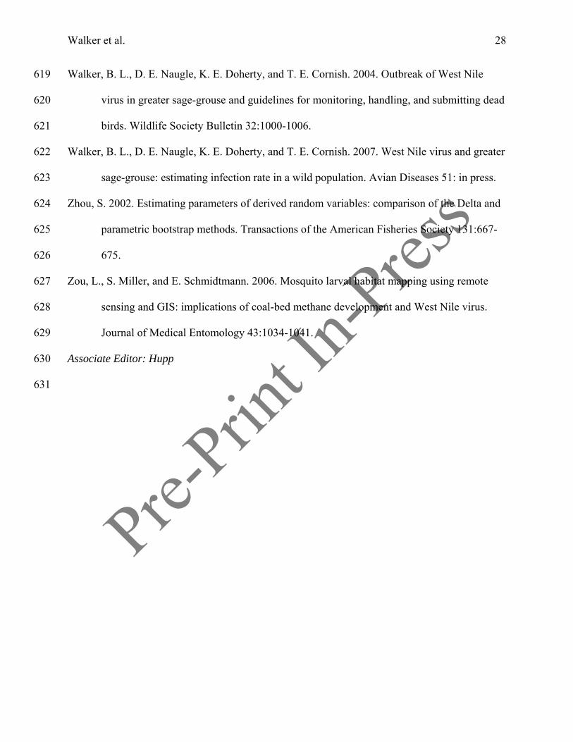
Figure 1. Distribution and status of active, inactive, and destroyed greater sage-grouse leks, coal-632
bed natural gas wells, and major highways in the Powder River Basin, Montana and Wyoming, 633
U.S.A. The dashed line shows the extent of SPOT-5 satellite imagery. This map excludes leks 634
that became inactive or were destroyed prior to 1997 and leks whose status in 2004-2005 was 635
unknown. The status of leks within a lek complex are depicted separately. Dot sizes of active 636
leks represent the final count of displaying males in 2004 or 2005, whichever was the last year 637
surveyed: small = 1-25 males, medium = 26-50 males, large = 51-75 males. 638
639
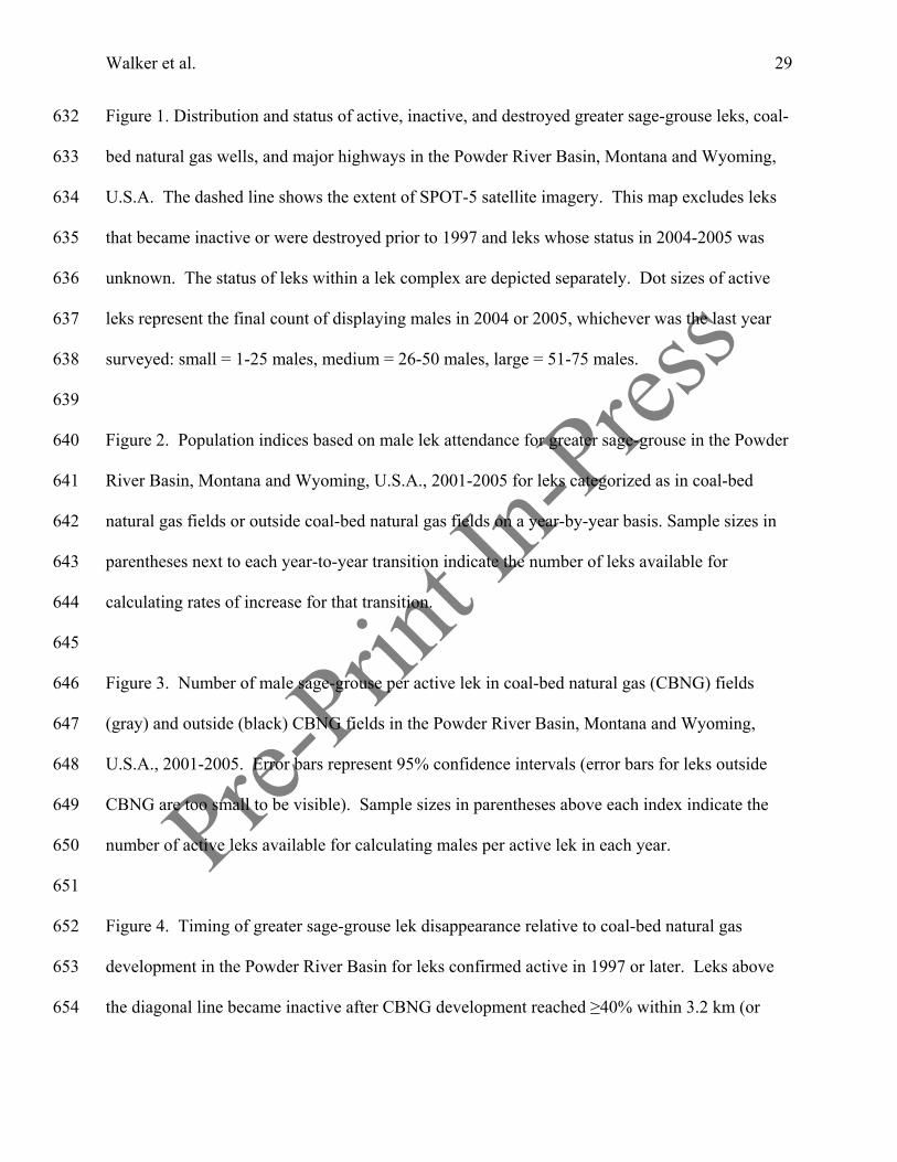
Figure 2. Population indices based on male lek attendance for greater sage-grouse in the Powder 640
River Basin, Montana and Wyoming, U.S.A., 2001-2005 for leks categorized as in coal-bed 641
natural gas fields or outside coal-bed natural gas fields on a year-by-year basis. Sample sizes in 642
parentheses next to each year-to-year transition indicate the number of leks available for 643
calculating rates of increase for that transition. 644
645
Figure 3. Number of male sage-grouse per active lek in coal-bed natural gas (CBNG) fields 646
(gray) and outside (black) CBNG fields in the Powder River Basin, Montana and Wyoming, 647
U.S.A., 2001-2005. Error bars represent 95% confidence intervals (error bars for leks outside 648
CBNG are too small to be visible). Sample sizes in parentheses above each index indicate the 649
number of active leks available for calculating males per active lek in each year. 650
651
Figure 4. Timing of greater sage-grouse lek disappearance relative to coal-bed natural gas 652
development in the Powder River Basin for leks confirmed active in 1997 or later. Leks above 653
the diagonal line became inactive after CBNG development reached ≥40% within 3.2 km (or 654
Pre-Prin
t In-Pres
s
Walker et al. 30
>25% development within 3.2 km and ≥1 well within 350 m of the lek center). Small dot = 1 655
lek, medium dot = 2 leks, large dot = 3 leks. 656
657
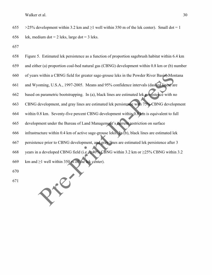
Figure 5. Estimated lek persistence as a function of proportion sagebrush habitat within 6.4 km 658
and either (a) proportion coal-bed natural gas (CBNG) development within 0.8 km or (b) number 659
of years within a CBNG field for greater sage-grouse leks in the Powder River Basin, Montana 660
and Wyoming, U.S.A., 1997-2005. Means and 95% confidence intervals (dashed lines) are 661
based on parametric bootstrapping. In (a), black lines are estimated lek persistence with no 662
CBNG development, and gray lines are estimated lek persistence with 75% CBNG development 663
within 0.8 km. Seventy-five percent CBNG development within 0.8 km is equivalent to full 664
development under the Bureau of Land Management’s current restriction on surface 665
infrastructure within 0.4 km of active sage-grouse leks. In (b), black lines are estimated lek 666
persistence prior to CBNG development, and gray lines are estimated lek persistence after 3 667
years in a developed CBNG field (i.e., ≥40% CBNG within 3.2 km or ≥25% CBNG within 3.2 668
km and ≥1 well within 350 m of the lek center). 669
670
671
Pre-Prin
t In-Pres
s
Walker et al. 31
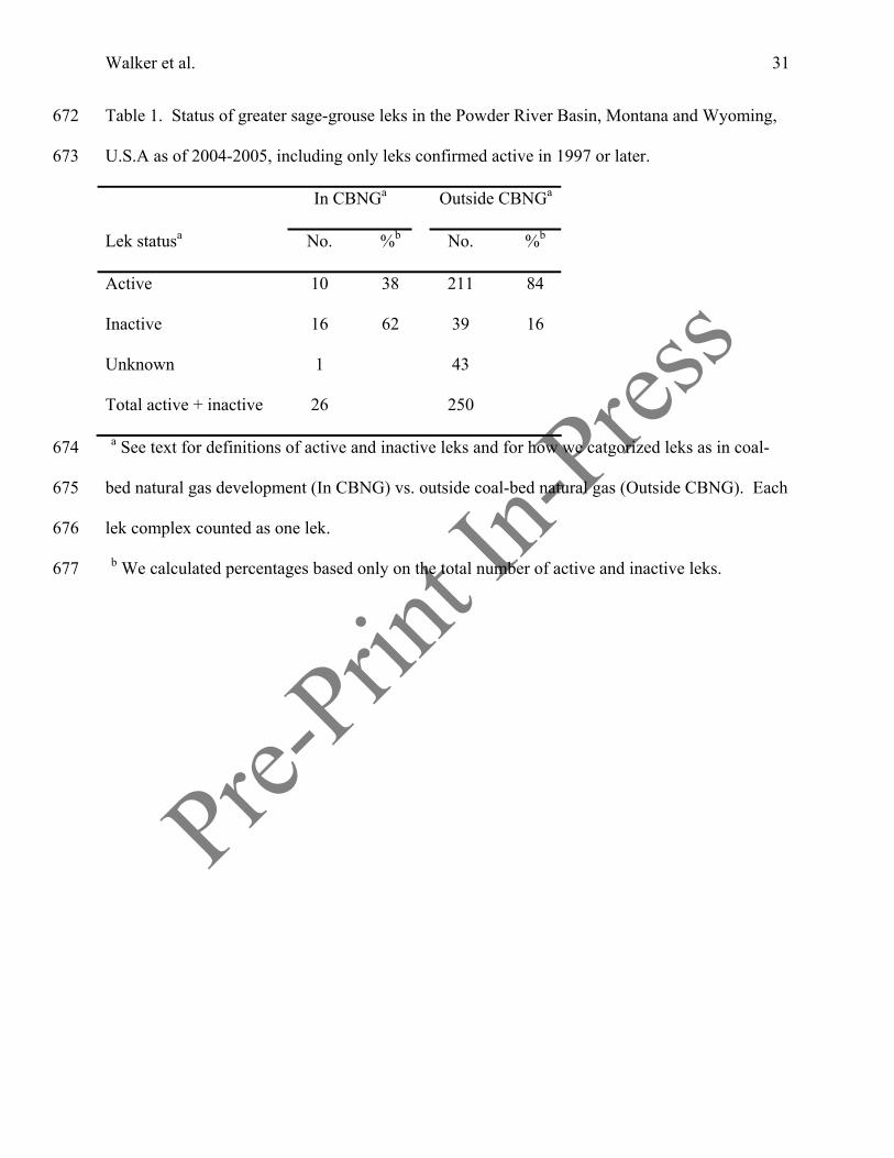
Table 1. Status of greater sage-grouse leks in the Powder River Basin, Montana and Wyoming, 672
U.S.A as of 2004-2005, including only leks confirmed active in 1997 or later. 673
In CBNGa Outside CBNGa
Lek statusa No. %b No. %b
Active 10 38 211 84
Inactive 16 62 39 16
Unknown 1 43
Total active + inactive 26 250
a See text for definitions of active and inactive leks and for how we catgorized leks as in coal-674
bed natural gas development (In CBNG) vs. outside coal-bed natural gas (Outside CBNG). Each 675
lek complex counted as one lek. 676
b We calculated percentages based only on the total number of active and inactive leks. 677
Pre-Prin
t In-Pres
s
Walker et al. 32
Table 2. Univariate model selection summary for different classes of landscape variables 678
influencing greater sage-grouse lek persistence in the Powder River Basin, Montana and 679
Wyoming, U.S.A., 1997-2005.a 680
Model LL K n ΔAICc wi β SE
Sagebrush
6.4 km -60.05 2 110 0.00 0.70 5.20 1.68
3.2 km -60.95 2 110 1.81 0.28 4.38 1.53
0.8 km -63.43 2 110 6.77 0.02 2.26 1.15
Tillage agriculture
6.4 km -55.52 2 110 0.00 0.79 -20.98 6.02
3.2 km -56.83 2 110 2.63 0.21 -19.31 6.30
0.8 km -60.92 2 110 10.81 0.00 -10.44 4.59
Power lines
6.4 km -58.69 2 110 0.00 0.52 -6.06 1.76
3.2 km -58.81 2 110 0.24 0.46 -4.92 1.43
0.8 km -62.12 2 110 6.84 0.02 -2.51 0.99
Roads
3.2 km -64.59 2 110 0.00 0.50 -2.50 1.99
6.4 km -65.20 2 110 1.21 0.27 -1.52 2.35
0.8 km -65.41 2 110 1.63 0.22 -0.08 0.87
a We present maximum log-likelihood (LL), number of parameters (K), sample size (n), ΔAICc 681
values, AICc weights (wi), estimated regression coefficients (β), and standard errors (SE) for each 682
model in each class in order of decreasing maximum log-likelihood. AICc = Akaike’s 683

Pre-Prin
t In-Pres
s
Walker et al. 33
Information Criterion adjusted for small sample size.684
Pre-Prin
t In-Pres
s
Walker et al. 34
Table 3. Model selection summary for hypotheses to explain greater sage-grouse lek persistence 685
in the Powder River Basin, Montana and Wyoming, U.S.A., 1997-2005.a 686
No. Modelb LL K n ΔAICcc wi
1 Sagebrush 6.4 + CBNG 0.8 -51.16 3 110 0.00 0.24
2 Sagebrush 6.4 + Agriculture 6.4 + CBNG 0.8 -50.48 4 110 0.80 0.16
3 Sagebrush 6.4 + Years in CBNG -51.56 3 110 0.80 0.16
4 Sagebrush 6.4 + CBNG 3.2 -51.70 3 110 1.09 0.14
5 Sagebrush 6.4 * CBNG 0.8 -50.98 4 110 1.81 0.10
6 Sagebrush 6.4 * Years in CBNG -51.32 4 110 2.48 0.07
7 Sagebrush 6.4 + Agriculture 6.4 + CBNG 3.2 -51.52 4 110 2.88 0.06
8 Sagebrush 6.4 + CBNG 6.4 -53.69 3 110 5.07 0.02
9 Sagebrush 6.4 + Agriculture 6.4 + Dist. power line2 -53.39 4 110 6.63 0.01
10 Sagebrush 6.4 + Agriculture 6.4 + CBNG 6.4 -53.48 4 110 6.81 0.01
11 Sagebrush 6.4 + Agriculture 6.4 -55.08 3 110 7.84 0.00
12 Sagebrush 6.4 + Power lines 6.4 -55.08 3 110 7.84 0.00
13 Sagebrush 6.4 + Agriculture 6.4 + Power lines 6.4 -54.07 4 110 7.99 0.00
14 Sagebrush 6.4 + Agriculture 6.4 + Dist. road2 -54.47 4 110 8.78 0.00
15 Sagebrush 6.4 + Agriculture 6.4 + Roads 3.2 -54.49 4 110 8.83 0.00
16 Sagebrush 6.4 + Dist. power line2 -57.36 3 110 12.41 0.00
17 Sagebrush 6.4 -60.05 2 110 15.67 0.00
18 Sagebrush 6.4 + Roads 3.2 -59.39 3 110 16.46 0.00
19 Sagebrush 6.4 + Dist. road2 -59.46 3 110 16.62 0.00

Pre-Prin
t In-Pres
s
Walker et al. 35
a We present maximum log-likelihood (LL), number of parameters (K), sample size (n), ΔAICc 687
values, and AICc weights (wi) for each model in order of increasing ΔAICc units, starting with 688
the best approximating model. AICc = Akaike’s Information Criterion adjusted for small sample 689
size. 690
b CBNG = coal-bed natural gas development. Numbers refer to the radius (km) around the lek 691
at which the variable was measured. 692
c The AICc value of the best approximating model in the analysis was 108.54. 693
Pre-Prin
t In-Pres
s
Walker et al. 36
Table 4. Model-averaged estimates of regression coefficients (β) and standard errors (SE), odds 694
ratios, and lower and upper 95% confidence limits on odds ratios for effects of landscape 695
variables on greater sage-grouse lek persistence in the Powder River Basin, Montana and 696
Wyoming, U.S.A., 1997-2005. 697
Variablea β SE Odds Ratio Lower CL Upper CL
Intercept -1.25 1.40
Sagebrush 4.06 2.03 58.241 1.083 3131.682
Agriculture -8.76 8.73 1.57 x 10⁻⁴ 5.81 x 10⁻¹² 4.22 x 10³
Dist. power line2 1.72 1.27 5.603 0.462 67.925
Power lines -4.52 2.40 0.011 0.0001 1.203
Dist. road2 0.62 0.67 1.86 0.505 6.859
Roads -2.38 2.23 0.092 0.001 7.331
CBNG 0.8 km -3.67 1. 18 0.026 0.003 0.257
CBNG 3.2 km -4.72 1.50 0.009 0.001 0.169
CBNG 6.4 km -5.11 2.04 0.006 0.0001 0.328
Years in CBNG -1.41 0.58 0.244 0.078 0.761
a CBNG = coal-bed natural gas development. The estimated regression coefficient for Years in 698
CBNG could only be derived from 1 model. 699
Pre-Prin
t In-Pres
s#
#
#
###
###
####
######
#
#####
# #######
##
#####
#
#####
#
###
##### ###
###### #######
##########
##
#
#
#######
# ################
#
#
#######
#
#
#### ### ### #### ####
###########
#
#
### #############################
############################
#
########
#
#
##
###
# ##
# ###
### #
### ##
# ##
## #
############
#
######## ###
#
####
#
# #
##### ##
#
#
##
#
#
# #
##
########
## #####
#
##
#
#
#
#
#
#
#
###
#
#
#
#
###########
## ####### ############## ######
##
### ### ## ## ######### ########### #
#
#
# ##### ############ ### #### ## ####
# ######
####
##
##
##### #
#
## ###### ###
############# ## ## #
#
######
##
#
#
#
####
###
##
# ### ### ####
###
#####
###
# ## ## #
#
###
##
#
##
###
###
#
#
#
## #######################
##
######
#####
##
####
#
####
##
#
#######
#
## ###
#
#
#
#
##
#### ##
###
#####
# ####
#
#
#
#
## #
#
# #
# ###
#
##
#
#
###
##
#
###
#
#
#
##
#
#
####
#
##
#
#
#
########
####
#
#
#
##
###
#
###
#
#
#
####
##
#
#
#
#
#
##
#
#
##
#
###
####
#
#
#
###
####
#
##########
###
###
#
###
##
########
###
#
#
#### ### ## ## ####### #### ########
#################
#
##
#
###########
## ######### ######
####
#
#
##
####
#
#
#######
######
#
#################
# ############## #####
#### ###
##########
##
######################
##
####
###
####### ## #### ###
##################
#### #### ### ### ### #### # ##########
#################
##### ################ ### ##
########
## #######
####################### ##### ##########
#
#### #
## ######
# ######## ##### ############ ##### ##### #########
#
## ##### #######
# ## ### ### ####
##### #########
# ### ### # # ####### # ## #### ### ################
### ## ## #### ## ###### ##### ###### ##### #### ######### ##### ############# ########## ## ##### ### ### ###### ##### # #### #### ## ### #### ######
##### #### ## ### ## ### ## ###################
###
# ### ###
#########
# ######### ## #### ##### ######### ########## ######## #### ####### # # ## ###### #### ### ##### ####
# # ## ###
#
#
# ##
###
# ###### #############
###
#
#
# #### #### ####### ## ##### ### ######
# # ############# ### ####
## ## ####### ### ## #### #### ## ##### ####### ######## ###### #### ### ## ###### # #### ## ### #### ##### ##### ## ###### # ##### ##### #########
###### ## ### ##### # # #### # ## # ### ## ### ######### ####
## ### # #### ### ######## ############
# ## #### ## ############## ### # ##### ### # # #### ### ###### # ## ## #### ##### #### ## ###### # # ####### #### # #### ###### # ####### ##### ## # ###### #### # ## ##### # ###### #### ## ## #### #### ### ## #### ## ## #### # ### ###### ## ##### # # ##### ## ## ##### #### ### #### #### ###### ###### ### ### ### ### ### ## ## ### ###### ## ##### ## ## ## ## #### ### ### ## ## ### #### # ### ### ## ### ##### ## ## ##### ##### #### ## ## ### ### ##### ### ## #### ## ### #### ## ## #### ######## ## # ### ## #### ## ## ## #### ## #### # #### #### # #### #### ### # ############# ### ## ## ###### #### # #### # ## ### # ###### # # ### ## ## ## ## ###### ##### ## # ## # ## #### ######### ## # ####### ##### #### ### ## # ## ## ######### ## ## ### ## ### #### ###### ##### ### ### ############ #### ### ### ## #### ##### ### ###### ########## #### ##### ## ### ## #### ## ########### ####### ## ######### ## ### ##### ## ## ## ## ## ####### ## ### ### ### #### ### ##### #### #### ######### ### ## ######## ## ####### ### ##### ####### ####### ##### ### ########## ## # ##### ### ######## #### ##### ##### # ###### ### ### ### # ### ## ####### ##### ########## # ###### ## ### #### ## ## ### #### ## #### # #### # ### ## ####### ##### ####
### ## ## ####### ##### #### ### ## ###### ## ## #### ## ######### ##### ### # ####### # ## # ### ############## ## ### #### ## #### ###### ## ### ### #### # ### ### ############## ### ###### ## ##### ## ### ### ##### ## ## ##### #### ## ######### ###### ## ### ##### ###### # ##### ## ### ###### # #### ### #### ############ # ########## #### ##### ## ## ############### ###### ## ## #### ## ########### ##### ### ### ##### ###### ################ ####### ##
########## # ###### ######### ##### ##### ##### ##############
###### ######## #### ###############
#### #### ##### #### #### ########### ####### ### ## #### ### # ######### ######## ########### ############ ## ############## ######## ########## ############ ################ ### ####### ############################## ############# #
####
##################
#### #### ############### ########## ##### ######## ###################################### ####################### ########## ############## ### ############ ########### ##
#
#
# ## #
# # ######### #### ### ## ### ## #### # ###### # # ## ## ## ### ## # ##### ### #### # ###### ## ###### ########## ######### ########### ##### ###### ## ### ##### ### ## ## ## ## ## ####### # ######## ###### ### # ### #### ## #### ###### ### ## # ## ####### ## ### ### # ##### ### ### ## # ## #### ### #### ## ##### ### ### #### ###### # #### #### #### ## ## ## ### ### ## # #### #### ### #### ### ###### ###### ##### # ## ##### ## # ## # ###### # ###### ## ###### #### # #### ## ### # ## # # ### # # ## #### ## # ### # #### # ### # #### ## # ### ##### # # ## ###### # ##### ##### #### ####### # ## ######### ### ####### # ##### ###### ########### ## ##### ## ## #### # ##### #### ### ## ##### ## # ### # ## ##### ### ### #### ## # ## ## ########### # ####### ## ### ## ###### ######## #### ####### # ###### # ###### ## #### ## # ### #### ## ######## ### # ## # ## # ### ## ###### # ## ## # # ##### ## # ### ### ## ## ## ## ## ## # #### ## ## ## ## ## #### # #### ### ### #### # ## ######## ## ## # ### ## ## ### ### ### ## ### ##### ### ### ##### ### # ### ### ## # ## #### # ## ### # # ## ### ## ### # #### ## ### #### # # #### ## ## #### # ###### ### ##### #### ## ###### ## #### ## # ## ## #### ## ## ####### ### ## ### ## ### ###### ### ### ### ##### ##### ### ### ## ## # # ##### ##### ## ## ### #### ### # #### ### #### # ## ## ## ## ###### # ## ## ####### #### ### ######### ### ### ##### ### ## ### ## ## ## ########## ###### ######## # ## ## ### #### ##### ### ##### ### # ############ ## ####### ##### ### ### #### ### ## # #### ######### ##### ### # #### ### #### # ### # ## ## ### #### #### ## # ## ###### #### ### ### ###### ## ## ###### ### ##### ## # ###### ### ## ### ## ## ## ###### ## ### ## ## ### ##### ### #### ### ###### ## #### # ########### ### #### #### ########## # ##### # ## # ######## ### ###### ## ## # # #### #### ## ### #### #### ## ## # ## #### #### ### #### # ### ## ### ## ### ##### ## ## ### ## # ## ## ## ## # #### ## ## ## # # ########## ### # # ## ######### ## #### #### ### ## ### #### ##### ## ## ### ## # ### ####### #### ## # ##### ##### ## ### ### ####### ###### ### ## # ###### ### ### # ## ##### ###### ## #### # #### ###### ## ## #### #### # # #### ##### # #### ### ### # ### ## ## # # ## #### ### # ### ###### ### # ## ## ## ## ##### ### ### ##### ## ## ####### # ### # ### ## ## # ### ###### ### ### ### ### # ### ##### ## ### ## ### # ### # ##### ## # ### ## ### #### # ###### # #### ## ######## ##### # ### ### ##### ## ##### ###### ## ########### ##### ####### ###### ###### # ###### ####### # ## ## #### ## ######## ### # ### #### ## ### ##### ### ##### ### ####### #### ### ### ## ####### ## # ###### #### # ########## ## ### ## ## ### ####### # ## ### ###### # ####### # ######## #### # # ###### ### ############# ## ############ # ######### # ####### ######## ## ### #### ####### ### #### ### ## ########## ## ######## ######### #### ## #### ##### ## ## ### # #### ## # ######### ## ############### ## ## ### #### ######## ##
## ## ### ############# ############ #### ## ############################ ############ ## ############ ######### #### ## ##### ## ### # ##### #### ### #### ##### #### # ### ## #### ### #### ## ###### # ###### #### ###### ### #### ##### ### ### ##### #### ## # #### ### ###### ###### ########### ## ##### ###### ### ### ########### ########## ##### ## ### ####### ### ##### ## ## ### # ###### ### # #### ### ## #### #### ## # ###### # ## ####### ## # ### ######### ### ### ######### # ##### ## ####### ## # ## #### ### # ## ### #### ###### #### #### #### ##### ##### ### ### ## ### ##### ############# ########### # ###### #### # ##### #### # ###### # ## ###### # ## ## ## ## ## ## #### ### #### # ######## #
# #### # # ## ## # ### #### #### ## ##### ### ## #### ### ## ##
###### ## ##
##### ## #### ## ######### ## ### # #### ##
## ##### ## ### ### ##### ### ##### ####### ### # ## ## ######## ## ## ###
# ###
######## ## ## ## #### ###### ##### ######### ### ### ###### ## ## ### # ######## ## ## # ### # #### ### ######## ###### ##### #### ## #### ## ### ### ### #### #### ###### ######### #### ###### ## ## #### ## ### #### ### #### # ## ## ############## ### ## ### ### # ### ################## ## ## ### ###### ### ## ### ## ## ## ### #### ## #### ############## ## ####### #### #### # ########### ### ### ### #### ##### ########### #### ## ### ## ##### ## ############# # ####### ######## ############ ### ## # ###### ### ######### ## ##### ## ## ## ######### ## ####### ### #####
### ############## ### ## ##### ########
########################################################## ########### ## ########## ##### ########### ######## ############################ ###### ############# ############ ######### ## ########## ##
#############
####### ### #### ################# ###### ############## ############## ##### ### ############################# ######### ####### ##### ###### ############ ###################
###
######
#
################
# ### ### ###### ## ### ### ######## #### ### #### # ######
# ## ####### #### ### ### #### ### ####### # # ### ### ## ## #### ## ######## #### #### ## ### ## ##### ### ## ### ## ####### #### ######## #### ### #### #### ### #### ## # ## #### ###### ## ## ### ###### ## ### ### ###### # # ####### ## # # #### # # #### # #### #### ## ### ### ## ### ### ## ##### ## ## ##### ## ### # #### ### # ## ## # ### ### #### ## ## #### # ## ## ## ## # ### ## #### ## ## ## # ### ## ## # ##### #### ## #### ## ## ####### #### ### # #### ## ###### ### #### ## ###### ##### #### ######### ## ## ######## # # ### ## # ####### ## ### # # ########## # # #### ##### #### ## ### ## ## ### #### # ### ## ### # ### ## ### # ## ######### ## ### ### # ### ### ##### ### # ### ### ### # ### ### #### ## ## ### ### ## # ## ## ## ### ### # ### ###### ## # ## ## ## # ## # ## ######## ######## ## ## #### ## # ##### ## ### ### ## ## ### ### # # #### ## # ##### ## #### ### ### # ###### #### ### ### ## #### # ### ## # ## ### ## # # ### ### #### # #### #### ## # # # ## ### #### #### #### ### ## ### ### # # ### #### ## # ### ##### ###### ## #### # ## ## # ### ## ## #### ######## ## ### ## ##### #### ##### #### #### # ## ### # # ##### ## ##### ### ######### # ##### ## ### ##### #### ### ## # #### ## #### ## ## #### ### # ## ## #### #### ### ## # ##### # ####### ## ### ## ## ## # ## ### ## # ### #### #### ## #### ##### # ## ##### #### # ## ##### # ### ## ## ### ### ### ##### ## ## # ## ## #### ##### ## ## ####### #### #### #### ### ### ###### ## ##### # ######## # ###### ### # ##### #### ### ### ### ## # ##### ## ## ## ## # ###### # #### # ### ### ## ## # ######### ## ## ##### # ### #### # ## ## ## ####### ## ### ## ## ##### ### # ######## ## ### ### ### # ### ### ## ##### ## ### # ### ## ## ## ## #### ### ### ### ## # ## # ## ####### # ###### ########### ###### ###### ##### #### ## ### ### #### ###### ##### ##### ## ## ## ## #### ############ # #### ### ## # ### ### # ##### # #### ### ## ##### ### ## ######### # # ## ### ##### ## ####### ## ## ##### #### ##### ######## ### #### ### ####### ## ######## ## ### # ### ## ## ## #### ##### ## ########### # ##### ######### # ### # ### ####### ## ### ## ### ### ### ## ## ## # ## ## ### #### ##### ## ####### #### ## # ####### #### ####### ### ##### # # ### ## ## ### ##### ## ##### ## ## ##### ### ##### ### ### # #### ###### ## #### ### ###### ### ## ### ## ## ### # ##### ### # ## ### #### #### ## # ## ## #### ### ## ######## #### #### ##### # ### ## ### ## ### ###### #### # # # ####### # #### ### # ## ### #### # ## ## ## ### # ### # ## ##### ### ############# ### ### # ######### ##### ### ### ### ### # ######### # ### ### ##### ### # ## #### #### ## #### ################ ################## ## ##### #### ### ######## ## # ## ###### # ## ############ # ## ######## ## ### ### ## #### #### # ########### # #### ## ## ######## ### ## ############# ###### ####### ##### ## #### # # ### ## ##### ### ## ## ### ## # ###### ########## # ### ## # ### ## ### ### ### ### ####### ## ###### ## ## ### ## ############ ### ######### ### ## #### ##### ## # ### ## #### #### ############# #### #### # ##### #### ### ####### ## ###### ###### ## ## ###### # ### ### ## ### #### ## ## ##### #### ## # # ### #### ####### ######### # ###### #### #### ##### ## ##### #### ## #### ## ## ####### ###### #### ##### #### #### ### ########### #### ########## #### ### # ##### ##### ####### ### ##### #### ###### # #### ### # ###### ##### ### ######## ########### ### # ##### # ######### ## ## ## ##### ### ## ##### #### ## ##
## #### ## ### ### ##### ### ## ## ### # # ## #### ### ##### ## ## ### #### ###### ###### ## ##### ### ### ##### ##### ###### ## #### #### ##### #### ### ####### ## # ## # ##### ## ## # ### ### #### # # ## ### ## #### # ###### ###### #### ## ##### ## ## ## # ### ### #### ## #### #### # # ### # ### ### ##### ## ## ######## ### ## #### ##### ### #### ######## ### ## # # ########### #### ### ## # #### ## ### ##### ## ##### ### # ## # #### ########### # ### ##### ######## # ######### ######### ## # ######### ### #### ##### ## # ## ## ## # ## ###
# ##### ### ###### # ## ###### ## #### ## # ########### ## ## ## ######## ###
### # ## ### ## # #####
##### ### ### ## # # # ## ##### #### ### ### ## ##### ######### ### ####### ####### ### ##### ######## ##### ############ ### ##### ## # ########## ### ### # ###### # # ####### # ## ## ## ## ### ##### # ############ ########## ##### ##### ## ## ### ### ## ## ## #### #### #
######## # # ## ### ## ##### # ####### ### ########### # ######
# # #### ## ##### ####### #### # ###### # ## ########### ########## # ## ### ##### #### # #### ## ####### ## #### # ###### #### ####### ## # ### ### ######## ####### ####### # # ######## # ### ## ## ##### ##### ### ## ##### ## ##### #####
### # ###### # ######## ########## ### ### # ############
########## ############# ###### ####
###
###### ###### ##### ##
#############
## ####### # #######
# ##
########
###### #### ###### ## ## # ## ## ##### ## ########
####
#### ###### ### ## ###
#### ### # ##
##### #### ## ###
##### # ##### ####### ########### #######################
############################################## ###### ### #### #### ##### #### ## ### ########## ## ##### ######## ### # ########### #### ######## ### ##### ### ### ################## ### ## ### ##### #### # ###### ### ######## # ############ ### ## ## ## ## # ## ######### ### # ### ## ## ### ###### ####### ####### ### ######## ###### #### ## #### ## ##### ## ################## ### ### ### ## ########## ###### ###### ######## #### ############ ## ## ## #### ####### ## ###### ### # ### ## ##### ########## #### ###### ############## ###############
#
#
## #### ### # ####### ### ### ##### ## # ### ##### # #### ### ##### #### #### #### #### # ###### # #### ##### ###### # # ##### # ## ## ## #### ## # ### ### # ### # ## #### #### # ### #### ## ## ## ### #### # ## ### #### # ### ## #### # ### ## ### ## ### ## # #### ## ## ## ## ##### ##### ### # ### ### ## #### ## ###### ## #### # ## #### ### ## ###### ### ##################### # ###### ### ##### # ###### ##### ### ### ###### ### #### #### # ### ## ## #### ## ## ## ## ######### ### ## ## ######## # ### ## #### ###### ### ### ### # ## # ### # ## ######### ######## ### ##### ########### ## # ## ###### ## ####### # ### ### ### ## ### ## ### ##### ### ####### # ## ## ## ### ####### # # ### ### ## #### # ## ## # ##### ## # ### # # ### #### ### ### #### ## ##### # ### ##### ### ### ## # # ### # ## ### # #### # # ### ## ### ## ## ### # ### # ## ### # ### ###### ## # # ## ## ## ## ### # # ## ## ## ## ### # #### ######## # ## ## # ### ### #### # ## ### ## #### # # ##### ## # ####### ##### # ### ### ##### ###### ## #### ### ### # ## ##### ## ## #### ## ## #### # #### ### # ## ##### ### ## ### # ### ### ### ### ## ### # ### ####### ##### ###### #### # ## # ### # ### # ### ##### #### ## ### ## #### # ### ####### # ### ### #### ### #
#### ### #### ### # ## ## ###### ###### # #### ## # ## #### ################ ##### ### #### #### #### ## ## ## #### ### ### #### ###### ## #### ##### ########## ### # ## ## ### # ###### #### ## ### ### #### ##### ### ## #### # # ## ## #### ######## ## ##### ## ## ## # ### ##### ### #### #### ### #### ## ## ####### ## ####### ## ## #### # ## ######### ### #### ######## ########## ## #### ### #### # # # ##### #### ### # ## #### ### # #### ## #### # ### ###### ### ### ### #### ## ## ### ####### ### ###### #### ## ##### ### ## ## # ## ## ## ###### # ##### # ### ## ### #### ## ### ## ## ##### ###### # #### ####### ### ##### # ######## ##### #################
## ## ## #### ####### ## ## #### #### # ### ### #### ################### #### ### #### ### #### ### #### ##### ### ### ## # # #### ## #### # ###### # #### ### ### ##### #### ## ##### ##
##### ######### # ##### ## ###### ### #### #### # ####### #### ### ####### ## ###### ### ## ##### #### # ## ### ######## # ########## ## ######### ## ####### ####### # ### ######### ############### ####### #
### ## ##### # ##### ## ##### ## ##### ## ## ### ###
# ######## # # #### # ## # ## # ## # ## ## ### ## ########### ##### #### #### ###### ### ## ######## ### ### ########### ############ ### ##### #### #### # ###
## ## ##### ##### ## ### # ## ### ##### ## ##### # ### ######### ####### ################## #
# #### ### ############# ### ### ### #### ## ######### #### ## ## ###
####### ############### ######### # ###### ### #### ##############
##### ####### ## #### ### ### #### ###### ## ## #### # ###### ### ###### ### # ### # #### ### ########### ### #### # ### ### # ####### ## ##### ### ## ##### ### ## ### #### ## ##### ### ## ###### ######### ####### ############# ### #### ##### ##### ## #### ######## ## #### ################## ##### #######
##
####### #### # #### # ## ## ### ### # ## # ##### # ## ## # # ## ### # ### # ### #### ### #### ## ## ### ## ### ### ### ## ####### ##### # ###### ### ## ###### ## ## #### ## ### ## # ### ### ##### #### ### ### ## ### # ### ## ### #### ###### ###### ####### ## ## ## ### ## ##### ### #### ## # ##### ## # ### ####### # ##### #### ### # ## ###### #### # ########## ## ######## ## ##### # ## ## ## ## #### # # # ## ######### ## ##### ## ## #### ### ###### ## ### ### # # ### #### # ## ## # ##### ## ### ### ###### # #### # ## ### ## #### ##### ### ##### ## # ## ## ## # #### ## ## ## ## ## ## ### ## # ## ## ##### ###### ###### #### ## ## ##### # ## ## ##### ## ## ### ## ##### ## ## ## # ### #### #### ## # ## # ### ## ### # ## ### #### #### ###### ######### ## #### ## ### ####### ## #### ## # ###### ## # ## ## ## ### ####### ### # ######## ## #### ### ### ### ## #### ####### # ##### # ######## ### #### ### ### ### ## ### # #### ## ## # ### ### ### ### ### ## ## ### ## ###### ## ### # # ##### #### #### ## # ## ### ## # ### ## ## ### ###### ########## ### #### ######### ### ##### ##### ##
### #### ##### ## # #### ###### ### # ###### ## ############ ##### ####
###### ### ### ###### ###### # ### # ## ### ##### # ### #### ### #### # ## #### ##### #######
# ## ####### ## ## # ## # ### # #### # ### ## ## ## ## ### ## # ###### ## #### ##### ## #### ## #### #### ############## #### # ## ## ##### ## ## # ## ### ### # ### ### ### ## ## ## ## #### ## ## ### #### # ### ### # ## ###### # # ## ## # ## ####### ##### # ## ##### ####### ## ### ####### ## ### ## #### ##### ## ### ## ### ### # ## ## ### #### #### ############### #### ### #### ### # ### ######### ### ### ##### # ###### ## ### ## ## ## # ## ### # ## ## #### #### # ##### #### # ###### ### # ## ### ### ### ## ### ###### ##### ## ### ## ##### ### ## ### # ## ###### ######## ###### ###### ##### ## #
##### ############ ########## ################# #### ###
# # ## ## ## #### ### #### # #### #### ####### #### #### ### ### #### ######## ## ### #### #### ############### ######## ####### ####### ### ### ## ## #### ## ## #### # # #### ## #### ### ##### ## ### ### #### ##### ######### #### ## ### # ###
# ###
##### ## ### ########## ### ##
# # ### #### ## ## ####
####### ## ## ### ### ## # ### ## ### # ### ### ####### ## ## ### ##### ### ## ## ### ### ## ### #### ##### # ## #### ########## #####
# # # ##
##### # # ##### # ### ##
###### #
##
##
##### ################## #####
# ################### ### ######## ###### #### #### #### ##### # ####### ######### # # #### ### ######## ### ## #### #### ## ## ## ## ###### ############ ## ### ### ### # ## # ## ## #### ########## ### ### ## ########### ##### #### ######### ## ##### ##### ###### ### # ##### #### ######## ####### ## ### ######## ## #### ### ### ### ###### ######## ### ########## ###### ########## ############ ########## ############## ############# ############### ############ ## ## ### ################## ##################
# ##
####
#
################## #### ### # ### ## ### ##### ## ##### # ### ### ### # ##### ## ######## ## ## ## #### #### ## # ## #### ## ## ### ##### #### # # ## #### ###### # ### #### ##### ## ##### ### ## ### # ### #### #### #### ## # ######## ##### ## ############# #### ##### ## ### ## ### ### ## #### # ### #### # ## #### # ### ### ### ## ## # #### ## ## ###### ## #### ##### ## ## ### ### # # ### #### ### ####### ## # ######### # ## # ## # ##### ## #### ## ### ### #### ## ## #### ### ## ### ## ## ## ## ### #### # ### ## ## #### ### # ## # ## ###### # ## # ## #### ## ### ### ####### ## ##### ## #### # # ### ## ### ## ###### ### ## # # #### ## ## ## # # # ### ## # # ### ## ### ### # ## # ## ### ## ### ## ## ### ## ########## #### ###### ## ## ## ## ##### ### ####### ###### ##### ### ## ## ### #### #### ##### # ###### ## ###### #### ## ## ######## ### ## #### ## ##### ## ## # ### #### #
## ###### ## #### #### ####### # ###### ## ###### ## # ####### # # ######## ##### ### ###### ### #### # ##### # ## # #### ## # # ## ##### # # ### # ## ## # ###### #### #### ## ## # ####
# ##################### ## ##### ### ##### ###### ### ### ## ## # ### # #### # ## ### ### #### ## ## #### ######### ## ## ### ## ##### ## ### ## #### ## ### # ##### # ## #### # ## ##### #### # ## ##### ###### ### ## ##### # ## ##### # ### ### ## #### ### ##### ### # #### ## ## ## #### # # ### # ##### ###### # # ##### ## ######### # ### ### # ## ### ## # ### #### ## #### ## ## # ### ## # #### ### # ## # #### ### ## ### #### # ## ### ###### # ### ##### #### ## ### # ####### # ## # ## # ### #### #### #### ### # ## ##### ## ##### # ## ##### # # ## # #### ### # ##### ## ## # ## #### #### ###### ### ####### ##### #### ##### ### #### ###### # ###### ### #### ## ###### ## ## ### ### ## ## ##### # ## ##### ###### ## #### #### ##### ### #### ####### ##### ##### ##### ## ### ## ## ## ### # ## ## #### #### ## ## #### # ## #### # ###### ### ###### #### ### ## # ######### ######### ### ## # ## ####### ### ## ####### # ## ### #### ### #### ### #### # #### ### ### ## ## ## ## ### ## # ##### # ## # ## # # ###### ### ##### ######## ######### #### ##### ####### ##### ## ###### ### ## #### ## ## ### ### # ### ## ### ## ###### #### ###### #### ## ####### ###### ### #### ##### ### ##### ###### ###### ##
#### ## # ### ######## ## ### #### ##### ##### ######### ## ##### ###### ## ### ####### ###### ### ## ## # ## #### ### ###### ### ## ### ## ## #### ##### #### ###
# # ### ## ## ######## #### ### ##
## ### #
############ # ######### ## ## # ##### ## ## ### # ##### ######## ## ### ### ####### ###### #
###
# # ## #### # ##### ### ## #####
## ## #### # ## ## #### # ## #### ### ### ## ### #### ### ## ####### #### #### ## ###
##### # #### ## #### # ### # #### # #### ### ## ## ## ### # ### ### #### ## ## ## ### ## ## ### ##
##### #### ### # #### ############ ## ## ### ### ###### ### # #### # ## ### #
##### ### ## ### ## ### # #### # ####
# ### ## ####
###### ######## # ## ###
### ## ##### ## ##### ## ## #
##
## ## ### ## ## #
## ### ##
##### ## ##
####### #
######
####
##
###
# ###### ####
###
### ####### #######
####
###### #
#### #### ## ##
## #########
## ## ## ##
##
## ### ### ## ###
## ##########
#####
# ##### # ## # ### ## #### ## ### ## # ### #### # ###### ## ## # ##
######## ## ######## ##
### ### #### ### ### ## #### ### # ##### ## ## ### ###### ##### ### # ## # ## #
#### ## ### ### ### ## ## ########
#### ### ## ####### # # # # ### # #### ##### # ### ####### #### ### # ## # ## ## ### # #### ### #### ## ##### ###
### # ##### ## ###### ###### # ## ##### ###### #### ###### ############ ### ####### ###### ##### ##### ### ####### ### ########## ######### ### #### ### ############## ####### ##### #### ######### ######## ###### ## ####
#
%U
%U
%U
%U
%U%U
%U
%U
%U %U
%U
%U%U
%U
%U%U
%U
%U
%U
%U
%U%U%U
%U
%U
%U
%U
%U
%U%U
%U
%U
%U
%U
%U
Ñ
%U%U%U
%U%U
%U
%U
%U
%U%U
%U%U
%U
%U
%U
%U
%U%U
%U%U
%U
%U
%U %U %U%U
#
# #
#
#
#
#
#
#
#
#
#
#
#
#
#
#
##
#
##
#
#
#
##
#
#
#
#
#
#
#
##
# #
##
#
#
#
#
#
#
#
##
#
#
#
#
#
#
#
#
#
#
#
#
#
#
#
#
#
#
#
#
#
#
#
#
#
##
#
#
#
#
#
#
#
#
# #
#
#
#
#
#
#
#
#
#
#
#
#
#
#
#
#
##
#
#
##
#
#
#
#
#
# ##
#
#
#
#
#
#
#
#
#
#
# #
#
#
#
#
##
#
#
#
#
##
#
#
#
#
#
#
#
#
#
#
#
#
#
#
#
# #
#
#
##
#
#
#
#
#
#
#
#
#
##
#
#
#
#
#
#
#
#
#
#
#
#
#
#
#
#
#
#
#
#
#
#
#
#
# #
#
#
#
#
#
#
#
##
#
#
#
#
#
#
#
#
#
#
#
#
#
#
#
#
#
#
#
#
#
#
#
#
#
#
#
#
#
Montana
Wyoming
N
0 50 100 km
I-25
I-90
I-90
16
14
16
14
85
Study area
Coal-bed natural gas wellsBoundary of SPOT-5 satellite imagery
Active lek:
Inactive lek
- Small (1-25 males)- Medium (26-50 males)- Large (51-75 males)
Destroyed lek
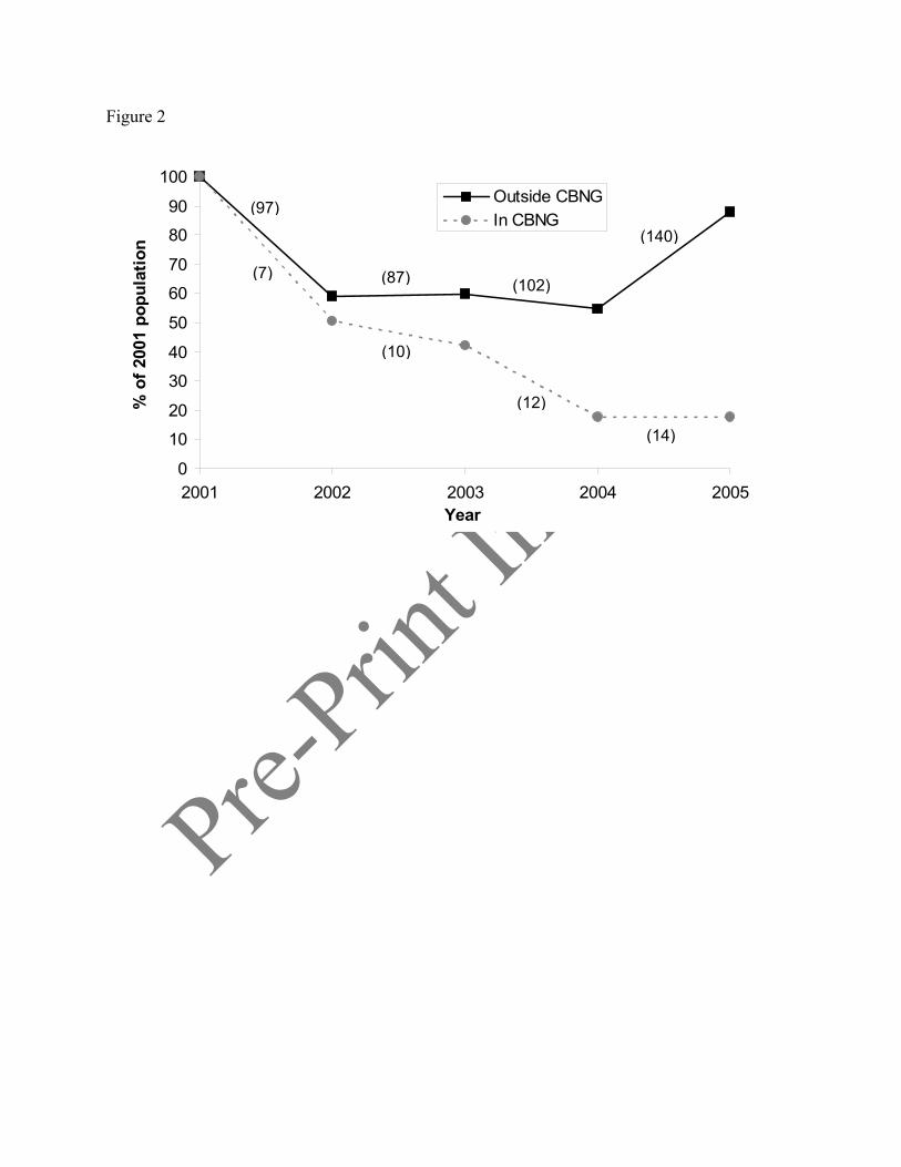
Pre-Prin
t In-Pres
s
Figure 2
0
10
20
30
40
50
60
70
80
90
100
2001 2002 2003 2004 2005Year
% o
f 200
1 po
pula
tion
Outside CBNGIn CBNG
(97)
(87) (102)
(140)
(7)
(10)
(12)
(14)
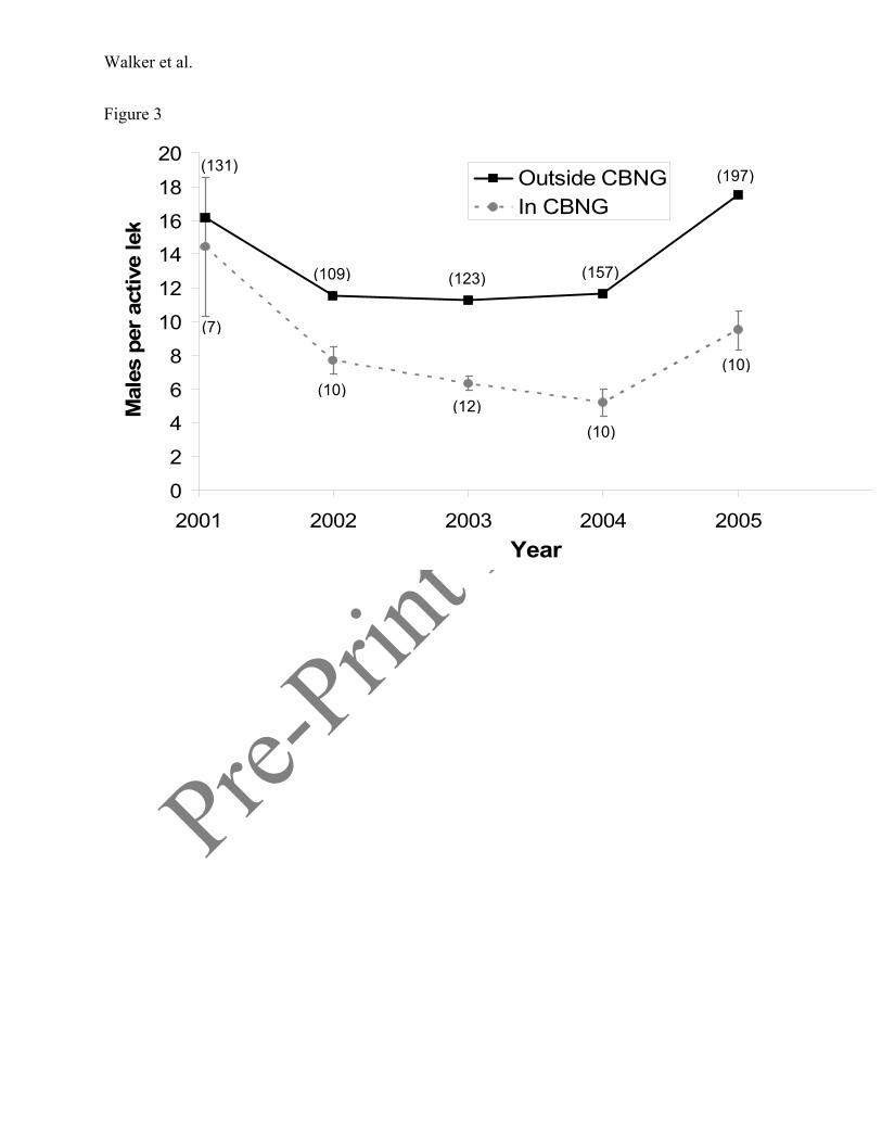
Pre-Prin
t In-Pres
s
Walker et al.
Figure 3
0
2
4
6
8
10
12
14
16
18
20
2001 2002 2003 2004 2005Year
Mal
es p
er a
ctiv
e le
k
Outside CBNGIn CBNG
(7)
(10)
(10)(12)
(10)
(131)
(109) (123) (157)
(197)
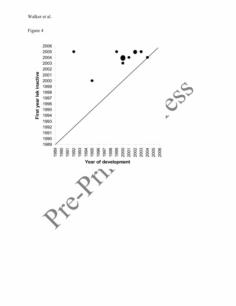
Pre-Prin
t In-Pres
s
Walker et al.
Figure 4
198919901991199219931994199519961997199819992000200120022003200420052006
1989
1990
1991
1992
1993
1994
1995
1996
1997
1998
1999
2000
2001
2002
2003
2004
2005
2006
Year of development
Firs
t yea
r le
k in
activ
e
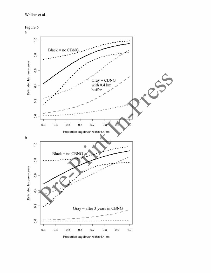
Pre-Prin
t In-Pres
s
Walker et al.
Figure 5 a
0.3 0.4 0.5 0.6 0.7 0.8 0.9 1.0
0.0
0.2
0.4
0.6
0.8
1.0
Proportion sagebrush within 6.4 km
Estim
ated
lek
pers
iste
nce
b
0.3 0.4 0.5 0.6 0.7 0.8 0.9 1.0
0.0
0.2
0.4
0.6
0.8
1.0
Proportion sagebrush within 6.4 km
Estim
ated
lek
pers
iste
nce
Black = no CBNG
Gray = CBNG with 0.4 km buffer
Black = no CBNG
Gray = after 3 years in CBNG
Related Documents